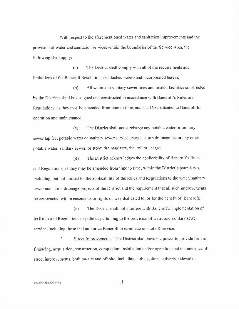
SERVT[CE PLAN
FOR
GREEN GABLES METROPOLITAN DISTRICT NO. 1 (Residential)
JEFFERSON COUNTY, COLORADO
Prepared y:
MeGead' Sisneros, P.C. 450 E. 17h Ave., Suite 400
Denver, CO 80203
As Approved by the Jefferson County Board of County Commissioners on: September 11,2012
{00246354.DOCX v:1 }
TABLE OF CONTENTS
Page
I, INTRODUCTION..............................................................................................................I
II, DEFINITIONS ................................................................................................................... 2
ilL DISTRICT BOUNDARIES/MAP .................................................................................... 5
IV. PURPOSE OF' THE DISTRICT ....................................................................................... 5
V. NI1ED FOR THE PROPOSED DISTRICT .................................................................... 6
VI. PROPOSED LAND USE/POPULATION PROJECTIONS .........................................7
VII. DESCRIPTION OF PROPOSED SERVICES ...............................................................8 A. General Information.................................................................................................8
1 . Water............................................................................................................8 2. Sanitation .....................................................................................................9 3. Street Improvements..................................................................................II 4. Safety Protection Improvements................................................................12 5. Park and Recreation...................................................................................12 6. Covenant Enforcement...............................................................................13 7. Other Powers..............................................................................................13
VIII. INCLUSION AUTHORITY ...........................................................................................14
IX . ASSESSED VALUATION..............................................................................................14
X. PRELIMINARY ENGINEERING ANALYSIS ........................................................... 14 A. Facilities to be Constructed and/or Acquired.........................................................14 B. Standards of Construction/Statement of' Compatibility......................................... 15 C, Estimated Costs of Facilities..................................................................................16 D. Operation and Maintenance/Estimated Costs........................................................16
XI. FINANCtAL PLAN/PROPOSED INDEBTEDNESS..................................................17 A. General Discussion................................................................................................17 B. Proposed Bonded Indebtedness.............................................................................18 C. Mill Levy and Other Revenue Sources..................................................................19 D. Cost Summary and Bond Development.................................................................22 B. Economic Viability................................................................................................22 F. Voter Authorization...............................................................................................23
XII, DISSOLUTION .................................................... 23
XIII. DISCLOSURE TO PURCHASERS ........................... 24
{0023043t.DOC v:9
LIST OF EXHIBITS
Exhibit A-I Legal Description and Map of Initial District Boundary
Exhibit A-2 Legal Description and Map of Initial Boundary of District No, 2
Exhibit A-3 Maps of Service Area
Exhibit B-i Vicinity Maps
Exhibit B-2 List of Counties, Municipalities and Districts within 3-Mile Vicinity
Exhibit C Preliminary Engineering Survey
Exhibit D-1 Will Serve Letter form Bancroft-Clover Water & Sanitation District, dated April 11, 2012
Exhibit D-2
Resolution of Bancroft-Clover Water & Sanitation District, dated June 18, 2012
Exhibit E Financial Plan
Exhibit F Overlapping Mill Levies, Estimate of Total Taxes, Mill Levy Comparisons, and Overlapping Indebtedness
Exhibit G Consultant Inforniation
{00230451.DOCv:9 } ifl
SERVICE PLAN FOR
GREEN GABLES METROPOLITAN DISTRICT NO. 1
1. INTRODUCTION
Pursuant to the requirements of the Special istrict Act, as defined below, and the
Jefferson County Policies and Procedures (Jefferson County Policies and Procedures Manual,
Part 7, Chapter 2, Section 5), this Service Plan sets forth a proposal for the creation of Green
Gables Metropolitan District No, I (the "District").
This Service Plan cQnsists of a financial analysis and an engineering plan showing how
the proposed facilities and services of the District will he. provided and financed. The following
items are included in this Service Plan:
A. A description of the proposed services;
B. A financial plan showing how the proposed services arc to be financed, including
the proposed operating revenue derived from property taxes for the first budget year of the
proposed District and a schedule indicating the year or years during which proposed
indebtedness is scheduled to be issued;
C. A preliminary engineering analysIs showing how the proposed services are
anticipated to he provided;
D. A map of the Initial District Boundary and Service Area (as each are defined
below) and an estimate of the population of the District and valuation for assessment of the
District;
E. A general description of the facilities to be constructed and the standards of such
construction, including a statement of how the facility and service standards of the proposed
special district are compatible with facility and service standards of any county or municipality
within which all or any portion of the proposed speciaL district is to be located; and of
(00230451 1)00 v:9
municipalities and special districts w Ii ich are interested parties pursuant to Section 32-1-204(1),
C.R.S.;
F. A general description of the estimated cost of engineering services, legal services,
administrative services, initial proposed indebtedness and estimated proposed maximum interest
rates and discounts, and other major expenses related to the organization and initial operation of
the District; and
G. A description of any arrangement or proposed agreement with any political
subdivision for the performance of any services between the District and such other political
subdivision.
The assumptions contained within this Service Plan were derived from a variety of
sources, Information regarding the present status of property within the District, as well as the
current status and projected future level of similar services, was obtained from the Developer.
Construction cost estimates were assembled by the Developer with the assistance of Enertia
Consulting Group, LLC. Legal advice in the preparation of this Service Plan was provided by
McOeady Sisneros, P.C., which represents numerous special districts throughout the state.
Financial recommendations in the preparation of the Service Plan were provided by D.A.
Davidson & Co., and the market analysis related to the same was provided by TI-IK Associates,
Inc. Contact information for each of these consultants in included at Exhibit G. attached hereto,
11. DEFINITIONS
In this Service Plan, the following terms shall have the meanings indicated below, unless
the context hereof clearly requires otherwise:
Bancroft: means the Bancroft-Clover Water and Sanitation District.
{002304S1 l)QCr:9} 2
Bancrofi Resolution: means that Resolution of the board of directors of Bancrofi
consenting to the provision by the Districts of certain limited water and sanitary sewer services
within the boundaries of Banerofi, dated June 18, 2Q12, which is set forth in Exhibit D-2.
Board: means the board of directors of the District.
Board of County Commissioners: means the Board of County Commissioners of
Jefferson County, Colorado.
Combined Debt Limit: shall have the meaning set forth in Section X1,B, below.
County: means Jefferson County, Colorado.
Debt: means bonds, notes, or other obligations for the payment of which the District has
promised to impose an ad valorem property tax mill levy.
Debt Mill Levy Cap: means the maximum mill levy the District may promise to impose
for payment of Debt as set forth in Section XJ.0 below,
Developer: means USL Denver Green Gables, LLC, its successors and assigns.
Dis ct: means the Green Gables Metropolitan District No. 1, a quasi-municipal
corporation apd political subdivision of the State organized pursuant to the Special District Act.
District No. 2: means the Green Gables Metropolitan District No. 2, a quasi-mUnicipal
corporation and political subdivision of the State organized pursuant to the Special District Act.
Districts: means, collectively, the District and District No. 2.
Financial Plan: means the combined Financial Plan of the Districts as described in
Section Xl and set forth in Exhibit E.
Initial Boundary of District No. 2: means the boundary of the area described in the legal
description and map in Exhibit A-2.
(00230481.DOCv:9 }
Initial District Boundary: means the boundary of the area described in the legal
description and Initial District Boundary Map in Exhibit A-I.
Initial District Boundary Map: means the map attached hereto as Exhibit A-I, depicting
the District's initial boundary.
Preliminary En gineeri Survey: means the Engineer's opinion of projected Public
Improvenierit costs, together with maps of the potential location and infrastructure layout of the
proposed Public Improvements, attached hereto as Exhibit C.
Project: means the Green Gables mixed-use redevelopment.
Public Improvements: means a part or all of the improvements authorized to be planned,
designed, acquired, constructed, installed, relocated, redeveloped, extended, operated,
maintained, and/or financed, including necessary and appropriate landscaping and
appurtenances, as generally and conceptually described Section VII and in Exhibit C to serve the
future taxpayers, residents and inhabitants of' the Service Area and public as determined by the
Board.
Service Area: means the property within the Initial District Boundary and the Initial
Boundary of District No. 2, as illustrated in exhibit A-3, and as modified by any future
inclusions or exclusions of property.
Service Plan: means this Service Plan for the District approved by the Board of County
Commissioners, as may be amended from time to time,
Special District Act: means Section 32-1-101, et seq., C.R.S., as amended from time to
i me.
State: means the State of Colorado.
TABOR.: means Article X, Section 20 of the Colorado Constitution,
{00230481 DC)C ':9 4
HI. I!ISTRICT BOUNDAR1ES/MA
The area to be served by the District is generally located east of Wadsworth Boulevard,
south oiJewell Avenue in the County. A vicinity map is attached hereto as Exhibit B-I. The
total area to be initially included in the Initial District Boundary is approximately one hundred
and twelve (112) acres, as reflected on Exhibit A-I. The Service Area consists of approximately
one hundred and fifty-two (152) acres.
USL Denver Green Gables, LLC is the owner of all of the real property within the Initial
District Boundary.
IV. PURPOSE OF THE DISTRICT
The District will be authorized to finance, cnstruc.t, own, operate and maintain the
Public Improvements for the Project, as such public improvements are contemplated in this
Service Plan. The Project is being developed by the Developer, pursuant to such land and
special use submittals as have been or will be approved by the County.
Services will be provided to the Project by the District and District No, 2. The District
and District No. 2 shall be collectively referred to as the "Districts." While the District will
serve the residential portion of the Project, District No.2 will serve the commercial portions of'
the Project. Although the Districts will operate as distinct and separate entities, it is anticipated
that the Districts will enter into one or more intergovernmental agreements to coordinate efforts
in the financing and construction of facilities and provision of improvements to the Project in
order that the improvements and services are provided in the most efficient, cost effective matter
possible within and for the benefit of the Service Area ("District IGAs"). Any such District
t00230481 .DOC v:9
IGAs will address the cost-sharing of construction of improvements to serve the Project. The
majority of the improvements constructed by the Districts will he constructed for the use 'and
benefit of the inhabitants and taxpayers of' the Districts.
V. NEED FOR THE PROPOSED DISTRICT
The Service i\rea is located entirely within the boundaries of the County. The County
does not consider it feasible or practical to provide the Property with the water, sanitation, street
and safety protection, and park and recreation improvements and facilities described in this
Service Plan. Therefore, it is necessary that the District be organized to provide its taxpayers and
inhabitants with those Public Improvemetits described in this Service Plan.
The Service Area is located entirely within the boundaries of Bancroft. 'l'he District fully
recognizes Bancrof't's existence and the fact that Bancrofi is authorized to provide water and
sanitation service within the District's boundaries. however, pursuant to Section 32-1-
I 006(l)(b)(l), C.R.S., as amended, Bancroft does not consider it feasible, practical or desirable
for the good of Bancroft to fund or construct the extension of water or sanitary sewer lines or
facilities to the Districts, nor does Bancroft plan to provide in the future for the construction and
financing of the specific water and sanitation improvements that the Districts are being organized
to providc. Therefore, pursuant to Section 32-l-203(2.5)(a), C.R.S., adequate water and
sanitation service is not, r will not, be available to the area through Bancro, within a
reasonable time and on a comparable basis. The Districts' inhabitants will require those water
and sanitation services which Barieroft has determined it cannot feasibly or practically provide
within the Service Area. As a result, pursuant to the Bancroft Resolution, Hancroft has
consented to the Districts' provision olcertain limited water and sanitary sewer services, subject
to certain requirements and limitations set forth therein.
{00230481 DOCv:9 6
VI. PROPOSED LAND USE/POPULATION PROJECTIONS
At present, the Property is zoned for Golf Course and Agricultural use. The Developer is
in the process of seeking rezoning for the Property, and it is anticipated that the new zoning
status will be for a mixed-use community, including a maximum of three hundred (300) single-
family homes, three hundred (300) mu]ti-family for-rent apartments, and two hundred twenty-
five thousand (225,000) square feet of commercial/retail uses. l'he Property is not presently
served with the facilities and/or services proposed to be provided by the Districts, nor does the
County or any other special district have any plans to pro\'ide such services within a reasonable
time and on a comparable basis. The property within the Service Area is proposed to be
developed for mixed use, including commercial, retail, multi-family residential and single-family
residential.
The Financial Plan set forth in Exhibit E, attached hereto and incorporated herein by this
reference, assumes that at build out the District will contain approximately two hundred and
eighty-five (285) single family homes, and that District No, 2 will contain approximately two
hundred twenty-five thousand (225,000) square feet of commercial space and three hundred
(300) multi-family units. Based upon an estimated 2.5 persons per single family unit and 1 .5
persons per multi-family unit, the projected population within the Service Area at final build out
is approximately one thousand one hundred sixty-three (1,163) persons. In order to facilitate the
development of the Property as planned, organized provision of facilities and services proposed
to be provided by the Districts will be necessary.
(002304S1 DOC v:9 J 7
VII, DESCRIPTION QFPROPOSED SERVICES
The following paragraphs provide a description of the proposed services to be provided
by the Districts:
A, Genera! Information.
It is intended that the Districts will provide certain essential Public Improvements
and services for the use and benefit of its residents, inhabitants and taxpayers. The District shall
have the power and authority to provide the Public Improvements within and without the
boundaries of the Service Area, as such power and authority is described in the Special District
Act, and other app]icab!e statutes, common !aw and the Constitution, subject to the !imitations
set forth in this Service Plan. A!! Public Improvements shall be constructed in accordance with
plans approved by the County or other governing entity, to the extent applicable.
It is contemplated that Bancroft will provide water and sewer service to the
Service Area and West Metro Fire Protection District will provide fire protection services to the
Service Area. Those Public Improvements that are not conveyed to Baneroft, the County or
another appropriate service provider, may be conveyed to an owners association, as appropriate.
With regard to those Public Improvements that are not conveyed to another entity, for the entire
life of the District, the District shall be authorized to own, operate and maintain such
improvements from any legally available revenues of the District. With regard to those Public
Improvements dedicated to an owners association, the District shall provide for the operations
and maintenance responsibilities for the improvements until such time as they are accepted by an
owners association.
Water. The District shall have the power to provide for the financing,
acquisition, construction, completion and installation of a complete potable and nonpotable local
{OO23O41 DOCv:9}
water transmission and distribution system, which may include, but shall not be limited to,
transmission lines, distribution mains and laterals, pressure reducing stations, irrigation facilities,
storage facilities, land and easements, and all necessary, incidental, and appurtenant facilities,
together with extensions of and improvements to said system within and without the boundaries
of the Service Area. It is anticipated that Bancroft will own, operate and maintain the domestic
potable water system for the Project.
The Service Area is located within the boundaries of Bancroft, and the District
will receive its domestic potable water supply from Bancroft Bancroft is willing and able to
provide potable water service to the Service Area, as is evidenced by the "will serve" letter set
forth at Exhibit D-1 and the Bancroft Resolution set forth at Exhibit D-2. The District will be
responsible for constructing or acquiring the necessary potable water improvements to connect to
Bancroft's system in accordance with the requirements of the Bancroft Resolution and
Bancroft's Rules and Regulations, as they may be amended from time to time. It is anticipated
that, following acceptance by Bancroft, the domestic potable water improvements will be owned,
operated, and maintained by Bancroft.
Bancroft does not provide for the construction and financing of the water facilities
anticipated to be provided by the Districts, as generally described in Exhibit C to this Service
Plan, Therefore, the improvements or facilities to be financed, acquired, constructed, completed
or installed by the Districts for water service do not duplicate or interfere with any other
improvements or facilities already constructed or planned to be constructed by Bancroft within
the boundaries of the Service Area.
2, Sanitation. The District shall have the power to provide for the financing,
acquisition, construction, completion and installation of a local sanitary sewage collection and
{OO23O4.DOC v9 9
transmission system which may include, but shall not he Limited to > collection mains and laterals,
lift stations > transmission lines > and/or storm sewer > flood and surface drainage facilities and
systems, including detention/retention ponds and associated irrigation facilities > and at]
necessary, incidental, and appurtenant facilities, land and easements, together with extensions of
and improvements to said system within and without the boundaries of the District. It is
anticipated that, following acceptance by Bancroft, Bancroft wilL own, operate and maintain the
sanitation improvements constructed by the District, but not the storm drainage improvements.
The Service Area is located within the boundaries of Bancroft, and the District
will receive its sanitation services from Bancroft. Bancroft is willing and able to provide
sanitary sewer service to the Service Area, as is evidenced by the "will serve" letter set forth at
Exhibit D-1 and the Bancroft Resolution set forth at Exhibit D2. The Districts will be
responsible for constructing the necessary sanitation improvements to connect to Bancroft's
system in accordance with the Bancroft Resolution and Bancrofi's Rules and Regulations, as
they may be amended from time to time. It is anticipated that, following acceptance by Baneroft,
the sanitation improvements constructed by the Districts will be owned, operated and maintained
by Bancroft,
Bancroft does not provide for the construction and financing of the sanitation
facilities anticipated to be provided by the Districts, as are generally described in the Exhibits to
this Service Plan. Therefore, the improvements or facilities to be financed, acquired,
constructed, completed or installed by the Districts for sanitation service do not duplicate or
interfere with any other improvements or facilities already constructed or planned to be
constructed by Bancroft within the boundaries of the Service Area.
(00230481 I)OC v:9 } 10
With respect to the aforementioned water and sanitation improvements and the
provision of water and sanitation services within the boundaries of the Service Area, the
following shall apply:
(a) The District shall comply with all of the requirements and
limitations of the Bancroft Resolution, as attached hereto and incorporated herein;
(b) All water and sanitary sewer lines and related facilities constructed
by the Districts shall be designed and constructed in accordance with Bancroft's Rules and
Regulations, as they may be amended from time to time, and shall be dedicated to Bancrolt for
operation and maintenance;
(c) The District shall not surcharge any potable water or sanitary
sewer tap fee, potable water or sanitary sewer service charge, storm drainage fee or any other
potable water, sanitary sewer, or storm drainage rate, fee, toll or charge;
(d) The District acknowledges the applicability of Bancroft's Rules
and Regulations, as they may be amended from time to time, within the District's boundaries,
including, but not limited to, the applicability of the Rules and Regulations to the water, sanitary
sewer and storm drainage projects of the District and the requirement that all such niprovements
be constructed with in easements or rights-of-way dedicated to, or for the benefit of, Bancroft;
(e) 'l'he District shall not interfere with Bancroft's implementation of
its Rules and Regulations or policies pertaining to the provision of water and sanitary sewer
service, including those that authorize Bancroft to terminate or shut of service.
3. Street Improvements. The District shall have the power to provide for the
financing, acquisition, construction, completion, installation and/or operation and maintenance of
street improvements, both on-site and off-site, including curbs, gutters, oulverts, sidewalks,
t00230481 I)OC ':9 } II
bridges, overpasses, bike paths and pedestrian ways, interchanges, median islands, paving,
grading, irrigation, streetscape and entryways, landscaping, parking lots and structures, together
with all necessary, incidental, and appurtenant facilities, land and easements, together with
extensions of and improvements to said facilities within and without the boundaries of the
District. It is anticipated that, following completion, certain of the streets within the District will
be dedicated to the County for ownership, operation and maintenance, while ownership, and the
operation and maintenance responsibility, for certain other roads is anticipated to be retained by
the District, It is anticipated that streetscaping improvements will be maintained by the District
or transferred to another appropriate entity.
4. Safety Protection Improvements. The District shall have the power to
provide for the financing, acquisition, construction, completion, installation and/or operation and
maintenance of facilities and/or services for a system of traffic and safety controls and devices
on streets and highways, including, but not limited to, signalization, signage and striping, area
identification, driver information and directional assistance signs, lighting, entry monumentation
and all necessary, incidental and appurtenant facilities, land and easements, together with
extensions of and improvements to said facilities within and without the boundaries of the
Service Area. All safety protection improvements will be conveyed to the proper entity for
perpetual ownership, operation and maintenance.
Park and Recreation. The District shall have the power to provide fr the
design, acquisition, construction, financing, completion, installation and/or operation and
maintenance of parks and recreational facilities and programs, including, but not limited to,
parks, bike paths and pedestrian ways, open space, landscaping, cultural activities, water bodies,
irrigation facilities, and other active and passive recreational facilities and programs, and all
{OO23O4I 1)QCv:9 12
necessary, incidental and appurtenant facilities, land and easements, together with extensions of
and improvements to said facilities within and without the Service Area. It is currently
anticipated that certain park and recreation improvements will be retained, operated and
maintained by the District, while others will be dedicated to an operated and maintained by an
owners association or other appropriate entity.
6. Covenant Enforcement. In accordance with Section 32-1-1004(8), C.R.S.,
the District shall have the power to provide covenant enforcement and design review services
within the Service Area if the District and the governing body of a master association or similar
body contract for such services, or if the declaration, rules and regulations, or any similar
document containing the covenants to be enforced for the area within the District name the
District as the enforcement or design review entity. The District shall have the power to provide
covenant enforcement and design review services only if revenues used to provide such services
are derived from the area in which the service is furnished.
7. Other Powers. In addition to the enumerated powers, the Board shall also
have the following authority:
(a) Service Plan Amendments. 'Io amend the Service Plan as needed,
subject to the appropriate statutory procedures. The District may independently amend its
Service Plan through the County's process and without the approval of District No, 2.
(b) ing, Deferral. Without amending this Service Plan, to defer,
forego, reschedule, or restructure the financing and construction of certain improvements and
facilities, to better accommodate the actual pace of growth, resource availability, and potential
inclusions arid exclusions of property within the District,
{OO2O48I DOC v9 13
VIII. INCLUSION AUTHORITY
The District shall have the authority to include and exclude property within its
boundaries, and shall have the authority to provide service to areas located within and wthout
the Service Area, pursuant to Section 32-1-401, et. seq., C.R.S., and Section 32-1-501, et. seq.,
C.R.S. Prior to any inclusion of property the District shall determine and adopt a policy with
objective procedures for the determination of costs, standards and criteria to allow for orderly
extension of services and/or facilities to adjacent lands.
IX. ASSESSED VALUATION
The current assessed valuation of the Service Area is assumed to be $-0- as set forth in
the Financial Plan section of this Service Plan. While the Service Area does, in fact, have some
current assessed value, using the zero assumption is a conservative approach given the
uncertainties with respect to valuation as the property goes through redevelopment, At build out,
the assessed valuation is expected to be sufficient to reasonably discharge the Debt under the
Financial Plan.
X. PRELIMINARY ENGINEERINI ANALYSIS
A. Facilities to be Constructed and/or Acquired.
The District will have the authority to provide and/or acquire those facilities
generally described in the Description of Proposed Services section above. A Preliminary
Engineering Survey of the Public Improvements anticipated to be constructed and/or acquired is
shown on Exhibit C. The maps included as part of the Preliminary Engineering Survey identify
the potential location and infrastructure layout of the Public Improvements, which are anticipated
to be completed in one phase. These maps are conceptual and are provided for illustrative
purposes only, The actual design, phasing, location and completion of the Public Improvements
{00230481.DOCV:9 } 14
will be determined by the District, in its sole discretion, to coincide with the development of the
Project, the availability of funding sources, and subject to receipt of all necessary approvals of
any governing jurisdiction. Any deviation from the Preliminary Engineering Survey shall not
constitute a material modification of this Service Plan.
B. Standards of Cons tion/Statement of Compatibility.
I. All Public. improvements shall be constructed in accordance with the plans
approved by the County or other governing entity, to the extent applicable.
2. The District's domestic potable water system will he designed, constructed
and maintained in accordance with the standards of the Colorado Department of Public Health
and Environment, the County, Bancrofi and any other jurisdiction, as appropriate, to the degree
they have jurisdiction or oversight.
3. The sanitary sewer treatment and/or collection facilities will he designed,
constructed and maintained in accordance with the standards of the Colorado Department of
Public Health and Environment, the County, Bancroft and any other jurisdiction, as appropriate,
to the degree they have jurisdiction r oversight..
4, All facilities to be dedicated to the County will be constructed in
accordance with the standards and specifications of the County or State where applicable, All
facilities to be dedicated to an owners association will be constructed in accordance with the
applicable standards and specifications, including any applicable County standards.
All storm sewers and related facilities will be constructed in accordance
with the standards and specifications of the County, the Urban Drainage and Flood Control
District, and other local jurisdictions, as appropriate.
{00230481 DOC v9 15
C. Estimated Costs of Facilities
The estimated costs of the facilities to be constructed, installed and/or acquired by
both Districts, cumulatively, are set forth in Exhibit C attached hereto, The total estimated cost
for all facilities to serve the Service Area, including contingencies, is approximately Thirty-
Seven Million Three Hundred Two Thousand Six and 19/100 Dollars ($37,302,006.19). It is
anticipated One Hundred percent (100%) of such costs will be financed by the Districts.
Notwithstanding the combined estimate of costs as set forth in Exhibit C, it is anticipated there
will be a general division of such cQsts as between the District and District No. 2, such that the
costs paid by the District will be based upon its relative debt capacity. Although the relative debt
capacity of the District will vary from time to time, based on the assumptions set forth in the
Financial Plan at Exhibit B, it is currently anticipated that the District will be able to support
approximately 17% of the total debt that may be issued by the Districts to finance the Public
Improvements.
To the extent that the cost of the improvements cannot be financed with bond
proceeds, the Developer shall be required to pay such costs. Any obligations issued or otherwise
contracted for to reimburse the Developer for advanced construction costs shall be included
within the debt limits described below.
D. Operation and Mainpnce(Estimatcd Costs.
The cost of engineering services, legal services, and administrative services,
together with the estimated costs of the District's organization and initial operations will be
eligible for reimbursement from Debt proceeds.
In addition to the capital costs of the Public Improvements, the Districts will
require operating funds for administration and to plan and cause the Public Improvements to be
(00230431.DOCv:9 16
constructed and maintained, The combined operating budget of the Districts for the first year is
estimated to be One Hundred Thousand Dollars ($100,000), which is anticipated to be derived
from property taxes and other revenues, including, to the extent necessary, advances from the
Developer.
The Debt Mill Levy Cap for the repayment of Debt shall not apply to the
District's ability to increase its mill levy as necessary for provision of operation and maintenance
services to its taxpayers and service users,
Xl, FINANCIAL PLAN/PROPOSED INDEBTEDNESS
A. General Discussion.
The Financial Plan attached hereto as Exhibit E is the combined linancing plan of
the Districts and describes how the proposed facilities and/or services may be financed, including
the estimated costs of engineering services, legal services, administrative services, proposed
indebtedness and estimated proposed maximum interest rates and discounts, and other major
expenses related to the organization and operation of the District, The Financial Plan
demonstrates the issuance of the debt and the anticipated repayment based on the projected
development within the Districts' boundaries. The Financial Plan demonstrates that, at various
projected levels of development, the Districts have the ability to finance the facilities identified
herein, and will be capable of discharging the proposed indebtedness on a reasonable basis.
The provision of facilities by the District will be primarily financed by the
issuance of bonds, loans, notes or other obligations secured by the ad valorem taxing authority of
the Districts, with limitations as discussed below, as well as other legally available revenues of
the Districts, Prior to that time, the organizational expenses and the construction costs for
necessary mprovements will be advanced by the Developer, subject to subsequent acquisition by
{00230481 .DOC ':9 17
the District of the completed improvements and reimbursement, with interest, to the Developer,
or others, of such advanced construction costs. Any obligations issued or otherwise contracted
for to reimburse the Developer, with interest, for the organizational expenses and advanced
construction costs shall be included within the debt limits described below.
B, Proposed Bonded Indebtedness.
The Financial Plan reflects the estimated amount of bonds which may be sold and
fees to be imposed to finance the completion, construction, acquisition and/or installation of the
proposed facilities, including all costs and expenses related to the anticipated bond issuances.
The amount of bonds actually sold will be based upon multiple factors including, but not limited
to final engineering estimates and/or actual construction contracts.
It is proposed that a total maximum amount of Forty-Nine Million Dollars
($49,000,000) of bonds that are secured by ad valorem property taxes and other legally available
revenues (including general obligation bonds and any other bonds issued, the repayment of
which is from the pledge of revenue from a capped debt service mill levy) for various purposes
be submitted to the electors of the District for their approval at an election. Based upon
construction cost estimates and financing cost estimates as computed during the preparation of
this Service Plan, it is anticipated that a combined total of approximately Forty-Two Million
Three Hundred Twenty-Two Thousand Six Hundred Sixty-Five Dollars ($42,322,665.00) of
bonds wi!l be issued by the Districts, The amount to be voted exceeds the amount of bonds
anticipated to be sold, as shown in the Financial Plan, to allow for unforeseen contingencies and
increases in construction costs due to inflation, and to covet' all issuance costs, including
capitalized interest, reserve funds, discounts, legal fees and other incidental costs of issuance;
provided, however, in no event shall the aggregate amount of Debt issued by the Districts exceed
{002304S1 DOCv:9} 18
Forty-Nine Million Dollars ($49,000,000) ("Combined Debt Limit"). Such Combined Debt
Limit shall not be applicable to refundings of the bonds authorized to be issued hereunder.
All issuances of bonds shall be deemed to be in compliance with the Financial
Plan so long as the Minimum Criteria, as hereinafter defined, have been met, Minimum Criteria
shall mean that the bonds are: (1) subject to a limited mill levy, if required by this Service Plan;
(2) together with other outstanding general obligation bonds, not in excess of the Combined Debt
Limit set forth in this Service Plan, as may be amended from time to time; and (3) together with
other outstanding bonds, not in excess of the Debt authority approved by the District's electorate.
The proposed maximum voted interest i'ate is estimated at eighteen percent (18%)
and the maximum underwriting discount at five percent (5%). The exact interest rates, terms and
discounts will be determined at the time the bonds are sold by the District and will reflect market
conditions at the time of sale. The bonds may be issued in one or more series by either or both of
the Districts, The District may also enter into agreements to reimburse the Developer out of
bond proceeds, for advances made prior to the issuance of bonds, subject to the limitations set
forth in this Service Plan.
C. Mill Levy and Other Revenue sources.
['he District will have a mill levy assessed on all taxable property in the District
as a primary source of revenue for repayment of debt service and for operations and
maintenance. Although the mill levy may vary depending upon the elected Board's decision to
fund the projects contemplated in this Service Plan, it is estimated that a mill levy of sixty-five
(65) mills will produce revenue sufficient to support the operations and maintenance and debt
retirement throughout the bond repayment period, The District shall be authorized to continue
(0023045! I)OC v:9 } 19
imposing a mill levy to support its obligations so long as it remains in existence, as necessary,
which may be beyond the bond repayment period.
In addition, the District may capitalize interest to permit payment of interest
during the time lapse between development of taxable properties and the collection of tax levies
therefrom. Interest income through the reinvestment of construction funds, capitalized interest
and annual tax receipts may provide additional funds. These revenue sources are projected to be
sufficient to retire the proposed indebtedness if growth occurs as projected; otherwise, increases
in the mill levy and/or the imposition of rates, tolls, fees and charges may be necessary. A mill
levy and fee comparison of similar districts supplying similar services is attached hereto as
Exhibit F. Also attached hereto as Exhibit F is a statement of the total overlapping mill levies for
the Service Area.
In addition to property taxes, the District may also rely upon various other
revenue sources authorized by law and this Service Plan to offset the expenses of capital
construction and district management, operations and maintenance. These will include the
power to assess fees, rates, tolls, penalties, or charges as provided in Title 32, as amended. The
Debt Mill Levy Cap shall be the. maximum mill levy the District can promise to impose for
payment of Debt, and shall be determined as follows:
I. For that portion of Debt which equals or exceeds 50% of the District's
assessed valuation, the Debt Mill Levy Cap for each series of bonds shall be fifty (50) mills;
reduced by the number of mills necessary to pay the unlimited mill levy Debt, provided however,
that in the event the method of calculating assessed valuation is changed after the date of
approval of this Service Plan, by any change in law, change in method or calculation, or in the
event of any legislation or constitutionally mandated tax credit, cut or abatement, the mill levy
{00230451.DOC v:9 } 20
limitation applicable to such debt may be increased or decreased to reflect such changes, such
increases or decreases to be determined by the Board in good faith (such determination to be
binding and final) so that to the extent possible, the actual tax revenues generated by the mill
levy, as adjusted, are neither diminished nor enhanced as a result of such changes. For purposes
of the foregoing, a change in the ratio of actual valuation shall be deemed to be a change in the
method of calculating assessed valuation.
2. For that portion of Debt which is equal to or less than 50% of the
District's assessed valuation, either on the date of issuance or at any time thereafter, the Debt
Mill Levy Cap shall be such amount as may be necessary to pay the debt service on such debt,
without limitation of rate.
For purposes of the foregoing, once Debt has been determined to be within
subsection C,2 above so that the District is entitled to pledge to its payment an unlimited ad
valorern mill levy, the District may provide that such debt shall remain secured by such
unlimited mill levy, notwithstanding any subsequent reduction in the assessed valuation of the
District.
Once the assessed value of the District is such that the District's Debt is less than
fifty percent (5Q%)
of the assessed value (in other words, the District's assessed value is more
than twice the Debt), the District is not limited to the number of mills it may levy. 1-Towever, in
practice, it does not necessarily follow that the District will then increase its mill levy above fiy
(50) mills, Under normal circumstances, any time a district's debt is less than or equal to fifty
(50%) percent of its assessed value, fifty (50) mills or less will be sufficient to service
outstanding debt. In a residential district like this, at the point in time when the assessed value is
twice as large as the District's Debt, the District will likely be homeowner controlled, and the
{OO23O45 .DOC v:9 21
homeowner Board will set the mill levy rates. The removal of the mill levy limitation can allow
a Board a wider variety of options with regard to restructuring the District's Debt in order to take
advantage of lower interest rates, extend and reduce debt payments, or speed up repayment ol the
Debt.
D. cost Summary and Bon&Qyeopment,
The Financial Plan reflects the aggregate amount of bonds to be sold by the
Districts to finance the completion, construction, acquisition and/or installation of the proposed
facilities, including all costs and expenses related to the anticipated bond issuances. The amount
of bonds sold will be based upon the final engineering estimates and/or actual construction
contracts. Organizational costs, including legal fees, and capitalized engineering costs, are to be
paid from the proceeds of each bond issue. The interest rates as set forth in the Financial Plan
are based upon the recommendation of D.A. Davidson & Co.
The Financial Plan projects the anticipated flow of funds and is based upon
estimates of construction and project needs for bond proceeds to finance the proposed Districts'
improvements. THK Associates, Inc. has evaluated the timing and cost estimate of the proposed
Districts' improvements which are necessary to support the proposed absorpt ions of
development as projected in the Financial Plan and has concurred with the assumptions. The
Financial Plan sets forth a reasonable estimate of growth within the proposed Districts and
allows the Board and the Districts flexibility such that the proposed Districts need not incur debt
in excess of what it needs to meet a growing population's demands for facilities and services.
E. Economic Viability.
The Financial Plan illustrates the estimated income and expenses for the Districts
over a thirty (30) year period presuming issuance of bonds maturing within a thirty (30) year
{OO23O4S.DOC v:9 } 22
period. The analysis reflects a total build-out period of five (5) years for the District, and a total
mill levy, for both debt arid operations and maintenance, of sixty-five (65) mills. It is also
assumed that the assessed valuation will he realized one year after construction and that tax
collections will be realized two years after initial construction. The Financial Plan contained in
this Service Plan demonstrates the economic viability of the Districts, but in no way limits the
ability of the Districts to continue to fund debt service or operations and maintenance obligations
beyond a thirty (30) year period.
F. Voter Authorization.
The District shall have the authority to and will exercise such authority to obtain
the required voter authorization in order to effectuate the purposes of this Service Plan.
XII. DISSOLUTION
It is intended that the District shall file a petition in the District Court for dissolution
when there are no financial obligations or outstanding bonds, or any such financial obligations or
outstanding bonds are adequately secured by escrow funds or securities fleeting the investment
requirements in Part 6 of Article 75 of Title 24, C.R.S,, when there is a determination that the
services of the District will not be continued or a plan specifically providing for the continued
provision of services within the District has been prepared, and upon an independent
determination by the County that the purposes for which the District was created have been
achieved, Dissolution of the District is subject to compliance with the statutory requirements of'
Part 7 of Article I of Title 32, C.R.S. The District will work closely and cooperate with the
County to serve and promote the health, safety, prosperity, security and general welfare of its
inhabitants.
t00230481 DOC v:9 } 23
XIII. DISCLOSURE TO PURCHASERS
In order to provide additional notice to purchasers of residential units in the Project of the
property taxes that may be imposed by the District, following District formation and prior to the.
initial transfer of property within the District from the Developer to a third party, the District
shall record a notice with the Jefferson County Clerk and Recorder, against all property included
within the Service Area, stating the District's maximum property tax mill levies and the
maximum amount of debt that the District may issue. The notice shall also provide a sample
calculation of the anticipated taxes a property owner within the Service Area may pay based on
the projected mill levies and tax assessments,
XIV. CONCLUSION
It is submitted that this Service Plan for the proposed Green Gables Metropolitan District
No, I, as required by Section 32-1-203(2), C.R.S., establishes that:
A. There is sufficient existing and projected need for organized service in the area to
be serviced by the District.
8. The existing service in the area to he served by the District is inadequate for
present and projected needs.
C. The District is capable of providing economical and sufficient service to the area
within its proposed boundaries.
0. The area to be included in the District does have or will have, the financial ability
to discharge the proposed indebtedness on a reasonable basis.
E. Adequate Service is not, or will not be, available to the area through the. County
or other existing municipal or quasi-municipal corporations, including special districts, within a
reasonable time and on a comparable basis.
OO23O4fl DOC v:9 } 24
F. The facility and service standards of the District are compatible with the facility
and service standards of each county within which the District is located and each municipality
which is an interested party under Section 32-1-204(1), C.R,S,
(, The proposal is in compliance with a master plan adopted pursuant to Section 30-
28-106, C.R.S.
H. The proposal is in compliance with any duly adopted county, regional or state
long range water quality management plan for the area.
The creation of the District will be in the best interests of the area proposed to be
served.
{00230481DOC v:9 } 25
LEGAl. DESCR1PTION - Green Qablos M1npoIitan Dis1ri1 No. (r v) Juflo 28,2012
A TRACT OF I.AND BEING A PARI' OF 'lYLE NORTHEAST QUARTER OF SECTION 26 AND A PART OF THE NORTHWEST QUARTER OF SECT1ON 25, ALL IN TOWNSI) IF 4 SOUTH, RANGE 69 WEST OF TIlE SIXTH I>R1NC(PAL MERIDIAN, COUNTY OF JEFFERSON, SEAl'S OF COLORADO DESCRIBED AS FOLLOWS'
"COMMENCING" Ar TIlE NORTHWEST CORNER OF TIlE NORTFJEASI' QUARTER OF SAID SECTION 26, AN)) CONSIDERING TIlE NORTH LINE OF SAID NORTHEAST QUARTER 1 ,0 BEAR NORTH 90"00'OO" EAST, WITH ALL BEARINGS CON'rAINED HEREIN RLLA'rIYETI'IEIW'ro; THENCE SOUTH 00"2I '21 EAST, AI.ONG THE WEST LINE OF SAID NORTHEAST QUARTER, A DISTANCE OF 430.20 FEF;I'; THENCE NORTh 89°38'39" EAST, A DISTANCE OF 46.24 FEET TO A POiNT ON THE EASTERLY RIGH'I OF-WAY LINE OF SOUT}I WADS WOIEI1'I BOIJLEVAXI) AS D[ISCRI13ED IN THAT DEED RECORDED Al' RECEI>'I'LON NUMBER $5064188 IN THE RECORDS OF THE OFF10E OF TILE CI.ERK AN)) RECORDER OF JEFFERSON COUNTY, SAID POIN'I' EETNCJ THE "POINT OF BEGJNN1NO"; THENCE NORTH 00"02'49" wEsT, ALONG SAIL) }3A5'i'ERLY RIGFIT-OF.\VAY LINE, A DISTANCEOF 103O6EEET; THENCE NORTH Q002l'2I"WESTCON'1'INUING ALONG SAID EASTERLY RLGII'r-oF-wAY LINE, A D1S . ..ANCF,OF 16.56 FEET; THENCE NORTH
6005618 EAST, AI,ONG TIlE SOUTHERLY LINE OF CI).EEKSIDE AT GREEN GAHI.ES OFFICE COMMONS, A SUBDIVISION RECORDED AT RECEPTION NIJMI3ER 83023495, SAID
F,FPERSON COUNTY RECORDS, A DISTANCE OF 42634 FEET 1'O A POINT ON THE SOU'l'HERI.Y LINE OF THAT TRACY OP LAND DESCRIBED AT RECEP'I'ION NUMBER P0546)179; 'thENCE ALONG SAID SOUTI ILELY LINE THE FOLLOWING TI1REE (3) CDURSF,S: (1) SOIJTH 58 02.1,Y(IO' ISAST, A DISTANCE OF 74 00 FEET; (2) NORTH 63°20'OO' EAS'i', A DISTANCE OF 35 00 FEE'I; (3) NORTH 39o4000 EAST, A I)ISTANCE OF 163.17 FEET'I'O 'I'HEMOST WESTERLY POIN'I'OFTILA'I"YRACTOF LANI,) DCSCRII3ED A'I RECEPTION NUMBER 90021793, SAID POINT BEING ON 1115 SOUTHERLY RIGIIT-OF-WAY LINE OF WEST JEWELL AVEN1JE; THENCE EASTERI.Y ALONG WE SOUTHERLY RIGHT-OF-WAY LINE OF WEST JDWEI.I AVENUE AS I)ESCR1BEI) AT SAID RECEP'IION NUMEER 90021793 THE FOLLOW1NG SEVENTEEN (17) COURSES: (1) SOIJTE(
7902250 EAST, A DISTANCE OF 67.93 FEEt; (2) NORTH 90"00'OO' EAST, A DISTANCE OF 60.00 FEET; (3) NOR'l'I'I 0000000 WFS'I, A DISTi\NCE OP 1500 FEET; (4) NORTI1 90°00'OO" EAST, A DISTANCE OF 638.00 FEEl'; (5) SOUTI I 69026380 HAS'I', A DISTANCE OP 42.72 pEer; (6) NORTH 9000000 EAST, A DISTANCE OF 52.00 FEET; (7) NORTH 63026060 EAST, A DIS'I'ANCE OF 3354 FLET;(8) NORTH
9000000 EAST,A Dhs'rANCEOF 1077110 FEET; (9) SOUTH 65"3'T12' GAS'!', A DISTANCE OF 2423 FEET; (10) NORTH 9000000 GAS')', A DISTANCE OP 35.00 FEET; (LI) NORT1I 8901856 EASY, A DISTANCE OF 37.0)) p5'); (12) NORTH 65°52'02" EAST, A DISTANCE OF 2513 FEEl'; (13) NORTH $9"I8'56" EASi', A DISTANCE. OF 42572 FEET; (14) SOIi'IH 4504 I'04 EAST, A DIS'I'ANCE OF 14.14 FEEl'; (15) NORTH
8901856 EAST, A DiSTANCE OF 78 51 PEEr; (16) NORTH 4401856
EAST, A DISTANCE OF 14 14 FEET; (17) NORTh $9018540 EAST, A DISTANCE OF 2501 FEETTO A I'OIN I' ON A I,INE LYING 609,23 FEET EAST OF ANI) PARALLEL WlTh THE EAST i.1NF. OFilifi NOICI'IIEAST QUARTER
01: SAID SECTION 26; 'I'IIENCFi 3011311 00°22'20' EAST, AI.ONG SAID PARAlLEL L,INE, A DIS'I'ANCE OF 2089.06 FEE......0 A POINT ON A I,!NE LYING 495.00 FEEl' NORTHERLY OF AND PAR/s 1,1,151, WIlE '11W SOUTH LINE 01' ....HE NORTHWEST QUARtER OF SA1D SECT1ON 25; 'I'HENCH SOU'I'Il 89"J2'30' WISS'I', ALONG SAID PARJ.LLEL LINE, A D1STANCE OF 60923 PEEl' TO SAID LAS'l' LINE OF THE NORTHEAST QUARTER OF SECTION 26; THENCE SOUTH 89"37'12' WES'I', ALONG A LINE 1.YING 495,00 FEE'I NORTHERLY OF AND PARALLEL Wi'l'H THE SOU'HI LINE OF'ftLE NOR'rIlhsAsl' Q1JARTER OP SAID SLC'I'iON 26, A D1STANCE OF 161)5,41 FEEl'; 'I'UENCN NQRT1-)
00022350 WEST, A
DLS'I'ANCE OF 1180.93 FEE'I'I'O A POINT OF CURVE; THENCE 273 57 FEll' ALONG THE ARCOF A CURVETO TIlE RIGID', HAVING A CENTRAL ANGLE OI
3704611, A RADIUS OF 415 00 FES'YAND A CHOP.1) WHICH DEARS NOR'I'H I 8°30'30" EASY, A DiSTANCE OF 268 64 FEET TO A NON:1'AWGENT POLN'L'; 'l'l'IFNCIS NORTH 75048l5 WESt, A D1S'I'ANCEOE 378) FEET; THENCE NORTH 39"Il'l 1" WES'I', A DISTANCE OF 40635 FF,ET. TIIENCIJ 30011-1 39°57'l I" WES'I', A DISTANCE OF 51060 FEEl'; 'rHENCE SOUTI I
60056 17 WEST, A DIS'rANcs OF 202,84 FEET; '13 WNCE SOUTH $9°57'lI" WEST, A DISTANCE OF 100 114 FEEl' TO 'IRE "POINT OF OEGINNING".
CON'I'A)1NlNC 112.421 ACRES OR 4,397,052 SQUARE FEE]', MORE OR LESS.
I, PATRICK C, O'HEARN, A PROFESSIONAL lAND SURVEYOR, LICENSED IN '11 IC S1'A'I'E OF COLORADO, DO HEREBY CERTIFY TFIA1"il if) ABOVE LEGAL DESCR1PI ION WAS PREPARED FlY ME OR UNDER MY D1REC'I'SUPERVlS ION AND CHECKING,
"'IIIIll, Il F
' y ly:G/Fr; -
f t
I' 4'"" 23515 0,1' /
1 0A'I'RICK C. (>1-lEARN ELS No 23515 FOR AND ON BEHALFOF DREXEL, BARRELL & CO. 1300
330 S1'REEl'
BO1J1DF.R, COI.ORAD() 80301 303.442.4338
South Wadsworth _Boulevard - - ____
.z_. 'i •
LINE I ' T
16
SCALE: 1=4OO' t OTE THIS MAP IS NOT A LAND SURVEY PLA1 OR AN IMPROVEMENT SURVEY PLAT, THE PURPO5E O THIS MAP IS TO DEPICT THE ATTACHED LEGAL DESCRIP11OH.
_., Green Gables Metropofltan District No, 1 I Drexel, arreII & Co.
____________ 0A1 NO, EXH/s/T MAP FOR PIE GREEN A8LES A?EOPOLITAN EnInesr rSurveyor
0/STRICT No. 1 LOCA 7Q IN PIE NW 1/4 CF SEC77ON 25 06/28/12 I AND THE NE 1/4 OF SEUT7ON 2 T45. R69W OP P/S IDistrlct #1
SIXPI Pu., COVNIY OF ..JEFFERSON 514 7E CF COLORADO 2042200 IIEn 1 o' I
PO/N OP 24 CO4IAIENCE.4IEN __3>...NW Corner, NE 1/4, 26 T4S, P69W, SIxth P.1
c.'/wr o (BV1NMNC
NE Corner, Section 26 (RASIS OF BEARINGS) T4S, R69W, SIxth P.M. "\
Section 26, - . ___.__ .!qg__. 2324
4, Ncrlh Line, NE 1/4. Section 25 25<F25
N 605617e
E 202.84'
N 89'57'11" f)6
/LN 8957'll" E 7///100.04'// /// ////// "N 0O'0249" w/ /// 4 .//// N 0V41'13" E
2 4 04'34'28" E
S 75'46'15 E ( 7.81'
L=273,b7' t-37'48'1 1" R'-41 5.00' Ch8-S 18O'3O" W
W .: ChD- 266.64'
o
• 0
0
'C a -.
0 0
Istrict No.
39.801 acreE I,73,742 ef ~1-
(I)
cC) 0
t'///Y/777////7//7 "//////7 / /_/ 7 S 89'37'12" W 1005.44' a
SCALE: 1 20O' \.'1/ ( NO: THIS MAP IS NOT A LAND SURVEY PLAT OR AN IMPROVEMENT SURVEY PLAT, THE PURPOSE OF THIS MAP IS TO DEPICT THE ATTACHED LEGAL XSCRIPTION. I
Green Gables Metropolitan District No, 2 I DrexeL Barrett & CQ. -- I ___________
1 A1E: DWG. NO. I'.".'.' ______ EXHiBIT 41,4P /VR ?E RE7/ BL5Y METROPOL/ TAN I Engineers • urveyoro
DISTRICT ,A/, LOCATV IN 171E NE //4 OF SECTJCN 26', I 06/28/12 T45, R6SW OF 171( S/XTW P.A4', CO(.JN7Y OF JEFFERSON. I Iotstrtot #2
STA iF OF C'OLORAOQ 20422-00 I FT lcr 1
LEGAl DL:SCRH'JION —Green Gables MetopoIiHn Dislric No, 2 (rev) June 28, 2012
A TRACT CF LAND eFJHO A PART OF TI-IE NORTFIEAS'I' QUARTER OF SECTiON 26, TOWNSHIP 4 SOUTH, RANGE 69 WEST OF THE SIXTH PRINCIPAL MERIDIAN, COUNTY OF JEFFERSON, STATE 01' COI.ORADO, DESCRIBED AS FOLLOWS:
"COMMNCLNG" Ar ThE NORTHWEST CORNER OF THE NOR11IEAST QUARTER OF SAU) SECTiON 26, AND CONSIDERiNG THE NORTH LINE OP SAID NORTHEAST QUARTER TO BEAR NORTH 90°00'OU" FAST, WITH ALL L3F,AR!NGS CON'i'AINCD 1EREIN RELATIVE THERETO; THENCE souio
000212 I'
EAST, ALONG 'IFIE WIiSTI,IN13 OF SAID NORTHEASTQLIARTER, A D1S'IANCL OF 48020 FEET; THENCE NORTH 89°38'39" EAs'r, A DISTANCE OF 46.24 FEET'ro A POINI' ON TI-IF EAStERLY i<i or-c OF-WAY LINE OF SDUTH WADSWORTH BOULEVARD AS DI!SCRI13ED IN THAT DEED RECORDED Al RECEPTION NUM13ER 85064188 IN TUE RECORDS OF TILE OFFiCE OP TI IL CLERK AND RECORDER OF JEFFERSON COUNTY, SAID POINT BlOND TIlE "I'OINT OF Bt'OTNN1NC' THENCE NORTH 8905711' EAST, A DISTANCE OF 100.04 FEET; THENCE NORTH 60°56'17" LAST, A DJS1'ANCE OF 202.84 FEET; TIIENCENORTLI 89°57'I 1" EAST, A DISTANCE OF 510.60 FEET; THENCE SOuTH 39°1 II I' EAS'r, A DISTANCE OF 406.35 FEEl; TIILNCE SOUTH
7504815 LAST, A DISTANCE OF 37.8 I FEETTO A NON-
FANGIIN'F POIN'I' OF CURVE, FROM WHICH, THE RADIAL LINE BEARS SOUTH 52°36'25' EAST; fl1ENCE SOUTHWESTERLY 273.57 FEET ALONG 'il-IL ARC OF A NON-TANGENT CURVE'•1O i'HE LEFT li MING A CENTRAL ANGLE OF 37°46'
110, A RADIUS OF 415.00 FEETAND A CHORI) WHICH BEARS
SOUTH I8°30'30' WEST, A DISIANCE OF 26864 FEEl' 10 A POINT TANGENT; THENCE SOUTH 00°22'35 EAS'I', A DISTANCE OF 1180.93 FEET; TI IENCE SOUTH
8903725 WEST, A DISTANCE OP 1005 44 FEET TO
SAID EASTER.LY 100111-OF-WAY LINE; THENCE NORTHERLY AlONG SAiD EASTERLY RLGII'i'-OF-WAY LINE, 'I'HE FOLI.OWING FOUR (4) COURSES:
I) NOLE I'll 00°2 121" WEST, A DISTANCE OF 1422.18 FEF,'r;
2) NORTH 04° 3428" EAST, A DISTANCE OF 59.94 FEET;
3) NORTJl 01041130
EAST, A DISTANCE OF 11138 FEET;
4)NOR11I 00°02'49" WEST, A DISTANCE 0F44 38 FF.ETTO THE 'POINT OF UGINNING"
CON'I'AINING 39.801 ACRES OR 1,733,742 SQUARE FEEL', MORE OR lESS.
I, PATRICK C. O'FIEARN, A PROPDSS1ONA). LAND SURVEYOR, LICENSED IN THE STATE OF COLORAIjO,00 HEREBY CERTIFY THAT'Fl IL ABOVE LEGAL DESCRJII'ION WAS PREPARFI) BY ME OR (JNDER MY DiRECT SUPERVISION AND CHECKINO.
, ,,,,I!iIIII
, ci0 IiE(I, "
(:: P' I ). 23515
PATRICK C. O'HEARN PLS No. 23515 FOR AND ON BF.I-IAL,F OF DREXEL, DARRELL, & CO. 1800
38! STREEl'
BOUJ.DER, COLORADO 80301 303.442.4338
CITY OF CL0VEROALEWESTJ
LAKEWOOD LOCHW000 HILLS NEIGHBORHOOD
13 - - -
J. iL.L 1
i ,,
, :
-
\\ '
---
I -. I R) BEMODILI)Ai It -----.
u.. 8 I / /' 's..J3AilroFrRw1LT)_\ - —
OP 1 I / i I GREEN GABLES I METROPOLITAN N4J4 GREEN GABLES NW1/4 I 1STRICT NO.'2 L SEC 26 "METROPOLITAN S 25
., / 0•' DISTFICTNO.1 . 00 1- . - ( \ ' I '. S. S S555 ___ _______ \ / 1 \ ' ) - --- . S
H 5- ,.
I • . 'I
.:.' II
(')
:
() I( ) t 5..
. I s ..,
I ) . - / /
S __________________
I I NEIGHBORHOOD
NOTE THE FOLLOWING SPECIAL DISTR1CTS OVERLAY THE GREEN GABLES METROPOLITAN OISTF1JCT NO. 1 & NO. 2 IN ENTIRETY: 1) BANCROFT-CLOVER WATER AND SANITATION DISTRICT 2) WGST METRO FIRE PROTECTION DISTRICT 3) URBAN DRAINAGE AND FLOOD CONTROL DISTRICT
LEGEND PROPOSED DISTRICT BOUNDARY
PROPOSED RIGHT-OF-WAY EXISTING 100 YEAR FEMA FLOODPLAIN
ETv1ER /, '
1437 LARIMER STREET EXHIBIT A3
DATE: JUNE 2012
I DENVER CO 80202 GREEN GABLES SCALE: 1"500' CONSULTING '3 0 Se S • (,IlOIJI I MAP OF SERVICE AREA BY: JSH
7
(
WARD IA/E
L w /
______ I/ /
)// q1si -= '/ 4. )' / , "z½v /// /, / - WMER
- '/J r
,/ // 9 / /: CREFKSIDEATG EN /// ///// /'./' I GASLESCONO
• Ii II. ii JI
c,?rktifl — :;!T i if/Ø
Tiii HILLS
GREEN ----GABLES IETR OL[T
DISTRTCT NO. 2
UNIN JEFFE
MIJNITV LVED ANTPJ't
SOVTHWET MON'IE9OTh W400I.
0 E*R0FTCt0VtI
iJ OB1RLCT
wnmNsM
r i .: H
1 H (GEtØsouJu J ( A &
Li çrj
s OYEA LOODPIl ..' -.—.---..—, () W
•*\
SANDERSON GUUi - flOflCtt1fl L
çPROPOSED I . J IRIGHT-OF-WAY __J ,_1
:..- .
-- - ,,.% i/, j
-- w MUL J( \ :EE0I
GAB - ii
METROPOLIT N . WkIlt4P
DFSTRICT T AMOOR NO. I NEthHBORN000 \I1? )RATED
COUNTY B C) - -
DR {Wiird 000 ¶umb.r
- / I
CTYOI LAKEWOOL) N) L'k,
UNINCORPORATED JFERSCN COUNTY
ii .
Lu
) Ui - ci ..o u 0
-- I
4 ITYANOOUNTYO ______________
' K > il L II 1 I
LEGEND NOTE -THE FOLLOWING SPECIAL DISTRICTS OVERLAY TNE GREEN PROPOSED DISTRICT BOUNDARY CABLES METROPOLITAN DISTRICT NO. 1 & NO.2 IN ENTIRETy — - - ---- PROPOSED RIGHT-OF-WAY 1) SANCROFT-CLOVER WATER AND SANITATION DISTRICT EXISTING 100 YEAR FEMA FLOODPLAIN 2) WEST METRO FIRE PROTECTION D1STRICT k .' A 0 I 3) URBAN DRAINAGE AND FLOOD CONTROL DISTRICT '- -' ' "
---•------ WATER & SAN DISTRICT BOUNDARIES ALAMEDA W&S DISTRICT BOUNDARY
53 BEAR CREEK W&S DISTRICT BOUNDARY
AIflTI A EXHIBIT A-3 DATE: JUNE2012
IVCKI (/—% 1437 LARJMER STREET GREEN GABLES SCALE: 1' 1,000
MAP OF SERVICE AREA BY: JSH
ENERTIA . ONSJLTN6
S GROUP
1437t.ARIMER$TREET I GREEN GABLES DATE; MAY2012
DENVER, CO 80202 VICINITY MAP SCALE: 1" 5000'
BY: JSH
EXHIBIT B-2
List of Counties, Municipalities and Districts within 3-Mile Vicinity
Counties Arapahoe Denver Jefferson
Municipa1itie Lakewood Bow Mar
Fire Protection Districts Litt]eton Fire Protection District West Metro Fire Protection District
Improvement Districts Alameda Corridor Business Improvement District Southeast Jefferson County Local Improvement District Urban Drainage and Flood Control District
Mropolitan Districts Plaza Metropolitan District No I Plaza Metropolitan District No 2 Plaza Metropolitan District No 3
Park and Recreation Districts Foothills P&R District Foothills P&R District Subdist A
Urban Renewal Districts West Alameda Ave Corridor Urban Redev Phi West Alameda Ave Corridor Urban Redev Ph2
Water and Sanitation Districts Alameda Water & Sanitation District Bancroft-Ciover Water & Sanitation District Bennett Bear Creek Farm Water & Sanitation District Bear Creek Water & Sanitation District Bonvue Water & Sanitation District Bow-Mar Water & Sanitation District Green Mountain Water & Sanitation District Lakehurst Water & Sanitation District Loohmoor Water & Sanitation District South Sheridan Water San Sewer & Storm Drainage
Others Jefferson County R-I Regional 'I'ransportati on District Law Enforcement Authority
{00230481.POC v:9 }
ENERTIA • • CONSULTING (J • ••• S S GROUP
GREEN GABLES METROPOLITAN DISTRICT NOS. I AND 2
OVERALL COST ESTIMATE SUBTOTAL
STREETS IMPROVEMENTS WADSWORTH BLVD W. JEWELL AVE. PIERCE CONNECTION EVANS CONNECTION ROAD C COMMERCIAL CONNECTOR INTERIOR STREETS STREETSCAPE
SUBTOTAL - STREETS IMPROVEMENTS
SAFETY PROTECTION IMPROVEMENTS WADSWORTH TRAFFIC SIGNAL W. JEWELL AVE. SIGNAL SIONAGE AND STRIPING
SUBTOTAL SAFETY PROTECTION IMPROVEMENTS
WATER IMPROVEMENTS DISTRIBUTION
SUBTOTAL - WATER iMPROVEMENTS
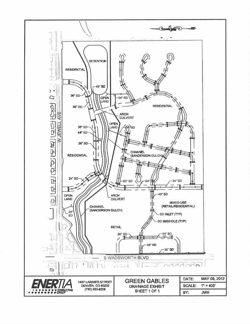
SANITARY SEWER AND DRAINAGE IMPROVEMENTS TRUNK LINE (21) SANITARY SEWER STORM SEWER DRAINJAGE/SANDERSON GULCH BRI DGES/CULVERTS DETENTICNNVATER QUALITY/OUTLET STRUCTURES
SUBTOTAL - SANITARY SEWER AND DRAINAGE IMPROVEMENTS
UTILITY RELOCATION UNDERGROUND POWER
SUBTOTAL - UTILITY I ELOCATlON
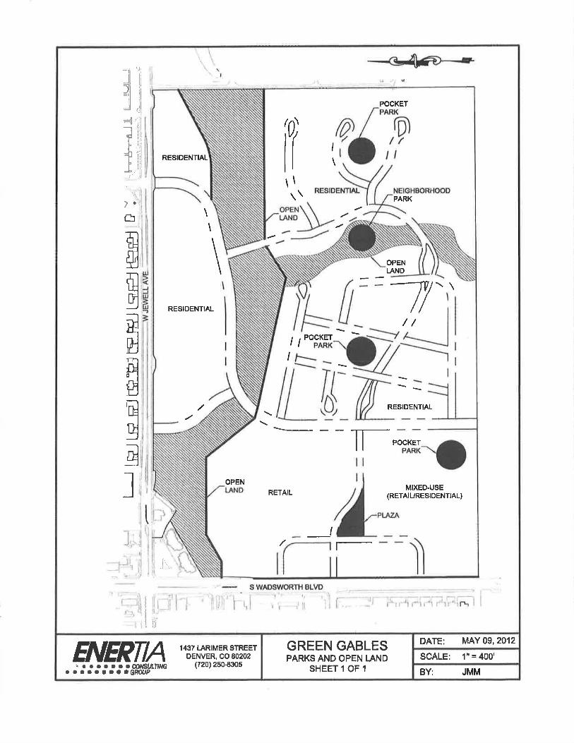
PARK & RECREATION IMPROVEMENTS OPEN LANDS AND SANDERSON GULCH NEIGHBORHOOD PARKS PLAZAS SIGNAGE & MONUMENTATION
SUBTOTAL - PARK & RECREATION IMPROVEMENTS
TOTAL
$424,619.74 $409477.32
$2,435,407.44 $837,491 01 $452,724.28 $851094.44
$6,558,257.67 $4,131,425.45
-
$386,220.00 $227,098.75 $58,917.00
$672225.75
$1805943.95 $1 L8059495
$603,201.23 $1 ,393, 445.56 $3,186. 804.78 $1,060,998.00
$959,400.00 $749685.00 -- . $7953 534
$613,032.00 $613 032.00 -..
$4,194,078.60 $3,050,080.20
$765.1 33.80 $2,14756O.00
- $idçi56,872i
$37,302,006.1 B
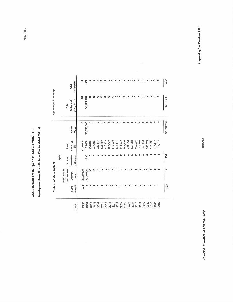
PUBLIC IMPROVEMENT COSTS! DIVISION OF COSTS: OVERALL COST ESTIMATE INCLUDES QOSTS FOR PUBLIC IMPROVEMENTS THAT ARE CUMULATIVE FOR BOTH DISTICT NO. 1 AND DISTRICT NO. 2. NOTWITHSTANDING THE COMBINED ESTIMATE OF COSTS, IT IS ANTICIPATED THERE WILL BE A GENERAL DIVISION OF SUCH COSTS AS BETWEEN DISTRICT NO. 1 AND DISTRICT NO. 2, SUCH THAT THE COSTS PAID BY EACH DISTRICT WILL SE BASED UPON ITS RELATIVE DEBT CAPACITY. ALTHOUGH RELATIVE DEBT CAPACITY OF THE DISTRICTS WILL VARY FROM TIME TO TIME, BASED UPON THE ASSUMPTIONS SET FORTH IN THE FINANCIAL PLAN AT EXH1BIT E, IT 1$ CURRENTLY ANTICIPATED DISTRICT NO. I WILL HAVE CAPACITY TO PAY FOR APPROXIMATELY 17% (OR $6,341,000) OF THE PROJECTED IMPROVEMENT COSTS AND DISTRICT NO. 2 WILL HAVE CAPACITY TO PAY FOR APPROX1MATELY 83% (OR $30,961,000) OF THE PROJECTED IMPROVEMENT COSTS.
IN PROVIDING OPINIONS OF PROBABLE CONSTRUCTION COST, THE CLIENT UNDERSTANDS THAT THE ENGINEER HAS NO CONTROL OVER COST OR THE PRICE OF LABOR, EQUIPMENT OR MATERIALS, OR OVER THE CONTRACTOR'S METHOD OF PRICING, AND THAT THE OPINIONS OF PROBABLE QONSTRUCTION COSTS PROVIDED HEREIN ARE TO BE MADE ON THE BASIS OF THE ENGINEER'S QUALIFICATIONS AND EXPERIENCE, THE ENGINEER MAPES NO WARRANTY, EXPRESSED OR IMPLIED, TO THE ACCURACY OF SUCH OPINIONS AS COMPARED TO BID OR ACTUAL COSTS
IMPROVEMENT PHASING: THE GREEN GABLES DEVELOPMENT, DUE TO ITS SIZE, PROXIMITY TO EXISITt1G INFRASTRUCTURE AND REQUIRED PUBLIC IMPROVEMENTS FOR DEVELOPMENT, IS PLANNED TO CONSTRUCT THE PUBLIC IMPROVMENTS IN A SINGLE PHASE, THE MAPS INCLUDED AS A PART OF THE PRELIMINARY ENGINEERING SURVEY IDENTIFY THE POTENTIAL LOCATION AND INFRASTRUCTURE LAYOUT OF THE PUBLIC IMPROVEMENTS. THESE MAPS ARE CONCEPTUAL AND ARE PROVIDED FOR ILLISTRATIVE PURPOSES ONLY, THE ACTUAL DESIGN, PHASING, LOCATION AND COMPLETION OF THE PUBLIC 1MPROVEMEF4TS WILL BE DETERMINED BY THE DISTRICT, IN ITS SOLE D1SCRETION, TO COINCIDE WITH THE DEVELOPMENT OF THE PROJECT, THE AVAILABILITY OF FUNDING SOURCES, AND IS SUBJECT TO RECEIPT OF ALL NECESSARY APPROVALS OF ANY GOVERNING JURISDICTION, ANY DEVIATION FROM THE PRELIMINARY ENGINEERING SURVEY SHALL NOT CONSTITUTE A MATERIAL MODIFICATION OF THE SERVICE PLAN.
ASSUMPTIONS: 1, PIERCE TO CONNECT TO THE EXISTING SIGNAL AT JEWELL AND REQUIRE MODIFICATION. 2. FULL MOVEMENT ACCESS TO WADSWORTH. 3. ROADWAY SECTIONS PER GREEN GABLES OVERALL DEVELOPMENT PLAN. 4. WET UTILITY SIZING BASED ON PHASE I MASTER REPORTS AND MAY CHANGE.
. DETENTION AND WATER QUALITY SIZING BASED ON PHASE I MASTER REPORT AND MAY CHANGE. 5. POWER RELOCATION REQUIRED DUE TO THE NECESSARY WIDENING OF WADSWORTH. 6. SANDERSON GULCH CROSSINGS ARE CONSTRUCTED WITH ARCH CULVERTS. 7. ALL PUBLIC ROADWAYS INTERNAL TO THE PROJECT BOUNDARY TO MEET JEFFERSON COUNTY STANDARDS. B. JEWELL AVENUE IMPROVEMENTS TO MEET THE CITY OF LAKEWOOD STANDARDS. 9. WADSWORTH BLVD IMPROVEMENTS TO MEET ODOT STANDARDS. 10. ALL WATER AND SEWER INFRASTRUCTURE TO MEET BANCROFT-CLOVER WATER AND SANITATION
DISTRICT STANDARDS. 11. ALL SAN DERSON GULCH IMPROVEMENTS TO MEET THE ARMY CORP OF ENGINEERS, URBAN DRAINAGE AND
FEMA STANDARDS FOR WATER QUALITY, STORMWATER DETENTION AND FLOOD CONTROL. 12, THE OVERALL COST ESTIMATE ALSO INCLUDES. BUT IS NOT LIMITED TO, EXPENSES ASSOCIATED WITH
ENGINEERING/DESIGN, TESTING/INSPECTION AND CONSTRUCTION MANAGEMENT, AS WELL AS CONTINGENCY COSTS AND ANCILLARY AND OTHER RELATED EXPENSES.
RESIDENTIAL
0
\
I RESIDENTIAL
/
11 I'
H' N
OPEN LAND
POC(ET PARK
RESIDENTIAL 1 NEIGHBORHOOD \
( PARK
/_ \\ N
i S - ____ SS
S
\SS II • OPEN (( ) H
'• •• *
- LsN9__1Lf \
Ii - - /
/L DDENTIA
H RETAIL I MIXED-USE
/ (RETAIL1RES1DENT1AL - - _ __
H - -
-- S WADSWORTH BLVD -
ENERTIA 1437 LARIMER$TREET GREEN GABLES DENVER, CO 80202 PARKS AND OPEN LAND
. ::::::: '- (720) 2508305 SHEET I OF I
DATE: MAY 09, 2012
SCALE: 1" 4001
BY: JMM
It RES1DE IT II OPEN I
L'ND I 1 IN RIOR ROADWAY \ I
(_L ZPROvEMP.NTS (TiP) JEWELL I ThMPROVEMEN'rS I
RESIDENTIAL
\\
OPEN
RESIDENTL ND
/1
// II
\ JJ_ _ _ - ________ PRCEST _________
JEWELL IMPROVEMENTS - - ________ -
OPEN
MIXED4JSE IL
/;I/:::/ (RETML/RESIOENTIAL)
LAND L INTERIOR ROADWAY
RETA - -
________ fIMPROVEMENTS P)
-I
- -. S WADSWORTH BLVD
I .
ENERTIA 1437 LRIMERSTREET GREEN GABLES J ' DENVER, CO 802&2 ROADWAY EXHIBIT
, • • , (720) 25-a305 . • • •• S S GJOUP
DATE; MAY 09, 2012
SCALE: 1"400'
HY JMM
w
L1j
11 I
21SS
OPEN 1) /" 0 LAND
8"SS / RESIDENTIA / /
21"SS B SS
8'SS
I 9Ss
RESIDENTIAL
\ fl --
RESIDENTIAL OPEN 1 I LAND / 8SS /1
21SS / I
8SS
9 ss
SEWER MANHOLE (TYP)
21' SS\ lOSS
OPEN LAND RETAIL MIXED-USE
7' (RETAILJRESIDENTIAL)
A if io'ss -J
L
SS-
ft -f1)
- - - - S WADSWORTH BLVD
AICDTIA 1437 LARIMERSTREET GREEN GABLES DATE: MAY09, 2012
,y,IIT__ DENVERCOBO202 SANITARY SEWER EXHIBIT SCALE: I' = 400 SHEETIOFI BY: JMM
7 ° i$ !Ii
-. - - S WADSWORTH BLVD 0 r',
1437 LARIMER STREET GREEN GABLES I DATE:
ENVER 0080202 DRAINAGE EXHIBIT SCALE: , •• •• , (720)250-8305 SHEET 1 OF I I
I BY:
MAY 09, 2012
1' =400'
JMM
RSDEN11AL
/ /" -8WL
12 WL—.
/ 12 WI PH (TYP)
-, / , '-12 WL -
w_- w- i -w -4
wvcrYn Th 12 WL I 1 ?WL
OPEN /___ LAND II
j / MIXEDUSE 'N. RETAIL / (RETAILJRESIDENTIAL)
p ___ , -12WL
f}2WL
S WADSWORTH BLVD
CAILbTIA 1437 L MER STREET GREEN GABLES DATE: MAY O9 2012
g' jP% DENVER, CO 90202 POTABLE WATER EXHIBIT SCALE: I' 4001 s p p • • • (720)250-8305
*SISSSSSGJIOUP SHEETIOF1 BY: JMM
EXHIBIT P-i
Will Serve Letter from Banerft-C1over Water & Sanitation District dated April 11, 2012
(0023048 1DOC v:9
BANCROFT CLOVER WATER & SANITATION DISTRICT
)
April 11,2012
Steven O'Dell USL Denver Green Gables, LLC 1800 Larimer Street, #1700 Denver, CO 80202
RE: 6802 W. Jewell Avenue, Green Gables Golf Course Property Redevelopment
Dear Mr. O'Dell,
The Bancroff-Clover Water and Sanitation District ("District") provides residential and conunercial and retail water service to lands within its boundaries pursuant to a master meter contract with Denver Water. The District's current contract with Denver Water is the Water Service Agreement (Master Meter), Distributors Contract No. MM 227, dated December 6, 1994. The District also provides sanitary sewer service to lands within its boundaries pursuant to an agreement with the Metro Waslewater Reclamation District.
It is our understanding that you intend to redevelop the Green Gables Golf Course Property, located at 6800 W. Jewell Avenue, Denver, Colorado, and described in the Special Warranty Deed, dated June 17, 2011, recorded with the Jefferson County Clerk and Recorder, Reception No, 2011057354 ("Property"). The Property is within Denver Water's Combined Service Area and the service area of the Metro Wastewater Reclamation District. The entire Property baa been included and is within the District's boundaries as sbo i on Figure A. It is also our understanding that the planned redevelopment of the Property is still evolving and may include up to 300 multi-family and 300 single family residential units, upto 225,000 square feet of com mercial e.rid/or retail space, 7 acres of special destination commercial and the redevelopment of the Property will require water service and sanitary sewer service.
The District Is willing and able to provide water service and sanitary sewer service to the redeveloped Property following certain physical improvements identified below, The District will be able to provide water service and sanitary sewer service to the Property pending the developer's extension, and possible replacement, of all onsite water distributiou and sanitary sewer collection main lines, This construction must be in accordance with. the applicable rules and regulations and
900 SOUTH WADSWORTH BOULEVARD LAKEW000, COLORADO 8022(,-4306 PfONE: 303 922l113 Mx: 303'922'6479
engmeering standards of the DIstr1c Denver Water, and the Metro Wastewater Rccbmition DistricL The relevant fees to be charged by the District are identified in the District's Schedule of Fees1 which Is available upon request. Water service and sanitary sewer service will be provided at the rates the District provides st h services to all ilinds within its boundaries.
Please contact me if you have any questions o need any information.
SncerçIy, /)
V>'cJ\ (- 7 /V "".-
David !rish' General Manager Bancroft-Clover Water and Sanitation District
EXHIBIT D-2
Resolution of Bancroft-Clover Water & Sanitation District dated June 18,2012
{0023048L00C v;9 }
RESOLUTION OF THE BOARD OF DIRECTORS OF THE
BANCROFI CLOVER WATER AND SANITATION DISTRICT
A RESOLUTION CONSENTING TO THE 1ROVISION BY GREEN GABLES METROPOLITAN DISTRJCTNOS. 1 AND 2 OF CERTAIN LIMITED WATER AND SANITARY SEWER SERVICES
WITHIN THE I3OUNDARIES OF BANOROFT CLOVER WATER AND SANITATION DISTRICT
WHEREAS, Bancroft Clover Water and Sanitation District ("Bancroft") is a cjuasi-municipal corporation and political subdivision of the State of Colorado operating under Article I of Title 32, C,R,S.; and
WHEREAS, Section 32-1-107(2), C.R,S. provides that no special district may be organized wholly or partly within an existing special district providing the same service; and
WHEREAS, Section 32-l-107(3)(b)(IV), C.R.S., provides that an overlapping special district may he authorized to provide the same service as the existing special district if, among other requirements, the board of directors for the existing special district consents to the overlapping special district providing the same service; and
WHEREAS, upon organization of the proposed Green Gables Metropolitan District Nos 1 and 2 (the 'Green Gables Districts"), the boundaries of the Green Gables Districts and Bancrort will ovei'Iap; and
WHEREAS, l3aucroft has received a request from the proponents of the Green Gables Districts to consent to the overlap of the Green Gables Districts over certain property located within the boundaries of Bancroft pursuant to Section 32-I-107(3)(b)(IV), C.R,S,; and
wHEREAS, the Green Gables Districts will have and exercise only limited powers with regard to the design, IThancing and construction of public water and sanitary sewer infrastructure; and
WHEREAS, Bancrofr will consent to an overlap of public water and sanitary sewer powers within the boundaries of l3ancrft by the Green Gables Districts for the purpose of designing, financing and construction of public water and sanitary sewer facilities upon the terms and conditions hereinafter set forth.
NOW, THE FORE, BE IT RESOLVEL) by the Board of Directors of Bancroft Clover Water and Sanitation District, County of Jefferson, State of Colorado, that:
Bancroft hereby consents to the overlapping of the proposed Green Gables Metropolitan District Nos. I and 2, and to such Green Gables Districts possessing certain authority to design, finance and construct public water and sanitary sewer facilities within their proposed boundaries subject to the following conditions:
The Service Plan of the Green Gables Districts approved by the governing body of Jefferson County, Colorado must contain sub-sections (a) - ( below:
a. The improvements to be financed, designed, acquired or constructed by the Green Gables Districts may not duplicate or inter fei'e with any and all other improvements or facilities existing or planned to be constructed by Bancroft without the written consent of Banroti..
b. All public potable water and sanitary sewer improvements to be constructed by the Green Gables Districts shall be constructed to any and all standards and specifications of Bancioft. Plans and designs for construction shall be submitted to Bancroft for review and approval prior to construction; construction shall be subject to inspection by ancroft oi' its authorized representatives and Bancroft shall not be obligated to accept a conveyance of or provide service through any public water or sanitary sewer facilities that have not been constructed in accordance with this paragraph and all other applicable provisions of the Bancrofi Rules and Regulations.
c. Under no circumstances and at no time shall the Green Gables Districts issue permits for the connection of water service or sanitary sewer lines to the Bancrolk facilities; charge any tap, connection or permit fees or levy or collect any potable water or sanitary sewer service fees or charges for the Bancroft facilities, whatsoever.
d. The powers of the Green Gables Districts with respect to potable water and sanitary sewer services shall be limited to the design, tiianeing, acquisition and eonstruotion of public water and sanitary sewer facilities and the conveyance of such facilities to Bancroft as required by th Bancroft Rules and Regulations. The Green Gables Districts may construct, acquire, operate and maintain a non-potable irrigation system only within their boundaries and only upon approval of Denver Water, Bancroft shall not be responsible for any aspect of a non-potable irrigation system.
e. Once the construction of the public potable water and sanitary sewer infrastructure to be dedicated to Baneroft is completed, the Green Gables Districts shall convey such infrastructure to Bancroft free and clear of all liens and encumbrances. Upon such conveyance the Green Gables Districts shall not have or exercise any further powers that are, by slatutc, exercisable by Banc.roft except as expressly provided herein.
I 'I he Qveen Gables Districts shall be subject to any and all rules and regulations of Baneroft with regard to any and all potable water and sanitary sewer related construction.
g. The proponents of the Green Gables Districts shall promptly, upon demand, reimburse Bancroft for all reasonable costs and expenses inculTed in
2
connection with the preparation and adoption of this Resolution and its activities in connection with the administration and enforcement of the provisions hereof
h. If l3ancroft is aggrieved by a breach or violation of the above limitations as set forth in the Service Plan of the Green Gables Districts as a condition of this Resolution shall be entitled to injunctive relief and, if applicable, to monetary damages and an award of attorneys fees and court costs reasonably incurred in obtaining a cessation of or remedying any such breach or violation except where Bancroft has expressly consented in writing to such action being taken.
2. Granting of this consent by Bancroft is expressly conditioned on compliance with the conditions stated herein. Failure by the Green Gables DIstricts to comply with the express conditions slated herein shall nulli' the consent of Bancroi to the formation and overlap of the Green Gables Districts. The Green Qables Districts shall provide a written copy of the draft Service Plan for the Districts to Bancroft upon filing of same with Jefferson County pursuant to § 32-1-202(1 )(a), C.R,S.
Dated this 18th day of June, 2012.
EANCROFT CLOVER WATER AND SANITATION DISTRICT
By: 2 President
A'I'TEST:
I// 4 ntUry T - . ., v
N
0
0, '9 0.
I
E
'4
0000 '941•-. 44514)0 10 00) = 10*5 *5 *5*5 NC) *5 P. 03 *5 N.0 0)
U? 40 00. ••. *5*5=0303_. U)*5*5 *5 N. 00 0NOU)NI0*51 ) 145 01 P-
*5*50*500000 NNNNNNNO)0)C) NNNNNO0)104040*50)N*5s)*5'9))4)40 ,0)400))I3 p
Bs .
'9
C)
N '0 0) '94 0) '9) — c) 40 '9 N *5 '9-
10
. P 0: .N N *5 N' N'9 I45 0) O '9'. e r- NO o o N U) c.s 0) 000) o *s '9, c 0)' 14)00) 400)*5U))Or-U)U? 0 0) N*5*5*5N.*50)Q '95 10 0 *5*510*5*5U?U)0300)0)0904O)0) 0)0)45) 0000r.?0'-. *5
0)
U 0.
o o 0 4)4 40 0) 10 0 0) N. *5 N '94 05 N *5 *5 14) 0) 0) U) Cl (0 0) 0) 0) N
ID *5
0) *5*5(0*5*510*510*545)Q)*5*50)0)010)0)*5 0000OC), 0) 0)
*5U)(. U) 00000(OU)U5(fl *5 U) U) 0OOOU)*5(fl*5
00000 . s - ggggSgggggggggg
0. O 0 . 0 . 00OO.O.
CO '90 4)) tO N N N Np.) N N N CS N N N N p.) N 0)0)0) N C.) NP) 1)4
445 0) 0 *5l4)*5N*5*50Q.-N05 U) N*50)0) N40U05*50 10
451 1') '9-
CS
O*5(0NN 0'0)*5C1D0> NU?I45U)O *5 N. 0NID10N C) '90 *5 40 10 N*5ON*5*5OP*5O0ON40*5O0 10 0) O.N40.CUS*5O N. N.*5U?*5*5*5*5<010 *5*5 o*5*5*50)o*5*5q Q. -.
N
Cl) 414 N. U) 14) 40 Is) U) Is) UI VS IL) U) U) In U) U) Il) 43 4) U) U) I)) IL) U) U) U) U) 01
U) I)
4) 0 0 '9- 49 '4) N- 0 ('3 10 03 1') P. 01 '9) '1 *5 0 10 0) - U) *5 ' U) CO
- N- S ' ' C). NNNNNNNNNNNNNNNNNNNNNNNNNN'
9 '9) 0)
40 0) 4') , . O(0N*50),*5*5NI0040*5 445 *5 P)*5.*50)NN-010 19 *5 *5,
0 40 *5.-N'0N-*5NNNU)0--NN40'0t-*5NU?*5NU)* 5 O'9 *5 *5
4)( 00,0)N-O)9'-'*5O)N. fl 0)' 0 Q0)OC'I0)01N0)0 Q11 N CO
*5 00)19004 *5 40 0*51450) 0 *5 0 , 10 '9 ON-N0U?N*5ON'9N '. 0*50) 0)
. °.°.
I ' 0 U) 00 00*50) O*50) 0 10 1010 145 ) 451 0)1 19*5*5) *50)0)
i °)- i p. 0) U) *5 145 0) 10
)DIPIPIPONN.NNC' CI) 0) 4'> *5 0)
I I') 0) 10 <'2 1') I Q ,., 00 O00C)0O0Q 0000N 0 NNNNNN NNNNNNNNN )NNNNOJNCONN NNNN
)9 0
I—
o N '3
Is (0
O B.
4 •
— 9
)!
; .
14.
18.
11
19
C I 0. .1; U.
z 0. IL,
U,
'91
0
I,
I — .4
-
!
"4
0
1' ' 5
0
[0 N
0 U) U) - - C'( N , WU)a) iO
C.)
QOS00000 Q00Q.. 0
00 do 00000000000000000000000 0 do 00 00000000 00000 00QQ000000000
C')
000000 0C.)C0000* - 0
<0
(.1 00
U) U) )U))4) r-.- oC--<0
000000')).) 000 00000 0 0)
0 0 0 0 0 0 0 0 0 0 0 0 0 0 0 0 0 0 0 0 0 0 0 0 0 0 0 0 0 0 0 0 0 0 0 0 0 0 0 0 0 0 0 0 0 0 0 0 0 0 0 0 0 0 0 0 0 0 0 0 0
U) .1) U) U) U) CC) '4) U) C)) CCC Cl) U) 4) Cl) U) Cl) U) U) '4) 1) '4) U) '4) Cl) U) Cl) C)) U) U) '4) U) 0)
'C', 40 0 'C' ' 0 0 N 0 0 .- .- .-' C.) C') 04 '.1' OC N-, N, 'd 'U, C'),
c'4 ' C' - 00 -
(.4 0'C'CAU)OO 0 ' .
N <0 CC 0 ,- N U) - U) CO N <0 CC 0 .- N C')
000 00000 0
UI N N CN <'4 0 NC C') N N 01 N 0 NC NJ N N 04 N <'4 N N) NJ N N <'4 <'4
.0,
U.
z & U)
0
U.
C) C) '4,
0
Q.
U
0
0
g uuuu
:
N
U 1 2
- e4' o, -. (4 . N N N C' N
000000
000000000000000 000000000000000
('( 't N P4 4 N N P1 P1 N (4 N N N N N A) N
• '
A
s g g
.
(4 N N N N N N P1 (4 A) A) (4
ONNNNN000000000 000000 V
N N 'V N (0 0) 0 'V N 4'. 0) A. N N
N
I
a
0
0
Lu - e O:i
E LU o
c .
En
£1. °
t) 0 - U
.E u
0
I 0
0 - U) I
.d c 1 c'
oI
H - 2 I I
I 2
€1 < I
000000000000000 H
000000000000000 1 U
U) H t'4 C'J C'4
000Ø)O)N000000000000000 U)
N: U)
U)u)U) U) U) W(DU)U)W
U) U) U) U) U) C) 0 0 0 0 0 0 0 0 0 0 0 0 0 0 U) U)
0
U) C'J )
U) c Co U) C, C) 0 0 0 0 0 0 0 0 0 0 0 0 0 0 U) U)LflU)U)U) U)
,- r r 0 00C)C) 00 N c'1 c'1 CNc'JC'J C N(N
x
C
C
I.'-
a
U
E a V
I H - p
i
a
(rJ Lu LU
- v i
°ct
fl cs a ,I c4c,
a a
a a
a a a
° a a: a a. . ' " -: a a a a. a a. a a a a a a a a a a a a a. a. a
a a a a a a a a a a a a a a a a: a: a a a a a a a a a a a V. t V. I'. V. V. Vt)
a a a a a a a a: a a a a a a: a a
C § 0 0 0 0 0 0 0 0 0 0 0 0 0 0 0 0 0 0 a
° a. a a a a a a a a a a a a a: a a a a a a a a a a a. a a a a a a a
a a a a a a a a a. a a a a a a
O 00QC00CUOOOUODC/00OCh a.
a
1
a 0
I
Q QQ
p E
§OQQOODOQOQCODOQ §
N g
§ 0 C) C) C) C) 0 0 0 0 C) C) C) C) C) C)
C)
§ & (4 N -. t
Q(4
gC)0000000000C)0000000 C)
C)
C) 00
C) 0 0 CC) CC)
N (C)
II l I I
I
4 U-
N
'p
H U- (I,
0
N
I-.
0
0
-J
0)- 2
0)
E 0)- 0
w 0)
I
0 F .') '1) 0)
0)0)0)0) co0),r - - 0' °' NN
; NO)C' Fo 0)0)o,-,-c'Je)c0 - W - 0) Q) 0)
ç R - t-
0 U) 0 0) 0 0) 0) 0 0) 0 0 0 0) 0) C' 0 0 0 U) F- 0' 0 0 0 0) 0 0) 0) 0) 0' 0 0) 0) 0 0 0
is
g
C
N
(9 CD U-
o (d
9
•1
N)0)jU7Q 0 ') 0) Q0)N.0)U)
3 0) 0) 0) 10 0) 10 10
0' 0000 o ) 0 0' Ij C0 C4
O <0 N C) N 11)
10 0)0)10 q'TU)U)<0 PN-NF-- 0) 0) 0) ,-,. ,-
0 00QQ0000Q000000000 O 1 0 0 1 0
C) ' 000OQ0O0000)00000QQ0 0
00 I 0) 0 00
000000Q00000000O0 I 1 0 0 0 0 I- <N
0))<N0) 0) N0)0)10E--.(010NU)W(0 I 0) 0 (Ø <0F0 i
U) , CO Ct) 0 1.'. 0) E N ' U) 0) 0)
U 00)0) 0'
U) <0)))
0 000 0) 00 00000'0000 CV
10) 0) '- 'tF-- 0) 0) <00) C' F00)<N0) 10 C') F- F- 0) <0 U) 0) 0) 0) 0) 0) 0 0 0 - - ,- N (N N 1')
0000)00000)00000000
11)
U)
00)O U) t , U) N 0Q 0)0)0 ' C')
00)0 000 0 0000 000 0 000 0
0 I', U)
0) 0 000)00000000)000000)0 0) 0 U) U)
00000000000000000000
C)) 1<)
(N C') (N 1') C') C') 0) 0,-N
8 0) 0 00000000
(N NNNNNN C'J C'1 CN NC'4 NNNNC")N
0
0)
0 C) 0
0
0
8 I)) U)
d Q
I
0)0)QQQQ0000)0000000 0)
0') (0
0
> 1
H ') N- 10 °Q
6 Nra60) i 0 0) 0) 0) 0) ." 0)
N. c O10 '. N. .rN.N.N-N.N.N. N. N. N. 10
0)
0000000000)0)00O00)00 °
0 0 0
1 0
I I N
0(0 U) N.
I. r
C') 6, 0>
( 3 U
U)
§ C')
0.
'
H 4I
10
o8'000000000000000>00 0
U) 0)
O000(00000000000 0> 0 0 0 0) 0 0 0) II)
(0
'.5 (0
E
E
0
U
0 0
U.
0
LJ e 0.
0.
LLi .2
0)
0 (C) C') U) 0 10 0) CC) 0) 0 0) N (0 10 -. 0) 0 CC)
N N 0)00 .C U)0) 10(00)0) N. I". (0 (0 10 0)
6,
0000 00 00 0000 000000 00)0 (0 0)
(0 N N (0 IL)
N-
(0 10
0) C') C') CC) ' '.1' 11) U) (C) CL) CL) (0 N- N- N. 0) 0) 0) 0)
(0
00000000000001000000 C 0 0) 0 0 0) 0)
C)
I: Co 0.
00)000)0QC000000 0>0> 0>
SOURCES AND USES OF FUNDS
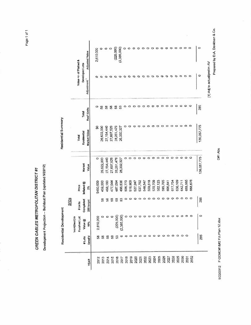
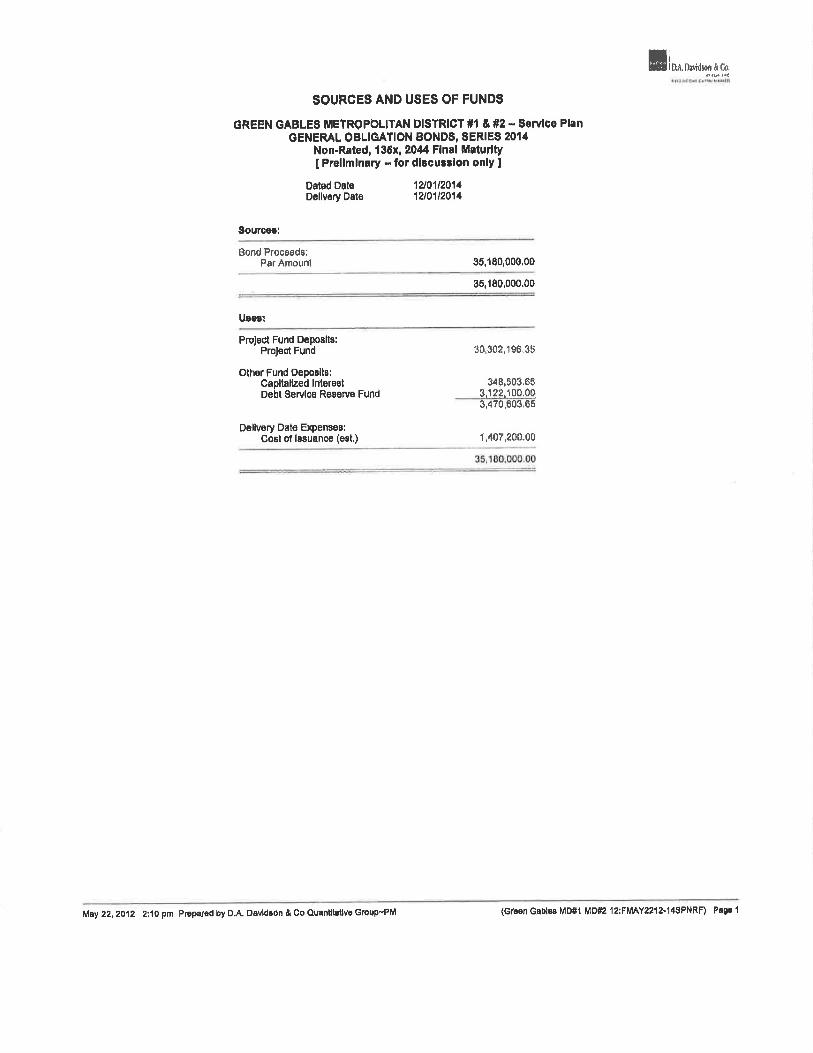
GREEN GABLES ME1ROPOUTAN DISTRICT #1  Sorvico PIrn GENERAL OBLIGATION BONDS, SERIES 2014
Non-Rated, 136x, 2044 FInal MRturlty [Preliminary - for discussion only]
Dated Date 12J01 12014 Dativery Dote 12/01 12014
Sources:
l3ond Proceeds: 3180000.00 PrAmouri - -
______ -
- 3e,180,000.00
Usas:
Project Fund Dpoatto: Project Fund
Other Fund Depoalta: Capitalized Interest Debt SaMoa ReeTva Fund
Deilvery Date Expenses: Cost of lasuance (eat) -
30302.1 96.3t5
34 8 03G5
3,470O036
I 407200M0
35,100,00000
May 22, 2012 2:10 pm Prepared by CA OeVtdROfl & Co Qventtveflve ro,pPM (Green Gables MD#1 M02 12:FMAY2Zl2l4PNRF) Pa 1
BOND SUMMARY STATISTICS
GREEN GABLES METROPOLITAN OISTRICT #1 & #2 ServIce Plan OENERAL OBLIGATION BONUS, SERIES 2014
Non-Rated, 135x, 2044 Final Maturity [PrelimInary -- for dicusIon only)
Dated Date 12101/2014 Delivery Date 12/0112014 First Coupon 06/01/2015 Lest Maturity 12/0112044
Arbitrage Yield 6.000000% True Interest Cost (TIC) 6.000000% Net interest Cost (NIC) 6.000000% All-In TIC 6.348268% Average Coupon 6.0 00000%
Average Life (years) 22.504 Duration of Issue (years) 12204
Par Amount 35,180,000.00 Bond Proceeds 35,180,000.00 Total lnlerest 47,501700.00 Net interest 47,501,700.00 Bond Years from Dated Date 791.695.000.00 Bond Years from Delivery Date 791.695,000.00 Total Debt Service 82,681,700.00 Maximum Annual Debt Service 8,280,500.00 Average Annual Debt Service 2,756,056.67
Underwriter's Fees (per $1000) Average Takedown Other Fee
Total Underwriter's Discount
Bid Pace 100.000000
Bond Component
Term Bond due 2044
Par Value + Accrued Interest + premium (Discount) - Underwriter's Discount - Cost of issuance Expense - Other Amounts
Target Value
Target Date Yield
-1,407,200.00
35.180,000.00 - 33,772,800.00
12/01/2014 12/01/2014 6.000000% 6.348266%
Average Par Ava rage Average Maturity PV of I bp
Value Price Coupon Life Date change
35,160,000.00 100.000 6.000% 22.504 06/02/2037 46,900.20
35,180,000.00 22.504 48,900.20
All-in Arbitrage TIC TIC Yield
35,180.000.00 35,180,000.00 35,160,000.00
35,180,000.00
12/01/2014 6.000000%
May22, 2012 2:10 pm Prepared byOA. Davidson&CoQuan5tativeGroup-PM (Green Gables MD#1 MD#2 12:FMAY2212-14SPNRF> Page2
i DA. Dithon&Co.
BOND DEBT SERVICE
GREEN GABLES METROPOLITAN DISTRICT #1 & #2 - Service Plan GENERAL OBLIGATION BONDS, SERIES 2014
Non-Rated l3Sx, 2044 Ftnal Maturity [ Preliminary --for dl8cussIon only]
Annual
Parlod O8bt Debt
EndlrlØ PrInOlpal Coupon lnt$r$$I $8rvlce 89rVl09
06/0112015 1 055,400 1.055,400 12101/2015 1,055,400 1,056,400 2,110,800
06/01/2018 1,055,400 1,065,400 12/01/2018 1.055,400 1 055.400 2,110,800
05/0112017 1.055,400 1,055,400 12/01/2017 1,055,400 1,055,400 2,110,800
08/01/2018 1.055,400 1,065,400 12101/2018 205,000 8,000% 1,056,400 1,260,400 2,315,800
08101/2019 1,049250 1,049,250
1210112019 285,000 6,000% 1,049,250 1,334,250 2,383.500
06/01/2020 1,040,700 1,040,700 12/01/2020 335,000 6000% 1,040,700 1.375,700 2,418,400 06/01/2021 1,030,650 1,030.850 12/01/2021 375,000 6.000% 1.030.650 1,406.860 2,436,300
06/01/2022 1.019.400 1.019,400
12/01/2022 425,000 6,000% 1.019,400 1,444,400 2.463,800
06/0l/2023 1,006,650 1,006,650 12/01/2023 470,000 8,000% 1.006.660 1,478,650 2,483,300
08/01/2024 992.850 992,550 12/01/2024 530,000 6.000% 992.550 1.522,550 2,515.100
06/01/2025 976,860 978,650
12/01/2025 585.000 6000% 978,600 1,681,850 2.538.300
06/01/2026 959,100 959,100 12/01/2026 650,000 6.000% 959.100 1,609.100 2,568.200
06/01/2027 939,600 939,600 12/01/2027 710.000 6.000% 939,600 1,649,600 2,580,200
06/01/2028 918,300 118.300
12/01/2028 785.000 6.000% 918,300 1,703,300 2,621,600
06/01/2029 894,750 894,700 12/01/2029 860,000 6,000% 894,750 1.744,750 2,839,500
05/01/2030 889,250 889,250
12/01/2030 940,000 8,000% 659,250 1,809250 2.678,500
06/01/2031 841,050 841,050
12/01/2031 1,015,000 6.000% 841.050 1,856,050 2,697,100
08/01/2032 810,600 610,800
12101/2032 1,110.000 8.000% 810,600 1.920,500 2,731,200
06/01/2033 777,300 777,300
12/01/2033 1,200,000 8,000% 777,300 1,977,300 2,754,600
06/01/2034 741,300 741,300
12/01/2034 1,305,000 6.00014 741.300 2.046,300 2,757.600
06/01/2035 702.1 50 702.150 12/01/2035 1,405,000 6,000"/o 702.150 2,107,150 2,809,300
08/01/2038 860,000 660,000
12/01/2035 1,525.000 6000% 660,000 2,185,000 2,845,000
08101/2037 814.260 614,250
12/01/2037 1,840,000 6.000% 614.260 2,254,250 2.688.500
06/01/2036 565.050 555,050
12/0112036 1,776.000 8.000% 565,050 2,340,050 2,905.100
06/01/2039 511,800 611,800 12/01/2039 1,900,000 6.000% 511,800 2,411.800 2,923,600 06/01/2040 454,800 464.800 12101/2040 2.055,000 6.000% 454,800 2.509,800 2,964,600
08/01/2041 393,150 393.160 12/01/2041 2,200,000 8.000% 393,150 2,693,150 2,086.300
06/01/2042 327.150 327.150 12/01/2042 2,370,000 5.000% 327.150 2,697.150 3,024,300
06/01/2043 255.050 258.050 12/01/2043 2.810,000 8.000% 256,060 2,886,050 3,122.100
08/01/2044 177,750 1/7.750
12/01/2044 5,925,000 6,000% 177.750 6,102,750 6,280,600
- 35,180,000 - 47,801,700 62,681,700 62,501,700
May 22,2012 2:10 pm Prepared by D.A. Davdon & Co Quantitative Group-'PM (Green Gab1s M0#1 MD#2 12:FMAY2212-14SPNRF) Page 3
0A.Da#thon& .
NET DEBT SERVICE
GREEN GABLES METROPOLITAlJ DISTRICT #1 & #2-- Servioe Plan GENERAL OBLIGATION BONDS, SERIES 2014
Non-Ratad 13&x r 2044 FInal MaturIty [Preliminary --fordlsussIon only)
Total Debt Service CapItalized Interest Debt Service Reserve Fund Interest
-351,800
Period EndIn9
12/01/2015 12/01/2016 12/01/2017 12101/2018 12/0112019 12/01/2020 12/01/202 1 12/01/2022 12/01/2023 12/01/2024 12/0112025 12/01/2026 12/0112027 12/01/2028 12/01/2029 12/01 /2030 12/01/2031 12/01/2032 12/01/2033 12/01/2034 12/01/2035 12/01/2036 12/01/2037 12/01/2038 12/01/2039 12/01/2040 12/01/2041 12/01/2042 12/01/2043 I 2/01/2044
PrncIpaI
205,000 285,000 335,000 375,000 425,000 470.000 530,000 585,000 650,000 710,000 785,000 850,000 940,000
1,016,000 1,110,000 1,200,000 1,305,000 1,405,000 1,525,000 1,640,000 1,775,000 1,900,000 2,055,000 2,200,000 2,370,000 2,610,000 5,925,000
2,110.600 2,110,800 2,110,800 2,110,600 2,098.500 2,081,400 2,061,300 2,038,800 2,013,300 1,985,100 1,953,300 tO 18,200 1,879,200 1,836,600 1,789,500 1,738,500 1,682,100 1,821,200 1,554,600 1,482,600 1,404,300 1,320,000 1,226,500 1.130,100 1,023,600
909.600 786,300 654,300 512,100 355,500
2.110.800 2,110,800 2.110.800 2,315,800 2,383.500 2,416,400 2,436,300 2,463,800 2,483,300 2.515,100 2,538,300 2,568.200 2,589,200 2,621,600 2,839,500 2,678,500 2,697.100 2,731,200 2,754,600 2,787,600 2,809,300 2,845,000 2,888,500 2,905,100 2,923,600 2,964,600 2.986.300 3,024,300 3,122,100 6,280,500
-3,122.10 -6,244.20 -5,244.20 -6,244.20 -6,244.20 -6,244.20 -8.244.20 -6,244.20 -6,244.20 -6,244.20 -0,244.20 -6,244.20 -6,244.20 -6,244.20 -6.244.20 -6,244.20 -6,244.20 -6,244.20 -6,244.20 -6,244.20 -8.244.20 -6.244.20 -6,244.20 -6,244.20 -6,244.20 -6,244.20 -6.244,20 -6,244.20 -6,244.20
-3,128,344.20
Net Debt Service
1,755,877.90 2,104,555.80 2,104.555.80 2,309,555.80 2,377,255.80 2,410,155.80 2,430,055.80 2,457,555.80 2,477,055.80 2,508,855.80 2,532,055.80 2,561.955.80 2,582.955.80 2,615,355.80 2,633,255.80 2.672.255.80 2.690.855.80 2,724,955.60 2,748,355.80 2,781,355.80 2,803,055.80 2,838,755.80 2,862,255.80 2,898.855.80 2,917,355.80 2,958,355.80 2,980,055.80 3,018,055.80 3.115.855.80 3.152.155.80
35,180,000 47,501,700 82,881,70 -3,306,303.90 -351.800 79,023,596.10
May 22, 2012 2:10 pm Prep5red by GA. Davidson & Co QuOitdative Group—PM (Green Gables MD#1 MD#2 12:FMAY2212-14SP1IRF) Pa9e 4
SOURCES AND USES OF UND$
GREEN GABLES METROPOLITAN DISTRICT #1 & #2 -- Serv1e Plan SUBORDINATE UONDS, SERIES 2014B
Non .Rted, Gonvoilibie CABS 2044 Flnl Maturfly [PruJiminary -- fOr discussion only
Dated Date 12f112O14 Delivery Dete 1211e12014
ourcee:
Bond Pr ecia: Par Amount
Project Fund Depeit3: Project F d
7142085.00
00
8$90811.70
Diivery Date Expenees; Coat of iaeuance (eat.) 142.85330
71426B500
My 22, 2012 2:11 pm reperad by D.A. OavIdon &Co Quanftthtfve Dcvup-PM (Gsari ble6 Mr)#1 MD#2 2:FMAY2212-14SCC5F) Page I
D.A.D d/on&Co,
CONVERTIBLE CAB DEBT SERVICE
GREEN GABLES METROPOLITAN DISTRICT #1 & #2 -- Service Plan SUBORDINATE BONDS, SERIES 20148
Non-Rated, Convertible CABS, 2044 FInal Maturity (Prelimulary --for discussIon only]
Date
12/15/2018 12/15/2019 12/15(2020 12115/2021 1 2/16/2022 12/16/2023 12)15/2024 12/15/2025 12/1612026 12/15/2027 12(15/2028 12/15/2029 12/15/2030 12(15)2031 12/15/2032 12/15/2033 12/15/2034 12/15/2035 12/1 6/2036 12/15/2037 12/15/2038 12/15/2038 12/15/2040 12)15/2041 12/15/2042 12/15/2043 12/1 5/2044
Amount at ie ue
3,860.90 11,582.7/.) 15,443.60 30.68720 34,740.10 46.330. 80 54,052.60 69.498,20 81.07890 96,522.50
111,966,10 127,409.70 146,714.20 169,870.60 168,184.10 216,210,40 243,238,70 274,123.90 305.01 1.10 339,759.20 378.306 20 420,83810 467,16890 621,221.50 690,717.70
2,195,852 10
7,142.665,00
A rste d Total Value Amount At Maturity -
1,139.10 5.000,00 3,417.30 18,000.00 4,856.40 20,000.00 9,112.60 40,000.00
10,251 90 45,000.00 13,669.20 60.000.00 15,047.40 70,000.00 20,503.80 90,000.00 23,921.10 105,00000 26,477.50 125,000.00 33,033.90 146,000.00 37,590 30 156,000.00 43,285.80 190,000.00 50,120.40 220,000.00 65,815,90 245,000.00 63,789.60 280,000.00 71,783.30 315. 000,00 80,876.10 355,000.00 89,988.90 395.00000
100,240.60 440,000.00 111,631.80 480,000.00 124,161.90 545,000.00 137,831.10 505,000.00 153,778.50 675.00000 174,282.30 765,000.00 848,147.90 2,845,00000
2,107,335.00 9,250,000.00
GU rront ntereet after
Conversion Date
532,600,00 832,600.00 832,05000 830,700.00 828,900.00 825,300.00 821,250.00 815,850.00 809,550.00 801,450.00 792.00000 780.750 00 767,700.00 752,850,00 735,750.00 715,950,00 693,900.00 868,700.00 640,350.00 608,400.00 572,850.00 533,25000 469,150,00 440,100,00 385,650.00 324,90000 258.05000
18,388.350.00
Anniiai Debt Debt Service ServicO
832,500 00 - 832.600,00 837,500.00 837,500.00 847,050.00 847,06000 850,700.00 860,70000 868,000.00 668,80000 670,300.00 870,300.00 681,260.00 881,250.00 885,850.00 886,850.00 899,550.00 899,550.00 906,460.00 005.450,00 917.000 00 917,000.00 925,750.00 925,750.00 032,700.00 932,700.00 842,850.00 942,850.00 855,750.00 955,760.00 060,960.00 960,950.00 973,900.00 973,900.00 983,700.00 983,700.00 995,35000 985,350.00
1.003,400.00 1,003,400.00 1,012.85000 1,012,65000 1.023,26000 1.023,260.00 1,034,150.00 1,034,150.00 1,045,100.00 1,045,10000 1.060,65000 1.060,65000 1.089.90000 1,089,90000 3.101.050.00 3,101,05000
27,638,350.00 27.638,35000
Yield to Converuion/
Interest Rate from
Conversion Date
9.000% 9.000% 9.000% 9,000% 9 .009% 9.000% 9.000% 9. 000% 9.000% 0.0006'o 9.000% 9.000% 9.000% 9.000% 9.000% 9000% 9.000% 9.000% 9. 000% 9.000% 9.000% 9.000'Yo 9.000% 9 000°/o 9.000% 9.000%
May 22. 2012 2:11 pm Prepared by GA. Davidson & Co Quantitetive Group'-PM (Green Gobles MD#1 61082 12:FMAY22I2-I4SCC8F) Pane 2
BOND AOCRETED VALUE TABLE
GREEN GABLES METROPOLITAN DISTRICT #1 & #2 .. Sarvlce Plan SUBORDINATE BONDS, SERIES 2014B
Non-Ratod Convertlbla CABS, 2044 InaI Maturity [Preliminary - for dIsculOfl only]
Date
12/15/2014 12/15/2015 12115/2016 12/15/2017
CCA due 2044 9%
3,860.00 4,208.35 4,587.15 5,000.00
N
May 22, 2012 211 pm Prep by DA. 0avdson & Ca QuaLatIve GroupPM Gnan Gabloa M0#1 M02 12FMAY2212-14SCCRF) Pa9e 3
EXhIBIT F
Overlapping Mill Levies, Estimate of Total Taxes, Mill Levy Comparisons, and Overlapping Indebtedness
MIII Levies of All Taxing Entities within the Initial District Boundary
Taxing Entity Mill Levy (based on 2011 taxes payable in 2012)
Jefferson County 26.092 mills
School District 48.721 mills
Law Enforcement Authority - 3,200 mills
Urban Drainage and Flood Control District 0.566 mills
Urban Drainage and Flood Control District - South 0.057 mills Platte
West Metro Fire Protection Dist 13.774 mills
Total Overlapping Mill Levies 92,41 mills
Estiniate of Total Taxes that Can be Expected by a Resident of the Proposed District
Taxing Entity MIII Levy (based on 2011 taxes payabLe in 2012)
Jefferson County
School District
Law Enforcement Authority
Urban Drainage and Flood Control District
Urban Drainage and Flood Control District —South Platte
West Metro Fire Protection District
Green Gables Metropolitan District NQ. 1
Total Mill Levy Imposed in Proposed District
26.092 mills
48.721 mills
3200 mills
0.566 mills
0,057 mills
13.774 mills
65.000 mills
157.41 mills
{0023048 [.DOC v;9
Example of 110w Taxes are Calculated:
Based on the estimate of the total mill levy to be imposed in the proposed District (including all overlapping taxing entities), the following chart shows the calculation of taxes for the proposed District.
Example Tax Calculation for Proposed District
Property Actual Assessment Assessed Value MIII Ievy Mill Rater Amount of -
Type Value 1 Ratio (AV) (M) District Tsx Due (V) (R) fVxRAV1 [AV M)
Residential $450,000 7,96% $35,820 157.4] 0.15741 $5,638.42
TTi.cd or th o fTh anc i a l plan assumption ofresidenal market value Roth mill is equal to 1/1000' ofa dollar
* TIlE AI3OVE EXAMPLE IS PROVIDED SOLELY FOR THE PURPOSE OF ILLUSTRATION AND IS NOT TO E tNTERPRETED AS A REPRESENTATION OF ANY ACTUAL CURREN1 OR PUTURE VALUE lNCIl,JD1NO, EUT NOT LIMITED TO, ANY ACTUAL VALUE, ASSESSMENT RATIO, OR MILL LEVY.
Mill Levy Comparisons for Similarly Situated Rcs,deuinil Metropolitan Districts
- - - Solterra Belmar Candelas Whispering Green Gables
Creek
Non-District 112.175 99.641 98.209 99.556 92.410
Mills
Metropolitan 30.000 25.000 70.000 ,o6d 65.000
District Mills
Total Mill Levy 142.175 124641 168.209 I 161.556 157.410
{00230481.DOC v:9 I
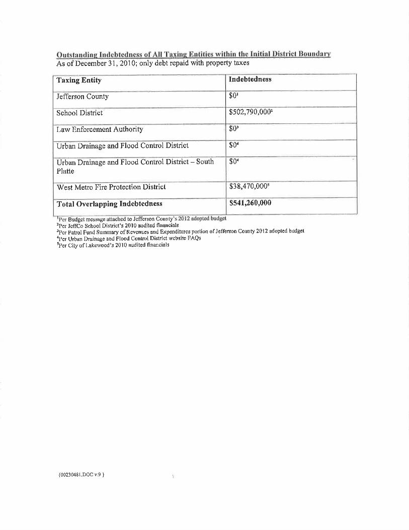
Outstanding Indcblcdncss of All 'laxitig Entities within the Initial l)ist rid J3tindary As of December 31, 2010; only debt repaid with property taxes
Taxing Entity - Indebtedness
Jefferson County
School District $502,790,0002
Law Enforcement Authority $O
Uran Drainage and Flood Control District $Q4
Jrban Drainage and Flood Control District - South $0 'latte
West Metro Fire Protection District $38,47O,000 -
Total Overlapping Indebtedness $541,260,000
' d incsiage attached to Jefferson Countys 2012 adopted budget 2}er JcffCo School District's 20] 0 audited fmaneials 3Fcr }>atrol Fund Summary of Revenues arid Expenditures portion of Jefferson County 2012 adopted budget 4Per Urban Drainage and Flood Control District website FAQs 5Fer City of Lakewood's 2010 audited financials
(002J0481.DQCV:9 }
EXHIEIT G
Consultant Information
Deve1op USL Denver Green Gables LLC 1800 Larimer Street, Suite 1700 Denver, CC 80202 Pb: 303-260-4404
District Legal Counsel MoGeady Sisneros, P.C. 450 B. 17 Ave., Suite 400 Denver, CO 80203-1214 Ph,: 303-592-4380
Investment Banker D.A. Davidson & Co. 1600 Broadway, Suite 1100 Denver, Co 80202 Ph,: 303-764-5768
Engine Enertia Consuiting Group, LLC 1437 Larimer Street Denver, CO 80202 Ph: 303-875-7131
Market Analyst THK Associates, mc. 2953 S. Peoria St., Suite 101 Aurora, CO 80014 Ph: 303-770-7201
OO23)4LDOC :) }