15
GOES-R Ground Segment Product Readiness & Operations (Science Algorithms & Products) Heather Kilcoyne

GOES-R Ground Segment Product Readiness & Operations
(Science Algorithms & Products)
Heather Kilcoyne

Outline
• GOES-R Launch
• Algorithm Development and Cal/Val Organization
• Cal/Val Program
• Data Distribution and Access
• Readiness Activities

3
GOESGOES--R LaunchR Launch
• GOES-R launches in March 2016
• Launch and orbit raising: 12 days
• Level 1b products will be validated during Post Launch Test (six months) and will be available through GOES-R Rebroadcast (GRB) service as products are certified
• Level 2+ product certification begins after L1b products and will be distributed on a product-by-product basis as they mature
• GOES-16 extended validation: Sept 2016 – March 2017
• GOES-16 operational: March 2017 at TBD orbit location
From G. Mandt NSC presentation 4/28/15

Product Readiness & Operations Team
Product Operations Manager “OSPO DOM”
Matt Seybold (OSPO) Deputy – Heather Kilcoyne (Program)
Alg & Product Development Lead
Satya Kalluri (OSGS)
Product Quality Lead
Heather Kilcoyne (Program)
Product Operations Lead (includes Cal/Val L2+) “PAL”
Wayne MacKenzie (OSPO)
Direct Readout Payload Services (GRB, HRIT/EMWIN) “PAL”
TBD NOAA Fed (OSPO)
User Services
TBD NOAA Fed (OSPO)
Cal/Val L2+ Support
TBD Contractor
Cal/Val L1
Bob Iacovazzi
L1 Cal Tools
Dave Pogorzala
Dev Support
Randy Race
Objectives Served • Unifies algorithm readiness and ops activities and SMEs in a single team • Aligns product maturity phases under appropriate government leads (dev
under OSGS, quality under Program, ops under OSPO) • Structure persists through all phases of program and algorithm maturity
GOES-R Assets
Chairmanship ARB Pre-Product Handover: Program delegates to Satya as chair ARB Post-Product Handover: OSPO delegates to Matt as chair AIRAT (Alg IR Action Team): Product Quality to Heather as chair
Cal/Val L1
TBD Contractor
Dev I&T
Harris
Non-GOES-R Assets
CWG
Fred Wu (STAR)
AWG
Jaime Daniels (STAR)
GRB Simulators
Harris IT Services
Interfaces with External (Non-GOES-R) Assets
NESDIS NESDIS
GOES-R Program GOES-R Program

• Goal of the Cal/Val Program is to have Provisional L1b (and CMI) and Beta L2 data
products at the Operations Handover to be held about 6 months post-launch
– Provisional = Ready for users to assess in their applications for operational use
– Beta = Product is minimally validated and may contain significant errors
• Calibration Working Group (CWG) will conduct Post-Launch Performance Tests to
calibrate and validate the L1B data products
– CWG will identify, report and collaborate with instrument vendors to resolve
issues with ground segment algorithms
– CWG will modify calibration tables as needed
• Algorithm Working Group (AWG) will also perform post-launch analyses to
calibrate and validated the L2 data products
– AWG will identify, report, and resolve issues with ground segment algorithms.
– AWG will modify configuration tables as needed.
GOES-R Calibration/Validation Program
5
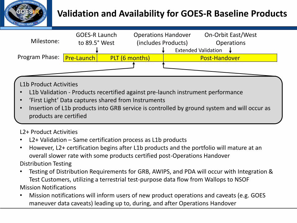
GOES-R Launch to 89.5° West Milestone:
Program Phase: Pre-Launch PLT (6 months) Post-Handover
Validation and Availability for GOES-R Baseline Products
Operations Handover (includes Products)
On-Orbit East/West Operations
Extended Validation
L1b Product Activities • L1b Validation - Products recertified against pre-launch instrument performance • ‘First Light’ Data captures shared from Instruments • Insertion of L1b products into GRB service is controlled by ground system and will occur as
products are certified
L2+ Product Activities • L2+ Validation – Same certification process as L1b products • However, L2+ certification begins after L1b products and the portfolio will mature at an
overall slower rate with some products certified post-Operations Handover Distribution Testing • Testing of Distribution Requirements for GRB, AWIPS, and PDA will occur with Integration &
Test Customers, utilizing a terrestrial test-purpose data flow from Wallops to NSOF Mission Notifications • Mission notifications will inform users of new product operations and caveats (e.g. GOES
maneuver data caveats) leading up to, during, and after Operations Handover

• Operational Software
– Operational software for the L2 data products has been made available to STAR through access to the Ground Configuration Management system, and STAR will provide Delivered Algorithm Packages with any necessary algorithm changes to be implemented on the operational system via the Ground Contractor.
– Operational software for the L1b data products is available to the CWG, though funding has not been provided for facilities to run the software offline.
• Data Access
– CWG may access L0 through the Level Zero Storage System (LZSS) at WCDAS remotely
– CWG may access L1b data from the NSOF/WCDAS Development Environments (DEs) from the NSOF (secured area)
– AWG may access L2 data from the DE at the NSOF (not as secure area)
– STAR will also access the L1b and L2 from PDA
• DE will be for anomaly resolution and diagnostic data not distributed over PDA
Data Distribution and Access

GOES-R Distribution to Users
Raw Data, GRB
Raw Data,GRB
AWIPS
Sectorized CMI
Primary
Processing
Product
Distribution &
Access (PDA)
Product
Users
Products
Backup
Processing
GRB
Product Generation
- L0 - L1b (+GLM) - GRB - Recover L1b - L2+ CMI
Mission
Management
- TT&C
Enterprise
Management
- Monitor
- Supervise
Product
Distribution
- Format
- Sectorize
- Distribute
L0 Pkt,GRB
Product
Generation
- Recover L1b
- L2+
Mission
Management
- TT&C
Enterprise
Management
- Monitor
- Supervise
Product
Distribution
- Format
- DistributeL1b,L2+
L1b, L2+
NSOF
Raw Data,GRB,TLM
Sectorized CMI
Product Generation
- L0 - L1b (+GLM) - GRB - Recover L1b - L2+ CMI
Mission
Management
- TT&C
Enterprise
Management
- Monitor
- Supervise
Product
Distribution
- Format
- Sectorize
- DistributeL0, L1b,
L2+GLM, L2+ CMI
WCDAS
GRB
L0 Pkt, GRB
Raw Data, GRB, TLM
Physical Security
Boundary
TLM
TLM
AncillaryData
GOES-R
GOES-S
GRB
GRB
GRB
GRB,CMD
GRB,CMD
CMDCMD
Antenna
System
Antenna
System
Antenna
System
RBU
GRBGRB
CMI: Cloud and Moisture Imagery (non-sectorized)L2+: excludes sectorized CMI
CMDTLM
CMDTLM
L0, L1b,L2+
GLM,L2+ CMI
Backup
Ground
Processing
External
Systems
Primary
Ground
Processing
GOES-R
Site
External to
Core GS
Government
Furnished
Property
GOES-R
Functionality
CLASS
Product Distribution
Product Generation
Product Users
Other GRB Receivers - NWS Centers - NWS WFOs - Non-NOAA Users
GRB
N-WAVE
ANCF BNCF
L1b/ L2+
SBN AWIPS
N-WAVE
ANCF BNCF
SBN AWIPS
Other Payload Services - SARSAT - HRIT/EMWIN - DCS
8

SOZ
SOZ DMZ
PPZ
Edge
SSD (NOAA 5050)
NSD (NOAA 5045)
RBU NSOF WCDAS
OE ITE DE
IS
AS IFDS
IS
IS
MM
IS
EM
PG*
PD*
OE ITE DE IS
OE ITE DE
IS
MM
IS
OE ITE DE
IS IS
AS IFDS
IS
IS
MM
IS
EM
MM
IS
EM
OE ITE DE IS IS
OE ITE DE
IS
MM
IS
MM
IS
OE ITE DE
IS IS
AS IFDS
IS
IS
AS
MM
IS
EM
PG*
PD*
MM
IS
EM
PG*
PD*
OE ITE DE IS IS
OE ITE DE
IS
MM
IS
MM
IS
P-to-P
TFRS TFRS TFRS
P-to-P
P-to-P P-to-P NWave
(AWIPS, P-to-P BU) NWave
(AWIPS, P-to-P BU)
OE ITE DE
IS IS
IS
IS
EM
PG**
PD**
IS
EM
PG**
PD**
NWave (P-to-P BU)
ANCF
AWIPS
BNCF
TNCF
ANCF
AWIPS
BNCF
TNCF
IS
AS
MM
IS
EM
PG*
PD*
PDA
GAS, ADRS
P-ITE
IS
IS
EM
PG**
PD**
SGC SGC SGC SGC SGC SGC
SGC SGC SGC SGC SGC SGC SGC SGC
SGC SGC SGC SGC SGC SGC SGC SGC
SGC SGC SGC SGC SGC SGC SGC SGC
Configurations by Site
Sectorized CMI Sectorized CMI L1b & L2+
LZSS
L0
[GRB inclues L1b +GLM]

SOZ
SOZ DMZ
PPZ
Edge
SSD (NOAA 5050)
NSD (NOAA 5045)
RBU NSOF WCDAS
OE ITE DE
IS
AS IFDS
IS
IS
MM
IS
EM
PG*
PD*
OE ITE DE IS
OE ITE DE
IS
MM
IS
OE ITE DE
IS IS
AS IFDS
IS
IS
MM
IS
EM
MM
IS
EM
OE ITE DE IS IS
OE ITE DE
IS
MM
IS
MM
IS
OE ITE DE
IS IS
AS IFDS
IS
IS
AS
MM
IS
EM
PG*
PD*
MM
IS
EM
PG*
PD*
OE ITE DE IS IS
OE ITE DE
IS
MM
IS
MM
IS
P-to-P
TFRS TFRS TFRS
P-to-P
P-to-P P-to-P NWave
(AWIPS, P-to-P BU) NWave
(AWIPS, P-to-P BU)
OE ITE DE
IS IS
IS
IS
EM
PG**
PD**
IS
EM
PG**
PD**
NWave (P-to-P BU)
ANCF
AWIPS
BNCF
TNCF
ANCF
AWIPS
BNCF
TNCF
IS
AS
MM
IS
EM
PG*
PD*
PDA
GAS, ADRS
P-ITE
IS
IS
EM
PG**
PD**
SGC SGC SGC SGC SGC SGC
SGC SGC SGC SGC SGC SGC SGC SGC
SGC SGC SGC SGC SGC SGC SGC SGC
SGC SGC SGC SGC SGC SGC SGC SGC
How to get to Data
Sectorized CMI Sectorized CMI L1b & L2+
LZSS
L0
[GRB inclues L1b +GLM]
SSD/SOZ: L1 Area, High Security, access via workstation at NSOF (or WCDAS) NSD/PPZ: L2 Area, Lower Security, access remotely for pull, working for push access
SSD = SCADA Secuirty Zone SOZ – Satellite Operations Zone NSD = Non SCADA security Domain PPZ = Product Processing Zone

• Pre-Launch “rehearsals” will prepare the CWG and AWG for the post-launch activities
• DOEs are mission rehearsals executed by the Data Operations team
– DOEs provide incremental readiness to prepare systems, operators, processes, and teams to support mission operations
– Conducted in a “rehearse like we fly” manner
– Both nominal and anomalous conditions are exercised • Problems encountered are recorded and opened for investigation
• Unscripted events are injected including failover scenarios
• Some long duration DOEs are planned to satisfy consumers’ needs
– Goal is to ultimately exercise the entire ground system by processing various data sets from end-to-end, from L0 through L2+, including PDA in DOE-3 and DOE-4 (STAR and CIMSS may not have PDA Access for DOE-3,4)
– DOE-4 will include participation by the NWS TOWR-S (Total Operational Weather Readiness - Satellites) project which is incorporating distribution to elements of the AWIPS community
CBU: Consolidated Back-Up in Fairmont, WV
Readiness Activities

Readiness Activities
• AWG and CWG participating in Ground Segment’s Data Operations Exercises (DOEs)
– DOE-0: NOV 2014: Analysis of DOE 0 data is almost complete
– DOE-1-2: 15-30 JUN 2015
• Algorithm change
• Manually transfer data off of OE to DE (NSOF PPZ DE)
– DOE-3: AUG 2015
• Analyze Space Wx Prototypes and Final Product Set updates (WCDAS DE)
– DOE-4: OCT 2015
• Cal INR update (Fast track LUT process)
12 May 8, 2015 GOES-R GSP Program Status Review

Simulated Cloud & Moisture Imagery (CMI) from the First GOES-R Data Operations Exercise (DOE-0)
DOE-0 Principals: Dan Linebarger Mike Andrews Moji Thompson Kim Pham Nikki Wilcox
DOE-0

Additional PRO Activities
• Product Definition & Users Guide (PUG), metadata, and support POCs • Calibration and Validation Planning and Rehearsals via Data Operations
Exercises • Science Products and Tools Verification & Validation • Finalizing Anomaly Tracking, Configuration Management, Integration, Test,
and Check-Out Processes • Formalizing Mission Notice Language and SOPs • Reviewing Transition & Handover Steps and Timelines • Setting ‘First Light’ Imagery & Data Release Strategies • Working on SOPs for GOES-R mode changes and mesoscale domain defaults
and changes – Assisting NWS in updating their existing GOES-13/14/15 RSO request
SOPs to also handle GOES-R – Writing SOPs for OSPO/SAB to request GOES-R mode and domain
changes – Writing SOPs for ESPC Help Desk to receive and transmit requests to
GOES-R Satellite Operations • Initiating Processes for Baseline Product Enhancements and New Products

NSC: GOES-R Product Portfolio Status
Advanced Baseline Imager (ABI)
1. Aerosol Detection (Including Smoke and Dust)
2. Aerosol Optical Depth (AOD)
3. Clear Sky Masks
4. Cloud and Moisture Imagery (KPP)
5. Cloud Optical Depth
6. Cloud Particle Size Distribution
7. Cloud Top Height
8. Cloud Top Phase
9. Cloud Top Pressure
10. Cloud Top Temperature
11. Derived Motion Winds
12. Derived Stability Indices
13. Downward Shortwave Radiation: Surface
14. Fire/Hot Spot Characterization
15. Hurricane Intensity Estimation
16. Land Surface Temperature (Skin)
17. Legacy Vertical Moisture Profile
18. Legacy Vertical Temperature Profile
19. Radiances
20. Rainfall Rate/QPE
21. Reflected Shortwave Radiation: TOA
22. Sea Surface Temperature (Skin)
23. Snow Cover
24. Total Precipitable Water
25. Volcanic Ash: Detection and Height
Geostationary Lightning Mapper (GLM)
1. Lightning Detection: Events, Groups & Flashes
Space Environment In-Situ Suite (SEISS)
2. Energetic Heavy Ions
3. Magnetospheric Electrons & Protons: Low Energy
4. Magnetospheric Electrons: Med & High Energy
5. Magnetospheric Protons: Med & High Energy
6. Solar and Galactic Protons
Magnetometer (MAG)
7. Geomagnetic Field
Extreme Ultraviolet and X-ray Irradiance Suite (EXIS)
8. Solar Flux: EUV 9. Solar Flux: X-ray Irradiance
Solar Ultraviolet Imager (SUVI)
10. Solar Imagery (X-ray): coronal holes, solar flares, coronal mass ejection source regions
Advanced Baseline Imager (ABI)
Absorbed Shortwave Radiation: Surface Aerosol Particle Size Aircraft Icing Threat Cloud Ice Water Path Cloud Layers/Heights Cloud Liquid Water Cloud Type Convective Initiation Currents Currents: Offshore Downward Longwave Radiation: Surface Enhanced “V”/Overshooting Top Detection Flood/Standing Water Ice Cover Low Cloud and Fog Ozone Total Probability of Rainfall Rainfall Potential Sea and Lake Ice: Age Sea and Lake Ice: Concentration Sea and Lake Ice: Motion Snow Depth (Over Plains) SO2 Detection Surface Albedo Surface Emissivity Tropopause Folding Turbulence Prediction Upward Longwave Radiation: Surface Upward Longwave Radiation: TOA Vegetation Fraction: Green Vegetation Index Visibility
Baseline Products Future Capabilities
GOES-R Key Performance Parameters
Added to Baseline, required for Snow Cover
Prospective Post-Handover Implementation
Prospective Prototype Wrapped Algorithms


