SETO CSP Program Summit 2019energy.gov/solar-office
SETO CSP Program Summit 2019
Development of a UAS-Driven Universal Field Assessment, Correction, Enhancement Tool Adopting Non-Intrusive Optics
CPS # 3..., 3…Partners: CU-Boulder, TietronixMarch 19, 2019
PI: Julius Yellowhair, Sandia National Laboratories
co-PI: Guangdong Zhu, NREL
SETO CSP Program Summit 2019
• Introduction
• Purpose
• Technology Overview
• Optical Methods
• Near-Field Target Imaging
• Far-Field Target Image
• Conclusion
Outline
2
SETO CSP Program Summit 2019
• The project aims to develop a first-of-a-kind airborne, non-intrusive optical characterization tool for heliostat fields
• Develop data collection and analysis methods to assess optical performance of heliostat collector fields: slope error, canting error, tracking error
• Develop capability for airborne assessments using an unmanned aerial system (UAS)
• Demonstrate at NSTTF and then at a commercial field
• Advance the concept from TRL3 to TRL6
Introduction
3
•Develop optical methods
•Develop UAS capability
Phase 1
•System integration
•Demonstrate at NSTTF
Phase 2
•Demonstrate at commercial field
•Prepare licensing
Phase 3
SETO CSP Program Summit 2019
• No tool currently exists that will assess multiple optical errors in a heliostat field efficiently and accurately
• Benefits:
• Assess heliostat field for optical errors, identify low performing heliostats, and make corrections to those heliostats
• Frequent monitoring of the heliostat field
• Quickly identify issues
• Quantify temporal effects on optical performance
• Ensure high performance from the heliostat field
• Consistently achieve needed high temperatures for Gen3 power towers
• Reduce O&M costs
• Efficiently and accurately assessing the heliostat field using UAS technology
Purpose
4
SETO CSP Program Summit 2019SETO CSP Program Summit 2019
Technology Overview
5
Develop flight paths for UAS
Assess field for optical errors using
far-field targets
Correct canting using near-field target imaging
• Slope error• Tracking error• Canting error
• Apply constraints to optimize flight paths
• Use live video with theoretical target mapping as overlay to provide feedback
• Stretch Goal – autonomously ID specific correction plan in real-time
Heliostat field
SETO CSP Program Summit 2019SETO CSP Program Summit 2019
UAS Imaging Platform
6
Criteria• Positional accuracy• Stability• Flight time• Payload
UAS• Flybycopters
(frame, motors, ESC, props, RTK GPS)
Camera• 10-12 Mpix
SETO CSP Program Summit 2019
• Introduction
• Purpose
• Technology Overview
• Optical Methods
• Near-Field Target Imaging
• Far-Field Target Image
• Conclusion
Outline
7
SETO CSP Program Summit 2019SETO CSP Program Summit 2019
Near-Field Target Imaging (HFACET UFACET)
8
SETO CSP Program Summit 2019SETO CSP Program Summit 2019
UFACET Analysis
9
Camera
Heliostat Under Assessment
Heliostat Providing Target Structure
SETO CSP Program Summit 2019
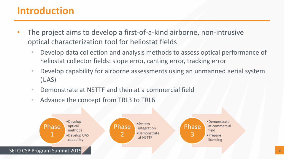
• Develop a flexible and non-intrusive optical (NIO) characterization methodology and tool to efficiently survey a utility-scale field without interrupting plant operation
Non-Intrusive Optics Approach (1/2)
10
SETO CSP Program Summit 2019
• Given a series of images of a heliostat, compare the reflected tower edge in each facet with that of a reference facet with known canting
• Distortions and misalignments of the reflected edge can be measured to calculate optical errors
Non-Intrusive Optics Approach (2/2)
11
SETO CSP Program Summit 2019
• Sandia and NREL are developing a UAS-based imaging system to assess heliostats for optical errors using far-field targets
• Slope errors
• Tracking errors
• Canting errors
• Correct canting errors using near-field target imaging for feedback
Conclusions
SETO CSP Program Summit 2019
Thank you!
Contacts:
Julius Yellowhair, Sandia, [email protected]
Guangdong Zhu, NREL, [email protected]
Dan Small, Sandia, [email protected]
Questions