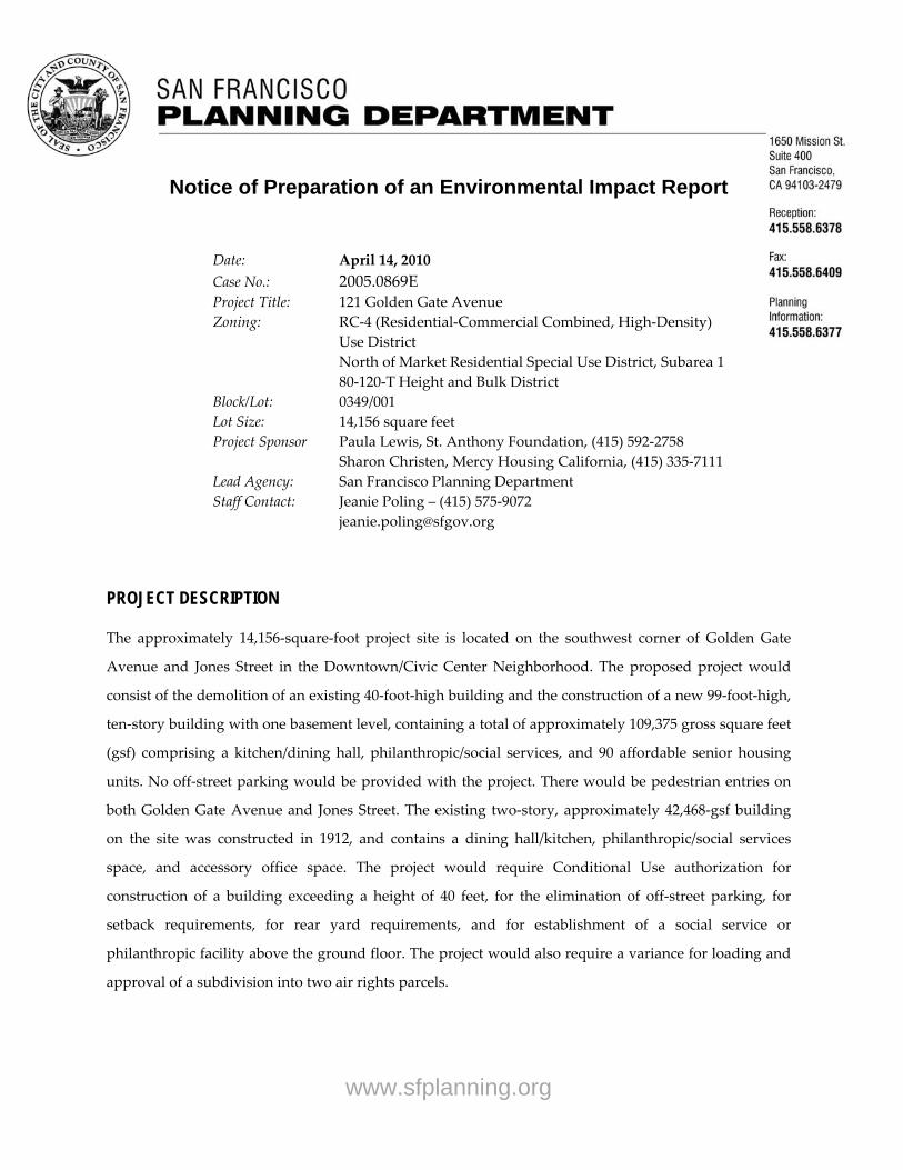
www.sfplanning.org PUBLIC NOTICE Availability of Draft Environmental Impact Report for the 121 Golden Gate Avenue Project Planning Department Case No. 2005.0869E State Clearinghouse No. 2010042048 A Draft Environmental Impact Report (EIR) has been prepared by the San Francisco Planning Department in connection with this project. The report is available for public review and comment on the Planning Department’s MEA Cases webpage (http://tinyurl.com/meacases ). CDs and paper copies are also available at the Planning Information Center (PIC) at 1660 Mission Street, 1 st Floor. Referenced materials are available for review by appointment at the Planning Departmentʹs office at 1650 Mission Street, 4 th Floor. (Call 575‐9122) Project Description: The project sponsors, St. Anthony Foundation and Mercy Housing California, propose to demolish the existing 40‐foot‐tall, two‐story historic building at 121 Golden Gate Avenue and construct a new 99‐foot‐tall, 10‐story building with one basement level, containing approximately 109,375 square feet (sq.ft.). The building would consist of a kitchen/dining hall, philanthropic/social services, and 90 affordable senior housing units without off‐street parking. The project site is located on the southwest corner of Golden Gate Avenue and Jones Street in the Downtown/Civic Center Neighborhood (101‐121 Golden Gate Avenue, Assessor’s Block 0349, Lot 001). A public hearing on this Draft EIR and other matters has been scheduled by the City Planning Commission for January 13, 2011, in Room 400, City Hall, 1 Dr. Carlton B. Goodlett Place, beginning at 1:30 p.m. or later. (Call 558‐6422 the week of the hearing for a recorded message giving a more specific time.) There will also be a hearing before the San Francisco Historic Preservation Commission on December 15, 2010. Public comments will be accepted from December 8, 2010 to 5:00 p.m. on January 21, 2011. Written comments should be addressed to Bill Wycko, Environmental Review Officer, San Francisco Planning Department, 1650 Mission Street, Suite 400, San Francisco, CA 94103. Comments received at the public hearing and in writing will be responded to in a Summary of Comments and Responses document. If you have any questions about the environmental review of the proposed project, please call Jeanie Poling at 415‐575‐9072.
Transcript
www.sfplanning.org
PUBLIC NOTICE Availability of Draft Environmental Impact Report for the
121 Golden Gate Avenue Project Planning Department Case No. 2005.0869E
State Clearinghouse No. 2010042048 A Draft Environmental Impact Report (EIR) has been prepared by the San Francisco Planning Department in connection with this project. The report is available for public review and comment on the Planning Department’s MEA Cases webpage (http://tinyurl.com/meacases). CDs and paper copies are also available at the Planning Information Center (PIC) at 1660 Mission Street, 1st Floor. Referenced materials are available for review by appointment at the Planning Departmentʹs office at 1650 Mission Street, 4th Floor. (Call 575‐9122) Project Description: The project sponsors, St. Anthony Foundation and Mercy Housing California, propose to demolish the existing 40‐foot‐tall, two‐story historic building at 121 Golden Gate Avenue and construct a new 99‐foot‐tall, 10‐story building with one basement level, containing approximately 109,375 square feet (sq.ft.). The building would consist of a kitchen/dining hall, philanthropic/social services, and 90 affordable senior housing units without off‐street parking. The project site is located on the southwest corner of Golden Gate Avenue and Jones Street in the Downtown/Civic Center Neighborhood (101‐121 Golden Gate Avenue, Assessor’s Block 0349, Lot 001). A public hearing on this Draft EIR and other matters has been scheduled by the City Planning Commission for January 13, 2011, in Room 400, City Hall, 1 Dr. Carlton B. Goodlett Place, beginning at 1:30 p.m. or later. (Call 558‐6422 the week of the hearing for a recorded message giving a more specific time.) There will also be a hearing before the San Francisco Historic Preservation Commission on December 15, 2010. Public comments will be accepted from December 8, 2010 to 5:00 p.m. on January 21, 2011. Written comments should be addressed to Bill Wycko, Environmental Review Officer, San Francisco Planning Department, 1650 Mission Street, Suite 400, San Francisco, CA 94103. Comments received at the public hearing and in writing will be responded to in a Summary of Comments and Responses document. If you have any questions about the environmental review of the proposed project, please call Jeanie Poling at 415‐575‐9072.
gener
121 Golden Gate Avenue Project
PLANNING DEPARTMENT CASE NO. 2005.0869E STATE CLEARINGHOUSE NO. 2010042048
Written comments should be sent to: Environmental Review Officer | 1650 Mission Street, Suite 400 | San Francisco, CA 94103
Draft EIR Publication Date: DECEMBER 8, 2010
Draft EIR Public Hearing Date: JANUARY 13, 2011
Draft EIR Public Comment Period: DECEMBER 8, 2010 – JANUARY 21, 2011
DRAFT ENVIRONMENTAL IMPACT REPORT
www.sfplanning.org
DATE: December 8, 2010
TO: Distribution List for 121 Golden Gate Avenue Project
FROM: Bill Wycko, Environmental Review Officer
SUBJECT: Request for the Final Environmental Impact Report for the 121 Golden Gate Avenue Project (Planning Department Case No. 2005.0869E)
This is the Draft of the Environmental Impact Report (EIR) for the 121 Golden Gate Avenue project. A public hearing will be held on the adequacy and accuracy of this document. After the public hearing, our office will prepare and publish a document titled “Comments and Responses” that will contain a summary of all relevant comments on this Draft EIR and our responses to those comments. It may also specify changes to this Draft EIR. Those who testify at the hearing on the Draft EIR will automatically receive a copy of the Comments and Responses document, along with notice of the date reserved for certification; others may receive a copy of the Comments and Responses and notice by request or by visiting our office. This Draft EIR together with the Comments and Responses document will be considered by the Planning Commission in an advertised public meeting and will be certified as a Final EIR if deemed adequate. After certification, we will modify the Draft EIR as specified by the Comments and Responses document and print both documents in a single publication called the Final EIR. The Final EIR will add no new information to the combination of the two documents except to reproduce the certification resolution. It will simply provide the information in one document, rather than two. Therefore, if you receive a copy of the Comments and Responses document in addition to this copy of the Draft EIR, you will technically have a copy of the Final EIR. We are aware that many people who receive the Draft EIR and Comments and Responses have no interest in receiving virtually the same information after the EIR has been certified. To avoid expending money and paper needlessly, we would like to send copies of the Final EIR to private individuals only if they request them. If you would like a copy of the Final EIR, therefore, please fill out and mail the postcard provided to the Major Environmental Analysis division of the Planning Department within two weeks after certification of the EIR. Any private party not requesting a Final EIR by that time will not be mailed a copy. Thank you for your interest in this project.
THIS PAGE INTENTIONALLY LEFT BLANK
City and County of San Francisco Planning Department 121 GOLDEN GATE AVENUE PROJECT
DRAFT ENVIRONMENTAL IMPACT REPORT Planning Department Case No. 2005.0869E State Clearinghouse No. 2010042048 December 8, 2010 Draft EIR Publication Date: December 8, 2010 Draft EIR Public Hearing Date: January 13, 2011 Draft EIR Public Comment Period: December 8, 2010 to January 21, 2011 Please send written comments on this document to: Environmental Review Officer RE: 121 Golden Gate Avenue San Francisco Planning Department 1650 Mission Street, Suite 400 San Francisco, CA 94103
THIS PAGE INTENTIONALLY LEFT BLANK
Case No. 2005.0869E i 121 Golden Gate Avenue Project
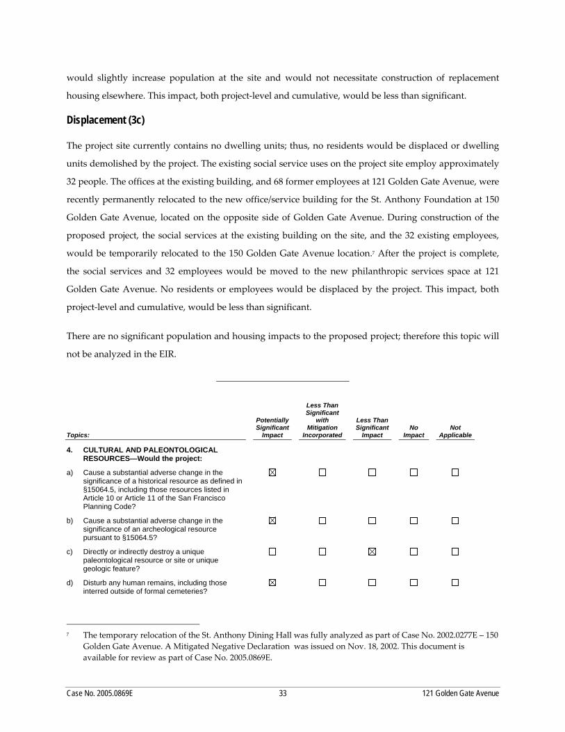
TABLE OF CONTENTS Page List of Acronyms and Abbreviations ..................................................................................................................... iii I. Summary ................................................................................................................................................... S‐1 II. Introduction .................................................................................................................................................. 1 A. Project Summary ............................................................................................................................ 1 B. Purpose of this Environmental Impact Report .......................................................................... 1 C. Environmental Review Process .................................................................................................... 2 III. Project Description ....................................................................................................................................... 7 A. Project Location .............................................................................................................................. 7 B. Project Characteristics ................................................................................................................. 10 C. Project Objectives ......................................................................................................................... 27 D. Required Approvals..................................................................................................................... 27 IV. Plans and Policies ....................................................................................................................................... 29 V. Environmental Setting, Impacts, and Mitigation Measures ................................................................. 35 A. Land Use and Land Use Planning ............................................................................................. 36 B. Aesthetics ..................................................................................................................................... 41 C. Cultural Resources ....................................................................................................................... 46 D. Air Quality .................................................................................................................................... 63 VI. Other CEQA Issues .................................................................................................................................... 91
A. Growth‐Inducing Impacts ........................................................................................................... 91 B. Significant Unavoidable Impacts ............................................................................................... 92 C. Significant Irreversible Impacts .................................................................................................. 92 D. Areas of Known Controversy and Issues to Be Resolved ....................................................... 93 VII. Alternatives ................................................................................................................................................. 95 A. Alternative A: No Project ............................................................................................................ 96 B. Alternative B: Partial Preservation Alternative........................................................................ 97 C. Alternatives Considered But Rejected ..................................................................................... 101 D. Environmentally Superior Alternative .................................................................................... 102 VIII. EIR Preparers and Persons and Organizations Contacted ................................................................. 105 IX. Appendix ................................................................................................................................................... 107 A. Notice of Preparation and Initial Study
TABLE OF CONTENTS
Case No. 2005.0869E ii 121 Golden Gate Avenue Project
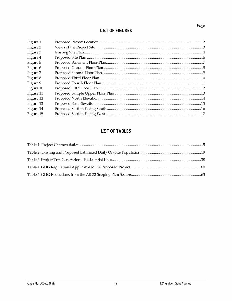
LIST OF FIGURES Page Figure 1 Project Location .............................................................................................................................. 8 Figure 2 Views of the Project Site ................................................................................................................ 9 Figure 3 Existing Site Plan .......................................................................................................................... 12 Figure 4 Proposed Site Plan ....................................................................................................................... 13 Figure 5 Proposed Basement Floor Plan ................................................................................................... 14 Figure 6 Proposed Ground Floor Plan ...................................................................................................... 15 Figure 7 Proposed Second Floor Plan ....................................................................................................... 16 Figure 8 Proposed Third Floor Plan .......................................................................................................... 17 Figure 9 Proposed Fourth Floor Plan ........................................................................................................ 18 Figure 10 Proposed Fifth Floor Plan ........................................................................................................... 19 Figure 11 Proposed Sample Upper Floor Plan .......................................................................................... 20 Figure 12 Proposed North Elevation .......................................................................................................... 21 Figure 13 Proposed East Elevation .............................................................................................................. 22 Figure 14 Proposed Section Facing South .................................................................................................. 23 Figure 15 Proposed Section Facing West .................................................................................................... 24 Figure 16 Partial Preservation Alternative Rendering ............................................................................. 98 Figure 17 Partial Preservation Alternative Sample Floor Plan ................................................................ 99
LIST OF TABLES Table S‐1 Summary of Impacts and Mitigation and Improvement Measures .................................... S‐4 Table S‐2 Comparison of Impacts of Alternatives
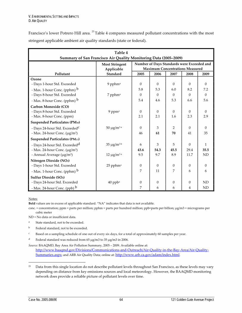
to Significant Impacts of Proposed Project .......................................................................... S‐16 Table 1 Project Characteristics ................................................................................................................. 11 Table 2 Existing and Proposed Estimated Daily On‐Site Population ................................................. 26 Table 3 Development Projects in Vicinity of Project Site ...................................................................... 39 Table 4 Summary of San Francisco Air Quality Monitoring Data (2005‐2009) ................................. 64 Table 5 Annual Average Ambient Concentrations of Carcinogenic TACs
Measured at BAAQMD Monitoring Station, 10 Arkansas Street, San Francisco ................ 68 Table 6 State and Federal Ambient Air Quality Standards .................................................................. 73 Table 7 URBEMIS Results for Project Construction Exhaust Emissions ............................................ 81 Table 8 URBEMIS Results for Project Operations Exhaust Emissions ............................................... 85 Table 9 Stationary and Roadway Toxic Air Contaminant Sources ..................................................... 86 Table 10 Comparison of Impacts of Alternatives
to Significant Impacts of Proposed Project ............................................................................ 104
Case No. 2005.0869E iii 121 Golden Gate Avenue Project
List of Abbreviations and Acronyms
‐sq.ft. ‐square‐foot ABAG Association of Bay Area Governments ADRP archeological data recovery plan ARB (California) Air Resources Board ARDTP archeological research design and treatment plan ATP archeological testing plan BAAQMD Bay Area Air Quality Management District BCDC San Francisco Bay Conservation and Development Commission C‐2 Community Business C‐3‐G Downtown General Commercial C‐3‐R Downtown Retail CA DPR California Department of Public Resources CCR California Code of Regulations CEQA California Environmental Quality Act City City and County of San Francisco CRHR California Register of Historical Resources DPM diesel particulate matter EE Environmental Evaluation EIR Environmental Impact Report EMFAC emissions factor ERO Environmental Review Officer FAR floor area ratio FARR Final Archeological Resources Report HABS Historic American Building Survey LEED Leadership in Energy and Environmental Design LNHNRHD Lower Nob Hill National Register Historic District MSTLNRHD Market Street Theatre and Loft National Register Historic District MTC Metropolitan Transportation Commission NAHC Native American Heritage Commission NEPA National Environmental Policy Act NOP Notice of Preparation NWIC California Archeological Site Survey Northwest Information Center OHP Office of Historic Preservation PDR production, distribution, and repair RC‐4 Residential‐Commercial Combined, High Density RM‐4 Residential, Mixed, High Density RTP Regional Transportation Plan RWQCB Regional Water Quality Control Board sq.ft. square feet SFRWQCB San Francisco Regional Water Quality Control Board SRO single‐room occupancy SUD Special Use District URBEMIS Urban Emissions calculation software UTNRHD Uptown Tenderloin National Register Historic District
Case No. 2005.0869E iv 121 Golden Gate Avenue Project
THIS PAGE INTENTIONALLY LEFT BLANK
Case No. 2005.0869E S-1 121 Golden Gate Avenue Project
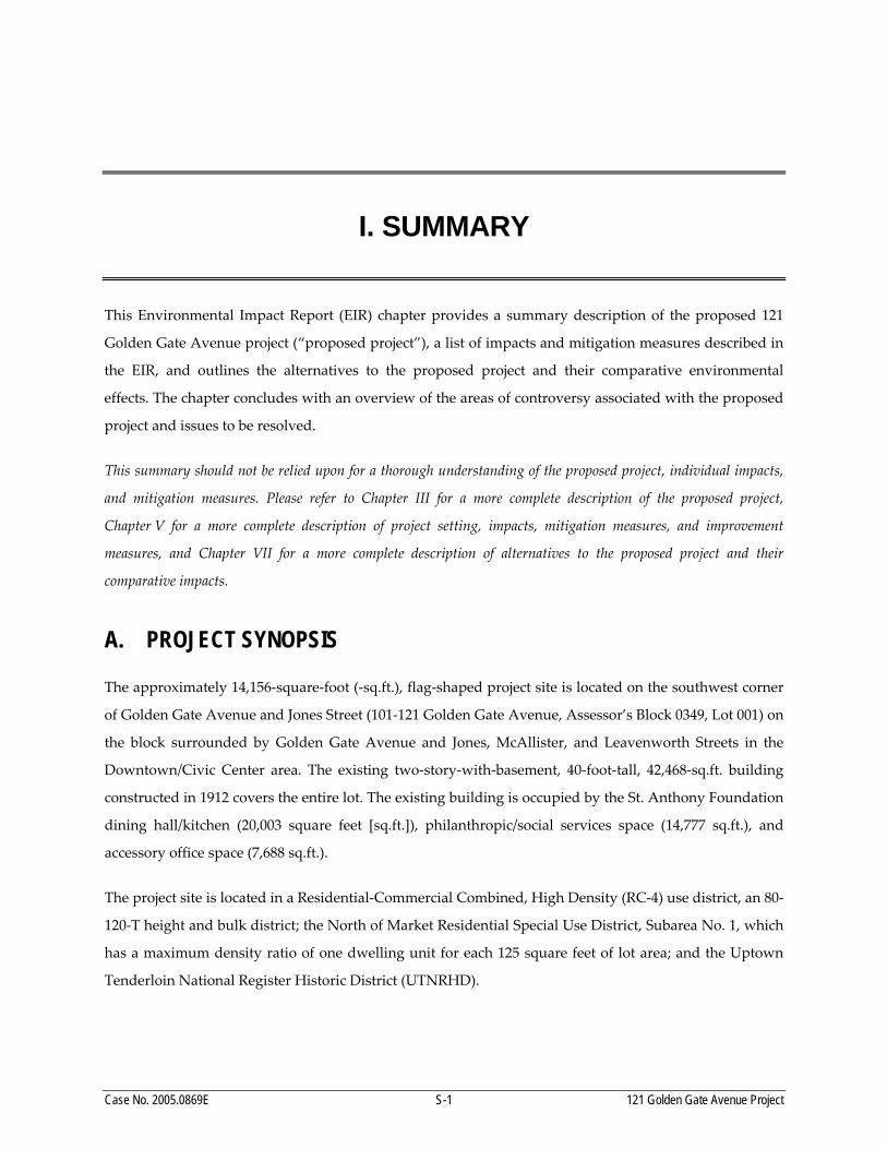
I. SUMMARY
This Environmental Impact Report (EIR) chapter provides a summary description of the proposed 121
Golden Gate Avenue project (“proposed project”), a list of impacts and mitigation measures described in
the EIR, and outlines the alternatives to the proposed project and their comparative environmental
effects. The chapter concludes with an overview of the areas of controversy associated with the proposed
project and issues to be resolved.
This summary should not be relied upon for a thorough understanding of the proposed project, individual impacts,
and mitigation measures. Please refer to Chapter III for a more complete description of the proposed project,
Chapter V for a more complete description of project setting, impacts, mitigation measures, and improvement
measures, and Chapter VII for a more complete description of alternatives to the proposed project and their
comparative impacts.
A. PROJECT SYNOPSIS
The approximately 14,156‐square‐foot (‐sq.ft.), flag‐shaped project site is located on the southwest corner
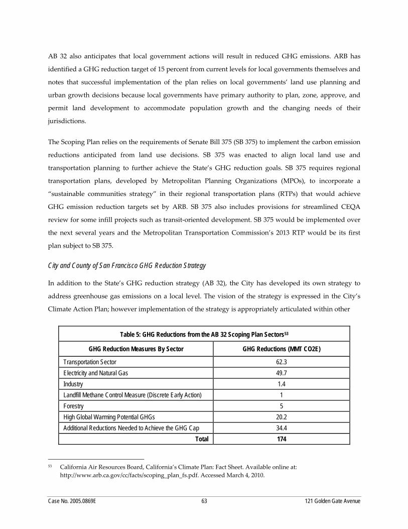
of Golden Gate Avenue and Jones Street (101‐121 Golden Gate Avenue, Assessor’s Block 0349, Lot 001) on
the block surrounded by Golden Gate Avenue and Jones, McAllister, and Leavenworth Streets in the
Downtown/Civic Center area. The existing two‐story‐with‐basement, 40‐foot‐tall, 42,468‐sq.ft. building
constructed in 1912 covers the entire lot. The existing building is occupied by the St. Anthony Foundation
dining hall/kitchen (20,003 square feet [sq.ft.]), philanthropic/social services space (14,777 sq.ft.), and
accessory office space (7,688 sq.ft.).
The project site is located in a Residential‐Commercial Combined, High Density (RC‐4) use district, an 80‐
120‐T height and bulk district; the North of Market Residential Special Use District, Subarea No. 1, which
has a maximum density ratio of one dwelling unit for each 125 square feet of lot area; and the Uptown
Tenderloin National Register Historic District (UTNRHD).
I. SUMMARY
Case No. 2005.0869E S-2 121 Golden Gate Avenue Project
The proposed project includes the demolition of the existing two‐story building currently used for
philanthropic purposes, and the construction of a 10‐story, 99‐foot‐high, 109,375‐sq.ft. building with
40,561 sq.ft. of dining hall/kitchen and philanthropic/social services in the basement and ground level.
The proposed building would contain 46,950 sq.ft. of residential space consisting of 90 senior affordable
rental dwelling units and 21,864 sq.ft. of non‐residential interior space on levels two through ten, and no
parking facilities. The 90 residences would consist of 43 studios, 46 one‐bedroom units, and 1 two‐
bedroom unit. The proposed building would cover the entire lot and have a density of one residential
unit per 139 square feet.
The building would be rectilinear in form, with a contemporary design. There would be street‐level
arcades on both Golden Gate Avenue and Jones Street, but the remainder of the façades would be built to
the lot lines, with no setbacks. At the time of publication of the Initial Study, it was thought that the
proposed project could reuse the existing basement and no excavation was expected. However, since
publication, construction plans have been refined, and it has been determined that foundational and
mechanical support would require excavation to a maximum depth of 10 feet below the existing
basement slab. The foundation of the proposed structure is anticipated to be a mat slab supported on
improved (compacted) soil or deep foundations.
The project sponsors and developers are the St. Anthony Foundation and Mercy Housing California. The
architect is Hardison Komatsu Ivelich & Tucker. The estimated construction cost is $39,000,000. Project
construction is expected to begin during the spring of 2012 and occur over a period of approximately 20
months, with demolition, foundation reconstruction, and site grading occurring over a period of three
months.
B. SUMMARY OF IMPACTS AND MITIGATION MEASURES
This EIR provides information on potential impacts of the proposed project on archeological and historic
architectural resources and air quality. The two topics of land use and land use planning and aesthetics
are discussed for informational purposes. Their impacts were found to be less than significant in the
Initial Study (Appendix A). The Initial Study also found a potentially significant hazardous materials
impact (contaminated soils and groundwater) that would be reduced to less than significant with the
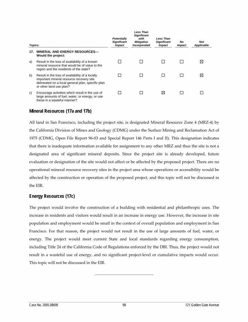
identified mitigation measure. The Initial Study found the following impacts to be less than significant:
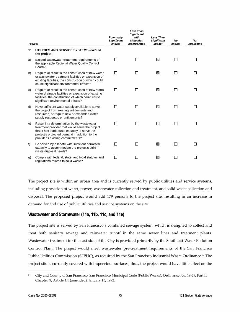
population and housing, paleontological resources, transportation and circulation, noise, air quality,
wind and shadow, recreation, utilities and service systems, public services, biological resources, geology
I. SUMMARY
Case No. 2005.0869E S-3 121 Golden Gate Avenue Project
and soils, hydrology and water quality, hazards and hazardous materials (except contaminated soils and
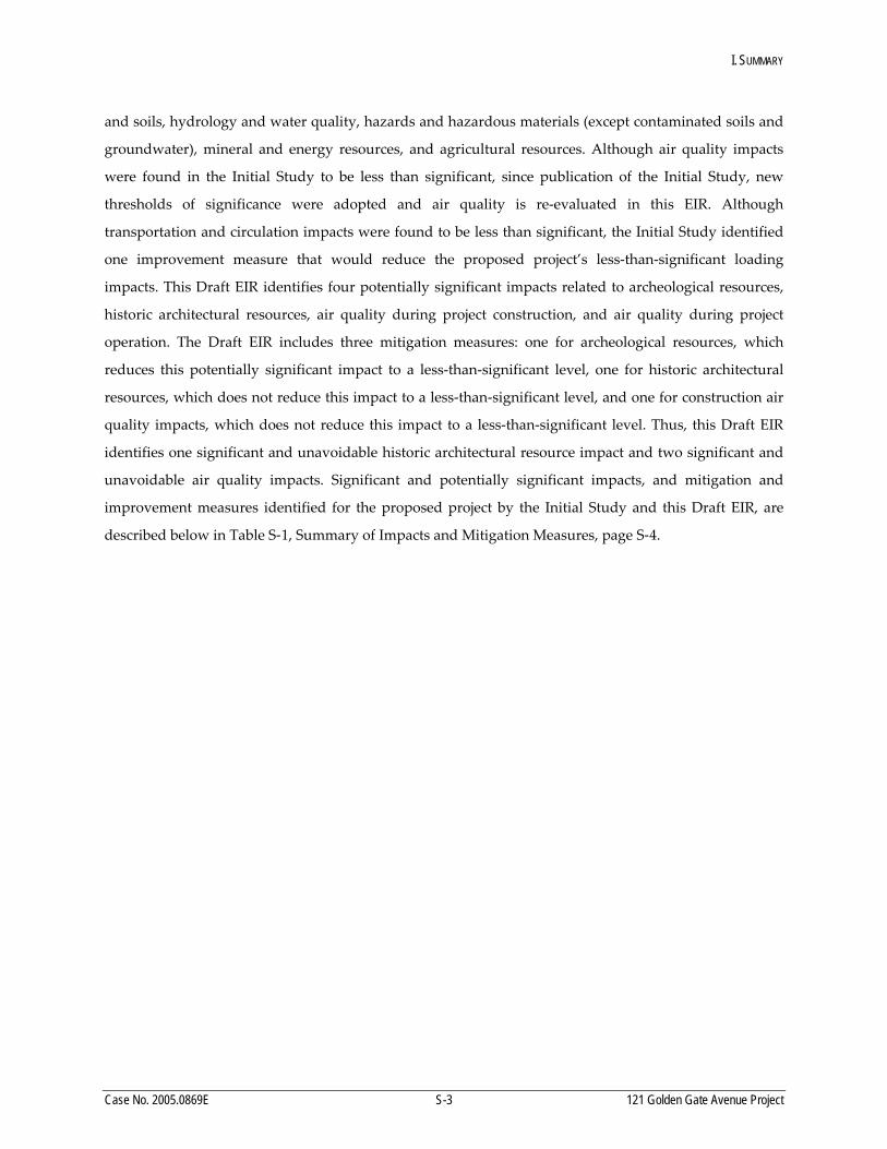
groundwater), mineral and energy resources, and agricultural resources. Although air quality impacts
were found in the Initial Study to be less than significant, since publication of the Initial Study, new
thresholds of significance were adopted and air quality is re‐evaluated in this EIR. Although
transportation and circulation impacts were found to be less than significant, the Initial Study identified
one improvement measure that would reduce the proposed project’s less‐than‐significant loading
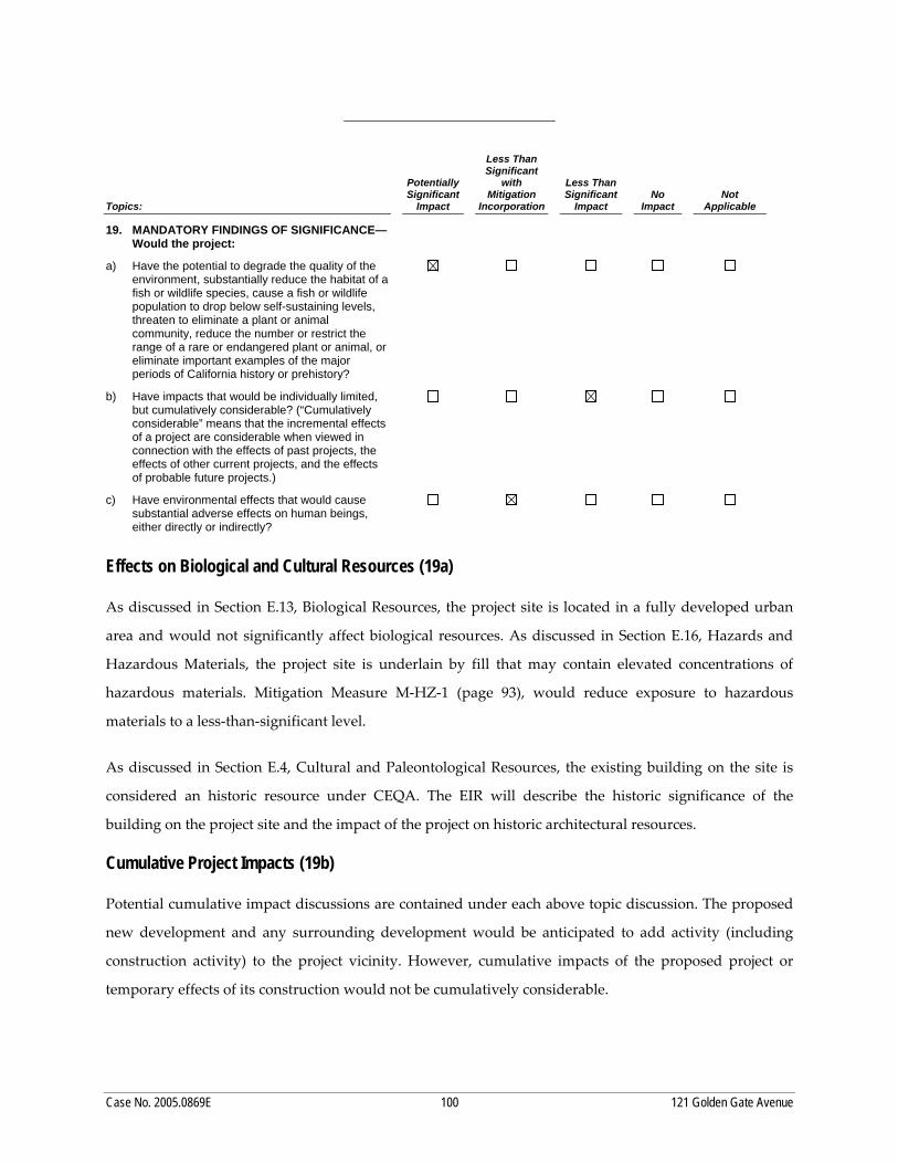
impacts. This Draft EIR identifies four potentially significant impacts related to archeological resources,
historic architectural resources, air quality during project construction, and air quality during project
operation. The Draft EIR includes three mitigation measures: one for archeological resources, which
reduces this potentially significant impact to a less‐than‐significant level, one for historic architectural
resources, which does not reduce this impact to a less‐than‐significant level, and one for construction air
quality impacts, which does not reduce this impact to a less‐than‐significant level. Thus, this Draft EIR
identifies one significant and unavoidable historic architectural resource impact and two significant and
unavoidable air quality impacts. Significant and potentially significant impacts, and mitigation and
improvement measures identified for the proposed project by the Initial Study and this Draft EIR, are
described below in Table S-1, Summary of Impacts and Mitigation Measures, page S-4.
I. SUMMARY
S = Significant SU = Significant and Unavoidable PS = Potentially Significant LTS = Less than Significant
Case No. 2005.0869E S-4 121 Golden Gate Avenue Project
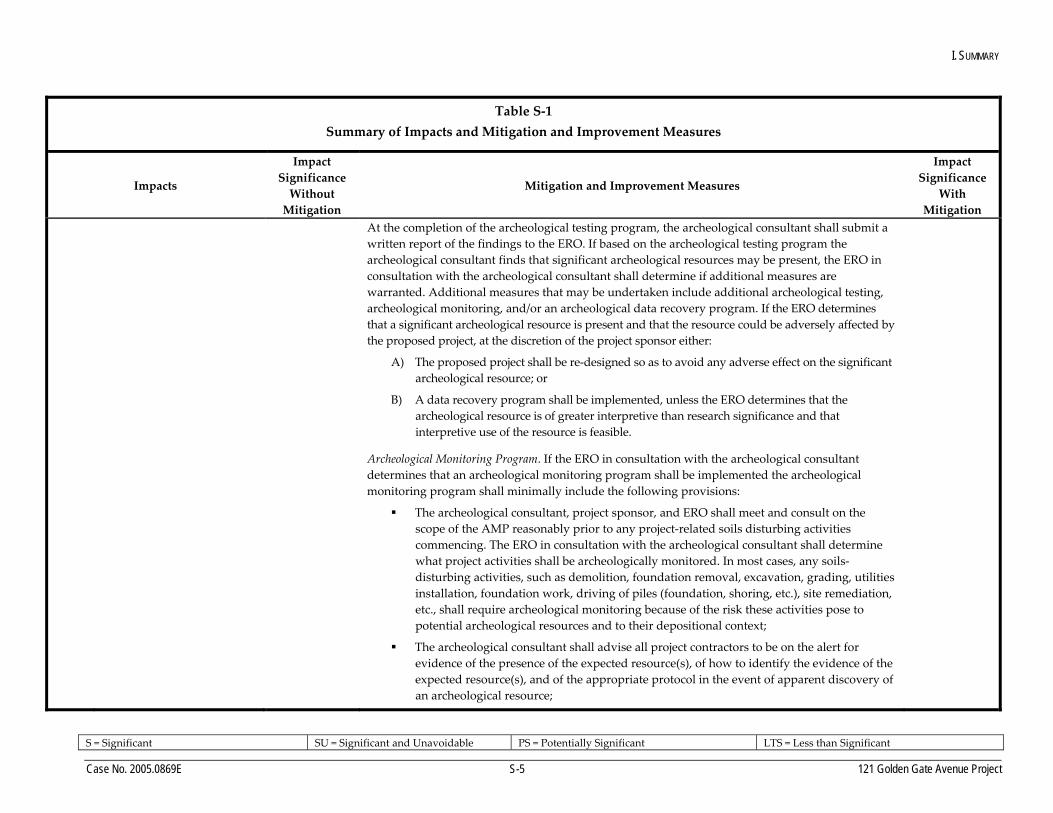
Table S‐1 Summary of Impacts and Mitigation and Improvement Measures
Impacts
ImpactSignificance Without Mitigation
Mitigation and Improvement Measures
ImpactSignificance
With Mitigation
CP-1 Construction of the proposed project could potentially damage or disturb subsurface archeological resources.
PS M‐CP‐1 (Testing). Based on a reasonable presumption that archeological resources may be present within the project site, the following measures shall be undertaken to avoid any potentially significant adverse effect from the proposed project on buried or submerged historical resources. The project sponsor shall retain the services of a qualified archeological consultant having expertise in California prehistoric and urban historical archeology. The archeological consultant shall undertake an archeological testing program as specified herein. In addition, the consultant shall be available to conduct an archeological monitoring and/or data recovery program if required pursuant to this measure. The archeological consultant’s work shall be conducted in accordance with this measure and with the requirements of the project archeological research design and treatment plan (Archeo‐Tec, Archaeological Research Design/Treatment Plan for the 121 Golden Gate Avenue Project, April 2008) at the direction of the Environmental Review Officer (ERO). In instances of inconsistency between the requirement of the project archeological research design and treatment plan and of this archeological mitigation measure, the requirements of this archeological mitigation measure shall prevail. All plans and reports prepared by the consultant as specified herein shall be submitted first and directly to the ERO for review and comment, and shall be considered draft reports subject to revision until final approval by the ERO. Archeological monitoring and/or data recovery programs required by this measure could suspend construction of the project for up to a maximum of four weeks. At the direction of the ERO, the suspension of construction can be extended beyond four weeks only if such a suspension is the only feasible means to reduce to a less‐than significant level potential effects on a significant archeological resource as defined in the CEQA Guidelines Section 15064.5(a)(c).
Archeological Testing Program. The archeological consultant shall prepare and submit to the ERO for review and approval an archeological testing plan (ATP). The archeological testing program shall be conducted in accordance with the approved ATP. The ATP shall identify the property types of the expected archeological resource(s) that potentially could be adversely affected by the proposed project, the testing method to be used, and the locations recommended for testing. The purpose of the archeological testing program will be to determine to the extent possible the presence or absence of archeological resources and to identify and evaluate whether any archeological resource encountered on the site constitutes an historical resource under CEQA.
LTS
I. SUMMARY
S = Significant SU = Significant and Unavoidable PS = Potentially Significant LTS = Less than Significant
Case No. 2005.0869E S-5 121 Golden Gate Avenue Project
Table S‐1 Summary of Impacts and Mitigation and Improvement Measures
Impacts
ImpactSignificance Without Mitigation
Mitigation and Improvement Measures
ImpactSignificance
With Mitigation
At the completion of the archeological testing program, the archeological consultant shall submit a written report of the findings to the ERO. If based on the archeological testing program the archeological consultant finds that significant archeological resources may be present, the ERO in consultation with the archeological consultant shall determine if additional measures are warranted. Additional measures that may be undertaken include additional archeological testing, archeological monitoring, and/or an archeological data recovery program. If the ERO determines that a significant archeological resource is present and that the resource could be adversely affected by the proposed project, at the discretion of the project sponsor either:
A) The proposed project shall be re‐designed so as to avoid any adverse effect on the significant archeological resource; or
B) A data recovery program shall be implemented, unless the ERO determines that the archeological resource is of greater interpretive than research significance and that interpretive use of the resource is feasible.
Archeological Monitoring Program. If the ERO in consultation with the archeological consultant determines that an archeological monitoring program shall be implemented the archeological monitoring program shall minimally include the following provisions:
The archeological consultant, project sponsor, and ERO shall meet and consult on the scope of the AMP reasonably prior to any project‐related soils disturbing activities commencing. The ERO in consultation with the archeological consultant shall determine what project activities shall be archeologically monitored. In most cases, any soils‐ disturbing activities, such as demolition, foundation removal, excavation, grading, utilities installation, foundation work, driving of piles (foundation, shoring, etc.), site remediation, etc., shall require archeological monitoring because of the risk these activities pose to potential archeological resources and to their depositional context;
The archeological consultant shall advise all project contractors to be on the alert for evidence of the presence of the expected resource(s), of how to identify the evidence of the expected resource(s), and of the appropriate protocol in the event of apparent discovery of an archeological resource;
I. SUMMARY
S = Significant SU = Significant and Unavoidable PS = Potentially Significant LTS = Less than Significant
Case No. 2005.0869E S-6 121 Golden Gate Avenue Project
Table S‐1 Summary of Impacts and Mitigation and Improvement Measures
Impacts
ImpactSignificance Without Mitigation
Mitigation and Improvement Measures
ImpactSignificance
With Mitigation
The archeological monitor(s) shall be present on the project site according to a schedule agreed upon by the archeological consultant and the ERO until the ERO has, in consultation with project archeological consultant, determined that project construction activities could have no effects on significant archeological deposits;
The archeological monitor shall record and be authorized to collect soil samples and artifactual/ecofactual material as warranted for analysis;
If an intact archeological deposit is encountered, all soils‐disturbing activities in the vicinity of the deposit shall cease. The archeological monitor shall be empowered to temporarily redirect demolition/excavation/pile driving/construction activities and equipment until the deposit is evaluated. If in the case of pile driving activity (foundation, shoring, etc.), the archeological monitor has cause to believe that the pile driving activity may affect an archeological resource, the pile driving activity shall be terminated until an appropriate evaluation of the resource has been made in consultation with the ERO. The archeological consultant shall immediately notify the ERO of the encountered archeological deposit. The archeological consultant shall make a reasonable effort to assess the identity, integrity, and significance of the encountered archeological deposit, and present the findings of this assessment to the ERO.
Whether or not significant archeological resources are encountered, the archeological consultant shall submit a written report of the findings of the monitoring program to the ERO.
Archeological Data Recovery Program. The archeological data recovery program shall be conducted in accord with an archeological data recovery plan (ADRP). The archeological consultant, project sponsor, and ERO shall meet and consult on the scope of the ADRP prior to preparation of a draft ADRP. The archeological consultant shall submit a draft ADRP to the ERO. The ADRP shall identify how the proposed data recovery program will preserve the significant information the archeological resource is expected to contain. That is, the ADRP will identify what scientific/historical research questions are applicable to the expected resource, what data classes the resource is expected to possess, and how the expected data classes would address the applicable research questions. Data recovery, in general, should be limited to the portions of the historical property that could be adversely affected by the proposed project. Destructive data recovery methods shall not be applied
I. SUMMARY
S = Significant SU = Significant and Unavoidable PS = Potentially Significant LTS = Less than Significant
Case No. 2005.0869E S-7 121 Golden Gate Avenue Project
Table S‐1 Summary of Impacts and Mitigation and Improvement Measures
Impacts
ImpactSignificance Without Mitigation
Mitigation and Improvement Measures
ImpactSignificance
With Mitigation
to portions of the archeological resources if nondestructive methods are practical.
The scope of the ADRP shall include the following elements:
Field Methods and Procedures. Descriptions of proposed field strategies, procedures, and operations.
Cataloguing and Laboratory Analysis. Description of selected cataloguing system and artifact analysis procedures.
Discard and Deaccession Policy. Description of and rationale for field and post‐field discard and deaccession policies.
Interpretive Program. Consideration of an on‐site/off‐site public interpretive program during the course of the archeological data recovery program.
Security Measures. Recommended security measures to protect the archeological resource from vandalism, looting, and non‐intentionally damaging activities.
Final Report. Description of proposed report format and distribution of results.
Curation. Description of the procedures and recommendations for the curation of any recovered data having potential research value, identification of appropriate curation facilities, and a summary of the accession policies of the curation facilities.
Human Remains and Associated or Unassociated Funerary Objects. The treatment of human remains and of associated or unassociated funerary objects discovered during any soils disturbing activity shall comply with applicable State and Federal laws. This shall include immediate notification of the Coroner of the City and County of San Francisco and in the event of the Coroner’s determination that the human remains are Native American remains, notification of the California State Native American Heritage Commission (NAHC) who shall appoint a Most Likely Descendant (MLD) (Pub. Res. Code Sec. 5097.98). The archeological consultant, project sponsor, and MLD shall make all reasonable efforts to develop an agreement for the treatment of, with appropriate dignity, human remains and associated or unassociated funerary objects (CEQA Guidelines. Sec. 15064.5(d)). The agreement should take into consideration the appropriate excavation, removal, recordation, analysis, custodianship, curation, and final disposition of the human remains and associated or unassociated funerary objects.
I. SUMMARY
S = Significant SU = Significant and Unavoidable PS = Potentially Significant LTS = Less than Significant
Case No. 2005.0869E S-8 121 Golden Gate Avenue Project
Table S‐1 Summary of Impacts and Mitigation and Improvement Measures
Impacts
ImpactSignificance Without Mitigation
Mitigation and Improvement Measures
ImpactSignificance
With Mitigation
Final Archeological Resources Report. The archeological consultant shall submit a Draft Final Archeological Resources Report (FARR) to the ERO that evaluates the historical significance of any discovered archeological resource and describes the archeological and historical research methods employed in the archeological testing/monitoring/data recovery program(s) undertaken. Information that may put at risk any archeological resource shall be provided in a separate removable insert within the final report.
Once approved by the ERO, copies of the FARR shall be distributed as follows: California Archaeological Site Survey Northwest Information Center (NWIC) shall receive one (1) copy and the ERO shall receive a copy of the transmittal of the FARR to the NWIC. The Major Environmental Analysis division of the Planning Department shall receive three copies of the FARR along with copies of any formal site recordation forms (CA DPR 523 series) and/or documentation for nomination to the National Register of Historic Places/California Register of Historical Resources. In instances of high public interest in or the high interpretive value of the resource, the ERO may require a different final report content, format, and distribution than that presented above.
CP-2 The proposed demolition of the 121 Golden Gate Avenue building, a contributor building to the UTNRHD and individually eligible for listing on the National and California Registers, would be a significant historic architectural resource impact.
S M‐CP‐2 (HABS 2 Documentation). Implementation of this mitigation measure would reduce Impact CP‐2 (historic architectural resources), but not to a less‐than‐significant level. Therefore, impacts related to the demolition of the 121 Golden Gate Avenue building would remain significant and unavoidable. However, to partially offset the loss of the building, the project sponsor shall, at a minimum, ensure that a complete survey meeting the standards of the Historic American Building Survey (HABS) is undertaken prior to demolition. This survey shall be completed in accordance with HABS level II documentation standards as follows.
• Prior to demolition, the project sponsor shall provide adequate documentation of the existing building. The documentation shall be submitted to the Planning Department Preservation Staff and found to be adequate prior to authorization of any permit that may be required for demolition of the building. In addition, the project sponsor shall prepare and transmit the photographs and descriptions of the property to the History Room of the San Francisco Public Library and the NWIC of the California Historic Information Resource System. The documentation shall include:
o A video documentary of the property.
SU
I. SUMMARY
S = Significant SU = Significant and Unavoidable PS = Potentially Significant LTS = Less than Significant
Case No. 2005.0869E S-9 121 Golden Gate Avenue Project
Table S‐1 Summary of Impacts and Mitigation and Improvement Measures
Impacts
ImpactSignificance Without Mitigation
Mitigation and Improvement Measures
ImpactSignificance
With Mitigation
o Photo‐documentation of the property to HABS Standards. The standard size of negatives and transparencies (and accompanying prints) are 5‐by‐7 inches. Other large‐format sizes such as 4‐by‐5 inches and 8‐by‐10 inches are also acceptable for formal documentation. Roll film, film packs, and electronic manipulation of images are not acceptable. Images must be fully identified with the name and location of the structure, a description of the feature or view being photographed, and the direction in which the photograph was taken, as well as the name of the photographer and the date created.
o Black and white, 35 millimeter photographs of the interior and exterior of the building. Negatives and 5‐by‐7 inch prints should be processed to meet archival requirements (i.e., negatives must be on safety film only; resin‐coated paper is not accepted).
o As‐built drawings of the building, produced to HABS and Historic American Engineering Record Standards.
o The available original plans of the building shall be included as part of the documentation. All drawings and site plans shall be appropriately conserved at the site or at a qualified repository.
• Prior to demolition, the project sponsor shall salvage the character‐defining elements of the existing building that are considered to be historically significant, as determined by a qualified architectural historian (and can feasibly be salvaged), and shall seek to donate those elements to an organization such as a local historical society. The features to be salvaged shall be determined by Planning Department Preservation Staff following consultation with a qualified historical resources firm. Features to be salvaged should include primary character‐defining features. Donation of the materials to the historical society or other entity approved by the City shall be confirmed by the City prior to the issuance of demolition permits.
AQ‐3 Construction of the proposed project would expose sensitive receptors to pollutants, which would violate an air quality standard or contribute
PS Mitigation Measure M‐AQ‐3. Construction Vehicle Emissions Minimization: To reduce construction vehicle emissions the project sponsor shall incorporate the following into construction specifications:
• Use Tier 3 equipment with best available control technology.
SU
I. SUMMARY
S = Significant SU = Significant and Unavoidable PS = Potentially Significant LTS = Less than Significant
Case No. 2005.0869E S-10 121 Golden Gate Avenue Project
Table S‐1 Summary of Impacts and Mitigation and Improvement Measures
Impacts
ImpactSignificance Without Mitigation
Mitigation and Improvement Measures
ImpactSignificance
With Mitigation
significantly to an existing or projected air quality violation
• Use temporary power from PG&E instead of diesel generators; where it is not possible to plug into the electric grid, use Tier 3 diesel generators and air compressors.
• Limit truck idle times to five minutes or less for dirt hauling and delivery trucks
• Use concrete batched from local plants to limit concrete trucks’ travel time and the amount of diesel exhaust emitted.
• Minimize idling times by either shutting equipment off when not in use or reducing the maximum idling time to five minutes (as required by the California airborne toxics control measure Title 13, Section 2485 of California Code of Regulations [CCR]). Provide clear signage for construction workers at all access points.
• Maintain and properly tune construction equipment in accordance with manufacturer’s specifications. Have all equipment checked by a certified mechanic to determine that equipment is running in proper condition prior to operation.
AQ‐5 The proposed project would potentially expose sensitive receptors to substantial pollutant concentrations.
PS No feasible mitigation has been identified. SU
HZ-1 Contaminated soil and groundwater may be encountered if excavation is required outside of the existing basement and foundation (see Appendix A, Initial Study).
PS M‐HZ‐1: Potentially Contaminated Soil and Groundwater. If, based on the results of the soil tests conducted, the San Francisco Department of Public Health (DPH) determines that the soils on the project site are contaminated with contaminants at or above potentially hazardous levels, all contaminated soils designated as hazardous waste shall be excavated by a qualified Removal Contractor and disposed of at a regulated Class I, II, or III hazardous waste landfill in accordance with U.S. Environmental Protection Agency regulations, as stipulated in the Site Mitigation Plan. The Removal Contractor shall obtain, complete, and sign hazardous waste manifests to accompany the soils to the disposal site. Other excavated soils shall be disposed of in an appropriate landfill, as governed by applicable laws and regulations, or other appropriate actions shall be taken in
LTS
I. SUMMARY
S = Significant SU = Significant and Unavoidable PS = Potentially Significant LTS = Less than Significant
Case No. 2005.0869E S-11 121 Golden Gate Avenue Project
Table S‐1 Summary of Impacts and Mitigation and Improvement Measures
Impacts
ImpactSignificance Without Mitigation
Mitigation and Improvement Measures
ImpactSignificance
With Mitigation
coordination with DPH.
If DPH determines that the soils on the project site are contaminated with contaminants at or above potentially hazardous levels, a Site Health and Safety Plan is required by the California Division of Occupational Safety and Health prior to initiating any earth‐moving activities at the site. The Site Health and Safety Plan shall identify protocols for managing soils during construction to minimize worker and public exposure to contaminated soils. The protocols shall include at a minimum:
• Sweeping of adjacent public streets daily (with water sweepers) if any visible soil material is carried onto the streets.
• Characterization of excavated native soils proposed for use on site prior to placement to confirm that the soil meets appropriate standards.
• The dust controls specified in the San Francisco Dust Control Ordinance.
• Protocols for managing stockpiled and excavated soils.
The Site Health and Safety Plan shall identify site access controls to be implemented from the time of surface disruption through the completion of earthwork construction. The protocols shall include as a minimum:
• Appropriate site security to prevent unauthorized pedestrian/vehicular entry, such as fencing or other barrier or sufficient height and structural integrity to prevent entry and based upon the degree of control required.
• Posting of “no trespassing” signs.
• Providing on‐site meetings with construction workers to inform them about security measures and reporting/contingency procedures.
If groundwater contamination is identified, the Site Health and Safety Plan shall identify protocols for managing groundwater during construction to minimize worker and public exposure to contaminated groundwater. The protocols shall include procedures to prevent unacceptable migration of contamination from defined plumes during dewatering.
The Site Health and Safety Plan shall include a requirement that construction personnel be trained
I. SUMMARY
S = Significant SU = Significant and Unavoidable PS = Potentially Significant LTS = Less than Significant
Case No. 2005.0869E S-12 121 Golden Gate Avenue Project
Table S‐1 Summary of Impacts and Mitigation and Improvement Measures
Impacts
ImpactSignificance Without Mitigation
Mitigation and Improvement Measures
ImpactSignificance
With Mitigation
to recognize potential hazards associated with underground features that could contain hazardous substances, previously unidentified contamination, or buried hazardous debris. Demolition personnel shall also be required to wash hands and face before eating, smoking, and drinking.
The Site Health and Safety Plan shall include procedures for implementing a contingency plan, including appropriate notification and control procedures, in the event unanticipated subsurface hazards are discovered during construction. Control procedures could include, but would not be limited to, investigation and removal of underground storage tanks or other hazards
Improvement Measure
Transportation ‐ Loading LTS I‐TR‐1: Loading Zone on Golden Gate Avenue. In order to reduce the potential for any traffic impacts caused by double‐parking delivery trucks serving the project site, the project sponsor and building management shall monitor delivery activities, and, if necessary, request that SFMTA convert one of the two‐short‐term metered parking spaces adjacent to the project site on Golden Gate Avenue to a commercial vehicle loading/unloading space. The total number of on‐street commercial vehicle loading/unloading spaces would be increased from one to two spaces. The conversion of metered short‐term spaces to commercial vehicle loading/unloading spaces would need to be approved at a public hearing through SFMTA.
LTS
I. SUMMARY
Case No. 2005.0869E S-13 121 Golden Gate Avenue Project
C. SUMMARY OF PROJECT ALTERNATIVES
Two alternatives are evaluated in this EIR: Alternative A: No Project, and Alternative B: Partial
Preservation Alternative. Alternative A would retain the existing historic building unaltered. Alternative
B would retain the façades of the existing historic building facing Golden Gate Avenue and Jones Street,
demolish the interior of the existing building, and construct a 10‐story, 99‐foot‐tall tower set back one
structural bay from the Golden Gate Avenue and Jones Street, about 14 feet. This alternative would be
similar to the proposed project, but with less tower area because of the setbacks.
NO PROJECT ALTERNATIVE
Alternative A, the No Project Alternative, would entail no changes to the project site. The existing
building on the property would remain, and the proposed ten‐story mixed‐use social services building
would not be constructed. This alternative would not preclude future proposals for development of the
project site.
If the No Project Alternative were implemented, none of the impacts associated with the proposed project
discussed in Chapter V, Environmental Setting, Impacts, and Mitigation Measures or in the Initial Study
(Appendix A) would occur, and none of the mitigation measures would be required.
2. PARTIAL PRESERVATION ALTERNATIVE
Alternative B, the Partial Preservation Alternative, would retain the street‐facing façades on Golden Gate
Avenue and Jones Street, but would demolish all other portions of the existing 121 Golden Gate Avenue
building, and construct a 10‐story, 99‐foot‐tall tower similar to that of the proposed project that
incorporates the historical façades into the design of the new structure. The portion of the proposed
building that extends above the height of the existing historic roofline would be set back one structural
bay, approximately 14 feet from the Golden Gate Avenue and Jones Street property lines, in order to
maintain a sense of the existing historic building’s height and massing. With the setbacks, this alternative
would be approximately 85,687 square feet, or 22 percent smaller than the 109,375 square feet of the
proposed project. All character‐defining materials of the historic façades would be cleaned and repaired
in conformance with the Secretary of the Interior’s Standards. The existing storefront systems would be
removed below the transom to accommodate the arcade proposed as part of the project. The bulkhead
below the storefront would be removed only in those locations that require a path of travel to the street.
I. SUMMARY
Case No. 2005.0869E S-14 121 Golden Gate Avenue Project
Three or four storefront openings that have been infilled or modified would be reopened to match their
historic configuration and provided with a new transom to match the original. This alternative would
reduce the unit count from the proposed project’s 90 units to approximately 68 units (a 24 percent
reduction).
Like the proposed project, the Partial Preservation Alternative would require EIR certification and
findings of General Plan and Priority Policies Consistency. This alternative would require the same project
approvals as the proposed project’s Conditional Use authorization for construction of a building
exceeding a height of 40 feet, for the elimination of off‐street parking, setback requirements, rear yard
requirements, bulk requirements, and establishment of a social service or philanthropic facility above the
ground floor, and would require a Variance for loading and approval of a subdivision into two air rights
parcels. It would also require National Environmental Policy Act (NEPA) approval and a finding of
Section 106 compliance from the State Historic Preservation Office, as would the proposed project.
The Partial Preservation Alternative would reduce the proposed project’s significant and unavoidable
historic architectural resources impact, but not to a less‐than‐significant level, because it would not meet
the Secretary of the Interior’s Standards for the Rehabilitation of Historic Structures. The alternative
would demolish most of a historical resource, while retaining some character‐defining features of the
subject building that would still convey its significance and its association with the UTNRHD.
Because the Partial Preservation Alternative would still demolish a majority of the historical resource, it
would still require Mitigation Measure M‐CP‐2, which calls for documenting the historical resource
prior to demolition and salvaging elements of the building. This alternative would have the same
archeological and hazardous materials (contaminated soils and groundwater) impacts as the proposed
project, and would require the same Mitigation Measures M‐HA‐1 and M‐CP‐1. Because this alternative
sites construction in direct proximity to sensitive resources, it would still have the same air quality
(construction exhaust emissions – health risk) impacts as the proposed project, which Mitigation
Measure M‐AQ‐3 would reduce but not to a less‐than‐significant level. Like the proposed project, the
Partial Preservation Alternative would also expose new sensitive receptors to substantial pollutant
concentrations, resulting in a significant and unavoidable operational air quality impact for which no
feasible mitigation measure has been identified.
Although this Partial Preservation Alternative would preserve a portion of the existing building’s
character‐defining features and design features to maintain a sense of the historical resource’s height and
massing, the project sponsor rejects this alternative as infeasible. It would partially meet the project
I. SUMMARY
Case No. 2005.0869E S-15 121 Golden Gate Avenue Project
sponsors’ objectives (see Project Synopsis). In particular, it would have approximately half the livable
residential space and 68 affordable units, 24 percent fewer than the proposed project’s 90 units; it would
be a smaller building; and it would insufficiently meet the additional space needs required for the
planned improvement in social service delivery. As a result, the Partial Preservation Alternative would
not sufficiently enhance the capacity of St. Anthony Foundation to meet its mission—to “feed, heal,
shelter, clothe, lift the spirits of those in need, and create a society in which all persons flourish.” This
alternative would also require structural compromises, setbacks, and additional expense in comparison to
the fully functional building of the proposed project. It was rejected by the project sponsor, because it
would not meet critical objectives of the project.
Table S‐2, page S‐16, contains a comparison of the alternatives’ impacts to the potentially significant
impacts of the proposed project.
D. AREAS OF CONTROVERSY AND ISSUES TO BE RESOLVED
The City distributed a Notice of Preparation (NOP) on April 14, 2010, announcing its intent to prepare
and distribute an EIR. Individuals and agencies that received this notice included owners of properties
within 300 feet of the project site, tenants of properties adjacent to the project site, and other potentially
interested parties, including various regional and state agencies. The Planning Department did not
receive public comment on the NOP during the public comment period. The EIR addresses all
environmental issues required by the California Environmental Quality Act (CEQA).
I. SUMMARY
Case No. 2005.0869E S-16 121 Golden Gate Avenue Project
Table S‐2 Comparison of Impacts of Alternatives to Significant Impacts of Proposed Project
Proposed Project Alternative A: No Project Alternative Alternative B: Partial Preservation
10 stories, 99 feet. Set back 14 feet1 23,262 sq.ft. / 68 units (sr. affordable)
40,561 Same as proposed project.
21,864 85,687 sq.ft.2
Potentially Significant Impacts:
CP‐1: Archeology Potentially significant.
Less than significant with Mitigation M‐CP‐1
No impact. Same as under proposed project
CP‐2: Historic Architectural Significant and unavoidable after
Mitigation M‐CP‐2 No impact. Impact reduced but still significant
AQ‐3: Construction Air Quality Significant and unavoidable after
Mitigation M‐AQ‐3 No impact Impact reduced but still significant
AQ‐5: Operational Air Quality Significant and unavoidable No impact Significant and unavoidable
HZ‐1: Hazardous Materials (Contaminated Soils and Groundwater).
Potentially significant. Less than significant with Mitigation
M‐HZ‐1 No impact. Same as under proposed project
Notes: 1 Setback of approximately 14 feet (one structural bay) from the Golden Gate Avenue and Jones Street property lines to maintain a sense of the historical resource’s height and massing. 2 Total building area reduced by setback on floors 3‐10 (14 feet by 137.5 feet along Golden Gate Avenue and by 90 feet along Jones Street).
Source: During Associates, 2010.
Case No. 2005.0869E 1 121 Golden Gate Avenue Project
II. INTRODUCTION
A. PROJECT SUMMARY
The project sponsors, St. Anthony Foundation and Mercy Housing California, propose to demolish the
existing 40‐foot‐tall, two‐story historic building at 121 Golden Gate Avenue and construct a new 99‐foot‐
tall, 10‐story building with one basement level, containing approximately 109,375 square feet (sq.ft.). The
building would consist of a kitchen/dining hall, philanthropic/social services, and 90 affordable senior
housing units without off‐street parking. The project site is located on the southwest corner of Golden
Gate Avenue and Jones Street in the Downtown/Civic Center Neighborhood (101‐121 Golden Gate
Avenue, Assessor’s Block 0349, Lot 001).
B. PURPOSE OF THIS ENVIRONMENTAL IMPACT REPORT
This Environmental Impact Report (EIR) has been prepared by the San Francisco Planning Department,
the Lead Agency for the proposed project, in conformance with the provisions of the California
Environmental Quality Act (CEQA) Guidelines as amended.1 The lead agency is the public agency that
has the principal responsibility for carrying out or approving a project. This EIR assesses potentially
significant cultural resource and air quality impacts, while the Initial Study (Appendix A) assessed
potentially significant impacts of the project on land use and land use planning, aesthetics, population
and housing, paleontological (cultural) resources, transportation and circulation, noise, air quality, wind
and shadow, recreation, utilities and service systems, public services, biological resources, geology and
soils, hydrology and water quality, hazards and hazardous materials, mineral and energy resources, and 1 CEQA, California Environmental Quality Act, Statutes and Guidelines, Guidelines as amended March 18, 2010,
published by the Governor’s Office of Planning and Research.
II. INTRODUCTION
Case No. 2005.0869E 2 121 Golden Gate Avenue Project
agriculture and forest resources. Although air quality impacts were found to be less than significant in
the Initial Study, since its publication, new thresholds of significance were adopted and air quality is
therefore re‐evaluated in this EIR. As defined in the CEQA Guidelines Section 15382, a “significant effect
on the environment” is:
…a substantial, or potentially substantial, adverse change in any of the physical
conditions within the area affected by the project including land, air, water, minerals,
flora, fauna, ambient noise, and objects of historic or aesthetic significance. An economic
or social change by itself shall not be considered a significant effect on the environment.
A social or economic change related to a physical change may be considered in
determining whether the physical change is significant.
The state CEQA Guidelines (California Code of Regulations, Title 14, Division 6, Chapter 3, Section 15000
et. seq.) help define the role and expectations of this EIR as follows:
Information document. An EIR is an informational document, which will inform public agency decision makers, and the public generally of the significant environmental effect(s) of a project, identify possible ways to minimize the significant effects, and describe reasonable alternatives to the project. The public agency shall consider the information in the ElR along with other information, which may be presented to the agency (Section 15121(a)).
Standards for Adequacy of an EIR. An EIR should be prepared with a sufficient degree of analysis to provide decision makers with information, which enables them to make a decision that intelligently takes account of environmental consequences. An evaluation of the environmental effects of a proposed project need not be exhaustive, but the sufficiency of an EIR is to be reviewed in the light of what is reasonably feasible. Disagreement among experts does not make an EIR inadequate, but the EIR should summarize the main points of disagreement among the experts. The courts have looked not for perfection but for adequacy, completeness, and a good faith effort at full disclosure (Section 15151).
C. ENVIRONMENTAL REVIEW PROCESS
An Environmental Evaluation application (EE application) for the proposed project was submitted to the
Planning Department on August 25, 2005. The filing of the EE application initiated the environmental
review process as outlined below.
With the publication of the Draft EIR, there will be a period of formal public comment on the accuracy
and adequacy of the Draft EIR from December 8, 2010, to January 21, 2011, with a public hearing before
the Planning Commission scheduled for January 13, 2011. A Comments and Responses document will be
II. INTRODUCTION
Case No. 2005.0869E 3 121 Golden Gate Avenue Project
prepared that includes all comments submitted at the hearing or in writing during this period, contains
written responses to the comments, and specifies any changes to the Draft EIR. This document, together
with the Draft EIR, will constitute the Final EIR. The Planning Commission will decide on the adequacy
of the environmental analysis contained in the EIR during a certification hearing.
NOTICE OF PREPARATION, INITIAL STUDY, AND PUBLIC COMMENTS
The Planning Department distributed a Notice of Preparation and an Initial Study (NOP/IS) on April 14,
2010, announcing its intent to prepare and distribute an EIR. The Planning Department did not receive
any comments on the NOP/IS during the public comment period. A copy of the NOP/IS is included in
this Draft EIR as Appendix A. This Draft EIR, including the Initial Study contained in Appendix A,
includes an assessment of all environmental effects of implementing the proposed project as required by
CEQA.
The CEQA Guidelines define the effects of a project as changes on the environmental setting (existing
conditions) that are attributable to the project. Short-term construction impacts, as well as the long-term
operational impacts, are analyzed as appropriate for the various topics listed below. The Initial Study
determined that the proposed project would have a less than‐significant effect, or a less‐than‐significant
effect with implementation of mitigation measures, on the following environmental factors:
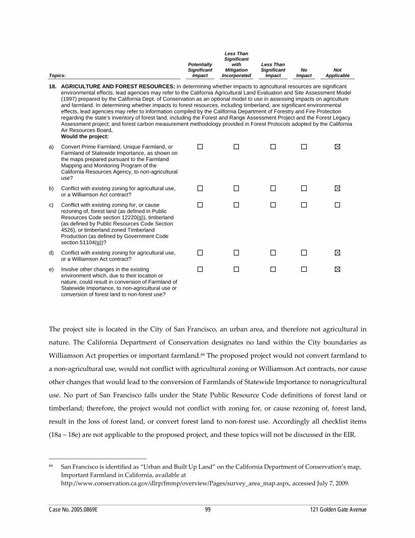
• Land Use and Land Use Planning • Aesthetics • Population and Housing • Archeological and Paleontological Resources • Transportation and Circulation • Noise • Greenhouse Gas Emissions • Wind and Shadow • Recreation • Utilities and Service Systems • Public Services • Biological Resources • Geology and Soils • Hydrology and Water Quality • Hazards and Hazardous Materials • Mineral and Energy Resources • Agriculture and Forest Resources
II. INTRODUCTION
Case No. 2005.0869E 4 121 Golden Gate Avenue Project
The Initial Study also determined that the proposed project would have a significant effect on Historic
Architectural Resources, and that an EIR would be required. Although air quality impacts were found to
be less than significant in the Initial Study, since its publication, new thresholds of significance were
adopted and air quality is re‐evaluated in this EIR.
DRAFT EIR AND PUBLIC COMMENT
This Draft EIR is prepared in accordance with CEQA, as amended, and the CEQA Guidelines. The EIR is
a public information document intended to disclose to project decision makers, public agencies, and the
public an analysis of the physical environmental effects of construction and operation of the proposed
project. Copies of the EIR are available at the San Francisco Planning Department, 1660 Mission Street, 1st
floor Planning Information Center, San Francisco, CA 94103. Additionally, the Draft EIR is available to
view or download at the Planning Department website at http://www.sfplanning.org/mea.
All documents referenced in this Draft EIR are available for review at the San Francisco Planning
Department, 1650 Mission Street, Suite 400, San Francisco, CA, 94103. The distribution list for the Draft
EIR is also available for review at the Planning Department.
Following publication of this Draft EIR, there will be a public hearing before the Planning Commission
during the EIR’s 45-day public review and comment period to solicit public comment on the adequacy
and accuracy of information and analysis presented in this Draft EIR. The public hearing on this Draft
EIR has been scheduled at the San Francisco Planning Commission for January 13, 2011, in Room 400 City
Hall, Dr. Carlton B. Goodlett Place, beginning at 2:00 p.m. or later (call 558-6422 the week of the hearing
for a recorded message giving a more specific time). There will also be a hearing before the San Francisco
Historic Preservation Commission on December 15, 2010.
Readers are invited to submit written comments on the adequacy of the document, that is, whether this
Draft EIR identifies and analyzes the possible environmental impacts and identifies appropriate
mitigation measures. Comments are most helpful when they suggest specific alternatives and/or
additional measures that would better mitigate significant environmental effects. CEQA Guidelines
Section 15096(d) calls for responsible agencies to provide comments on those project activities within
II. INTRODUCTION
Case No. 2005.0869E 5 121 Golden Gate Avenue Project
those agencies’ areas of expertise and to support those comments with either oral or written
documentation.2
Written comments should be submitted to: Bill Wycko, Environmental Review Officer c/o 121 Golden Gate Avenue Project Draft EIR San Francisco Planning Department 1650 Mission Street, Suite 400 San Francisco, CA 94103
Comments must be received by 5 p.m. on January 21, 2011.
FINAL EIR
Following the close of the public review and comment period, the Planning Department will prepare and
publish a document titled “Comments and Responses” that will contain a summary of all relevant
comments on this Draft EIR and the City’s responses to those comments, along with copies of the letters
received and a transcript of the Planning Commission Draft EIR public hearing. This Draft EIR, together
with the Comments and Responses document, will be considered by the Planning Commission in an
advertised public meeting, and then certified as a Final EIR if deemed adequate.
2 CEQA Section 21069 defines a responsible agency as a public agency, other than the lead agency, which has
responsibility for carrying out or approving a project.
Case No. 2005.0869E 6 121 Golden Gate Avenue Project
THIS PAGE INTENTIONALLY LEFT BLANK
Case No. 2005.0869E 7 121 Golden Gate Avenue Project
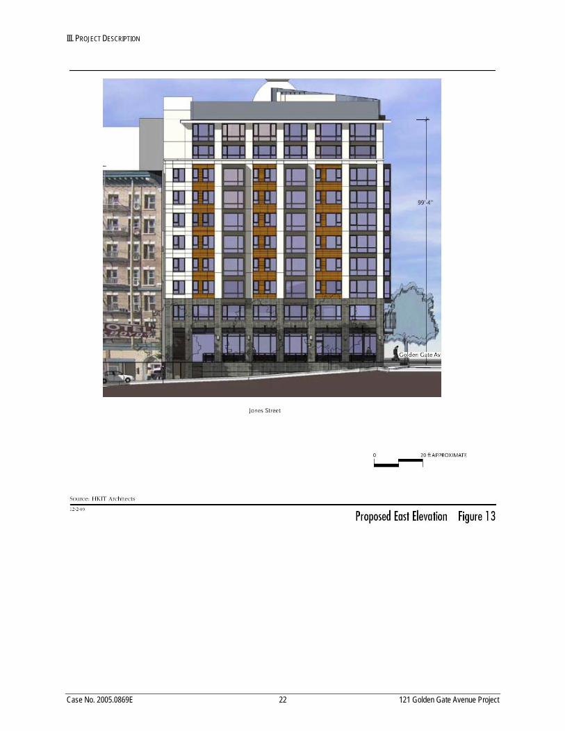
III. PROJECT DESCRIPTION
The project sponsors, St. Anthony Foundation and Mercy Housing California, propose to demolish the
existing 40‐foot‐tall, two‐story historic building at 121 Golden Gate Avenue and construct a new 99‐foot‐
tall, 10‐story building with one basement level, containing approximately 109,375 square feet (sq.ft.). The
building would consist of a kitchen/dining hall, philanthropic/social services, and 90 affordable senior
housing units without off‐street parking. The project site is located on the southwest corner of Golden
Gate Avenue and Jones Street in the Downtown/Civic Center Neighborhood (101‐121 Golden Gate
Avenue, Assessor’s Block 0349, Lot 001).
A. PROJECT LOCATION
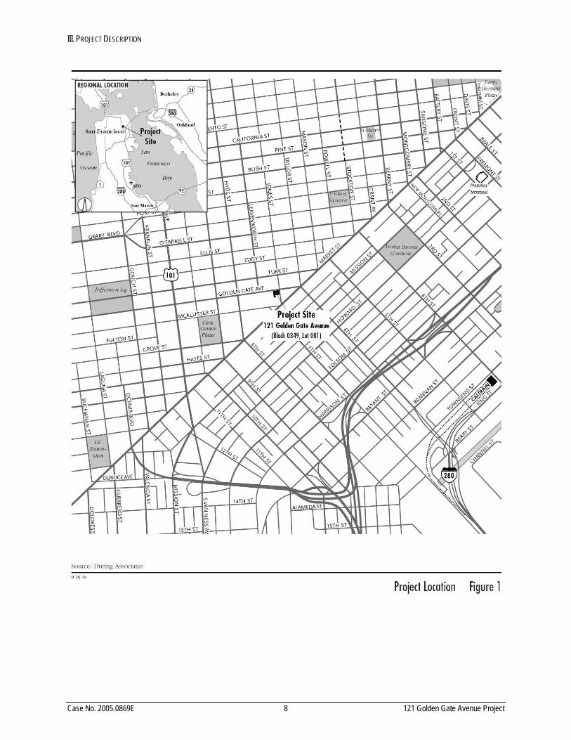
1. PROJECT SITE
The approximately 14,156‐sq.ft., flag‐shaped project site is located one block north of Market Street in the
Downtown/Civic Center area on the southwest corner of Golden Gate Avenue and Jones Street (101‐121
Golden Gate Avenue, Assessor’s Block 0349, Lot 001) on the block surrounded by Golden Gate Avenue
and Jones, McAllister, and Leavenworth Streets (see Figure 1, page 8). The topography of the project
block, including the project site, slopes moderately downward from northwest to southeast.
The existing two‐story‐with‐basement, 40‐foot‐tall, 42,468‐sq.ft. building (see Figure 2, page 9),
constructed in 1912, covers the entire lot (see Figure 3, page 12). The existing building is occupied by the
St. Anthony Foundation dining hall and kitchen (20,003 sq.ft.), philanthropic and social services space
(14,777 sq.ft.), and accessory office space (7,688 sq.ft.). The floor area ratio (FAR) is 3.0. The existing
building has pedestrian entrances on Golden Gate Avenue and Jones Street and no off‐street parking or
loading spaces. There is no open space or trees on the project site, no street trees along the Golden Gate
Avenue frontage of the project site, and one street tree along the Jones Street frontage of the site.
III. PROJECT DESCRIPTION
Case No. 2005.0869E 8 121 Golden Gate Avenue Project
III. PROJECT DESCRIPTION
Case No. 2005.0869E 9 121 Golden Gate Avenue Project
III. PROJECT DESCRIPTION
Case No. 2005.0869E 10 121 Golden Gate Avenue Project
The project site is located in an RC‐4 (Residential Commercial Combined, High Density) use district, an
80‐120‐T height and bulk district, and the North of Market Residential Special Use District, Subarea No. 1,
which has a maximum density ratio of one dwelling unit for each 125 square feet of lot area. The property
is listed as a contributor to the Uptown Tenderloin National Register Historic District (UTNRHD).
2. SURROUNDING LAND USES
The project site is located in an area with a variety of building types and uses, including residential, social
Land uses on the project block include the historic St. Boniface Church and Rectory (133‐175 Golden Gate
Avenue, San Francisco Landmark No. 172) adjacent to the project site to the west; the historic seven‐story
Boyd Hotel adjacent to the project site to the south (39 Jones Street); and the historic Hibernia Bank
building to the south of the Boyd Hotel (1 Jones Street, San Francisco Landmark No. 130). These historic
resources and the project building are located within the UTNRHD. Other uses in the project block
consist of multi‐family residential, restaurant, social services, and surface parking.
At 150 Golden Gate Avenue across the street from the project site, the St. Anthony Foundation recently
constructed a five‐story, approximately 47,000‐sq.ft. building. The building contains the administrative
offices for the Foundation, a social work center, the Tenderloin Tech Lab, a medical clinic, community
meeting space, and a food preparation and dining hall.
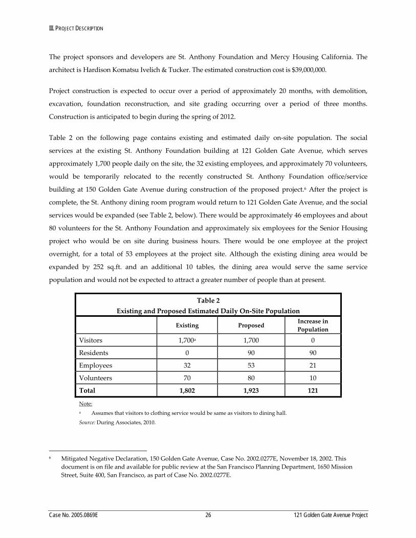
B. PROJECT CHARACTERISTICS
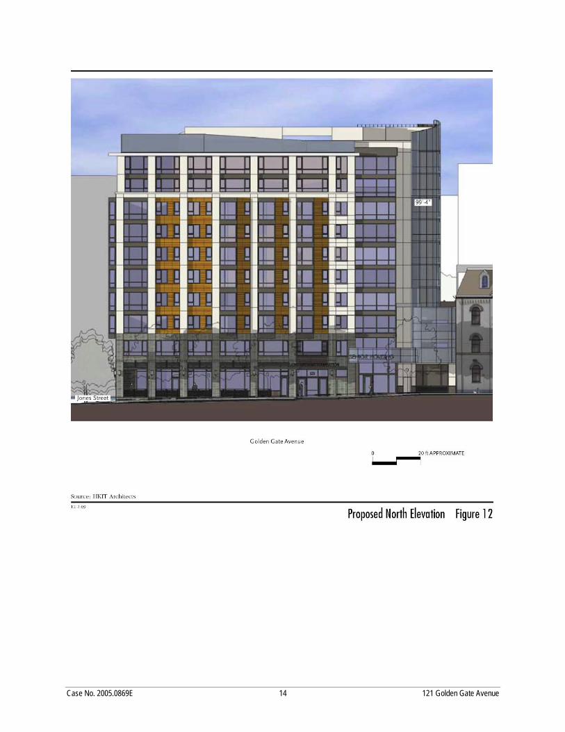
The proposed project includes the demolition of the existing two‐story building currently used for
philanthropic purposes, and construction of a 99‐foot‐tall, 10‐story, 109,375‐sq.ft. building with 40,561
sq.ft. of dining hall/kitchen and philanthropic/social services in the basement and levels 1 and 2. The
proposed building would contain 46,950 sq.ft. of residential space consisting of 90 senior affordable rental
dwelling units and 21,864 sq.ft. of non‐residential interior space on levels 3 through 10, and no parking
facilities. Table 1 below summarizes the characteristics of the project. The 90 residences would consist of
43 studios, 46 one‐bedroom units, and 1 two‐bedroom unit. The proposed building would cover the
entire lot and have a density of one residential unit per 139 square feet.
III. PROJECT DESCRIPTION
Case No. 2005.0869E 11 121 Golden Gate Avenue Project
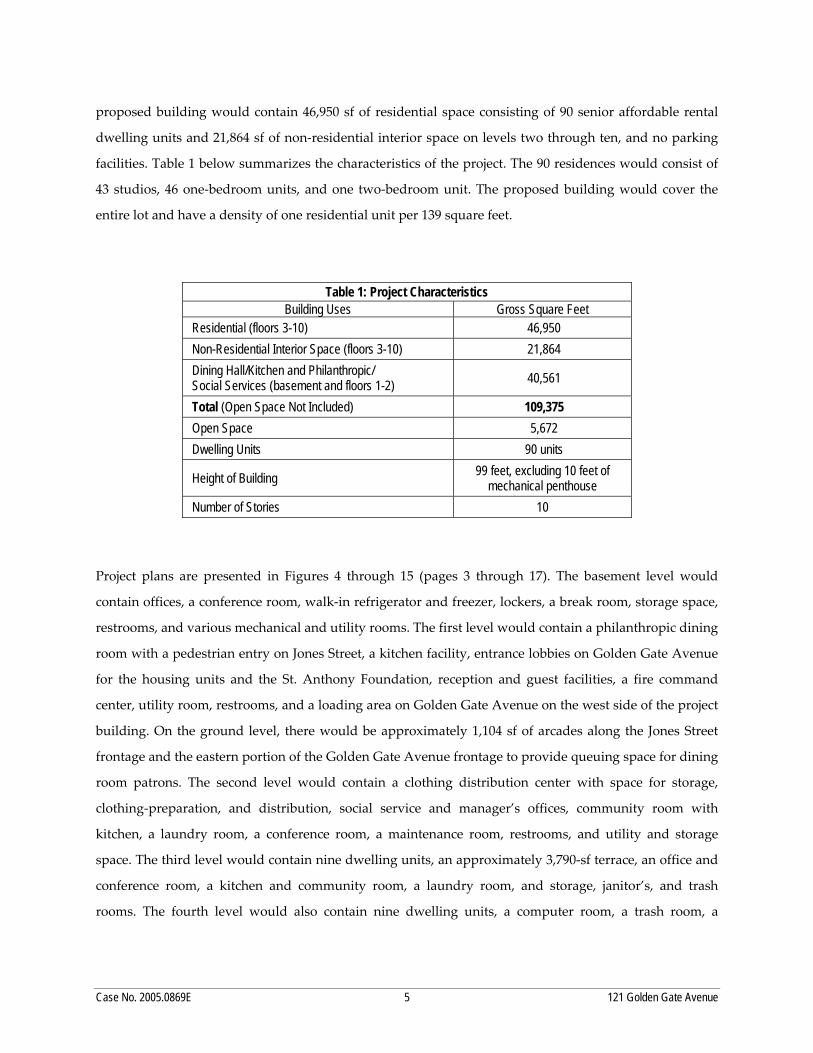
Table 1 Project Characteristics
Characteristic Measurement
Residential (floors 3‐10) 46,950 gsf
Non‐Residential Interior Space (floors 3‐10)
21,864 gsf
Dining Hall/Kitchen and Philanthropic/ Social Services (basement and floors 1‐2)
40,561 gsf
Total (Open Space Not Included) 109,375 gsf
Open Space 5,672 gsf
Dwelling Units 90 units
Height of Building 99 feet, excluding 10 feet of mechanical penthouse
Number of Stories 10
Note: gsf = gross square feet
Source: HKIT Architects, 2010.
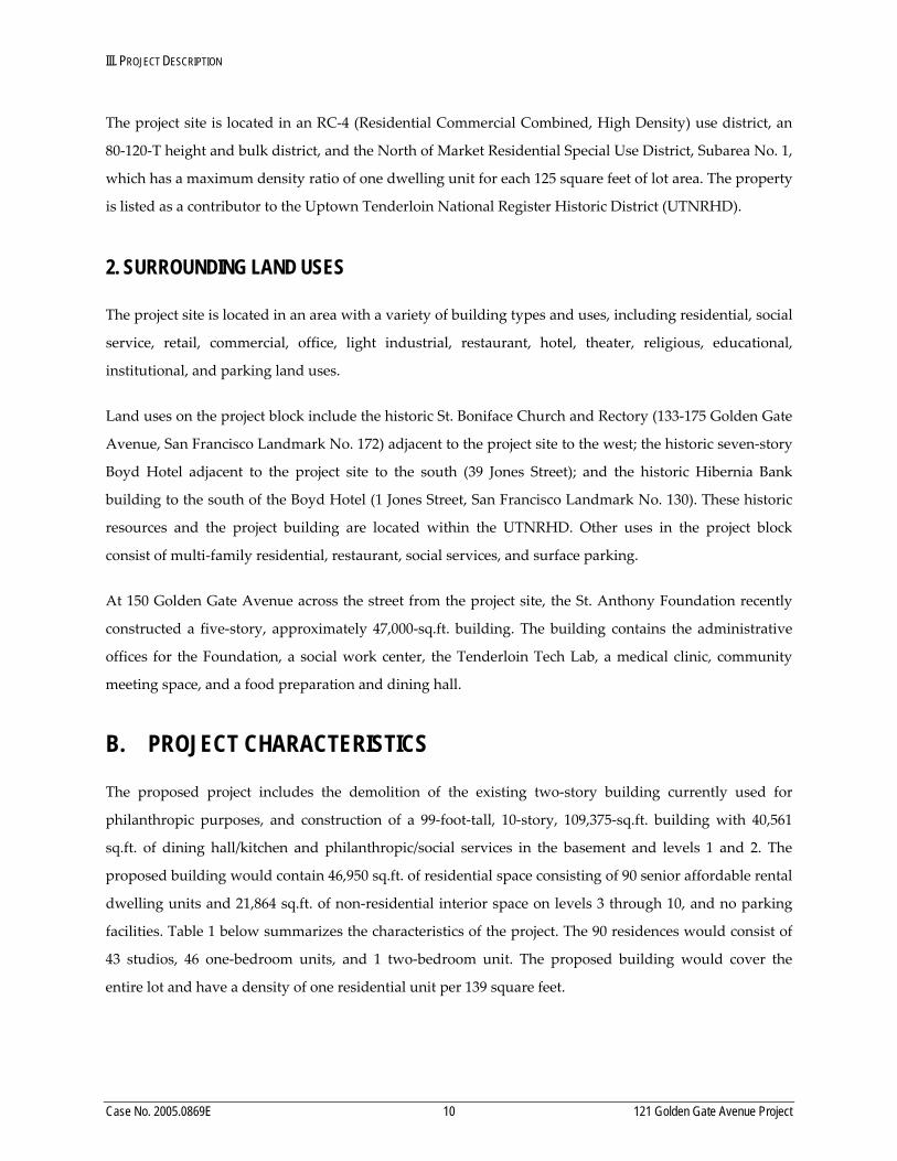
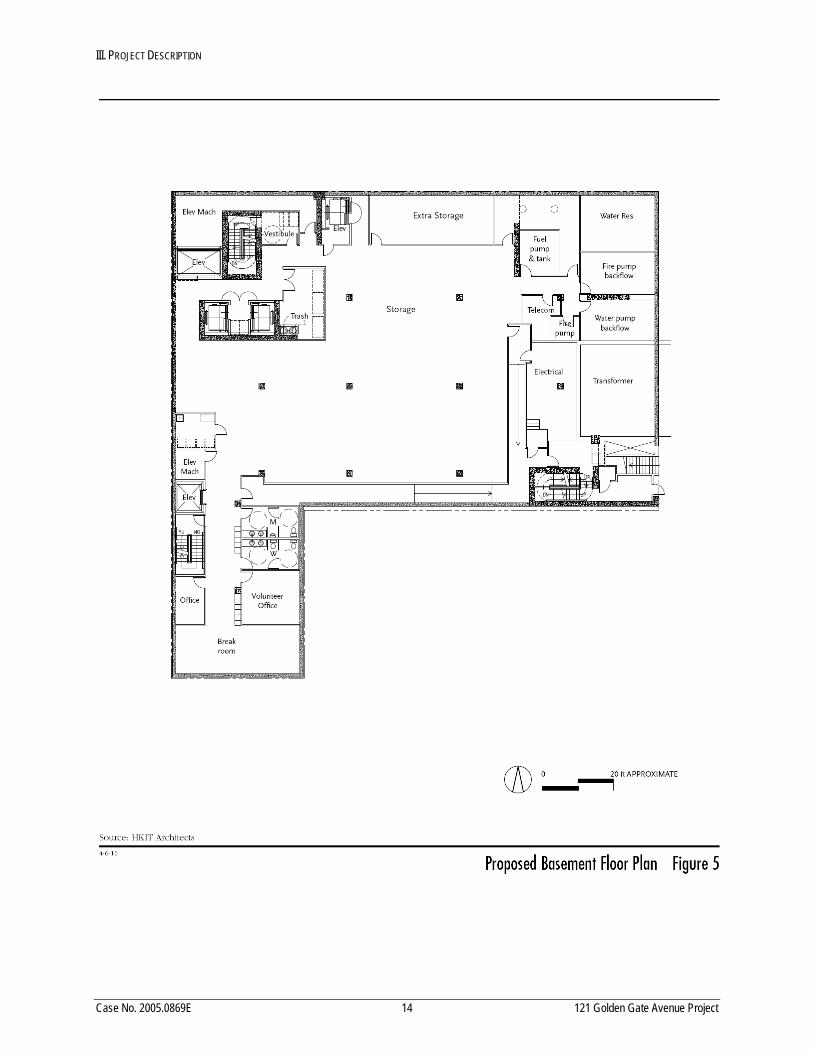
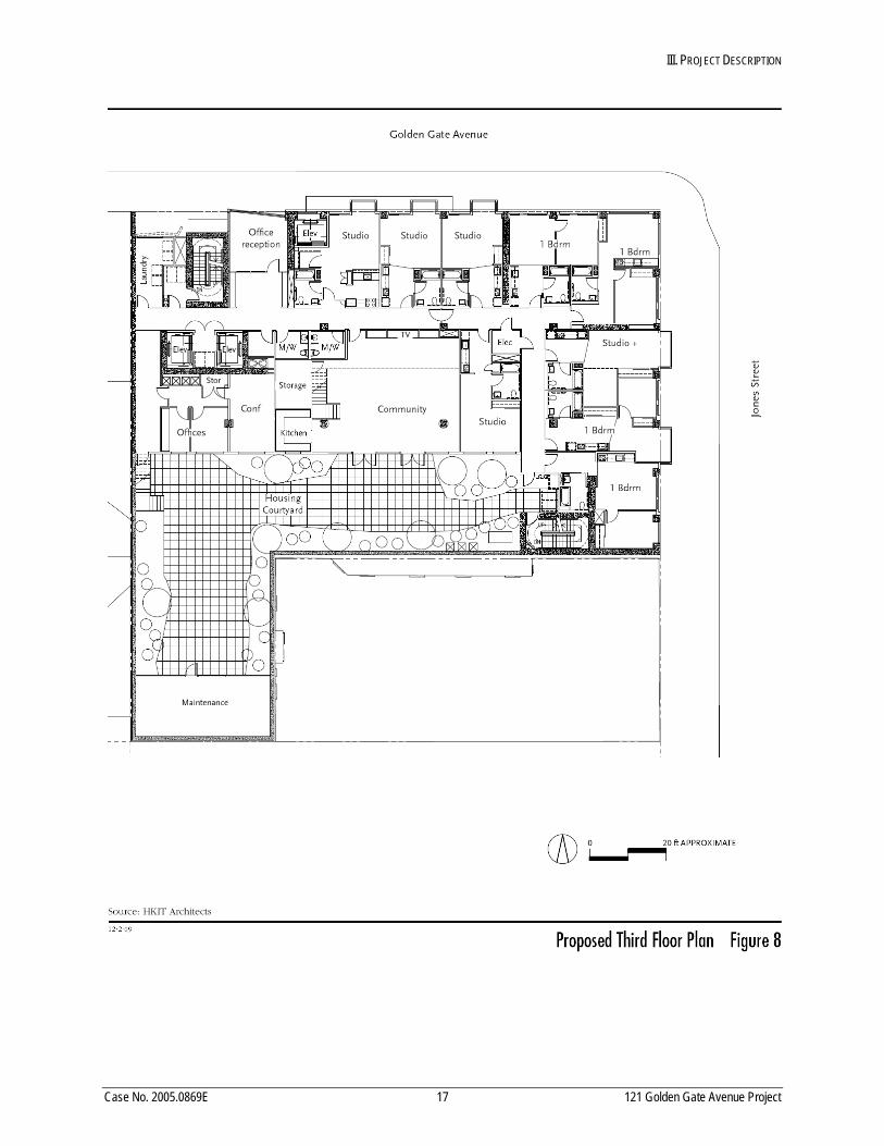
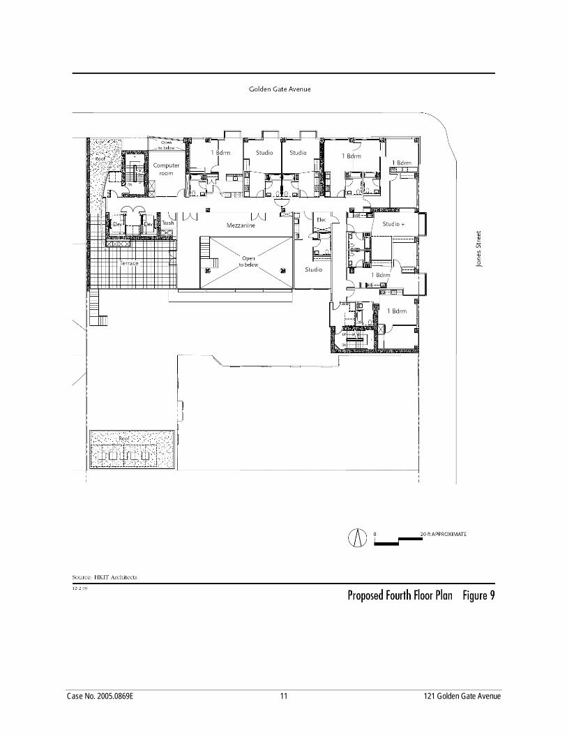
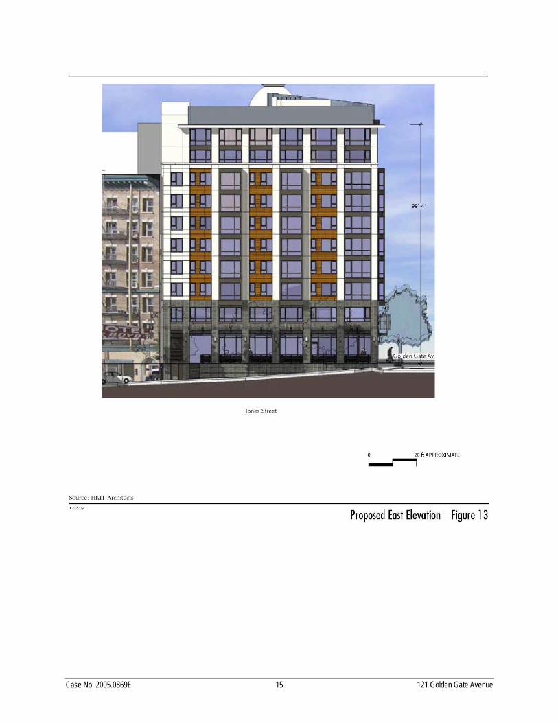
Project plans are presented in Figures 4 through 15 (pages 13 through 24). The basement level of the
proposed building would contain offices, a conference room, walk‐in refrigerator and freezer, lockers, a
break room, storage space, restrooms, and various mechanical and utility rooms. The first level would
contain a philanthropic dining room with a pedestrian entry on Jones Street, a kitchen, entrance lobbies
on Golden Gate Avenue for the housing units and St. Anthony Foundation, reception and guest facilities,
a fire command center, a utility room, restrooms, and a loading area on Golden Gate Avenue on the west
side of the project building. On the ground level, there would be approximately 1,104 sq.ft. of arcades
along the Jones Street frontage and the eastern portion of the Golden Gate Avenue frontage to provide
queuing space for dining room patrons. The second level would contain a clothing distribution center
with space for storage, clothing preparation, and distribution, social service and manager’s offices, a
laundry room, a conference room, a maintenance room, restrooms, and utility and storage space. The
third level would contain nine dwelling units, an approximately 3,790‐sq.ft. terrace, an office and
conference room, a community room with small kitchen, a laundry room, and storage, janitor’s, and trash
rooms. The fourth level would also contain nine dwelling units, a computer room, a trash room, a
III. PROJECT DESCRIPTION
Case No. 2005.0869E 12 121 Golden Gate Avenue Project
St.
III. PROJECT DESCRIPTION
Case No. 2005.0869E 13 121 Golden Gate Avenue Project
III. PROJECT DESCRIPTION
Case No. 2005.0869E 14 121 Golden Gate Avenue Project
III. PROJECT DESCRIPTION
Case No. 2005.0869E 15 121 Golden Gate Avenue Project
III. PROJECT DESCRIPTION
Case No. 2005.0869E 16 121 Golden Gate Avenue Project
III. PROJECT DESCRIPTION
Case No. 2005.0869E 17 121 Golden Gate Avenue Project
III. PROJECT DESCRIPTION
Case No. 2005.0869E 18 121 Golden Gate Avenue Project
III. PROJECT DESCRIPTION
Case No. 2005.0869E 19 121 Golden Gate Avenue Project
III. PROJECT DESCRIPTION
Case No. 2005.0869E 20 121 Golden Gate Avenue Project
III. PROJECT DESCRIPTION
Case No. 2005.0869E 21 121 Golden Gate Avenue Project
III. PROJECT DESCRIPTION
Case No. 2005.0869E 22 121 Golden Gate Avenue Project
III. PROJECT DESCRIPTION
Case No. 2005.0869E 23 121 Golden Gate Avenue Project
III. PROJECT DESCRIPTION
Case No. 2005.0869E 24 121 Golden Gate Avenue Project
III. PROJECT DESCRIPTION
Case No. 2005.0869E 25 121 Golden Gate Avenue Project
mezzanine, and a 778‐sq.ft. terrace. The fifth through tenth levels would each contain 12 dwelling units.
In addition, there would be laundry rooms on the fifth, seventh, and ninth levels, a television room on the
sixth level, and a library on the eighth level. The fifth through eighth levels would contain five studios
and seven one‐bedroom units, the ninth level would contain seven studios and five one‐bedroom units,
and the tenth level would contain seven studios, four one‐bedroom units, and one two‐bedroom unit.
The building would be rectilinear in form, with a contemporary design. There would be street‐level
arcades on both Golden Gate Avenue and Jones Street, but the remainder of the façades would be built to
the lot lines, with no setbacks. The proposed project would retain or replace the single street tree along
the Jones Street frontage of the site, as well as add up to nine street trees to the front of the property.
The proposed project would comply with the Residential Inclusionary Affordable Housing Program
(Planning Code Section 315), because all of the 90 senior units would be below market rate rental units.
At the time of publication of the Initial Study, it was thought that the proposed project could reuse the
existing basement and no excavation was expected. However, since publication, construction plans have
been refined and it has been determined that foundational and mechanical support would require
excavation to a maximum depth of 10 feet below the existing basement slab.3,4 The foundation of the
proposed structure is anticipated to be a mat slab supported on improved (compacted) soil or deep
foundations. The potential impacts of excavating an additional 10 feet below the existing basement slab
were evaluated, and the conclusions presented in the Initial Study remain unchanged.
While project plans show a 156‐sq.ft. off‐street loading space along Golden Gate Avenue, the space does
not meet the minimum dimensions for freight loading.5 The project would not supply the one loading
space required under Planning Code Section 152 and thus would require a Variance. In addition, the
project sponsor would request that the existing 42‐foot long on‐street passenger loading/unloading zone
on Golden Gate Avenue be maintained to serve the project’s residential and St. Anthony Foundation
uses. 3 The geotechnical consultant has determined that the underlying soils are suitable for such excavation and the
proposed foundation structure. Therefore, the conclusion in the Initial Study of a less‐than‐significant geological impact remains true for the currently proposed project. Treadwell & Rollo, letter to Sharon Christen, Mercy Housing California, July 1, 2010. This document is on file and available for public review at the Planning Department, 1650 Mission Street, San Francisco, as part of Case No. 2005.0896E.
4 The Initial Study also determined that the proposed project could have a significant impact on archeological resources, and that topic is therefore evaluated in this EIR.
5 Per Planning Code Section 154(b), the minimum dimensions for off‐street freight loading are 35 feet long by 12 feet wide.
III. PROJECT DESCRIPTION
Case No. 2005.0869E 26 121 Golden Gate Avenue Project
The project sponsors and developers are St. Anthony Foundation and Mercy Housing California. The
architect is Hardison Komatsu Ivelich & Tucker. The estimated construction cost is $39,000,000.
Project construction is expected to occur over a period of approximately 20 months, with demolition,
excavation, foundation reconstruction, and site grading occurring over a period of three months.
Construction is anticipated to begin during the spring of 2012.
Table 2 on the following page contains existing and estimated daily on‐site population. The social
services at the existing St. Anthony Foundation building at 121 Golden Gate Avenue, which serves
approximately 1,700 people daily on the site, the 32 existing employees, and approximately 70 volunteers,
would be temporarily relocated to the recently constructed St. Anthony Foundation office/service
building at 150 Golden Gate Avenue during construction of the proposed project.6 After the project is
complete, the St. Anthony dining room program would return to 121 Golden Gate Avenue, and the social
services would be expanded (see Table 2, below). There would be approximately 46 employees and about
80 volunteers for the St. Anthony Foundation and approximately six employees for the Senior Housing
project who would be on site during business hours. There would be one employee at the project
overnight, for a total of 53 employees at the project site. Although the existing dining area would be
expanded by 252 sq.ft. and an additional 10 tables, the dining area would serve the same service
population and would not be expected to attract a greater number of people than at present.
Table 2 Existing and Proposed Estimated Daily On‐Site Population
Existing Proposed Increase in Population
Visitors 1,700a 1,700 0
Residents 0 90 90
Employees 32 53 21
Volunteers 70 80 10
Total 1,802 1,923 121
Note: a Assumes that visitors to clothing service would be same as visitors to dining hall.
Source: During Associates, 2010.
6 Mitigated Negative Declaration, 150 Golden Gate Avenue, Case No. 2002.0277E, November 18, 2002. This
document is on file and available for public review at the San Francisco Planning Department, 1650 Mission Street, Suite 400, San Francisco, as part of Case No. 2002.0277E.
III. PROJECT DESCRIPTION
Case No. 2005.0869E 27 121 Golden Gate Avenue Project
C. PROJECT OBJECTIVES
The proposed mixed‐use project, described above, would continue the mission of St. Anthony
Foundation and provide affordable housing for seniors in close proximity to transit. The objectives of the
proposed project are as follows:
• Provide a facility that enhances the mission of St. Anthony Foundation to feed, heal, shelter, clothe, lift the spirits of those in need, and create a society in which all persons flourish.
• Provide a state‐of‐the‐art dining room and new social services facilities for the very low‐income residents of San Francisco.
• Provide a maximum amount of affordable senior housing units and associated facilities in response to the severe shortage of housing affordable to low income seniors in the City. The target population includes seniors (persons 62 years or older) with incomes that are 50 percent or less of area median income. Sponsored by Mercy Housing, the project would serve very low‐income seniors in San Francisco who are homeless or at risk of homelessness, with 18 units reserved for homeless seniors.
• Design a project that enhances the existing urban character of the area and is compatible with the Uptown Tenderloin National Register Historic District.
• Construct a LEED‐certified building.
D. REQUIRED APPROVALS
The project’s proposed social service and residential uses are principally permitted uses in the RC‐4
zoning district and the North of Market Residential Special Use District (SUD), Subarea No. 1. As
discussed in more detail in Chapter IV, Plans and Policies, below, the proposed project would require the
following actions under existing zoning regulations and ordinances, with acting bodies shown in italics.
• Conditional use authorization for construction of a building exceeding a height of 40 feet pursuant to Sections 249.5 and 253. (Planning Commission).
• Conditional use authorization for elimination of off‐street parking requirements for dwelling units pursuant to Sections 249.5(c)(6) and 161(h). (Planning Commission).
• Exception to setback requirements pursuant to Sections 249.5(c)(9) and 132.2. (Planning Commission).
• Exception to rear yard requirements pursuant to Sections 249.5(c)(10) and 134(f). (Planning Commission).
• Exception for bulk requirements pursuant to Section 271(b). (Planning Commission).
• Exception to establishment of a social service or philanthropic facility above the ground floor pursuant to Section 209.3(d). (Planning Commission).
• Variance for off‐street loading pursuant to Section 152. (Zoning Administrator).
III. PROJECT DESCRIPTION
Case No. 2005.0869E 28 121 Golden Gate Avenue Project
• Subdivision into two air rights parcels. (Department of Public Works, Permits and Mapping, Subdivision and Mapping Services).
• NEPA compliance. (Mayor’s Office of Housing).
• Recommendation to the State Historic Preservation Office of Section 106 compliance. (San Francisco Historic Preservation Commission).
• Concurrence of Section 106 compliance. (State Historic Preservation Office, completed March 18, 2009).
• Demolition and Site Permits. (Department of Building Inspection)
Case No. 2005.0869E 29 121 Golden Gate Avenue Project
IV. PLANS AND POLICIES
For informational purposes, this section provides a summary of plans and policies of the City and County
of San Francisco, and regional, state, and federal agencies that have policy and regulatory control over the
project site, and assesses the proposed project’s potential for conflicts with these plans and policies.
SAN FRANCISCO PLANS AND POLICIES
Priority Policies
In November 1986, the voters of San Francisco approved Proposition M, the Accountable Planning
Initiative, which added Section 101.1, Master Plan Consistency, and Implementation, to the Planning Code
to establish eight Priority Policies. These policies are: (1) preservation and enhancement of neighborhood‐
serving retail uses; (2) protection of neighborhood character; (3) preservation and enhancement of
affordable housing; (4) discouragement of commuter automobiles; (5) protection of industrial and service
land uses from commercial office development and enhancement of resident employment and business
ownership; (6) maximization of earthquake preparedness; (7) landmark and historic building
preservation; and (8) protection of open space. The case report and approval motions for the proposed
project will contain the Planning Department’s comprehensive project analysis and findings regarding
consistency of the proposed project with the Priority Policies. The proposed project was reviewed against
the Priority Policies and is inconsistent with Priority Policy No. 7, landmark and historic preservation.
This inconsistency is discussed below in Section V.C, Cultural Resources.
San Francisco General Plan7
The San Francisco General Plan (General Plan), which provides general policies and objectives to guide land
use decisions, contains some policies that relate to physical environmental issues. The proposed project 7 San Francisco General Plan at http://www.sf‐planning.org/ftp/General_Plan/index.htm, accessed November 29,
2010.
IV. PLANS AND POLICIES
Case No. 2005.0869E 30 121 Golden Gate Avenue Project
would not obviously or substantially conflict with any such policy. In general, potential conflicts with the
General Plan are considered by decision makers independently of the environmental review process, as
part of the decision whether to approve or disapprove a proposed project. Any potential conflict not
identified here could be considered in that context, and would not alter the physical environmental
effects of the proposed project.
Other local plans and policies reviewed against the proposed project were the San Francisco Sustainability
Plan, the San Francisco Transit First Policy, the Transit Effectiveness Project,8 and the San Francisco Bicycle
Plan. The proposed project would not conflict with the policies and objectives in these plans.
San Francisco Planning Code
The San Francisco Planning Code (Planning Code), which incorporates by reference the Cityʹs Zoning Maps,
implements the General Plan and governs permitted uses, densities, and configuration of buildings within
the City. Permits to construct new buildings (or to alter or demolish existing ones) may not be issued
unless (1) the proposed project conforms to the Planning Code, (2) the City grants allowable exceptions
pursuant to provisions of the Planning Code, or (3) the project includes amendments to the Planning Code.
The discussion in the Initial Study (Appendix A, pp. 19‐24) identifies exceptions, Variances, and
Conditional Use authorizations needed for the proposed project. The proposed project does not seek any
Planning Code amendments and is therefore consistent with the Planning Code.
Zoning Districts
As set forth in Section 206.3 of the Planning Code, the project site’s RC‐4 land use district “provide[s] for a
mixture of high‐density dwellings similar to those in RM‐4 Districts with supporting commercial uses.”
The commercial uses are those permitted in C‐2 Districts, located in or below the ground story in most
instances, and excluding automobile‐oriented establishments. Permitted uses in C‐2 Districts include
social service, philanthropic facilities, and residential care facilities. Open spaces are required for
dwellings in the same manner as in RM‐4 Districts, except that rear yards need not be at ground level and
front setback areas are not required. The high‐density and mixed‐use nature of these districts is
recognized by certain reductions in off‐street parking requirements.” The senior residential uses
proposed on the project site are principally permitted uses in the RM‐4 District, and the philanthropic
8 Recommendations of the Transit Effectiveness Project were endorsed by the SFMTA Board on October 28, 2008.
Environmental assessment is ongoing.
IV. PLANS AND POLICIES
Case No. 2005.0869E 31 121 Golden Gate Avenue Project
uses are conditionally permitted uses. Other surrounding zoning districts include RC‐4 to the north and
west, and C‐3‐G and C‐3‐R to the east and to the south.
The project site is also within the North of Market Residential SUD, Subarea No. 1 (Planning Code Section
249.5). This SUD was established to accomplish the following eight goals: (1) protect and enhance
important housing resources in an area near downtown; (2) conserve and upgrade existing low and
moderate income housing stock; (3) preserve buildings of architectural and historic importance; (4)
preserve the existing scale of development; (5) maintain sunlight in public spaces; (6) encourage new
infill housing at a compatible density; (7) limit the development of tourist hotels and other commercial
uses that could adversely impact the residential nature of the area; and (8) limit the number of
commercial establishments that are not intended primarily for customers who are residents of the area.
The North of Market Residential SUD includes the following five land use controls: (1) restriction of
commercial uses to the ground floor, the first basement floor, and (with Conditional Use authorization)
the second story; (2) prohibition of hotels, inns, hostels, motels, and massage establishments; (3) a
maximum density ratio of one dwelling unit for each 125 square feet of lot area (in Subarea No. 1); (4)
restrictions on demolitions of buildings containing residential units; and (5) various restrictions on liquor
establishments.
The proposed project does not accomplish Goal 3; it proposes demolition of an historical resource.
The City’s height and bulk districts are intended to serve a variety of urban design purposes.9 Generally,
these height and bulk districts try to relate the scale of new development to existing development
characteristics—such as height, bulk, scale, and design character—in order to prevent the new
development from creating an overwhelming or dominating appearance in the City’s skyline. The
regulation of height and bulk is also intended to promote harmony in the visual relationships and
transitions between new and existing development.
The project site is in an 80‐120‐T height and bulk district, which permits a building height of 80 feet.
Subject to the bulk restrictions discussed above, a maximum building height of 120 feet may be allowed
with Conditional Use authorization.10 Within this height and bulk district, the height at which the bulk
limits apply is determined as part of a Conditional Use authorization, required for projects in the North
San Francisco Planning Code, Section 251, Height and Bulk Districts: Purposes.
San Francisco Planning Code, Section 252, Classes of Height and Bulk Limits.
IV. PLANS AND POLICIES
Case No. 2005.0869E 32 121 Golden Gate Avenue Project
of Market Residential Special Use District (in which the project is located); as mentioned above, in no case
is it higher than 80 feet.
As discussed above, the project’s proposed residential, and social services uses are principally permitted
uses in the RC‐4 use district. The following discusses Conditional Use authorizations, exceptions, and
Variances required for the project as proposed.
Conditional Use Authorization/Variance
The project would require Conditional Use authorization pursuant to Planning Code Sections 249.5 and
253 for construction of a building exceeding a height of 40 feet, Planning Code Sections 249.5(c)(6) and
161(h) for the elimination of off‐street parking, Planning Code Sections 249.5(c)(9) and 132.2 for setback
requirements, Planning Code Sections 249.5(c)(10) and 134(f) for rear yard requirements, Planning Code
Section 271 for bulk requirements; and Planning Code Section 209.3(d) for establishment of a social service
or philanthropic facility above the ground floor and a Variance for off‐street loading requirements. The
following discussions provide additional details:
• Parking Requirements. Planning Code, Section 249.5(c)(6), provides that the off‐street parking
requirements for new construction located in the North of Market Residential SUD may be
modified by the Planning Commission as provided for in Section 161(h). The off‐street parking
requirements established by Section 151 require one parking space for each five senior dwelling
units. The proposed project would have no off‐street parking and thus would require
Conditional Use authorization for elimination of off‐street parking as required by Section 151.
• Off‐Street Loading Requirements. Planning Code Section 152, Table 152, calls for one loading
space per 100,001–200,000 sq.ft. of structure. The gross floor area of the proposed project is
109,375 sq.ft. thus, the project would be required to include one off‐street loading space. The
project would not supply the one loading space required under Planning Code Section 152 and
thus would require a Variance.
• Setback Requirements. Planning Code, Section 249.5(c)(9), provides that setbacks of 20 feet above
50 feet in height are required for new construction located in the North of Market Residential
Special Use District, and also provides that the Planning Commission may grant Conditional Use
authorization without imposing a setback requirement as set forth in Section 132.2. The proposed
project would have no setback and thus would require exception to the setback requirements
pursuant to Sections 249.5(c)(9) and 132.2.
IV. PLANS AND POLICIES
Case No. 2005.0869E 33 121 Golden Gate Avenue Project
• Rear Yard Requirements. Planning Code, Section 249.5(c)(10), provides that, for new construction
located in the North of Market Residential Special Use District, exceptions to the rear yard
requirement for an RC‐4 District may be granted pursuant to Section 134(f). Section 134(f)
provides that the rear yard requirement may be substituted with an equivalent amount of open
space situated anywhere on the site provided that the following two conditions are true: (1) the
substituted open space in the proposed new or expanding structure will improve the access of
light and air to—and views from—existing abutting properties; and (2) the proposed new or
expanding structure will not adversely affect the interior block open space formed by the rear
yards of existing abutting properties. Section 134(a)(1) requires that the minimum rear yard
depth in RC‐4 districts be equal to 25 percent of the total depth of the lot on which the building is
situated, but in no case less than 15 feet. The proposed project would have no rear yard but
would provide open space on the second, third, and fourth levels. Thus, it would require
exception to the rear yard requirements pursuant to Sections 249.5(c)(10) and 134(f).
• Bulk Requirements. Planning Code Section 271(b) requires Conditional Use authorization for
projects to exceed bulk requirements. As noted above, in the 80‐120‐T bulk districts, bulk at the
upper stories is limited to a length of 110 feet and a diagonal dimension of 125 feet. The proposed
building would have a length at the upper stories (i.e., above 80 feet) of 130’ 10” and a diagonal
dimension of 158’ 10”. It would therefore require a bulk exception for the proposed building
dimensions.
• Institutional Use Approval. Planning Code, Section 209.3(d) requires Conditional Use
authorization for establishment within an R zoning district of a social service or philanthropic
facility providing assistance of a charitable or public service nature and not of a profit‐making or
commercial nature. Within RC districts (such as the proposed project), such social service or
philanthropic facilities are principal permitted uses (i.e., allowed without Conditional Use
authorization) if they are located only in the ground floor and/or below‐ground floors, pursuant
to Planning Code, Section 209.3(d). Because the proposed philanthropic/social services would be
provided above the ground floor, the proposed project would require Conditional Use
authorization pursuant to Section 209.3(d).
PROJECT APPROVALS
As discussed under Zoning, above, the project would require Conditional Use authorization for
construction of a building exceeding a height of 40 feet, for the elimination of off‐street parking, for
IV. PLANS AND POLICIES
Case No. 2005.0869E 34 121 Golden Gate Avenue Project
setback requirements, for rear yard requirements, for bulk requirements, and for establishment of a social
service or philanthropic facility above the ground floor, and a Variance for off‐street loading
requirements. The project would also require approval of a subdivision into two air rights parcels by the
Department of Public Works. Any physical environmental effects associated with the proposed building
height are evaluated in this EIR and in the Initial Study (Appendix A). The project is subject to—and
would comply with—the Residential Inclusionary Affordable Housing Program (Planning Code Section
415).11
REGIONAL PLANS AND POLICIES
The five principal regional planning agencies and their policy plans that guide planning in the nine‐
county Bay Area are (1) the Association for Bay Area Governments’ A Land Use Policy Framework and
Projections 2009, (2) the Bay Area Air Quality Management Districtʹs (BAAQMD) Clean Air Plan (CAP)
and Bay Area 2005 Ozone Strategy, (3) the Metropolitan Transportation Commissionʹs Regional
Transportation Plan (RTP) ‐ Transportation 2030, (4) the San Francisco Regional Water Quality Control
Boardʹs (RWQCB) San Francisco Basin Plan, and (5) the San Francisco Bay Conservation and Development
Commissionʹs (BCDC) San Francisco Bay Plan. Due to the size, location, and nature of the proposed
project, there would be no anticipated conflicts with regional plans.
11 Formerly Planning Code Section 315.
Case No. 2005.0869E 35 121 Golden Gate Avenue Project
V. ENVIRONMENTAL SETTING, IMPACTS, AND MITIGATION MEASURES
Based on the Initial Study published on April 14, 2010, the San Francisco Planning Department
determined that an Environmental Impact Report (EIR) was required. The Initial Study determined that
the following effects of the project would either be less than significant or would be reduced to a less‐
than‐significant level by mitigation measures included in the project, and thus required no further
analysis. These topics are Population and Housing; Transportation and‐Circulation; Noise; Greenhouse
Gas Emissions; Wind and Shadow; Recreation; Utilities and Service Systems; Public Services; Biological
Resources; Geology and Soils; Hydrology and Water Quality; Hazards/Hazardous Materials;
Mineral/Energy Resources, and Agricultural Resources. CEQA does not require further assessment of the
environmental effects that would be less than significant; therefore, the EIR does not discuss these effects
(see Appendix A for the Initial Study). The proposed projectʹs effects on Land Use and Aesthetics were
also determined to be less than significant. These topics are included in the ElR to assist the reader and
provide details about the proposed project. In addition, construction‐related and operational‐related air
quality emissions are re‐evaluated in this Draft EIR as they relate to criteria air pollutants pursuant to the
newly updated thresholds of significance adopted by the BAAQMD on June 2, 2010 and reflected in
BAAQMD’s California Environmental Quality Act Guidelines.
V. ENVIRONMENTAL SETTING AND IMPACTS A. LAND USE AND LAND USE PLANNING
Case No. 2005.0869E 36 121 Golden Gate Avenue Project
A. LAND USE AND LAND USE PLANNING
This section is included for informational purposes only as stated in the Initial Study, page 25 (Appendix
A). The Initial Study found that the proposed project’s land use impacts would be less than significant.
SETTING
LAND USES IN PROJECT VICINITY
The project site is located in the Downtown/Civic Center area. The topography of the project block,
including the project site, slopes moderately downward from northwest to southeast. The area has a
variety of building types and uses, including residential, social service, retail, commercial, office, light
industrial, restaurant, hotel, theater, religious, educational, institutional, and parking land uses. Uses on
the project block include the historic St. Boniface Church and Rectory (133‐175 Golden Gate Avenue, San
Francisco Landmark No. 172) adjacent to the project site to the west, the historic seven‐story Boyd Hotel
adjacent to the project site to the south (39 Jones Street), and the historic Hibernia Bank building to the
south of the Boyd Hotel (1 Jones Street, San Francisco Landmark No. 130). These historic buildings and
the project building are within the Uptown Tenderloin National Register Historic District (UTNRHD).
Other uses in the project block consist of multi‐family residential, restaurant, social services, and surface
parking.
North of the project site, across Golden Gate Avenue, is a nine‐story multi‐family residential building
(111 Jones Street). West of this building, on the north side of Golden Gate Avenue, is a three‐story
commercial building (134 Golden Gate Avenue), the recently constructed five‐story office/service
building for the St. Anthony Foundation (150 Golden Gate Avenue), and a two‐story commercial/office
building on the northeast corner of Golden Gate Avenue and Leavenworth Street (172 Golden Gate
Avenue). Northeast of the project site, on the northeast corner of Golden Gate Avenue and Jones Street, is
a three‐story light industrial building (90 Golden Gate Avenue). East of the project site, across Jones
Street, is a paved surface parking lot. South of the parking lot on the east side of Jones Street is a three‐
story commercial/office building (20 Jones Street).
To the southeast, along the Market Street transportation and commercial corridor in the vicinity of the
project site, are one‐ to seven‐story buildings with a variety of uses including hotel, retail, commercial,
office, restaurant, theater, and residential.
V. ENVIRONMENTAL SETTING AND IMPACTS A. LAND USE AND LAND USE PLANNING
Case No. 2005.0869E 37 121 Golden Gate Avenue Project
IMPACTS
SIGNIFICANCE CRITERIA
The project would have a significant effect on the environment in terms of land use if it were to:
• Physically divide an established community;
• Conflict with any applicable land use plan, policy, or regulation of an agency with jurisdiction over the project (including, but not limited to, the General Plan, specific plans, local coastal program, or zoning ordinance) adopted for the purpose of avoiding or mitigating an environmental effect; or
• Have a substantial adverse impact on the existing character of the vicinity.
A conflict between a proposed project and a General Plan policy does not necessarily indicate a significant
effect on the environment under CEQA. The staff report for the Planning Commission will analyze the
project’s consistency with General Plan policies and zoning, and will discuss any exceptions requested or
modifications required. As a result, the impact analysis below does not evaluate inconsistencies between
the proposed project and General Plan policies that do not relate to physical environmental impacts,
although relevant sections of this EIR analyze physical environmental impacts that could result from such
conflicts.
IMPACT ANALYSIS
Neighborhood Character and Compatibility Impact LU‐1: The proposed project would have a less‐than‐significant impact on the existing character of the project site and vicinity and would not physically divide an established community. (Less than Significant)
The project proposes approximately 109,375 sq.ft. of mixed‐use space consisting of a kitchen/dining hall,
philanthropic/social services, and 90 affordable senior housing units. While the proposed ten‐story‐with‐
basement building would represent a change to the area and would be a substantially larger development on
the project site than what currently exists, the proposed project would not introduce new or incompatible
land uses to the area. The project neighborhood is a mixed area, with residential, social service, retail,
uses. Numerous residential uses already exist in the project vicinity, including several eight‐ to ten‐story
multi‐family residential buildings.
V. ENVIRONMENTAL SETTING AND IMPACTS A. LAND USE AND LAND USE PLANNING
Case No. 2005.0869E 38 121 Golden Gate Avenue Project
The scale and massing of the proposed building would be greater than the low‐rise buildings in the
surrounding area, but would be similar to the larger (eight‐ to ten‐story) buildings in the area, such as the
eight‐story Grant Building at 1095 Market Street, the eight‐story building at 177 Golden Gate Avenue (at the
west end of the project block), and the ten‐story building at 270 Turk Street (one block north of the project);
and would be smaller than the 15‐story building at 1010 Market Street, located one block east of the project.
The proposed project would be consistent with existing heights and character of the vicinity; therefore, this
impact would be less than significant.
While the proposed project would intensify land uses on the project site, the scale and massing would be
similar to other buildings in the project vicinity and therefore would not have a demonstrable adverse
effect on the land use character in the vicinity. In addition, it would not physically divide an established
community.
Consistency with Applicable Land Use Plans and Policies Impact LU‐2: The proposed project would not conflict with an adopted land‐use plan or policy adopted for the purpose of avoiding or mitigating and environmental effect. (Less than Significant)
As discussed in the Plans and Policies section, the proposed project appears to conflict with policies that
call for the preservation of historic residential buildings (General Plan Housing Element Policy 3.6;
Priority Policy (7)), because the proposed project would result in the demolition of an historic resource on
the site. The project would require Conditional Use authorization for the elimination of off‐street parking,
for setback requirements, for rear yard requirements, for bulk limits, and for establishment of a social
service or philanthropic facility above the ground floor. In addition, it would require a Variance from off‐
street loading space requirements set forth in Planning Code Section 152. These actions, if approved would
be granted through the existing provisions of the Planning Code. They would not require an amendment
to, and therefore they would be considered consistent with the Planning Code.
As discussed above, San Francisco General Plan, which provides general policies and objectives to guide
land use decisions, contains some policies that relate to physical environmental issues. Any physical
environmental impacts that could result from such conflicts are analyzed in this EIR. The compatibility of
the project with General Plan policies that do not relate to physical environmental issues will be
considered by decision makers as part of their decision whether to approve or disapprove the proposed
project, and any potential conflicts identified as part of that process would not alter the physical
environmental effects of the proposed project.
V. ENVIRONMENTAL SETTING AND IMPACTS A. LAND USE AND LAND USE PLANNING
Case No. 2005.0869E 39 121 Golden Gate Avenue Project
Cumulative Impacts Impact LU‐3: The proposed project, in combination with other planned and foreseeable future developments and projects, would not have a cumulatively ultimately considerable effect on land use. (Less than Significant)
All of the cumulative projects identified in the vicinity of the proposed project are small‐scale developments,
with the exception of the proposed retail and parking project at 935‐965 Market Street (see Table 3 below).
These cumulative projects and the proposed development, when considered together, would not introduce
substantial new incompatible land uses to the area; furthermore, they would not change the existing street
network or traffic patterns, or establish any physical barriers to pedestrian or vehicular traffic within the
community. Therefore, implementing these cumulative projects would not be expected to physically disrupt
or divide an established community. The cumulative projects would be required to be generally consistent
with the City’s adopted plans and policies. For these reasons, the project would result in a less‐than‐
significant cumulative land use impact.
Table 3 Development Projects in Vicinity of Project Site
New 5‐story, approx 90 foot tall, 375,700 sq ft retail center with 188 parking spaces.
Approved (appeal to BOS dismissed) 9/14/10
570 Jessie Street
New construction of an eight‐story 75‐foot‐tall, residential building containing approximately 47 dwelling units, 23 off‐street parking spaces and three car‐share spaces.
Approved by Planning 12/5/2008
168‐186 Eddy Street
Demolish an existing surface parking lot and construct a new 14‐story, 130‐foot tall mixed‐use building containing approximately 153 affordable dwelling units, approximately 13,750 square feet of ground‐floor commercial space, a supportive services office, rooftop and second floor open space, one loading space, and no off‐street parking.
Approved by Planning 3/26/09
1036 Mission Street
Construction of a mixed use building containing approximately 100 affordable dwelling units, ground floor retail space, common community space, and no off‐street parking.
Approved by Planning 5/14/09
519 Ellis/430 Eddy
Two companion projects to construct a total of 46 dwelling units.
Planning case open
Source: Planning Department, November 2010.
V. ENVIRONMENTAL SETTING AND IMPACTS A. LAND USE AND LAND USE PLANNING
Case No. 2005.0869E 40 121 Golden Gate Avenue Project
Project Land Use Impacts: Conclusion
While the proposed project combined with other foreseeable development proposals in the area would
intensify land uses on the project site, they would not physically divide an established community,
substantially and obviously conflict with any applicable land use plans, or substantially and adversely
alter the land use character of the vicinity. For these reasons, the project‐specific and cumulative land use
impacts would be considered less than significant.
V. ENVIRONMENTAL SETTING AND IMPACTS B. AESTHETICS
Case No. 2005.0869E 41 121 Golden Gate Avenue Project
B. AESTHETICS
This section is included for informational purposes. The Initial Study found that the proposed project’s
aesthetics impacts would be less than significant.
SETTING
SCENIC VISTAS AND VIEWS
View corridors are defined by physical elements such as buildings and structures that direct lines of sight
and control view directions available to the public. Scenic views are limited in the project vicinity due to
surrounding urban development and intervening buildings.
There are no public scenic vistas in the area. The neighborhood is densely developed, and many
buildings extend to the lot lines. Surrounding building placements define the Golden Gate Avenue and
Jones Street view corridors. The project site is visible from the adjacent segments of Golden Gate Avenue
and Jones Street, their sidewalks, and the immediate project vicinity. Surrounding buildings are also
visible from the streets and sidewalks near the project site, including the historic Hibernia Bank building
on the west side of Jones Street south of the project site, and the steeple of the St. Boniface Church and
Rectory, which is visible from vantage points at the intersection of Golden Gate Avenue and Jones Street,
Golden Gate Avenue east of Jones Street, and west of the project site. Because the church is a historical
landmark, views of the steeple and rectory can be considered a public benefit of the existing environment.
Public open spaces located within the project vicinity include Father Alfred E. Boeddeker Park, Hyde and
Turk Mini‐Park, United Nations Plaza, and the Joseph L. Alioto Performing Arts Piazza. Boeddeker Park
is located about two blocks north of the project site. Views of the project site from Boeddeker Park are
screened by intervening buildings and the density of mature trees in the park. Similarly, the project site is
not visible from United Nations Plaza located about one block southwest of the project site, from Hyde
and Turk Mini‐Park located approximately three blocks west of the project site, or from the Joseph L.
Alioto Performing Arts Piazza located approximately four blocks southwest of the site because
intervening buildings and the distance limit views to and from the project site.
V. ENVIRONMENTAL SETTING AND IMPACTS B. AESTHETICS
Case No. 2005.0869E 42 121 Golden Gate Avenue Project
VISUAL CHARACTER
The visual character of the project site and vicinity is urban and mixed, with a variety of residential, social
institutional, and parking uses. While there are a variety of building types, sizes, and ages, most
buildings date from the early to mid twentieth century. In the project vicinity, building heights vary from
two to ten stories.
IMPACTS
SIGNIFICANCE CRITERIA
The project would have a significant effect on the environment in terms of aesthetics if it would:
• Have a substantial adverse effect on a scenic vista;
• Substantially damage scenic resources, including, but not limited to, trees, rock outcroppings, and other features of the built or natural environment, which contribute to a scenic public setting;
• Substantially degrade the existing visual character or quality of the site and its surroundings; or
• Create a new source of substantial light or glare which would adversely affect day or nighttime views in the area or which would substantially impact other people or properties.
IMPACT ANALYSIS
Scenic Resources and Visual Character
Scenic Vistas
Impact AE‐1: Implementation of the proposed project would alter public views of and through the project site from public vantage points, but would not have a substantial adverse effect on a scenic vista. (Less than Significant)
The existing visual character of the project site would be altered by replacing the existing two‐story‐over‐
basement historic building with a new ten‐story building. The proposed 99‐foot‐tall building would be
visible along Golden Gate Avenue and Jones Street and the immediate project vicinity. The project would
not affect existing public views of the historic Hibernia Bank building on the west side of Jones Street
south of the project site. The project would block existing public views of the steeple of the St. Boniface
Church and Rectory from vantage points at the intersection of Golden Gate Avenue and Jones Street, and
Golden Gate Avenue east of Jones Street. Views of the steeple from vantage points west of the project site
V. ENVIRONMENTAL SETTING AND IMPACTS B. AESTHETICS
Case No. 2005.0869E 43 121 Golden Gate Avenue Project
would not be affected. Other eastward and westward views of surrounding urban development along
Golden Gate Avenue, and northward and southward views of surrounding urban development along
Jones Street, would not be substantially affected. Although some views of the steeple of the St. Boniface
Church and Rectory would be affected, there are no views that would be considered scenic in the area,
and the proposed project would not substantially alter existing views of surrounding development.
Views of the proposed building from Boeddeker Park would be screened by intervening buildings and
the density of mature trees in the park. Similarly, the proposed project would not be visible from United
Nations Plaza located about one block southwest of the project site, from Hyde and Turk Mini‐Park
located approximately three blocks west of the project site, or from the Joseph L. Alioto Performing Arts
Piazza located approximately four blocks southwest of the site because intervening buildings would limit
views of the project site. Therefore, the proposed project would not have a significant impact on existing
views from public open space areas in the project vicinity. The proposed new building may be visible in
some long‐range views from other public spaces (such as Russian Hill and Nob Hill), but would not
result in a substantial adverse visual change because it would tend to blend into the densely built urban
fabric of the area.
The proposed project at 121 Golden Gate Avenue would be visible from adjacent and nearby office and
residential buildings. The proposed building could be visible from residential buildings across Golden
Gate Avenue or Jones Street or on the project block. For those residences with views of the project site, the
proposed project would change the existing views of the project site’s 40‐foot‐tall, two‐story building, the
upper floors of adjacent buildings, and the sky in the background. The proposed project would replace
these with views of a 99‐foot‐tall, ten‐story‐tall building that would block all or a substantial amount of
the view of background buildings and sky. Although some reduced private views would be an
undesirable change for those individuals affected, the change in views would not exceed that commonly
expected in an urban setting.
The upper portion of the proposed project would be visible from various vantage points along the streets
in the vicinity. Since these views would be consistent with surrounding urban development, the
proposed project would not contribute to any potential obstruction of views or substantially degrade any
existing scenic vistas.
Scenic Resources
Impact AE‐2: Implementation of the proposed project would not adversely affect scenic resources. (Less than Significant)
V. ENVIRONMENTAL SETTING AND IMPACTS B. AESTHETICS
Case No. 2005.0869E 44 121 Golden Gate Avenue Project
A two‐story‐over‐basement building currently occupies the project site and the site contains no scenic
resources of the natural or built environment. Therefore, the project would not damage scenic resources
or other features of the built or natural environment that contribute to a scenic public setting. (Chapter
V.C, Cultural Resources, assesses the proposed project’s impact on historical architectural resources.)
Visual Character
Impact AE‐3: Implementation of the proposed project would not substantially degrade the existing visual character or quality of the site or its surroundings. (Less than Significant)
The proposed ten‐story building would be compatible with the height of immediately surrounding
buildings, which range from three to nine stories. The proposed building would be rectilinear in form
with a contemporary design character. Both the Golden Gate Avenue and Jones Street façades would be
built to the lot lines, with ground floor arcades. The proposed project’s final architectural design and
articulation would undergo evaluation by the Planning Department and Planning Commission as part of
the Conditional Use authorization review, a process separate from the environmental review. The
proposed project would retain or replace the single existing street tree along the Jones Street frontage of
the site, as well as add up to nine street trees to the front of the property on Jones Street and Golden Gate
Avenue, in conformance with the Planning Code and Department of Public Works requirements, which
include provision of street trees every 20 feet. While the proposed project would intensify use of the site
and would be visible to neighboring residents, workers, and visitors, it would not be visually inconsistent
with other buildings in the project vicinity in terms of its building materials, massing, height, and the
overall mixed‐use visual character of surrounding development. Therefore, the proposed project would
not substantially degrade the existing visual character or quality of the site and its surroundings.
Light and Glare
Impact AE‐4: Implementation of the proposed project would increase light and glare at the project site. (Less than Significant)
Current sources of light and glare on and from the project site include exterior lighting and lighting from
windows of existing buildings in the vicinity. The proposed project would introduce additional sources
of lighting to the project area, coming from the additional eight stories of windows of the proposed ten‐
story building. Outdoor lighting at the street perimeter of the project site and nighttime lighting for the
project would remain within typical and accepted levels for an urban residential setting. The proposed
project would comply with Planning Commission Resolution 9212, which prohibits the use of mirrored or
V. ENVIRONMENTAL SETTING AND IMPACTS B. AESTHETICS
Case No. 2005.0869E 45 121 Golden Gate Avenue Project
reflective glass. The proposed project would not generate obtrusive light or glare that would substantially
affect other properties.
Cumulative Impacts
Impact AE‐5: The implementation of the proposed project, in combination with past, present, and reasonably foreseeable future projects in the vicinity, would result in a less‐than‐significant cumulative impact to visual resources. (Less than Significant)
As discussed under Land Use, all of the cumulative projects identified in the vicinity of the proposed project
are small‐scale developments, with the exception of the proposed retail and parking project at 935‐965
Market Street, which is two blocks from the project site. No designated scenic vistas exist within the site
vicinity, and scenic resources in the vicinity are limited to the built environment. Cumulative development
would not affect enjoyment of the historical resources in the vicinity, or Civic Center, which would not be
affected by cumulative development. Although visual quality is subjective, it can reasonably be concluded
that the proposed project, itself, within anticipated cumulative development, would not result in a
substantial negative effect on the existing visual character. Additionally, all new development in the area
would be required to comply with Planning Commission Resolution 9212, and would not generate
obtrusive light or glare that would cumulatively substantially affect other properties.
Conclusion
Based on the above analysis, the proposed project would not have a substantial demonstrable negative
effect on a scenic vista, damage scenic resources, degrade the site’s or surrounding area’s visual character,
or create a new source of obtrusive light and glare, either on a project‐specific or cumulative level. The
proposed project would therefore have a less‐than‐significant cumulative aesthetic impact.
V. ENVIRONMENTAL SETTING AND IMPACTS C. CULTURAL RESOURCES
Case No. 2005.0869E 46 121 Golden Gate Avenue Project
C. CULTURAL RESOURCES
This section evaluates the proposed project’s archeological and historic architectural impacts. The
proposed project’s paleontological impacts were found to be less than significant in the Initial Study,
page 35 (Appendix A).
SETTING
ARCHEOLOGICAL RESOURCES
This section evaluates the potential for the proposed project to substantially and adversely affect
archeological resources. The project site has not been subject to a subsurface archeological study and is in
an archeologically sensitive area for prehistoric sites. An independent consultant prepared an
archeological research design and treatment plan (ARDTP),12 which was reviewed by Planning
Department staff.13 These documents are summarized below.
Archeological evidence suggests that the earliest traces of human habitation on the San Francisco
peninsula date to around 6,000 B.P., and that the region has been continuously inhabited by humans ever
since. The earliest site found in San Francisco—discovered during the course of excavation at the BART
Civic Center station—contained a fragmentary human skeleton, a find that points to the possibility of
prehistoric resources throughout San Francisco.
There are 6 prehistoric and 11 historical period archeological sites within one‐half mile of the project site.
Human remains associated with the nearby Yerba Buena Cemetery (one block from the project site) have
a very slight potential of being found beneath the project site. Although also unlikely, there remains a
possibility that items salvaged from the 1906 earthquake by refugees—and collected at the site but
subsequently abandoned in order to flee the encroaching fires that followed the earthquake—could
remain buried at the project site. Rubble deposits from nearby buildings that collapsed in the 1906
earthquake may also exist beneath the project site, but it is unlikely that they would be deemed
significant.
12 Archeo‐Tec, Draft Archeological Research Design and Treatment Plan (ARDTP) for the 101‐121 Golden Gate Avenue
Project, City and County of San Francisco, California, April 2008. 13 Randall Dean/Don Lewis, MEA Preliminary Archeological Review: Checklist, July 23, 2010.
V. ENVIRONMENTAL SETTING AND IMPACTS C. CULTURAL RESOURCES
Case No. 2005.0869E 47 121 Golden Gate Avenue Project
The project site was a vacant lot at the time of the 1906 earthquake and fire, and was not built upon until
1912 when a two‐story structure housing stores, a saloon, and an auto sales and repair shop was built.
The building burned in 1922 and was repaired, and in 1950 became St. Anthonyʹs dining room, a free
kitchen that is still in operation today. Since the project site was not occupied until the early twentieth
century, significant nineteenth‐century or early twentieth‐century remains are not likely to be found.
The project site and surrounding area were undeveloped in 1852. In 1859, three small wood‐frame
buildings had been constructed on the project block, but not on the project site. By 1869, they had been
replaced by a large building along the Tyler Street (Golden Gate Avenue, and likely the St. Boniface
Church) frontage and by another building along Jones Street. The 121 Golden Gate Avenue project site
remained undeveloped.
The project block continued its pattern of slow but steady growth during the latter nineteenth century,
although the project site continued to remain undeveloped. However, the project site may have been
frequented by neighbors, because it became one of the few open spaces left in the neighborhood. By 1899,
the project area had become a bustling part of the City.
To the south of the project area was a large building with a domed entrance at the corner of Jones and
McAllister streets—headquarters for the Hibernia Loan & Savings Society. The building survived the
quake and still stands today. It had both gas and electric lights and a stone façade. West of this was a
large office building varying from four to five stories. Farther to the west were a boarding house,
dwellings from 1886, and an office building fronting on Leavenworth Street.
The 121 Golden Gate Avenue site and its environs burned on the first day of the Great Earthquake and
Fire of April 1906. The newly finished St. Boniface church was reduced to a few walls and a massive pile
of rubble. Only the spire remained intact. The Hibernia Bank Building, which survived the fire relatively
intact, was a common photographic subject during and after the fires.
In 1912, a two‐story commercial building with a basement was built on the project site—the building that
remains today. It is unknown from the historical record whether excavations for the basement of the 1912
building completely removed all earthquake rubble or if rubble from the old St. Boniface Church may still
lie under the basement of the existing building.
By 1913, new development on the project block showed significant consolidation. The old single‐family
detached homes and small office buildings were replaced with larger structures. Near the southwest
corner of the block, where the three dwellings and the small office buildings had been, was now the
V. ENVIRONMENTAL SETTING AND IMPACTS C. CULTURAL RESOURCES
Case No. 2005.0869E 48 121 Golden Gate Avenue Project
Savoy Theatre. The lot east of the Savoy was mostly vacant, except for a two‐story commercial building
located mid‐way along the lot. The southeastern corner still contained the Hibernia Savings & Loan
Society. The northwestern corner of the block, where an independent residence and a marble works had
been, was vacant. Directly east of that, the St. Boniface School, church, and friary had been rebuilt.
At the northeast corner of the project block, the existing 121 Golden Gate Avenue building filled the
entire flag‐shaped parcel. Then as today, the building surrounded a seven‐story hotel with a store on the
first floor, which was wedged along Jones St. between the project area and the Hibernia building. The
project building was internally divided into six spaces. One of these, a store, fronted Jones Street. Three
others alongside the Jones Street store fronted onto Golden Gate and consisted of two stores and a bar.
Next to these, separated by a firewall, was the anchor tenant: an automobile dealership and repair
business. The first floor contained the showroom and the basement contained the repairing room. The
basement was accessed off Jones Street. Next to the auto dealership was a large store whose business is
unknown. The project area burned again in September 1922, but the existing building survived with only
smoke stains. All the storefronts along Golden Gate had fire damage.
By mid‐twentieth century, most of the remaining vacant lots had been developed, but existing buildings
were mostly unchanged. By 1949, the auto dealership within the subject building had been subdivided
into two smaller stores. Otherwise the project area appeared physically unchanged. Its surroundings—
the hotel, Hibernia Bank, and the St Boniface Church complex—were also unchanged. Elsewhere on the
block, the Salvation Army had built a girls’ hotel next door to Hibernia Bank, while the single store that
had once filled this lot had been torn down. The Savoy Theatre became the President Theatre, and the
vacant corners of Leavenworth at McAllister Street and at Golden Gate Avenue had been filled in with
commercial buildings.
HISTORIC ARCHITECTURAL RESOURCES
The assessment in the Initial Study (Appendix A) found that the 121 Golden Gate Avenue building is
considered a historic resource under CEQA. The building—a 40‐foot, two‐story‐over‐basement
commercial building that was constructed in 1912 for a theatrical supply company—appears to be eligible
for listing individually and as a contributor on both the California Register of Historical Resources and
National Register of Historic Places based on its association with known historical events and with Father
Alfred Boeddeker, a person of significance in local history. The 121 Golden Gate Avenue building is also
one of 408 Contributors to the 452‐building Uptown Tenderloin National Register Historic District
(UTNRHD) that was listed on the National Register in January 2009.
V. ENVIRONMENTAL SETTING AND IMPACTS C. CULTURAL RESOURCES
Case No. 2005.0869E 49 121 Golden Gate Avenue Project
The 121 Golden Gate Avenue Building
No documentation has been located that would indicate that previous buildings existed on the project
site before the existing building was constructed in 1912. The existing building is a low, two‐story
rectangular mass (over partial basement) that is built to the property lines, resulting in an L‐shaped floor
plan. The lower level was for commercial uses, with offices above. The Golden Gate Avenue façade is
divided into eight structural bays, the Jones Street façade into five. Each façade features a continuous
horizontal stucco band that separates the upper and lower levels, and the entire composition is
surmounted by a modest stamped sheet metal cornice above a blank frieze and a cast plaster egg‐and‐
dart molding strip.
The street level of the Golden Gate Avenue façade appears to be composed of eight regularly spaced
individual storefronts with conventional display windows and doors with full‐width transoms above.
However, an examination of the floor plan illustrates that the street level plan is actually composed of
three individual elements. The corner element 101, 105 and 107 Golden Gate / 45‐55 Jones Street is 50ʹ‐0ʺ
wide by 90ʹ‐0ʺ deep that contained three shops, a restaurant, and at 45 Jones Street the lobby for the
residential units above. 109‐117 Golden Gate contained a single shop in a second 50ʹ‐0ʺ0ʺ space. A fire
door connected these two spaces. Separated only by a non‐rated partition, 121‐127 Golden Gate
comprises the third element of the plan, and is contained in a single space 37ʹ‐6ʺ wide by 137ʹ‐6ʺ deep. No
indication of any special characteristics of the interiors has been located.
The exterior materials include sheet metal cornice, painted cement plaster exterior walls, and wood frame
construction. The upper level features large, evenly spaced, vertically oriented window openings with
heavy cement plaster “shadow‐box” moldings. Single‐pane, single‐glazed interior‐opening awning‐type
windows with wood frames are typical for this level, although one on the east elevation appears to have
been altered to accommodate a surface mounted fire escape.
The building’s primary tenant until at least 1944 was a theatrical supply company that benefitted from
proximity to several large theaters in what was then San Francisco’s Theater District, including the Fox,
Orpheum, Granada, Golden Gate, Warfield, and others, many of which survive today. 14
14 McGrew Architecture, Historic Resource Evaluation Report, 101‐121 Golden Gate Avenue/45‐55 Jones Street, June
2008, Revised April 2009. This document is on file and available for public review at the Planning Department, 1650 Mission Street, Suite 400, as part of Case No. 2005.0869E.
V. ENVIRONMENTAL SETTING AND IMPACTS C. CULTURAL RESOURCES
Case No. 2005.0869E 50 121 Golden Gate Avenue Project
Uptown Tenderloin National Register Historic District
The UTNRHD provides the immediate neighborhood context for the existing building at 121 Golden Gate
Avenue, which is a contributor to the UTNRHD. The UTNRHD was listed on the National Register as of
February 5, 2009 (Reference #08001407). The District’s boundaries extend from McAllister Street on the
south, Mason Street on the east, Geary Street on the north (but only between Taylor and Polk Streets), and
just east of Polk Street, which forms the western border.15 “The District’s 470 buildings include the
world’s largest collection of historic single‐room occupancy hotels (SROs), such structures as the Central
YMCA, the Hibernia Bank, the former Empire Hotel (now Hastings Tower), and the ornate Alcazar
Theater.”16 When first used in San Francisco, the term “tenderloin” did not refer to a specific district but
to a variety of districts and various street corners. Coined in New York City, it referred to “a nightclub
district in Manhattan during the 1880s … [and popularly referred to] district[s that] contained the greatest
concentration of saloons, brothels, gambling parlors, dance halls, and ‘clip joints’ in the city.”17
The UTNRHD is described as a largely intact, visually consistent, high‐density residential area
constructed during the years following the earthquake and fire from 1906 through 1931. Because the
entire area was constructed over a relatively short period of time (25 years), a limited number of
architects, builders, and clients produced a harmonious group of structures. The buildings share a single,
classically oriented form using similar materials and architectural details. The District is characterized by
three‐ to seven‐story multi‐unit residential apartment and hotel buildings constructed of brick and
reinforced concrete, often with stucco cladding, decorated entrances and lobbies, and prominent cornices.
The UTNRHD was listed in the National Register because it is an area important for social history, its
“association with the development of hotel and apartment life in San Francisco during a critical period of
change … [and] as a distinctive residential area it is also associated with commercial activity,
entertainment, and vice.”18 It was also listed because the area’s architecture represents a significant and
distinguishable entity even though its components (namely the multiple blocks with a high concentration
of three‐ to seven‐story residential buildings constructed between 1906 and 1931) may lack individual
distinction. The district is significant at the local level for the period 1906‐1957.
http://www.beyondchron.org/news/index.php?itemid=5912 (accessed May 10, 2010). 16 Ibid. 17 Uptown Tenderloin Historic District, http://www.uptowntl.org (accessed May 10, 2010). 18 Ibid.
V. ENVIRONMENTAL SETTING AND IMPACTS C. CULTURAL RESOURCES
Case No. 2005.0869E 51 121 Golden Gate Avenue Project
Nearby Historic Districts
The following historical districts are nearby:
• Lower Nob Hill National Register Historic District; • San Francisco Civic Center Historic, consisting of the locally designated Civic Center Historic
District, the Civic Center National Register Historic District, the Civic Center National Historic Landmark District; and
• Market Street Theatre and Loft National Register Historic District adjacent to southeast with the UTNRHD’s Market Street boundary.
The Market Street Theatre and Loft National Register District is an architecturally cohesive area with a
relatively high concentration of commercial buildings (especially theaters and open‐plan office/industrial
space) associated with the City Beautiful Movement, both before and after the Earthquake and Fire of
1906. Within the district boundaries are seven recognized historic buildings including the Hibernia Bank
and the Golden Gate Theatre.
Policy and Regulatory Framework
Under CEQA, evaluation of historic resource impacts is a two‐step process. The first step determines
whether the property is a historic resource. The second step evaluates whether the proposed project
would cause a substantial adverse change to the character‐defining features of the historic resource.
CEQA Statutes, Section 21084.1 defines a historic resource as “… a resource listed in, or determined to be
eligible for listing in, the California Register of Historical Resources,” properties included in a local
register of historic resources, or properties deemed significant pursuant to criteria set forth in Public
Resources Code Section 5024.1(g). According to CEQA Guidelines, Section 15064.5(a)(3), a lead agency
can determine that a resource is significant in the architectural, engineering, scientific, economic,
agricultural, educational, social, political, military, or cultural annals of California, provided that the
determination is supported by substantial evidence in light of the whole record.
There are four listing criteria for the California Register under which a property may be considered
historically significant:
1. Association with events that have made a significant contribution to the broad patterns of California’s history and cultural heritage.
2. Association with the lives of persons important in our past.
3. Embodiment of the distinctive characteristics of a type, period, region, or method of construction, or representation of the work of a master, or possession of high artistic values.
4. Yielding, or likely to yield, information important in prehistory or history.
V. ENVIRONMENTAL SETTING AND IMPACTS C. CULTURAL RESOURCES
Case No. 2005.0869E 52 121 Golden Gate Avenue Project
In addition to meeting at least one of these criteria, the property must retain its historic integrity.
California Register guidelines define integrity as the authenticity of a historical resource’s physical
identity evidenced by the survival of characteristics that existed during the resource’s period of
significance. A building’s historic integrity is assessed along seven dimensions—location, design, setting,
materials, workmanship, feeling, and association—although a building need not possess integrity along
all dimensions. The period during which the historic association existed is the period of significance.
To support historic resource evaluation, the San Francisco Planning Department has organized some
twenty‐seven criteria into three major categories that classify properties based on their evaluation and
inclusion in specified registers or surveys, as outlined in San Francisco Preservation Bulletin 16 and
summarized here (Category A is divided into two subcategories):
• Category A.1 ‐ Resources Listed on or Formally Determined to be Eligible for the California Register of Historical Resources. These properties are historical resources.
• Category A.2 ‐ Adopted Local Registers, and Properties That Have Been Determined to Appear or May Become Eligible for the California Register. These resources are presumed to be historical resources for purposes of CEQA, unless a preponderance of the evidence demonstrates that the resource is not historically or culturally significant.
• Category B ‐ Properties Requiring Further Consultation and Review. Properties that do not meet the criteria for listing Categories A.1 or A.2, but for which the City has information indicating that further consultation and review will be required to evaluate whether a property is a historical resource for the purposes of CEQA.
• Category C ‐ Properties Determined Not To Be Historical Resources or Properties For Which The City Has No Information Indicating that the Property is an Historical Resource. Properties that have been affirmatively determined not to be historical resources, properties less than 50 years of age, and properties for which the City has no information indicating that the property qualifies as a historical resource.
The Planning Department considers a listing of historical resources approved by ordinance or resolution
of the Board of Supervisors or the Planning Commission to be a local register of historical resources for
purposes of CEQA evaluation. These lists are Articles 10 and 11 of the Planning Code and the Here Today
survey. Other historical resource surveys, such as the Architectural Heritage surveys, 1990 Unreinforced
Masonry Building survey, and the 1976 Citywide Architectural survey, are not approved by ordinance or
resolution, but contain useful initial information as the basis for further study.
Historic Resource Evaluation
The 121 Golden Gate Avenue building is not designated under either Articles 10 or 11 of the Planning
Code. It is not included in other local San Francisco historical resource surveys such as the Architectural
V. ENVIRONMENTAL SETTING AND IMPACTS C. CULTURAL RESOURCES
Case No. 2005.0869E 53 121 Golden Gate Avenue Project
Heritage surveys, Here Today, the 1990 Unreinforced Masonry Building survey, or the 1976 Citywide
Architectural survey.
The historical significance of the 121 Golden Gate Avenue building was evaluated under both National
and California Registers’ standards, which are similar. The criteria notation used below is “A/1,” where
the “letter” is the National Register Criterion and the “number” is the California Register Criterion.
Under Criterion A/1, Events, the 121 Golden Gate Avenue building appears individually eligible for the
National Register of Historic Places and the California Register of Historic Resources for its services to the
city’s poor. The property involved the wider community, including ordinary people, as volunteer servers
or donors of $1 a month. St. Anthony’s Dining Room served 462,000 meals during its first year of
operation in 1950. It became a model for social service delivery that continues to this day.19
Under Criterion B/2, Persons, the existing building on the project site appears individually eligible for the
National Register of Historic Places and the California Register of Historic Resources at the local level of
significance for its association with Father Alfred Boeddeker. Born in San Francisco and ordained a priest
in 1927, he had varied assignments until 1948, when he was appointed pastor of St. Boniface Church in
San Francisco’s Tenderloin neighborhood, where he remained for the rest of his life (1980). He conceived
the idea of the soup kitchen/dining room as an extension of the parish’s bread line. Father Boeddeker
persuaded bakeries, packing houses, groceries, farmers, warehousemen, etc. to donate their wares. In so
doing, he created a new donations model and social services delivery system that continues to feed
thousands daily. Father Boeddeker was a humanitarian, theologian, poet, and writer who was nominated
for a Nobel Peace Prize by former President Ronald Reagan.
Under Criterion C/3, Design/Construction, the existing building on the project site has been listed as a
contributor to the UTNRHD because it embodies the distinctive characteristics of a type, period, or
method of construction. While it does not represent the work of a master, or possess high artistic values,
it may be considered as representing a significant and distinguishable entity whose components may lack
individual distinction.
Under Criterion D/4, Information Potential, the 121 Golden Gate Avenue building does not yield and is
not likely to yield information important in prehistory or history. Therefore, it does not appear eligible for
19 San Francisco Planning Department, Historic Resource Evaluation Response—121 Golden Gate Avenue, Case No.
2005.0869E, October 29, 2010. This document is on file and available for public review at the Planning Department, 1650 Mission Street, Suite 400, as part of Case No. 2005.0869E.
V. ENVIRONMENTAL SETTING AND IMPACTS C. CULTURAL RESOURCES
Case No. 2005.0869E 54 121 Golden Gate Avenue Project
the National Register of Historic Places and the California Register of Historic Resources under Criterion
D/4.
A building’s historical integrity is assessed in relationship to its period of significance along seven
dimensions (location, design, setting, materials, feeling, workmanship, association) that relate most
directly to the reasons the property is significant. Not all seven aspects of integrity need be present for all
resources. Building permits indicate minor alterations to the ground floor, original storefronts based on
changing tenancy, including those of St. Anthony Foundation, involved an employment office, a clothing
distribution center, a drop‐in center, barbershop, and showers. St. Anthony’s Dining Room, located in the
basement, is scarcely visible from the street except for the block‐wrapping mid‐day line of persons
waiting their turn for food service. Largely unaltered since 1944, the building possesses integrity from at
least that time. In relation to the resource’s periods of significance (of which there are two: 1906‐1931 for
its association with the UTNRHD, and 1950‐1980 for its association with St. Anthony’s), the building
retains integrity as to location, design, setting, materials, workmanship, feeling, and association.
IMPACTS
SIGNIFICANCE CRITERIA
A project is generally found to have a significant effect on the environment if it will substantially disrupt
or substantially adversely affect a property of historic significance. Public Resources Code Section 21084.1
states, “a project that may cause a substantial adverse change in the significance of a historical resource is
a project that may have a significant effect on the environment.” The significance criteria listed below are
derived from San Francisco Planning Department’s Initial Study Checklist. Implementation of the
proposed project would have a significant effect on cultural resources if it would:
• Cause a substantial adverse change in the significance of a historic resource as defined in California Code of Regulations (CCR) 14(3) Section 15064.5, including those resources listed in Article 10 or Article 11 of the Planning Code;
• Cause a substantial adverse change in the significance of an archeological resource pursuant to CCR 14(3) Section 15064.5;
• Directly or indirectly destroy a unique paleontological resource or site or unique geologic feature; or
• Disturb any human remains, including those interred outside of formal cemeteries.
V. ENVIRONMENTAL SETTING AND IMPACTS C. CULTURAL RESOURCES
Case No. 2005.0869E 55 121 Golden Gate Avenue Project
A “substantial adverse change” is defined by CEQA Guidelines Section 15064.5 as “demolition,
destruction, relocation, or alteration of the resource or its immediate surroundings such that the
significance of a historical resource would be materially impaired.” The significance of a historical
resource is materially impaired when a project demolishes or materially alters in an adverse manner
those physical characteristics of a historical resource that convey its historical significance and that justify
its inclusion in, or eligibility for, inclusion in the California Register of Historical Resources (CRHR).
Generally, a project that follows the Secretary of the Interior’s Standards for the Treatment of Historic
Properties with Guidelines for Preserving, Rehabilitating, Restoring, and Reconstructing Historic
Buildings or the Secretary of the Interior’s Standards for Rehabilitation and Guidelines for Rehabilitating
Historic Buildings (1995), Weeks and Grimmer, shall be considered as mitigated to a level of less than a
significant impact on the historical resource.20
CEQA requires that the effects of a project on an archeological resource shall be taken into consideration
and that if a project may affect an archeological resource that it shall first be determined if the
archeological resource is a “historical resource,” that is, if the archeological resource meets the criteria for
listing in the CRHR. To be eligible for listing to the CRHR under Criterion 1, 2, or 3, an archeological site
must contain artifact assemblages, features, or stratigraphic relationships associated with important
events, or important persons, or be exemplary of a type, period, or method of construction (CEQA
Guidelines Section 15064.5(a)(1), (a)(3), (c)(l), and (c)(2)). To be eligible under Criterion 4, an archeological
site need only show the potential to yield important information (United States Department of the
Interior, 1986). An archeological resource that qualifies as a historical resource under CEQA, generally,
qualifies for listing under Criterion 4 of the CRHR (CEQA Guidelines Section 15064.5(a)(3)(D). An
archeological resource may qualify for listing under Criterion 4 when it can be demonstrated that the
resource has the potential to contribute significantly to questions of scientific/historical importance. The
research value of an archeological resource can be evaluated only within the context of the historical
background of the site of the resource and within the context of prior archeological research related to the
property type represented by the archeological resource (California Office of Historic Preservation,
Preservation Planning Bulletin No.5).
20 CCR 14(3) Section 15064.5(b)(3).
V. ENVIRONMENTAL SETTING AND IMPACTS C. CULTURAL RESOURCES
Case No. 2005.0869E 56 121 Golden Gate Avenue Project
IMPACT ANALYSIS
Archeological Resources Impact CP‐1: Construction of the proposed project could potentially damage or disturb subsurface archeological resources. (Potentially Significant)
Project Impact
The proposed project would include excavation to a maximum depth of 10 feet, and could include soil
compaction techniques, which would affect any archeological resources that lay beyond the depth of
excavation. Should resources exist on the project site, their disturbance could substantially and adversely
affect an important archeological resource. If resources were affected, it is not yet known if they would
have sufficient integrity or research value to qualify as historical resources under CEQA, that is, would be
CRHR‐eligible. Nevertheless, the potential exists for foundation activities to significantly affect
archeological resources, and testing for archeological resources is warranted. Mitigation Measure M‐CP‐
1, page 58, would reduce the project impact to a less‐than‐significant level.
Cumulative Impact
In the project vicinity, current or future development projects could adversely affect subsurface
archeological resources. Cumulative development, in combination with the proposed project, could
contribute to potential cumulative archeological resources impacts in the project vicinity. However,
Mitigation Measure M‐CP‐1, page 58, would reduce the project impact to a less‐than‐significant level. As
a result, the proposed project would not have a cumulatively considerable contribution to a potentially
significant cumulative impact and would have a less‐than‐significant cumulative impact.
Historic Architectural Resources CP-2 The proposed demolition of the 121 Golden Gate Avenue building, a contributor building to the Uptown Tenderloin National Register Historic District and individually eligible for listing on the National and California Registers, would result in a significant project‐specific and cumulative historic architectural resource impact. (Significant)
Project Impact
As discussed above in the Setting‐Historic Resource Evaluation section, the 121 Golden Gate Avenue
building is a Contributor to the UTNRHD and appears individually eligible for listing on the National
and California Registers. As discussed in the Historic Resource Evaluation section, the 121 Golden Gate
Avenue building appears individually eligible for the National Register of Historic Places and the
V. ENVIRONMENTAL SETTING AND IMPACTS C. CULTURAL RESOURCES
Case No. 2005.0869E 57 121 Golden Gate Avenue Project
California Register of Historic Resources under Criterion A/1, Events, for its services to the city’s poor,
and Criterion B/2, Persons, for its association with Father Alfred Boeddeker. Therefore, the building is
considered a historic resource under CEQA.
The proposed demolition of the 121 Golden Gate Avenue building under the proposed project would be
unavoidable if the proposed project were approved. Therefore, the loss of the building would be
considered a significant impact under CEQA. Mitigation Measure M‐CP‐2, page 61, would reduce this
impact, but not to a less‐than‐significant level.
As referenced in this document, the proposed building is adjacent to other historic resources (the Boyd
Hotel, St. Boniface Church and Rectory, and the Market Street Theatre and Loft National Register Historic
District). While the new building would be taller than adjacent Boyd Hotel and would block public views
of the steeple of the St. Boniface Church and Rectory from vantage points at the intersection of Golden
Gate Avenue and Jones Street, the proposed building is compatible with the general scale and massing of
the surrounding larger‐sized buildings in the area. The scale of the larger sized buildings in the project
vicinity include the eight‐story Joseph D. Grant Building at 1095 Market Street the eight‐story building at
777 Golden Gate Avenue, the ten‐story building at 270 Turk Street, and the 15‐story San Christina
Building at 1010 Market Street. While the proposed building would intensify land uses on the project site,
the scale and massing would not have a demonstrable adverse effect on the physical character of the
vicinity.
Cumulative Impact
The proposed new development would lie within the UTNRHD’s boundaries. Other historic resources
near the subject building include the Hibernia Bank, the Boyd Hotel, St. Boniface Church, and the Market
Street Theatre and Loft National Register Historic District, to which the project site is adjacent. Because
the existing 121 Golden Gate Avenue building is included as a contributing structure within the
recognized UTNRHD, its demolition would have a measurable adverse impact on the historic district.21
As a result, the proposed project would have a significant cumulative historic architectural resource
impact. Mitigation Measure M‐CP‐2, page 61, would reduce this impact, but not to a less‐than‐significant
level.
21 McGrew Architecture, op. cit.
V. ENVIRONMENTAL SETTING AND IMPACTS C. CULTURAL RESOURCES
Case No. 2005.0869E 58 121 Golden Gate Avenue Project
MITIGATION MEASURES
MITIGATION MEASURE M-CP-1 (TESTING)
Based on a reasonable presumption that archeological resources may be present within the project site,
the following measures shall be undertaken to avoid any potentially significant adverse effect from the
proposed project on buried or submerged historical resources. The project sponsor shall retain the
services of a qualified archeological consultant having expertise in California prehistoric and urban
historical archeology. The archeological consultant shall undertake an archeological testing program as
specified herein. In addition, the consultant shall be available to conduct an archeological monitoring
and/or data recovery program if required pursuant to this measure. The archeological consultant’s work
shall be conducted in accordance with this measure and with the requirements of the project
archeological research design and treatment plan (Archeo‐Tec, Archaeological Research Design/Treatment
Plan for the 121 Golden Gate Avenue Project, April 2008) at the direction of the Environmental Review
Officer (ERO). In instances of inconsistency between the requirement of the project archeological research
design and treatment plan and of this archeological mitigation measure, the requirements of this
archeological mitigation measure shall prevail. All plans and reports prepared by the consultant as
specified herein shall be submitted first and directly to the ERO for review and comment, and shall be
considered draft reports subject to revision until final approval by the ERO. Archeological monitoring
and/or data recovery programs required by this measure could suspend construction of the project for up
to a maximum of four weeks. At the direction of the ERO, the suspension of construction can be extended
beyond four weeks only if such a suspension is the only feasible means to reduce to a less‐than‐significant
level potential effects on a significant archeological resource as defined in the CEQA Guidelines Section
15064.5(a)(c).
Archeological Testing Program. The archeological consultant shall prepare and submit to the ERO for review
and approval an archeological testing plan (ATP). The archeological testing program shall be conducted
in accordance with the approved ATP. The ATP shall identify the property types of the expected
archeological resource(s) that potentially could be adversely affected by the proposed project, the testing
method to be used, and the locations recommended for testing. The purpose of the archeological testing
program will be to determine to the extent possible the presence or absence of archeological resources and
to identify and to evaluate whether any archeological resource encountered on the site constitutes an
historical resource under CEQA.
V. ENVIRONMENTAL SETTING AND IMPACTS C. CULTURAL RESOURCES
Case No. 2005.0869E 59 121 Golden Gate Avenue Project
At the completion of the archeological testing program, the archeological consultant shall submit a
written report of the findings to the ERO. If based on the archeological testing program the archeological
consultant finds that significant archeological resources may be present, the ERO in consultation with the
archeological consultant shall determine if additional measures are warranted. Additional measures that
may be undertaken include additional archeological testing, archeological monitoring, and/or an
archeological data recovery program. If the ERO determines that a significant archeological resource is
present and that the resource could be adversely affected by the proposed project, at the discretion of the
project sponsor either:
A) The proposed project shall be re‐designed so as to avoid any adverse effect on the significant archeological resource; or
B) A data recovery program shall be implemented, unless the ERO determines that the archeological resource is of greater interpretive than research significance and that interpretive use of the resource is feasible.
Archeological Monitoring Program. If the ERO in consultation with the archeological consultant determines
that an archeological monitoring program shall be implemented the archeological monitoring program
shall minimally include the following provisions:
• The archeological consultant, project sponsor, and ERO shall meet and consult on the scope of the AMP reasonably prior to any project‐related soils disturbing activities commencing. The ERO in consultation with the archeological consultant shall determine what project activities shall be archeologically monitored. In most cases, any soils‐ disturbing activities, such as demolition, foundation removal, excavation, grading, utilities installation, foundation work, driving of piles (foundation, shoring, etc.), site remediation, etc., shall require archeological monitoring because of the risk these activities pose to potential archeological resources and to their depositional context;
• The archeological consultant shall advise all project contractors to be on the alert for evidence of the presence of the expected resource(s), of how to identify the evidence of the expected resource(s), and of the appropriate protocol in the event of apparent discovery of an archeological resource;
• The archeological monitor(s) shall be present on the project site according to a schedule agreed upon by the archeological consultant and the ERO until the ERO has, in consultation with project archeological consultant, determined that project construction activities could have no effects on significant archeological deposits;
• The archeological monitor shall record and be authorized to collect soil samples and artifactual/ecofactual material as warranted for analysis;
• If an intact archeological deposit is encountered, all soils‐disturbing activities in the vicinity of the deposit shall cease. The archeological monitor shall be empowered to temporarily redirect demolition/excavation/pile driving/construction activities and equipment until the deposit is
V. ENVIRONMENTAL SETTING AND IMPACTS C. CULTURAL RESOURCES
Case No. 2005.0869E 60 121 Golden Gate Avenue Project
evaluated. If in the case of pile driving activity (foundation, shoring, etc.), the archeological monitor has cause to believe that the pile driving activity may affect an archeological resource, the pile driving activity shall be terminated until an appropriate evaluation of the resource has been made in consultation with the ERO. The archeological consultant shall immediately notify the ERO of the encountered archeological deposit. The archeological consultant shall make a reasonable effort to assess the identity, integrity, and significance of the encountered archeological deposit, and present the findings of this assessment to the ERO.
Whether or not significant archeological resources are encountered, the archeological consultant shall
submit a written report of the findings of the monitoring program to the ERO.
Archeological Data Recovery Program. The archeological data recovery program shall be conducted in accord
with an archeological data recovery plan (ADRP). The archeological consultant, project sponsor, and ERO
shall meet and consult on the scope of the ADRP prior to preparation of a draft ADRP. The archeological
consultant shall submit a draft ADRP to the ERO. The ADRP shall identify how the proposed data
recovery program will preserve the significant information the archeological resource is expected to
contain. That is, the ADRP will identify what scientific/historical research questions are applicable to the
expected resource, what data classes the resource is expected to possess, and how the expected data
classes would address the applicable research questions. Data recovery, in general, should be limited to
the portions of the historical property that could be adversely affected by the proposed project.
Destructive data recovery methods shall not be applied to portions of the archeological resources if
nondestructive methods are practical.
The scope of the ADRP shall include the following elements:
• Field Methods and Procedures. Descriptions of proposed field strategies, procedures, and operations.
• Cataloguing and Laboratory Analysis. Description of selected cataloguing system and artifact analysis procedures.
• Discard and Deaccession Policy. Description of and rationale for field and post‐field discard and deaccession policies.
• Interpretive Program. Consideration of an on‐site/off‐site public interpretive program during the course of the archeological data recovery program.
• Security Measures. Recommended security measures to protect the archeological resource from vandalism, looting, and non‐intentionally damaging activities.
• Final Report. Description of proposed report format and distribution of results.
• Curation. Description of the procedures and recommendations for the curation of any recovered data having potential research value, identification of appropriate curation facilities, and a summary of the accession policies of the curation facilities.
V. ENVIRONMENTAL SETTING AND IMPACTS C. CULTURAL RESOURCES
Case No. 2005.0869E 61 121 Golden Gate Avenue Project
Human Remains and Associated or Unassociated Funerary Objects. The treatment of human remains and of
associated or unassociated funerary objects discovered during any soils disturbing activity shall comply
with applicable State and Federal laws. This shall include immediate notification of the Coroner of the
City and County of San Francisco and in the event of the Coroner’s determination that the human
remains are Native American remains, notification of the California State Native American Heritage
Commission (NAHC) who shall appoint a Most Likely Descendant (MLD) (Pub. Res. Code Sec. 5097.98).
The archeological consultant, project sponsor, and MLD shall make all reasonable efforts to develop an
agreement for the treatment of, with appropriate dignity, human remains and associated or unassociated
funerary objects (CEQA Guidelines. Sec. 15064.5(d)). The agreement should take into consideration the
appropriate excavation, removal, recordation, analysis, custodianship, curation, and final disposition of
the human remains and associated or unassociated funerary objects.
Final Archeological Resources Report. The archeological consultant shall submit a Draft Final Archeological
Resources Report (FARR) to the ERO that evaluates the historical significance of any discovered
archeological resource and describes the archeological and historical research methods employed in the
archeological testing/monitoring/data recovery program(s) undertaken. Information that may put at risk
any archeological resource shall be provided in a separate removable insert within the final report.
Once approved by the ERO, copies of the FARR shall be distributed as follows: California Archaeological
Site Survey Northwest Information Center (NWIC) shall receive one (1) copy and the ERO shall receive a
copy of the transmittal of the FARR to the NWIC. The Major Environmental Analysis division of the
Planning Department shall receive three copies of the FARR along with copies of any formal site
recordation forms (CA DPR 523 series) and/or documentation for nomination to the National Register of
Historic Places/California Register of Historical Resources. In instances of high public interest in or the
high interpretive value of the resource, the ERO may require a different final report content, format, and
distribution than that presented above.
MITIGATION MEASURE M-CP-2 (HABS DOCUMENTATION)
Completing a historical resources survey to HABS level II documentation standards would reduce Impact CP‐2, but not to a less‐than‐significant level, and the impact would remain significant and unavoidable.
Implementation of this mitigation measure would reduce Impact CP‐2 (historic architectural resources),
but not to a less‐than‐significant level. Therefore, impacts related to the demolition of the 121 Golden
Gate Avenue building would remain significant and unavoidable. However, to partially offset the loss of
V. ENVIRONMENTAL SETTING AND IMPACTS C. CULTURAL RESOURCES
Case No. 2005.0869E 62 121 Golden Gate Avenue Project
the building, the project sponsor shall, at a minimum, ensure that a complete survey meeting the
standards of the Historic American Building Survey (HABS) is undertaken prior to demolition. This
survey shall be completed in accordance with HABS level II documentation standards as follows.
• Prior to demolition, the project sponsor shall provide adequate documentation of the existing building. The documentation shall be submitted to the Planning Department Preservation Staff and found to be adequate prior to authorization of any permit that may be required for demolition of the building. In addition, the project sponsor shall prepare and transmit the photographs and descriptions of the property to the History Room of the San Francisco Public Library and the NWIC of the California Historic Information Resource System. The documentation shall include:
o A video documentary of the property.
o Photo‐documentation of the property to HABS Standards. The standard size of negatives and transparencies (and accompanying prints) are 5‐by‐7 inches. Other large‐format sizes such as 4‐by‐5 inches and 8‐by‐10 inches are also acceptable for formal documentation. Roll film, film packs, and electronic manipulation of images are not acceptable. Images must be fully identified with the name and location of the structure, a description of the feature or view being photographed, and the direction in which the photograph was taken, as well as the name of the photographer and the date created.
o Black and white, 35 millimeter photographs of the interior and exterior of the building. Negatives and 5‐by‐7 inch prints should be processed to meet archival requirements (i.e., negatives must be on safety film only; resin‐coated paper is not accepted).
o As‐built drawings of the building, produced to HABS and Historic American Engineering Record Standards.
o The available original plans of the building shall be included as part of the documentation. All drawings and site plans shall be appropriately conserved at the site or at a qualified repository.
• Prior to demolition, the project sponsor shall salvage the character‐defining elements of the existing building that are considered to be historically significant, as determined by a qualified architectural historian (and can feasibly be salvaged), and shall seek to donate those elements to an organization such as a local historical society. The features to be salvaged shall be determined by Planning Department Preservation Staff following consultation with a qualified historical resources firm. Features to be salvaged should include primary character‐defining features. Donation of the materials to the historical society or other entity approved by the City shall be confirmed by the City prior to the issuance of demolition permits.
V. ENVIRONMENTAL SETTING AND IMPACTS D. AIR QUALITY
Case No. 2005.0869E 63 121 Golden Gate Avenue Project
D. AIR QUALITY
The purpose of the Bay Area Air Quality Management District (BAAQMD) CEQA Guidelines is to assist lead
agencies in evaluating air quality impacts of projects and plans proposed in the San Francisco Bay Area
Air Basin. The Guidelines provide procedures for evaluating potential air quality impacts during the
environmental review process consistent with CEQA requirements. Using the 1999 BAAQMD CEQA
Guidelines, which were in effect at the time its publication, the Notice of Preparation (NOP)/Initial Study
for the 121 Golden Gate Avenue project addressed air quality and found impacts to be less than
significant. Subsequent to publication of the NOP/Initial Study, the BAAQMD issued revised Guidelines
that supersede the 1999 BAAQMD CEQA Guidelines.22 Therefore, this section of the EIR discusses the
adopted 2010 BAAQMD CEQA Guidelines and air quality thresholds of significance.
SETTING
CRITERIA AIR POLLUTANTS
As required by the 1970 federal Clean Air Act, the United States Environmental Protection Agency (EPA)
has identified six criteria air pollutants that are pervasive in urban environments and for which state and
federal health‐based ambient air quality standards have been established. EPA calls these pollutants
criteria air pollutants because the agency has regulated them by developing specific public health‐and
welfare based criteria as the basis for setting permissible pollutant levels. Ozone, carbon monoxide (CO),
particulate matter (PM), nitrogen dioxide (NO2), sulfur dioxide (SO2), and lead are the six criteria air
pollutants.
The Bay Area Air Quality Management District’s (BAAQMD’s) air quality monitoring network provides
information on ambient concentrations of criteria air pollutants at various locations in the San Francisco
Bay Area. Table 4 is a five‐year summary of the highest annual criteria air pollutant concentrations (2005
to 2009), collected at the BAAQMD’s air quality monitoring station at 16th and Arkansas Streets, in San
22 Bay Area Air Quality Management District (BAAQMD), California Environmental Quality Act Air Quality
Guidelines, June 2010.
V. ENVIRONMENTAL SETTING AND IMPACTS D. AIR QUALITY
Case No. 2005.0869E 64 121 Golden Gate Avenue Project
Francisco’s lower Potrero Hill area. 23 Table 4 compares measured pollutant concentrations with the most
stringent applicable ambient air quality standards (state or federal).
Table 4 Summary of San Francisco Air Quality Monitoring Data (2005–2009)
Pollutant
Most Stringent Applicable Standard
Number of Days Standards were Exceeded and Maximum Concentrations Measured
Notes: Bold values are in excess of applicable standard. “NA” indicates that data is not available. conc. = concentration; ppm = parts per million; pphm = parts per hundred million; ppb=parts per billion; μg/m3 = micrograms per
cubic meter ND = No data or insufficient data. a State standard, not to be exceeded. b Federal standard, not to be exceeded. c Based on a sampling schedule of one out of every six days, for a total of approximately 60 samples per year. d Federal standard was reduced from 65 μg/m3 to 35 μg/m3 in 2006.
Source: BAAQMD, Bay Area Air Pollution Summary, 2005 – 2009. Available online at: http://www.baaqmd.gov/Divisions/Communications‐and‐Outreach/Air‐Quality‐in‐the‐Bay‐Area/Air‐Quality‐Summaries.aspx; and ARB Air Quality Data; online at: http://www.arb.ca.gov/adam/index.html.
23 Data from this single location do not describe pollutant levels throughout San Francisco, as these levels may vary
depending on distance from key emissions sources and local meteorology. However, the BAAQMD monitoring network does provide a reliable picture of pollutant levels over time.
V. ENVIRONMENTAL SETTING AND IMPACTS D. AIR QUALITY
Case No. 2005.0869E 65 121 Golden Gate Avenue Project
Ozone
Ozone is a secondary air pollutant produced in the atmosphere through a complex series of
photochemical reactions involving reactive organic gases (ROG) and nitrogen oxides (NOx). The main
sources of ROG and NOx, often referred to as ozone precursors, are combustion processes (including
motor vehicle engines) and the evaporation of solvents, paints, and fuels. In the Bay Area, automobiles
are the single largest source of ozone precursors. Ozone is referred to as a regional air pollutant because
its precursors are transported and diffused by wind concurrently with ozone production through the
photochemical reaction process. Ozone causes eye irritation, airway constriction, and shortness of breath
and can aggravate existing respiratory diseases such as asthma, bronchitis, and emphysema. Table 4
shows that, according to published data, the most stringent applicable standards (state 1‐hour standard of
9 parts per hundred million (pphm) and the federal 8‐hour standard of 8 pphm) were not exceeded in San
Francisco between 2004 and 2008.
Carbon Monoxide (CO)
CO is an odorless, colorless gas usually formed as the result of the incomplete combustion of fuels. The
single largest source of CO is motor vehicles; the highest emissions occur during low travel speeds, stop‐
and‐go driving, cold starts, and hard acceleration. Exposure to high concentrations of CO reduces the
oxygen‐carrying capacity of the blood and can cause headaches, nausea, dizziness, and fatigue, impair
central nervous system function, and induce angina (chest pain) in persons with serious heart disease.
Very high levels of CO can be fatal. As shown in Table 4, no exceedances of state CO standards were
recorded between 2004 and 2008. Measurements of CO indicate maximum 8‐hour CO levels
approximately 25 percent of the allowable 8‐hour standard.
Particulate Matter (PM10 and PM2.5)
Particulate matter is a class of air pollutants that consists of heterogeneous solid and liquid airborne
particles from manmade and natural sources. Particulate matter is measured in two size ranges: PM10 for
particles less than 10 microns in diameter, and PM2.5 for particles less than 2.5 microns in diameter. In the
Bay Area, motor vehicles generate about half of the air basin’s particulates through tailpipe emissions as
well as brake pad and tire wear. Wood burning in fireplaces and stoves, industrial facility operations, and
ground‐disturbing activities, such as construction, are other sources of such fine particulates. These fine
particulates are small enough to be inhaled into the deepest parts of the human lung and can cause
adverse health effects. According to the state Air Resources Board (ARB), studies in the United States and
elsewhere “have demonstrated a strong link between elevated particulate levels and premature deaths,
hospital admissions, emergency room visits, and asthma attacks,” and studies of children’s health in
V. ENVIRONMENTAL SETTING AND IMPACTS D. AIR QUALITY
Case No. 2005.0869E 66 121 Golden Gate Avenue Project
California have demonstrated that particle pollution “may significantly reduce lung function growth in
children.” The ARB also reports that statewide attainment of particulate matter standards could prevent
thousands of premature deaths, lower hospital admissions for cardiovascular and respiratory disease and
asthma‐related emergency room visits, and avoid hundreds of thousands of episodes of respiratory
illness in California.24
Among the criteria pollutants that are regulated, particulates appear to represent a serious ongoing
health hazard. As long ago as 1999, the BAAQMD was reporting, in its CEQA Guidelines, that studies had
shown that elevated particulate levels contribute to the death of approximately 200 to 500 people per year
in the Bay Area. High levels of particulates have also been known to exacerbate chronic respiratory
ailments, such as bronchitis and asthma, and have been associated with increased emergency room visits
and hospital admissions.
Table 4 shows that exceedances of the state PM10 standard have routinely occurred in San Francisco. It is
estimated that the state 24‐hour PM10 standard was exceeded on up to 18 days per year between 2005 and
2008.25 The BAAQMD began monitoring PM2.5 concentrations in San Francisco in 2002. The federal
24‐hour PM2.5 standard was not exceeded until 2006, when the standard was lowered from 65 micrograms
per cubic meter (μg/m3) to 35 μg/m3. The state annual average standard was not exceeded between 2004
and 2008.
Nitrogen Dioxide (NO2)
NO2 is a reddish brown gas that is a byproduct of combustion processes. Automobiles and industrial
operations are the main sources of NO2. Aside from its contribution to ozone formation, NO2 can increase
the risk of acute and chronic respiratory disease and reduce visibility. NO2 may be visible as a coloring
component on high pollution days, especially in conjunction with high ozone levels. Table 4 shows that
the standard for NO2 is being met in the Bay Area, and pollutant trends suggest that the air basin will
continue to meet these standards for the foreseeable future. On January 22, 2010 the USEPA strengthened
the health based NAAQS for NO2.
24 California Air Resources, Board, “Recent Research Findings: Health Effects of Particulate Matter and Ozone Air
Pollution,” January 2004. Available on the internet at: http://www.arb.ca.gov/research/health/fs/PM‐03fs.pdf. 25 PM10 is sampled every sixth day; therefore, actual days over the standard can be estimated to be six times the
V. ENVIRONMENTAL SETTING AND IMPACTS D. AIR QUALITY
Case No. 2005.0869E 67 121 Golden Gate Avenue Project
Sulfur Dioxide (SO2)
SO2 is a colorless acidic gas with a strong odor. It is produced by the combustion of sulfur‐containing
fuels such as oil, coal, and diesel. SO2 has the potential to damage materials and can cause health effects at
high concentrations. It can irritate lung tissue and increase the risk of acute and chronic respiratory
disease. Table 4 shows that the standard for SO2 is being met in the Bay Area, and pollutant trends
suggest that the air basin will continue to meet these standards for the foreseeable future.
Lead
Leaded gasoline (phased out in the United States beginning in 1973), paint (on older houses, cars),
smelters (metal refineries), and manufacture of lead storage batteries have been the primary sources of
lead released into the atmosphere. Lead has a range of adverse neurotoxic health effects; children are at
special risk. Some lead‐containing chemicals cause cancer in animals. Lead levels in the air have
decreased substantially since leaded gasoline was eliminated.
Toxic Air Contaminants
Toxic air contaminants (TACs) are air pollutants that may lead to serious illness or increased mortality,
even when present in relatively low concentrations. Potential human health effects of TACs include birth
defects, neurological damage, cancer, and mortality. There are hundreds of different types of TACs with
varying degrees of toxicity. Individual TACs vary greatly in the health risk they present; at a given level
of exposure, one TAC may pose a hazard that is many times greater than another.
TACs do not have ambient air quality standards, but are regulated by the BAAQMD using a risk‐based
approach. This approach uses a health risk assessment to determine what sources and pollutants to
control as well as the degree of control. A health risk assessment is an analysis in which human health
exposure to toxic substances is estimated, and considered together with information regarding the toxic
potency of the substances, to provide quantitative estimates of health risks.26
In addition to monitoring criteria pollutants, both the BAAQMD and the ARB operate TAC monitoring
networks in the San Francisco Bay Area. These stations measure 10 to 15 TACs, depending on the specific
station. The TACs selected for monitoring are those that have traditionally been found in the highest
concentrations in ambient air, and therefore tend to produce the most significant risk. The BAAQMD 26 In general, a health risk assessment is required if the BAAQMD concludes that projected emissions of a specific
air toxic compound from a proposed new or modified source suggest a potential public health risk, then the applicant is subject to a health risk assessment for the source in question. Such an assessment generally evaluates chronic, long‐term effects, calculating the increased risk of cancer as a result of exposure to one or more TACs.
V. ENVIRONMENTAL SETTING AND IMPACTS D. AIR QUALITY
Case No. 2005.0869E 68 121 Golden Gate Avenue Project
operates an ambient TAC monitoring station at its 16th and Arkansas Streets facility in San Francisco.
When TAC measurements at this station are compared to ambient concentrations of various TACs for the
Bay Area as a whole, the cancer risks associated with mean TAC concentrations in San Francisco are
similar to those for the Bay Area as a whole. Therefore, the estimated average lifetime cancer risk
resulting from exposure to TAC concentrations monitored at the San Francisco station does not appear to
be any greater than for the Bay Area as a region.
Table 5 Annual Average Ambient Concentrations of Carcinogenic TACs
Measured at BAAQMD Monitoring Station, 10 Arkansas Street, San Francisco a Substance Conc. (ppb)b Cancer Risk per Million c
Gaseous TACs Acetaldehyde 0.39 2
Benzene 0.18 17
1,3‐Butadiene 0.036 14
Para‐Dichlorobenzene 0.15 10
Carbon Tetrachloride 0.094 25
Ethylene Dibromide 0.01 6
Formaldehyde 2.69 20
Perchloroethylene 0.02 0.8
Methlylene Chloride 0.12 0.4
MTBE 0.61 0.6
Chloroform 0.015 0.4
Trichloroethlene 0.01 0.1
Particulate TACs (ng/m3)
Chromium (Hexavalent) 0.059 9
Total Risk for all TACs 96.3
Notes:
a All values are from BAAQMD 2008 monitoring data from the Arkansas Street station, except for Formaldehyde and Hexavalent Chromium, which are statewide averages for the year 2008.
b ppb is parts per billion, and ng/m3 is nanograms per cubic meter.
c Cancer risks were estimated by applying published unity risk values to the measured concentrations.
Source: California Air Resources Board, Ambient Air Toxics Summary – 2008. Available online at: http:www.arb.ca.gov/adam/toxics/sitesubstance.html
V. ENVIRONMENTAL SETTING AND IMPACTS D. AIR QUALITY
Case No. 2005.0869E 69 121 Golden Gate Avenue Project
Diesel Particulate Matter
The ARB identified diesel particulate matter (DPM) as a toxic air contaminant in 1998, primarily based on
evidence demonstrating cancer effects in humans.27 The exhaust from diesel engines includes hundreds of
different gaseous and particulate components, many of which are toxic. Mobile sources such as trucks
and buses are among the primary sources of diesel emissions, and concentrations of DPM are higher near
heavily traveled highways. The estimated cancer risk from exposure to diesel exhaust is much higher
than the risk associated with any other toxic air pollutant routinely measured in the region. The risk from
diesel particulate matter as determined by ARB declined from 750 in one million in 1990 to 570 in one
million in 1995; by 2000, ARB estimated the average statewide cancer risk from DPM at 540 in one
million.28, 29
Recent air pollution studies have shown an association between respiratory and other non‐cancer health
effects and proximity to high traffic roadways. The ARB community health risk assessments and
regulatory programs have produced air quality information about certain types of facilities for
consideration by local authorities when siting new residences, schools, day care centers, parks and
playgrounds, and medical facilities (i.e., sensitive land uses, or “receptors”).30 Sensitive land uses deserve
special attention because children, pregnant women, the elderly, and those with existing health problems
are especially vulnerable to the non‐cancer effects of air pollution. There is also substantial evidence that
children are more sensitive to cancer‐causing chemicals.31
In 2000, the ARB approved a comprehensive Diesel Risk Reduction Plan to reduce diesel emissions from
both new and existing diesel‐fueled vehicles and engines. As part of the Plan, the ARB in 2008 approved a
new regulation for existing heavy‐duty diesel vehicles that will require retrofitting and replacement of
vehicles (or their engines) over time such that by 2023, all vehicles must have a 2010 model year engine or
27 California Air Resources Board, Fact Sheet, “The Toxic Air Contaminant Identification Process: Toxic Air
Contaminant Emissions from Diesel‐fueled Engines.” October 1998. Available on the internet at: http://www.arb.ca.gov/toxics/dieseltac/factsht1.pdf.
28 California Air Resources Board, California Almanac of Emissions and Air Quality ‐2009 Edition, Table 5‐44 and p. 5‐44. Available on the internet at: http://www.arb.ca.gov/aqd/almanac/almanac09/pdf/chap509.pdf.
29 This calculated cancer risk values from ambient air exposure in the Bay Area can be compared against the lifetime probability of being diagnosed with cancer in the United States, from all causes, which is more than 40 percent (based on a sampling of 17 regions nationwide), or greater than 400,000 in one million, according to the National Cancer Institute.
30 As discussed below, parks and playgrounds are generally less sensitive than the other uses listed because exposure times are shorter, resulting in less exposure to pollutants.
31 California Air Resources Board, Air Quality and Land Use Handbook: A Community Health Perspective, April 2005. Available on the internet at: http://www.arb.ca.gov/ch/handbook.pdf.
V. ENVIRONMENTAL SETTING AND IMPACTS D. AIR QUALITY
Case No. 2005.0869E 70 121 Golden Gate Avenue Project
equivalent. The regulation is anticipated to result in an 80 percent decrease in statewide diesel health risk
in 2020 as compared with the diesel 2000 cancer risk.32 Additional regulations apply to new trucks and to
diesel fuel. With new controls and fuel requirements, 60 trucks built in 2007 would have the same soot
exhaust emissions as one truck built in 1988. 33 Despite these reductions, the ARB recommends that
proximity to sources of DPM emissions be considered in the siting of new sensitive land uses. The ARB
notes that these recommendations are advisory and should not be interpreted as defined “buffer zones,”
and that local agencies must balance other considerations, including housing and transportation needs,
the benefits of urban infill, community economic development priorities, and other quality of life issues.
With careful evaluation of exposure, health risks, and affirmative steps to reduce risk where necessary,
ARB’s position is that infill development, mixed use, higher density, transit‐oriented development, and
other concepts that benefit regional air quality can be compatible with protecting the health of individuals
at the neighborhood level.34
Roadway-Related Pollutants Motor vehicles are responsible for a large share of air pollution, especially in California. Vehicle tailpipe
emissions contain diverse forms of particles and gases, and also contribute to particulates by generating
road dust and through tire wear. Epidemiologic studies have demonstrated that people living in
proximity to freeways or busy roadways have poorer health outcomes, including increased asthma
symptoms and respiratory infections and decreased pulmonary function and lung development in
children. Air pollution monitoring done in conjunction with epidemiological studies has confirmed that
roadway related health effects vary with modeled exposure to particulate matter and nitrogen dioxide. In
traffic‐related studies, the additional non‐cancer health risk attributable to roadway proximity was seen
within 1,000 feet of the roadway and was strongest within 300 feet.35 As a result, the ARB recommends
that new sensitive land uses not be located within 500 feet of a freeway or urban roads carrying 100,000
vehicles per day.
32 California Air Resources Board, “Overview of Truck and Bus Regulation Reducing Emissions from Existing
Diesel Vehicles,” fact sheet, February 25, 2009; and “Facts About Truck and Bus Regulation Emissions Reductions and Health Benefits,” fact sheet, February 25, 2009. available on the internet at: http://www.arb.ca.gov/msprog/onrdiesel/documents.htm.
33 Pollution Engineering, New Diesel Fuel Rules Start, website accessed on October 30, 2006: http://www.pollutioneng.com/CDA/.
34 California Air Resources Board, Air Quality and Land Use Handbook; op cit. 35 Ibid.
V. ENVIRONMENTAL SETTING AND IMPACTS D. AIR QUALITY
Case No. 2005.0869E 71 121 Golden Gate Avenue Project
Sensitive Receptors Air quality does not affect every individual in the population in the same way, and some groups are more
sensitive to adverse health effects than others. Population subgroups sensitive to the health effects of air
pollutants include the elderly and the young, population subgroups with higher rates of respiratory
disease such as asthma and chronic obstructive pulmonary disease, and populations with other
environmental or occupational health exposures (e.g. indoor air quality) that affect cardiovascular or
respiratory diseases. Land uses such as schools, children’s day care centers, hospitals, and nursing and
convalescent homes are considered to be the most sensitive to poor air quality because the population
groups associated with these uses have increased susceptibility to respiratory distress. Parks and
playgrounds are considered moderately sensitive to poor air quality because persons engaged in
strenuous work or exercise also have increased sensitivity to poor air quality; however, exposure times
are generally far shorter in parks and playgrounds than in residential locations and schools, which
typically reduces overall exposure to pollutants. Residential areas are considered more sensitive to air
quality conditions compared to commercial and industrial areas because people generally spend longer
periods of time at their residences, with associated greater exposure to ambient air quality conditions.36
REGULATORY SETTING
FEDERAL AMBIENT AIR QUALITY STANDARDS
The 1970 Clean Air Act (last amended in 1990) requires that regional planning and air pollution control
agencies prepare a regional air quality plan to outline the measures by which both stationary and mobile
sources of pollutants will be controlled in order to achieve all standards by the deadlines specified in the
Clean Air Act. The ambient air quality standards are intended to protect the public health and welfare,
and they specify the concentration of pollutants (with an adequate margin of safety) to which the public
can be exposed without adverse health effects. They are designed to protect those segments of the public
most susceptible to respiratory distress, known as sensitive receptors, including asthmatics, the very
young, the elderly, people weak from other illness or disease, or persons engaged in strenuous work or
exercise. Healthy adults can tolerate occasional exposure to air pollution levels that are somewhat above
the ambient air quality standards before adverse health effects are observed.
36 The factors responsible for variation in exposure are also often similar to factors associated with greater
susceptibility to air quality health effects. For example, poorer residents may be more likely to live in crowded substandard housing and be more likely to live near industrial or roadway sources of air pollution.
V. ENVIRONMENTAL SETTING AND IMPACTS D. AIR QUALITY
Case No. 2005.0869E 72 121 Golden Gate Avenue Project
The current attainment status for the San Francisco Bay Area Air Basin with respect to federal standards
is summarized in Table 6. In general, the Bay Area Air Basin experiences low concentrations of most
pollutants when compared to federal standards, except for particulate matter (PM10 and PM2.5), for which
standards are exceeded periodically.
In June 2004, the Bay Area was designated as a marginal nonattainment area of the national 8‐hour ozone
standard. The EPA lowered the national 8‐hour ozone standard from 0.80 to 0.75 parts per million
effective May 27, 2008. EPA will issue final designations based upon the new 0.75 ppm ozone standard by
March 2010. The Bay Area Air Basin is in attainment for other criteria pollutants, with the exception of the
24‐hour standards for PM10 and PM2.5, for which the Bay Area is designated “Unclassified.”
STATE AMBIENT AIR QUALITY STANDARDS
Although the federal Clean Air Act established national ambient air quality standards, individual states
retained the option to adopt more stringent standards and to include other pollution sources. California
had already established its own air quality standards when federal standards were established, and
because of the unique meteorological problems in California, there is considerable diversity between the
state and national ambient air quality standards, as shown in Table 6. California ambient standards tend
to be at least as protective as national ambient standards and are often more stringent.
In 1988, California passed the California Clean Air Act (California Health and Safety Code Sections 39600
et seq.), which, like its federal counterpart, called for the designation of areas as attainment or
nonattainment, but based on state ambient air quality standards rather than the federal standards. As
indicated in Table 6, the Bay Area Air Basin is designated as “nonattainment” for state ozone, PM10, and
PM2.5 standards. The Bay Area Air Basin is designated as “attainment” for most other pollutants listed in
the table.
Air Quality Planning Relative to State and Federal Standards
Air quality plans developed to meet federal requirements are referred to as State Implementation Plans.
The federal and state Clean Air Acts require plans to be developed for areas designated as nonattainment
(with the exception of areas designated as nonattainment for the State PM10 standard). On September 15,
2010, the BAAQMD, in cooperation with the Metropolitan Transportation Commission (MTC) and
Association of Bay Area Governments (ABAG), adopted the 2010 Clean Air Plan, which replaced the Bay
Area 2005 Ozone Strategy.
V. ENVIRONMENTAL SETTING AND IMPACTS D. AIR QUALITY
Case No. 2005.0869E 73 121 Golden Gate Avenue Project
Table 6 State and Federal Ambient Air Quality Standards
Pollutant Averaging Time
(State) SAAQSa (Federal) NAAQSb
Standard Attainment Status Standard
Attainment Status
Ozone 1 hour 0.09 ppm N NA See Note c
8 hour 0.07 ppm N 0.075 ppm N/Marginal
Carbon Monoxide (CO)
1 hour 20 ppm A 35 ppm A
8 hour 9 ppm A 9 ppm A
Nitrogen Dioxide (NO2)
1 hour 0.18 ppm A 0.1 ppmd U
Annual 0.03 ppm NA 0.053 ppm A
Sulfur Dioxide (SO2) 1 hour 0.25 ppm A NA NA
24 hour 0.04 ppm A 0.14 ppm A
Annual NA NA 0.03 ppm A
Particulate Matter (PM10)
24 hour 50 μg/m3 N 150 μg/m3 U
Annual 20 μg/m3 N NA NA
Fine Particulate Matter (PM2.5)
24 hour NA NA 35 μg/m3 U
Annual 12 μg/m3 N 15 μg/m3 A
Sulfates 24 hour 25 μg/m3 A NA NA
Lead 30 day 1.5 μg/m3 A NA NA
Cal. Quarter NA NA 1.5 μg/m3 A
Hydrogen Sulfide 1 hour 0.03 ppm U NA NA
Visibility‐Reducing Particles
8 hour See Note e U NA NA
Notes: A = Attainment; N = Nonattainment; U = Unclassified; NA = Not Applicable, no applicable standard; ppm = parts per million; μg/m3 = micrograms per cubic meter.
a SAAQS = state ambient air quality standards (California). SAAQS for ozone, carbon monoxide (except Lake Tahoe), sulfur dioxide (1‐hour and 24‐hour), nitrogen dioxide, particulate matter, and visibility‐reducing particles are values that are not to be exceeded. All other state standards shown are values not to be equaled or exceeded.
b NAAQS = national ambient air quality standards. NAAQS, other than ozone and particulates, and those based on annual averages or annual arithmetic means, are not to be exceeded more than once a year. The 8‐hour ozone standard is attained when the three‐year average of the fourth highest daily concentration is 0.08 ppm or less. The 24‐hour PM10 standard is attained when the three‐year average of the 99th percentile of monitored concentrations is less than the standard. The 24‐hour PM2.5 standard is attained when the three‐year average of the 98th percentile is less than the standard.
c The U.S. EPA revoked the national 1‐hour ozone standard on June 15, 2005. d To attain this standard, the 3‐year average of the 98th percentile of the daily maximum 1‐hour average at each monitor within
the area must not exceed 0.1 ppm (effective January 22, 2010). e Statewide visibility‐reducing particle standard (except Lake Tahoe Air Basin): Particles in sufficient amount to produce an
extinction coefficient of 0.23 per kilometer when the relative humidity is less than 70 percent. This standard is intended to limit the frequency and severity of visibility impairment due to regional haze and is equivalent to a 10‐mile nominal visual range.
Source: Bay Area Air Quality Management District (BAAQMD), Standards and Attainment Status, May 2006. Website Accessed on October 28, 2006: http://www.baaqmd.gov/pln/air_quality/ambient_air_quality.htm.
V. ENVIRONMENTAL SETTING AND IMPACTS D. AIR QUALITY
Case No. 2005.0869E 74 121 Golden Gate Avenue Project
The 2010 Clean Air Plan updated the 2005 Ozone Strategy in accordance with the requirements of the
California Clean Air Act to implement “all feasible measures” to reduce ozone; provide a control strategy
to reduce ozone, particulate matter, toxic air contaminants, and greenhouse gases in a single, integrated
plan; review progress in improving air quality in recent years; and establish emission control measures to
be adopted or implemented in the 2010 – 2012 time frame. The control strategy includes stationary‐source
control measures to be implemented through BAAQMD regulations; mobile‐source control measures to
be implemented through incentive programs and other activities; and transportation control measures to
be implemented through transportation programs in cooperation with the MTC, local governments,
transit agencies, and others. The 2010 Clean Air Plan represents the Bay Area’s most recent triennial
assessment of the region’s strategy to attain the state one‐hour ozone standard.
Air Resource Board (ARB) Idling Regulations
In 2005, the ARB approved a regulatory measure to reduce emissions of toxic and criteria pollutants by
limiting the idling of new heavy‐duty diesel vehicles. The regulations generally limit idling of
commercial motor vehicles (including buses and trucks) within 100 feet of a school or residential area for
more than five consecutive minutes or periods aggregating more than five minutes in any one hour.37
Buses or vehicles also must turn off their engines upon stopping at a school and must not start their
engines more than 30 seconds before beginning to depart from a school. Additionally, state law SB351
(adopted in 2003) prohibits locating public schools within 500 feet of a freeway or busy traffic corridor.
REGIONAL/LOCAL AIR QUALITY PLANNING
Bay Area Air Quality Management District (BAAQMD)
The BAAQMD is the regional agency with jurisdiction air quality regulations within the nine‐county Bay
Area Air Basin. ABAG, MTC, county transportation agencies, cities and counties, and various non‐
governmental organizations also join in the efforts to improve air quality through a variety of programs.
These programs include the adoption of regulations and policies, as well as implementation of extensive
education and public outreach programs.
37 There are 12 exceptions to this requirement (e.g., emergency situations, military, adverse weather conditions,
etc.), including: when a vehicle’s power takeoff is being used to run pumps, blowers, or other equipment; when a vehicle is stuck in traffic, stopped at a light, or under direction of a police officer; when a vehicle is queuing beyond 100 feet from any restricted area; or when an engine is being tested, serviced, or repaired.
V. ENVIRONMENTAL SETTING AND IMPACTS D. AIR QUALITY
Case No. 2005.0869E 75 121 Golden Gate Avenue Project
BAAQMD is responsible for attaining and/or maintaining air quality in the Bay Area Air Basin within
federal and State air quality standards. Specifically, BAAQMD has the responsibility to monitor ambient
air pollutant levels throughout the Air Basin and to develop and implement strategies to attain the
applicable federal and State standards.
In 1999, BAAQMD adopted its CEQA Guidelines as a guidance document to provide lead government
agencies, consultants, and project proponents with uniform procedures for assessing air quality impacts
and preparing the air quality sections of environmental documents for projects subject to CEQA. In
May 2010, BAAQMD published an updated and revised version of its CEQA Air Quality Guidelines, and
the Air District’s board adopted revised thresholds of significance in June 2010. BAAQMD is recognized
as the regional agency with special expertise in air quality; therefore, the Air District’s guidelines and
thresholds are commonly used in CEQA analysis, and are normally relied upon by the Planning
Department for its significance determinations.
San Francisco General Plan Air Quality Element The San Francisco General Plan (General Plan) includes the 1997 Air Quality Element, which includes the
following objectives:
Objective 1: Adhere to state and federal air quality standards and regional programs.
Objective 2: Reduce mobile sources of air pollution through implementation of the Transportation Element of the General Plan
Objective 3: Decrease the air quality impacts of development by coordination of land use and transportation decisions.
Objective 4: Minimize particulate matter emissions from road and construction sites.
Objective 5: Link the positive effects of energy conservation and waste management to emission reductions.
San Francisco Dust Control Ordinance San Francisco Health Code Article 22B, and San Francisco Building Code Section 106.A.3.2.6, collectively the
Construction Dust Control Ordinance, requires that all site preparation work, demolition, or other
construction activities within San Francisco that have the potential to create dust or to expose or disturb
more than 10 cubic yards or 500 square feet of soil comply with specified dust control measures whether
or not the activity requires a permit from the Department of Building Inspection (DBI). The Director of
DBI may waive this requirement for activities on sites less than one half‐acre that are unlikely to result in
any visible wind‐blown dust.
V. ENVIRONMENTAL SETTING AND IMPACTS D. AIR QUALITY
Case No. 2005.0869E 76 121 Golden Gate Avenue Project
For project sites greater than one half‐acre in size, the Ordinance requires that the project sponsor submit
a Dust Control Plan for approval by the San Francisco Health Department. The 121 Golden Gate Avenue
project site is 0.3 acres and thus is not required to submit a Dust Control Plan.
San Francisco Health Code Provisions Regarding Roadway Generated Pollutants In 2008, San Francisco added Article 38 of the San Francisco Health Code, which requires that, for new
residential projects of 10 or more units located in proximity to high‐traffic roadways, as mapped by DPH,
an air quality assessment be prepared to determine whether residents would be exposed to potentially
unhealthful levels of PM2.5. Through air quality modeling, an assessment is conducted to determine if the
annual average concentration of PM2.5 from the roadway sources exceeds 0.2 micrograms per cubic
meter.38 If this standard is exceeded, the project sponsor must install a filtered air supply system with
high‐efficiency filters designed to remove at least 80 percent of ambient PM2.5 from habitable areas of
residential units.
The project site, at 121 Golden Gate Avenue, is located within the Potential Roadway Exposure Zone, as
mapped by DPH. Pursuant to Article 38 of the San Francisco Health Code, the project sponsor prepared
an air quality assessment consistent with DPH guidance. The air quality assessment concluded that the
site is located in an area that experiences PM2.5 concentrations greater than 0.2 micrograms per cubic
meter.39 Thus, the project must comply with Article 38 of the San Francisco Health Code and must be
designed and constructed such that ventilation systems remove at least 80 percent of the PM2.5 pollutants
from habitable areas. The project would comply with Article 38 of the San Francisco Health Code and
therefore would not result in a significant impact from exposure of sensitive receptors to high
concentrations of roadway‐related pollutants. 38 According to DPH, this threshold, or action level, of 0.2 micrograms per cubic meter represents about 8 – 10
percent of the range of ambient PM2.5 concentrations in San Francisco based on monitoring data, and is based on epidemiological research that indicates that such a concentration can result in an approximately 0.28 percent increase in non‐injury mortality, or an increased mortality at a rate of approximately 20 “excess deaths” per year per one million population in San Francisco. “Excess deaths” (also referred to as premature mortality) refer to deaths that occur sooner than otherwise expected, absent the specific condition under evaluation; in this case, exposure to PM2.5. (San Francisco Department of Public Health, Occupational and Environmental Health Section, Program on Health, Equity, and Sustainability, “Assessment and Mitigation of Air Pollutant Health Effects from Intra‐urban Roadways: Guidance for Land Use Planning and Environmental Review, May 6, 2008. Twenty excess deaths per million based on San Francisco’s non‐injury, non‐homicide, non‐suicide mortality rate of approximately 714 per 100,000. Although San Francisco’s population is less than one million, the presentation of excess deaths is commonly given as a rate per million population.)
39 Jennifer McLaughlin, MS, Environmental Health Planner, San Francisco City and County Department of Public Health, Environmental Health Section Program on Health Equity and Sustainability, Letter to Stu During, During Associates, Re: 121 Golden Gate Avenue Air Quality Assessment, March 9, 2009. This letter is available as part of Case No. 2005.0869E.
V. ENVIRONMENTAL SETTING AND IMPACTS D. AIR QUALITY
Case No. 2005.0869E 77 121 Golden Gate Avenue Project
IMPACTS
SIGNIFICANCE CRITERIA
The project would have a significant effect on the environment in terms of land use if it were to:
• Conflict with or obstruct implementation of the applicable air quality plan;
• Violate any air quality standard or contribute substantially to an existing or projected air quality violation;
• Result in a cumulatively considerable net increase of any criteria pollutant for which the project region is in nonattainment under an applicable federal or state ambient air quality standard (including releasing emissions that exceed quantitative thresholds for ozone precursors);
• Expose sensitive receptors to substantial pollutant concentrations; or
• Create objectionable odors affecting a substantial number of people.
As noted in the setting, in 2010, BAAQMD published an update to its CEQA Air Quality Guidelines and
adopted new significance thresholds for CEQA analysis. Under the new BAAQMD CEQA Air Quality
Guidelines and thresholds,40 the significance thresholds for criteria pollutant emissions from project
construction and operations have generally been lowered, and are as follows: for ROG, NOx and PM2.5, a
net increase of 54 pounds per day or 10 tons per year would be considered significant, while for PM10, a
net increase of 82 pounds per day or 15 tons per year would be considered significant. For CO, an
increase would be considered significant if it leads to or contributes to CO concentrations exceeding the
State Ambient Air Quality Standard, although quantification would not be required if a project is
consistent with the local congestion management program and plans and traffic volumes at affected
intersections are below 44,000 vehicles per hour or 24,000 vehicles per year in tunnel like conditions. For
construction‐period impacts, the same thresholds apply for ROG, NOx, PM2.5, and PM10, except that the
thresholds for PM2.5 and PM10 apply only to exhaust emissions. There are no quantitative thresholds for
construction dust emissions; instead, impacts are considered less than significant if best management
practices are employed to control dust during construction activities, including demolition and
excavation.
For health risks and hazards resulting from emissions of toxic air contaminants, BAAQMD recommends
either that a project be found to be in compliance with a “qualified community risk reduction plan,” or
40 BAAQMD, California Environmental Quality Act (CEQA) Air Quality Guidelines, June 2010; and adopted
Thresholds of Significance, June 2010. Available on the internet at: http://www.baaqmd.gov/Divisions/Planning‐and‐Research/CEQA‐GUIDELINES/Updated‐CEQA‐Guidelines.aspx.
V. ENVIRONMENTAL SETTING AND IMPACTS D. AIR QUALITY
Case No. 2005.0869E 78 121 Golden Gate Avenue Project
that significance thresholds be used for both construction and operational emissions based on commonly
used standards employed in health risk assessment. The thresholds for project‐specific impacts are an
increase in lifetime cancer risk of 10 chances in one million, an increase in the non‐cancer risk equivalent
to a chronic or acute “Hazard Index” greater than 1.0,41 or an increase in the annual average concentration
of PM2.5 in excess of 0.3 micrograms per cubic meter. BAAQMD also recommends cumulative thresholds
of 100 in one million cancer risk, a Hazard Index greater than 10.0, and a PM2.5 concentration greater than
0.8 micrograms per cubic meter. Unlike the volume‐based thresholds for criteria pollutants noted above,
the toxic air contaminant thresholds are used for specific receptor locations when a risk analysis is
required for specific project components, such as stationary sources (common in industrial operations) or
the use of diesel‐powered equipment, including construction equipment.
BAAQMD considers projects that exceed these criteria air pollutant standards to also result in a
cumulatively considerable air quality upon the region. According to BAAQMD, no further cumulative
analysis should be required beyond the analysis of whether a proposed project’s impacts would
contribute considerably to ambient levels of pollutants or greenhouse gases,42 with the exception of the
following cumulative risk and hazard analysis for toxic air contaminants.
METHODOLOGY
Construction exhaust emissions and operational emissions of criteria air pollutants were estimated using
the URBan EMISsions (URBEMIS) 2007 model (version 9.2.4) for the expected project buildout and
compared to BAAQMD significance thresholds. The model combines information on trip generation with
vehicular emissions data specific to different types of trips in the San Francisco area from the ARB’s
EMFAC 2007 BURDEN model to create an estimated daily emissions burden for travel within the San
Francisco Bay Area Air Basin. The resulting quantification is compared against the BAAQMD’s
recommended thresholds. As discussed previously because the 2010 CEQA thresholds have generally
been lowered, this EIR reconsiders the project air quality impact with respect to the BAAQMD revised
thresholds of significance.
For the health risk assessment related to use of diesel‐powered construction equipment, the BAAQMD
has prepared screening tables that allow a project to be found to have a less‐than‐significant impact if
construction activities would occur at least 100 meters (330 feet), in most cases, from sensitive receptors.
41 Hazard Index represents the ratio of expected exposure levels to an acceptable reference exposure levels. 42 Ibid.
V. ENVIRONMENTAL SETTING AND IMPACTS D. AIR QUALITY
Case No. 2005.0869E 79 121 Golden Gate Avenue Project
The proximity of the closest sensitive receptors to the proposed project was identified to determine
whether the BAAQMD thresholds would be exceeded. The nearest sensitive receptors are the Boyd Hotel
(71 Jones Street), and St. Boniface Church (133 Golden Gate Avenue), both adjacent to the project site.
Similar to many projects in urban areas, the proposed project would be closer than 100 meters to sensitive
receptors. Because the project site is in close proximity to nearby sensitive receptors, it is assumed for the
purposes of analysis that the BAAQMD construction thresholds would be exceeded, and no quantitative
analysis was conducted.
For health risk assessment related to exposure of new sensitive receptors to substantial pollutant
concentrations, a health risk‐screening table identified 11 permitted stationary sources within 1,000 feet of
the project site:
1. Alexander Residence ,Standby Emergency Generator, 230 Eddy Street
2. Accurate Auto Body, Spray Paint Booth/Area, 460 Eddy Street
3. 1035 Market Street
4. UC Hastings, Standby Emergency Generator, 198 McAllister Street
5. Lee Auto Body and Mechanic, Spray Booth, 256 Turk Street
6. Regis Property Management, Diesel Engine, 989 Market Street
7. CityTech Auto Body Service Center, 150 Turk St, 2nd Floor
8. UC Hastings, Standby Emergency Generator, 200 McAllister Street
9. Tamʹs Auto Body Shop, Spray Paint Booth/Area, 545 Eddy Street
10. Vel Cleaners, 485 OʹFarrell Street
11. General Services Administration, Standby Emergency Generator, 95 7th Street
IMPACT ANALYSIS
Project‐related air quality impacts fall into two categories: short‐term impacts due to construction, and
long‐term impacts due to project operation. First, during project construction, the project would affect
local particulate concentrations primarily due to fugitive dust sources, as well as construction equipment
exhaust. Over the long term, the project would result in an increase in emissions primarily due to
increased motor vehicle trips. On‐site stationary sources (such as natural gas boilers for water and space
heating) and area sources (such as landscaping and use of consumer products) would result in lesser
quantities of pollutant emissions.
V. ENVIRONMENTAL SETTING AND IMPACTS D. AIR QUALITY
Case No. 2005.0869E 80 121 Golden Gate Avenue Project
Odors
The proposed project would not result in a perceptible increase or change in odors on the project site or in
the vicinity of the proposed project, as it would not include uses prone to the generation of objectionable
odors. Observation indicates that surrounding land uses are not sources of objectionable odors that
would adversely affect project residents. Therefore, the project would not result in any project‐level or
cumulative odor impacts.
Construction Emissions – Fugitive Dust Impact AQ‐1: Project construction would not result in localized dust‐related impacts that would violate an air quality standard or contribute significantly to an existing or projected air quality violation. (Less than Significant)
Demolition, grading and new construction activities would temporarily affect local air quality during the
project’s proposed 20‐month construction schedule, causing temporary increases in particulate dust and
other pollutants. Emissions generated from construction activities include dust (including PM10 and
PM2.5)43 primarily from “fugitive” sources, combustion emissions of criteria air pollutants (reactive
organic gases [ROG], nitrogen oxides [NOx], carbon monoxide [CO], sulfur oxides [SOx], and PM10 and
PM2.5) primarily from operation of construction equipment and worker vehicles, and evaporative
emissions (ROG) from architectural coating applications.
As discussed above, the San Francisco Construction Dust Control Ordinance requires that for project sites
greater than one half‐acre in size, the project sponsor must submit a Dust Control Plan for approval by
the San Francisco Health Department. The ordinance requires that all site preparation work, demolition, or other
construction activities within San Francisco that have the potential to create dust or to expose or disturb more than
10 cubic yards or 500 sf of soil comply with specified dust control measures whether or not the activity requires a
permit from DBI. The Director of DBI may waive this requirement for activities on sites less than one half-acre that
are unlikely to result in any visible wind-blown dust. The 121 Golden Gate Avenue project site is 0.3 acres and
thus is not required to submit a Dust Control Plan.
These regulations and procedures set forth by the San Francisco Building Code would ensure that
potential dust‐related air quality impacts during project construction, both project‐level and cumulative,
would be less than significant.
43 Particles that are 10 microns or less in diameter and 2.5 microns or less in diameter, respectively.
V. ENVIRONMENTAL SETTING AND IMPACTS D. AIR QUALITY
Case No. 2005.0869E 81 121 Golden Gate Avenue Project
Construction Exhaust Emissions—Inventory Impact AQ‐2: Project construction would not result in exhaust emissions that would violate an air quality standard or contribute significantly to an existing or projected air quality violation. (Less than Significant)
Criteria pollutant emissions of ROG, NOx, PM10, and PM2.5 from construction equipment would
incrementally add to the regional atmospheric loading of these pollutants during project construction.
The BAAQMD CEQA Air Quality Guidelines recommend the quantification of project related exhaust
emissions and comparison of the emissions to its new significance thresholds. Therefore, daily project
construction exhaust emissions that would be associated with the proposed project have been estimated
and are presented in Table 7.
Table 7 URBEMIS Results for Project Construction Exhaust Emissions
(average daily emissions in lbs./day) Criteria Pollutant Amount
ROG 34
NOx 26
PM10 Exhaust 5
PM2.5 Exhaust 2
Source: URBEMIS, During Associates, 2010.
As indicated in Table 7, emissions from project construction would not exceed the BAAQMD’s
significance thresholds.44 It should also be noted that the URBEMIS model does not account for new
BAAQMD architectural coatings regulations (BAAQMD Regulation 8, Rule 3) that will go into effect on
January 1, 2011. The new regulation will put additional limits on the amount of VOCs and ROG that
would be allowed in architectural coatings, which the BAAQMD estimates will result in approximately a
32 percent reduction in VOC/ROG emissions in the Air Basin.45 Therefore, actual daily ROG emissions
that would be associated with the project would be less than those presented in Table 7.
Although construction‐related emissions would not exceed the BAAQMD’s significance thresholds for
criteria pollutants, Implementation of Mitigation Measure M‐AQ‐3 (see below) would further reduce the 44 BAAQMD, Adopted Air Quality CEQA Thresholds of Significance, June 2, 2010. Available on the Updated CEQA
45 BAAQMD, “Staff Report, BAAQMD Regulation 8, Rule 3: Architectural Coatings.” May 2009; p. 4. Available on the internet at: http://www.baaqmd.gov/~/media/Files/Planning%20and%20Research/Public%20Hearings/2009/0803_July09_public_hearing/0803_stfrpt_052109.ashx.
V. ENVIRONMENTAL SETTING AND IMPACTS D. AIR QUALITY
Case No. 2005.0869E 82 121 Golden Gate Avenue Project
less‐than‐significant emissions from construction vehicles, and would be consistent with the BAAQMD’s
basic emissions control measures for all projects.
Construction Exhaust Emissions—Health Risk Impact AQ‐3: Construction of the proposed project would potentially expose sensitive receptors to a substantial amount of TACs and PM2.5 above the project‐level and cumulative construction thresholds. (Significant and Unavoidable with Mitigation)
The BAAQMD 2010 CEQA Guidelines provides thresholds of significance for construction‐related criteria
air pollutant and precursor emissions from vehicle exhaust. To determine if construction emissions could
result in adverse health effects at nearby receptors, the screening tables for construction air toxics during
construction were reviewed. The 109,375‐sq.ft. proposed project would require a minimum offset
distance of 100 meter (330 feet) from the project fence line to ensure that a sensitive receptor would have a
less‐than‐significant impact.46 The screening tables consider the construction emissions of PM2.5, diesel
particulate matter, and Acrolein to determine potential cancer, non‐cancer, and PM2.5 risks from
construction. Based upon the distance from the proposed construction activities to the nearest receptors,
the cancer risk could exceed BAAQMD’s health risk thresholds.47 The nearest sensitive receptors are the
Boyd Hotel (71 Jones Street), and St. Boniface Church (133 Golden Gate Avenue), both adjacent to the
project site. Due to the proximity of residential uses to construction activities, the proposed project would
likely exceed the BAAQMD’s health risk significance thresholds, and the impact would therefore be
significant.
The assessment of construction emission health risk is part of the BAAQMD’s newly promulgated CEQA
guidance, and the resulting impacts would be similar for any comparably sized construction project in a
densely developed area that contains a mix of land uses. Indeed, the BAAQMD has published a guide for
a screening‐level analysis of construction health risk that finds a significant impact due to construction
emissions for virtually any project, other than a residential project of five or fewer units, that is within
100 meters (330 feet) of a sensitive receptor.48 Additionally, the screening tables are provided as interim
guidance, and lead agencies can assume that the risks are equivalent to the screening levels. BAAQMD
notes that its screening methodology incorporates many worst‐case and conservative assumptions. The
46 BAAQMD, May 2010, Screening Tables for Air Toxics Evaluation During Construction, Table 2. 47 According to BAAQMD, the estimated lifetime cancer risk from all toxic air contaminants in the Bay Area is
approximately 400 in one million, while the total lifetime cancer risk for all causes is approximately 400,000 in one million (BAAQMD, Draft Bay Area 2010 Clean Air Plan, March 2010; p. 1‐17)
48 BAAQMD, Screening Tables for Air Toxics Evaluation During Construction, May 2010.
V. ENVIRONMENTAL SETTING AND IMPACTS D. AIR QUALITY
Case No. 2005.0869E 83 121 Golden Gate Avenue Project
BAAQMD guidance also states that projects may assume that the construction risk is equivalent to that
determined in the screening procedure.49 Additionally, cumulative construction emissions are calculated
by adding the project’s construction emissions to all roadway and stationary sources within 1,000 feet of
the closest sensitive receptors. As discussed below under Impact AQ‐5 and Table 9, estimated operational
impacts from all roadway and stationary sources of TAC emissions and PM2.5 would result in an increase
in lifetime cancer risk of 56.7 chances in one million (above BAAQMD’s threshold of significance), an
increase in the non‐cancer risk equivalent to a chronic or acute Hazard Index less than 0.1 (below
BAAQMD’s threshold of significance), and an increase in the annual average concentration of PM2.5 of
0.48 micrograms per cubic meter (above BAAQMD’s threshold of significance). Thus, construction of the
proposed project would add PM2.5 and TAC emissions to existing operational emissions that may exceed
the BAAQMD’s cumulative construction thresholds for cancer risk and PM2.5.
The implementation of Mitigation Measure M‐AQ‐3 could potentially reduce the construction health
risk impacts.
MITIGATION MEASURE
MITIGATION MEASURE M-AQ-3. CONSTRUCTION VEHICLE EMISSIONS MINIMIZATION:
To reduce construction vehicle emissions the project sponsor shall incorporate the following into construction specifications:
• Use Tier 3 equipment with best available control technology.
• Use temporary power from PG&E instead of diesel generators; where it is not possible to plug into the electric grid, use Tier 3 diesel generators and air compressors.
• Limit truck idle times to five minutes or less for dirt hauling and delivery trucks
• Use concrete batched from local plants to limit concrete trucks’ travel time and the amount of diesel exhaust emitted.
• Minimize idling times by either shutting equipment off when not in use or reducing the maximum idling time to five minutes (as required by the California airborne toxics control measure Title 13, Section 2485 of California Code of Regulations [CCR]). Provide clear signage for construction workers at all access points.
• Maintain and properly tune construction equipment in accordance with manufacturer’s specifications. Have all equipment checked by a certified mechanic to determine that equipment is running in proper condition prior to operation.
49 BAAQMD, May 2010, Screening Tables for Air Toxics Evaluation During Construction, page 8.
V. ENVIRONMENTAL SETTING AND IMPACTS D. AIR QUALITY
Case No. 2005.0869E 84 121 Golden Gate Avenue Project
Since it cannot be stated with certainty that cancer risk, non‐cancer risk, or PM2.5 concentrations would be
reduced to below the BAAQMD‐recommended significance thresholds, this impact is conservatively
judged significant and unavoidable.
Operational Air Quality Impacts Impact AQ‐4: Traffic from project operation would not generate emissions that would conflict with air quality plans or violate air quality standards. (Less than Significant)
As noted in the regulatory setting section on page 76, the project would comply with Article 38 of the San
Francisco Health Code, which requires air quality modeling for new residential projects of 10 or more
units located in proximity to high‐volume roadways, and would not result in a significant impact from
exposure of sensitive receptors to concentrations of roadway‐related pollutants.
The proposed project would be generally consistent with the San Francisco General Plan. Additionally, the
General Plan, Planning Code, and City Charter implement various transportation control measures
identified in the 2010 Bay Area Clean Air Plan through the City’s Transit First Program, bicycle parking
requirements, transit development impact fees applicable to commercial uses, and other regulations.
However, an analysis of the proposed project’s criteria air pollutant and ozone precursor emissions was
conducted.
Based on the project transportation analysis,50 the proposed project would generate a net increase of
approximately 15 vehicle trips per day. Operational emissions from project traffic and from operation of
the proposed building were calculated using the URBEMIS 2007 (version 9.2.4) model, and are presented
in Table 8. As shown in Table 8, emission increases attributable to the proposed project would be
substantially below the significance thresholds established by the BAAQMD.51 Therefore, the project’s
effects of regional criteria pollutant emissions would be less than significant. The BAAQMD considers
projects that exceed their thresholds of significance to result in cumulative regional air quality impacts.
Given that the proposed project’s criteria air pollutant emissions are well below the BAAQMD’s
thresholds, the project would not violate an air quality standard nor significantly contribute to regional
air pollutants, either individually or cumulatively, nor would it interfere with implementation of the 2010
50 LCW Consulting, St. Anthony Supplemental Trip Gen, April 7, 2010. This document is on file and available for
public review at the Planning Department, 1650 Mission Street, San Francisco, as part of Case No. 2005.0896E. 51 BAAQMD, Adopted Air Quality CEQA Thresholds of Significance, op cit.
V. ENVIRONMENTAL SETTING AND IMPACTS D. AIR QUALITY
Case No. 2005.0869E 85 121 Golden Gate Avenue Project
Clean Air Plan, which is the applicable regional air quality plan developed to improve air quality and to
effectively meet the state and federal ambient air quality standards.
Table 8 URBEMIS Results for Project Operations Exhaust Emissions
Criteria Pollutant Average Daily Emissions (lbs./day)
Maximum Annual Emissions (tons/year)
ROG 9 2
NOx 2 1
PM10 1 1
PM2.5 1 1
Source: URBEMIS, During Associates, 2010.
Impact AQ‐5: The proposed project would potentially expose sensitive receptors to substantial pollutant concentrations. (Significant and Unavoidable)
The BAAQMD 2010 CEQA Air Quality Guidelines recommend analysis of health risk impacts, which are
effects related to the placement of a new sensitive receptor (for example, a residential project) in
proximity to source(s) of TACs and particulate matter. Per the BAAQMD 2010 CEQA Air Quality
Guidelines, the thresholds for project‐specific impacts are an increase in lifetime cancer risk of 10 chances
in one million, an increase in the non‐cancer, chronic or acute, “Hazard Index” greater than 1.0, and an
increase in the annual average concentration of PM2.5 in excess of 0.3 micrograms per cubic meter.
BAAQMD also recommends cumulative thresholds of an increased cancer risk of 100 in one million,
acute or chronic Hazard Index greater than 10.0, and a PM2.5 concentration greater than 0.8 micrograms
per cubic meter.
Sources of TACs include both roadway sources and stationary sources. To determine whether the
proposed project would be below BAAQMD thresholds for TAC exposure, roadway and stationary
sources in proximity to the project site were identified and quantified (see Table 9).
BAAQMD methodology was used to evaluate local community risk and hazard impacts associated with
TACs and PM2.5.52
52 BAAQMD, Recommended Methods for Screening and Modeling Local Risks and Hazards, May 2010. Methodology for
roadway analysis is described in Section 3.1.2, and roadway‐screening tables are provided in Chapter 7. Updated screening tables for San Francisco were provided by the BAAQMD in October 2010.
V. ENVIRONMENTAL SETTING AND IMPACTS D. AIR QUALITY
Case No. 2005.0869E 86 121 Golden Gate Avenue Project
Table 9 Stationary and Roadway Toxic Air Contaminant Sources
Stationary Sources within 1,000 feet
Name Type Address Cancer Risk Chronic Hazard Acute Hazard PM2.5
Alexander Residence Standby Emergency Generator 230 Eddy Street 1.66 0.000590 0.0000000 0.00295
Accurate Auto Body, INC Spray Paint Booth/Area 460 Eddy Street 0.00 0.000163 0.0000577 0.00000
1035 Market Street No data 1035 Market Street 0.00 0.000000 0.0000000 0.00000
Notes 1 This source exceeded the project level threshold in the screening analysis.
Source: BAAQMD, CEQA Guidelines, 2010; San Francisco Planning Department, 2010.
V. ENVIRONMENTAL SETTING AND IMPACTS D. AIR QUALITY
Case No. 2005.0869E 88 121 Golden Gate Avenue Project
Stationary Sources. BAAQMD data sources identified 11 permitted stationary sources of air pollutants
within the zone of influence (1,000 feet) of the project site. One permitted source—the backup diesel
generator located at 95 Seventh Street—exceeded the BAAQMD initial screening threshold for cancer risk
at 34.3 in one million. No other stationary sources exceeded the individual cancer, non‐cancer or PM2.5
significance thresholds. Further analysis of the diesel generator was required.
A refined analysis of the stationary source at 95 Seventh Street was undertaken consistent with BAAQMD
methodology.53 The exact location of the backup diesel generator at 95 Seventh Street was conservatively
estimated at a distance of 187 meters from the project site. Applying the BAAQMD diesel distance
adjustment criteria at this distance results in an excess cancer risk of 24.7 per million at the project site.
In addition, the proposed project is above 75 feet in height, and the San Francisco Fire Department would
require the project to include a back‐up diesel generator. Any diesel generator on the project site would
be an additional stationary source of air pollutants. These stationary source diesel generators are
regulated by the BAAQMD, and current regulations require that no property’s sum of all generators
exceed a cancer risk of 10 in a million. Therefore, it was conservatively estimated that the proposed
project’s back‐up diesel generator would result in a cancer risk of 10 in a million. Table 9 includes the
cancer risk of the proposed project’s back‐up diesel generator.
Roadway Sources. The BAAQMD considers roadways with average daily vehicle traffic greater than
10,000 to result in potential health risks. Table 9 identifies 12 roadways within 1,000 feet of the project site
with vehicle rates of over 10,000 vehicles per day.54 None of the roadways exceeds the BAAQMD
significance thresholds (cancer risk of 10 chances in one million, and an increase in the annual average
concentration of PM2.5 in excess of 0.3 micrograms per cubic meter). Because no roadways in San
Francisco exceed non‐cancer risk impact thresholds, they were not quantified for project screening.
Conclusion. No sources would exceed the BAAQMD’s significance thresholds for non‐cancer risks and
the annual average concentration of PM2.5. However, the individual standby emergency generator at the
General Services Administration building would expose sensitive receptors of the proposed project at
121 Golden Gate Avenue to TACs at a level that exceeds BAAQMD 2010 CEQA Air Quality Guidelines
53 Don Ballanti, Certified Consulting Meteorologist, TAC Risk Analysis for the 121 Golden Gate Project, October 25,
2010. This document is on file and available for public review at the Planning Department, 1650 Mission Street, San Francisco, as part of Case No. 2005.0896E.
54 Vehicle rate data obtained from the California Environmental Health Tracking Program website, http://www.ehib.org/traffic_tool.jsp, accessed November 17, 2010.
V. ENVIRONMENTAL SETTING AND IMPACTS D. AIR QUALITY
Case No. 2005.0869E 89 121 Golden Gate Avenue Project
thresholds for project‐specific impacts of an increase in lifetime cancer risk of 10 chances in one million.
Based on these results, project effects involving exposure of sensitive receptors to substantial pollutant
concentrations would be significant. The cumulative risk from all stationary and mobile sources would be
less than the BAAQMD cumulative thresholds of significance (excess cancer risk of 100 in one million,
chronic and acute Hazard Index of 10, or a PM2.5 increase of 0.8 micrograms per cubic meter). Thus,
cumulative impacts involving exposure of sensitive receptors to substantial pollutant concentrations
would be less than significant.
MITIGATION
The BAAQMD identifies a number of mitigation measures to reduce the impacts of TACs and PM2.5 on
sensitive receptors, including building setbacks, tree planting, and air filtration and intake systems. Due
to the project’s urban location, the substantial building setbacks needed to reduce the cancer risk below
BAAQMD’s threshold would not be feasible. However, the project’s residential uses would not be below
the third floor of the building, and residents would therefore be less exposed to TACs and PM2.5. While
the project would plant up to nine trees, this number of trees would not be sufficient to reduce the cancer
risks below BAAQMD’s thresholds. Regarding air filtration and air intake systems, BAAQMD’s current
position is that these systems do not mitigate the outdoor air and are therefore not sufficient mitigation.
As such, no feasible mitigation has been identified, and this impact would remain significant and
unavoidable.
Case No. 2005.0869E 90 121 Golden Gate Avenue Project
THIS PAGE INTENTIONALLY LEFT BLANK
Case No. 2005.0869E 91 121 Golden Gate Avenue Project
VI. OTHER CEQA ISSUES
This chapter discusses other CEQA‐required topics, including growth inducement, significant and
unavoidable environmental effects of the proposed project, significant irreversible changes involved in
the proposed project, and areas of controversy and issues to be resolved.
A. GROWTH-INDUCING IMPACTS
A proposed project would be growth‐inducing if (1) its construction and use would encourage a
substantial population increase; (2) it would indirectly stimulate new development that would not occur
without the proposed project; and (3) it would involve new infrastructure (such as water or sewer
utilities) with capacity to serve other projects.
The proposed project’s 90 affordable senior residential units, a new use at the project site, would add 90
people to the site’s existing daily population of 1,802 (1,700 visitors, 32 employees, and 70 volunteers). In
addition, the proposed project would be expected to add 21 additional employees and 10 additional
volunteers, for a total additional daily population of 121 persons and a new total daily population of
1,923 persons. The additional daily population would not be considered substantial in the context of
overall San Francisco growth projections. Since the proposed project would not have unusual labor
requirements, construction would be expected to meet its need for labor within the regional labor market
without attracting construction labor from areas beyond the region’s border, and the project would not
create substantial demand for new housing in the City. Because of the current strong demand for
housing, which would exist with or without the project, the proposed project would not induce
substantial growth or concentration of population beyond that which would have occurred without the
project. The project would be located in an already urbanized area in San Francisco; it would not result in
the extension of utilities or roads into undeveloped areas, and would not directly lead to substantial
VI. OTHER CEQA ISSUES
Case No. 2005.0869E 92 121 Golden Gate Avenue Project
development outside the City. For these reasons, the proposed project would not cause significant
growth‐inducing impacts.
B. SIGNIFICANT UNAVOIDABLE IMPACTS
In accordance with Section 21067 of the Public Resources Code and Sections 15126(b) and 15126.2(b) of
the CEQA Guidelines, this section identifies significant environmental impacts that could not be
eliminated or reduced to a less‐than‐significant level by implementation of mitigation measures identified
in Chapter V, Environmental Setting and Impacts.
The proposed project would result in the following significant and unavoidable impacts: it would result
in significant health impacts from construction exhaust and operational emissions and demolish a
historical resource.
C. SIGNIFICANT IRREVERSIBLE IMPACTS
In accordance with Public Resources Code Section 21100(b)(2)(B) and Section 15126.2(c) of the CEQA
Guidelines, an EIR must identify any significant irreversible environmental changes that could result from
implementation of the proposed project. This may include current or future uses of non‐renewable
resources, and secondary or growth‐inducing impacts that commit future uses of non‐renewable
resources, and secondary or growth‐inducing impacts that commit future generations to similar uses.
According to the CEQA Guidelines, irretrievable commitments of resources should be evaluated to
assure that such current consumption is justified.
The proposed project would intensify development at the project site consistent with development in San
Francisco’s urban environment. Although the effects would not be irreversible, the effects of the proposed
project would be difficult to change in the short term. The proposed project would commit future
generations to an irreversible commitment of energy resources, primarily in the form of fossil fuels,
automobiles, during demolition, construction, and ongoing use of the site. Because the proposed project
would comply with CCR Title 24, it would not use energy in a wasteful manner. The consumption of
other non-renewable or slowly renewable resources would also occur during construction, occupancy
and use of the site. These resources include, but are not limited to lumber, concrete, sand and gravel,
asphalt, masonry, metals, and water. The proposed project would also irreversibly use water and solid
waste landfill resources. However, the proposed project would not involve a large commitment of those
resources relative to supply, nor would it consume any of those resources wastefully.
VI. OTHER CEQA ISSUES
Case No. 2005.0869E 93 121 Golden Gate Avenue Project
D. AREAS OF KNOWN CONTROVERSY AND ISSUES TO BE RESOLVED
This Draft EIR and the Initial Study (Appendix A) assess the significance of land use and land use
planning, aesthetics, population and housing, cultural and paleontological resources, transportation and
circulation, noise, air quality, greenhouse gas emissions, wind, shadow, recreation, utilities and service
systems, public services, biological resources, geology and soils, hydrology and water quality, hazardous
materials, mineral and energy resources, and agriculture and forest resources, in some cases with
required mitigation measures to which the project sponsor has agreed.
On April 14, 2010, the Planning Department issued a Notice of Preparation of an Environmental Impact
Report (NOP). Individuals and agencies that received these notices included owners of properties within
300 feet of the project site, tenants of properties adjacent to the project site, and other potentially
interested parties, including various regional and state agencies. The Planning Department did not
receive public comment on the NOP during the public comment period. The EIR addresses all
environmental issues required by CEQA.
Case No. 2005.0869E 94 121 Golden Gate Avenue Project
THIS PAGE INTENTIONALLY LEFT BLANK
Case No. 2005.0869E 95 121 Golden Gate Avenue Project
VII. ALTERNATIVES
This chapter identifies alternatives to the proposed project and discusses potential environmental impacts
associated with each alternative. Project decision makers could approve any of the following alternatives
instead of the proposed project if the alternative is feasible, would reduce or eliminate any of the project’s
significant impacts, and would attain most of the project sponsor’s objectives. The determination of
feasibility will be made by project decision makers based on substantial evidence in the record, which
shall include, but not be limited to, information presented in this Draft EIR and comments received on it.
Two alternatives were selected that would reduce some of the identified impacts of the proposed project:
• The CEQA‐required No Project Alternative would result in no change on the project site and no environmental impacts.
• The Partial Preservation Alternative would preserve two facades of the existing 121 Golden Gate Avenue building and construct a 10‐story, 99‐foot‐tall tower similar to that of the proposed project, but set back one structural bay, approximately 14 feet, from the Golden Gate Avenue and Jones Street property lines. This alternative would have 68 affordable residential units in contrast to the proposed project’s 90 units. Other aspects of the proposed project would be unchanged or similar. This alternative would have less useable open space. This alternative would reduce the proposed project’s significant and unavoidable construction and operational air quality impacts and historic architectural resources impact but not to less‐than‐significant levels. All other impacts would remain less than significant or less than significant with mitigation incorporated, as under the proposed project.
The analysis of alternatives is of benefit to decision makers because it provides more complete
information about the potential impacts of land use decisions, and consequently a better understating of
the inter‐relationships among all the environmental topics under evaluation. The City must consider
approval of an alternative if that alternative would substantially lessen or avoid significant
environmental impacts identified for a proposed project and that alternative is determined to be feasible.
VII. ALTERNATIVES
Case No. 2005.0869E 96 121 Golden Gate Avenue Project
A. ALTERNATIVE A: NO PROJECT
CEQA and the State CEQA Guidelines require EIRs to include a No Project Alternative so decision
makers can compare the effects of the proposed project with the effects of not approving a project.
DESCRIPTION
Alternative A, the No Project Alternative, would entail no changes to the project site. The existing historic
architectural resource—two‐story‐with‐basement, 40‐foot‐tall, 42,468‐sq.ft. building constructed in 1912—
would remain. The proposed demolition of the existing historically significant building would not occur.
The proposed 99‐foot‐high, 10‐story building with one basement level, containing approximately 109,375
sq.ft. comprising a kitchen/dining hall, philanthropic/social services, 90 affordable senior housing units
and no off‐street parking would not be constructed. This alternative would not preclude future proposals
for development of the project site. Because the No Project Alternative would not involve demolition,
construction, or alteration of the existing buildings, it would avoid the need for the proposed project’s
approvals: EIR certification; findings of General Plan and Priority Policies Consistency; Conditional Use
authorization for construction of a building exceeding a height of 40 feet, for the elimination of off‐street
parking, for setback requirements, for rear yard requirements, for bulk limits, and for establishment of a
social service or philanthropic facility above the ground floor; a Variance for loading; and approval of a
subdivision into two air rights parcels. Nor would it require NEPA compliance. The No Project
Alternative would not further any of the project sponsor’s objectives, presented in Chapter III.
IMPACTS
If the No Project Alternative were implemented, conditions described in detail for each environmental
topic in the Initial Study and in the setting discussion of each environmental topic would remain. None of
the proposed project’s impacts discussed in Chapter V, Environmental Setting and Impacts, or the Initial
Study (Appendix A), would occur, and none of the mitigation measures would be required, as discussed
below.
This alternative would not have the proposed project’s significant and unavoidable construction and
operational air quality and historic architectural resources impacts and would not have the potentially
significant archeological resources and hazardous materials (contaminated soil and groundwater)
impacts. It would not have the less‐than‐significant impacts identified in the Initial Study (Appendix A)
in the following areas: land use and land use planning, aesthetics, population and housing,
VII. ALTERNATIVES
Case No. 2005.0869E 97 121 Golden Gate Avenue Project
paleontological resources, transportation and circulation, noise, greenhouse gas emissions, wind and
shadow, recreation, utilities and service systems, public services, biological resources, geology and soils,
hydrology and water quality, hazards and hazardous materials (other than contaminated soil and
groundwater), mineral and energy resources, and agriculture and forest resources.
The No Project Alternative would continue providing social services in the existing two‐story,
approximately 42,468‐sq.ft. building. Development and growth in the area would continue. This
alternative would not preclude future proposals for redevelopment of the project site. If the Planning
Commission selected this alternative, and a different development proposal were submitted
subsequently, that proposal would be subject to a separate project‐specific CEQA environmental review.
B. ALTERNATIVE B: PARTIAL PRESERVATION ALTERNATIVE
DESCRIPTION
Alternative B, the Partial Preservation Alternative, would retain the street‐façades on Golden Gate
Avenue and Jones Street, but would demolish all other portions of the existing 121 Golden Gate Avenue
building. It would construct a 99‐foot‐tall, 10‐story tower similar to that of the proposed project that
incorporates the historic façades into the design of the new structure. The portion of the proposed
building that extends above the height of the existing historic roofline would be set back one structural
bay, approximately 14 feet, from the Golden Gate Avenue and Jones Street property lines, (See Figures 16
and 17, pages 98 and 99) in order to maintain a sense of the existing historic building’s height and
massing. With the setbacks, this alternative would be approximately 85,687 square feet, or 22 percent
smaller than the 109,375 square feet of the proposed project. This alternative would have 68 affordable
housing units, 24 percent fewer than the proposed project’s 90 affordable units. Other aspects of the
proposed project would be unchanged or similar (land uses, height).
All character‐defining materials of the historic façades would be cleaned and repaired in conformance
with the Secretary of the Interiors Standards. The existing storefront systems would be removed below
the transom to accommodate the arcade proposed as part of the project. The bulkhead below the
storefront would be removed only in those locations that require a path of travel to the street. Three to
four storefront openings that have been infilled/modified would be reopened to match their historic
configuration and provided with a new transom to match the original.
VII. ALTERNATIVES
Case No. 2005.0869E 98 121 Golden Gate Avenue Project
VII. ALTERNATIVES
Case No. 2005.0869E 99 121 Golden Gate Avenue Project
VII. ALTERNATIVES
Case No. 2005.0869E 100 121 Golden Gate Avenue Project
This alternative’s first floor plan would be similar to the proposed project, except the stair and elevator
core would be about 14 feet further south than with the proposed project, which would restrict the size of
the St. Anthony’s Foundation kitchen space on the first floor. The footprint would be roughly equivalent
to the proposed project and would feature a new structural system. The Partial Preservation Alternative
would include an arcade similar to the proposed project within the walls of the existing building, and a
few areas of the existing façade—notably near the St. Anthony’s Foundation and Mercy Housing
entrances—would be replaced with larger areas of storefront glass. New openings would be added to
accommodate the ground‐floor program. A portion of the existing façade would have to be removed to
accommodate the loading area at the northwest corner of the existing building. The street level arcade
would be immediately inside the walls of the existing building.
Similar to the proposed project, the Partial Preservation Alternative would require EIR certification and
findings of General Plan and Priority Policies Consistency. This alternative would require the same project
approvals as the proposed project’s Conditional Use authorization for construction of a building
exceeding a height of 40 feet, for the elimination of off‐street parking, setback requirements, rear yard
requirements, and establishment of a social service or philanthropic facility above the ground floor, and
would require a Variance for loading and approval of a subdivision into two air rights parcels. It would
also require NEPA approval and a finding of Section 106 compliance from the State Historic Preservation
Office, as would the proposed project.
IMPACTS
Compared to the proposed project, the Partial Preservation Alternative would reduce the proposed
project’s significant and unavoidable historic architectural resources impact, but not to a less‐than‐
significant level, because it would not meet the Secretary of the Interior’s Standards for the Rehabilitation
of Historic Structures. The alternative would demolish most of a historical resource, while retaining some
character‐defining features of the subject building that would still convey its significance and its
association with the Uptown Tenderloin National Register Historic District.
This alternative’s historical resources impact would be significant because it would cause a substantial
adverse change in the significance of a historical resource. Because the Partial Preservation Alternative
would demolish a majority of the historical resource it would require Mitigation Measure M‐CP‐2,
which calls for documenting the historical resource prior to demolition and salvaging elements of the
building. Compared to the proposed project, the Partial Preservation Alternative would have the same
VII. ALTERNATIVES
Case No. 2005.0869E 101 121 Golden Gate Avenue Project
significant and unavoidable construction air quality impact, because its construction activities would take
place in the same proximity to sensitive receptors. Mitigation Measure M‐AQ‐3 would reduce this
impact, but not to a less‐than‐significant level. The Partial Preservation Alternative would have the same
significant and unavoidable operational air quality impact as the proposed project, because it would be
siting new sensitive receptors in the same proximity to existing health risks as the proposed project. This
alternative would have the same archeological and hazardous materials (contaminated soils and
groundwater) impacts as the proposed project, and would require the same Mitigation Measures M‐HA‐
1 and M‐CP‐1.
The Partial Preservation Alternative would also have a similar range of the proposed project’s less‐than‐
significant impacts identified in the Initial Study (Appendix A) in the following areas: land use and land
use planning, aesthetics, population and housing, paleontological resources, transportation and
circulation, noise, air quality (except toxic air contaminants), greenhouse gas emissions, wind and
shadow, recreation, utilities and service systems, public services, biological resources, geology and soils,
hydrology and water quality, hazards and hazardous materials (other than contaminated soil and
groundwater), mineral and energy resources, and agriculture and forest resources.
Although this Partial Preservation Alternative would preserve a portion of the existing building’s
character‐defining features and design features to maintain a sense of the historical resource’s height and
massing, the project sponsor rejects this alternative as infeasible. It would partially meet the project
sponsors’ seven objectives (see Project Synopsis). In particular, it would have approximately half the
livable residential space and 68 affordable units, 24 percent fewer than the proposed project’s 90 units; it
would be a smaller building; and it would insufficiently meet the additional space needs required for the
planned improvement in social service delivery. As a result, the Partial Preservation Alternative would
not sufficiently enhance the capacity of St. Anthony Foundation to meet its mission—to feed, heal,
shelter, clothe, lift the spirits of those in need, and create a society in which all persons flourish. This
alternative would also require structural compromises, setbacks, and additional expense in comparison to
the fully functional building of the proposed project. It was rejected by the project sponsor because it
would not meet critical objectives of the project.
C. ALTERNATIVES CONSIDERED BUT REJECTED
An EIR need not consider an alternative whose effect cannot be reasonably ascertained and whose
implementation is remote and speculative (CEQA Guidelines, Section 15126.6[f][3]). Alternatives may be
VII. ALTERNATIVES
Case No. 2005.0869E 102 121 Golden Gate Avenue Project
eliminated from detailed consideration in the EIR if they fail to meet most of the project objectives, are
infeasible, or do not avoid any significant environmental effects (CEQA Guidelines, Section 15126.6[c]).
A full preservation alternative was identified that would avoid the proposed project’s impact on
historical resources. The full preservation alternative would not demolish the existing building but would
renovate its interior to better meet the functional requirements and priorities of the St. Anthony
Foundation. The subject building could reasonably accommodate a small rooftop (vertical) addition that
conforms to the Secretary of Interior’s Standards provided that the overall massing of the addition was
designed to be visually subordinate to the subject building and its materials were compatible without
creating a false sense of history, and its construction did not materially impair the subject building in a
manner that was unable to convey its significance. The absence of an added tower in the air space above
the existing building would fully comply with the Secretary of Interior’s Standards. This alternative
would not avoid the project’s significant construction air quality impacts, but if it did not include
residential units in the small vertical addition, it would avoid the project’s significant operational air
quality impacts. However, the full preservation alternative would only minimally meet the project
sponsors’ objectives to enhance delivery of social services and would not meet the proposed project’s
affordable housing objective. Thus, the full preservation alternative was rejected from further
consideration.
A taller partial preservation alternative that would provide some residential units and more space for the
planned improvements in social service delivery was considered by the project sponsor but rejected from
further analysis based on feedback provided by Planning Department staff. While a taller building would
be permitted under existing zoning regulations, staff discouraged consideration of the building taller
than the proposed project because it would be incompatible with the existing buildings in the project
area.
D. ENVIRONMENTALLY SUPERIOR ALTERNATIVE
As discussed in the preceding subsections, the proposed 90‐unit mixed‐use social services project would
result in a significant and unavoidable historic architectural resources impact (Impact CP‐2, page 56,
which would not be reduced to a less‐than‐significant level with inclusion of mitigation measure M‐CP‐2,
page 61). The project would result in a significant unavoidable construction air quality impact (Impact
AQ‐3, page 82, which would not be reduced to a less‐than‐significant level with inclusion of Mitigation
Measure M‐AQ‐3, page 83.) It would also result in a significant and unavoidable operational air quality
VII. ALTERNATIVES
Case No. 2005.0869E 103 121 Golden Gate Avenue Project
impact (Impact AQ‐5, page 85). The proposed project would also result in potentially significant
archeological resource and hazardous materials (soil and groundwater contamination) impacts that
would be reduced to less‐than‐significant levels with two mitigation measures (M‐CP‐1 and M‐HZ‐1,
page 58 and Initial Study [Appendix A], page 94).
Because the Partial Preservation Alternative would result in incrementally reduced impacts on historic
resources in comparison with the proposed project, it would be the environmentally superior alternative
even though it would not avoid the proposed project’s significant and unavoidable historic architectural
resources impact or its two significant and unavoidable air quality impacts.
VII. ALTERNATIVES
Case No. 2005.0869E 104 121 Golden Gate Avenue Project
Table 10 Comparison of Impacts of Alternatives to Significant Impacts of Proposed Project
Proposed Project Alternative A: No Project Alternative Alternative B: Partial Preservation
10 stories, 99 feet. Set back 14 feet1 23,262 sq.ft. / 68 units (sr. affordable)
40,561 Same as proposed project
21,864 85,687 sq.ft.2
Potentially Significant Impacts:
CR‐1: Archeology Potentially significant
Less than significant with Mitigation M‐CP‐1
No impact Same as under proposed project
CR‐2: Historic Architectural Significant and unavoidable after
Mitigation M‐CP‐2 No impact Impact reduced but still significant
AQ‐3: Construction Air Quality Significant and unavoidable after
Mitigation M‐AQ‐3 No impact Impact reduced but still significant
AQ‐5: Operational Air Quality Significant and unavoidable No impact Significant and unavoidable
HZ‐1: Hazardous Materials (Contaminated Soils and Groundwater).
Potentially significant. Less than significant with Mitigation
M‐HZ‐1 No impact Same as under proposed project
Notes: 1 Setback of approximately 14 feet (one structural bay) from the Golden Gate Avenue and Jones Street property lines to maintain a sense of the historical resource’s height and massing. 2 Total building area reduced by setback on floors 3‐10 (14 feet by 137.5 feet along Golden Gate Avenue and by 90 feet along Jones Street).
Source: During Associates, 2010.
Case No. 2005.0869E 105 121 Golden Gate Avenue Project
VIII. EIR PREPARERS AND PERSONS AND ORGANIZATIONS CONTACTED
EIR AUTHORS Planning Department, City and County of San Francisco Major Environmental Analysis 1650 Mission Street, Suite 400 San Francisco, CA 94103
Environmental Review Officer: Bill Wycko EIR Coordinator: Jeanie Poling EIR Supervisor: Nannie Turrell Preservation Planner: Tim Frye Archeology Planner: Randall Dean Air Quality Planner: Jessica Range
EIR CONSULTANTS
During Associates 100 Montgomery Street, Suite 2290 San Francisco, CA 94104 Stu During, Project Manager Scott Edmondson Douglas Herring Morgan Gillespie
Clement Designs (Graphics Design) 358 Third Avenue, Suite 100 San Francisco, CA 94118 Kathy Clement
McGrew/Architecture (Historic Architectural Resources) 764 South Greenfall Road Palm Springs, CA 92264 Patrick McGrew, Principal
Don Ballanti (Air Quality) 1424 Scott Street El Cerrito, CA 94530
Case No. 2005.0869E 106 121 Golden Gate Avenue Project
PROJECT SPONSOR’S TEAM
PROJECT SPONSORS
St. Anthony Foundation 150 Golden Gate Avenue San Francisco, CA 94102
Mercy Housing California San Francisco Regional Office 1360 Mission Street, Suite 3000 San Francisco, California 94103
Notice of Preparation of an Environmental Impact Report
Date: April 14, 2010 Case No.: 2005.0869E Project Title: 121 Golden Gate Avenue Zoning: RC‐4 (Residential‐Commercial Combined, High‐Density)
Use District North of Market Residential Special Use District, Subarea 1 80‐120‐T Height and Bulk District Block/Lot: 0349/001 Lot Size: 14,156 square feet Project Sponsor Paula Lewis, St. Anthony Foundation, (415) 592‐2758 Sharon Christen, Mercy Housing California, (415) 335‐7111 Lead Agency: San Francisco Planning Department Staff Contact: Jeanie Poling – (415) 575‐9072 [email protected]
PROJECT DESCRIPTION
The approximately 14,156‐square‐foot project site is located on the southwest corner of Golden Gate
Avenue and Jones Street in the Downtown/Civic Center Neighborhood. The proposed project would
consist of the demolition of an existing 40‐foot‐high building and the construction of a new 99‐foot‐high,
ten‐story building with one basement level, containing a total of approximately 109,375 gross square feet
(gsf) comprising a kitchen/dining hall, philanthropic/social services, and 90 affordable senior housing
units. No off‐street parking would be provided with the project. There would be pedestrian entries on
both Golden Gate Avenue and Jones Street. The existing two‐story, approximately 42,468‐gsf building
on the site was constructed in 1912, and contains a dining hall/kitchen, philanthropic/social services
space, and accessory office space. The project would require Conditional Use authorization for
construction of a building exceeding a height of 40 feet, for the elimination of off‐street parking, for
setback requirements, for rear yard requirements, and for establishment of a social service or
philanthropic facility above the ground floor. The project would also require a variance for loading and
approval of a subdivision into two air rights parcels.
Notice of Preparation of an EIR April 14, 2010
www.sfplanning.org
Case No. 2005.0869E121 Golden Gate Avenue
FINDING
This project may have a significant effect on the environment and an Environmental Impact Report is
required. This determination is based upon the criteria of the State CEQA Guidelines, Sections 15063
(Initial Study), 15064 (Determining Significant Effect), and 15065 (Mandatory Findings of Significance),
and for the reasons documented in the Environmental Evaluation (Initial Study) for the project, which is
attached.
PUBLIC SCOPING PROCESS
Written comments will be accepted until the close of business on May 14, 2010. Written comments
should be sent to Bill Wycko, San Francisco Planning Department, 1650 Mission Street, Suite 400, San
Francisco, CA 94103.
If you work for a responsible State agency, we need to know the views of your agency regarding the
scope and content of the environmental information that is germane to your agency’s statutory
responsibilities in connection with the proposed project. Your agency may need to use the EIR when
considering a permit or other approval for this project. Please include the name of a contact person in
your agency.
Case No. 2005.0869E i 121 Golden Gate Avenue
INITIAL STUDY 121 GOLDEN GATE AVENUE
PLANNING DEPARTMENT CASE NO. 2005. 0869E
TABLE OF CONTENTS Page
A. Project Description ........................................................................................................................................... 1
B. Project Setting ................................................................................................................................................. 20
C. Compatibility with Existing Zoning and Plans ......................................................................................... 20
D. Summary of Environmental Effects ............................................................................................................ 24
E. Evaluation of Environmental Effects ........................................................................................................... 25
1. Land Use and Land Use Planning .................................................................................................... 25 2. Aesthetics ............................................................................................................................................. 27 3. Population and Housing .................................................................................................................... 30 4. Cultural and Paleontological Resources .......................................................................................... 33 5. Transportation and Circulation ......................................................................................................... 35 6. Noise ..................................................................................................................................................... 47 7. Air Quality ........................................................................................................................................... 51 8. Greenhouse Gas Emissions ................................................................................................................ 57 9. Wind and Shadow ............................................................................................................................... 68 10. Recreation ............................................................................................................................................. 74 11. Utilities and Service Systems ............................................................................................................. 75 12. Public Services ..................................................................................................................................... 77 13. Biological Resources ........................................................................................................................... 80 14. Geology and Soils ................................................................................................................................ 81 15. Hydrology and Water Quality .......................................................................................................... 85 16. Hazards and Hazardous Materials ................................................................................................... 90 17. Mineral and Energy Resources .......................................................................................................... 98 18. Agriculture and Forest Resources ..................................................................................................... 99 19. Mandatory Findings of Significance ............................................................................................... 100
F. Public Notice and Comment ...................................................................................................................... 101
G. Mitigation Measure and Improvement Measure ..................................................................................... 102
H. Determination ............................................................................................................................................... 104
I. Initial Study Authors and Project Team ................................................................................................... 105
Page
Case No. 2005.0869E ii 121 Golden Gate Avenue
LIST OF FIGURES
Figure 1 Proposed Project Location ............................................................................................................ 2 Figure 2 Views of the Project Site ................................................................................................................ 3 Figure 3 Existing Site Plan ............................................................................................................................ 4 Figure 4 Proposed Site Plan ......................................................................................................................... 6 Figure 5 Proposed Basement Floor Plan ..................................................................................................... 7 Figure 6 Proposed Ground Floor Plan ........................................................................................................ 8 Figure 7 Proposed Second Floor Plan ......................................................................................................... 9 Figure 8 Proposed Third Floor Plan .......................................................................................................... 10 Figure 9 Proposed Fourth Floor Plan ........................................................................................................ 11 Figure 10 Proposed Fifth Floor Plan ........................................................................................................... 12 Figure 11 Proposed Sample Upper Floor Plan .......................................................................................... 13 Figure 12 Proposed North Elevation .......................................................................................................... 14 Figure 13 Proposed East Elevation .............................................................................................................. 15 Figure 14 Proposed Section Facing South .................................................................................................. 16 Figure 15 Proposed Section Facing West .................................................................................................... 17
LIST OF TABLES Table 1: Project Characteristics ................................................................................................................................. 5
Table 2: Existing and Proposed Estimated Daily On‐Site Population ............................................................... 19
a Assumes that visitors to clothing service would be same as visitors to dining hall.
Required Approvals
The proposed project, under the San Francisco Planning Code, would require the following approvals by
the Planning Commission:
• Conditional Use authorization for construction of a building exceeding a height of 40 feet pursuant to Sections 249.5 and 253.
• Conditional Use authorization for elimination of off‐street parking requirements for dwelling units pursuant to Sections 249.5(c)(6) and 161(h).
• Exception to setback requirements pursuant to Sections 249.5(c)(9) and 132.2.
• Exception to rear yard requirements pursuant to Sections 249.5(c)(10) and 134(f).
• Exception to establishment of a social service or philanthropic facility above the ground floor pursuant to Section 209.3(d).
• Variance for off‐street loading pursuant to Section 152.
The project would also require:
• Approval by the Department of Public Works, Permits and Mapping, Subdivision and Mapping Services, of a subdivision into two air rights parcels.
• Approval by the Mayor’s Office of Housing of the project’s National Environmental Policy Act (NEPA) compliance.
• Recommendation by the San Francisco Historic Preservation Commission to the State Historic Preservation Office regarding the project’s Section 106 compliance.
• Concurrence of the State Historic Preservation Office with the San Francisco Historic Preservation Commission determination regarding Section 106 compliance.
The required approvals are discussed in more detail in Section C on page 20.
Case No. 2005.0869E 20 121 Golden Gate Avenue
B. PROJECT SETTING
The project site is located in the Downtown/Civic Center area. The topography of the project block,
including the project site, slopes moderately downward from northwest to southeast. The area has a
variety of building types and uses, including residential, social service, retail, commercial, office, light
industrial, restaurant, hotel, theater, religious, educational, institutional, and parking land uses. Uses on
the project block include the historic St. Boniface Church and Rectory (133‐175 Golden Gate Avenue, San
Francisco Landmark No. 172) adjacent to the project site to the west, the historic seven‐story Boyd Hotel
adjacent to the project site to the south (39 Jones Street), and the historic Hibernia Bank building to the
south of the Boyd Hotel (1 Jones Street, San Francisco Landmark No. 130). Other uses in the project block
consist of multi‐family residential, restaurant, social services, and surface parking.
North of the project site, across Golden Gate Avenue, is a nine‐story multi‐family residential building
(111 Jones Street). West of this building, on the north side of Golden Gate Avenue, is a three‐story
commercial building (134 Golden Gate Avenue), the recently constructed five‐story office/service
building for the St. Anthony Foundation (150 Golden Gate Avenue), and a two‐story commercial/office
building on the northeast corner of Golden Gate Avenue and Leavenworth Street (172 Golden Gate
Avenue). Northeast of the project site, on the northeast corner of Golden Gate Avenue and Jones Street, is
a three‐story light industrial building (90 Golden Gate Avenue). East of the project site, across Jones
Street, is a paved surface parking lot. South of the parking lot on the east side of Jones Street is a three‐
story commercial/office building (20 Jones Street).
To the southeast, along the Market Street transportation and commercial corridor in the vicinity of the
project site, are one‐ to seven‐story buildings with a variety of uses including hotel, retail, commercial,
office, restaurant, theater, and residential.
C. COMPATIBILITY WITH EXISTING ZONING AND PLANS Applicable Not Applicable
Discuss any variances, special authorizations, or changes proposed to the Planning Code or Zoning Map, if applicable.
Discuss any conflicts with any adopted plans and goals of the City or Region, if applicable.
Discuss any approvals and/or permits from City departments other than the Planning Department or the Department of Building Inspection, or from Regional, State, or Federal Agencies.
Case No. 2005.0869E 21 121 Golden Gate Avenue
Planning Code and Approvals Required
The subject property is within an RC‐4 (Residential‐Commercial Combined, High Density) zoning
district. As set forth in Section 206.3 of the Planning Code, RC‐4 districts “provide for a mixture of high‐
density dwellings similar to those in RM‐4 Districts with supporting commercial uses. The commercial
uses are those permitted in C‐2 Districts, located in or below the ground story in most instances, and
excluding automobile‐oriented establishments. Permitted uses in C‐2 Districts include social service,
philanthropic facilities, and residential care facilities. Open spaces are required for dwellings in the same
manner as in RM‐4 Districts, except that rear yards need not be at ground level and front setback areas
are not required. The high‐density and mixed‐use nature of these districts is recognized by certain
reductions in off‐street parking requirements.” The senior residential uses of the project are principally
permitted uses in the RM‐4 District, and the philanthropic uses are conditionally permitted uses. The
project site is in the 80‐120‐T height and bulk district, which permits a maximum building height of 120
feet with Conditional Use authorization.
North of Market Residential Special Use District
The project site is within the North of Market Residential Special Use District (SUD), Subarea No. 1
(Planning Code Section 249.5). This SUD was established to protect and enhance important housing
resources in an area near downtown, conserve and upgrade existing low and moderate income housing
stock, preserve buildings of architectural and historic importance and preserve the existing scale of
development, maintain sunlight in public spaces, encourage new infill housing at a compatible density,
limit the development of tourist hotels and other commercial uses that could adversely impact the
residential nature of the area, and limit the number of commercial establishments which are not intended
primarily for customers who are residents of the area. Controls in the North of Market Residential SUD
include restriction of commercial uses to the ground floor, the first basement floor, and (with conditional
use authorization) the second story; prohibition of hotels, inns, hostels, motels, and massage
establishments; a maximum density ratio of one dwelling unit for each 125 square feet of lot area (in
Subarea No. 1); restrictions on demolitions of buildings containing residential units; and various
restrictions on liquor establishments. The project would be generally consistent with these policies;
however, the project would demolish the historic building on the site. The impact of the proposed project
on historic architectural resources is discussed in Section E.4, Cultural and Paleontological Resources, of
this Initial Study, and will be evaluated in the EIR.
Case No. 2005.0869E 22 121 Golden Gate Avenue
Conditional Use Authorization
The project would require Conditional Use authorization pursuant to San Francisco Planning Code
Sections 249.5 and 253 for construction of a building exceeding a height of 40 feet, Planning Code Sections
249.5(c)(6) and 161(h) for the elimination of off‐street parking, Planning Code Sections 249.5(c)(9) and
132.2 for setback requirements, Planning Code Sections 249.5(c)(10) and 134(f) for rear yard requirements,
and Planning Code Section 209.3(d) for establishment of a social service or philanthropic facility above
the ground floor. Off‐Street Parking Requirements
San Francisco Planning Code, Section 249.5(c)(6), provides that the off‐street parking requirements for
new construction located in the North of Market Residential Special Use District may be modified by the
Planning Commission as provided for in Section 161(h). The off‐street parking requirements established
by Section 151 require one parking space for each five senior dwelling units. The proposed project would
have no off‐street parking and thus would require Conditional Use authorization for elimination of off‐
street parking as required by Section 151.
Variance
Planning Code Section 152, Table 152, calls for one loading space per 100,001–200,000 gsf of structure. The
gross floor area of the proposed project is 109,375 gsf; thus, the project would be required to include one
off‐street loading space. The project would not supply the one loading space required under Planning
Code Section 152 and thus would require a variance.
Setback Requirements
The San Francisco Planning Code, Section 249.5(c)(9), provides that setbacks are required for new
construction located in the North of Market Residential Special Use District, and also provides that the
Planning Commission may grant conditional use authorization without imposing a setback requirement
as set forth in Section 132.2. The proposed project would have no setback and thus would require
exception to the setback requirements pursuant to Sections 249.5(c)(9) and 132.2.
Rear Yard Requirements
The San Francisco Planning Code, Section 249.5(c)(10), provides that, for new construction located in the
North of Market Residential Special Use District, exceptions to the rear yard requirement for an RC‐4
District may be granted pursuant to Section 134(f). Section 134(f) provides that the rear yard requirement
may be substituted with an equivalent amount of open space situated anywhere on the site, provided that
(1) the substituted open space in the proposed new or expanding structure will improve the access of
Case No. 2005.0869E 23 121 Golden Gate Avenue
light and air to and views from existing abutting properties; and (2) the proposed new or expanding
structure will not adversely affect the interior block open space formed by the rear yards of existing
abutting properties. Section 134(a)(1) requires that the minimum rear yard depth in RC‐4 districts shall be
equal to 25 percent of the total depth of the lot on which the building is situated, but in no case less than
15 feet. The proposed project would have no rear yard but would provide open space on the second,
third, and fourth levels. Thus, it would require exception to the rear yard requirements pursuant to
Sections 249.5(c)(10) and 134(f).
Consistency with Plans and Policies
San Francisco General Plan
The San Francisco General Plan provides general policies and objectives to guide land use decisions. Any
conflict between the proposed project and policies that relate to physical environmental issues are
discussed in Section E, Evaluation of Environmental Effects. The compatibility of the proposed project
with General Plan policies that do not relate to physical environmental issues will be considered by
decision‐makers as part of their decision whether to approve or disapprove the proposed project. Any
potential conflicts identified as part of the process would not alter the physical environmental effects of
the proposed project.
Accountable Planning Initiative
In November 1986, the voters of San Francisco approved Proposition M, the Accountable Planning
Initiative, which added Section 101.1 to the City Planning Code to establish eight Priority Policies. These
policies, and the sections of this Environmental Evaluation addressing the environmental issues
associated with the policies, are: (1) preservation and enhancement of neighborhood‐serving retail uses;
(2) protection of neighborhood character (Question 1c, Land Use); (3) preservation and enhancement of
affordable housing (Question 3b, Population and Housing, with regard to housing supply and
displacement issues); (4) discouragement of commuter automobiles (Questions 5a, 5b, and 5f,
Transportation and Circulation); (5) protection of industrial and service land uses from commercial office
development and enhancement of resident employment and business ownership (Question 1c, Land
Use); (6) maximization of earthquake preparedness (Questions 14a–14d, Geology, Soils, and Seismicity);
(7) landmark and historic building preservation (Question 4a, Cultural Resources)(project would result in
a loss of a potentially significant cultural resource); and (8) protection of open space (Questions 9a and 9b,
Wind and Shadow, and Questions 10a and 10c, Recreation and Public Space). Prior to issuing a permit for
any project that requires an Initial Study under the California Environmental Quality Act (CEQA), and
Case No. 2005.0869E 24 121 Golden Gate Avenue
prior to issuing a permit for any demolition, conversion, or change of use, and prior to taking any action
which requires a finding of consistency with the General Plan, the City is required to find that the
proposed project or legislation is consistent with the Priority Policies. As noted above, the consistency of
the proposed project with the environmental topics associated with the Priority Policies is discussed in
Section E, Evaluation of Environmental Effects, providing information for use in the case report for the
proposed project. The case report and approval motions for the project will contain the Department’s
comprehensive project analysis and findings regarding consistency of the proposed project with the
Priority Policies.
Other Approvals and Permits Required
The project would require approval by the Department of Public Works (DPW), Permits and Mapping,
Subdivision and Mapping Services, of a subdivision into two air rights parcels.
During construction, the project would require DPW permits for any temporary sidewalk, traffic, or bike
lane closure, and a grading permit. In addition, the establishment of a passenger loading/unloading zone
would need to be approved at a public hearing through the Department of Parking and Traffic.
The project would also require National Environmental Policy Act (NEPA) compliance in conformance
with Section 106 regulations, and the Programmatic Agreement by the City and Country of San Francisco,
the California State Historic Preservation Office, and the federal Department of Housing and Urban
Development. The Historic Preservation Commission will review the Draft EIR, which will be published
following this Notice of Preparation/Initial Study.
D. SUMMARY OF ENVIRONMENTAL EFFECTS
The proposed project could potentially affect the environmental factor(s) checked below. The following
pages present a more detailed checklist and discussion of each environmental factor.
Land Use Air Quality Biological Resources
Aesthetics Greenhouse Gas Emissions Geology and Soils
Population and Housing Wind and Shadow Hydrology and Water Quality
Cultural Resources Recreation Hazards/Hazardous Materials
Transportation and Circulation Utilities and Service Systems Mineral/Energy Resources
Noise Public Services Agriculture and Forest Resources
Mandatory Findings of Significance
Case No. 2005.0869E 25 121 Golden Gate Avenue
EFFECTS FOUND TO BE POTENTIALLY SIGNIFICANT
This Initial Study evaluates the proposed project to determine whether it would result in significant
environmental impacts. Topics noted as “Potentially Significant Impact” in the Initial Study mean that the
EIR assessment will enable a determination as to whether there would be a significant impact. The
proposed project would have a significant effect on an historic architectural resource because it would
demolish a building that is an historic resource, based on its association with known historical events and
with Fr. Alfred Boeddeker, a person of significance in local history; and a contributory building to the
452‐building Uptown Tenderloin National Register Historic District. The proposed project could also
have an effect on archeological resources, as there are known archeological sites in the vicinity (E3b and
d). The EIR will also discuss land use (E1) and aesthetics (E2) for informational purposes. The proposed
project could result in potentially significant impacts concerning hazardous materials. A mitigation
measure addressing this impact is included in this Initial Study, and this topic will not be discussed in the EIR.
EFFECTS FOUND NOT TO BE SIGNIFICANT
The following potential individual and cumulative environmental effects of the 121 Golden Gate Avenue
project were determined either to be less than significant or to be reduced to a less‐than‐significant level
through recommended mitigation measures included in this Initial Study: land use and land use
planning (E1), aesthetics (E2), population and housing (E3), paleontological resources (E4c),
transportation and circulation (E5), noise (E6), air quality (E7), greenhouse gas emissions (E8), wind and
shadow (E9), recreation (E10), utilities and service systems (E11), public services (E12), biological
resources (E13), geology and soils (E14), hydrology and water quality (E15), hazards and hazardous
materials (E16), mineral and energy resources (E17), and agriculture and forest resources (E18).
E. EVALUATION OF ENVIRONMENTAL EFFECTS
Topics:
Potentially Significant
Impact
Less Than Significant
with Mitigation
Incorporated
Less Than Significant
Impact No
Impact Not
Applicable
1. LAND USE AND LAND USE PLANNING— Would the project:
a) Physically divide an established community?
b) Conflict with any applicable land use plan, policy, or regulation of an agency with jurisdiction over the project (including, but not limited to the general plan, specific plan, local coastal program, or zoning ordinance) adopted for the purpose of avoiding or mitigating an environmental effect?
c) Have a substantial impact upon the existing character of the vicinity?
Case No. 2005.0869E 26 121 Golden Gate Avenue
Divide an Established Community (1a)
Land use impacts of a proposed project are considered significant if the project would divide an
established community; conflict with plans, policies, or regulations adopted for the purpose of avoiding
or mitigating an environmental effect; or have a substantial adverse impact upon the existing character of
the vicinity.
The proposed project would not disrupt or divide the physical arrangement of an established
community. It would be incorporated within the established street plan and would create no impediment
to the passage of persons or vehicles. The sidewalks around the project site may see greater use because
of the proposed project, but they would not be closed by the proposed project. No on‐site parking is
proposed on the project site. The surrounding uses and activities would continue on their own sites and
would interrelate with each other as they do at present without significant disruption from the proposed
project. Therefore, the proposed project would not divide an established community.
Conflict with Plans or Policies (1b)
As described above in Section C, Compatibility with Existing Zoning and Plans, the proposed project
would not conflict with any land use plan, policy, or regulation adopted for the purpose of avoiding or
mitigating an environmental effect.
Existing Character of the Project Vicinity (1c)
While the proposed ten‐story‐with‐basement building would represent a change to the area and would
be a substantially larger development on the project site than what currently exists, the proposed project
would not introduce new or incompatible land uses to the area. The project neighborhood is a mixed
area, with residential, social service, retail, commercial, office, light industrial, restaurant, hotel, theater,
religious, educational, institutional, and parking uses. Numerous residential uses already exist in the
project vicinity, including several eight‐ to ten‐story multi‐family residential buildings. The project
proposes approximately 109,375 gsf of mixed‐use space consisting of a kitchen/dining hall,
philanthropic/social services, and 90 affordable senior housing units. The scale and massing of the
proposed building would be greater than the low‐rise buildings in the surrounding area, but similar to
the larger (eight‐ to ten‐story) buildings in the area, and smaller than the 26‐story University of California
Hastings College of the Law (100 McAllister Street) building located one block southwest of the project at
Case No. 2005.0869E 27 121 Golden Gate Avenue
the northwest corner of McAllister and Leavenworth Streets. The proposed project would be consistent
with existing heights and character of the vicinity; therefore, this impact would be less than significant.
In terms of cumulative impacts, two major themes have emerged in the debate over land use changes in
San Francisco—whether the supply of land available for production, distribution, and repair (PDR) uses
will be adequate to meet future demand for these uses, and how planning and zoning actions can help
meet San Francisco’s acute need for affordable housing. The question of supply of PDR land has been
focused on the proposed rezoning of the City’s Eastern Neighborhoods, which do not include the project
site or vicinity. The project site is located within a mixed‐use area that includes residential. The
introduction of new affordable housing would not introduce an incompatible land use to the project
vicinity.
In addition, the proposed project would not contribute to a substantial impact upon the existing character
of the vicinity in the context of the overall development in the Downtown/Civic Center area. For these
reasons, the project would result in a less‐than‐significant cumulative land use impact; however this topic
will be discussed in the EIR for informational purposes.
Topics:
Potentially Significant
Impact
Less Than Significant
with Mitigation
Incorporated
Less Than Significant
Impact No
Impact Not
Applicable
2. AESTHETICS—Would the project:
a) Have a substantial adverse effect on a scenic vista?
b) Substantially damage scenic resources, including, but not limited to, trees, rock outcroppings, and other features of the built or natural environment which contribute to a scenic public setting?
c) Substantially degrade the existing visual character or quality of the site and its surroundings?
d) Create a new source of substantial light or glare which would adversely affect day or nighttime views in the area or which would substantially impact other people or properties?
Case No. 2005.0869E 28 121 Golden Gate Avenue
Scenic Vistas (2a)
View corridors are defined by physical elements such as buildings and structures that direct lines of sight
and control view directions available to the public. Scenic views are limited in the project vicinity due to
surrounding urban development and intervening buildings.
There are no public scenic vistas in the area that would be substantially affected by the proposed project.
The proposed building would be consistent with surrounding building placements that define the
Golden Gate Avenue and Jones Street view corridors. The neighborhood is densely developed, and many
buildings extend to the lot lines. The proposed project would similarly be built to or near the lot lines,
and would be within the allowable 120‐foot height limit. The proposed building would be visible from
the adjacent segments of Golden Gate Avenue and Jones Street and the immediate project vicinity. The
project would not affect existing public views of the historic Hibernia Bank building on the west side of
Jones Street south of the project site. The project would block existing public views of the steeple of the St.
Boniface Church and Rectory from vantage points at the intersection of Golden Gate Avenue and Jones
Street, and Golden Gate Avenue east of Jones Street. Views of the steeple from vantage points west of the
project site would not be affected. Other eastward and westward views of surrounding urban
development along Golden Gate Avenue, and northward and southward views of surrounding urban
development along Jones Street, would not be substantially affected. Although some views of the steeple
of the St. Boniface Church and Rectory would be affected, there are no views that would be considered
scenic in the area, and the proposed project would not substantially alter existing views of surrounding
development in this urban area.
Public open spaces located within the project vicinity include Father Alfred E. Boeddeker Park, Hyde and
Turk Mini‐Park, United Nations Plaza, and the Joseph L. Alioto Performing Arts Piazza. Boeddeker Park
is located about two blocks north of the project site. Views of the proposed building from Boeddeker Park
would be screened by intervening buildings and the density of mature trees in the park. Similarly, the
project site would not be visible from United Nations Plaza, located about one block southwest of the
project site, Hyde and Turk Mini‐Park, located approximately three blocks west of the project site, or the
Joseph L. Alioto Performing Arts Piazza, located approximately four blocks southwest of the site, due to
intervening buildings and the distance from the project site. Therefore, the proposed project would not
have a significant impact on existing views from public open space areas in the project vicinity. The
proposed new building may be visible in some long‐range views from other public spaces (such as
Case No. 2005.0869E 29 121 Golden Gate Avenue
Russian Hill and Nob Hill), but would not result in a substantial adverse visual change because it would
tend to blend into the densely built urban fabric of the area.
The proposed project would be visible from public sidewalks and streets surrounding the project site.
Views from Golden Gate Avenue and Jones Street would consist of the respective ten‐story building
façades. Views from other nearby streets would be partially or completely screened by intervening
buildings, but the upper portion of the proposed building may be visible from segments of streets in the
vicinity. Since these views would be consistent with surrounding urban development in the project
vicinity, the proposed project would not contribute to any potential cumulative degradation or
obstruction of views.
Scenic Resources (2b)
The project site is currently occupied by a two‐story building and contains no scenic resources of the
natural or built environment. Therefore, the project would not, on a project level or cumulatively, damage
scenic resources or other features of the built or natural environment which contribute to a scenic public
setting.
Visual Character (2c)
The visual character of the project site and vicinity is urban and mixed, with a variety of residential, social
institutional, and parking uses. While there are a variety of building types, sizes, and ages, most
buildings date from the early to mid twentieth century. In the project vicinity, building heights vary from
two to ten stories, with the exception of the 26‐story UC. Hastings McAllister Tower building (100
McAllister Street) located one block southwest of the project at the northwest corner of McAllister and
Leavenworth Streets.
As discussed in the project description, the proposed project would construct a ten‐story mixed‐use
building on a site that is currently occupied by a two‐story social services building. At ten stories, the
proposed building would conform to the site’s 80‐120‐T height district controls and would be compatible
with the height of immediately surrounding buildings, which range from three to nine stories, as well as
buildings in the project vicinity, which range from two to 26 stories. The proposed building would be
rectilinear in form with a contemporary design character. Both the Golden Gate Avenue and Jones Street
façades would be built to the lot lines, with ground floor arcades. The proposed project’s final
architectural design and articulation would undergo evaluation by the Planning Department and
Case No. 2005.0869E 30 121 Golden Gate Avenue
Planning Commission as part of the Conditional Use authorization review, a process separate from the
environmental review. The proposed project would retain or replace the single existing street tree along
the Jones Street frontage of the site, as well as add up to nine street trees to the front of the property on
Jones Street and Golden Gate Avenue, in conformity with Planning Code and Department of Public
Works requirements, which include provision of street trees every 20 feet. While the proposed project
would intensify use of the site and would be visible to neighboring residents, workers, and visitors, it
would not be visually inconsistent with other buildings in the project vicinity in terms of its building
materials, massing, height, and the overall mixed‐use visual character of surrounding development.
Therefore, the proposed project would not substantially degrade the existing visual character or quality
of the site and its surroundings, nor would it contribute to any potential cumulative negative aesthetic
effect.
Light and Glare (2d)
Current sources of light and glare on and from the project site include exterior lighting and lighting from
windows of existing buildings in the vicinity. The proposed project would introduce additional sources
of lighting to the project area, coming from the additional eight stories of windows of the proposed ten‐
story building. Outdoor lighting at the street perimeter of the project site and nighttime lighting for the
project would remain within typical and accepted levels for an urban residential setting. The proposed
project would comply with Planning Commission Resolution 9212, which prohibits the use of mirrored or
reflective glass. The proposed project would not generate obtrusive light or glare substantially impacting
other properties, on either a project‐level or cumulative basis.
There are no significant aesthetic impacts to the proposed project; however, for informational purposes
this topic will be discussed in the EIR.
Topics:
Potentially Significant
Impact
Less Than Significant
with Mitigation
Incorporated
Less Than Significant
Impact No
Impact Not
Applicable
3. POPULATION AND HOUSING— Would the project:
a) Induce substantial population growth in an area, either directly (for example, by proposing new homes and businesses) or indirectly (for example, through extension of roads or other infrastructure)?
Case No. 2005.0869E 31 121 Golden Gate Avenue
Topics:
Potentially Significant
Impact
Less Than Significant
with Mitigation
Incorporated
Less Than Significant
Impact No
Impact Not
Applicable
b) Displace substantial numbers of existing housing units or create demand for additional housing, necessitating the construction of replacement housing?
c) Displace substantial numbers of people, necessitating the construction of replacement housing elsewhere?
Population Growth (3a)
San Francisco consistently ranks as one of the most expensive housing markets in the United States. It is a
central city in an attractive region known for its agreeable climate, open space, recreational opportunities,
cultural amenities, a strong and diverse economy, and prominent educational institutions. As a regional
employment center, San Francisco attracts people who want to live close to where they work. These
factors continue to support strong housing demand in the City. Providing new housing to meet this
strong demand is particularly difficult, because the amount of land available for residential development
is limited, and because land and development costs are high.
The U.S. Census estimated the year 2000 population of San Francisco at 776,733.2 Corresponding year
estimates of the San Francisco Planning Department for year 2000 households and employment are
330,000 and 642,500, respectively.3 The Planning Department projects that San Francisco household
population, households, and jobs will be approximately 790,885, 346,680, and 568,730, respectively, by
year 2010 and about 913,000, 400,700, and 748,100, respectively, by 2030. The Planning Department
expects an increase of 54,020 households between 2010 and 2030.
During the period 1988‐2007, the number of new housing units completed citywide ranged from a low of
about 380 units (1993) to a high of about 2,730 units (2003) per year. The citywide annual average over
that 20‐year period was about 1,540 units.4 In May 2008, the Association of Bay Area Governments
(ABAG) projected the Bay Area’s need for housing based on their Regional Housing Needs
2 U.S. Census, State and County Quick Facts, http://quickfacts.census.gov/qfd/states/06/06075.html. 3 San Francisco Planning Dept., Citywide Policy and Analysis, Housing Element Growth Projections, personal
communication with Teresa Ojeda, SF Planning Department, and Scott Edmondson, During Associates, April 15, 2009, and Aksel Olsen, April 20, 2009. Some figures are rounded. Household population data has been estimated using the ratio of ABAG P2009 Household/LUA_P since that data was not provided by Citywide.
4 City and County of San Francisco Planning Department, Housing Element of the General Plan, February 2003, page 29.
Case No. 2005.0869E 32 121 Golden Gate Avenue
Determination (RHND) 2007‐2014 allocation. The RHND estimated the jurisdictional need of the City as
31,193 dwelling units (rounded to 32,000), or an average yearly need of 4,000 net new dwelling units.5
The project area is a densely populated urban area with existing commercial, institutional, and residential
uses. The existing building on the project site has no residents, approximately 32 employees, 70
volunteers, and approximately 1,700 daily users of the dining room (between the hours of 10:00 a.m. and
2:00 p.m.), or a total daily population of about 1,800. The proposed project’s 90 senior affordable
residential units would add 90 residents to the site. The 32 employees would remain and work at the
proposed project, and there would be an addition of about 21 new employees and 10 volunteers for a
total population of 53 employees and 80 volunteers.6 Including the approximately 1,700 daily users, the
typical daily population would be approximately 1,923. Compared to the employees, volunteers, users,
residents, and visitors at the existing building, there would be an on‐site population increase of
approximately 121 people (see Table 2 on page 19 for a summary of existing versus proposed
population). Thus, the project would not induce substantial population growth. Furthermore, the
proposed project would not result in a cumulative population impact, as it would add a negligible
amount of new residents and employees to the neighborhood.
The proposed project would comply with and exceed the requirements of the City’s Inclusionary
Affordable Housing Program by providing all of its 90 dwelling units as below market rate rentals. While
San Francisco has an ongoing shortfall in production of affordable housing, the development of up to 90
affordable housing units on the site of a smaller social service building in a mixed residential‐commercial
area, within a zoning district where the project is a permitted use, would comply with the Residential
Inclusionary Affordable Housing Program and would not contribute considerably to any adverse
cumulative impact related to a citywide shortfall in affordable housing.
Housing (3b)
The 90 new senior affordable residential units would help to relieve housing demands in San Francisco
and would not displace housing since none exists on the project site. The growth associated with the 90
residents would be insubstantial in the context of total households in San Francisco. Therefore, the project
5 Association of Bay Area Governments, Final Regional Housing Needs Allocation, Adopted May 15, 2008,
www.abag.ca.gov/planning/housingneeds/pdfs/Final_RHNA.pdf. Additional information regarding ABAG’s 2007‐2014 Regional Housing Needs Determination can be found at www.abag.ca.gov/planning/housingneeds.
6 Sharon Christen, Housing Developer, Mercy Housing, email to Stu During, During Associates, December 18, 2009. Calculations by During Associates.
Case No. 2005.0869E 33 121 Golden Gate Avenue
would slightly increase population at the site and would not necessitate construction of replacement
housing elsewhere. This impact, both project‐level and cumulative, would be less than significant.
Displacement (3c)
The project site currently contains no dwelling units; thus, no residents would be displaced or dwelling
units demolished by the project. The existing social service uses on the project site employ approximately
32 people. The offices at the existing building, and 68 former employees at 121 Golden Gate Avenue, were
recently permanently relocated to the new office/service building for the St. Anthony Foundation at 150
Golden Gate Avenue, located on the opposite side of Golden Gate Avenue. During construction of the
proposed project, the social services at the existing building on the site, and the 32 existing employees,
would be temporarily relocated to the 150 Golden Gate Avenue location.7 After the project is complete,
the social services and 32 employees would be moved to the new philanthropic services space at 121
Golden Gate Avenue. No residents or employees would be displaced by the project. This impact, both
project‐level and cumulative, would be less than significant.
There are no significant population and housing impacts to the proposed project; therefore this topic will
not be analyzed in the EIR.
Topics:
Potentially Significant
Impact
Less Than Significant
with Mitigation
Incorporated
Less Than Significant
Impact No
Impact Not
Applicable
4. CULTURAL AND PALEONTOLOGICAL RESOURCES—Would the project:
a) Cause a substantial adverse change in the significance of a historical resource as defined in §15064.5, including those resources listed in Article 10 or Article 11 of the San Francisco Planning Code?
b) Cause a substantial adverse change in the significance of an archeological resource pursuant to §15064.5?
c) Directly or indirectly destroy a unique paleontological resource or site or unique geologic feature?
d) Disturb any human remains, including those interred outside of formal cemeteries?
7 The temporary relocation of the St. Anthony Dining Hall was fully analyzed as part of Case No. 2002.0277E – 150
Golden Gate Avenue. A Mitigated Negative Declaration was issued on Nov. 18, 2002. This document is available for review as part of Case No. 2005.0869E.
Case No. 2005.0869E 34 121 Golden Gate Avenue
Historic Architectural Resources (4a)
In evaluating whether the proposed project is exempt from environmental review under the California
Environmental Quality Act (CEQA), the Planning Department must first determine whether 121 Golden
Gate Avenue is a historical resource as defined by CEQA, and if so, whether the proposed project would
cause a substantial adverse change in the significance of the historical resource. An independent historical
resources consultant evaluated the potential effect of the proposed project on historic architectural
resources, as summarized below.8
The project site is occupied by a 40‐foot, two‐story‐over‐basement commercial building (121 Golden Gate
Avenue) that was constructed in 1912 for a theatrical supply company and designed by Phillip Overman.
The building is currently occupied by philanthropic services and office space. The building at 121 Golden
Gate Avenue appears to be eligible for listing on both the California Register of Historical Resources and
National Register of Historic Places, based on its association with known historical events and with Fr.
Alfred Boeddeker, a person of significance in local, state, or national history. The 121 Golden Gate
Avenue building is also one of 408 Contributors to the 452‐building Uptown Tenderloin National
Register Historic District that was listed on the National Register in January 2009. Therefore, the building
is considered an historic resource under CEQA. Furthermore, there are historic properties in the
immediate vicinity of the project site, including the St. Boniface Church and Rectory (135‐175 Golden
Gate Avenue, San Francisco Landmark No. 172) adjacent to the project site to the west, the seven‐story
Boyd Hotel adjacent to the project site to the south (39 Jones Street), the Hibernia Bank building to the
south of the project site on the west side of Jones Street (1 Jones Street, San Francisco Landmark No. 130),
and the Market Street Theatre and Loft National Register Historic District. Given the 121 Golden Gate
Avenue building’s status as a historical resource, demolition of the building, as proposed, has the
potential to cause a significant adverse affect to a historical architectural resource. The EIR will describe
the history, architect, architectural character, and significance of the building on the project site, as well as
describing the historic significance of nearby buildings and the Uptown Tenderloin National Register
Historic District and the project’s relation to those buildings and the historic district. The EIR will include
analysis of the compatibility of the new design with the historic district, and alternatives, including a
discussion of consistency with the Secretary of the Interior’s Standards for Rehabilitation of Historic
Buildings. One alternative to be presented in the EIR will meet the Secretary’s Standards, and another
alternative will partially meet the Secretary’s Standards.
8 McGrew Architecture, Historic Resource Evaluation Report, 101‐121 Golden Gate Avenue/45‐55 Jones Street, June
2008, Revised April 2009. This document is on file and available for public review as part of Case No. 2005.0869E.
Case No. 2005.0869E 35 121 Golden Gate Avenue
Archeological Resources (4b and 4d)
The project site has not been previously subject to a subsurface archeological study, and is in an
archeologically sensitive area for prehistoric sites. An archeological research design and treatment plan
(ARDTP) is being prepared for the proposed project by an independent consultant,9 and will address the
prehistoric, historic, and natural formation contexts of the project site; the potential for archeological
resources to be present; the relationship of the expected resources to be significant historical/scientific
research themes; and the eligibility of the expected resources for listing to the California Register of
Historic Resources. This topic will be addressed in the EIR.
Paleontological Resources and Geological Features (4c)
There are no known paleontological resources or geological features at the project site, and, therefore, the
proposed project would not result in any adverse effects on paleontological resources or geological
features, either project‐level or cumulative. This topic will be addressed in the EIR.
Topics:
Potentially Significant
Impact
Less Than Significant
with Mitigation
Incorporated
Less Than Significant
Impact No
Impact Not
Applicable
5. TRANSPORTATION AND CIRCULATION— Would the project:
a) Conflict with an applicable plan, ordinance or policy establishing measures of effectiveness for the performance of the circulation system, taking into account all modes of transportation including mass transit and non-motorized travel and relevant components of the circulation system, including but not limited to intersections, streets, highways and freeways, pedestrian and bicycle paths, and mass transit?
b) Conflict with an applicable congestion management program, including but not limited to level of service standards and travel demand measures, or other standards established by the county congestion management agency for designated roads or highways?
c) Result in a change in air traffic patterns, including either an increase in traffic levels, obstructions to flight, or a change in location, that results in substantial safety risks?
d) Substantially increase hazards due to a design feature (e.g., sharp curves or dangerous intersections) or incompatible uses?
e) Result in inadequate emergency access?
9 Archeo‐Tec, Draft Archeological Research Design and Treatment Plan (ARDTP) for the 101‐121 Golden Gate Avenue
Project, City and County of San Francisco, California, April 2008.
Case No. 2005.0869E 36 121 Golden Gate Avenue
Topics:
Potentially Significant
Impact
Less Than Significant
with Mitigation
Incorporated
Less Than Significant
Impact No
Impact Not
Applicable
f) Conflict with adopted policies, plans, or programs regarding public transit, bicycle, or pedestrian facilities, or otherwise decrease the performance or safety of such facilities?
To determine the project’s impact on traffic in the project area, this section discusses the existing roadway
and traffic conditions in the project area and then estimates project travel demand and impact by
transportation mode. Construction‐related traffic impacts are also addressed. This section also provides a
parking analysis for informational purposes.
Existing Roadway Network
Streets adjacent to the project site are Golden Gate Avenue and Jones Street. Market Street is one block
east and south of the project site.
Golden Gate Avenue
Golden Gate Avenue runs between Market Street and Parker Avenue. It is a one‐way street with three
eastbound travel lanes in the vicinity of the project site. On‐street metered parking is available on both
sides of Golden Gate Avenue. The San Francisco General Plan identifies Golden Gate Avenue as a Major
Arterial in the Vehicle Street Map and Congestion Management Network; and a Freight Traffic Route,
Other Major Arterial.10 Adjacent to the project site on Golden Gate Avenue there is a passenger
loading/unloading zone (about two parking spaces), two short‐term 30 minute metered parking spaces,
and 42‐foot long metered commercial vehicle loading/unloading space.
Jones Street
Jones Street runs from Market Street to Jefferson Street. It is a one‐way southbound street, with three
travel lanes north of Golden Gate Avenue and two travel lanes south of Golden Gate Avenue. On‐street
metered parking is available on both sides of Jones Street. The San Francisco General Plan identifies Jones
Street as a Secondary Arterial in the Vehicle Street Map. Adjacent to the project site on Jones Street there
is one metered parking space, one 40‐foot long metered commercial vehicle space, and one handicap‐
accessible parking space.
10 The designation of roads is obtained from the San Francisco General Plan Transportation Element.
Case No. 2005.0869E 37 121 Golden Gate Avenue
Market Street
Market Street, one block south of the project site, is a two‐way, northeast‐southwest arterial street with
two travel lanes in each direction and intermittent on‐street parking. The San Francisco General Plan
identifies Market Street in the vicinity of the project site as a Transit Conflict Street in the Vehicle Street
Map and Congestion Management Network; a Primary Transit Street, Transit Oriented; a Citywide
Pedestrian Network Street; a Neighborhood Commercial Street; and a Citywide Bicycle Route.
Existing Traffic Conditions
The Tenderloin neighborhood in which the project site is located is one of San Francisco’s poorest
communities, and has the lowest car ownership rate in the City. Only 18 percent of households own an
automobile; walking and transit are the primary modes of transportation. Much of the auto traffic that
impacts the neighborhood is not local traffic. The neighborhood’s11 location adjacent to the downtown
results in large volumes of through traffic moving rapidly to and from the Bay Bridge, the Financial
District, and other areas of the City. The Tenderloin community has expressed a desire to shift the
balance away from maximizing auto efficiency to an improved environment for pedestrians and public
transit through measures such as slowing traffic speeds or “traffic calming.”12
The St. Anthony Foundation dining room operation generates about 3,200 trips a day by service users
and employees. Almost all users arrive by walking or public transit, likely because they are low‐income,
and have low vehicle ownership rates.13 According to St. Anthony Foundation, a majority of the 32
employees travel to work by transit.14
Project Travel Demand
Table 3 presents travel demand for the proposed senior residential uses, which was calculated using the
San Francisco Planning Department’s October 2002 Transportation Impact Analysis Guidelines for
Environmental Review. The maintenance, service, security, and administrative employees for the
residential portions of the project are included in the travel demand.
11 San Francisco County Transportation Authority (SFCTA), Tenderloin‐Little Saigon Neighborhood Transportation
Plan Final Report, March 2007. This document is on file and available for public review as part of Case No. 2005.0869E.
12 Ibid, page 5‐2 13 Paula Lewis, Director of Operations, St. Anthony Foundation, personal conversation with Stu During, During
Associates, November 18, 2009. 14 Ibid.
Case No. 2005.0869E 38 121 Golden Gate Avenue
The addition of the 90 senior residential units would generate an estimated 450 new average daily person
trips to and from the project vicinity. About 27 person trips would occur in the p.m. peak hour
distributed across several modes of transportation, with an estimated four p.m. peak‐hour vehicle person
trips, 14 p.m. peak‐hour transit trips, and nine p.m. peak‐hour walking trips. The trip generation
calculations include travel to and from the project site by residents, employees, and visitors at the
residential project site.
Table 3: Project Trip Generation – Residential Uses Trip Generation Mode Split ( Person-Trips) Daily p.m. Peak Hour Auto 67 4 Transit 226 14 Walk 143 9 Other 14 1 Total 450 27 Parking Demand 18 spaces Loading Demand (Average Hour Truck-Trips) 0.10 Loading Demand (Peak Hour Truck-Trips) 0.12 Source: San Francisco Planning Department, 2009; Transportation Impact Analysis Guidelines for Environmental Review, October 2002; U.S. Census Bureau, Census 2000, Journey to Work Data Set for Census Tract 125.
The St. Anthony Foundation dining room and emergency clothing service would continue operations at
the project site. There would be an increase of 21 employees and 10 volunteers (as shown in table 2, page
19). The additional 21 employees and 10 volunteers would generate an additional 62 person trips per
day.15 To estimate the travel demand of the 31 employees and volunteers on a typical day, the assumption
is that about 10 percent of the 62 daily person trips would occur during p.m. peak hour – about six person
trips, which would mostly be by transit or walking. Based on the mode split and average automobile
occupancy for the project location, there would be about fifteen daily vehicle trips, or about two vehicle
trips during p.m. peak hour. The number of patrons at the St. Anthony dining room would remain the
same (approximately 1,700). The total trips for all modes would be 512 daily and 33 p.m. peak hour trips.
Traffic
The residential portion of the project would generate an estimated 67 daily vehicle trips, of which four
vehicle trips would occur during the p.m. peak‐hour, which would be a small change undetectable to
most drivers. It would not be a significant traffic increase relative to the existing capacity of the local
street system. Thus, the project would not result in a substantial increase in traffic nor substantially
15 LCW Consulting, St. Anthony Project Trip Generation, March 25, 2010 and April 7, 2010. These calculations are on
file and available for public review as part of Case No. 2005.0869E.
Case No. 2005.0869E 39 121 Golden Gate Avenue
contribute to nearby intersection operating conditions. One other residential project is proposed one
block north of the project site — a 32‐residential unit project at 180 Jones Street; however, it would not
have any transportation impacts on the proposed project due to the limited number of residential units
and low peak‐hour residential, employee, and volunteer trips.
Transit
The project site is well served by transit, with both local and regional service provided nearby. Local bus
routes in the project vicinity include 16X‐Noriega (on Golden Gate Avenue near the project site), 19‐Polk
(on McAllister between Hyde and Larkin about 700 feet from the project site), 31‐Balboa (on Eddy and
Turk about 600 feet from the project), 5‐Fulton, 6‐Parnassus, 9‐San Bruno, 21‐Hayes, and 71‐Haight‐
Noriega (on Market Street about 400 feet from the project). In addition, in the project vicinity, the F‐
Market and Wharves (historic streetcar runs along Market Street) and the Metro J‐Church, K‐Ingleside, L‐
Taraval, and M‐Ocean View N‐Judah, and T‐Third light rail lines run within the subway along Market
Street, all passing about 600 feet from the project site.16 In addition, Golden Gate Transit regional buses
run along Seventh and McAllister Streets. The nearest regional BART station (Civic Center) is
approximately three blocks southwest of the project site.
Because of its central location, the Tenderloin neighborhood has a high amount of transit in terms of
geographical coverage, frequency of service, regional connectivity, or amount of late night (i.e., 24‐hour)
service. The 5‐Fulton and the 38L‐Geary Limited recently have surpassed Muni’s load standards, and
only about half of trips on those lines arrived according to scheduled headways.17 The “Tenderloin‐Little
Saigon Neighborhood Transportation Plan” (Tenderloin Transportation Plan) notes that every Tenderloin
route except the 27‐Bryant is less reliable than the Muni average. Unfortunately, the Tenderloin’s location
causes many transit routes to be full when they arrive in the neighborhood. Many transit line maximum
load points occur just outside the neighborhood, and routes that pass through the Tenderloin are among
the longest in the City, so they have more opportunity to be delayed, which can impact their reliability.18
16 http://sfmta .org, accessed March 24, 2010. 17 San Francisco County Transportation Authority, Tenderloin‐Little Saigon Neighborhood Transportation Plan Final
Report, March 2007. 18 Ibid
Case No. 2005.0869E 40 121 Golden Gate Avenue
Both the Tenderloin Plan and the San Francisco Municipal Transportation Authority’s Transit
Effectiveness Project recommend improving transit reliability, reducing travel time, providing more
frequent transit service, and consolidating route operations, particularly on two‐way streets.19
The project’s residential uses would generate about 14 transit trips during the p.m. peak hour. In
addition, the majority of the additional 21 employees and 10 volunteers serving the St. Anthony
Foundation dining room would arrive and depart on transit, although these trips may occur outside of
the peak hours. The limited number of transit trips would be accommodated within the existing transit
lines in the project vicinity.
Bicycles
Two designated bicycle routes are in the project vicinity. Bicycle Route #20 is a Class III facility (signed
bicycle route where bicyclists and vehicles share the travel lane) bicycle route that runs westbound along
McAllister Street, one block south of the project site. Bicycle Route #50 is a Class III facility (signed route
only) that runs northeast‐southwest along Market Street, one block from the project site.20
It is anticipated that a portion of the new trips generated by the proposed project would be bicycle trips
that would likely use the bicycle routes on McAllister and Market Streets. The small addition of bicycles
and vehicular traffic generated by the proposed project would not substantially affect bicycle conditions.
In addition, because the proposed project does not include on‐site parking, there would be no vehicles
accessing the project site that could pose potential conflicts with bicycles on Jones Street and Golden Gate
Avenue.
Planning Code Section 155.5 would not require the proposed project to provide any bicycle parking, and
the proposed project would not include any bicycle spaces.
Pedestrians
All streets within the project vicinity have sidewalks, with pedestrian crossings at intersections. As noted
above, cars move through the neighborhood very quickly, and the area is over‐designed for automobile
flow relative to other needs. Accident rates are six times higher in the Tenderloin than in the City at large,
especially at intersections with Market Street and the intersection of McAllister and Leavenworth
19 Ibid, http://www.sfmta.com/cms/mtep/teprecs.htm. Accessed March 15, 2010. 20 San Francisco Bicycle Advisory Committee, San Francisco Bike Map, available on the internet at:
http://www.sfgov.org/site/bac_index.asp?id=11527, accessed April 14, 2009.
Case No. 2005.0869E 41 121 Golden Gate Avenue
Streets.21 Collisions are distributed throughout the neighborhood, indicating that traffic speeds are an
issue in the neighborhood at large and not just at one or two “hot spots.” The Tenderloin Transportation
Plan notes that pedestrian safety is a primary concern and recommends the following improvements:
countdown signals, visible crosswalks, corner bulbs, conversion of double‐turn lanes to single‐turn lanes,
greater enforcement of traffic laws, additional signage, and traffic calming.22 Currently, about 1,700
project users arrive and leave the project site and this number is not expected to change. They queue
along Golden Gate and Jones Street (See Figure 2, page 3). During meal times, ropes and stanchions are
used to keep project users from spilling into the pedestrian right‐of‐way. Pedestrian trips generated by
the proposed project would include walking trips to and from St. Anthony dining room and social
services, and residential uses as well as to and from local transit providers. The proposed project is
estimated to generate about 143 daily and nine p.m. peak‐hour walking trips. The employees/volunteers
would generate about three daily walking trips and none during the p.m. peak‐ hour. Thus, the total
would be approximately 146 daily and nine p.m. peak‐hour trips. During the peak hour, the project
would generate, on average, one project‐generated pedestrian trip every six minutes, distributed among
the intersections in the project vicinity. This would be a small impact on project area intersections,
including the intersection of Market/Sixth/Golden Gate/Taylor. The entry to the dining room would be on
Jones Street. There would be ground‐floor floor arcades along Jones Street and the eastern portion of the
Golden Gate Avenue frontage of the proposed building to separate the queuing area in front of the doors
to the dining room from the public right‐of‐way. Given the current level of pedestrian use, and the arcade
and queuing area that would be provided by the proposed project, it is anticipated that sidewalks and
crosswalks in the project vicinity would continue to have more than sufficient capacity to accommodate
these trips. Development of the project site would not create potential hazardous conditions for
pedestrians. Therefore, the addition of pedestrian and vehicular traffic generated by the proposed project
would not substantially affect pedestrian conditions.
Loading
The freight loading for the St. Anthony Foundation program currently occurs at the on‐street yellow‐
commercial vehicle loading/unloading spaces adjacent to the project site on Jones Street and Golden Gate
Avenue. Deliveries occur throughout the day. In addition, a passenger white zone (about two vehicle
spaces) is located adjacent to the project site on Golden Gate Avenue at the approach to the intersection
with Jones Street.
21 SFMTA, Tenderloin‐Little Saigon Neighborhood Transportation Plan Final Report, March 2007. 22 Ibid, page 4‐8.
Case No. 2005.0869E 42 121 Golden Gate Avenue
Planning Code Section 152, Table 152, calls for one loading space per 100,001–200,000 gsf of structure
where the use or activity is offices, hotels, apartments, live/work units included above, and other uses not
included above. The gross floor area of the proposed project is 109,375 gsf; thus, the project would be
required to include one off‐street loading space.23 While project plans show a 156 sf off‐street ‘loading
space’ along Golden Gate Avenue, the space does not meet the minimum dimensions for freight
loading.24 The project would not supply the one loading space required under Planning Code Section 152
and thus would require a variance.
Based on the project’s proposed residential uses, service calls and deliveries would on average be
relatively low; the proposed project residential and St. Anthony Foundation program uses would
generate about 14 delivery and service vehicle trips per day, which would result in a demand for one
loading space during the peak hour of loading activities.25 The project site does not currently have an off‐
street loading space and none is proposed. The loading demand could generally be accommodated on‐
street within the existing 42‐foot long metered commercial vehicle loading/unloading space on Golden
Gate Avenue, as there are no adjacent commercial uses on the project block. If this space is occupied,
some delivery and service vehicles may double‐park on Golden Gate Avenue adjacent to the project site.
Since there are three eastbound travel lanes on Golden Gate Avenue, eastbound traffic would be able to
bypass the double‐parked vehicle and would not be substantially affected.
Residential move‐in and move‐out activities are anticipated to occur from the curb on Golden Gate
Avenue, and residents would be able to reserve curb parking on Golden Gate Avenue through the local
station of the San Francisco Police Department. Thus, project loading impacts would be less than
significant.
The project would also generate passenger loading/unloading vehicle trips. Most of the senior residents
would be eligible to receive paratransit passes and many residents would also use off‐site adult day
health services. Transportation for adult day health would be provided by a van stopping once in the
morning and once in the late afternoon, Monday through Friday. Paratransit service typically would be
provided by a van cab, making five to ten stops per day. On average, it is anticipated that the passenger
loading/unloading demand associated with the transportation for adult health and the paratransit service
23 Per Planning Code Section 153(a)(1), in the case of mixed uses in the same structure, the total requirement for off‐
street loading is the sum of the requirements for the various uses or activities. 24 Per Planning Code Section 154(b), the minimum dimensions for off‐street freight loading are 35 feet long by 12
feet wide. 25 Peak‐hour of loading demand generally occurs between 10:00 a.m. and 1:00 p.m.
Case No. 2005.0869E 43 121 Golden Gate Avenue
would be a maximum on two vehicles at one time. The project sponsor would request that the existing
passenger loading/unloading zone on Golden Gate Avenue be maintained to serve the project’s
residential and St. Anthony Foundation uses.
Maintaining the existing 42‐foot long on‐street loading space on Golden Gate Avenue for residential and
institutional uses, and providing an additional space adjacent to the existing space would reduce the
potential for vehicle/vehicle and vehicle/pedestrian conflicts. The following improvement measure is
recommended to further reduce the less‐than‐significant loading effects of the project. It would be
implemented, with agreement from the project sponsor, and would require review and approval by
SFMTA.
Improvement Measure I-TR-1: Loading Zone on Golden Gate Avenue
In order to reduce the potential for any traffic impacts caused by double‐parking delivery trucks
serving the project site, the project sponsor and building management shall monitor delivery
activities, and, if necessary, request that SFMTA convert one of the two‐short‐term metered
parking spaces adjacent to the project site on Golden Gate Avenue to a commercial vehicle
loading/unloading space. The total number of on‐street commercial vehicle loading/unloading
spaces would be increased from one to two spaces. The conversion of metered short‐term spaces
to commercial vehicle loading/unloading spaces would need to be approved at a public hearing
through SFMTA.
Construction
During the projected 20‐month construction period, temporary and intermittent traffic, parking, and
transit impacts in the vicinity would result from truck movements to and from the project site. The St.
Anthony dining room would continue operating at 150 Golden Gate Avenue. The relocation impacts
were addressed in the 150 Golden Gate Negative Declaration (as noted on page 1). Staging would occur
on the project site and along the parking lanes on Jones Street and Golden Gate Avenue. Trucks would
deliver and remove materials to and from the site during working hours, and construction workers
would likely drive to and from the site. It is expected that construction would occur approximately 7:30
a.m. to 5:00 p.m., Monday through Friday. Truck movements during periods of peak traffic flow would
have a greater potential to create conflicts than during non‐peak hours because of the greater numbers of
vehicles on the streets during the peak hour that would have to maneuver around queued trucks.
Construction‐period traffic impacts resulting from the proposed project would be considered temporary.
Case No. 2005.0869E 44 121 Golden Gate Avenue
The City’s Transportation Advisory Staff Committee (TASC), which consists of representatives from the
Fire Department, Police Department, MTA Traffic Engineering Division, and Department of Public
Works, provides recommendations on construction projects that impact the public right‐of‐way. TASC
would review the project’s traffic control plan and make recommendations on the hours of construction
prior to the project receiving a building permit.
During construction, the project sponsor does not anticipate closure of any traffic lanes on Golden Gate
Avenue or Jones Street, but temporary closures of the sidewalks abutting the project site may be required,
which would affect pedestrians, who may be directed to use the east side of Jones Street and the north
side of Golden Gate Avenue. Any such temporary sidewalk or traffic lane closure proposed during
construction would be subject to review and approval by the Interdepartmental Staff Committee on
Traffic and Transportation and the Department of Public Works.
Temporary parking demand from construction workers’ vehicles and impacts on local intersections from
their traffic would occur in proportion to the number of construction workers who would use
automobiles to arrive at the job site. Construction workers would utilize existing on‐street parking spaces
in the project vicinity, thereby temporarily increasing the anticipated parking deficit. Although a
temporary inconvenience to local residents and workers, this would not be considered a significant
impact, either project‐level or cumulative, due to its temporary nature.
Adopted Policies, Plans, or Programs (5a, 5b, and 5f)
As discussed in Section C, Consistency with Plans and Policies (page 23), the project would be consistent
with the San Francisco General Plan, in that it encourages higher residential density in areas adjacent to
downtown and locates housing in an area well served by transit. As noted above, the proposed project is
not expected substantially affect the performance of the transportation and circulation system; and
therefore, would not conflict with any plans, ordinances, or policies establishing measures of
effectiveness for the system. Nor would the proposed project would not conflict with any congestion
management programs or adopted plans, policies, regarding public transit or bicycle or pedestrian
facilities; nor would the proposed project decrease the performance or safety of such facilities, for the
reasons discussed above. These topics will not be addressed in the EIR.
Air Traffic (5c)
The project site is not located within an airport land use plan area or in the vicinity of a private airstrip.
Therefore, this topic is not applicable to the proposed project.
Case No. 2005.0869E 45 121 Golden Gate Avenue
Transportation Hazards (5d)
The proposed project does not include features that would substantially increase traffic‐related hazards.
In addition, as discussed in Section E.1, Land Use and Land Use Planning, Question 1c (page 26), the
project does not include incompatible uses. Therefore, this topic is not applicable to the proposed project.
Emergency Access (5e)
The project site is located in the Downtown/Civic Center area of San Francisco with adequate access to
the site from public streets. The project includes no on‐site parking; the residences and philanthropic uses
of the proposed project would be accessed on Golden Gate Avenue and Jones Street. Therefore, there
would be no impacts on emergency access as a result of the project, and this topic will not be addressed
in the EIR.
Parking
In the project vicinity, metered parking is provided on Golden Gate Avenue and Jones Street, with certain
times designated for street cleaning. Observation indicates that during weekdays, on‐street parking
utilization in the immediate project vicinity is high. There are two off‐street parking facilities within one
block of the project site. On the southeast corner of Golden Gate Avenue and Jones Street, opposite the
project site, is a surface parking lot with approximately 150 spaces, where, during a weekday afternoon
observation, numerous spaces were available. On the north side of Golden Gate Avenue one‐half block
east of Jones Street is a one‐level parking garage (64 Golden Gate Avenue) with several dozen spaces,
where, during a weekday afternoon observation, a small number of parking spaces were available.
Planning Code Section 151 requires one off‐street parking space for each dwelling unit, or a total of 90
spaces for the proposed 90 residential units in the project. The proposed project would not provide any
off‐street parking spaces, and would require Conditional Use authorization pursuant to Planning Code
Section 161(h).
Based on the Transportation Impact Analysis Guidelines, demand for parking for residential use generated
by the proposed project would be 18 parking spaces, and the new employees and volunteers would also
generate a demand for approximately three spaces. Since the majority of the trips generated by the
additional employees and volunteers at the St. Anthony Foundation Program would arrive by transit, the
parking demand associated with this use would be limited.
Case No. 2005.0869E 46 121 Golden Gate Avenue
San Francisco does not consider parking supply as part of the physical environment and therefore does
not consider changes in parking conditions to be environmental impacts as defined by CEQA. The San
Francisco Planning Department acknowledges, however, that parking conditions may be of interest to the
public and decision makers. Thus, the parking analysis and discussion is included here for informational
purposes.
Parking conditions are not static, as parking supply and demand varies from day to day, from day to
night, from month to month, etc. Hence, the availability of parking spaces (or lack thereof) is not a
permanent physical condition, but changes over time as people change their modes and patterns of
travel. Parking deficits are considered to be social effects, rather than impacts on the physical
environment as defined by CEQA.
Under CEQA, a project’s social impacts need not be treated as significant impacts on the environment.
Environmental documents should, however, address the secondary physical impacts that could be
triggered by a social impact.26 The social inconvenience of parking deficits, such as having to hunt for
scarce parking spaces, is not an environmental impact, but there may be secondary physical
environmental impacts, such as increased traffic congestion at intersections, air quality impacts, safety
impacts, or noise impacts caused by congestion. In the experience of San Francisco transportation
planners, however, the absence of a ready supply of parking spaces, combined with available alternatives
to auto travel (e.g., transit service, taxis, bicycles, or travel by foot) and a relatively dense pattern of urban
development, induces many drivers to seek and find alternative parking facilities, shift to other modes of
travel, or change their overall travel habits. Any such resulting shifts to transit service in particular would
be in keeping with the City’s “Transit First” Policy.
The City’s Transit First Policy, established in the City’s Charter Section 8A.115, provides that “parking
policies for areas well served by public transit shall be designed to encourage travel by public
transportation and alternative transportation.” The project site is conveniently located to provide
alternatives to automobile use. As discussed above, the project site is well served by public transit, which
provides an alternative to auto travel.
The transportation analysis accounts for potential secondary effects, such as cars circling and looking for
a parking space in areas of limited parking supply, by assuming that all drivers would attempt to find
parking at or near the project site and then seek parking farther away if convenient parking is
26 CEQA Guidelines Section 15131(a).
Case No. 2005.0869E 47 121 Golden Gate Avenue
unavailable. Moreover, the secondary effects of drivers searching for parking is typically offset by a
reduction in vehicle trips due to others who are aware of constrained parking conditions in a given area.
Hence, any secondary environmental impacts which may result from a shortfall in parking in the vicinity
of the proposed project would be minor, and the traffic assignments used in the transportation analysis,
as well as in the associated air quality, noise, and pedestrian safety analyses, reasonably address potential
secondary effects.
For all of the above reasons, the project would not result in inadequate parking capacity that could not be
accommodated by alternative solutions.
Traffic Summary
The existing uses at the project site would be relocated to 150 Golden Gate Avenue, on the north side of
the street, and would not have an effect on current traffic conditions in the project area. The project
would include new and improved facilities for the St. Anthony Foundation services that would allow for
more efficient pedestrian circulation and pedestrian and freight loading. The 90‐unit senior residential
project and increased service uses of the St. Anthony Foundation would generate few vehicle trips. In
summary, the proposed project would not substantially affect the transportation and circulation system,
and this topic will not be addressed in the EIR.
Topics:
Potentially Significant
Impact
Less Than Significant
with Mitigation
Incorporated
Less Than Significant
Impact No
Impact Not
Applicable
6. NOISE—Would the project:
a) Result in exposure of persons to or generation of noise levels in excess of standards established in the local general plan or noise ordinance, or applicable standards of other agencies?
b) Result in exposure of persons to or generation of excessive groundborne vibration or groundborne noise levels?
c) Result in a substantial permanent increase in ambient noise levels in the project vicinity above levels existing without the project?
d) Result in a substantial temporary or periodic increase in ambient noise levels in the project vicinity above levels existing without the project?
e) For a project located within an airport land use plan area, or, where such a plan has not been adopted, in an area within two miles of a public airport or public use airport, would the project expose people residing or working in the area to excessive noise levels?
Case No. 2005.0869E 48 121 Golden Gate Avenue
Topics:
Potentially Significant
Impact
Less Than Significant
with Mitigation
Incorporated
Less Than Significant
Impact No
Impact Not
Applicable
f) For a project located in the vicinity of a private airstrip, would the project expose people residing or working in the project area to excessive noise levels?
g) Be substantially affected by existing noise levels?
Expose or Generate Excessive Noise Levels During Project Operation (6a, 6c, and 6g)
Ambient noise and vibration levels in the project vicinity are typical of neighborhood noise levels in
urban San Francisco, which are dominated by vehicular traffic, including trucks, cars, Muni buses,
emergency vehicles, and surrounding land use activities, such as businesses and temporary construction
noise due to such as street repairs and other construction. The nearest sensitive receptors27 to the project
site are occupants of the Boyd Hotel adjacent to the site to the south (41 Jones Street), the multi‐family
residential building north of the site on the opposite side of Golden Gate Avenue (111 Jones Street), and
the St. Boniface Church and Rectory adjacent to the site to the west (135‐175 Golden Gate Avenue). There
are no day care facilities or senior centers nearby.
Traffic and Transit Noise
Traffic makes the greatest contribution to ambient noise levels in most of San Francisco, including the
area in which the project site is located. The project site is adjacent to Golden Gate Avenue and Jones
Street. As noted in the transportation section, page 35, the project area street network is primarily
oriented to vehicles, which travel through the area at a high rate of speed.
The proposed project would generate vehicle trips to the site and could increase traffic noise levels in the
area. Based on published scientific acoustic studies, traffic volumes would need to approximately double
to produce a noticeable increase in ambient noise levels in the area.
The addition of 90 dwelling units and continuation of the philanthropic uses at the project site would
generate approximately 67 daily vehicle trips. This increase in vehicle trips would not be a doubling of
27 Sensitive receptors are people or institutions with people that are particularly susceptible to illness from
environmental pollution, such as the elderly, very young children, people already weakened by illness (e.g., asthmatics), and persons engaged in strenuous exercise.
Case No. 2005.0869E 49 121 Golden Gate Avenue
traffic volumes in the area and therefore would not substantially increase ambient noise levels.28
Therefore, the proposed project would not result in a significant project‐level or cumulative noise impact
related to traffic noise.
Building Equipment Noise
The proposed project would include new mechanical equipment that could produce operational noise.
These operations would be subject to Section 2909 of Article 29 (the Noise Ordinance) of the San Francisco
Police Code, which limits noise from building operations. Substantial increases in the ambient noise level
due to building equipment noise of the proposed project would not be anticipated. The proposed project
would therefore result in less‐than‐significant project‐level and cumulative operational noise impacts.
Interior Noise
The San Francisco General Plan’s Transportation Noise Element sets noise policies to minimize noise
impacts on indoor residential use. For areas with background noise levels between 60 and 70 decibels, the
San Francisco General Plan states that “new construction or development should be undertaken only
after a detailed analysis of the noise reduction requirements is made and needed noise insulation features
included in the design.”29 Background noise levels due to vehicle traffic on the segments of Golden Gate
Avenue and Jones Street adjacent to the project site are estimated to be in the 60‐70 decibel range.30
The proposed project would be subject to Title 24 of the California Code of Regulations, which establishes
uniform noise insulation standards for residential structures. Title 24 requires that residential structures
(other than detached single‐family dwellings) be designed to prevent the intrusion of exterior noise so
that the noise level with windows closed, attributable to exterior sources, shall not exceed 45 dBA31 in any
habitable room. To ensure that occupants of the proposed residential units would not be adversely
affected by proximity to traffic noise, noise insulation measures would be included as part of the design
for the proposed project, as required by Title 24. The Department of Building Inspection (DBI) would
review the final building plans to ensure that the building walls, doors, and floor ceiling assemblies meet
28 San Francisco Department of Parking and Traffic, Traffic Counts. Available at
http://sfgov.org/site/frame.asp?u=http://www.sfmta.com/, accessed April 14, 2009. 29 San Francisco General Plan, Environmental Protection Element, Land Use Compatibility Chart for Community
Noise. 30 San Francisco General Plan, Environmental Protection Element, Map 2, Thoroughfare Noise Levels. 31 dBA is the symbol for decibels using the A‐weighted scale. A decibel is a unit of measurement for sound
loudness (amplitude). The A‐weighted scale is a logarithmic scale that approximates the sensitivity of the human ear.
Case No. 2005.0869E 50 121 Golden Gate Avenue
Title 24 standards regarding sound transmission. With compliance with Title 24 noise insulation
requirements, the existing noise environment would not significantly affect occupant use. Thus, the
proposed project would not generate or be exposed to excessive noise. This impact would be less than
significant and this topic will not be discussed in the EIR.
Expose or Generate Groundborne Vibration or Noise During Project Construction (6b and 6d)
Demolition and project construction would temporarily and intermittently increase noise and possibly
vibration levels around the project site and may be considered an annoyance by occupants of nearby
properties. Noise and vibration levels over the estimated 24‐month construction period would fluctuate
depending on the construction phase, equipment type and duration of use, distance between noise source
and listener, and presence or absence of barriers. Construction noises associated with the proposed
project would include demolition, truck traffic, foundation construction, steel erection, and finishing. Of
these, demolition, site work, and erection of the new building’s exterior would likely generate the most
construction‐related noise. Throughout the construction period there would be truck traffic to and from
the site, hauling away excavated materials and debris, or delivering building materials. It is anticipated
that the construction would occur during normal working weekday hours, with possible limited night or
weekend work.
The San Francisco Noise Ordinance (Article 29 of the Police Code), amended in November 2008, regulates
construction‐related noise. Compliance with Article 29, Section 2909, would minimize noise from
building operations, and substantial increases in ambient noise levels due to building equipment noise
would not be expected. The ordinance requires that noise levels from individual pieces of construction
equipment, other than impact tools, not exceed 80 dBA at a distance of 100 feet from the source. Impact
tools, such as jackhammers, must have both the intake and exhaust muffled to the satisfaction of the
Director of the Department of Public Works or the Director of Building Inspection. If the noise from the
construction work would exceed the ambient noise levels at the property line of the site by five dBA, the
work must not be conducted between 8:00 p.m. and 7:00 a.m., unless the Director of DPW or the Director
of DBI authorizes a special permit for conducting the work during that period. Improvement Measure I‐
TR‐2, proposed to minimize the disruption of traffic flow by limiting truck movement to the hours
between 9:00 a.m. and 3:30 p.m., would also have the secondary effect of reducing the construction noise
impacts.
The project sponsors anticipate using a mat slab supported on improved soil or deep foundations. Thus,
the proposed building would not use pile driving, although shoring, underpinning, or similar foundation
Case No. 2005.0869E 51 121 Golden Gate Avenue
elements are likely to be required. As a result, the proposed project would not create unusual levels of
ground borne vibration that would disturb nearby residents or businesses, and vibration impacts, both
project‐level and cumulative, would be less than significant. This topic will not be discussed in the EIR.
Airports and Airstrips (6e and 6f)
The project is not within two miles of an airport or airstrip; therefore, these topics are not applicable to
the proposed project.
Topics:
Potentially Significant
Impact
Less Than Significant
with Mitigation
Incorporated
Less Than Significant
Impact No
Impact Not
Applicable
7. AIR QUALITY Where available, the significance criteria established by the applicable air quality management or air pollution control district may be relied upon to make the following determinations. Would the project:
a) Conflict with or obstruct implementation of the applicable air quality plan?
b) Violate any air quality standard or contribute substantially to an existing or projected air quality violation?
c) Result in a cumulatively considerable net increase of any criteria pollutant for which the project region is non-attainment under an applicable federal, state, or regional ambient air quality standard (including releasing emissions which exceed quantitative thresholds for ozone precursors)?
d) Expose sensitive receptors to substantial pollutant concentrations?
e) Create objectionable odors affecting a substantial number of people?
Air Quality Plans and Standards and Criteria Pollutants (7a, 7b, and 7c)
The federal Clean Air Act, as amended, and the California Clean Air Act legislate ambient air standards
and related air quality reporting systems for regional regulatory agencies to develop mobile and
stationary source control measures to meet the standards. The Bay Area Air Quality Management District
(BAAQMD) is the primary responsible regulatory agency in the Bay Area for planning, implementing,
and enforcing the federal and state ambient standards for criteria pollutants.32 Criteria air pollutants
32 Federal and state air quality standards and the Bay Area’s attainment status can be viewed on the BAAQMD
website at http://www.baaqmd.gov.
Case No. 2005.0869E 52 121 Golden Gate Avenue
include ozone, carbon monoxide, nitrogen dioxide, sulfur dioxide, particulate matter (PM10 and PM2.5),
and lead.
The San Francisco Bay Area Air Basin encompasses San Francisco, Alameda, Contra Costa, Marin, San
Mateo, Napa, and parts of Solano and Sonoma Counties. The basin has a history of air quality violations
for ozone, carbon monoxide, and particulate matter and currently does not meet the state ambient air
quality standards for ozone, PM10, and PM2.5.33 The BAAQMD has adopted air quality management plans
over the years to address control methods and strategies to meet air quality standards, the latest being the
Bay Area 2000 Clean Air Plan, 2001 Ozone Attainment Plan, and 2005 Bay Area Ozone Strategy.
Operational Impacts
Project operation would affect local air quality by increasing the number of vehicles on nearby roads and
at the project site, and by introducing stationary emissions to the project site. Transportation vehicles are
the primary source of operational project‐related emissions.34 According to the BAAQMD guidance for
CEQA analysis, a project would have potentially significant emissions impacts if the project were to
generate more than 2,000 vehicle trips per day. Based on the transportation analysis for the proposed
project, the project would generate up to about 82 vehicle trips per day35, well below the BAAQMD’s
threshold for air quality analysis. Therefore, consistent with BAAQMD guidance, no quantitative analysis
of transportation air quality is required, and the project would not result in a significant effect with
regard to operational air quality. The project would be generally consistent with the General Plan, which
does not project a population in excess of that forecast in the Bay Area 2000 Clean Air Plan. The General
Plan, Planning Code, and City Charter implement various Transportation Control Measures identified in
the Clean Air Plan through the City’s Transit First Program, bicycle parking requirements, transit
development fees, and other actions. In light of the above, the project would not contribute considerably
to cumulative air quality impacts.
Additional stationary source emissions, generated by mechanical equipment, and the combustion of
natural gas for building space and water heating would be relatively minimal and would therefore be
considered less than significant. The proposed project would not violate any BAAQMD ambient air
quality standard or contribute substantially to an existing or projected air quality violation. Thus, the
33 Ibid. 34 Bay Area Air Quality Management District, BAAQMD CEQA Guidelines, Assessing the Air Quality Impacts of Projects and
Plans, December 1999. 35 LCW Consulting, op.cit
Case No. 2005.0869E 53 121 Golden Gate Avenue
proposed project would not generate significant project‐level or cumulative operational air quality
impacts, and this topic will not be discussed further in the EIR.
Construction Impacts
Project‐related demolition, grading, and other construction activities may cause wind‐blown dust that
could contribute particulate matter into the local atmosphere. In particular, demolition and soil
movement for the foundation and site grading, lasting approximately six to eight months, would create
the potential for wind‐blown dust adding particulate matter into the local atmosphere near the project
site.
Despite federal standards for air pollutants and implementation of state and regional air quality control
plans, air pollutants continue to have impacts on human health throughout the country. California has
found that particulate matter exposure can cause health effects at lower levels than national standards.
The current health burden of particulate matter demands that, where possible, public agencies take
feasible available actions to reduce sources of particulate matter exposure. According to the California Air
Resources Board, reducing ambient particulate matter from 1998‐2000 levels to natural background
concentrations in San Francisco would prevent over 200 premature deaths.
Dust can be an irritant causing watering eyes or irritation to the lungs, nose, and throat. Demolition,
grading, and other construction activities can cause wind‐blown dust to add to particulate matter in the
local atmosphere. Depending on exposure, adverse health effects can occur due to this particulate matter
in general and also due to specific contaminants such as lead or asbestos that may be constituents of soil.
In response, the San Francisco Board of Supervisors approved a series of amendments to the San
Francisco Building and Health Codes generally referred hereto as the Construction Dust Control
Ordinance (Ordinance 176‐08, effective July 30, 2008) with the intent of reducing the quantity of dust
generated during site preparation, demolition and construction work in order to protect the health of the
general public and of on‐site workers, minimize public nuisance complaints, and to avoid orders to stop
work by DBI.
The ordinance requires that all site preparation work, demolition, or other construction activities within
San Francisco that have the potential to create dust or to expose or disturb more than 10 cubic yards or
500 sf of soil comply with specified dust control measures whether or not the activity requires a permit
from DBI. The Director of DBI may waive this requirement for activities on sites less than one half‐acre
that are unlikely to result in any visible wind‐blown dust.
Case No. 2005.0869E 54 121 Golden Gate Avenue
The project sponsor and the contractor responsible for construction activities at the project site are
required to use the following practices to control construction dust on the site or other practices that
result in equivalent dust control that are acceptable to the Director of DBI. Dust suppression activities
may include watering all active construction areas sufficiently to prevent dust from becoming airborne;
increased watering frequency may be necessary whenever wind speeds exceed 15 miles per hour.
Reclaimed water must be used if required by Article 21, Section 1100 et seq. of the San Francisco Public
Works Code. If not required, reclaimed water should be used whenever possible. Contractors shall
provide as much water as necessary to control dust (without creating run‐off in any area of land clearing,
and/or earth movement. During dirt‐moving activities, contractors shall wet sweep or vacuum the streets,
sidewalks, paths, and intersections where work is in progress at the end of the workday. Inactive
stockpiles (where no disturbance occurs for more than seven days) greater than 10 cubic yards or 500 sf of
excavated materials, backfill material, import material, gravel, sand, road base, and soil shall be covered
with a 10 millimeter (0.01 inch) polyethylene plastic (or equivalent) tarp, braced down, or use other
equivalent soil stabilization techniques.
For projects over one half‐acre, the ordinance requires that the project sponsor submit a dust control plan
for approval by the San Francisco Health Department. DBI will not issue a building permit without
written notification from the Director of Public Health that the applicant has a site‐specific dust control
plan, unless the Director waives the requirement. Interior‐only tenant improvement projects that are over
one‐half acre in size that will not produce exterior visible dust are exempt from the site‐specific dust
control plan requirement.
Site‐specific dust control plans shall require the project sponsor to: submit a map to the Director of Public
Health showing all sensitive receptors within 1,000 feet of the site; wet down areas of soil at least three
times per day; provide an analysis of wind direction and install upwind and downwind particulate dust
monitors; record particulate monitoring results; hire an independent third‐party to conduct inspections
and keep a record of those inspections; establish shut‐down conditions based on wind, soil migration,
etc.; establish a hotline for surrounding community members who may be potentially affected by project‐
related dust; limit the area subject to construction activities at any one time; install dust curtains and
windbreaks on the property lines, as necessary; limit the amount of soil in hauling trucks to the size of the
truck bed and securing with a tarpaulin; enforce a 15 mph speed limit for vehicles entering and exiting
construction areas; sweep affected streets with water sweepers at the end of the day; install and utilize
wheel washers to clean truck tires; terminate construction activities when winds exceed 25 miles per
hour; apply soil stabilizers to inactive areas; and to sweep off adjacent streets to reduce particulate
Case No. 2005.0869E 55 121 Golden Gate Avenue
emissions. The project sponsor would be required to designate an individual to monitor compliance with
dust control requirements.
These regulations and procedures set forth by the San Francisco Building Code would ensure that
potential dust‐related air quality impacts during project construction, both project‐level and cumulative,
would be reduced to a level of insignificance, and this topic will not be discussed further in the EIR.
Air Quality Plans and Standards and Criteria Pollutants – Conclusion
The proposed project would be generally consistent with the General Plan and air quality management
plans such as the Bay Area 2000 Clean Air Plan, and the Bay Area 2005 Ozone Strategy. Additionally, the
General Plan, Planning Code, and City Charter implement various transportation control measures
identified in the City’s Transit First Program, bicycle parking requirements, transit development fees, and
other actions. Accordingly, the proposed project would not contribute considerably to cumulative air
quality impacts; nor would it interfere with implementation of the Bay Area 2005 Ozone Strategy or the
2001 Ozone Attainment Plan, which are the applicable regional air quality plans developed to improve
air quality towards attaining the state and federal air quality standards. As such, operational
characteristics of the proposed project would not result in cumulatively considerable increases in regional
air pollutants, and this topic will not be discussed in the EIR.
Exposure to Pollutants (7d)
The California Air Resources Board (CARB) established its statewide comprehensive air toxics program
in the early 1980s. CARB created California’s program in response to the Toxic Air Contaminant
Identification and Control Act (AB 1807, Tanner 1983) to reduce exposure to air toxics. CARB identifies
244 substances as toxic air contaminants (TACs) that are known or suspected to be emitted in California
and have potential adverse health effects. Public health research consistently demonstrates that pollutant
levels are significantly higher near freeways and busy roadways. Human health studies demonstrate that
children living within 100 to 200 meters of freeways or busy roadways have poor lung function and more
respiratory disease; both chronic and acute health effects may result from exposure to TACs. In 2005,
CARB issued guidance on preventing roadway related air quality conflicts, suggesting localities “avoid
siting new sensitive land uses within 500 feet of a freeway [or other] urban roads with volumes of more
Case No. 2005.0869E 56 121 Golden Gate Avenue
than 100,000 vehicles/day.”36 However, there are no existing federal or state regulations to protect
sensitive land uses from roadway air pollutants.
The San Francisco Department of Public Health (DPH) has issued guidance for the identification and
assessment of potential air quality hazards and methods for assessing the associated health risks.37
Consistent with CARB guidance, DPH has identified that a potential public health hazard for sensitive
land uses exists when such uses are located within a 150‐meter (approximately 500‐foot) radius of any
boundary of a project site that experiences 100,000 vehicles per day. To this end, San Francisco added
Article 38 of the San Francisco Health Code, approved November 25, 2008, which requires that, for new
residential projects of 10 or more units located in proximity to high‐traffic roadways, as mapped by DPH,
an air quality assessment be prepared to determine whether residents would be exposed to potentially
unhealthful levels of PM2.5. Through air quality modeling, an assessment is conducted to determine if the
annual average concentration of PM2.5 from the roadway sources exceeds 0.2 micrograms per cubic
meter.38 If this standard is exceeded, the project sponsor must install a filtered air supply system with
high‐efficiency filters designed to remove at least 80 percent of ambient PM2.5 from habitable areas of
residential units.
The project site, at 121 Golden Gate Avenue, is located within the Potential Roadway Exposure Zone, as
mapped by DPH. Pursuant to Article 38 of the San Francisco Health Code, the project sponsor prepared
an air quality assessment consistent with DPH guidance. The air quality assessment concluded that the
site is located in an area that experiences PM2.5 concentrations greater than 0.2 micrograms per cubic
36 California Air Resources Board, 2005 Air Quality and Land Use Handbook: A Community Health Perspective,
http://www.arb.ca.gov/ch/landuse.htm, accessed July 7, 2009. 37 San Francisco Department of Public Health, Assessment and Mitigation of Air Pollutant Health Effects from Intra‐
urban Roadways: Guidance for Land Use Planning and Environmental Review, May 6, 2008, http://dphwww.sfdph.org/phes/publications/Mitigating_Roadway_AQLU_Conflicts.pdf, accessed July 7, 2009.
38 According to DPH, this threshold, or action level, of 0.2 micrograms per cubic meter represents about 8 – 10 percent of the range of ambient PM2.5 concentrations in San Francisco based on monitoring data, and is based on epidemiological research that indicates that such a concentration can result in an approximately 0.28 percent increase in non‐injury mortality, or an increased mortality at a rate of approximately 20 “excess deaths” per year per one million population in San Francisco. “Excess deaths” (also referred to as premature mortality) refer to deaths that occur sooner than otherwise expected, absent the specific condition under evaluation; in this case, exposure to PM2.5. (San Francisco Department of Public Health, Occupational and Environmental Health Section, Program on Health, Equity, and Sustainability, “Assessment and Mitigation of Air Pollutant Health Effects from Intra‐urban Roadways: Guidance for Land Use Planning and Environmental Review, May 6, 2008. Twenty excess deaths per million based on San Francisco’s non‐injury, non‐homicide, non‐suicide mortality rate of approximately 714 per 100,000. Although San Francisco’s population is less than one million, the presentation of excess deaths is commonly given as a rate per million population.)
Case No. 2005.0869E 57 121 Golden Gate Avenue
meter.39 Thus, the project must comply with Article 38 of the San Francisco Health Code and must be
designed and constructed such that ventilation systems remove at least 80 percent of the PM2.5 pollutants
from habitable areas. The project would comply with Article 38 of the San Francisco Health Code and
therefore would not result in a significant impact from exposure of sensitive receptors to high
concentrations of roadway‐related pollutants, and this topic will not be discussed further in the EIR.
Odors (7e)
The proposed project would not result in a perceptible increase or change in odors on the project site or in
the vicinity of the proposed project, as it would not include uses prone to the generation of objectionable
odors. Observation indicates that surrounding land uses are not sources of objectionable odors that
would adversely affect project residents. Therefore, the project would not result in any project‐level or
cumulative odor impacts, and this topic will not be discussed further in the EIR.
Topics:
Potentially Significant
Impact
Less Than Significant
with Mitigation
Incorporated
Less Than Significant
Impact No
Impact Not
Applicable
8. GREENHOUSE GAS EMISSIONS—Would the project:
a) Generate greenhouse gas emissions, either directly or indirectly, that may have a significant impact on the environment?
b) Conflict with an applicable plan, policy or regulation adopted for the purpose of reducing the emissions of greenhouse gases?
Gases that trap heat in the atmosphere are referred to as greenhouse gases (GHGs) because they capture
heat radiated from the sun as it is reflected back into the atmosphere, much like a greenhouse does. The
accumulation of GHG’s has been implicated as the driving force for global climate change. The primary
GHGs are carbon dioxide, methane, nitrous oxide, ozone, and water vapor.
While the presence of the primary GHGs in the atmosphere are naturally occurring, carbon dioxide
(CO2), methane (CH4), and nitrous oxide (N2O) are largely emitted from human activities, accelerating the
rate at which these compounds occur within earth’s atmosphere. Emissions of carbon dioxide are largely
by‐products of fossil fuel combustion, whereas methane results from off‐gassing associated with
agricultural practices and landfills. Other GHGs include hydrofluorocarbons, perfluorocarbons, and
39 Jennifer McLaughlin, MS, Environmental Health Planner, San Francisco City and County Department of Public
Health, Environmental Health Section Program on Health Equity and Sustainability, Letter to Stu During, During Associates, Re: 121 Golden Gate Avenue Air Quality Assessment, March 9, 2009. This letter is available as part of Case No. 2005.0869E.
Case No. 2005.0869E 58 121 Golden Gate Avenue
sulfur hexafluoride, and are generated in certain industrial processes. Greenhouse gases are typically
reported in “carbon dioxide‐equivalent” measures (CO2E).40
There is international scientific consensus that human‐caused increases in GHGs have and will continue
to contribute to global warming. Potential global warming impacts in California may include, but are not
limited to, loss in snow pack, sea level rise, more extreme heat days per year, more high ozone days, more
large forest fires, and more drought years. Secondary effects are likely to include a global rise in sea level,
impacts to agriculture, changes in disease vectors, and changes in habitat and biodiversity.41
The Air Resources Board (ARB) estimated that in 2006 California produced about 484 million gross metric
tons of CO2E (MMTCO2E), or about 535 million U.S. tons.42 The ARB found that transportation is the
source of 38 percent of the State’s GHG emissions, followed by electricity generation (both in‐state and
out‐of‐state) at 22 percent and industrial sources at 20 percent. Commercial and residential fuel use
(primarily for heating) accounted for 9 percent of GHG emissions.43 In the Bay Area, fossil fuel
consumption in the transportation sector (on‐road motor vehicles, off‐highway mobile sources, and
aircraft) and the industrial and commercial sectors are the two largest sources of GHG emissions, each
accounting for approximately 36% of the Bay Area’s 95.8 MMTCO2E emitted in 2007.44 Electricity
generation accounts for approximately 16% of the Bay Area’s GHG emissions followed by residential fuel
usage at 7%, off‐road equipment at 3% and agriculture at 1%.45
Senate Bill 97 (SB 97) requires the Office of Planning and Research (OPR) to amend the state CEQA
guidelines to address the feasible mitigation of GHG emissions or the effects of GHGs. In response, OPR
amended the CEQA guidelines, effective March 18, 2010, by amending various sections of the guidelines
to provide guidance for analyzing GHG emissions. Among other CEQA Guidelines changes, the
40 Because of the differential heat absorption potential of various GHGs, GHG emissions are frequently measured
in “carbon dioxide‐equivalents,” which present a weighted average based on each gas’s heat absorption (or “global warming”) potential.
41 California Climate Change Portal. Frequently Asked Questions About Global Climate Change. Available online at: http://www.climatechange.ca.gov/publications/faqs.html. Accessed March 2, 2010.
42 California Air Resources Board (ARB), “California Greenhouse Gas Inventory for 2000‐2006— by Category as Defined in the Scoping Plan.” http://www.arb.ca.gov/cc/inventory/data/tables/ghg_inventory_scopingplan_2009‐03‐13.pdf. Accessed March 2, 2010.
43 Ibid. 44 Bay Area Air Quality Management District, Source Inventory of Bay Area Greenhouse Gas Emissions: Base Year
2007, Updated: February 2010. Available online at: http://www.baaqmd.gov/~/media/Files/Planning%20and%20Research/Emission%20Inventory/regionalinventory2007_2_10.ashx. Accessed March 2, 2010.
45 Ibid.
Case No. 2005.0869E 59 121 Golden Gate Avenue
amendments add a new section to the CEQA Checklist (CEQA Guidelines Appendix G) to address
questions regarding the project’s potential to emit GHGs. OPR’s amendments to the CEQA Guidelines
have been incorporated into this analysis accordingly.
Project Greenhouse Gas Emissions (8a)
The most common GHGs resulting from human activity are CO2, CH4, and N2O.46 State law defines GHGs
to also include hydrofluorocarbons, perfluorocarbons and sulfur hexafluoride. These latter GHG
compounds are usually emitted in industrial processes, and therefore not applicable to the proposed
project. The GHG calculation presented in this analysis includes an estimate of emissions from CO2, N2O,
and CH4. Individual projects contribute to the cumulative effects of climate change by emitting GHGs
during construction and operational phases. Both direct and indirect GHG emissions are generated by
project operations. Operational emissions include GHG emissions from new vehicle trips and area
sources (natural gas combustion). Indirect emissions include emissions from electricity providers, energy
required to pump, treat, and convey water, and emissions associated with landfill operations.
The proposed project would increase the activity onsite by demolishing a 42,468‐gsf building on the site
with a dining hall/kitchen, philanthropic/social services, and accessory office space, and constructing a
109,375‐gsf building with kitchen/dining hall, philanthropic/social services, and 90 affordable senior
housing units. Therefore, the proposed project would contribute to annual long‐term increases in GHGs
as a result of increased vehicle trips (mobile sources) and residential operations associated with energy
use, water use and wastewater treatment, and solid waste disposal. Construction of the proposed project
would emit 323 MTCO2E.47 Direct project emissions of carbon dioxide equivalents (CO2E) (including CO2,
NOx, and CH4 emissions) include 56 MTCO2E/year from transportation, and 44 MTCO2E /year from
heating, for a total of 100 MTCO2E/year of project‐emitted GHGs. The project would also indirectly result
in GHG emissions from off‐site electricity generation at power plants (approximately 59 to 208
MTCO2E/year), energy required to convey, pump and treat water and wastewater (approximately 6
MTCO2E/year), and anaerobic decomposition of solid waste disposal at landfills, mostly in the form of
methane (approximately 6 MTCO2E/year), for a GHG emissions total of approximately 171 to 320
46 Governor’s Office of Planning and Research. Technical Advisory‐ CEQA and Climate Change: Addressing Climate
Change through California Environmental Quality Act (CEQA) Review. June 19, 2008. Available at the Office of Planning and Research’s website at: http://www.opr.ca.gov/ceqa/pdfs/june08‐ceqa.pdf. Accessed March 3, 2010.
47 Construction emissions and annual emissions are not intended to be additive as they occur at different points in the project’s lifecycle. Construction emissions are one‐time emissions that occur prior to building occupancy. Annual emissions are incurred only after construction of the proposed project and are expected to occur annually for the life of the project.
Case No. 2005.0869E 60 121 Golden Gate Avenue
MTCO2E/year. Construction emissions represent approximately 0.0003 percent of the Bay Area’s GHGs
emitted in 2007, and annual emissions represent approximately 0.0002 to 0.0003 percent of total Bay Area
GHGs emitted in 2007.48
The GHG estimate above does not include emission reductions from compliance with the City’s
regulations that would reduce the project’s GHG emissions. Specifically, the proposed project would
include the following project design features as required by city regulations.
Table 4: GHG Regulations Applicable to the Proposed Project
All employers must provide at least one of the following benefit programs: (1) A Pre-Tax Election consistent with 26 U.S.C. § 132(f), allowing employees to elect to exclude from taxable wages and compensation, employee commuting costs incurred for transit passes or vanpool charges, or (2) Employer Paid Benefit whereby the employer supplies a transit pass for the public transit system requested by each Covered Employee or reimbursement for equivalent vanpool charges at least equal in value to the purchase price of the appropriate benefit, or (3) Employer Provided Transit furnished by the employer at no cost to the employee in a vanpool or bus, or similar multi-passenger vehicle operated by or for the employer.
Transit Impact Development Fee (Administrative Code, Chapter 38)
Establishes the following fees for all commercial developments. Fees are paid to the SFMTA to improve local transit services.
Economic Activity Category
TIDF/GSF
Office Space in New Development in the Downtown Area $5.00
Cultural/Institution/Education $10.00 Management, Information and Professional Services $10.00 Medical and Health Services $10.00 Production/Distribution/Repair $8.00 Retail/Entertainment $10.00 Visitor Services $8.00
San Francisco Green Building Requirements for Energy Efficiency (SF Building Code, Chapter 13C)
The proposed project would be required to be LEED Silver certified, or achieve a GreenPoint rating of at least 75 points. In addition, if it is determined to be a historical resource, the proposed project would be required to obtain an additional 10 percent of total available LEED® points, or an additional 25 GreenPoints.
48 Bay Area Air Quality Management District. Source Inventory of Bay Area Greenhouse Gas Emissions. Updated:
February 2010. 939 Ellis Street, San Francisco, CA 94109. The Bay Area Air Quality Management District reported regional Bay Area GHGs emissions in 2007 at approximately 95.8 MMTCO2E. Bay Area 2007 GHG emissions are used as the baseline for determining whether a project’s contributions are significant as these are the most recent emissions inventory for the bay area.
49 The Commuter Benefits Ordinance applies to all employers with 20 or more employees.
Case No. 2005.0869E 61 121 Golden Gate Avenue
Table 4: GHG Regulations Applicable to the Proposed Project
San Francisco Green Building Requirements for Stormwater Management (SF Building Code, Chapter 13C)
All projects in San Francisco are required to comply with the SFPUC’s stormwater design guidelines, which emphasize low impact development using a variety of Best Management Practices for managing stormwater runoff and reducing impervious surfaces, thereby reducing the volume of combined stormwater and sanitary sewage requiring treatment.
San Francisco Green Building Requirements for water reduction (SF Building Code, Chapter 13C)
The proposed project would be required to reduce the amount of potable water used for landscaping by 50% and reduce the amount of potable water used for the building by 20%.
San Francisco Green Building Requirements for renewable energy (SF Building Code, Chapter 13C)
The project sponsor would be required to retain a Commissioning Agent to provide documentation demonstrating the proposed project’s compliance with LEED® Energy and Atmosphere Credit 3.
Commercial and Residential Water Conservation Ordinances (SF Building Code, Chapters 13A and Housing Code, Chapter 12A)
Requires projects to meet the following minimum standards: 1. All showerheads have a maximum flow of 2.5 gallons per minute (gpm) 2. All showers have no more than one showerhead per valve 3. All faucets and faucet aerators have a maximum flow rate of 2.2 gpm 4. All Water Closets (toilets) have a maximum rated water consumption of 1.6 gallons per flush (gpf) 5. All urinals have a maximum flow rate of 1.0 gpf 6. All water leaks have been repaired.
San Francisco Green Building Requirements for solid waste (SF Building Code, Chapter 13C)
Pursuant to Section 1304C.0.4 of the Green Building Ordinance, all new construction, renovation and alterations subject to the ordinance are required to provide recycling, composting and trash storage, collection, and loading that is convenient for all users of the building.
San Francisco Green Building Requirements for construction and demolition debris recycling (SF Building Code, Chapter 13C)
The project sponsor would be required to divert at least 75% of the project’s construction and demolition debris to recycling. For projects that must comply with this requirement, it supersedes the requirements of the Construction Demolition Debris Recovery Ordinance (requiring a 65% diversion)].
Street Tree Planting Requirements for New Construction (Planning Code Section 143)
The proposed project would retain or replace the existing street tree adjacent to the project site (along the Jones Street frontage) and add up to nine additional street trees along the front of the property.
San Francisco has been actively pursuing cleaner energy, alternative transportation and solid waste
policies, many of which have been codified into regulations as shown above. In an independent review of
San Francisco’s communitywide emissions it was reported that San Francisco has achieved a 5%
reduction in communitywide GHG emissions below the Kyoto Protocol 1990 baseline levels. The 1997
Kyoto Protocol sets a greenhouse gas reduction target of 7% below 1990 levels by 2012. The ʺcommunity‐
wide inventoryʺ includes greenhouse gas emissions generated by San Francisco by residents, businesses,
and commuters, as well as municipal operations. The inventory also includes emissions from both
transportation and building energy sources.50
50 City and County of San Francisco: Community GHG Inventory Review. August 1, 2008. IFC International, 394 Pacific
Avenue, 2nd Floor, San Francisco, CA 94111. Prepared for City and County of San Francisco, Department of the Environment.
Case No. 2005.0869E 62 121 Golden Gate Avenue
As infill development, the proposed project would be constructed in an urban area with good transit
access, reducing regional vehicle trips and vehicle miles traveled. Additionally, compliance with the
City’s regulations, as discussed above, would reduce the project’s overall GHG emissions. Given that San
Francisco has implemented binding and enforceable programs to reduce GHG emissions applicable to the
proposed project and that San Francisco’s sustainable policies have resulted in the measured success of
reduced GHG emissions levels, the proposed project’s GHG emissions would result in a less‐than
significant‐impact, and this topic will not be discussed in the EIR.
Consistency with Applicable Plans (8b)
Both the State and the City of San Francisco have adopted programs for reducing greenhouse gas
emissions, as discussed below.
Assembly Bill 32
In 2006, the California legislature passed Assembly Bill No. 32 (California Health and Safety Code
Division 25.5, Sections 38500, et seq., or AB 32), also known as the Global Warming Solutions Act. AB 32
requires ARB to design and implement emission limits, regulations, and other measures, such that
feasible and cost‐effective statewide GHG emissions are reduced to 1990 levels by 2020 (representing a 25
percent reduction in emissions).
Pursuant to AB 32, ARB adopted a Scoping Plan in December 2008, outlining measures to meet the 2020
GHG reduction limits. In order to meet these goals, California must reduce its GHG emissions by
30 percent below projected 2020 business as usual emissions levels, or about 15 percent from today’s
levels.51 The Scoping Plan estimates a reduction of 174 million metric tons of CO2E (MMTCO2E) (about
191 million U.S. tons) from the transportation, energy, agriculture, forestry, and high global warming
potential sectors, see Table 5, page 86. ARB has identified an implementation timeline for the GHG
reduction strategies in the Scoping Plan.52 Some measures may require new legislation to implement,
some will require subsidies, some have already been developed, and some will require additional effort
to evaluate and quantify. Additionally, some emissions reductions strategies may require their own
environmental review under CEQA or the National Environmental Policy Act (NEPA).
51 California Air Resources Board, California’s Climate Plan: Fact Sheet. Available online at:
http://www.arb.ca.gov/cc/facts/scoping_plan_fs.pdf. Accessed March 4, 2010. 52 California Air Resources Board. AB 32 Scoping Plan. Available Online at:
http://www.arb.ca.gov/cc/scopingplan/sp_measures_implementation_timeline.pdf. Accessed March 2, 2010.
Case No. 2005.0869E 63 121 Golden Gate Avenue
AB 32 also anticipates that local government actions will result in reduced GHG emissions. ARB has
identified a GHG reduction target of 15 percent from current levels for local governments themselves and
notes that successful implementation of the plan relies on local governments’ land use planning and
urban growth decisions because local governments have primary authority to plan, zone, approve, and
permit land development to accommodate population growth and the changing needs of their
jurisdictions.
The Scoping Plan relies on the requirements of Senate Bill 375 (SB 375) to implement the carbon emission
reductions anticipated from land use decisions. SB 375 was enacted to align local land use and
transportation planning to further achieve the State’s GHG reduction goals. SB 375 requires regional
transportation plans, developed by Metropolitan Planning Organizations (MPOs), to incorporate a
“sustainable communities strategy” in their regional transportation plans (RTPs) that would achieve
GHG emission reduction targets set by ARB. SB 375 also includes provisions for streamlined CEQA
review for some infill projects such as transit‐oriented development. SB 375 would be implemented over
the next several years and the Metropolitan Transportation Commission’s 2013 RTP would be its first
plan subject to SB 375.
City and County of San Francisco GHG Reduction Strategy
In addition to the State’s GHG reduction strategy (AB 32), the City has developed its own strategy to
address greenhouse gas emissions on a local level. The vision of the strategy is expressed in the City’s
Climate Action Plan; however implementation of the strategy is appropriately articulated within other
Table 5: GHG Reductions from the AB 32 Scoping Plan Sectors53
GHG Reduction Measures By Sector GHG Reductions (MMT CO2E)
Transportation Sector 62.3 Electricity and Natural Gas 49.7 Industry 1.4 Landfill Methane Control Measure (Discrete Early Action) 1 Forestry 5 High Global Warming Potential GHGs 20.2 Additional Reductions Needed to Achieve the GHG Cap 34.4
Total 174
53 California Air Resources Board, California’s Climate Plan: Fact Sheet. Available online at:
http://www.arb.ca.gov/cc/facts/scoping_plan_fs.pdf. Accessed March 4, 2010.
Case No. 2005.0869E 64 121 Golden Gate Avenue
Table 5: GHG Reductions from the AB 32 Scoping Plan Sectors53
Other Recommended Measures Government Operations 1-2 Agriculture- Methane Capture at Large Dairies 1 Methane Capture at Large Dairies 1 Additional GHG Reduction Measures Water 4.8 Green Buildings 26 High Recycling/ Zero Waste
Principle Policy, etc.), and regulations (Green Building Ordinance, etc.). The following plans, policies and
regulations highlight some of the main components of San Francisco’s GHG reduction strategy.
Overall GHG Reduction Sector
• San Francisco Sustainability Plan. In July 1997 the Board of Supervisors endorsed the Sustainability Plan for the City of San Francisco establishing sustainable development as a fundamental goal of municipal public policy.
• The Climate Action Plan for San Francisco. In February 2002, the San Francisco Board of Supervisors passed the Greenhouse Gas Emissions Reduction Resolution (Number 158‐02) setting a goal for the City and County of San Francisco to reduce GHG emissions to 20 percent below 1990 levels by the year 2012. In September 2004, the San Francisco Department of the Environment and the Public Utilities Commission published the Climate Action Plan for San Francisco: Local Actions to Reduce Greenhouse Emissions.54 The Climate Action Plan provides the context of climate change in San Francisco and examines strategies to meet the 20 percent GHG reduction target. Although the Board of Supervisors has not formally committed the City to perform the actions addressed in the Plan, and many of the actions require further development and commitment of resources, the Plan serves as a blueprint for GHG emission reductions, and several actions have been implemented or are now in progress.
• Greenhouse Gas Reduction Ordinance. In May 2008, the City of San Francisco adopted an ordinance amending the San Francisco Environment Code to establish City GHG emission targets and
54 San Francisco Department of the Environment and San Francisco Public Utilities Commission, Climate Action
Plan for San Francisco, Local Actions to Reduce Greenhouse Emissions, September 2004.
Case No. 2005.0869E 65 121 Golden Gate Avenue
departmental action plans, to authorize the Department of the Environment to coordinate efforts to meet these targets, and to make environmental findings. The ordinance establishes the following GHG emission reduction limits for San Francisco and the target dates to achieve them:
− Determine 1990 City GHG emissions by 2008, the baseline level with reference to which target reductions are set;
− Reduce GHG emissions by 25 percent below 1990 levels by 2017;
− Reduce GHG emissions by 40 percent below 1990 levels by 2025; and
− Reduce GHG emissions by 80 percent below 1990 levels by 2050.
The ordinance also specifies requirements for City departments to prepare departmental Climate Action Plans that assess, and report to the Department of the Environment, GHG emissions associated with their department’s activities and activities regulated by them, and prepare recommendations to reduce emissions. As part of this, the San Francisco Planning Department is required to: (1) update and amend the City’s applicable General Plan elements to include the emissions reduction limits set forth in this ordinance and policies to achieve those targets; (2) consider a project’s impact on the City’s GHG reduction limits specified in this ordinance as part of its review under CEQA; and (3) work with other City departments to enhance the “transit first” policy to encourage a shift to sustainable modes of transportation thereby reducing emissions and helping to achieve the targets set forth by this ordinance.
Transportation Sector
• Transit First Policy. In 1973 San Francisco instituted the Transit First Policy (Article 8A, Section 8A.115. of the City Charter) with the goal of reducing the City’s reliance on freeways and meeting transportation needs by emphasizing mass transportation. The Transit First Policy gives priority to public transit investments; adopts street capacity and parking policies to discourage increased automobile traffic; and encourages the use of transit, bicycling and walking rather than use of single‐occupant vehicles.
• San Francisco Municipal Transportation Agency’s Zero Emissions 2020 Plan. The SFMTA’s Zero Emissions 2020 plan focuses on the purchase of cleaner transit buses including hybrid diesel‐electric buses. Under this plan hybrid buses will replace the oldest diesel buses, some dating back to 1988. The hybrid buses emit 95 percent less particulate matter (PM, or soot) than the buses they replace, they produce 40 percent less oxides of nitrogen (NOx), and they reduce GHGs by 30 percent.
• San Francisco Municipal Transportation Agency’s Climate Action Plan. In November 2007 voters passed Proposition A, requiring the SFMTA to develop a plan to reach a 20 percent GHG reduction below 1990 levels by 2012 for the City’s entire transportation sector, not merely in the SFMTA’s internal operations. SFMTA has prepared a Draft Climate Action Plan outlining measures needed to achieve these targets.
• Commuter Benefit Ordinance. The Commuter Benefit Ordinance (Environment Code, Section 421), effective January 19, 2009, requires all employers in San Francisco that have 20 or more employees to offer one of the following benefits: (1) A Pre‐tax Transit Benefit, (2) Employer Paid Transit Benefits, or (3) Employer Provided Transit.
• The City’s Planning Code reflects the latest smart growth policies and includes: electric vehicle
Case No. 2005.0869E 66 121 Golden Gate Avenue
refueling stations in city parking garages, bicycle storage facilities for commercial and office buildings, and zoning that is supportive of high density mixed‐use infill development. The City’s more recent area plans, such as Rincon Hill and the Market and Octavia Area Plan, provide transit‐oriented development policies that allow for neighborhood‐oriented retail and services and where off‐street parking is limited to accessory parking spaces.55. At the same time there is also a community‐wide focus on ensuring San Francisco’s neighborhoods as “livable” neighborhoods, including the Better Streets Plan that would improve San Francisco’s streetscape, the Transit Effectiveness Plan, that aims to improve transit service, and the Bicycle Plan, all of which promote alternative transportation options.
Renewable Energy
• The Electricity Resource Plan (Revised December 2002). San Francisco adopted the Electricity Resource Plan to help address growing environmental health concerns in San Francisco’s southeast community, home of two power plants. The plan presents a framework for assuring a reliable, affordable, and renewable source of energy for the future of San Francisco.
• Go Solar SF. On July 1, 2008, the San Francisco Public Utilities Commission (SFPUC) launched their “GoSolarSF” program to San Francisco’s businesses and residents, offering incentives in the form of a rebate program that could pay for approximately half the cost of installation of a solar power system, and more to those qualifying as low‐income residents. The San Francisco Planning Department and Department of Building Inspection have also developed a streamlining process for Solar Photovoltaic (PV) Permits and priority permitting mechanisms for projects pursuing LEED® Gold Certification.
Green Building
• LEED® Silver for Municipal Buildings. In 2004, the City amended Chapter 7 of the Environment code, requiring all new municipal construction and major renovation projects to achieve LEED® Silver Certification from the US Green Building Council.
• City of San Francisco’s Green Building Ordinance. On August 4, 2008, Mayor Gavin Newsom signed into law San Francisco’s Green Building Ordinance for newly constructed residential and commercial buildings and renovations to existing buildings. The ordinance specifically requires newly constructed commercial buildings over 5,000 square feet (sq. ft.), residential buildings over 75 feet in height, and renovations on buildings over 25,000 sq. ft. to be subject to an unprecedented level of LEED® and green building certifications, which makes San Francisco the city with the most stringent green building requirements in the nation. Cumulative benefits of this ordinance includes reducing CO2 emissions by 60,000 tons, saving 220,000 megawatt hours of power, saving 100 million gallons of drinking water, reducing waste and stormwater by 90 million gallons of water, reducing construction and demolition waste by 700 million pounds, increasing the valuations of recycled materials by $200 million, reducing automobile trips by 540,000, and increasing green power generation by 37,000 megawatt hours.56
55 See Planning Code Sections 206.4 and 155.1. 56 These findings are contained within the final Green Building Ordinance, signed by the Mayor August 4, 2008.
Case No. 2005.0869E 67 121 Golden Gate Avenue
Waste Reduction
• Zero Waste. In 2004, the City of San Francisco committed to a goal of diverting 75 percent of its’ waste from landfills by 2010, with the ultimate goal of zero waste by 2020. San Francisco currently recovers 72 percent of discarded material.
• Construction and Demolition Debris Recovery Ordinance. In 2006 the City of San Francisco adopted Ordinance No. 27‐06, requiring all construction and demolition debris to be transported to a registered facility that can divert a minimum of 65% of the material from landfills. This ordinance applies to all construction, demolition and remodeling projects within the City.
• Universal Recycling and Composting Ordinance. Signed into law on June 23, 2009, this ordinance requires all residential and commercial building owners to sign up for recycling and composting services. Any property owner or manager who fails to maintain and pay for adequate trash, recycling, and composting service is subject to liens, fines, and other fees.
• The City has also passed ordinances to reduce waste from retail and commercial operations. Ordinance 295‐06, the Food Waste Reduction Ordinance, prohibits the use of polystyrene foam disposable food service ware and requires biodegradable/compostable or recyclable food service ware by restaurants, retail food vendors, City Departments and City contractors. Ordinance 81‐07, the Plastic Bag Reduction Ordinance, requires many stores located within the City and County of San Francisco to use compostable plastic, recyclable paper and/or reusable checkout bags.
AB 32 contains a comprehensive approach for developing regulations to reduce statewide GHG
emissions. ARB acknowledges that decisions on how land is used will have large effects on the GHG
emissions that will result from the transportation, housing, industry, forestry, water, agriculture,
electricity, and natural gas sectors. Many of the measures in the Scoping Plan—such as implementation of
increased fuel efficiency for vehicles (the “Pavley” standards), increased efficiency in utility operations,
and development of more renewable energy sources—require statewide action by government, industry,
or both.
Some of the Scoping Plan measures are at least partially applicable to development projects, such as
increasing energy efficiency in new construction, installation of solar panels on individual building roofs,
and a “green building” strategy. As evidenced above, the City has already implemented several of these
measures that require local government action, such as a Green Building Ordinance, a Zero Waste
strategy, a Construction and Demolition Debris Recovery Ordinance, and a solar energy generation
subsidy program, to realize meaningful reductions in GHG emissions. These programs (and including
others not listed) collectively comprise San Francisco’s GHG reduction strategy and continue San
Franciscoʹs efforts to reduce the Cityʹs greenhouse gas emissions to 20 percent below 1990 levels by the
Case No. 2005.0869E 68 121 Golden Gate Avenue
year 2012, a goal outlined in the Cityʹs 2004 Climate Action Plan. The City’s GHG reduction strategy also
furthers the Stateʹs efforts to reduce statewide GHG emissions as mandated by AB 32.
The proposed project would be required to comply with GHG reduction regulations as discussed above,
as well as applicable AB 32 Scoping Plan measures that are ultimately adopted and become effective
during implementation of proposed project. Given that the City has adopted numerous GHG reduction
strategies recommended in the AB 32 Scoping Plan, that the City’s GHG reduction strategy includes
binding, enforceable measures to be applied to development projects, such as the proposed project, and
that the City’s GHG reduction strategy has produced measurable reductions in GHG emissions, the
proposed project would not conflict with either the state or local GHG reduction strategies. In addition
the proposed project would not conflict with any plans, policies, or regulations adopted for the purpose
of reducing GHG emissions. Therefore, the proposed project would have a less‐than‐significant impact
with respect to GHG emissions. Because the project would be consistent with state and local plans that
address the project’s GHG emissions, it can be presumed that the project would not have cumulatively
considerable GHG emissions impacts. This topic will not be discussed in the EIR.
Topics:
Potentially Significant
Impact
Less Than Significant
with Mitigation
Incorporated
Less Than Significant
Impact No
Impact Not
Applicable
9. WIND AND SHADOW—Would the project:
a) Alter wind in a manner that substantially affects public areas?
b) Create new shadow in a manner that substantially affects outdoor recreation facilities or other public areas?
Wind (9a)
Introduction
Large buildings can redirect wind flows around and down to street level, resulting in increased wind
speed and turbulence at street level. To provide a comfortable wind environment, the City established
comfort criteria for evaluation of proposed buildings.57 The pedestrian comfort criteria are based on
pedestrian‐level wind speeds, which include the effects of turbulence. These adjusted wind speeds are
referred to as “equivalent wind speeds.” The Planning Code establishes an equivalent wind speed of 7
miles per hour in seating areas and 11 miles per hour in areas of substantial pedestrian use as comfort
57 The Planning Code specifically outlines these criteria for several districts within the city. For CEQA purposes,
the provisions of Section 148 apply citywide, as described here.
Case No. 2005.0869E 69 121 Golden Gate Avenue
criteria. New buildings and new additions to buildings may not cause ground‐level winds to exceed these
levels more than 10 percent of the time year‐round between 7:00 a.m. and 6:00 p.m. If existing wind
speeds exceed the comfort level, new buildings and additions must be designed to reduce ambient wind
speeds to meet these requirements. An exception to this requirement may be permitted but only if and to
the extent that the project sponsor demonstrates that the building or addition cannot be shaped or wind‐
baffling measures cannot be adopted without unduly restricting the development potential of the
building site in question. The Planning Code also establishes hazard criterion at an equivalent wind
speed of 26 miles per hour for a single full hour per year. No building or additions to buildings would be
permitted that would cause wind speeds to exceed the hazard level for more than one hour of any year.
Existing Wind Conditions
A wind/comfort study was conducted for the proposed project.58 The study notes that the local
topographic gradient slopes upward to the northwest, toward Lafayette Park. Along the project block,
and then on to Market Street, Golden Gate Avenue and Jones Street slope gently down to the east and
south, respectively. To the south, the topography is nearly flat and level.
The vicinity is characterized by a combination of many low‐, mid‐, and high‐rise buildings that extend
upwind (to the west and northwest) for a considerable distance from the site. The tallest structures in the
effective upwind of the project site are the Phillip Burton Federal Building and the Hiram Johnson State
Office Building Complex. The Federal Building, located west of the project site at 450 Golden Gate
Avenue, is 312 feet high. The State Office Building complex (comprised of two interconnected structures
with towers of 180 and 80 feet in height) is located across the street from the Federal Building at 455
Golden Gate Avenue. The bulk and spacing of these two buildings affect west winds that reach the
project site.
Scattered throughout the area to the west and northwest of the project site are some taller structures.
Between Leavenworth and Hyde Streets, the Mosser Towers complex has a 184‐foot‐tall tower at 350
Turk Street and a 160‐foot‐tall tower at 447 Eddy Street. Each block to the south has a similarly tall
building. These buildings affect west and west‐northwest winds that reach the project site.
58 Charles Bennett, Environmental Science Associates, Technical Memorandum to Stu During, During Associates,
Subject: Potential Section 148 Wind Impacts, St Anthony’s Dining Room/55 Jones Street Development, San Francisco, California, February 2, 2009. This letter report is available as part of Case No. 2005.0869E.
Case No. 2005.0869E 70 121 Golden Gate Avenue
An approximately 90‐foot‐tall, nine‐story residential development is situated immediately across Golden
Gate Avenue, at 111 Jones Street. It is part of a relatively solid frontage of buildings ranging from two to
nine stories in height on the north side of the street and similar buildings on the south side. These
buildings affect the northwest winds that reach the project site.
The area immediately downwind of the project site includes a parking lot across Jones Street. Further
downwind are one‐ to three‐story buildings on Golden Gate Avenue and Market Street. Further east of
the site are low‐ to mid‐rise buildings, some with considerable bulk, including the Warfield Theater and
Office buildings, and the Westfield San Francisco Centre.
Both the local topography and the nearby buildings strongly influence wind conditions at the project site.
The topography shapes and directs the winds as they approach the site; the buildings redirect those
winds near ground level, as well as introduce turbulence and local accelerations.
In terms of local wind conditions, the more important structures in the area surrounding the project site
include the buildings on the project block, the similarly sized buildings immediately across Golden Gate
Avenue and those that line Turk Street, as well as all buildings within three blocks to the northwest and
to the west of the project site. Further, the presence of the State Office complex and the Phillip Burton
Federal Building is known to contribute to wind accelerations and wind turbulence in the vicinity of the
project site.
The existing conditions in the vicinity of the proposed project are considered windy, with the average of
the wind speeds for the locations measured being approximately 13 mph. Wind speeds of 14 mph or
more occur at about half of the measurement locations, while wind speeds at about one‐quarter of the
locations meet the Planning Code’s pedestrian‐comfort criterion value of 11 mph.59
Under existing conditions, wind speeds, which exceed 10 percent, generally fall in the range of 13 mph to
15 mph along Golden Gate Avenue between Taylor and Leavenworth Streets and on Jones Street between
59 Three projects had wind tunnel tests performed. One project was across the street from the project site at
111 Jones Street, which was not constructed. The second was at 67‐69 Turk Street and was not constructed, and the third was for 949 Market Street. Environmental Science Associates, Potential Wind Conditions, Proposed Development at 134 Golden Gate Avenue, San Francisco, California. Technical Memorandum ESA 200599, January 3, 2001. Environmental Science Associates, Potential Wind Conditions, Proposed Development at 67‐69 Turk Street, at Taylor Street, San Francisco, California. Technical Memorandum ESA 201021, December 18, 2000. Environmental Science Associates, Potential Wind Conditions, Proposed 949 Market Street Building, San Francisco, California. Technical Memorandum ESA 200605, December 19, 2000.
Case No. 2005.0869E 71 121 Golden Gate Avenue
McAllister and Turk Streets. The highest wind speed (17 mph) occurs at the southwest corner of Jones
Street and Golden Gate Avenue, at the corner of the existing St. Anthony building.
No nearby locations along Golden Gate Avenue or along Jones Street should be expected to meet the
Planning Code’s pedestrian‐comfort criterion value of 11 mph, although some locations at the corner of
Golden Gate Avenue and Taylor and Market Streets, near the entrances to the Golden Gate and the
Warfield theaters, were found to meet the pedestrian‐comfort criterion in prior wind tunnel tests for three
120‐foot‐tall projects proposed nearby.
The Code’s wind hazard criterion was met at all measurement locations north of Market Street. The prior
testing found a wind hazard condition at the northeast corner of Stevenson and Sixth Streets under the
existing test conditions; however, that hazard was eliminated under project test conditions and under
project plus cumulative test conditions. This indicates that the added upwind presence of the 120 feet
high buildings provided sufficient added drag to reduce peak wind speeds to less than the hazard
criterion at Stevenson and Sixth Streets while not creating other hazards closer to the individual
project sites.
Project Wind Impacts
The project would construct a 99‐foot‐high building at the corner of Jones Street and Golden Gate
Avenue. A mechanical penthouse would rise approximately ten feet higher. The project would replace an
existing approximately 40‐foot‐high building. Based on the previous wind tunnel tests in the area, the
project would result in the following wind effects at the pedestrian level along the street frontages:
• The project would have no increased exposure to northwest winds, which would otherwise strike the front of the building at roughly a 53‐degree angle, because the existing nine‐story 111 Jones Street building, across Golden Gate Avenue, already blocks this exposure. There would be no net wind increase at street level caused by northwest winds.
• There would be limited new exposure to west‐northwest winds, because those winds would not be fully blocked by the new five‐story building at 150 Golden Gate Avenue, but the additional new exposure would be to winds from the west‐northwest, which would strike only the top half of the project façade, and at nearly a 30 degree angle. This exposure appears to be insufficient to result in a substantial net increase in wind at pedestrian level caused by west‐northwest winds, although some increases in wind speeds could be expected near the building at the intersection of Golden Gate Avenue and Jones Street.
• The largest new exposure would be to west winds, which would strike the Golden Gate Avenue frontage of the building at an eight‐degree angle – a glancing blow that would not contribute to noticeable changes in wind at pedestrian level. The west wind would also strike the west end of
Case No. 2005.0869E 72 121 Golden Gate Avenue
the building nearly head‐on. Because the lower five floors of the building would be shielded by the St. Boniface structure, only the top five floors of the west end of the building would be exposed. However, the narrow width of the west façade, as well as the five‐story height of exposure, would result in a relatively small area of the tower that could act to generate wind at ground level. In addition, the rounded shape of the glass façade would reduce pressure build‐up on the curved surface and would reduce the ability of that exposed area to create winds at ground level. Overall, the rounded shape of the tower and its relatively small area of exposure would diminish the ability of the building to cause any effect at sidewalk level due to west winds. The previous studies did not identify any dramatic shifts in the wind conditions along Golden Gate Avenue. The project would be unlikely to result in a net wind increase at street level caused by west winds.
For the above reasons, wind conditions at specific locations with the project in place are expected to
change by showing increases and decreases of 1 to 2 mph at sidewalk locations near the proposed
building. It can be expected that there would be wind speed increases of one to two mph close to the
building and related wind speed decreases of 1 to 2 mph in nearby downwind locations. Overall, an
increase of approximately 1 mph in the average of the wind speeds at all locations in the immediate
vicinity of the project would be anticipated.
Since nearby locations along Golden Gate Avenue or along Jones Street do not now appear to meet the
Planning Code’s pedestrian‐comfort criterion value of 11 mph, an increase or a decrease of one to two
mph at any given location would not change the compliance with the pedestrian‐comfort criterion.
Previous wind tests noted above (see footnote 59) found that the Planning Code’s wind comfort criterion
of 11 mph was met in several north of Market Street locations.60 The wind tunnel study for 949 Market
Street also found that the added upwind presence of a project building provided sufficient drag to reduce
peak wind speeds to less than the hazard criterion at Stevenson and Sixth Streets (about 600 feet from the
project site) while not creating other hazards closer to the individual project sites. A similar result is
anticipated from the proposed project building.
The wind study concludes that there appears to be no adverse effects on the wind environment that could
result from the development of the proposed project. The potential of the project to have an adverse effect
on the wind environment appears to be small. Therefore, the project would not alter wind in a manner
that substantially affects public areas, and wind impacts would be less than significant. In addition, the
project would not contribute to cumulative wind impacts. This topic will not be discussed in the EIR.
60 Charles Bennett, op cit. Studies included 935 Market Street. This letter is available as part of Case No. 2005.0869E.
Case No. 2005.0869E 73 121 Golden Gate Avenue
Shadow (9b)
The proposed project would be 99 feet high, with a mechanical penthouse that would rise approximately
ten feet higher. Section 295 of the Planning Code was adopted in response to Proposition K (passed in
November 1984) to protect certain public open spaces (under Recreation and Park jurisdiction) from
shadowing by new structures during the period between one hour after sunrise and one hour before
sunset, year round. Section 295 restricts new shadow upon public spaces under the jurisdiction of the
Recreation and Park Department by any structure exceeding 40 feet unless it is determined that the
impact would be insignificant. Under the provisions of Section 295, the San Francisco Planning
Commission shall not make the determination until the General Manager of the Recreation and Park
Department, in consultation with the Recreation and Park Commission, has had an opportunity to review
and comment to the Planning Commission upon the proposed project. The nearest public open spaces to
the project site that fall under the jurisdiction of the Recreation and Park Department are United Nations
Plaza, located one block southwest of the project site, Father Alfred E. Boeddeker Park, located two
blocks north of the project site, Hyde and Turk Mini‐Park, located approximately three blocks west of the
project site, and the Joseph L. Alioto Performing Arts Piazza, located approximately four blocks
southwest of the site. To determine whether this project would conform to Section 295, a shadow fan
analysis was prepared by the Planning Department.61 The analysis determined that the project would not
shade any properties subject to Section 295.
The proposed building would cast some shade on adjacent properties and those within approximately a
block and a half of the project site; however, the proposed project would not increase the total amount of
shading in the neighborhood above levels that are common and generally accepted in urban areas. While
additional shading and loss of sunlight would be an adverse change for affected neighbors, it would not
constitute a significant adverse effect on the environment under CEQA or a cumulative impact on the
City’s environment under CEQA. This topic will not be discussed in the EIR.
61 Email from Kevin Guy, San Francisco Planning Department, to Jeanie Poling, San Francisco Planning
Department, April 6, 2009; and Kevin Guy, San Francisco Planning Department, letter to Sharon Christen, Mercy Housing of California, Case No.: 2005.0869K – Shadow Analysis, Address: 121 Golden Gate Ave., Block/Lot: 0349/001, May 22, 2008. This document is available for public review as part of Case No. 2005.0869E.
Case No. 2005.0869E 74 121 Golden Gate Avenue
Topics:
Potentially Significant
Impact
Less Than Significant
with Mitigation
Incorporated
Less Than Significant
Impact No
Impact Not
Applicable
10. RECREATION—Would the project:
a) Increase the use of existing neighborhood and regional parks or other recreational facilities such that substantial physical deterioration of the facilities would occur or be accelerated?
b) Include recreational facilities or require the construction or expansion of recreational facilities that might have an adverse physical effect on the environment?
c) Physically degrade existing recreational resources?
Recreation (10a, 10b, and 10c)
In August 2004, the San Francisco Recreation and Park Department published a Recreation Assessment
Report that evaluates the recreational needs of San Francisco residents.62 Nine service area maps were
developed for the report. The service area maps were intended to help Recreation and Park Department
staff and key leadership assess where services are offered, how equitable the service delivery is across the
City, and how effective the service is as it applies to participating levels overlaid against the
demographics of where the service is provided. The project site is within approximately one block from
United Nations Plaza, two blocks from Father Alfred E. Boeddeker Park, three blocks from Hyde and
Turk Mini‐Park, four blocks from the Joseph L. Alioto Performing Arts Piazza, and five blocks from the
Tenderloin Children’s Recreation Center.
As discussed in Section E.3, Population Growth, Question 3a (page 31), the proposed project would add
179 persons to the existing census tract population of 6,939,63 an increase of approximately 2.6 percent.
Although the proposed project would be expected to generate additional demand for recreational
facilities, its contribution to this need would not be considered substantial and would not be in excess of
amounts expected and provided for in the area and the City as a whole. The proposed project would not
result in substantial physical deterioration of existing recreational resources or require the expansion of
recreational facilities. The impact on recreational facilities, both individually and cumulatively, would
therefore be less than significant, and this topic will not be discussed in the EIR.
62 San Francisco Recreation and Park Department, Recreation Assessment Report, August 2004. Accessed at
http://www.parks.sfgov.org/site/recpark_index.asp?id=27310 on July 7, 2009. 63 The population estimate is based on data from the 2000 Census for Census Tract 125.
Case No. 2005.0869E 75 121 Golden Gate Avenue
Topics:
Potentially Significant
Impact
Less Than Significant
with Mitigation
Incorporated
Less Than Significant
Impact No
Impact Not
Applicable
11. UTILITIES AND SERVICE SYSTEMS—Would the project:
a) Exceed wastewater treatment requirements of the applicable Regional Water Quality Control Board?
b) Require or result in the construction of new water or wastewater treatment facilities or expansion of existing facilities, the construction of which could cause significant environmental effects?
c) Require or result in the construction of new storm water drainage facilities or expansion of existing facilities, the construction of which could cause significant environmental effects?
d) Have sufficient water supply available to serve the project from existing entitlements and resources, or require new or expanded water supply resources or entitlements?
e) Result in a determination by the wastewater treatment provider that would serve the project that it has inadequate capacity to serve the project’s projected demand in addition to the provider’s existing commitments?
f) Be served by a landfill with sufficient permitted capacity to accommodate the project’s solid waste disposal needs?
g) Comply with federal, state, and local statutes and regulations related to solid waste?
The project site is within an urban area and is currently served by public utilities and service systems,
including provision of water, power, wastewater collection and treatment, and solid waste collection and
disposal. The proposed project would add 179 persons to the project site, resulting in an increase in
demand for and use of public utilities and service systems on the site.
Wastewater and Stormwater (11a, 11b, 11c, and 11e)
The project site is served by San Francisco’s combined sewage system, which is designed to collect and
treat both sanitary sewage and rainwater runoff in the same sewer lines and treatment plants.
Wastewater treatment for the east side of the City is provided primarily by the Southeast Water Pollution
Control Plant. The project would meet wastewater pre‐treatment requirements of the San Francisco
Public Utilities Commission (SFPUC), as required by the San Francisco Industrial Waste Ordinance.64 The
project site is currently covered with impervious surfaces; thus, the project would have little effect on the
64 City and County of San Francisco, San Francisco Municipal Code (Public Works), Ordinance No. 19‐29, Part II,
Chapter X, Article 4.1 (amended), January 13, 1992.
Case No. 2005.0869E 76 121 Golden Gate Avenue
total stormwater volume discharged through the combined sewer system. All discharges are operated in
compliance with permits issued by the San Francisco Bay Regional Water Quality Control Board, and
with the U.S. Environmental Protection Agency’s Combined Sewer Overflow Control Policy. The SFPUC
launched the citywide Wastewater Enterprise Interim Capital Improvement Program to address the
needs of San Francisco’s wastewater system.65 The Interim Capital Improvement Program addresses
immediate critical needs while a long‐term comprehensive plan is developed through the San Francisco
Sewer System Plaster Plan. The San Francisco Sewer System Master Plan is undergoing environmental
review and is anticipated to be complete in 2011.
In light of the above, the proposed project would not exceed wastewater treatment requirements of the
Regional Water Quality Control Board and would not require the construction of new
wastewater/stormwater treatment facilities or expansion of existing ones. In addition, while the proposed
project would add to sewage flows in the area; it would not cause the collection treatment capacity of the
sewer system in the City to be exceeded. Therefore, the proposed project would result in a less‐than‐
significant project‐level and cumulative impact on wastewater treatment service systems, and this topic
will not be discussed in the EIR.
Water Supply (11d)
The proposed project would incrementally increase the demand for water in San Francisco. The new
construction would be required to incorporate water‐conserving measures, such as low‐flush toilets and
urinals, in compliance with California State Building Code Section 402.0(c). Sufficient growth to
accommodate the proposed project’s residential population was assumed in the SFPUC’s 2005 Urban
Water Management Plan and an adequate water supply would be available for the proposed project.66
Since the proposed project would have sufficient water supply available from existing entitlements,
project‐level and cumulative impacts on water supply would be less than significant, and this topic will
not be discussed in the EIR.
Solid Waste (11f and 11g)
Following sorting of recyclable materials at the Norcal Transfer Station near Candlestick Park, San
Francisco solid waste is transported to, and disposed of at, the Altamont Landfill in Alameda County. 65 San Francisco Public Utilities Commission,
http://sfwater.org/mto_main.cfm/MC_ID/14/MSC_ID/116/MTO_ID/381, accessed July 7, 2009. 66 The SFPUC’s 2005 Urban Water Management Plan is based on data presented in the Association of Bay Area
Government’s Projections 2002: Forecasts for the San Francisco Bay Area to the Year 2025, which includes all known or expected development projects in San Francisco through the Year 2025.
Case No. 2005.0869E 77 121 Golden Gate Avenue
The operation of the landfill is required to meet federal, state, and local solid waste regulations. The
Altamont Landfill has a permitted maximum disposal of 6,000 tons per day and received about 1.34
million tons of waste in 2002 (the most recent year reported). According to the San Francisco Department
of the Environment, the City generated 1.88 million tons of waste material in 2002: approximately
63 percent (1.18 million tons) was diverted through recycling, composting, reuse, and other efforts; and
approximately 37 percent (700,000 tons) went into landfill.67 San Francisco has a goal to divert 75 percent
of its waste away from disposal by 2010.
The total estimated permitted capacity of the Altamont landfill is 62 million cubic yards and with this
capacity, the landfill can operate until approximately 2029.68 In addition, prior to receipt of a demolition
permit, the project is required to show compliance with the City’s Construction and Demolition Debris
Recovery Ordinance (Ordinance 27‐06). Requirements for a full demolition include the development of a
waste diversion plan that provides for a minimum of 65 percent diversion of construction and demolition
debris, including materials source separated for reuse and recycling.
Given the above, the solid waste associated with the construction and operation of the proposed project
would not substantially affect the projected life of the Altamont Landfill, and therefore would result in a
less‐than‐significant project‐level and cumulative impact. This topic will not be discussed in the EIR.
Topics:
Potentially Significant
Impact
Less Than Significant
with Mitigation
Incorporation
Less Than Significant
Impact No
Impact Not
Applicable
12. PUBLIC SERVICES— Would the project:
a) Result in substantial adverse physical impacts associated with the provision of, or the need for, new or physically altered governmental facilities, the construction of which could cause significant environmental impacts, in order to maintain acceptable service ratios, response times, or other performance objectives for any public services such as fire protection, police protection, schools, parks, or other services?
67 City and County of San Francisco, Office of the Controller, Community Indicators Report,
http://www.sfgov.org/wcm_controller/community_indicators/physicalenvironment/recycling/recycling.htm accessed July 7, 2009.
68 California Integrated Waste Management Board, Active Landfill Profile for Altamont Landfill & Resource Recovery (01‐AA‐0009), http://www.ciwmb.ca.gov/Profiles/Facility/Landfill/LFProfile1.asp?COID=3&FACID=01‐AA‐0009, accessed July 7, 2009.
Case No. 2005.0869E 78 121 Golden Gate Avenue
Public Services (12a)
The project site is within an urban area that is currently served by public services, including provision of
fire suppression and emergency medical services, police protection, public schools, recreational facilities,
and other public services. The proposed project would increase the intensity of development on the site
and potentially the demand for and use of public services in the project vicinity. The following discussion
addresses potential impacts on fire services, police protection, and school services. Impacts on parks are
addressed under Question 10, Recreation, above.
Fire Services
The San Francisco Fire Department (SFFD), headquartered at 698 Second Street, provides fire suppression
and emergency medical services to the City and County of San Francisco, including the project site. The
SFFD consists of three divisions, which are further divided into ten battalions and 42 active stations
located throughout the City. The nearest fire stations are Station 3 at 1067 Post Street near Polk Street
(approximately 0.5 mile from the project site) and Station 36 at 109 Oak Street near Franklin Street
(approximately 0.7 mile from the site).69
The proposed project would result in an increase in demand for fire suppression and emergency medical
service in the project area; however, the increase would be incremental and would not be in excess of
amounts expected and provided for in the project area. Nor would the proposed project necessitate the
need for new or physically altered facilities or significantly increased staff. Therefore, the proposed
project would not be expected to have any substantial project‐level or cumulative impact on fire services.
Police Protection
The San Francisco Police Department (SFPD), headquartered at 850 Bryant Street, provides police
protection for the City and County of San Francisco including the project site. The SFPD consists of four
Bureaus and ten Districts located throughout the City. The Tenderloin Station at 301 Eddy Street (at Jones
Street), approximately two blocks from the project site, has jurisdiction over the project site and vicinity.70
The 179 new project residents and visitors would result in an increase in demand for police service calls.
However, this increase would not be in excess of amounts expected and provided for in the project area,
nor would it require the construction of any new police facilities. The proposed project would, therefore,
69 San Francisco Fire Department, http://www.sfgov.org/site/sffd_page.asp?id=57819 (Fire Station Location),
accessed April 14, 2009. 70 San Francisco Police Department http://www.sfgov.org/site/police_index.asp?id=19969, accessed April 14, 2009.
Case No. 2005.0869E 79 121 Golden Gate Avenue
not adversely affect police protection services in the project vicinity. Thus, the project‐level and
cumulative impacts on police services would be less than significant.
Schools
It is not expected that any of the residents of the proposed project’s 90 affordable senior housing units
would be school age children. If, however, the project does generate a small number of students, it is
anticipated that the existing schools could accommodate these students.
Under the San Francisco United School District’s (SFUSD’s) current enrollment policy, the most
significant determinants of a student’s school assignment are parental choice and school capacity.
Students are assigned to a school as close to home as possible when they do not get one of their choices
through the student assignment system.71 The nearest public elementary school is Tenderloin Elementary
School (at 627 Turk Street, approximately six blocks or 0.4 mile from the site). The nearest public middle
school is Francisco Middle School (2190 Powell Street, approximately 2.5 miles from the project site in the
North Beach neighborhood of San Francisco). The nearest public high school is Galileo High School
(approximately 2.5 miles from the project site in the Marina neighborhood of San Francisco).
In the last decade, overall SFUSD enrollment has gradually declined. The decline stopped in the fall of
2008, when kindergarten enrollments began to increase, reflecting a growth in birth rates five years
earlier. SFUSD projections indicate that elementary enrollment will continue to grow.72 The number of
elementary school students will eventually rise from 25,000 students in 2008 to 27,600 in 2013,
representing an 11 percent increase in five years. After a slight decline in 2009 and 2010, middle school
enrollment will increase again. However, in 2013 it will still stand below current enrollment (at 11,640
compared with 11,816 in 2008). High school enrollment will experience a continuous decline over the next
five years, from 19,696 students in 2008 to 18,396 in 2013. District‐wide enrollment as of Fall 2008 was
55,272. SFUSD is adopting a new student assignment policy to manage the projected growth in students.
An increase in students associated with the proposed project would not substantially change the demand
for schools, and no new facilities are expected to be needed to accommodate the students. The proposed
project would thus result in a less‐than‐significant individual and cumulative impact on schools, and this
topic will not be discussed in the EIR. Public services will not be discussed in the EIR.
71 San Francisco Unified School District, School Assignment Update, March 7, 2008, http://www.sfusd.edu,
accessed April 14, 2009. 72 San Francisco Unified School District, Capital Plan FY 2010‐2019, September 2009. Available at
http://portal.sfusd.edu/data/facilities/FINAL%20APPROVED%20CAPITAL%20PLAN%202010‐2019%20Oct%2027%202009.pdf, accessed February 11, 2010.
Case No. 2005.0869E 80 121 Golden Gate Avenue
Topics:
Potentially Significant
Impact
Less Than Significant
with Mitigation
Incorporation
Less Than Significant
Impact No
Impact Not
Applicable
13. BIOLOGICAL RESOURCES— Would the project:
a) Have a substantial adverse effect, either directly or through habitat modifications, on any species identified as a candidate, sensitive, or special-status species in local or regional plans, policies, or regulations, or by the California Department of Fish and Game or U.S. Fish and Wildlife Service?
b) Have a substantial adverse effect on any riparian habitat or other sensitive natural community identified in local or regional plans, policies, regulations or by the California Department of Fish and Game or U.S. Fish and Wildlife Service?
c) Have a substantial adverse effect on federally protected wetlands as defined by Section 404 of the Clean Water Act (including, but not limited to, marsh, vernal pool, coastal, etc.) through direct removal, filling, hydrological interruption, or other means?
d) Interfere substantially with the movement of any native resident or migratory fish or wildlife species or with established native resident or migratory wildlife corridors, or impede the use of native wildlife nursery sites?
e) Conflict with any local policies or ordinances protecting biological resources, such as a tree preservation policy or ordinance?
f) Conflict with the provisions of an adopted Habitat Conservation Plan, Natural Community Conservation Plan, or other approved local, regional, or state habitat conservation plan?
Animal and Plant Species (13a, 13b, 13c, and 13d)
Located in a dense urban area, the project site is completely developed with an existing building; there is
no landscaping or vegetation on the site. Given the conditions present on the project site and in the area,
the proposed project would not affect a rare or endangered plant or animal species or habitat, riparian
habitat or sensitive natural communities, or wetlands. For similar reasons, the proposed project would
not interfere with wildlife movement or impede the use of nursery sites, and this topic will not be
discussed further in the EIR.
Tree Protection (13e)
The Planning Department, DBI, and DPW have established guidelines to ensure that legislation adopted
by the Board of Supervisors governing the protection of trees, including street trees, is implemented.
Case No. 2005.0869E 81 121 Golden Gate Avenue
DPW Code Section 8.02‐8.11 requires disclosure and protection of Landmark, Significant, and street trees,
collectively known as “protected trees” located on private and public property. There is one street tree
along the Jones Street frontage of the site. The proposed project would retain or replace this street tree.
Given the above, the proposed project would not conflict with the local tree preservation ordinance, or
with any local policies or ordinances protecting trees. For the reasons noted above, the proposed project
would not conflict with any other local policies or ordinances protecting biological resources. Thus, there
would be no impact, either project‐level or cumulative, and this topic will not be discussed further in the
EIR.
Habitat Conservation (13f)
There are no adopted habitat conservation plans that include the project site or vicinity; therefore, this
topic is not applicable, and will not be discussed in the EIR.
Topics:
Potentially Significant
Impact
Less Than Significant
with Mitigation
Incorporated
Less Than Significant
Impact No
Impact Not
Applicable
14. GEOLOGY AND SOILS— Would the project:
a) Expose people or structures to potential substantial adverse effects, including the risk of loss, injury, or death involving:
i) Rupture of a known earthquake fault, as delineated on the most recent Alquist-Priolo Earthquake Fault Zoning Map issued by the State Geologist for the area or based on other substantial evidence of a known fault? (Refer to Division of Mines and Geology Special Publication 42.)
ii) Strong seismic ground shaking?
iii) Seismic-related ground failure, including liquefaction?
iv) Landslides?
b) Result in substantial soil erosion or the loss of topsoil?
c) Be located on geologic unit or soil that is unstable, or that would become unstable as a result of the project, and potentially result in on- or off-site landslide, lateral spreading, subsidence, liquefaction, or collapse?
d) Be located on expansive soil, as defined in Table 18-1-B of the Uniform Building Code, creating substantial risks to life or property?
Case No. 2005.0869E 82 121 Golden Gate Avenue
Topics:
Potentially Significant
Impact
Less Than Significant
with Mitigation
Incorporated
Less Than Significant
Impact No
Impact Not
Applicable
e) Have soils incapable of adequately supporting the use of septic tanks or alternative wastewater disposal systems where sewers are not available for the disposal of wastewater?
f) Change substantially the topography or any unique geologic or physical features of the site?
Seismic and Geological Hazards (14a)
A preliminary geotechnical review was conducted for the project; the results and recommendations of the
report are summarized below.73 The review concludes that the project is feasible from a geotechnical
standpoint. The review identified, and included recommendations to address, potential hazards
including foundation design; temporary shoring of the adjacent streets, utilities, and adjacent structures;
underpinning of adjacent buildings; and site grading.
Subsurface Conditions
Based on the preliminary geotechnical review prepared for the project site, the site is underlain by loose
to dense sand interbedded with occasional, discontinuous sandy clay layers. The sand is loose to dense,
contains a low percentage of fines, and extends to depths of approximately 18 to 23 feet below the
basement slab (elevation 19 to 14 feet). The upper five to seven feet of the sand directly beneath the
existing basement slab is loose. The sandy clay layers are discontinuous, medium stiff to stiff, two to six
feet thick, and occur below elevation 14 to 18 feet (below the clean sand). A consolidation test performed
on a representative sample of the clay indicates it is overconsolidated.74 The sand below the clean sand
and/or sandy clay (below elevation 8 to 14 feet) contains varying amounts of silt and clay to a depth of at
least 53 feet below the existing basement slab. The loose to medium dense clayey and silty sand has a
plasticity index (PI) ranging from zero (non‐plastic) to 13 percent. About three to four feet of clayey, silty,
loose to medium dense sand, with a PI less than seven, was encountered at the north and east edge of the
site, below elevation 14.5 feet. The silty clayey sand becomes dense at depths of 30 to 35 feet below the
bottom of the existing slab. Groundwater levels, which may fluctuate seasonally, were measured at
depths of 17 and 20 feet beneath the existing basement slab, corresponding to elevations 20 and 17 feet.
The high groundwater level at the site is estimated near elevation 22 feet.
73 Treadwell & Rollo, Letter to Sharon Christen, Mercy Housing California, March 3, 2008. This document is available
as part of Case No. 2005.0869E. 74 Overconsolidated clay has experienced a load greater than its current load.
Case No. 2005.0869E 83 121 Golden Gate Avenue
Seismic Hazards
The major active faults in the area are the San Andreas, San Gregorio, Hayward, and Calaveras Faults.
The 2007 Working Group on California Earthquake Probabilities at the U.S. Geological Survey predicted
a 63 percent chance of a magnitude 6.7 or greater earthquake occurring in the San Francisco Bay Area in
30 years. During a major earthquake, strong to very strong shaking is expected to occur at the project site.
In a seismically active area, such as the San Francisco Bay Area, the remote possibility exists for future
faulting in areas where no faults previously existed. The preliminary geotechnical review for the project
site found no evidence of active faulting on the site and concludes that the risk of surface faulting is very
low.75
The project site is within a liquefaction hazard zone.76 Soil most susceptible to liquefaction is loose, clean,
saturated, uniformly graded, and fine‐grained sand and silt of low plasticity that is relatively free of clay.
About 3 to 4 feet of clayey, silty, loose to medium dense sand, with a PI less than seven was encountered
at the north and east edge of the site, below elevation 14.5 feet, which is below the measured
groundwater level. During a major earthquake on a nearby fault, the saturated loose to medium dense
sand with a PI less than seven may liquefy and lose its strength. Considering that there would be at least
25 feet of sandy and clayey soil below the basement of the proposed building and the top of the
liquefiable sand, the geotechnical consultant concluded that loss of bearing capacity for shallow
foundations is low. If a mat foundation (see discussion of foundation design below) is used, anticipated
liquefaction‐induced settlement at the mat subgrade should be less than ½ inch. Furthermore, because the
potentially liquefiable soil is discontinuous at the site and there is no free face in the site vicinity, the
geotechnical consultant concluded that the potential for lateral spreading is very low at the project site.77
The project site is not within a defined area subject to landslide (Map 5 of the Community
Safety Element).78
Design Recommendations
The primary geotechnical concerns at the site, as identified in the preliminary geotechnical review, are:
• Potential for seismically induced compaction of the unsaturated, loose sand.
• Liquefaction potential of the saturated loose to medium dense sand.
75 Treadwell & Rollo, op cit. 76 Ibid. 77 Ibid. 78 City and County of San Francisco, Community Safety Element, San Francisco General Plan, April 1997.
Case No. 2005.0869E 84 121 Golden Gate Avenue
• Compressibility of the medium stiff to stiff sandy clay layer under the anticipated building loads.
• Selection of appropriate foundation system(s) for the support of the proposed structure.
The review included recommendations to address these potential hazards, including foundation design
(consisting of a mat foundation supported on improved soil or deep foundations such as auger‐pressure‐
of the adjacent streets, utilities, and adjacent structures; underpinning of adjacent buildings; and
site grading.
The final building plans would be reviewed by DBI. In reviewing building plans, DBI refers to a variety
of information sources to determine existing hazards and assess requirements for mitigation. Sources
reviewed include maps of Special Geologic Study Areas and known landslide areas in San Francisco as
well as the building inspectors’ working knowledge of areas of special geologic concern. If the need were
indicated by available information, DBI would require that site‐specific soils reports be prepared by a
California‐licensed geotechnical engineer prior to construction. To ensure compliance with all San
Francisco Building Code provisions regarding structural safety, when DBI reviews the geotechnical
report and building plans for a proposed project, it determines whether engineering and design features
are necessary to reduce potential damage to structures from groundshaking and liquefaction. Therefore,
potential damage to structures from geologic hazards on a project site would be mitigated through the
DBI requirement for a geotechnical report and review of the building permit application pursuant to its
implementation of the Building Code.
Based on the information and recommendations of the geotechnical feasibility assessment, and in
compliance with DBI requirements, the proposed project would not result in a significant project‐level or
cumulative effect related to seismic and geological hazards, and this topic will not be discussed in
the EIR.
Soil Erosion (14b)
Soil movement during demolition could create the potential for wind‐ and water‐borne soil erosion. The
project would require DPW approval of a grading permit and analysis for efficient stormwater
management during project construction and operation. Review of the stormwater runoff from the
proposed project’s construction and operation, in accordance with the City’s National Pollutant
Discharge Elimination System (NPDES) Permit for the Southeast Water Pollution Control Plant, would
ensure that significant soil erosion would not occur. Therefore, the project would not result in project‐
level or cumulative substantial soil erosion, and this topic will not be discussed in the EIR.
Case No. 2005.0869E 85 121 Golden Gate Avenue
Unstable and Expansive Soil (14c and 14d)
As discussed in Section E.13, Seismic and Geological Hazards, Question 14a (page 82), with design
recommendations of the geotechnical assessment, the potential for soil liquefaction and seismically
induced ground settlement at the project site is low. Following City requirements for site preparation and
structural safety as part of the building permit process would reduce these risks to less‐than‐significant
levels. Because the project site is flat, the potential for lateral spreading and landslide is not applicable,
and this topic will not be discussed in the EIR.
Septic Tanks (14e)
The proposed building would connect to existing wastewater conveyance, treatment, and disposal
facilities, and would not rely on septic tanks or other on‐site land disposal systems. Therefore, this issue
is not applicable to the project site, and will not be discussed in the EIR.
Topography (14f)
The project site is completely covered by the existing building. Therefore, the proposed project would not
affect the topography of the project site or any unique geologic or physical features, and this issue is not
applicable to the project site, and will not be discussed in the EIR.
Topics:
Potentially Significant
Impact
Less Than Significant
with Mitigation
Incorporation
Less Than Significant
Impact No
Impact Not
Applicable
15. HYDROLOGY AND WATER QUALITY— Would the project:
a) Violate any water quality standards or waste discharge requirements?
b) Substantially deplete groundwater supplies or interfere substantially with groundwater recharge such that there would be a net deficit in aquifer volume or a lowering of the local groundwater table level (e.g., the production rate of pre-existing nearby wells would drop to a level which would not support existing land uses or planned uses for which permits have been granted)?
c) Substantially alter the existing drainage pattern of the site or area, including through the alteration of the course of a stream or river, in a manner that would result in substantial erosion of siltation on- or off-site?
Case No. 2005.0869E 86 121 Golden Gate Avenue
Topics:
Potentially Significant
Impact
Less Than Significant
with Mitigation
Incorporation
Less Than Significant
Impact No
Impact Not
Applicable
d) Substantially alter the existing drainage pattern of the site or area, including through the alteration of the course of a stream or river, or substantially increase the rate or amount of surface runoff in a manner that would result in flooding on- or off-site?
e) Create or contribute runoff water which would exceed the capacity of existing or planned stormwater drainage systems or provide substantial additional sources of polluted runoff?
f) Otherwise substantially degrade water quality?
g) Place housing within a 100-year flood hazard area as mapped on a federal Flood Hazard Boundary or Flood Insurance Rate Map or other authoritative flood hazard delineation map?
h) Place within a 100-year flood hazard area structures that would impede or redirect flood flows?
i) Expose people or structures to a significant risk of loss, injury or death involving flooding, including flooding as a result of the failure of a levee or dam?
j) Expose people or structures to a significant risk of loss, injury or death involving inundation by seiche, tsunami, or mudflow?
Water Quality Standards and Waste Discharge (15a and 15f)
Domestic wastewater from the project site currently flows and would continue to flow to the City’s
combined sewer system, where it would be treated to standards contained in the City’s NPDES permit
for the Southeast Water Pollution Control Plant prior to discharge. During dry weather (typically, May 1
to October 15), all sanitary sewage generated at the project site would be treated at the Southeast Plant,
which currently operates at about 80 percent of its design capacity. The additional dry weather flow
associated with the proposed project could be accommodated within the system’s existing capacity.
During wet weather (typically, October 16 to April 30), the combined sewer system collects large volumes
of stormwater runoff, and other facilities in the City provide additional treatment as needed prior to
discharging treated effluent to the Bay.79 When combined flows exceed the total capacity of all of the
facilities, excess flows receive primary treatment and are discharged through combined sewer overflow
79 San Francisco Public Utilities Commission, Wastewater System Reliability Assessment, Summary Report, Draft
December 2003, http://www.sfsewers.org/library.asp#Background, accessed October 16, 2008.
Case No. 2005.0869E 87 121 Golden Gate Avenue
(CSO) structures located along the Bayside waterfront.80,81 These intermittent CSO discharges occur in
compliance with the current NPDES permit.
Discharge of typical residential and institutional wastewater to this existing wastewater treatment system
would not violate any water quality standards or waste discharge requirements and would be within the
capacity of the Southeast Water Pollution Control Plant. Therefore, project‐level and cumulative impacts
of the proposed project on stormwater runoff would be less than significant, and this topic will not be
discussed in the EIR.
Groundwater (15b)
The project site is developed and completely covered with impervious surfaces, namely the existing
structure. The project would not change the amount of impervious surface on the site. The existing water
supply to the project site is provided from reservoirs in the SFPUC water system.
The proposed project would not result in disturbance of soils below the existing basement. As discussed
in Section E.13, Geology and Soils, Question 13a (page 82), groundwater in the project area is estimated
near elevation 22 feet. Therefore, it is unlikely that groundwater would be encountered during project
construction. However, any groundwater encountered during construction would be discharged to the
combined sewer system in accordance with Article 4.1 of the San Francisco Public Works Code, as
supplemented by Order No. 158170, which regulates the quantity and quality of discharges to the
combined sewer system. This permit would contain appropriate discharge standards and may require
installation of meters to measure the volume of the discharge. As part of its Water Pollution Prevention
Program, the Environmental Regulation and Management Department of the SFPUC must be notified of
projects necessitating dewatering, and may require water analysis before discharge.
Should dewatering be necessary, the final soils report would address the potential settlement and
subsidence impacts of this dewatering. The report would contain a determination as to whether a lateral
movement and settlement survey should be done prior to dewatering to monitor for any movement or
settlement of surrounding buildings and adjacent streets. If a monitoring survey were recommended,
DPW would require that a Special Inspector (as defined in Article 3 of the San Francisco Building Code)
80 San Francisco Public Utilities Commission, San Francisco Sewer System Master Plan Project, Combined Sewer
Overflows, http://www.sfsewers.org/combinedseweroverflows.asp?groupid=10398, accessed October 16, 2008. 81 San Francisco Public Utilities Commission, Recycled Water Master Plan, March 2006, p. 34. Available at
http://sfwater.org/detail.cfm/MC_ID/13/MSC_ID/165/MTO_ID/290/C_ID/2920/Keyword/recycled%20water%20master%20plan, accessed October 16, 2008.
Case No. 2005.0869E 88 121 Golden Gate Avenue
be retained by the project sponsor to perform this monitoring. Groundwater observation wells would be
installed to monitor potential settlement and subsidence. If, in the judgment of the Special Inspector,
unacceptable movement were to occur during dewatering, groundwater recharge would be used to halt
this settlement. Costs for the survey and any necessary repairs to service lines under the streets would be
borne by the project sponsor.
In view of the above, the proposed project would not have a project‐level or cumulative significant
impact on groundwater supplies or levels, and this topic will not be discussed in the EIR.
Erosion, Flooding, and Runoff (15c, 15d, and 15e)
There are no surface water channels on the project site. Although project development would occur
within an area that is already developed, construction activities such as earthwork could lead to erosion
when soil is exposed, particularly during wet weather. During construction, measures to reduce potential
erosion would be implemented pursuant to California Building Code Chapter 33, Grading, including an
analysis for efficient stormwater management during construction and operation of the proposed project.
For these reasons, significant individual and cumulative water quality impacts with respect to erosion
and siltation would not occur, and this topic will not be discussed further in the EIR.
As with the existing building, the proposed project would generally be built to the property lines. The
overall amount of ground coverage would not change substantially under the proposed project. Thus, the
project would not individually or cumulatively substantially affect or increase the rate or amount of
surface runoff in a manner that would result in on‐ or off‐site flooding or exceed the capacity of existing
or planned stormwater drainage and wastewater systems, and this topic will not be discussed in the EIR.
Flood Hazard (15g and 15h)
Flood risk assessment and some flood protection projects are conducted by federal agencies including the
Federal Emergency Management Agency (FEMA) and the U.S. Army Corps of Engineers (Corps). The
flood management agencies and cities implement the National Flood Insurance Program (NFIP) under
the jurisdiction of FEMA and its Flood Insurance Administration. Currently, the City of San Francisco
does not participate in the NFIP and no flood maps are published for the City. However, FEMA is
preparing Flood Insurance Rate Maps (FIRMs) for the City and County of San Francisco for the first time.
FIRMs identify areas that are subject to inundation during a flood having a 1 percent chance of
occurrence in a given year (also known as a “base flood” or “100‐year flood”). FEMA refers to the flood
plain that is at risk from a flood of this magnitude as a special flood hazard area (“SFHA”).
Case No. 2005.0869E 89 121 Golden Gate Avenue
Because FEMA has not previously published a FIRM for the City and County of San Francisco, there are
no identified SFHAs within San Francisco’s geographic boundaries. FEMA has completed the initial
phases of a study of the San Francisco Bay. On September 21, 2007, FEMA issued a preliminary FIRM of
San Francisco for review and comment by the City. The City has submitted comments on the preliminary
FIRM to FEMA. FEMA anticipates publishing a revised preliminary FIRM in 2009, after completing the
more detailed analysis that Port and City staff requested in 2007. After reviewing comments and appeals
related to the revised preliminary FIRM, FEMA will finalize the FIRM and publish it for flood insurance
and floodplain management purposes.
FEMA has tentatively identified SFHAs along the City’s shoreline in and along the San Francisco Bay
consisting of Zone A (in areas subject to inundation by tidal surge) and Zone V (areas of coastal flooding
subject to wave hazards).82 On June 10, 2008, legislation was introduced at the San Francisco Board of
Supervisors to enact a floodplain management ordinance to govern new construction and substantial
improvements in flood prone areas of San Francisco, and to authorize the City’s participation in NFIP
upon passage of the ordinance. Specifically, the proposed floodplain management ordinance includes a
requirement that any new construction or substantial improvement of structures in a designated flood
zone must meet the flood damage minimization requirements in the ordinance. The NFIP regulations
allow a local jurisdiction to issue variances to its floodplain management ordinance under certain narrow
circumstances, without jeopardizing the local jurisdiction’s eligibility in the NFIP. However, the
particular projects that are granted variances by the local jurisdiction may be deemed ineligible for
federally backed flood insurance by FEMA.
Once the Board of Supervisors adopts the Floodplain Management Ordinance, the Department of Public
Works will publish flood maps for the City, and applicable City departments and agencies may begin
implementation for new construction and substantial improvements in areas shown on the Interim
Floodplain Map. According to the preliminary map, the project site is not located within a flood zone
designated on the City’s interim floodplain map. In addition, there are no natural waterways within or
near the project site that could cause stream‐related flooding. Therefore, no project‐level or cumulative
impacts related to placement of housing or other structures in a 100‐year flood zone would occur, and
this topic will not be discussed in the EIR.
82 City and County of San Francisco, Office of the City Administrator, San Francisco Floodplain Management Program
Fact Sheet, Revised July 18, 2008, available at http://www.sfgov.org/site/uploadedfiles/risk_management/factsheet.pdf, accessed July 7, 2009.
Case No. 2005.0869E 90 121 Golden Gate Avenue
Levee or Dam Failure (15i)
The project site is not located within an area that would be flooded as the result of failure of a levee or
dam.83 Therefore, no impact would occur, and this topic will not be discussed in the EIR.
Seiche, Tsunami, or Mudflow (15j)
The project site is not within an area subject to inundation by seiche or tsunami.84, 85 The project site is
located within an urbanized, relatively flat area that is not subject to mudflow. Therefore, no impact
would occur, and this topic will not be discussed in the EIR.
Topics:
Potentially Significant
Impact
Less Than Significant
with Mitigation
Incorporated
Less Than Significant
Impact No
Impact Not
Applicable
16. HAZARDS AND HAZARDOUS MATERIALS— Would the project:
a) Create a significant hazard to the public or the environment through the routine transport, use, or disposal of hazardous materials?
b) Create a significant hazard to the public or the environment through reasonably foreseeable upset and accident conditions involving the release of hazardous materials into the environment?
c) Emit hazardous emissions or handle hazardous or acutely hazardous materials, substances, or waste within one-quarter mile of an existing or proposed school?
d) Be located on a site which is included on a list of hazardous materials sites compiled pursuant to Government Code Section 65962.5 and, as a result, would it create a significant hazard to the public or the environment?
e) For a project located within an airport land use plan or, where such a plan has not been adopted, within two miles of a public airport or public use airport, would the project result in a safety hazard for people residing or working in the project area?
f) For a project within the vicinity of a private airstrip, would the project result in a safety hazard for people residing or working in the project area?
83 Association of Bay Area Governments, Dam Failure Inundation Hazard Map for San Francisco, available at
http://www.abag.ca.gov/cgi‐bin/pickdamx.pl (Environment/ Earthquake Maps/ Dam Failure after Earthquakes), accessed April 14, 2009.
84 City and County of San Francisco, Community Safety Element, San Francisco General Plan, April 1997. 85 Association of Bay Area Governments, ABAG Tsunami Information, available at
http://www.abag.ca.gov/bayarea/eqmaps/tsunami/tsunami.html, accessed April 14, 2009.
Case No. 2005.0869E 91 121 Golden Gate Avenue
Topics:
Potentially Significant
Impact
Less Than Significant
with Mitigation
Incorporated
Less Than Significant
Impact No
Impact Not
Applicable
g) Impair implementation of or physically interfere with an adopted emergency response plan or emergency evacuation plan?
h) Expose people or structures to a significant risk of loss, injury or death involving fires?
Hazardous Materials Transport, Use, and Disposal (16a)
During operation, the proposed project would involve residential and philanthropic uses that would
require relatively small quantities of hazardous materials for routine business and household purposes.
The project would likely result in the use of common types of hazardous materials such as paints,
cleaners, toners, solvents, and disinfectants. All of these products are labeled to inform users of risks, and
to instruct them in proper disposal methods. Most of these materials are consumed or neutralized
through use, resulting in little hazardous waste. Businesses are required by law to ensure employee
safety by identifying hazardous materials, providing safety information, and adequately training workers
in hazardous material transport, handling, and disposal. For these reasons, hazardous material use by the
project would not pose a substantial project‐level or cumulative public health or safety hazard, and this
topic will not be discussed in the EIR.
Hazardous Materials (16b and 16d)
The following discussion focuses on the potential for exposure to hazardous materials in soil or
groundwater beneath the project site, or in the existing building on the site.
The project site is not on the list of hazardous materials sites compiled by the California Department of
Toxic Substances Control (DTSC) pursuant to Government Code Section 65962.5, commonly called the
“Cortese List.”
A Phase I Environmental Site Assessment (ESA) report was prepared for the project site.86 The purpose of
the ESA is to identify recognized environmental conditions at the site, defined as the presence or likely
presence of hazardous substances or petroleum products that may indicate an existing, past, or material
threat of a release of such material to the structures, soil, or groundwater at the site. As part of the ESA, a
site visit and a review of records were performed to identify potential sources of hazardous substances,
both on‐ and off‐site, that may affect the soil and/or groundwater quality at the project site.
86 Treadwell & Rollo, op cit.
Case No. 2005.0869E 92 121 Golden Gate Avenue
Based on Sanborn Fire Insurance Maps dating from 1886 and aerial photographs dating from 1946, the site
was vacant until approximately between 1899 and 1913, when the existing building was constructed on
the site. The building was occupied by a theater supply company from 1925 to 1944. The St. Anthony
Foundation along with related tenants occupied the building by 1953. Based on typical characteristics of
these prior land uses, significant historical on‐site sources of hazardous materials would not be
anticipated, and this topic will not be discussed in the EIR.
Potential Impacts Related to Materials in Soil or Groundwater
A site and vicinity reconnaissance of the project site and nearby area was performed to look for visual
evidence of past or present use or storage of petroleum products and/or hazardous materials that could
potentially affect the soil and/or groundwater quality at the site. The project site consists of a two‐story
concrete building with basement. During the site visit, the building and sidewalk areas appeared well
maintained with no evidence of any significant staining, spillage, and/or ponded liquids or uncontained
solids. A visual inspection of the project site found no evidence of underground storage tanks (USTs).
Similarly, no apparent signs of chemical releases or leaks were noted at any nearby buildings.87 A review
of regulatory databases revealed four nearby sites with unauthorized releases that are up‐gradient or
cross‐gradient to groundwater flow to the project site. All four of these sites were subject to UST removal
or closure, and were granted administrative case closure (no further investigation or remediation
required) by the San Francisco Department of Public Health (DPH) or the Regional Water Quality Control
Board.88 Therefore, reviewed hazardous materials records did not indicate a hazard to the development of
the project site.
The project site is not listed in State and federal regulatory agency databases that identify businesses and
properties that handle or have released hazardous materials. Similarly, no records were found at the DPH
Local Oversight Program or the San Francisco Fire Department regarding fuel or hazardous material
uses, or releases at the subject property. No permits or other records were found to indicate hazardous
materials were ever used, stored, or disposed of at the project site.
The Phase I Environmental Site Assessment noted that the project site and vicinity are in a portion of San
Francisco where some sites are known to be underlain by fill that may contain elevated concentrations of
hazardous materials. The sources of these chemicals generally result from past regional industrial
activities and debris from the 1906 earthquake and fire. With implementation of the following mitigation 87 Ibid, pp. 8‐9. 88 Ibid, pp. 5‐8.
Case No. 2005.0869E 93 121 Golden Gate Avenue
measure, the impacts of contaminated soil and groundwater at the project site, both project‐level and
cumulative, would be reduced to a less‐than‐significant level, and this topic will not be discussed in
the EIR.
Mitigation Measure M-HZ-1: Potentially Contaminated Soil and Groundwater
If, based on the results of the soil tests conducted, the San Francisco Department of Public Health
(DPH) determines that the soils on the project site are contaminated with contaminants at or
above potentially hazardous levels, all contaminated soils designated as hazardous waste shall be
excavated by a qualified Removal Contractor and disposed of at a regulated Class I, II, or III
hazardous waste landfill in accordance with U.S. Environmental Protection Agency regulations,
as stipulated in the Site Mitigation Plan. The Removal Contractor shall obtain, complete, and sign
hazardous waste manifests to accompany the soils to the disposal site. Other excavated soils shall
be disposed of in an appropriate landfill, as governed by applicable laws and regulations, or
other appropriate actions shall be taken in coordination with DPH.
If DPH determines that the soils on the project site are contaminated with contaminants at or
above potentially hazardous levels, a Site Health and Safety Plan is required by the California
Division of Occupational Safety and Health prior to initiating any earth‐moving activities at the
site. The Site Health and Safety Plan shall identify protocols for managing soils during
construction to minimize worker and public exposure to contaminated soils. The protocols shall
include at a minimum:
• Sweeping of adjacent public streets daily (with water sweepers) if any visible soil material is carried onto the streets.
• Characterization of excavated native soils proposed for use on site prior to placement to confirm that the soil meets appropriate standards.
• The dust controls specified in the San Francisco Dust Control Ordinance.
• Protocols for managing stockpiled and excavated soils.
The Site Health and Safety Plan shall identify site access controls to be implemented from the
time of surface disruption through the completion of earthwork construction. The protocols shall
include as a minimum:
• Appropriate site security to prevent unauthorized pedestrian/vehicular entry, such as fencing or other barrier or sufficient height and structural integrity to prevent entry and based upon the degree of control required.
Case No. 2005.0869E 94 121 Golden Gate Avenue
• Posting of “no trespassing” signs.
• Providing on‐site meetings with construction workers to inform them about security measures and reporting/contingency procedures.
If groundwater contamination is identified, the Site Health and Safety Plan shall identify
protocols for managing groundwater during construction to minimize worker and public
exposure to contaminated groundwater. The protocols shall include procedures to prevent
unacceptable migration of contamination from defined plumes during dewatering.
The Site Health and Safety Plan shall include a requirement that construction personnel be
trained to recognize potential hazards associated with underground features that could contain
hazardous substances, previously unidentified contamination, or buried hazardous debris.
Demolition personnel shall also be required to wash hands and face before eating, smoking,
and drinking.
The Site Health and Safety Plan shall include procedures for implementing a contingency plan,
including appropriate notification and control procedures, in the event unanticipated subsurface
hazards are discovered during construction. Control procedures could include, but would not be
limited to, investigation and removal of underground storage tanks or other hazards.
Potential Impacts Related to Building Materials
The proposed project would involve demolition of the existing building. Given the age of the existing
structure (which was built in 1912), lead‐based interior or exterior paint, asbestos‐containing building
materials, and polychlorinated biphenyls (PCBs) related to fluorescent lighting may be present.
Lead‐Based Paint
Work that could result in the disturbance of lead paint must comply with Section 3423 of the San
Francisco Building Code, Work Practices for Lead‐Based Paint on Pre‐1979 Buildings and Steel Structures.
Where there is any work that may disturb or remove lead‐based paint on the exterior of any building
built prior to December 31, 1978, Chapter 34 Section 3423 of the Building Code requires specific
notification and work standards, and identifies prohibited work methods and penalties. Commonly
placed on residential and other buildings in San Francisco that are undergoing re‐painting, such notices
are generally affixed to a drape that covers all or portions of a building.
Case No. 2005.0869E 95 121 Golden Gate Avenue
Section 3423 applies to the exterior of all buildings or steel structures on which original construction was
completed prior to 1979 (which are assumed to have lead‐based paint on their surfaces, unless
demonstrated otherwise through laboratory analysis), and to the interior of residential buildings, hotels,
and childcare centers. The ordinance contains performance standards, including establishment of
containment barriers, at least as effective at protecting human health and the environment as those in the
U.S. Department of Housing and Urban Development Guidelines (the most recent Guidelines for
Evaluation and Control of Lead‐Based Paint Hazards), and identifies prohibited practices that may not be
used in disturbance or removal of lead‐based paint. Any person performing work subject to the
ordinance shall, to the maximum extent possible, protect the ground from contamination during exterior
work; protect floors and other horizontal surfaces from work debris during interior work; and make all
reasonable efforts to prevent migration of lead paint contaminants beyond containment barriers during
the course of the work. Clean‐up standards require the removal of visible work debris, including the use
of a high efficiency particulate air filter (HEPA) vacuum following interior work.
Section 3423 also includes notification requirements and requirements for signs. Prior to commencement
of work, the responsible party must provide written notice to the Director of DBI of the location of the
project; the scope of work including specific location; methods and tools to be used; the approximate age
of the structure; anticipated job start and completion dates for the work; whether the building is
residential or nonresidential, owner‐occupied or rental property, the dates by which the responsible party
has or will fulfill any tenant or adjacent property notification requirements; and the name, address,
telephone number, and pager number of the party who will perform the work. The code contains
provisions regarding inspection and sampling for compliance by DBI, and enforcement, and describes
penalties for non‐compliance. Compliance with these regulations and procedures required by the
Building Code would ensure that potential project‐level and cumulative impacts related to the demolition
and renovation of structures with lead‐based paint are less than significant, and this topic will not be
discussed in the EIR.
Asbestos‐Containing Materials
Section 19827.5 of the California Health and Safety Code, adopted January 1, 1991, requires that local
agencies do not issue demolition or alteration permits until an applicant has demonstrated compliance
with notification requirements under applicable federal regulations regarding hazardous air pollutants,
including asbestos. The Bay Area Air Quality Management District (BAAQMD) is vested by the
California legislature with authority to regulate airborne pollutants, including asbestos, through both
Case No. 2005.0869E 96 121 Golden Gate Avenue
inspection and law enforcement, and is to be notified 10 days in advance of any proposed demolition or
abatement work.
Required notification includes the names and addresses of operations and persons responsible;
description and location of the structure to be demolished or altered including its size, age and prior use,
and the approximate amount of friable (subject to crumbling) asbestos; scheduled start and completion
dates of demolition or abatement; nature of planned work and methods to be employed; procedures to be
employed to meet BAAQMD requirements; and the name and location of the waste disposal site to be
used. The BAAQMD randomly inspects asbestos removal operations. In addition, BAAQMD will inspect
any removal operation for which a complaint has been received.
The local office of the State Occupational Safety and Health Administration must be notified of asbestos
abatement to be carried out. Asbestos abatement contractors must follow State regulations contained in
Title 8, Sections 341.6 through 341.14, and Section 1529 of the California Code of Regulations where there
is asbestos‐related work involving 100 sf or more of asbestos‐containing material. Asbestos removal
contractors must be certified as such by the California Contractors State License Board. The owner of the
property where abatement is to occur must have a Hazardous Waste Generator Number assigned by and
registered with the Office of the California Department of Health Services in Sacramento. The
contractor/hauler of the material is required to file a hazardous waste manifest that details the hauling of
the material from the site and its disposal. Pursuant to California law, DBI would not issue the required
permit until the applicant has complied with the notice requirements described above. These regulations
and procedures, already established as a part of the permit review process, would insure that any
potential project‐level and cumulative impacts due to asbestos‐containing materials would be reduced to
a level of insignificance, and this topic will not be discussed in the EIR.
PCBs and Other Building Materials
Spent fluorescent light tubes commonly contain mercury vapors at levels high enough to be considered a
hazardous waste under California law; depending on the levels of mercury present, the light tubes may
also be classified as hazardous under federal law. These and other potentially hazardous building
materials could pose health risks to site workers if improperly handled. However, adherence to
applicable laws and regulations for removal and disposal of these materials would reduce the potential
for exposure to hazardous substances during demolition activities. Therefore, this impact, both on a
project level and cumulatively, would be less than significant, and this topic will not be discussed further
in the EIR.
Case No. 2005.0869E 97 121 Golden Gate Avenue
Schools (16c)
The University of California Hastings College of the Law at 200 McAllister Street is approximately 0.1
mile from the project site. However, as discussed in Section E.16, Hazards and Hazardous Materials,
Questions 15.a, 15.b, and 15.d (page 91), the project would not emit significant levels of hazardous
materials. Therefore, project‐level and cumulative impacts would be less than significant, and this topic
will not be discussed in the EIR.
Airports and Airstrips (16e and 16f)
The project site is not located within an airport land use plan, within two miles of a public airport, or
within the vicinity of a private airstrip. Therefore, these topics are not applicable to the proposed project,
and this topic will not be discussed in the EIR.
Emergency Response (16g)
The proposed project would not change the existing traffic circulation network in the vicinity. Residents,
employees, and visitors to the proposed building would contribute to congestion if an emergency
evacuation of the Downtown/Civic Center area were required. Section 12.202(e)(1) of the San Francisco
Fire Code requires that all owners of high‐rise buildings (over 75 feet) “shall establish or cause to be
established procedures to be followed in case of fire or other emergencies. All such procedures shall be
reviewed and approved by the chief of division.” The proposed project would conform to these
standards. Therefore, project‐level and cumulative impacts related to interference with emergency
response or evacuation plans would be less than significant, and this topic will not be discussed further in
the EIR.
Fire Safety (16h)
San Francisco ensures fire safety primarily through provisions of the Building Code and the Fire Code.
The proposed project would be required to conform to those provisions, which include additional life‐
safety protections for high‐rise buildings. Therefore, the proposed project would have no significant
project‐level or cumulative impacts related to fire hazards, and this topic will not be discussed in the EIR.
Case No. 2005.0869E 98 121 Golden Gate Avenue
Topics:
Potentially Significant
Impact
Less Than Significant
with Mitigation
Incorporated
Less Than Significant
Impact No
Impact Not
Applicable
17. MINERAL AND ENERGY RESOURCES—Would the project:
a) Result in the loss of availability of a known mineral resource that would be of value to the region and the residents of the state?
b) Result in the loss of availability of a locally important mineral resource recovery site delineated on a local general plan, specific plan or other land use plan?
c) Encourage activities which result in the use of large amounts of fuel, water, or energy, or use these in a wasteful manner?
Mineral Resources (17a and 17b)
All land in San Francisco, including the project site, is designated Mineral Resource Zone 4 (MRZ‐4) by
the California Division of Mines and Geology (CDMG) under the Surface Mining and Reclamation Act of
1975 (CDMG, Open File Report 96‐03 and Special Report 146 Parts I and II). This designation indicates
that there is inadequate information available for assignment to any other MRZ and thus the site is not a
designated area of significant mineral deposits. Since the project site is already developed, future
evaluation or designation of the site would not affect or be affected by the proposed project. There are no
operational mineral resource recovery sites in the project area whose operations or accessibility would be
affected by the construction or operation of the proposed project, and this topic will not be discussed in
the EIR.
Energy Resources (17c)
The project would involve the construction of a building with residential and philanthropic uses. The
increase in residents and visitors would result in an increase in energy use. However, the increase in site
population and employment would be small in the context of overall population and employment in San
Francisco. For that reason, the project would not result in the use of large amounts of fuel, water, or
energy. The project would meet current State and local standards regarding energy consumption,
including Title 24 of the California Code of Regulations enforced by the DBI. Thus, the project would not
result in a wasteful use of energy, and no significant project‐level or cumulative impacts would occur.
This topic will not be discussed in the EIR.
Case No. 2005.0869E 99 121 Golden Gate Avenue
Topics:
Potentially Significant
Impact
Less Than Significant
with Mitigation
Incorporated
Less Than Significant
Impact No
Impact Not
Applicable
18. AGRICULTURE AND FOREST RESOURCES: In determining whether impacts to agricultural resources are significant environmental effects, lead agencies may refer to the California Agricultural Land Evaluation and Site Assessment Model (1997) prepared by the California Dept. of Conservation as an optional model to use in assessing impacts on agriculture and farmland. In determining whether impacts to forest resources, including timberland, are significant environmental effects, lead agencies may refer to information compiled by the California Department of Forestry and Fire Protection regarding the state’s inventory of forest land, including the Forest and Range Assessment Project and the Forest Legacy Assessment project; and forest carbon measurement methodology provided in Forest Protocols adopted by the California Air Resources Board. Would the project:
a) Convert Prime Farmland, Unique Farmland, or Farmland of Statewide Importance, as shown on the maps prepared pursuant to the Farmland Mapping and Monitoring Program of the California Resources Agency, to non-agricultural use?
b) Conflict with existing zoning for agricultural use, or a Williamson Act contract?
c) Conflict with existing zoning for, or cause rezoning of, forest land (as defined in Public Resources Code section 12220(g)), timberland (as defined by Public Resources Code Section 4526), or timberland zoned Timberland Production (as defined by Government Code section 51104(g))?
d) Conflict with existing zoning for agricultural use, or a Williamson Act contract?
e) Involve other changes in the existing environment which, due to their location or nature, could result in conversion of Farmland of Statewide Importance, to non-agricultural use or conversion of forest land to non-forest use?
The project site is located in the City of San Francisco, an urban area, and therefore not agricultural in
nature. The California Department of Conservation designates no land within the City boundaries as
Williamson Act properties or important farmland.89 The proposed project would not convert farmland to
a non‐agricultural use, would not conflict with agricultural zoning or Williamson Act contracts, nor cause
other changes that would lead to the conversion of Farmlands of Statewide Importance to nonagricultural
use. No part of San Francisco falls under the State Public Resource Code definitions of forest land or
timberland; therefore, the project would not conflict with zoning for, or cause rezoning of, forest land,
result in the loss of forest land, or convert forest land to non‐forest use. Accordingly all checklist items
(18a – 18e) are not applicable to the proposed project, and these topics will not be discussed in the EIR.
89 San Francisco is identified as “Urban and Built Up Land” on the California Department of Conservation’s map,
Important Farmland in California, available at http://www.conservation.ca.gov/dlrp/fmmp/overview/Pages/survey_area_map.aspx, accessed July 7, 2009.
Case No. 2005.0869E 100 121 Golden Gate Avenue
Topics:
Potentially Significant
Impact
Less Than Significant
with Mitigation
Incorporation
Less Than Significant
Impact No
Impact Not
Applicable
19. MANDATORY FINDINGS OF SIGNIFICANCE—Would the project:
a) Have the potential to degrade the quality of the environment, substantially reduce the habitat of a fish or wildlife species, cause a fish or wildlife population to drop below self-sustaining levels, threaten to eliminate a plant or animal community, reduce the number or restrict the range of a rare or endangered plant or animal, or eliminate important examples of the major periods of California history or prehistory?
b) Have impacts that would be individually limited, but cumulatively considerable? (“Cumulatively considerable” means that the incremental effects of a project are considerable when viewed in connection with the effects of past projects, the effects of other current projects, and the effects of probable future projects.)
c) Have environmental effects that would cause substantial adverse effects on human beings, either directly or indirectly?
Effects on Biological and Cultural Resources (19a)
As discussed in Section E.13, Biological Resources, the project site is located in a fully developed urban
area and would not significantly affect biological resources. As discussed in Section E.16, Hazards and
Hazardous Materials, the project site is underlain by fill that may contain elevated concentrations of
hazardous materials. Mitigation Measure M‐HZ‐1 (page 93), would reduce exposure to hazardous
materials to a less‐than‐significant level.
As discussed in Section E.4, Cultural and Paleontological Resources, the existing building on the site is
considered an historic resource under CEQA. The EIR will describe the historic significance of the
building on the project site and the impact of the project on historic architectural resources.
Cumulative Project Impacts (19b)
Potential cumulative impact discussions are contained under each above topic discussion. The proposed
new development and any surrounding development would be anticipated to add activity (including
construction activity) to the project vicinity. However, cumulative impacts of the proposed project or
temporary effects of its construction would not be cumulatively considerable.
Case No. 2005.0869E 101 121 Golden Gate Avenue
Effects on Human Beings (19c)
As discussed in Section E.16, Hazards and Hazardous Materials, the project site is underlain by fill that
may contain elevated concentrations of hazardous materials. Mitigation Measure M‐HZ‐1 (page 93),
would reduce exposure of human beings to hazardous materials to a less‐than‐significant level. Potential
adverse effects on human beings have been considered as part of the analysis of individual
environmental topics in this Initial Study. The project would not result in significant adverse effects
on humans.
F. PUBLIC NOTICE AND COMMENT
On December 3, 2007, the Planning Department mailed a Revised Notice of Project Receiving
Environmental Review for the project to property owners within 300 feet of the project site, tenants
adjacent to the site, and other potentially interested parties. Several parties responded to the notification
and expressed concern regarding the following topics:
• Loss of sunlight and views to local residents, particularly the residents of the adjacent Boyd Hotel. (This Initial Study has determined the aesthetic impacts of the proposed project would be less‐than‐significant. See “Aesthetics,” beginning on page 27. Note that a courtyard would abut the majority of the Boyd Hotel façades above the second floor; please see Figures 3, 8, and 15, pages 4, 10, and 17, respectively. The Environmental Impact Report may discuss aesthetics in greater detail for informational purposes);
• Impact of the proposed project on the adjacent St. Boniface Church. (This Initial Study has determined that the proposed project could have a significant impact on historic architectural resources. The Environmental Impact Report will analyze the proposed project’s impact on historic resources, including the appropriateness of the proposed design. See “Historic Architectural Resources,” page 34.)
• Pedestrian safety. (This Initial Study has determined that the proposed project’s contribution to pedestrian safety issues would be less than significant. See “Pedestrians,” pages 40 and 41.)
• Construction noise. (This Initial Study has determined that the proposed project’s construction noise effects would be less than significant. Please see “Expose or Generate Groundborne Vibration or Noise During Project Construction,” page 50.)
• Construction dust abatement. (This Initial Study has determined that the proposed project’s construction dust effects would be less than significant. See “Construction Impacts,” page 53, under the air quality section of this document.)
• The existence of asbestos‐containing building materials in the existing building. (Also under “Construction Impacts,” page 53, and “Asbestos‐Containing Materials,” page 95. This Initial
Case No. 2005.0869E 102 121 Golden Gate Avenue
Study has determined that the proposed project’s effects related to asbestos are less than significant.)
• Community outreach for neighbors’ input. (Whether or not the project sponsor has undertaken community outreach does not affect the analysis in this document, and is not an environmental issue for the purposes of CEQA.)
G. MITIGATION MEASURE AND IMPROVEMENT MEASURE
Mitigation Measure M-HZ-1: Potentially Contaminated Soil and Groundwater
If, based on the results of the soil tests conducted, the San Francisco Department of Public Health
(DPH) determines that the soils on the project site are contaminated with contaminants at or
above potentially hazardous levels, all contaminated soils designated as hazardous waste shall be
excavated by a qualified Removal Contractor and disposed of at a regulated Class I, II, or III
hazardous waste landfill in accordance with U.S. Environmental Protection Agency regulations,
as stipulated in the Site Mitigation Plan. The Removal Contractor shall obtain, complete, and sign
hazardous waste manifests to accompany the soils to the disposal site. Other excavated soils shall
be disposed of in an appropriate landfill, as governed by applicable laws and regulations, or
other appropriate actions shall be taken in coordination with DPH.
If DPH determines that the soils on the project site are contaminated with contaminants at or
above potentially hazardous levels, a Site Health and Safety Plan is required by the California
Division of Occupational Safety and Health prior to initiating any earth‐moving activities at the
site. The Site Health and Safety Plan shall identify protocols for managing soils during
construction to minimize worker and public exposure to contaminated soils. The protocols shall
include at a minimum:
• Sweeping of adjacent public streets daily (with water sweepers) if any visible soil material is carried onto the streets.
• Characterization of excavated native soils proposed for use on site prior to placement to confirm that the soil meets appropriate standards.
• The dust controls specified in the San Francisco Dust Control Ordinance.
• Protocols for managing stockpiled and excavated soils.
Case No. 2005.0869E 103 121 Golden Gate Avenue
The Site Health and Safety Plan shall identify site access controls to be implemented from the
time of surface disruption through the completion of earthwork construction. The protocols shall
include as a minimum:
• Appropriate site security to prevent unauthorized pedestrian/vehicular entry, such as fencing or other barrier or sufficient height and structural integrity to prevent entry and based upon the degree of control required.
• Posting of “no trespassing” signs.
• Providing on‐site meetings with construction workers to inform them about security measures and reporting/contingency procedures.
If groundwater contamination is identified, the Site Health and Safety Plan shall identify
protocols for managing groundwater during construction to minimize worker and public
exposure to contaminated groundwater. The protocols shall include procedures to prevent
unacceptable migration of contamination from defined plumes during dewatering.
The Site Health and Safety Plan shall include a requirement that construction personnel be
trained to recognize potential hazards associated with underground features that could contain
hazardous substances, previously unidentified contamination, or buried hazardous debris.
Demolition personnel shall also be required to wash hands and face before eating, smoking, and
drinking.
The Site Health and Safety Plan shall include procedures for implementing a contingency plan,
including appropriate notification and control procedures, in the event unanticipated subsurface
hazards are discovered during construction. Control procedures could include, but would not be
limited to, investigation and removal of underground storage tanks or other hazards.
Improvement Measure I-TR-1: Loading Zone on Golden Gate Avenue
In order to reduce the potential for any traffic impacts caused by double‐parking delivery trucks
serving the project site, the project sponsor and building management shall monitor delivery
activities, and, if necessary, request that SFMTA convert one of the two‐short‐term metered
parking spaces adjacent to the project site on Golden Gate Avenue to a commercial vehicle
loading/unloading space. The total number of on‐street commercial vehicle loading/unloading
spaces would be increased from one to two spaces. The conversion of metered short‐term spaces
to commercial vehicle loading/unloading spaces would need to be approved at a public hearing
through SFMTA.
Case No. 2005.0869E 104 121 Golden Gate Avenue
H. DETERMINATION
On the basis of this initial study:
I find that the proposed project COULD NOT have a significant effect on the environment, and a NEGATIVE DECLARATION will be prepared.
I find that although the proposed project could have a significant effect on the environment, there will not be a significant effect in this case because revisions in the project have been made by or agreed to by the project proponent. A MITIGATED NEGATIVE DECLARATION will be prepared.
I find that the proposed project MAY have a significant effect on the environment, and an ENVIRONMENTAL IMPACT REPORT is required.
I find that the proposed project MAY have a “potentially significant impact” or “potentially significant unless mitigated” impact on the environment, but at least one effect 1) has been adequately analyzed in an earlier document pursuant to applicable legal standards, and 2) has been addressed by mitigation measures based on the earlier analysis as described on attached sheets. An ENVIRONMENTAL IMPACT REPORT is required, but it must analyze only the effects that remain to be addressed.
I find that although the proposed project could have a significant effect on the environment, because all potentially significant effects (a) have been analyzed adequately in an earlier EIR or NEGATIVE DECLARATION pursuant to applicable standards, and (b) have been avoided or mitigated pursuant to that earlier EIR or NEGATIVE DECLARATION, including revisions or mitigation measures that are imposed upon the proposed project, no further environmental documentation is required.
Case No. 2005.0869E 105 121 Golden Gate Avenue
I. INITIAL STUDY AUTHORS AND PROJECT TEAM
AUTHORS
Major Environmental Analysis Planning Department, City and County of San Francisco 1650 Mission Street, Suite 400 San Francisco, CA 94103
Environmental Review Officer: Bill Wycko EIR Coordinator: Jeanie Poling Shadow: Kevin Guy
CONSULTANTS
During Associates 120 Montgomery Street, Suite 2290 San Francisco, CA 94104 Stu During, Project Manager Michael Kent Morgan Gillespie Sue Smith Clement Designs (Graphics Design) 358 Third Avenue, Suite 100 San Francisco, CA 94118 Kathy Clement Patrick McGrew (Historic Architectural Resources) 674 South Greenfall Road Palm Springs, CA 92264
Environmental Science Associates (Wind) 225 Bush Street Suite 1700 San Francisco, CA 94104 Charles Bennett Treadwell & Rollo (Geotechnology) 555 Montgomery Street Suite 1300 San Francisco, CA 94111 Timothy Chi‐To Wong Maria G. Flessas
PROJECT TEAM
St. Anthony Foundation
121 Golden Gate Avenue San Francisco, CA 94102
Paula Lewis
Mercy Housing Corporation
1360 Mission Street Suite 300 San Francisco, CA 94103
Sharon Christen
Reuben & Junius
235 Pine Street, Suite 1600 San Francisco, CA 94104
THIS PAGE INTENTIONALLY LEFT BLANK
PLEASE CUT ALONG THE DOTTED LINE
RETURN REQUEST REQUIRED FOR FINAL ENVIRONMENTAL IMPACT REPORT
PLACE POSTAGE HERE
San Francisco Planning Department 1650 Mission Street, Suite 400 San Francisco, CA 94103 Attn: Environmental Review Officer
121 Golden Gate Avenue (a.k.a. Golden Gate Avenue) Project Draft Environmental Impact Report (2005.0869E)
REQUEST FOR FINAL ENVIRONMENTAL IMPACT REPORT 121 Golden Gate Avenue Project Draft Environmental Impact Report (2005.0869E)
Check one box: Please send me a copy of the Final EIR on a CD. Please send me a paper copy of the Final EIR. Signed: Print Your Name and Address Below