The Sea of Okhotsk is a marginal sea located withinthe limits of the Pacific seismic belt which, in its order,hosts more than 80% of earthquakes on Earth, includ�ing most catastrophic events. Strong and major earth�quakes occurring east of the Kuril Islands are accom�panied by great destruction and human death. Themost striking examples are the Kamchatka earthquakeof November 04, 1952 (Mw = 9.0) (MacInnes et al.,2010) and the Shikotan one of October 4, 1994 (Mw =8.3) (Shikotanskoe…, 1994; Aleksin et al., 1995). Con�siderable damage is related to the fact that most seis�mic events in the region of the Kuril–Kamchatka arcoccur in the Benioff focal zone dipping beneath thecontinent (Tarakanov, 2006). The existence of thiszone is attributed to either subduction of the PacificPlate beneath the Okhotsk Plate (Le Pichon et al.,1973; Wei and Seno, 1998) or deep thrust of Eurasiaonto the bottom of the Nortthwest Pacific (Sergeev,1976; Lomtev et al., 2012). The Benioff zone reachesthe Earth’s surface on the continental slope of theKuril–Kamchatka deep trench. An additional,although almost not studied, contribution to the seis�micity of the island arc is made by the shallow oppositefocal zone discovered south of here and named (Kro�potkin, 1978) “Tarakanov zone.” North of HonshuIsland, the focal zone is exposed on the surface nearthe volcanic front (line of Quaternary volcanoes) (Tar�akanov et al., 1977; Hasegawa et al., 1978).
However, the present work’s object of study is theshallow�focus (crustal) seismicity of the Sea ofOkhotsk related to the tectonics of crust of up to ~20–40 km thick (Poplavskii and Bobkov, 2001; Tekton�ika…, 2004). The investigation of the seismicity ofmarginal seas and open ocean differs from that of land.The seafloor is reachable by seismological study onlywith difficulty; therefore, marine seismic catalogs areless full, and the accuracy of hypocenter localization islower. The seismicity level in the central parts of mar�ginal seas is usually lower than that in the peripheries(Gordeev et al., 2006). Some segments of the periph�eries can considerably differ in seismicity level bothwithin the limits of any given sea and for different seas,at that. Seismic activity east of the Kuril Islands isnearly maximal for the entire Earth, while west of it, inthe Sea of Okhotsk, it is of a moderate character(Novyi…, 1977; Ivashchenko et al., 1990).
INITIAL DATA
Data on seismicity in the Sea of Okhotsk are avail�able from a number of articles and chapters of somemonographs (Soloviev et al., 1967; Novyi…, 1977;Seismicheskoe…, 1980; Seismichnost’…, 1993, 1995).Additionally, there are particular data in various cata�logs and bulletins (JMA…, 1926–2000; Bulletin…,1974–2005; JNEC, 1985–1990; Unifitsirovannyi…,1996; Operativnyi…, 2005–2010; Katalog zemletryase�nii…, 2001) and in the yearbooks Zemletryaseniya vSSSR (Earthquakes in USSR) and Zemletryaseniya
2
2
Shallow Seismicity of the Sea of Okhotsk and Its Probable Tectonic Nature
I. N. Tikhonov and V. L. LomtevInstitute of Marine Geology and Geophysics, Far East Branch of the Russian Academy of Sciences,
Abstract—Based on the analysis of different seismological data on the Sea of Okhotsk, two of the fullest cat�alogs of shallow�focus earthquakes are made for the historical (1735–2010; M ≥ 5.0) and instrumental(1962–2010; M ≥ 4.0) periods. The peculiarities of the lateral and depth distributions of seismicity are con�sidered, and earthquake recurrence on three shelf zones of the Sea of Okhotsk is estimated. Maps of earth�quake hypocenters are compared with the Moho depth scheme. With the data of seismic continuous profiling(SCP) and common depth point studies (CDP) taken into account, the probable relationship between thetectonic nature of seismicity in the Sea of Okhotsk and the mobility and allochthonous occurrence of thecrust (divergent glide on the Okhotsk Swell, regional thrusts along the island arc margins, subsidence of theKuril Basin’s bottom) is examined.
Keywords: Sea of Okhotsk, earthquake catalog, shallow seismicity, Earth’s crust, basement, cover, swell,basin, shelf, active fault
DOI: 10.3103/S0747923915020097
112
SEISMIC INSTRUMENTS Vol. 51 No. 2 2015
TIKHONOV, LOMTEV
Severnoi Evrazii (Earthquakes in Northern Eurasia) aswell. The data of instrumental seismological observa�tions in 1913–1975 for the Sea of Okhotsk region wereconsidered in (Poplavskaya and Oskorbin, 1977):these authors concluded that the data from 1913–1958are heterogeneous and often unreliable; in the follow�ing period (1959–1975), when the network of seismicstations was developed and their equipment wasenhanced, more high�quality data began to beobtained. The next generalizing analysis of seismicityin the Sea of Okhotsk was made in (Ivashchenko et al.,1990).
The study of shallow seismicity in the Sea ofOkhotsk is topical for several reasons. First, the stron�gest earthquakes near the coasts can be significanthazard for harbor facilities and coastal settlements.Second, the intensive industrial development of oiland gas fields (in particular, on the northeastern shelfof Sakhalin) also requires a degree of seismic risk andhazard to be taken into account. In its order, the infor�mational basis for any seismic zoning is a unified cat�alog of earthquakes representative for the studied area.Third, the underestimation of seismic hazard may leadto the underestimation of possible tsunami hazardsassociated with strong underwater earthquakes, andhence to human death and considerable economicloss.
In the present work, we addressed the followingproblems:
(1) preparation of a catalog of strong (Ì ≥ 5.0) shal�low earthquakes (h ≤ 60 km), both historical and con�temporary, for the water area of the Sea of Okhotsk;
(2) compilation of a more detailed catalog for thisregion (earthquakes with Ì ≥ 4.0) for the last half�cen�tury;
3) description of the seismic regime in the areas ofhighest activity;
4) analysis of the relationship between seismicityand thickness and tectonics of the Earth’s crust.
When compiling cumulative earthquake catalogs,we took into consideration the peculiarities of initialdata published by different agencies in order to choosethe most full and reliable estimates of earthquakeparameters. The problem regarding seismic�regimedescription was solved using standard seismologicalapproaches. The fourth problem mentioned above wassolved using geological–geophysical data (mainlyCDP and SCP, with the elements of new geologicalinterpretation). Considering the new character ofsome conclusions obtained, we consider the presentwork to be posing a problem.
The investigation of the crustal structure of the Seaof Okhotsk, Kuril arc, and the adjacent seafloor of theNorthwestern Pacific began under the auspices of theInternational Geophysical Year, when the Institute ofPhysics of the Earth, Academy of Sciences of USSR,made a network of deep seismic sounding profiles(Stroenie…, 1976). In the 1970–1980s, the Institute of
Marine Geology and Geophysics (IMGG, Far EastBranch of Academy of Sciences of USSR),Dal’morneftegeofizika geophysical enterprise, the FarEast Office of Marine Survey Drilling (FEOMSD),and the Far East Marine Geological EngineeringExpedition (FEMGEE) carried out geological–geo�physical studies of various scales and depths, includingdepth measurements, SCP, CDP, and refracted wavecorrelation (RWC); gravimetry, magnetometry, andthermometry; dredging, core sampling, prospecting,and stratigraphic drillings. The densest survey wasimplemented on the shelves of Northeastern Sakhalin,Western Kamchatka, the Cis�Magadan Region, shal�low�water northwestern Sea of Okhotsk (Okhotsk�Shantar sedimentary basin), and in southern MiddleKuril trough and its adjacent areas (Chuiko et al.,1988; Geologiya…, 2002; Tektonika…, 2004). In thisperiod, a regional geological–geophysical survey wasalso implemented for the submarine margins of theJapan Islands (Geological…, 1978, and others) andalmost all marginal seas of the Pacific, primarily forthe purposes of petroleum geology (Gnibidenko,1979).
As a result of this work, the bathymetry was speci�fied; maps of the Cenozoic cover isopachs and those ofthe acoustic basement depths (composed of volcano�genic–sedimentary rocks of the Cretaceous, or thePaleozoic in the northwestern Sea of Okhotsk) werepublished; the composition, age (in part), and petro�physics (in part) of the recovered rocks of the base�ment and sedimentary cover were found; the main fea�tures of stratigraphy, tectonics, magmatism, and geo�logical evolution of the Sea of Okhotsk basin and othermarginal seas of the Pacific were outlined. In earlierpublications it was believed there had been an Okhotskrigid block, or a middle massif with continental (sub�continental) crust, surrounded by Cenozoic foldingzones. Later, as plate tectonics were developed, therange of ideas significantly expanded: mantle diapir�ism, backarc spreading (Karig, 1971; Zlobin, 2006);gapping in the zone of left�lateral mega�strike–slipbetween Eurasia and the Pacific (Utkin, 1980), andother hypotheses. Nevertheless, almost all researchersthought that Cenozoic riftogenesis played a leadingrole in the Sea of Okhotsk and other marginal seas ofthe Pacific (Gnibidenko, 1979; Stroenie…, 1976, 1981;Tektonika…, 2004). It is attributed to in situ tensionand tectonic subsidence of continental crust on a sys�tem of normal faults confining horsts and grabens ofthe Meso�Paleozoic acoustic basement (Emelyanova,2004). Grabens are filled with Cenozoic marine andcoastal�marine deposits (Bol’shakov et al., 1989).Commonly accepted ideas are (i) the stratified, with�out detachment, occurrence of the crust upon themantle; (ii) large crustal protrusion in the Kuril Basin(Stroenie …, 1976; Prokudin and Medvedev, 2011);and (iii) relationship between the crustal seismicity ofcoasts of the Sea of Okhotsk and the active faultsexposed in part in the water area (Vashchilov et al.,
SEISMIC INSTRUMENTS Vol. 51 No. 2 2015
SHALLOW SEISMICITY OF THE SEA OF OKHOTSK 113
2004; Voeikova et al., 2007; Trifonov and Kozhurin,2010; Kharakhinov, 2010).
In the last decades, seismologists have considerablyenhanced the accuracy of the determination of hypo�center location for both land and offshore earth�quakes. E.g., on Sakhalin Island and in its submarinemargins, strong earthquakes occurred in the lithos�phere at depths of 50–150 km and, as determined in(Soloviev et al., 1968), received a crustal status(Nagornykh et al., 2003). The main problem in theseismotectonics of the Sea of Okhotsk is the mobilityof the crust and the aseismicity of the subcrustal man�tle. Apart from the seismicity, crustal mobility isproved by other evidence: (i) the considerable (5–12km) amplitude of the acoustic basement relief, whichis typical for continental mountain regions (akin to theso�called Okhotia (Lomtev et al., 2002; Tektonika…,2004)); (ii) discordance between the Japan–Sakhalinarc and the seismoisobaths of the Benioff zone (Geol�ogo�geofizicheskii…, 1987; Tarakanov et al., 1977); and(iii) the regional thrust (up to 30–70 km long) of theKuril and Tohoku arcs upon the bottom of the North�western Pacific in the Middle Pleistocene to theHolocene (Tihonov and Lomtev, 2011; Lomtev et al.,2012). Since there are no young longitudinal openingsof comparable width in the seas of Okhotsk and Japan(Osnovnye…, 1978; Tektonika…, 2004)—openingsthat could compensate thrusting of the mentionedarcs—we have to state an allochthonous occurrence ofthe crust in these marginal seas. To investigate thesigns of mobility of the crust in the Sea of Okhotsk, weused SCP and CDP data with a new geological inter�pretation, which had been tested earlier in the Kuriland Japan trenches, on the seafloor of NorthwesternPacific, and in some other areas (Lomtev, 2000, 2008,2009, 2012; Lomtev and Patrikeev, 1985). In the Cen�ozoic, coal accumulation, abrasion of escarpments,and marine bioterrigenous sedimentation had consid�erably leveled the mountain relief of Okhotia andformed the plains in the shelf, avant�shelf, and seaf�loors of three bathyal basins of Sea of Okhotsk(Bol’shakov et al., 1989; Tektonika…, 2004).
PREPARATION OF CATALOGS OF SHALLOW�FOCUS EVENTS FOR 1735–2010
(M ″ 5.0) AND 1962–2010 (M ″ 4.0). PECULIARITIES OF REGIONAL SEISMICITY
AND SEISMIC REGIME
The low population of the coastal areas of the Seaof Okhotsk during the historical period is the maincause of the scarce earthquake records for this timeinterval. Historical earthquakes in the Sea of OkhotskRegion, starting from 1735, are available in the catalogcompiled by I.V. Mushketov and A.P. Orlov (1893).This catalog contains the data on earthquakes for theperiod of 1700–1888. The data for the period of 1889–1897 were given in additional issues published by
I.V. Mushketov, and—from 1902 to 1907—in the bul�letins of Permanent Central Seismic Commission.
In 1961, the Atlas zemletryasenii v SSSR (Atlas ofEarthquakes in USSR) was published; it contained, inparticular, an earthquake catalog for the Russian FarEast for 1911–1953. In addition to the main earth�quake parameters, it provided accuracy classes for thedetermination of the seismic event location. In 1977another fundamental work had been finished and(Novyi…, 1977) (hereinafter, the New Catalog) hadbeen published: this catalog generalized all the dataavailable that time on the strong earthquakes in theterritory of USSR. This catalog included all knownhistorical events, and strong contemporary ones until1974 inclusively. For every particular earthquake, themost probable value of each parameter was chosen onthe basis of the entire set of available data. Estimates ofeach parameter’s value were accompanied by esti�mates of determination accuracy.
In addition to the New Catalog, the present workdrew on other sources of information (see the refer�ences).
Different estimates of the same parameters for thesame events, based on the data from different seismo�logical sources, complicated the work of compiling aunified catalog of seismic events. In the studied area,an additional complexity is the subdivision of thewater area of the Sea of Okhotsk into six parts, withdifferent divisions of the Geophysical Survey of theRussian Academy of Sciences (GS RAS) beingresponsible for their study. As a result, data on earth�quakes in the Sea of Okhotsk Region can be found inthe catalogs of the following regions: NortheasternRussia (Magadan Division of the GS RAS); Yakutia(Yakutian Division of the GS RAS); Kamchatka andthe Komandor Islands (Kamchatkan Division of theGS RAS); Kuril–Okhotsk Region, Sakhalin, Cis�Amurian Region, and Primorye (Sakhalin Division ofthe GS RAS).
When compiling the catalog of strong shallowearthquakes in the Sea of Okhotsk Region, weimposed the following restrictions upon the values ofearthquake parameters. Data on historical earth�quakes were selected for all magnitudes (with the min�imal value being 4.0), while for modern events thechosen magnitudes were M ≥ 5.0. The range of hypo�central depths for surface quakes was assumed to be 0–60 km. This choice was based on the fact that themajority of earthquakes occur at depths from 0 to 30–40 km (Poplavskii and Bobkov, 2001). The compiledcatalog included data from sources containing themost reliable estimates of earthquake parameters. Pre�ferred data on earthquakes occurring in any of six sec�tors were usually those from the GS RAS divisionresponsible for the given sector. Data from interna�tional earthquake catalogs were used mainly to providefor the completeness of the complied catalog.
When sampling data from the regional earthquakecatalogs of the Kamchatkan Division of the GS RAS,
114
SEISMIC INSTRUMENTS Vol. 51 No. 2 2015
TIKHONOV, LOMTEV
values of energy class KS, after S.A. Fedotov, wererecalculated into magnitudes Ì based on the relation(Fedotov, 1972) KS = 4.6 + 1.5Ì.
Analogously, values of energy class KC, afterS.L. Soloviev, for the Kuril–Okhotsk Region, wererecalculated into magnitudes M based on the relation(Soloviev and Solovieva, 1967) KÑ = 1.2 + 2.0Ì.
After processing the data, a catalog of historical(M ≥ 4.0) and contemporary (M ≥ 5.0, h ≤ 60 km)earthquakes for the Sea of Okhotsk Region during theperiod of 1735–2010, including 81 event, was com�piled. The map of the epicenters of these earthquakesis shown in Fig. 1a. Each line in the catalog contains alist of the estimates of main parameters for each par�ticular earthquake (date and time in source, epicentralcoordinates, focal depth, and magnitude), and theerrors of these estimates as well. Each line also con�tains the source of information for the given earth�quake.
The described scheme of data processing was alsoused when preparing the more detailed earthquake
catalog for the Sea of Okhotsk Region during theperiod of 1962–2010 (M ≥ 4.0, h ≤ 60 km). This cata�log includes 356 events. The map of the epicenters ofthese earthquakes is shown in Fig. 1b and the sublati�tudinal vertical sections of seismoactive zones for thenorthern, middle, and southern parts of the Sea ofOkhotsk are given in Fig. 2.
According to Fig. 1, almost all sources of crustalearthquakes with M ≥ 4.0 are clustered near the coastof the Sea of Okhotsk. The highest seismicity level isobserved in three areas: near the northwestern coast ofSakhalin Island, at one segment of the near�Kurilshelf, and in the northern Sea of Okhotsk (from thevicinity of Magadan to 56° N on the western coast ofKamchatka Peninsula).
The lowest seismicity level is observed in the centralSea of Okhotsk, and also within several aseismic “win�dows” of the first and second orders (northwestern Seaof Okhotsk, southwestern Kamchatka Peninsula forthe first order; along the middle and southern Sakha�
≥6.05.5–5.95.0–5.44.5–4.94.0–4.4
62°
58°
54°
50°
46°
132° 140° 148° 156° 164°(a)
136° 140° 144° 148° 152°
0–10 km11–20 km21–30 km≥31 m
≥6.05.5–5.95.0–5.44.5–4.94.0–4.4
62°
58°
54°
50°
46°
132° 140° 148° 156° 164°(b)
136° 140° 144° 148° 152°
0–10 km11–20 km21–30 km≥31 m
SE
A O
F O
KH
OT
SK
Sakhalin Is.
Hokkaido Is.
Kamchatka Pen.
Classification
by depth
1692
SE
A O
F O
KH
OT
SK
1632
18
1000
1000
100045
10
83
3000
3000
33
Hokkaido Is.
Sakhalin Is.
Kamchatka Pen.
of earthquakesby magnitude
Classificationof earthquakesby magnitude
by depth
A
B
B'
C 'C
Fig. 1. (a) The map showing epicenters of all historical and contemporary earthquakes (M ≥ 5.0, h ≤ 60 km) in the Sea of Okhotskfor the period of 1735–2010, with the positions of the SCP and CDP profiles denoted. Isobaths, in meters, are shown fragmen�tarily, after (Krasnyi et al., 1981); (b) the map showing epicenters of shallow (h ≤ 60 km) earthquakes with M ≥ 4.0 in the Sea ofOkhotsk for the period of 1962–2010, with the profiles A–A', B–B', and C–C' denoted (axial lines of vertical sublatitudinal sec�tion of the seismoactive zones of ±150 km wide). Triangles indicate locations of seismic stations.
SEISMIC INSTRUMENTS Vol. 51 No. 2 2015
SHALLOW SEISMICITY OF THE SEA OF OKHOTSK 115
lin, and along Hokkaido, in the South Okhotsk (Kuril)bathyal basin for the second).
The assessment of the seismic regime using theearthquake recurrence graphs is feasible only for threeareas with high seismicity, located at a great distancefrom each other and characterized by different seis�motectonic settings. Let us construct the recurrencegraphs for each of these areas on the basis of the cata�
log of earthquakes with M ≥ 4.0 for the period of1962–2010.
(1) The area near the northwestern coast of Sakha�lin Island. Sakhalin Island is where the boundarybetween the North American and Eurasian plates islocated; the system of main submeridional faults of theisland is identified with this boundary (Prytkov andVasilenko, 2011). Based on GPS observations, the
50
40
30
20
10
0600200 400 800
≥6.0
5.5–5.95.0–5.44.5–4.94.0–4.4
(c)40
30
20
10
0600200 400 800
(b)50
40
30
20
10
0600200 400
(a)
800 1000
1000 1200
W E
Classification
H, km
by magnitude
km
km
km
Fig. 2. Vertical sublatitudinal sections of the seismoactive zones along the A–A' (a), B–B' (b), C–C' (C) profiles, within the limitsof ±150 km relative to these lines. Coordinates of end points: A (59.0° N; 141.0° E), À' (58.65° N; 161.40° E); B (52.65° N; 137.0°E), B'; (53.0° N; 157.0° E); C (47.1° N; 142.0° E), C'; (47.2° N; 154.0° E).
116
SEISMIC INSTRUMENTS Vol. 51 No. 2 2015
TIKHONOV, LOMTEV
island is moving westward relative to Eurasia at the rateof from 2.5 mm/yr in the north to 7.6 mm/yr in thesouth. Over the entire extent of the island, the domi�nating deformations are those of sublatitudinal com�pression accompanied by right�lateral strike–slip.
Let us consider the sampling of earthquakes with M≥ 4.0 for this area confined between 50.0° and 55.7° N.The cumulative earthquake recurrence graph normal�ized to a one�year time interval, in the magnituderange of 4.0–6.7, is of the following form:
logN = (3.65 ± 0.13) – (0.82 ± 0.03)M.
According to this graph, earthquakes with M ≥ 6.0near the northwestern coast of Sakhalin Island mayoccur approximately once every 23 years. Note thatthe recurrence period of the same events in the north�ern land part of the island is much smaller due to thefact that it is here that the main submeridional faultsystems of high seismicity are located.
(2) Near�Kuril shelf. Here, epicenters of earth�quakes with M ≥ 4.0 occupy the band which is widest(up to 150 km and more) on the flanks of the Kuril arc,while the narrowest (~40 km) are in the central part.The cumulative earthquake recurrence graph on thewestern shelf of Kuril Islands is of the following form:
log N = (3.83 ± 0.21) – (0.83 ± 0.04)M.
The resultant graph suggests that earthquakes withM ≥ 6.0 may occur here approximately once every 16years.
(3) Northern Sea of Okhotsk. The seismicity of thisshelf zone is likely related to the tectonic activity of theOkhotsk–Chukotka volcanogenic belt which stretchesalong the northern coast of the Sea of Okhotsk (Êîçü�ìèí, 1984). Earthquake recurrence for this area is deter�mined by the following equation:
logN = (3.36 ± 0.32) – (0.77 ± 0.07)M.
This implies that earthquakes with M ≥ 6.0 in thearea can be expected approximately once every18years.
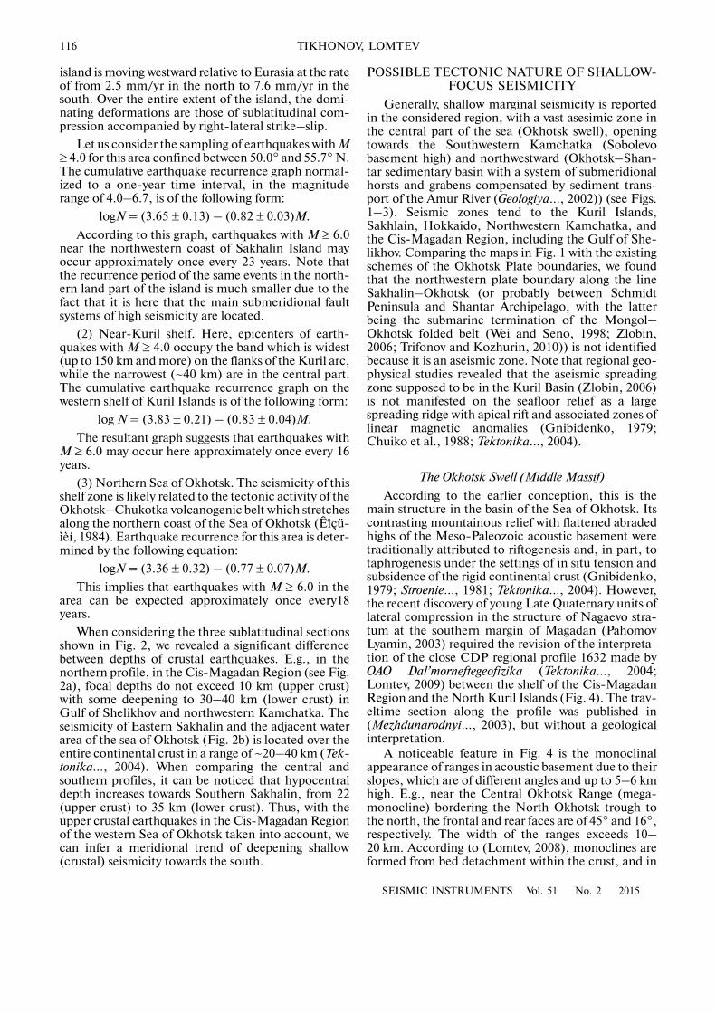
When considering the three sublatitudinal sectionsshown in Fig. 2, we revealed a significant differencebetween depths of crustal earthquakes. E.g., in thenorthern profile, in the Cis�Magadan Region (see Fig.2a), focal depths do not exceed 10 km (upper crust)with some deepening to 30–40 km (lower crust) inGulf of Shelikhov and northwestern Kamchatka. Theseismicity of Eastern Sakhalin and the adjacent waterarea of the sea of Okhotsk (Fig. 2b) is located over theentire continental crust in a range of ~20–40 km (Tek�tonika…, 2004). When comparing the central andsouthern profiles, it can be noticed that hypocentraldepth increases towards Southern Sakhalin, from 22(upper crust) to 35 km (lower crust). Thus, with theupper crustal earthquakes in the Cis�Magadan Regionof the western Sea of Okhotsk taken into account, wecan infer a meridional trend of deepening shallow(crustal) seismicity towards the south.
POSSIBLE TECTONIC NATURE OF SHALLOW�FOCUS SEISMICITY
Generally, shallow marginal seismicity is reportedin the considered region, with a vast asesimic zone inthe central part of the sea (Okhotsk swell), openingtowards the Southwestern Kamchatka (Sobolevobasement high) and northwestward (Okhotsk–Shan�tar sedimentary basin with a system of submeridionalhorsts and grabens compensated by sediment trans�port of the Amur River (Geologiya…, 2002)) (see Figs.1–3). Seismic zones tend to the Kuril Islands,Sakhlain, Hokkaido, Northwestern Kamchatka, andthe Cis�Magadan Region, including the Gulf of She�likhov. Comparing the maps in Fig. 1 with the existingschemes of the Okhotsk Plate boundaries, we foundthat the northwestern plate boundary along the lineSakhalin–Okhotsk (or probably between SchmidtPeninsula and Shantar Archipelago, with the latterbeing the submarine termination of the Mongol–Okhotsk folded belt (Wei and Seno, 1998; Zlobin,2006; Trifonov and Kozhurin, 2010)) is not identifiedbecause it is an aseismic zone. Note that regional geo�physical studies revealed that the aseismic spreadingzone supposed to be in the Kuril Basin (Zlobin, 2006)is not manifested on the seafloor relief as a largespreading ridge with apical rift and associated zones oflinear magnetic anomalies (Gnibidenko, 1979;Chuiko et al., 1988; Tektonika…, 2004).
The Okhotsk Swell (Middle Massif)
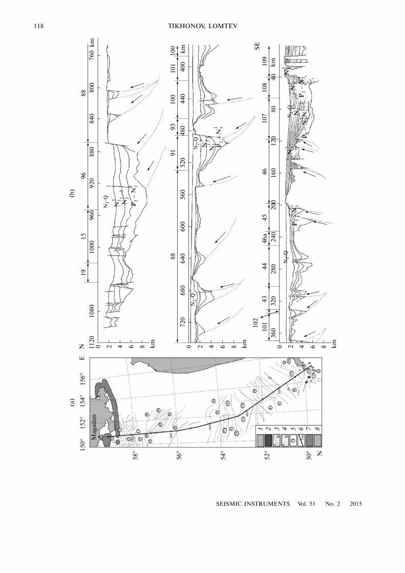
According to the earlier conception, this is themain structure in the basin of the Sea of Okhotsk. Itscontrasting mountainous relief with flattened abradedhighs of the Meso�Paleozoic acoustic basement weretraditionally attributed to riftogenesis and, in part, totaphrogenesis under the settings of in situ tension andsubsidence of the rigid continental crust (Gnibidenko,1979; Stroenie…, 1981; Tektonika…, 2004). However,the recent discovery of young Late Quaternary units oflateral compression in the structure of Nagaevo stra�tum at the southern margin of Magadan (PahomovLyamin, 2003) required the revision of the interpreta�tion of the close CDP regional profile 1632 made byOAO Dal’morneftegeofizika (Tektonika…, 2004;Lomtev, 2009) between the shelf of the Cis�MagadanRegion and the North Kuril Islands (Fig. 4). The trav�eltime section along the profile was published in(Mezhdunarodnyi…, 2003), but without a geologicalinterpretation.
A noticeable feature in Fig. 4 is the monoclinalappearance of ranges in acoustic basement due to theirslopes, which are of different angles and up to 5–6 kmhigh. E.g., near the Central Okhotsk Range (mega�monocline) bordering the North Okhotsk trough tothe north, the frontal and rear faces are of 45° and 16°,respectively. The width of the ranges exceeds 10–20 km. According to (Lomtev, 2008), monoclines areformed from bed detachment within the crust, and in
SEISMIC INSTRUMENTS Vol. 51 No. 2 2015
SHALLOW SEISMICITY OF THE SEA OF OKHOTSK 117
64°
62°
60°
58°
56°
150° 150° 154° 158°134° 138° 142° 146° 162° 166°
54°
52°
50°
48°
46°
≥6.05.5–5.95.0–5.44.5–4.94.0–4.4
0–10 km11–20 km21–30 km≥31 km
SE
A
OF
O
KH
OT
SK
Sakhalin Is.
Hokkaido Is.
Kamchatka Pen.
Classification of earthquakesby magnitude
by depth
Fig. 3. Map showing epicenters of shallow earthquakes with M ≥ 4.0 in the Sea of Okhotsk M ≥ 4.0 for the period of 1962–2010,combined with the scheme of Moho depth, in km, after (Tektonika…, 2004).
section they are limited by overthrust faults. In theirorder, overthrust faults near surface exposure are oftencomplicated by folding and turn into reverse faults.
Their positions are marked by analogy with the struc�tural interpretation of CDP and SCP profiles in(Lomtev and Patrikeev, 1985; Lomtev, 2010). In par�
118
SEISMIC INSTRUMENTS Vol. 51 No. 2 2015
TIKHONOV, LOMTEV
42024
032
036
028
0
86
200
160
120
8040
101
4344
46a
4510
710
810
9
102
N2�
Q
46
P3
N11
–N
13
P3
N11
–N
112
–N
13N
2�Q
N13
P3
N11
–
N13
N2�
QN
2�Q
N13
N11
2–
P3
N11
–420
600
680
720
640
86
560
520
480
440
400
42010
0010
8011
20
86
960
920
880
840
800
100
101
100
9391
88
N2�
Q
N13 N
112
–
P3
N11
–
760
8896
1519
(b)
150 °
152°
154°
156°
58°
(a)
19
1100 16 1000
1595
9688
96
9998
96
88
800
56°
54°
52°
50°
1 2 3 4 5 6 7 888 600
91a 93
100
101 40
0
100
44
43
4520
0 4610
710
6
108
110
A
78
109
100
91
N
E
Mag
adan
B
N km
SE
km
km
km
km
km
B
100
A
SEISMIC INSTRUMENTS Vol. 51 No. 2 2015
SHALLOW SEISMICITY OF THE SEA OF OKHOTSK 119
ticular, the frontal (base) overthrust of each slab seemsto continue a gentle outer side of the adjacent troughinto depth, where the allochthonous and autochtho�nous basement blocks are divided. Fault types weredetermined by using the Lagrangian prionciple whendetermining their active walls.
As a result, on both sides of the Kola trough (open�ing zone with a young diapir) the opposite dips ofthrust and reverse faults is outlined—this is typical forzones of divergent gravity detachment. In other words,the opening divided the Okhotsk swell into two alloch�thonous megablocks, which are slowly divergingnorthwards and southwards. The largest slab of thenorthern megablock is the Central Okhotsk mega�monocline, 180 km wide, consisting of several sheets.Judging by the relief of the acoustic basement top,some sheets can be categorized as bed monoclines,while others are folded ones; however, the former havefine fold�related bends in places. Thus, judging by dis�location types in the part of the CDP profile 1632 cor�responding to the Sea of Okhotsk, the compression ofthe crust dominates, excluding the narrow openingzone. Compression also resulted in the Quaternary ris�ing of some ranges, for example, the Lebed’ one, by1.0–1.5 km and the formation of overthrusts in thenorthern megablock of swell on regional high the bot�tom and basement top, analogous to regional nappesof basement in the Pacific trenches (Lomtev and Patri�keev, 1985).
Another characteristic feature of the Okhotsk swellstructure is ramp semigrabens. E.g., North Okhotskand smaller troughs filled with Cenozoic deposits areasymmetric in cross�section (semigrabens, or so calledunilateral grabens) (Bol’shakov et al., 1989). Theirsides are weakly terraced with faults, especially steepones (of up to 45°), to which trough depocenters tend.Semigrabens are joined with monoclinic ranges in thebasement, forming sheet tectonocouples of overthrustmonocline–ramp semigraben. The formation of tec�tonocouples, analogous to the Pacific trenches(Lomtev and Patrikeev, 1985) is caused by thrusting ofallochthonous masses of acoustic basement and sub�sidence of autochthon under their pressure (such amechanism was proposed as early as 1920s by A. Wege�ner (1922) for the Peru�Chile Trench), and, in part, bythe presence of plastic strata in the underlying section.Some authors attribute the production of grabens tocrustal tension in shear zones, in the framework of the
pull�apart basin concept (“hanging basins,” after(Ioganson, 2005)). However, this contradicts suchfacts as (i) the areal development of the mentionedcover tectonocouples (instead of linear development,as in the case of strike–slips; see Fig. 4 and (Tekton�ika…, 2004)); (ii) signs of young (Quaternary) rising ofsome monoclinic ranges and those of lateral compres�sion in the vicinity of Magadan (Pahomov andLyamin, 2003); and (iii) opposite dipping of sheetoverthrusts of acoustic basement along the CDP pro�file 1632.
An important sign of crustal detachment in the Seaof Okhotsk is velocity inversion (up to 0.5 km/s) basedon deep seismic sounding data (Tektonika…, 2004;Lomtev, 2008, 2009) that was revealed in the 4�kmlayer occurring in the bottoms of allochthon immedi�ately above Moho (decollement, or detachment sur�face). The regional slope of the decollement towardsthe mountain–plain framing of the Sea of Okhotskbasin provides the development of gravity intracrustaldetachment in the Cenozoic (Lomtev, 2008, 2009).
Kuril (South Okhotsk) Bathyal Basin
In early publications this basin was believed to bethe deepest part of the Okhotsk middle massif; then itwas thought to be part of the Pacific basin divided fromthe main part by the Kuril arc in the Cenozoic, or to beproduced by magmatic diapirism (Karig, 1971; Rod�nikov et al., 2005), backarc spreading, and formationof thin suboceanic crust (Zlobin, 2006; Prokudin andMedvedev, 2011). From the viewpoint of currentlyaccepted concepts of Cenozoic riftogenesis, the originof this basin is unclear because there is no developedsystem of rift�related grabens and horsts limited bynormal faults (Stroenie…, 1976, 1981; Gnibidenko,1979; Geologiya…, 2002). Let us briefly consider thestructural peculiarities of the northern and easternsides of the Kuril Basin based on SCP and depth�mea�surement data (Fig. 5).
The structure of the northern side can be seen fromthe fathogram containing stepwise (normal) faults(Baranov and Vol’nev, 1982) and the SCP sectionalong the profile 10 shown in Fig. 5 as interpreted byone of the authors (V.L. Lomtev). The identification ofnormal faults on this side of the Kuril Basin agreeswith the ideas about tension and subsidence of theEarth’s crust in the Sea of Okhotsk (Gnibidenko,
Fig. 4. Fragment of the map of structural elements in the sedimentary cover of the Sea of Okhotsk (a) and the interpretation ofCDP profile 1632 (b), after (Tektonika…, 2004; Lomtev, 2009) with modifications: (1) exposures acoustic basement of the seaf�loor; (2) Pliocene–Quaternary volcanoes; (3) axes of relative rises (A) and troughs (B); (4) boundaries of tectonic elements andzones (A) and structures within zones (B); (5) numbers of structural elements; (6) position of the CDP profile 1632; (7) positivemagnetic anomalies, after L.M. Lyutaya with modifications (see (Lomtev, 2009)), above the Koni�P’yaga (right) and Magadanmega�dikes; (8) shore of the Sea of Okhotsk. Nonitalicized digits denote rises (15, North Okhotsk; 98, West Tinro; 99, East Tinro;88, Central Okhotsk; 93, Lebed’; 101, Atlasov; 43, Sobolevo; 46, Bol’sheretskoe; 106, Alaid�Paramushir; 109, Onekotan; 110,Ekarma�Simushir) and troughs (19, Koni; 16, Motyklei; 95, Northwestern Tinro; 96, Central Tinro; 91, Lebed’; 91a, Lineinyi;100, Central Pkhotsk; 44, Kol’; 45, Bol’sheretskii; 107, Golygina; 8, Fourth Kuril Strait. The turn of the CDP profile 1632 fromNW to submeridional direction towards Magadan is at its 445th km. In the section, arrows with points denote compression faultswith active hanging wall. Position of the profile is also shown in Fig. 1a.
120
SEISMIC INSTRUMENTS Vol. 51 No. 2 2015
TIKHONOV, LOMTEV
1979). This is how stepwise slopes were interpreted infathograms, from the viewpoint of tectonics, bymarine geologists and geomorphologists before theSCP and CDP methods appeared (Menard, 1964).However, in this case, such an interpretation is errone�ous for at least two reasons. First, the SCP profile reli�ably detects seismofacies of relic (extinct) submarinefan in the lower part of the basin side, with channelsframed by alluvial dams—it is these dams that formedthe “steps” on the slope. Second, tectonic steps onslopes form both tension and compression faults(overthrust and reverse faults), as follows from theSCP and CDP data of tectonic simulation (Lomtevand Patrikeev, 1985). E.g., the stepwise outline of thebasement top in the same profile is formed by gentlesmall�amplitude overthrusts. The slow southward shiftof basement sheets on them has been continuing andis marked in part by the through, almost reaching thebottom, anticline of the Cenozoic cover (Fig. 5).
Larger�scale gravity tectonics is presumed to be onthe eastern side of the basin, or, in other words, at theOkhotsk submarine margin of the Kuril arc. Oneexample illustrating this is the asymmetric overthrustanticline more than 15 km wide near Iturup Island inthe SCP profile (Fig. 6). This anticline is a side pres�sure fold related to the slow slide of the Cenozoic coverand probably the acoustic basement.
Another example is a large overthrust (retro�over�thrust) in the regional CDP profile 1620 crossing theFriz Strait between Iturup and Urup islands. Underthe pressure of allochthonous masses at its hangingwall, acoustic basement (autochthon) is submerged by2 km relative to the adjacent bottom of the basin(Chuiko et al., 1988; Tektonika…, 2004). In other SCPand CDP profiles, this retro�overthrust is not distin�guished (hidden fault) due to the saturation of theCenozoic cover with gas (see the profile 33 in Fig. 6)and near�bottom gas hydrates (Bondarenko and Rash�idov, 2011). The existence of the retro�overthrust isalso proved by bathyal mud volcanoes near Bussol’Strait (Bondarenko and Rashidov, 2011), if their gen�esis is compared with the South Skhalin andPugachevo mud volcanoes exposed at the CentralSakhalin regional upthrust–overthrust (Veselov et al.,2004).
Gravity tectonics is probably related to the en�ech�elon arrangement of diagonal ranges in the easternside of the Kuril Basin (Geologo�geofizicheskii …,1987)—similarly to the diagonal anticlines of the slid�ing Cenozoic cover in the rear part of the Kamyshevomonoclinorium on Sakhalin (Chuiko et al., 1988;Lomtev, 2010b)—and to the complex cover�and�folded structure of the basement and Cenozoic sedi�mentary filling of the oil�and�gas�bearing West Kam�
3000
2000
1000706040200 3010 50
4000
4
3
110 70 5090
5
6
7
(a)
(b)
km
m
NW SEFanAD
AB
TA
s
Fig. 5. Fragments of the SCP profile 10 (21st cruise of R/VPegas�1980) across the northern side of the Kuril (SouthOkhotsk) Basin (a) and those of echogram showing step�wise normal faults, after (Baranov and Vol’nev, 1982) (b).AB means acoustic basement (top is indicated with dottedline); AD, alluvial dams of channels within the limits ofsubmarine fan; TA, through anticline in the Cenozoiccover; dashed arrows, small�amplitude overthrusts of thebasement, which form stepwise profile of the basementtop, and displacements on these faults. Position of the pro�file is shown in Fig. 1a. Vertical scale of the profile is indouble travel seconds.
4
3
2
5
6
0102030 102030
4
3
5
6
5
4
6
026 03040 040 20026
123
km
NW SE W E
NE N S
PR 33 CB
GW(VH)
SC
ES
CS
LALE
LR
PR 83
CB
km
SE NWPR 42PR 45 PR 44 PR 43 PR 41
ESES
CSCS
CS
ES
AB
N11
N13
–
K1 2–
N13
Q–
Fig. 6. The SCP profiles made during the 21st cruise ofR/V Pegas�1980 on the Okhotsk submarine margin of theKuril Kuril arc. CB means continental slope base;GW(VH), gas window (vapor hydrothermals); L, lacco�lith; SC, summit crater; ES, extrusive swell with sedimen�tary cap; CS, covers of slopes; LA, landslides; LE, lateralcone�shaped edifices; LR, lateral reflections. Dashedarrows denote faults and slips on them; empty dashes,unconformity; empty points, top of extrusion�piercingcore. Positions of the profiles are shown in Fig. 1a.
SEISMIC INSTRUMENTS Vol. 51 No. 2 2015
SHALLOW SEISMICITY OF THE SEA OF OKHOTSK 121
chatka marginal trough with multiple predepositional,syndepositional, and postdepositional faults (Chuikoet al., 1988; Kim, 2010).
However, the seismicity of the eastern and southernKuril Basin is mainly deeper (30–60 km) than that ofWestern Kamchatka (Figs. 1–3). This may indicatethe subsidence of the basin under the pressure of slid�ing masses on the slopes of the Kuril and Japan–Sakhalin arcs, due to the outflow of magmatic massestowards the surface and associated weighing of thecrust. Let us consider the last point with the help ofFig. 6, where a structure of several cone�shapedmountains near the base of the Okhotsk margin, nearthe Brouton Island, is seen (SCP profiles 41–45;Fig. 1a). The heights of the seamounts are more than2 km in most cases, the base diameter is 15–30 km, theangles of slopes are ~15°. These and other cone�shaped seamounts with their hills have been tradition�ally considered submarine volcanoes, i.e., mound edi�fices consisting mainly of lava and ash (Tuezov, 1977;Geologo�geofizicheskii…, 1987; Podvodnyi…, 1992;Emelyanova and Lelikov, 2010). However, SCP pro�files 41–45 show that the tops and slopes of the area ofseamounts are composed by a Cenozoic sedimentarycover, traceable through the adjacent saddles. Hencethese seamounts formed when viscous magma pene�trated into the sedimentary cover (magma diapirs orextrusive swells with thick sedimentary caps). In sad�dles, bottom sediments of ~0.2–0.4 km thick occurhorizontally indicating that their accumulationstopped (relics). The relative age of the seamounts canbe inferred from the average rate of magmatic edificegrowth, 1–2 mm/yr (Kukal, 1983), and sedimentationrate (~100–200 m/Ma) for contrast sediments inintermontane lenses (Lomtev, 2010a). In the first case,it will be 0.5–3 Ma, while 1–4 Ma in the second case;nevertheless, both estimates are close to radiocarbonisotope datings of volcanic rocks (0.9–4.1 Ma)dredged at the seamounts of the Kuril Basin (Emely�anova and Lelikov, 2010).
However, according to the SCP profile 83 (Fig. 6),the slope of the more ancient, pre�Miocene extrusiveseamount (paleorelief) is composed by Oligocenemarine (?) deposits, which are absent on the bottom ofthe Kuril Basin. Therefore the acoustic basement topwith rough seismofacies (trappean eluvium) is com�posed here by subaerial Cretaceous trapps of Okhotiapaleoland (Lomtev et al., 2002) and this agrees withthe parametric drilling data on the North OkhotskTrough (Bol’shakov et al., 1989). Thus, the KurilBasin is the deepest (4–5 km) part of the OkhotskSwell (middle massif) whose subsidence is probablyrelated to the deepening of shallow seismicity (Figs. 1and 2).
Okhotsk submarine margin of Sakhalin
Judging by Figs. 1 and 2, shallow seismicity is dis�tributed on the coasts and submarine margins of
northern and southwestern Sakhalin (East Sakhalinupthrust–overthrust (Margulis et al., 1979; Geologo�geofizicheskii…, 1987)) and, locally, at the head of Ter�peniya Bay (Makarov compensated trough limitedwith the Central Sakhalin upthrust–overthrust on west(Mel’nikov, 1987; Chuiko et al., 1988)). The depths ofthe hypocenters increase from 20–25 km in the northto 30–35 km in the south. Crustal seismicity is charac�teristic for the island proper as well (Poplavskaya et al.,2006), except the southern part where deep earth�quakes of the Benioff zone are also reported (Tara�kanov, 2006; Lomtev et al., 2012).
The shallow seismicity of Sakhalin Island is tradi�tionally attributed to its main meridional thrust faults(Smekhov, 1953; Mel’nikov, 1987; Voeikova et al.,2007). However, in recent years the island has beeninterpreted as the boundary between the Mesozoicplates, with different versions of the boundary properbeing drawn along the West and Central Sakhalinregional faults (Wei and Seno, 1998; Zlobin, 2006; Tri�fonov and Kozhurin, 2010; Prytkov and Vasilenko,2011); the shear component of displacements alongactive faults is also emphasized (Mel’nikov, 1987;Kharakhinov, 2010). Nevertheless, the geologicalyouth of Sakhalin Island, which was formed in theSakhalin folding and orogenic stage (Pliocen or theend of Late Pliocene until Quaternary), and the aseis�micity of the subcrustal mantle, contrasting with theseismicity of the continental crust, 35–40 km thick,reliably shows the continental crust’s tectonic mobil�ity (Fig. 3).
With the regional overthrusts and asymmetric,monoclinorium�type structure of anticlinoria inSakhalin Island, V.L. Lomtev and his coauthors (2007)came to the conclusion of an eastward amagmaticdetachment of the continental crust in different timeperiods (detachments of different ages). The ampli�tudes of horizontal displacement of its eastern andwestern allochthonous slabs forming mountain sys�tems of East and West Sakhalin, respectively, are prob�ably small (up to 5–10 km). Vertical deformations aremore noticeable: in the Chaivo syncline of the oil�and�gas�bearing shelf of Northeastern Sakhalin(North Sakhalin sedimentary basin) they are morethan 12 km, if measured based on the acoustic base�ment’s top (Chuiko et al., 1988; Kharakhinov, 2010).The study of crustal seismicity on this shelf is currentlybeing implemented with the use of land digital seismicstations and bottom seismographs, in order to provideseismic safety and diminish the risk of prospecting andproduction drilling, and to do the same for the systemof oil and gas pipes between the fields and shores.
In the context of the present work, let us pay atten�tion to the Trekhbratskaya (Tri Brata, or East Odoptu)mega�anticline, 360 km long, on the northeasternshelf of Sakhalin Island, in whose vicinity the epicen�ters of shallow earthquakes have been recorded (Figs.1 and 2). It was traditionally thought to be a marginalrise of the North Sakhalin sedimentary basin, the east�
122
SEISMIC INSTRUMENTS Vol. 51 No. 2 2015
TIKHONOV, LOMTEV
ern limit of the basin (Lopatnev et al., 1989). Themega�anticline is marked with linear positive anoma�lies of magnetic and gravity fields, including those ofthe Eastern Range on the Schmidt Peninsula corre�sponding to the massif of Early Mesozoic serpentinites(Margulis et al., 1979). The authors of the just�citedwork identified here a zone of the East Sakhalin deepfault with ultrabasic bodies. Later, CDP profilesrevealed through postdepositional anticlines in theLate Cenozoic cover above the zone, with archesabraded in the Late Quaternary (Fig. 7; (Lomtev andLitvinova, 2012)). Hence, these folds formed in theEarly–Middle Quaternary, and this formation wasrelated to repeated intrusion of ultrabasites along thezone of East Sakhalin deep fault which has existedsince the Mesozoic (Trekhbratskaya mega�dike). Thisintrusion can be seen in Fig. 7 from the local angularunconformity, which divides the Pomyr and cross�bedded Deryugin deposits (end of Late Pliocene–Quarternary, after V.O. Savitskii (Chuiko et al., 1988))and is located seaward. The formation of this uncon�formity and the cross�bedded series of bottom sedi�ments is related to the appearance of the topographicbarrier (intrusive mega�anticline) before the front ofthe paleo�Amur avant�delta (Lomtev and Litvinova,2012).
V.V. Kharakhinov (2010) considered the Trekh�bratskaya structure to be a clod protrusion of Mesozoicserpentinites. However, the development of near�bot�tom gas hydrates in the margins of shelf as permafrostrelic, due to shelf dewatering in Late Quaternary (i.e.,at some distance from the mega�dike), indicates ahigher heat flow from this megadike; this heat mightpromote the thermal generation of hydrocarbons inthe North Sakhalin sedimentary basin (Lomtev andLitvinova, 2012). The apophysis (tongue) of a hotmega�dike is probably related to the Dagi hot springson the coast.
Thus, the weighting of the crust in NorthernSakhalin due to the recent penetration of ultrabasite ofTrekhbratskaya mega�dike and, in part, the at leastoccasional manifestations of crustal and/or intrac�rustal detachment eastwards (Figs. 1 and 2), generatesshallow seismicity in both allochthon and autochthon,with the latter being subsided under the pressure of theallochthon load. A similar, in the seismotectonicsense, situation is observed south of here, at the sub�marine margin of the East Sakhalin Mountains ofMiddle Sakhalin, where geophysical data suggest pres�ence of young Pogranichnaya ultrabasite megadike(Mel’nikov, 1987; Lomtev et al., 2007).
The anomalous feature in the structure of theOkhotsk margin of Sakhalin Island is the almost aseis�
Fig. 7. Fragment of the CDP profile 18 across the submarine margin of Northern Sakhalin, after (Litvinova and Lomtev, 2010):(1)–(5) faults and boundaries of sedimentary seismic complexes, based on the data of geological department of OAODal’morneftegeofizika: (1) top of the Nut complex, Late Miocene–Early Pliocene; (2) top of the Okobykai complex, Middle–Late Miocene; (3) top of the Dagi�Uinin complex, Early–Middle Miocene; (4) top of the Daekhuriin�Lyukamin complex,Paleogene; (5) the acoustic basement’s top composed by Late Cretaceous rocks. Horizontal scale is determined between theSP/CDP points and is 25 and 12.5 m, respectively. The points mark local unconformity dividing the the Pomur and Deryuginsediments and appeared after penetration of the Trekhbratskaya ultrabasite mega�dike (TUM) (Lomtev and Litvinova, 2012).
SEISMIC INSTRUMENTS Vol. 51 No. 2 2015
SHALLOW SEISMICITY OF THE SEA OF OKHOTSK 123
mic shelf block of Terpeniya Bay and its adjacent areas.In terms of the structure shown in the SCP and CDP,it is a typical plain tableland (platform) with Creta�ceous marine sedimentary basement, gentle regionalslope westwards, and with a developed tree�like rivernetwork of paleo�Poronai with avant�delta near thetown of Makarov (Chuiko et al., 1988). In Early Cen�ozoic it was probably still a part of the Okhotsk middlemassif, but later was isolated from the massif with thedevelopment of eastward crustal detachment.
DISCUSSION
Thus, based on the data from new catalogs, theperipheral character of shallow earthquakes in the Seaof Okhotsk is identified. A large aseismic zone isobserved, however, in the central part of the sea(Okhotsk Swell): it expands northwestwards (grabensand horsts of the Okhotsk–Shantar sedimentarybasin) and towards Southwestern Kamchatka (Sobo�levo high). Such a distribution of earthquakes indi�cates the leading role played by orogeny in formationof mountain�and�plain framing of the Sea of Okhotsk(Kuril�Kamchatka and Japan�Sakhalin island arcs).Among them, the deep overthrust on the Benioff zoneis traditionally distinguished (Sergeev, 1976); platetectonics suggests an underthrust here (Le Pichon etal., 1973). The deep overthrust during the global Pasa�denian orogeny (Stille, 1924) led to the formation ofthe Kuril–Kamchatka Trench, and the middle andlower (tectonocouple of basement nappe–accretion�ary prism) parts of the Pacific slope of the Kuril—Kamchatka from the Middle Quaternary to theHolocene (Lomtev and Patrikeev, 1985; Tihonov andLomtev, 2011; Lomtev et al., 2012); it also caused anintensive magmogenesis (volcanic arc and submarine,predominantly extrusive, volcanism), seismogenesis(opposite focal zones and allochthonous seismiccrust), and tsunamigenesis (regional tectonic tsunamisof focal rhombus and landslide�caused local tsunamisin canyons and on steep open slopes). The horizontaldisplacement of the Kuril arc to the bottom of theNorthwestern Pacific for the last 0.5–1 Ma is from30 km in the central part to 50–70 km in the flanks, atthickness of basement nappe (Pegas) of 10–20 km atthe base.
The absence of a young longitudinal opening in theKuril Basin parallel to the island arc and compensat�ing the eastward overthrust of the basin suggests anallochthonous occurrence of the continental crust andprobably upper mantle (up to the asthenosphere level(Rodnikov et al., 2005)) in the Sea of Okhotsk. Fromthe velocity inversion above the Moho in deep seismicsounding profiles, we can conclude presence of acrustal, not an upper�mantle, gravity detachment(Lomtev, 2009). In the CDP profile 1632 (Fig. 6),opposite overthrusts of acoustic basement mark thesubmeridional direction of the megablocks in theOkhotsk Swell relative to the Kol’ Trough (opening
zone). However, the relief of Moho in Fig. 3 and theconclusions of some researchers regarding the thin(~14 km) suboceanic crust in the probably newlyformed Kuril Basin (Prokudin and Medvedev, 2011)contradict the supposed southward gravity detach�ment of the southern megablock of the Okhotsk Swell.In contrast, such a detachment agrees with the direc�tion of basement shift on small�amplitude overthrustsin the northern side of the basin in profile 10 (Fig. 5).The key to solving this ambiguity can be found in thework by E.A. Starshinova (1980): based on this publi�cation, the depth of Moho in the Kuril Basin is up to28 km.
With the SCP and CDP data taken into account,the seismicity of the Okhotsk margins of the Kuril arcand Kamchatka, including the Gulf of Shelikhov (Fig.1), may be related to the development of regionalretro�overthrust and subsequent subsidence of itsautochthon with the adjacent seafloor of the Sea ofOkhotsk in the back part of the deep overthrust ofBenioff zone. The latter statement is verified by resultsfrom (Gordeev et al., 2006) on the crustal (0–55 km)seismicity of Kamchatka: the latitudinal trend ofintensifying seismicity is revealed towards the expo�sure of Benioff zone on the Pacific slope of the penin�sula (see also (Tektonika…, 1980; Geologo�geofiz�icheskii…, 1987)). A similar trend can be traced in thecrustal seismicity of the Kuril and Japan (Tohoku) arcs(Asano et al., 1979; Hasegawa et al., 1978; Tekton�ika…, 1980), and the Kamyshevo monoclinorium(Sakhalin), with the Central Sakhalin upthrust–over�thrust in the frontal and West Sakhalin upthrow in therear part (Lomtev, 2010b; Tihonov and Lomtev, 2012).
The shallowest seismicity (0–10 km) is observed onthe shelf of Cis�Magadan Region (Figs. 1 and 2). It isimportant to emphasize the slow displacement of thenorthern megablock in the Okhotsk Swell, and theKoni�P’yagina and Magadan young (Early–MiddleQuaternary) ultrabasite megadikes in the CDP profile1632 (Fig. 6; (Lomtev, 2009)) marking the southernflank of the Cretaceous Okhotsk�Chukotka volcanicbelt and the considerable increase in thickness (up to55 km) of the continental crust on the coast of the Cis�Magadan Region (Surkov et al., 2003). The increase inthickness and weighting of the crust likely impededgravity detachment along the Moho northwards, andthis might have promoted the regional rising of decol�lement into the upper crust i.e., crustal detachmentbecame intracrustal.
Deepening of shallow earthquakes in S–N direc�tion is observed in the Sakhalin and Kuril sides of theSea of Okhotsk basin (Figs. 1 and 2). In the formercase, it is reliably shown (Nagornykh et al., 2003) andis related to eastward crustal and/or intracrustaldetachment, which is complicated in places with largeultrabasite intrusions (Lomtev et al., 2007). In the lat�ter case, it likely reflects the regional subsidence of theKuril Basin seafloor as the deepest part of the southernOkhotsk Swell (middle massif). Subsidence can be
124
SEISMIC INSTRUMENTS Vol. 51 No. 2 2015
TIKHONOV, LOMTEV
compensatory, due to the outflow of magma massesfrom the top of the Benioff zone towards the surfaceand the accompanying weighting of the continentalcrust and increased load on the underlying mantle.Tectonic subsidence might also affect the rear zones ofregional thrusts, as was manifested, for example, in theTohoku megaearthquake (Rogozhin, 2012). However,this problem requires detailed consideration, as well asdoes the aseismicity in the zone of elongated regionalgrabens and horsts in the Meso�Paleozoic basement inthe shallow water of the northeastern Sea of Okhotsk(Okhotsk–Shantar sedimentary basin)—jointly withthe structures of the Okhotsk Swell and NorthOkhotsk Trough, these horsts and grabens form areentrant structural corner near the town of Okhotsk(Chuiko et al., 1988; Geologiya…, 2002; Tektonika…,2004). One of the most reliable ways to study shallowseismicity of oil�and�gas�bearing shelves and avant�shelf in the Sea of Okhotsk is the application of bottomseismographs.
CONCLUSIONS
The present work resulted in the compilation of twocatalogs of the shallow earthquakes (h ≤ 60 km) thatoccurring during the historical and contemporaryobservation periods within the limits of the Sea ofOkhotsk: a catalog of strong (M ≥ 5.0) earthquakes for1735–2010 and a more detailed one (M ≥ 4.0) for1962–2010. The maps of earthquake epicenters andthe vertical sublatitudinal sections of seismoactivezones constructed on the basis of these catalogs allowus to obtain a more objective view of the spatiotempo�ral distribution of regional seismicity and to find therelationship between seismicity and crustal tectonics.It is found that historical and contemporary (1735–2010) shallow earthquakes in the Sea of Okhotsk areclustered at the Kuril, North Sakhalin, Cis�Magadan(including Gulf of Shelikhov), and North and SouthKamchatka submarine margins.
The central part of the sea is generally aseismic(Okhotsk rigid block, or middle massif framed by theCenozoic folded zones). Vast aseismic areas (“win�dows”) are revealed in the northwestern Sea ofOkhotsk and at the southwestern submarine margin ofKamchatka. Small “windows” are detected along theMiddle and Southern Sakhalin, Hokkaido Island, andin the Kuril bathyal basin. Comparison between theseismicity distribution and schemes of the OkhotskPlate has not revealed the northwestern plate bound�ary due to presence of an aseismic zone here.
Shallow (crustal) seismicity in the Sea of Okhotskis characterized by different depths depending onlocation: it ranges from 0–10 km on the shelf of Cis�Magadan Region to 20–30 km on the Sakhalin one; itsrange is 0–40 km on the North Kamchatka shelf(including the Gulf of Shelikhov) and mainly 30–60 km at the Okhotsk side of the Kuril arc and theKuril basin. Shallow seismicity reliably marks the
mobility of the continental crust in the region and itsallochthonous occurrence on the aseismic mantle,and this is verified by seismic survey data from deepseismic sounding, CDP, CDP, and SCP. On theOkhotsk side of the Kuril–Kamchatka arc, gravitysliding of the sedimentary cover (and probably that ofthe basement) in the rear part of the deep overthrust ofBenioff zone dominates. The deepening of the shallowseismicity in the Kuril Basin (which is the deepest partof the Okhotsk Swell) is likely caused by compensatorysubsidence of the basin’s seafloor due to the outflow ofmagma masses towards the surface (extrusive subma�rine volcanism) and weighting of the crust.
At the Okhotsk margin of Sakhalin Island, the rigidplatform block of Terprniya Bay is nearly aseismic,while the shallow seismicity north and south of it isrelated to the long�term active East Sakhalin marginalfault, the penetration of large volumes of ultrabasites(mega�dikes), and to the at least occasional manifes�tations of crustal and intracrustal (on north) detach�ment eastwards. The aseismic Okhotsk Swell (middlemassif), which is the main structure in the Sea ofOkhotsk and characterized by the developed system ofcovering tectonocouples “monocline range–rampsemigraben,” is the zone of slow divergent detachmentof the continental crust (opening zone) in the areasnorth and south of the Kol’ Trough (based on the CDPprofile 1632). In the northern megablock of the swell,decollement (detachment surface) probably rises fromthe crustal base to the upper crust due to thickening(up to 55 km) and weighing (mega�dikes) of theallochthonous crust.
ACKNOWLEDGMENTS
The authors thank O.A. Zherdeva andM.G. Gurinova for help in preparation of figures forthe manuscript.
Asano, S., Okada, H., Yoshii, Y., Yamamoto, K., Haseg�awa, T., Ito, K., Suzuki, S., Ikami, A., and Hamada, K.,Crust and upper mantle structure beneath northeasternHonshu, Japan as derived from explosion seismic observa�
2
SEISMIC INSTRUMENTS Vol. 51 No. 2 2015
SHALLOW SEISMICITY OF THE SEA OF OKHOTSK 125
tions, J. Phys. Earth, 1979, vol. 27, Suppl. Issue, pp. S1–S13.
Baranov, V.V. and Vol’nev, V.M., On some geomorphologicpeculiarities of the northern and western slopes of the deepbasin, Sea of Okhotsk, in Struktura i sostav osadochnogochekhla severo�zapada Tikhogo okeana (Structure andComposition of the Sedimentary Cover in the Northwest�ern Pacific), Vladivostok: DVNTs AN SSSR, 1982, pp. 81–86.
Bol’shakov, A.K., Bol’shakova, R.A., and Shainyan, S.Kh.,On the age of sediments in the Northe Okhotsk Trough, inVozrast geologicheskikh obrazovanii Okhotomorskogo regionai prilegayushchikh territorii (Age of Geological Units in theSea of Okhotsk Region and Adjacent Territories), Vladivos�tok: DVO AN SSSR, 1989, pp. 16–26.
Bondarenko, V.I. and Rashidov, V.A., Manifestations ofhydrate formation and mud volcanism processes in the areaof Bussol’ Strait, Kuril island arc, in Geologiya morei iokeanov: Materialy XIX Mezhdunarodnoi nauchnoi konfer�entsii (shkoly) po morskoi geologii (Geology of Seas andOceans: Proceeding of the XIX International ResearchConference (Workshop) on Marine Geology), Moscow:GEOS, 2011, vol. V, pp. 38–42.
Bulletin of the International Seismological Center, Edin�burg (UK), 1964–1973.
Bulletin of the International Seismological Center, Berk�shire (UK), 1974–2005.
Chuiko, L.S., Kudel’kin, V.V., Karpei, T.I., et al., Komple�ksnye rekognostsirovochnye geofizicheskie issledovaniya vOkhotskom more (ob”ekt 11/86) (Complex ReconnaissanceGeophysical Research in the Sea of Okhotsk (Site 11/86)),Yuzhno�Sakhalinsk: Dal’morneftegeofizika, 1988.
Earthquake Catalog of the Kamchatka Division of Geo�physical Survey, Russian Academy of Sciences, 2006–2010.http://www.emsd.ru
Emelyanova, T.A., Vulkanizm Okhotskogo morya (Volcan�ism of the Sea of Okhotsk), Vladivostok: Dal’nauka, 2004.
Emelyanova, T.A. and Lelikov, E.P., Miocene–Pleistocenevolcanism of deep�water basins of the Sea of Japan and Seaof Okhotsk, Rus. J. Pac. Geol., 2010, vol. 4, no. 2, pp. 145–155.
Fedotov, S.A., Energeticheskaya klassifikatsiya Kurilo�Kam�chatskikh zemletryasenii i problema magnitud (Energy Clas�sification of Earthquakes in the Kuril�Kamchatka regionand the Problem of Magnitudes), Moscow: Nauka, 1972.
Geological Investigations of the Okhotsk and Japan Seas offHokkaido. June–July 1977 (Cruise Rep. no. 11), Honza, E.,Ed., Tokyo: Geol. Surv. Japan, 1978.
Geologiya i neftegazonosnost’ Okhotsko�Shantarskogo osa�dochnogo basseina (Geology and Oild�and�Gas�BearingPotential of the Okhotsk�Shantar Sedimentary Basin),Vladivostok: DVO RAN, 2002.
Geologo�geofizicheskii atlas Kuril’skoi ostrovnoi sistemy(Geological�Geophysical Atlas of the Kuril Island Arc),Leningrad: VSEGEI, 1987.
Global Hypocenter Data Base (CD�ROM), Denver:NEIC/USGS, 1989.
Gnibidenko, G.S., Tektonika dna okrainnykh moreiDal’nego Vostoka (Tectonics of Marginal Seas in the RussianFar East), Moscow: Nauka, 1979.
1
1
Gordeev, E.I., Gusev, A.A., Levina, V.I., Leonov, V.L., andChebrov, V.N., Shallow earthquakes in Kamchatka Penin�sula, Vulkanol. Seismol., 2006, no. 3, pp. 28–38.Hasegava, A., Umino, T., and Takagi, A., Double�planeddeep seismic zone and upper�mantle structure in theNortheastern Japan Arc, Geophys. J. Int., 1978, vol. 54,no. 2, pp. 281–296.Ioganson, L.I., Pull�apart basins: A review, Geotectonics,2005, vol. 39, no. 2, pp. 156–168.Ivashchenko, A.I., Kim, Ch.U., and Bondarenko, G.A.,Seismicity of near�surface earthquakes in the Sea ofOkhotsk, in Seismicheskoe raionirovanie shel’fa (SeismicZoning of the Sea Shelf), Vladivostok: DVO AN SSSR,1990, pp. 22–37.Japan University Network Earthquake Catalog (JUNEC),Bunkyo: Earthquake Prediction Data Center, 1985–1990.JMA Earthquake Catalog, Tokyo: Japan MeteorologicalAgency, 1926–2000.Karig, D.E., Origin and development of marginal basins inthe Western Pacific, J. Geophys. Res., 1971, vol. 76,pp. 2542–2561.Kim, Ch.U., Semenova, E.P., Zherdeva, O.A., Sen, RakSe, Mikhailov, V.I., Levin, Yu.N., Parshina, I.S., Urban,N.A., Kasakhara, M., Ichiyanagi, M., and Takahashi, H.,Katalog zemletryasenii yuga Sakhalina za period s 2000 po2010 g. (po dannym avtonomnykh tsifrovykh seismicheskikhstantsii) (The Catalog of Earthquakes in South Sakhalin forthe period since 200 until 2010 (Based on the Data fromAutonomous Digital Seismic Stations)), Vladivostok:Dal’nauka, 2011.Kharakhinov, V.V., Neftegazovaya geologiya Sakhalinskogoregiona (Petroleum Geology of the Sakhlain Region), Mos�cow: Nauch. mir, 2010.Kim, A.Kh., Structure and formation of the Cenozoicdeposits in the Icha Trough, western Kamchatka Peninsula,in Prirodnye katastrofy: izuchenie, monitoring, prognoz:Materialy IV Sakhalinskoi molodezhnoi nauchnoi shkoly(Research, Monitoring, and Prediction of Natural Catas�trophes: Proceedings of the IV Sakhalin Workshop forYoung Scientists), Yuzhno�Sakhalinsk: IMGiG DVO RAN,2010, pp. 152–160.Koz’min, B.M., Seismicheskie poyasa Yakutii i mekhanizmyochagov ikh zemletryasenii (Seismic Belts of Yakutia andFocal Mechanisms of Their Earthquakes), Moscow:Nauka, 1984.Krasnyi, M.L., Neverov, Yu.L., Kornev, O.S., et al., Geo�logical Structure of the Basement in the Framing of the Seaof Okhotsk Basin Based on the Results of 21st Cruise of R/VPegas, Preprint of Sakhalin. Kompl. Nauchn. Issled. Inst,Dal’nevost. Nauchn. Tsentra Akad. Nauk SSSR, Novoale�ksandrovsk, 1981.Kropotkin, P.N., Seismicity generated by a break ofsubducting lithospheric plate, Geotektonika, 1978, no. 5,pp. 3–6.Kukal, Z., Rychlost geologických proces@, Praha: Aca�demia, 1983.Le Pichon, X., Francheteau, J., and Bonnin, J., Plate Tec�tonics, Elsevier, 1973.Litvinova, A.V. and Lomtev, V.L., On the structure of sub�marine margin of NW Sakhalin, Degazatsiya Zemli: geotek�tonika, geodinamika, geoflyuidy, neft’ i gaz uglevodorody izhizn’. Materialy vserossiiskoi konferentsii (Degassing of the
126
SEISMIC INSTRUMENTS Vol. 51 No. 2 2015
TIKHONOV, LOMTEV
Earth: Geotectonics, Geodynamics, Geofulids; Oil andGas; Hydrocarbons and Life. Proceedings of All�RussiaConference), Valyaev, B.M. and Dmitrievskii, A.N., Eds.,Moscow: GEOS, 2010, pp. 317–320.
Lomtev, V.L., Meso�Cenozoic peneplaine in the North�western Pacific, in Stroenie i perspektivy neftegazonosnosti vregionakh severo�zapadnoi okrainy Tikhogo okeana (Struc�ture and Oil�and�Gas�Bearing Potential in the Region ofNorthwestern Pacific Margin), Yuzhno�Sakhalinsk:IMGiG DVO RAN, 2000, pp. 38–53.
Lomtev, V.L., On the diagnostics of decollements, in Obsh�chie i regional’nye problemy tektoniki i geodinamiki: Materi�aly XLI Tektonichescogo soveshchaniya (General andRegional Problems of Tectonics and Geodynamics: Pro�ceedings of the XLI Meeting on Tectonics), Moscow:GEOS, 2008, vol. 1, pp. 508–512.
Lomtev, V.L., On the structural�geomorphologic character�istics of the Sea of Okhotsk seafloor, Geol. Polezn. Iskop.Mirovogo Okeana, 2009, no. 1, pp. 69–80.
Lomtev, V.L., New data on the structure of the southern partof Kuril arc on its Sea�of�Okhotsk margin, Geol. Polezn.Iskop. Mirovogo Okeana, 2010à, no. 2, pp. 74–83.
Lomtev, V.L., Deformations of the Nevelsk (August 2, 2007,M ~ 7) earthquake on the shelf of SW Sakhalin, Geol.Polezn. Iskop. Mirovogo Okeana, 2010b, no. 2, pp. 35–46.
Lomtev, V.L., New data on the structure of Ullyndo basinand trough, Sea of Japan, Vestn. KRAUNTs. Nauki Zemle,2012, vol. 19, no. 1, pp. 98–107.
Lomtev, V.L. and Litvinova, A.V., New data on the geologi�cal structure of the submarine margin of Northern Sakha�lin, based on geophysical data, Vestn. SVNTs DVO RAN,2012, no. 1, pp. 8–14.
Lomtev, V.L. and Patrikeev, V.N., Struktury szhatiya vKuril’skom i Yaponskom zhelobakh (Compression Structuresin the Kuril and Japan Trenches), Vladivostok: DVNTs ANSSSR, 1985.
Lomtev, V.L., Zhigulev, V.V., Patrikeev, V.N., and Kocher�gin, E.V., Okhotia, in Stroenie, geodinamika i metallogeniyaOkhotskogo regiona i prilegayushchikh chastei Severo�Zapadnoi Tikhookeanskoi plity: Materialy Mezhduarodnogonauchnogo simpoziuma (Structure, Geodynamics, and Met�allogeny of the Okhotsk Region and the Adjacent Areas ofthe Northwestern Pacific Plate: Proceedings of the Interna�tional Research Symposium), Yuzhno�Sakhalinsk: IMGiGDVO RAN, 2002, vol. 1, pp. 224–226.
Lomtev, V.L., Nikiforov, S.P., and Kim, Ch.U., Tectonicaspects of crustal seismicity of Sakhalin island, Vestn. DVORAN, 2007, no. 4, pp. 64–71.
Lomtev, V.L., Nagornykh, T.V., and Safonov, D.A., On thestructure and seismotectonics of the Kuril arc–trench sys�tem, Seism. Instrum., 2013, vol. 49, no. 4, p. 328.
Lopatnev, Yu.V., Kharakhinov, V.V., Kononov, V.E., andSludnev, Yu.G., Seismostratigraphic model of the NorthSakhalin sedimentary basin, in Geologiya dna Tikhogookeana i zony perekhoda k Aziatskomu kontinentu (SeafloorGeology of the Pacific and Transitional Zone between theOcean and the Asian Continent), Vladivostok: DVO ANSSSR, 1989, pp. 111–116.
MacInnes, B.T., Weiss, R., Bourgeois, J., and Pinegina,T.K., Slip distribution of the 1952 Kamchatka great earth�quake based on near�field tsunami deposits and historical
Margulis, L.S., Mudretsov, V.B., Sapozhnikov, B.G., et al.,Geological structure of the northwestern Sea of Okhotsk,Sov. Geol., 1979, no. 7, pp. 61–71.
Mel’nikov, O.A., Struktura i geodinamika Khokkaido�Sakhalinskoi skladchatoi oblasti (Structure and Geodynam�ics of the Hokkaido–Sakhalin Folded Zone), Moscow:Nauka, 1987.
Menard, H.W., Marine Geology of the Pacific, New York:McGraw�Hill, 1964.
Mezhdunarodnyi geologo�geofizicheskii atlas Tikhogookeana (International Geological�Geophysical Atlas of thePacific Ocean), Udintsev, G.B., Ed., Moscow–St. Peters�burg: Intergovernmental Oceanographic Commission,2003.
Mushketov, I.V. and Orlov, A.P., Katalog zemletryaseniiRossiiskoi imperii (Catalog of Earthquakes in RussianEmpire), vol. 26 of Zap. Imp. Rus. Geogr. O�va, 1893.
Nagornykh, T.V., Poplavskaya, L.N., and Kim, Chun Un,Refinement of coordinates for hypocenters of strong earth�quakes in Sakhalin Region for 1924–1967, in Problemy seis�michnosti Dal’nego Vostoka i Vostochnoi Sibiri: DokladyMezhduarodnogo simpoziuma (Problems of Seismicity of theRussian Far East and East Siberia: Proceedings of the Inter�national Symposium), Yuzhno�Sakhalinsk: IMGiG DVORAN, 2003, vol. 2, pp. 131–155.
Novyi katalog zemletryasenii na territorii SSSR s drevneish�ikh vremen do 1975 g. (New Catalog of Earthquake in USSRfrom Ancient Times through 1975), Kondorskaya, N.V.,and Shebalin, N.V., Eds., Moscow: Nauka, 1977.
Operativnyi katalog zemletryasenii Sakhalinskogo filiala GSRAN (Operational Earthquake Catalog of the SakhalinDivision of Geophysical Survey, Russian Academy of Sci�ences), Yuzhno�Sakhalinsk: SF GS RAN, 2005–2010.
Osnovnye cherty geologicheskogo stroeniya dna Yaponskogomorya (Main Features of the Seafloor Geological Structurein the Sea of Japan), Moscow: Nauka, 1978.
Pakhomov, A.Yu. and Lyamin, S.M., A model of tectonicmotions in the Magadan depression, in Geodinamika, mag�matizm i minerageniya kontinental’nykh okrain Severa Patsi�fiki: Materialy Vserossiiskogo soveshchaniya, posvyashchen�nogo 90�letiyu akademika N.A. Shilo (Geodynamics, Mag�matism, and Minerageny of Continental Margins of theNorth Pacific: Proceeding of the All�Russia Meeting on the90th Anniversary of Academician N.A. Shilo), Magadan:SVKNII DVO RAN, 2003, vol. 1, pp. 253–255.
Podvodnyi vulkanizm i zonal’nost’ Kuril’skoi ostrovnoisistemy (Submarine Volcanism and Zonality of the KurilIsland Arc), Moscow: Nauka, 1992.
Poplavskaya, L.N. and Oskorbin, L.S., Seismic activity ofthe Earth’s crust within shelf zones of the Sea of Okhotsk,in Seismicheskoe raionirovanie Kuril’skikh ostrovov, Pria�mur’ya i Primor’ya (Seismic Zoning of the Kuril Islands,Cis�Amur Region, and Primorye), Vladivostok, 1977,pp. 120–127.
Poplavskii, A.A. and Bobkov, A.O., A statistical study ofearthquake distribution on depth, with random estimationerrors taken into account, in Dinamika ochagovykh zon iprognozirovanie sil’nykh zemletryasenii severo�zapadaTikhogo okeana (Dynamics of Source Zones and Predictionof Strong Earthquakes in the Northwestern Pacific Ocean),Yuzhno�Sakhalinsk, 2001, vol. 1, pp. 128–141.Prokudin, V.G. and Medvedev, S.N., A new velocity modelof the Earth’s crust in the Kuril Basin, Sea of Okhotsk, inFizika geosfer: Materialy 7�go Vserossiiskogo simpoziuma(Physics of the Geospheres: Proceedings of the 7th All�Russia Symposium), Vladivostok: Dal’nauka, 2011,pp. 368–374.Prytkov, A.S. and Vasilenko, N.F., Modeling of the lithos�pheric plates’ sliding within the limits of main fault systemsof Sakhalin island, in Prirodnye katastrofy: izuchenie, moni�toring, prognoz: Materialy IV Sakhalinskoi molodezhnoinauchnoi shkoly (Research, Monitoring, and Prediction ofNatural Catastrophes: Proceedings of the IV SakhalinWorkshop for Young Scientists), Yuzhno�Sakhalinsk:IMGiG DVO RAN, 2011, pp. 90–99.Rodnikov, A.G., Zabarinskaya, L.P., Piip, B.V., Rashidov,V.A., Sergeyeva, N.A., and Filatova, N.I., Geotraverse ofthe Sea of Okhotsk, Vestn. KRAUNTs. Nauki Zemle, 2005,no. 5, pp. 45–58.Rogozhin, E.A., Japan Tohoku March 11, 2011 (M = 9.0)Earthquake Source Structure,Its Macroseismic, Seismological, and Geodynamic Mani�festations, Seism. Instrum., 2012, vol. 42, no. 2, pp. 93–104.Rogozhin, E.A. and Zakharova, A.I., Paleoearthquakes andseismic regime of Northern Sakhalin, in Stroenie, geodi�namika i metallogeniya Okhotskogo regiona i prilegayush�chikh chastei Severo�Zapadnoi Tikhookeanskoi plity: Mate�rialy Mezhdunarodnogo nauchnogo simpoziuma (Structure,Geodynamics, and Metallogeny of the Okhotsk Region andthe Adjacent Areas of the Northwestern Pacific Plate: Pro�ceedings of the International Research Symposium),Yuzhno�Sakhalinsk: IMGiG DVO RAN, 2002, vol. 2, pp.227–228.Seismicheskoe raionirovanie territorii SSSR: Metodicheskieosnovy i regional’noe opisanie karty 1978 g. (Seismic Zoningof the Territory of USSR: Methodological Basis andRegional Description of the 1978 Seismic Zoning Map),Moscow: Nauka, 1980.Seismichnost’ i seismicheskoe raionirovanie Severnoi Evrazii(Seismicity and Seismic Zoning of Northern Eurasia), vol.1, Ulomov, V.I., Ed., Moscow: OIFZ RAN, 1993.Seismichnost’ i seismicheskoe raionirovanie Severnoi Evrazii(Seismicity and Seismic Zoning of Northern Eurasia),vols. 2–3, Ulomov, V.I., Ed., Moscow: OIFZ RAN, 1995.Sergeev, K.F., Tektonika Kuril’skoi ostrovnoi sistemy (Tec�tonics of the Kuril Island System), Moscow: Nauka, 1976.The Shikotan earthquake of October 4 (5), 1994, Inf.�Anal.Byul. Fed. Sist. Seismol. Nabl. Prognoza Zemletryasenii,Spec. Issue, November 1994.Smekhov, E.M., Geologicheskoe stroenie ostrova Sakhalin iego neftegazonosnost’ (Geological Structure and Oil�and�Gas�Bearing Potential of Sakhalin Island), Moscow:Gostoptekhizdat, 1953.Soloviev, S.L., Poplavskaya, L.N., and Zaraiskii, M.P., WestIturup earthquake of May 7–8, 1962, Geol. Geofiz., 1964,no. 7, pp. 55–62.
1
Soloviev, S.L., Oskorbin, L.S., and Ferchev, M.D., Zemlet�ryaseniya na Sakhaline (Earthquakes of Sakhlain Island),Moscow: Nauka, 1967.
Soloviev, S.L. and Solovieva, O.N., Relationship betweenenergy class and magnitude, Izv. Akad. Nauk SSSR, Fiz.Zemli, 1967, no. 2, pp. 3–23.
Starshinova, E.A., Inhomogeneity of the crustal and mantlestructure beneath the Sea of Okhotsk, Dokl. Akad. NaukSSSR, 1980, vol. 25, no. 6, pp. 1339–1343.
Stroenie dna Okhotskogo morya (Seafloor Structure of theSea of Okhotsk), Moscow: Nauka, 1981.
Stroenie zemnoi kory i verkhnei mantii v zone perekhoda otAziatskogo kontinenta k Tikhomu okeanu (Crustal andUpper Mantle Structure in the Transitional Zone betweenthe Asian Continent and the Pacific Ocean), Novosibirsk:Nauka, 1976.
Surkov, V.S., Larichev, A.I., Starosel’tsev, V.S., et al., Pre�liminary geological results on the Magadan segment of the2�DV reference geophysical profile (Koni Pen.–WrangelIs.), in Geodinamika, magmatizm i minerageniya kontinen�tal’nykh okrain Severa Patsifiki: Materialy Vserossiiskogosoveshchaniya, posvyashchennogo 90�letiyu akademika N.A.Shilo (Geodynamics, Magmatism, and Minerageny ofContinental Margins of the North Pacific: Proceeding ofthe All�Russia Meeting on the 90th Anniversary of Acade�mician N.A. Shilo), Magadan: SVKNII DVO RAN, 2003,vol. 1, pp. 72–75.
Tarakanov, R.Z., Kim, Ch.U., and Sukhomlinova, R.I.,Regularities of spatial distribution of earthquake hypo�centers in the Kuril�Kamchatka and Japan regions, inGeofizicheskie issledovaniya zony perekhoda ot Aziatskogokontinenta k Tikhomu okeanu (Geophysical Research of theTransitional Zone between the Asian Continent and thePacific Ocean), Moscow: Nauka, 1977, pp. 67–77.
Tarakanov, R.Z., Seismicity, deep structure, and seismichazard of the Kuril–Okhotsk Region, Doctoral (Phys.�Math.) Dissertation, Yuzhno�Sakhalinsk: IMGiG DVORAN, 2006.
Tektonika i uglevodorodnyi potentsial Okhotskogo morya(Tectonics and Hydrocarbon Potential of the Sea ofOkhotsk), Vladivostok: DVO RAN, 2004.
Tikhonov, I.N. and Lomtev, V.L., Great Japan earthquakeof March 11, 2011: Tectonic and seismological aspects, Izv.,Atmos. Ocean. Phys., 2011, vol. 47, no. 8, pp. 978–991.
Tikhonov, I.N. and Lomtev, V.L., Shallow seismicity in thebackarc area of the Japan�Sakhalin arc and its probable tec�tonic nature, Materialy II Shkoly�seminara ‘Gordinskie cht�eniya’ (Readings in Memory of V.M. Gordin: Proceeding ofthe II Workshop), Moscow, 2012, pp. 199–204.
Trifonov, V.G. and Kozhurin, A.I., Study of active faults:Theoretical and applied implications, Geotectonics, 2010,vol. 44, no. 6, pp. 510–528.
Tuezov, I.K., Buried and submarine volcanoe of the Kurildeep basin, Sea of Okhotsk, Dokl. Akad. Nauk SSSR, 1977,vol. 232, no. 1, pp. 98–200.
Unifitsirovannyi katalog zemletryasenii Severnoi Evrazii sdrevneishikh vremen po 1990 god (Unified Catalog of Earth�quakes in Northern Eurasia from Ancient Times through1990), Kondorskaya, N.V. and Ulomov, V.I., Ed., Moscow:OIFZ RAN, 1996.
2
128
SEISMIC INSTRUMENTS Vol. 51 No. 2 2015
TIKHONOV, LOMTEV
Utkin, V.P., Sdvigovye dislokatsii i metodika ikh izucheniya(Strike�Slip Dislocations and Methods of Their Study),Moscow: Nauka, 1980.
Vashchilov, Yu.Ya., Gaidai, N.K., Zimnikova, T.P., Luchin�ina, A.V., Lyubomudrov, V.V., Postnikova, V.V., and Sahno,O.V., Continuation of linear structural elements of theshore framing in the northern part of the Sea of Okhotsk, inGeodinamika, geologiya i neftegazonosnost’ osadochnykhbasseinov Dal’nego Vostoka Rossii (Geodynamics, Geology,and Oil�and�Gas�Bearing Potential of Sedimentary Basinsin the Russian Far East), Yuzhno�Sakhalinsk: IMGiG DVORAN, 2004, vol. 1, pp. 22–38.
Veselov, O.V., Volgin, P.F., Lyutaya, L.M., and Parovyshnyi,V.A., Structural peculiarities of the Upper Cretaceous com�plex, Pugachevo mud volcano, based on the geophysicaldata, in Geodinamika, geologiya i neftegazonosnost’ osadoch�nykh basseinov Dal’nego Vostoka Rossii: Doklady Mezhdun�arodnogo simpoziuma (Geodynamics, Geology, and Oil�and�Gas�Bearing Potential of Sedimentary Basins in theRussian Far East), Yuzhno�Sakhalinsk: IMGiG DVORAN, 2004, vol. 1, pp. 145–156.
Voeikova, O.A., Nesmeyanov, S.A., and Serebryakova, L.I.,Neotektonika i aktivnye razlomy Sakhalina (Neotectonicsand Active Faults of Sakhalin Island), Moscow: Nauka,2007.
Wegenerg, A., Die Entstehung der Kontinente und Ozeane,Braunschweig: Friedrich Vieweg & Sohn, 1922, 3rd ed.
Wei, D. and Seno, T., Determination of the Amurian Platemotion, in Mantle Dynamics and Plate Interactions in East
Asia, vol. 27 of Geodynamics Series, 1998. doi10.1029/GD027p0337Zemletryaseniya Severnoi Evrazii v 1992 g. (Earthquakes ofNorthern Eurasia in 1992), Moscow: Geoinformmark,1997.Zemletryaseniya Severnoi Evrazii v 1993 g. (Earthquakes ofNorthern Eurasia in 1993), Moscow: NIA�Priroda, 1999.Zemletryaseniya Severnoi Evrazii v 1994 g. (Earthquakes ofNorthern Eurasia in 1994), Moscow: OIFZ RAN, 2000.Zemletryaseniya Severnoi Evrazii v 1995 g. (Earthquakes ofNorthern Eurasia in 1995), Moscow: OIFZ RAN, 2001.Zemletryaseniya Severnoi Evrazii v 1996 g. (Earthquakes ofNorthern Eurasia in 1996), Moscow: OIFZ RAN, 2002.Zemletryaseniya Severnoi Evrazii v 1997 g. (Earthquakes ofNorthern Eurasia in 1997), Obninsk: FOP, 2003.Zemletryaseniya Severnoi Evrazii v 1998 g. (Earthquakes ofNorthern Eurasia in 1998), Obninsk: FOP, 2004.Zemletryaseniya Severnoi Evrazii v 1999 g. (Earthquakes ofNorthern Eurasia in 1999), Obninsk: FOP, 2005.Zemletryaseniya Severnoi Evrazii v 2000 g. (Earthquakes ofNorthern Eurasia in 2000), Obninsk: FOP, 2006.Zemletryaseniya Severnoi Evrazii v 2001 g. (Earthquakes ofNorthern Eurasia in 2001), Obninsk: FOP, 2007.Zemletryaseniya v SSSR v 1980–1991 gg. (ezhegodniki)(Earthquakes in USSR in 1980�1991 (Yearbooks)), Mos�cow: Nauka, 1984–1997.Zlobin, T.K., Okhotsk lithospheric plate and the evolution�ary model for the marginal sea–island arc–deep trench sys�tem, Vestn. DVO RAN, 2006, no. 1, pp. 26–32.