36
Shan Plateau Expedition 2012/2013 Final Report Compiled by the expedition members, May2013
| Date post: | 04-May-2018 |
| Category: |
Documents |
| Upload: | nguyendien |
| View: | 214 times |
| Download: | 0 times |

Shan Plateau Expedition
2012/2013
Final Report
Compiled by the expedition members, May2013

Summary
The Shan Plateau Expedition in December 2012 and January 2013 was a six person three week
caving expedition spent based in Ywangan Township in the Southern Shan State of Myanmar
(Burma). The expedition followed on from three previous expeditions to the Shan region in 2010,
2011 and 2012. The Shan Plateau Expedition 2013 was a six-person three-week caving expedition to
the Ywangan Township area in the Southern Shan State of Myanmar (Burma).
The 2013 expedition was highly successful, more than doubling the length of the longest known cave
in Myanmar (Kyauk Khaung – ‘Stone Cave’) from 2.3 km to 4.8 km. A major drafting lead (Heart of
Darkness; see attached survey) was left ongoing at the base of a > 30 m pitch, where the final
pushing/derigging team ran out of rope dangling above open passage. The surveyed depth range of
Kyauk Khaung was 92 m in 2011/12, and is now 148 m. The lowest and highest surveyed points of
Kyauk Khaung are both ongoing leads. Heart of Darkness is heading towards a major depression
near the village of Linwe (see Figure 1). The 2013 expedition found two major resurgences, and a
large strongly drafting sink within the Linwe depression, each locally more than 10 m in diameter.
This opens the possibility of a major cave system extending from Kyauk Khaung to the Linwe
Depression (~3.5 km in a straight line), with the Khauk Khaung water most likely resurging 4.5 or 7.5
km from where it sinks, with > 300m of elevation change (Fig. 2). Two extremely large well
decorated passages (> 50 m wide; > 25 m high) were found near Kyauk Khaung, at a higher level,
suggesting multi-level development.
The 2013 expedition therefore started to bear the fruit of the 2010, 2011 and 2012 expeditions, and
has established the world-class caving potential of the Ywangan area. The 2013 expedition collected,
and preserved, samples of the first cave-adapted fish reported from Myanmar. Scientific links have
been established between the Universities of Mandalay, Oxford, and Kunming to provide a detailed
analysis these new species of cave-adapted fish.
Caving in Myanmar requires both national and local permissions and careful liaison with the local
authorities and in some cases monks and monasteries. As in previous years our national permissions
were obtained in advanced by Phyoe Wai Yar Zar and local permissions were negotiated by our
guide Yan Naing. In Ywangan, access was typically straightforward, although we were subject to a
night time curfew and had to return to the town before dark. We strengthened relations with our
national and local contacts in Ywangan. We have been told that we can stay in the village by the
main cave entrance next year, which will increase the length of trips to the far reaches of the cave
Note that the compilers of this report and the members of the expedition agree that any or all of this
report may be copied for the purposes of private research.

Contents
Expedition Members 6
With Thanks 6
Introduction 7
Background 7
Permissions 7
Travel & Accommodation Logistics 8
Ywangan Township 9
Equipment 11
Surveying 11
Cave of the Ywangan Township Area 12
Kyauk Khaung (Stone Cave) 12
River and Entrance: 12
Catwalk: 13
The cat-flap extensions: 15
Right Downstream & Enlightenment 15
Stalagmite Slalom: 16
Left Downstream – The Great Leap Forward 16
Upstream – The Road to Mandalay 17
Over 18 Series 17
New Upstream - Infinity and the Edge of Enlightenment: 19
New Downstream – Absolute Truth and The Heart of Darkness: 21
Other Caves Explored in 2012/2013 23
Bear Hole 23
Unnamed Cave 23
Chaung Myaung Cave and Hole 23
Linwe Depression Cave 1 (large wet resurgence) 23
Linwe Depression Cave 2 (large dry resurgence) 24
Linwe Depression Cave 3 (drafting sink) 25
Linwe Depression Pool 25
Environment 26
Geology and Geomorphology 26

Observations from Ywangan 28
Hydrology and Hydrogeology 28
Weather 29
Presentation to the Ywangan Township Hospital 29
Appendix A: Ywangan Cave Database 31
Appendix B: Surveys 33
Appendix C: Expedition Log 35
Appendix D: Equipment in Myanmar (in trunk) 37
Appendix E: 2012/13Accounts 38
Table of Figures and Tables
Figure 1 Location of the Shan States; a) Location of the states in Myanmar; b) Area of the Shan States
................................................................................................................................................................ 8
Table 1 Expedition Time Line .................................................................................................................. 9
Figure 2. Showing the location of Ywangan and Kyauk Ngauk cave. Manadaly is in the top left part of
the map. ................................................................................................................................................ 10
Figure 3 Locations of Main Caves Identified and/or Explored near Ywangan......................................10
Figure 4. Surveying in Stalagmite Slalom in Stone cave........................................................................ 11
Figure 5: View of valley and stream that sinks (to the left of photo) in Kyauk Khaung (Stone Cave) ..12
Figure 6: (left) Entrance and (right) river passage close to the entrance of Kyauk Khaung .................13
Figure 7: Formations with Oo-la-la ....................................................................................................... 14
Figure 8: Ooo-la-la looking towards the way to Independence Day ....................................................15
Figure 9: Tense survey team in Stalagmite Slalom. .............................................................................. 16
Figure 10: In Independence Day ........................................................................................................... 18
Figure 11: (left) Pete and Fleur after a muddy crawl in Out of the Page. (right) Stemple of Doom (aka
Liquid limit) pool in Out of the Page. .................................................................................................... 19
Figure 12. Liu Hong approaching Infinity. ............................................................................................. 20
Figure 13. Lou in the Edge of Enlightenment........................................................................................ 20
Figure 14 Caves around Ywangan Township ........................................................................................ 21
Figure 15. Google map showing Stone Cave......................................................................................... 22
Figure 16: Linwe Depression Cave 1 – the wet resurgence (left) and bypass passage with remarkably
long thin column (right). ....................................................................................................................... 24
Figure 17 Entrance to the large dry resurgence in Linwe Depression. .................................................24

Figure 18. The limit of exploration in the main sink in Linew Depression. This passage has a very
strong draft. .......................................................................................................................................... 25
Figure 19 Extent of the Permian and Triassic Carbonates in Eastern Myanmar ..................................27
Figure 20. The seasonal lake at Ywangan ............................................................................................. 29
Figure 21. Presenting the Ventouse at Ywangan Hospital.................................................................... 30

6
Expedition Members
Peter Talling
Ben Wright
Tim Guilford
Lui Hong
Fleur Loveridge
Lou Maurice
If you would like further information regarding this expedition then please contact the Expedition
Leader, Peter Talling on Peter<dot>Talling<at>noc<dot>ac<dot>ac<dot>uk
With Thanks
Myanmar is not always a straightforward place to travel and this expedition would not have been
possible without the ongoing help and assistance from Mr Phyoe Wai Yar Zar, Managing Director of
All Asia Exclusive and vice chair of the Myanmar Tourism Promotion Board. We are also indebted to
our driver Dan Oo who always made sure we got there regardless of the state of the roads, and our
new guide Daniel Htwe.
We were also fortunate to receive financial support from the Mount Everest and Ghar Parau
Foundations. Visiting Myanmar is not a cheap activity and we are therefore extremely grateful for
this contribution. We hope that the caving potential of Myanmar is now beginning to be unlocked,
with ongoing underground leads within a 4.8 km long cave, and adjacent large entrances found
ready for next year. As always, the local people in and around Ywangan were incredibly friendly.

7
Introduction
Background
This was the fourth Myanmar Shan Plateau Expedition, following on from the successful
reconnaissance trips carried out in 2010, 2010/11 and 2011/12. This in itself had been facilitated by
early preparatory work by Joerg Dreybrodt, which had made key contacts and used these to carry
out a short expedition to Southern Myanmar.
This year the expedition was focused entirely on the area around Ywangan Township. This area, in
the north western corner of the Southern Shan State (Figure 1) had originally been identified by the
team as having karstic potential during early geological research prior to the 2010 expedition.
However, it was not until the expedition in 2010/11 passed through the area en route to Lashio that
people hopped enthusiastically from the back of the moving truck, and found very well developed
karst. The majority of the 2011/12 expedition was based in Ywangan, and found 2.3 km of passage
beyond an impressive river sink in Kyauk Khaung (‘Stone Cave’). This made Kyauk Khaung the
longest (and briefly deepest) cave in Myanmar. Extending and deepening Kyauk Khaung was a major
objective for the 2012/13 expedition, which also aimed to explore for further entrances within the
surrounding area.
Permissions
Permissions for the 2012/13 expedition were obtained at the national level via Mr Phyoe Wai Yar
Zar, Managing Director of All Asia Exclusive and vice chair of the Myanmar Tourism Promotion
Board. Mr Phyoe was able to arrange for special permission for the expedition to stay in Ywangan
Township, something not normally afforded to foreigners who are required to stay in licenced hotels
only. We later discovered that tourist cycles tours do sometimes stay in Ywangan, but with the
proviso of passing through and staying for one night only, rather than the facility to base an
expedition in the area as we required. Without such special permissions it is clearly impossible to
carry out expeditions in these areas and we are grateful to the authorities for facilitating this.
Locally, the Immigration department in Ywangan granted permissions day to day with respect to the
destinations we wished to visit. The length of Kyauk Khang now means that future trips will really
need to be based in local villages nearer to the cave entrance, to avoid the 45 minute drive each way
from Ywangan itself. Mr Phyoe believes that it will be possible to stay in the local villages next year,
and this will be key. A true 4 wheel drive vehicle may also be needed to access some of the new
areas in an efficient manner, although we hope this will not mean losing our old driver Dan Oo.
.

8
a)
b)
Figure 1 Location of the Shan States; a) Location of the states in Myanmar; b) Area of the
Shan States
Travel & Accommodation Logistics
All six expedition members entered Myanmar at Yangon airport having travelled from Britain via
Bangkok or directly from China. Internal flights were then taken to Heho, the regional airport which
serves the nearby tourist sites around Inle Lake. At Heho the expedition team was met by its guide,
U Thet Nyo Htue, its driver, Dan Oo, and the Mazda pickup truck which was to be our expedition
vehicle.
The preceding Air Bagan plane that landed at Heho pn Christmas Day overshot the runway and
crashed, killing two passengers and a further person on the ground. From what we saw of the

9
remains of the plane, it was surprising that anyone survived. Talling had originally planned to book
this earlier flight for the expedition team, but left the booking to Mr Phyoe’s team, who booked the
subsequent flight.
Table 1 Expedition Time Line
Date From Date To Comments
24th Dec 2012 25th Dec 2012 Flight from Heathrow to Yangon via Guagzhou in China. Liu Hong
flies in from Kunming. Team meet in Yangon.
25th Dec 2012 Travel to Heho; preceding plane crashed at Heho airport killing 3
people.
26th Dec 2012 10th Jan 2013 Caving in Ywangan Township area
11th Jan 2013 Travel to Yangon via Heho; night in Ywangan
12th Jan 2013 13th Jan 2013 Flights back from Yangon to Heathrow and Kunming.
Ywangan Township
The first phase of the expedition was based in Ywangan Township (Figure 2). Although not a
restricted area, we required special permission to stay here for an extended period. Local
permissions were straightforward and simply required informing the local Immigration officials of
our plans for each day and then returning to the town before night fall.
There are no hotels in Ywangan and the expedition stayed in the main guesthouse in the town, a
small, but clean and cheerful establishment not far from the main road. Typically the guesthouse
catered for those travelling the road from Mandalay to Kalaw, with the occasional addition of
passing westerners on cycle tours of the region. We took three rooms in the upstairs of the
guesthouse, which in the absence of other guests gave us access to a larger communal room in
which we stored our equipment. The guest house did not offer catering, but the town had several
excellent restaurants and plenty of noodle and samosa bars for breakfasts. Overall, the logistics in
Ywangan were straightforward compared to other areas we have previously visited in Myanmar and
it proved to be an excellent and friendly expedition base.

10
Figure 2. Showing the location of Ywangan and Kyauk Ngauk cave. Manadaly is in the top
left part of the map.
Figure 3 Locations of Main Caves Identified and/or Explored near Ywangan

11
Equipment
Over the three Shan Plateau expeditions we have now built up a supply of rope and rigging gear in
Myanmar to allow exploration of small more vertical caves. In Ywangan we encountered more shafts
than we have previously in the Hopong Region and the Northern Shan State. However, these were
typically less than 40m in depth and were all blocked at the base. Nonetheless, given the relief in this
area, and the proximity of the edge of the Shan Plateau to the west and the north, it is possible that
more vertical development may be encountered in the future. We have now stored ~300m of rope
with our guide in Ywangan, some of which was later used by the following Dreyboldt expedition
further south.
Most exploration in Ywangan was carried out in one cave, Kyauk Khaung. Here most progress was
horizontal, although an increasing number of pitches and climbs up in the downstream area did
require the use of single rope technique. In addition we regularly used tapes for handlines on smaller
climbs. Given the large built up of mud in some areas from the wet season floods, we also
discovered that bamboo stakes or stemples provided excellent tools for scaling steep mud banks.
Surveying
All caves were surveyed to BCRA Grade 5 and the entrances logged using GPS. Surveying was by a
mixture of traditional (hand held compass and clinometer in combination with a tape measure)
methods and digital techniques. The latter used a “Disto” which allows laser measurement of
distances, which particular useful in the larger passages discovered in Kyauk Khaung.
Figure 4. Surveying in Stalagmite Slalom in Stone cave
12
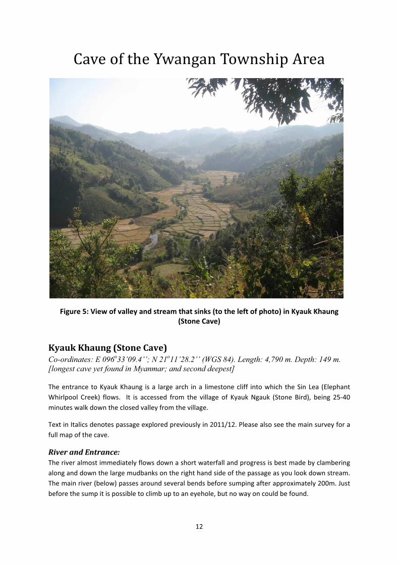
Cave of the Ywangan Township Area
Figure 5: View of valley and stream that sinks (to the left of photo) in Kyauk Khaung
(Stone Cave)
Kyauk Khaung (Stone Cave)
Co-ordinates: E 096o33’09.4’’; N 21
o11’28.2’’ (WGS 84). Length: 4,790 m. Depth: 149 m.
[longest cave yet found in Myanmar; and second deepest]
The entrance to Kyauk Khaung is a large arch in a limestone cliff into which the Sin Lea (Elephant
Whirlpool Creek) flows. It is accessed from the village of Kyauk Ngauk (Stone Bird), being 25-40
minutes walk down the closed valley from the village.
Text in Italics denotes passage explored previously in 2011/12. Please also see the main survey for a
full map of the cave.
River and Entrance:
The river almost immediately flows down a short waterfall and progress is best made by clambering
along and down the large mudbanks on the right hand side of the passage as you look down stream.
The main river (below) passes around several bends before sumping after approximately 200m. Just
before the sump it is possible to climb up to an eyehole, but no way on could be found.

13
Figure 6: (left) Entrance and (right) river passage close to the entrance of Kyauk Khaung
Catwalk: About 100m back from the sump a large highlevel passages, The Catwalk, goes off on the
right. Despite being approximately 12m above the streamway The Catwalk, contains large amounts
of fresh mud and large flood debris from the monsoon. In this mud, feline paw prints are numerous.
Lou Maurice was lucky enough to see a Civit in 2012/13, which rapidly moved out of sight down the
passage as mud bogged down the caver’s wellies. The roof of the Catwalk soon rises up into a very
large hading rift. About 100m further on, it is possible to climb up a mudbank to the right and enter
Over 18 Series.
Continuing along The Catwalk, the passage becomes lower, crawling in places, but always drafting.
After a further 150m a brief flat out section leads immediately to a junction. Right leads to a large
chamber from which the stream may be heard but not accessed. It is likely that the far side of the
chamber connects through to the area around Enlightenment, but this was not pursued due to a
dangerous slope of mud and boulders. Back at the junction, straight on soon leads to a balcony
overlooking the main stream, which flows from left to right.

14
Figure 7: Formations with Oo-la-la

15
Figure 8: Ooo-la-la looking towards the way to Independence Day
The cat-flap extensions:
A short distance along the catwalk shortly before the handline climb, it is possible to climb up (3-4
m) with difficult on the right (facing in). A high step up behind and boulder and further scrambling up
steep boulders leads to the top of the main rift. It is then possible to duck under the roof into a
second medium sized chamber, and then follow a tortuous upward route between boulders – as first
seen by Talling in 2011/12. There is a route at the same level along the top of the rift heading
towards Ooo-la-la. Returning to the initial chamber, this route was extended upwards through an
even more tortuous series of boulder, climbs and a small lateral narrow crawl for a considerable
distance. The route is locally highly polished and is used by animals (cat sized or smaller from where
polish seen between boulders). It was left at an upward tubular squeeze, and a 30 cm window into
an adjacent large chamber, on the last day of the 2012/13 expedition. It is likely that further
exploration will find a way on. The end of the passage is now the highest point in the cave, over 50 m
above the entrance, and most likely leads to a second entrance used by animals in the vicinity of the
path down from the nearby village.
Right Downstream & Enlightenment
From the end of the Catwalk, a climb down reaches a chamber with the river. The main stream is of
noticeably smaller volume and soon splits again at a diffluence. To the right the water sinks into a
choke of flood debris. However, shortly back from this it is possible to ascend a large mudbank via
The Slayer’s Staircase (a line of bamboo stakes) and enter Enlightenment. This huge chamber is
effectively a steeply ascending boulder pile, some 60m wide and with 100m vertical range. The
boulders can be very loose in places and care must be taken.

16
Stalagmite Slalom:
At the top of Enlightenment the boulders, almost, but not entirely fill to the roof. Here it is possible
to crawl between the resulting gap. A wide but low passage extends for over 150m, often in close
proximity to stalagmites and stalagtites, make this difficult and stressful. Towards the end of the
explored passage the elvation starts to dip down steeply, until the limit of exploration. The cave is
likely to continue here, but has not been pushed to a conclusion. It is very likely to continue
downwards through loose boulders to the southern end of Edge of Enlightenment.
Figure 9: Tense survey team in Stalagmite Slalom.
The east side of Enlightenment is likely to connect back to the large chamber accessed from The
Catwalk. However, as time and the difficult terrain did not allow inspection of all of the wall in
Enlightenment this has not been physically verified.
To the west side of Enlightenment it is possible to rigged an assisted climb down to connect to the
area above the flood debris choke and then enter a small tube. This leads to an undescended 6m
pitch.
Left Downstream – The Great Leap Forward
Back at the diffluence at the end of the Catwalk, the left hand fork of the streamway leads under a
low arch to continuing stream passage. This does not last for long, however, as the stream then
sinks, and a 3m climb down leads into a dry continuation. 10m further on it is possible to enter an
oxbow heading back upstream where a pit allows the last sighting of the streamway.

17
A further 10m downstream another climb down (~4m) lands in a chamber. The only way out is via a
small U-tube which leads to the foot of a climb up to a second chamber. From here further ascent is
required, via a very steep mud slope into which steps were cut. As the gradient reduces the climb
enters a passage full of boulders, with another climb up and a pitch down.
Much of this section could not be accessed in 2012/13, as the low passages had become blocked by
cobbles carried in by floods.
Upstream – The Road to Mandalay
From the balcony the upstream passages continues for approximately 150m to a junction with an
inlet. In these 150m, some of the flow sinks behind a stal boss. At the junction, an inlet comes in from
the right. To the left, the main streamway continues unexplored through deep water, but is at this
point only 50m from the downstream sump.
The inlet passage, The Road to Mandalay, continues for over 500m to the south west. For the first
150m the “inlet” is actually dry, but then water is finally met cascading down a rocky section before
sliding into a rift on the left (true right). Above the climb the stream continues in fine style, past
calcite formations and flowstone. Several times the water sinks and reappears. After a short
constricted section, walking passage resumes.
The passage soon became mainly blocked by boulders running in from above, and is notable for the
abundance of gently waving leeches on the walls. Ben Wright stripped off and swam along a pool in
the stream at a low level, but there was no obvious way on. A disappointing conclusion.
Over 18 Series
Back in The Catwalk, Over 18 Series is entered by scrambling up a mudbank. To the right, this may
connect back to the high hading rift encountered earlier in the Catwalk, although this was not
explored. To the left a large beautifully decorated chamber is entered. This leads, on the left, into a
wide passage with numerous stal columns and a mud floor. After around 100m a very large junction,
Ooo La La, is reached. To the left leads via a smaller section of passage, to the impressive
Independence Day. This large passage-chamber contains an untouched mud floor and many columns,
other calcite formations, and some idyllic crystal pools. There is no major route out of Independence
Day, but a small descending muddy slope was not explored.
Right at Ooo La La leads over large house sized boulders to another beautifully decorated chamber.
Climbing down at the eastern end of this chamber, enters a smaller muddy passage, Off the Page..

18
Figure 10: In Independence Day
This is clearly a major flood overflow route and is extremely muddy, with numerous pools of
water. These pools where seen to drain during the cause of the 2012/2013 expedition as the
moonsoon water evaporated. About 400m along the passage a high aven enters from the left.
Shortly after this some water drains down a small passage to the left which leads to a short
undescended pitch.
After another 400m, shortly after passing a small drain on the right, a major cross passage is
encountered. To the right this is choked with mud almost immediately, while to the left it
continues for around 100m to a steeply ascending boulder choke. Interestingly the choke soon
rises above the muddly flood line, but no safe way through could be seen.
A further 200m down Off The Page the passage splits. The main way on is to the left up a
mudbank, but it is also possible to continue in crawling passage straight ahead (The Cat

19
Latrine). This eventually reconnects to the main route via a climb up.
Taking the main route, this soon emerges into a much larger area containing a major junction.
Figure 11: (left) Pete and Fleur after a muddy crawl in Out of the Page. (right) Stemple of
Doom (aka Liquid limit) pool in Out of the Page.
New Upstream - Infinity and the Edge of Enlightenment:
Turning left the upstream passage can be followed for several hundred metres. However it
soon degenerates. Instead progress is made by ascending a mud bank on the immediate left as
one exits Off the Page. From here a large and well decorated chamber – Infinity – is entered.
An 8m climb down from the right hand side of Infinity allows the upstream passage to be re-
enters. This leads to over 1km of passages, but unfortunately includes much crawling. There
are occasional glimpses via boulder chokes of potentially larger passages in the area above,
but these cannot be entered. This area – known as the Edge of Englightment – is heading
straight for Englightment, but at a substantially lower level. Ultimately it ends in a choke.

20
Figure 12. Liu Hong approaching Infinity.
Figure 13. Lou in the Edge of Enlightenment

21
New Downstream – Absolute Truth and The Heart of Darkness:
Turning right at the end of Off the Page leads in the downstream direction to the northern
extend of the cave. The passage is large with a (dry) stream trench between mudbanks. The
trench may be followed down into a smaller muddy passage, down several climbs to a short
pitch. This leads on through a muddy crawl to a further undescended pitch.
Back in the main passage it is possible to ascend the mudbanks on the left to enter a large
chamber called Absolute Truth. At the top (north west) end of this chamber are some large
calcite formations. At the north east end of the chamber it is possible to climb down over
boulders and gain access to a high rift passage – The Heart of Darkness.
The rift is entered by abseiling down a mudslope before a shorted bolt-climbed pitch is
ascended to regain the same level. From here the rift continues 2 to 3m wide and up to 20+m
vertical range. Progress is generally made at the mid level where many boulders are wedged.
After ascending the pitch the next 15m of progress is gained via a protected traverse which
ends in a pitch down shortly followed by a further pitch up. A short section of unhindered
progress is then followed by a more significant drop, estimated to be in excess of 30m and the
current limit of exploration.
Figure 14 Caves around Ywangan Township

22
Figure 15. Google map showing Stone Cave
Map also shows village where we parked, Bear Hole and the large cave entrance we were
shown on the last day (‘Big Chamber Cave’ or Chaung Myaung Cave). The ‘wet resurgence’
is Linwe Depression Cave 1, ‘dry resurgence’ is Linwe Depression Cave 2, and ‘drafting
sink’ is Linwe Depression cave 3.

23
Other Caves Explored in 2012/2013
Bear Hole
Length 413m.Location: UTM 0245269; 2346026; entrance elevation 1198m
Visted by the 2013 expedition of the Myanmar Cave Documentation Project (UK team). A
series of exceptionally large chambers entered via a small hole in a cliff near Kyauk Ngauk
(Stone Bird) village. It is not yet confirmed that there is no further way one as all the walls
have yet to be surveyed. Air in
Unnamed Cave
No surveyed. ~15 m long; UTM 0245093; 2345993; entrance elevation 1282m
A short passage leads almost immediately to a choke. The cave is entered via a hole in the
bottom of the same Cliff which contains Bear Hole.
Chaung Myaung Cave and Hole
No surveyed. UTM 0245582; 2345277; entrance elevation 1307m
The 2012/3 expedition was shown this cave on the last day of the expedition. Two small
holes in a field lead to a steep slope which will need gear to descent. Locals report the cave to
be very large and to contain a lake. From climbing a short distance down the entrance (which
will need a ~30m rope) – this seems to be the case…it is big, but no obvious draft. Located in
large surface collapse doline above the end of Road to Mandalay within Stone Cave
Linwe Depression Cave 1 (large wet resurgence)
Not surveyed. UTM 0246019; 2347791; entrance elevation 1173m
A resurgence cave in the south west corner of the larged closed depression near to the village
of Linwe. The lake at the entrance to the cave was crossed but the flow found to come from a
sump. However, a further entrance at higher level allowed the sump to be bypassed. A well
decorated passage lead via several climbs to the river upstream of the sump. Open and
ongoing.

24
Figure 16: Linwe Depression Cave 1 – the wet resurgence (left) and bypass passage with
remarkably long thin column (right).
Linwe Depression Cave 2 (large dry resurgence)
Not surveyed. UTM 0246393; 2349315; entrance elevation 1136m
A dry cave that is either a fossil resurgence or active in the monsson, located at the northern
end of the Linwe depression. The large entrance leads to a very large passage that appears to
continue for some distance (100’s m). However there is no air movement within the cave.
Local describe how the passage is big enough to ‘drive a car down’.
Figure 17 Entrance to the large dry resurgence in Linwe Depression.

25
Linwe Depression Cave 3 (drafting sink)
Not surveyed. UTM 0246788; 2348666; entrance elevation 1122m
cave is located at the northern end of the Eastern edge of the large closed depression near
Linwe. To enter the cave one must scramble down over boulders. Although dry when
visited, the polished nature of the rocks suggest that a substantial amount of wáter flows here
in the wet season. After a short distance an undescended pitch was reached. The cave drafts
strongly and is a good prospect for future exploration.
Figure 18. The limit of exploration in the main sink in Linew Depression. This passage has a
very strong draft.
Linwe Depression Pool
Not surveyed.Locals claimed that this pool was the resurgence for Kyauk Khaung. However, this was
clearly not the case as the pool appeared to be static (at least in the dry season).

26
Environment
Geology and Geomorphology
The Permian and Triassic carbonate sequences of Eastern Myanmar are extensive and large tracts of
the Shan Plateau are comprised of these sediments (Figure 5). Although the main lithology
throughout is limestone, this is often dolomitic rather than calcitic. The stratigraphy and ages of
these deposits were uncertain for some time, with the major carbonate units variously referred to as
the Plateau Limestone1, or the Shan Dolomite Group2, in older publications. More recently, a revised
stratigraphic assessment has been made3 which divides the carbonates into two main units:
1. The Thitsipin Limestone Formation, named for a type section at Thitsipin village near the
township of Ywangan in the Southern Shan State. The Formation comprises five main
lithofacies:
a. Poorly bedded conglomerate
b. Laminated calcareous shale and other fined grained carbonate sediments
c. Massive fined grained calcareous sediments
d. Thick bedded calcareous sandstone with some calcareous mud
e. Massive or poorly bedded cherty wackestone (matrix supported calcareous grains
within carbonate mud)
Some sections of the formation are partially dolomitised and comprise fine grained dolomite.
2. The Thitsipine Limestone Formation then passes transitionally upwards into the Nwabangyi
Dolomite Formation
a. Calcareous conglomerate and sandstone with some carbonate mud.
b. Poorly bedded dolomitic wackestone
c. Thin bedded dolomitc and bioclastic wackestone
d. Thinly laminated turbitic dolomitic mudstone
The formation often suffers from shattered and brecciation.
1Geological Map of the Socialist Republic of the Union of Burma, Prepared under the auspices of the earth
science research division, research policy direction board, Government of the Socialist Republic of the Union of
Myanmar, 1:1,000,000 March 1977.2
Bender, F. (1983) Geology of Burma, Gerbruder Borntraeger, Berlin.3
Oo, T., Hlaing, T. & Htay, N. (2002) The Permian of Myanmar, Journal of Asian Earth Sciences, 20, 683-689.

27
The overlying Triassic limestones tends to be more crystalline and less sandy than the underlying
Devonian strata. The younger limestones also contain a greater proportion of calcium carbonate, up
to 98% 4.
The sequence of carbonate rocks is thought to be of considerable thickness, with estimates in the
range of 5000ft (approximately 1650m) in the Northern Shan State1 and up to 1000m in the
Southern Shan State 5.
The presence of these abundant carbonate beds has a major impact on the scenery in the Shan
States, leading to “dramatic scarp and ridge scenery and with spectacular karstic features”3. The
carbonates that form the Shan Plateau also form a natural geographic break between the elevated
and cooler plateau states and the hotter lowlands to the east.
As well as the Permian and Triassic calcareous sediments, less extensive limestones have been
deposited at other geological times included the Ordovician, the Jurassic and the Cretaceous-
Tertiary. The Jurassic limestones are known to be cave developing and are seen in the caves in Kalaw
and the surrounding area.
Figure 19 Extent of the Permian and Triassic Carbonates in Eastern Myanmar
3 Zin Taung
4 Sedawgyi Dam
5 Thipaw
6 Mandalay
7 Tonbo Range
8 Pyinoolwin
9 Dattaw Range
10 Magyiye area
11 Lungyaw
12 Kubyin-Lebyin
13 Nwabangyi
14 Thitsipin
15 Linwe-Sin area
16 Ywangan
17 Taunggyi
18 Loikaw
4Chibber, H. L. (1934) Geology of Burma, MacMillan and Co Limited, London.
5Robertson Research International Ltd (1997) Burma, South East Asia Geological Map Series, 1:2,000,000, with
explanatory notes, June 1997.

28
Observations from Ywangan
The main cave explored during the expedition, Kyauk Khaung, sinks in the Thitsipin limestone. It is
not known where the water from the cave resurges, although a closed basin of Quaternary
sediments some 5km to the north is one possibility. On the basis of the cave passages explored in
Kyauk Khaung the Thitsipin limestone is suitable for well developed karst systems and will be a focus
for future expeditions.
From geological maps, the water which feeds Kyauk Khaung appears to rise at a faulted boundary
with the older Chaung Magyi Group, a Pre-Cambrian unit comprises sandstones, mudstones,
dolomites and green limestones. On first inspection this does not appear to be a highly developed
karst formation, but will required future investigation.
The majority of the other caves explored around Ywangan appear to be within the Ordovician
Doktoye Limestone Formation and are not so well developed. The exception to this are the entrance
near Myhakalay which are believed to be in the Jurassic limestones.
Hydrology and Hydrogeology
Ywangan is situated near a seasonal lake. This is reported to fill up following the rainy season but
with a slight lag. We interpreted this feature to be similar to the Irish term “turlough” also
representing a karstic seasonal lake. However, it is possible that there are superficial quaternary
sediments in the fertile basin around Ywangan which complicate the local hydrogeology.
Apart from the aforementioned lake there are few surface water features around Ywangan. As the
road from Kalaw to Ywangan ascends the plateau there are some small streamed which the road
crosses. However, we have not traced these nor found resurgences. In a number of small caves we
encountered a shallow local water table and it is these caves which appear to be important for the
local cave adapted fish species. These areas, due to their shallow water table, do not appear to have
extensive large cave passage development, although it is clear that the underlying rocks are karstic.
The large river which enters Kyauk Khaung is known to come from a resurgence although we did not
have time to visit this. However, on the whole we saw very few resurgences and none of any size.
We do not know where the water from Kyauk Khaung is seen again and this question remains a key
one for future expeditions.
The internal drainage within Kyauk Khaung also remains of interest. The main stream, and its inlet in
the Road to Mandalay, shows great propensity to split and sink or partially sink on its route
downstream. Thus the volume of water at the downstream limit is significantly smaller than that at
the cave entrance.

29
Figure 20. The seasonal lake at Ywangan
Weather
Contrary to previous experience we saw colder and wetter weather in Myanmar this year due to the
passage of a significant front through the area at the start of the expedition. It rained for around
three days and nights near the beginning of our time at Ywangan. This saw only little influence on
the water levels in Kyauk Khaung, although it did have a large impact on the weather the local roads
where passable. When the weather conditions were over cast and rainy it was also cooler than on
previous visits. Later in the expedition, conditions did become warmer, but only during the day with
cooler conditions continued to be experienced at night.
Presentation to the Ywangan Township Hospital
Following their outstanding help last year, when Peter Talling crushed a toe and lost the bone out of
the bottom, we presented a Ventouse (suction device for delivering babies) to Ywangan Hospital.
The midwives obviously knew exactly how to assemble the Ventouse.

30
Figure 21. Presenting the Ventouse at Ywangan Hospital

31
Appendix A: Ywangan Cave Database
Area Name Alternative Name Date UTM Easting UTM Northing Elevation length m Comments Exploration
Ywangan Pete's spider cave 26/12/2011 0227962 2358084 1239
small cave following
bedding, after two
climbs chokes with
mud dead
Ywangan Kyaw Khaunng Gu first day cave 26/12/2011 0233489 2351635 1434 69
large arch entrance
leads to smaller
passage and two
pitches down to
mud choked
chamber dead
Ywangan U Mya Ohn Gu 26/12/2011 0233062 2352275 1403
large arch entrance
totally choked with
calcite dead
YwanganGrovel down valley from
Pete's spider cave 26/12/2011 0227967 2358195 1241
narrow shaft for 3m,
can see to mud floor dead
Ywangan Linnloe Cave Bat Cave 27/12/2011 0234691 2350523 1373
large arch entrance
to handline climb to
very large
chammber with 3%
CO2. Continues to
further climb down ongoing
Ywangan Bamboo ladder cave 1000ft cave 27/12/2011 0234214 2351081 1562
Two shafts that
interconnect via
elaborate bamboo
ladders dead
Ywangan 28/12/2011 0238747 2349337 1379
Sink on route to fish
caves dead
Ywangan Thein Khong Cave 1 Fish cave 1 28/12/2011 0241081 2348214 1348
Mendip esq grovel
to sump dead
Ywangan Thein Khong Cave 2 Fish cave 2 28/12/2011 0240884 2348598 1361
Climb down to small
stream which sumps dead
Ywangan Pho Tha Oo Cave 28/12/2011 0241719 2347885 1353 shaft of four potches dead

32
Ywangan Kyauk Khaung Stone Cave 29/12/2011 0245912 2345267 1200 2355 BIG river sink cave ongoing
Ywangan Myhakalay 2 Fish(es) Cave 3 30/12/2011 0232032 2338782 1078
Tim et al. found
many fishes dead
Ywangan Myhakalay 1 Pete's Pool Plunge Cave 30/12/2011 0231496 2340576 1127
Pete rearranged toes
with rock ongoing
Ywangan Kaseppin 1 Kaseppin 1 31/12/2011 0235048 2350533 1233
rift in doline, close
to Kaseppin 2 ongoing
Ywangan Kaseppin 2 Kaseppin 2 31/12/2011 0235051 2350375 1257 Rubbish fill dead
Ywangan Bear Hole 01/01/2013 0245269 2346026 1198 413
series of very large
chambers, not all
walls checked ongoing?
Ywangan No name 01/01/2013 0245093 2345993 1282
Short passage which
chokes dead
Ywangan Linwe Depression Pool 07/01/2013 0246213 2348077 1242
static pool
resurgance in Linwe
depression no passage
Ywangan Linwe Depression 1 07/01/2013 0246019 2347791 1173
resurgance cave
sumps,but entrance
aboves leads to
bypass ongoing
Ywangan Linwe Depression 2 07/01/2013 0246393 2349315 1136
dry resurgance cave;
large passage
ongoing but no
draught ongoing
Ywangan Linwe Depression 3 07/01/2013 0246788 2348666 1122
dry sink; climb down
over boulders to
reach pitch;
draughts ongoing
YwanganChaung Myaung Cave
and Hole 10/01/2013 0245582 2345277 1307
Small hole leads to
big chamber with
lake ongoing

33
Appendix B: Surveys

34

35
Appendix C: Expedition Log
Date Who What
22/12/12 PF, FL, TG, LM, BW leave Heathrow
23/12/12 PF, FL, TG, LM, BW Arrive and overnight in Guangzhou
24/12/12 All Arrive and overnight in Yangon
25/12/12 All Travel to Heho, and on to Ywangan
26/12/12 All Stone Cave – TG/LM/BW off the page; PT/LH/FL Ooo la la
27/12/12 All Stone Cave – FL/PT/LH off the page; TG/LM/BW Over 18
28/12/12 All Myhakalay – all to fish caves;
29/12/12 All Stone Cave – TG/LM/BW off the page (stemple of doom); FL,
PT, LH enlightenment RH.
30/12/12 All All – off the page, new upstream; absolute truth, cat latrine
31/12/12 All, Stone Cave – FL/PT/CH Downstream new leads; TG/LM/BW
upstream new leads
01/01/13 All Bear Hole and nearby cave
02/01/13 All Stone Cave – FL/PT/BW – downstream (voltarol assist);
TG/LM, LH – upstream new passage
03/01/13 All Stone Cave – FL/PT/BW Downstream – poo traverse;
TG/LM/LH new upstream passage
04/01/12 All Myhakalay – TG/LM/FL/BW to fish cave; PT/LH to pete’s
plunge and toe cave
05/01/13 All Stone cave – FL/TG/LM – Downstream Heart of darkness;
PT/LH/BW Road to Manadalay
06/01/13 Various Myhakalay – TG/LM/FL to fish cave;
Bear Hole survey – PT/LH/BW
07/01/13 All, Linwe Depression. Successful prospecting to find sink and
two major resurgences

36
Date Who What
08/01/13 All Rest day – walking from Ywangan and survey drawing
09/01/13 All Stone Cave – TG/LH/LM/FL photography; PT/BW Heart of
Darkness
10/01/13 All Stone Cave – PT/FL to Cat Flap; TG/LH/LM/BW photos;
PT/BW/FL shown large extrance near village
11/01/12 All Leave heho and travel to overnight in Yangon
12/01/12 All Leave Yangon for Kunming/Guangzhou
13/01/12 All Arrive Heathrow


