+ All Categories
Home > Documents > Shoreline Master Program 2009 - 2010 Update Draft · MSQ-05 M EL-07 MEL-05 MEL-04 MEL-02 MEL-00...

Shoreline Master Program 2009 - 2010 Update Draft · MSQ-05 M EL-07 MEL-05 MEL-04 MEL-02 MEL-00...

Date post: 06-May-2020
Category:
Upload: others
View: 10 times
Download: 0 times
Share this document with a friend
1
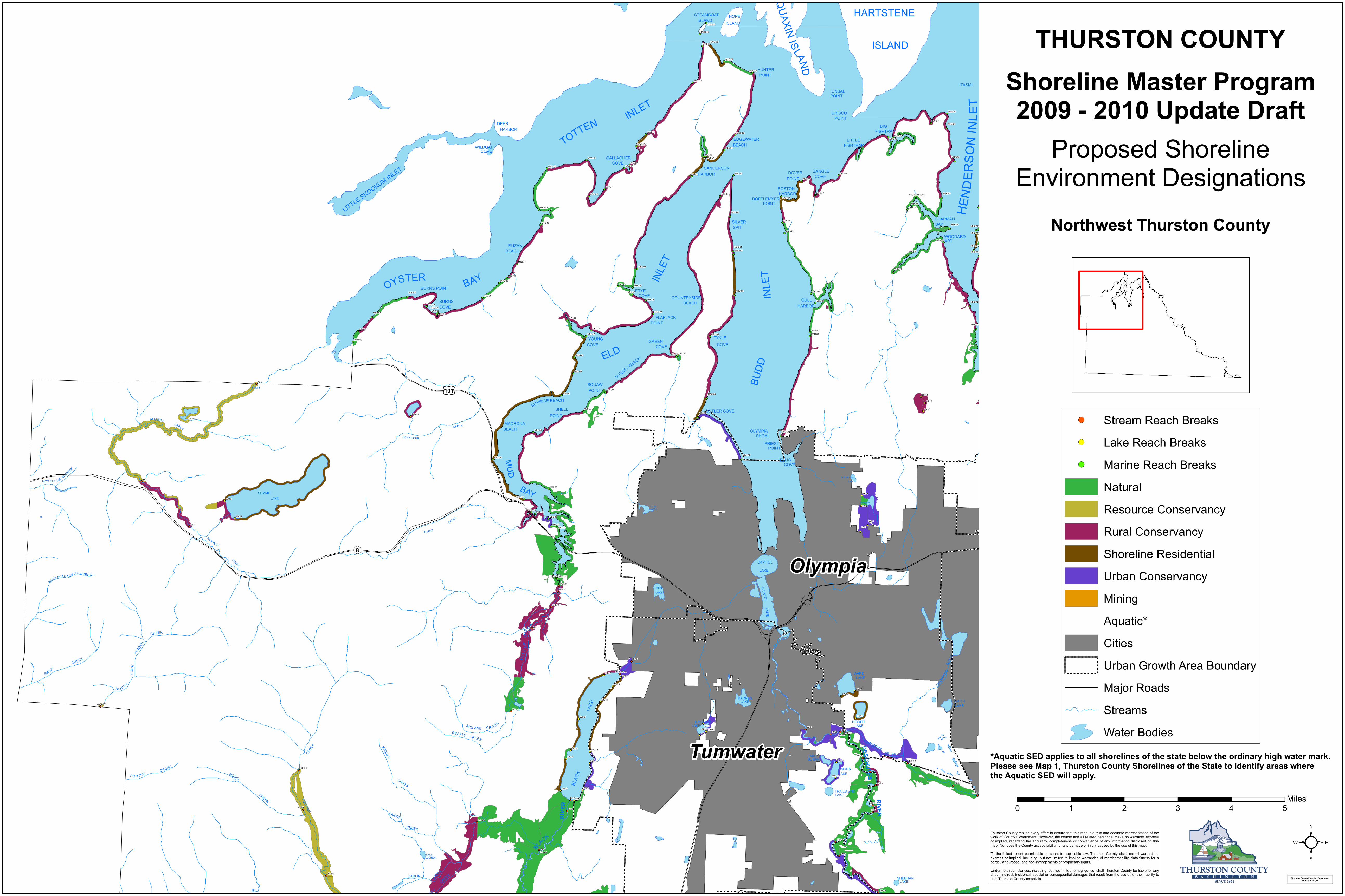
Q U A X I N I S L A N D STEAMBOAT HARTSTENE HOPE ISLAND ISLAND ISLAND HUNTER POINT ITASMI UNSAL POINT BRISCO POINT INLET DEER BIG HARBOR FISHTRAP EDGEWATER LITTLE T O T T E N BEACH FISHTRAP WILDCAT COVE GALLAGHER COVE SANDERSON ZANGLE DOVER HARBOR COVE POINT BOSTON HARBOR DOFFLEMYER POINT LITTLE SKOOKUM INLET H E N D E R S O N I N L E T CHAPMAN SILVER BAY SPIT WOODARD BAY ELIZAN BEACH INLET B A Y O Y S T E R BURNS POINT FRYE COVE INLET COUNTRYSIDE GULL BURNS BEACH HARBOR COVE FLAPJACK POINT TYKLE YOUNG GREEN COVE COVE COVE ELD S U N S E T BE AC H SQUAW BUDD FALLS POINT S U N R I S E BEAC H SHELL BUTLER COVE POINT MADRONA CREEK BEACH OLYMPIA SHOAL SC HNEIDER PRIEST POINT MUD ELLIS COVE SETCHFIELD LAKE B A Y SUMMIT LAKE BIGELOW LAKE LOUISE LAKE CREEK PERRY CREEK CAPITOL LAKE CAPITOL KEN LAKE LAKE DITCH WARD LAKE CHAMBERS BARNES SMITH LAKE LAKE LAKE HEWITT TROSPER LAKE LAKE CHAMBERS DESCHUTES CREEK CREEK LAKE SUSAN MUNN C R E EK NOSKI LAKE RIVER BLACK TRAILS END CREEK LAKE WADDELL PANTS R I V E R CREEK B L ACK LAKE LUCINDA DARLIN SHEEHAN CREEK LAKE P S E Y M C L A N E C R E E K S W A N C R E E K N O R T H F O R K P O R TER C R E E K KENN E D Y C R E E K M OX C H E H A L I S C R E E K K E NN E D Y W E S T F O R K P O R T E R C R E E K P O R T E R CR E E K S TO N E Y C R E E K M C L A N E C R E E K B E A T T Y CR E E K Tumwater Olympia ¬ « 8 £ ¤ 101 MHE-06 MHE-05 MEL-21 MEL-20 MEL-17 MEL-11 MEL-06 MBU-04 MTO-22 MHE-07 MHE-04 MHE-11 MHE-00 MBU-21 MBU-20 MBU-19 MBU-18 MBU-17 MBU-16 MBU-15 MBU-14 MBU-13 MBU-12 MBU-11 MBU-09 MBU-10 MEL-32 MEL-31 MEL-30 MEL-29 MEL-28 MEL-27 MEL-26 MEL-25 MEL-24 MEL-23 MEL-22 MEL-19 MEL-18 MEL-16 MEL-14 MEL-15 MEL-03 MSQ-04 MSQ-03 MSQ-02 MTO-11 MEL-13 MEL-12 MEL-10 MEL-09 MEL-08 MSQ-05 MEL-07 MEL-05 MEL-04 MEL-02 MEL-00 MEL-01 MSQ-01 MSQ-00 MTO-23 MTO-21 MTO-20 MTO-19 MTO-18 MTO-16 MTO-15 MTO-14 MTO-17 MTO-13 MTO-12 MTO-10 MTO-08 MTO-09 MTO-07 MTO-06 MTO-05 MTO-04 MTO-01 MTO-00 MTO-03 MTO-02 MBU-03 MBU-02 MBU-01 MBU-00 MHE-19 MHE-18 MHE-17 MHE-16 MHE-13 MHE-12 MHE-10 MHE-09 MHE-08 MHE-03 MHE-02 MHE-01 MBU-08 MBU-07 MBU-06 MBU-05 LTR-4 LTR-3 LTR-2 LTR-1 LBI-3 LSH-3 LSH-2 LSH-1 LWA-2 LWA-1 LHE-1 LMU-2 LMU-1 LBL-9 LBL-8 LBL-7 LBL-6 LBL-5 LBL-4 LBL-3 LBL-2 LBL-1 LSU-2 LSU-1 LBL-13 LBL-12 LBL-11 LBL-10 LPO1-1 LPO2-1 LBI-4 LBI-2 LBI-1 NP-1 NP-0 KE-2 KE-1 KE-0 MCL-4 MCL-3 MCL-2 MCL-1 MCL-0 DE-9 DE-8 DE-7 DE-6 DE-5 DE-3 DE-2 DE-1 DE-0 DE-10 DE-2-4 DE-2-3 DE-2-2 DE-2-1 DE-2-0 BL-3 BL-4 BL-2 BL-1 BL-0 BL-8-6 BL-8-5 BL-8-4 BL-4-1 BL-4-0 ² Thurston County makes every effort to ensure that this map is a true and accurate representation of the work of County Government. However, the county and all related personnel make no warranty, express or implied, regarding the accuracy, completeness or convenience of any information disclosed on this map. Nor does the County accept liability for any damage or injury caused by the use of this map. To the fullest extent permissible pursuant to applicable law, Thurston County disclaims all warranties, express or implied, including, but not limited to implied warranties of merchantability, data fitness for a particular purpose, and non-infringements of proprietary rights. Under no circumstances, including, but not limited to negligence, shall Thurston County be liable for any direct, indirect, incidental, special or consequential damages that result from the use of, or the inability to use, Thurston County materials. 0 1 2 3 4 5 Miles ! ( Stream Reach Breaks ! ( Lake Reach Breaks ! ( Marine Reach Breaks Natural Resource Conservancy Rural Conservancy Shoreline Residential Urban Conservancy Mining Aquatic* Cities Urban Growth Area Boundary Major Roads Streams Water Bodies Thurston County Planning Department 12 May 2010 - jkb THURSTON COUNTY Shoreline Master Program 2009 - 2010 Update Draft Proposed Shoreline Environment Designations Northwest Thurston County *Aquatic SED applies to all shorelines of the state below the ordinary high water mark. Please see Map 1, Thurston County Shorelines of the State to identify areas where the Aquatic SED will apply.
Transcript

SQUAXIN ISLAND

ARCADIA

STEAMBOAT HARTSTENEHOPEISLAND ISLAND

ISLANDHUNTERPOINT

ITASMIUNSAL

POINT

BRISCOPOINTINLET

DEER BIGHARBOR FISHTRAPEDGEWATER LITTLETOTTENBEACH FISHTRAPWILDCAT

COVEGALLAGHER

COVESANDERSON ZANGLEDOVERHARBOR COVEPOINT

BOSTONHARBOR

DOFFLEMYERPOINT

LITTLE SKOOKUM INLET

HEND

ERSO

N IN

LET

CHAPMANSILVER BAYSPITWOODARDBAY

ELIZANBEACH

INLET

BAYOYSTERBURNS POINT FRYE

COVE INLE

T

COUNTRYSIDE GULLBURNS BEACH HARBORCOVE

FLAPJACKPOINT

TYKLEYOUNG GREEN COVECOVE COVE

ELDSUNSET BEACH

SQUAW BUDD

FALLS POINT

SUNRISE BEACHSHELL BUTLER COVE

POINTMADRONA

CREEK BEACH OLYMPIA

WOO

DLAN

D

SHOALSCHNEIDERPRIEST

POINT

MUD

ELLISCOVE

SETCHFIELDLAKE

BAYSUMMITLAKE

BIGELOWLAKELOUISE

LAKE

CREEK

PERRY

CREEK CAPITOLLAKE

CAPITOL

KENLAKE

LAKE

DITCH

WARDLAKE

CHAM

BERS

BARNES SMITHLAKELAKE

LAKE

HEWITTTROSPERLAKE LAKE

CHAMBERS

DESCHUTES

CREEKCREEK

LAKESUSAN

MUNNCREEKNOSKI

LAKE

RIVER

BLAC

K

TRAILS ENDCREEKLAKE

WADD

ELL

PANTS RIVE

R

CREEK

BL

ACK

LAKELUCINDA

DARLIN SHEEHANCREEK

LAKE

DEMPS

EY

MCLA

NE

CREE

K

SW AN

CREEK

NO RTH

FORK

PORTER

CREEK

KENNEDYCREEK

MOX CHE HALIS CREEK

KENNE DY

WEST FORK P ORTER CREE K

PO RT ER

MONROE CR EEK

CREEK

STONEY

CREEK

M CLANE CR E EK

BEATTY CREEK Tumwater

OlympiaLacey

¬«8

£¤101

MHE-06

MHE-05

MEL-21

MEL-20

MEL-17

MEL-11

MEL-06

MBU-04

MTO-22

MHE-07

MHE-04

MHE-11

MHE-00

MBU-21

MBU-20MBU-19

MBU-18

MBU-17

MBU-16

MBU-15

MBU-14

MBU-13

MBU-12

MBU-11

MBU-09MBU-10

MEL-32

MEL-31

MEL-30MEL-29

MEL-28

MEL-27

MEL-26

MEL-25

MEL-24MEL-23

MEL-22

MEL-19MEL-18

MEL-16

MEL-14

MEL-15

MEL-03

MSQ-04

MSQ-03

MSQ-02

MTO-11

MEL-13

MEL-12

MEL-10

MEL-09

MEL-08

MSQ-05

MEL-07

MEL-05

MEL-04

MEL-02

MEL-00

MEL-01

MSQ-01

MSQ-00

MTO-23

MTO-21

MTO-20

MTO-19MTO-18

MTO-16

MTO-15

MTO-14

MTO-17

MTO-13

MTO-12

MTO-10

MTO-08

MTO-09

MTO-07MTO-06

MTO-05MTO-04

MTO-01

MTO-00

MTO-03

MTO-02

MBU-03

MBU-02MBU-01

MBU-00

MHE-19

MHE-18

MHE-17

MHE-16

MHE-13

MHE-12

MHE-10

MHE-09

MHE-08

MHE-03

MHE-02

MHE-01

MBU-08

MBU-07

MBU-06

MBU-05

LTR-4LTR-3LTR-2

LTR-1

LBI-3

LSH-3

LSH-2

LSH-1

LWA-2

LWA-1

LHE-1

LMU-2

LMU-1

LBL-9LBL-8LBL-7

LBL-6

LBL-5

LBL-4

LBL-3

LBL-2

LBL-1

LSU-2

LSU-1

LBL-13

LBL-12

LBL-11

LBL-10

LPO1-1LPO2-1

LBI-4

LBI-2

LBI-1

NP-1NP-0

KE-2

KE-1

KE-0

MCL-4

MCL-3

MCL-2

MCL-1

MCL-0

DE-9

DE-8

DE-7

DE-6

DE-5

DE-3

DE-2DE-1

DE-0

DE-10

DE-2-4

DE-2-3

DE-2-2

DE-2-1DE-2-0

BL-3

BL-4

BL-2

BL-1

BL-0

BL-8-6

BL-8-5

BL-8-4

BL-4-1

BL-4-0 ²Thurston County makes every effort to ensure that this map is a true and accurate representation of thework of County Government. However, the county and all related personnel make no warranty, expressor implied, regarding the accuracy, completeness or convenience of any information disclosed on thismap. Nor does the County accept liability for any damage or injury caused by the use of this map.To the fullest extent permissible pursuant to applicable law, Thurston County disclaims all warranties,express or implied, including, but not limited to implied warranties of merchantability, data fitness for aparticular purpose, and non-infringements of proprietary rights.Under no circumstances, including, but not limited to negligence, shall Thurston County be liable for anydirect, indirect, incidental, special or consequential damages that result from the use of, or the inability touse, Thurston County materials.

0 1 2 3 4 5Miles

!( Stream Reach Breaks!( Lake Reach Breaks!( Marine Reach Breaks

NaturalResource ConservancyRural ConservancyShoreline ResidentialUrban ConservancyMiningAquatic*CitiesUrban Growth Area BoundaryMajor RoadsStreamsWater Bodies

Thurston County Planning Department12 May 2010 - jkb

THURSTON COUNTYShoreline Master Program2009 - 2010 Update Draft

Proposed ShorelineEnvironment Designations

Northwest Thurston County

*Aquatic SED applies to all shorelines of the state below the ordinary high water mark.Please see Map 1, Thurston County Shorelines of the State to identify areas wherethe Aquatic SED will apply.

Recommended