Page 1
ACC
EPTE
D M
ANU
SCR
IPT
ACCEPTED MANUSCRIPT
1
A descriptive and quantitative approach regarding erosion and
development of landforms on abandoned mine tailings: new insights and
environmental implications from SE Spain
Short title: landforms on abandoned mine tailing deposits
J.F. Martín Duquea*
, I. Zapico a, R. Oyarzun
b , J.A. López García
b, P. Cubas
c
a Departamento de Geodinámica, Facultad de Ciencias Geológicas, Universidad Complutense e Instituto de
Geociencias, IGEO (CSIC, UCM), 28040 Madrid, Spain
b Departamento de Cristalografía y Mineralogía, Facultad de Ciencias Geológicas, Universidad Complutense,
28040 Madrid, Spain
c Departamento de Biología Vegetal II, Facultad de Farmacia, Universidad Complutense, 28040 Madrid, Spain
*Corresponding author. Tel.:+34 913944857; [email protected] .
Abstract
The San Cristóbal-Perules mining site in Mazarrón in southeast Spain was subjected to about
a hundred years of intense mining activity for lead, silver, and zinc. Metallurgical operations
(smelting, calcination, gravity concentration) carried out during the late nineteenth century –
early twentieth century induced significant land transformation, and the most conspicuous
wastes of this period consists of a chaotic piling of ‘old’ tailing deposits. Later on, during the
mid- twentieth century, ‘modern’ tailings resulting from froth flotation were accumulated
filling small valleys; these latter valley-fill tailings rose sequentially according to the
upstream construction method, progressively raising the level of the dam during the process.
Once abandoned, both types of tailing deposits underwent severe erosion, resulting in a
Page 2
ACC
EPTE
D M
ANU
SCR
IPT
ACCEPTED MANUSCRIPT
2
mosaic of erosional and sedimentary landforms developed upon (e.g., gully formation) and
within them (e.g., piping). We made an inventory and classification of these landforms. Our
study shows the geomorphic work to reestablish a new steady state between the tailings
deposits and the local erosive conditions. This scenario implies several hazards related to the
extremely high heavy metal contents of these tailings and the geomorphic instability of the
deposits. We also quantified the tailings tonnage and erosion that occurred at one of the
tailings dams (El Roble). As shown by an oblique aerial photograph taken in 1968, this dam
had a terraced topography, whereas in 2013 this morphology had evolved into a badland-type
relief with deep parallel gullies. By recognizing and surveying specific, remnant points along
the benches and outslopes of the older terraced topography, we were able to build up a first
digital elevation model (DEM1) reflecting the initial topography. A second DEM, this time
showing the present topography, allowed quantification of erosion via Material Loss = DEM1
– DEM2. This yields an erosion rate (1968-2009) of 151.8 Mg (MT) ha-1
y-1
, which matches
well typical values for erosion of mined areas, commonly above 100 Mg (MT) ha-1
y-1
.
Abandoned mine tailing deposits are extremely common in the semiarid scenarios of the SW
USA, Australia, Chile, and Peru. Given the similarities of these scenarios with SE Spain, the
example from Mazarrón may provide useful new insights regarding the erosion and
geomorphic evolution of such tailing deposits. These matters should be addressed in key
environmental actions such as mine closure plans and land reclamation projects. A solution
may come via restoration of these deposits through landform design involving the building up
of stable mature landscapes, which in turn can withstand erosion much more easily.
Keywords: Mazarrón; SE Spain; mining; erosion of tailing deposits; descriptive and
environmental geomorphology; landform design
Page 3
ACC
EPTE
D M
ANU
SCR
IPT
ACCEPTED MANUSCRIPT
3
1. Introduction
1.1. Background
Geomorphology is the interdisciplinary and systematic study of landforms and their
landscapes as well as the earth surface processes that create and change them (IAG, 2014).
Despite that all landforms of the Earth’s surface are potentially included under that definition,
the truth is that geomorphology has traditionally focused on landscapes that have not
undergone significant anthropic modification by earth movement. However, the percentage of
the Earth’s land surface subjected to human modification by earth moving activities has
grown significantly in the last decades, and the likely forecast is that it will not stop growing
in the forthcoming future (e.g., Rivas et al., 2006; Hooke et al., 2012), as shown by fast-
developing countries such as China, India, or Brazil (among others). Humankind has moved
and is moving huge amounts of earth thus creating new landforms, a process that often leads
to accelerated erosion. The sediments derived from the latter process end up as colluvium on
the hillslopes and as alluvium in the floodplains, thus subtly altering the shape of the land.
The rest is carried away by streams and rivers. Taking all these matters into consideration,
two facts must be highlighted: (i) landscapes modified by earth movement activity are
becoming a key issue in geomorphology; and (ii) the environmental effects of these new
landscapes (runoff from these areas is commonly contaminated and has a high sediment load)
and the associated risk potential involving mass movements (flooding, loss of human life,
economic catastrophes, etc.) are of paramount importance. This confers to geomorphology
(together with environmental geochemistry in the case of abandoned mine sites) a leading role
Page 4
ACC
EPTE
D M
ANU
SCR
IPT
ACCEPTED MANUSCRIPT
4
in the understanding of the roots of the problems and in the search for sound closure plans,
reclamations and management solutions.
This paper is focused on ‘minescapes’―here defined as landscapes generated by
mining activity―and in this regard, despite the evident morphological modification that they
undergo, most of the research and literature on the subject has focused on geomorphologically
based assessments of mining-affected catchments. Langedal (1997) and James (2005) studied
the geomorphic implications of dams built to stop fluvial dispersion of tailings. Taylor and
Kesterton (2002) researched the dispersal of high metalliferous pollution from spoil heaps
derived from copper mining in the Gruben River valley of Namibia. Macklin et al. (2006)
showed how the understanding of sediment-associated metal dispersion processes in rivers
can be used in a practical way to help river basin managers more effectively control and
remediate catchments affected by present and historical metal mining. Lecce and Pavlowsky
(2014) assessed the magnitude and distribution of mercury (Hg) and copper (Cu)
contamination of floodplain deposits associated with nineteenth century gold (Au) mining
activities in the Gold Hill mining district of North Carolina.
Other studies linking geomorphology and mined lands have focused on: (i) criteria for
their geomorphic reclamation (Bugosh, 2007); (ii) the application of geomorphic evolution
models, under and outside of reclamation measurements (Riley, 1995; Evans and Loch, 1996;
Willgoose and Riley, 1998; Evans et al., 2000; Hancock et al., 2003); and (iii) the monitoring
of geomorphically reclaimed lands (Martín-Duque et al., 2010). However, very few studies
(e.g., Haigh, 1979, 1980) have dealt with actual ‘mining geomorphology’. Two examples
from Belgium are provided by Nyssen and Vermeerch (2010) and Beullens et al. (2014). The
former analyzes the spatial distribution of the main geomorphic processes occurring on coal
tips, whereas the second one shows the high impact of slope morphology on the magnitude of
rill erosion on coal mine spoil heaps.
Page 5
ACC
EPTE
D M
ANU
SCR
IPT
ACCEPTED MANUSCRIPT
5
1.2. Tailing dams and derived hazards: a brief introduction
The volumes of tailing deposits (creating large new landforms) can be huge; for example, a
large mine such as Escondida in Chile is expected to dispose 3.3 billion metric tons of tailings
during the period 2003-2043 at its local impoundment facility of Laguna Seca (Chambers et
al., 2003). Even relatively small-scale operations may alter the landscape so profoundly as to
eliminate an entire bay with its harbor facilities as it happened in Portman (Spain) (Oyarzun et
al., 2013), not far from our study area. The Peñarroya Mining and Metallurgical Company
disposed at Portman Bay about 60 million tons of tailing materials directly to the
Mediterranean Sea between 1957 and 1990; a substantial part of it (12.5 Mt) was dragged
back by the sea currents progressively infilling the bay, making the shoreline advance
between 500 and 600 m seaward (Manteca et al., 2014) thus creating a massive, physical and
chemical environmental impact (Oyarzun et al., 2013).
Tailing dams are one of the most unstable minescapes, resulting in evident hazards.
These hazards are chemical (leaching and transport of heavy metals and metalloids) and
physical (failure of the dam) or a combination of both. Tailing dams may fail because of
many reasons, among them, they are not built to last. In fact, different from civil engineering
works such as road or tunnel construction, in mining operations the works are basically
designed to endure the mine life cycle and little more. A typical case of dam failure relates to
piping that occurs if seepage within or beneath the embankment causes erosion along its
flowpath. In this respect, excessive piping may result in local or general failure of the
embankment (WISE, 2014). The consequences can be catastrophic if human settlements are
located in the vicinity of a tailings dam and may affect large areas if the residues reach a river.
A situation of this type can develop even if no dam failure happens; all is required is the
Page 6
ACC
EPTE
D M
ANU
SCR
IPT
ACCEPTED MANUSCRIPT
6
strong erosion of the tailings dam and a nearby river, as it happens to be in the case of
Mazarrón where massive earth removal has taken place in the last 45 years or so. In this
regard, the older a tailings dam is the greater and cumulative become the risks, a fact well
exemplified by the high heavy metal contents along the Las Moreras seasonal river, which
runs alongside the San Cristóbal-Perules mined site in the Mazarrón district (Oyarzun et al.,
2011) (see Figs. 1 and 2). Two previous works on the Mazarrón district (Acosta et al., 2011;
Oyarzun et al., 2011) indicate the potential contamination risk associated with the tailing
deposits. However, a geomorphological approach (either qualitative or quantitative) is not
provided by either of them, and this is the focus of this paper.
1.3. Aims and research questions
Based on detailed field work and topographical quantification carried out at the referred
Mazarrón district (Murcia, Spain) (Fig. 1) ―one of the classic and oldest Pb–Zn mining sites
in Europe― we sought to: (i) make an inventory, classification, description, and interpretation
(relating geomorphology and geochemistry) of the landforms existing in the tailings dams; (ii)
quantify the tailings tonnage and erosion that occurred at the El Roble dam; (iii) interpret the
erosive characteristics of the tailings and its hydrological connectivity as a key factor for
environmental effects and risk potential. By providing new insights into these matters, we
pursued answering these questions: (i) what are the main geomorphic processes currently
acting upon these tailing deposits and mobilizing sediments, and how do they operate?; (ii)
what is the magnitude of the erosive process at the tailing dams of this minescape?; and (iii)
what is the meaning of the highly erosive character of this minescape and what is its
hydrological connectivity framework? From this information, we finally sought to assess
alternative, geomorphic-based reclamation strategies, asking ourselves if a geomorphic
Page 7
ACC
EPTE
D M
ANU
SCR
IPT
ACCEPTED MANUSCRIPT
7
reclamation approach is applicable for tailing deposits. All that focusing on an environmental
geomorphology perspective, a discipline originally defined as the practical use of
geomorphology for the solutions of problems where man wishes to transform or to use and
change superficial processes (e.g., Panizza, 1996).
2. Regional setting
2.1. Physiography and climate
The physiographic setting of Mazarrón is laid by three sierras (Algarrobo, Las Moreras, and
Almenara), with altitudes ranging from 400 to 700 m; and the San Cristóbal–Perules mined
site is located at the footslope of the Sierra del Algarrobo, surrounded by small volcanic hills
(Fig. 1). These sierras define a horseshoe-shaped sedimentary basin (Mazarrón), opened to the
north and slightly inclined to the south. The basin is drained by the Rambla de Las Moreras,
which receives sediments from the sierras, the basin itself, and in its lower course, from the
San Cristóbal–Perules mine site. The mining wastes are located at about 5.5 km from the
coast (Fig. 1). The major man-made landforms at this location are the result of metallurgical
activities and consist of tailing deposits and rock waste dumps (Fig. 3). However, apart from
dirt roads and cuts there are no truly large excavations (e.g., open pits) because mining was
mostly underground. Rambla is a Spanish term referring to wadi: ephemeral fluvial channels
of semiarid and arid areas. These wadis have a flat stream bed with vertical banks. They are
dry most of the year and are only functional under torrential rainfall, giving rise to flash
floods, and able to move high quantities of bedload, suspended sediment, and dissolved
cations and anions.
Page 8
ACC
EPTE
D M
ANU
SCR
IPT
ACCEPTED MANUSCRIPT
8
The area is characterized by a semiarid Mediterranean climate (Fig. 1), with rain-
deprived summers and moderation of temperatures by the influence of the Mediterranean Sea.
Annual rainfall may strongly vary between years, but it is within the range of 185-310 mm;
whereas average annual temperatures are between 16.5 and 18.8°C (García-Rizo et al., 1999).
Although rainfall is not high, the area is subjected to annual, strong stormy episodes that can
induce important flash flood phenomena. The semiarid climate of SE Spain may have started
as early as ~ 4500 BP (before present), with a radical transformation of the landscape that
reflects in the establishment of the steppe conditions found today (Pantaleón-Cano et al.,
2003). Because of the scarcity of precipitation that characterizes the climate of the region,
most of the soils lack a B horizon, and therefore C profiles are dominant. Calcic xerosols,
haplic calcisols, and calcaric regosols, typical of semiarid Mediterranean ‘caliches’, along
with lithosols, are common in the slopelands; whereas calcaric fluvisols typify the floodplains
of the Las Moreras wadi (IDERM, 2009-2014). The areas affected by mining and
metallurgical activities can be classified as anthrosols and technosols (Oyarzun et al., 2011).
2.2. Geological setting, ore deposits, mining history, and wastes
2.2.1. Geology and mineral deposits
Mazarrón is located within the 160 kmlongAlmeríaCartagena volcanic belt (Oyarzun et
al., 1995). This Miocene belt comprises a variety of volcanic series including calc-alkaline,
high-K calc-alkaline, and shoshonitic rocks. The area of Mazarrón is also characterized by the
presence of two of the most important Alpine metamorphic complexes of southern Spain:
Alpujarride and Nevado Filábrides (mainly carbonates and schists) (Fig. 1). In Mazarrón, the
volcanic activity gave rise to andesites, dacites, and rhyodacites of Tortonian to Messinian
age that were emplaced as subvolcanic domes and ashfall deposits (tuffs) (Fig. 1). The
Page 9
ACC
EPTE
D M
ANU
SCR
IPT
ACCEPTED MANUSCRIPT
9
volcanic rocks form an inner ring within the horseshoe structure bounding the Mazarrón
basin, infilled during TortonianMessinian and Pliocene by marine sediments comprising
marls, sandstones, conglomerates, and coquina limestones. The southern realm of the volcanic
rim hosts Pb-Zn-Ag-Cu deposits of the vein and stockwork type; whereas the main ore
deposits clusters are (from west to east): Coto Fortuna, Pedreras Viejas, and San
CristóbalPerules (Fig. 1). These clusters are characterized by the presence of dacitic to
rhyodacitic domes that underwent strong and pervasive advanced argillic alteration, with
kaolinite, alunite and silica formation. Main ore minerals are pyrite, sphalerite, and Ag-
bearing galena; whereas other sulphides include chalcopyrite, tetrahedrite-tennantite,
arsenopyrite, cinnabar, stibnite, and berthierite (e.g., Oyarzun et al., 2011).
2.2.2. Mining history and resulting waste deposits
The district was first mined for lead in Roman time, later for the alum (aluminium sulphate:
alunite) during the fifteenth to sixteenth centuries; then for the alum wastes from 1774 to
1953; and finally for lead, silver, and zinc during the nineteenth to twentieth centuries (until
the early 1960s). Galena (PbS) was separated from the PbZn ore using gravity concentration
with jigs; in turn, this concentrate was sent to reverberatory smelting of galenarich ore to
obtain lead metal, a process that must have started in 1886 when two large furnaces were
installed at San Cristóbal–Perules. It was not until 1951 that zinc was selectively extracted
from the Mazarrón ores. In this regard, the tailing deposits of the San Cristóbal−Perules area
unequivocally correspond to the 1960s decade, as it is reflected in a valuable set of oblique
aerial photographs dated in 1968 (Fig. 4). By the early 1970s all mining activities had ceased;
however, the wastes from these operations remained in the area (Fig. 5).
The main mine waste deposits at Mazarrón were derived from either gravity
concentration or froth flotation procedures (modern tailings; e.g., El Roble dam). Froth
Page 10
ACC
EPTE
D M
ANU
SCR
IPT
ACCEPTED MANUSCRIPT
10
flotation (e.g., Kawatra, 2011) physically separates particles based on differences in the
ability of air bubbles to selectively adhere to specific mineral surfaces (ore minerals) in a
mineral-water slurry; the particles with attached air bubbles are then carried to the surface and
removed, whereas the particles that remain completely wetted (gangue minerals) stay in the
liquid phase and form the ‘tailings’. The usual procedure continues by sending the
‘concentrate’ (rich in base metal sulfides) to a smelter, whereas the tailings are disposed at a
specially designed impoundment facility, which is usually near to the flotation plant. In this
regard, more than 95% of the milled mined material (or ‘head’) that enters the flotation plant
will go into the tailings impoundment as a slurry (or ‘pulp’) where it eventually dries out after
the operation ends (e.g., Oyarzun et al., 2013). However, this is partially true only because,
unless a waterproof sealing is laid upon the tailings (which is rarely the case in abandoned
mines), the rain water will continuously manage to get into the deposit. Given that the tailings
are usually rich in pyrite, the vadose zone will be subjected to constant oxidation of sulphides
and therefore the leaching of heavy metals and metalloids, thus converting the tailings in live
chemical reactors. This is well exemplified at San Cristóbal–Perules by the seasonal
formation of red ponds of acid mine drainage on top of the tailings.
The San Cristóbal–Perules mining site hosts two types of tailing deposits: (i) those
made of a chaotic piling of tailings (or old tailing deposits) that correspond to the late
nineteenth century – early twentieth century industrial activities, and (ii) proper (or modern)
tailing deposits (valley-fill type) raised sequentially using the ‘upstream’ construction method
during the mid- twentieth century, following the level of the impounded tailings during the
filling process (Fig. 4). The latter procedure, while available at low cost, implies a number of
specific hazards related to dam stability. These mine tailings are extremely rich in Pb (mean =
12,400 μg g-1
) and Zn (mean = 6100 μg g-1
), whereas As concentrations are very high (mean =
650 μg g-1
) (Oyarzun et al., 2011). From a mineralogical point of view, the tailings are rich in
Page 11
ACC
EPTE
D M
ANU
SCR
IPT
ACCEPTED MANUSCRIPT
11
quartz, feldspar, kaolinite, and illite, but also contain pyrite (FeS2; main sulphide phase),
galena (PbS), and sphalerite (ZnS; the main source of arsenic). The continuous oxidation of
pyrite results in formation of complex hydrated sulphates of variable composition (e.g.,
gypsum: CaSO4·2H2O; rozenite: FeSO4·4H2O), basic sulphates such as alunite
(KAl3(SO4)2(OH)6), jarosite (KFe3(SO4)2(OH)6, and goethite (FeO(OH)). The hydrated
sulphates are unstable chemical byproducts in the tailings, being constantly subjected to
precipitation–dissolution cycles during dry and wet conditions, respectively. This plays a
major role in the physical stability (and geomorphic activity) of the tailing materials because
erosion will be enhanced by the loss of the mineralogical cement that keeps the grains
together. Besides, instability of the tailings is further increased by the scarcity of vegetation in
the San Cristóbal–Perules minescape, which cannot provide an effective and protective
vegetation cover against water erosion (Moreno-de las Heras et al., 2009). The plants and
shrubs disappear altogether on top of the tailing deposits (Fig. 5), which is easy to understand
given the extremely high metal contents of the tailings. Nevertheless some resilient plants
grow on the slopes and have colonized mine rock wastes, the most conspicuous plant being
Salsola oppositifolia, a bush that withstands high salinity levels. On the surrounding slopes
neighboring the mined lands, patches of the natural vegetation still persist, including bushes
and shrubs of Ziziphus lotus (Iberian jujube), Withania frutescens (oroval, a member of the
nightshade family), Salsola oppositifolia (salao borde, a saltwort), Launaea arborescens
(cardaviejo, a spiny species of the daisy family), Asparagus albus (a wild asparagus),
Capparis spinosa (caper bush), Thymus sp. (thyme), and Dianthus broteroi (a wild carnation);
perennial tussock grasslands of Stipa tenacissima (esparto grass); and naturalized plants such
as Zygophyllum fabago (Syrian bean-caper). These are the plants (and their closer relatives ―
or ecologically equivalent in other world regions) that should be used in land reclamation
works on minescapes with similar climatic and orographic conditions to those of Mazarrón.
Page 12
ACC
EPTE
D M
ANU
SCR
IPT
ACCEPTED MANUSCRIPT
12
3. Material and methods
A detailed field work survey was done in September 2013 for the reconnaissance of
landforms denoting geomorphic activity at the abandoned tailing deposits of El Roble and its
surroundings. We searched for unequivocal signs of current superficial dynamics (e.g., ‘fresh’
scarps) along with identifying landform types and patterns universally accepted in the
geomorphic literature. The landforms were process-based classified, described, and
genetically interpreted. The waste deposits affected by these processes correspond to the old
and modern tailing deposits (see above Section Mining history).
To calculate the tonnage of tailings from the El Roble dam in the San Cristóbal–
Perules area, we first built a triangular irregular network (TIN) representing the detailed
topography of the valley fill, at its present state, and a portion of its surroundings. To build
this TIN, we used the available high resolution LIDAR data, with a minimum point density of
0.5 points m−2
(PNOA, 2009), and ArcGIS 10.2.2 software (ESRI, 2013). From this TIN, 1-m
contours were generated for the referred area. Then, the contours within the tailings dam
polygon were deleted. Subsequently, the contours of the original unfilled valley for the same
area were interpreted. The criteria for interpretation were to correlate the radius of curvature
and the contour spacing according to the topographical maps and an aerial photograph from
1956 (before the valley fill began). After that, we built a TIN representing the estimated
unfilled valley topography. Finally, the two TINs, the one without the tailings dam
(reconstructed) and the one with the actual tailings dam (PNOA, 2009), were compared
geometrically, using the surface difference tool of the ArcGIS 10.2.2 software. The difference
in volume between the two TINs was obtained, representing the total volume of tailings
Page 13
ACC
EPTE
D M
ANU
SCR
IPT
ACCEPTED MANUSCRIPT
13
filling El Roble valley head. To estimate the tonnage (metric tons: MT), we multiplied the
volume by the bulk density of the tailings. The latter was obtained by hydrostatic weighing at
the Engineering Geology Laboratory of the Complutense University of Madrid, using samples
gathered during the field work campaign of September 2013.
To quantify the total erosion at the El Roble dam, we first inspected the remnants of its
19 consecutive former terraces (Fig. 7). The benches and outslopes of this dam (as those of
most tailing dams) have no uniform width and height, and therefore, their boundaries are
three–dimensional breaklines. This is because tailing dams are not initially constructed to
completion, but raised sequentially as the impoundment gets filled (WISE, 2014). Because
mineral extraction rates from a mine fluctuate along the mine life cycle (because of geologic,
engineering, or economic conditions), the terraces are bound to be different in height and even
in composition (some may be more reactive than others). We used a GPS Leica 1200
instrument to identify and locate the remaining well-defined breaklines (although erosion has
blurred some of them) at specific points (Fig. 8). These points were labelled based on whether
they were the head (outer boundary of bench) or the toe (inner boundary of bench) of the
outslope, taking also into consideration their XYZ position at the terraces. From this surveyed
XYZ point cloud and their spatial reference and with the help of the oblique aerial photo (Fig.
7), we digitized two-dimensional breaklines linking points that originally formed part of the
same three–dimensional breakline. The next step was to give heights to the points that
defined the digitized two-dimensional breaklines, establishing a new point cloud with the
heights that must have had the three-dimensional breaklines in 1968. For those terraces
without remnant breaklines, the heights were defined taking into account those of the closest
remaining breaklines and a standard size defined for the regular pattern of the terraces. From
this new point cloud, we converted the two-dimensional breaklines into three-dimensional
breaklines. We used ArcGIS 10.2.2 (ESRI, 2013) to generate a Triangular Irregular Network
Page 14
ACC
EPTE
D M
ANU
SCR
IPT
ACCEPTED MANUSCRIPT
14
(TIN) for a virtual reconstruction of the terraced topography of the tailings dam in 1968. The
TIN representing the detailed topography of the eroded tailings dam was built upon the
available high resolution LIDAR point cloud, with a minimum point density of 0.5 points m−2
(PNOA, 2009). Subsequently, the two TINs, the one of the reconstructed topography of the
tailings dam as of 1968 and the one of the eroded tailings dam (obtained from the LIDAR
data of 2009), were geometrically compared (subtracted), allowed quantification of erosion
via Material Loss = DEM1 – DEM2, by using the surface difference tool of the ArcGIS 10.2.2
software. Their direct comparison was possible because both TINs had the same coordinate
system. The difference in volume between the two TINs represents the total volume of eroded
material in 41 years. To get the total eroded material in tons, we multiplied it by its bulk
density.
4. Results and discussion
4.1. Main geomorphic features within the San Cristóbal–Perules minescape
Figure 9 compiles a selection of representative examples of the inventoried landforms, and
Fig. 10 shows their location. A description and analysis of the forms follow.
4.1.1. Weathering landforms
Physical and chemical weathering at the San Cristóbal‒Perules minescape is disaggregating
the tailings, thus favoring their detachment and transport by geomorphic agents and processes.
The most obvious one is a superficial popcorn crust layer (1 in Fig. 9), which covers specific
areas of the tailing deposits. This layer shows randomly oriented chips, highly irregularly
shaped aggregates resembling desiccation racks, with sizes ranging between 5 and 10 cm
Page 15
ACC
EPTE
D M
ANU
SCR
IPT
ACCEPTED MANUSCRIPT
15
width and < 2 cm depth. These cracks are interpreted as a result of repeated processes of
wetting (swelling) and drying (shrinking), related to chemical reactions of the sulphates. The
hydrated sulphates are unstable chemical byproducts in the tailings, being constantly
subjected to precipitation–dissolution cycles during dry and wet conditions, respectively.
When they are located on slopes, small slab failure processes occur, mobilizing materials
downslope. Once saturation occurs, small mudflows and microslumps affect this crust.
4.1.2. Water erosion landforms
Erosion, transport, and sedimentation by running water are the most efficient geomorphic
processes at the San Cristóbal‒Perules minescape. Runoff and truly fluvial processes detach,
move downslope, and locally deposit high amounts of mine deposits, forming erosion pillars
or pedestals, sandpaper-like surfaces, rills, gullies, badland-like terrains, braided sand-bed
channels and alluvial cones. Erosion pillars or pedestals (2 in Fig. 9) are small (10–5 cm in
height) earth microtowers (or miniature ‘hodoos’ or ‘dames coiffees’) capped by remnants of
ferricretes that appear at flat surfaces and low-gradient slopes of the tailing deposits.
Ferricretes and hardpans are a common feature in tailing deposits from SE Spain (e.g.,
Oyarzun et al., 2013; Manteca et al., 2014), capping the deposits with a hard, brownish-
coloured, erosion-resistant cover. These erosional forms are the result of raindrop impact on
weakly consolidated mine deposits. The remnants of ferricretes protect the underlying
sediment from raindrop impact, resulting in the formation of the pillars.
Sandpaper-like surfaces (3 in Fig. 9) develop at silt and sandy low-gradient slopes,
mostly located just downslope of rounded divides along the tailing deposits. This denotes
sheet erosion ― a continuous sheet of water that covers the surface completely, mobilizing
the smallest particles downslope. The location of these surfaces at the convex part of rounded
Page 16
ACC
EPTE
D M
ANU
SCR
IPT
ACCEPTED MANUSCRIPT
16
divides (at gently sloping surfaces), just below them, is conditioned by the fact that, at these
positions, the runoff has not accumulated enough to form rills.
We differentiated two types of rills, as they are different according to the slope in
which they developed. We did this following Brice’s (1966) classification for gullies, broadly
divulgated by Campbell (1997). Although this classification was not proposed for rills, the
same principles apply. Rills on upland surfaces (such as former beach areas of the
sedimentation area behind the tailings dam) are small channels or grooves of the order of a
few centimeters in width and in depth, with a dendritic drainage pattern (4a in Fig. 9). They
are the result of concentration of runoff at the surface, caused by irregularities in the surface
and by an excess in the runoff. Hence sheet water begets rills by its accumulation into
channels, eroding their bottom and sides. Rills on slopes (4b in Fig. 9) are small channels or
grooves of the order of a few centimeters in width and depth that, different from the dendritic
drainage pattern of the upland surfaces, form parallel lines following the direction of the
maximum gradient. Their origin is as just explained for rills on upland surfaces, their main
difference being that the slope (gradient) is higher here; this means that runoff erosivity is
higher, and therefore, the transition from sheet erosion to rill erosion occurs at lower distances
from the divides.
According to the slope in which they develop, Brice’s (1966; in Campbell, 1997)
classification for gullies (as a function of the physiographic position in which they appear) is
totally applicable here. Gullies on upland surfaces (such as former beach areas of the
sedimentation area behind the tailings dam) are linear incisions (with steep slopes and
headwalls) characterized by intense erosion and sufficient extent (in the order of magnitude
from decimeters to meters) as to be permanent landforms of the landscape (Brice, 1966; Torri
and Borselli, 2003) (5a in Fig. 9). On these upland surfaces, they usually expand on
undissected surfaces by headcutting, which makes the knickpoints (identifiable in the field)
Page 17
ACC
EPTE
D M
ANU
SCR
IPT
ACCEPTED MANUSCRIPT
17
migrating upstream. Because of the low gradient of these upland surfaces, their drainage
pattern is dendritic. The same definition of gullies according to Brice (1966) and Torri and
Borselli (2003) applies to gullies on slopes (5b in Fig. 9). In these cases, due to the high
gradient of these steep slopes, their drainage pattern is parallel. While the term ‘badlands’ is
associated with parts of deserts, we have classified some areas of these abandoned tailing
deposits as badlands-like landforms (5c in Fig. 9) because they are similar in definition:
barren and usually intricately dissected terrain, cut by rills and gullies, with complex
microrelief (popcorn, cracks, pipes, knife-edge and rounded divides…) (see Campbell, 1997).
The main difference between the landforms existing here and the typical badlands that are
natural (or human-induced) components of arid zone landscapes is their size, much larger in
the latter.
A network of dry washes develops on the flat surfaces of the tailing deposits, showing
braided, sand-bed channels (6 in Fig. 9). Their beds are comprised of bedforms with a well-
defined braided pattern with complex bars on which chutes are developed. At the surface of
the wash complex, hydrated sulfates of variable composition appear (e.g., gypsum:
CaSO4•2H2O; rozenite: FeSO4•4H2O; etc.). We deduce that these bedforms are a result of the
interactions between coarse and fine fractions during bedload transport of the intrinsically
heterogeneous-sizing tailing deposits. We also interpret the freshness of the landforms as a
frequent activity of small (low-depth) flash flood events. Small coalescent alluvial cones (7 in
Fig. 9) form where gullies on slopes and badlands-like slopes on tailings emerge to flat
surfaces. Sedimentation occurs as a consequence of change of slope, where the loss of
channel confinement and flow velocity propitiates the sedimentation with cone morphology,
with the apex located at the mouth of the gully. Most of the identified cones are located on the
top of tailing platforms at lower elevations than the eroded slopes, consequently without
hydrological connection with the environment outside the mine but with risk of connection
Page 18
ACC
EPTE
D M
ANU
SCR
IPT
ACCEPTED MANUSCRIPT
18
with the fluvial network ― for instance, gullies on upland surfaces can reach these cones by
upstream migration, or headcutting.
4.1.3. Mass movement landforms
Completing the catalogue of the main geomorphic features within the San Cristóbal–Perules
minescape are a series of landforms created by gravitational processes. The most accepted
classifications for them include the material that is mobilized and the type of movement. For
the tailing deposits of Mazarrón, the affected terrain is composed by residual earth material,
and therefore, we find three types of earth movements: earth slides, earth topples, and earth
falls. Finally, collapse headwalls and collapse sinks, common also at this minescape, must
also be included as types of gravitational processes.
A series of scars of earth slides (8 in Fig. 9) occur at the platform–slope edges of the
tailing deposits. Despite the dominant dry conditions of the area, we interpret that these
movements occur in wet conditions after either intense or continuous rainfall events. During
these events, the flat-top surfaces of the tailing deposits infiltrate water, which increases the
water pore pressure buildup of the mine deposits. An increasing of the pore pressure
decreases the material’s cohesion, triggering slope instability. Earth topples (9a in Fig. 9)
appear at the steep (almost vertical) slopes of gullies on upland surfaces. The movement is
rotational toward the exterior of the gullies’ banks. These movements are triggered by flow
undercutting at the base of the gullies’ walls, mostly at external banks of meanders, where the
flow concentrates. These gravitational processes move material from the gullies’ walls to their
bottoms, where they are temporally stored, waiting to be transported downstream in
subsequent flow events. Earth falls (9b in Fig. 9) are different from the topples because in this
case the material falls from the gullies’ banks to their base without any rotational movement,
forming a continuous small debris (talus) slope. This process is triggered by flow undercutting
Page 19
ACC
EPTE
D M
ANU
SCR
IPT
ACCEPTED MANUSCRIPT
19
at the base of the gullies’ walls at straight stretches of the gullies or by a loss of cohesion of
the gullies’ banks. These gravitational processes are coupled with fluvial ones so that once
this material moves from the gullies’ walls to the gullies’ bottoms, it will be transported
downstream in subsequent flow events.
Waste and tailing deposits of the El Roble surroundings are also affected by collapses.
When the collapses occur in linear caves, they form collapse headwalls (10a in Fig. 9),
initiating gully formation. We interpret these collapses as a consequence of piping processes
(also called tunnel erosion or pseudokarst) ― a subsurface erosion process in which
percoline-controlled flowing water removes soil particles. Therefore, a subterranean drainage
network forms. Once these cavities collapse, their surfaces form gullies’ headwalls. We
interpret the occurrence of piping here as a consequence of any of the following factors: (i)
the soil particles of the tailings are cemented by sulphates ― unstable chemical byproducts in
the tailings ― so that dissolution processes at wet conditions of these hydrated sulphates
dissolve the cement and soil particles become loose; or (ii) the presence of alternating layers
of permeable and impermeable materials at the tailing deposits, which may have facilitated
lateral flow of water within them, coupled with the presence of outlets of the pipe systems at
the tailing slopes, favoring the formation of the pipes. We interpret that piping has a key role
in this minescape of the Mazarrón abandoned mine deposits. When the collapses happen in a
specific point, they have a truly funnel morphology (collapse sinks, 10b in Fig. 9), very
similar to that of limestone sinkholes. Collapse sinks are also interpreted as a consequence of
piping. Spontaneous combustion of carbon spoil heaps has been reported to give rise to
similar subsurface cavities in coal-mined areas (Bell, 1996).
4.2. Quantifying tailings tonnage and erosion from the El Roble dam tailings
Page 20
ACC
EPTE
D M
ANU
SCR
IPT
ACCEPTED MANUSCRIPT
20
The total volume of tailings filling the El Roble valley (Fig. 6) is about 370,000 m3, which for
a bulk density of 1.6 g cm−3
yields a total and original tonnage of 592,000 MT; these materials
do not account for those that were lost during ongoing erosion because the TIN used for the
quantification already had the gullied topography (PNOA, 2009). An estimation of the
removal follows. Figure 11 shows the two TINs generated for the tailings dam topography:
(A) as of 1968, reconstructed following the procedure explained in the material and methods
section; (B) as of 2009, from the 2009 LIDAR point cloud (PNOA, 2009). The difference
between both TINs is about 3500 m3. The density of the eroded material is 1.6 g cm
-3.
Therefore, the total sediment eroded is volume times density, which yields 5600 MT.
Considering the area of the dam, the resulting erosion rate (1968-2009) is around 150 Mg
(MT) ha-1
y-1
. This means a mean annual lowering rate, for the whole dam, of 9.3 mm y-1
(about 1 cm y-1
). The mean annual lowering rate has only the purpose of offering an idea of
the magnitude of the erosion process because there is no such homogeneous lowering but
erosion in gullies.
There degree of uncertainty at the reconstructed original topography of the tailings
dam as of 1968 is unknown, as it was not possible to verify, in the field, if the identified
points of the head of the outslopes were in their original position or if they had been eroded.
Additionally, some of the points marking the outslopes’ toes showed sedimentation. Another
limitation for making this quantification is the resolution of the LIDAR data of PNOA (2009),
0.5 points m−2
, which is not considered to be detailed enough to represent the complex gullied
topography developed in the tailings dam. Therefore, a higher resolution would have been
needed in order to get more accuracy. However, ground conditions at the Mazarrón tailings
sites make the use of Terrestrial Laser Scanner (TLS) very difficult.
In terms of water erosion, the obtained rate per year 151.8 Mg (MT) ha-1
y-1
matches
very well with typical values of water erosion directly measured at mined areas, commonly
Page 21
ACC
EPTE
D M
ANU
SCR
IPT
ACCEPTED MANUSCRIPT
21
above 100 Mg ha-1
y-1
: 93 Mg ha-1
y-1
(Haigh, 1979); 160-180 Mg ha-1
y-1
(Goodman and
Haigh, 1981); 116 and 203 Mg ha-1
y-1
(West and Wali, 1999); 425 Mg ha-1
y-1
(So et al.,
2002); among others. However, if this value is within the order of magnitude of what can be
expected for mined sites in terms of ‘pure water soil erosion’it is extraordinary high for
sediments with exceptionally high metal content.
4.3. Interpretation of the erosive characteristics of the tailings and hydrological connectivity
as a key factor for environmental effects and risk potential
The El Roble mine tailing deposits filled the head of a small valley, formerly a tributary of the
Las Moreras wadi. The analysis of landforms at these abandoned tailings and at its
surroundings demonstrates that there is a high geomorphic activity (and therefore instability)
in this minescape. We interpret that these predominant erosive characteristics reflect the
geomorphic work to reestablish a new steady state between the new landforms (tailings
accumulation) and the site environmental conditions (Schumm and Rea, 1995); this fact has
important environmental implications. Thus, the main concern of having a dense network of
deep gullies on tailings deposits is that harmful heavy metals and metalloids ―such as lead or
arsenic― are being dispersed into the environment (Oyarzun et al., 2011); this is because
gullies transmit ephemeral flows that are very efficient moving sediments off-site. Therefore,
this entire geomorphic system works toward the evacuation of sediments from the mined
areas to Las Moreras wadi, mobilizing high amounts of sediments within the area. The main
environmental effects and risk potential are then entirely related with the hydrological
connectivity of the affected elements of this landscape (Fig. 12).
Part of the eroded material is retained in the sectors that lack a connection with the Las
Moreras stream, being sedimented within small endorheic basins within the mine. So far, only
Page 22
ACC
EPTE
D M
ANU
SCR
IPT
ACCEPTED MANUSCRIPT
22
the slopes of two tailings’ dams in the El Roble area ―but also other areas of the San
Cristóbal–Perules mined site― are hydrologically connected with the Las Moreras fluvial
system. That causes, during intense storms, flash floods at Las Moreras that are loaded with
sediments coming from this mined site (Figs. 2 and 12). As this geomorphic system evolves,
new areas of the minescape connect with the Las Moreras wadi. The process of a progressive
increase of mined areas hydrologically connected with Las Moreras fluvial system is caused
by the process in which gullies of the upland surfaces (‘tailing platforms’) expand on
undissected surfaces by headcutting (Fig. 13).
5. Lessons from a minescape: the search for environmentally sound solutions
The Mazarrón minescape has an invaluable educational value because it allows identification
of a high diversity of erosional and sedimentary landforms in a reduced area (Petersen, 2002).
Thus, a broad catalogue of typical landforms of semiarid erosive areas (related with water
erosion and mass movements) can be recognized in short walking distances in the
surroundings of the El Roble tailings dam: pedestals, sheet-erosion–made landforms, different
types of rills and gullies, badland-like terrains, braided sand-bed channels, alluvial cones,
earth slides, earth falls and topples, and different kinds of collapses. The catalogue of
landforms and related active geomorphic processes that is provided here is novel for a
minescape of a semiarid region. If this information is linked to their meaning in terms of
geomorphic instability, then we may get a picture on the foreseeable future of tailing dams
once the mine installations are decommissioned. As already stated in terms of geomorphic
instability, gullies are a clear sign of severity of the water erosion process.
Page 23
ACC
EPTE
D M
ANU
SCR
IPT
ACCEPTED MANUSCRIPT
23
Covering the tailings, with either geotextiles or soil may prove useless in the long
term. A tailings deposit should be stable not in terms of a few years or decades (best case
scenario at present) but for centuries. In this regard, perhaps a different and more powerful
approach is needed, for example geomorphic reclamation, involving the stabilization of this
anthropic landscape. For instance, the New Mexico Mining and Minerals Division
specifically recognizes this fact in its legal requirement for mining reclamation (NMMMD,
2010). The GeoFluv method (Bugosh, 2000, 2007) for geomorphic reclamation replicates
factors of natural-stable landscapes such as drainage density, slope shape, channel profiles
and sinuosity, among others. The philosophy behind this approach is simple: if a deposit is
bound to physically evolve (along decades or centuries) as erosion carves it, why then not
accelerate the process using bulldozers and backhoe excavators to create a stable new surface?
In other words, a mature landscape can be obtained almost instantly; this has many
advantages, including minimizing the erosion to very small levels. Thus, this dynamic
geomorphic procedure tackles most of the erosion-related problem because it essentially
reproduces the natural landform evolution to the mature stage, resulting in stable slopes and
channels in balance with the local environmental conditions (Martín-Duque et al., 2010). This
reflection means also that the hydrological connectivity of minescapes with their surrounding
is not the problem per se. Actually, the aim of a geomorphic reclamation is to get a
hydrological connectivity between the restored mined lands and the downstream watersheds,
but guaranteeing not having a higher erosion than that of the surroundings. The problems with
hydrological connectivity arise when the mine deposits are highly unstable and have harmful
heavy metals or metalloids, as is the case in the Mazarrón area.
Geomorphic reclamation projects have been and are being designed and constructed
worldwide at coal mines and quarries. However, this method has not been proven yet at
tailing deposits. Therefore, the key question is: can geomorphic reclamation provide sound
Page 24
ACC
EPTE
D M
ANU
SCR
IPT
ACCEPTED MANUSCRIPT
24
solutions for the stabilization of tailing deposits? The first limitation is the process by which
they are accumulated: the fact that a slurry mixture of mineral particles and water that
comprise the tailings need to be accumulated ‘upstream’ in dams prevents us from building
stable landforms from the beginning, as it is made in coal mines and quarries. However,
tailing ponds could also be designed with an irregular footprint and built up in lifts to a
GeoFluv design. However, the standard practice is to design very simple, linear shapes. In
addition to building irregular tailing ponds, a reclamation solution would be transforming the
valley fill of the tailings dam, once dry, into the head of a watershed with a dendritic drainage
fluvial network (Bugosh, 2000). The advantages of such procedures relate to the fact that the
geomorphic reclamation allows less water to infiltrate, moving water through the fill at a
faster rate, but without being erosive, having less storage volume, and lower pore pressure
buildup. In this regard, Russell et al. (2014) found that the geomorphic design slope stability
analysis yielded much higher factors of safety compared to traditional valley fills (over 2.0
compared to 1.3). The reason for these high slope stability factors of safety is that the
geomorphic designs have shallow slopes and beneficial drainage (surface and internal),
avoiding an increase in pore pressure that often triggers slope instability. Additionally,
Quaranta et al. (2013) found out that higher water velocities (decreased residence times) and
less water storage occur through mine spoil reclaimed according to the geomorphic fill
design. And shorter hydraulic transit times through the spoil result in lower ionic
concentrations in discharge water. In short, the beneficial is not only in terms of stability, but
also about reducing pollution to the environment. Geomorphic stability gained using the
GeoFluv method has been empirically proven for more than a decade in some mines from
New Mexico (USA) (Bugosh and Epp, 2014). Additionally, present models allow predictions
for the behavior of these tailings deposits in their traditional way of building (dams) or those
that have been geomorphically reclaimed. The most remarkable example is the SIBERIA
Page 25
ACC
EPTE
D M
ANU
SCR
IPT
ACCEPTED MANUSCRIPT
25
model, which can predict thousands of years of change in the shape of a landform, broadly
tested for this purpose at minescapes (Willgoose and Riley, 1998; Evans et al., 2000; Hancock
and Turley, 2006).
However, the risks of significant earth-moving tailing deposits with high metal
contents need to be evaluated (see for example Oyarzun et al., 2013). Geomorphic
reclamation of tailing deposits should (whatever the circumstances are) be accompanied by
chemical stabilization, covering the area with new soils, and revegetation (e.g., Johnson and
Hallberg, 2005). This could be achieved in the following way: (i) adding carbonate to the
tailings material (if pyrite is present in the tailings) while the new landscape is being built
during geomorphic reclamation works (e.g., GeoFluv method); (ii) covering the new surface
with a thick, compacted, clay-rich protective layer to impede gaseous diffusion of oxygen to
the interior of the deposit; and (iii) covering the protecting layer with topsoil for planting local
plant species. On the contrary, if the tailings deposit is left as it is, the rainwater will pond and
eventually will percolate to the interior, as shown at Mazarrón and other abandoned tailing
deposits around the world. On the other hand, the use of a topsoil rich in macropores will do
little to impede gaseous diffusion of oxygen to the interior (e.g., Dziejowski et al., 1997) and
therefore oxidation of pyrite, generation of sulphuric acid, and eventually leaching of heavy
metals. Let us be clear on this matter, no topsoil (alone) will prevent erosion and this might
prove to be a very shortsighted solution because in the end, if a landform is unstable, erosion
will carve it sooner or later. In this regard, Mazarrón provides an excellent example of the
dangers that erosion may pose in a few decades (Fig. 2).
Covering the tailings with topsoil and doing some gardening might be cheaper today
(for a mining company) but far more expensive (for the society) in the end. For example, the
closing and remediation of the old Faro mine (Pb-Zn) site in Yukon (Canada) will cost about
$700 million (Canadian dollars) (Faro Mine Remediation Project, 2011) to the federal
Page 26
ACC
EPTE
D M
ANU
SCR
IPT
ACCEPTED MANUSCRIPT
26
government of Canada; constant monitoring of the area will take decades if not centuries.
Metals and minerals are needed by the society, therefore the key issue here is not whether we
should keep mining or not, but how we do it and, in particular, ‘what’ we leave behind after
mining has ceased. If we search for truly sustainable schemes, then mining will not be a
liability for future generations, and this can be achieved implementing real long-term
reclamation policies. In our opinion, whatever the long-term policy is, it should include a
dynamic geomorphic approach involving restoration of the mine wastes through landform
design, thus searching for stable slopes and channels in balance with the local environmental
conditions.
The Mazarrón example shows us how ‘youthful’ landforms created by humans (tailing
deposits in this case) can be subjected to a fast and intense superficial dynamism while trying
to reach a mature character. Thus, erosion, transport, and sedimentation processes adapt to the
environmental conditions in which they are being developed (e.g., Graf, 1977). Therefore,
reclamation works should take into account the mature landforms, thus replicating the natural
landscapes that have been subjected to thousands of years of erosive actions, including
extreme events (storms, earthquakes, etc.). This geomorphological approach (in combination
with mineralogical, geochemical, and geophysical studies) emerges as the wisest course of
action to evaluate the actual risks related to tailings deposits. However, to our best knowledge
this is not a common practice, neither in active nor in decommissioned tailing dams.
6. Conclusions
The study of landforms within a minescape such as the one provided by San Cristóbal–
Perules, in the Mazarrón district, provides some useful lessons for geomorphological and
Page 27
ACC
EPTE
D M
ANU
SCR
IPT
ACCEPTED MANUSCRIPT
27
environmental studies. On the one hand the site has a powerful educational value in that
within a relatively small area a myriad of landforms can be observed and properly understood.
Some of these forms are truly small-scale representations of much larger features that cannot
be observed at once in natural landscapes because of their much larger size. Meters (not
kilometres) are the observational scale at San Cristóbal–Perules. The study also reveals the
importance of combining chemical, mineralogical, and geomorphological studies. Although
no specific geochemical or mineralogical studies were conducted during research, previous
works by some of the authors contributed to a better understanding of key phenomena at San
Cristóbal–Perules, such as piping and removal of forms during complex hydrated sulphate
dissolution. Although no specific monitoring of the site has been carried out, successive visits
to Mazarrón during the last 10 years have allowed an informal follow up of the continuous
erosion of the tailing deposits, including the observation of stormy episodes such as that of
2008 (Fig. 2). On the other hand, from an environmental perspective, the study of San
Cristóbal–Perules provides a world-class example of what erosion can do to tailings deposits
(‘heavy metal reservoirs’) in relatively short periods of time. From our experience in South
America and Europe, neither the operators (mining companies) nor the regulators (political
authorities) have a grasp on what the geomorphic evolution of tailings deposits through time
can bring. Human beings move and think in an entirely different timeframe to that of geology.
Thus, most of the solutions proposed in environmental impact assessment reports (including
mine closure plans) are not bound to last more than a few decades (some do not survive after
a few years). As shown here, it does not take millennia but mere decades to induce strong
erosion and removal of tailing deposits, thus the question is what we should do about them
beyond the typical planting of some aesthetic (but allochthonous) grasses, shrubs, and trees on
top of the wastes (with or without the installation of engineered soil covers). In this regard,
our proposal involves restoration of these deposits through landform design, looking for
Page 28
ACC
EPTE
D M
ANU
SCR
IPT
ACCEPTED MANUSCRIPT
28
stable mature landscapes that withstand erosion much more easily. If the wastes contain metal
sulphides, then chemical neutralization (e.g., with pellets of CaCO3) should accompany the
process. Once all of this has been accomplished, then we may introduce the proper vegetation
cover, i.e., using local, resilient plant species.
Acknowledgements
This study was funded by the Research Projects CGL2010-21754-C02-01 and CTM2012-
33918 (Spanish Ministry of Science and Technology, and Ministry of Economy), and Grant
JAE-Predoc of (CSIC). The authors want to thank Carlos de Andrés for his help with the
erosion quantification of the tailings dam. We are grateful to four anonymous reviewers and
to Editor Richard A. Marston for a very careful and professional review and editing of our
work, which has led to a significant improvement of the original manuscript.
References
Acosta, J.A., Martínez-Martínez, S., Martínez-Pagan, P., Zornoza, R., Carmona, D.M., Faz,
A., 2011. Estudio de estabilidad en depósitos de lodos del Distrito Minero de Mazarrón
(SE España): Riesgos potenciales sobre la Rambla de Las Moreras. Bol. Geol. Min. 122,
145-160.
Bell, F.G., 1996. Dereliction: Colliery spoil heaps and their rehabilitation. Environ. Eng.
Geosci. 2, 85-96.
Beullens, J., Van de Velde, D., Nyssen, J., 2014. Impact of slope aspect on hydrological
rainfall and on the magnitude of rill erosion in Belgium and northern France. Catena 114,
129-139.
Page 29
ACC
EPTE
D M
ANU
SCR
IPT
ACCEPTED MANUSCRIPT
29
Brice, J.C., 1966. Erosion and deposition in the loess-mantled Great Plains. Medicine Creek
drainage basin, Nebrasca. US Geol. Surv. Prof. Pap. 352H, 255-335.
Bugosh, N., 2000. Fluvial geomorphic principles applied to mined land reclamation. In: OSM
Alternatives to Gradient Terraces Workshop, January 2000. Office of Surface Mining,
Farmington, NM, without page numbers.
Bugosh, N., 2007. Technology utilizes nature’s design. Sustainable Land Development
Today, February, 16–17.
Bugosh, N., Epp, E., 2014. Evaluating Sediment Production from Watersheds at La Plata
Mine. In: Advances in Fluvial Geomorphic Reclamation at Coal Mines, 20-22 May 2014,
Albuquerque, New Mexico, U.S. Department of the Interior, Office of Surface Mining,
Washington, D.C., without page numbers.
Campbell, I.A., 1997. Badlands and badland gullies. In: Thomas, D.S.G. (Ed.), Arid Zone
Geomorphology. Process, Form and Change in Drylands, 2nd Edition. Belhaven Press,
London, pp. 261-291.
Chambers, B., Plewes, H., Pottie, J., Murray, L., Burgess, A., 2003. Water recovery from a
mine in the Atacama Desert. In: Water in Mining – 2003, October 13-15, 2003, Brisbane,
Australia, http://www.infomine.com/library/publications/docs/Chambers2003.pdf
CNIG, 2014. Centro Nacional de Información Geográfica, Fototeca Virtual (virtual
photographic library). Instituto Geográfico Nacional, Ministerio de Fomento
(http://www.fototeca.cnig.es/ (accesed February 2014).
Crespo, E., Lillo, J., Oyarzun, R., Cubas, P., Leal, M., 2013. The Mazarrón basin, SE Spain: a
study of mineralization processes, evolving magmatic series, and geothermal activity.
International Geol. Rev. 55, 1978-1990.
Dziejowski, J.E., Rimmer, A., Steenhuis, T.S., 1997. Preferential movement of oxygen in
soils? Soil Sci. Soc.Am. J. 61, 1607-1610.
Page 30
ACC
EPTE
D M
ANU
SCR
IPT
ACCEPTED MANUSCRIPT
30
ESRI, 2013. ArcGIS. 10.2.2.
Evans, K.G., Loch, R.J., 1996. Using the RUSLE to identify factors controlling erosion rates
of mine soils. Land Degrad. Dev. Rehabil. 7, 267-277.
Evans, K.G., Saynor, M.J., Willgoose, R., Riley, S.J., 2000. Post-mining landform evolution
modelling: 1. Derivation of sediment transport model and rainfall-runoff model
parameters. Earth Surf. Processes Landf. 25, 743–763. doi:10.1002/1096-
9837(200007)25:7⟨743::AID-ESP95⟩3.0.CO;2-0
Faro Mine Remediation Project, 2011. Reference: Frequently Asked Questions - The
Environment at the Mine Site. http://www.faromine.ca/reference/faq.html (accessed
August 2014).
García-Rizo, C., Martínez-Sánchez, J., Pérez-Sirvent, C., 1999. Environmental transfer of
zinc in calcareous soils in zones near mining sites with semi-aridic climate. Chemosphere
39, 209–227.
Goodman, J.M., Haigh, M.J., 1981. Slope evolution on abandoned spoil banks in Eastern
Oklahoma. Phys. Geogr. 2(2), 160-173.
Graf, W., 1977. The rate law in fluvial geomorphology. Am. J. Sci. 27,178–191.
Haigh, M.J., 1979. Ground retreat and slope evolution on regraded surface-mine dumps,
Waunafon, Gwent. Earth Surf. Processes 4, 183–189. doi:10.1002/esp.3290040208
Haigh, M.J., 1980. Slope retreat and gullying on revegetated surface mine dumps, Waun
Hoscyn, Gwent. Earth Surf. Processes 5(1), 77–79. doi:10.1002/esp.3760050108
Hancock, G.R., Turley, E., 2006. Evaluation of proposed waste rock dump designs using the
SIBERIA erosion model. Environ. Geol. 49, 765-779.
Hancock, G.R., Loch, R.J., Willgoose, G.R., 2003. The design of postmining landscapes
using geomorphic principles. Earth Surf. Processes Landf. 28, 1097–1110.
doi:10.1002/esp.518
Page 31
ACC
EPTE
D M
ANU
SCR
IPT
ACCEPTED MANUSCRIPT
31
Hooke, R., Martín Duque, J.F., Pedraza, J., 2012. Land transformation by humans. GSA
Today 22(12), 4-10. doi: 10.1130/GSAT151A.1.
IAG 2014. Web site of the International Association of Geomorphologists, IAG. http://www.
geomorph.org/Accessed April 19, 2014.
IDERM, 2009–2014. Mapa digital de suelos de la Región de Murcia (recurso online).
http://www.cartomur.com/servicios/wms_10_2.htm. (accessed February 2014).
James, L.A., 2005. Sediment from hydraulic mining detained by Englebright and small dams
in the Yuba basin. Geomorphology 71, 202-226. doi:10.1016/j.geomorph.2004.02.016
Johnson, D.B., Hallberg, K.B., 2005. Acid mine drainage remediation options: a review. Sci.
Total Environ. 338, 3-14.
Kawatra, S.K., 2011. Fundamental principles of froth flotation. In: Darling, P. (Ed.), SME
Mining Engineering Handbook. Society for Mining, Metallurgy, and Exploration,
Englewood (CO), pp. 1517-1532.
Langedal, M., 1997. The influence of a large anthropogenic sediment source on the fluvial
geomorphology of the Knabeåna-Kvina rivers, Norway. Geomorphology 19, 117-132.
PII: S0169-555X(96)000426
Lecce, S.A., Pavlowsky, R.T., 2014. Floodplain storage of sediment contaminated by mercury
and copper from historic gold mining at Gold Hill, North Carolina, USA.
Geomorphology 206, 122-132. http://dx.doi.org/10.1016/j.geomorph.2013.10.004
Macklin, M.G., Brewer, P.A., Hudson-Edwards, K.A., Bird, G., Coulthard, T.J., Dennis, I.A.,
Lechler, P.J., Miller, J.R., Turner, J.N., 2006. A geomorphological approach to the
management of rivers contaminated by metal mining. Geomorphology 79, 423–447.
doi:10.1016/j.geomorph.2006.06.024
Manteca, J.I., López García, J.A., Oyarzun, R., Carmona, C., 2014. The beach placer iron
deposit of Portman Bay, Murcia, SE Spain: the result of 33 years of tailings disposal
Page 32
ACC
EPTE
D M
ANU
SCR
IPT
ACCEPTED MANUSCRIPT
32
(1957–1990) to the Mediterranean seaside. Miner. Deposita 49(6), 777-783. doi
10.1007/s00126-014-0511-x.
Martín-Duque, J.F., Sanz, M.A., Bodoque, J.M., Lucía, A., Martín-Moreno, C., 2010.
Restoring earth surface processes through landform design. A 13-year monitoring of a
geomorphic reclamation model for quarries on slopes. Earth Surf. Processes Landf. 35,
531-548.
Moreno-de las Heras, M., Merino-Martín, L., Nicolau, J.M., 2009. Effect of vegetation cover
on the hydrology of reclaimed mining soils under Mediterranean–Continental climate.
Catena 77, 39–47.
NMMMD, 2010. A Method for the Evaluation of Compliance with the Approximate Original
Contour Requirements of CSMC RULE 19.8. NMAC. New Mexico Mining and Minerals
Division, Santa Fe.
Nyssen, J., Vermeerch, D., 2010. Slope aspect affects geomorphic dynamics of coal mining
spoil heaps in Belgium. Geomorphology 123, 109-121.
doi:10.1016/j.geomorph.2010.07.004
Oyarzun, R., Márquez, A., Ortega, L., Lunar, R., Oyarzún, J., 1995. A late Miocene
metallogenic province in southeast Spain: atypical Andean-type processes on a smaller
scale. Trans. Inst. Min. Metall. B 104, 197–202.
Oyarzun, R., Lillo, J., López-García, J.A., Esbrí, J.M., Cubas, P., Llanos, W., Higueras, P.,
2011. The Mazarrón Pb–(Ag)–Zn mining district (SE Spain) as a source of heavy metal
contamination in a semiarid realm: Geochemical data from mine wastes, soils, and stream
sediments. J. Geochem. Explor. 109, 113–124.
Oyarzun, R., Manteca Martínez, J.I., López García, J.A., Carmona, C., 2013. An account of
the events that led to full bay infilling with sulfide tailings at Portman (Spain), and the
Page 33
ACC
EPTE
D M
ANU
SCR
IPT
ACCEPTED MANUSCRIPT
33
search for "black swans" in a potential land reclamation scenario. Sci. Total Environ.
454-455, 245-249.
Panizza, M., 1996. Environmental Geomorphology. Elsevier, Amsterdam.
Pantaleón-Cano, J., Yll, E.I., Pérez-Obiol, R., Roure, J.M., 2003. Palynological evidence for
vegetational history in semi-arid areas of the western Mediterranean (Almería, Spain).
Holocene 13, 109–119.
Petersen, J.F., 2002. The role of roacuts, quarries and other artificial exposures in
geomorphology education. Geomorphology 47(2-4), 289-301.
PNOA, 2009. Plan Nacional de Ortofotografía Aérea, LIDAR y Ortofotos de Castilla La–
Mancha, vuelo de 2009. Instituto Geográfico Nacional, Ministerio de Fomento
(http://www.ign.es/PNOA/ (accessed December 2013).
Quaranta, J.D., Hopkinson, L., Ziemkiewicz, P., 2013. Comparison of groundwater seepage
modeling in approximate original contour and geomorphic valley fill design. In: Craynon,
J.R. (Ed.) Environmental Considerations in Energy Production, Society for Mining,
Metallurgy, and Exploration (SME), Englewood, CO, pp. 246-254.
Riley, S.J., 1995. Geomorphic estimates of the stability of a uranium mill tailings containment
cover, Nabarlek, NT, Australia. Land Degrad. Rehabil. 6, 1-16.
Rivas, V., Cendrero, A., Hurtado, M., Cabral, M., Giménez, J., Forte, L., del Río, L., Cantú,
M., Becker, A., 2006. Geomorphic consequences of urban development and mining
activities; an analysis of study areas in Spain and Argentina. Geomorphology 73, 185-
206.
Russell, H., DePriest, N., Quaranta, J.D., 2014. Stability analysis comparison of conventional
valley-fill to geomorphic landform designs. Trans. Soc. Min. Metall. Expl. (in press).
Schumm, S.A., Rea, D.K., 1995. Sediment yield from disturbed earth systems. Geology
23(5), 391-394.
Page 34
ACC
EPTE
D M
ANU
SCR
IPT
ACCEPTED MANUSCRIPT
34
So, H.B., Yatapange, K., Horn, C.P., 2002. Mine-Erosion: an integrated erosion and
landscape design package for monitoring and modeling erosion from steep hillslopes on
minespoils. 12th ISCO Conference, Beijing, pp. 36-41.
Taylor, M.P., Kesterton, R.G.H., 2002. Heavy metal contamination of an arid river
environment: Gruben River, Namibia. Geomorphology 42, 311-327. PII: S0169-
555X(01)00093-9
Torri, D., Borselli, L., 2003. Equation for high-rate gully erosion. Catena 50, 449-467.
West, T.O., Wali, M.K., 1999. A model for estimating sediment yield from surface-mined
lands. Int. J. Surf. Min. Reclamat. Environ 13(3), 103-109.
Willgoose, G., Riley, S., 1998. The long-term stability of engineered landforms of the Ranger
Uranium Mine, Northern Territory, Australia. Application of a catchment evolution
model. Earth Surf. Processes Landf. 23, 237–259. doi:10.1002/(SICI)1096-
9837(199803)23:3⟨237::AID-ESP846⟩3.0.CO;2-X
WISE, 2014. Tailings dam safety. http://www.wise-uranium.org/indexm.html
Page 35
ACC
EPTE
D M
ANU
SCR
IPT
ACCEPTED MANUSCRIPT
35
List of figures
Fig. 1. (A) The Mazarrón district at the Iberian Peninsula. (B) Digital elevation model for
Mazarrón displaying major physiographic features. (C) Climatic diagram. (D) Regional
geology of Mazarrón (after Crespo et al., 2013), displaying major mining sites and location of
towns. The study area is located at the San Cristóbal–Perules site.
Fig. 2. (A) Severe erosion and removal of oxidized old tailing deposits at San Cristóbal–
Perules abandoned mining site (Mazarrón mining district). (B) Removal of oxidized tailings
at Mazarrón during a stormy episode on 8 May 2008; part of the tailings materials (on the
left) were being transported to the Rambla de las Moreras stream (on the right), and from
there to the Mediterranean Sea some 4 km downstream.
Fig. 3. Digital elevation model of the main land features that layout the framework of this
research. (1) Built area of the Mazarrón town. (2) San Cristóbal–Perules mining area. (3) Las
Moreras stream (rambla). (4) Studied tailing deposits. Data source: LIDAR data from the files
648-4164, 648-4162, 646-4162, 646-4164 (PNOA 2009). Coordinate system: UTM 30N,
DATUM: ETRS89.
Fig. 4. Oblique aerial photograph of the San Cristóbal–Perules mining area showing the
existing landscape in 1968 (photograph by Paisajes Españoles S.A.). The white circle is El
Roble dam, showing the original morphology of the tailing deposits: (1) terraced (benches
plus outslopes) tailings dam; (2) pond area with tailings slurry/sediments.
Page 36
ACC
EPTE
D M
ANU
SCR
IPT
ACCEPTED MANUSCRIPT
36
Fig. 5. (A) General view of old and modern tailing deposits (OTD and MTD), ephemeral pond
(EP), and the surrounding hills. The modern tailings deposits have been covered in recent
years by the old ones, see for example how a mudflow (*) originating in an Old Tailing
Deposit (OTD) covers modern tailings (MTD). (B) General view showing striking differences
in plant cover between the tailings deposits (no vegetation cover), waste rock deposits (WRD,
minor vegetation cover), and the surrounding hills (normal vegetation cover). The shape and
size of the ephemeral pond (EP) changes every now and then, which explains why its position
does not match perfectly in (A) and (B). (C) Perennial grasslands of esparto grass (Stipa
tenacissima) with Launaea arborescens, covering the hillslopes. (D) Bushes of Salsola
oppositifolia (salao borde), Capparis spinosa (caper bush) and Launaea arborescens on dirty
road alongside old tailing deposits. (E) Salsola oppositifolia growing on top of waste rock
deposits. (F) Shrublands composed by thymes (Thymus sp.), Dianthus broteri, and grasses on
the slopes facing NW. Sligthly displaced to the right at the base of the main picture (B). See
also (A).
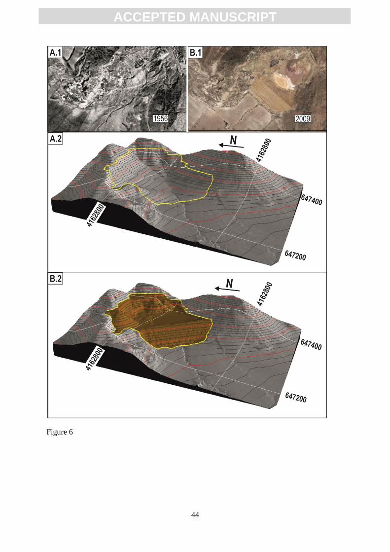
Fig. 6. Two- and three-dimensional representation of El Roble valley with and without its
tailings dam valley fill. (A.1) Two-dimensional aerial photograph of 1956 (without valley
fill), downloaded from the virtual photographic library of the CNIG (2014). (B.1) Orthophoto
of 2009 (with valley fill and gullied dam) (PNOA, 2009). (A.2) Three-dimensional view
without valley-fill. (B.2) Three-dimensional view with valley fill and gullied dam. For the
three-dimensional images, see text within manuscript for a detailed explanation (Coordinate
system: UTM 30N, DATUM: ETRS89).
Fig. 7. Tailing mine deposits of El Roble, which are the focus of this paper. (A) Oblique aerial
photograph as of 1968 (Paisajes Españoles S.A.). (B) Orthophotograph raised with MDE
Page 37
ACC
EPTE
D M
ANU
SCR
IPT
ACCEPTED MANUSCRIPT
37
elaborated from LIDAR data of 2009 (data source: Ortophotograph, sheet 976 and LIDAR
from the file 646-4164; PNOA, 2009. Coordinate system: UTM 30N, DATUM: ETRS89).
Fig. 8. Surveying the El Roble dam with a GPS Leica 1200 instrument while identifying
remnants of the original breaklines. The surveyor is standing at the remnant of a former
bench.
Fig. 9. Catalogue and classification of the main landforms denoting current geomorphic
activity at the surroundings of the El Roble tailings dam. The numbers correspond with those
described within the text. See text for detailed explanations of each landform.
Fig. 10. Location of the photos that constitute the catalogue of landforms of Fig. 7.
Data source: Ortophotograph sheet 976; PNOA, 2009. Coordinate system: UTM 30N;
DATUM: ETRS89.
Fig. 11. Triangular irregular networks (TIN) of the tailings dam of El Roble. (A)
Reconstructed, original topography as of 1968 (see text for detailed explanation). (B) Eroded
topography of the dam as of 2009 (data source: LIDAR from the file 646-4164; PNOA, 2009.
Coordinate system: UTM 30N, DATUM: ETRS89).
Fig. 12. Representation of the hydrological connectivity between the eroded tailings dams and
the Las Moreras Rambla (river). Data source: Ortophotograph sheet 976 and LIDAR from
the files 648-4164, 648-4162, 646-4162, 646-4164; PNOA, 2009. Coordinate system: UTM
30N, DATUM: ETRS89.
Page 38
ACC
EPTE
D M
ANU
SCR
IPT
ACCEPTED MANUSCRIPT
38
Fig. 13. Edge of the El Roble tailings dam. The slope toward the right of the image is the
tailings dam, formerly the only element hydrologically connected with Las Moreras fluvial
system. As geomorphic instability progresses, the platform toward the right of the image (that
was the beach area of sedimentation behind the tailings dam), originally forming a closed
basin, connects with the Las Moreras fluvial system by gullies’ headcutting (see gullies at the
lower half of the image).
Page 39
ACC
EPTE
D M
ANU
SCR
IPT
ACCEPTED MANUSCRIPT
39
Figure 1
Page 40
ACC
EPTE
D M
ANU
SCR
IPT
ACCEPTED MANUSCRIPT
40
Figure 2
Page 41
ACC
EPTE
D M
ANU
SCR
IPT
ACCEPTED MANUSCRIPT
41
Figure 3
Page 42
ACC
EPTE
D M
ANU
SCR
IPT
ACCEPTED MANUSCRIPT
42
Figure 4
Page 43
ACC
EPTE
D M
ANU
SCR
IPT
ACCEPTED MANUSCRIPT
43
Figure 5
Page 44
ACC
EPTE
D M
ANU
SCR
IPT
ACCEPTED MANUSCRIPT
44
Figure 6
Page 45
ACC
EPTE
D M
ANU
SCR
IPT
ACCEPTED MANUSCRIPT
45
Figure 7
Page 46
ACC
EPTE
D M
ANU
SCR
IPT
ACCEPTED MANUSCRIPT
46
Figure 8
Page 47
ACC
EPTE
D M
ANU
SCR
IPT
ACCEPTED MANUSCRIPT
47
Figure 9
Page 48
ACC
EPTE
D M
ANU
SCR
IPT
ACCEPTED MANUSCRIPT
48
Figure 9b
Page 49
ACC
EPTE
D M
ANU
SCR
IPT
ACCEPTED MANUSCRIPT
49
Figure 10
Page 50
ACC
EPTE
D M
ANU
SCR
IPT
ACCEPTED MANUSCRIPT
50
Figure 11
Page 51
ACC
EPTE
D M
ANU
SCR
IPT
ACCEPTED MANUSCRIPT
51
Figure 12
Page 52
ACC
EPTE
D M
ANU
SCR
IPT
ACCEPTED MANUSCRIPT
52
Figure 13
Page 53
ACC
EPTE
D M
ANU
SCR
IPT
ACCEPTED MANUSCRIPT
53
Highlights
This article:
blends tailings’ landform classifications with erosion quantifications using GIS;
relates geomorphic changes in tailings deposits to mineralogical changes;
provides a discussion about addressing environmental actions related with tailings;
proposes the restoration of tailings deposits through landform design;