+ All Categories
Home > Documents > SHULER PROPERTY ASSESSMENT - · PDF fileSHULER PROPERTY ASSESSMENT UWRMP Section 5.6.4...

SHULER PROPERTY ASSESSMENT - · PDF fileSHULER PROPERTY ASSESSMENT UWRMP Section 5.6.4...

Date post: 10-Mar-2018
Category:
Upload: nguyenkhue
View: 221 times
Download: 2 times
Share this document with a friend
53
SHULER PROPERTY ASSESSMENT UWRMP Section 5.6.4 Supplement March 6, 2012 Background: Located in Liberty County within the Ochlockonee River watershed, the Northwest Florida Water Management District (NWFWMD) acquired a conservation easement (less-than- fee acquisition) on the 1,573.66-acre (±) Shuler Property in July, 2008. The conservation easement allows for NWFWMD restoration of degraded wetlands in the western portion of the property, and preservation and management of wetlands and buffers in the eastern portions of the property. This credit assessment pertains only to a 100-acre polygon of bottomland hardwood forest (FLUCCS 615) adjacent to the Ochlockonee River that is contained within the Shuler Property conservation easement. Objectives: Perpetual preservation and management of intact wetlands and upland buffers within the eastern portions of the Shuler Property, and the restoration of disturbed wetlands in the western portion of the property. Site Selection Criteria: This site was selected as part of an ongoing effort to acquire, preserve, and restore wetlands and water resources within the Ochlockonee River watershed. Site Protection Instrument: This site is protected by a conservation easement recorded with Liberty County, Florida on 7/28/08 (see attached).
Transcript

SHULER PROPERTY ASSESSMENT

UWRMP Section 5.6.4 Supplement

March 6, 2012

Background:

Located in Liberty County within the Ochlockonee River watershed, the Northwest

Florida Water Management District (NWFWMD) acquired a conservation easement (less-than-

fee acquisition) on the 1,573.66-acre (±) Shuler Property in July, 2008. The conservation

easement allows for NWFWMD restoration of degraded wetlands in the western portion of the

property, and preservation and management of wetlands and buffers in the eastern portions of the

property.

This credit assessment pertains only to a 100-acre polygon of bottomland hardwood

forest (FLUCCS 615) adjacent to the Ochlockonee River that is contained within the Shuler

Property conservation easement.

Objectives:

Perpetual preservation and management of intact wetlands and upland buffers within the

eastern portions of the Shuler Property, and the restoration of disturbed wetlands in the western

portion of the property.

Site Selection Criteria:

This site was selected as part of an ongoing effort to acquire, preserve, and restore

wetlands and water resources within the Ochlockonee River watershed.

Site Protection Instrument:

This site is protected by a conservation easement recorded with Liberty County, Florida

on 7/28/08 (see attached).

r_lide
Text Box
Note--UMAM scores in this supplement have been superseded by the USACE-approved scores in the "Bottomland UMAM Assessment (4/25/2012)" document [see attached].

2

Baseline Information:

Maps (see attached)

Location of Shuler Property

2007 DOQ of Shuler Property Conservation Easement

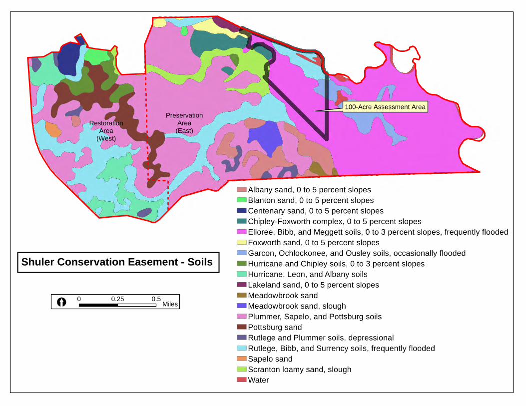
Location of 100-acre Polygon within Shuler Property (Pertaining to this

Supplement)

2007 DOQ

1937 B&W Aerial

LiDAR

Soils

Conservation Easement (see attached—contains maps of wetland areas)

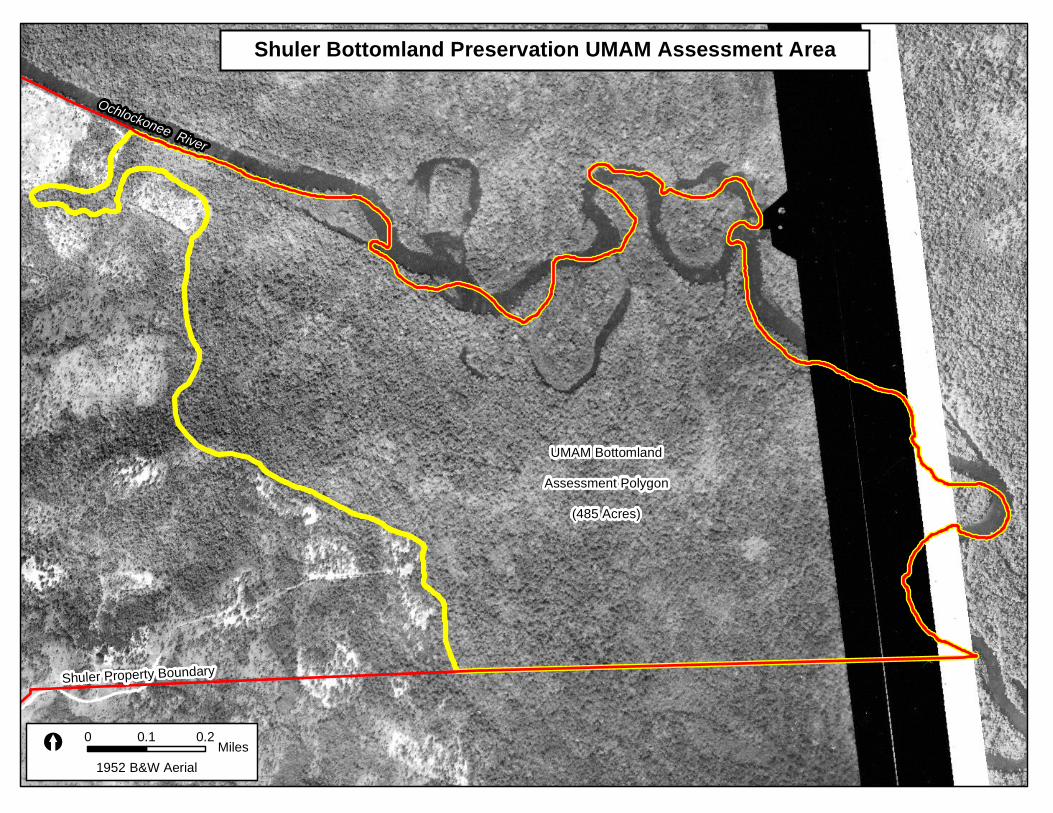
The Shuler conservation easement site consists of 1,573.66± acres. Approximately 800-

900 acres are wetlands. Wetlands in the western portion of the Shuler property are highly

disturbed. Those in the eastern portion adjacent to the Ochlockonee River are generally of high

quality. The 100 acres addressed by this supplement consists entirely of high-quality bottomland

hardwood forest (FLUCCS 615).

Determination of Credits:

Mitigation credits for this 100-acre polygon within the Shuler Property were derived

using the Uniform Mitigation Assessment Method (UMAM). Assessments by NFWMD staff

estimate that this mitigation project will yield 20.00 UMAM palustrine credits. Estimated

mitigation value for the entire Shuler Property (1,573.66± Acres) is in the 100-200 credit range.

Detailed Work Plan:

The preservation and management areas of the Shuler Property (including the 100-acre

polygon assessed in this document) will be maintained in a natural state in perpetuity. Detailed

restoration plans will be developed at a later date for the disturbed areas at the Shuler Property

(not addressed by this document).

Maintenance Plan:

The site will be preserved and managed in a natural state according to the terms of the

conservation easement and associated federal and state permits.

3

Performance Standards:

PC1 – No observable decline in natural community health

PC2 – Stable or increase in species diversity per wetland type

PC3 – No more than 1% coverage of invasive/exotic vegetation and 5% nuisance native and non-

invasive exotic vegetation species unless otherwise specified in a management plan

PC4 – Maintain a dominant cover of native, suitable plant species in the wetland and upland

buffer areas appropriate for the type of target community

PC5 – Maintain the ecological conditions so that the mitigation UMAM scores are met for each

of the specified community types

Monitoring:

Annual inspections to ensure compliance with terms of the conservation easement and

associated US Army Corps of Engineer permits.

Long-term Management:

The site will be preserved and managed in a natural state according to the terms of the

conservation easement.

Adaptive Management Plan:

All ecological restoration projects are site specific and multiple endpoints are possible

owing to the stochastic nature of ecological processes. If unforeseen circumstances require

modifications to this mitigation plan, such modifications will only occur after consultation with

the Interagency Review Team (IRT) and approval by the US Army Corps of Engineers.

Financial Assurances:

The NWFWMD is a governmental entity created by the Florida Water Resources Act of

1972 with the mission of protecting water resources protection and ecosystem integrity. A

mitigation fund has been established that has sufficient funds ear-marked for implementation and

long-term monitoring.

4

Other Information:

Any additional information requested by the US Army Corps of Engineers to determine

the appropriateness, feasibility, and practicability of this compensatory mitigation project will be

provided.

Credit Release:

Release of mitigation credits will determined by the US Army Corps of Engineers in

consultation with the IRT.

Status Reports:

Status reports of mitigation activities will be generated as mandated by the US Army

Corps of Engineers and posted at http://www.nwfwmdwetlands.com.

Impacts Mitigated at Shuler (as of 3/6/12):

US 98 Wakulla River Bridge (4.92 Credits)

Town of Havana (0.15 Credits)

Location of Shuler Property

0 5 10Miles XOchlockonee River Watershed

Shuler Property

£¤90

§̈¦10

Liberty Co.

Midway

Gadsden Co.

Quincy

Æ·20

£¤27

O

c h l

o c k

o n e

e

R i v e r

Talla.

Lak

e Talquin

Wakulla Co.

Leon Co.

Æ·12

Havana

Och

lockonee

Rive

r

Æ·20

Æ·267

Æ·267

Æ·65

Æ·12

Shuler Conservation Easement - 2007 DOQ

0 0.25 0.5 Miles[

Ochlockonee River

Æ·67

100-Acre Assessment Area

RestorationArea

(West)

PreservationArea

(East)

100-Acre UMAM Assessment Area - 2007 DOQ

0 0.1 0.2 Miles[

Ochlockonee River

Shuler Conservation Easement - 1952 B&W Aerial

0 0.25 0.5 Miles[

Ochlockonee River

Æ·67

100-Acre Assessment Area

RestorationArea

(West)

PreservationArea(East)

Shuler Conservation Easement - 1937 B&W Aerial

0 0.25 0.5 Miles[

Ochlockonee River

Æ·67

100-Acre Assessment Area

RestorationArea

(West)

PreservationArea(East)

Shuler Conservation Easement - LiDAR

0 0.25 0.5 Miles[

Ochlockonee River 100-Acre Assessment Area

RestorationArea

(West)

PreservationArea(East)

High : 81.1172

Low : 11.4388

Shuler Conservation Easement - Soils

0 0.25 0.5 Miles[

100-Acre Assessment Area

RestorationArea

(West)

PreservationArea(East)

Albany sand, 0 to 5 percent slopesBlanton sand, 0 to 5 percent slopesCentenary sand, 0 to 5 percent slopesChipley-Foxworth complex, 0 to 5 percent slopesElloree, Bibb, and Meggett soils, 0 to 3 percent slopes, frequently floodedFoxworth sand, 0 to 5 percent slopesGarcon, Ochlockonee, and Ousley soils, occasionally floodedHurricane and Chipley soils, 0 to 3 percent slopesHurricane, Leon, and Albany soilsLakeland sand, 0 to 5 percent slopesMeadowbrook sandMeadowbrook sand, sloughPlummer, Sapelo, and Pottsburg soilsPottsburg sandRutlege and Plummer soils, depressionalRutlege, Bibb, and Surrency soils, frequently floodedSapelo sandScranton loamy sand, sloughWater

Shuler - Preservation Lands Not Applicable Polygon A

PART I – Qualitative Description(See Section 62-345.400, F.A.C.)

Site/Project Name Application Number Assessment Area Name or Number

FLUCCS code Further classification (optional) Impact or Mitigation Site? Assessment Area Size

615 --- Mitigation 100 Acres

Basin/Watershed Name/Number Affected Waterbody (Class) Special Classification (i.e.OFW, AP, other local/state/federal designation of importance)

Ochlockonee III ---

Geographic relationship to and hydrologic connection with wetlands, other surface water, uplands

Wetlands adjacent and contiguous to Ochlockonee River. Buffered by Ochlockonee River to east and silvicultural areas to west.

Assessment area description

Bottomland hardwood forest adjacent to Ochlockonee River.

Significant nearby features Uniqueness (considering the relative rarity in relation to the

regional landscape.)

---

SR 65; Ochlockonee River; Tates Hell State Forest. Not unique.

Functions Mitigation for previous permit/other historic use

Flood abatement; water quality; detritus export; floral and faunal habitat. None

Anticipated Wildlife Utilization Based on Literature Review (List of

species that are representative of the assessment area and reasonably

expected to be found )

Anticipated Utilization by Listed Species (List species, their legal

classification (E, T, SSC), type of use, and intensity of use of the

assessment area)

--- ---

Observed Evidence of Wildlife Utilization (List species directly observed, or other signs such as tracks, droppings, casings, nests, etc.)

Form 62-345.900(1), F.A.C. [ effective date ]

Additional relevant factors

---

Assessment conducted by Assessment date(s)

NWFWMD Staff

w/out pres

w/out pres

w/out pres

w/out mit

Shuler - Preservation Lands Not Applicable Polygon A

PART II – Quantification of Assessment Area (impact or mitigation)(See Sections 62-345.500 and .600, F.A.C.)

Site/Project Name Application Number Assessment Area Name or Number

Impact or Mitigation Assessment conducted by: Assessment date:

Mitigation NWFWMD Staff

The scoring of each

indicator is based on what

would be suitable for the

type of wetland or surface

water assessed

Condition is optimal and

fully supports

wetland/surface water

functions

Condition is less than

optimal, but sufficient to

maintain most

wetland/surface

waterfunctions

Minimal level of support of

wetland/surface water

functions

Condition is insufficient to

provide wetland/surface

water functions

Scoring Guidance Optimal (10) Moderate(7) Minimal (4) Not Present (0)

.500(6)(b)Water Environment

(N/A for Uplands) Without Preservation - Construction of river-front houses with septic systems on upland inclusions on bluff

along Ochlockonee River; logging within bottomland hardwood forest wetland areas; lack of BMP

implementation on silvicultural buffers; continued modification of hydrology via ditching and other activities

involving heavy equipment in buffer areas to west. With Preservation - Elimination of threats to existing

wetlands and buffers.

w/pres

7 9

.500(6)(a) Location and

Landscape SupportWithout Preservation - Construction of river-front houses with septic systems on upland inclusions on bluff

along Ochlockonee River; logging within bottomland hardwood forest wetland areas; lack of BMP

implementation on silvicultural buffers; continued modification of hydrology via ditching and other activities

involving heavy equipment in buffer areas to west. With Preservation - Elimination of threats to existing

wetlands and buffers.

w/pres

7 9

.500(6)(c)Community structure

Without Preservation - Construction of river-front houses with septic systems on upland inclusions on bluff

along Ochlockonee River; logging within bottomland hardwood forest wetland areas; lack of BMP

implementation on silvicultural buffers; continued modification of hydrology via ditching and other activities

involving heavy equipment in buffer areas to west. With Preservation - Elimination of threats to existing

wetlands and buffers.

Vegetation and/or Benthic

Community

w/pres

7 9

Score = sum of above scores/30 (if

uplands, divide by 20) Preservation Adjustment Factor

(PF) = 1UMAM Functional Assessment

w/mit Time Lag Factor = 10.70 0.90

Risk Factor = 1 Polygon Acreage = 100.00

Functional Gain w/Mitigation (Adjusted Delta * Acres) = 20.00Raw Delta = [w/mit - w/out mit] Adjusted Delta [(Raw Delta * PF) / (T

* R)] = 0.200.20

Cur or

W/Out With Raw Time PF Adjusted UMAM

Polygon Acres L1 L2 W1 W1 C1 C2 Score Score Delta Lag Factor Risk Delta Credits

Polygon A 100.00 7 9 7 9 7 9 0.70 0.90 0.20 1 1 1 0.20 20.00

-------- --------100.00 20.00

Shuler Preservation Lands - Preliminary Estimate of UMAM Credits23 November 2010 (NWFWMD Staff)

Cur or

W/Out With Raw Time PF Adjusted UMAM

Polygon Acres L1 L2 W1 W1 C1 C2 Score Score Delta Lag Factor Risk Delta Credits

Polygon A 485.00 9 10 10 10 9 10 0.93 1.00 0.07 1 1 1 0.07 33.95

(Total Credits) 33.95

L1 = Location and Landscape Support (Without Mitigation Project)

L2 = Location and Landscape Support (With Mitigation Project)

W1 = Water Environment (Without Mitigation Project)

W2 = Water Environment (With Mitigation Project)

C1 = Vegetation Community Structure (Without Mitigation Project)

C2 = Vegetation Community Structure (With Mitigation Project)

Shuler Bottomland Preservation - UMAM Credit Assessment

25 April 2012 (US Army Corps of Engineers)

Form 62-345.900(1), F.A.C. [ effective date ]

Additional relevant factors

---

Assessment conducted by Assessment date(s)

US Army Corps of Engineers (Andy Kizlauskas) 4/25/2012

---

SR 65; Ochlockonee River; Tates Hell State Forest. Not unique.

Functions Mitigation for previous permit/other historic use

Flood abatement; water quality; detritus export; floral and faunal habitat. None

Anticipated Wildlife Utilization Based on Literature Review (List of

species that are representative of the assessment area and reasonably

expected to be found )

Anticipated Utilization by Listed Species (List species, their legal

classification (E, T, SSC), type of use, and intensity of use of the

assessment area)

--- ---

Observed Evidence of Wildlife Utilization (List species directly observed, or other signs such as tracks, droppings, casings, nests, etc.)

Geographic relationship to and hydrologic connection with wetlands, other surface water, uplands

Wetlands adjacent and contiguous to Ochlockonee River. Buffered by Ochlockonee River to east and silvicultural areas to west.

Assessment area description

Bottomland hardwood forest adjacent to Ochlockonee River.

Significant nearby features Uniqueness (considering the relative rarity in relation to the

regional landscape.)

Basin/Watershed Name/Number Affected Waterbody (Class) Special Classification (i.e.OFW, AP, other local/state/federal designation of importance)

Ochlockonee III ---

FLUCCS code Further classification (optional) Impact or Mitigation Site? Assessment Area Size

615 (Approximate) --- Mitigation 485 Acres

Shuler - Bottomland Preservation Not Applicable Polygon A

PART I – Qualitative Description(See Section 62-345.400, F.A.C.)

Site/Project Name Application Number Assessment Area Name or Number

w/out pres

w/out pres

w/out pres

w/out mit

Functional Gain w/Mitigation (Adjusted Delta * Acres) = 33.95Raw Delta = [w/mit - w/out mit] Adjusted Delta [(Raw Delta * PF) / (T

* R)] = 0.070.07

Score = sum of above scores/30 (if

uplands, divide by 20) Preservation Adjustment Factor

(PF) = 1UMAM Functional Assessment

w/mit Time Lag Factor = 10.93 1.00

Risk Factor = 1 Polygon Acreage = 485.00

.500(6)(c)Community structure

Without Preservation - Plausible impacts include logging of bottomland hardwood forest, lack of proactive

management if exotic vegetation were to invade, lack of BMPs in adjacent silvicultural buffers, and construction

of several hunt cabins or river houses on bluff along Ochlockonee River. With Preservation - Elimination of

threats to existing high-quality, bottomland forested wetlands.

Vegetation and/or Benthic

Community

w/pres

9 10

.500(6)(a) Location and

Landscape Support Without Preservation - Plausible impacts include logging of bottomland hardwood forest, lack of proactive

management if exotic vegetation were to invade, lack of BMPs in adjacent silvicultural buffers, and possible

construction of several hunt cabins or river houses on bluff along Ochlockonee River. With Preservation -

Elimination of threats to existing high-quality, bottomland forested wetlands.

w/pres

9 10

.500(6)(b)Water Environment

(N/A for Uplands)

Without Preservation - No substantive change. With Preservation - No substantive change.

w/pres

10 10

Scoring Guidance Optimal (10) Moderate(7) Minimal (4) Not Present (0)The scoring of each

indicator is based on what

would be suitable for the

type of wetland or surface

water assessed

Condition is optimal and

fully supports

wetland/surface water

functions

Condition is less than

optimal, but sufficient to

maintain most

wetland/surface

waterfunctions

Minimal level of support of

wetland/surface water

functions

Condition is insufficient to

provide wetland/surface

water functions

Impact or Mitigation Assessment conducted by: Assessment date:

Mitigation US Army Corps 4/25/2012

Shuler - Bottomland Preservation Not Applicable Polygon A

PART II – Quantification of Assessment Area (impact or mitigation)(See Sections 62-345.500 and .600, F.A.C.)

Site/Project Name Application Number Assessment Area Name or Number

Shuler Bottomland Preservation UMAM Assessment Area

Ochlockonee River

Shuler Property Boundary

UMAM BottomlandAssessment Polygon

(485 Acres)

2010 DOQ0 0.1 0.2 Miles[

Shuler Bottomland Preservation UMAM Assessment Area

Ochlockonee River

Shuler Property Boundary

UMAM BottomlandAssessment Polygon

(485 Acres)

2007 DOQ0 0.1 0.2 Miles[

Shuler Bottomland Preservation UMAM Assessment Area

Ochlockonee River

Shuler Property Boundary

UMAM BottomlandAssessment Polygon

(485 Acres)

1999 DOQ0 0.1 0.2 Miles[

Shuler Bottomland Preservation UMAM Assessment Area

Ochlockonee River

Shuler Property Boundary

UMAM BottomlandAssessment Polygon

(485 Acres)

1952 B&W Aerial0 0.1 0.2 Miles[

Shuler Bottomland Preservation UMAM Assessment Area

Ochlockonee River

Shuler Property Boundary

UMAM BottomlandAssessment Polygon

(485 Acres)

LiDAR0 0.1 0.2 Miles[

Shuler Bottomland Preservation UMAM Assessment AreaOchlockonee River

Shuler Property Boundary

UMAM BottomlandAssessment Polygon

(485 Acres)

NRCS Soil Survey0 0.1 0.2 Miles[

Elloree, Bibb, and Meggett soils, 0 to 3 percent slopes, frequently floodedGarcon, Ochlockonee, and Ousley soils, occasionally floodedRutlege, Bibb, and Surrency soils, frequently floodedOther Soils

Location of Shuler Property

0 5 10Miles XOchlockonee River Watershed

Shuler Property

£¤90

§̈¦10

Liberty Co.

Midway

Gadsden Co.

Quincy

Æ·20

£¤27

O

c h l

o c k

o n e

e

R i v e r

Talla.

Lak

e Talquin

Wakulla Co.

Leon Co.

Æ·12

Havana

Och

lockonee

Rive

r

Æ·20

Æ·267

Æ·267

Æ·65

Æ·12


Recommended