114
GR-48Huelva 1 PROVINCE OF HUELVA SIERRA MORENA PATH ANDALUCÍA 8 Trail maps Scale 1:30000 and 1:50000

GR
-48
Hu
elv
a
1
PROVINCE OF HUELVA
SIERRA MORENA PATH
ANDALUCÍA
8 Trail maps Scale 1:30000 and 1:50000

GR
-48
Hu
elv
a
2
Commissioned by and Copyright: ADIT Sierra MorenaCalle Retama, 1 14350 Cerro Muriano-Obejo (Córdoba)957350273 www.senderogr48.com [email protected]
Produced by:Zumaya Ambiente CreativoJuan Relaño MoyanoGloria Pareja CanoStela María Alcántara Guerrero (cartography)Pedro Peinado (graphic design & ilustration)Karmen Domínguez (translation) Illustrations:Zumaya Ambiente CreativoAbén Aljama pages 2, 17, 31 and 60Aurora José Gallego page 13GDR Sierra de Aracena y Picos de Aroche pages 18, 24, 28, 29 and 68Iván Gómez pages 36, 43 and 98Nuria Cubas page 89Reda Choho page 33Juan Manuel Delgado Marzo pages 15, 34, 48, 49, 61, 62, 71, 72, 87 and 88Rafael Romero Porrino pages 97 and 101
National Book Catalogue Number: XXXXXXXX

GR
-48
Hu
elv
a
3
LIST OF CONTENTS
Introduction ..........................................................................
Presentation ..........................................................................
Towns and Villages ...........................................................
Stage 1. Barrancos-Encinasola .........................................
Stage 2. Encinasola-Cumbres de San Bartolomé ..........
Stage 3. Cumbres de San Bartolomé -Cumbres Mayores......
Stage 4. Cumbres Mayores-Hinojales ............................
Stage 5. Hinojales-Arroyomolinos de León ..................
Stage 6. Arroyomolinos de León-Cala ..................................
Stage 7. Cala-Santa Olalla del Cala .................................
Stage 8. Santa Olalla del Cala-Real de la Jara................
Useful Information ...........................................................
List of Species ...................................................................
PROVINCE OF HUELVA
SIERRA MORENA PATH
ANDALUCÍA
4
6
17
31
40
49
56
63
75
83
92
103
108

GR
-48
Hu
elv
a
4
INTRODUCTIÓN
The Asociación para el Desarrollo Integral del Territorio de Sierra Morena, ADIT Sierra Morena, (Association for an Integral Development of Sierra Morena Territory) is a non profit organization established by the fo-llowing bodies: Asociación Grupo de Desarrollo Rural Sierra de Aracena y Picos de Aroche; Asociación Grupo de Desarrollo Rural Sierra Morena Sevilla-na; Asociación para el Desarrollo Rural de Sierra Morena Cordobesa and the Asociación para el Desarrollo Rural de la Campiña Norte de Jaén. The group also includes other public and private institutions from Huelva, Sevilla, Córdoba and Jaén provinces.
ADIT Sierra Morena is supporting many activities and projects around hik- ing. From an environmental and healthy position, this outdoor activity appears to be an important tool for introducing the highland regions to visitors. At the same time, hiking is seen as the fundamental outdoor ac-tivity on which many others are based and that will reinforce a proper growth of the region without compromising its cultural and environmen-tal values.
The GR-48 ‘Sierra Morena Track’ is a 590 kilometres of waymarked route through the provinces of Huelva, Sevilla, Córdoba and Jaén in Andalucía. The starting point is Barrancos, a village located in Portugal at the border with Huelva province. The journey, described here from west to east, embraces an astonishing territory worthy of visiting or living in it.
This is a full colour essential hiking topo-guide to some of the blissfully undiscovered walks in southern Andalucía. It has been designed for bet-ter appreciate the natural beauty and cultural aspects exhibited throug-hout the walk. The guide provides texts, pictures, sketches and relevant maps in order to facilitate the walking. It also features information on estimated times, distances, route and elevation profile, and difficulty of the walk as well as on the most interesting historical, cultural and ethno-graphical features located on the route. The reading will help the walkers

GR
-48
Hu
elv
a
5
to pay attention to different ways of countryside labour; to discover sin-gular natural features; to perceive the footprint left on the natural environ-ment; and to appreciate the many environmental features they may come across with at any season of the year. In addition, readers will find easier to understand the many shades between the provinces and regions whe-re the trail goes through. This hiking topo-guide will certainly enhance the walkers’ vision of the track as well as providing a complete picture of the journey.
Every section of the route is introduced with some general information about the natural world and how human beings have traditionally related to it in each province. Also included are detailed overviews of each the sites the walkers will find on their journey. We do believe that hiking stirs up complicity between the walker and the environment while uplifting the walker’s interest and curiosity about the reality around them. The walk itself evidences the harmonious relation established through centuries between human beings and the land. It is an amazing way to discover how much tradition is still rooted in the small towns located along way. Moreover, it will give the walker the chance to find out about natural re-sources uses and costumes as well as other activities around those.
In general, this is an easy to follow route. Each section of the trial is suita-ble for mountain biking, horse riding or just walking. The technical diffi-culty of each section determines its length. Every stage of the route starts off and most finishes in a well-equipped small town, village or settlement where the hiker may find supplies such as food, drinks and accommoda-tion for at least one night.
Certainly this is a much essential guide which cannot be missing from the backpack of those overs of nature discovering and travelling.

GR
-48
Hu
elv
a
6
PRESENTATION
HIKING
Hiking is a non-competitive sporting activity which takes place on ru-ral tracks and paths. These paths are mainly endorsed by the different national Mountaineering Federations. In Spain, “Vías pecuarias”, local paths and riverside paths -all they of public uses- are preferably desig-nated for hiking. This recently developed outdoor activity is becoming very popular since ramblers not only enjoy outdoor walking but also achieve a much deeply knowledge of the social, cultural, ethnographic and historical heritage of the places located throughout the trial.
Hiking is an activity which posses low impact onto the environment. In order to sustain the environmental conditions and natural heritage of the areas covered by the trail, a thoughtful system of regulated signs and marks is posed on countryside paths, animal tracks, rivers alley ways and rural roads. This system also facilitates and ensures walkers safety. So far, it could be said that hiking is a most engaging and harm-less way to discover both the environmental wealth of a country and the peculiarities of the people living in.
A BRIEF NOTE ABOUT HIKING
It seems to be in France where hiking was considered as an activity for visiting places. Shortly after the World War II, the FFRP (Fédération Françai-se de la Randonnée Pedestre) was established and soon other countries as Germany, Netherland, Belgium and Switzerland starting to promote hiking as a way for sporting and doing tourism up in the mountains.
In Spain, this outdoor activity is managed by the FEDME (Federación Es-

GR
-48
Hu
elv
a
7
pañola de Deportes de Montaña y Escalada) the body in charge for the ma-nagement of this outdoor activity. Hiking is seen as directly related to mountaineering at the time it does require of regulation about waymar-ked trails.
PATHS HOMOLOGATION AND SIGN POSTING
The FEDME is the body responsible for a footpath homologation. This means that the route is well marked and signposted using a system of registered trade mark signs. It does also mean that there is a writing topo-guide where the route is thoughtfully described and that there is a legal body fully compromised to the path maintenance and care.
Wherever possible, a homologated path will avoid crossing or using tar-macs and traffic roads. It is a pedestrian path well equipped with direc-tion signs such milestones or mileposts, direction arrows, paint marks and interpretation boards. Most footpaths are suitable for cycling and horse riding. In Spain, footpaths are classified into: SGR (long distance paths), SPR (short distance paths) and SL (local paths).
• SGRs. Those are long distance trails that run over 50 kilometres and link countries, regions or single sites really far away from each other. A SGR route is usually split into several sections for a much affordable journey. SGR routes that run through more than three European countries are clas-sified as European International Path (E).
• SPRs. Half-day or one-day trails that cover any distance between 10 and 50 kilometres. These short journeys are designed for visiting specific and singular natural sites or for taking the walkers up to a location of interest.
• SLs. These are very easy trails that cover less than 10 kilometres and poses low difficulty on to the walkers.

GR
-48
Hu
elv
a
8
• Waymarking
RECOMENDATIONS
To maximize your enjoyment and minimize problems on the trail, before start-ing any outdoor activity, we need to carefully ponder over the stuff and equip-ment we are going to take with us. It is also worthy to give lengthy thought to prevent any unforeseen incidents they may occur along the route.
BEFORE THE WALK
Gather information and use accurate maps for planning on the route. Work out your time realistically. Take the advice culled by other hikers and ask to local people since they best know the area. Ramblers’ experience enhan-ces through vivid conversation with locals.
Get updated permissions from the environment department if you might trespass restricted areas. You may need to get especial permits for walking on restricted areas; certain protected sites of a natural park; for using cook-
Milestone or MilepostFinger posting
Continue straight
Trail turn Wrong direction

GR
-48
Hu
elv
a
9
ing devices or lit a fire; and for using a mountain refuge or accommodation within the limits of protected areas.
Make sure your equipment is the right one. Boots are perhaps the most important tool when hiking. Get a pair of lightweight, over-the-ankle boots with a Gore-Tex lining that keeps rainwater from seeping in yet allows your feet to breathe. Your ankles will suffer a lot if your boots do not provide enough support and you may experience internal injuries such sprains. Re-member to break in your boots thoroughly before departure. Lightweight polyester hiking pants are preferable to jeans or heavy cottons, which can be uncomfortable in wet or warm weather.
Get a good quality daypack with enough capacity to tote your personal items. Better if it has bottle holders that keep precious water within easy reach. The following items are essential in your pack: a water bottle, the topoguide and useful maps, sunglasses, sun cream and lips moist, a brim-med hat, some energetic food, a Swiss Army knife, a hiking lantern or a mountaineering one and a basic first aid kit equipped for topical injuries.
Take a mobile phone with you even you might find yourself walking in low or no-signal areas. Remember the Spanish number for emergency calls: 112
ALONG THE WALK
Hiking may produce threats to personal safety. Even if you are in top condition, it is a good idea to com-bine techniques for hiking to your physical poten-tial in order to minimize strenuous exercising.
It is important to start your walk to a slower pace and progressively increase your speed until you find yourself walking steadily. Matching your walk-ing pace to the breathing will keep you better oxy-genated. Avoid prolonged stops to prevent muscles cooling. A walking pace of 3 to 4 km per hour on flat appears to be a right walking rhythm.
Keep yourself well hydrated. Drink water frequently and, every now and then have an isotonic drink in order to prevent metabolic imbalances.
OUR RELATIONSHIP WITH NATURE
• Fire is perhaps nature worst enemy. Along the walk, surely there will be designates areas where you are allow to lit a fire. Obeying area regula-tions about seasonal restrictions on fire will reduce the risk of wildfire.
• Human waste is often a major source of environmental impact from

GR
-48
Hu
elv
a
10
hiking. A responsible hiker will take out their garbage and dispose it pro-perly. When getting ready for the walk, it is important to think ahead about the amount of garbage you may finish your walk with.
• Just like the unwritten standards established in the cities, a logical and sounded relationship is set up between nature and hiking. An emphatic relationship is often established among hikers and local people in the villages.
• Collecting living plants, animals or stones will have an adverse impact on the ecosystem. A picture will make an everlasting souvenir though.
• A good practice is keep country gates and railings closed behind us to avoid cattle and wild animals entering fenced-off areas.
• Personal pets should always go by our side and supervised.
• Dangerous hiking circumstances include losing the way. It is para-mount to keep walking on the path and always keep an eye on it when we walk somewhere else. Missing the way may put at risk our safety and turn a joyful experience into a proper mare.
MIDE. METHOD FOR APPRISING HIKERS
WHAT IS MIDE?
MIDE is a communication system which inform about the technical and physical characteristics of a trail. It is aimed to evaluate and unify the about findings hiking trails allowing each practitioner to make a better choice.
The MIDE system uses a scale designed to grade the difficulty of a specific hiking trip. By doing so, hiking trips are classified according to their diffi-culty and hikers will have a much accurate knowledge about the route. This is a tool designed by experienced hikers so other hikers may find the route that better suits to their physical condition and motivation. It is not

GR
-48
Hu
elv
a
11
all about information as the MIDE is also a tool for preventing accidents up in the mountains. The idea is that well informed walkers are likely of suffering less harm. (Information = safety).
WHEN MIDE WAS CREATED?
MIDE is a relatively recent tool. It was developed in 2002 within the fra-mework of the programme ‘Montañas para vivirlas seguro’. Three years after the project started, some of the programme sponsors (Gobierno de Aragón -Protección Civil-, Obra Social y Cultural de Ibercaja y la Federación Aragonesa de Montañismo) pondered over the need for expert informa-tion to be put in Procedure Manual in order to prevent accidents in the mountain. In 2003, the MIDE Handbook is introduced to the public and therefore the MIDE method begins to be used.
WHAT SORT OF INFORMATION DOES MIDE PROVIDE?
The MIDE contains background information and assessment informa-tion. Background information is about informing on general aspects of a rated route. It gives information about where the track starts and finishes; about places where the track passes by; about both positive cumulati-ve slope and negative cumulative drop for the whole route; horizontal distance for the entire route; and weather conditions for which the as-sessment applies.Assessment information is about rating the following topics: • Severity of the natural environment • Guidance on the route about choosing and keeping good orientation. • Difficulty in walking along the track (type of path, slopes, etc) • Struggle required for accomplishing the route.
A numerical value (1 to 5) is given to the above topics in order to set down the degree of difficulty posses on the route.
Environment 1- The environment holds 2- There is more than one factor of risk 3- There are several factors of risk 4- There are enough factors of risk 5- There are many factors of risk
Orientation 1- Well defined tracks and junctions 2- Waymarking signs showing the way 3- It requires precise identification of geographical features and of compass points 4- It requires walking out the track tracing 5- The track is obstructed by unavoidable obstacles which must be skirted along.

GR
-48
Hu
elv
a
12
Track features 1- The track runs on smooth surface 2- The track runs on bridle paths 3- The track runs on irregular surface and staggered paths 4- The use of hands and even jumping over obstacles is required to negotiate the track 5- The use of hands is required to progress
Struggle 1- Up to 1 hour walk 2- From 1 to 3 hours walk 3- From 3 to 6 hours walk 4- From 6 to 10 hours walk 5- More than 10 hours walk
Calculations made according to MIDE criteria for an average and slightly loaded hiker. Hiking rated according to MIDE criteria for summers without snow.
Sample of a MIDE route rating:
More information:www.euromide.infowww.fam.es
THE NATURAL WORLD
The area covered by this GR-48 trail is located within the Sierra de Aracena y Picos de Aroche Natural Park. This is a transverse walk passing through one of the most singular natural areas in the Sierra Morena mountain ran-ge. The path will connect Barrancos, a highland town in Portugal, and El Real de la Jara a small Spanish highland town located in Seville region.

GR
-48
Hu
elv
a
13
GEOLOGY
The Sierra de Aracena y Picos de Aroche Natural Park is located in the ‘Zona Ossa Morena’, a NW-SE mountain range that stretches the southernmost area in the Hesperic massif.
The strata comprises rocks from the Palaeozoic period such as limestone, greywacke, quartzite, schist and gneiss rocks as well as acid rocks like granite. The strata in the higher area comprise carbonate rocks such as marble and dolomite rocks. Dolomite rocks are the main rock formation in the surrounding area of Sierra del Viento mountain range located nearby Hinojales town. As the walk progresses, we will find again this type of rocks in La Toba Mountain Pass which is between the Búho and the Los Gabrieles-La Nava mountain ranges, located nearby the Arroyomolinos de León highland village.
Another interesting geological feature along the path will be the mineral outcroppings spattering the region. A powerful magma activity happen-ed in the past which igneous rocks result by cooling. Those igneous rocks actively pressed over other existing igneous rocks resulting in a great metamorphism. In that metamorphic aureole is where the deposits locate since metal rocks and metalliferous seams are accumulated on the magma top surface during the cooling process.
Two interesting examples of that powerful geological activity are the Mi-nas de Cala natural site and the Minas de Teluer Private Mining Country Estate.
Minas de Teuler Site

GR
-48
Hu
elv
a
14
FLORA. THE PLANTS WORLD
The plants world is mainly represented by two clearly different expo-nents. On the one hand are the Mediterranean woodlands occupying the most abrupt areas and then they are the great pastures of Ilex. Large patches of Cork Oak and Portuguese Oak woods occur occasionally in the area. Reforested Pine groves and Eucalyptus groves are rarely found in this area although they are very frequent in most regions of the Huelva mountain range.
Crops fields are quite rare and only poor Olive groves can be found in the surrounding areas of some highland towns and villages. Vegetable gardens are well located by some river banks and springs as it happens near Cañaveral de León village and Arroyomolinos de León town.
Green corridors mainly of Ash trees and White Poplars and where biodi-versity constantly enhances are well located along permanent river flows. Good examples of gallery forest are by the Múrtigas River, natural border with Portugal and by the Sillo Brook near Encinasola town. Another im-pressive gallery forest locates by the Montemayor River between Cañave-ral de León and Arroyomolinos de León towns.
FAUNA. THE ANIMAL WORLD
The many animals associated to Mediterranean woodlands are well represen-ted all along this section of the GR-48 route through the Sierra de Aracena y Picos de Aroche mountain range. Big wild mammals such Deer and Wild Boars are easily spotted in the steepest highland areas. Otters are regular visitors in the pristine and permanent waters of the Múrtigas River and the Montemayor River where traces of those animals can easily be seen along the riverbanks.
Colourful Mediterranean undergrowth by the trail

GR
-48
Hu
elv
a
15
And as for birds, a large range of birds of prey can be spotted along the GR-48 route through Huelva province. Griffon and Black Vultures, Common Buzzards and Common Kestrels can be watched flying over our heads all year around. In the summer season is easy to spot birds such as the Booted Eagle, the Black Kite and the Beaudouin’s Snake Eagle whereas in winter, the Red Kite is the most attractive bird in the sky. In addition, walkers will be very lucky if they watch rare birds such as the Montagu’s Harrier and the beau-tiful Egyptian Vulture which come to this region in migration seasons. Good areas for birds of prey watching are pastures and meadows nearby San Bartolomé and Cumbres de Enmedio villages, and the sites known as Los Llanos de Gracia and the Sierra del Viento mountain range (Cumbres Ma-yores).
Cork Oak woods nearby Minas de Teuler (Cala and Santa Olalla) are home to an interesting forest bird community with especial mention to birds such as the Orphean Warble the Eurasian Wryneck, the Common Redstart, the Spotted Flycatcher, the Mistle Thrush and the Rock Sparrow.
In gallery forests like the Montemayor River (Cañaveral and Arroyomoli-nos de León), walkers will listen the songs of birds such the Lesser Spotted Woodpecker and the Golden Oriole which is one of the most emblematic birds of the Sierra de Aracena y Picos de Aroche Natural Park. Together with the Golden Oriole is the endangered Black Stork which is another bird used as an identifying mark of the Natural Park and that is easily spotted by the Múrtigas River near Encinasola town.
The Olive groves near Hinojales town are home to common birds such the Long-Tailed Tit and the Hawfinch and a large number of Song Thrushes and Redwings can be watched in the groves in winter.
And for the mammals, big ungulate species such Deer and Wild Boards are easily spotted all along the route and in large patches of Mediterranean wood stretching the Sierra de Aracena y Picos de Aroche Natural Park. Communi-ties of Otters locate in the healthiest sections of the main rivers and brooks flowing through the route as the Múrtigas, Sillo and Rivera del Cala rivers. In addition, Foxes and Mongeese are commonly found in the surrounding pastures of the mentioned rivers’ riverbanks.
Nevertheless, another less attractive animal group stands out in the region due to the large number of exceptional species in it. Rare and endemic fish species, and more specifically continental fish species, are located in rivers and brooks of the Guadiana Basin. Among others, they are the Iberian Barbel, the Lake Trout, the Jarabugo (Anaecypris hispanica), the Pardilla (Rutilus lem-mingii), the Iberian Nase and the Iberian-Roach – a very rare fish.
Beaudouin’s Snake Eagle

GR
-48
Hu
elv
a
16
THE HUMAN FOOTPRINT
The GR-48 route through the Sierra the Aracena y Picos deAroche mountain range arranges together different traditional routes of the greatest importance and sig-nificance in the past. A common feature along almost every track and path of the route are the dry stone walls which gives character to the trail as it is like walking on well delimiting alleys.
Along the route, the path meets or even matches different traditional paths and tracks of great anthropological value. In areas on the border between Portugal and Spain, the path matches former tracks traditionally used for smuggling known as ‘caminos contrabandistas’. Beautiful pebbles paved paths will take hikers through the surrounding areas of small towns and villages such San Bartolomé, Cumbres Mayores and Hinojales. Some traditional cattle routes known as ‘sendas arrieras’ go across mountain passes like those near Arroyomolinos de León town and Cala town respectively. Approaching Cañaveral de León town, the GR-48 track matches the Camino de Santiago trail which is one of the most famous pilgrimage routes in Europe. Finally, the path matches a former mine railway connecting Cala town and Santa Olalla del Cala town which have recently been converted into a ‘via verde’ trail.
Former water mills are other interesting ethnological reference along the path. In those buildings grain used to be grounded and transformed into flour. However, water mills are not longer in use yet the remains of such interesting buildings loca-te on the riverbanks of brooks near Arroyomolinos de León such Mari Prado Brook and at the Rivera del Hierro Natural Site.
A range of fortresses and castles can be seen along some sections of the route. In the past many strategically located towns and villages played an important defen-sive role since battles and fights between the armies of the Christians and Muslim kingdoms were held all along the Portuguese border. Good examples of those bastions can be seen in towns such Cumbres de San Bartolomé, Cumbres Mayo-res, Cala and Santa Olalla del Cala.
Finally, mentioning in here the enormous importance of mining works in the re-gion. From the Roman period to the 20th century, mineral deposits not only have left an indelible footprint on the landscape but also have shaped the lifestyle of the people living in the Sierra de Aracena y Picos de Aroche mountain range. Former mines as Minas de Cala and Minas de Teuler are good examples of this traditional use of land.
Traditional paved path outside Cumbres Mayores Village

GR
-48
Hu
elv
a
17
TOWNS AND VILLAGES
BARRANCOS (PORTUGAL)
Altitude: 341 m Population: 1.825 (2004)
This Portuguese small town is located in the Bajo Alentejo region, Alentejo sub-region, and onto the left bank of the Guadiana River. Ba-rrancos town is some 250 kilometres away from Lisbon, the Portuguese capital city. The municipality adjoins to two different Spanish counties having borders to the north with Ex-tremadura and to the east with An-dalucía. In addition, Barrancos is one of the five Portuguese municipalities consisting of a single ‘freguesía’ which is the term for a secondary local administrative unit in Portugal, roughly equivalent to an administra-tive parish.
Farming together with livestock breeding are the main activities in the municipality. The economy is mainly based on Iberian pig bree-ding and on the food industry de-rived from this. Iberian ham pro-duced in Barrancos is said to be the tastiest in Portugal. In addition, a thriving tourism industry has
increasingly flourished in the last years thanks to rural tourism, short breakers and mainly weekend breakers from the nearby Spanish provinces.
Varied archaeological deposits and excavations located within the municipal district exposing the first human settlements in the area which are from the Chalcolithic period or Copper Age. However, other cultural groups such Romans, Visigoths, Muslims and Castilians in the Middle Ages settled in the region creating fully developed societies.
For many centuries, Barrancos has been clearly influenced by Spanish tradition and custom. The integration of Barrancos within Portuguese terri-tory was by no means a peaceful pro-cess that came to an end in 1893. This situation led to the development of a very particular culture with Spanish and Portuguese customs interacting

GR
-48
Hu
elv
a
18
upon each other. Among others, the most visible manifestation of this cul-tural kinship is that Barrancos people are trilingual using Portuguese and Spanish languages together with the barranquenho a dialect spoken here which is a mixture of the formers.
Barrancos natural world is really attractive and most municipal te-rritory locates within the Natureza de Noudar Natural Park. Rivers Ar-dila and Múrtega (Múrtigas in Spain) flow through the municipality and between hills and valleys. This is a breathtaking landscape which comprises astonishing riparian vegetation and beautiful valleys where the impressive Castelo de Noudar Castle stands out between the two mentioned rivers. This castle which has been registered as Portugal National Heritage is an excellent piece of the military and defensive architecture from the 15th century.
Altitude: 434 m Population: 1.582 (2010)
Source: http://www.cm-barrancos.pthttp://www.guiadacidade.pt/por-tugal/poi/13939/02/castelo-de-noudar-barrancoshttp://www.hoy.es/20071021/regional/barrancos-pueblo-portu-nol-20071021.html
Town HallPraça do Município, 2(+351) 285950630 Tourist Information OfficeRua 1º de Dezembro, s/n(+351) 285950641Medical CenterRua Dr. Filipe Figueiredo, 4(+351) 285950660 / (+351) 285958185PharmacyLargo de Montes Claros, 12 (+351) 285958145Barrancos Archaeological and Ethnographic Museum Travessa do Arco, 2(+351) 285950649
ENCINASOLA
Encinasola town locates in the nor-theast of Huelva province and 138 kilometres from Huelva capital city
and some 250 kilometres from Lis-bon (Portugal). The municipality has borders to the east with both Portu-

GR
-48
Hu
elv
a
19
gal and Extremadura, the Spanish region. The whole municipal district locates within the limits of the Sierra de Aracena y Picos de Aroche Natu-ral Park, one of the greatest in Spain and Europe which stretches some 186,827 hectares.
The economy is directly based on the manufacturing and trading of the excellent natural resources obtained from the pastures and mountains. The main activities are management of olive and cereal groves, handcraft-ing and livestock farming, especially Iberian pig breeding which is also the base for the growing of the food industry in the region.
Walking in Encinasola will make us to understand the importance of this site during the Muslim occupation in the Middle Ages. The town’s most interesting cultural and historical elements are the remains of a forti-fied area which once was the town. A group of military forts and towers comprising the Azhinasola Castle and the San Felipe and San Juan bulwark-towers that flank the town. This cul-tural and historical heritage enriches with some religious buildings such the San Andrés Parish Church from the 16th century, the Rocadamor Her-mitage and the hermitage of La Vir-gen de las Flores.
Nevertheless, the landscape and the natural resources are the most attrac-tive features in this municipality. This is an ideal site for outdoor activities since the whole region is shaped by
a network of water streams all they coming to water in the municipality’s two main rivers the Múrtigas Ri-ver and the tributary Sillo River. In addition, almost the entire territory resembles a large pasture-shaped wood of Holm Oaks and Cork Oaks and many are the traditional paths and tracks that go through the region which are perfect for hiking. Some interesting marked hiking tracks in Encinasola municipal district are the Ruta del Camino de la Contienda, the Ruta de los Pilares, the Ruta del Caño, the Ruta de los Cinco Pinos and the Ruta del Puente de los Cabriles which at some point goes over a bridge from the 15th century.
Source: www.ayto-encinasola.es Town HallPlaza Mayor, 2 959714054 / Fax: 959714356Guardia CivilCanalejas s/n959714003 Medical CenterCalle del Ensanche s/n959714449Pharmacy959714138
How to get there:• Autobuses Damas 902114492 / www.damas-sa.es • Taxi. Borjano Jarrillo: 959714237
Any queries about the Sierra de Aracena y Picos de Aroche Natural Park 959 714 131

GR
-48
Hu
elv
a
20
CUMBRES DE SAN BARTOLOMé
Altitude: 586 m Population: 459 (2010)
This small town locates up in the north of the province and some 145 kilometres from Huelva capital city. As it happens to other nearby towns and villages, the name of the place takes after the town’s high location (cumbres is the Spanish for ‘sum-mits’). The entire municipal district stretches within the limits of the Sierra de Aracena y Picos de Aroche Natural Park and it is classified as Biosphere Reserve because of the high value of the landscape and natural resources in the area.
In past times, the economy of the town was based on mining extrac-tions and on a flourishing mining in-dustry. Today, the main activities are those related to farming and livestock rising of goats and Iberian pig.
The origins of the town seem to be in the Roman period when people was relocated from the valley to the highlands, causing a series of small villages which are known as Las Cumbres. In the Middle Ages and because of its location, the town became a most important defensive post among those located along the border between the kingdoms of Portugal and Castile.
The most interesting elements of the cultural heritage in the town are from that period. Among others they are the Castillo – a castle also known as Muralla Artillera (Artillery Wall) from the 13th and 14th centuries and the Torres Castle from the 13th century. Both castles are excellent samples of the military Iberian architecture. In the Middle Ages, they were part of a large group of many forts, fortresses, watch towers and military buildings known as Castillos de la Banda Gallega aimed to defend the kingdoms of Sevi-lle and Castile against the Portuguese attack. In addition, the San Bartolomé Parish Church from the 15th century is another interesting element of the cultural heritage of the town.
Hikers and visitors will have the chance to experiencing walking in one of the most exquisite natural si-tes within Huelva province because of the exceptionally diverse natural resources in the region. The Múrtigas River and the Sillo River flow through the entire municipality. The area is also home to many endangered animal species and plants and both rivers’ riverbanks are classified as special protection areas.We will find a network of different hi-

GR
-48
Hu
elv
a
21
king routes in the municipality which help hikers and visitors experiencing a most enjoyable understanding of such lush and exquisite natural world. This network comprises:
• 27 local paths covering 84.94 hec-tares of pastures, meadows, Medite-rranean woods and riverbanks.• Six vias pecurias pass through this municipality covering some 200 hectares of tracks and paths. Some of them are also classified as GR. they are: The Cañada Real Soriana trail; the Cordel de Sevilla a Badajoz track; the Vereda de Barranco a Cumbres Mayo-res path; the Vereda de Encinasola a Cumbres Mayores path; the Vereda de La Trocha de En medio path; and the Vereda de la Sierra path.• Many natural viewpoints and van-tage points from where hikers and visitors will contemplate a stunning landscape and breathtaking sunsets. The viewpoints Montubio and the
Piedra La Utrera are specially attracti-ve because of the views of an area comprising some natural sites of Ex-tremadura, the Sillo River which is the natural border between Andalucía and Extremadura regions and many picturesque highland villages and small towns.
Source: http://www.ayuntaweb.info/cumbresdesanbartolome
Town HallPlaza España 1959721011Medical CenterEspíritu Santo, 65959129648
How to get there:• Autobuses Damas 902114492 / www.damas-sa.es
CUMBRES DE ENMEDIO
Altitude: 593 m Population: 50 (2010)
This small village locates at the heart of the Sierra de Aracena y Picos de Aroche Natural Park and some 140 kilometres from Huelva capital. This is the village with less popula-tion in Andalucía which is a perfect
condition to keep a most ancestral democratic system, the Consejo abierto. The major and all citizens over 18 constituted the Asamblea Vecinal which is the body dealing with any issues of the municipality
GR
-48
Hu
elv
a
22
and where everyone has a say.
The main activities are growing ce-reals for forage and Olive groves. The pastures surrounding the villa-ge are also ideal for cattle breeding specially the Iberian pig.
The origins of this small village are back in the 13th century when many villages where established in the region. However, unlike other nearby villages and towns, in Cumbres de Enmedio there is no a single military building nor the remains of defensive architecture. The most remarkable feature of the cultural heritage is the San Pe-dro Church from the 18th century which was also classified as BIC (Asset of Cultural Interest) in 1995. In addition, the picturesque look of this village is created by a net-work of streets, alleys and typical highland houses and buildings.
The village is also part of one of the former cattle routes which are still in use. The Cañada Street is a section of the Cañada Real Leonesa Occidental Route yet today it is a paved transverse road that crosses the village. Then it is the Fuente del Pilar, a fountain which in the past used to be a water trough for cattle drinking and as a stopping pla-ce for shepherds and their herds when passing through the village.
Nevertheless, the most attractive feature is the lush natural world surrounding this village. There are many paths, dirt paths and tracks that go through the variegated and lush Mediterranean pastures and mea-dows. For instance, beautiful samples of White Poplars, Alders and Willow trees can be admired along the river-banks of the Sillo River.
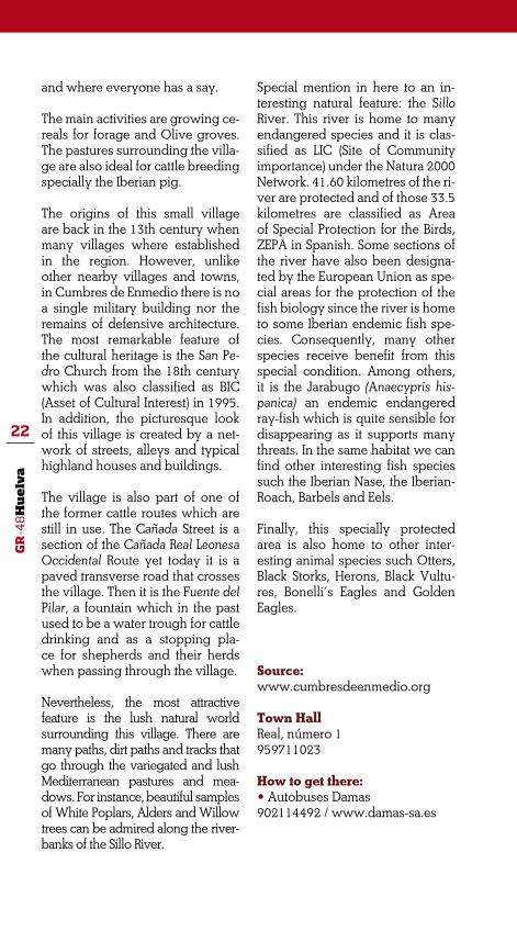
Special mention in here to an in-teresting natural feature: the Sillo River. This river is home to many endangered species and it is clas-sified as LIC (Site of Community importance) under the Natura 2000 Network. 41.60 kilometres of the ri-ver are protected and of those 33.5 kilometres are classified as Area of Special Protection for the Birds, ZEPA in Spanish. Some sections of the river have also been designa-ted by the European Union as spe-cial areas for the protection of the fish biology since the river is home to some Iberian endemic fish spe-cies. Consequently, many other species receive benefit from this special condition. Among others, it is the Jarabugo (Anaecypris his-panica) an endemic endangered ray-fish which is quite sensible for disappearing as it supports many threats. In the same habitat we can find other interesting fish species such the Iberian Nase, the Iberian-Roach, Barbels and Eels.
Finally, this specially protected area is also home to other inter-esting animal species such Otters, Black Storks, Herons, Black Vultu-res, Bonelli’s Eagles and Golden Eagles.
Source: www.cumbresdeenmedio.org
Town HallReal, número 1959711023
How to get there:• Autobuses Damas 902114492 / www.damas-sa.es

GR
-48
Hu
elv
a
23
CUMBRES MAYORES
Altitude: 700 m Population: 1.954 (2010)
Cumbres Mayores also locates in the north of the province and some 144 kilometres from the capital Huelva. The entire municipality locates wi-thin the Sierra de Aracena y Picos de Aroche Natural Park and therefore is also classified as Biosphere Reserve.
Like other towns and villages within the region, the main activities are tho-se of the primary sector and services. Meat industry is really important in this municipality and special national recognition is given to the exquisite Iberian ham and other meat products obtained from Iberian pigs.
The origin of this highland town is in a nearby Celtic settlement known as Nertóbriga (literally ‘strong castle’ or ‘fortified high’). The remains found in some archaeological excavations in the municipality report about how the original settlement was completely abandoned in the 5th century causing the different villages in Cumbres to be settled. Because of its population and economy, Cumbres Mayores is the most important town among the three established in the area. It is worthy to spend some time walking in this town and look at the typical architecture of this region. The distinctive qualities
characteristic of the city centre com-prises traditional highland houses where elements from the architecture of Portugal, Extremadura and Andalu-cía become firmly connected to each other. Cumbres Mayores cultural he-ritage is all about the remains of those bordering towns and villages which played an important role on defen-ding Castile from the Portuguese attacks from the 13th to the 15th cen-turies. The most significant element is the castle known as Castillo de Sancho ‘El Bravo’ which is a castle-fortress classified as Monumento Historico Nacional (Historical heritage Monu-ment). Together with the castle there are two other excellent religious buil-dings which enhance the exquisite cultural and historical heritage of the town. One is the San Miguel Parish Church which was built by Hernán Ruiz in the 15th century. The other is the remains of the Convento de las Franciscanas Clarisas de la Observan-cia, a Romanic convent established in 1467. Today only the facade –known as ‘La Portá’- remains though.
Lovers of the natural world and of out-door activities will find very attractive the excellent conservation condi-tions of the pasture woodland and

GR
-48
Hu
elv
a
24
HINOJALES
gallery forests in this municipality. The astonishing landscape together with an extensive network of paths, cattle tracks and especially many na-tural viewpoints appear to be ideal for hiking and rural tourism. Especial mention to two natural viewpoints: the Alto de Hinojales and the Balcón de Pilatos from where visitors may have breathtaking views of the Sierra de Aracena y Picos de Aroche Natural Park. Finally, many endangered animal and plant species find shelter and food in this great and protected woodland of Holm Oaks and Cork Oaks.
Source: www.cumbresmayores.eu http://www.pueblos-espana.org/andalucia/huelva/
cumbres+mayores/http://enciclopedia.us.es/index.php/Cumbres_Mayores_(Huelva)
Town HallPlaza España 1959710609 / 957710001Medical CenterHuertos, s/n959129576 How to get there:• Autobuses Damas902114492 / www.damas-sa.es • Taxi Félix Dominguez NavarroLos Abades, 17959710301 • Taxi Gabriel Romero MoroDean Campos Moro, 11959710252
ble gardening together with cattle and pigs breeding.
Mention to the first nomadic settlers established in this municipality can be found in the writings of different ancient authors like Pliny and Polybius. However, the village was established as such after the migrations happening during the Muslim occupation and the later relocations of the 13th century.
The most interesting cultural featu-
Altitude: 606 m Population: 370 (2010)
Hinojales is some 143 kilometres from the capital city Huelva. This highland village has borders to the north with the Serranía de Hinojales mountain range and to the south with the Valle de la Ribera valley. This is the smaller village of the Mancomunidad Intermunicipal de Sierra Minera, a Trust comprising several towns and villages in the region.
The main activities are the manage-ment of Olive groves and vegeta-

GR
-48
Hu
elv
a
25
CAÑAVERAL DE LEÓN
re of this village is a Paleochristian memorial tablet from the 6th cen-tury which can be found inside the Virgen de la Tórtola Hermitage. The hermitage is also classified as BIC (Asset of Cultural Interest). These two elements tell about how important this village became in the Visigoth period. The other excellent element of the cultural heritage is the Nuestra Señora de la Consolación Church. The church which was built in the 15th century is a beautiful example of the Goth- mudejar architecture style. In addition, some excellent and well preserved wall paintings from the Gothic to Renaissance period can be admired in the chancel of this church.
Nevertheless, the most peculiar feature of this small village is per-haps its folkloric heritage. The Celt and Old Roman customs attached to the very first origins of Hinoja-les still prevail in its culture. A li-vely traditional dancing known as La Danza de Nuestra Señora de la Tórtola, or just simply the La Lan-za, incorporates Celt instruments
like pipes and the ‘tamboril’ (small drum) together with the castanets which are very much used in the highlands folklore. The dancing consists on seven men dressing flamboyant costumes who perform a lively dance to honouring the Virgin Mary. The natural world of this municipality comprises diver-se vegetable gardens and pastures of Holm Oaks, Olive groves and patches of Mediterranean forest on hills and mounts which can be up to 850 metres high.
Source: www.hinojales.org
Town HallPlaza de España, 1959722638 / 959722773Medical CenterCañá, 2. 959722627Pharmacy959722609
How to get there:• Autobuses Damas902114492 / www.damas-sa.es
Altitude: 533 m Population: 412 (2010)
Cañaveral de León locates at the border with Extremadura region and some 134 kilometres from Huelva capital city. The village is
also at the heart of one of the first valleys in Sierra Morena mountain range. The village and the natu-ral surroundings are classified as

GR
-48
Hu
elv
a
26
Biosphere Reserve because of the rich natural heritage of the region. The name of the village sums up two important features of the past. On the one hand is the fact that the village was originally dependent on the Encomienda de León. On the other hand is the remarkable cane plantation that used to grow around the water spring that flows out from the city centre.
The main activities in this villa-ge are devoted to cattle and pig breeding in nearby open pastures. The meat industry based on the preparation and manufacturing of products obtained from Iberian pigs is considered to be one of the best on the world. In addition and as it happens in other villages and towns in the area, services appear to be a most favourable source for local development and income in this village.
Fuente Redonda is the name of a na-tural water spring which locates in the town centre and that provides for watering the farms outside the village. The water flows through a long channel that ends in La Lagu-na, a large pond which is the main attraction in the village’s central square. Certainly, there is no ques-tion about the significant cultural value of these two elements.
There are other interesting build-ings which clearly represent the characteristic peculiarity of tradi-tion and custom of the site. Among others, it is the Molino de Márquez, a former Olive oil pressing Mill near La Laguna. This is a building from
the early 19th century which was active until the late 1960s. After a careful and thoughtful process of restoring the original site, the for-mer mill has recently been opened to the public as the Museo Etnológi-co del Aceite (Olive Oil Ethnologi-cal Museum) as well as a space for many other different public uses.
The charming and almost un-touched natural world surroun-ding this small village is another inviting reason for visiting Caña-veral de León
Source: www.canaveraldeleon.com http://www.andalucia.org/des-tinos/provincias/huelva/munici-pios/canaveral-de-leon/
Town HallPantano, 1959465860Medical Center959129589
How to get there:• Autobuses Damas902114492 / www.damas-sa.es

GR
-48
Hu
elv
a
27
ARROYOMOLINOS DE LEÓN
Altitude: 609 m Population: 1.055 (2010)
Arroyomolinos de León locates in the northernmost region of the province and some 172 kilome-tres from the capital city, Huelva. From this small highland town we will have a most impressive and breathtaking view of the Sierra de Aracena y Picos de Aroche Natural Park since the entire municipality locates within the borders of the park.As it happens in other villages and towns of the region, the eco-nomy of Arroyomolinos de León is mainly based on those activities re-lated to the agriculture, especially rainfed Olive groves and cereals cropping; the management of pas-tureland; handcrafting and cattle raising together with Iberian pig breeding.The name of the town is after two important aspects linked to the development of this small town. Part of the name recalls of the village’s independency from the Encomienda de León. For almost seven hundred years, the village was integrated in several lordships according to many different land demarcations (this was a system for marking boundaries between different lands which was origi-
nally used in the phrase line of de-marcation, a line fixed by the Pope in 1493 which separated Spanish and Portuguese territories in the New World). Eventually, in 1833 the municipality is incorporated to the newly established province of Huelva. The other part of the name is after the many water mills in the area. There are 32 former and do-cumented water mills in the mu-nicipality which originally were used for cereals crushing into flour. Perhaps the most attractive one is the Molino de Anastasio water mill which has been restored and converted into the Centro de Inter-pretación de la Cultura del Agua, an Interpretation Centre for the Cultu-re of Water. The centre offers accu-rate information together with an exhibition of the most significant features of the former water mills as well as the many jobs and activi-ties carried in a grind mill. The site is also the starting point of the Ru-tas de los Molinos, a compilation of different routes between the many water mills in the municipality.
Together with the peculiar archi-tecture of the water mills are other interesting buildings of the town’s

GR
-48
Hu
elv
a
28
cultural and historical heritage. It is worthy to contemplate the beauti-ful Santiago el Mayor Parish Church as well as the La Gitana Bridge or just take a little time for a walk up to the Monasterio de Tentudía, an impressive monastery which is located in the nearby province of Badajoz (Extremadura).
Nevertheless, the appealing beau-ty of the hills and mountain range surrounding this small town is ex-ceptionally magnificent. Walkers will enjoy a most breathtaking view from the Mirador de la Sierra del Bujo viewing point. The landsca-pe comprises many water streams flowing through valleys and ra-vines, a series of small mountain ranges and numerous hills cove-red on Holm Oaks, Cork Oaks and Olive trees. In addition, many are the paths and tracks that go across
the municipality causing different hiking routes. The Gabrieles Track together with the Buho Track, the Castillo del Cuerno Route and the Monasterio de Tentudía Track are, among others, the most popular and attractive hiking routes in the municipality.
Source:www.arroyomolinosdeleon.com
Town HallPlaza Clara Campoamor, 1959197675Medical Center959199536
How to get there:• Autobuses Damas902114492 / www.damas-sa.es
CALA
Altitude: 588 m Population: 1.326 (2010)
This is another small highland town which is located within the boundaries of the Sierra de Aracena y Picos de Aroche Natural Park. Cala is some 160 kilometres up north
from Huelva capital city and at the border with Badajoz (Extremadura region).
Traditionally, mining works were

GR
-48
Hu
elv
a
29
the main source for incoming in this small town. Today, the eco-nomy is mainly based on services and activities related to agriculture and cattle breeding though.
Mining works were at the very first origins of Cala, back to the time of the Roman occupation of the Ibe-rian territory. In Cala, visitors will have the chance to come closer to the mining culture in Andalu-cía. Some of the former mine si-tes which were active until quite recently are now open to tourists and visitors. It is also quite interest-ing to take a walk along the for-mer railings. Today, these former railings are perfectly conditioned for hiking yet in the past time were an essential element when trans-porting the deposits to the port in Seville from where they were ex-ported for purposes of trade.
The cultural and historical heritage of this town comprises interesting elements of the 14th and 15th cen-turies such as the Santa María Mag-dalena Church. This church is an exceptionally interesting example of the Mudejar style architecture in the highlands. In addition, the altar-piece is remarkable and so they are some wall paintings which deco-rate the church. The good preser-vation of the building added to its architectonic beauty is the reason why the church is one of the jewels of the Andalucía Cultural Heritage. Another good example is the Cas-tillo de Cala -from the 15th century which was also part of the many military buildings located along the international border for the protection of the Kingdom of Sevi-lle. In 1949 the castle was classified as BIC (Asset of Cultural Interest).
Walkers and hikers will enjoy wal-king in Cala surrounding areas because of the attractive natural world and the flat profile of this municipality. The walks are all ‘easy’ to ‘moderate’ grade, making use of dirt tracks and good quali-ty paths. Especially interesting are the routes known as Sendero de los Contrabandistas; Sendero del Alto del Bujo and Sendero Santa Olalla-Minas de Teuler.
Source:www.ayuntamientodecala.es
Town HallPlaza de los Mineros, 4959191125Medical CenterSevilla s/n959191026
How to get there:• Autobuses Damas902114492 / www.damas-sa.es

GR
-48
Hu
elv
a
30
SANTA OLALLA DEL CALA
Altitude: 535 m Population: 2.177 (2010)
This town is located some 147 kilo-metres from Huelva capital city and to the west of a region known as Sie-rra de Aracena Mountains. The mu-nicipality stretches 204 km2 connec-ting to the north with Extremadura region and to the east with Seville province. The municipality appears to be the border between two re-gions (Extremadura and Andalucía) as well as the junction where many important roads and tracks meet.
Santa Olalla municipal district is part of the Sierra de Aracena y Picos de Aroche Natural Park. The park stretches the westernmost area of the Sierra Morena Mountains. A breathtaking landscape compri-sing pasture lands, meadows and Mediterranean scrubs that pro-vides this town with some of the most interesting natural resources.
The village great cultural heritage is the result of a very interesting his-tory. The most remarkable buildings are the Nuestra Señora de la Asunción Parish Church and the Castle For-tress from the Middle Ages period. The later was declared as National Heritage of Cultural Interest in 1993.
Despite of the strong tradition in handcrafting (Santa Olalla is fa-mous because of the cork and wood crafting works as well as embroidery and crochet needle works), today the main working activity is wholesale and retail trading; houses building; activi-ties related to the sale and repair of vehicles and motorbikes; and agriculture especially of forage and Olive groves. The local gastro-nomy incorporates a large range of tasty products derived from the Iberian pig. Santa Olalla’s famous sausages are the best elements of its gastronomy.
Source:www.santa-olalla-del-cala.es
Town HallPlaza de la Constitución, 4959190175 Local PolicePlaza de la Constitución 667689643 Guardia Civil (National Guard)Avda. de Extremadura 959190082Antonio Machado Medical Centre959190275

GR
-48
Hu
elv
a
31 STAGE 1 :
BARRANCOS/ENCINASOLA
This first stage of the GR-48 Path (long distance trail) is the beginning of a singular hiking route through Sierra Morena mountain range. The starting point is Barrancos a Portuguese small town located in the Alentejo region which is a main landscaping feature of this section of the Iberian border.
At the beginning of this stage, the path will soon cross the border between Spain and Portugal to go into the Múrtigas River valley. The landscape comprises gallery forests, Rockroses patches and scattering Olive groves. This natural scenery makes more enjoyable this hiking route through di-verse panoramic natural sites.
Smuggling all along the border was a very important activity in the past. Sites such the Virgen de las Flores Hermitage used to be a very popular pass for smugglers who used to smuggle both dairy and first need pro-ducts from Portugal into Spain during the Spanish post-war period.
The track is in good and acceptable surface and the walk is easy and has no difficulty other than the wading across the Múrtigas River, especially in the raining season. In general, this is a very comfortable hiking along a pretty acceptable track.

GR
-48
Hu
elv
a
32
ROUTE GENERAL DESCRIPTION
Barrancos is a Portuguese municipality located in the Beja District in the Alentejo region. This is a typical border town and people speaks “ba-rranqueño” a Portuguese dialect which is also very much affected by the language spoken in the bordering areas of both Extremadura and Anda-lucía regions. In addition, this region comprising of large pastures used to shelter fugitives and exiles as it was considered ‘nobody’s land’ for almost five hundred years.
This stage of the route starts at the highest point in Barrancos town. There some telecommunication aerials will make a good landmark reference. Hikers’ sensible feelings will wake up with the astonishing panoramic view of the Hispanic border from the natural viewing-point located opposite to the cemetery. On having taken to the right flank of the site, we will follow up the tarmac road which will become a dirt path that starts descending towards east at the junction.
Some two hundred metres ahead, the path comes to a wide esplanade where there are three different paths. An intuitive insight will help us to
Start: Barrancos (Portugal)Finish: Encinasola (Spain)Distance: 13,100 kmTime: 4 hours
Suitability:
Environment: Severity of the natural environment.
Track Features: Difficulty in following the track.
1
1
1
3
Orientation: Guidance on the route directions.
Struggle: Struggle required for accomplishing the route.
MIDE evaluation:

GR
-48
Hu
elv
a
33
make the right choice which is the path on the right. This is a far more used path which soon will descend towards a dry and arid valley that appears to be the ideal kingdom for Rockroses and Broom bushes.
On coming to the bottom off the valley, the path will meet a junction of multiple paths and tracks. We will ignore all paths to the right to take the one that makes a 90º turn to the left and heads towards a pine forest bor-dering the last plots of Olive grove in Barrancos municipality.
Rockrose flower
Border between Spain and Portugal

GR
-48
Hu
elv
a
34
••• Km 0.66. Border between Spain and Portugal
A path with dry stone walls on both sides will take us to a natural site where the E386 border milestone stands up. The path will come to a Pine grove area where the first signing posts to the Sierra de Aracena y Picos de Aroche Natural Park can be spotted. This Pine grove is also a site where European Turtle Doves purring songs are frequently heard together with the barking from the hounds kept in a nearby kennel.
After wading across the Pedro Miguel Brook, the path will follow the natu-ral course of this small brook through Pine and Eucalyptus groves while looking for the HU-9101 road which connects Barrancos and Encinasola towns. This is an area with high levels of humidity and dampness even in the dry season which sustains good samples of riparian vegetation such as Oleanders, Brambles and Rosemery bushes.
On following the road direction, we will meet a fountain on the side of the road. The fountain is from 1959 and has two water-tubes coming out from a showy front to pour water into a central basin (pilar). Nearby there is also a picnic area with some picnic tables. As the path goes through this natural gorge carved by the brook, we will leave behind the Portu-guese territory to come into Spain through Huelva province. The road will come to a junction with the road to Aroche town yet we will conti-nue walking straight ahead. The road wades across a small brook and we will take onto a dirt path that branches off to the left and that is blocked by a country gate.
Black Storks are very common at the Múrtigas Riverbanks

GR
-48
Hu
elv
a
35
••• Km 2.56. Camino la Carvajera Path and the Múrtigas Riverbanks
On having left the road, the path continues on a former countryside road for a few metres. As the road goes through a Cork Oak grove, the terraces made in the past to level off the ground still can be seen. The electrical laying over our heads is a good landmark acting as a direction sign that eventually will head towards the country house known as Casa de la Ri-bera Alta located atop a small hill and under the shadow of a massive Eucalyptus tree.
The path continues ascending and on the former and dismantled road. On having reached the top of the small hill, a new path meets the former road. At the junction, we will take the path that goes straight ahead to start a deep descending towards the bed of a seasonal brook. At this point, a dry stone wall on the left side of the path will guide us while ascending a new steep slope. On having reached the top of this new hill, we need to pay attention to a new junction. Here, we will see a country gate block-ing a path to the right, another path leading to the left and another track that goes ahead and parallel to the dry stone wall. We will take this path, known as the Cañada de la Carcaveja, which starts descending through young pastures of Holm Oaks until it comes to the Múrtigas Riverbanks. Despite being a short distance, this may be a difficult and challenging section of the route for bikers.
At the riverbank, the path turns to the right and goes across a countryside gate. The path continues upstream and parallel to the river for the next 250 metres or so. At a point, the dry stone wall on the left side of the path opens to give access to the river ford. As the path curves, we will leave
Múrtigas Riverbanks

GR
-48
Hu
elv
a
36
the path and wade across the river. All necessary precautions must be taken before wading across the river even it is not very large and does not carry much water.
The sinuous tracing of the Múrtigas River facilitates numerous meanders along. Riparian vegetation and gallery forest comprise Reeds, Bulrush and Oleanders together with tree formations of Ash-trees, Black Poplars and patches of Eucalyptus groves.
After wading across the river, the path is blocked by a country gate that will be shut behind us after passing. The path continues climbing through a scanty Olive grove while following the watercourse direction. On ha-ving reached the top of the hill, we will turn left at the point where the path joins another footpath that goes perpendicular to our direction and by the end of the countryside fencing. The reward for such a climb is the exceptional view of both the Múrtigas Riverbanks fitting into the meander and Barrancos town in a distant background.
The path continues ahead and, after crossing a country gate, it will take us into a different environment where Brooms and scattering woodland give shape to a pasture for cattle breeding. Two Wild Olive trees appear to be guarding the path that now runs parallel to a dry stone wall and from where the Virgen de las Flores Hermitage is already spotted.
Just after passing by a dairy, another gate is blocking the path that makes a turn to the left to save the watercourse to finally arrive to the Virgen de las Flores Hermitage.
Virgen de las Flores Hermitage
GR
-48
Hu
elv
a
37
••• Km 5.03. Virgen de las Flores Hermitage
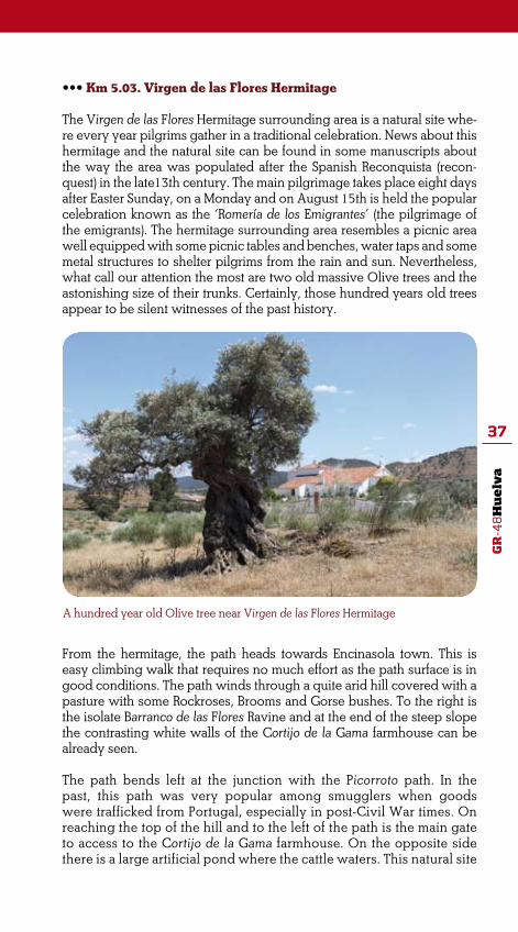
The Virgen de las Flores Hermitage surrounding area is a natural site whe-re every year pilgrims gather in a traditional celebration. News about this hermitage and the natural site can be found in some manuscripts about the way the area was populated after the Spanish Reconquista (recon-quest) in the late13th century. The main pilgrimage takes place eight days after Easter Sunday, on a Monday and on August 15th is held the popular celebration known as the ‘Romería de los Emigrantes’ (the pilgrimage of the emigrants). The hermitage surrounding area resembles a picnic area well equipped with some picnic tables and benches, water taps and some metal structures to shelter pilgrims from the rain and sun. Nevertheless, what call our attention the most are two old massive Olive trees and the astonishing size of their trunks. Certainly, those hundred years old trees appear to be silent witnesses of the past history.
A hundred year old Olive tree near Virgen de las Flores Hermitage
From the hermitage, the path heads towards Encinasola town. This is easy climbing walk that requires no much effort as the path surface is in good conditions. The path winds through a quite arid hill covered with a pasture with some Rockroses, Brooms and Gorse bushes. To the right is the isolate Barranco de las Flores Ravine and at the end of the steep slope the contrasting white walls of the Cortijo de la Gama farmhouse can be already seen.
The path bends left at the junction with the Picorroto path. In the past, this path was very popular among smugglers when goods were trafficked from Portugal, especially in post-Civil War times. On reaching the top of the hill and to the left of the path is the main gate to access to the Cortijo de la Gama farmhouse. On the opposite side there is a large artificial pond where the cattle waters. This natural site

GR
-48
Hu
elv
a
38
is popularly known as La Cruz de la Moza.
Eventually, dry stone walls will become the borders of the path. As the walk progresses the number of Holm oaks increases together with some patches of lush woodland resulting from the active reforestation in the area.
••• Km 8.73. The Piedra de los Valientes Monolith
As the level flatten, the path straights having fewer curves. A monolith known as La Piedra de los Valientes (The Braves’ Stone) locates at the side of the path. During the peregrination to the Virgen de las Flores Hermitage a stop made it obligatory for everyone at this site where there is also a commemorative plaque with the following popular reading:
“En la Piedra los ValientesUn lunes por la mañanaSe brinda con aguardiente
The Piedra de los Valientes Monolith

GR
-48
Hu
elv
a
39
En la romería serranaDe Encinasola y sus gentes”
From this site, Barrancos town is still visible in the distant and to the southwest. As the GR-48 approaches to Encinasola town, the number of vegetable gar-dens and plots increment and farmhouses such the Valdepegas farmhouse and the Lagunillas one become more numerous. Another interesting feature are the ‘aljibes’ which are water deposits usually built with bricks together with mortar designed to store either water from the rain or from nearby wells as the one located on the left side of the path.
As the walk progresses the land use changes. Suddenly, the pasture with Oaks and Mediterranean undergrowth at the Virgen de las Flores Hermita-ge surrounding areas turns into small Olive groves perfectly subjected to the limits of dry stone walls and Prickly Pears bushes.
The path meets the countryside road to Encinasola and goes across the road by a tiny underground path made of concrete. On passing by a ‘L’ shaped fountain with a water trough, the path connects to Encinasola ring road to go across and continue through an alley with a semi-demo-lished wall on the side that comes to the town centre where this section of the route finishes.
Carbine soldiers and smugglers at Picorroto
•••The Real Cuerpo de Carabine-ros de Costas y Fronteras (The Ro-yal Spanish Carbine Corps Police of Coasts and Borders) came into law by Royal Decree on March 9th, 1829. As it comes on the Constitutive Act, this police was established to ‘to do the war to smuggling; to prevent smuggling and to vigorously attack its sour-ces; to firmly prosecute any form of smuggling until its total exter-mination’. Throughout more than hundred years, many were the changes affecting the institution organization, management and even its official name. In 1833, just a few years after it was established, the army was rena-med as ‘Carabi-neros de la Real
Hacienda’ (the Royal Treasury Police) depending on the Ministry of Finan-ce. Shortly after, the army entered a state of neglect. Civil people were admitted and they were little accus-tomed to the ungrateful life style of an army which was bad paid and poorly billeted. Despite being part of the army, civilians were subjected to civil law and sanctions which tur-
ned them into lazy servants always at the mercy of their own interest, dirty manoeuvres and rapacity.
Manuel Márquez Pérez aka ‘Catalino’ (1919-2010). One of the last smugglers

GR
-48
Hu
elv
a
40
The Picorroto Carbine Police Barracks were located in a strategic natural site nearby the Portuguese border and many families were lodging in the building. During the Spanish post-Civil War time this border crossing post was very busy becoming very crucial when prosecuting smuggling. At that time, large groups of smugglers (sometimes they were groups of over one hundred smugglers) used to go across the border bringing from Por-tugal different products such food, sugar and, most important, coffee from Brazil. The small towns and villages like Encinasola and Fregenal de la Sie-rra were well supplied with those products. Carbine police had to locate and stop those big groups of smugglers as well as individual smugglers before they reached any town or village in the region. Hereby, many epic encounters happened in the region yet very often agreements between both the police and smugglers were sorted out if the smugglers paid a fee to the police or shared part of the load.
Nevertheless, in the late 60s Picorroto Carbine Police Barracks were dis-mantled. Since then, these paths and tracks have kept the memories of a recent past time closely related to clandestine trading activity and seve-re vigilance along the border.
STAGE 2 :
ENCINASOLA/CUMBRES DE SAN BARTOLOMé The second stage of the route is a walk through some narrow valleys which are surrounded by rich pastures fully devoted to cattle breed-ing. Flowing through the region are some rivers, creeks and brooks of pristine water which are home to rare fish specimens. This is a typical Mediterranean landscape where the hardness of rocky masses of quartzite appears to defy erosion and time passing.
This is a quite easy walking section suitable for walking, horse riding and mountain biking. The path heads clearly east and it is in good surface yet it deteriorates somehow when climbing down. Some ra-vines may be forded and some rivers and streams may be waded across along this section of the route. Apart from a short section whe-re the path matches a countryside road, the path follows the trace of a dirt path which becomes a paved path of pebbles and stones while approaching Cumbres de San Bartolomé town. Certainly, this is a his-toric and ethnologic value added to the natural features of this stage of the route.
The most attractive features in this section are some natural sites and especially some riverbanks and their surrounding areas. However, it is the landscape what may get our attention the most. After centu-ries of water erosion, the crests of these ancient mountains show im-

GR
-48
Hu
elv
a
41Start: EncinasolaFinish: Cumbres de San BartoloméDistance: 17 kmTime: 4 hours and 30 minutes
Suitability:
Enviroment: Severity of the natural environment.Track Features: Difficulty in following the track.
1
1
1
3
Orientation: Guidance on the route directions.
Struggle: Struggle required for accomplis-hing the route.
Difficulty: MIDE evaluation
A pebbles paved street in Encinasola
pressive masses of quartzite rocks which are also home to rocky birds of prey such Griffon Vultures, Bonelli’s Eagles and the Eagle-Owl.

GR
-48
Hu
elv
a
42
Partial view of Encinasola town at the beginning of the stage
ROUTE GENERAL DESCRIPTION
Encinasola is located at the Sierra de Aracena and Picos de Aroche mountain range. The origins of this highland town go back to the Bronze Age yet Romans and Arabs left a distinctive mark on this land. The remains of the Castillo Árabe, an Arabic castle from the 10th cen-tury, are a good example of this. Nevertheless, the symbol of this small town are the two bastion-towers from the 16th century known as San Felipe and San Juan which were built to defend the place against the Portuguese attacks during the Reconquista period.
This stage of the route starts at Arrabal Menor Street which is outsi-de of the town. From there, we will come to a level open stretch of grassy ground with three paths. The right choice is the path in the middle which is a waymarked track known as Sendero de la Peña de San Calixto. The area comprises an Olive grove and some dry stone walls. Small birds like Goldfinches and Greenfinches are quite com-mon in the area as they are quite at use of human proximity.
The path, well limited by dry stone walls on both sides, continues straight ahead and towards El Cerro de la Cruz Hill while leaving be-hind Encinasola town. As the walk progresses, we will bump into an iron countryside gate which is blocking the path. After crossing the gate, the path splits in two and we will go onto the path to the left which will soon wind through vegetable gardens and fruit tree groves.

GR
-48
Hu
elv
a
43
Ford at the Caño Brook
••• km 1.2. The Cuesta del Caño Slope
The track begins to descend and becomes wavier. Fantastic views open out across two valleys known as Valle del Caño and Valle del Sillo. The Olive grove will progressively turn into a richlynourished woodland comprising Holm Oaks and Mediterranean undergrowth of Rockroses, Spanish Lavender and Brooms. Any curve of this descending path is a good place to stop and look at the landscape and to the peculiar geomor-phology of these valleys. The showy shapes of the rocks worked on the mountains relief are the result of centuries of erosion.
The path continues descending until it reaches the bottom of the valley. The Huerta del Caño country house remains to right of the path which now goes across the Caño Brook by a footbridge made of concrete. The riverbanks support some vegetation of Tamujos (Flueggea tinctorea) and Oleanders as well as some Eucalyptus trees by the ford.
On having crossed the brook, the trail continues straight ahead having the El Berrón Country Estate on a side. After crossing a countryside gate
which is blocking the track, the path starts a gentle climbing and soon we will spot a massive quartzite rock to the right. This is the Peña de San Sixto (San Sixto Rock). Using the binoculars and from the path, we will watch some Vultures and perhaps other rocky birds standing on the rocks. Per-manent communities of Griffon Vultures locate on the top of the rock which is also home to other rocky birds. Despite of currently being a paradise for rocky birds, the Peña de San Calixto used to shelter diverse

GR
-48
Hu
elv
a
44
San Sixto Rock
groups of people. Evidences of this are the settlements from ancient times which have been discovered at the rock foothills and, from a most recent period, the remains of the huts known as ‘chozos’.
After having enjoyed the majesty of the flight of Griffon Vultures, the trail heads towards the Arroyo del Sillo Brook while winding through a Cork Oak pasture and some Olive groves that in spring time appear fully cove-red with annual plants of pleasing natural colours.
••• Km 4. Ford at the Arroyo del Sillo Brook
The Sillo Brook is faster-flowing and wider than the Caño Brook. Since there is no bridge over the brook, wading across this stream might be a pretty arduous task especially in the raining season.
However, this is an especially interesting riverbed because of the many animal species related to it. The pristine water of the Sillo Brook is home to many rare and endemic fish species. Among others, they are the jarabugo (Anaecypris hispanica), the pardilla (Rutilus lemmingii), the boga (Chondos-troma polylepis), the Barbel and the Eel; all they Iberian endemic species. In addition, excrements of Otters are easily spotted along the stony ri-ver bed while Vultures’ guano whitens the rocks and stones on the river shores. Together with this interesting animal world is scarce vegetation comprising thorny Tamujos on the brook shores and, floating on the bac-kwaters, the Water Buttercups of white flowers.

GR
-48
Hu
elv
a
45
Ford at the Sillo Brook
After wading across the brook, the trail comes into Cumbres de San Bar-tolomé municipality while winding through a Holm Oaks pasture known as Dehesa de la Gallega which is fully devoted to cattle breeding. The trail starts climbing until it reaches the top where it splits into two tracks. In here, we will take onto the track that bears right making a 90º turn to continue straight ahead. On the opposite slope locates the Cortijo De la Gallega farmhouse while views of the Barranco del Lobo Ravine and the Sillo Brook open at the front. The trail continues straight ahead while pass- ing by some artificial water troughs for the cattle.
In this section of the route we will see retinta and avileña cattle as well as some peculiar landmarks which are piles of stones located at the side of the path and that are known as ‘majanos’. Cattle breading is a main activity in the area and the many cattle exploitations are separated one from each other by dry stone walls and just some cattle grids on the path. The path continues leaving behind El Pizarro farmhouse which stands up atop a hill to the left. The Holm Oaks pasture is progressively gaining biodiversity with some Rockroses and Gorse bushes. After reaching the top of a hill, the path continues with gentle ups and downs while fording some seasonal small brooks which support a lush Mediterranean undergrowth of Brambles and Oleanders and that break the monotony of the pasture woodland.
After crossing the last gate to access to the De la Gallega Country Estate, the trail connects to the H-2111road that links Encinasola and Cumbres de San Bartolomé towns. For about three kilometres the trail will match the road border which is wide. This is an easy walking section of the route as there is no much traffic on this highland road. On having come to the three kilometre and at a STOP traffic sign, the trail moves away from the road and bends right to get to a dirt path.

GR
-48
Hu
elv
a
46
••• km 11.5. Camino del Estrecho del Puerto Path
The track soon heads away from the road that is easy to find as there is a sign for heavy machinery not trespassing on it. The path descends through pastures while Rockroses become more abundant. The Puerto Brook starts showing to the right of the path. As the walk progresses, the Romanitos pasture turns into a narrow rocky ravine where the brook is fitted while carving the rock outcroppings between Wild Olive trees.
This is a natural site known as El Estrecho. The brook flows beneath the path and vegetation on the brook banks comprises Brambles patches and some Poplars. The trail continues ahead and soon we will find ourselves walking again through pastures of Broom bushes. The cattle breeding local tradition is clear as there are many stone-made farmyards and sheepfolds near the Casa de la Gangosa country house.
The trail continues gently downhill and through an open area while looking for the Arroyo del Estrecho Brook. We need to pay attention to the track direction before wading across the brook. Some fifty meters before coming to the concrete made ford, we will bend just to the left to get to a dirt path that goes across a country gate located between dry stone walls. The track continues ahead and shortly after passing the gate comes to a former stone made ford and wades across the Arroyo del Estrecho Brook.
••• km 13.69. Ford at the Arroyo del Puerto Brook
Just after fording the brook, the path starts climbing while matching a dirt path which is little used yet is well limited by laboriously made
Casa de la Gangosa surroundings

GR
-48
Hu
elv
a
47
dry stone walls on both sides aimed to keep the path surface.
The path continues ahead and climbing through a thick Rockroses patch which is also home to mammals such Foxes and Mongoose. It will be difficult to spot any of the mentioned animals since those are primarily active during twilight and night. We will easily spot their tracks and excrements on the path and on some nearby rocks though.
Hikers will climb up between thick Rockroses patches
The path reaches the top of the hill to come to a different area in which Rockroses and Mediterranean bushes are replaced by meadows. As the walk progresses, it is increasingly clear the human action in the area and different uses of the land.
After crossing another country gate, the path continues straight ahead having the protection of dry stone walls on both sides. The path co-mes to a much more humanized area where locate small country farms and country houses together with vegetable gardens and fruit trees such as Orange trees and Fig trees. In a sudden turn to the right, the dirt path turns into a traditional and beautifully designed stone paved path made of perfectly preserved pebbles and stones. The dry stone walls make a perfect complement to the pavement in which secures firmly a rich Mediterranean undergrowth of Wild Olive trees, Rockroses and Asparagus bushes. No doubt this is one of the most attractive sections of this stage of the route.
The path which is now paved of concrete starts climbing up towards Cumbres de San Bartolomé town while winding through the surround- ing areas. This stage comes to finish at a picnic area located outside the town and from where we will have a beautiful view of the town.

GR
-48
Hu
elv
a
48
••• By definition, rocky habitats are areas of steep rugged rocks such as cliffs and crags and whe-re the ecological conditions might be seem as hostile for life. Never-theless, many are the animal and vegetal species that are adapted themselves to living in this peculiar environment.
In the stage of the GR-48 Trail through Huelva province that connects Encinasola and Cumbres de San Bartolomé towns, there is a rock known as Peña de San Sixto.
Common Kestrel, the Rock Bunting and the Blue Rock-Thrush take also shelter at the craggy San Sixto Rock. In addition, birds such as the Golden Eagle, the Bonelli’s Eagle and the Black Stork build their nests on the most inaccessible areas of the site while other birds better adapted to human settlement such as Common Kestrels, Crag Martins and Common Swifts prefer the wild and natural cliffs of this rock to the walls of the churches and castles located in the nearby towns and villages.
Rocky habitats
The rock itself is a mass of hard quartzite rocks which have resisted the scourge of erosion creating a projecting peak which is home to many species. The rock is also one of the biggest rocky areas within the Sierra de Aracena y Picos de Aroche Natural Park where this natural habitat type is not very common.
The most emblematic animal spe-cies in this natural site is the Griffon Vulture. Many Griffon Vultures roost on the rocky crests of the rock and the Eagle-Owl, the Crag Martin, the
This natural site is also home to a range of plants which stick to life in this wild and inhospitable natural en-vironment. Different Ferns and Wild Carnations species grow in the rock crevices and even endemic plants of very limited distribution in the region can be found in this site.
It could be said that every single crag and cliff in San Sixto Rock deserve of a special protection as the whole site gives protection and shelter to a sin-gular biodiversity.
The Common Kestrel is a common bird in open areas yet it prefers rocky sites for nesting

GR
-48
Hu
elv
a
49
This stage of the route covers a region known as Las Cumbres which comprises three different municipalities: Cumbres de San Bartolomé, Cumbres de Enmedio and Cumbres Mayores all they connected by a network of traditional paths, countryside alleys, causeways and cattle tracks. The region is clearly influenced by the customs of the nearby Extremadura and therefore primary land uses are cattle breeding and pasture management.
This easy West-East oriented route with a few slopes yet some sections of the path may deteriorate especially when wading across some brooks. Never-theless, the whole track is suitable for walking, biking and horse riding.
A common feature along this section of the trial will be the dry stone walls on both sides of the track. These walls mark the limits between different pastures which are mainly devoted to livestock breeding, es-pecially Iberian pig bred in ‘montanera’, the period during which the pig grazes in acorn-rich pastures. The main cultural expressions along this section of the trail are many towers and fortress located in the small towns and villages along the trail together with the paved path nearby Cumbres Mayores town.
As for the wild life, a large range of birds and other animal species asso-ciated to pastures and river banks are the most significant. Corn Buntings and Larks are easily spotted in these fields without paying much atten-tion to other birds of prey such as the Common Buzzard and the Red Kite. In addition, the region is also home to a large range of wild vegetation which is a much valuable natural resource. Activities very popular in the region are the collection of wild Asparagus and especially of Gurumelos mushrooms (Amanita ponderosa) both very much appreciated in the local gastronomy.
STAGE 3 :
CUMBRES DE SAN BARTOLOMé/ CUMBRES MAYORES
Black Kite
GR
-48
Hu
elv
a
50
ROUTE GENERAL DESCRIPTION
The origins of the region known as Las Cumbres seem to be in the Ro-man period. According to some authors, in the 5th century people from Nertóbriga, a town located up in the north and in the Beturia Céltica re-gion, moved to the south when searching shelter and protection in the highlands causing a series of small towns and villages. Later, the region was colonized by Berbers since the orography of the region appeared to be ideal for shepherding.
In the Middle Ages and during the Reconquista period, Fernándo III King of Castile commissioned and founded the San Bartolomé Parish Church renaming the site as Cumbres de San Bartolomé. Nevertheless, even to-day and thanks to the oral tradition the former name of Cumbres de Abajo and Cumbres Bajas still are in use. The site together with other sites in the region played an important defensive role when defending Castile from
Enviroment: Severity of the natural environment.
Track Features: Difficulty in following the track.
1
1
2
3
Orientation: Guidance on the route directions.
Struggle: Struggle required for accomplishing the route.
Difficulty: MIDE evaluation
Start: Cumbres de San Bartolomé. Plaza de San Sebastián.Finish: Cumbres Mayores (Callejón del Cementerio Alley next to Iglesia Square and the Castle)Distance: 10.8 kmTime: 3 hours and 30 minutes
Suitability:

GR
-48
Hu
elv
a
51
A remarkable picture: a pasture surrounded by dry stone walls
the Portuguese attacks and many towers, forts and castles were built in the villages and towns causing many people from the northern regions of Castile, Galicia and León to move in here.
This stage of the trail starts off at the San Sebastián Square in Cumbres de San Bartolomé town. From here, we will head east while walking along an alleyway that will come to a path known as Camino de las Viñitas. Following this path that winds through vegetable gardens and plots, we will come to the Barranco de las Cañadas Ravine where the main features are pastures and Olive groves. Nevertheless, what it will call walkers’ attention most is the goat cattle since they are many cattle exploitations along this section of the route.
The path which become rockier, starts descending while approaching to the brook in the Barranco de las Cañadas Ravine.
••• Km 1.5. Barranco de las Cañadas Ravine
After wading across the brook, the path continues on ahead while having the ravine to the left. As the path descends, Mediterranean undergrowth predo-minates with bushes of Myrtle, Wild Pear trees and Wild Olive trees. On the slope to the right, ‘majanos’ (landmarks made of a pile of stones) and stone fences are marking the borders between different private Country Estates.
The path progresses parallel to the brook which carries less water now. Bram-bles, Oleanders and some White Poplars line up along the banks though. A se-quence of pastures of Oaks is the main landscape feature where Great Tits and Blue Tits flutter about while searching for the abundant insects in the pasture.

GR
-48
Hu
elv
a
52
The path starts going up and passes by a water trough located to the right. This is a rectangular ‘fountain-trough’ of about 12 metres long made of adobe bricks. On the opposite side of the trough is the tube from where the water is spilled into a basin. The water passes from the basin into the trough by means of lowering the railing.
While looking for the top of the ravine, the Viñitas path makes a 90º turn to the right and starts climbing up while heading south-east. Dry stone walls mark the borders on both sides of the path while large specimens of Oak trees and some Hawthorns give shadow to the walkers.
On reaching the highest point on this climbing, the path becomes a tarmac road. There the path makes again a 90º turn this time to the left and towards the N-435 road. An underpass facilitates going across the road to start walking ahead and towards Cumbres de Enmedio town.
The path continues climbing while winding through a pasture of Broom bus-hes and an Olive grove on the top of the hill. Then, the path starts climbing down until it meets the countryside road that connects Cumbres de San Bar-tolomé and Cumbres de Enmedio small towns. On reaching the road, we will go to the right and continue walking ahead and towards Cumbres de Enmedio main road.
••• Km 4.85. Cumbres de Enmedio
Cumbres de Enmedio is the smaller municipality in Andalucía region with some fifty people living in it. Most streets in the village still keep the traditional stone pavement proper of these highland towns and villages. The main road goes through the village and passes by the church to fi-nally come to die into a small square. This is a good site for a break and
A fountain-trough with a large basin at the Barranco de las Cañadas Ravine

GR
-48
Hu
elv
a
53
walkers may quench their thirst in the fountain located on the left side of the square. A nearby steal made weather vane representing a wild Lynx is perhaps a fade memory of a time when those animals used to gad about in this mountain range.
Weather vane representing a Lynx in Cumbres de Enmedio village
On having left behind Cumbres de Enmedio village and as the walk pro-gresses towards Cumbres Mayores town, we will come to a roundabout outside the village. In here, we will leave the countryside road to conti-nue walking straight ahead and on a dirt path with dry stone walls on both sides. These stone walls will be the walkers’ companion until almost the end of this section of the route.
The path now winds through a former Oak woodland converted into a pasture where retinta and avileña cattle races are predominant. The path continues ahead and between the La Aldea pasture which stretches in a beautiful valley to the left and the El Endrinar pasture on the opposite side of the path.
As the path starts climbing down, Mediterranean undergrowth becomes more frequent on both sides of the path. The path will wade across di-fferent streams and minor brooks where Brambles, Round-Leaved Mint bushes and Reed finely develop. By the dry stone walls proliferate plant species such ferns, different types of moss and Navelwort plants. These are plants which are well adapted to this rocky habitat type growing to-gether thanks to the water infiltration through the stones and under the shade of the vertical walls.
••• Km 7.2. The Cortijo y Majada de Suárez Farmhouse
At this point of the stage the trail meets other path that we will ignore to continue walking straight ahead. This other path that branches off to the left connects with another long distance trail known as GR-42 towards Segura de León town.

GR
-48
Hu
elv
a
54
Cattle in open pastures. A very common feature in the area
Shortly after passing by the above mentioned junction, our track enters Cumbres Mayores municipality where the highlands pastures are mainly devoted to cattle breeding, specially the Iberian pig. Livestock exploita-tions of Iberian pig in ‘montanera’ are well represented in this region. A good example of this type of farming can be found in the surrounding areas of the Cortijo de Peliche Farmhouse where an interpretative board locates with accurate information about this traditional activity. The way Iberian pig is bred in the region has gained national and international recognition by means of the Sierra de Aracena y Picos de Aroche Denomi-nación de Origen, DO (classification which is part of a regulatory classi-fication system aimed to identify the quality and geographical origin of Spain’s finest wines and food products).
As the walk progresses, the path deteriorates and starts climbing down when fording the Barranco de la Magdalena Ravine to come to an open meadow fully devoted to cattle breeding. Then the path changes direction sharply to the right to start climbing up a hill on the shady side of the ra-vine where vegetation is more abundant. The trail continues climbing up and at some point on the slope gets to a junction of paths. Ignore those other paths and continue walking on this track until reaching the top of the hill. The path continues uphill while fitting between a thicker Medite-rranean woodland and undergrowth. The reward for such a steep climb
is the astonishing view from the top of the hill. A landscape of pastures and Mediterranean woodland widens in front of us having to the North some villages and small towns like Higuera la Real located in Extremadu-ra region.
The path swings right at a junction on the slope heading on towards Cumbres Mayores cemetery. From this point onwards, walkers may en-joy walking on a traditionally paved path which goes around the small town and passes by the impressive wall of the Castle. After passing by one wing of the churchyard, the path comes into an alley to the left that comes to die in the square near the Castle known as Plaza de la Iglesia where this stage of the route finishes.

GR
-48
Hu
elv
a
55
Near Cumbres Mayores village
Fountains••• In past times, sites where water sprang spontaneously were considered to be real oases and most cattle routes and traditional paths could even change direc-tion in order to get passing by one natural fountain or well where both animals and men quenched their thirst.
Natural fountains and springs were of such importance that in many cases villages and towns were arranged around them. It is a quite common feature in the region having a main square with either a fountain, a water trough or a ‘lavadero’ (a stone made basin for sluicing clothes) around which the town develops. Each of those
Large stone made water trough and basin in Cumbres de Enmedio village
water structures shows a particular shape and peculiar architecture.
Nevertheless, fountains and springs were not only a source for water collection but also a busy meeting point for locals. People used to ga-ther around the fountain and so they were workers, cattle breeders, wo-men carrying pitchers of water on their heads and children involved in water games while refreshing them-selves from the heat of the summer. One could say that those water sour-ces were the ‘community centre’ of the past time where many communi-ty issues were dealt to by everyone in a daily basis.
Water wells, fountains and water troughs appear to be the guardians of a silent legacy. Coming close to any of those water troughs takes the walkers deeply into the sound of the rippling water which seems to re-peat the noises of the quiet hot days and thirst quenching added to a well deserved break in one’s journey.

GR
-48
Hu
elv
a
56
Enviroment: Severity of the natural environment.
Track Features: Difficulty in following the track.
1
2
2
3
Orientation: Guidance on the route directions.
Struggle: Struggle required for accomplishing the route.
Difficulty: MIDE evaluation
Start: Cumbres de San BartoloméFinish: HinojalesDistance: 12.6 km Time: 4 hours
Suitability:
STAGE 4 :
CUMBRES MAYORES /HINOJALESThis stage of the route is a very easy walk connecting Cumbres Mayores town to Hinojales, a small highland village. Still within the limits of the Sierra de Aracena y Picos de Aroche Natural Park, the trail will match some former traditional paved paths and tracks which gives an extra value to the stage.
The track heads on south direction while moving away from the typical landscape at the border between the regions of Extremadura and Anda-lucía. Then it will come to a much shady and humid region where Por-tuguese Oaks and Cork Oaks are a clear sign of a closer groundwater level. In fact, a large section of the track matches the course of water that supplies Hinojales village and even passes through one of the few well preserved patches of Chestnut trees. The Chestnut tree is also the symbol of this mountain range.
Even most part of the trail uses former and traditional paths and cattle routes, a section of the track runs by the A-5300 road. This is a quiet highland road with no much traffic and even walkers will have the chan-ce to enjoy the astonishing views at their backs of scattering villages in breathtaking valleys.
As mentioned above, this is a very easy walk and the path narrows and perhaps deteriorates in the fewer metres. This is a flat route and the ideal stage for hiking, biking or horse riding; the only steep climbing will happen when approaching the Gracias Mountain Pass at the Sierra del Viento mountain range.

GR
-48
Hu
elv
a
57
ROUTE GENERAL DESCRIPTION
The route starts off at Cumbres Mayores town. The trail heads towards a tunnel beneath the road next to the petrol station and soon after passing the tunnel it matches a beautiful traditional paved path. The path starts climbing down after passing by a gorgeous stone made water trough to the right. This water trough is certainly a beautiful work of stone and still keeps the former stone decorating the front. Water comes out from a side and it is poured into another smaller basin which has the typical shape for the better filling of pitchers and all sort of water containers. By means of lowering the railing, the water comes to fill in the large water trough which is about seven metres long.
Stone made water trough and basin at the beginning of this stage of the route

GR
-48
Hu
elv
a
58
The landscape resembles a mosaic of farming plots
As we continue walking, we will bump into another water trough which is blocking the path. Decorating the trough there is a triangular shaped stone front with an almost illegible inscription from the 19th century. Also located on the front stone are two taps from where the water is poured into a square shaped basin which was used for water collection and for washing in running water. By means of a tile, the water passes to a lower level where locates another rectangular and larger basin from where the water is supplied to a modern cistern.
The path descends gradually while tracing a large zigzag and widens when approaching to an area of different plots separated by dry stone walls. From here we will have a panoramic view of the Riofrío Valley and the Huelva-Zafra railway line crossing over the valley. Later the trail will go across the railway at a level crossing. The path comes to a site where two brooks meet. After fording the brooks, the path connects with a dirt path to the left known as Camino del Moral that immediately heads up towards a countryside road.
••• Km 1.2. Camino del Moral path and the Puerto de Gracia Moun-tain Pass
The Camino del Moral path is an easy and good quality dirt path. The path winds around an area of farming plots and cattle exploitations. After pass-ing by a diary the path wades across a small brook which supports some associated bushy vegetation such as Reed and Brambles.
The path continues straight ahead until it meets the A-5300 road where we will turn right and towards Hinojales village. After some 350 metres walking along the road and at the kilometre 8 another path branches off

GR
-48
Hu
elv
a
59Panoramic view of Cumbres Mayores from the Sierra del Viento mountain range
to the right. We will follow this new path that gently climbs up through Oleander patches while running parallel to the road.
The climbing comes to an end when the path meets a sharp curve of a for-mer road. There, the path bends left while heading again towards the A-5300 road. We will follow along the road for a while having at the back a beautiful view of Cumbres Mayores town and the highlands. At the kilometre 10 we will go onto another path known as Camino del Venero that branches off to the right. At this point we will be half way to finish this stage of the route. The Puerto de Gracia mountain pass is already at sight.
••• Km 6. Camino del Venero Path
The Camino del Venero path starts after passing across a cattle grid. This is an area of hills covered with large meadows and pastures which are ideal for cattle breeding, a most traditional activity in the region. It is not casual that this area is known as Cerro del Viento (Hill of the Wind) since this section of the mountain range comprises many hills.
In the spring season, the Mediterranean undergrowth shows a magnificent display of chromatic contrast because of the blooming of white Rockroses, yellow Gorse and purple Lavender. It will also be easy to watch some birds of prey such the Tawny Vulture flying over the valley while taking advance of the thermal currents proper of the high mountains.
The path continues ahead and passes by a ruined country house with no roof. Some stone walls still are up though. As the walk progresses the num-ber of trees increases and humidity becomes more perceptible. After passing through a Pine grove, the path starts climbing down while winding between
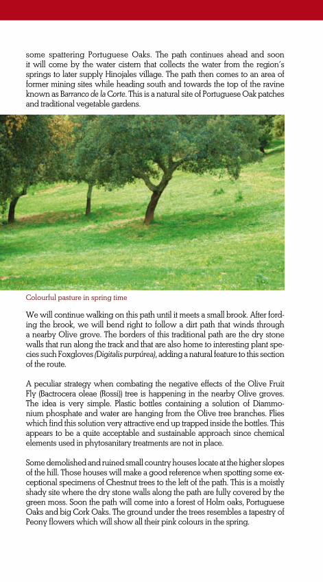
GR
-48
Hu
elv
a
60
some spattering Portuguese Oaks. The path continues ahead and soon it will come by the water cistern that collects the water from the region’s springs to later supply Hinojales village. The path then comes to an area of former mining sites while heading south and towards the top of the ravine known as Barranco de la Corte. This is a natural site of Portuguese Oak patches and traditional vegetable gardens.
Colourful pasture in spring time
We will continue walking on this path until it meets a small brook. After ford-ing the brook, we will bend right to follow a dirt path that winds through a nearby Olive grove. The borders of this traditional path are the dry stone walls that run along the track and that are also home to interesting plant spe-cies such Foxgloves (Digitalis purpúrea), adding a natural feature to this section of the route.
A peculiar strategy when combating the negative effects of the Olive Fruit Fly (Bactrocera oleae (Rossi)) tree is happening in the nearby Olive groves. The idea is very simple. Plastic bottles containing a solution of Diammo-nium phosphate and water are hanging from the Olive tree branches. Flies which find this solution very attractive end up trapped inside the bottles. This appears to be a quite acceptable and sustainable approach since chemical elements used in phytosanitary treatments are not in place.
Some demolished and ruined small country houses locate at the higher slopes of the hill. Those houses will make a good reference when spotting some ex-ceptional specimens of Chestnut trees to the left of the path. This is a moistly shady site where the dry stone walls along the path are fully covered by the green moss. Soon the path will come into a forest of Holm oaks, Portuguese Oaks and big Cork Oaks. The ground under the trees resembles a tapestry of Peony flowers which will show all their pink colours in the spring.

GR
-48
Hu
elv
a
61
Great Tit
••• Km 10.3. La Sabia Site
After a gentle climbing, the path meets a junction where we will pay close attention to the direction signs. At the junction, we will go onto another dirt path that continues straight ahead while slightly bending to the left. This is a quite hard to follow path because of the irregular and deteriorated surface yet it is wide enough for a cart to pass through (‘de ancho carretero’).
This is a beautiful section of the route with some sections of a former pa-ved path. The path gently drops down until it meets a small brook which supplies water for the small gardens and fruit trees of the nearby farms. We can hear the singings of Blackbirds, Great Tits and Blue Tits; all they
large in number in the site. The path then swings right before fording the brook to continue ahead while passing by a cluster of small farms and pigpens to the left. From there we will follow a countryside road which still keeps the original dry stone walls.
A nearby Olive grove secures firmly to the scarce fertile soil while the tree’s three roots appear to be drilling out the dark outcropping of tosca limestone. No doubt this is a good example of the wild farming in the region.
The path continues ahead and meets again the A-5300 road and we will start walking towards Hinojales and on the left side of the road. After some two hundred metres and immediately before a ‘no overtaking’ tra-ffic sign of the road we will go onto another path that branches off left.

GR
-48
Hu
elv
a
62
The route progresses again on a dirt path that runs perpendicular to the road. We will ignore an iron country fence which is blocking the path to swing right and on to another dirt path with dry stone walls on both sides. The path gradually drops down while heading south. Hinojales’ bell tower can be spotted in the distant.
The path continues descending until the end of this last slope where it meets another dirt path at a junction. That other path is the one from where the next stage of the route will start towards Cañaveral de León. At the junction there is an information board of the Natural Park with some interesting information about the Camino de la Víbora path. On having come to the road that connects Hinojales and Cañaveral de León villages we will go across the road to conti-nue ahead to continue along an alley with dry stone walls. Turn to the right at the junction with a fountain and a water trough to come into Hinojales village which is also the end of this stage of the route.
The sweet chestnut tree••• The Sweet Chestnut tree is the most emblematic symbol of the Sie-rra de Aracena and Picos de Aroche mountain range yet they are very little in number along this section of the trail. For many centuries, Sweet Chestnut groves have sha-ped both the landscape and the culture of this highland re-gion. Paradoxically, original woodland of Oaks was substituted by Sweet Chest-nut groves; as the centuries passed by, those groves became fully mature woo-dlands. Today and under the Council Directive 92/43/EEC of 21 May 1992 on the conservation of natural habitats and of wild fau-na and flora, these very ancient chestnut woods are classified as Natural Habitat of Community Interest whose conservation re-quires the designation of Special
Areas of Conservation. In addition, the sites are also under special pro-tection by means of the Sierra de Aracena y Picos de Aroche Natural Park act and regulations.Sweet Chestnut trees require very particular ecological conditions
for good growth and further development. Those
conditions can ba-rely be found in
some specific areas within the Iberian territory and the Sierra de Aracena y Picos de Aro-che mountain range is one
of those. Some of the region’s
natural sites com-prise most of these re-
quirements: a sub acid-neutral soil (pH 5.8 – 6.7) which is very rich in organic matter; humidity is relatively high with an average of rainfall of some thousand litres per square metre and year; and mild springs and summers.

GR
-48
Hu
elv
a
63
STAGE 5
HINOJALES /ARROYOMOLINOS DE LEÓN
This is one of the longest stages of this long distance route, the GR-48 Sierra Morena Trail. Nevertheless, hikers could break in Cañaveral de León town which locates half way to the end of the stage. Cañaveral de León is also a site where many different traditional cattle routes, highland paths and trails come together; there the GR-48 trail will meet a section of the most famous trail in Spain: the Camino de Santiago Route.
Our trail stretches across ancient pastures locate along a series of moun-tain ranges comprising the Sierra del Puerto and the Sierra del Bujo moun-tain ranges. The trail will climb up until passing across the Alto de la Toba Mountain Pass. From where it will progress along the northern side of the mountain range to finally come to die in Arroyomolinos de León.
The track is easy to walk despite the many ups and downs and the for-ding of different water streams. Perhaps, the most interesting natural fea-ture is the Rivera del Montemayor Site. The Montemayor River’s pristine waters flow all the way down from Extremadura region and its riverbanks support a large range of lush riparian vegetation in good conservation. This is a quite serpentine section of the trail yet it will be a very much pleasing and agreeable walk along the riverbanks.
Most time the track matches either traditional paved paths or routes that run between dry stone walls. Consequently, this is a very easy walk with a few sections of steep climbs when approaching the Puerto de la Toba Mountain Pass and some ups and downs at the Montemayor riverbanks. Nevertheless, this is a walk suitable for walking, biking and horse riding.
Enviroment: Severity of the natural environment.
Track Features: Difficulty in following the track.
1
2
2
3
Orientation: Guidance on the route directions.
Struggle: Struggle required for accomplishing the route.
Difficulty: MIDE evaluation
Start: HinojalesFinish: Arroyomolinos de LeónDistance: 21.5 km Time: 6 hours and 40 minutes
Suitability:

GR
-48
Hu
elv
a
64
ROUTE GENERAL DESCRIPTION
The first human settlements in this site of the Sierra de Aracena y Picos de Aroche mountain rage came to happen in the prehistory. From the Bronze Age is a burial site which locates nearby the centre of the village. The site is no matter for archaeological study; it has been plundered ruthlessly though.
The writings of the Roman author Plinius and the Greek historian Polybius tell about the Celtic, Vetoni and Lusitanian origins of most sites in the region. Those were cultures of a clear nomadic lifestyle whose main ac-tivity was cattle breeding. Perhaps, that is the reason why no settlements from that period have yet been discovered in the region.
After the Roman Empire disintegrated, Visigoths ruled by Walia (418 A.D) established some sites in Hinojales surrounding areas. The remains of settlements from the 568 A.D locate in the municipality. From the same year is also a Old Christian tablet which is placed at the altar room of the Nuestra Señora de Tórtola Hermitage. Apparently, the hermitage locates where other cultures of the past used to celebrate their religious ceremonies.
The beginning of the Camino de la Víbora path outside Hinojales village

GR
-48
Hu
elv
a
65
It is clear that Hinojales history has been clearly marked by people migra-tion. After the Muslims invasion and centuries of occupation, Christians conquered the southern regions in the country and people from many different regions in the Iberian Peninsula were relocated throughout the municipality.
After the Battle of La Janda, which took place in 711 (A.D), the North Afri-can Tarik troops took control and possession of the southern regions of the Iberian territory. Today, the names of some sites in the region remind of those five centuries of Islamic culture. That is the case of the Cueva y Horno del Moro, literally ‘The Moor’s Cave and Furnace’.
In the 13th century, people from León and Galicia –regions up in the north of Castile- moved to this site and it was then when the village was fully set. The new settlers brought with them much of their own traditio-nal culture and wealth that today is part of Hinojales cultural heritage. Among other artistic expressions is the ‘lanza’, a traditional dance ho-nouring the Virgen de Tórtola who is also the village’s saint patron. The Virgen de Tórtola Hermitage was built at the early 15th century. However, by the end of the same century population had grown so large that a new Parish church, the Parroquia de la Encarnación, was built in order to accomplish the religious needs of so many new citizens.
Our next stage of the trail will start at the junction where the previous one finished. We will leave Hinojales village heading north to go across the road. We will meet the junction after some metres of gentle climbing along the Camino de la Víbora path.
••• Km 0.9. Camino de la Víbora path
On having come to the junction, we will choose the path to the right and head on towards Cañaveral de León. As mentioned in the previous stage, at the junction there is an information board which tells to visitors about the ethnographic value of traditional paved paths within the Sierra de Aracena y Picos de Aroche Natural Park.
While ascending, the trail winds through Olive groves and pastures of Holm and Cork Oaks. Nevertheless, the stony sides of the path are fully covered of lush Mediterranean undergrowth comprising bushes of Sage, Lavender, Mastic Thyme and Flax-Leaved Daphne. Ignore the end of the Camino de la Víbora path and continue walking ahead to come into Fuen-tes de León municipality already in the province of Badajoz (Extremadu-ra).
This is a very pleasant walk under the green canopy created by the tops of the trees and many climbing plants such as the Common Smilax (Smi-lax aspera). The path drops down until it gets to the ravine of the Arroyo de la Corte Brook which is surrounded by pastures of Cork Oaks and nearby the Linarejos Farmhouse. In the past, this was a very important natural

GR
-48
Hu
elv
a
66
site where many vegetable gardens were set along the water course yet today just a few Fig trees remain. A small Black Poplar forest is home to many birds as the Common Nightingale whose singing can be heard in the spring.
The path under a green canopy of Cork Oaks
Soon after wading across the Arroyo de la Orden Brook, the path splits into two. Ignore the path that branches off left that goes up to Fuentes de León village and continue walking on the path to the right and towards the Colada de las Tablas Site again in Andalucía territory.

GR
-48
Hu
elv
a
67
Common Mullein
••• Km 2.7. La Colada de las Tablas Path
The track which now heads southwest is a very comfortable dirt path. On the right side of the path, an old country house will keep our attention but also a massive sample of Cork Oak. This impressive natural hallmark will mark the entry to Huelva province.
This is a quite pleasant section of the track as the path surface is in good condition and the track goes down a gentle slope while winding through Olive groves and some patches of Mediterranean forest. At some point the cumulative slope is about 10% and the path turns into a concrete paved path. The path continues ahead and goes through the pasture of a private Country Estate. Among other interesting features in this pasture is a beautifully built stone made water well with a vault which locates to the left of the path.
Soon after passing by the well the path splits into two. We will continue walking on the path to the right and towards the junction at the road that connects Hinojales and Cañaveral de León villages. At the junction, we will go across the road to continue walking a few metres ahead and again on a dirt path.
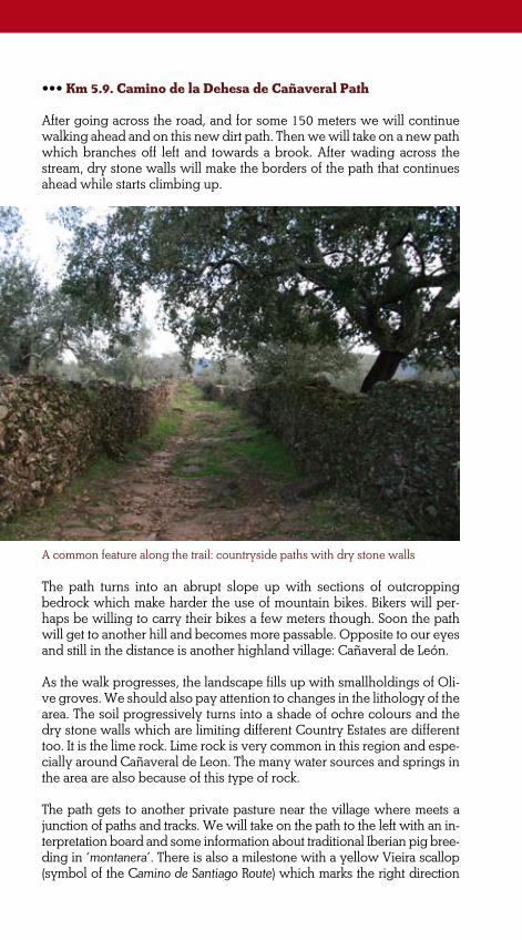
GR
-48
Hu
elv
a
68
••• Km 5.9. Camino de la Dehesa de Cañaveral Path
After going across the road, and for some 150 meters we will continue walking ahead and on this new dirt path. Then we will take on a new path which branches off left and towards a brook. After wading across the stream, dry stone walls will make the borders of the path that continues ahead while starts climbing up.
A common feature along the trail: countryside paths with dry stone walls
The path turns into an abrupt slope up with sections of outcropping bedrock which make harder the use of mountain bikes. Bikers will per-haps be willing to carry their bikes a few meters though. Soon the path will get to another hill and becomes more passable. Opposite to our eyes and still in the distance is another highland village: Cañaveral de León.
As the walk progresses, the landscape fills up with smallholdings of Oli-ve groves. We should also pay attention to changes in the lithology of the area. The soil progressively turns into a shade of ochre colours and the dry stone walls which are limiting different Country Estates are different too. It is the lime rock. Lime rock is very common in this region and espe-cially around Cañaveral de Leon. The many water sources and springs in the area are also because of this type of rock.
The path gets to another private pasture near the village where meets a junction of paths and tracks. We will take on the path to the left with an in-terpretation board and some information about traditional Iberian pig bree-ding in ‘montanera’. There is also a milestone with a yellow Vieira scallop (symbol of the Camino de Santiago Route) which marks the right direction

GR
-48
Hu
elv
a
69
Camino de Santiago Route waymarking sign
to follow up the pilgrimage track. This traditional pilgrimage route matches some sections of the GR-48 route though. In the pasture we will admire a magnificent sample of Holm Oak whose trunk has grown biased.
••• Km 7.6. Cañaveral de León village
This town is named after the many cane plantations in the area. The town has traditionally been linked to those cane plantations but also to the many water sources and springs in the surrounding areas. As mentioned above, the greater and perhaps the more important spring locates in the middle of a street in the centre of the village.
Even the origins of the village are back in the past times, the title of ‘villa’ was given to the town by Felipe II, King of Castile, on December the 30th 1588. The title was granted by means of high taxes. During four years in a row every single citizen of the village paid a large sum of money to the king of Castile. As a self-governing township, the municipality was incor-porated to Badajoz municipality until 1833 when the current administrati-ve division into provinces was established and therefore Cañaverales de León was incorporated to Huelva.
The second half of this stage passes through the village’s travesía (literally a road that passes through a village) to get to the opposite side. Here we will find a junction where we will go onto the road to the left and towards Arroyomolinos de León village. This section of the stage matches the A-5300 road until we will get to the 22 kilometre. There and after passing a curve, we will take on a dirt path that runs between dry stone fences and moves away from the road and to the left.
As the walk progresses, the path passes by a nearby pasture devoted to Iberian pig breeding in ‘montanera’ that means that pigs are exclusively

GR
-48
Hu
elv
a
70
fed on acorns in the open range. However, some areas of this private Country Estate appear to be in a state of semi-abandonment causing in-vasive shrub and bushes of Rockroses and Gorses (Ulex parviflorus). In the background is the Sierra del Bujo mountain range and to the left the Sierra del Cuerno one with the castle of the same name.
The path which now is a serpentine one starts climbing down. The dry sto-ne walls on both sides of the path support spillways for the draining away of water from the land surface. Those spillways -locally known as ‘porti-llos’- are also quite peculiar features of extreme beauty since their thres-holds are crowned with large limestone rock. As the path comes to the end of the slope, the pastureland becomes much more opened and with fewer plants coverage. Water courses follow each other causing to grow many patches of Brambles. Those are very interesting habitat types for birds such Corn Buntings, Hoopoes and Chaffinches. Approaching to the Montemayor River we will see near the riverbanks some private country houses and farmhouses known as Casas de la Suerte del Montero which still keep the traditional archetype on building that is using blocks of stone without mor-tar fillings. The houses also keep traditional sheepfolds attached.
••• Km 11.5. Rivera de Montemayor Site
The Montemayor River flows down from the Extremadura region while working a series of small canyons which support very interesting and lush riparian vegetation. Ash-Trees, Willows and Poplars create a green corridor which appears to be an ideal oasis for the diverse animal species living up in the mountains. Wild Boars, and Deer come to drink from the river’s pristine water; the excrements of Otters can be seen on the rocks of the riverbed and on the riverbanks since those mustelids come to the numerous ponds when searching for fish and Crayfish.
The path comes to meet the river and we will wade across to reach a pic-
Casas de la Suerte del Montero former country houses and the Castillo del Cuerno Castle in the background

GR
-48
Hu
elv
a
71
Wild Boar
nic area on the opposite riverbank. Nevertheless, before fording the river we should get back on our steps to take on another path to the right that runs downstream and parallel to the river. This is a section of the stage that may be hard for bikers because of the stony surface of the path and the lush shrubby vegetation of Brambles, and Oleanders.
The path continues parallel to the river and soon we will see the remains of a former transversal irrigation dam and water mill which locate at the
riverbed while keeping the semi-stagnant water. This is an ideal site for birdwatching since Herons come e to these backwaters when looking for food. In addition, big specimens of Black Poplars enrich the ecological value of the riparian vegetation.
Finally, the path comes to an open vega (plain field) with a large patch of Poplars and where locates another board with some information about riparian vegetation. The path meets a countryside road and goes over a bridge. After crossing the bridge, we will take onto a dirt path to the left that runs parallel to the river on the left riverbank.
••• Km 13.5. Ascending to the Alto de la Toba Mountain Pass
The path eventually moves away from the riverbank and we will not see the Montemayor River again. The path swings left and soon after will have dry stone walls on its borders. As the path continues ahead, we observe clear signs of shepherding in the surrounding pasture. In the pasture we will see scattering Holm Oaks together with lush shrub of Brooms and

GR
-48
Hu
elv
a
72
Gorse in the hills. To the right, the impressive Cortijo de Marivázquez farmhouse will keep our attention because of its large size.
The path meets a junction of tracks and paths. We will take on the path to the left to make a 90º turn. This new dirt path passes between the Capellania
country houses and by a pig pen which locates under a large Holm Oak. Despite of being semi-ruined, the pig pen still
keeps up some of the stone walls and the threshold loading which were
built with thick trunks of oaks. The hospitality of this deserted
building is such that birds like Barn Swallows use it for nesting.
We will be then entering Arroyomolinos de León municipality. There we will see many small water streams draining the area. In summer time, the colourful flowers of Oleanders will decorate those small streams. In addition, this is an ideal home to birds such the Woodchat Shrike and the Hoopoe since in the pasture and between the cattle and pigs they search for insects, their favourite food.
After fording a small water stream that flows on both sides, the path will start climbing up towards the road and the La Toba Mountain Pass. Mo-dest smallholdings surrounded by stone fences support rich vegetable gardens and fruit trees such beautiful Orange trees together with Poplars that give shelter and shade to the cattle.
As the path goes up, the slope steepens and typical highland farmhouses and country houses follow each other. To the right and on a small hill locates the Cortijada de Los Ejidos farmhouse and shortly after yet on the opposite side the Casa del Organista country house which still keeps the traditional architecture made of rough stone.
Barn Swallow

GR
-48
Hu
elv
a
73
Climbing down towards Arroyomolinos de León
••• Km 19. La Toba Mountain Pass and paved path towards Arroyomolinos de León
After such a steep climbing, the path gets to the top of the hill and meets a mountain road. There we will turn left and continue walking on the side of the road for just a few metres. Go across the road and continue walking onto a shortcut until the junction with the A-5300 road. From the junction the trail continues ahead and on the road.
This section of the road matches the natural mountain pass between the Sierra del Búho and the Sierra de los Gabrieles mountain ranges. This is a narrow valley where are located the Casas del Valle Hondo farms fully devoted to Iberian pig breeding. Pastures are clearly eroded because of the large number of pigs in it.
As the number of Cork Oaks increases, we will pay close attention to the road since we will soon go onto a traditional paved path that branches off left. The dry stone walls appear to be fully covered on Mediterranean bushes of both Strawberry Trees and Turpentine Trees.
The path starts descending towards Arroyomolinos de León on this last section of the stage. This is a pleasant walk along a paved path which also
includes sections of outcropping bedrock on the pavement. The path continues descending on the shady side of the hill and winds through different smallholdings covered by a lush forest of Cork Oaks. The size and shape of the Cork Oaks which are located along the path is such that the tops interlock above creating a green and fresh vaulted ceiling which also provides a much agreeable shade to walkers.

GR
-48
Hu
elv
a
74
Water sources at Cañaveral de León
••• A massive aquifer known as Fuente Redonda is located at the very heart of Cañaveral de León village. A layer of calca-reous rock in the ground causes the water from the nearby massif -Macizo de Jacaco- to be borne. Eventually, the excess of water will spring from beneath in one of the village’s main streets. Lo-cal women with water pitches used to collect from this water source until quite recently while pack animals used to drink from a water trough in Pantano Street. In addition, Cañaveral de León surrounding area is drained by many small water streams and springs causing many fertile ve-
As the path continues ahead, a beautiful picture of Arroyomolinos de León emerges in front of us. As we approach to this highland village, the number of smallholdings with stone walls increases. After wading across the Arroyo del Manzanito Brook, the path goes across a bridge over a wider riverbed. This is the Rivera de Mari Prado Brook which waters the nearby vegetable gardens.
Eventually, the GR-48 trail gets into the streets and alleys of Arroyomoli-nos de León. The path continues ahead and along the narrow and pictu-resque Aracena Street to finally come to the junction at the road which is also the end of this stage of the route.
getable gardens to spread over.
Finally, the excess of water is co-llected in a large water reservoir known as La Laguna which is also one of the village’s symbols. From here, the water is delivered to the many gardens by means of a large network of ditches and water channels.
La Laguna, literally The Pond, has traditionally been used as a social gathering place and where locals come for breaking. In the summer-time, it is also used as a swimming pool.

GR
-48
Hu
elv
a
75
STAGE 6:
ARROYOMOLINOS DE LEÓN/CALA
On this stage of the route, the trail will go and come across a cros-section of the mountain range known as ‘Sierra de los Gabrieles, la Nava y los Cas-tillejos’. This will be an ideal opportunity for us to wonder at the lands-cape polarity between the sunny and shady hillsides of the mountain range.
Perhaps the most interesting feature on this stage of the route is the hu-man footprint. The trail will pass by some water mills located at Arroyo-molinos de León surrounding areas and at the Rivera del Hierro Natural Site which is halfway to the end of this stage. We will bump into the remains of former mining sites as well as others still in use. And of course, the continually occurring traditional paved paths with stone walls that have been used for travelling from and to any site throughout this moun-tain range in Huelva highlands.
The trail will go through a region clearly devoted to mining works. Howe-ver, in the southern section of this stage, the flowery colour of the sunny plains and hillsides of La Nava, the Llanos de Matías and the Bermejales will remind us of other uses of the land such cattle breeding. From this area, the path will continue onwards while matching a traditional wavy track known as ‘Camino de los Molinos’ which connects the many water mills located along the area from the Rivera de Hierro Natural Site to Cala town.
Certainly, hikers will enjoy walking along this easy stage of the route. The effort when dealing with some steep climbing will pay off at the top with the beautiful view of the so different mountainsides of this moun-tain range. This is an ideal trail for hiking yet it turns to be a bit hard for biking especially when climbing up to the top of the mountain range. In addition, it will be paramount to pay attention to the direction signs when approaching the Molino de la Parra area.
Enviroment: Severity of the natural environment.
Track Features: Difficulty in following the track.
1
1
2
3
Orientation: Guidance on the route directions.
Struggle: Struggle required for accomplishing the route.
Difficulty: MIDE evaluation
Start: Arroyomolinos de LeónFinish: CalaDistance: 14 kmTime: 4 hours and 30 minutes
Suitability:
*Walking and horse riding. Not suitable for biking at some sections.

GR
-48
Hu
elv
a
76
ROUTE GENERAL DESCRIPTION
The sixth stage of the route starts at Arroyomolinos de León, a small highland village where it is worthy to spend some time visiting the lo-cal museum devoted to the culture of water mills. The building where the museum locates is a former water mill ‘de cubo’. The building and the surrounding area have recently been restored and fully equipped for interpreting the forgotten and traditional uses of water and water mills. In addition and by means of two waymarked routes which start off at the museum, visitors will have the chance to visit diverse water mills and local vegetable gardens near Arroyomolinos de León.
This stage of the route begins at the A-434 road that passes through the village from where we will come to the outside of the village and towards Cala town. Soon we will come to a junction with the A-5300 road towards Arroyomolinos de León village. At the junction there is a board of the Sie-rra de Aracena y Picos de Aroche Natural Park which shows the head of the Sendero Sierra de los Gabrieles Path some 20 metres away. Our track will match this well marked path for about 5.8 kilometres and until it gets to the top of the Sierra de los Gabrieles mountain range. From here, we will head towards Cala town.
••• Km 0.2. Sendero Sierra de los Gabrieles Path
This section of the route starts not far away from the Rivera de los Huertos Bridge and eventually, we will move away from the road that connects to Cañaveral de León. The path bends to the left to continue ahead and parallel to a small stream that waters the Huertas de Mari Prado gardens.
To the left of this small brook and downstream we will see different family gardens and many fruit trees such as Fig trees, Pomegranates and Wal-nut trees which produce goods for the gardener’s own family. The limy river bed presents little resistance to the stream shaping capriciously the brook.

GR
-48
Hu
elv
a
77Shortly after, we will get to a ford with some big concrete stones which make easier to wade across the stream. The path continues ahead and between dry stone walls while passing by some traditional houses before coming up to a junction. At the junction we will take onto the path to the left which goes downstream. A patch of Black Poplars and the remains of a former water mill can be seen from the hill.
Before we leave this site we will wade across a small brook that flows down from the Barranco de la La Fresnera ravine. Then the path continues ahead while climbing up on a former paved path which will take us to the top of the mountain range.
We will soon be entering a much humid site. This is a narrow pass where pastures of Ilex have been replaced by large specimens of Cork Oaks, Portuguese Oaks and Mediterranean shrub of Strawberry Trees and La-rustinus bushes.
By the steeper sections of this paved path we will see the typical overflow channels which help to drain off any water that may produce damage on the path. The top of the hill is covered by a former Olive grove while lush Mediterranean shrub spreads over both sides of this traditional path. Large samples of Purple Phlomis bushes and Flax-Leaved Daphne plants together with Mastic Trees make a green vault over the path while refres-hing the climbing.
Rivera de Mari Prado Site

GR
-48
Hu
elv
a
78 ••• Km 2.65. Los Gabrieles Summit and the sunny hillside
At the top of the hill, the path goes across a wire country fence that we must leave shut behind us. There we will be at some 700 meters altitude and a wide panoramic view of La Nava plain fields opens below us. This is a good site for breaking as nearby there is country bench where we can take a rest while trying to spot any birds of prey in the sky like the Short-Toed Snake Eagle and the Red Kite.
At this point of the stage, we will find ourselves walking on the crest of this transversal NW-SE mountain range. The differential erosion of slate rocks has given shape to the site. The landscape comprises massive slate headlands which are much easily eroded that dolomites and limestone rocks.
As the zigzag path starts climbing down, thermophile bushes become much present on the sunny hillsides. Among others, they are Steppe Rockroses, Rosemary bushes and just some scarce tree coverage of Ker-mes Oak trees.
Once at the lowest area of the hills, we will see a large pasture of Holm Oaks that covers up the plain fields between the hills. The path conti-nues ahead and goes across a wooden countryside gate while approach- ing the Llanos de la Nava Farmhouse. In spring, the dominant plants of meadows like Dandelions and Blueweeds interspersed with other casual plants creating a colourful tapestry which covers the pasture.
On leaving behind and to the right the farmhouse, the path will meet
Nava at the sunny side of the Sierra de los Gabrieles Mountain range

GR
-48
Hu
elv
a
79
a countryside road. We will walk a little on this road and shortly after we will take on another dirt track to the left. This new track will take us through the plain fields while heading down to skirt the southern hills of the Sierra de la Nava mountain range.
••• Km 3.7. Plain fields at Los Bermejales pasture
The dirt track surface is in good conditions which facilitates an easy walk- ing through pastures of ancient Holm Oak trees. The track will soon get to the surrounding area of Los Bermejales farmhouse and the Amanecer Country Estate. There the track will make a 90º turn to the left while starts climbing and turn gently again to the right.
The dirt track is also the border between the sunny hill and the pasture that stretches over the lower side of the mountain. We will have breathta-king views from here yet on the nearby mountains are now evident the scars left on the soil by the Minas de Cala Mining site.
A cluster of farmhouses known as Casas de Barranquero locates beneath and to the right of the track. On the opposite side, on the Cerro de los Lobos hill, locates the remains of La Casa del Santo, a former farmhouse which still keeps up some of the original rubble walls of dark stone and the ruins of a former kiln.
••• Km 6.7. The Rivera del Hierro Valley
The track continues ahead while winding through pastures devoted to cattle breeding. After crossing another countryside gate, the track turns to the right and towards the Barranquero Country Estate. At this point, we will leave the dirt track to continue walking on a less travelled path that
Local architecture features still prevail in some isolated buildings

GR
-48
Hu
elv
a
80
heads directly straight forward. Shortly after, a dry stone wall indicates the point where the path branches off to the left while entering an area of lush Mediterranean undergrowth. We need to be alert to the trail signs on this section of the stage to keep on the right direction. Nevertheless, we will continue walking on the same path that now heads down the hill and between Rockroses and dry stone walls while heading down towards the river.
Finally, the trail gets to the Rivera del Hierro natural site. The river flows impetuously down and it is fitted into the gorge that splits the mountain range into two mountain ranges: Sierra de la Nava and Sierra de los Castille-jos. At the very beginning of this stage and near Arroyomolinos de León village, the trail had run by and waded across a small brook that shapes both the Rivera de Mari Prado Riverside and the Huertas one. That brook has progressively increases while flowing down the mountain range and now, together with others, feeds this river at the Rivera del Hierro site.
The exception to the Spanish saying ‘agua pasada no mueve molino’ (lite-rally: “water that’s gone past doesn’t turn the waterwheel”) can be found in this natural site. In the past, the headwaters at the Rivera del Hierro site did turn the waterwheels of the mills that were located in the Huertas su-rroundings. As the river flows, the same waters did turn the waterwheel of the Molino de la Parra Watermill which locates in this natural site and by the middle section of the river.
In the region, watermills located at the river banks are known as ‘Rodezno’ Watermill. In a ‘rodezno’ watermill, the water was diverted from the river to the waterwheel, along a vertical channel known as ‘cubo’ which was a sort of stone made tower. The remains of this tower still can be seen here. Through the tower the water fell down vertically which in turn rotated a horizontal wheel -the ‘rodezno’- that drove the mill’s other machinery. Today the former millstones can be seen by the ruins of the tower of the ‘cubo’. Our trail continues ahead and passes beneath the remains of the
Remains of the ‘cubo’ at the Molino de la Parra Watermill

GR
-48
Hu
elv
a
81
Molino de la Parra Watermill to wade across the river’s stepping stones. Once on the opposite riverside, the path will soon be entering Cala mu-nicipality. Shortly after wading across the river, the path starts climbing while zigzagging along a countryside alley with a gate on the left. After the ‘Z’ described, the path crosses a countryside wire fencing that it must be left shut behind us to continue ahead with a dry stone wall on the left side. The path will then get to the main access of another Country Estate. Here, we will take on the path that enters the Country Estate from its main entrance and that turns right.
Some 300 meters ahead we will leave this path that heads south in a gentle turn to take on a dirt path that continues straight ahead. To the left of the path there is a dry stone wall with a former door with pillars. Some meters ahead we will see a whitish stone embedded into the dry stone wall which is facing to the southern hills of the mountain range opposite to it. This is a trail’s sign which indicates that some meters ahead we should turn right and look for a difficult-to-spot dirt track which will beco-me a path as it heads straight forwards while skirting the hillside.
••• Km 9. The climbing up to the Castillejos Mountain Range
At some point and as the walk progresses, we will spot three small Holm Oaks together. This is also where different mountain paths and tracks meet and we will continue walking on the path that branches off to the left. Another track that leads to a country estate comes closer to our track although it runs on the opposite side of a dry stone wall. We should continue walking ahead and along the left side of the dry stone wall.
The Iberian pig: an exemplary case of perfect livestock breeding
The path comes to an area of thermophile vegetation. Depending on which season we are hiking, we may get confused about the trail because of the many occasional cattle routes in the area. If that is the case, we should follow the dry stone wall direction. As the path continues ahead, we will come to ano-ther country estate main access where there is interpretation board with some information about the landscape surrounding Minas de Cala Mining Site. As

GR
-48
Hu
elv
a
82
The ‘Rodezno’ Watermill ••• Former ‘rodezno’ watermills distribute along most riverbanks in Arroyomolinos de León muni-cipality. They can be seen at the Huertas de Mari Prado site and on the riverbanks of the Rivera de las Huertas and at the Rivera del Hie-rro Site. The water from the river was diverted to a channel or ditch known as ‘cavuceras’ and then into a peculiar inverted conical tower or ‘cubo’. The unusual sha-pe of the tower dramatically in-creased the water pressure which was enough to make the ‘rodezno’ to spin around at the lower level of the mill.
The ‘rodezno’ itself was also connected to a main driveshaft or ‘parahuso’ which made the runner stone rotates on the ‘so-lera’ stone which was fixed to the floor. Grain was ground by means of the friction between the two rounded stones. The grain and the flour both were ca-rried by pack animals from and to different sites in the region.
the path climbs up, we may turn around and have a better look to the opposite side of the valley where still are visible the scars left on the soil by the open-pit mine. As the path continues climbing up the ravine the Mediterranean under-growth thickens. Along the track we will see many hiking signs on the nearby rocks which may sometimes happen together with those used for marking other short distance routes in the area. The path matches a countryside alley which is well protected by dry stone walls on both sides. At the top of the ravi-ne, the path comes to a junction where we will take on the track to the right.
The path climbs down now through a more cleared area. A rubble wall marks the boundary of a country estate to the left of the path while the opposite one uses knotted grid fencing. We will spot some Iberian pigs wondering freely in a pasture of Holm Oaks at the Álamo Country Estate. The path continues descending the northern hillsides and meets a dirt track. We will continue walking on this dirt track and to the right. Ignoring any other paths and tracks that join the dirt track, we will continue walking straight ahead until coming to Cala’s Industrial Estate. There we will bend left and walk on a countrysi-de road that goes up to Minas de Cala Mining Site. After some 400 meters this countryside road meets the A-434 road that connects Arroyomolinos de León and Cala villages. This is the end of this stage of the route.
Hence, many traditional tracks and paths met and joined near those former watermills. An example of this is the traditional path that we will follow most time on this stage of the route and that connects the Molino de la Parra Watermill and Cala village.

GR
-48
Hu
elv
a
83
STAGE 7 :
CALA-SANTA OLALLA DEL CALA
The GR-48 trail will connect two typical highland small towns: Cala and Santa Olalla del Cala. On this stage, the trail fully matches a local track as well as a section of the former mine railway at the Mina de Teuler Mining Site.
This is an easy walk because of both the good path surface and the gentle slopes in the area.
The landscape still resembles that of the Extremadura region. Fortresses and bastions will remind us of a land located near a frontier. In addition, the names of some sites are clearly related to a past time when the Mus-lims occupied the region. Good examples of this are ‘Los Moriscos’ or ‘El Cortijo del Moro’.
This stage of the route has two clearly different sections. On the first section through Cala municipality the trail matches traditional paths and tracks most of them between stone walls. On the last section the trail matches the former Mina de Teuler mine railway already in Santa Olalla municipality.
Mediterranean woods and bushes will remain as the main natural feature with some good and large pastures of big Holm Oaks and Cork Oaks. We will see excellent Mediterranean undergrowth near the mining site as well as on the banks of the former railway. Rockroses together with other colonizing plants such the Silver Broom (Adenocarpus decorticans) are very common in some degraded sites.
Enviroment: Severity of the natural environment.Track Features: Difficulty in following the track.
1
2
2
3
Orientation: Guidance on the route directions.
Struggle: Struggle required for accomplishing the route.
Difficulty: MIDE evaluation
Start: CalaFinish: Santa Olalla del CalaDistance: 14.26 km Time: 4 hours
Suitability:

GR
-48
Hu
elv
a
84
ROUTE GENERAL DESCRIPTION
This section of the trail starts at the village street of the A-434 road in Cala town towards Santa Olalla del Cala village. We will take onto the last paved street to the right after the Avenida de la Constitución Street. Then turn right at Córdoba Street until the junction of the path that goes up to the hermitage. At this junction we will have another dirt path that enters a pasture and that is where this stage of the trail will properly start.
Cala Village

GR
-48
Hu
elv
a
85
Cerro de Fuente Meína Hill
The dirt path which is in good surface conditions will wind through pas-tures of Holm Oaks and between some very impressive Cork Oaks. Near the town, we will also see some gardens with fruit trees such Fig trees and Almond trees. Near to the stone walls of the path will see good samples of Mediterranean undergrowth such Mastic Tree, Common Hawthorns and Wild Iberian Pear trees.
At some point, the path will go beneath a countryside high voltage elec-tricity line where we will spot a nest of Storks. It is very common in the region to see those platforms made of sticks on the electricity towers sin-ce Storks use them for nesting.
After climbing down a gentle slope, the path will come to the riverside of the Arroyo de Tres Encinas Brook. From there, our trail will change di-rection and we should pay attention to the signs. The path that we were walking on makes a turn to the left while another track on the front goes across the bridge over the brook. Ignore both paths and walk some se-venty meters on a dirt path to the right that goes upstream.
••• Km. 1,33. Arroyo de Tres Encinas Brook and Cerro de Fuente Meína Hill
Upstream the dirt path will wade across the Arroyo de Tres Encinas Brook in an area where there is a big rock. Soon after passing through a patch of Brambles, the track will follow ahead and between countryside stone walls and will take us through a stony and steep climbing up to the top of the Cerro de Fuente Meína Hill.

GR
-48
Hu
elv
a
86
This hill separates the Arroyo de Tres Encinas Brook watershed and the Arroyo del Charco Brook one. From the top of the hill we will have a breathtaking view of the landscape. On the slopes of the hill, the pastures of Holm Oaks and Cork Oaks share ground with the linear Mediterranean wood and hedgerow that give shade to the path.
The path continues ahead and winds through a less stony flat area and an Olive grove to the right. There we will pass another country gate that will remain closed behind us. This natural site supports certain humidity yet it is located at such high hill. The levels of dampness cause some aromatic plants such the Lesser Mint (Calamintha nepetta) to grow in the site.
Cork: another natural resource of the Mountian Range
The path which still is well protected by the countryside walls makes a zigzag -first to the left and then to the right- while starts climbing down towards the Arroyo del Charco Brook. This is a seasonal brook which supports some freshwater plants such Reed and Apple Mint (Mentha sua-veolens). The name of the site ‘Cerca de las Cañadas’ refers to the country-side stone walls along the borders of many tracks and paths in the area.
At the point where the brook meets a river, we will turn to the right and continue walking upstream and parallel to the brook while heading towards a farmhouse. After passing by the farmhouse to the right, the track becomes a countryside path and moves away from the brook and to the right. The path enters through a beautiful wood of captivating Cork Oaks. We will bend left where the path meets the former path from Cala to Santa Olalla del Cala which is perpendicular to this one.

GR
-48
Hu
elv
a
87
••• Km 3. Traditional Path from Cala to Santa Olalla and the Minas de Teuler Site
This traditional path is a good surface dirt track which gently climbs up towards a more humid area. Some fruit trees such Fig trees remain to the left where once used to be some vegetable gardens.
As the walk progresses and along the borders of the path, increases the number of shade-adapted plants yet we will see an Olive grove on the slopes of Los Moriscos Hill. The end of this climbing is at the top of the hill and by the farmhouses which locate at the Puerto de la Legua Mountain Pass.
The Puerto de la Legua Mountain Pass is also the border between Cala and Santa Olalla del Cala municipalities. As the walk continues ahead, we will spot to the left the Minas de Teuler Site.
From the mountain pass we will have an impressive view of this former mining site and especially of the ‘corta’, the rubble and waste accumula-
European Bee-Eater
Blue Rock Thrush

GR
-48
Hu
elv
a
88
tion. The area once affected by the extraction works has become a large green bluish pond resulting from the wash of the steep hillsides rich in minerals and in copper sulphur. Occasionally, some birds like the Blue Rock-Thrush and the European Bee-Eater that nest in the nearby open mountain areas can be spotted by the pond as competing with the colour of the water.
The Minas de Teuler Site was devoted to the extraction of magnetite, he-matite and limonite ore which are minerals associated to the contact me-tamorphism produced by the nearby large granite pluton.
Step by step we will leave behind and to the left the mining pit while skirt- ing around it. The track starts climbing down and broadens at some point where we can break. After a well deserved break, we will continue ahead ignoring the path that turns to the right to go onto a small dirt track that branches off left and runs between Brambles and a great Holm Oak tree.
••• Km 6.2. Cortijo Paco Marín Farmhouse and the former railway
After passing by a water pool for watering the crops, the path comes by a farmhouse known as Cortijo de Marín. Surrounding this farmhouse they are some Eucalyptus trees and scattering Olive trees together with some patches of Brambles where former gardens plots used to locate.
We will pass by the right side of the farmhouse and after crossing ano-ther countryside gate the path will star a gentle climbing downwards towards the surroundings of the former slagheap. From this point onwards, the path will match the former mine railway today converted into a rail trail in good conditions.
Rockroses flowers giving notes of chromatic contrast when blooming

GR
-48
Hu
elv
a
89
We will follow the rail trail to the right and soon we will cross over a cattle grid at a site known as ‘Pedregosilla’. The rail trail draws curves to the left and to the right as it follows the same lines of the ground. In this section the rail trail progresses through a flat that gently slopes down.
The landscape mainly comprises pastures of Cork Oaks and Holm Oaks. The former are replaced by large specimens of Portuguese Oaks in the more humid hillsides of the watershed. In addition, Mediterranean undergrowth of Rockroses, Sage Leaved Rockroses, Strawberry Trees, Laurustinus and Brooms bushes develops under the protection of the railway embankments and deep cuttings.
Large blocks of granite outcropping can be seen at some areas along the rail trail that avoids the Corcovados Watershed by means of tracing a large curve while leaving to the right the Cortijo del Moro farmhouse. The views from the large terrace are those of ancient rounded hills with the higher mounts and hills to the North-East. The rail trail continues ahead and through the Sierra del Viso mountain range and humid pastures.
From this point onward the track is easy to follow and there will be no problems of navigation. Railway embankments and cuttings will be less visible as we approach Santa Olalla de Cala town. The town’s castle can be seen in the distance. Now Olive groves are an important feature in the landscape. As the track continues straight ahead, a countryside road will cross perpendicularly our track. A former small and derelict railway shed is located to the right.
Panoramic view of the Castle at Santa Olalla del Cala
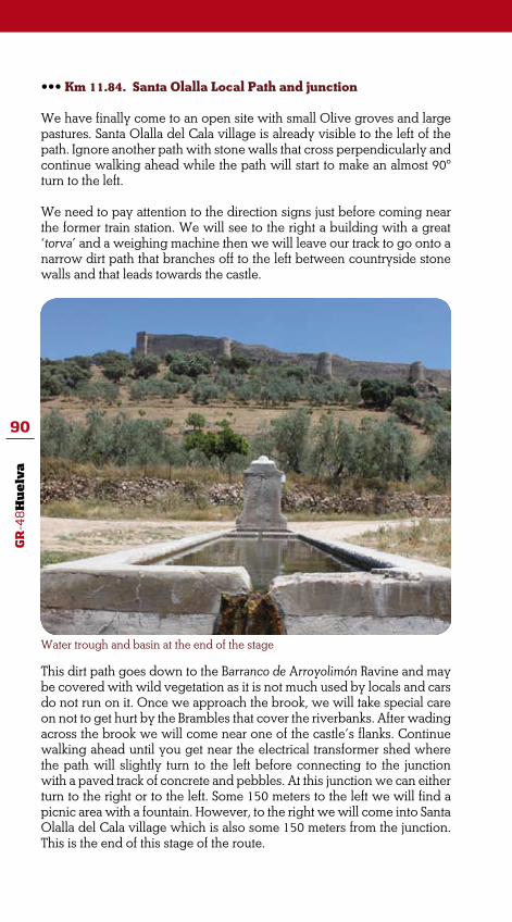
GR
-48
Hu
elv
a
90
••• Km 11.84. Santa Olalla Local Path and junction
We have finally come to an open site with small Olive groves and large pastures. Santa Olalla del Cala village is already visible to the left of the path. Ignore another path with stone walls that cross perpendicularly and continue walking ahead while the path will start to make an almost 90º turn to the left.
We need to pay attention to the direction signs just before coming near the former train station. We will see to the right a building with a great ‘torva’ and a weighing machine then we will leave our track to go onto a narrow dirt path that branches off to the left between countryside stone walls and that leads towards the castle.
Water trough and basin at the end of the stage
This dirt path goes down to the Barranco de Arroyolimón Ravine and may be covered with wild vegetation as it is not much used by locals and cars do not run on it. Once we approach the brook, we will take special care on not to get hurt by the Brambles that cover the riverbanks. After wading across the brook we will come near one of the castle’s flanks. Continue walking ahead until you get near the electrical transformer shed where the path will slightly turn to the left before connecting to the junction with a paved track of concrete and pebbles. At this junction we can either turn to the right or to the left. Some 150 meters to the left we will find a picnic area with a fountain. However, to the right we will come into Santa Olalla del Cala village which is also some 150 meters from the junction. This is the end of this stage of the route.

GR
-48
Hu
elv
a
91
Minas de Teuler Site and the railway
••• The Sierra de Aracena y Picos de Aroche Mountain Range is an area rich in iron ore. There are several mines in the region such the Minas de Cala Site or the Coto Minero de Teuler which is located in Santa Olalla municipality.
This rich iron ore is the result from the contact metamorphism between the plutonic rocks of the granite batholiths in Santa Olalla and the limestone rocks that do-minate the nearby areas. A large range of iron ore such magnetite rocks and chalcopyrite minerals emerged from that contact meta-morphic aureole.
The Coto Minero de Teuler Site comprises nine mines. At the beginning of the 19th Century, this mining site together with the Minas de Cala one became very
productive and a mine railway was built to rolling transport the ore to the inland port of Seville. The 18 kilometres railway line connected the Zufre Station to the Minas de Teuler Site while also passing by Santa Olalla village. Today, a sec-tion of the GR-48 Trail matches a large section of this former railway line.
The railway line was in operation throughout the first third of the 20th Century and until 1933 when the mining site became less pro-fitable and transportation of ore, goods and passengers was cance-lled. In years of zero profitability, the site was managed and owned by the Compañía Minero Andaluza del Andévalo Mining Company un-til 1982 when the company closed down and the mine was totally abandoned.

GR
-48
Hu
elv
a
92
STAGE 8
SANTA OLALLA DEL CALA (HUELVA) /REAL DE LA JARA (SEVILLA)This final stage of the trail will match many paths and tracks which are silent witnesses of the hard work up in the highlands. Step by step our trail will fit into a valley with an interesting history to continue ahead through pastures while passing by old farmhouses where the spirits of the highlands still prevail. The natural site known as Rivera de Cala is at the time the middle of this stage and the border between Seville and Huelva provinces. The trail will go through this natural site for a while and we will have a wonderful opportunity to enjoy hiking in a beautiful riparian landscape.
The trail will go through acorn-rich pastures and meadows which are also the cause of so many exquisite delicatessens at the table. Most pas-tures may be well protected by countryside stone walls resulting from a tiring geological life.
The direction is mainly SW-NE through a soft profile which is descending in the first half of the stage to finish with a gently climbing. This is an easy walk suitable for hiking and cycling even some sections may be hard to accomplish on the bike. The trail is well marked and hardly we will get lost. Nevertheless, we should pay attention to the direction signs especially at some points where the track changes direction.
Many are the attractive features we may come across along the trail. Perhaps the most interesting one is the peculiar geology of the area which has deeply shaped the region’s history, culture, ethnography and natural world
Enviroment: Severity of the natural environment.Track Features: Difficulty in following the track.
2
2
2
2
Orientation: Guidance on the route directions.
Struggle: Struggle required for accomplishing the route.
Difficulty: MIDE evaluation
Start: Santa Olalla del Cala (Huelva)Finish: Real de la Jara (Seville)Distance: 13 km Time: 5 hours
Suitability:
*Mountain biking in some sections.

GR
-48
Hu
elv
a
93
ROUTE GENERAL DESCRIPTION
Santa Olalla del Cala is located at the ‘Sierra de Aracena y Picos de Aro-che’ region. This small highland town is set in a strategic crossing point between Extremadura and Andalucía territories as well as between Huel-va and Seville provinces.
In addition, this small town is fully located in the ‘Ruta de la Plata’ Route. This traditional cattle route facilitated an impressive growth of the town in the past because of the constant transit of goods and especially mine-rals from the nearby mining sites.
Santa Olalla del Cala Castle clearly tells us about the culture in a border region. From a time before the Romans Empire and especially throughout the Middle Ages, most pastures in the region witnessed many battles and fights. The Spanish word for pasture is ‘dehesa’. Apparently the term co-mes from the word ‘defensa’ (defence) since forests were cleared in order to elude any undesirable ambushes from the enemy.
This last stage of the GR-48 Trail starts off at the stone bridge located out-
Plaza de la Constitución Square at Santa Olalla del Cala village

GR
-48
Hu
elv
a
94
side the village and at the Almadén de la Plata Road (HU-9116 road). We will get to the bridge from Almadén Street which branches off from the Ruta de la Plata Road (N-630 road). This road is the southern access to the village and it is opposite to a factory of Iberian ham and sausages.
The trail moves away from the village and follows up the road which soon will be surrounded by the nearby large pastures of Holm Oaks and Cork Oaks. One easily imagines the close relation established between the town and some exceptional natural sites which from centuries have provided for the pantries in the region and other areas. A good example is the Iberian pig farm to the left of the road and near the Casa de Silva farmhouse.
The trail goes beneath the motorway known as Autovía Ruta de la Plata (A-66/E-803 motorway) and continues ahead until a roundabout where we will chose the Almadén de la Plata direction. Some 100 meters after a dirt path branches off from the left. Remove any trace of tar from your boots and forget about the bustle of the urban area before start walking on this new dirt path.
••• Km 0.8. Beginning of the Camino de Almadén Path and the Valle del Muchacho Valley
The dirt path is a traditional path known as ‘Camino de Almadén’. The path climbs down and between dry stone walls which are silent witnesses of the many comings and goings of thousands walkers. The dry stone walls stand up solemnly, taking pride in the highland hands for they were built. These walls constitute a particular habitat for many insects, reptiles, small birds and small mammals. They appear to be a scale representation of those massive rocky outcrops up in the highlands which are home to bigger animals.
Extensive livestock farming is very common in the region

GR
-48
Hu
elv
a
95
Pastures of Holm Oaks and Cork Oaks will be our companion until we get to the Valle del Muchacho Valley. Apparently, the name of the valley comes from a terrible incident happening in the area time ago. According to the legend, in times of wolves a young man was on his way back to the village after being working all day up in the mountain. The young man and his donkey were travelling on this same path when a herd of wolves stalked and then attacked them, giving death first to the man’s donkey and killing the young man after. We might say that the irreproachable wild instinct of the animals gave name to this beautiful natural site.
Rocks outcropping at the pastures in the Valle del Muchacho Valley
Sheep herds grazing in the pasture
The trail continues ahead and goes across a country fence while passing by and to the right a countryside house with the name of the valley inscri-bed on the front. The trail continues descending and matches a dirt path that winds under Holm Oaks. We will leave behind and to the left a small farmyard with a nice well curb. The path continues parallel to a seasonal brook known as Barranco Marín Brook which left bank is flanked by the dry stone wall of the farmyard that we have just left behind.

GR
-48
Hu
elv
a
96
As the walk progresses, it will be interesting to take a look at the land- scape on both sides of the track. The path itself appears to be the division line between two slightly different pastures. To the right side trees grow on a clean surface without stones whereas to the left the bulky trunks wrench in order to avoid great rocks. Those big rocks are tonalites which shape to the granite landscape and reveal the presence ahead of a mas-sive rock outcropping known as Plutón de Santa Olalla del Cala. This is a geological structure formed by the solidification of the magma rocks that emerge from the bottom of the earth.
Perhaps those deep hollows created by the stone formations were the above mentioned Wolves’ lairs. At present time Wolves are not longer living in the area. However, this is home to Foxes, Badgers, Mongoose, Genets and Garden Dormice; all they discreetly do their things with a great effort while looking for food in the nearby pastures.
The trail continues parallel to the brook and gets to another country fencing that must remain closed behind us preventing sheep and cattle from going into the riverbed and out of the Country Estate. At this point, the path turns into a most irregular surface due to water erosion. Some 150 meters after crossing the fencing, the stone wall which has all time been parallel to the brook makes a 90º turn yet we will carry on walking on the path which will take us to the left side of the brook. Pastures on this area appear to be regenerating the vegetation. There are many Ilex undergrowth and bushes known as ‘chirpiales’. In fact, they are young Holm Oaks sprouting out from the roots of other mature specimens. The Mediterranean undergrowth on the pasture comprises Rockroses, Purple Phlomis and White Spanish Brooms all them away from the cattle cutting or lopping their lower branches.
The trail will wade across the brook again to get to the riverbank on the right. From there the trail turns into a dirt path and passes by a group of
White Rockroses are the ideal food for some species of insects, reptiles and birds

GR
-48
Hu
elv
a
97
burnt trees to the left and a Country Estate gate to the right. After wading across another seasonal brook which is also tributary to the previous one, the trail will continue ahead this time on the left side while moving di-rectly away from the brook and gently downhill.
We will continue along this new path that will pass by a small artificial pond where both farm and wild animals come to drink. This element reveals the characteristic seasonal variation of the Mediterranean climate. In autumn and winter time, brooks and other small water streams water in the pond banks. However, water flow reduces almost completely by the end of the spring time to finally impose a most aggressive thirst during the long summer.
As the walk progresses, we will leave to the South the Monte de los Ca-bezos Hill with its hillsides covered of great Holm Oaks and Cork Oaks shading and where still some vegetation regeneration can be perceived.
••• Km 3.3. Country Estate gate by the farmyard at El Berrocal Na-tural Site
The trail gets at another Country Estate gate located by an old country house and a farmyard. After crossing the gate and to the right, we will have an open pasture landscape which horizon is totally made of sharp angular rocks resembling a knives collection.
Stork
Some round shaped rocks are now spattering the pasture land and crop-ping out between the Oak trees. Those peculiar rocks are called ‘berrue-cos’. Natural sites like this with this type of rock formations are known as ‘berrocales’, herein the name of the site. Berrocales are the result of the natural decomposition of the rock. The homogeneous composition of the

GR
-48
Hu
elv
a
98
rock tends to transform into spherical shape as the rock itself erodes.
Continue on the same trail avoiding another path than branches off from the right and that will get to another artificial pond. The path surface will soon become a former stone pavement. The path makes its way along a pasture land of slightly thicker vegetation with many artificial ponds located by the track. The many metallic troughs scattering the place are a clear sign of bovine cattle in the area. Our walk pace will undoubtedly be determined by the sound of the animals’ bells.
From this point forward, we must pay attention to the direction signs as the trail will branch off right at the artificial pond with a water tank and a small building nearby. In here, we will take on a new path that heads east while coming into flat woodland.
Without leaving the track, we will reach up to an area from where just in front of us and under the tops of the Oaks, we will be able to have a glimpse to the Rivera de Cala staggering vegetation. Next we will turn right until we get to two Country Estate gates. We will go across the one that take us by an old watermill on the river shore. This appears to be a beautiful place for breaking.
••• Km 4.5. Rivera de Cala Natural Site
We can imagine how important this old watermill was in other times just looking at the remains of it. Today, this magnificent building appears to collapse in front of us. However, it is easy to believe that many fa-milies were fed in the past thanks to the force of the river waters. The lush vegetation at the healthy riverbanks will change their features ac-cord- ing to seasons yet walkers will be always delighted by a rich ri-verside vegetation comprising Tamujos, Oleanders, Rushes, Brambles,
The remains of a former watermill near the Rivera de Cala Natural Site

GR
-48
Hu
elv
a
99
White Hawthorns, Ash-Trees and some Black Poplars which appear to be stretching up to touch the sky.
We will continue walking upstream and on the left side of this linear ecosystem. Now the path becomes more irregular and harder to follow on mountain bike. If we were riding a bike, we should now get down of it
Collecting wild Mushrooms in the Rivera de Cala Natural Site is a quite common activity
and carry on walking on this section of the track. It will keep our attention the amazing irregular shape of many stones which are in the river and the riverbanks alternating with the riparian vegetation.
We will pass by the ‘cao’, the channel that provided water to the water-mill that we have left behind, to get to an area where the river widens and where is the mill pond from where water was diverted to the channel and then to the watermill.
In the warmer season, we may take a break and refresh ourselves at the river shores. Surrounded by this fairy riparian vegetation and river forest, we will get enough energy to negotiate the second half of the route.
We will continue walking upstream and, after passing by a picnic area we will meet a small waterfall. At this point, we will turn to the left to keep walking on the edge of the road until we get to the bridge of the former road that connects Santa Olalla del Cala and El Real de la Jara villages.
We will have a breathtaking view of the river riverbanks from the bridge. The gradient of dampness marked by the river can be easily identified by bands of vegetation which occupy different areas by the river according to their irrigation needs. So we will see Tamujos, Oleanders and Black
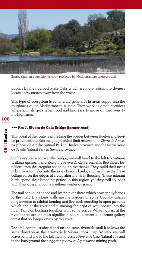
GR
-48
Hu
elv
a
100
Scarce riparian vegetation is soon replaced by Mediterranean undergrowth
poplars by the riverbed while Oaks which are more resistant to dryness locate a few metres away from the water.
This type of ecosystem is so far a life generator in areas supporting the roughness of the Mediterranean climate. They work as green corridors where animals get shelter, food and find easy to move on their way to the highlands.
••• Km 7. Rivera de Cala Bridge (former road)
This point of the route is at the time the border between Huelva and Sevi-lle provinces but also the geographical limit between the Sierra de Arace-na y Picos de Aroche Natural Park in Huelva province and the Sierra Norte de Sevilla Natural Park in Seville province.
On having crossed over the bridge, we will bend to the left to continue walking upstream and along the Rivera de Cala riverbank. Bee-Eaters be-nefices from the irregular shape of the riverbanks. They build their nests in burrows tunneled into the side of sandy banks, such as those that have collapsed on the edges of rivers after the river flooding. These migrant birds spend their breeding period in this region yet they will fly back with their offspring to the southern winter quarters.
The trail continues ahead and by the river shore which now gently bends to the right. Dry stone walls are the borders of some Country Estates fully devoted to rainfed farming and livestock breeding in open pastures which end at the river and sustaining the right of way posses into the river. Tamujos bushing together with some scarce White Poplars at the river shores are the most significant natural element of a former gallery forest that no longer exists by this river.
The trail continues ahead and on the same riverside until it follows the same direction as the Arroyo de la Víbora Brook. Step by step, we will leave behind and to the left the impressive Rivera de Cala Natural Site and in the background the staggering view of Aguablanca mining pitch.

GR
-48
Hu
elv
a
101
The Little Owl is a common bird at these pastures l
This section of the stage is the border between Andalucía and Extremadu-ra regions. This border does not affect to the wild animals’ behaviour. The region is home to many animal species such Herons and Storks that come to feed themselves at the meadows by the river which are also home to Frogs and Toads.
The path will wade across the river at the Cortijo de Rufinito farmhouse to continue ahead and in the same direction but on the opposite shore. The round-shaped stepping stones in the river will help us to reach the other riverbank though.
After some 500 metres, the path moves away from the river bank to conti-nue on a countryside road that branches off to the right and that will lead us towards El Real de la Jara village. The trail then matches a section of the Camino de Aguablanca path which slightly climbs up until the outside of the village. From this point we will see some buildings at La Encina Indus-trial Estate as well as the first houses at Murillo Street. This will be the end of this last stage and therefore of the GR-48 Trail.
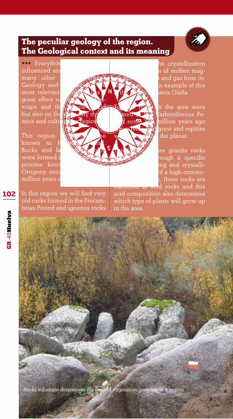
GR
-48
Hu
elv
a
102
The peculiar geology of the region. The Geological context and its meaning••• Everything around us is influenced and determined by many other factors. Perhaps Geology and Climate are the most relevant. Geology has a great effect not only on land- scape and the natural world but also on the economy dyna-mics and culture of a region.
This region is in the zone known as Hesperic Massif. Rocks and landscape profile were formed in a compression process known as Variscan Orogeny occurring some 350 million years ago.
In this region we will find very old rocks formed in the Precam-brian Period and igneous rocks
resulting from the crystallization and solidification of molten mag-ma (melted rocks and gas from in-side the earth). An example of this is the Plutón de Santa Olalla.
Tonalite rocks in the area were formed in the Carboniferous Pe-riod some 300 million years ago when ferns first grew and reptiles were occupying the planet.
Tonalite rocks are granite rocks which went through a specific process of cooling and crystalli-zation. Because of a high concen-tration of silicate, these rocks are classified as acid rocks and this acid composition also determines which type of plants will grow up in the area.
Rocks substrate determines the type of vegetation growing in a region

GR
-48
Hu
elv
a
103
ARROYOMOLINOS DE LEÓN
••• Accommodation
CORTIJO LOS BOGONALES Finca El Pozuelo 21280 Arroyomolinos de León 689 710 401
••• Active Tourism
ALMA NATURA EDUCACIÓN, OCIO Y TIEMPO LIBRE, S.L.L C/ Ánimas, 1 21280 Arroyomolinos de León 959 197 729
CALA
••• Accommodation
LA CAÑÁ DEL CORCHUELO Paraje Javata, s/n 21270 Cala 959 191 383
••• Restaurants
LAS TRES ENCINAS
Urbanización Juan del Cid Calonge 21270 Cala 630 382 402
ROMERO C/ Corazón de Jesús, 44 21270 Cala 959 106 103
USEFUL INFORMATION

GR
-48
Hu
elv
a
104
CUMBRES DE SAN BARTOLOMé
••• Accommodation
LA FONDA DEL CASTILLO C/ Castillo, s/n 21386 Cumbres de San Bartolomé 959 721 133
••• Restaurants
BAR RESTAURANTE PERICO C/ Monjas, 1 21386 Cumbres de San Bartolomé 606 948 510
CUMBRES MAYORES
••• Accommodation
MAYMA Paseo de Andalucía, 14 21380 Cumbres Mayores 959 710 592
••• Restaurants
LAS CABAÑAS Finca La Lancha, Km. 2 21380 Cumbres Mayores 959 710 372
MAYMA C/ Andalucía, 14 21380 Cumbres Mayores 959 710 592
MESÓN PATA CHICA C/ Antonio Machado, 1 21380 Cumbres Mayores

GR
-48
Hu
elv
a
105
ENCINASOLA
•••Accommodation
UMBRÍA LA VÍBORA Ctra. Encinasola- La Nava, Km. 20,3 21390 Encinasola 607 609 606
RINCÓN DEL ABADE C/ Llano de San Juan, s/n 21390 Encinasola 959 714 536
•••Restaurants
BARRILITO
C/ Portugal, 1 21390 Encinasola 959 714 455
EL RINCÓN
Plaza Mayor, 5 21390 Encinasola
EMIGRANTE
C/ Portugal, 2 21390 Encinasola 959 714 154
RINCÓN DEL ABADE
C/ Llano de San Juan, s/n 21390 Encinasola 959 714 536
HINOJALES
•••Accommodation
SIERRA TORTOLA
C/ Arriba, 8 21389 Hinojales 959 722 731

GR
-48
Hu
elv
a
106
•••Restaurants
SIERRA TORTOLA
C/ Arriba, 6-8 21389 Hinojales 959 722 731
SANTA OLALLA DEL CALA
•••Accommodation
CASA OLALLA
Avenida de Andalucía, 60 21260 Santa Olalla del Cala 959 190 559
LOS SAUCES
Ctra. 630, Km. 755,5. Paraje Cuartón. Dehesa Los Sauces. 21260 Santa Olalla del Cala 618 710 297
CARMELO
C/ Marina Española, 23 21260 Santa Olalla del Cala 959 190 169
•••Restaurants
CARMELO
C/ Marina Española, 23 21260 Santa Olalla del Cala
MESÓN RÚSTICO LA éPOCA
Avda. Marina Española, 46 21260 Santa Olalla del Cala 959 190 100

GR
-48
Hu
elv
a
107
PRIMITIVO
C/ Marina Española, 3 21260 Santa Olalla del Cala 959 190 052
AURELIA
Ctra. Sevilla-Mérida, Km. 408 21260 Santa Olalla del Cala 959 190 202
••• Active Tourism
TEULER AVENTURA, S.L
C/ Blas Infante, 2 21260 Santa Olalla del Cala 670 332 390

GR
-48
Hu
elv
a
108
LIST OF SPECIES
FLORA
•••The plants world
Blue Bedder (Echium plantagineum)Bramble (Rubus ulmifolius)Broom (Retama sphaerocarpa)Bulrush (Typha latifolia)Buttercup (Ranunculus sp.)Canary Sticky Broom (Adenocarpus telonensis)Common Hawthorn (Crataegus monogyna)Common Smilax (Smilax aspera)Dandelion (Taraxacum officinale)Fern (Pteridium aquilinum)Flax-Leaved Daphne (Dagne gnidium)Foxglove (Digitalis purpúrea)French Lavender (Lavandula stoechas)Gorse (Genista hirsuta)Greasy/Gum Rockrose (Cistus ladanifer)Gurumelo (Amanita ponderosa)Laurustinus (Viburnum tinus)Lesser Calamint (Calamintha nepetta)Mastic Thyme (Thymus mastichina)Mastic Tree (Pistacea lentiscus)MossMyrtle (Mirtus communis)Navelwort (Umbilicus pendulinus)Oleander (Nerium oleander)Peony (Paeonia broteroi)Pine (Pinus sp.)Prickly Pear Cactus (Opuntia ficus-carica)Purple Phlomis (Phlomis purpurea)Reed (Juncus sp.)Rosemery (Rosmarinus officinalis)Sage (Salvia)Sageleaf Rockrose (Cistus salvifolius)Strawberry Tree (Arbutus unedo)Tamujo (Flueggea tinctorea)Terebinth Tree (Pistacia terebintus)Wavyleaf Mullein (Verbascum sinuatum)White/Steppe Rockrose (Cistus albidus)White Spanish Broom (Cytisus multiflorus)Wild Asparagus (Asparagus acutifolia)Wild Carnation (Dianthus lusitanicus)

GR
-48
Hu
elv
a
109
•••Trees
Almond Tree (Prunus dulcis)Ash-Tree (Fraxinus excelsior)Black Poplar (Populus nigra)Common Hawthorn (Crataegus monogyna)Common/White Mulberry (Morus alba)Cork Oak (Quercus suber)Eucalyptus Tree (Eucaliptus globulus)Fig Tree (Ficus carica)Holm Oak / Ilex (Quercus ilex)Italian Stone Pine (Pinus pinea)Kermes Oak (Quercus coccifera)Narrow-Leaved Ash (Fraxinus angustifolia)Olive Tree (Olea europea)Orange Tree (Citrus sinensis)Pommegranate Tree (Punica granatum)Portuguese Oak (Quercus faginea)Sweet Chestnut Tree (Castanea sativa)Walnut Tree (Juglans regia)White Poplar (Populus alba)Wild Iberian Pear Tree (Pyrus bourgaeana)Wild Olive Tree (Olea europea silvestris)Willow Tree (Salix alba)
THE ANIMAL WORLD
•••Birds
Beaudouin’s Snake Eagle (Circaetus gallicus)Bee-Eater (Merops apiaster)Black Kite (Milvus migrans)Black Sork (Ciconia nigra)Black Vulture (Aegypius monachus)Blue Rock-Thrush (Monticola solitarius)Blue Tit (Parus caeruleus)Bonelli´s Eagle (Hieraaetus fasciatus)Booted Eagle (Hieraetus pennatus)Common Buzzard (Buteo buteo)Chaffinch (Fringilla coelebs)Great Tit (Parus major)Common Kestrel (Falco tinnunculus)Common Nightingale (Luscinia megarhynchos)Common Redstart (Phoenicurus phoenicurus)Common Swift (Apus apus)Common Wood Pigeon (Columba palumbus)Corn Bunting (Miliaria calandra)

GR
-48
Hu
elv
a
110
Egyptian Vulture (Neophron percnopterus)Eurasian Crag Martin (Ptyonoprogne rupestris)Eurasian Eagle-Owl (Bubo bubo)Eurasian Wryneck (Jynx torquilla)Golden Eagle (Aquila chrysaetos)Golden Oriole (Oriolus oriolus)Goldfinch (Carduelis carduelos)Great Tit (Parus major)Red-Rumped Swallow (Hirundo daurica)Greenfinch (Carduelis chloris)Grey Heron (Ardea cinerea)Griffon Vulture (Gyps fulvus)Hawfinch (Coccothraustes coccothraustes)Hoopoe (Upupa epops)Lesser Spotted Woodpecker (Dendrocopos minor)Little Grebe (Tachybaptus ruficollis)Little Owl (Athene noctua)Long-Tailed Tit (Aegithalo caudatus)Mallard (Anas platyrhynchos)Mistle Thrush (Turdus viscivorus)Montagu’s Harrier (Circus pygargus)Orphean Warbler (Sylvia hortensis)Red Kite (Milvus milvus)Red-Rumped Swallow (Hirundo rustica)Redwing (Turdus iliacus)Rock Bunting (Emberiza cia)Rock Sparrow (Petronia petronia)Song Thrush (Turdus philomelos)Spotted Flycatcher (Muscicapa striata)Stork (Ciconia ciconia)Thekla Lark (Galerida theklae)
•••Mammals
Badger (Meles meles)Common Genet (Genetta genetta)Deer (Cervus elaphus)Egyptian Mongoose (Herpestes ichneumon)Fox (Vulpes vulpes)Garden Dormouse (Eliomys quercinus)Iberian Pig (Sus scrofa ssp. domestica)Otter (Lutra lutra)Wild Boar (Sus scrofa)

GR
-48
Hu
elv
a
111
•••Fish
Common Iberian Barbel (Barbus bocagei)European Eel (Anguilla anguilla)Iberian Barbel (Luciobarbus comiza)Iberian Nase (Chondostroma polylepis)Iberian-Roach (Tropidophoxinellus alburnoides)Jarabugo (Anaecypris hispanica)Lake Trout (Luciobarbus microcephalus)Pardilla (Rutilus lemmingii)
•••Anphibians
Common Toad (Bufo bufo)Water Frog (Pelophylax perezi)

GR
-48
Hu
elv
a
112

GR
-48
Hu
elv
a
113

GR
-48
Hu
elv
a
114
The GR-48 ‘Sierra Morena’ Path covers some 590 kilometers through the provinces of Huelva, Sevilla, Córdoba and Jaén in Andalucía although the route starts off at Barrancos, a small village in Portugal.
Four different rough guides have been produced for a better understanding and interpretation of this long distance trail. Each guide suits each one of the provinces covered by the GR-48 Path.
This one is about the 110 kilometers through the Province of Huelva. This is an 8 stages route through the Sierra de Aracena y Picos de Aroche Natural Park. The trail matches some important traditional paths and tracks in the region. The landscape comprises a large variety of lush Mediterranean wood and un-dergrowth together with pastures fully devoted to livestock farming. This is a region where tradition and Nature still relate harmoniously; where people incorporate natural values to their own lifestyle and personal development. Definitively, hiking in Sierra de Aracena y Picos de Aroche region will be an unforgettable experience.


