U.S. Department of the Interior U.S. Geological Survey Scientific Investigations Report 2016–5116 A product of the Water Use and Availability Science Program Simulating Groundwater Flow in Karst Aquifers with Distributed Parameter Models— Comparison of Porous-Equivalent Media and Hybrid Flow Approaches
Transcript
U.S. Department of the InteriorU.S. Geological Survey
Scientific Investigations Report 2016–5116
A product of the Water Use and Availability Science Program
Simulating Groundwater Flow in Karst Aquifers with Distributed Parameter Models—Comparison of Porous-Equivalent Media and Hybrid Flow Approaches
Cover. Background: Photograph of karst outcrop of Ocala Limestone, Eocene age, Ozello Archipelago, Gulf of Mexico, Citrus County, Florida (photograph by Alan M. Cressler, U.S. Geological Survey). Inset: Cross-sectional view of the main vent at Wakulla Spring (modified from Kincaid, 1999).
Simulating Groundwater Flow in Karst Aquifers with Distributed Parameter Models—Comparison of Porous-Equivalent Media and Hybrid Flow Approaches
By Eve L. Kuniansky
A product of the Water Use and Availability Science Program
Scientific Investigations Report 2016–5116
U.S. Department of the InteriorU.S. Geological Survey
U.S. Department of the InteriorSALLY JEWELL, Secretary
U.S. Geological SurveySuzette M. Kimball, Director
U.S. Geological Survey, Reston, Virginia: 2016
For more information on the USGS—the Federal source for science about the Earth, its natural and living resources, natural hazards, and the environment—visit http://www.usgs.gov or call 1–888–ASK–USGS.
For an overview of USGS information products, including maps, imagery, and publications, visit http://store.usgs.gov.
Any use of trade, firm, or product names is for descriptive purposes only and does not imply endorsement by the U.S. Government.
Although this information product, for the most part, is in the public domain, it also may contain copyrighted materials as noted in the text. Permission to reproduce copyrighted items must be secured from the copyright owner.
Suggested citation:Kuniansky, E.L., 2016, Simulating groundwater flow in karst aquifers with distributed parameter models—Comparison of porous-equivalent media and hybrid flow approaches: U.S. Geological Survey Scientific Investigations Report 2016–5116, 14 p., http://dx.doi.org/10.3133/sir20165116.
The U.S. Geological Survey (USGS) conducted this applied research into the application of the MODFLOW-Conduit Flow Process at the Woodville Karst Plain with the voluntary assistance of Josue J. Gallegos, a graduate student of Dr. Bill X. Hu at Florida State University. As part of his Master’s thesis, Josue converted a USGS MODFLOW model of the area developed by Hal Davis (retired USGS) into a hybrid model using the MODFLOW-Conduit Flow Process with assistance from Hal Davis, Eve Kuniansky, and Barclay Shoemaker (USGS). This report and the companion data release are funded by the Water Use and Availability Science Program of the USGS.
The manuscript was improved by peer reviews from Angel Martin, retired USGS, and Michael Bradley, USGS. Additional reviews, comments, and editing were provided by Jason Bellino, Sandra Cooper, Devin Galloway, Michael Lewis, David Sumner, and Kim Waltenbaugh, all USGS, who helped improve its content. Caryl Wipperfurth, USGS, is thanked for the illustration and final layout of the report. Alan Cressler, USGS, is greatly appreciated for providing the photo-graph used on the cover of the report.
Single-Continuum Porous-Equivalent Models—The Sponge .......................................................3Dual-Continuum Porous-Equivalent Models—Two Linked Sponges...........................................4Hybrid Models—The Sponge with Pipes .........................................................................................5Discrete Single and Multiple Fracture or Pipe Network Models .................................................5
Model Application in the Woodville Karst Plain, Florida—Comparisons of Single-Continuum and Hybrid Models ...........................................................................................................................5
1. Diagram showing approaches to karst modeling with distributed parameter models and some stochastic methods for developing fracture or pipe networks, where the networks are simulated with flow equations for fractures or pipes ....................................3
2. Map showing simulated hydraulic conductivity in model layer 2 with large hydraulic conductivity located at submerged conduits for approaches 1 and 3, Woodville Karst Plain, Florida .....................................................................................................7
3. Map showing steady-state post-development simulated potentiometric maps of model layer 2 in the Woodville Karst Plain, Florida ............................................................8
4. Graph showing simulated and observed springflow at Wakulla Springs, Florida .............9
Conversion Factors U.S. customary units to International System of Units
Multiply By To obtain
Lengthfoot (ft) 0.3048 meter (m)mile (mi) 1.609 kilometer (km)
Flow ratefoot per day (ft/d) 0.3048 meter per day (m/d)cubic foot per second (ft3/s) 0.02832 cubic meter per second (m3/s)
Temperature in degrees Celsius (°C) may be converted to degrees Fahrenheit (°F) as follows:
°F = (1.8 × °C) + 32.
Temperature in degrees Fahrenheit (°F) may be converted to degrees Celsius (°C) as follows:
°C = (°F – 32) / 1.8.
v
Datum
Vertical coordinate information is referenced to the National Geodetic Vertical Datum of 1929 (NGVD 29).
Horizontal coordinate information is referenced to the North American Datum of 1983 (NAD 83).
Altitude, as used in this report, refers to distance above the vertical datum.
Supplemental Information
Transmissivity: The standard unit for transmissivity is cubic foot per day per square foot times foot of aquifer thickness [(ft3/d)/ft2]ft. In this report, the mathematically reduced form, foot squared per day (ft2/d), is used for convenience.
Abbreviations
CFP Conduit Flow Process
DCPE Dual-Continuum Porous-Equivalent Model
DMFS Discrete Multiple Fracture Set Model
DSFS Discrete Single Fracture Set Model
FAS Floridan Aquifer System
GUI Graphic User Interface
HM Hybrid Model
K Hydraulic Conductivity
SCPE Single-Continuum Porous-Equivalent Model
SWMM Storm Water Management Model
USGS U.S. Geological Survey
WKPP Woodville Karst Plain Project
Simulating Groundwater Flow in Karst Aquifers with Distributed Parameter Models—Comparison of Porous-Equivalent Media and Hybrid Flow Approaches
By Eve L. Kuniansky
AbstractUnderstanding karst aquifers, for purposes of their
management and protection, poses unique challenges. Karst aquifers are characterized by groundwater flow through con-duits (tertiary porosity), and (or) layers with interconnected pores (secondary porosity) and through intergranular porosity (primary or matrix porosity). Since the late 1960s, advances have been made in the development of numerical computer codes and the use of mathematical model applications towards the understanding of dual (primary [matrix] and secondary [fractures and conduits]) porosity groundwater flow processes, as well as characterization and management of karst aquifers. The Floridan aquifer system (FAS) in Florida and parts of Alabama, Georgia, and South Carolina is composed of a thick sequence of predominantly carbonate rocks. Karst features are present over much of its area, especially in Florida where more than 30 first-magnitude springs occur, numerous sinkholes and submerged conduits have been mapped, and numerous circular lakes within sinkhole depressions are present. Different types of mathematical models have been applied for simulation of the FAS. Most of these models are distributed parameter mod-els based on the assumption that, like a sponge, water flows through connected pores within the aquifer system and can be simulated with the same mathematical methods applied to flow through sand and gravel aquifers; these models are usually referred to as porous-equivalent media models. The partial dif-ferential equation solved for groundwater flow is the potential flow equation of fluid mechanics, which is used when flow is dominated by potential energy and has been applied for many fluid problems in which kinetic energy terms are dropped from the differential equation solved. In many groundwater model codes (basic MODFLOW), it is assumed that the water has a constant temperature and density and that flow is laminar, such that kinetic energy has minimal impact on flow. Some models have been developed that incorporate the submerged conduits as a one-dimensional pipe network within the aquifer rather than as discrete, extremely transmissive features in a porous-equivalent medium; these submerged conduit models are usually referred to as hybrid models and may include the
capability to simulate both laminar and turbulent flow in the one-dimensional pipe network. Comparisons of the application of a porous-equivalent media model with and without turbu-lence (MODFLOW-Conduit Flow Process mode 2 and basic MODFLOW, respectively) and a hybrid (MODFLOW-Conduit Flow Process mode 1) model to the Woodville Karst Plain near Tallahassee, Florida, indicated that for annual, monthly, or seasonal average hydrologic conditions, all methods met calibration criteria (matched observed groundwater levels and average flows). Thus, the increased effort required, such as the collection of data on conduit location, to develop a hybrid model and its increased computational burden, is not neces-sary for simulation of average hydrologic conditions (non-laminar flow effects on simulated head and spring discharge were minimal). However, simulation of a large storm event in the Woodville Karst Plain with daily stress periods indicated that turbulence is important for matching daily springflow hydrographs. Thus, if matching streamflow hydrographs over a storm event is required, the simulation of non-laminar flow and the location of conduits are required. The main challenge in application of the methods and approaches for developing hybrid models relates to the difficulty of mapping conduit networks or having high-quality datasets to calibrate these models. Additionally, hybrid models have long simulation times, which can preclude the use of parameter estimation for calibration. Simulation of contaminant transport that does not account for preferential flow through conduits or extremely permeable zones in any approach is ill-advised. Simulation results in other karst aquifers or other parts of the FAS may differ from the comparison demonstrated herein.
IntroductionUnderstanding karst aquifers, for purposes of their
management and protection, poses unique challenges. Since the 1960s, advances have been made in the development of numerical computer codes and the use of mathematical model applications towards the understanding of dual-porosity groundwater flow processes as well as the characterization and
2 Simulating Groundwater Flow in Karst Aquifers with Distributed Parameter Models
management of karst aquifers. The Floridan aquifer system (FAS) in Florida and in parts of Alabama, Georgia, and South Carolina is composed of a thick sequence of predominantly carbonate rocks (Miller, 1986; Williams and Kuniansky, 2015). Karst features are present over much of its area, espe-cially in Florida where more than 30 first-magnitude springs are present, numerous sinkholes and submerged conduits have been mapped, and numerous circular lakes within sinkhole depressions are found (Sinclair and Stewart, 1985; Arthur and others, 2007; Harrington and others, 2010; Williams and Kuniansky, 2015).
Different types of mathematical models can be applied to hydrologic and environmental problems in complex dual or triple (matrix, large pores, and submerged caverns) porosity karst aquifers. Depending on the types of data available and the problems identified, different mathematical techniques can be applied to solve identified problems. The naming of the types of mathematical models that have been applied to karst aquifers can be confusing because terminology has not been used consistently in the literature dealing with these models. This report describes distributed parameter models commonly applied for water-resource management in Florida. The most commonly applied distributed parameter code is MODFLOW, a code that solves the potential flow equation describing saturated groundwater flow (Harbaugh, 2005). Much of the general material on mathematical models presented herein was previously published in Kuniansky (2014) and has been summarized for this report. Application of a porous-equivalent media model with and without turbulence and a hybrid model (porous media with one-dimensional pipe network) were made for the Woodville Karst Plain near Tallahassee, Florida. Results from these applications described herein are presented in a manner that can be understood without a rigorous math-ematical definition in hopes that some of the concerns about when and how to apply distributed parameter models to the FAS can be better understood (Pittman, 2013). Kuniansky (2014) provides discussion of two other classes of mathemati-cal models that have been applied to karst aquifers: lumped parameter models and fitting models. A discussion of these two other mathematical model types is beyond the scope of this report.
Distributed parameter models typically are applied at a specific site once data have been collected to define and map the aquifers and confining units, to determine how much and where water enters and exits the aquifer system, and to provide water-level and flow observations for calibration of the site model. These data are used to define the hydrogeo-logic framework and develop a conceptual flow model for the application and finally for calibration of the site model. Most site models have limitations in their use and application result-ing from simplifications of the system, inadequate calibration data, or poorly understood system geometry and boundary conditions. It is beyond the scope of this report to discuss the documentation of models such that calibration criteria and limitations are fully documented. However, good resources
on this topic can be found in Anderson and others (2015) and Reilly and Harbaugh (2004).
The companion data release with all of the simulation input and output files discussed herein is available (Kuniansky, 2016). All simulations in the data release were rerun on new Windows 7 service pack 1 64-bit operating system with 16 megabytes of random access memory in 2016.
Distributed Parameter Models Distributed parameter models, also called determinis-
tic numerical models, are frequently applied to karst aquifer systems (Kuniansky and Holligan, 1994; Teutsch and Sauter, 1998; Kuniansky and others, 2001; Kuniansky and Ardis, 2004; Scanlon and others, 2003). These types of models are process oriented; however, all forces within the partial differential equations that describe unsteady fluid flow in three dimensions (Navier-Stokes equations) cannot be solved readily on a computer. The Navier-Stokes equations are coupled sets of partial differential equations that describe how pressure, temperature, density and viscosity of a moving fluid are related; the equations were derived based on the underlying principles of conservation of mass, energy, and momentum (Daily and Harleman, 1966).
Forces and processes that have negligible impact on the flow problem can be eliminated from the full set of Navier-Stokes equations such that a reduced equation or set of equations that includes the important physical process(es) are applied. In groundwater problems, flow is typically dominated by potential energy as reflected by the head gradient or poten-tiometric surface of an aquifer. The energy that would go into eddies or vortices within the water (kinetic energy losses from turbulence or non-laminar flow) is negligible for most ground-water flow problems as are differences in temperature, density, and viscosity. Thus, the potential flow equation, used in ground-water model codes such as the basic version of MODFLOW, assumes that flow is laminar and that temperature, density, and viscosity are constant over the model domain. Provided that the problem is reasonably well represented by these assump-tions, computational burden and simulation run times can be greatly reduced with little loss of accuracy in the solution. The potential flow equation has also been used in aerodynamics for flow of air over a wing; in thermodynamics for heat flow; in hydrodynamics for flow around objects in a stream and full pipe flow; and for the flow of electricity.
Distributed parameter models require dividing (discretiz-ing) the aquifer system into smaller representative three-dimensional volumes, such as finite-difference cells or finite elements. Depending on the scale of the study, representation of the karst aquifer may also be greatly simplified owing to limitations on the total number of finite volume cells or ele-ments that can be solved in a reasonable time on a computer. Thus, the greater the total area and thickness of the system simulated, the larger the cells or elements; which may be less
Distributed Parameter Models 3
representative of fine-scale features and require the use of composite hydraulic properties (Sepulveda and Kuniansky, 2009). The governing physical aquifer hydraulic proper-ties (parameters), such as storage, hydraulic conductivity, or transmissivity, are distributed spatially and allowed to vary in each model cell or element. Thus, the general name, distrib-uted parameter model, is widely applied to the mathematical modeling approaches discussed herein.
Various types of deterministic models have been applied to karst aquifers (fig. 1). The simplest approach is often referred to as the porous-equivalent media model approach (also called the single-continuum porous-equivalent [SCPE], heterogeneous continuum, distributed parameter, or smeared conduit model) (fig. 1). The SCPE is based on the assump-tion that flow in the aquifer system can be simulated with the potential flow equation of fluid mechanics.
Other distributed parameter approaches shown in figure 1 are the dual-continuum porous-equivalent model (DCPE), the hybrid model (HM), the discrete single fracture or pipe set model (DSFS), and the discrete multiple fracture or pipe set model (DMFS). The DCPE model links two flow regimes (two SCPEs) at each cell or element with a head-dependent water exchange term between sub-cells or sub-elements. Essentially with a DCPE, the flow within each cell volume representing a physical volume of the aquifer is simulated with two sub-cells that exchange flow with each other, with one sub-cell repre-senting the conduits and the other sub-cell representing flow in the rock matrix. The hybrid model (HM) couples a three-dimensional SCPE model with a discrete one-dimensional flowing fracture or pipe network (fig. 1, HM). The fracture set or pipe network modeling approaches shown in figure 1 may involve the stochastic generation of fracture or pipe networks; however, the networks, once generated, are simulated with equations for pipe or fracture flow. The discrete single fracture or pipe network set (DSFS) and discrete multiple fracture
or multiple pipe network set (DMFS) models are possible, but rarely applied for karst aquifers. The advantages and disadvantages of each modeling approach are described in the following sections.
An SCPE approach using the potential flow equation (which assumes laminar flow and constant temperature, density, and viscosity) is the simplest model to apply to the FAS. The FAS can be considered as composed of rocks with small openings in the rock matrix that are interconnected and that open into larger pores, much like the interior of a sponge. The SCPE approach has been applied for regional or sub-regional flow hydrologic and environmental problems in the FAS because the scale of investigation is much greater than the scale of the heterogeneities in the rocks (size of dissolution feature or units with varying water-transmitting properties). The SCPE approach has been successfully applied for water-resources investigations where the models can be calibrated to flow and head (water level) information and regional- or sub-regional-scale water budgets are sought (Bush and Johnston, 1988; Geraghty and Miller, Inc., 1991; Davis, 1996; Williams, 1997, 2006; McGurk, 1998; Teutsch and Sauter, 1998; Hydro-GeoLogic, Inc., 2000; Svensson, 2001; Knowles and others, 2002; McGurk and Presley, 2002; Sepulveda, 2002; Agyei and others, 2005; Davis and Katz, 2007; Grubbs and Crandall, 2007; Davis and others, 2010; Sepulveda and others, 2012). In general, the SCPE approach can simulate transient spring-flow for monthly or annual averages, but may not reproduce detailed storm-event hydrographs as well as other model types because of the onset of non-laminar flow during storms (Hill and others, 2010; Kuniansky and others, 2011; Gallegos and others, 2013; Saller and others, 2013; Kuniansky, 2014).
SCPESingle-
ContinuumPorous-
Equivalent
Deterministic approach
Investigation effort
Practical applicability
Capability to simulate heterogeneities
Small
High
Limited
High
Small
Good
Stochastic approach
DCPEDual-
ContinuumPorous-
Equivalent
HMHybridmodel
Figure 1.
DSFSDiscrete
SingleFracture
Set
DMFSDiscreteMultipleFracture
Set
Figure 1. Approaches to karst modeling with distributed parameter models (deterministic numerical models) and some stochastic methods for developing fracture or pipe networks, where the networks are simulated with flow equations for fractures or pipes (modified from Teutsch and Sauter, 1998).
4 Simulating Groundwater Flow in Karst Aquifers with Distributed Parameter Models
Simulations of advective transport using a single-continuum model are infrequently performed with varying degrees of success. Advective transport applications to karst aquifers that were able to match geochemical age estimates and tracer-test-derived times of travel based on an effective porosity of less than 5 percent rather than the physical porosity (which ranges from 15 to 40 percent for the FAS) are documented in Knochenmus and Robinson (1996); Kuniansky and others (2001); Merritt (2004); Renken and others (2005); Davis and others (2010). In these studies, groundwater flow volume (Darcy flux) was mainly governed by the model cell hydraulic conductivity and total model layer thickness. The effective porosity is used for calculation of a pore velocity that matches observed water age or times of travel from tracer tests. In some cases where conduit locations were known, the finite-difference cells or finite elements with conduits were assigned much greater hydraulic conductivity values than surrounding cells and were successful in reproducing transient spring discharge (annual, seasonal, or monthly average) and match-ing tracer-test-derived times of travel in part of the FAS (Davis and others, 2010). A similar attempt was not successful within the Edwards aquifer system in Texas (Lindgren and others, 2009), but was successful in the Fort Payne aquifer in Tennes-see, which is a less permeable karst aquifer than the Edwards aquifer system or the FAS (Haugh, 2006).
Finite-difference and finite-element methods have been widely applied to the modeling of karst systems. Finite-element methods allow for greater variation in element size than finite-difference methods, and streams, wells, and springs may be more accurately located with finite-element methods. If geologic structure creates varying orientations of dissolution features, thus creating anisotropy that varies over the aquifer domain, this anisotropy can be readily accommodated by using finite-element methods (Kuniansky and Lowther, 1993). How-ever, developing model datasets for a finite-element model is more complex than using a block-centered finite-difference scheme, and so a graphical user interface (GUI) is essential. As computer speeds have increased, so have the simulation speeds of large finite-difference model grids (for example, more than 1,000,000 active cells with grid spacing smaller than 1,000 feet [ft] for sub-regional-scale applications). Addi-tionally, MODFLOW simulations using packages such as the horizontal flow barrier package (Hsieh and Freckleton, 1993) have been used to incorporate geologic structure that reflects anisotropy rather than incorporating anisotropy directly into the flow equation (Lindgren and others, 2004). The new code for MODFLOW that allows unstructured grids (MODFLOW-USG) has many of the advantages of finite elements, but also requires a sophisticated GUI (Panday and others, 2013).
Most previously mentioned SCPE applications simulate laminar flow. The most commonly used computer code for these applications are various versions and variants of MODFLOW (U.S. Geological Survey, 2015). However, non-laminar flow for aquifers, where flow through secondary or tertiary porosity becomes turbulent at low Reynolds numbers, has been incorporated as an option into a variant
of MODFLOW-2005 (the conduit flow process called MODFLOW-CFP [mode 2]; Shoemaker and others, 2008; Kuniansky and others, 2008). Reimann and others (2012) derived a more general form than Kuniansky and others (2008) for incorporation of turbulence into MODFLOW-CFP mode 2, which can simulate turbulence for porous-equivalent media (non-laminar flow at Reynolds numbers less than 10) or submerged pipes (non-laminar flow at Reynolds numbers greater than 1,000) based on the SCPE approach.
The DCPE models link two single-continuum models (SCPE) via a hydraulic head-dependent flux term between the linked cells of the SCPEs. Thus, flow in each aquifer cell vol-ume is represented by two sub-cell properties of each SCPE within the dual porosity karst system, one represents flow in conduits and the other flow in the rock matrix. DCPE models were originally designed to help subdivide the flow within a block of aquifer between the conduits and the rock matrix by assigning different hydraulic properties to each, such that the faster flows in the extremely transmissive conduits and the slower flows in the rock matrix could be duplicated (better matched to observed springflow).
In simple terms, a hydraulic head-dependent flux means that flow between the two sub-cells in the dual-continuum cell is controlled by a resistance to flow between the two (“conductance” is the term used in the numerical code for this resistance to flow) and by the head difference between each continuum (water flows from high to low head). One SCPE has large hydraulic conductivity and small storage, repre-senting conduits, and the other SCPE has relatively smaller hydraulic conductivity and greater storage, representing the rock matrix. The groundwater flow equations are solved for head at all SCPE model sub-cells that compose the DCPE model at each time step iteratively until the solution converges.
DCPE models have been applied successfully when the geometry of conduits is not known (Teutsch and Sauter, 1991; Sauter, 1993; Teutsch, 1993; Teutsch and Sauter, 1998; Painter and others, 2007). One advantage of using the DCPE approach is that the detailed geometry of the conduits is not required (Teutsch, 1993; Sauter, 1993; Lang, 1995). The main advantages of the DCPE model are its capacity to simulate rapid variations in discharge and head change following recharge events and its mathematical representation of conduit and rock matrix contribution to total flow with time. The data demand of the model is still relatively modest, and the parameterization effort is manageable for general field studies. The DCPE model, however, does not always have the capacity for simulating transport processes on a small scale (Mohrlok, 1996). Application of this modeling approach to the FAS is not common, and no recent (2010 or later) applications are found in the literature.
Model Application in the Woodville Karst Plain, Florida—Comparisons of Single-Continuum and Hybrid Models 5
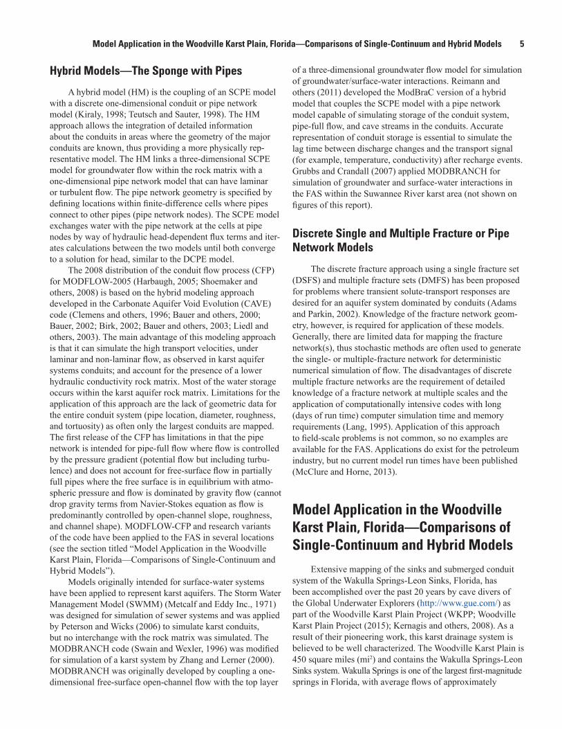
Hybrid Models—The Sponge with Pipes
A hybrid model (HM) is the coupling of an SCPE model with a discrete one-dimensional conduit or pipe network model (Kiraly, 1998; Teutsch and Sauter, 1998). The HM approach allows the integration of detailed information about the conduits in areas where the geometry of the major conduits are known, thus providing a more physically rep-resentative model. The HM links a three-dimensional SCPE model for groundwater flow within the rock matrix with a one-dimensional pipe network model that can have laminar or turbulent flow. The pipe network geometry is specified by defining locations within finite-difference cells where pipes connect to other pipes (pipe network nodes). The SCPE model exchanges water with the pipe network at the cells at pipe nodes by way of hydraulic head-dependent flux terms and iter-ates calculations between the two models until both converge to a solution for head, similar to the DCPE model.
The 2008 distribution of the conduit flow process (CFP) for MODFLOW-2005 (Harbaugh, 2005; Shoemaker and others, 2008) is based on the hybrid modeling approach developed in the Carbonate Aquifer Void Evolution (CAVE) code (Clemens and others, 1996; Bauer and others, 2000; Bauer, 2002; Birk, 2002; Bauer and others, 2003; Liedl and others, 2003). The main advantage of this modeling approach is that it can simulate the high transport velocities, under laminar and non-laminar flow, as observed in karst aquifer systems conduits; and account for the presence of a lower hydraulic conductivity rock matrix. Most of the water storage occurs within the karst aquifer rock matrix. Limitations for the application of this approach are the lack of geometric data for the entire conduit system (pipe location, diameter, roughness, and tortuosity) as often only the largest conduits are mapped. The first release of the CFP has limitations in that the pipe network is intended for pipe-full flow where flow is controlled by the pressure gradient (potential flow but including turbu-lence) and does not account for free-surface flow in partially full pipes where the free surface is in equilibrium with atmo-spheric pressure and flow is dominated by gravity flow (cannot drop gravity terms from Navier-Stokes equation as flow is predominantly controlled by open-channel slope, roughness, and channel shape). MODFLOW-CFP and research variants of the code have been applied to the FAS in several locations (see the section titled “Model Application in the Woodville Karst Plain, Florida—Comparisons of Single-Continuum and Hybrid Models”).
Models originally intended for surface-water systems have been applied to represent karst aquifers. The Storm Water Management Model (SWMM) (Metcalf and Eddy Inc., 1971) was designed for simulation of sewer systems and was applied by Peterson and Wicks (2006) to simulate karst conduits, but no interchange with the rock matrix was simulated. The MODBRANCH code (Swain and Wexler, 1996) was modified for simulation of a karst system by Zhang and Lerner (2000). MODBRANCH was originally developed by coupling a one-dimensional free-surface open-channel flow with the top layer
of a three-dimensional groundwater flow model for simulation of groundwater/surface-water interactions. Reimann and others (2011) developed the ModBraC version of a hybrid model that couples the SCPE model with a pipe network model capable of simulating storage of the conduit system, pipe-full flow, and cave streams in the conduits. Accurate representation of conduit storage is essential to simulate the lag time between discharge changes and the transport signal (for example, temperature, conductivity) after recharge events. Grubbs and Crandall (2007) applied MODBRANCH for simulation of groundwater and surface-water interactions in the FAS within the Suwannee River karst area (not shown on figures of this report).
Discrete Single and Multiple Fracture or Pipe Network Models
The discrete fracture approach using a single fracture set (DSFS) and multiple fracture sets (DMFS) has been proposed for problems where transient solute-transport responses are desired for an aquifer system dominated by conduits (Adams and Parkin, 2002). Knowledge of the fracture network geom-etry, however, is required for application of these models. Generally, there are limited data for mapping the fracture network(s), thus stochastic methods are often used to generate the single- or multiple-fracture network for deterministic numerical simulation of flow. The disadvantages of discrete multiple fracture networks are the requirement of detailed knowledge of a fracture network at multiple scales and the application of computationally intensive codes with long (days of run time) computer simulation time and memory requirements (Lang, 1995). Application of this approach to field-scale problems is not common, so no examples are available for the FAS. Applications do exist for the petroleum industry, but no current model run times have been published (McClure and Horne, 2013).
Model Application in the Woodville Karst Plain, Florida—Comparisons of Single-Continuum and Hybrid Models
Extensive mapping of the sinks and submerged conduit system of the Wakulla Springs-Leon Sinks, Florida, has been accomplished over the past 20 years by cave divers of the Global Underwater Explorers (http://www.gue.com/) as part of the Woodville Karst Plain Project (WKPP; Woodville Karst Plain Project (2015); Kernagis and others, 2008). As a result of their pioneering work, this karst drainage system is believed to be well characterized. The Woodville Karst Plain is 450 square miles (mi2) and contains the Wakulla Springs-Leon Sinks system. Wakulla Springs is one of the largest first-magnitude springs in Florida, with average flows of approximately
6 Simulating Groundwater Flow in Karst Aquifers with Distributed Parameter Models
400 cubic feet per second (ft3/s). A large vent opening (80 ft by 52 ft) forms a large pool (approximately 300 ft in diameter and 185 ft deep) at the headwaters of the Wakulla River at Edward Ball Wakulla Springs State Park, Florida (Florida Department of Environmental Protection, 2016).
The WKPP maps served as the basis for three model approaches used to simulate the FAS in the vicinity of Wakulla Springs: (1) SCPE with laminar flow only (Davis and others, 2010), (2) HM that consists of a single continuum coupled to a one-dimensional pipe-flow network capable of simulating laminar and non-laminar flow, an application of MODFLOW-CFP mode 1 (Shoemaker and others, 2008; Gallegos, 2011; Gallegos and others, 2013; Kuniansky, 2014), and (3) SCPE model in approach 1, but with laminar and turbulent flow in the SCPE, an application of the CFP mode 2 (Shoemaker and others, 2008; Kuniansky and others, 2008; Davis and others, 2010; Kuniansky and others, 2011; Reimann and others, 2012; Kuniansky, 2014). Groundwater flow can be non-laminar within a SCPE model layer for the CFP mode 2 approach and so model layer 2, the layer with the submerged conduits, is allowed to have laminar or non-laminar flow. More details about the hydrogeology of the area and the original model grid, boundary conditions, and calibration upon which all three models are based is discussed in Davis (1996), Davis and Katz (2007), Davis and others (2010), Gallegos (2011), and Gallegos and others (2013). The simulation input and output files discussed herein are available as a data release (Kuniansky, 2016).
All of the models have the same two-layer discretization, with the top layer being the confined upper 200 ft of the Upper Floridan aquifer and layer 2 the confined lower part of the Upper Floridan aquifer, which is more than 1,000 ft thick in the west and thins to 200 ft in the east, and contains the sub-merged mapped conduits (Davis and others, 2010). Hydraulic conductivity (K) values greater than 10,000 feet per day (ft/d) were assigned to cells that represent mapped and hypothesized conduits (fig. 2) in approaches 1 and 3 (refer to Davis and oth-ers [2010] for details). For the HM (approach 2), the single-continuum model of Davis and others (2010) was modified by replacing the large K values (greater than 10,000 ft/d on fig. 2) with the smaller K values surrounding these cells, adding the mapped pipe network, and recalibrating to steady-state aver-age condition (Gallegos, 2011; Gallegos and others, 2013).
MODFLOW-2005 (Harbaugh, 2005) and MODFLOW-CFP (Shoemaker and others, 2008) were applied to the Woodville Karst Plain in order to examine spring discharge under various time discretization and flow conditions. Model approach 1, the sub-regional model of Davis and others (2010), was a SCPE with transient simulation from January 1, 1966, when spray-field operations (irrigation using treated wastewater as part of municipal wastewater treatment process-ing) began, through 2018, when results of operating system upgrades to the wastewater system were planned to take effect. Annual stress periods were primarily used in the 1966–2018 model simulation. Calibration data for water levels and spring discharge were available for November 1991 and May to early June 2006. Additional hydrologic information was provided by
tracer tests conducted in 2006 and 2007 by Hazlett-Kincaid, Inc. (listed in Davis and others, 2010). The HM (approach 2) was calibrated to steady-state conditions for the same calibra-tion datasets as in approach 1 (Gallegos and others, 2013). The third modeling approach (SCPE with the ability to simulate laminar and non-laminar flow in model layer 2—the confined part of the FAS with the mapped submerged conduits) yielded virtually identical heads and springflows within 2 percent as those in approach 1 for two transient simulation comparisons. The two transient comparisons between approaches 1 and 3 were (1) transient simulation (1966–2018, 58 mostly annual stress periods and (2) transient simulation with 81 10-day stress periods (2.2 years total time for tracer test simulation). Turbulence did not occur over much area under the annual or 10-day average hydrologic conditions compared. Both the SPCE (approaches 1 and 3) and HM (approach 2) simulated observed average spring discharge at Wakulla and Spring Creek Springs within the calibration criterion of 10 percent, and head residuals were within the calibration criterion of plus or minus 5 ft (Davis and others, 2010; Gallegos, 2011; Gallegos and others, 2013). Thus, for average spring discharge and tracer-test time of travel, the three modeling approaches produce similar results, and all are considered acceptable calibrations (Davis and others, 2010; Kuniansky and others, 2011; Gallegos and others, 2013; Kuniansky, 2014). For the HM (approach 2), however, simulated water levels were lower than observed levels, resulting in biased residuals (Gallegos, 2011; Gallegos and others 2013). Additionally, approach 1 was able to accurately match tracer-test times of travel (Davis and others, 2010).
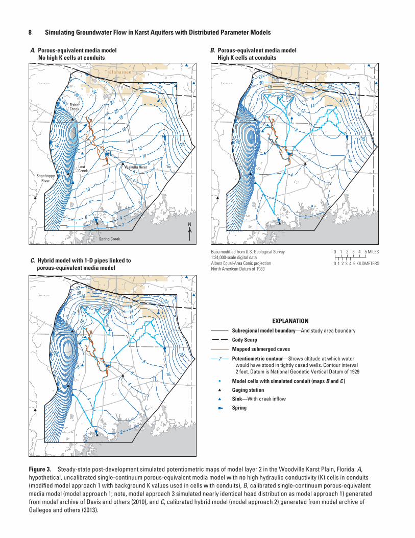
These three modeling approaches met the water-level and flow calibration criteria, but the simulated potentiometric maps for model layer 2 (layer with submerged conduits ) dif-fered slightly between the HM (approach 2) and two SCPE modeling approaches 1 and 3. For illustration purposes, three potentiometric maps are shown in figure 3 for model layer 2 under steady-state average conditions from 1966 to 2018 with three variations. Figure 3A shows what happens when the high hydraulic conductivity cells are set to the lower values of surrounding cells and an SCPE approach is used (hypothetical, uncalibrated model—used MODFLOW layer 2 K values from the HM of Gallegos and others [2013] and turned off the pipe network). Figure 3B shows the potentiometric map for approach 1 (approaches 1 and 3 simulated essentially identi-cal head distributions) representing the SCPE model with the high hydraulic conductivity cells where conduits are mapped. Figure 3C shows the simulated potentiometric map from the HM (approach 2). The simulated potentiometric map in figure 3A is not similar to the simulated potentiometric maps shown in figures 3B and 3C. The simulated surfaces when the conduits are incorporated into either an SCPE model or a hybrid model (figs. 3B and 3C) are similar. Thus, incorpora-tion of conduits with very large hydraulic conductivity cells in an SCPE approach can mimic the HM approach. If high K cells are not incorporated in areas of conduits or hypothesized conduits, then the SCPE model will not approximate the water levels of an HM model.
Model Application in the Woodville Karst Plain, Florida—Comparisons of Single-Continuum and Hybrid Models 7
319
98
61
267
98
365
319
267
61
363
27
LEONCOUNTYWAKULLACOUNTY
YTNUOC
NOSREFFEJ
Spring CreekSpring
Wakulla Springs
Gu l f o f Mex i co
St Marks Spring
Tallahassee
AmesSink
LostCreekSink
Burnt MillSink
Turf Sink
JumpCreekSink
Black Creek SinkFisher Creek Sink
HallBranchSink
Subregional model boundary
Cody ScarpGEORGIA
FLORIDA
AL
Model area
Map area
Gulf of Mexico
EXPLANATION
Figure 2.
Simulated horizontal hydraulic conductivity, in feet per day
Sinkhole
Sink—With creek inflow
Spring
10 to 100
101 to 1,000
1,001 to 10,000
10,001 to 100,000
100,001 to 1,000,000
1,000,001 to 5,000,000
N
0Base modified from U.S. Geological Survey digital data, 1:24,000Albers Equal-Area Conic projection, North American Datum of 1983Standard parallels 29°30' and 45°30', central meridian –83°00'
1 2 3 4 5 MILES
0 1 2 3 4 5 KILOMETERS
Figure 2. Simulated hydraulic conductivity in model layer 2 with large hydraulic conductivity located at submerged conduits for approaches 1 and 3, Woodville Karst Plain, Florida (modified from Davis and others, 2010, fig. 27).
8 Simulating Groundwater Flow in Karst Aquifers with Distributed Parameter Models
Tal lahassee
FisherCreek
Wakulla River
Spring Creek
SopchoppyRiver
Lost Creek
Base modified from U.S. Geological Survey 1:24,000-scale digital dataAlbers Equal-Area Conic projectionNorth American Datum of 1983
0 1 2 3 4 5 MILES
0 1 2 3 4 5 KILOMETERS
N
A. Porous-equivalent media model No high K cells at conduits
C. Hybrid model with 1-D pipes linked to porous-equivalent media model
B. Porous-equivalent media model High K cells at conduits
Figure 3.
EXPLANATION
Subregional model boundary—And study area boundary
Potentiometric contour—Shows altitude at which water would have stood in tightly cased wells. Contour interval 2 feet. Datum is National Geodetic Vertical Datum of 1929
Cody Scarp
Mapped submerged caves
Model cells with simulated conduit (maps B and C )
Gaging station
Sink—With creek inflow
Spring
2
6
6
4
4
8
8
10
10
1214
16
10
22
20
1820
22
26
28
24
50
2
121416
1820
20
22
8
10
10
20
4
6
2
50
14 141210
16
182022
22
10
6
50
10
20
6
8
4
2
4
Figure 3. Steady-state post-development simulated potentiometric maps of model layer 2 in the Woodville Karst Plain, Florida: A, hypothetical, uncalibrated single-continuum porous-equivalent media model with no high hydraulic conductivity (K) cells in conduits (modified model approach 1 with background K values used in cells with conduits), B, calibrated single-continuum porous-equivalent media model (model approach 1; note, model approach 3 simulated nearly identical head distribution as model approach 1) generated from model archive of Davis and others (2010), and C, calibrated hybrid model (model approach 2) generated from model archive of Gallegos and others (2013).
Model Application in the Woodville Karst Plain, Florida—Comparisons of Single-Continuum and Hybrid Models 9
In order to observe differences between the SCPE and hybrid model approaches, a transient period with daily springflow observations and a storm event (rising and falling of springflow, no recalibration) was simulated (Kuniansky and others, 2011; Gallegos and others, 2013; Kuniansky, 2014). A 52-day storm event was simulated with daily time steps, and only model approach 3 simulated the observed peak discharge within 10 percent (fig. 4). The shape of the storm hydrograph for Wakulla Springs is best matched by model approach 3 SCPE model with turbulence (labeled “CFP mode 2” on fig. 4). The peak average observed daily discharge of 2,363 ft3/s occurred on day 14, and simulated discharges for day 14 were 3,085, 1,653, and 2,149 ft3/s, for model approaches 1–3, respectively (labeled as model approaches “(1) MODFLOW,” “(2) CFP mode 1 hybrid,” and “(3) CFP mode 2,” in figure 4). Model approach 1 overestimated and model approach 2 underestimated the peak daily discharge at Wakulla Spring and both were within 30 percent of the observed peak value. Model approach 3 underestimated the peak, but was within 9 percent of the observed peak daily discharge. When the total volume of measured and simulated discharges for the 52-day period at Wakulla Springs is compared, approach 1 (SCPE laminar) matched observed volume within 23 percent, approach 2 (HM) matched within 0.01 percent, and approach 3 (SCPE laminar and non-laminar) matched within 17 percent of the total volume of discharge under the 52-day hydrograph. Simulated fits to observed data at Spring Creek Spring and Saint Marks Spring were worse than those at Wakulla Springs for all three modeling approaches. Implementation of model approach 3 using MODFLOW-CFP mode 2, which allows non-laminar flow in layer 2 is quite simple and requires only specifying a temperature, average pore diameter, and upper
and lower Reynolds numbers for the layer. The temperature was specified equal to the average temperature of the groundwater (20.5 degrees Celsius), and the other parameters were adjusted manually by trial and error during calibration to improve the match of simulated and observed flows at Wakulla Springs. The calibrated parameter values were an average pore diam-eter of 0.75, and lower and upper critical Reynolds numbers of 11 and 150, respectively. [Note in this original version of CFP mode 2, the effect of non-laminar flow requires specifica-tion of parameters that represent large-pore porous media, not pipes; Reimann and others (2012) developed a modification that allows for specification of Reynolds numbers more typical of large pipes. The Reimann and others (2012) form of CFP mode 2 will reproduce similar springflow as the original version when using an average pore diameter of 1 ft, and lower and upper critical Reynolds numbers of 3,000 and 10,000, respectively. The computation time required by the HM approach 2 (about 12 hours in 2016) was more than 100 times longer than for the SCPE model approaches 1 and 3. This test of hybrid models is large, with more than 1,000 pipes and nodes simulated. The hybrid approach requires that two models are iteratively solved until both converge for each 1-day stress period, result-ing in the long run times. The approximately 12-hour simula-tion time precluded using automated parameter-estimation techniques to calibrate the hybrid model; thus no attempt was made to recalibrate all three models in transient simulation for both transient average annual stress periods with additional daily stress periods to match a storm hydrograph.
Hill and others (2010) compared a hybrid model approach with a SCPE model approach for two other spring systems in Florida (Weeki Wachee and Twin Dees) and con-cluded that the hybrid model more closely simulated observed transient spring discharge. Another recent study (Saller and others, 2013) converted a SCPE model to a hybrid model for a watershed in the Madison aquifer in South Dakota and found that the hybrid model better matched head observations at monitor wells, and both models simulated spring discharge within the calibration criteria.
The Wakulla Springs example described herein indicates that, for simulation of average conditions, none of the three model approaches is distinctly better. However, the HM was manually calibrated with three steady-state periods rather than the full transient simulation of average periods of Davis and others (2010) owing to long run times, which is a disadvantage (Gallegos, 2011; Gallegos and others, 2013). For the simula-tion of a transient 52-day storm hydrograph, the SCPE model with turbulence (approach 3) best matched peak spring daily discharge at Wakulla Springs, and the HM (approach 2) best matched the total volume of springflow. None of the model approaches had acceptable matches to the observed daily storm hydrographs at the springs in the model domain.
It is unclear if the extra effort required to use a hybrid model, both in data preparation and computation time, is justified for investigations not requiring site-scale transport or matching storm events, because the simpler SCPE models adequately simulate groundwater-level and average fluid
500
1,000
1,500
2,000
2,500
3,000
3,500
0 10 20 30 40 50 60
Daily
dis
char
ge, i
n cu
bic
feet
per
sec
ond
Elapsed time since start of simulation, in days
Observed
(1) Modflow
(2) CFP mode 1 hybrid
EXPLANATION
Figure 4.
(3) CFP mode 2
Figure 4. Simulated and observed springflow at Wakulla Springs, Florida (modified from Kuniansky, 2014; CFP, conduit flow process).
10 Simulating Groundwater Flow in Karst Aquifers with Distributed Parameter Models
mass-balance conditions. Recent ongoing research by Xu and others (2015) utilizing a research version of CFP that includes transport between the pipe network and the SCPE (Reimann and others, 2013) was applied to a hybrid model of the Woodville Karst Plain for better simulation of long-term nitrate transport using the same longer stress periods of Davis and others (2010).
An additional test of model capabilities could compare residence times of rapid (event) flow components or slow flow matrix components, derived from the use of geochemical mix-ing models with hydrograph separation techniques given time series datasets of chemistry and flow information. Unfortu-nately, no such time series datasets are currently (2016) avail-able for the major springs within the Wakulla Springs-Leon Sinks area.
Discussion The USGS, multiple State water management districts,
and other agencies and consultants have frequently used porous-equivalent media models for water-management prob-lems to simulate the Biscayne aquifer and the FAS in Florida. The Biscayne aquifer and FAS are composed of karstified carbonate rocks that can be characterized as dual porosity continua. As of 2015, more than 30 models developed by the USGS have used a SCPE model approach to meet necessary calibration criteria for the study objectives (U.S. Geological Survey, 2014). Many of the water management districts in Florida use a SCPE model approach for groundwater man-agement and resource evaluation (Geraghty and Miller, Inc., 1991; Williams, 1997, 2006; McGurk, 1998; HydroGeoLogic, Inc., 2000; McGurk and Presley, 2002; Agyei and others, 2005). Most of these SCPE models are applied to water-supply studies and are regional or subregional in scale and water budgets are desired; this is an appropriate application of such models. Documentation of each model application should include the calibration criteria (be calibrated on both flow and groundwater-level information), the range of hydrologic conditions applied, and descriptions of the limitations of the model application; such that readers can decide if the model is useful for its intended purpose (Anderson and others, 2015; Reilly and Harbaugh, 2004).
The application of hybrid models is still being explored primarily in research studies or at spring sites such as the Woodville Karst Plain where the conduit system is mapped (Hill and others, 2010; Gallegos and others, 2013; Kuniansky, 2014; Xu and others, 2015). For most of Florida, few conduit systems have been mapped. However, highly karstified areas have been mapped (Sinclair and Stewart, 1985; Miller, 1986; Williams and Kuniansky, 2015), springs have been documented (Arthur and others, 2007; Harrington and others, 2010), and transmissivity databases and mapping are avail-able (Kuniansky and Bellino, 2012; Kuniansky and others, 2012), all of which can be used in conjunction with detailed
potentiometric mapping to infer areas that likely contain submerged caverns.
While general times of travel can be matched by using a SCPE model with effective porosity, the SCPE model approach may have substantial limitations for site-scale trans-port (less than 1 mi2) if detailed knowledge of karst features or preferential flow layers is unknown. Caution in use of SCPE models at a site scale for transport problems in dual or triple porosity aquifers is warranted.
Conclusions
Mathematical methods for simulation of karst aquifers are well developed. Depending on the objectives for the study, a single-continuum porous-equivalent (SCPE) model may be adequate for simulation of the Floridan aquifer system (FAS) to address many water-supply problems involving annual or monthly average hydrologic conditions. The possible presence of conduits in the FAS does not mean that, on average, non-laminar flow is dominant over the study domain. It does mean, however, that the large flow capacity of the conduits must be incorporated into the models using either large hydraulic conductivity cells in the SCPE model approach or using a pipe network incorporated in a hybrid model approach. The ability to simulate non-laminar flow is important for simulation of large storm events when non-laminar flow affects discharge during the storm event if matching springflow hydrographs is desired. For the simulation of annual, seasonal, or monthly average flows, the ability to simulate laminar and non-laminar flow may not be necessary to match average springflow. Addi-tionally, times of travel from natural and anthropogenic tracers can be matched with an SCPE model approach if an effective porosity is used (typically less than 5 percent) rather than the actual porosity.
The main challenge in application of the methods and approaches described herein primarily relates to the difficulty in mapping the conduit networks or in having high-quality datasets to calibrate the models. Advances in geophysics, tracer testing, geochemistry, cave exploration, streamflow measurement, and recharge estimation will improve applica-tion of the mathematical models. All of the methods and approaches require an understanding of each karst aquifer and its unique hydrogeologic setting. The extensive mapping of the conduit system in the Woodville Karst Plain makes this an ideal research area. However, future research in mathematical simulation of the FAS in the Woodville Karst Plain could benefit from continuous measurements of spring discharge, and temperature, conductance or other water-quality properties at the major springs; currently these springs are not continu-ously monitored. Additionally, continuous groundwater-level monitoring in wells completed within the rock matrix near the springs could be valuable to constrain numerical model simulations.
References Cited 11
References Cited
Adams, R., and Parkin, G., 2002, Development of a surface-groundwater-pipe network model for the sustainable management of karstic groundwater: Berlin, Environmental Geology, v. 42, no. 5, p. 513–517.
Agyei, Eugene, Munch, Douglas, and Burger, Patrick, 2005, Application of optimization modeling to water resource planning in east-central Florida: Palatka, Fla., St. Johns River Water Management District Technical Publication SJ2005-2, 82 p.
Anderson, M.P., Woessner, W.W., and Hunt, R.J., 2015, Applied groundwater modeling —Simulation of flow and advective transport (2d ed.): Academic Press, 630 p.
Arthur, J.D., Wood, H.A.R., Baker, A.E., Cichon, J.R., and Raines, G.L., 2007, Development and implementation of a Bayesian-based aquifer vulnerability assessment in Florida: Natural Resources Research, v. 16, no. 2, p. 93–107.
Bauer, Sebastian, 2002, Simulation of the genesis of karst aquifers in carbonate rocks: v. 62 of Tübinger Geowis-sen-schaftliche Arbeiten: Tübingen, Germany, Reihe C. Institut und Museum für Geologie und Paläontologie der Univer-sität Tübingen.
Bauer, Sebastian, Liedl, Rudolf, and Sauter, Martin, 2000, Modelling of karst development considering conduit-matrix exchange flow, in Stauffer, F., Kinzelbach, W., Kovar, K., and Hoehn, E., eds., Calibration and reliability in ground-water modelling: Coping with uncertainty—Proceedings of the ModelCARE’99 Conference: International Association of Hydrological Sciences Publication 265, p. 10–15.
Bauer, Sebastian, Liedl, Rudolf, and Sauter, Martin, 2003, Modeling of karst aquifer genesis: Influence of exchange flow: Water Resources Research, v. 39, no. 10, p. 1285.
Birk, Steffen, 2002, Characterization of karst systems by simu-lating aquifer genesis and spring responses: Model develop-ment and application to gypsum karst: v. 60 of Tübinger Geowissenschaftliche Arbeiten: Tübingen, Germany, Reihe C. Institut und Museum für Geologie und Paläontologie der Universität Tübingen.
Bush, P.W., and Johnston, R.H., 1988, Ground-water hydrau-lics, regional flow, and ground-water development of the Floridan aquifer system in Florida and in parts of Georgia, South Carolina, and Alabama: U.S. Geological Survey Professional Paper 1403–C, 80 p.
Clemens, Torsten, Hückinghaus, Dirk, Sauter, Martin, Liedl, Rudolf, and Teutsch, Georg, 1996, A combined con-tinuum and discrete network reactive transport model for the simulation of karst development, in Proceedings of the ModelCARE 96 Conference, Golden, Colo., Septem-ber 1996: International Association of Hydrological Sci-ences Publication 237, p. 309–318.
Daily, J.W., and Harleman, D.R.F., 1966, Fluid dynamics: Addison-Wesley Publishing Company, 454 p.
Davis, H., 1996, Hydrogeologic investigation and simulation of ground-water flow in the Upper Floridan aquifer of north-central Florida and delineation of contributing areas for selected city of Tallahassee, Florida, water-supply wells: U.S. Geological Survey Water-Resources Investigations Report 95–4296, 55 p.
Davis, J.H., and Katz, B.G., 2007, Hydrogeologic investiga-tion, water chemistry analysis, and model delineation of contributing areas for City of Tallahassee public-supply wells, Tallahassee, Florida: U.S. Geological Survey Scientific Investigations Report 2007–5070, 67 p.
Davis, J.H., Katz, B.G., and Griffin, D.W., 2010, Nitrate-N movement in groundwater from the land application of treated municipal wastewater and other sources in the Wakulla Springs springshed, Leon and Wakulla Counties, Florida, 1966–2018: U.S. Geological Survey Scientific Investigations Report 2010–5099, 90 p.
Florida Department of Environmental Protection, 2016, Edward Ball Wakulla Springs State Park, accessed March 15, 2016, at http://www.floridasprings.org/visit/map/wakulla/.
Gallegos, J.J., 2011, Modeling groundwater flow in karst aqui-fers—An evaluation of MODFLOW-CFP at a laboratory and sub-regional scale: Masters Thesis, Tallahassee, Fla., Florida State University.
Gallegos, J.J., Hu, B.X., and Davis, Hal, 2013, Simulating flow in karst aquifers at laboratory and sub-regional scales using MODFLOW-CFP: Hydrogeology Journal, v. 21, no. 8, p. 1749–1760.
Geraghty and Miller, Inc., 1991, Numerical modeling of groundwater flow and seawater intrusion, Volusia County, Florida: Palatka, Fla., St. Johns River Water Management District Special Publication SJ92-SP6.
Grubbs, J.W., and Crandall, C.A., 2007, Exchanges of water between the Upper Floridan aquifer and the Lower Suwan-nee and Lower Santa Fe Rivers, Florida: U.S. Geological Survey Professional Paper 1656–C, 83 p.
12 Simulating Groundwater Flow in Karst Aquifers with Distributed Parameter Models
Harbaugh, A.W., 2005, MODFLOW-2005, the U.S. Geological Survey modular ground-water model—The ground-water flow process: U.S. Geological Survey Techniques and Methods 6-A16 [variously paged].
Harrington, D., Maddox, G., and Hicks, R., 2010, Florida springs initiative monitoring network report and recognized sources of nitrate: Florida Department of Environmental Protection.
Haugh, C.J., 2006, Hydrogeology and simulation of ground-water flow at Arnold Air Force Base, Coffee and Franklin Counties, Tennessee—2002 update: U.S. Geological Survey Scientific Investigations Report 2006–5157, 70 p.
Hill, M.E., Stewart, M.T., and Martin, A., 2010, Evaluation of the MODFLOW-2005 Conduit Flow Process: Ground Water, v. 48, p. 549–559.
Hsieh, P.A., and Freckleton, J.R., 1993, Documentation of a computer program to simulate horizontal-flow barriers using the U.S. Geological Survey’s modular three-dimensional finite-difference ground-water flow model: U.S. Geological Survey Open-File Report 92–477, 32 p.
HydroGeoLogic, Inc., 2000, Modeling of ground water flow in Walton, Okaloosa and Santa Rosa Counties, Florida: Havana, Fla., Northwest Florida Water Management District Report, 117 p.
Kernagis, D.N., McKinlay, C., and Kincaid, T.R., 2008, Dive logistics of the Turner to Wakulla Cave Traverse, in Brueggeman, P., and Pollock, N.W., eds., Diving for Science 2008, Proceedings of the American Academy of Underwater Sciences 27th Scientific Symposium, Dauphin Island, Ala., p. 91–102.
Kincaid, T.R., 1999, Morphologic and fractal characterization of saturated karstic caves: Laramie, Wyo., University of Wyoming, Ph.D. dissertation, 174 p.
Kiraly, L., 1998, Modelling karst aquifers by the combined discrete channel and continuum approach: Bulletin d’Hydrogeologie, v. 16, p. 77–98.
Knochenmus, L.A., and Robinson, J.L., 1996, Descriptions of anisotropy and heterogeneity and their effect on ground-water flow and areas of contribution to public supply wells in a karst carbonate aquifer system: U.S. Geological Survey Water-Supply Paper 2475, 47 p.
Knowles, Leel, Jr., O’Reilly, A.M., and Adamski, J.C., 2002, Hydrogeology and simulated effects of ground-water with-drawals from the Floridan Aquifer System in Lake County and in the Ocala National Forest and vicinity, North-Central Florida: U.S. Geological Survey Water-Resources Investiga-tions Report 02–4207, 140 p.
Kuniansky, E.L., 2014, Taking the mystery out of mathemati-cal model applications to karst aquifers—A primer, in Kuniansky, E.L., and Spangler, L.E., eds., U.S. Geological Survey Karst Interest Group Proceedings, Carlsbad, New Mexico, April 29–May 2, 2014: U.S. Geological Survey Scientific Investigations Report 2014–5035, p. 69–81, accessed March 25, 2016, at http://dx.doi.org/10.3133/sir20145035.
Kuniansky, E.L., 2016, MODFLOW and MODFLOW Conduit Flow Process data sets for simulation experiments of the Woodville Karst Plain, near Tallahassee, Florida with three different approaches and different stress periods: U.S. Geological Survey data release, http://dx.doi.org/10.5066/F7PK0D87.
Kuniansky, E.L., and Ardis, A.F., 2004, Hydrogeology and ground-water flow in the Edwards-Trinity aquifer system, west-central, Texas: U.S. Geological Survey Professional Paper 1421–C, 78 p., 4 pls.
Kuniansky, E.L., and Bellino, J.C., 2012, Tabulated transmis-sivity and storage properties of the Floridan aquifer sys-tem in Florida and parts of Georgia, South Carolina, and Alabama: U.S. Geological Survey Data Series 669, 37 p., accessed August 29, 2016, at http://pubs.usgs.gov/ds/669/.
Kuniansky, E.L., Bellino, J.C., and Dixon, J.F., 2012, Trans-missivity of the Upper Floridan aquifer in Florida and parts of Georgia, South Carolina, and Alabama: U.S. Geological Survey Scientific Investigations Map 3204, 1 sheet, scale 1:100,000, accessed August 29, 2016, at http://pubs.usgs.gov/sim/3204/.
Kuniansky, E.L., Fahlquist, Lynne, and Ardis, A.F., 2001, Travel times along selected flow paths of the Edwards aqui-fer, central Texas, in Kuniansky, E.L., ed., U.S. Geological Survey Karst Interest Group Proceedings, St. Petersburg, Florida, February 13–16, 2001: U.S. Geological Survey Water-Resources Investigations Report 01–4011, p. 69–77.
Kuniansky, E.L., Gallegos, J.J., and Davis, J.H., 2011, Com-parison of three model approaches for spring simulation, Woodville Karst Plain, Florida, in Kuniansky, E.L., ed., U.S. Geological Survey Karst Interest Group Proceedings, Fayetteville, Arkansas, April 26–29, 2011: U.S. Geological Survey Scientific Investigations Report 2011–5031, p. 169–170.
Kuniansky, E.L., Halford, K.J., and Shoemaker, W.B., 2008, Permeameter data verify new turbulence process for MODFLOW: Groundwater, v. 46, no. 5, p. 768–771.
Kuniansky, E.L., and Holligan, K.Q., 1994, Simulations of flow in the Edwards-Trinity aquifer system and contiguous hydraulically connected units, west-central Texas: U.S. Geological Survey Water-Resources Investigations Report 93–4039, 40 p.
Kuniansky, E.L., and Lowther, R.A., 1993, Finite-element mesh generation from mappable features: International Journal of Geographical Information Systems, v. 7, no. 5, p. 395–405.
Lang, U., 1995, Simulation regionaler Strömungs—Und Transportvorgänge in Karstaquiferen mit Hilfe des Doppel-kontinuumansatzes: Stuttgart, Germany, Methodenentwick-lung und Parameterstudie, Ph.D. dissertation, Institut für Wasserbau, Universität Stuttgart.
Liedl, R., Sauter, M., Hückinghaus, D., Clemens, T., and Teutsch, G., 2003, Simulation of the development of karst aquifers using a coupled continuum pipe flow model: Water Resources Research, v. 39, no. 1, p. 1057, accessed March 25, 2016, at http://dx.doi.org/10.1029/2001WR001206.
Lindgren, R.J., Dutton, A.R., Hovorka, S.D., Worthington, S.R.H., and Painter, Scott, 2004, Conceptualization and simulation of the Edwards aquifer, San Antonio region, Texas: U.S. Geological Survey Scientific Investigations Report 2004–5277, 143 p.
Lindgren, R.J., Taylor, C.J., and Houston, N.A., 2009, Description and evaluation of numerical groundwater flow models for the Edwards aquifer, south-central Texas: U.S. Geological Survey Scientific Investigations Report 2009–5183, 25 p.
McClure, M.W., and Horne, R.N., 2013, Discrete fracture network modeling of hydraulic stimulation-coupling flow and geomechanics: New York, Springer, 90 p.
McGurk, B., 1998, Regional simulation of projected ground-water withdrawals from the Floridan aquifer system in western Volusia County and southeastern Putnam County, Florida: Palatka, Fla., St. Johns River Water Management District Technical Report SJ98-1, 237 p.
McGurk, B., and Presley, P.F., 2002, Simulation of the effects of groundwater withdrawals on the Floridan aquifer system in east-central Florida: Model expansion and revision: St. Johns River Water Management District Technical Publication SJ2002-3, 196 p.
Merritt, M.L., 2004, Estimating hydraulic properties of the Floridan aquifer system by analysis of earth-tide, ocean-tide, and barometric effects, Collier and Hendry Counties, Florida: U.S. Geological Survey Water-Resources Investiga-tions Report 03–4267, 70 p.
Metcalf and Eddy Inc., 1971, Storm water management model, volume I—Final report: Washington, D.C., U.S. Environ-mental Protection Agency, 353 p.
Miller, J.A., 1986, Hydrogeologic framework of the Floridan aquifer system in Florida and in parts of Georgia, Alabama, and South Carolina: U.S. Geological Survey Professional Paper 1403–B, 91 p.
Mohrlok, U., 1996, Parameter-identifikation in doppel-kontinum-modellen am beispiel von karst-aquiferen: Tübingen, Germany, Reihe C. Institut und Museum für Geologie und Paläontologie der Universität Tübingen, Tübinger Geowi-senschaftliche Arbeiten, v. 31.
Painter, S.L., Sun, A., and Green, R.T., 2007, Enhanced characterization and representation of flow through karst aquifers––Phase II. Revision 1: San Antonio, Texas, Geosciences and Engineering Division, Southwest Research Institute.
Panday, Sorab, Langevin, C.D., Niswonger, R.G., Ibaraki, Motomu, and Hughes, J.D., 2013, MODFLOW–USG version 1: An unstructured grid version of MODFLOW for simulating groundwater flow and tightly coupled processes using a control volume finite-difference formulation: U.S. Geological Survey Techniques and Methods, book 6, chap. A45, 66 p.
Peterson, E.W., and Wicks, C.M., 2006, Assessing the importance of conduit geometry and physical parameters in karst systems using the storm water management model (SWMM): Journal of Hydrology, v. 329, no. 1–2, p. 294–305.
Pittman, Craig, 2013, Florida’s aquifer models full of holes, allowing more water permits and pollution: Tampa Bay Times, January 27, 2013.
Reilly, T.E., and Harbaugh, A.W., 2004, Guidelines for evalu-ating ground-water flow models: U.S. Geological Survey Scientific Investigations Report 2004–5038, 30 p.
Reimann, T., Birk, S., Rehrl, C., and Shoemaker, W.B., 2012, Modifications to the Conduit Flow Process Mode 2 for MODFLOW-2005: Groundwater, v. 50, no. 1, p. 144–148.
Reimann, T., Geyer, T., Shoemaker, W.B., Liedl, R., and Sauter, M., 2011, Effects of dynamically variable saturation and matrix-conduit coupling of flow in karst aquifers: Water Resources Research, v. 47, no. 11, accessed March 25, 2016, at http://dx.doi.org/10.1029/2011WR010446.
Reimann, T., Liedl, R., Giese, M., Geyer, T., Maréchal, J-C., Dörfliger, N., Bauer, S., and Birk, S., 2013, Addition and enhancement of flow and transport pro-cesses to the MODFLOW-2005 Conduit Flow Process: Proceedings Presentation at NGWA Ground Water Summit, April 29, 2013, San Antonio, Texas, accessed December 14, 2015, at https://tu-dresden.de/die_tu_dresden/fakultaeten/fakultaet_forst_geo_und_hydrowis-senschaften/fachrichtung_wasserwesen/igw/mitarbeiter1/reimann/2013_04_25_reimann_summit2013.pdf.
14 Simulating Groundwater Flow in Karst Aquifers with Distributed Parameter Models
Renken, R.A., Cunningham, K.J., Zygnerski, M.R., Wacker, M.A., Shapiro, A.M., Harvey, R.W., Metge, D.W., Osborn, C.L., and Ryan, J.N., 2005, Assessing the vulnerability of a municipal wellfield to contamination in a karst aquifer: Environmental and Engineering Geoscience, v. XI, no. 4, p. 319–331.
Saller, S.P., Ronayne, M.J., and Long, A.J., 2013, Comparison of a karst groundwater model with and without discrete conduit flow: Hydrogeology Journal, v. 21, no. 7, p. 1555–1566.
Sauter, Martin, 1993, Double porosity models in karstified limestone aquifers: Field validation and data provision, in Günay, G., Johnson, A.I., and Back, W., Hydrogeological processes in karst terranes, Proceedings of the Interna-tional Symposium and Field Seminar, Antalya, Turkey, October 7–17, 1990: International Association of Hydro-logical Sciences, v. 207, p. 261–279.
Scanlon, B.R., Mace, R.E., Barrett, M.E., and Smith, Brian, 2003, Can we simulate regional groundwater flow in a karst system using porous-equivalent media models? Case study, Barton Springs Edwards aquifer, United States of America: Journal of Hydrology, v. 276, p. 137–158.
Sepúlveda, Nicasio, 2002, Simulation of ground-water flow in the intermediate and Floridan aquifer systems in peninsular Florida: U.S. Geological Survey Water-Resources Investiga-tions Report 02–4009, 130 p.
Sepulveda, Nicasio, and Kuniansky, E.L., 2010, Effects of model layer simplification using composite hydraulic prop-erties: Hydrogeology Journal, v. 18, no. 2, p. 405–416.
Sepulveda, Nicasio, Tiedeman, C.R., O’Reilly, A.M., Davis, J.B., and Burger, Patrick, 2012, Groundwater flow and water budget in the surficial and Floridan aquifer systems in east-central Florida: U.S. Geological Survey Scientific Investigations Report 2012–5161, 214 p.
Shoemaker, W.B., Kuniansky, E.L., Birk, S., Bauer, S., and Swain, E.D., 2008, Documentation of a Conduit Flow Pro-cess (CFP) for MODFLOW-2005: U.S. Geological Survey Techniques and Methods, book 6, chap. A24, 50 p.
Sinclair, W.C., and Stewart, J.W., 1985, Sinkhole type, devel-opment, and distribution in Florida: U.S. Geological Survey Map Series 110, 1 pl.
Svensson, U., 2001, A continuum representation of fracture networks, Part I: Method and basic test cases: Journal of Hydrology, v. 250, p. 170–186.
Swain, E.D., and Wexler, E.J., 1996, A coupled surface-water and ground-water flow model (MODBRANCH) for simula-tion of stream-aquifer interaction: U.S. Geological Survey Techniques of Water Resources Investigations, book 6, chap. A6, 125 p.
Teutsch, Georg, 1993, An extended double-porosity concept as a practical modeling approach for a karstified terraine, in Günay, G., Johnson, A.I., and Back, W., Hydrogeologi-cal processes in karst terranes, Proceedings of the Inter-national Symposium and Field Seminar, Antalya, Turkey, October 7–17, 1990: International Association of Hydro-logical Sciences, v. 207, p. 281–292.
Teutsch, Georg, and Sauter, Martin, 1991, Groundwater modeling in karst terranes: Scale effects, data acquisition and field validation, in Proceedings of the Third Conference on Hydrogeology, Ecology, Monitoring, and Management of Ground Water in Karst Terranes, Nashville, Tennessee, December 4–6, 1991, p. 17–35.
Teutsch, G., and Sauter, Martin, 1998, Distributed parameter modelling approaches in karst hydrological investigations: Bulletin d’Hydrogeologie, v. 16, p. 99–110.
U.S. Geological Survey, 2014, Model boundaries, accessed August 6, 2015, at http://fl.water.usgs.gov/projects/ models.html.
U.S. Geological Survey, 2015, MODFLOW and related pro-grams, accessed March 29, 2016, at http://water.usgs.gov/ogw/modflow/.
Williams, L.J., and Kuniansky, E.L., 2015, Revised hydrogeo-logic framework of the Floridan aquifer system in Florida and parts of Georgia, Alabama, and South Carolina: U.S. Geological Survey Professional Paper 1807, 140 p., 23 pls.
Williams, S.A., 1997, A regional groundwater flow model of the Volusia groundwater basin: Palatka, Fla., St. Johns River Water Management District, Technical Publication SJ97-3, 105 p.
Williams, S.A., 2006, Simulation of the effects of groundwater withdrawals from the Floridan aquifer system in Volusia County and vicinity: Palatka, Fla., St. Johns River Water Management District, Technical Publication SJ2006-4, 218 p.
Woodville Karst Plain Project, 2015, The Woodville Karst Plain Project (WKPP) 501c3, accessed March 29, 2016, at http://www.wkpp.org/.
Xu, Z., Hu, B.X., Davis, H., and Cao, J., 2015, Simulating long term nitrate-N contamination processes in the Woodville Karst Plain using CFPv2 with UMT3D: Journal of Hydrology, v. 524, p. 72–88.
Zhang, B., and Lerner, D.N., 2000, Modeling of ground water flow to adits: Groundwater, v. 38, no. 1, p. 99–105.