Sinai: Beautiful and Biblical Images from the Pictorial Library of Bible Lands, Revised and Expanded edition, Volume 7
Transcript
Sinai: Beautiful and Biblical
Images from the Pictorial Library of Bible Lands, Revised and Expanded edition,
Volume 7
Bedouin woman with sheep near Serabit el-Khadim
Presenter
Presentation Notes
When you think of Sinai's desert sands or its rugged granite mountains, you may not think of it as a good place for shepherds to bring their flocks to graze. But from biblical times until today, shepherds have found the high mountains of southern Sinai to provide sufficient water and food for their sheep and goats. Moses was tending his father-in-law's flock in this area when the Lord appeared to him in a burning bush (Exodus 3). In the photo above, a female shepherd moves her flock in the area of Serabit el-Khadim, north of the traditional location of Mount Sinai. tb032506719
Ayun Musa, possible Marah, springs
Presenter
Presentation Notes
After the Israelites had fled from Pharaoh and crossed through the Red Sea, they traveled for three days in the desert without finding water (Exodus 15:22-26). When they arrived at the first watering hole, they discovered the water was bitter and they grumbled against Moses. Though the Lord made the bitter waters fresh, the place became known as Marah ("bitter"). Here the Lord promised his people that if they would obey him fully, he would not bring on them any of the diseases he had brought on the Egyptians. The best candidate for Marah is today known as Ayun Musa, the "springs of Moses." This oasis is marked by palm and tamarisk trees which are nourished by brackish underground springs containing magnesium sulfate. The site later became an important stop for Muslims on pilgrimage to Mecca. tb032306473
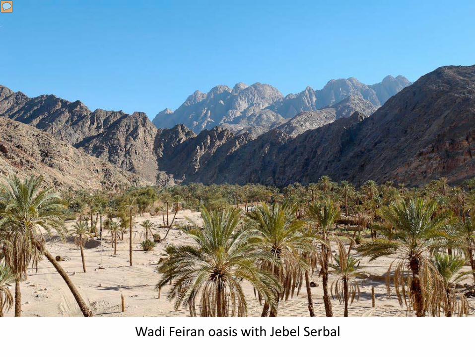
Wadi Feiran oasis with Jebel Serbal
Presenter
Presentation Notes
If the traditional site of Jebel Musa is the correct location for Mount Sinai, then the Israelites passed through the Wadi Feiran on their way to their appointment with God. This natural route is supplied by the largest oasis of southern Sinai, the Feiran spring, evidence of which is visible today in the large palm tree grove. On the north side of the oasis, a 4th century AD chapel marks the traditional location where Moses, Aaron, and Hur observed the battle between the Israelites and the Amalekites (Exodus 17:8-15). If this is accurate, then the oasis was known as Rephidim in the biblical period (Exodus 17:1, 8; Numbers 33:14). tb032506867
Jebel Musa from southwest
Presenter
Presentation Notes
A visit to Sinai at the present is not recommended because of recent kidnappings of foreigners and locals, but in the past most tourists were hustled up and down the mountain to see the sunrise. If you spend some days hiking around the area, you will get a better sense for the prominence of this 7,500-foot (2,300 meters) peak and its rugged surroundings. This view from the southwest shows the traditional place where the Lord descended and inscribed the Ten Commandments. Today a chapel occupies the summit. tb062105021
Plain of er-Raha from Ras Safsafa
Presenter
Presentation Notes
Meaning “rest,” El-Raha is traditionally believed to be the area where the Israelites camped and the golden calf was forged. Nearby is the tomb of Sheikh Harun and the chapel of the golden calf. Psalm 106:19–28 (LEB) “They made a calf at Horeb and bowed down to a cast image. 20 And so they exchanged their glory for an image of an ox that eats grass. 21 They forgot God their Savior, who had done great things in Egypt, 22 wonders in the land of Ham, awesome deeds by the Red Sea. 23 So he said he would exterminate them, had not Moses, his chosen one, stood in the breach before him, to reverse his wrath from destroying them. 24 Then they refused the desirable land; they did not believe his word, 25 but grumbled in their tents. They did not obey the voice of Yahweh. 26 So he made an oath against them, to make them drop in the wilderness, 27 and to disperse their descendants among the nations and to scatter them among the lands. 28 They also attached themselves to Baal of Peor, and they ate sacrifices offered to the dead.” tb062205249
St Catherine's Monastery from above
Presenter
Presentation Notes
To the north of Jebel Musa, the plain of er-Raha is believed to be the place where the Israelites encamped and worshipped the golden calf while waiting for Moses. Near the plain, Constantine's mother Helena identified the location of the burning bush in the year 330 and ordered the construction of St. Catherine's Monastery. Today the monastery houses the second most important collection of manuscripts in the world (after the Vatican), with more than 3,500 manuscripts in its library. The Codex Sinaiticus, a 4th century copy of the Old and New Testaments, was discovered here in 1844 but most of it is now in the British Library. This photo provides a rare view looking down on the monastery from Ras Safsafa. tb062105105
Sinai desert near Ein Hudra, Hazeroth
Presenter
Presentation Notes
A green oasis fed by springs and surrounded by steep cliffs, Ein Hudra is located about 37 miles (60 km) northeast of Jebel Musa and about 13 miles (21 km) from the Gulf of Aqaba. This oasis may be the location of biblical Hazeroth, where Miriam and Aaron spoke out against Moses (Num 11:35-12:16; 33:17-18). tb062205338
Serabit el-Khadim temple from east
Presenter
Presentation Notes
The name Serabit el-Khadim means “Columns (or Tunnels) of the Slave.” Located about 17 miles (27 km) from the shore of the Gulf of Suez, Serabit el-Khadim is situated on a plateau high up the mountains, at an elevation of 2,410 feet (753 m). The hills around Serabit el-Khadim, surrounded by wadis on all sides, are composed of Nubian sandstone and were a source of turquoise for the ancient Egyptians. tb032406576
Serabit el-Khadim temple
Presenter
Presentation Notes
The original Temple of Hathor consisted of a cave-like shrine cut out of rocky outcrop. Another shrine-cave to Sopdu was cut out of the rock right next to the Hathor shrine, and in front of each shrine was a court and portico. Over the centuries, successive pharaohs added a long chain of rooms extending westward from the caves. The entire precinct was enclosed by a temenos measuring 200 x 140 feet (61 x 43 m). The Temple of Hathor was built during the reign of Amenemhat I (1985-1956 BC; 12th Dynasty), and the last room to be added was from the reign of Seti I (1294-1297 BC; 19th Dynasty), although later inscriptions date to the reign of Ramesses VI (1143-1136 BC; 20th Dynasty). Photo by Mindy McKinny; mm091211004
Wadi Mukattab inscription
Presenter
Presentation Notes
Wadi Mukattab means “Valley of the Inscriptions,” a reference to the many Nabatean inscriptions along the wadi’s rock walls. Sinai’s largest collection of inscriptions and graffiti occupy the walls of Wadi Mukattab for a distance of about two miles (3 km). Most of the inscriptions are Nabatean, dating from the 2nd and 3rd centuries AD, but there are also a few inscriptions in Greek. tb032506811
Dahab, possible Dizahab, shoreline
Presenter
Presentation Notes
If you're a diehard student of biblical geography, and you need an excuse to stop by one of the beautiful beaches of Sinai, then the possibility that biblical Dizahab is located at modern Dahab should provide sufficient cause to spend a night and a day at this village located on the eastern side of the Sinai Peninsula. Mentioned only in Deuteronomy 1:1, the context does not contain enough information for geographers to locate the site, but the similarity between the names has led some in the past to locate it at Dahab. tb032606935
This collection is taken from the Pictorial Library of Bible Lands, Revised and Expanded edition, Volume 7: Egypt.
For more information about this volume, go to: http://www.bibleplaces.com/07-egypt-and-sinai-revised.htm
• Egypt includes more than 1,000 photos like these – all in high-resolution.
• Each photo is clearly labeled. Most slides have descriptive explanations (see notes section below).
• Designed for ease of use. PowerPoint presentations, jpg files, no watermarks, few restrictions.
• If you don’t love it, return it!
• Free shipping within the U.S.
This collection is taken from the Pictorial Library of Bible Lands, Revised and Expanded edition, Volume 7: Egypt. Presentations on this volume
include:
For more information about this volume, go to: http://www.bibleplaces.com/07-egypt-and-sinai-revised.htm
Abu Simbel Abusir Abydos Alexandria Aswan Beni Hasan Cairo Dashur Delta Edfu Giza Pyramids Karnak Temple Kom Ombo
Luxor Temple Luxor-Medinet Habu Luxor-West Bank Meidum, El-Lahun, Lisht Memphis Nile River Valley Saqqara Scenes of Egypt Sinai Peninsula Sinai-Jebel Musa, Mount Sinai Sinai-Serabit el-Khadim Sinai-Wadi Feiran Tell el-Amarna
Egypt is volume 7 of the Pictorial Library of Bible Lands, a collection of 17,600 high-resolution images of biblical sites and scenes.
Other volumes in the collection include:
For more information about the Pictorial Library of Bible Lands, go to: http://www.bibleplaces.com/details.htm
Galilee and the North Samaria and the Center Jerusalem Judah and the Dead Sea Negev and the Wilderness Jordan Lebanon Eastern and Central Turkey Western Turkey
Greece The Greek Islands Cyprus and Crete Italy and Malta Rome Trees, Plants, and Flowers of the Holy Land Cultural Images of the Holy Land Signs of the Holy Land