82
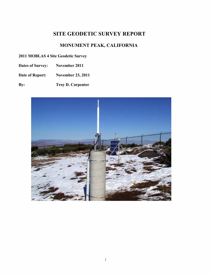
1 SITE GEODETIC SURVEY REPORT MONUMENT PEAK, CALIFORNIA 2011 MOBLAS 4 Site Geodetic Survey Dates of Survey: November 2011 Date of Report: November 23, 2011 By: Troy D. Carpenter
1
SITE GEODETIC SURVEY REPORT
MONUMENT PEAK, CALIFORNIA
2011 MOBLAS 4 Site Geodetic Survey Dates of Survey: November 2011 Date of Report: November 23, 2011 By: Troy D. Carpenter

2
Table of Contents
1. Introduction………………………………………………………………………….. 3
2. MOBLAS 4 Site Description………………………………………………………….3
2.1 SLR Station – DOMES Number: 40497M001
2.2 GPS Station – DOMES Number: 40497M004 2.3 DORIS Antenna – DOMES Number: 40497S009 2.4 Site Survey Control Monuments/Calibration Piers
3. Survey Description……………………………………………………………………4
3.1 Organization 3.2 Instruments and Equipment 3.3 Survey Network and Strategy 3.4 SLR Conventional Reference Point Observations 3.5 GPS Antenna Observations 3.6 Doris Antenna Observations 3.7 GPS Observations for Network Orientation and Reference Frame Update
4. Survey Computations…………………………………………………………………8
4.1 Survey Control Network 4.2 GPS Network
5. Results………………………………………………………………………………….8
5.1 Summary Results of Final Adjustment 5.2 SLR (MOBLAS 4) Reference Point Eccentricity 5.3 Co-Location Vector Components 5.4 MOBLAS 4 System Calibration Pier Results
Appendix A. Global Results Listing from Geolab Adjustment Output Appendix B. SLR MOBLAS 4 ILRS Site Log Appendix C. GPS MONP IGS Site Log Appendix D. DORIS MOOB IDS Site Log

3
1. Introduction The realization of the International Terrestrial Reference Frame (ITRF) is a product of the International Earth Rotation and Reference Frames Service (IERS) International Terrestrial Reference System (ITRS) Product Center. The ITRF coordinates are obtained by the combination of individual ITRF solutions computed from the observations of the different space geodesy techniques: Global Positioning System (GPS), Very Long Baseline Interferometry (VLBI), Satellite Laser Ranging (SLR), and Doppler Orbitography and Radiopositioning Integrated by Satellite (DORIS) located at sites around the whole earth. Two very important components of this combination of space geodesy solutions are the co-location site, where multiple space geodesy techniques are located in close proximity, and the local tie survey, which provides an accurate ground connection between the different space geodesy systems. This report decribes the site survey conducted at the NASA MOBLAS 4 Satellite Laser Ranging (SLR) Monument Peak, California site, and includes the results of the adjustment and analysis of the collected survey data. 2. MOBLAS 4 Site Description
The Moblas 4 site is located approximately 65 miles East of San Diego, California. The site is operated by the NASA Goddard Space Flight Center (GSFC) for space geodesy research and development. The site has three space geodesy techniques: a. SLR
b. GPS (System operated by the Southern California Integrated GPS Network – SCIGN)
c. DORIS (This system has been deactivated)
The local survey control network at the Monument Peak, California site consists of several stable, inter-visible ground monuments and concrete pillars. The concrete pillars are equipped with stainless steel self-centering fixtures, that accept will special self-centering ball survey tribrachs. 2.1 SLR Station – DOMES Number : 40497M001 Monument Peak SLR 7110 This station refers to the ground survey mark, designated ORT 7110, located beneath the SLR Moblas 4 telescope. The survey mark is a standard NASA 100 millimeter (mm) brass disk set flush in the center of the isolated concrete foundation for the SLR Moblas 4 mount. The SLR is a transportable system named MOBLAS 4 (ILRS designation: MONP). The system consists of a 0.76 meter (m) telescope on an azimuth/elevation (Az/El) mount supported by three legs, isolated from the mobile trailer enclosure. The trailer has a roll back roof and sides that can be lowered to expose the SLR telescope. The foundation for the mobile trailer is separate and isolated from the foundation of the SLR telescope.

4
The conventional reference point for the SLR telescope is the intersection of the horizontal and vertical axis of rotation. This reference point is not accessible and cannot be measured directly. The SLR reference point is horizontally and vertically eccentric from the station mark. 2.2 GPS Station – DOMES Number: 40497M004 Monument Peak GNSS MONP This station refers to a punch mark located on the side of the center pole brace of the Wyatt/Agnew drilled-braced steel supports. The actual vertical reference point is located at this punch mark and the horizontal point referenced to the center of the GPS antenna ARP. The GPS station is designated MONP by the IGS and it is an IGS Reference Frame Station. The MONP antenna is an ASH701945B_M with a SCIS antenna radome. The height of the MONP antenna reference point (ARP) is o.1176 meters above the station mark. 2.3 DORIS Antenna – DOMES Number: 40497S009 Monument Peak DORIS MOOB The DORIS station is designated by the IDS and the station refers to the antenna reference point (400 MHz phase center). The antenna is mounted on a stainless steel plate fixture and frame attached to the top of a 300 mm diameter reinforced concrete pillar. The DORIS reference mark (survey point) is the intersection of the centerline of the DORIS antenna at the 400 MHz phase center point (red line). This point is located 0.894 meters above a punch mark in a small brass pin imbedded in the top of the concrete pillar. 2.4 Site Survey Control Monuments/Calibration Piers
(a) Monument SLR 7220 DOMES Number: 40497M002 – Punch Mark in center of a steel plate set in top of concrete monument.
(b) Monument 7274 – Center mark of standard National Geodetic Survey (NGS) brass triangulation disk set in top of concrete monument.
(c) Monument Reference Mark 1 – Center mark of standard National Geodetic Survey (NGS) brass reference disk set in top of concrete monument.
(d) Lookout – Center mark of Standard NASA brass survey disk set flush in the top of a concrete helio-pad.
(e) Calibration Pier A – Center top of a stainless steel insert imbedded in the top of a concrete pillar that is incased in a hard black plastic ribbed material.
(f) Calibration Pier C – Center top of a stainless steel insert imbedded in the top of a concrete pillar.
3. Survey Description 3.1 Organization The survey work was completed by ITT surveyor Troy Carpenter, under the NASA SCNS contract and TO22. The field survey data was collected during November 2011 for a re-survey of the Moblas 4 Monument Peak site survey control monuments, the existing Global Positioning and DORIS systems, and the Moblas 4 calibration piers. This was to update the Moblas 4 system calibration distances to the
5
two existing calibration pillars and the Moblas 4 system eccentricity from survey control monument ORT 7110. In addition Global Positioning System (GPS) data was collected to upgrade and reference the site geodetic coordinates to the ITRF2008 epoch 2005 International terrestrial Reference Frame. 3.2 Instruments and Equipment
All of the survey instruments and equipment utilized for this project is owned by NASA and administered by ITT under the SCNS TO22 Contract. The following are the primary survey instruments utilized: a. Leica electronic theodolite T3000, with an angular accuracy standard deviation of 0.5 arc seconds,
were used to measure horizontal directions and zenith distances.
b. Two Leica electronic distance measurement (EDM) instruments (DI2000 66886 and DI2002 180595), with an accuracy standard deviation of 1 mm + 1 ppm were used to measure the slope distances.
c. Lieca electronic level NA3003 (93769), with an accuracy standard deviation of 1.2 mm was used for
the differential level measurements.
d. Four Trimble 4000SSE GPS receivers with Trimble choke ring antennas, with a horizontal accuracy standard deviation of 5mm + 1ppm and a vertical accuracy standard deviation of 10 mm + 1 ppm were used to collect the GPS data.
Other survey accessory equipment included: a. Leica optical plummet b. Wild T2 targets c. Tripods d. Translation Stage e. Trivet plates, tribrachs, and tribrach adapters f. Calibrated 40 mm mini-prisms
Prior to the site survey, the calibration constants for the Leica EDM instruments where verified using a Leica TS30 robotic theodolite. Several distances where measured and compared between the Leica instruments at the NASA GGAO facility in Greenbelt, Maryland. The Leica DI2000 and DI2002 had been calibrated at the National Geodetic Survey (NGS) precise baseline in Corbin, Virginia (CBL) in May 2009. The Leica TS30 robotic theodolite was calibrated at the NGS precise baseline in Corbin, Virginia in April 2010. This calibration confirmed the manufactures published calibration value.

6
3.3 Survey Network and Strategy
The special self centering pier tribrach was used to set the T3000 theodolite at both Calibration Pier A and Calibration Pier C to ensure stability and eliminate plumbing errors. The prisms at these calibration piers where set directly into the stainless steel inserts to also eliminate any plumbing errors. The Leica optical plummet was used for all tripod setups to minimize plumbing errors. The majority of the inter-visible lines-of-sight between the survey stations were observed. Horizontal directions where observed in sets of four observations with each set consisting of an observation in both the direct and reverse theodolite telescope pointings. Zenith distances where observed in sets of three observations, both direct and reverse theodolite telescope pointings. Zenith distance observations where observed across all the lines from each of the occupied stations. The distance measurements where made from each station standpoint with both the Leica DI2000 and the Leica DI2002 to the majority of the inter-visible target points. The atmospheric pressure and temperature data were recorded at the beginning and end of each distance measurement. Direct differential levels where observed to determine orthometric height differences between the majority of the survey control stations in the control network. All observations where double run: forward run and backward run. The exceptions where both Calibration Pier A and Calibration Pier C. The heights of these control points where determined by a combination of zenith distance observations and Global Positioning System (GPS) collected data. All of the observations to the Moblas 4 system mount (translation stage target/prism) where made from as many of the ground survey monuments as possible. These consisted of horizontal directions, zenith distances, distance measurements, and differential levels. No observations where made from the top of the Moblas 4 mount with the exception of the differential levels. Both the Global Positioning System (GPS) and the DORIS system antennas could not be removed. To provide the survey ties to both of these systems, it was necessary to use survey intersection methods. The survey intersection observations consisted of horizontal directions and zenith distances from several of the control monuments in the site survey scheme. Differential levels where observed to the base of both antennas, and a vertical tape was used to measure the vertical heights from the base to the GPS antenna ARP and the DORIS antenna reference point.

7
3.4 SLR Conventional Reference Point Observations The conventional reference point for the SLR Moblas 4 telescope was determined two ways. For the vertical height from the Moblas 4 vertical axis of rotation relative to a horizontal plane, to the top of the system mount survey plate, the standard prior determined value of 0.489 meters was used. To determine the vertical axis of rotation, a trivet plate with a translation stage assembly (two slides in orthogonal directions) was set onto the system mount survey plate. The system mount survey plate has been mounted approximately on the vertical axis of rotation. The Moblas 4 mount was then leveled with a large carpenters level and locked in place. A theodolite with an EDM instrument was set up on a tripod approximately 10 to 16 meters away, and a prism placed in the translation stage tribrach. The center of the prism was sighted and the distance recorded. Then the Moblas 4 telescope was rotated 180 degrees about the vertical axis and the distance to the prism was measured again. The translation stage was then adjusted by one-half of the value of the difference in the two distance measurements. The Moblas 4 telescope was then rotated by 90 degrees from the original position and the process repeated until the prism remains within 0.5 mm during an entire rotation. 3.5 GPS Antenna Observations The conventional reference point for the ASH701945B_M GPS antenna is defined as the center of the 5/8”-11 threaded insert at the base of the power amplifier (BPA). This point is normally referred to as the Antenna Reference Point (ARP). Since the MONP GPS antenna and the radome could not be removed, the conventional reference point was determined by indirect methods. For the horizontal position, the forward intersection method was used by observing horizontal directions (4 sets, direct and reverse pointings) to the tangent point of both the left side and the right side of the antenna power amplifier (BPA). In the actual final adjustment, the mean of the left and right directions was used as input for the horizontal directions. The vertical position was determined by observing direct differential levels to a fixed point at the base of the GPS antenna center pole mount. A vertical tape was then used to measure from this point to the base of the GPS antenna ARP. In the adjustment, the height difference was reduced to the published survey point using the published dimension of 0.1176 meters as listed in the site log for the ASH701945B_M GPS antenna. In addition, zenith distance observations (3 sets, direct and reverse pointings) where observed from all those survey monuments with line-of-sight to the GPS antenna. 3.6 DORIS Antenna Observations The conventional reference point for the DORIS antenna is defined as the intersection of the vertical antenna axis and at the center of the horizontal red stripe. This point is designated as the 400 MHz reference point of the DORIS antenna. Since the DORIS antenna could not be removed, the conventional reference point was also determined by indirect methods. The method used was exactly the same as with the GPS antenna observations, except the actual left and right pointings where made at the tangent points of the actual antenna at the red stripe location. The zenith distance observations where made to the actual center of the red stripe.

8
3.7 GPS Observations for Network Orientation and Reference Frame Update In order to provide for orientation of the topocentric survey network at the Moblas 4 site, Global Positioning System (GPS) data was collected on select ground control monuments and pillars. The GPS observations consisted of five sessions over five different days. These sessions ranged from 3 to 5 hours with two sessions of 11 hours each. For each session, GPS data was collected with two Trimble 4000SSE receivers and two Trimble choke ring antennas. The appropriate MONP GPS RINEX data was subsequently downloaded for the post processing with the collected GPS data. 4. Survey Computations 4.1 Survey Control Network The conventional electro-optical survey data recorded in the filed (distances, horizontal directions, zenith distances, and direct differential levels) was reduced and organized in abstract form fro subsequent input into a least-squares adjustment. The distance measurements were corrected for the deviations in atmospheric pressure and temperature. The MicroSearch software program GeoLab32v3 was used for the preliminary and final least-squares adjustment of both the conventional and collected GPS data. The original input .iob file was developed from the reduced conventional survey observation data. The geodetic coordinates for station MONP were constrained, and a control survey scheme azimuth developed from the GPS collected data. A preliminary adjustment was used to identify any blunders or outliers in the survey observations, and verify the accuracy of the survey meets requirements. 4.2 GPS Network The collected Trimble GPS data was post processed with the Trimble software GPSurvey, version 2.35, along with the downloaded RINEX GPS data for MONP. Since all of the collected GPS data covered a small area of 200 meters or less, only the broadcast ephemeris orbits for the GPS satellites were utilized during the post processing. For these processed solutions, the reference station MONP was constrained (at 1mm) to the ITRF2008 coordinates at epoch 2005. 5. Results The final comprehensive least-squares adjustment was completed with the GeoLab32v3 software, and is a combination of the survey control network observations and the collected GPS data. The conventional survey observations are used to develop the input file developed from the output data from the GPSurvey GPS post-processing (vector coordinate values and extracted covariance matrix) for the selected baselines. The coordinates for the MONP station were constrained at 1 mm to the ITRF2008 epoch 2005 values.

9
5.1 Summary Results of Final Adjustment The summary of the adjusted coordinates from GeoLab are shown below, after Table 1. The full results are provided in Appendix A. Table 1 is a translation table provided to assist in coordinating the survey point description and the names used in the adjustment for selected points of interest.
Table 1. Translation Table for Survey Point Names
Survey Point Description DOMES Number Adjustment Name GNSS GPS MONP 40497M004 MONP SLR 7110 40497M001 7110 SLR 7220 40497M002 7220 SLR 7274 40497M003 7274 SLR MOBLAS 4 None MOB4 DORIS MOOB 40497S009 DORIS Calibration Pier A None CALA Calibration Pier C None CALC
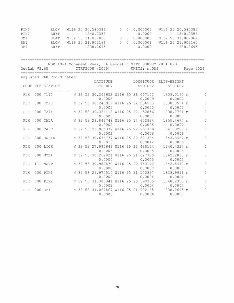
Adjusted PLH Coordinates: LATITUDE LONGITUDE ELIP-HEIGHT CODE FFF STATION STD DEV STD DEV STD DEV ---- --- ------------ ----------------- ----------------- ------------ PLH 000 7110 N 32 53 30.263652 W116 25 21.627103 1839.0167 m 0.0008 0.0009 0.0007 PLH 000 7220 N 32 53 30.243919 W116 25 22.236593 1838.8594 m 0.0005 0.0005 0.0005 PLH 000 7274 N 32 53 30.366118 W116 25 22.152856 1838.7781 m 0.0005 0.0007 0.0005 PLH 000 CALA N 32 53 28.849748 W116 25 14.652824 1855.4677 m 0.0002 0.0005 0.0007 PLH 000 CALC N 32 53 26.966377 W116 25 22.961759 1841.3288 m 0.0002 0.0006 0.0006 PLH 000 DORIS N 32 53 30.676777 W116 25 20.521364 1843.3467 m 0.0016 0.0012 0.0006 PLH 000 LOOK N 32 53 27.980648 W116 25 23.485154 1840.4324 m 0.0003 0.0005 0.0005 PLH 000 MOB4 N 32 53 30.262821 W116 25 21.627790 1842.2063 m 0.0004 0.0005 0.0005 PLH 111 MONP N 32 53 30.982870 W116 25 20.453170 1842.5470 m 0.0000 0.0000 0.0000 PLH 000 PIN1 N 32 53 29.974514 W116 25 21.550397 1838.9911 m 0.0002 0.0004 0.0004 PLH 000 PIN2 N 32 53 31.380341 W116 25 20.590385 1840.2358 m 0.0002 0.0004 0.0004 PLH 000 RM1 N 32 53 31.067867 W116 25 21.902165 1838.2695 m 0.0006 0.0006 0.0005
10
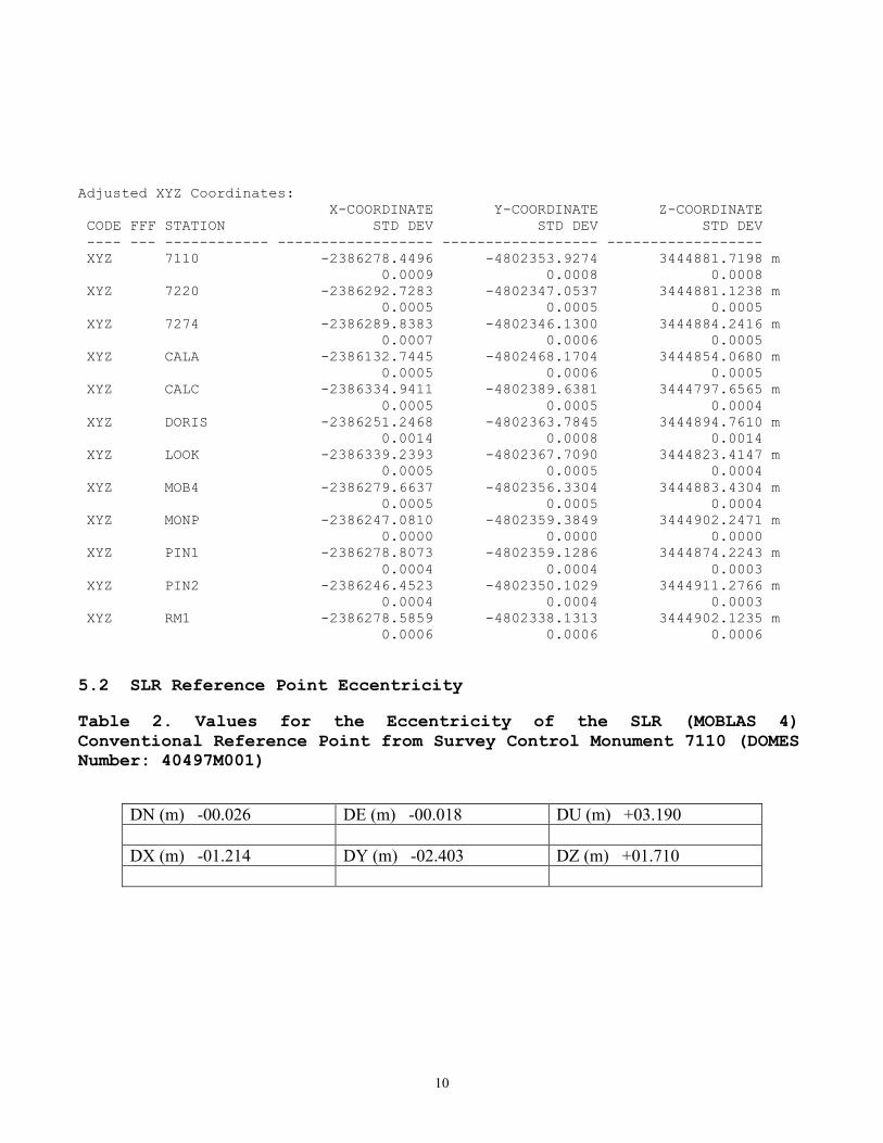
Adjusted XYZ Coordinates: X-COORDINATE Y-COORDINATE Z-COORDINATE CODE FFF STATION STD DEV STD DEV STD DEV ---- --- ------------ ------------------ ------------------ ------------------ XYZ 7110 -2386278.4496 -4802353.9274 3444881.7198 m 0.0009 0.0008 0.0008 XYZ 7220 -2386292.7283 -4802347.0537 3444881.1238 m 0.0005 0.0005 0.0005 XYZ 7274 -2386289.8383 -4802346.1300 3444884.2416 m 0.0007 0.0006 0.0005 XYZ CALA -2386132.7445 -4802468.1704 3444854.0680 m 0.0005 0.0006 0.0005 XYZ CALC -2386334.9411 -4802389.6381 3444797.6565 m 0.0005 0.0005 0.0004 XYZ DORIS -2386251.2468 -4802363.7845 3444894.7610 m 0.0014 0.0008 0.0014 XYZ LOOK -2386339.2393 -4802367.7090 3444823.4147 m 0.0005 0.0005 0.0004 XYZ MOB4 -2386279.6637 -4802356.3304 3444883.4304 m 0.0005 0.0005 0.0004 XYZ MONP -2386247.0810 -4802359.3849 3444902.2471 m 0.0000 0.0000 0.0000 XYZ PIN1 -2386278.8073 -4802359.1286 3444874.2243 m 0.0004 0.0004 0.0003 XYZ PIN2 -2386246.4523 -4802350.1029 3444911.2766 m 0.0004 0.0004 0.0003 XYZ RM1 -2386278.5859 -4802338.1313 3444902.1235 m 0.0006 0.0006 0.0006 5.2 SLR Reference Point Eccentricity Table 2. Values for the Eccentricity of the SLR (MOBLAS 4) Conventional Reference Point from Survey Control Monument 7110 (DOMES Number: 40497M001)
DN (m) -00.026 DE (m) -00.018 DU (m) +03.190 DX (m) -01.214 DY (m) -02.403 DZ (m) +01.710

11
5.3 Co-Location Vector Components The local tie vectors were calculated from the results of the final Geolab least-squares adjustment. Table 3 contains a summary of the local tie vectors, as determined during the survey, compared to local tie vectors used in the ITRF2008 epoch 2005 combination solution shown in Table 4.
From Domes To Domes DX (m) DY (m) DZ (m) Name Name 40497M001 40497M004 +31.369 -05.458 +20.527 7110 MONP 40497M001 40497S009 +27.203 -09.857 +13.041 7110 DORIS 40497M004 40497S009 -04.166 -04.400 -07.486 MONP DORIS
Table 4. Local tie vectors as published in the ITRF2008 Epoch 2005 solution.
From Domes To Domes DX (m) DY (m) DZ (m) Name Name 40497M001 40497M004 +31.374 -05.444 +20.522 7110 MONP 40497M001 40497S009 +27.208 -09.839 +13.021 7110 DORIS 40497M004 40497S009 -04.166 -04.395 -07.501 MONP DORIS

12
5.4 MOBLAS 4 System Calibration Pier Results
Table 5. MOBLAS 4 System Calibration Pier Data
Target: Prism SN: Prism Constant Applied
Cal Pier A LTN 91-D +0.0331 Calibration Distance: 187.003 meters Elevation Angle: +04.0898 Degrees Geodetic Azimuth: 103.5020 Degrees
Target: Prism SN: Prism Constant Applied
Cal Pier C LTN 90-F +0.0313 Calibration Distance: 107.372 meters Elevation Angle: -00.4288 Degrees Geodetic Azimuth: 198.8508 Degrees

13
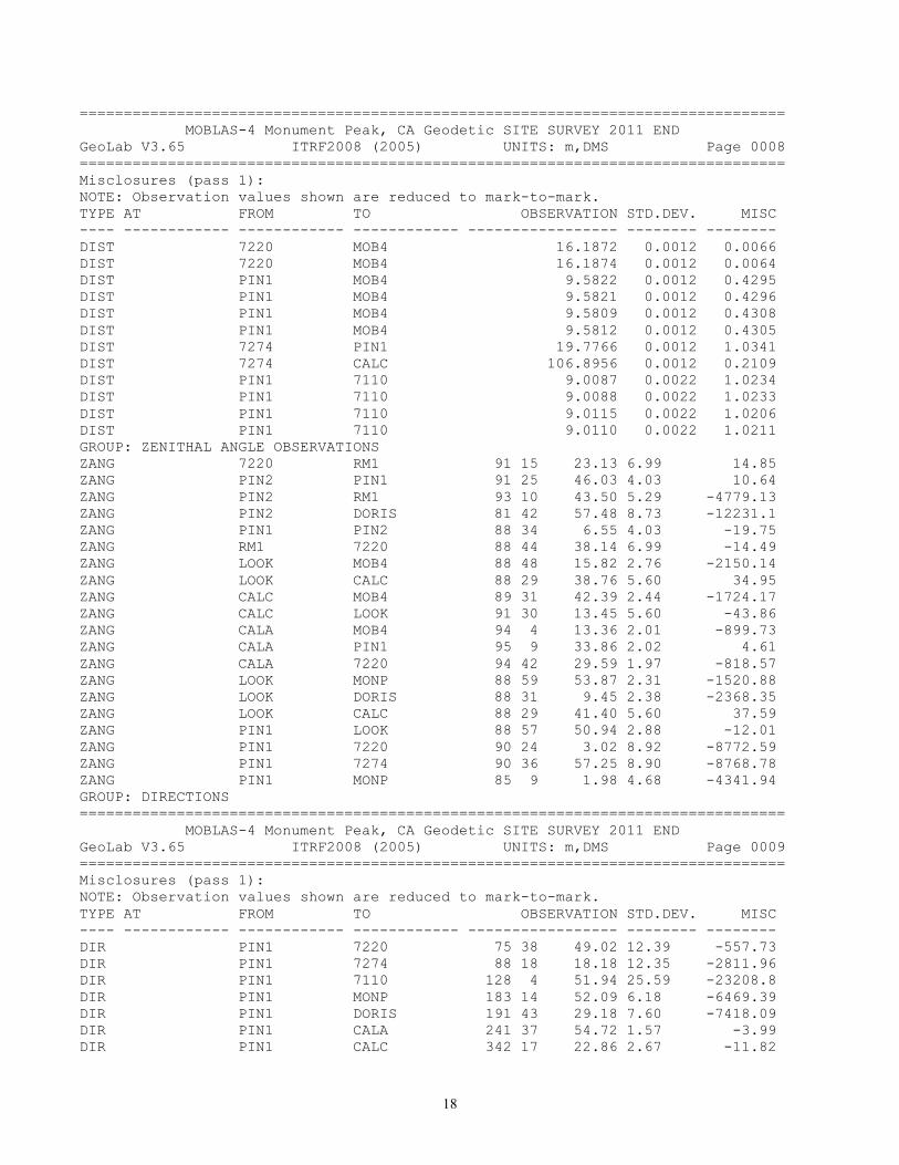
Appendix A. Global results Listing from Geolab Adjustment Output ================================================================================ MOBLAS-4 Monument Peak, CA Geodetic SITE SURVEY 2011 END GeoLab V3.65 ITRF2008 (2005) UNITS: m,DMS Page 0001 ================================================================================ 10:48:51, Sat Nov 19, 2011 Input file: C:\glab32v3\MON_Peak\MP_03G.iob Output file: C:\glab32v3\MON_Peak\MP_03G.lst Options file: C:\glab32v3\default.cfg Geoid File: C:\glab32v3\GEOID09\g2009u05.gsp Geoid File: C:\glab32v3\geoid09\g2009u05.gsp ----------------------------------------------------------------------------- | PARAMETERS | OBSERVATIONS | |-----------------------------------------------------------------------------| | Description | Number | Description | Number | |-----------------------------------------------------------------------------| | No. of Stations | 12 | Directions | 50 | | Coord Parameters | 33 | Distances | 79 | | Free Latitudes | 11 | Azimuths | 0 | | Free Longitudes | 11 | Vertical Angles | 0 | | Free Heights | 11 | Zenithal Angles | 26 | | Fixed Coordinates| 3 | Angles | 0 | | Astro. Latitudes | 0 | Heights | 0 | | Astro. Longitudes| 0 | Height Differences| 32 | | Geoid Records | 0 | Auxiliary Params. | 0 | | All Aux. Pars. | 16 | 2-D Coords. | 0 | | Direction Pars. | 16 | 2-D Coord. Diffs. | 0 | | Scale Parameters | 0 | 3-D Coords. | 0 | | Constant Pars. | 0 | 3-D Coord. Diffs. | 48 | | Rotation Pars. | 0 | | | | Translation Pars.| 0 | | | | | | | | | | -------- | | -------- | | Total Parameters | 49 | Total Observations| 235 | |-----------------------------------------------------------------------------| | Degrees of Freedom = 186 | -----------------------------------------------------------------------------
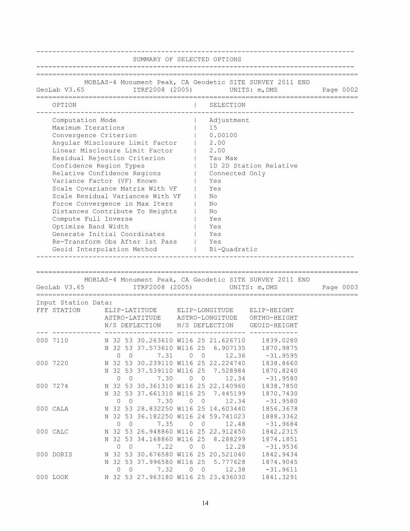
14
------------------------------------------------------------------------------- SUMMARY OF SELECTED OPTIONS ------------------------------------------------------------------------------- ================================================================================ MOBLAS-4 Monument Peak, CA Geodetic SITE SURVEY 2011 END GeoLab V3.65 ITRF2008 (2005) UNITS: m,DMS Page 0002 ================================================================================ OPTION | SELECTION ------------------------------------------------------------------------------- Computation Mode | Adjustment Maximum Iterations | 15 Convergence Criterion | 0.00100 Angular Misclosure Limit Factor | 2.00 Linear Misclosure Limit Factor | 2.00 Residual Rejection Criterion | Tau Max Confidence Region Types | 1D 2D Station Relative Relative Confidence Regions | Connected Only Variance Factor (VF) Known | Yes Scale Covariance Matrix With VF | Yes Scale Residual Variances With VF | No Force Convergence in Max Iters | No Distances Contribute To Heights | No Compute Full Inverse | Yes Optimize Band Width | Yes Generate Initial Coordinates | Yes Re-Transform Obs After 1st Pass | Yes Geoid Interpolation Method | Bi-Quadratic ------------------------------------------------------------------------------- ================================================================================ MOBLAS-4 Monument Peak, CA Geodetic SITE SURVEY 2011 END GeoLab V3.65 ITRF2008 (2005) UNITS: m,DMS Page 0003 ================================================================================ Input Station Data: FFF STATION ELIP-LATITUDE ELIP-LONGITUDE ELIP-HEIGHT ASTRO-LATITUDE ASTRO-LONGITUDE ORTHO-HEIGHT N/S DEFLECTION N/S DEFLECTION GEOID-HEIGHT --- ------------ ----------------- ----------------- ------------ 000 7110 N 32 53 30.263610 W116 25 21.626710 1839.0280 N 32 53 37.573610 W116 25 6.907135 1870.9875 0 0 7.31 0 0 12.36 -31.9595 000 7220 N 32 53 30.239110 W116 25 22.224740 1838.8660 N 32 53 37.539110 W116 25 7.528984 1870.8240 0 0 7.30 0 0 12.34 -31.9580 000 7274 N 32 53 30.361310 W116 25 22.140960 1838.7850 N 32 53 37.661310 W116 25 7.445199 1870.7430 0 0 7.30 0 0 12.34 -31.9580 000 CALA N 32 53 28.832250 W116 25 14.603440 1856.3678 N 32 53 36.182250 W116 24 59.741023 1888.3362 0 0 7.35 0 0 12.48 -31.9684 000 CALC N 32 53 26.948860 W116 25 22.912450 1842.2315 N 32 53 34.168860 W116 25 8.288299 1874.1851 0 0 7.22 0 0 12.28 -31.9536 000 DORIS N 32 53 30.676580 W116 25 20.521040 1842.9434 N 32 53 37.996580 W116 25 5.777628 1874.9045 0 0 7.32 0 0 12.38 -31.9611 000 LOOK N 32 53 27.963180 W116 25 23.436030 1841.3291
15
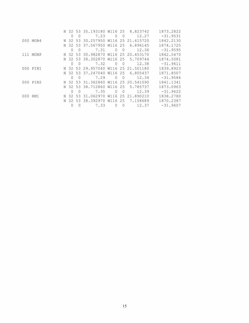
N 32 53 35.193180 W116 25 8.823742 1873.2822 0 0 7.23 0 0 12.27 -31.9531 000 MOB4 N 32 53 30.257950 W116 25 21.615720 1842.2130 N 32 53 37.567950 W116 25 6.896145 1874.1725 0 0 7.31 0 0 12.36 -31.9595 111 MONP N 32 53 30.982870 W116 25 20.453170 1842.5470 N 32 53 38.302870 W116 25 5.709744 1874.5081 0 0 7.32 0 0 12.38 -31.9611 000 PIN1 N 32 53 29.957040 W116 25 21.501180 1839.8923 N 32 53 37.247040 W116 25 6.805437 1871.8507 0 0 7.29 0 0 12.34 -31.9584 000 PIN2 N 32 53 31.362860 W116 25 20.541090 1841.1341 N 32 53 38.712860 W116 25 5.785737 1873.0963 0 0 7.35 0 0 12.39 -31.9622 000 RM1 N 32 53 31.062970 W116 25 21.890210 1838.2780 N 32 53 38.392970 W116 25 7.158689 1870.2387 0 0 7.33 0 0 12.37 -31.9607

16
================================================================================ MOBLAS-4 Monument Peak, CA Geodetic SITE SURVEY 2011 END GeoLab V3.65 ITRF2008 (2005) UNITS: m,DMS Page 0005 ================================================================================ Misclosures (pass 1): NOTE: Observation values shown are reduced to mark-to-mark. TYPE AT FROM TO OBSERVATION STD.DEV. MISC ---- ------------ ------------ ------------ ----------------- -------- -------- GROUP: 00001925.SSF,obs#: 2 day 310 OPT 310 1 18 DXCT CALC CALA 202.1999 0.0022 -0.0004 DYCT CALC CALA -78.5278 0.0036 -0.0032 DZCT CALC CALA 56.4064 0.0021 0.0042 GROUP: 00001910.SSF,obs#: 3 day 308 OPT 308 15 DXCT MONP CALA 114.3397 0.0020 0.6800 DYCT MONP CALA -108.7866 0.0026 -1.5093 DZCT MONP CALA -48.1796 0.0017 0.0366 GROUP: 00001919.SSF,obs#: 4 day 310 OPT 310 18 DXCT MONP CALA 114.3376 0.0027 0.6821 DYCT MONP CALA -108.7786 0.0040 -1.5173 DZCT MONP CALA -48.1846 0.0022 0.0416 GROUP: 00001913.SSF,obs#: 5 day 308 OPT 308 14 DXCT MONP CALC -87.8601 0.0016 0.6803 DYCT MONP CALC -30.2572 0.0028 -1.5077 DZCT MONP CALC -104.5894 0.0017 0.0358 GROUP: 00001922.SSF,obs#: 6 day 310 OPT 310 18 DXCT MONP CALC -87.8607 0.0025 0.6809 DYCT MONP CALC -30.2533 0.0039 -1.5116 DZCT MONP CALC -104.5902 0.0021 0.0366 GROUP: 00001952.SSF,obs#: 7 day 314 OPT 314 17 DXCT MONP LOOK -92.1600 0.0016 0.6803 DYCT MONP LOOK -8.3207 0.0021 -1.5078 DZCT MONP LOOK -78.8332 0.0015 0.0358 GROUP: 00001937.SSF,obs#: 8 day 312 OPT 312 DXCT MONP PIN1 -31.7275 0.0012 0.6803 DYCT MONP PIN1 0.2551 0.0017 -1.5078 DZCT MONP PIN1 -28.0211 0.0012 0.0357 GROUP: 00001931.SSF,obs#: 9 day 312 OPT 312 23 DXCT MONP PIN1 -31.7334 0.0311 0.6862 DYCT MONP PIN1 0.2677 0.0222 -1.5204 DZCT MONP PIN1 -28.0295 0.0161 0.0441 GROUP: 00001949.SSF,obs#: 10 day 313 OPT 313 DXCT MONP PIN1 -31.7245 0.0011 0.6773 DYCT MONP PIN1 0.2579 0.0015 -1.5106 DZCT MONP PIN1 -28.0244 0.0011 0.0390 GROUP: 00001955.SSF,obs#: 11 day 314 OPT 314 16 DXCT MONP PIN1 -31.7288 0.0020 0.6816 DYCT MONP PIN1 0.2588 0.0026 -1.5115 DZCT MONP PIN1 -28.0227 0.0018 0.0373 GROUP: 00001934.SSF,obs#: 12 day 312 OPT 312 DXCT MONP PIN2 0.6302 0.0013 0.6804 DYCT MONP PIN2 9.2819 0.0025 -1.5077 DZCT MONP PIN2 9.0292 0.0015 0.0359 GROUP: 00001943.SSF,obs#: 15 day 313 OPT 313 1 DXCT PIN2 MONP -0.6303 0.0010 -0.6803 DYCT PIN2 MONP -9.2841 0.0014 1.5099 DZCT PIN2 MONP -9.0283 0.0010 -0.0368 GROUP: 00001946.SSF,obs#: 17 day 312 OPT 312 1 23

17
DXCT PIN2 PIN1 -32.3550 0.0011 -0.0028 DYCT PIN2 PIN1 -9.0265 0.0015 -0.0004 DZCT PIN2 PIN1 -37.0522 0.0011 0.0017 GROUP: DISTANCES DIST PIN1 7110 9.0094 0.0022 1.0227 DIST PIN1 LOOK 79.4168 0.0012 0.0029 DIST PIN1 LOOK 79.4167 0.0012 0.0030 DIST PIN1 7220 19.6684 0.0012 1.0794 DIST PIN1 7220 19.6690 0.0012 1.0788 DIST PIN1 7274 19.7700 0.0012 1.0407 DIST 7220 7110 15.8578 0.0022 -0.2908 DIST 7220 7110 15.8550 0.0022 -0.2880 DIST PIN1 CALA 183.3861 0.0013 0.0050 DIST PIN1 CALA 183.3852 0.0013 0.0059 DIST PIN1 7274 19.7706 0.0012 1.0401 DIST 7220 CALA 202.4815 0.0013 1.1016 DIST 7220 CALA 202.4825 0.0013 1.1006 DIST 7220 PIN1 19.6774 0.0012 1.0704 DIST 7220 PIN1 19.6776 0.0012 1.0702 DIST RM1 PIN2 35.4956 0.0012 0.8884 DIST RM1 PIN2 35.4950 0.0012 0.8890 DIST CALA MOB4 186.9655 0.0013 1.0954 DIST CALA MOB4 186.9656 0.0013 1.0953 DIST CALA MOB4 186.9652 0.0013 1.0957 DIST CALA MOB4 186.9658 0.0013 1.0951 DIST CALC MOB4 107.3450 0.0012 0.0537 DIST CALC MOB4 107.3454 0.0012 0.0533 DIST CALC MOB4 107.3457 0.0012 0.0530 DIST CALC MOB4 107.3451 0.0012 0.0536 DIST CALC MOB4 107.3451 0.0012 0.0536 DIST CALC MOB4 107.3456 0.0012 0.0531 DIST CALC PIN1 99.7197 0.0012 0.0026 DIST CALC LOOK 34.0993 0.0012 0.0046 DIST CALC LOOK 34.0989 0.0012 0.0050 DIST PIN2 RM1 35.4901 0.0012 0.8939 DIST PIN2 RM1 35.4914 0.0012 0.8926 DIST LOOK MOB4 85.3186 0.0012 -0.2251 DIST LOOK MOB4 85.3188 0.0012 -0.2253 DIST LOOK PIN1 79.4172 0.0012 0.0025 DIST LOOK CALC 34.0994 0.0012 0.0045 DIST LOOK CALC 34.0995 0.0012 0.0044 DIST LOOK CALA 231.6734 0.0013 0.0062 DIST LOOK CALA 231.6734 0.0013 0.0062 DIST CALA PIN1 183.3859 0.0013 0.0053 DIST CALA PIN1 183.3851 0.0013 0.0061 DIST CALA LOOK 231.6729 0.0013 0.0067 DIST CALA LOOK 231.6729 0.0013 0.0067 DIST CALA MOB4 186.9669 0.0013 1.0939 DIST CALA MOB4 186.9670 0.0013 1.0938 DIST CALA 7220 202.4793 0.0013 1.1038 DIST CALA 7220 202.4796 0.0013 1.1035 DIST 7220 MOB4 16.1878 0.0012 0.0060 DIST 7220 MOB4 16.1880 0.0012 0.0058
18
================================================================================ MOBLAS-4 Monument Peak, CA Geodetic SITE SURVEY 2011 END GeoLab V3.65 ITRF2008 (2005) UNITS: m,DMS Page 0008 ================================================================================ Misclosures (pass 1): NOTE: Observation values shown are reduced to mark-to-mark. TYPE AT FROM TO OBSERVATION STD.DEV. MISC ---- ------------ ------------ ------------ ----------------- -------- -------- DIST 7220 MOB4 16.1872 0.0012 0.0066 DIST 7220 MOB4 16.1874 0.0012 0.0064 DIST PIN1 MOB4 9.5822 0.0012 0.4295 DIST PIN1 MOB4 9.5821 0.0012 0.4296 DIST PIN1 MOB4 9.5809 0.0012 0.4308 DIST PIN1 MOB4 9.5812 0.0012 0.4305 DIST 7274 PIN1 19.7766 0.0012 1.0341 DIST 7274 CALC 106.8956 0.0012 0.2109 DIST PIN1 7110 9.0087 0.0022 1.0234 DIST PIN1 7110 9.0088 0.0022 1.0233 DIST PIN1 7110 9.0115 0.0022 1.0206 DIST PIN1 7110 9.0110 0.0022 1.0211 GROUP: ZENITHAL ANGLE OBSERVATIONS ZANG 7220 RM1 91 15 23.13 6.99 14.85 ZANG PIN2 PIN1 91 25 46.03 4.03 10.64 ZANG PIN2 RM1 93 10 43.50 5.29 -4779.13 ZANG PIN2 DORIS 81 42 57.48 8.73 -12231.1 ZANG PIN1 PIN2 88 34 6.55 4.03 -19.75 ZANG RM1 7220 88 44 38.14 6.99 -14.49 ZANG LOOK MOB4 88 48 15.82 2.76 -2150.14 ZANG LOOK CALC 88 29 38.76 5.60 34.95 ZANG CALC MOB4 89 31 42.39 2.44 -1724.17 ZANG CALC LOOK 91 30 13.45 5.60 -43.86 ZANG CALA MOB4 94 4 13.36 2.01 -899.73 ZANG CALA PIN1 95 9 33.86 2.02 4.61 ZANG CALA 7220 94 42 29.59 1.97 -818.57 ZANG LOOK MONP 88 59 53.87 2.31 -1520.88 ZANG LOOK DORIS 88 31 9.45 2.38 -2368.35 ZANG LOOK CALC 88 29 41.40 5.60 37.59 ZANG PIN1 LOOK 88 57 50.94 2.88 -12.01 ZANG PIN1 7220 90 24 3.02 8.92 -8772.59 ZANG PIN1 7274 90 36 57.25 8.90 -8768.78 ZANG PIN1 MONP 85 9 1.98 4.68 -4341.94 GROUP: DIRECTIONS ================================================================================ MOBLAS-4 Monument Peak, CA Geodetic SITE SURVEY 2011 END GeoLab V3.65 ITRF2008 (2005) UNITS: m,DMS Page 0009 ================================================================================ Misclosures (pass 1): NOTE: Observation values shown are reduced to mark-to-mark. TYPE AT FROM TO OBSERVATION STD.DEV. MISC ---- ------------ ------------ ------------ ----------------- -------- -------- DIR PIN1 7220 75 38 49.02 12.39 -557.73 DIR PIN1 7274 88 18 18.18 12.35 -2811.96 DIR PIN1 7110 128 4 51.94 25.59 -23208.8 DIR PIN1 MONP 183 14 52.09 6.18 -6469.39 DIR PIN1 DORIS 191 43 29.18 7.60 -7418.09 DIR PIN1 CALA 241 37 54.72 1.57 -3.99 DIR PIN1 CALC 342 17 22.86 2.67 -11.82

19
DIR 7220 PIN1 12 39 36.36 12.39 -724.93 DIR 7220 7274 287 44 35.39 58.99 -136.92 DIR 7220 7110 345 30 31.89 16.50 -2268.49 DIR PIN2 RM1 44 17 13.54 7.09 3610.12 DIR PIN2 MONP 313 48 29.53 21.37 18707.76 DIR PIN2 DORIS 325 19 16.18 12.11 11941.79 DIR RM1 MONP 19 44 33.42 6.85 -4328.31 DIR 7220 PIN1 96 2 51.84 12.39 -569.63 DIR RM1 7220 124 40 6.80 9.59 -3591.76 DIR RM1 PIN2 235 19 53.75 7.09 3591.21 DIR CALC LOOK 261 30 38.48 7.56 -18.95 DIR CALC MOB4 303 53 19.99 2.49 -2000.08 DIR CALC PIN1 306 38 6.25 2.67 -7.73 DIR CALA 7220 27 19 51.14 1.44 176.20 DIR CALA MOB4 28 32 29.25 1.54 164.38 DIR LOOK CALC 73 7 27.05 7.56 -18.00 DIR LOOK MOB4 311 7 39.24 3.10 -2457.92 DIR LOOK MONP 1 7 37.73 2.23 -2258.54 DIR LOOK DORIS 3 32 16.78 2.38 -2367.95 DIR PIN1 MOB4 145 38 42.69 25.64 -18161.2 DIR 7220 MOB4 332 55 49.39 15.86 612.33 DIR 7274 PIN1 296 15 47.78 12.35 -829.89 DIR 7274 7220 82 25 39.52 58.99 2832.60 GROUP: ORTHOMETRIC HEIGHT DIFFERENCES EHDF 7220 LOOK 1.5677 0.0009 0.8905 EHDF LOOK 7220 -1.5677 0.0009 -0.8905 EHDF MOB4 PIN2 -1.9682 0.0009 0.8920 EHDF PIN2 MOB4 1.9676 0.0009 -0.8914 EHDF 7220 7110 0.1587 0.0009 0.0048 EHDF 7110 7220 -0.1590 0.0009 -0.0045 EHDF PIN2 MONP 2.3092 0.0009 -0.8974 EHDF MONP PIN2 -2.3094 0.0009 0.8976 EHDF PIN2 DORIS 3.1088 0.0009 -1.3006 EHDF DORIS PIN2 -3.1087 0.0009 1.3005 EHDF MOB4 PIN2 -1.9679 0.0009 0.8917 EHDF PIN2 MOB4 1.9676 0.0009 -0.8914 EHDF PIN2 RM1 -1.9668 0.0009 -0.8908 EHDF RM1 PIN2 1.9675 0.0009 0.8901 EHDF RM1 7220 0.5872 0.0009 -0.0019 EHDF 7274 PIN1 0.2131 0.0009 0.8946 EHDF PIN1 7274 -0.2132 0.0009 -0.8945 EHDF 7220 PIN1 0.1322 0.0009 0.8945 EHDF PIN1 7220 -0.1321 0.0009 -0.8946 EHDF PIN1 PIN2 1.2474 0.0009 -0.0018 EHDF PIN2 PIN1 -1.2474 0.0009 0.0018 EHDF 7220 PIN1 0.1330 0.0013 0.8937 EHDF PIN1 7220 -0.1328 0.0013 -0.8939 EHDF 7220 7110 0.1585 0.0013 0.0050 EHDF 7110 7220 -0.1583 0.0013 -0.0052
20
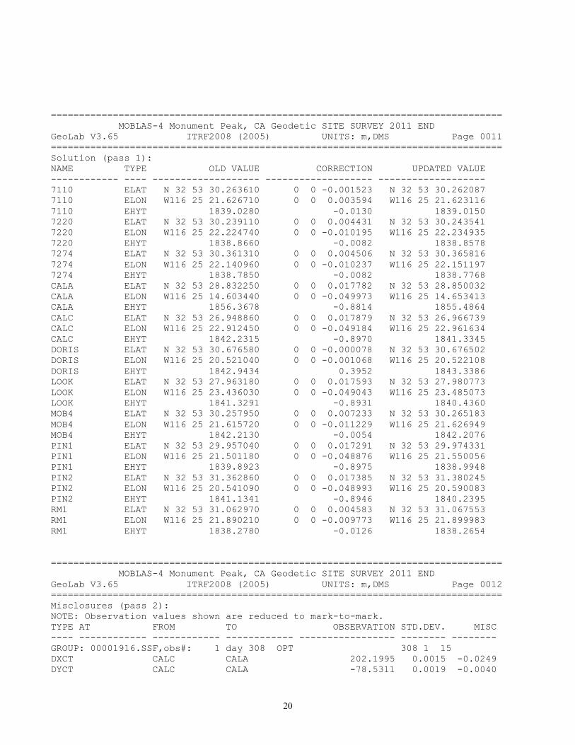
================================================================================ MOBLAS-4 Monument Peak, CA Geodetic SITE SURVEY 2011 END GeoLab V3.65 ITRF2008 (2005) UNITS: m,DMS Page 0011 ================================================================================ Solution (pass 1): NAME TYPE OLD VALUE CORRECTION UPDATED VALUE ------------ ---- ------------------- ------------------- ------------------- 7110 ELAT N 32 53 30.263610 0 0 -0.001523 N 32 53 30.262087 7110 ELON W116 25 21.626710 0 0 0.003594 W116 25 21.623116 7110 EHYT 1839.0280 -0.0130 1839.0150 7220 ELAT N 32 53 30.239110 0 0 0.004431 N 32 53 30.243541 7220 ELON W116 25 22.224740 0 0 -0.010195 W116 25 22.234935 7220 EHYT 1838.8660 -0.0082 1838.8578 7274 ELAT N 32 53 30.361310 0 0 0.004506 N 32 53 30.365816 7274 ELON W116 25 22.140960 0 0 -0.010237 W116 25 22.151197 7274 EHYT 1838.7850 -0.0082 1838.7768 CALA ELAT N 32 53 28.832250 0 0 0.017782 N 32 53 28.850032 CALA ELON W116 25 14.603440 0 0 -0.049973 W116 25 14.653413 CALA EHYT 1856.3678 -0.8814 1855.4864 CALC ELAT N 32 53 26.948860 0 0 0.017879 N 32 53 26.966739 CALC ELON W116 25 22.912450 0 0 -0.049184 W116 25 22.961634 CALC EHYT 1842.2315 -0.8970 1841.3345 DORIS ELAT N 32 53 30.676580 0 0 -0.000078 N 32 53 30.676502 DORIS ELON W116 25 20.521040 0 0 -0.001068 W116 25 20.522108 DORIS EHYT 1842.9434 0.3952 1843.3386 LOOK ELAT N 32 53 27.963180 0 0 0.017593 N 32 53 27.980773 LOOK ELON W116 25 23.436030 0 0 -0.049043 W116 25 23.485073 LOOK EHYT 1841.3291 -0.8931 1840.4360 MOB4 ELAT N 32 53 30.257950 0 0 0.007233 N 32 53 30.265183 MOB4 ELON W116 25 21.615720 0 0 -0.011229 W116 25 21.626949 MOB4 EHYT 1842.2130 -0.0054 1842.2076 PIN1 ELAT N 32 53 29.957040 0 0 0.017291 N 32 53 29.974331 PIN1 ELON W116 25 21.501180 0 0 -0.048876 W116 25 21.550056 PIN1 EHYT 1839.8923 -0.8975 1838.9948 PIN2 ELAT N 32 53 31.362860 0 0 0.017385 N 32 53 31.380245 PIN2 ELON W116 25 20.541090 0 0 -0.048993 W116 25 20.590083 PIN2 EHYT 1841.1341 -0.8946 1840.2395 RM1 ELAT N 32 53 31.062970 0 0 0.004583 N 32 53 31.067553 RM1 ELON W116 25 21.890210 0 0 -0.009773 W116 25 21.899983 RM1 EHYT 1838.2780 -0.0126 1838.2654 ================================================================================ MOBLAS-4 Monument Peak, CA Geodetic SITE SURVEY 2011 END GeoLab V3.65 ITRF2008 (2005) UNITS: m,DMS Page 0012 ================================================================================ Misclosures (pass 2): NOTE: Observation values shown are reduced to mark-to-mark. TYPE AT FROM TO OBSERVATION STD.DEV. MISC ---- ------------ ------------ ------------ ----------------- -------- -------- GROUP: 00001916.SSF,obs#: 1 day 308 OPT 308 1 15 DXCT CALC CALA 202.1995 0.0015 -0.0249 DYCT CALC CALA -78.5311 0.0019 -0.0040

21
DZCT CALC CALA 56.4107 0.0013 0.0059 GROUP: 00001925.SSF,obs#: 2 day 310 OPT 310 1 18 DXCT CALC CALA 202.1999 0.0022 -0.0253 DYCT CALC CALA -78.5278 0.0036 -0.0073 DZCT CALC CALA 56.4064 0.0021 0.0102 GROUP: 00001910.SSF,obs#: 3 day 308 OPT 308 15 DXCT MONP CALA 114.3397 0.0020 -0.0218 DYCT MONP CALA -108.7866 0.0026 -0.0019 DZCT MONP CALA -48.1796 0.0017 0.0181 GROUP: 00001919.SSF,obs#: 4 day 310 OPT 310 18 DXCT MONP CALA 114.3376 0.0027 -0.0197 DYCT MONP CALA -108.7786 0.0040 -0.0099 DZCT MONP CALA -48.1846 0.0022 0.0231 GROUP: 00001913.SSF,obs#: 5 day 308 OPT 308 14 DXCT MONP CALC -87.8601 0.0016 0.0035 DYCT MONP CALC -30.2572 0.0028 0.0038 DZCT MONP CALC -104.5894 0.0017 0.0113 GROUP: 00001922.SSF,obs#: 6 day 310 OPT 310 18 DXCT MONP CALC -87.8607 0.0025 0.0041 DYCT MONP CALC -30.2533 0.0039 -0.0001 DZCT MONP CALC -104.5902 0.0021 0.0121 GROUP: 00001952.SSF,obs#: 7 day 314 OPT 314 17 DXCT MONP LOOK -92.1600 0.0016 0.0032 DYCT MONP LOOK -8.3207 0.0021 -0.0051 DZCT MONP LOOK -78.8332 0.0015 0.0060 GROUP: 00001937.SSF,obs#: 8 day 312 OPT 312 DXCT MONP PIN1 -31.7275 0.0012 0.0064 DYCT MONP PIN1 0.2551 0.0017 -0.0083 DZCT MONP PIN1 -28.0211 0.0012 -0.0043 GROUP: 00001949.SSF,obs#: 10 day 313 OPT 313 DXCT MONP PIN1 -31.7245 0.0011 0.0034 DYCT MONP PIN1 0.2579 0.0015 -0.0111 DZCT MONP PIN1 -28.0244 0.0011 -0.0010 GROUP: 00001955.SSF,obs#: 11 day 314 OPT 314 16 DXCT MONP PIN1 -31.7288 0.0020 0.0077 DYCT MONP PIN1 0.2588 0.0026 -0.0120 DZCT MONP PIN1 -28.0227 0.0018 -0.0027 GROUP: 00001934.SSF,obs#: 12 day 312 OPT 312 DXCT MONP PIN2 0.6302 0.0013 0.0034 DYCT MONP PIN2 9.2819 0.0025 -0.0076 DZCT MONP PIN2 9.0292 0.0015 -0.0001 GROUP: 00001958.SSF,obs#: 14 day 314 OPT 314 1 17 DXCT PIN1 LOOK -60.4327 0.0016 -0.0030 DYCT PIN1 LOOK -8.5795 0.0023 0.0069 DZCT PIN1 LOOK -50.8102 0.0016 0.0084 GROUP: 00001943.SSF,obs#: 15 day 313 OPT 313 1 DXCT PIN2 MONP -0.6303 0.0010 -0.0033 DYCT PIN2 MONP -9.2841 0.0014 0.0098 DZCT PIN2 MONP -9.0283 0.0010 -0.0008 GROUP: 00001940.SSF,obs#: 16 day 311 OPT 311 1 23 DXCT PIN2 PIN1 -32.3571 0.0012 0.0024 DYCT PIN2 PIN1 -9.0273 0.0024 -0.0002 DZCT PIN2 PIN1 -37.0502 0.0015 -0.0043 GROUP: 00001946.SSF,obs#: 17 day 312 OPT 312 1 23 DXCT PIN2 PIN1 -32.3550 0.0011 0.0003 DYCT PIN2 PIN1 -9.0265 0.0015 -0.0010 DZCT PIN2 PIN1 -37.0522 0.0011 -0.0023
22
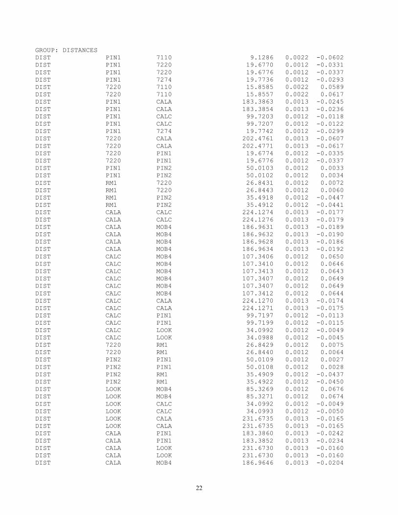
GROUP: DISTANCES DIST PIN1 7110 9.1286 0.0022 -0.0602 DIST PIN1 7220 19.6770 0.0012 -0.0331 DIST PIN1 7220 19.6776 0.0012 -0.0337 DIST PIN1 7274 19.7736 0.0012 -0.0293 DIST 7220 7110 15.8585 0.0022 0.0589 DIST 7220 7110 15.8557 0.0022 0.0617 DIST PIN1 CALA 183.3863 0.0013 -0.0245 DIST PIN1 CALA 183.3854 0.0013 -0.0236 DIST PIN1 CALC 99.7203 0.0012 -0.0118 DIST PIN1 CALC 99.7207 0.0012 -0.0122 DIST PIN1 7274 19.7742 0.0012 -0.0299 DIST 7220 CALA 202.4761 0.0013 -0.0607 DIST 7220 CALA 202.4771 0.0013 -0.0617 DIST 7220 PIN1 19.6774 0.0012 -0.0335 DIST 7220 PIN1 19.6776 0.0012 -0.0337 DIST PIN1 PIN2 50.0103 0.0012 0.0033 DIST PIN1 PIN2 50.0102 0.0012 0.0034 DIST RM1 7220 26.8431 0.0012 0.0072 DIST RM1 7220 26.8443 0.0012 0.0060 DIST RM1 PIN2 35.4918 0.0012 -0.0447 DIST RM1 PIN2 35.4912 0.0012 -0.0441 DIST CALA CALC 224.1274 0.0013 -0.0177 DIST CALA CALC 224.1276 0.0013 -0.0179 DIST CALA MOB4 186.9631 0.0013 -0.0189 DIST CALA MOB4 186.9632 0.0013 -0.0190 DIST CALA MOB4 186.9628 0.0013 -0.0186 DIST CALA MOB4 186.9634 0.0013 -0.0192 DIST CALC MOB4 107.3406 0.0012 0.0650 DIST CALC MOB4 107.3410 0.0012 0.0646 DIST CALC MOB4 107.3413 0.0012 0.0643 DIST CALC MOB4 107.3407 0.0012 0.0649 DIST CALC MOB4 107.3407 0.0012 0.0649 DIST CALC MOB4 107.3412 0.0012 0.0644 DIST CALC CALA 224.1270 0.0013 -0.0174 DIST CALC CALA 224.1271 0.0013 -0.0175 DIST CALC PIN1 99.7197 0.0012 -0.0113 DIST CALC PIN1 99.7199 0.0012 -0.0115 DIST CALC LOOK 34.0992 0.0012 -0.0049 DIST CALC LOOK 34.0988 0.0012 -0.0045 DIST 7220 RM1 26.8429 0.0012 0.0075 DIST 7220 RM1 26.8440 0.0012 0.0064 DIST PIN2 PIN1 50.0109 0.0012 0.0027 DIST PIN2 PIN1 50.0108 0.0012 0.0028 DIST PIN2 RM1 35.4909 0.0012 -0.0437 DIST PIN2 RM1 35.4922 0.0012 -0.0450 DIST LOOK MOB4 85.3269 0.0012 0.0676 DIST LOOK MOB4 85.3271 0.0012 0.0674 DIST LOOK CALC 34.0992 0.0012 -0.0049 DIST LOOK CALC 34.0993 0.0012 -0.0050 DIST LOOK CALA 231.6735 0.0013 -0.0165 DIST LOOK CALA 231.6735 0.0013 -0.0165 DIST CALA PIN1 183.3860 0.0013 -0.0242 DIST CALA PIN1 183.3852 0.0013 -0.0234 DIST CALA LOOK 231.6730 0.0013 -0.0160 DIST CALA LOOK 231.6730 0.0013 -0.0160 DIST CALA MOB4 186.9646 0.0013 -0.0204

23
DIST CALA MOB4 186.9647 0.0013 -0.0205 DIST CALA 7220 202.4751 0.0013 -0.0598 DIST CALA 7220 202.4754 0.0013 -0.0601 DIST 7220 MOB4 16.1881 0.0012 -0.0166 DIST 7220 MOB4 16.1883 0.0012 -0.0168 DIST 7220 MOB4 16.1875 0.0012 -0.0160 DIST 7220 MOB4 16.1877 0.0012 -0.0162 DIST PIN1 MOB4 9.6586 0.0012 0.0701 DIST PIN1 MOB4 9.6585 0.0012 0.0702 DIST PIN1 MOB4 9.6573 0.0012 0.0714 DIST PIN1 MOB4 9.6576 0.0012 0.0711 DIST 7274 PIN1 19.7736 0.0012 -0.0293 DIST 7274 CALC 106.8836 0.0012 -0.0116 DIST PIN1 7110 9.1270 0.0022 -0.0586 DIST PIN1 7110 9.1271 0.0022 -0.0587 DIST PIN1 7110 9.1298 0.0022 -0.0614 DIST PIN1 7110 9.1293 0.0022 -0.0609 GROUP: ZENITHAL ANGLE OBSERVATIONS ZANG 7220 RM1 91 15 22.88 6.99 -17.63 ================================================================================ MOBLAS-4 Monument Peak, CA Geodetic SITE SURVEY 2011 END GeoLab V3.65 ITRF2008 (2005) UNITS: m,DMS Page 0016 ================================================================================ Misclosures (pass 2): NOTE: Observation values shown are reduced to mark-to-mark. TYPE AT FROM TO OBSERVATION STD.DEV. MISC ---- ------------ ------------ ------------ ----------------- -------- -------- ZANG PIN2 RM1 93 10 54.72 5.29 -52.90 ZANG PIN2 DORIS 81 51 32.07 8.73 -131.34 ZANG RM1 7220 88 44 38.39 6.99 17.99 ZANG LOOK MOB4 88 48 21.89 2.76 -7.06 ZANG LOOK CALA 86 16 35.31 1.93 14.77 ZANG CALC CALA 86 22 50.41 1.94 14.24 ZANG CALC MOB4 89 31 42.21 2.44 -12.03 ZANG CALC LOOK 91 30 15.80 5.60 -19.67 ZANG CALC PIN1 91 20 24.55 2.53 -6.33 ZANG CALA CALC 93 37 16.94 1.94 -14.34 ZANG CALA MOB4 94 4 17.82 2.01 -19.11 ZANG CALA LOOK 93 43 34.73 1.93 -12.42 ZANG CALA PIN1 95 9 34.08 2.02 -16.29 ZANG CALA 7220 94 42 36.81 1.97 -21.06 ZANG LOOK DORIS 88 31 21.91 2.38 -22.67 ZANG LOOK CALA 86 16 34.34 1.93 13.80 ZANG LOOK CALC 88 29 38.76 5.60 13.11 ZANG PIN1 7220 90 23 2.89 8.92 -64.78 ZANG PIN1 7274 90 37 3.83 8.90 -59.71 ZANG PIN1 MONP 85 10 34.47 4.68 -22.68 GROUP: DIRECTIONS DIR PIN1 LOOK 0 0 0.00 3.31 25.13 DIR PIN1 7220 75 38 49.02 12.39 94.72 DIR PIN1 7274 88 18 18.18 12.35 185.63 DIR PIN1 7110 128 4 51.94 25.59 1874.12 DIR PIN1 MONP 183 14 52.09 6.18 -59.39 DIR PIN1 DORIS 191 43 29.18 7.60 -99.39 DIR PIN1 CALA 241 37 54.72 1.57 -13.56 DIR PIN1 CALC 342 17 22.86 2.67 18.48 DIR 7220 CALA 0 0 0.00 1.44 -6.34

24
DIR 7220 PIN1 12 39 36.36 12.39 105.07 DIR 7220 7110 345 30 31.89 16.50 510.51 DIR PIN2 PIN1 0 0 0.00 5.18 48.65 DIR PIN2 RM1 44 17 13.54 7.09 -62.05 DIR PIN2 MONP 313 48 29.53 21.37 188.36 DIR PIN2 DORIS 325 19 16.18 12.11 319.41 DIR RM1 PIN2 0 0 0.00 7.09 -92.17 DIR RM1 PIN2 0 0 0.00 7.09 -134.45 DIR RM1 7220 124 40 6.80 9.59 79.56 DIR RM1 7220 0 0 0.00 9.59 79.92 DIR RM1 PIN2 235 19 53.75 7.09 -134.65 DIR PIN1 LOOK 0 0 0.00 3.31 11.55 DIR PIN1 PIN2 170 38 29.46 5.18 -28.42 DIR CALC CALA 0 0 0.00 1.34 -3.36 DIR CALC LOOK 261 30 38.48 7.56 -20.98 DIR CALC PIN1 306 38 6.25 2.67 20.36 DIR CALA CALC 0 0 0.00 1.34 -9.75 DIR CALA LOOK 8 23 9.39 1.31 -14.08 DIR CALA PIN1 25 58 40.61 1.57 -20.56 DIR CALA 7220 27 19 51.14 1.44 -16.28 DIR CALA MOB4 28 32 29.25 1.54 68.28 DIR LOOK PIN1 315 57 36.49 3.31 33.89 DIR LOOK MOB4 311 7 39.24 3.10 -45.74 DIR LOOK PIN1 0 0 0.00 3.31 23.08 DIR LOOK MONP 1 7 37.73 2.23 -8.17 DIR LOOK DORIS 3 32 16.78 2.38 -20.51 DIR PIN1 MOB4 145 38 42.69 25.64 642.33 DIR 7220 PIN1 0 0 0.00 12.39 465.94 DIR 7220 MOB4 332 55 49.39 15.86 -710.81 DIR 7274 CALC 0 0 0.00 2.50 5.87 DIR 7274 PIN1 296 15 47.78 12.35 103.28 DIR 7274 PIN1 0 0 0.00 12.35 154.02 GROUP: ORTHOMETRIC HEIGHT DIFFERENCES EHDF 7220 LOOK 1.5677 0.0009 0.0056 EHDF LOOK 7220 -1.5677 0.0009 -0.0056 EHDF MOB4 PIN2 -1.9682 0.0009 0.0028 EHDF PIN2 MOB4 1.9676 0.0009 -0.0022 EHDF PIN2 MONP 2.3092 0.0009 -0.0028 EHDF MONP PIN2 -2.3094 0.0009 0.0030 EHDF PIN2 DORIS 3.1088 0.0009 -0.0108 EHDF DORIS PIN2 -3.1087 0.0009 0.0107 EHDF MOB4 PIN2 -1.9679 0.0009 0.0025 EHDF PIN2 MOB4 1.9676 0.0009 -0.0022 EHDF PIN2 RM1 -1.9668 0.0009 -0.0088 EHDF RM1 PIN2 1.9675 0.0009 0.0081 EHDF RM1 7274 0.5059 0.0009 0.0028 EHDF 7274 RM1 -0.5060 0.0009 -0.0027 EHDF RM1 7220 0.5872 0.0009 0.0025 EHDF 7220 RM1 -0.5870 0.0009 -0.0027 EHDF 7274 PIN1 0.2131 0.0009 0.0053 EHDF PIN1 7274 -0.2132 0.0009 -0.0052 EHDF 7220 PIN1 0.1322 0.0009 0.0053 EHDF PIN1 7220 -0.1321 0.0009 -0.0054 EHDF 7220 PIN1 0.1330 0.0013 0.0045 EHDF PIN1 7220 -0.1328 0.0013 -0.0047

25
================================================================================ MOBLAS-4 Monument Peak, CA Geodetic SITE SURVEY 2011 END GeoLab V3.65 ITRF2008 (2005) UNITS: m,DMS Page 0019 ================================================================================ Solution (pass 2): NAME TYPE OLD VALUE CORRECTION UPDATED VALUE ------------ ---- ------------------- ------------------- ------------------- 7110 ELAT N 32 53 30.262087 0 0 0.001543 N 32 53 30.263630 7110 ELON W116 25 21.623116 0 0 -0.003956 W116 25 21.627072 7110 EHYT 1839.0150 0.0020 1839.0170 7220 ELAT N 32 53 30.243541 0 0 0.000374 N 32 53 30.243915 7220 ELON W116 25 22.234935 0 0 -0.001644 W116 25 22.236579 7220 EHYT 1838.8578 0.0020 1838.8598 7274 ELAT N 32 53 30.365816 0 0 0.000300 N 32 53 30.366116 7274 ELON W116 25 22.151197 0 0 -0.001651 W116 25 22.152847 7274 EHYT 1838.7768 0.0017 1838.7785 CALA ELAT N 32 53 28.850032 0 0 -0.000285 N 32 53 28.849747 CALA ELON W116 25 14.653413 0 0 0.000551 W116 25 14.652862 CALA EHYT 1855.4864 -0.0202 1855.4662 CALC ELAT N 32 53 26.966739 0 0 -0.000364 N 32 53 26.966376 CALC ELON W116 25 22.961634 0 0 -0.000132 W116 25 22.961766 CALC EHYT 1841.3345 -0.0058 1841.3287 DORIS ELAT N 32 53 30.676502 0 0 0.000275 N 32 53 30.676777 DORIS ELON W116 25 20.522108 0 0 0.000746 W116 25 20.521362 DORIS EHYT 1843.3386 0.0082 1843.3468 LOOK ELAT N 32 53 27.980773 0 0 -0.000125 N 32 53 27.980648 LOOK ELON W116 25 23.485073 0 0 -0.000084 W116 25 23.485157 LOOK EHYT 1840.4360 -0.0036 1840.4324 MOB4 ELAT N 32 53 30.265183 0 0 -0.002373 N 32 53 30.262809 MOB4 ELON W116 25 21.626949 0 0 -0.000834 W116 25 21.627783 MOB4 EHYT 1842.2076 -0.0012 1842.2065 PIN1 ELAT N 32 53 29.974331 0 0 0.000183 N 32 53 29.974514 PIN1 ELON W116 25 21.550056 0 0 -0.000339 W116 25 21.550395 PIN1 EHYT 1838.9948 -0.0036 1838.9912 PIN2 ELAT N 32 53 31.380245 0 0 0.000096 N 32 53 31.380341 PIN2 ELON W116 25 20.590083 0 0 -0.000303 W116 25 20.590385 PIN2 EHYT 1840.2395 -0.0037 1840.2358 RM1 ELAT N 32 53 31.067553 0 0 0.000312 N 32 53 31.067865 RM1 ELON W116 25 21.899983 0 0 -0.002168 W116 25 21.902151 RM1 EHYT 1838.2654 0.0046 1838.2700 ================================================================================ MOBLAS-4 Monument Peak, CA Geodetic SITE SURVEY 2011 END GeoLab V3.65 ITRF2008 (2005) UNITS: m,DMS Page 0020 ================================================================================ Misclosures (pass 3): NOTE: Observation values shown are reduced to mark-to-mark. TYPE AT FROM TO OBSERVATION STD.DEV. MISC ---- ------------ ------------ ------------ ----------------- -------- -------- GROUP: 00001916.SSF,obs#: 1 day 308 OPT 308 1 15 DXCT CALC CALA 202.1995 0.0015 -0.0031 DYCT CALC CALA -78.5311 0.0019 0.0001 DZCT CALC CALA 56.4107 0.0013 0.0001 GROUP: 00001925.SSF,obs#: 2 day 310 OPT 310 1 18
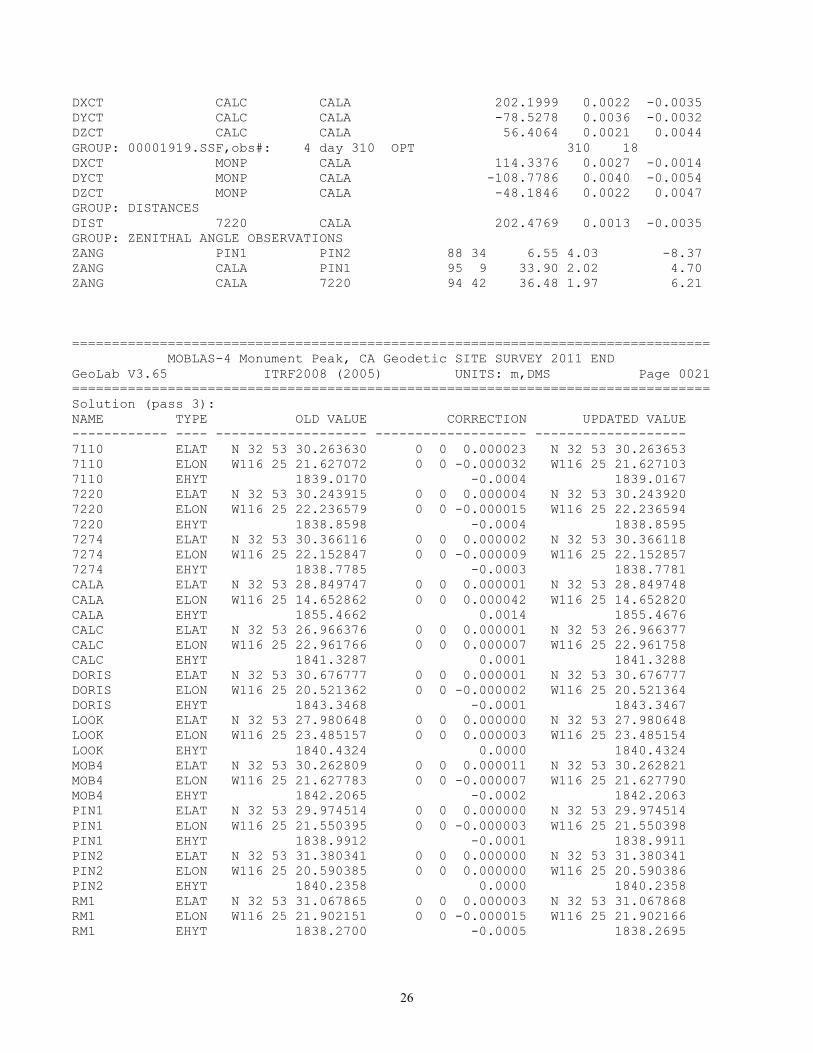
26
DXCT CALC CALA 202.1999 0.0022 -0.0035 DYCT CALC CALA -78.5278 0.0036 -0.0032 DZCT CALC CALA 56.4064 0.0021 0.0044 GROUP: 00001919.SSF,obs#: 4 day 310 OPT 310 18 DXCT MONP CALA 114.3376 0.0027 -0.0014 DYCT MONP CALA -108.7786 0.0040 -0.0054 DZCT MONP CALA -48.1846 0.0022 0.0047 GROUP: DISTANCES DIST 7220 CALA 202.4769 0.0013 -0.0035 GROUP: ZENITHAL ANGLE OBSERVATIONS ZANG PIN1 PIN2 88 34 6.55 4.03 -8.37 ZANG CALA PIN1 95 9 33.90 2.02 4.70 ZANG CALA 7220 94 42 36.48 1.97 6.21
================================================================================ MOBLAS-4 Monument Peak, CA Geodetic SITE SURVEY 2011 END GeoLab V3.65 ITRF2008 (2005) UNITS: m,DMS Page 0021 ================================================================================ Solution (pass 3): NAME TYPE OLD VALUE CORRECTION UPDATED VALUE ------------ ---- ------------------- ------------------- ------------------- 7110 ELAT N 32 53 30.263630 0 0 0.000023 N 32 53 30.263653 7110 ELON W116 25 21.627072 0 0 -0.000032 W116 25 21.627103 7110 EHYT 1839.0170 -0.0004 1839.0167 7220 ELAT N 32 53 30.243915 0 0 0.000004 N 32 53 30.243920 7220 ELON W116 25 22.236579 0 0 -0.000015 W116 25 22.236594 7220 EHYT 1838.8598 -0.0004 1838.8595 7274 ELAT N 32 53 30.366116 0 0 0.000002 N 32 53 30.366118 7274 ELON W116 25 22.152847 0 0 -0.000009 W116 25 22.152857 7274 EHYT 1838.7785 -0.0003 1838.7781 CALA ELAT N 32 53 28.849747 0 0 0.000001 N 32 53 28.849748 CALA ELON W116 25 14.652862 0 0 0.000042 W116 25 14.652820 CALA EHYT 1855.4662 0.0014 1855.4676 CALC ELAT N 32 53 26.966376 0 0 0.000001 N 32 53 26.966377 CALC ELON W116 25 22.961766 0 0 0.000007 W116 25 22.961758 CALC EHYT 1841.3287 0.0001 1841.3288 DORIS ELAT N 32 53 30.676777 0 0 0.000001 N 32 53 30.676777 DORIS ELON W116 25 20.521362 0 0 -0.000002 W116 25 20.521364 DORIS EHYT 1843.3468 -0.0001 1843.3467 LOOK ELAT N 32 53 27.980648 0 0 0.000000 N 32 53 27.980648 LOOK ELON W116 25 23.485157 0 0 0.000003 W116 25 23.485154 LOOK EHYT 1840.4324 0.0000 1840.4324 MOB4 ELAT N 32 53 30.262809 0 0 0.000011 N 32 53 30.262821 MOB4 ELON W116 25 21.627783 0 0 -0.000007 W116 25 21.627790 MOB4 EHYT 1842.2065 -0.0002 1842.2063 PIN1 ELAT N 32 53 29.974514 0 0 0.000000 N 32 53 29.974514 PIN1 ELON W116 25 21.550395 0 0 -0.000003 W116 25 21.550398 PIN1 EHYT 1838.9912 -0.0001 1838.9911 PIN2 ELAT N 32 53 31.380341 0 0 0.000000 N 32 53 31.380341 PIN2 ELON W116 25 20.590385 0 0 0.000000 W116 25 20.590386 PIN2 EHYT 1840.2358 0.0000 1840.2358 RM1 ELAT N 32 53 31.067865 0 0 0.000003 N 32 53 31.067868 RM1 ELON W116 25 21.902151 0 0 -0.000015 W116 25 21.902166 RM1 EHYT 1838.2700 -0.0005 1838.2695

27
================================================================================ MOBLAS-4 Monument Peak, CA Geodetic SITE SURVEY 2011 END GeoLab V3.65 ITRF2008 (2005) UNITS: m,DMS Page 0022 ================================================================================ Misclosures (pass 4): NOTE: Observation values shown are reduced to mark-to-mark. TYPE AT FROM TO OBSERVATION STD.DEV. MISC ---- ------------ ------------ ------------ ----------------- -------- -------- GROUP: 00001925.SSF,obs#: 2 day 310 OPT 310 1 18 DXCT CALC CALA 202.1999 0.0022 -0.0032 DYCT CALC CALA -78.5278 0.0036 -0.0046 DZCT CALC CALA 56.4064 0.0021 0.0051 GROUP: 00001919.SSF,obs#: 4 day 310 OPT 310 18 DXCT MONP CALA 114.3376 0.0027 -0.0010 DYCT MONP CALA -108.7786 0.0040 -0.0069 DZCT MONP CALA -48.1846 0.0022 0.0055 GROUP: ZENITHAL ANGLE OBSERVATIONS ZANG PIN2 DORIS 81 51 31.65 8.73 -17.58 ZANG CALA 7220 94 42 36.47 1.97 4.52 ================================================================================ MOBLAS-4 Monument Peak, CA Geodetic SITE SURVEY 2011 END GeoLab V3.65 ITRF2008 (2005) UNITS: m,DMS Page 0023 ================================================================================ Solution (pass 4): NAME TYPE OLD VALUE CORRECTION UPDATED VALUE ------------ ---- ------------------- ------------------- ------------------- 7110 ELAT N 32 53 30.263653 0 0 -0.000001 N 32 53 30.263652 7110 ELON W116 25 21.627103 0 0 0.000001 W116 25 21.627103 7110 EHYT 1839.0167 0.0000 1839.0167 7220 ELAT N 32 53 30.243920 0 0 0.000000 N 32 53 30.243919 7220 ELON W116 25 22.236594 0 0 0.000001 W116 25 22.236593 7220 EHYT 1838.8595 0.0000 1838.8594 7274 ELAT N 32 53 30.366118 0 0 0.000000 N 32 53 30.366118 7274 ELON W116 25 22.152857 0 0 0.000001 W116 25 22.152856 7274 EHYT 1838.7781 0.0000 1838.7781 CALA ELAT N 32 53 28.849748 0 0 0.000000 N 32 53 28.849748 CALA ELON W116 25 14.652820 0 0 -0.000004 W116 25 14.652824 CALA EHYT 1855.4676 0.0000 1855.4677 CALC ELAT N 32 53 26.966377 0 0 0.000000 N 32 53 26.966377 CALC ELON W116 25 22.961758 0 0 -0.000001 W116 25 22.961759 CALC EHYT 1841.3288 0.0000 1841.3288 DORIS ELAT N 32 53 30.676777 0 0 0.000000 N 32 53 30.676777 DORIS ELON W116 25 20.521364 0 0 0.000000 W116 25 20.521364 DORIS EHYT 1843.3467 0.0000 1843.3467 LOOK ELAT N 32 53 27.980648 0 0 0.000000 N 32 53 27.980648 LOOK ELON W116 25 23.485154 0 0 0.000000 W116 25 23.485154 LOOK EHYT 1840.4324 0.0000 1840.4324 MOB4 ELAT N 32 53 30.262821 0 0 0.000000 N 32 53 30.262821 MOB4 ELON W116 25 21.627790 0 0 0.000000 W116 25 21.627790 MOB4 EHYT 1842.2063 0.0000 1842.2063 PIN1 ELAT N 32 53 29.974514 0 0 0.000000 N 32 53 29.974514 PIN1 ELON W116 25 21.550398 0 0 0.000000 W116 25 21.550397 PIN1 EHYT 1838.9911 0.0000 1838.9911 PIN2 ELAT N 32 53 31.380341 0 0 0.000000 N 32 53 31.380341
28
PIN2 ELON W116 25 20.590386 0 0 0.000000 W116 25 20.590385 PIN2 EHYT 1840.2358 0.0000 1840.2358 RM1 ELAT N 32 53 31.067868 0 0 0.000000 N 32 53 31.067867 RM1 ELON W116 25 21.902166 0 0 0.000001 W116 25 21.902165 RM1 EHYT 1838.2695 0.0000 1838.2695 ================================================================================ MOBLAS-4 Monument Peak, CA Geodetic SITE SURVEY 2011 END GeoLab V3.65 ITRF2008 (2005) UNITS: m,DMS Page 0024 ================================================================================ Adjusted PLH Coordinates: LATITUDE LONGITUDE ELIP-HEIGHT CODE FFF STATION STD DEV STD DEV STD DEV ---- --- ------------ ----------------- ----------------- ------------ PLH 000 7110 N 32 53 30.263652 W116 25 21.627103 1839.0167 m 0 0.0008 0.0009 0.0007 PLH 000 7220 N 32 53 30.243919 W116 25 22.236593 1838.8594 m 0 0.0005 0.0005 0.0005 PLH 000 7274 N 32 53 30.366118 W116 25 22.152856 1838.7781 m 0 0.0005 0.0007 0.0005 PLH 000 CALA N 32 53 28.849748 W116 25 14.652824 1855.4677 m 0 0.0002 0.0005 0.0007 PLH 000 CALC N 32 53 26.966377 W116 25 22.961759 1841.3288 m 0 0.0002 0.0006 0.0006 PLH 000 DORIS N 32 53 30.676777 W116 25 20.521364 1843.3467 m 0 0.0016 0.0012 0.0006 PLH 000 LOOK N 32 53 27.980648 W116 25 23.485154 1840.4324 m 0 0.0003 0.0005 0.0005 PLH 000 MOB4 N 32 53 30.262821 W116 25 21.627790 1842.2063 m 0 0.0004 0.0005 0.0005 PLH 111 MONP N 32 53 30.982870 W116 25 20.453170 1842.5470 m 0 0.0000 0.0000 0.0000 PLH 000 PIN1 N 32 53 29.974514 W116 25 21.550397 1838.9911 m 0 0.0002 0.0004 0.0004 PLH 000 PIN2 N 32 53 31.380341 W116 25 20.590385 1840.2358 m 0 0.0002 0.0004 0.0004 PLH 000 RM1 N 32 53 31.067867 W116 25 21.902165 1838.2695 m 0 0.0006 0.0006 0.0005

29
================================================================================ MOBLAS-4 Monument Peak, CA Geodetic SITE SURVEY 2011 END GeoLab V3.65 ITRF2008 (2005) UNITS: m,DMS Page 0025 ================================================================================ Adjusted XYZ Coordinates: X-COORDINATE Y-COORDINATE Z-COORDINATE CODE FFF STATION STD DEV STD DEV STD DEV ---- --- ------------ ------------------ ------------------ ------------------ XYZ 7110 -2386278.4496 -4802353.9274 3444881.7198 m 0 0.0009 0.0008 0.0008 XYZ 7220 -2386292.7283 -4802347.0537 3444881.1238 m 0 0.0005 0.0005 0.0005 XYZ 7274 -2386289.8383 -4802346.1300 3444884.2416 m 0 0.0007 0.0006 0.0005 XYZ CALA -2386132.7445 -4802468.1704 3444854.0680 m 0 0.0005 0.0006 0.0005 XYZ CALC -2386334.9411 -4802389.6381 3444797.6565 m 0 0.0005 0.0005 0.0004 XYZ DORIS -2386251.2468 -4802363.7845 3444894.7610 m 0 0.0014 0.0008 0.0014 XYZ LOOK -2386339.2393 -4802367.7090 3444823.4147 m 0 0.0005 0.0005 0.0004 XYZ MOB4 -2386279.6637 -4802356.3304 3444883.4304 m 0 0.0005 0.0005 0.0004 XYZ MONP -2386247.0810 -4802359.3849 3444902.2471 m 0 0.0000 0.0000 0.0000 XYZ PIN1 -2386278.8073 -4802359.1286 3444874.2243 m 0 0.0004 0.0004 0.0003 XYZ PIN2 -2386246.4523 -4802350.1029 3444911.2766 m 0 0.0004 0.0004 0.0003 XYZ RM1 -2386278.5859 -4802338.1313 3444902.1235 m 0 0.0006 0.0006 0.0006
30
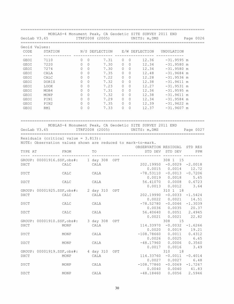
================================================================================ MOBLAS-4 Monument Peak, CA Geodetic SITE SURVEY 2011 END GeoLab V3.65 ITRF2008 (2005) UNITS: m,DMS Page 0026 ================================================================================ Geoid Values: CODE STATION N/S DEFLECTION E/W DEFLECTION UNDULATION ---- ------------ ----------------- ----------------- ------------ GEOI 7110 0 0 7.31 0 0 12.36 -31.9595 m GEOI 7220 0 0 7.30 0 0 12.34 -31.9580 m GEOI 7274 0 0 7.30 0 0 12.34 -31.9580 m GEOI CALA 0 0 7.35 0 0 12.48 -31.9684 m GEOI CALC 0 0 7.22 0 0 12.28 -31.9536 m GEOI DORIS 0 0 7.32 0 0 12.38 -31.9611 m GEOI LOOK 0 0 7.23 0 0 12.27 -31.9531 m GEOI MOB4 0 0 7.31 0 0 12.36 -31.9595 m GEOI MONP 0 0 7.32 0 0 12.38 -31.9611 m GEOI PIN1 0 0 7.29 0 0 12.34 -31.9584 m GEOI PIN2 0 0 7.35 0 0 12.39 -31.9622 m GEOI RM1 0 0 7.33 0 0 12.37 -31.9607 m
================================================================================ MOBLAS-4 Monument Peak, CA Geodetic SITE SURVEY 2011 END GeoLab V3.65 ITRF2008 (2005) UNITS: m,DMS Page 0027 ================================================================================ Residuals (critical value = 3.813): NOTE: Observation values shown are reduced to mark-to-mark. OBSERVATION RESIDUAL STD RES TYPE AT FROM TO STD DEV STD DEV PPM ---- ------------ ------------ ------------ ----------------- -------- -------- GROUP: 00001916.SSF,obs#: 1 day 308 OPT 308 1 15 DXCT CALC CALA 202.19950 -0.0029 -2.0018 0.0015 0.0014 12.72 DYCT CALC CALA -78.53110 -0.0013 -0.7206 0.0019 0.0018 5.65 DZCT CALC CALA 56.41070 0.0008 0.6723 0.0013 0.0012 3.64 GROUP: 00001925.SSF,obs#: 2 day 310 OPT 310 1 18 DXCT CALC CALA 202.19990 -0.0033 -1.5424 0.0022 0.0021 14.51 DYCT CALC CALA -78.52780 -0.0046 -1.3039 0.0036 0.0035 20.37 DZCT CALC CALA 56.40640 0.0051 2.4945 0.0021 0.0021 22.82 GROUP: 00001910.SSF,obs#: 3 day 308 OPT 308 15 DXCT MONP CALA 114.33970 -0.0032 -1.6266 0.0020 0.0019 19.21 DYCT MONP CALA -108.78660 0.0011 0.4312 0.0026 0.0025 6.65 DZCT MONP CALA -48.17960 0.0006 0.3560 0.0017 0.0016 3.49 GROUP: 00001919.SSF,obs#: 4 day 310 OPT 310 18 DXCT MONP CALA 114.33760 -0.0011 -0.4014 0.0027 0.0027 6.48 DYCT MONP CALA -108.77860 -0.0069 -1.7267 0.0040 0.0040 41.83 DZCT MONP CALA -48.18460 0.0056 2.5946
31
0.0022 0.0021 33.79 GROUP: 00001913.SSF,obs#: 5 day 308 OPT 308 14 DXCT MONP CALC -87.86010 0.0000 -0.0124 0.0016 0.0015 0.13 DYCT MONP CALC -30.25720 0.0041 1.4673 0.0028 0.0028 29.04 DZCT MONP CALC -104.58940 -0.0011 -0.6862 0.0017 0.0017 8.14 GROUP: 00001922.SSF,obs#: 6 day 310 OPT 310 18 DXCT MONP CALC -87.86070 0.0006 0.2365 0.0025 0.0025 4.16 DYCT MONP CALC -30.25330 0.0002 0.0423 0.0039 0.0039 1.17 DZCT MONP CALC -104.59020 -0.0003 -0.1645 0.0021 0.0021 2.42 GROUP: 00001952.SSF,obs#: 7 day 314 OPT 314 17 DXCT MONP LOOK -92.16000 0.0017 1.1096 0.0016 0.0015 13.71 DYCT MONP LOOK -8.32070 -0.0034 -1.6228 0.0021 0.0021 27.74 DZCT MONP LOOK -78.83320 0.0008 0.5695 0.0015 0.0014 6.79 GROUP: 00001937.SSF,obs#: 8 day 312 OPT 312 DXCT MONP PIN1 -31.72750 0.0012 1.0993 0.0012 0.0011 28.74 DYCT MONP PIN1 0.25510 0.0012 0.7093 0.0017 0.0017 28.12 DZCT MONP PIN1 -28.02110 -0.0016 -1.3702 0.0012 0.0012 37.98 GROUP: 00001931.SSF,obs#: 9 day 312 OPT 312 23 DXCT MONP PIN1 -31.73340 0.0071 0.2291 0.0311 0.0311 168.12 DYCT MONP PIN1 0.26770 -0.0114 -0.5142 0.0222 0.0222 269.54 DZCT MONP PIN1 -28.02950 0.0068 0.4224 0.0161 0.0161 160.46 GROUP: 00001949.SSF,obs#: 10 day 313 OPT 313 DXCT MONP PIN1 -31.72450 -0.0018 -1.7010 0.0011 0.0010 42.13 DYCT MONP PIN1 0.25790 -0.0016 -1.1169 0.0015 0.0014 38.03 DZCT MONP PIN1 -28.02440 0.0017 1.6127 0.0011 0.0010 39.98 GROUP: 00001955.SSF,obs#: 11 day 314 OPT 314 16 DXCT MONP PIN1 -31.72880 0.0025 1.2564 0.0020 0.0020 59.45 DYCT MONP PIN1 0.25880 -0.0025 -0.9819 0.0026 0.0026 59.29 DZCT MONP PIN1 -28.02270 0.0000 -0.0043 0.0018 0.0018 0.18 GROUP: 00001934.SSF,obs#: 12 day 312 OPT 312 DXCT MONP PIN2 0.63020 -0.0015 -1.2882 0.0013 0.0012 117.38 DYCT MONP PIN2 9.28190 0.0002 0.0647 0.0025 0.0025 12.26 DZCT MONP PIN2 9.02920 0.0004 0.2567 0.0015 0.0015 29.12

32
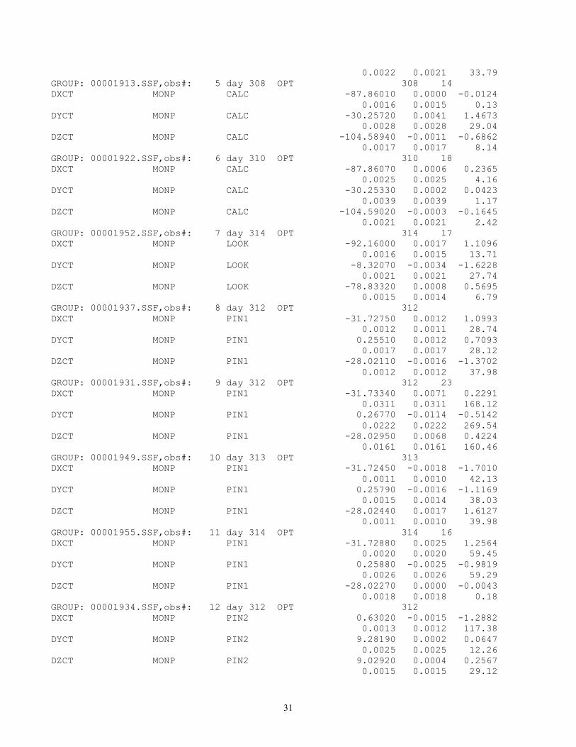
GROUP: 00001958.SSF,obs#: 14 day 314 OPT 314 1 17 DXCT PIN1 LOOK -60.43270 0.0006 0.4079 0.0016 0.0016 8.18 DYCT PIN1 LOOK -8.57950 -0.0009 -0.3831 0.0023 0.0023 10.86 DZCT PIN1 LOOK -50.81020 0.0005 0.3477 0.0016 0.0015 6.71 GROUP: 00001943.SSF,obs#: 15 day 313 OPT 313 1 DXCT PIN2 MONP -0.63030 0.0016 1.8045 0.0010 0.0009 125.09 DYCT PIN2 MONP -9.28410 0.0020 1.5256 0.0014 0.0013 157.43 DZCT PIN2 MONP -9.02830 -0.0013 -1.3258 0.0010 0.0010 98.54 GROUP: 00001940.SSF,obs#: 16 day 311 OPT 311 1 23 DXCT PIN2 PIN1 -32.35710 0.0021 1.8093 0.0012 0.0012 42.76 DYCT PIN2 PIN1 -9.02730 0.0015 0.6357 0.0024 0.0024 30.62 DZCT PIN2 PIN1 -37.05020 -0.0021 -1.4055 0.0015 0.0015 41.69 GROUP: 00001946.SSF,obs#: 17 day 312 OPT 312 1 23 DXCT PIN2 PIN1 -32.35500 0.0000 0.0367 0.0011 0.0011 0.77 DYCT PIN2 PIN1 -9.02650 0.0007 0.4877 0.0015 0.0015 14.63 DZCT PIN2 PIN1 -37.05220 -0.0001 -0.0787 0.0011 0.0011 1.70 GROUP: DISTANCES DIST PIN1 7110 9.13027 0.0001 0.0328 0.0022 0.0020 7.37 DIST PIN1 LOOK 79.41676 0.0016 1.3397 0.0012 0.0012 20.26 DIST PIN1 LOOK 79.41666 0.0017 1.4230 0.0012 0.0012 21.52 DIST PIN1 7220 19.67707 0.0004 0.3089 0.0012 0.0012 18.49 DIST PIN1 7220 19.67767 -0.0002 -0.2005 0.0012 0.0012 12.00 DIST PIN1 7274 19.77360 0.0000 -0.0243 0.0012 0.0011 1.35 DIST 7220 7110 15.85828 -0.0001 -0.0454 0.0022 0.0020 5.68 DIST 7220 7110 15.85548 0.0027 1.3651 0.0022 0.0020 170.89 DIST PIN1 CALA 183.38613 0.0007 0.5922 0.0013 0.0012 3.88 DIST PIN1 CALA 183.38523 0.0016 1.3407 0.0013 0.0012 8.79 DIST PIN1 CALC 99.72024 0.0017 1.3996 0.0012 0.0012 17.06 DIST PIN1 CALC 99.72064 0.0013 1.0706 0.0012 0.0012 13.05 DIST PIN1 7274 19.77420 -0.0006 -0.5680 0.0012 0.0011 31.70 DIST 7220 7274 4.35037 0.0000 -0.0165 0.0012 0.0011 4.07

33
DIST 7220 7274 4.35027 0.0001 0.0768 0.0012 0.0011 18.91 DIST 7220 CALA 202.47595 -0.0010 -0.8546 0.0013 0.0012 5.03 DIST 7220 CALA 202.47695 -0.0020 -1.6936 0.0013 0.0012 9.97 DIST 7220 PIN1 19.67740 0.0000 0.0298 0.0012 0.0012 1.78 DIST 7220 PIN1 19.67760 -0.0002 -0.1400 0.0012 0.0012 8.38 DIST PIN1 PIN2 50.01030 0.0015 1.2254 0.0012 0.0012 29.90 DIST PIN1 PIN2 50.01020 0.0016 1.3073 0.0012 0.0012 31.90 DIST RM1 7220 26.84310 0.0009 0.8062 0.0012 0.0011 33.69 DIST RM1 7220 26.84430 -0.0003 -0.2634 0.0012 0.0011 11.01 DIST RM1 PIN2 35.49175 0.0000 0.0395 0.0012 0.0011 1.25 DIST RM1 PIN2 35.49115 0.0006 0.5738 0.0012 0.0011 18.16 DIST CALA CALC 224.12738 0.0000 -0.0149 0.0013 0.0012 0.08 DIST CALA CALC 224.12758 -0.0002 -0.1832 0.0013 0.0012 0.97 DIST CALA MOB4 186.96309 0.0010 0.8681 0.0013 0.0012 5.55 DIST CALA MOB4 186.96319 0.0009 0.7844 0.0013 0.0012 5.01 DIST CALA MOB4 186.96279 0.0013 1.1191 0.0013 0.0012 7.15 DIST CALA MOB4 186.96339 0.0007 0.6171 0.0013 0.0012 3.94 DIST CALC MOB4 107.34057 0.0008 0.6360 0.0012 0.0012 7.05 DIST CALC MOB4 107.34097 0.0004 0.2998 0.0012 0.0012 3.32 DIST CALC MOB4 107.34127 0.0001 0.0476 0.0012 0.0012 0.53 DIST CALC MOB4 107.34067 0.0007 0.5520 0.0012 0.0012 6.12 DIST CALC MOB4 107.34067 0.0007 0.5520 0.0012 0.0012 6.12 DIST CALC MOB4 107.34117 0.0002 0.1317 0.0012 0.0012 1.46 DIST CALC CALA 224.12703 0.0003 0.2815 0.0013 0.0012 1.49 DIST CALC CALA 224.12713 0.0002 0.1974 0.0013 0.0012 1.05 DIST CALC PIN1 99.71970 0.0022 1.8430 0.0012 0.0012 22.47 DIST CALC PIN1 99.71990 0.0020 1.6784 0.0012 0.0012 20.46 DIST CALC LOOK 34.09909 0.0014 1.1536 0.0012 0.0012 40.31 DIST CALC LOOK 34.09869 0.0018 1.4893
34
0.0012 0.0012 52.04 DIST 7220 RM1 26.84288 0.0011 1.0027 0.0012 0.0011 41.91 DIST 7220 RM1 26.84398 0.0000 0.0223 0.0012 0.0011 0.93 DIST PIN2 PIN1 50.01091 0.0009 0.7253 0.0012 0.0012 17.69 DIST PIN2 PIN1 50.01081 0.0010 0.8072 0.0012 0.0012 19.69 DIST PIN2 RM1 35.49086 0.0009 0.8326 0.0012 0.0011 26.34 DIST PIN2 RM1 35.49216 -0.0004 -0.3250 0.0012 0.0011 10.28 DIST LOOK MOB4 85.32692 -0.0004 -0.3023 0.0012 0.0012 4.14 DIST LOOK MOB4 85.32712 -0.0006 -0.4733 0.0012 0.0012 6.49 DIST LOOK PIN1 79.41736 0.0010 0.8434 0.0012 0.0012 12.76 DIST LOOK PIN1 79.41716 0.0012 1.0099 0.0012 0.0012 15.28 DIST LOOK CALC 34.09911 0.0014 1.1330 0.0012 0.0012 39.59 DIST LOOK CALC 34.09921 0.0013 1.0491 0.0012 0.0012 36.66 DIST LOOK CALA 231.67335 -0.0006 -0.5188 0.0013 0.0012 2.66 DIST LOOK CALA 231.67335 -0.0006 -0.5188 0.0013 0.0012 2.66 DIST CALA PIN1 183.38589 0.0009 0.7878 0.0013 0.0012 5.17 DIST CALA PIN1 183.38509 0.0017 1.4531 0.0013 0.0012 9.53 DIST CALA LOOK 231.67286 -0.0001 -0.1107 0.0013 0.0012 0.57 DIST CALA LOOK 231.67286 -0.0001 -0.1107 0.0013 0.0012 0.57 DIST CALA MOB4 186.96453 -0.0004 -0.3367 0.0013 0.0012 2.15 DIST CALA MOB4 186.96463 -0.0005 -0.4204 0.0013 0.0012 2.69 DIST CALA 7220 202.47500 -0.0001 -0.0582 0.0013 0.0012 0.34 DIST CALA 7220 202.47530 -0.0004 -0.3099 0.0013 0.0012 1.82 DIST 7220 MOB4 16.18787 0.0005 0.4011 0.0012 0.0012 29.01 DIST 7220 MOB4 16.18807 0.0003 0.2303 0.0012 0.0012 16.66 DIST 7220 MOB4 16.18727 0.0011 0.9135 0.0012 0.0012 66.08 DIST 7220 MOB4 16.18747 0.0009 0.7427 0.0012 0.0012 53.72 DIST PIN1 MOB4 9.66043 -0.0004 -0.3702 0.0012 0.0012 45.54 DIST PIN1 MOB4 9.66033 -0.0003 -0.2860 0.0012 0.0012 35.18
35
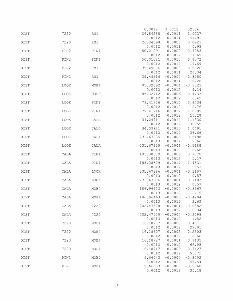
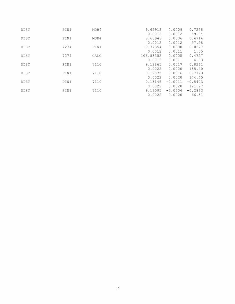
DIST PIN1 MOB4 9.65913 0.0009 0.7238 0.0012 0.0012 89.04 DIST PIN1 MOB4 9.65943 0.0006 0.4714 0.0012 0.0012 57.98 DIST 7274 PIN1 19.77354 0.0000 0.0277 0.0012 0.0011 1.55 DIST 7274 CALC 106.88352 0.0005 0.4727 0.0012 0.0011 4.83 DIST PIN1 7110 9.12865 0.0017 0.8261 0.0022 0.0020 185.40 DIST PIN1 7110 9.12875 0.0016 0.7773 0.0022 0.0020 174.45 DIST PIN1 7110 9.13145 -0.0011 -0.5403 0.0022 0.0020 121.27 DIST PIN1 7110 9.13095 -0.0006 -0.2963 0.0022 0.0020 66.51

36
================================================================================ MOBLAS-4 Monument Peak, CA Geodetic SITE SURVEY 2011 END GeoLab V3.65 ITRF2008 (2005) UNITS: m,DMS Page 0036 ================================================================================ --- |:::| |:::| --- |:::| |:::| |:::| |:::| |:::| |:::| |:::| |:::| |:::| |:::| 0.4 - |::***--|:::|--- |:*:|:*:|:::|:::| |*::|::*|:::|:::| *:::|:::*:::|:::| R |:::|:::|:::|:::| e *|:::|:::|*::|:::| l |:::|:::|:::|:::| a |:::|:::|:::|:::| t 0.3 - * |:::|:::|:*:|:::| i |:::|:::|:::|:::| v * |:::|:::|::*|:::| e |:::|:::|:::|:::| |:::|:::|:::|:::| F * |:::|:::|:::*:::| r |:::|:::|:::|:::| e * |:::|:::|:::|*::| q 0.2 - |:::|:::|:::|:::| u * |:::|:::|:::|:*:| e |:::|:::|:::|:::| n |:::|:::|:::|:::| c * |:::|:::|:::|::*| y |:::|:::|:::|:::| * |:::|:::|:::|:::* ---|:::|:::|:::|:::| 0.1 - * |:::|:::|:::|:::|:::|* * |:::|:::|:::|:::|:::| * |:::|:::|:::|:::|:::| * |:::|:::|:::|:::|:::| * * |:::|:::|:::|:::|:::| * * |:::|:::|:::|:::|:::|--- * * |:::|:::|:::|:::|:::|:::| * *** --- |:::|:::|:::|:::|:::|:::| *** +---+---+---+---+---+---+---+---+---+---+---+---+---+---+---+---+---+---+ -4 -3 -2 -1 0 1 2 3 4 DISTANCES (79 residuals)

37
================================================================================ MOBLAS-4 Monument Peak, CA Geodetic SITE SURVEY 2011 END GeoLab V3.65 ITRF2008 (2005) UNITS: m,DMS Page 0038 ================================================================================ Residuals (critical value = 3.813): NOTE: Observation values shown are reduced to mark-to-mark. OBSERVATION RESIDUAL STD RES TYPE AT FROM TO STD DEV STD DEV PPM ---- ------------ ------------ ------------ ----------------- -------- -------- GROUP: ZENITHAL ANGLE OBSERVATIONS ZANG 7220 RM1 91 15 23.08 0.45 0.07 6.99 6.47 ZANG PIN2 PIN1 91 25 46.04 -1.24 -0.33 4.03 3.80 ZANG PIN2 RM1 93 10 54.21 7.01 1.46 5.29 4.79 ZANG PIN2 DORIS 81 51 31.66 -17.59 -2.36 8.73 7.47 ZANG PIN1 PIN2 88 34 6.55 -7.87 -2.07 4.03 3.80 ZANG RM1 7220 88 44 38.20 -0.09 -0.01 6.99 6.47 ZANG LOOK MOB4 88 48 20.55 0.47 0.19 2.76 2.45 ZANG LOOK CALA 86 16 35.38 0.41 0.23 1.93 1.83 ZANG LOOK CALC 88 29 37.97 -1.43 -0.29 5.60 4.91 ZANG CALC CALA 86 22 50.41 1.18 0.64 1.94 1.82 ZANG CALC MOB4 89 31 42.94 -1.90 -0.89 2.44 2.15 ZANG CALC LOOK 91 30 14.27 -7.46 -1.52 5.60 4.91 ZANG CALC PIN1 91 20 24.19 -2.03 -0.89 2.53 2.28 ZANG CALA CALC 93 37 16.94 -1.28 -0.70 1.94 1.82 ZANG CALA MOB4 94 4 17.75 1.63 0.89 2.01 1.83 ZANG CALA LOOK 93 43 34.65 1.93 1.06 1.93 1.83 ZANG CALA PIN1 95 9 33.89 2.99 1.61 2.02 1.86 ZANG CALA 7220 94 42 36.47 4.46 2.43 1.97 1.83 ZANG LOOK MONP 89 0 2.86 2.59 1.22 2.31 2.12 ZANG LOOK DORIS 88 31 22.54 -1.96 -0.93 2.38 2.10 ZANG LOOK CALA 86 16 34.42 -0.55 -0.30 1.93 1.83 ZANG LOOK CALC 88 29 40.48 1.09 0.22 5.60 4.91 ZANG PIN1 LOOK 88 57 50.95 -0.21 -0.08 2.88 2.66 ZANG PIN1 7220 90 23 4.76 -3.59 -0.43

38
8.92 8.28 ZANG PIN1 7274 90 37 3.64 -3.57 -0.44 8.90 8.05 ZANG PIN1 MONP 85 10 34.87 -4.81 -1.17 4.68 4.10

39
================================================================================ MOBLAS-4 Monument Peak, CA Geodetic SITE SURVEY 2011 END GeoLab V3.65 ITRF2008 (2005) UNITS: m,DMS Page 0040 ================================================================================ --- |:::| |:::| |:::| |:::| |:::| |:::| |:::| |:::| |:::| |:::| 0.4 - |::*** |:*:| * |*::| * *:::| * R |:::| e *|:::| * l |:::| a |:::| t 0.3 - -*-|:::|--- * i |:::|:::|:::| v |*::|:::|:::| * e |:::|:::|:::| |:::|:::|:::| F *:::|:::|:::| * r |:::|:::|:::| --- e *|:::|:::|:::| |*::| q 0.2 - |:::|:::|:::| |:::| u * |:::|:::|:::| |:*:| e |:::|:::|:::| |:::| n |:::|:::|:::| |:::| c * |:::|:::|:::| |::*| y --- |:::|:::|:::|---|:::| |:::| * |:::|:::|:::|:::|:::* |:::| |:::|:::|:::|:::|:::| 0.1 - |:::| * |:::|:::|:::|:::|:::|* |:::| * |:::|:::|:::|:::|:::| * |:::| |:::|:::|:::|:::|:::| |:::|*-- ---|:::|:::|:::|:::|:::|--* --- |:::*:::|:::|:::|:::|:::|:::|:::|:::*:::| |::*|:::|:::|:::|:::|:::|:::|:::|:::|*::| |:*:|:::|:::|:::|:::|:::|:::|:::|:::|:*:| ***::|:::|:::|:::|:::|:::|:::|:::|:::|::*** +---+---+---+---+---+---+---+---+---+---+---+---+---+---+---+---+---+---+ -4 -3 -2 -1 0 1 2 3 4 ZENITHAL ANGLE OBSERVATIONS (26 residuals)
40
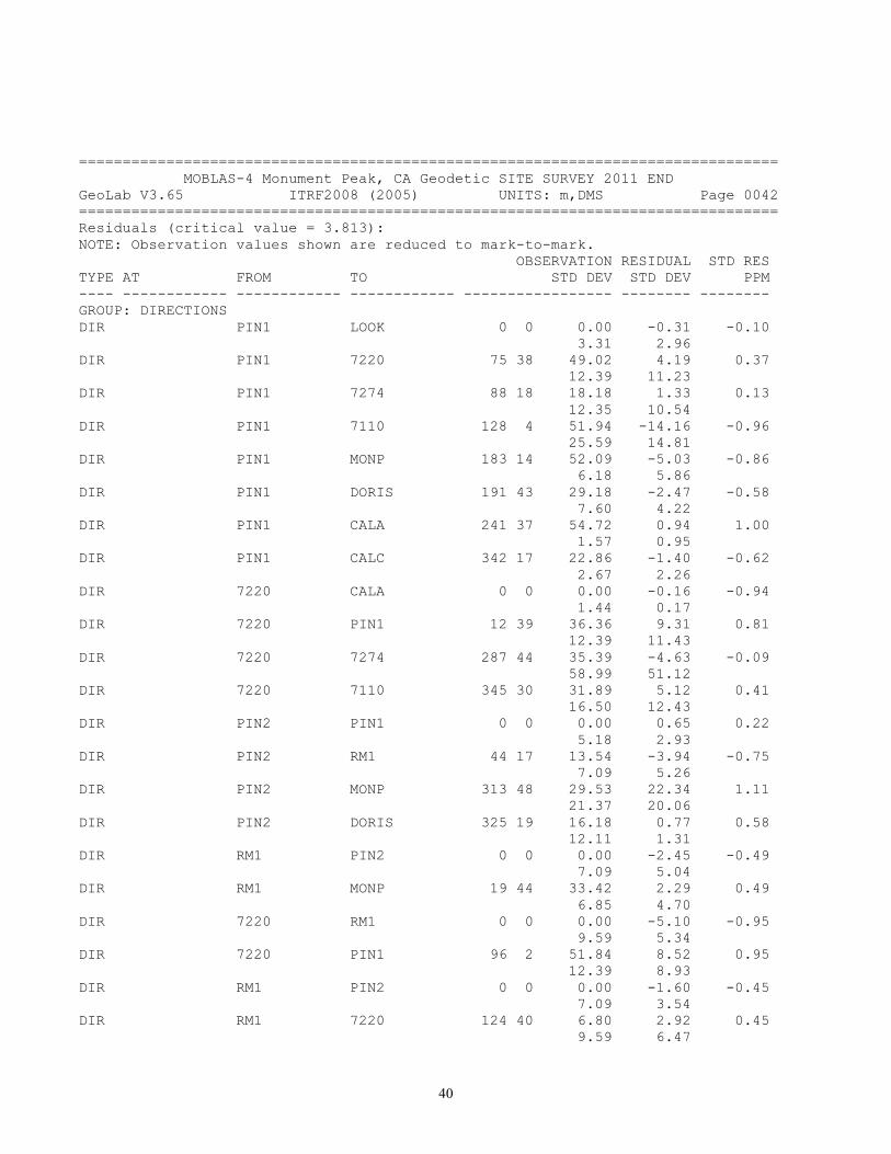
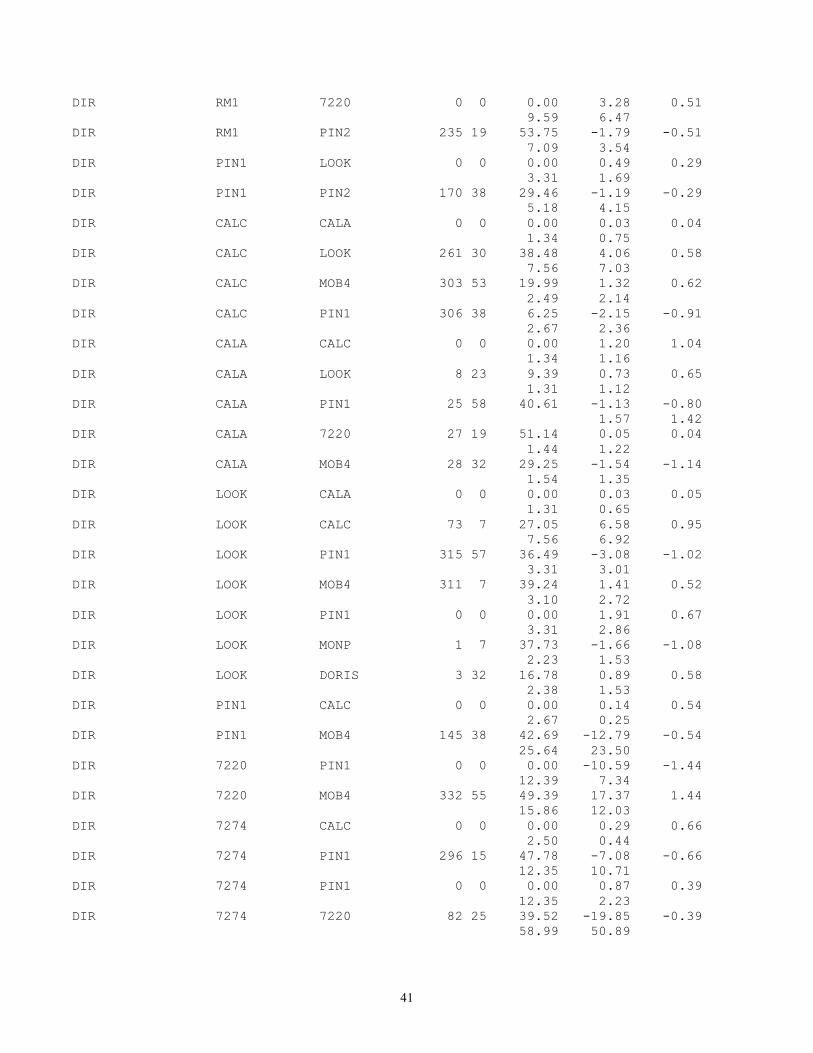
================================================================================ MOBLAS-4 Monument Peak, CA Geodetic SITE SURVEY 2011 END GeoLab V3.65 ITRF2008 (2005) UNITS: m,DMS Page 0042 ================================================================================ Residuals (critical value = 3.813): NOTE: Observation values shown are reduced to mark-to-mark. OBSERVATION RESIDUAL STD RES TYPE AT FROM TO STD DEV STD DEV PPM ---- ------------ ------------ ------------ ----------------- -------- -------- GROUP: DIRECTIONS DIR PIN1 LOOK 0 0 0.00 -0.31 -0.10 3.31 2.96 DIR PIN1 7220 75 38 49.02 4.19 0.37 12.39 11.23 DIR PIN1 7274 88 18 18.18 1.33 0.13 12.35 10.54 DIR PIN1 7110 128 4 51.94 -14.16 -0.96 25.59 14.81 DIR PIN1 MONP 183 14 52.09 -5.03 -0.86 6.18 5.86 DIR PIN1 DORIS 191 43 29.18 -2.47 -0.58 7.60 4.22 DIR PIN1 CALA 241 37 54.72 0.94 1.00 1.57 0.95 DIR PIN1 CALC 342 17 22.86 -1.40 -0.62 2.67 2.26 DIR 7220 CALA 0 0 0.00 -0.16 -0.94 1.44 0.17 DIR 7220 PIN1 12 39 36.36 9.31 0.81 12.39 11.43 DIR 7220 7274 287 44 35.39 -4.63 -0.09 58.99 51.12 DIR 7220 7110 345 30 31.89 5.12 0.41 16.50 12.43 DIR PIN2 PIN1 0 0 0.00 0.65 0.22 5.18 2.93 DIR PIN2 RM1 44 17 13.54 -3.94 -0.75 7.09 5.26 DIR PIN2 MONP 313 48 29.53 22.34 1.11 21.37 20.06 DIR PIN2 DORIS 325 19 16.18 0.77 0.58 12.11 1.31 DIR RM1 PIN2 0 0 0.00 -2.45 -0.49 7.09 5.04 DIR RM1 MONP 19 44 33.42 2.29 0.49 6.85 4.70 DIR 7220 RM1 0 0 0.00 -5.10 -0.95 9.59 5.34 DIR 7220 PIN1 96 2 51.84 8.52 0.95 12.39 8.93 DIR RM1 PIN2 0 0 0.00 -1.60 -0.45 7.09 3.54 DIR RM1 7220 124 40 6.80 2.92 0.45 9.59 6.47
41
DIR RM1 7220 0 0 0.00 3.28 0.51 9.59 6.47 DIR RM1 PIN2 235 19 53.75 -1.79 -0.51 7.09 3.54 DIR PIN1 LOOK 0 0 0.00 0.49 0.29 3.31 1.69 DIR PIN1 PIN2 170 38 29.46 -1.19 -0.29 5.18 4.15 DIR CALC CALA 0 0 0.00 0.03 0.04 1.34 0.75 DIR CALC LOOK 261 30 38.48 4.06 0.58 7.56 7.03 DIR CALC MOB4 303 53 19.99 1.32 0.62 2.49 2.14 DIR CALC PIN1 306 38 6.25 -2.15 -0.91 2.67 2.36 DIR CALA CALC 0 0 0.00 1.20 1.04 1.34 1.16 DIR CALA LOOK 8 23 9.39 0.73 0.65 1.31 1.12 DIR CALA PIN1 25 58 40.61 -1.13 -0.80 1.57 1.42 DIR CALA 7220 27 19 51.14 0.05 0.04 1.44 1.22 DIR CALA MOB4 28 32 29.25 -1.54 -1.14 1.54 1.35 DIR LOOK CALA 0 0 0.00 0.03 0.05 1.31 0.65 DIR LOOK CALC 73 7 27.05 6.58 0.95 7.56 6.92 DIR LOOK PIN1 315 57 36.49 -3.08 -1.02 3.31 3.01 DIR LOOK MOB4 311 7 39.24 1.41 0.52 3.10 2.72 DIR LOOK PIN1 0 0 0.00 1.91 0.67 3.31 2.86 DIR LOOK MONP 1 7 37.73 -1.66 -1.08 2.23 1.53 DIR LOOK DORIS 3 32 16.78 0.89 0.58 2.38 1.53 DIR PIN1 CALC 0 0 0.00 0.14 0.54 2.67 0.25 DIR PIN1 MOB4 145 38 42.69 -12.79 -0.54 25.64 23.50 DIR 7220 PIN1 0 0 0.00 -10.59 -1.44 12.39 7.34 DIR 7220 MOB4 332 55 49.39 17.37 1.44 15.86 12.03 DIR 7274 CALC 0 0 0.00 0.29 0.66 2.50 0.44 DIR 7274 PIN1 296 15 47.78 -7.08 -0.66 12.35 10.71 DIR 7274 PIN1 0 0 0.00 0.87 0.39 12.35 2.23 DIR 7274 7220 82 25 39.52 -19.85 -0.39 58.99 50.89
42
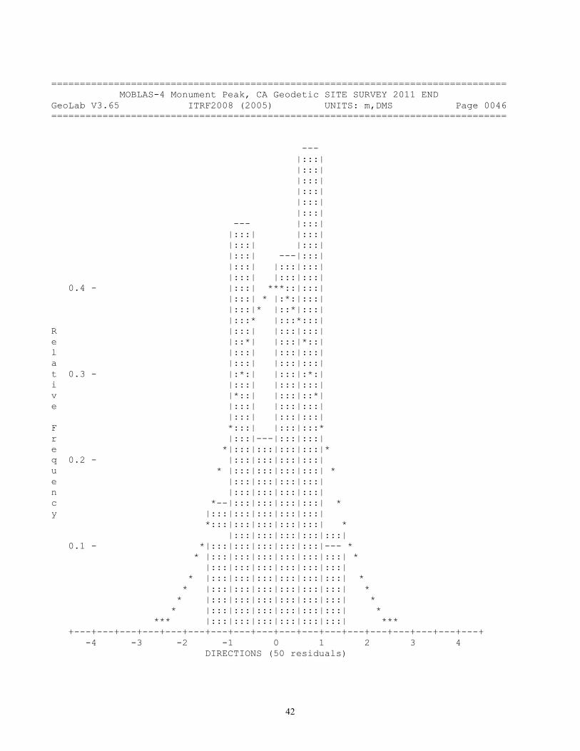
================================================================================ MOBLAS-4 Monument Peak, CA Geodetic SITE SURVEY 2011 END GeoLab V3.65 ITRF2008 (2005) UNITS: m,DMS Page 0046 ================================================================================ --- |:::| |:::| |:::| |:::| |:::| |:::| --- |:::| |:::| |:::| |:::| |:::| |:::| ---|:::| |:::| |:::|:::| |:::| |:::|:::| 0.4 - |:::| ***::|:::| |:::| * |:*:|:::| |:::|* |::*|:::| |:::* |:::*:::| R |:::| |:::|:::| e |::*| |:::|*::| l |:::| |:::|:::| a |:::| |:::|:::| t 0.3 - |:*:| |:::|:*:| i |:::| |:::|:::| v |*::| |:::|::*| e |:::| |:::|:::| |:::| |:::|:::| F *:::| |:::|:::* r |:::|---|:::|:::| e *|:::|:::|:::|:::|* q 0.2 - |:::|:::|:::|:::| u * |:::|:::|:::|:::| * e |:::|:::|:::|:::| n |:::|:::|:::|:::| c *--|:::|:::|:::|:::| * y |:::|:::|:::|:::|:::| *:::|:::|:::|:::|:::| * |:::|:::|:::|:::|:::| 0.1 - *|:::|:::|:::|:::|:::|--- * * |:::|:::|:::|:::|:::|:::| * |:::|:::|:::|:::|:::|:::| * |:::|:::|:::|:::|:::|:::| * * |:::|:::|:::|:::|:::|:::| * * |:::|:::|:::|:::|:::|:::| * * |:::|:::|:::|:::|:::|:::| * *** |:::|:::|:::|:::|:::|:::| *** +---+---+---+---+---+---+---+---+---+---+---+---+---+---+---+---+---+---+ -4 -3 -2 -1 0 1 2 3 4 DIRECTIONS (50 residuals)

43
================================================================================ MOBLAS-4 Monument Peak, CA Geodetic SITE SURVEY 2011 END GeoLab V3.65 ITRF2008 (2005) UNITS: m,DMS Page 0048 ================================================================================ Residuals (critical value = 3.813): NOTE: Observation values shown are reduced to mark-to-mark. OBSERVATION RESIDUAL STD RES TYPE AT FROM TO STD DEV STD DEV PPM ---- ------------ ------------ ------------ ----------------- -------- -------- GROUP: ORTHOMETRIC HEIGHT DIFFERENCES OHDF 7220 LOOK 1.56770 0.0004 0.4702 0.0009 0.0008 4.69 OHDF LOOK 7220 -1.56770 -0.0004 -0.4702 0.0009 0.0008 4.69 OHDF MOB4 PIN2 -1.96820 0.0004 0.4726 0.0009 0.0008 8.47 OHDF PIN2 MOB4 1.96760 0.0002 0.2916 0.0009 0.0008 5.23 OHDF 7220 7110 0.15870 0.0000 0.0162 0.0009 0.0007 0.73 OHDF 7110 7220 -0.15900 0.0003 0.4055 0.0009 0.0007 18.19 OHDF PIN2 MONP 2.30920 0.0009 1.2472 0.0009 0.0008 73.18 OHDF MONP PIN2 -2.30940 -0.0007 -0.9843 0.0009 0.0008 57.75 OHDF PIN2 DORIS 3.10880 0.0010 1.3958 0.0009 0.0007 46.57 OHDF DORIS PIN2 -3.10870 -0.0011 -1.5322 0.0009 0.0007 51.12 OHDF MOB4 PIN2 -1.96790 0.0001 0.0905 0.0009 0.0008 1.62 OHDF PIN2 MOB4 1.96760 0.0002 0.2916 0.0009 0.0008 5.23 OHDF PIN2 RM1 -1.96680 -0.0009 -1.1494 0.0009 0.0008 25.62 OHDF RM1 PIN2 1.96750 0.0002 0.2645 0.0009 0.0008 5.90 OHDF RM1 7274 0.50590 0.0000 -0.0234 0.0009 0.0008 0.81 OHDF 7274 RM1 -0.50600 0.0001 0.1509 0.0009 0.0008 5.24 OHDF RM1 7220 0.58720 0.0000 0.0059 0.0009 0.0008 0.18 OHDF 7220 RM1 -0.58700 -0.0002 -0.2527 0.0009 0.0008 7.63 OHDF 7274 7220 0.08090 0.0004 0.5258 0.0009 0.0008 97.28 OHDF 7220 7274 -0.08110 -0.0002 -0.2773 0.0009 0.0008 51.30 OHDF 7274 PIN1 0.21310 0.0003 0.3321 0.0009 0.0008 13.46 OHDF PIN1 7274 -0.21320 -0.0002 -0.2073 0.0009 0.0008 8.40 OHDF 7220 PIN1 0.13220 -0.0002 -0.1914 0.0009 0.0008 7.98
44
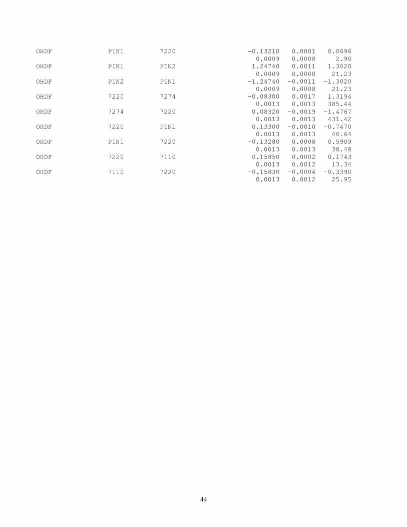
OHDF PIN1 7220 -0.13210 0.0001 0.0696 0.0009 0.0008 2.90 OHDF PIN1 PIN2 1.24740 0.0011 1.3020 0.0009 0.0008 21.23 OHDF PIN2 PIN1 -1.24740 -0.0011 -1.3020 0.0009 0.0008 21.23 OHDF 7220 7274 -0.08300 0.0017 1.3194 0.0013 0.0013 385.44 OHDF 7274 7220 0.08320 -0.0019 -1.4767 0.0013 0.0013 431.42 OHDF 7220 PIN1 0.13300 -0.0010 -0.7470 0.0013 0.0013 48.64 OHDF PIN1 7220 -0.13280 0.0008 0.5909 0.0013 0.0013 38.48 OHDF 7220 7110 0.15850 0.0002 0.1743 0.0013 0.0012 13.34 OHDF 7110 7220 -0.15830 -0.0004 -0.3390 0.0013 0.0012 25.95

45
================================================================================ MOBLAS-4 Monument Peak, CA Geodetic SITE SURVEY 2011 END GeoLab V3.65 ITRF2008 (2005) UNITS: m,DMS Page 0050 ================================================================================ --- |:::| |:::| |:::| |:::| |:::| |:::| |:::| |:::| |:::| ---|:::| |:::|:::| |:::|:::| 0.4 - |::***::| |:*:|:*:| |*::|::*| *:::|:::* R |:::|:::| e *|:::|:::|* l |:::|:::| a |:::|:::| t 0.3 - * |:::|:::| * i |:::|:::| v * |:::|:::| * e |:::|:::| |:::|:::| F * |:::|:::| *--- r |:::|:::| |:::| e * |:::|:::| |*::| q 0.2 - |:::|:::| |:::| u * |:::|:::| |:*:| e --- |:::|:::| |:::| n |:::| |:::|:::| |:::| c |*::| |:::|:::| |::*| y |:::| |:::|:::| |:::| *:::| |:::|:::| |:::* |:::|---|:::|:::|---|:::| 0.1 - *|:::|:::|:::|:::|:::|:::|* * |:::|:::|:::|:::|:::|:::| * |:::|:::|:::|:::|:::|:::| * |:::|:::|:::|:::|:::|:::| * *---|:::|:::|:::|:::|:::|:::| * *|:::|:::|:::|:::|:::|:::|:::| * * |:::|:::|:::|:::|:::|:::|:::| * *** |:::|:::|:::|:::|:::|:::|:::| *** +---+---+---+---+---+---+---+---+---+---+---+---+---+---+---+---+---+---+ -4 -3 -2 -1 0 1 2 3 4 ORTHOMETRIC HEIGHT DIFFERENCES (32 residuals)

46
================================================================================ MOBLAS-4 Monument Peak, CA Geodetic SITE SURVEY 2011 END GeoLab V3.65 ITRF2008 (2005) UNITS: m,DMS Page 0052 ================================================================================ --- |:::| |:::| |:::| |:::| |:::| 0.4 - ***::| -*-|:*:| |*::|::*| *:::|:::* R |:::|:::| e *|:::|:::|*-- l |:::|:::|:::| a |:::|:::|:::| t 0.3 - * |:::|:::|:*:| i |:::|:::|:::| v * |:::|:::|::*| e |:::|:::|:::| |:::|:::|:::|--- F * |:::|:::|:::*:::| r |:::|:::|:::|:::| e * ---|:::|:::|:::|*::| q 0.2 - |:::|:::|:::|:::|:::| u * |:::|:::|:::|:::|:*:| e |:::|:::|:::|:::|:::| n |:::|:::|:::|:::|:::| c * |:::|:::|:::|:::|::*| y |:::|:::|:::|:::|:::| * |:::|:::|:::|:::|:::* |:::|:::|:::|:::|:::| 0.1 - * ---|:::|:::|:::|:::|:::|* * |:::|:::|:::|:::|:::|:::| * |:::|:::|:::|:::|:::|:::| * |:::|:::|:::|:::|:::|:::| * *---|:::|:::|:::|:::|:::|:::| * *|:::|:::|:::|:::|:::|:::|:::|--- * * |:::|:::|:::|:::|:::|:::|:::|:::| * ***--|:::|:::|:::|:::|:::|:::|:::|:::| *** +---+---+---+---+---+---+---+---+---+---+---+---+---+---+---+---+---+---+ -4 -3 -2 -1 0 1 2 3 4 covariance (235 residuals)
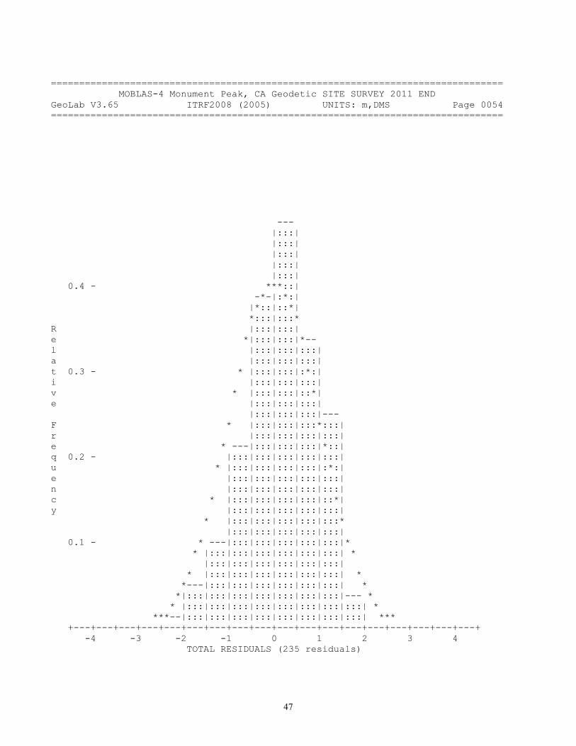
47
================================================================================ MOBLAS-4 Monument Peak, CA Geodetic SITE SURVEY 2011 END GeoLab V3.65 ITRF2008 (2005) UNITS: m,DMS Page 0054 ================================================================================ --- |:::| |:::| |:::| |:::| |:::| 0.4 - ***::| -*-|:*:| |*::|::*| *:::|:::* R |:::|:::| e *|:::|:::|*-- l |:::|:::|:::| a |:::|:::|:::| t 0.3 - * |:::|:::|:*:| i |:::|:::|:::| v * |:::|:::|::*| e |:::|:::|:::| |:::|:::|:::|--- F * |:::|:::|:::*:::| r |:::|:::|:::|:::| e * ---|:::|:::|:::|*::| q 0.2 - |:::|:::|:::|:::|:::| u * |:::|:::|:::|:::|:*:| e |:::|:::|:::|:::|:::| n |:::|:::|:::|:::|:::| c * |:::|:::|:::|:::|::*| y |:::|:::|:::|:::|:::| * |:::|:::|:::|:::|:::* |:::|:::|:::|:::|:::| 0.1 - * ---|:::|:::|:::|:::|:::|* * |:::|:::|:::|:::|:::|:::| * |:::|:::|:::|:::|:::|:::| * |:::|:::|:::|:::|:::|:::| * *---|:::|:::|:::|:::|:::|:::| * *|:::|:::|:::|:::|:::|:::|:::|--- * * |:::|:::|:::|:::|:::|:::|:::|:::| * ***--|:::|:::|:::|:::|:::|:::|:::|:::| *** +---+---+---+---+---+---+---+---+---+---+---+---+---+---+---+---+---+---+ -4 -3 -2 -1 0 1 2 3 4 TOTAL RESIDUALS (235 residuals)

48
================================================================================ MOBLAS-4 Monument Peak, CA Geodetic SITE SURVEY 2011 END GeoLab V3.65 ITRF2008 (2005) UNITS: m,DMS Page 0056 ================================================================================ --- |:::| |:::| |:::| |:::| |:::| 0.4 - ***::| -*-|:*:| |*::|::*| *:::|:::* R |:::|:::| e *|:::|:::|*-- l |:::|:::|:::| a |:::|:::|:::| t 0.3 - * |:::|:::|:*:| i |:::|:::|:::| v * |:::|:::|::*| e |:::|:::|:::| |:::|:::|:::|--- F * |:::|:::|:::*:::| r |:::|:::|:::|:::| e * ---|:::|:::|:::|*::| q 0.2 - |:::|:::|:::|:::|:::| u * |:::|:::|:::|:::|:*:| e |:::|:::|:::|:::|:::| n |:::|:::|:::|:::|:::| c * |:::|:::|:::|:::|::*| y |:::|:::|:::|:::|:::| * |:::|:::|:::|:::|:::* |:::|:::|:::|:::|:::| 0.1 - * ---|:::|:::|:::|:::|:::|* * |:::|:::|:::|:::|:::|:::| * |:::|:::|:::|:::|:::|:::| * |:::|:::|:::|:::|:::|:::| * *---|:::|:::|:::|:::|:::|:::| * *|:::|:::|:::|:::|:::|:::|:::|--- * * |:::|:::|:::|:::|:::|:::|:::|:::| * ***--|:::|:::|:::|:::|:::|:::|:::|:::| *** +---+---+---+---+---+---+---+---+---+---+---+---+---+---+---+---+---+---+ -4 -3 -2 -1 0 1 2 3 4 TOTAL RESIDUALS (235 residuals)
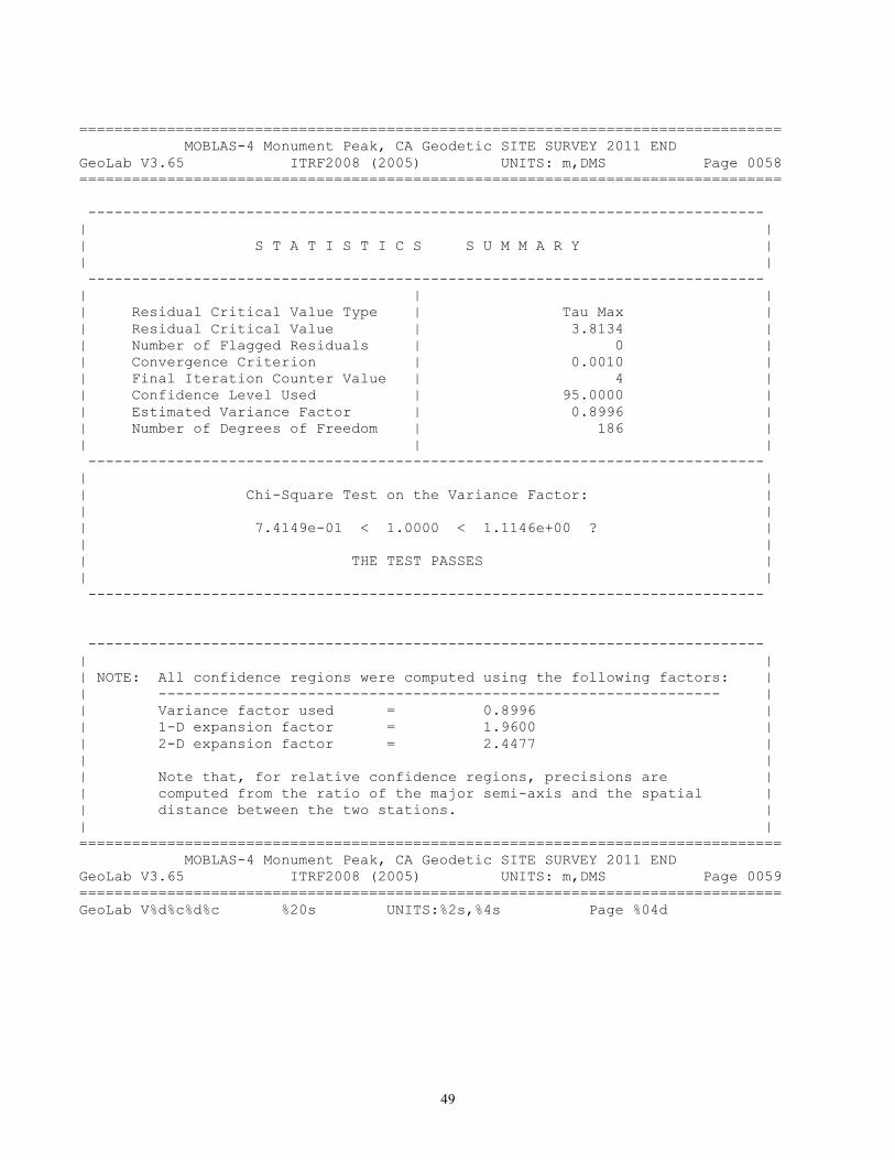
49
================================================================================ MOBLAS-4 Monument Peak, CA Geodetic SITE SURVEY 2011 END GeoLab V3.65 ITRF2008 (2005) UNITS: m,DMS Page 0058 ================================================================================ ----------------------------------------------------------------------------- | | | S T A T I S T I C S S U M M A R Y | | | ----------------------------------------------------------------------------- | | | | Residual Critical Value Type | Tau Max | | Residual Critical Value | 3.8134 | | Number of Flagged Residuals | 0 | | Convergence Criterion | 0.0010 | | Final Iteration Counter Value | 4 | | Confidence Level Used | 95.0000 | | Estimated Variance Factor | 0.8996 | | Number of Degrees of Freedom | 186 | | | | ----------------------------------------------------------------------------- | | | Chi-Square Test on the Variance Factor: | | | | 7.4149e-01 < 1.0000 < 1.1146e+00 ? | | | | THE TEST PASSES | | | ----------------------------------------------------------------------------- ----------------------------------------------------------------------------- | | | NOTE: All confidence regions were computed using the following factors: | | ---------------------------------------------------------------- | | Variance factor used = 0.8996 | | 1-D expansion factor = 1.9600 | | 2-D expansion factor = 2.4477 | | | | Note that, for relative confidence regions, precisions are | | computed from the ratio of the major semi-axis and the spatial | | distance between the two stations. | | | ================================================================================ MOBLAS-4 Monument Peak, CA Geodetic SITE SURVEY 2011 END GeoLab V3.65 ITRF2008 (2005) UNITS: m,DMS Page 0059 ================================================================================ GeoLab V%d%c%d%c %20s UNITS:%2s,%4s Page %04d
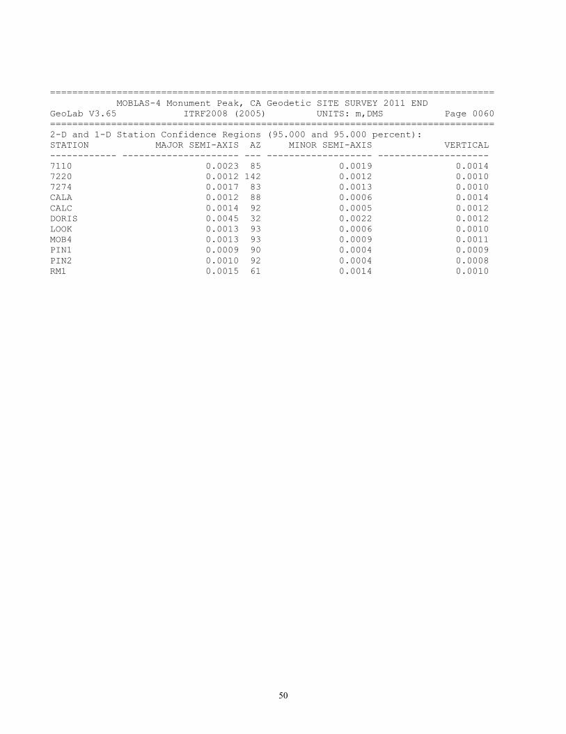
50
================================================================================ MOBLAS-4 Monument Peak, CA Geodetic SITE SURVEY 2011 END GeoLab V3.65 ITRF2008 (2005) UNITS: m,DMS Page 0060 ================================================================================ 2-D and 1-D Station Confidence Regions (95.000 and 95.000 percent): STATION MAJOR SEMI-AXIS AZ MINOR SEMI-AXIS VERTICAL ------------ --------------------- --- ------------------- -------------------- 7110 0.0023 85 0.0019 0.0014 7220 0.0012 142 0.0012 0.0010 7274 0.0017 83 0.0013 0.0010 CALA 0.0012 88 0.0006 0.0014 CALC 0.0014 92 0.0005 0.0012 DORIS 0.0045 32 0.0022 0.0012 LOOK 0.0013 93 0.0006 0.0010 MOB4 0.0013 93 0.0009 0.0011 PIN1 0.0009 90 0.0004 0.0009 PIN2 0.0010 92 0.0004 0.0008 RM1 0.0015 61 0.0014 0.0010

51
================================================================================ MOBLAS-4 Monument Peak, CA Geodetic SITE SURVEY 2011 END GeoLab V3.65 ITRF2008 (2005) UNITS: m,DMS Page 0061 ================================================================================ 2-D and 1-D Relative Station Confidence Regions (95.000 and 95.000 percent): FROM TO MAJ-SEMI AZ MIN-SEMI VERTICAL DISTANCE PPM ------------ ------------ -------- --- -------- --------- ------------ -------- 7110 7220 0.0022 80 0.0020 0.0010 15.8582 138.88 7110 PIN1 0.0021 81 0.0019 0.0011 9.1303 235.08 7220 7274 0.0015 68 0.0014 0.0007 4.3504 344.98 7220 CALA 0.0013 8 0.0009 0.0013 202.4749 6.63 7220 LOOK 0.0013 179 0.0012 0.0008 76.9433 17.10 7220 MOB4 0.0014 1 0.0010 0.0010 16.1883 89.11 7220 PIN1 0.0012 2 0.0009 0.0006 19.6774 60.09 7220 RM1 0.0014 105 0.0012 0.0006 26.8440 52.67 7274 CALC 0.0018 85 0.0014 0.0011 106.8840 16.86 7274 PIN1 0.0015 70 0.0013 0.0007 19.7736 74.56 7274 RM1 0.0019 77 0.0017 0.0007 22.5911 85.44 CALA CALC 0.0010 95 0.0006 0.0013 224.1274 4.53 CALA LOOK 0.0010 101 0.0008 0.0013 231.6727 4.24 CALA MOB4 0.0010 13 0.0009 0.0014 186.9641 5.26 CALA MONP 0.0012 88 0.0006 0.0014 165.0101 7.17 CALA PIN1 0.0009 82 0.0007 0.0013 183.3868 4.66 CALC LOOK 0.0011 93 0.0007 0.0008 34.1005 33.60 CALC MOB4 0.0012 104 0.0009 0.0011 107.3413 11.63 CALC MONP 0.0014 92 0.0005 0.0012 139.9065 9.75 CALC PIN1 0.0011 94 0.0006 0.0010 99.7219 11.22 DORIS LOOK 0.0045 33 0.0023 0.0012 113.3507 40.13 DORIS PIN1 0.0045 32 0.0021 0.0011 34.6844 129.91 DORIS PIN2 0.0045 31 0.0022 0.0009 21.9759 202.95 LOOK MOB4 0.0012 110 0.0010 0.0010 85.3266 13.94 LOOK MONP 0.0013 93 0.0006 0.0010 121.5607 10.78 LOOK PIN1 0.0010 96 0.0006 0.0008 79.4184 12.88 MOB4 PIN1 0.0010 96 0.0009 0.0009 9.6600 103.82 MOB4 PIN2 0.0013 96 0.0010 0.0007 43.7857 30.81 MONP PIN1 0.0009 90 0.0004 0.0009 42.3308 21.89 MONP PIN2 0.0010 92 0.0004 0.0008 12.9648 79.25 MONP RM1 0.0015 61 0.0014 0.0010 38.0039 39.77 PIN1 PIN2 0.0010 94 0.0004 0.0006 50.0118 19.35 PIN2 RM1 0.0015 172 0.0012 0.0007 35.4918 41.09 10:48:51, Sat Nov 19, 2011

52
Appendix B. SLR MOBLAS 4 ILRS Site Log ILRS Site and System Information Form International Laser Ranging Service 0. Form Prepared by (Full Name) : Nikki Desch Preparer E-mail : [email protected] Date Prepared : 2011-06-02 Report Type : UPDATE Format Version : 1.0 1. Identification of the Ranging System Reference Point (SRP) Site Name : Monument Peak IERS DOMES Number : 40497M001 CDP Pad ID : 7110 Subnetwork : NASA Description : MONUMENT Monument Description : Standard NASA Disk Monument Inscription : ORT STATION 7110 1981 Mark Description : Punch mark in center Date Installed : 1983-08-15 Date Removed : Geologic Characteristic : Granitic and Metamorphic rock Additional Information : The marker has two punch marks. The center punch mark is the survey reference point. 2. Site Location Information City or Town : Mount Laguna State or Province : California Country : United States Tectonic Plate : Pacific Approximate Position X coordinate [m]: -2386278.2 Y coordinate [m]: -4802354.0 Z coordinate [m]: 3444881.6 Latitude [deg]: 32.8917 N Longitude [deg]: 116.4227 W Elevation [m]: 1837.564 Additional Information : (multiple lines) 3. General System Information
53
3.01 System Name : Moblas-4 4-Character Code : MONL CDP System Number : 04 CDP Occupation Number : 11 Eccentricity to SRP (if Not Identical With SRP) North [m]: -0.026 +- 0.001 East [m]: -0.019 +- 0.001 Up [m]: 3.189 +- 0.001 Date Measured : 1999-10-01 Date Installed : 1983-08-15 Date Removed : (yyyy-mm-dd) Additional Information : (multiple lines) 4. Telescope Information 4.01 Receiving Telescope Type : CASSEGRAIN Aperture [m]: 0.762 Mount : AZ-EL Xmitting Telescope Type : REFRACTOR Aperture [m]: 0.163 Tracking Camera Type : CCD Model : Gen 11 Intensifier Manufacturer : Photon Field of View [deg]: Minimum Magnitude [mag]: Transmit/Receive Path : SEPARATE Transmit/Receive Switch : NONE Max Slew Rate Az [deg/s]: 20 Max Slew Rate El [deg/s]: 5 Max Used Tracking Rate Az : 5 Max Used Tracking Rate El : 3 Telescope Shelter : ROLL-BACK ROOF Daylight Filter Type : Omega Optical 532NBl 9114 Dayl. Filt. Bandwidth [nm]: <10 Adjustable Attenuation : RECEIVE Transmit Efficiency : 0.94 Receive Efficiency : 0.76 Date Installed : 1983-08-15 Date Removed : (yyyy-mm-dd) Additional Information : (multiple lines) 5. Laser System Information
54
5.01 Laser Type : ND:YAG Number of Amplifiers : 1 Primary Wavelength [nm]: 1064 Primary Maximum Energy [mJ]: 200 Secondary Wavelength [nm]: 532 Secondary Max. Energy [mJ]: 100 Xmit Energy Adjustable : YES Pulse Width (FWHM) [ps]: 200 Max. Repetition Rate [Hz]: 10 Fullw. Beam Divergence ["]: 30 Final Beam Diameter [m]: 0.093 Eyesafe : NO Eyesafe Standard : ANSI 136.1,ANSI 136.6 Date Installed : 1983-08-15 Date Removed : (yyyy-mm-dd) Additional Information : 1)Laser repetition rate is capable of 10Hz. Receive equipment upgraded to 10Hz for LRO support 2)Laser Cavity Upgrade 2001-01-23 3)Saturable absorber upgrade 2008-08-14 6. Receiver System 6.01.01 Primary Chain Wavelength [nm]: 532 Detector Type : MCP Manufacturer : ITT Model : F4129F Quantum Efficiency [%]: 17.7 Nominal Gain : 1E+06 Rise Time [ps]: 350 Jitter (Single PE)[ps]: 100 Field of View ["]: 360 Date Installed : 1986-03-31 Date Removed : (2001-08-19) Signal Processing : CFD Manufacturer : Tennelec Model : TC454 Date Installed : 1986-03-31 Date Removed : (yyyy-mm-dd) Amplitude Measurement : YES Return-rate Controlled: YES Mode of Operation : Few to Multi Photons Time of Flight Observ. : INTERVAL Manufacturer : Hewlett-Packard

55
Model : 5370B Resolution [ps]: 20 Precision [ps]: 35 Date Installed : 1986-03-31 Date Removed : (yyyy-mm-dd) Additional Information : (multiple lines) 6.01.02 Primary Chain Wavelength [nm]: 532 Detector Type : MCP Manufacturer : Photek Model : PMT318 Quantum Efficiency [%]: 13.12 Nominal Gain : 1E+07 Rise Time [ps]: 250 Jitter (Single PE)[ps]: 100 Field of View ["]: 360 Date Installed : 2001-08-19 Date Removed : (yyyy-mm-dd) Signal Processing : CFD Manufacturer : Tennelec Model : TC454 Date Installed : 1986-03-31 Date Removed : (yyyy-mm-dd) Amplitude Measurement : YES Return-rate Controlled: YES Mode of Operation : Few to Multi Photons Time of Flight Observ. : INTERVAL Manufacturer : Hewlett-Packard Model : 5370B Resolution [ps]: 20 Precision [ps]: 35 Date Installed : 1986-03-31 Date Removed : (yyyy-mm-dd) Additional Information : (multiple lines) 6.02.01 Secondary Chain Wavelength [nm]: 532 Detector Type : MCP Manufacturer : ITT Model : F4129F Quantum Efficiency [%]: 17.7 Nominal Gain : 1E6 Rise Time [ps]: 350 Jitter (Single PE)[ps]: 100 Field of View ["]: 360

56
Date Installed : 1986-03-31 Date Removed : 2001-08-19 Signal Processing : CFD Manufacturer : Tennelec Model : TC454 Date Installed : 1986-03-31 Date Removed : (yyyy-mm-dd) Amplitude Measurement : YES Return-rate Controlled: YES Mode of Operation : Single to Multi Photons Time of Flight Observ. : INTERVAL Manufacturer : Hewlett-Packard Model : 5370B Resolution [ps]: 20 Precision [ps]: 35 Date Installed : 1986-03-31 Date Removed : (yyyy-mm-dd) Additional Information : High sensivity laser receiver configuration installed 1997-04-01. Everything is the same as the primary chain except the discriminator threshold has been lowered to accept single photons and then amplified with 24db of gain. 6.02.02 Secondary Chain Wavelength [nm]: 532 Detector Type : MCP Manufacturer : Photek Model : PMT318 Quantum Efficiency [%]: 13.12 Nominal Gain : 1E+07 Rise Time [ps]: 250 Jitter (Single PE)[ps]: 100 Field of View ["]: 360 Date Installed : 2001-08-19 Date Removed : (yyyy-mm-dd) Signal Processing : CFD Manufacturer : Tennelec Model : TC454 Date Installed : 1986-03-31 Date Removed : (yyyy-mm-dd) Amplitude Measurement : YES Return-rate Controlled: YES Mode of Operation : Single to Multi Photons Time of Flight Observ. : INTERVAL Manufacturer : Hewlett-Packard Model : 5370B

57
Resolution [ps]: 20 Precision [ps]: 35 Date Installed : 1986-03-31 Date Removed : (yyyy-mm-dd) Additional Information : High sensivity laser receiver configuration installed 1997-04-01. Everything is the same as the primary chain except the discriminator threshold has been lowered to accept single photons and then amplified with 24db of gain. 7. Tracking Capabilities 7.01.01 Satellites Very Low Alt (<400 km) : YES Low Altitude (400-2000) : YES Lageos : YES GLONASS : YES Etalon : NIGHT GPS : NIGHT Moon : NO Avge Pass Switch Time [s]: 60 Average values for Lageos Single Shot RMS [mm]: 10 # of Obs per NP : 100 Use of Semi-trains : NO # of Semi-train Tracks : N.A. Range Gate Width [ns]: 600-10000 Beam Pointing Accuracy ["]: 0.6 Angle Encoder Resolution["]: 0.6 Min. Tracking Elev. [deg]: 20 Operation Months per Year : 12 Days per Week : 7 Hours per Day : 24 Staff per Shift : 1 System Shared With : NOTHING Time Allocated to SLR [%]: 100 Remotely Controllable : NO Date First Applicable : 1983-08-15 Date Last Applicable : (2004-02-06 04:00 UT) Additional Information : Station does not provide support : during U.S. holidays 7.01.02 Satellites Very Low Alt (<400 km) : YES

58
Low Altitude (400-2000) : YES Lageos : YES GLONASS : YES Etalon : NIGHT GPS : NIGHT Moon : NO Avge Pass Switch Time [s]: 60 Average values for Lageos Single Shot RMS [mm]: 10 # of Obs per NP : 100 Use of Semi-trains : NO # of Semi-train Tracks : N.A. Range Gate Width [ns]: 600-10000 Beam Pointing Accuracy ["]: 0.6 Angle Encoder Resolution["]: 0.6 Min. Tracking Elev. [deg]: 20 Operation Months per Year : 12 Days per Week : 5 Hours per Day : 24 Staff per Shift : 1 System Shared With : NOTHING Time Allocated to SLR [%]: 100 Remotely Controllable : NO Date First Applicable : 2004-08-15 Date Last Applicable : (yyyy-02-06 04:00 UT) Additional Information : Station does not provide support : during U.S. holidays 8. Calibration 8.01 Calibration Type : PRE+POST Target Location : EXTERNAL Target Type : CORNER CUBE Target Structure : CONCRETE PIER Target Distance [m]: 187 Date Measured : 1999-10-01 Accuracy (mm) [mm]: 2 Verification : first order survey and ranging to multiple ground targets Return-rate Controlled : YES Mode of Operation : Few to Multi Photons Average Cal Interval [min]: 3.5 Single Shot RMS [mm]: 5 +/- 1 Edit Criterion 1st Chain : ITERATIVE 3 SIGMA Edit Criterion 2nd Chain : N.A.

59
Application of Cal Data : AVERAGE Date Installed : 1990-12-01 Date Removed : (yyyy-mm-dd) Additional Information : (multiple lines) 9. Time and Frequency Standards 9.01.01 Frequency Standard Type : Rubidium disciplined by GPS Model : XL-DC 151-358-108-2 Manufacturer : Symmetricom (TrueTime) Short Term Stab. [e-12]: 10 Long Term Stab. [e-12]: 3 Time Reference : GPS Synchronization : GPS Epoch Accuracy [ns]: <100 Date Installed : 1999-06-30 Date Removed : (yyyy-mm-dd) Additional Information : This Truetime model contains the Stanford PRS10 Rubidium Frequency Standard 9.02.01 GPS Timing Rcvr Model : XL-DC 151-358-108-2 Manufacturer : Symmetricom (TrueTime) Date Installed : 1999-04-20 Date Removed : (yyyy-mm-dd) Additional Information : CNS clock used for comparisons 10. Preprocessing Information 10.01 On-site NP Generation : YES Data Screening : IRV+POLYNOMIAL Edit Criterion 1st Chain : ITERATIVE 3.0 SIGMA Edit Criterion 2nd Chain : N.A. Upload interval : HOURLY Date First Applicable : 1991-12-09 Date Last Applicable : 2001-12-19 Additional Information : (multiple lines) 10.02 On-site NP Generation : YES Data Screening : IRV+POLYNOMIAL Edit Criterion 1st Chain : ITERATIVE 3.0 SIGMA Edit Criterion 2nd Chain : N.A. Upload interval : HOURLY Date First Applicable : 2001-12-19

60
Date Last Applicable : (yyyy-mm-dd) Additional Information : Generic Normal Point Processing System 2.0 installed 2001-12-19 11. Aircraft Detection 11.01 Detection Type : RADAR Date Installed : 1995-09-15 Date Removed : (yyyy-mm-dd) Additional Information : (multiple lines) 12. Meteorological Instrumentation 12.01.01 Pressure Sensor Model : MET3 Manufacturer : Paroscientific Recording Interval : EVERY PULSE Accuracy [mbar]: 0.1 Height Diff to SRP [m]: -0.15 Date Installed : 2000-04-16 Calibration Interval : YEARLY Date Removed : 2011-03-29 Additional Information : (multiple lines) 12.01.02 Pressure Sensor Model : MET4 Manufacturer : Paroscientific Recording Interval : EVERY PULSE Accuracy [mbar]: 0.08 Height Diff to SRP [m]: -0.15 Date Installed : 2011-03-29 Calibration Interval : BIYEARLY Date Removed : (yyyy-mm-dd hh:mm UT) Additional Information : (multiple lines) 12.02.01 Temp Sensor Model : MET3 Manufacturer : Paroscientific Recording Interval : EVERY PULSE Accuracy [deg C]: 0.5 Date Installed : 2000-04-16 Calibration Interval : YEARLY Date Removed : 2011-03-29 Additional Information : (multiple lines) 12.02.02 Temp Sensor Model : MET4 Manufacturer : Paroscientific

61
Recording Interval : EVERY PULSE Accuracy [deg C]: 0.2 Date Installed : 2011-03-29 Calibration Interval : BIYEARLY Date Removed : (yyyy-mm-dd hh:mm UT) Additional Information : (multiple lines) 12.03.01 Humidity Sensor Model : MET3 Manufacturer : Paroscientific Recording Interval : PER PASS Accuracy [% rel h]: 2 Date Installed : 2000-04-16 Calibration Interval : YEARLY Date Removed : 2011-03-29 Additional Information : (multiple lines) 12.03.02 Humidity Sensor Model : MET4 Manufacturer : Paroscientific Recording Interval : PER PASS Accuracy [% rel h]: 2 Date Installed : 2011-03-29 Calibration Interval : BIYEARLY Date Removed : (yyyy-mm-dd hh:mm UT) Additional Information : (multiple lines) 13. Local Ties, Eccentricities, and Collocation Information 13.01 Collocated Permanent Geodetic Systems GPS : IGS Date Installed : 1993-09-16 Date Removed : (yyyy-mm-dd) Additional Information : (multiple lines) GLONASS : NO Date Installed : (yyyy-mm-dd) Date Removed : (yyyy-mm-dd) Additional Information : (multiple lines) DORIS : NO Date Installed : (2005-11-30) Date Removed : (2010-02-04) Additional Information : (multiple lines) PRARE : NO Date Installed : (yyyy-mm-dd) Date Removed : (yyyy-mm-dd) Additional Information : (multiple lines) VLBI : NO

62
Date Installed : (yyyy-mm-dd) Date Removed : (yyyy-mm-dd) Additional Information : (multiple lines) Gravimeter : NO Date Installed : (yyyy-mm-dd) Date Removed : (yyyy-mm-dd) Additional Information : (multiple lines) 13.02.xx Local Ties from the SRP to Other Monuments or Systems on Site Monument Name : Instrumentation Type : (GPS/GLONASS/DORIS/PRARE/SLR/VLBI/NONE) Instrumentation Status : (PERMANENT/MOBILE) DOMES Number : (XXXXXXXXX) CDP Number : (XXXX) Differential Components (ITRS) dx [m]: (m +- m) dy [m]: (m +- m) dz [m]: (m +- m) Date Measured : (yyyy-mm-dd) Determined by : Date Installed : (yyyy-mm-dd) Date Removed : (yyyy-mm-dd) Additional Information : (multiple lines) 13.03.01 Eccentricities Between Other Monuments on Site From: Monument Name : 7110 DOMES Number : 40497M001 CDP Number : 7110 To: Monument Name : NCMN 1983 mobile VLBI NGS disk DOMES Number : 40497M003 CDP Number : 7274 Differential Components (ITRS) dx [m]: -11.393 +- 0.002 dy [m]: 7.802 +- 0.002 dz [m]: 2.523 +- 0.002 Date Measured : 1999-10-30 Determined by : HTSI Additional Information : (multiple lines) 13.03.02 Eccentricities Between Other Monuments on Site From: Monument Name : 7110 DOMES Number : 40497M001
63
CDP Number : 7110 To: Monument Name : PGGA MARK DOMES Number : 40497M004 CDP Number : N.A. Differential Components (ITRS) dx [m]: 31.365 +- 0.002 dy [m]: -5.456 +- 0.002 dz [m]: 20.526 +- 0.002 Date Measured : 1999-10-30 Determined by : HTSI Additional Information : original site log had a typo for the Dz component 20.256 14. Local Events Possibly Affecting Computed Position 14.01 Date : (yyyy-mm-dd hh:mm UT) Event : (EARTHQUAKE/CONSTRUCTION/etc) Additional Information : (multiple lines) 15. On-Site, Point of Contact Agency Information Agency : ITT Mailing Address : NASA SLR Tracking Station P.O. Box 130 Mt. Laguna, CA 91948 Primary Contact Contact Name : Ronald Sebeny Telephone (primary) : 619-473-9754 Telephone (secondary) : 619-840-9754 Fax : 619-473-8387 E-mail : [email protected] Secondary Contact Contact Name : Dr. Thomas Varghese Telephone (primary) : 301-823-2607 Telephone (secondary) : Fax : 301-823-2501 E-mail : [email protected] Additional Information : (multiple lines) 16. Responsible Agency (if different from 15.) Agency : NASA, Code 453 Mailing Address : Code 453
64
NASA/GSFC Greenbelt, MD 20771 USA Primary Contact Contact Name : Dave McCormick Telephone (primary) : 301-286-2354 Telephone (secondary) : 301-377-2711 Fax : 301-286-0328 E-mail : [email protected] Secondary Contact Contact Name : Curtis Emerson Telephone (primary) : 301-286-7670 Telephone (secondary) : 301-286-3065 Fax : 301-286-0328 E-mail : [email protected] Additional Information : (multiple lines) 17. More Information URL for More Information : http://stat.hpwren.ucsd.edu/cameras/hpwren-iqeye3.JPG Hardcopy on File Site Map : YES Site Diagram : YES Horizon Mask : YES Monument Description : YES Site Pictures : YES Additional Information : (multiple lines) Appendix C: GPS MONP IGS Site Log MONP Site Information Form SOPAC-SIO Continuously Operating Reference Station See Instructions at: ftp://igscb.jpl.nasa.gov/pub/station/general/sitelog_instr.txt 0. Form Prepared by (full name) : Toni Hollingsworth Date Prepared : 2008-04-24 Report Type : UPDATE
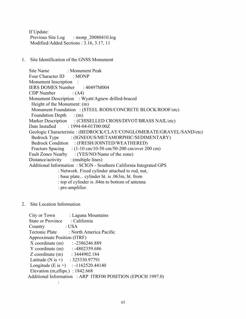
65
If Update: Previous Site Log : monp_20080410.log Modified/Added Sections : 3.16, 3.17, 11 1. Site Identification of the GNSS Monument Site Name : Monument Peak Four Character ID : MONP Monument Inscription : IERS DOMES Number : 40497M004 CDP Number : (A4) Monument Description : Wyatt/Agnew drilled-braced Height of the Monument: (m) Monument Foundation : (STEEL RODS/CONCRETE BLOCK/ROOF/etc) Foundation Depth : (m) Marker Description : (CHISELLED CROSS/DIVOT/BRASS NAIL/etc) Date Installed : 1994-04-01T00:00Z Geologic Characteristic : (BEDROCK/CLAY/CONGLOMERATE/GRAVEL/SAND/etc) Bedrock Type : (IGNEOUS/METAMORPHIC/SEDIMENTARY) Bedrock Condition : (FRESH/JOINTED/WEATHERED) Fracture Spacing : (1-10 cm/10-50 cm/50-200 cm/over 200 cm) Fault Zones Nearby : (YES/NO/Name of the zone) Distance/activity : (multiple lines) Additional Information : SCIGN - Southern California Integrated GPS : Network. Fixed cylinder attached to rod, nut, : base plate... cylinder ht. is .063m, ht. from : top of cylinder is .04m to bottom of antenna : pre-amplifier. 2. Site Location Information City or Town : Laguna Mountains State or Province : California Country : USA Tectonic Plate : North America Pacific Approximate Position (ITRF) X coordinate (m) : -2386246.889 Y coordinate (m) : -4802359.686 Z coordinate (m) : 3444902.184 Latitude (N is +) : 325330.97791 Longitude (E is +) : -1162520.44140 Elevation (m,ellips.) : 1842.668 Additional Information : ARP ITRF00 POSITION (EPOCH 1997.0) :
66
: 3. GNSS Receiver Information 3.1 Receiver Type : ASHTECH Z-XII3 Satellite System : GPS Serial Number : 01426 Firmware Version : 1C01-1C00 Elevation Cutoff Setting: (deg) Date Installed : 1994-03-31T00:00Z Date Removed : 1994-04-15T00:00Z Temperature Stabiliz. : (none or tolerance in degrees C) Additional Information : P/N 700724-6(B) 3.2 Receiver Type : ASHTECH Z-XII3 Satellite System : GPS Serial Number : 02085 Firmware Version : 1C01 Elevation Cutoff Setting: (deg) Date Installed : 1994-04-15T00:00Z Date Removed : 1994-05-26T00:00Z Temperature Stabiliz. : (none or tolerance in degrees C) Additional Information : P/N 700724-6(B) 3.3 Receiver Type : ASHTECH Z-XII3 Satellite System : GPS Serial Number : 01894 Firmware Version : 1C01 Elevation Cutoff Setting: (deg) Date Installed : 1994-05-26T00:00Z Date Removed : 1994-07-01T00:00Z Temperature Stabiliz. : (none or tolerance in degrees C) Additional Information : 3.4 Receiver Type : ASHTECH Z-XII3 Satellite System : GPS Serial Number : 01894 Firmware Version : 1D00-1C01 Elevation Cutoff Setting: (deg) Date Installed : 1994-07-01T00:00Z Date Removed : 1994-07-20T00:00Z Temperature Stabiliz. : (none or tolerance in degrees C) Additional Information : 3.5 Receiver Type : ASHTECH Z-XII3

67
Satellite System : GPS Serial Number : 03862 Firmware Version : 1D00-1C01 Elevation Cutoff Setting: (deg) Date Installed : 1994-07-20T00:00Z Date Removed : 1994-10-06T00:00Z Temperature Stabiliz. : (none or tolerance in degrees C) Additional Information : P/N 700570C 3.6 Receiver Type : ASHTECH Z-XII3 Satellite System : GPS Serial Number : 03233 Firmware Version : 1D00-1C01 Elevation Cutoff Setting: (deg) Date Installed : 1994-10-06T00:00Z Date Removed : 1994-10-12T00:00Z Temperature Stabiliz. : (none or tolerance in degrees C) Additional Information : MIT 6 3.7 Receiver Type : ASHTECH Z-XII3 Satellite System : GPS Serial Number : 03373 Firmware Version : 1D00-1C01 Elevation Cutoff Setting: (deg) Date Installed : 1994-10-12T00:00Z Date Removed : 1994-10-19T00:00Z Temperature Stabiliz. : (none or tolerance in degrees C) Additional Information : LNR-3 3.8 Receiver Type : ASHTECH Z-XII3 Satellite System : GPS Serial Number : 03233 Firmware Version : 1D00-1C01 Elevation Cutoff Setting: (deg) Date Installed : 1994-10-19T00:00Z Date Removed : 1995-03-03T00:00Z Temperature Stabiliz. : (none or tolerance in degrees C) Additional Information : MIT-6 3.9 Receiver Type : ASHTECH Z-XII3 Satellite System : GPS Serial Number : 03866 Firmware Version : 1D00-1C01 Elevation Cutoff Setting: (deg) Date Installed : 1995-03-03T00:00Z Date Removed : 1995-05-16T00:00Z

68
Temperature Stabiliz. : (none or tolerance in degrees C) Additional Information : PW Lnr-2 3.10 Receiver Type : ASHTECH Z-XII3 Satellite System : GPS Serial Number : 03233 Firmware Version : 1D00-1C01 Elevation Cutoff Setting: (deg) Date Installed : 1995-05-16T00:00Z Date Removed : 1995-06-18T00:00Z Temperature Stabiliz. : (none or tolerance in degrees C) Additional Information : MIT-6 3.11 Receiver Type : ASHTECH Z-XII3 Satellite System : GPS Serial Number : 03862 Firmware Version : 1D00-1C01 Elevation Cutoff Setting: (deg) Date Installed : 1995-06-18T00:00Z Date Removed : 1995-08-01T19:00Z Temperature Stabiliz. : (none or tolerance in degrees C) Additional Information : PW Lnr-1 3.12 Receiver Type : ASHTECH Z-XII3 Satellite System : GPS Serial Number : 00242 Firmware Version : 1J00-1C63 Elevation Cutoff Setting: (deg) Date Installed : 1995-08-01T19:00Z Date Removed : 1995-11-29T19:00Z Temperature Stabiliz. : (none or tolerance in degrees C) Additional Information : Lnr LP-II 3.13 Receiver Type : ASHTECH Z-XII3 Satellite System : GPS Serial Number : 00242 Firmware Version : 1E76-1D01 Elevation Cutoff Setting: (deg) Date Installed : 1995-11-29T19:00Z Date Removed : 1997-12-17T23:00Z Temperature Stabiliz. : (none or tolerance in degrees C) Additional Information : Firmware upgrade. 3.14 Receiver Type : ASHTECH Z-XII3 Satellite System : GPS Serial Number : 03007

69
Firmware Version : 1F50 Elevation Cutoff Setting: (deg) Date Installed : 1997-12-17T23:00Z Date Removed : 1999-07-20T19:19Z Temperature Stabiliz. : (none or tolerance in degrees C) Additional Information : Receiver swap 3.15 Receiver Type : ASHTECH Z-XII3 Satellite System : GPS Serial Number : LP03085 Firmware Version : CC00 Elevation Cutoff Setting: 10 Date Installed : 1999-07-20T19:19Z Date Removed : 2002-02-13T00:00Z Temperature Stabiliz. : (none or tolerance in degrees C) Additional Information : Receiver swap for GPS week rollover-compliance. 3.16 Receiver Type : ASHTECH Z-XII3 Satellite System : GPS Serial Number : LP03085 Firmware Version : CC00 Elevation Cutoff Setting: 10 Date Installed : 2002-02-13T00:00Z Date Removed : 2006-04-03T00:00Z Temperature Stabiliz. : (none or tolerance in degrees C) Additional Information : Sampling interval increased to 5 seconds. Raw : files are decimated to 30 seconds upon rinex : translation. Receiver upgrade. 3.17 Receiver Type : ASHTECH Z-XII3 Satellite System : GPS Serial Number : LP02912 Firmware Version : CC00 Elevation Cutoff Setting: 10 Date Installed : 2006-04-03T00:00Z Date Removed : (CCYY-MM-DDThh:mmZ) Temperature Stabiliz. : (none or tolerance in degrees C) Additional Information : Died @ PIN2 (wouldn't boot). Returned from : Thales 1-7-05, tested in Telemetry Lab: fine. 3.x Receiver Type : (A20, from rcvr_ant.tab; see instructions) Satellite System : (GPS/GLONASS/GPS+GLONASS) Serial Number : (A5) Firmware Version : (A11)
70
Elevation Cutoff Setting: (deg) Date Installed : (CCYY-MM-DDThh:mmZ) Date Removed : (CCYY-MM-DDThh:mmZ) Temperature Stabiliz. : (none or tolerance in degrees C) Additional Information : (multiple lines) 4. GPS Antenna Information 4.1 Antenna Type : ASH700228A Serial Number : 700228 A1723 Antenna Reference Point : BPA Marker->ARP Up Ecc. (m) : 0.1190 Marker->ARP North Ecc(m): 0.0000 Marker->ARP East Ecc(m) : 0.0000 Alignment from True N : (deg; + is clockwise/east) Antenna Radome Type : SNOW Radome Serial Number : Antenna Cable Type : (vendor & type number) Antenna Cable Length : (m) Date Installed : 1994-03-31T00:00Z Date Removed : 1994-07-20T00:00Z Additional Information : ASHTECH GEODETIC L1/L2 P rev B 4.2 Antenna Type : ASH700718A Serial Number : 700718A 10018 Antenna Reference Point : BPA Marker->ARP Up Ecc. (m) : 0.1190 Marker->ARP North Ecc(m): 0.0000 Marker->ARP East Ecc(m) : 0.0000 Alignment from True N : (deg; + is clockwise/east) Antenna Radome Type : SNOW Radome Serial Number : Antenna Cable Type : (vendor & type number) Antenna Cable Length : (m) Date Installed : 1994-07-20T00:00Z Date Removed : 1994-10-06T00:00Z Additional Information : ASHTECH GEODETIC L1/L2 P rev D (Large Ground : Plane). 4.3 Antenna Type : ASH700228A Serial Number : 700228 A1723 Antenna Reference Point : BPA Marker->ARP Up Ecc. (m) : 0.1207 Marker->ARP North Ecc(m): 0.0000 Marker->ARP East Ecc(m) : 0.0000

71
Alignment from True N : (deg; + is clockwise/east) Antenna Radome Type : SNOW Radome Serial Number : Antenna Cable Type : (vendor & type number) Antenna Cable Length : (m) Date Installed : 1994-10-06T00:00Z Date Removed : 1995-06-18T00:00Z Additional Information : ASHTECH GEODETIC L1/L2 P rev D. PFJ, : 23-APR-1999: is this rev D or B (see 4.1) 4.4 Antenna Type : ASH700228B Serial Number : B1163 (SIOA) Antenna Reference Point : BPA Marker->ARP Up Ecc. (m) : 0.1196 Marker->ARP North Ecc(m): 0.0000 Marker->ARP East Ecc(m) : 0.0000 Alignment from True N : (deg; + is clockwise/east) Antenna Radome Type : SNOW Radome Serial Number : Antenna Cable Type : (vendor & type number) Antenna Cable Length : (m) Date Installed : 1995-06-18T00:00Z Date Removed : 1995-08-01T19:00Z Additional Information : ASHTECH GEODETIC L1/L2 P rev D 700228B (SIOA). 4.5 Antenna Type : ASH700936B_M Serial Number : CR11489 Antenna Reference Point : BPA Marker->ARP Up Ecc. (m) : 0.1186 Marker->ARP North Ecc(m): 0.0000 Marker->ARP East Ecc(m) : 0.0000 Alignment from True N : (deg; + is clockwise/east) Antenna Radome Type : SNOW Radome Serial Number : Antenna Cable Type : (vendor & type number) Antenna Cable Length : (m) Date Installed : 1995-08-01T19:00Z Date Removed : 2000-03-22T22:16Z Additional Information : ASHTECH 700936-B (Ashtech w/ Choke Ring); : 10/10/1999 (14:45 - 19:45 Z): : antenna removed + replaced 4.6 Antenna Type : ASH701945B_M Serial Number : CR519991751 Antenna Reference Point : BPA Marker->ARP Up Ecc. (m) : 0.1176

72
Marker->ARP North Ecc(m): 0.0000 Marker->ARP East Ecc(m) : 0.0000 Alignment from True N : 0 Antenna Radome Type : SCIS Radome Serial Number : 098 Antenna Cable Type : (vendor & type number) Antenna Cable Length : (m) Date Installed : 2000-03-22T22:16Z Date Removed : (CCYY-MM-DDThh:mmZ) Additional Information : Antenna, dome type changed. Note : antenna height change. 4.x Antenna Type : (A20, from rcvr_ant.tab; see instructions) Serial Number : (A*, but note the first A5 is used in SINEX) Antenna Reference Point : (BPA/BCR/XXX from "antenna.gra"; see instr.) Marker->ARP Up Ecc. (m) : (F8.4) Marker->ARP North Ecc(m): (F8.4) Marker->ARP East Ecc(m) : (F8.4) Alignment from True N : (deg; + is clockwise/east) Antenna Radome Type : (A4 from rcvr_ant.tab; see instructions) Radome Serial Number : Antenna Cable Type : (vendor & type number) Antenna Cable Length : (m) Date Installed : (CCYY-MM-DDThh:mmZ) Date Removed : (CCYY-MM-DDThh:mmZ) Additional Information : (multiple lines) 5. Surveyed Local Ties 5.1 Tied Marker Name : Tied Marker Usage : (SLR/VLBI/LOCAL CONTROL/FOOTPRINT/etc) Tied Marker CDP Number : (A4) Tied Marker DOMES Number: (A9) Differential Components from GNSS Marker to the tied monument (ITRS) dx (m) : (m) dy (m) : (m) dz (m) : (m) Accuracy (mm) : (mm) Survey method : (GPS CAMPAIGN/TRILATERATION/TRIANGULATION/etc) Date Measured : (CCYY-MM-DDThh:mmZ) Additional Information : (multiple lines) 5.x Tied Marker Name : Tied Marker Usage : (SLR/VLBI/LOCAL CONTROL/FOOTPRINT/etc) Tied Marker CDP Number : (A4)
73
Tied Marker DOMES Number: (A9) Differential Components from GNSS Marker to the tied monument (ITRS) dx (m) : (m) dy (m) : (m) dz (m) : (m) Accuracy (mm) : (mm) Survey method : (GPS CAMPAIGN/TRILATERATION/TRIANGULATION/etc) Date Measured : (CCYY-MM-DDThh:mmZ) Additional Information : (multiple lines) 6. Frequency Standard 6.1 Standard Type : INTERNAL Input Frequency : (if external) Effective Dates : 1994-03-31/CCYY-MM-DD Notes : (multiple lines) 6.x Standard Type : (INTERNAL or EXTERNAL H-MASER/CESIUM/etc) Input Frequency : (if external) Effective Dates : (CCYY-MM-DD/CCYY-MM-DD) Notes : (multiple lines) 7. Collocation Information 7.1 Instrumentation Type : SLR Status : (PERMANENT/MOBILE) Effective Dates : (CCYY-MM-DD/CCYY-MM-DD) Notes : NASA SLR facility 7.x Instrumentation Type : (GPS/GLONASS/DORIS/PRARE/SLR/VLBI/TIME/etc) Status : (PERMANENT/MOBILE) Effective Dates : (CCYY-MM-DD/CCYY-MM-DD) Notes : (multiple lines) 8. Meteorological Instrumentation 8.1.1 Humidity Sensor Model : MET3 Manufacturer : Paroscientific Serial Number : 67631 Data Sampling Interval : 600 sec. Accuracy (% rel h) : 2. Aspiration : (UNASPIRATED/NATURAL/FAN/etc) Height Diff to Ant : (m)

74
Calibration Date : (CCYY-MM-DD) Effective Dates : 1997-12-17/1999-04-21 Notes : (multiple lines) 8.1.2 Humidity Sensor Model : MET3 Manufacturer : Paroscientific Serial Number : 69824 Data Sampling Interval : 600 sec. Accuracy (% rel h) : 2. Aspiration : (UNASPIRATED/NATURAL/FAN/etc) Height Diff to Ant : (m) Calibration Date : (CCYY-MM-DD) Effective Dates : 1999-04-21/CCYY-MM-DD Notes : Previous unit ceased operating on : 24-AUG-1998 due to lightning : strike 8.1.x Humidity Sensor Model : Manufacturer : Serial Number : Data Sampling Interval : (sec) Accuracy (% rel h) : (% rel h) Aspiration : (UNASPIRATED/NATURAL/FAN/etc) Height Diff to Ant : (m) Calibration Date : (CCYY-MM-DD) Effective Dates : (CCYY-MM-DD/CCYY-MM-DD) Notes : (multiple lines) 8.2.1 Pressure Sensor Model : MET3 Manufacturer : Paroscientific Serial Number : 67631 Data Sampling Interval : 600 sec. Accuracy : .5 Height Diff to Ant : (m) Calibration Date : (CCYY-MM-DD) Effective Dates : 1997-12-17/1999-04-21 Notes : (multiple lines) 8.2.2 Pressure Sensor Model : MET3 Manufacturer : Paroscientific Serial Number : 69824 Data Sampling Interval : 600 sec. Accuracy : .5 Height Diff to Ant : (m) Calibration Date : (CCYY-MM-DD)
75
Effective Dates : 1999-04-21/CCYY-MM-DD Notes : See humidity sensor addl. info. 8.2.x Pressure Sensor Model : Manufacturer : Serial Number : Data Sampling Interval : (sec) Accuracy : (hPa) Height Diff to Ant : (m) Calibration Date : (CCYY-MM-DD) Effective Dates : (CCYY-MM-DD/CCYY-MM-DD) Notes : (multiple lines) 8.3.1 Temp. Sensor Model : MET3 Manufacturer : Paroscientific Serial Number : 67631 Data Sampling Interval : 600 sec. Accuracy : .5 Aspiration : (UNASPIRATED/NATURAL/FAN/etc) Height Diff to Ant : (m) Calibration Date : (CCYY-MM-DD) Effective Dates : 1997-12-17/1999-04-21 Notes : (multiple lines) 8.3.2 Temp. Sensor Model : MET3 Manufacturer : Paroscientific Serial Number : 69824 Data Sampling Interval : 600 sec. Accuracy : .5 Aspiration : (UNASPIRATED/NATURAL/FAN/etc) Height Diff to Ant : (m) Calibration Date : (CCYY-MM-DD) Effective Dates : 1999-04-21/CCYY-MM-DD Notes : See humidity sensor addl. info. 8.3.x Temp. Sensor Model : Manufacturer : Serial Number : Data Sampling Interval : (sec) Accuracy : (deg C) Aspiration : (UNASPIRATED/NATURAL/FAN/etc) Height Diff to Ant : (m) Calibration Date : (CCYY-MM-DD) Effective Dates : (CCYY-MM-DD/CCYY-MM-DD) Notes : (multiple lines)

76
8.4.1 Water Vapor Radiometer : Manufacturer : Serial Number : Distance to Antenna : (m) Height Diff to Ant : (m) Calibration Date : (CCYY-MM-DD) Effective Dates : (CCYY-MM-DD/CCYY-MM-DD) Notes : (multiple lines) 8.4.x Water Vapor Radiometer : Manufacturer : Serial Number : Distance to Antenna : (m) Height Diff to Ant : (m) Calibration Date : (CCYY-MM-DD) Effective Dates : (CCYY-MM-DD/CCYY-MM-DD) Notes : (multiple lines) 8.5.1 Other Instrumentation : (multiple lines) Effective Dates : (CCYY-MM-DD/CCYY-MM-DD) 8.5.x Other Instrumentation : (multiple lines) Effective Dates : (CCYY-MM-DD/CCYY-MM-DD) 9. Local Ongoing Conditions Possibly Affecting Computed Position 9.1.1 Radio Interferences : (TV/CELL PHONE ANTENNA/RADAR/etc) Observed Degradations : (SN RATIO/DATA GAPS/etc) Effective Dates : (CCYY-MM-DD/CCYY-MM-DD) Additional Information : (multiple lines) 9.1.x Radio Interferences : (TV/CELL PHONE ANTENNA/RADAR/etc) Observed Degradations : (SN RATIO/DATA GAPS/etc) Effective Dates : (CCYY-MM-DD/CCYY-MM-DD) Additional Information : (multiple lines) 9.2.1 Multipath Sources : (METAL ROOF/DOME/VLBI ANTENNA/etc) Effective Dates : (CCYY-MM-DD/CCYY-MM-DD) Additional Information : (multiple lines) 9.2.x Multipath Sources : (METAL ROOF/DOME/VLBI ANTENNA/etc)

77
Effective Dates : (CCYY-MM-DD/CCYY-MM-DD) Additional Information : (multiple lines) 9.3.1 Signal Obstructions : (TREES/BUILDINGS/etc) Effective Dates : (CCYY-MM-DD/CCYY-MM-DD) Additional Information : (multiple lines) 9.3.x Signal Obstructions : (TREES/BUILDINGS/etc) Effective Dates : (CCYY-MM-DD/CCYY-MM-DD) Additional Information : (multiple lines) 10. Local Episodic Effects Possibly Affecting Data Quality 10.1 Date : (CCYY-MM-DD/CCYY-MM-DD) Event : (TREE CLEARING/CONSTRUCTION/etc) 10.x Date : (CCYY-MM-DD/CCYY-MM-DD) Event : (TREE CLEARING/CONSTRUCTION/etc) 11. On-Site, Point of Contact Agency Information Agency : Scripps Orbit and Permanent Array Center Preferred Abbreviation : SOPAC / SIO Mailing Address : Institute of Geophysics and Planetary Physics, : Scripps Institution of Oceanography, MC 0225, : University of California San Diego, 9500 : Gilman Dr., La Jolla CA 92093-0225 Primary Contact Contact Name : Paul Jamason Telephone (primary) : 858-822-4472 Telephone (secondary) : 858-663-3508 Fax : 858-534-9873 E-mail : [email protected] Secondary Contact Contact Name : Glen Offield Telephone (primary) : 858-534-7274 Telephone (secondary) : 858-663-3508 Fax : 858-534-9873 E-mail : [email protected] Additional Information : P-O-C updated 04-24-2008. 12. Responsible Agency (if different from 11.)

78
Agency : SOPAC Preferred Abbreviation : (A10) Mailing Address : 9500 Gilman Drive / Dept. 0225 : La Jolla, CA 92093-0225 Primary Contact Contact Name : Keith Stark, Stark Consulting, LLC Telephone (primary) : 800-957-8275 Telephone (secondary) : 818-789-8275 Fax : 626-583-7827 E-mail : [email protected] Secondary Contact Contact Name : Telephone (primary) : Telephone (secondary) : Fax : E-mail : Additional Information : Secondary SCIGN Network Coordinator 13. More Information Primary Data Center : Scripps Orbit and Permanent Array Center Secondary Data Center : Crustal Dynamics Data Information System URL For More Information: http://www.scign.org Hardcopy on File Site Map : (Y or URL) Site Diagram : (Y or URL) Horizon Mask : (Y or URL) Monument Description : (Y or URL) Site Pictures : (Y or URL) Additional Information : (multiple lines) Antenna Graphics with Dimensions Appendix D. DORIS MOOB IDS Site Log
MONUMENT PEAK DORIS site description form 0. Form Prepared by : SIMB (DORIS installation and maintenance department) Date prepared : 04/02/2011 Report type : UPDATE 1. Site location information

79
Site name : MONUMENT PEAK Site DOMES number : 40497 Host agency : NASA City : Mount Laguna State or province : California Country : USA Tectonic plate : NOAM Geological information : Geographical coordinates (ITRF) : North Latitude : 32 deg 53' 31'' East Longitude : -116 deg 25' 21'' Ellipsoid height : 1843 m Approximate altitude : 1875 m 2. DORIS antenna and reference point information 2.1 Four character ID : MONB Antenna model : Starec 52291 type Antenna serial number : 102 IERS DOMES number : 40497S008 CNES/IGN number : 404971 DORIS SSALTO number : 249 Date installed (dd/mm/yy): 30/11/2005 Date removed (dd/mm/yy) : 12/12/2007 Antenna support type : 1.5 m high, 0.46 m diameter concrete pillar Installed on : ground (the pillar foundations are 3 m deep) Height above ground mark : 0.490 m Ground mark type : Domed brass screw Ground mark DOMES number : 40497M005 Notes : 2.2 Four character ID : MOOB Antenna model : Starec 52291 type Antenna serial number : 102 IERS DOMES number : 40497S009 CNES/IGN number : 404972 DORIS SSALTO number : 281 Date installed (dd/mm/yy): 14/12/2007 Date removed (dd/mm/yy) : 06/02/2010 Antenna support type : 1.5 m high, 0.46 m diameter concrete pillar Installed on : ground (the pillar foundations are 3 m deep) Height above ground mark : 0.893 m Ground mark type : Domed brass screw Ground mark DOMES number : 40497M005 Notes : 3. DORIS beacons information 3.1 Beacon serial number : 2819060 Beacon model : 3.0

80
USO serial number : 3.374 4 Char. ID of the REF point : MONB Date installed (dd/mm/yy) : 30/11/2005 Date removed (dd/mm/yy) : 12/12/2007 3.2 Beacon serial number : 2819060 Beacon model : 3.0 USO serial number : 3.374 4 Char. ID of the REF point : MOOB Date installed (dd/mm/yy) : 14/12/2007 Date removed (dd/mm/yy) : 07/04/2010 4. ITRF coordinates and velocities of the current DORIS ref. point (MOOB) Solution : ITRF2005 (tie to GPS "MONP") Epoch : 2000.0 X = -2386251.098 m Y = -4802363.919 m Z = 3444894.690 m Sig X = 0.002 m Sig Y = 0.002 m Sig Z = 0.002 m VX = -0.0307 m/y VY = 0.0249 m/y VZ = 0.0152 m/y Sig VX = 0.0001 m/y Sig VY = 0.0001 m/y Sig VZ = 0.0001 m/y 5. IERS colocation information 5.1 Instrument type : GPS Status : Permanent DOMES number of the instrument ref. point : 40497M004 Notes : IGS station MONP 5.2 Instrument type : SLR Status : Permanent DOMES number of the instrument ref. point : 40497M001 Notes : CDP station 7110 6. Tide Gauge colocation information 7. Local site ties 7.1 Point description : SLR mark CDP 7110 DOMES number : 40497M001 Differential components from the current DORIS ref. point (MOOB) to the above point (in the ITRS) : dX (m) : -27.200 dY (m) : 9.854 dZ (m) : -13.042

81
Accuracy (m) : 0.002 Date measured : 01/10/1999 Additional information : SLR-IGS survey by Honeywell 7.2 Point description : IGS station "MONP" DOMES number : 40497M004 Differential components from the current DORIS ref. point (MOOB) to the above point (in the ITRS) : dX (m) : 4.165 dY (m) : 4.398 dZ (m) : 7.484 Accuracy (m) : 0.001 Date measured : 01/12/2005 Additional information : Survey by IGN-F 7.3 Point description : Domed mark on the DORIS concrete pillar DOMES number : 40497M005 Differential components from the current DORIS ref. point (MOOB) to the above point (in the ITRS) : dX (m) : 0.337 dY (m) : 0.668 dZ (m) : -0.487 Accuracy (m) : 0.001 Date measured : 01/12/2007 Additional information : Survey by IGN-F 7.4 Point description : DORIS starec antenna reference point (MONB) DOMES number : 40497S008 Differential components from the current DORIS ref. point (MOOB) to the above point (in the ITRS) : dX (m) : 0.154 dY (m) : 0.299 dZ (m) : -0.221 Accuracy (m) : 0.001 Date measured : 01/12/2007 Additional information : Survey by IGN-F 8. Meteorological Instrumentation 8.1 Humidity sensor Model : HMP45D Manufacturer : VAISALA Accuracy : +/- 3 percents Notes : 8.2 Pressure sensor Model : PTU200 class B Manufacturer : VAISALA Accuracy : +/- 0.25 hPa Height : 0.9 m below the current DORIS ref. point (MOOB) Notes : long term stability = +/- 0.1 hPa/year

82
8.3 Temperature sensor Model : HMP45D Manufacturer : VAISALA Accuracy : +/- 0.5 deg C Notes : 9. DORIS network contacts Primary contact: Name : Jerome SAUNIER Agency : Institut Geographique National Mailing address : Service de Geodesie et de Nivellement : 73 avenue de PARIS : 94165 SAINT-MANDE CEDEX FRANCE Telephone : + 33 1 43 98 83 63 Fax : + 33 1 43 98 84 50 E-mail : jerome (.) saunier (@) ign.fr Secondary contact: Name : Francois BOLDO Agency : Institut Geographique National Mailing address : CNES (DCT/ME/OT) : 18 Avenue Edouard BELIN : 31401 TOULOUSE Cedex FRANCE Telephone : + 33 5 61 27 40 72 Fax : + 33 5 61 28 25 95 E-mail : Simb (.) Doris (@) cnes.fr


