ScandiVanadium Limited ACN 061 375 442 68 Aberdeen Street Northbridge Western Australia 6003 ASX Announcement 04 December 2018 04 December 2018 Skåne Vanadium Project Sampling Results ScandiVanadium Limited (ASX:SVD) (the Company or SVD) is pleased to announce the results of a mapping and sampling programme conducted on outcropping Dictyonema Formation along the Flagabro Creek, adjacent to the historic Flagabro Vanadium Quarry within the Company’s Killeröd exploration licence, Skåne. HIGHLIGHTS • Systematic grab sampling confirmed consistent and high grade vanadium mineralisation • True thickness of targeted Dictyonema Formation is greater than 10m, indicated by interpretation of mineralised strata • Peak grade of 0.81% V2O5 and 13 of 14 samples collected within mineralised D2 horizon exceeded 0.4% V2O5 (see Table 1) • 180m of outcrop sampled where a full sequence and thickness of the mineralised Dictyonema Formation is exposed at surface within a sedimentary black shale host • Good correlation with historic borehole data enhances confidence in Skåne project. Managing Director David Minchin said, “The results of this sampling programme confirm historical data used in estimating the Skåne exploration target, reaffirming our understanding of the high grade vanadium hosted in sediment within our licences. Mapping and sampling of the entire thickness of the Dictyonema Formation at outcrop has allowed us to gain a deeper understanding of the mineralised host rock. The stratigraphic nature of the mineralisation in a flat lying sedimentary shale host gives us confidence that we can identify high-grade mineralisation over large areas of the Skåne licences.” For personal use only
Transcript
ScandiVanadium Limited ACN 061 375 442
68 Aberdeen Street Northbridge Western Australia 6003
ASX Announcement 04 December 2018
04 December 2018
Skåne Vanadium Project Sampling Results
ScandiVanadium Limited (ASX:SVD) (the Company or SVD) is pleased to announce the results of a mapping and sampling programme conducted on outcropping Dictyonema Formation along the Flagabro Creek, adjacent to the historic Flagabro Vanadium Quarry within the Company’s Killeröd exploration licence, Skåne.
HIGHLIGHTS
• Systematic grab sampling confirmed consistent and high grade vanadium mineralisation
• True thickness of targeted Dictyonema Formation is greater than 10m, indicated by interpretation of mineralised strata
• Peak grade of 0.81% V2O5 and 13 of 14 samples collected within mineralised D2 horizon exceeded 0.4% V2O5 (see Table 1)
• 180m of outcrop sampled where a full sequence and thickness of the mineralised Dictyonema Formation is exposed at surface within a sedimentary black shale host
• Good correlation with historic borehole data enhances confidence in Skåne project.
Managing Director David Minchin said, “The results of this sampling programme confirm historical data used in estimating the Skåne exploration target, reaffirming our understanding of the high grade vanadium hosted in sediment within our licences. Mapping and sampling of the entire thickness of the Dictyonema Formation at outcrop has allowed us to gain a deeper understanding of the mineralised host rock. The stratigraphic nature of the mineralisation in a flat lying sedimentary shale host gives us confidence that we can identify high-grade mineralisation over large areas of the Skåne licences.”
For
per
sona
l use
onl
y
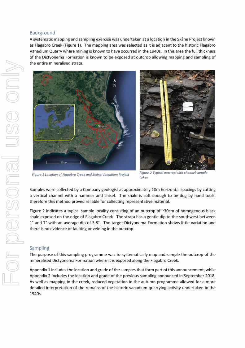
Background A systematic mapping and sampling exercise was undertaken at a location in the Skåne Project known as Flagabro Creek (Figure 1). The mapping area was selected as it is adjacent to the historic Flagabro Vanadium Quarry where mining is known to have occurred in the 1940s. In this area the full thickness of the Dictyonema Formation is known to be exposed at outcrop allowing mapping and sampling of the entire mineralised strata.
Figure 1 Location of Flagabro Creek and Skåne Vanadium Project
Figure 2 Typical outcrop with channel sample taken
Samples were collected by a Company geologist at approximately 10m horizontal spacings by cutting a vertical channel with a hammer and chisel. The shale is soft enough to be dug by hand tools, therefore this method proved reliable for collecting representative material.
Figure 2 indicates a typical sample locality consisting of an outcrop of ~30cm of homogenous black shale exposed on the edge of Flagabro Creek. The strata has a gentle dip to the southwest between 1° and 7° with an average dip of 3.8°. The target Dictyonema Formation shows little variation and there is no evidence of faulting or veining in the outcrop.
Sampling The purpose of this sampling programme was to systematically map and sample the outcrop of the mineralised Dictyonema Formation where it is exposed along the Flagabro Creek.
Appendix 1 includes the location and grade of the samples that form part of this announcement, while Appendix 2 includes the location and grade of the previous sampling announced in September 2018. As well as mapping in the creek, reduced vegetation in the autumn programme allowed for a more detailed interpretation of the remains of the historic vanadium quarrying activity undertaken in the 1940s.
For
per
sona
l use
onl
y
Interpreted Stratigraphic Column Using first principles, an interpretive stratigraphic profile was constructed from sample results along the Flagabro Creek (Figure 3). This section shows that the mineralised Dictyonema Formation is at least 10m thick, noting that the base of the mineralised Dictyonema Formation was not seen in outcrop. Grade is distributed evenly throughout the strata, reflecting the lateral and vertical homogeneity seen in outcrop.
Figure 3 Interpreted Stratigraphic Section from mapping and sampling of Flagabro Creek
Sample grade was plotted onto the stratigraphic profile by Micon International Co Limited. Construction of the interpretive stratigraphic profile of Flagabro Creek has been based on the following mapped assumptions:
1) The direction of the section along Flagabro Creek is 185°; 2) True dip and dip direction measured at each location were converted to apparent dip along
the line of the section. These were averaged to give a stratigraphic dip along section of 3.2°; 3) The stratigraphic depth from the Tøyen Shale contact to each sample location was calculated
using the horizontal distance from the contact along with the average dip; and 4) The stratigraphic depth to the top of the sample was calculated by subtracting the sampled
thickness at outcrop from the calculated stratigraphic depth from the Tøyen shale contact.
The plotted results indicate a good distribution of % V2O5 grade throughout the mineralised D2 horizon. The base of the D2 horizon is not exposed in outcrop and as such has been inferred from the supposed limit of mining activity at Flagabro Vanadium Quarry (Appendix 1). A calculated thickness
For
per
sona
l use
onl
y
of >10m compares with the historic mapped thickness of 11m reported in literature (Bergstrom 1982)1.
Geological Interpretation Based on mapping and multi-element assay results, company geologists have inferred that deposition of the mineralised Dictyonema Formation was from a low energy epicontinental sea. Semi-restricted basin conditions with high organic production and little terrigenous input resulted in a black, carbon rich mudstone. A low energy depositional environment suggests that deposition was a basin wide event with very little variation at a local level. This is confirmed by observation at Flagabro Creek where mudstone shows remarkable homogeneity and consistent grade distribution across 180m of outcrop.
The mudstone shows some soft-sedimentary dewatering features, but no bioturbation. The occasional presence of brachiopod fossils (Figure 4) indicates that the redox front was most likely at, or near, the sediment-water interface rather than higher in the water column.
These observations support current theories that the vanadium was primarily concentrated by biological activity of plankton in the Cambrian / Ordovician ocean. During the deposition of the Dictyonema Formation the basin was undergoing freshening conditions with increased oxygen in the water column pushing the redox front downward toward the sediment-water interface. This resulted in higher biological activity which in turn resulted in high vanadium concentrations when compared to the underlying footwall sequence of the Alum Shale to the Dictyonema Formation. This also resulted in less chemical precipitation of deleterious elements such as uranium, molybdenum and other heavy metals when compared to the underlying Alum Shale.
1 Bergstrom, J., The Ordovician of Scania, in 4th international symposium on the Ordovician system (1982) Field Excursion Guide Edited by: D. L. Bruton & S. H. Williams p 182-197
For
per
sona
l use
onl
y
Figure 4 Brachiopod fossils in the Dictyonema Formation
David Minchin Managing Director Phone +44 7792 555 195 Email: [email protected]
Competent Person’s Statement The information in this document that relates to Exploration Results is based on information compiled by Mr Andrew de Klerk, a Competent Person who is a member of the South African Institute of Mining and Metallurgy (SAIMM), the Geological Society of South Africa (GSSA) and a registered Professional Natural Scientist (Pr.Sci.Nat. 400030/11). Mr de Klerk is employed by Micon International Co Limited and is an independent consultant to ScandiVanadium Limited. Mr de Klerk has sufficient experience that is relevant to the style of mineralisation and type of deposit under consideration and to the activity which he is undertaking to qualify as a Competent Person as defined in the 2012 Edition of the Australasian Code for Reporting of Exploration Results, Mineral Resources and Ore Reserves. Mr de Klerk consents to the inclusion in this document of the matters based on his information in the form and context in which it appears.
For
per
sona
l use
onl
y
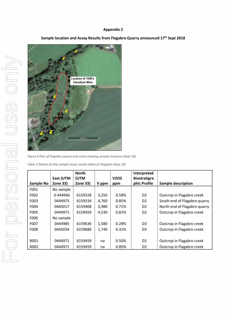
Appendix 1
Sample location and Assay Results from Flagabro Creek
Figure 5 Plan of Flagabro quarry and creek including sample locations and grades reported in this announcement For
per
sona
l use
onl
y
Table 1 Details of chip sample assay results reported in this announcement
F001 No sample F002 0 444946 6159328 3,250 0.58% D2 Outcrop in Flagabro creek F003 0444975 6159334 4,760 0.85% D2 South end of Flagabro quarry F004 0445017 6159408 3,980 0.71% D2 North end of Flagabro quarry F005 0444971 6159459 4,530 0.81% D2 Outcrop in Flagabro creek F006 No sample F007 0444985 6159636 1,580 0.28% D3 Outcrop in Flagabro creek F008 0445034 6159680 1,740 0.31% D3 Outcrop in Flagabro creek R001 0444971 6159459 na 0.50% D2 Outcrop in Flagabro creek R002 0444971 6159459 na 0.85% D2 Outcrop in Flagabro creek
For
per
sona
l use
onl
y
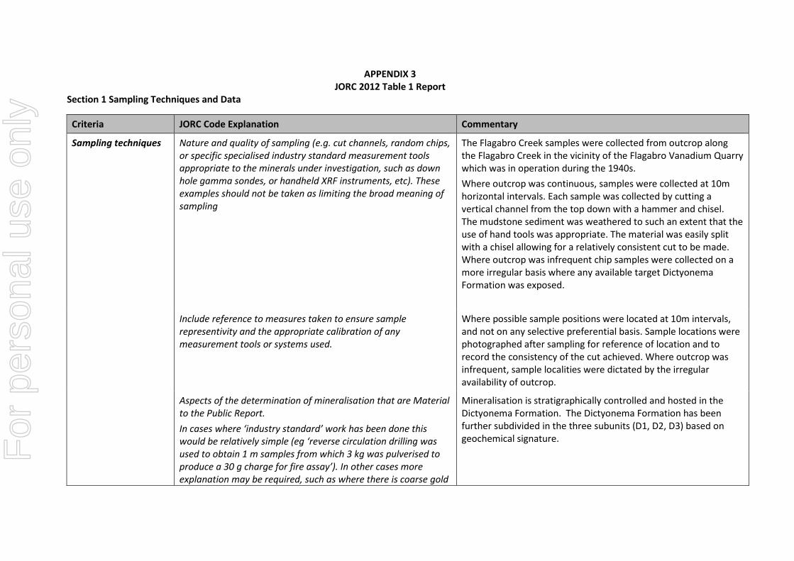
APPENDIX 3 JORC 2012 Table 1 Report
Section 1 Sampling Techniques and Data
Criteria JORC Code Explanation Commentary
Sampling techniques Nature and quality of sampling (e.g. cut channels, random chips, or specific specialised industry standard measurement tools appropriate to the minerals under investigation, such as down hole gamma sondes, or handheld XRF instruments, etc). These examples should not be taken as limiting the broad meaning of sampling
The Flagabro Creek samples were collected from outcrop along the Flagabro Creek in the vicinity of the Flagabro Vanadium Quarry which was in operation during the 1940s. Where outcrop was continuous, samples were collected at 10m horizontal intervals. Each sample was collected by cutting a vertical channel from the top down with a hammer and chisel. The mudstone sediment was weathered to such an extent that the use of hand tools was appropriate. The material was easily split with a chisel allowing for a relatively consistent cut to be made. Where outcrop was infrequent chip samples were collected on a more irregular basis where any available target Dictyonema Formation was exposed.
Include reference to measures taken to ensure sample representivity and the appropriate calibration of any measurement tools or systems used.
Where possible sample positions were located at 10m intervals, and not on any selective preferential basis. Sample locations were photographed after sampling for reference of location and to record the consistency of the cut achieved. Where outcrop was infrequent, sample localities were dictated by the irregular availability of outcrop.
Aspects of the determination of mineralisation that are Material to the Public Report. In cases where ‘industry standard’ work has been done this would be relatively simple (eg ‘reverse circulation drilling was used to obtain 1 m samples from which 3 kg was pulverised to produce a 30 g charge for fire assay’). In other cases more explanation may be required, such as where there is coarse gold
Mineralisation is stratigraphically controlled and hosted in the Dictyonema Formation. The Dictyonema Formation has been further subdivided in the three subunits (D1, D2, D3) based on geochemical signature. F
or p
erso
nal u
se o
nly
Criteria JORC Code Explanation Commentary that has inherent sampling problems. Unusual commodities or mineralisation types (eg submarine nodules) may warrant disclosure of detailed information.
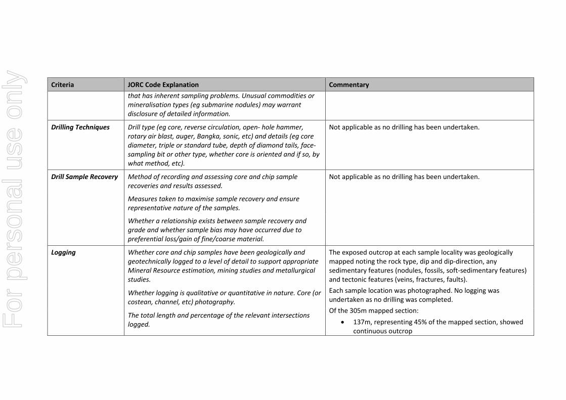
Drilling Techniques Drill type (eg core, reverse circulation, open- hole hammer, rotary air blast, auger, Bangka, sonic, etc) and details (eg core diameter, triple or standard tube, depth of diamond tails, face-sampling bit or other type, whether core is oriented and if so, by what method, etc).
Not applicable as no drilling has been undertaken.
Drill Sample Recovery Method of recording and assessing core and chip sample recoveries and results assessed.
Not applicable as no drilling has been undertaken.
Measures taken to maximise sample recovery and ensure representative nature of the samples.
Whether a relationship exists between sample recovery and grade and whether sample bias may have occurred due to preferential loss/gain of fine/coarse material.
Logging Whether core and chip samples have been geologically and geotechnically logged to a level of detail to support appropriate Mineral Resource estimation, mining studies and metallurgical studies.
The exposed outcrop at each sample locality was geologically mapped noting the rock type, dip and dip-direction, any sedimentary features (nodules, fossils, soft-sedimentary features) and tectonic features (veins, fractures, faults). Each sample location was photographed. No logging was undertaken as no drilling was completed. Of the 305m mapped section:
• 137m, representing 45% of the mapped section, showed continuous outcrop
Whether logging is qualitative or quantitative in nature. Core (or costean, channel, etc) photography.
The total length and percentage of the relevant intersections logged. F
or p
erso
nal u
se o
nly
Criteria JORC Code Explanation Commentary • 44m, representing 14% of the mapped section, showed
infrequent outcrop defined as 1 outcrop in any 30m section
• 124m, representing 41% of the mapped sequence, showed no outcrop
Sub-sampling techniques and sample preparation
If core, whether cut or sawn and whether quarter, half or all core taken. If non-core, whether riffled, tube sampled, rotary split, etc and whether sampled wet or dry.
No core was obtained as no drilling has been completed. The Flagabro Creek chip samples averaged 1.25kg in weight, including moisture content. The entire sample was submitted for assay at ALS metallurgical laboratory in Perth. Samples were dried, crushed to -3.35mm and homogenised. From the homogenised sample a 60g aliquot was collected for assay analysis while the remainder was retained for further metallurgical testwork.
For all sample types, the nature, quality and appropriateness of the sample preparation technique.
This sample preparation technique is standard in manner and regarded as appropriate.
Quality control procedures adopted for all sub-sampling stages to maximise representivity of samples.
No field duplicates were collected.
Measures taken to ensure that the sampling is representative of the in situ material collected, including for instance results for field duplicate/second-half sampling. Whether sample sizes are appropriate to the grain size of the material being sampled.
Samples are considered as representative of the target Dictyomena Formation which were located at 10m intervals, and not on any selective preferential basis. Where outcrop was infrequent, sample localities were dictated by the irregular availability of outcrop. No field duplicates were collected. The sample size (average of 1.25kg) is regarded as sufficient to the grain size of the mudstone material being sampled. The deposit is regional in extent with a massive and homogenous grain size and grade distribution.
For
per
sona
l use
onl
y
Criteria JORC Code Explanation Commentary
Quality of assay data and laboratory tests
The nature, quality and appropriateness of the assaying and laboratory procedures used and whether the technique is considered partial or total. For geophysical tools, spectrometers, handheld XRF instruments, etc, the parameters used in determining the analysis including instrument make and model, reading times, calibrations factors applied and their derivation, etc. Nature of quality control procedures adopted (eg standards, blanks, duplicates, external laboratory checks) and whether acceptable levels of accuracy (ie lack of bias) and precision have been established.
Samples were submitted for analysis by ALS Laboratories located in Perth, Australia which is ISO9001 accredited. Crushed samples were prepared by using either sodium peroxide fusion in a zirconia crucible (Al, Ba, Ca, Cs, Fe, Ga, In, K, Mg, Mn, Rb, Re, Si, Sn, Th, U, V, W) or by four acid digest (Ag, As, Be, Bi, Cd, Co, Cr, Cu, Ge, Li, Mo, Na, Ni, P, Pb, Sr, Zn, Zr). Both methods used ICP OES or MS finish. Carbon and sulphur were assayed by CS2000. Internal laboratory reference standards were run as parallel digests as well as internal standards used for OES calibration. No independent standard reference material were submitted within the sample stream by the Company.
Verification of sampling and assaying
The verification of significant intersections by either independent or alternative company personnel.
No available historical sampling or drilling exists for the Project with which to verify. Results yielded from the previous field sampling conducted by the Company along the Flagabro Creek in September 2018 (Table 1 above – eight samples) have been confirmed by this latest sampling campaign. The use of twinned holes
Discuss any adjustment to assay data For consistency, assays reported as elemental ppm vanadium (V) by ALS Laboratories were converted to % V2O5 by multiplying by the gravimetric factor of 1.7852. F
or p
erso
nal u
se o
nly
Criteria JORC Code Explanation Commentary
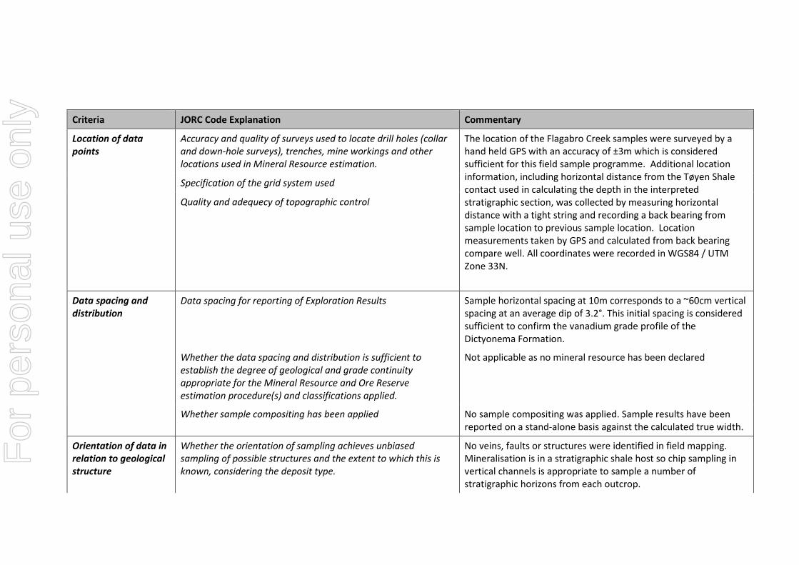
Location of data points
Accuracy and quality of surveys used to locate drill holes (collar and down-hole surveys), trenches, mine workings and other locations used in Mineral Resource estimation.
The location of the Flagabro Creek samples were surveyed by a hand held GPS with an accuracy of ±3m which is considered sufficient for this field sample programme. Additional location information, including horizontal distance from the Tøyen Shale contact used in calculating the depth in the interpreted stratigraphic section, was collected by measuring horizontal distance with a tight string and recording a back bearing from sample location to previous sample location. Location measurements taken by GPS and calculated from back bearing compare well. All coordinates were recorded in WGS84 / UTM Zone 33N.
Specification of the grid system used
Quality and adequecy of topographic control
Data spacing and distribution
Data spacing for reporting of Exploration Results Sample horizontal spacing at 10m corresponds to a ~60cm vertical spacing at an average dip of 3.2°. This initial spacing is considered sufficient to confirm the vanadium grade profile of the Dictyonema Formation.
Whether the data spacing and distribution is sufficient to establish the degree of geological and grade continuity appropriate for the Mineral Resource and Ore Reserve estimation procedure(s) and classifications applied.
Not applicable as no mineral resource has been declared
Whether sample compositing has been applied No sample compositing was applied. Sample results have been reported on a stand-alone basis against the calculated true width.
Orientation of data in relation to geological structure
Whether the orientation of sampling achieves unbiased sampling of possible structures and the extent to which this is known, considering the deposit type.
No veins, faults or structures were identified in field mapping. Mineralisation is in a stratigraphic shale host so chip sampling in vertical channels is appropriate to sample a number of stratigraphic horizons from each outcrop.
For
per
sona
l use
onl
y
Criteria JORC Code Explanation Commentary
If the relationship between the drilling orientation and the orientation of key mineralised structures is considered to have introduced a sampling bias, this should be assessed and reported if material.
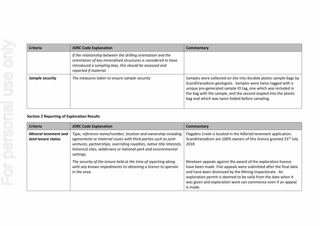
Sample security The measures taken to ensure sample security Samples were collected on site into durable plastic sample bags by ScandiVanadium geologists. Samples were twice tagged with a unique pre-generated sample ID tag, one which was included in the bag with the sample, and the second stapled into the plastic bag seal which was twice folded before sampling.
Section 2 Reporting of Exploration Results
Criteria JORC Code Explanation Commentary
Mineral tenement and land tenure status
Type, reference name/number, location and ownership including agreements or material issues with third parties such as joint ventures, partnerships, overriding royalties, native title interests, historical sites, wilderness or national park and environmental settings.
Flagabro Creek is located in the Killeröd tenement application. ScandiVanadium are 100% owners of this licence granted 23rd July 2018
The security of the tenure held at the time of reporting along with any known impediments to obtaining a licence to operate in the area.
Nineteen appeals against the award of the exploration licence have been made. Five appeals were submitted after the final date and have been dismissed by the Mining Inspectorate. An exploration permit is deemed to be valid from the date when it was given and exploration work can commence even if an appeal is made. F
or p
erso
nal u
se o
nly
Criteria JORC Code Explanation Commentary A memo on the appeals and appeal process by Kaiding AB concluded “It is unlikely that the appeals will be successful, though it is possible. If successful, the ruling of the court could include the imposition of further conditions to protect the interests of the affected party and/or the excise of a portion of the exploration permit area to remove areas impacting the aggrieved party. And, in extreme circumstances, there does remain the possibility of a reversal of the decision to grant the exploration permit such that title to the permit is lost and exploration activities cannot be carried out, though in our experience this is a very rare outcome and there is nothing to suggest from the materials we have reviewed for these appeals that such an outcome is likely in this case.”
Exploration done by other parties
Acknowledgment and appraisal of exploration by other parties. Historic mapping conducted by Dr Jan Bergström, State Geologist at the Geological Survey of Sweden in Lund in 1982, is referenced.
Geology Deposit type, geological setting and style of mineralisation. The sampling programme targets sediment hosted mineralisation within the Dictyonema Formation, the topmost horizon of the Alum Shale. The Middle Cambrian to Early Ordovician (Tremadoc) Alum Shale Formation was deposited in epicontinental sea waters on the East European Platform. The uppermost Dictyonema Formation is about 10m thick. This unit is known to have elevated levels of vanadium which was historically mined at Flagabro Vanadium Quarry during the Second World War. The vanadium has been enriched by biological action and locked into sediment under anoxic conditions in sediment starved shelf facies. Black, carbon rich, mudstone shows some soft-sedimentary dewatering features, but no bioturbation. However the infrequent presence
For
per
sona
l use
onl
y
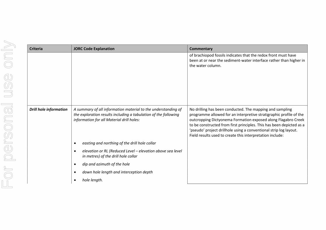
Criteria JORC Code Explanation Commentary of brachiopod fossils indicates that the redox front must have been at or near the sediment-water interface rather than higher in the water column.
Drill hole information A summary of all information material to the understanding of the exploration results including a tabulation of the following information for all Material drill holes:
No drilling has been conducted. The mapping and sampling programme allowed for an interpretive stratigraphic profile of the outcropping Dictyonema Formation exposed along Flagabro Creek to be constructed from first principles. This has been depicted as a ‘pseudo’ project drillhole using a conventional strip log layout. Field results used to create this interpretation include:
• easting and northing of the drill hole collar
• elevation or RL (Reduced Level – elevation above sea level in metres) of the drill hole collar
• dip and azimuth of the hole
• down hole length and interception depth
• hole length. For
per
sona
l use
onl
y
Criteria JORC Code Explanation Commentary
If the exclusion of this information is justified on the basis that the information is not Material and this exclusion does not detract from the understanding of the report, the Competent Person should clearly explain why this is the case.
Data aggregation methods
In reporting Exploration Results, weighting averaging techniques, maximum and/or minimum grade truncations (eg cutting of high grades) and cut-off grades are usually Material and should be stated.
Aggregated data or metal equivalent values have not been reported.
Where aggregate intercepts incorporate short lengths of high grade results and longer lengths of low grade results, the procedure used for such aggregation should be stated and some typical examples of such aggregations should be shown in detail.
The assumptions used for any reporting of metal equivalent values should be clearly stated.
For
per
sona
l use
onl
y
Relationship between mineralisation widths and intercept lengths
These relationships are particularly important in the reporting of Exploration Results.
Calculation of true thickness from samples along outcrop is detailed above and in the announcement.
If the geometry of the mineralisation with respect to the drill hole angle is known, its nature should be reported.
Elevated vanadium grades are present in the target Dictyonema Formation which represents the ~10m upper formation of the Alum Shale. Grade profile is indicated in Figure 3 of the announcement.
If it is not known and only the down hole lengths are reported, there should be a clear statement to this effect (eg ‘down hole length, true width not known’).
Diagrams Appropriate maps and sections (with scales) and tabulations of intercepts should be included for any significant discovery being reported These should include, but not be limited to a plan view of drill hole collar locations and appropriate sectional views.
Included in announcement.
Balanced reporting Where comprehensive reporting of all Exploration Results is not practicable, representative reporting of both low and high grades and/or widths should be practiced to avoid misleading reporting of Exploration Results.
Locations and results from all samples taken by the Company to date are reported in this announcement.
Other substantive exploration data
Other exploration data, if meaningful and material, should be reported including (but not limited to): geological observations; geophysical survey results; geochemical survey results; bulk samples – size and method of treatment; metallurgical test results; bulk density, groundwater, geotechnical and rock characteristics; potential deleterious or contaminating substances.
Historical vanadium mining is known to have occurred from the Flagabro vanadium quarry. Production records from this time (1940s) are not available. It is apparent production was via open pit with three 1.8m high benches. Historic drilling and assay results reported from the Gislövhammar borehole ~15km to the southeast (17th September 2018) indicate the presence of elevated levels of vanadium and are consistent with the results from the Flagabro Creek.
For
per
sona
l use
onl
y
Further work The nature and scale of planned further work (eg tests for lateral extensions or large scale step out drilling.
A diamond drilling programme of approximately 2000m is planned for 2019 to test the Exploration Target announced on 17th September 2018.
Diagrams clearly highlighting the areas of possible extensions, including the main geological interpretations and future drilling areas, provided this information is not commercially sensitive.
Section 3 Estimation and Reporting of Mineral Resources
Criteria JORC Code explanation Commentary
Database integrity
Measures taken to ensure that data has not been corrupted by, for example, transcription or keying errors, between its initial collection and its use for Mineral Resource estimation purposes.
The database used to create the interpretive stratigraphic profile was created from manually collected mapping data and laboratory assay data. Data has been captured and organised in an Excel database.
Data validation procedures used. No data validation checks were done, other than visual checks to confirm sample localities and grades.
Site visits
Comment on any site visits undertaken by the Competent Person and the outcome of those visits.
The Competent Person visited the Skåne Project from 8 to 10 October 2018 during which time the Flagabro Creek was visited along with the Flagabro Vanadium Quarry.
If no site visits have been undertaken indicate why this is the case.
Not applicable
For
per
sona
l use
onl
y
Criteria JORC Code explanation Commentary
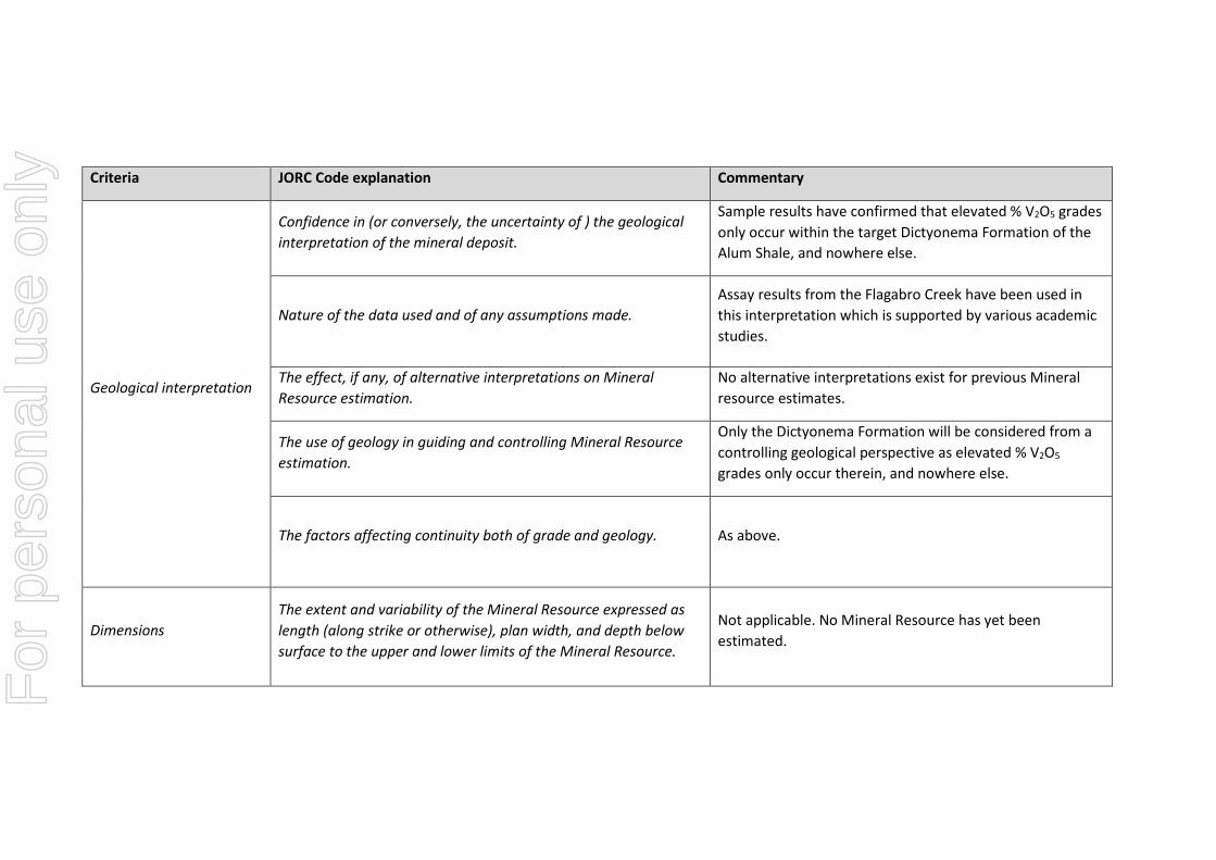
Geological interpretation
Confidence in (or conversely, the uncertainty of ) the geological interpretation of the mineral deposit.
Sample results have confirmed that elevated % V2O5 grades only occur within the target Dictyonema Formation of the Alum Shale, and nowhere else.
Nature of the data used and of any assumptions made. Assay results from the Flagabro Creek have been used in this interpretation which is supported by various academic studies.
The effect, if any, of alternative interpretations on Mineral Resource estimation.
No alternative interpretations exist for previous Mineral resource estimates.
The use of geology in guiding and controlling Mineral Resource estimation.
Only the Dictyonema Formation will be considered from a controlling geological perspective as elevated % V2O5 grades only occur therein, and nowhere else.
The factors affecting continuity both of grade and geology. As above.
Dimensions The extent and variability of the Mineral Resource expressed as length (along strike or otherwise), plan width, and depth below surface to the upper and lower limits of the Mineral Resource.
Not applicable. No Mineral Resource has yet been estimated.
For
per
sona
l use
onl
y
Criteria JORC Code explanation Commentary
Estimation and modelling techniques
The nature and appropriateness of the estimation technique(s) applied and key assumptions, including treatment of extreme grade values, domaining, interpolation parameters and maximum distance of extrapolation from data points. If a computer assisted estimation method was chosen include a description of computer software and parameters used.
Not applicable. No Mineral Resource has yet been estimated.
The availability of check estimates, previous estimates and/or mine production records and whether the Mineral Resource estimate takes appropriate account of such data.
Not applicable. No Mineral Resource has yet been estimated.
The assumptions made regarding recovery of by-products. Not applicable. No Mineral Resource has yet been estimated.
Estimation of deleterious elements or other non-grade variables of economic significance (eg sulphur for acid mine drainage characterisation).
Not applicable. No Mineral Resource has yet been estimated.
In the case of block model interpolation, the block size in relation to the average sample spacing and the search employed.
Not applicable. No Mineral Resource has yet been estimated.
Any assumptions behind modelling of selective mining units. Not applicable. No Mineral Resource has yet been estimated. F
or p
erso
nal u
se o
nly
Criteria JORC Code explanation Commentary
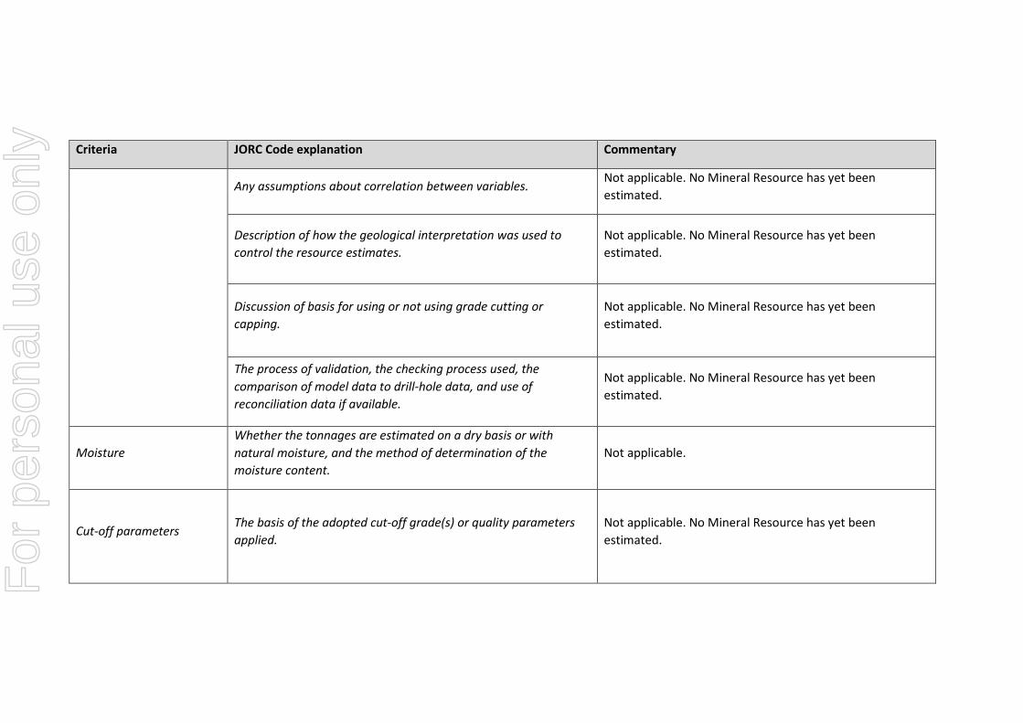
Any assumptions about correlation between variables. Not applicable. No Mineral Resource has yet been estimated.
Description of how the geological interpretation was used to control the resource estimates.
Not applicable. No Mineral Resource has yet been estimated.
Discussion of basis for using or not using grade cutting or capping.
Not applicable. No Mineral Resource has yet been estimated.
The process of validation, the checking process used, the comparison of model data to drill-hole data, and use of reconciliation data if available.
Not applicable. No Mineral Resource has yet been estimated.
Moisture Whether the tonnages are estimated on a dry basis or with natural moisture, and the method of determination of the moisture content.
Not applicable.
Cut-off parameters The basis of the adopted cut-off grade(s) or quality parameters applied.
Not applicable. No Mineral Resource has yet been estimated.
For
per
sona
l use
onl
y
Criteria JORC Code explanation Commentary
Mining factors or assumptions
Assumptions made regarding possible mining methods, minimum mining dimensions and internal (or, if applicable, external) mining dilution. It is always necessary as part of the process of determining reasonable prospects for eventual economic extraction to consider potential mining methods, but the assumptions made regarding mining methods and parameters when estimating Mineral Resources may not always be rigorous. Where this is the case, this should be reported with an explanation of the basis of the mining assumptions made.
Not applicable. No Mineral Resource has yet been estimated.
Metallurgical factors or assumptions
The basis for assumptions or predictions regarding metallurgical amenability. It is always necessary as part of the process of determining reasonable prospects for eventual economic extraction to consider potential metallurgical methods, but the assumptions regarding metallurgical treatment processes and parameters made when reporting Mineral Resources may not always be rigorous. Where this is the case, this should be reported with an explanation of the basis of the metallurgical assumptions made.
Not applicable. No Mineral Resource has yet been estimated.
For
per
sona
l use
onl
y
Criteria JORC Code explanation Commentary
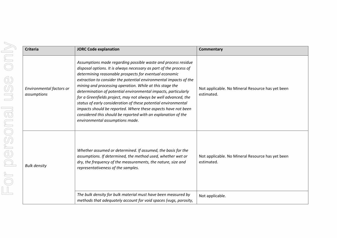
Environmental factors or assumptions
Assumptions made regarding possible waste and process residue disposal options. It is always necessary as part of the process of determining reasonable prospects for eventual economic extraction to consider the potential environmental impacts of the mining and processing operation. While at this stage the determination of potential environmental impacts, particularly for a Greenfields project, may not always be well advanced, the status of early consideration of these potential environmental impacts should be reported. Where these aspects have not been considered this should be reported with an explanation of the environmental assumptions made.
Not applicable. No Mineral Resource has yet been estimated.
Bulk density
Whether assumed or determined. If assumed, the basis for the assumptions. If determined, the method used, whether wet or dry, the frequency of the measurements, the nature, size and representativeness of the samples.
Not applicable. No Mineral Resource has yet been estimated.
The bulk density for bulk material must have been measured by methods that adequately account for void spaces (vugs, porosity,
Not applicable. For
per
sona
l use
onl
y
Criteria JORC Code explanation Commentary
etc), moisture and differences between rock and alteration zones within the deposit.
Discuss assumptions for bulk density estimates used in the evaluation process of the different materials.
Not applicable.
Classification
The basis for the classification of the Mineral Resources into varying confidence categories.
Not applicable. No Mineral Resource has yet been estimated.
Whether appropriate account has been taken of all relevant factors (ie relative confidence in tonnage/grade estimations, reliability of input data, confidence in continuity of geology and metal values, quality, quantity and distribution of the data).
Not applicable. No Mineral Resource has yet been estimated.
Whether the result appropriately reflects the Competent Person’s view of the deposit.
Not applicable. No Mineral Resource has yet been estimated.
Audits or reviews The results of any audits or reviews of Mineral Resource estimates.
Not applicable. No Mineral Resource has yet been estimated.
For
per
sona
l use
onl
y
Criteria JORC Code explanation Commentary
Discussion of relative accuracy/ confidence
Where appropriate a statement of the relative accuracy and confidence level in the Mineral Resource estimate using an approach or procedure deemed appropriate by the Competent Person. For example, the application of statistical or geostatistical procedures to quantify the relative accuracy of the resource within stated confidence limits, or, if such an approach is not deemed appropriate, a qualitative discussion of the factors that could affect the relative accuracy and confidence of the estimate.
Not applicable. No Mineral Resource has yet been estimated.
The statement should specify whether it relates to global or local estimates, and, if local, state the relevant tonnages, which should be relevant to technical and economic evaluation. Documentation should include assumptions made and the procedures used.
Not applicable. No Mineral Resource has yet been estimated.
These statements of relative accuracy and confidence of the estimate should be compared with production data, where available.
Not applicable. No Mineral Resource has yet been estimated.
Section 4 Estimation and Reporting of Ore Reserves
Not applicable. No Mineral Resource has yet been estimated. As such no Ore Reserve has yet been estimated.
Section 5 Estimation and Reporting of Diamonds and Other Gemstone
Not applicable. The Skåne Project is targeting sedimentary hosted vanadium only. No diamonds or gemstones are considered. For