157
SKOKOMISH RIVER BASIN MASON COUNTY, WASHINGTON ECOSYSTEM RESTORATION APPENDIX L COMPLIANCE DOCUMENTS Integrated Feasibility Report and Environmental Impact Statement

SKOKOMISH RIVER BASIN MASON COUNTY, WASHINGTON
ECOSYSTEM RESTORATION
APPENDIX L
COMPLIANCE DOCUMENTS
Integrated Feasibility Report and Environmental Impact Statement

This page was intentionally left blank to facilitate double sided copying.

FISH AND WILDLIFE COORDINATION ACT FINAL REPORT
NOTE: Throughout the plan formulation and environmental coordination processes of the feasibility study, the project team was using local site names to refer to each site where measures could be implemented for ecosystem restoration. During the project's recent feasibility-level design phase, site names were formalized in the Final Feasibility Report and Environmental Impact Statement; therefore, some site names have changed since initial environmental compliance and coordination efforts were completed early in the study. The final list of sites in the recommended plan includes the following:
• Confluence Levee Removal • Upstream Large Woody Debris • Side Channel Reconnection • Wetland Restoration at River Mile 9 • Wetland Restoration at Grange

This page was intentionally left blank to facilitate double sided copying.

United States Department of the Interior
In Reply Refer To: OlEWFW00-2015-CPA-0018
Evan R. Lewis, Chief
FISH AND WILDLIFE SERVICE
Washington Fish and Wildlife Office 510 Desmond Dr. SE, Suite 102
Lacey, Washington 98503
Environmental and Cultural Resources Branch U.S. Army Corps of Engineers, Seattle District P.O. Box 3755 Seattle, Washington 98124-3755
Dear Mr. Lewis:
Subject: Final Fish and Wildlife Coordination Act Report, Skokomish River Basin Ecosystem Restoration Project
u.s. FISII&WILDLIFE
Sl<KVICll!:
~ ~ ~t)IJ'tl,v.·
FEB 2 7 2015
In January 2014, the U.S. Fish and Wildlife Service (Service) issued a draft Fish and Wildlife Coordination Act (FWCA) (Ref.# OlEWFW00-2014-CPA-0015) Section 2(b) report for the Skokomish River Basin Ecosystem Restoration Project proposed by the U.S. Army Corps of Engineers, Seattle District (Corps), and local sponsors (Mason County and Skokomish Indian Tribe). We are pleased that the Corps has advanced the preferred alternative described in the draft FWCA report, and, further, that the Corps has addressed and/or incorporated many of the Service's recommendations. The basic project elements in the current proposal do not differ substantially from those described in the draft FWCA report. For these reasons, the January 2014 draft FWCA report will serve as the final FWCA report, with the modifications and additions noted in this letter.
Together, the draft report and the contents of this letter constitute the Service's final FWCA report for the Skokomish River Basin Ecosystem Restoration Project authorized by the River and Harbor Act of 1962 (Public Law 87-874), Section 209, Puget Sound and Adjacent Waters. Our comments and recommendations have been prepared under the authority of and in accordance with the provisions of the Fish and Wildlife Coordination Act (48 Stat. 401, as amended; 16 U.S.C. 661 et seq.) (Act) and constitute the report of the Secretary of the Interior required under Section 2(b) of that Act.

Evan Lewis 2
COORDINATION
On September 23, 2014, the Corps met with the Service, other natural resource agencies (including the National Marine Fisheries Service and the Washington Department of Fish and Wildlife), and other stakeholders to present draft designs, get feedback from the natural resource agencies, and to provide design guidance from the natural resources perspective to the Corps design team. Additional coordination has occurred via email.
CURRENT PROPOSAL
The Corps' preferred alternative described in the draft FWCA report consisted of a base action -the Car Body Levee Removal - and eight additional actions, or increments. Each of these nine actions (the base and the eight increments) were independent in that implementation of any one action did not depend on implementation of any of the others. At the time the draft FWCA report was issued, the Corps' proposal was largely conceptual in nature and provided few design details. This section identifies conceptual modifications from the initial proposal, and describes the current proposal's critical design details.
The following six increments described in the draft FWCA report have been excluded from the project and are not part of the current proposal: Grange Levee Setback (Increment 371
), River Mile 9 Levee Setback (Increment 28), Hunter Creek Mouth Restoration (Increment 39), Hunter Creek Enhancement (Increment 40), Weaver Creek Enhancement (Increment 43), and Dips Road Setback (Increment 26). The current proposal consists of the Car Body Levee Removal, and the following two increments: Upstream large woody debris (LWD) Installation (Increment 35) and Side Channel Reconnection (Increment 9). The Service recently completed consultation under section 7 of the Endangered Species Act for these restoration projects (Ref.# OlEWFW00-2015-TA-0253).
The Car Body Levee Removal action involves the removal of the existing levee and diverting flow into the existing North Fork channel by enlarging an existing channel and installing seven engineered logjams (diversion El.J's). The proposal also includes adding 26 single-log structures. Channel enlargement will require excavating 4, 715 cubic yards ( cy) of material to enlarge the existing channel to 200 feet long and 70 feet wide. The channel will be designed to pass flows up to 2,000 cubic feet per second (cfs). Discharges above 2,000 cfs will be split between the main channel and the historic South Fork channel. Each ELJ will consist of 27 logs of varying length, will be anchored with 10 piles, and will be partially buried with excavated streambed material (as ballast). Single logs will be anchored with boulders and partially buried. The initial Car Body Levee Removal action described in the draft FWCA report describes potentially leaving sections of the existing levee in place provided that they did not interfere with the hydraulics of the project. The current proposal does not contain this provision. Under the current proposal, 10,345 cy of earthen or mostly earthen levee material, 61 small trees (less than 12 inch diameter breast height), and 57 larger trees (greater than 12 inch diameter breast height)
1 Increment numbers noted throughout this letter are consistent with those in the draft FWCA report and may not reflect the current Corps numbering scheme.

Evan Lewis 3
will be removed. The total area where excavation or soil disturbance will occur is approximately 3.6 acres. The disturbed area will be planted with native conifers (10 foot on center) and shrubs (6 foot on center), and covered with bark mulch to a depth of six inches.
The Upstream LWD Installation action involves the installation of seven bar apex-type (after Abbe and Montgomery 1996) EU's, 24 five-log clusters, and 56 single logs. The bar apex-type EU' s are a recent addition to the project proposal. Each EU will consist of 27 logs of varying length, will be anchored with 10 piles, and will be partially buried with excavated material replaced as ballast. The five-log channel clusters will be anchored with 4-5 ft boulder anchors buried directly under the log trunks. Single logs will be anchored with boulders and partially buried. The large wood installations currently proposed represent a 25 percent increase over that described in the draft FWCA report.
The Side Channel Reconnection will activate an existing side channel and off-channel pond network at lower river discharges than current. This network provides 45 acres of high quality, low velocity fish habitat. The reconnected side channel will be activated at discharges greater than what is typically experienced during a moderate winter storm (4,000 to 6,000 cfs). The channel inlet will be excavated to open it up to the river. Excavation dimensions will be approximately 50 feet wide, 0 to 5 feet deep, and a few hundred feet long. Approximately 3,600 cy of material will be excavated at the inlet. To ensure longevity of the project, the inlet and the outlet will be stabilized with six five-log clusters (four at the inlet, two at the outlet).
PROJECT IMPACTS
The project impacts are as described in the draft FWCA report, with the modifications described in this section.
All impacts associated with the following removed increments are eliminated:
• Grange Levee and River Mile 9 Levee Setbacks (Increments 37 and 28)
• Hunter Creek Mouth Restoration (Increment 39)
• Hunter and Weaver Creek Side Channel Restorations (Increments 40 and 43)
• Dips Road Setback (Increment 26)
Impacts associated with the following increments are modified as indicated:
• Car Body Levee Removal - The Service identified potential negative effects of leaving existing levee sections in place, which was part of the Corps' initial proposal. The current proposal is to remove the entirety of the existing levee, thereby eliminating these concerns.

Evan Lewis 4
• Upstream L WD Installation - The Service identified potential negative effects associated with improper placement of EI.J's and large wood. Improper placement could serve to "lock" the channel in place rather than providing the intended geomorphic, hydraulic, and fish habitat benefits. The current Corps engineering design drawing (dated December 5, 2014) does not indicate any improper ELJ or large wood placements. These concerns are thus eliminated.
The initial Corps proposal did not include large, bar apex-type EI.J's. The inclusion of seven such structures in the current proposal will have positive impacts above those described in the draft FWCA report. Bar apex log jams have the greatest positive influence on river hydrogeomorphology and fish habitat relative to other types of jams or large wood placements (Abbe and Montgomery 1996). The long-term benefits of these structures greatly outweigh the short-term negative impacts associated with installation (i.e., pile driving). In sum, the seven proposed bar apex-type EI.J's will increase the overall benefits of the project.
RECOMMENDATIONS
The draft FWCA report offered two types of recommendations: Tier 1 recommendations were offered to help minimize negative impacts and maximize benefits to natural resources, and Tier 2 recommendations were intended to generate additional benefits to natural resources. This section describes how these recommendations apply to the current proposal, and offers additional recommendations.
Tier 1 Recommendations
1. Improper EU and large wood placement. The current design does not indicate any improper EI.J or large wood placement. The Service encourages the Corps to remain attentive to this recommendation in making any modifications to the design and placement of EI.J's and large wood.
2. Levee breaches. The current proposal calls for completely removing the Car Body Levee, rather than breaching it in places and leaving portions of the levee in place. The River Mile 9 and Grange Levee setbacks are not included in the current proposal. Therefore, this recommendation no longer applies.
3. Tributary side-channel contaminants. The tributary side-channel enhancements are not included in the current proposal. Therefore, this recommendation no longer applies.
4. Tributary side-channel water temperature. The tributary side-channel enhancements are not included in the current proposal. Therefore, this recommendation no longer applies.
5. Tributary side-channel habitat complexity. The tributary side-channel enhancements are not included in the current proposal. Therefore, this recommendation no longer applies.

Evan Lewis 5
6. Dips Road existing bank armoring. The Dips Road setback is not included in the current proposal. Therefore, this recommendation no longer applies.
7. Hunter Creek mouth excavation. The Hunter Creek mouth excavation is not included in the current proposal. Therefore, this recommendation no longer applies.
8. Coordination. We recommend that the Corps continue to coordinate with the Service, the National Marine Fisheries Service, Tribes, and permitting agencies, as needed, during design development and in making any substantial modifications the project proposal and/or design.
Tier 2 Recommendations
1. Channel pattern, river mile (RM) 9 to 11. The seven bar apex-type ELJ's the Corps has added to the project proposal will help facilitate formation of an island-braided pattern to this reach of the river. The Service further recommends intentionally locating the proposed five-log clusters to serve specific geomorphic functions, including: a) ensuring that flow is directed at the bar apex-type ELJ's; and, b) encouraging development of a meandering pattern and relatively deep, narrow channels throughout the reach. The meander jams described by Abbe and Montgomery ( 1996) are useful in providing these functions. A relatively deep, narrow channel will facilitate sediment transport through the reach, which will minimize future aggradation and provide better fish habitat.
2. Channel pattern, RM 3.2 to 9. The Corps has not acted on this recommendation. The Service continues to maintain that channel pattern is a critical consideration for long-term aquatic habitat restoration and recovery of fish populations in the action area.
3. Channel pattern, RM 7.8 to 9. The Service continues to maintain that channel pattern is a critical consideration for long-term aquatic habitat restoration and recovery of fish populations in the action area. Therefore, it is important to protect and maintain the existing forested area between the North and South Fork channels downstream from RM 9. The Service recommends positioning some of the diversion ELJ's to serve this purpose.
The Service also recommends installing meander-type jams in the current South Fork reach between RM 7.8 and 9. This reach will be bypassed by the project, but will be active at elevated flows. In addition, depending on how hydrogeomorphic forces interact in this section of the river, it is quite possible that this reach will become active at discharges below the design threshold. The five-log cluster structures proposed by the Corps for other areas of the project may serve as meander-type jams in this reach. Properly sited meander-type jams will aid in creating a deeper, narrower channel, facilitate sediment transport through the reach, minimize future aggradation, and provide better fish habitat. If necessary for budgetary reasons, we recommend not installing the single-log structures proposed for RM 9 to 11, and instead using these resources to install

Evan Lewis 6
meander-type jams in the RM 7 .8 to 9 and the North Fork reaches (see recommendation 5 below). Meander-type jams in the RM 7 .8 to 9 and the North Fork reaches will provide greater hydrogeomorphic and fish habitat functions than single logs in the RM 9 to 11 reach.
4. Increasing levee setbacks. The River Mile 9 and Grange Levee setbacks are not included in the current proposal. Therefore, this recommendation no longer applies.
5. North Fork channel enhancements. The current proposal includes a provision for moving some of the diversion ELJ's to the downstream side of the excavated channel to improve habitat quality. This opportunity may arise if hydraulic modelling shows that fewer ELJ' s are needed to maintain the desired channel configuration at the excavated channel location. The Service supports this contingency as long as a sufficient number of diversion ELJ's are sited to protect and maintain the existing forested area between the North and South Fork channels downstream of RM 9.
The Service continues to maintain that North Fork channel enhancements are important for long-term aquatic habitat restoration and recovery of fish populations. Therefore, we recommend that the Corps evaluate the potential for additional enhancements, including installing meander-type jams in this reach. The five-log cluster structures proposed by the Corps for other areas of the project may serve this function if properly sited. Properly sited meander-type jams in this reach will aid in creating a deeper, narrower channel, facilitate sediment transport through the reach, create pools, minimize future aggradation, and provide better fish habitat. If necessary for budgetary reasons, we recommend not installing the single-log structures proposed for RM 9 to 11, and instead using these resources to install meander-type jams in the North Fork and RM 7.8 to 9 reaches. Meander-type jams in these reaches will provide greater hydrogeomorphic and fish habitat functions than single logs in the RM 9 to 11 reach.
Additional Recommendations
We highly recommend that the Corps reconsider the River Mile 9 and Grange Levee Setbacks. These levees represent some of the most severe constrictions in this part of the river. Setting them back and reconnecting these parts of the floodplain with the river would provide a multitude of benefits, including:
• providing valuable floodplain refuge habitat for fish (refuge from high flood flows);
• increasing hydraulic energy and sediment transport capacity, helping to ameliorate the aggradation problem; and,
• reestablishing potential for formation of seasonal or perennial off-channel habitat such as swales which are currently lacking in the system.
Evan Lewis 7
SUMMARY
The current proposal will provide meaningful long-term ecological benefits that outweigh the short-term negative impacts of construction. Elimination of some of the increments (namely the levee setbacks, the side channel restorations, and the Dips Road setback) has reduced the overall positive impact potential of the project as a whole. However, the remaining base action and increments will provide important and substantial ecological restoration. The modifications to these elements described in this letter (i.e., incorporation of bar apex-type ELJ's, increase in wood abundance, and full removal of the Car Body levee) have eliminated some concerns and increased benefits of these elements to natural resources. The Service supports the project as described. Our support is not contingent upon implementing the recommendations outlined in this letter. However, we feel strongly that our recommendations will meaningfully increase the ecological restoration and fish recovery value of the project, and encourage their implementation.
We have appreciated and enjoyed cooperating with the Corps as this project has proceeded. Please contact Mark Celedonia at (360) 534-9327, or Martha Jensen at (360) 753-9000 for questions about our comments and/or for future coordination and collaboration on the Skokomish General Investigation.
12~ ~ic V. Rickerson, State Supervisor
Washington Fish and Wildlife Office
LITERATURE CITED
Abbe, T.B., and D.R. Montgomery. 1996. Large woody debris jams, channel hydraulics and habitat formation in large rivers. Regulated Rivers: Research and Management 12:201-221.
FISH AND WILDLIFE COORDINATION ACT DRAFT REPORT
NOTE: Throughout the plan formulation and environmental coordination processes of the feasibility study, the project team was using local site names to refer to each site where measures could be implemented for ecosystem restoration. During the project's recent feasibility-level design phase, site names were formalized in the Final Feasibility Report and Environmental Impact Statement; therefore, some site names have changed since initial environmental compliance and coordination efforts were completed early in the study. The final list of sites in the recommended plan includes the following:
• Confluence Levee Removal • Upstream Large Woody Debris • Side Channel Reconnection • Wetland Restoration at River Mile 9 • Wetland Restoration at Grange

United States Department of the Interior
Evan R. Lewis, Chief
FISH AND WILDLIFE SERVICE
Washington Fish and Wildlife Office 510 Desmond Dr. SE, Suite l 02
Lacey, Washington 98503
Environmental & Cultural Resources Branch U.S. Army Corps of Engineers, Seattle District PO Box 3755 Seattle, Washington 98124-3755
Dear Mr. Lewis,
JAN 1 6 2014
Enclosed is the draft Fish and Wildlife Coordination Act Report for the Skokomish River Basin Ecosystem Restoration Project authorized by the River and Harbor Act of 1962 (Public Law 87-874), Section 209, Puget Sound and Adjacent Waters. Our comments and recommendations have been prepared under the authority of and according to the provisions of the Fish and Wildlife Coordination Act (48 Stat. 401, as amended; 16 U.S.C. 661 et seq.)(Act), and constitutes the report of the Secretary of the Interior required under Section 2(b) of that Act.
We appreciate and support the U.S. Army Corps of Engineers restoration efforts in the Skokomish River watershed. We look forward to continued coordination as the project moves forward. Should you or your staff have any questions regarding the enclosed draft report, please contact Mark Celedonia (360-534-9327; mark [email protected], of this office.
Sincerely,
V~n S. Berg, Manager Washington Fish and Wildlife Office


Fish and Wildlife Coordination Act Draft Section 2(b) Report
ASSESSMENT OF THE SKOKOMISH RIVER BASIN ECOSYSTEM RESTORATION FEASIBILITY STUDY, MASON COUNTY,
WASHINGTON
Submitted to: Seattle District
U.S. Army Corps of Engineers Seattle, Washington
Prepared by: Mark T. Celedonia Reviewed by: Martha L. Jensen Approved by: Bridget Moran
U.S. Fish and Wildlife Service
Washington Fish and Wildlife Office Lacey, Washington
January 2014

TABLE OF CONTENTS
Table of Contents ............................................................................................................................. i List of Acronyms ........................................................................................................................... iii I. Introduction ............................................................................................................................. 1
A. Project authority, purpose, and scope............................................................................... 2
B. Prior efforts and coordination with the Service ............................................................... 2
C. Prior studies and reports ................................................................................................... 3
II. Description of study area and action area ............................................................................... 4
A. Watershed context ............................................................................................................ 4
B. Study area and action area ................................................................................................ 5
1. Geology ........................................................................................................................ 8
2. Channel pattern ............................................................................................................. 9
3. Aggradation ................................................................................................................ 12
4. Large woody debris .................................................................................................... 13
5. Channelization and floodplain connectivity ............................................................... 14
C. Other restoration efforts ................................................................................................. 14
III. Fish and wildlife resources and planning objectives ......................................................... 16
A. General fish and wildlife concerns ................................................................................. 16
B. Planning objectives ........................................................................................................ 17
C. Current status of fish and wildlife resource ................................................................... 17
1. Federally listed, proposed, and candidate Species ..................................................... 17
2. State-listed Species ..................................................................................................... 22
3. Federal species of concern .......................................................................................... 23
4. Other fish and wildlife resources ................................................................................ 24
D. Conditions affecting fish and wildlife resources ............................................................ 24
IV. Evaluation methodology .................................................................................................... 25
V. Fish and wildlife resources without the project .................................................................... 26
VI. Alternatives considered ...................................................................................................... 27
A. Formulation of alternatives ............................................................................................ 27
B. Preferred Alternative / Tentatively Selected Plan .......................................................... 28
1. Car Body Levee removal ............................................................................................ 29
2. Increment 35 - upstream LWD installation ................................................................ 30
i
3. Increment 9 - side channel reconnection .................................................................... 31
4. Increments 37 and 28 - Grange Levee and River Mile 9 Levee setbacks .................. 32
5. Increment 39 - Hunter Creek mouth restoration ......................................................... 33
6. Increments 40 and 43 - Hunter and Weaver Creek side channel restorations ............ 34
7. Increment 26: Dips Road setback ............................................................................... 35
VII. Project impacts ................................................................................................................... 36
A. Preferred Alternative / Tentatively Selected Plan .......................................................... 36
1. Car Body Levee removal ............................................................................................ 36
2. Increment 35 - upstream LWD installation ................................................................ 38
3. Increment 9 - side channel reconnection .................................................................... 38
4. Increments 37 and 28 - Grange Levee and River Mile 9 Levee setbacks .................. 39
5. Increment 39 - Hunter Creek mouth restoration ......................................................... 39
6. Increments 40 and 43 - Hunter and Weaver Creek side channel restorations ............ 39
7. Increment 26: Dips Road setback ............................................................................... 40
B. Other plans ..................................................................................................................... 41
VIII. Evaluation of alternatives ............................................................................................... 41
IX. Recommendations for fish and wildlife conservation ....................................................... 42
A. Tier 1 recommendations: Ensuring PA/TSP effectiveness ............................................ 42
B. Tier 2 recommendations: Generating additional benefits .............................................. 43
X. Summary and the Service position ....................................................................................... 44
XI. References .......................................................................................................................... 46
ii
LIST OF ACRONYMS
cfs cubic feet per second DPS Distinct Population Segment EIS Environmental Impact Statement ESA Endangered Species Act ESU Evolutionarily Significant Unit FAA Final Array of Alternatives FWCA Fish and Wildlife Coordination Act GI General Investigation LWD large woody debris PA Preferred Alternative NEPA National Environmental Policy Act PAL Planning Aid Letter PMP Project Management Plan RA Range of Alternatives SRBER Skokomish River Basin Ecosystem Restoration SWAT Skokomish Watershed Action Team TSP Tentatively Selected Plan USFS United States Forest Service USFWS United States Fish and Wildlife Service USACE United State Army Corps of Engineers WFDW Washington Department of Fish and Wildlife WSDOT Washington State Department of Transportation
iii
SKOKOMISH RIVER BASIN ECOSYSTEM RESTORATION January 2014 DRAFT FISH AND WILDLIFE COORDINATION ACT SECTION 2(b) REPORT
I. INTRODUCTION
The United States Army Corps of Engineers (the Corps), Seattle District is proposing to conduct the Skokomish River Basin Ecosystem Restoration (SRBER) project in the lower Skokomish River watershed. This watershed, including the study area, is severely degraded and has been the focus of significant attention by federal, state, local, tribal, and private entities. Significant, widespread, and persistent anthropogenic disturbances throughout the watershed from the late 1800’s to the early 1990’s have resulted in degraded conditions for many aquatic species. The river is believed to have once supported the most abundant salmon and steelhead trout (Oncorhynchus spp.) populations in all of Hood Canal, one of the four major Puget Sound basins. Now, however, two endemic populations are locally extirpated and several others are severely depressed. Recovery plans for two species specifically cite a need for significant restoration in the lower watershed before recovery can begin. The SRBER project proposes a suite of actions intended to restore natural watershed and ecosystem structure, function, and processes to the lower watershed for the benefit of native salmonids and other aquatic species. The Corps, in coordination with local cost-sharing sponsors, stakeholders, and the Service, identified a multitude of possible restoration-oriented activities across the General Investigation (GI) study area. The study area is a fairly broad area encompassing the entirety of the lower watershed, including floodplains and the river delta (see Section II.B. for more detail). The Corps analyzed the proposed restoration activities and issued a Final Array of Alternatives intended to represent the Range of Alternatives of a National Environmental Policy Act (NEPA) assessment. From this Range of Alternatives / Final Array of Alternatives (RA/FAA)1, the Corps, in conjunction with local sponsors and with input from the Service, identified a Tentatively Selected Plan intended to represent the Preferred Alternative of a NEPA assessment. The area affected by the Preferred Alternative / Tentatively Selected Plan (PA/TSP) is located in the upstream part of the study area. The area affected by the PA/TSP will be referred to as the “action area” in this report. The purpose of this report is to evaluate possible effects to fish and wildlife of the proposed SRBER project, and recommend actions for minimizing deleterious consequences and maximizing benefits. In doing so, this report broadly evaluates effects within the study area of each alternative in the RA/FAA in order to concur with or dispute selection of the PA/TSP. A greater level of detail is provided in the evaluation of PA/TSP effects in the action area. This report is provided under the authority of the Fish and Wildlife Coordination Act (48 Stat. 401, as amended; 16 U.S.C. 661 et seq.), and constitutes the report of the Secretary of the Interior required under Section 2(b) of that Act. The National Marine Fisheries Service (NMFS) and the Washington Department of Fish and Wildlife were invited to provide input and participate in developing recommendations. The NMFS opted to provide input directly to the USACE. The WDFW opted to not participate.
1 “Final Array of Alternatives” and “Tentatively Selected Plan” are Corps terms related to internal Corps process. As noted, each term represents a specific corresponding element in a NEPA assessment. The Corps and NEPA terms will be used together in this report to facilitate ease of understanding.
Page 1 of 53

SKOKOMISH RIVER BASIN ECOSYSTEM RESTORATION January 2014 DRAFT FISH AND WILDLIFE COORDINATION ACT SECTION 2(b) REPORT
A. Project authority, purpose, and scope
The proposed SRBER project is the outcome of the Skokomish River Basin Feasibility Study, which the Corps is conducting under the authority of the River and Harbor Act of 1962 (Public Law 87-874), Section 209, Puget Sound and Adjacent Waters. The Corps concluded the reconnaissance phase in March 2000 and determined that there was sufficient federal interest to advance to the next stage of conducting a feasibility study. The study was postponed from 2002 to 2006 due to unresolved issues associated with Cushman Dam operations and lack of local sponsor funding. The feasibility study was resumed on July 3, 2006, with Mason County and the Skokomish Tribal Nation as the local sponsors and non-federal funding partners. The project was dual purpose - flood hazard reduction and ecosystem restoration - throughout much of the feasibility phase. However, preliminary economic analyses indicated low expected annual flood damages due in part to recent flood mitigation projects spearheaded by Mason County. These developments have led the Corps and project sponsors to focus solely on ecosystem restoration (USACE 2012). The Corps (USACE 2012) identified a three-part purpose to the Skokomish River Basin feasibility study:
1. evaluate significant ecosystem degradation in the Skokomish River Basin;
2. formulate, evaluate, and screen potential solutions to these problems; and,
3. recommend a series of actions and projects that have federal interest and are supported by a local entity willing to provide the requisite local cooperation.
B. Prior efforts and coordination with the Service
Prior to 1998. A variety of entities - including the Corps, Mason County, the Skokomish Tribal Nation, and Washington State Department of Transportation - identify flooding problems in the study area. The Corps determines that flood control and/or flood hazard reduction efforts would not be cost effective. 1998-1999. The Corps proposes a combined Flood Hazard Reduction and Ecosystem Restoration. Entities involved in formulating and discussing proposals include the Corps, the Service, Mason County, and the Skokomish Tribal Nation January 1999. The Corps issues the document “Project Management Plan: Skokomish River Flood Hazard Reduction and Ecosystem Restoration.” July 1999. The Corps issues for comments the document “Skokomish River Flood Hazard Reduction and Ecosystem Restoration Study, Preliminary 905(b) Analysis.” October 1999. The Service provides written comments on the July 1999 Preliminary 905(b) Analysis.
Page 2 of 53

SKOKOMISH RIVER BASIN ECOSYSTEM RESTORATION January 2014 DRAFT FISH AND WILDLIFE COORDINATION ACT SECTION 2(b) REPORT
February 2000. The Corps issues the document “Skokomish River General Investigation (GI) Reconnaissance Study, 905(b) Analysis.” The analysis determined that there is a Federal interest in proceeding with a project in the area. July 2006. The Corps issues the document “Final Project Management Plan (PMP) for Feasibility Phase Study of Skokomish River Basin, Mason County, Washington.” November 2006. Several meetings were held, with Service participation, to discuss and develop GI studies and evaluations. June 2008 - September 2009. The Service conducts comprehensive ecological field surveys in the Skokomish River watershed as part of the GI. Final report is issued June 2011 (Peters et al. 2011). September 2008. The Service provides a written Planning Aid Letter commenting on the July 2006 PMP. January 2011 - May 2012. A series of meetings are held with the Corps, the Service, Mason County, and the Skokomish Tribal Nation to develop ecosystem restoration project ideas. June 2012. The Corps issues the document “Integrated Feasibility Report and Environmental Impact Statement Feasibility Scoping Meeting Read-Ahead.” June 2013. The Corps meets with the Service to provide update on planning process and discuss Fish and Wildlife Coordination Act (FWCA) reporting needs. June 2013 - September 2013. Ongoing communications between the Corps and the Service to discuss and refine the Final Array of Alternatives. September 16, 2013. The Corps, the Service, NMFS, the local sponsors, and other stakeholders (e.g., Mason Conservation District) meet to discuss the PA/TSP. WDFW was invited but was not in attendance.
C. Prior studies and reports
A multitude of studies and reports have been issued on Skokomish River basin hydrology and ecology, the causes and consequences of watershed and aquatic ecosystem degradation, and recommendations for improvement. The most pertinent ones are cited throughout this report.
Page 3 of 53
SKOKOMISH RIVER BASIN ECOSYSTEM RESTORATION January 2014 DRAFT FISH AND WILDLIFE COORDINATION ACT SECTION 2(b) REPORT
II. DESCRIPTION OF STUDY AREA AND ACTION AREA
A. Watershed context
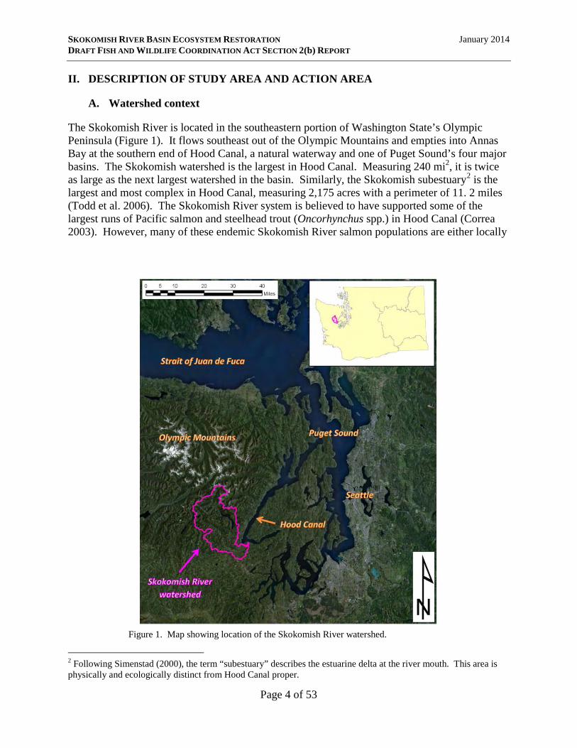
The Skokomish River is located in the southeastern portion of Washington State’s Olympic Peninsula (Figure 1). It flows southeast out of the Olympic Mountains and empties into Annas Bay at the southern end of Hood Canal, a natural waterway and one of Puget Sound’s four major basins. The Skokomish watershed is the largest in Hood Canal. Measuring 240 mi2, it is twice as large as the next largest watershed in the basin. Similarly, the Skokomish subestuary2 is the largest and most complex in Hood Canal, measuring 2,175 acres with a perimeter of 11. 2 miles (Todd et al. 2006). The Skokomish River system is believed to have supported some of the largest runs of Pacific salmon and steelhead trout (Oncorhynchus spp.) in Hood Canal (Correa 2003). However, many of these endemic Skokomish River salmon populations are either locally
Figure 1. Map showing location of the Skokomish River watershed.
2 Following Simenstad (2000), the term “subestuary” describes the estuarine delta at the river mouth. This area is physically and ecologically distinct from Hood Canal proper.
Page 4 of 53
SKOKOMISH RIVER BASIN ECOSYSTEM RESTORATION January 2014 DRAFT FISH AND WILDLIFE COORDINATION ACT SECTION 2(b) REPORT
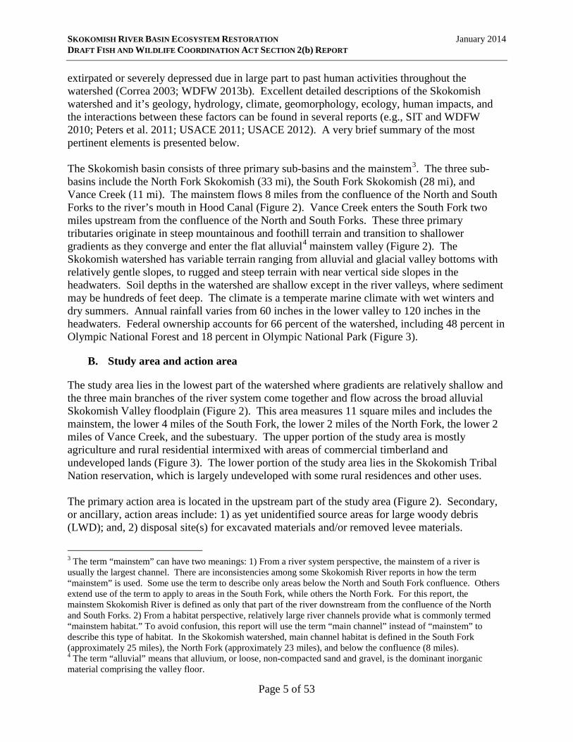
extirpated or severely depressed due in large part to past human activities throughout the watershed (Correa 2003; WDFW 2013b). Excellent detailed descriptions of the Skokomish watershed and it’s geology, hydrology, climate, geomorphology, ecology, human impacts, and the interactions between these factors can be found in several reports (e.g., SIT and WDFW 2010; Peters et al. 2011; USACE 2011; USACE 2012). A very brief summary of the most pertinent elements is presented below. The Skokomish basin consists of three primary sub-basins and the mainstem3. The three sub-basins include the North Fork Skokomish (33 mi), the South Fork Skokomish (28 mi), and Vance Creek (11 mi). The mainstem flows 8 miles from the confluence of the North and South Forks to the river’s mouth in Hood Canal (Figure 2). Vance Creek enters the South Fork two miles upstream from the confluence of the North and South Forks. These three primary tributaries originate in steep mountainous and foothill terrain and transition to shallower gradients as they converge and enter the flat alluvial4 mainstem valley (Figure 2). The Skokomish watershed has variable terrain ranging from alluvial and glacial valley bottoms with relatively gentle slopes, to rugged and steep terrain with near vertical side slopes in the headwaters. Soil depths in the watershed are shallow except in the river valleys, where sediment may be hundreds of feet deep. The climate is a temperate marine climate with wet winters and dry summers. Annual rainfall varies from 60 inches in the lower valley to 120 inches in the headwaters. Federal ownership accounts for 66 percent of the watershed, including 48 percent in Olympic National Forest and 18 percent in Olympic National Park (Figure 3).
B. Study area and action area
The study area lies in the lowest part of the watershed where gradients are relatively shallow and the three main branches of the river system come together and flow across the broad alluvial Skokomish Valley floodplain (Figure 2). This area measures 11 square miles and includes the mainstem, the lower 4 miles of the South Fork, the lower 2 miles of the North Fork, the lower 2 miles of Vance Creek, and the subestuary. The upper portion of the study area is mostly agriculture and rural residential intermixed with areas of commercial timberland and undeveloped lands (Figure 3). The lower portion of the study area lies in the Skokomish Tribal Nation reservation, which is largely undeveloped with some rural residences and other uses. The primary action area is located in the upstream part of the study area (Figure 2). Secondary, or ancillary, action areas include: 1) as yet unidentified source areas for large woody debris (LWD); and, 2) disposal site(s) for excavated materials and/or removed levee materials.
3 The term “mainstem” can have two meanings: 1) From a river system perspective, the mainstem of a river is usually the largest channel. There are inconsistencies among some Skokomish River reports in how the term “mainstem” is used. Some use the term to describe only areas below the North and South Fork confluence. Others extend use of the term to apply to areas in the South Fork, while others the North Fork. For this report, the mainstem Skokomish River is defined as only that part of the river downstream from the confluence of the North and South Forks. 2) From a habitat perspective, relatively large river channels provide what is commonly termed “mainstem habitat.” To avoid confusion, this report will use the term “main channel” instead of “mainstem” to describe this type of habitat. In the Skokomish watershed, main channel habitat is defined in the South Fork (approximately 25 miles), the North Fork (approximately 23 miles), and below the confluence (8 miles). 4 The term “alluvial” means that alluvium, or loose, non-compacted sand and gravel, is the dominant inorganic material comprising the valley floor.
Page 5 of 53
SKOKOMISH RIVER BASIN ECOSYSTEM RESTORATION January 2014 DRAFT FISH AND WILDLIFE COORDINATION ACT SECTION 2(b) REPORT
Figure 2. Map showing Skokomish River watershed shaded relief across the watershed (top) and within the study area and primary action area (bottom).
Page 6 of 53

SKOKOMISH RIVER BASIN ECOSYSTEM RESTORATION January 2014 DRAFT FISH AND WILDLIFE COORDINATION ACT SECTION 2(b) REPORT
Figure 3. Map showing land use and land ownership in the Skokomish River watershed (top) and in the study area and primary action area (bottom).
Page 7 of 53

SKOKOMISH RIVER BASIN ECOSYSTEM RESTORATION January 2014 DRAFT FISH AND WILDLIFE COORDINATION ACT SECTION 2(b) REPORT
The current state of the Skokomish River in the study area is the product of many decades of anthropogenic impacts throughout the watershed. These impacts have been substantial, widespread, and persistent. The migration of Euro-American settlers to the watershed in the late 1800’s marked the onset of watershed transformation. During the next century, the watershed and the river experienced a variety of impacts, including: intense logging and widespread deforestation of riparian, floodplain, and upland areas throughout the basin; removal of nearly all LWD from the river and tributaries; river straightening and channelization with levees; additional hydraulic constrictions caused by roadway bridges (US101 and SR106); and, installation of two dams on the North Fork and subsequent withdrawal of nearly all its water. Many of these actions took place entirely or partially within the study area. Others occurred outside of the study area (e.g., North Fork impoundment and water withdrawal), but directly or indirectly shaped the physical and biological conditions observed today. Cumulatively, these actions have resulted in a severely impaired system: the channel is highly aggraded and very unstable; sediment routing is highly impaired; and characteristics of quality salmon and trout habitat are lacking, including LWD, pools, side-channels, and off-channel habitat. Increased sediment supplies, reduced flows, and levees have also had a significant effect on estuarine habitat. The delta has become steeper, resulting in: 1) loss of important intertidal and eelgrass habitat; and, 2) a reduced mesohaline mixing zone, which is an important transition area for juvenile and adult salmonids as they move between freshwater and seawater. Several reports provide fairly thorough documentation and discussion of how human alterations have shaped the river and aquatic ecosystem in the study area (e.g., SIT and WDFW 2010; Peters et al. 2011). In order to understand how the proposed SRBER project may affect fish and wildlife resources, it is important to understand the natural and human history of the watershed and the study area, and how these have interacted to create the physical and biological conditions observable today. These histories and interaction can be summed up as follows: 1) the physical forms, functions, and processes within the watershed and the study area are inherently very sensitive to disturbance and alterations; 2) the biological character of the watershed and the study area - including survival and productivity of fish and aquatic species of interest - are intimately linked to these physical forms, functions, and processes; and, 3) the watershed and the study area have been heavily disturbed and altered by diverse human activities since the late-1800’s, substantially altering their physical and biological character. This context is a primary driver influencing project success at restoring more natural physical and biological characteristics and ultimate effect on fish and wildlife resources. A brief summary of pertinent study area characteristics and how they’ve been shaped by humans is presented below.
1. Geology
The study area’s geologic history and setting suggest that it is highly sensitive to disturbance. Recently deglaciated landscapes such as the Skokomish basin experience an unstable “paraglacial” (or immediate post-glacial) period until glacial sediments are either removed from the system or become stable (Ballantyne 2002). Low-gradient alluvial reaches such as that within the study area are particularly sensitive and highly responsive to disturbance (Skidmore et al. 2011). In the Pacific Northwest, significant stabilization is achieved by abundant in-channel
Page 8 of 53

SKOKOMISH RIVER BASIN ECOSYSTEM RESTORATION January 2014 DRAFT FISH AND WILDLIFE COORDINATION ACT SECTION 2(b) REPORT
LWD and mature conifer-dominated forests that blanket riparian, floodplain, and upland areas. Disruption to such stabilization mechanisms can destabilize the entire system by re-activating paraglacial sediment transport, creating unstable channel conditions, and re-mobilizing floodplain sediment sources (Ballantyne 2002; Skidmore et al. 2011).
2. Channel pattern
Channel pattern is important to river restoration because it has a direct bearing on aquatic ecosystem diversity and productivity. The term “channel pattern” is used to describe two basic aspects of a river: 1) the migratory behavior of a river; that is, the degree to which the channel migrates laterally across the floodplain; and, 2) whether the river has a single thread or multiple threads. Researchers generally recognize four primary channel patterns in rivers such as the Skokomish5: straight, meandering, island-braided (or anabranching), and braided (Figure 4; Leopold and Wolman 1957; Beechie et al. 2006; Huang and Nanson 2007; Eaton et al. 2010; Beechie and Imaki 2013). Meandering channels are single-thread channels that migrate laterally across the floodplain (Leopold and Wolman 1957; Beechie et al. 2006). They are often found at low gradients, and thus are usually lowest in the watershed. The meandering pattern is evident in the lower Skokomish River mainstem. Evidence suggests that the meandering pattern was present in this part of the river prior to anthropogenic disturbance (Bountry et al. 2009; SIT and WDFW 2010)
Figure 4. Examples of the four channel patterns found in western Washington rivers similar to the Skokomish. Image from Beechie and Imaki (2013).
5 Authors have used different terms and definitions for similar patterns, and these terms have sometimes overlapped or contradicted one another. Beechie et al. (2006) provides a summary of these.
Page 9 of 53

SKOKOMISH RIVER BASIN ECOSYSTEM RESTORATION January 2014 DRAFT FISH AND WILDLIFE COORDINATION ACT SECTION 2(b) REPORT
Braided channels have multiple threads that migrate laterally across the floodplain (Leopold and Wolman 1957; Beechie et al. 2006). They are usually found high in watersheds where steep headwater streams deposit abundant sediment into more moderately sloped main channels (Beechie et al. 2006; Beechie and Imaki 2013). Braided channels are symptomatic of large sediment inputs that exceed transport capacity of the channel. Braided channels are highly unstable. Of the three migrating channel patterns, meandering channels migrate the quickest and thus have the most disturbed floodplains (Beechie et al. 2006). Individual threads are separated by non- or sparsely-vegetated islands. Locations of channel threads and islands are in a constant state of change. Within the study area, the South Fork and much of the mainstem currently exhibit a braided channel pattern (Peters et al. 2011). Braided morphologies are highly unstable, homogenous, and inhospitable to many fish species including salmonids. In the study area, the lack of LWD in the braided channel has yielded a largely featureless plane-bed channel type with a general paucity of pools (WDFW and PNPTT 2000). This provides poor habitat for fish spawning, rearing, and overwintering. The current braided channel pattern is not believed to have existed in this location prior to anthropogenic disturbance (SIT and WDFW 2010; Peters et al. 2011). Instead, anthropogenic disturbances to the system, including but not limited to removal of most LWD from the system and widespread deforestation of riparian, floodplain, and upland areas, are responsible for the current braided pattern. Conversion to the braided pattern is believed to have had substantial deleterious consequences to many fish species (Peters et al. 2011). The third cannel pattern, island-braided, also has multiple threads that migrate laterally across the floodplain (Beechie et al. 2006; Huang and Nanson 2007; Eaton et al. 2010; Beachie and Imaki 2013). This channel pattern existed in part or most of the study area prior to anthropogenic disturbance (SIT and WDFW 2010; Peters et al. 2011). Island-braided channels are much more stable than braided channels because individual threads of the island-braided pattern are separated by stable vegetated islands. In contrast, the non-vegetated islands of the braided pattern are unstable and constantly shifting. Island-braided channels are considered intermediate between meandering and braided channels (Eaton et al. 2010). They are often found downstream of braided channels and upstream of meandering channels in the watershed (Beechie et al. 2006; Beechie and Imaki 2013). They also show a migration rate and floodplain disturbance level that are intermediate between the braided and meandering patterns (Beechie et al. 2006). The island-braided pattern is common in undisturbed transport-limited depositional reaches of western Washington alluvial rivers (Beechie et al. 2006). This pattern provides channel stability and allows for both sediment storage and sediment transport (Beechie et al. 2006; Burge 2006; Huang and Nanson 2007; Jansen and Nanson 2010). It is a physically and hydraulically diverse pattern with abundant side channels, LWD, riffles, and complex pool habitats. Side channels are often markedly different from main channels in terms of hydrology, gradient, substrate, and habitat. Ecological theory suggests that the island-braided channel pattern produces the most diverse and productive aquatic and floodplain habitats, which in turn supports the most productive fish populations (Ward et al. 1999; Gurnell and Petts 2002; Ward et al. 2002; Beechie et al. 2006;
Page 10 of 53
SKOKOMISH RIVER BASIN ECOSYSTEM RESTORATION January 2014 DRAFT FISH AND WILDLIFE COORDINATION ACT SECTION 2(b) REPORT
Francis et al. 2009). Empirically, the island-braided pattern has been found to contain the highest quantity, quality, and diversity of aquatic habitats (Arscott et al. 2000), and thus the greatest biological diversity (Gurnell et al. 2005). Side channels and other off-channel habitat typically associated with the island-braided pattern (Ward et al. 1999; Ward et al. 2002; Beechie et al. 2006) have well-documented superior value to salmonids in the Pacific Northwest (e.g., Murphy et al. 1989; Beechie et al. 1994; Morley et al. 2005; Jeffres et al. 2008; Bellmore et al. 2013). There are three primary lines of evidence supporting the contention that most of the river in the study area exhibited an island-braided channel pattern prior to human disturbance:
1. Maps and survey records made during the late 1800’s and early 1900’s indicate historic vegetated islands between RM 4.5 and 11, as well as in the lower North Fork. These data are presented in SIT and WDFW (2010) and Peters et al. (2011) and will not be duplicated here. The maps and survey records clearly show islands between RM 9 and 11, between RM 7.7 and RM 8, between RM 4.5 and 6, and on the North Fork between RM 0 and 1. A slough mapped between RM 6.8 and 7.6 suggests another likely island in this location.
2. Geomorphic theory suggests that the island-braided pattern develops in transitional areas
where steeper, more mountainous gradients transition to shallower gradients in valley bottoms (Beechie et al. 2006, and references therein; Beechie and Imaki 2013). The study area matches the idealized setting where the island-braided pattern would be expected.
3. Preliminary application of a predictive model (Beechie et al. 2006) to the Skokomish
River6 predicts the island-braided pattern starting at about RM 11.5, and extending downriver to RM 3.2 to 5 (Figure 5). This matches very closely with the early maps and survey records discussed above.
Both SIT and WDFW (2010) and Peters et al. (2011) relied on historic land surveys and maps (line of evidence 1) to support the contention that the Skokomish River had an island-braided pattern prior to human disturbance. Neither report considered geomorphic theory (line of evidence 2) or channel pattern predictive models (line of evidence 3). These two additional lines of evidence have not been reported or considered elsewhere. The brief presentations above are not intended as comprehensive or sufficient applications of geomorphic theory or channel pattern predictive modeling to the Skokomish River. Such evaluations are beyond the scope of this report. Rather, they are included to highlight heretofore neglected information and approaches
6 The Beechie et al. (2006) model uses river discharge and channel slope to predict channel pattern in western Washington watersheds. Variations of this methodology are common (e.g., Leopold and Wolman 1957; Desloges and Church 1989; Beechie and Imaki 2013). The preliminary Skokomish assessment used slope data from Bountry et al. (2009). Estimates of two-year flood discharge (approximating bankfull discharge) were obtained from two sources: a) LP-III Model estimates calculated by the Bureau of Reclamation (England 2007; USBOR 2009, cited in USACE 2011); and, b) the regression equation proposed by Sumioka et al. (1998) using watershed area and mean annual precipitation. Mean annual precipitation for the Sumioka et al. (1998) method was represented by climatological period 1961-1990 and was obtained from the United States Department of Agriculture Natural Resource Conservation Service.
Page 11 of 53

SKOKOMISH RIVER BASIN ECOSYSTEM RESTORATION January 2014 DRAFT FISH AND WILDLIFE COORDINATION ACT SECTION 2(b) REPORT
Figure 5. Results of preliminary predictive modeling (Beechie et al. 2006) for predicting natural channel pattern in the Skokomish River. The black lines represent thresholds that separate channel patterns: meandering from island-braided (lower line); island-braided from braided (upper line). Two methods for estimating two-year flood discharge in the Skokomish River are shown (Sumioka et al. 1998 and LP-III Model). See text for explanation. River miles on the left correspond with each pair of data points to the right. Results indicate that the island-braided pattern is predicted from RM 11.5 to about RM 3.2. vital to understanding the geomorphic and ecological history of the Skokomish River, and thus informing restoration efforts for maximizing benefits.
3. Aggradation
Rapid and substantial riverbed aggradation7 in the study area has been one of the most notable and agreed upon consequences of human impacts in the watershed. For example, the U.S. Geological Survey (USGS) gaging station at the US101 bridge has experienced over 4 feet of aggradation over the 32 year period from 1965 to 1997, a rate of 1.3 feet per decade (Stover and Montgomery 2001). As a result of aggradation, channel capacity in this location has steadily decreased from 13,000 cfs in 1943 to about 4,000 cfs in recent years (USACE 2011). Aggradation is so severe that the South Fork often goes completely dry between RM 8 and 9 during late-summer and early-fall8 (SIT and WDFW 2010). It is thought that the Skokomish River in the study area has been naturally aggrading for the past 2,000 years (Bountry et al. 2009). However, the rate of aggradation experienced during the 20th and early 21st century is believed to be well above natural.
7 Aggradation is the build-up of sediment in the river channel. It occurs when sediment inputs from upstream exceed transport capacity. The result is an increase in the elevation of the river bed. 8 Late-summer and early-fall is the normal seasonal low-flow period for unimpounded western Washington rivers.
Page 12 of 53

SKOKOMISH RIVER BASIN ECOSYSTEM RESTORATION January 2014 DRAFT FISH AND WILDLIFE COORDINATION ACT SECTION 2(b) REPORT
Reviewers commonly cite six factors believed to have contributed to the current state of aggradation (Bountry et al. 2009; SIT and WDFW 2010; Peters et al. 2011):
1. Clearcut logging and rapid deforestation throughout the watershed resulting in an increased sediment load from unstable slopes, mass wasting, and bank erosion.
2. Removal of logjams and large wood pieces and clearing of riparian zone old-growth forest throughout the study area resulting in release of stored floodplain sediments and subsequent conversion of an island-braided channel pattern to a less stable braided one.
3. Reduction in flow from the North Fork Skokomish River due to the operation of Cushman dam, resulting in reduced sediment transport capacity in the mainstem Skokomish River.
4. Channelization and straightening of the river channel using riprap, crib structures, cabled logs, and removal of large wood, resulting in reduced sediment transport efficiency.
5. Confinement of the channel by levees, resulting in backwatering of some areas, translation of depositional zones in a downstream direction, in-channel deposition of suspended sediments in low gradient areas, and loss of storage of coarse sediments in secondary channels.
6. Hydraulic flow constrictions at US101 and SR106 bridge crossings, causing back watering and loss of sediment transport capacity.
Each of these mechanisms is physically plausible and has likely contributed to the aggradation problem to varying degrees. However, there is no professional consensus among the various experts who have studied physical processes in the Skokomish River as to which are most important (Bountry et al. 2009). Without a clear understanding of which mechanisms are driving or most responsible for aggradation in the study area, agreement on the most effective restoration actions in the study area will remain elusive. Severe aggradation in the study area may impact fish populations by: 1) blocking migration; 2) inducing channel instability which can scour and bury redds (egg nests); 3) reducing habitat quantity and quality by filling in pools and diminishing pool frequency and depth; and, 4) increased incidence of fish stranding and mortality in the floodplain due to increased frequency and severity of flooding.
4. Large woody debris
Large woody debris is severely lacking throughout the study area (Correa 2003; Peters et al. 2011), a result of direct channel clearing of LWD in the early 1900’s as well as removal of source LWD areas via deforestation. LWD is a primary structural factor affecting general channel stability, hydraulics, sediment routing and retention, bank erosion, and channel pattern. It is vital in both: 1) creating and maintaining channel characteristics that constitute high quality
Page 13 of 53
SKOKOMISH RIVER BASIN ECOSYSTEM RESTORATION January 2014 DRAFT FISH AND WILDLIFE COORDINATION ACT SECTION 2(b) REPORT
fish habitat; and, 2) providing a direct source of complexity, hydraulic cover, and cover from predators, which together increase salmonid rearing densities and survival.
5. Channelization and floodplain connectivity
Residents of the valley and various government agencies have over the years implemented various uncoordinated diking, channelization, and bank stabilization efforts throughout the study area (Bountry et al. 2009). The result has been an extensive albeit discontinuous network of levees, dikes, and associated structures through the length of the study area. The Corps (USACE 2000) noted that these levees may mitigate low-level and site-specific flooding but are of little benefit during large magnitude flood events. These levees have likely contributed to the current state of aggradation and fish habitat loss through the complex interactions that levees can have with channel hydraulics and sediment transport and deposition. Although not entirely conclusive, the construction of levees coincides with the beginning of aggradation in the study area (Stover and Montgomery 2001). Three levee sites have severely constrained the river and are believed to have had the most influence in shaping the study area: the Nalley Island levees9; the Car Body and River Mile 9 Levees near the pre-2004 North Fork confluence; and the Grange Levee (Peters et al. 2011). These and other levees in the study area isolate the channel from the floodplain, and inhibit natural physical processes and formation of natural river morphologies. They also inhibit formation, maintenance, and use of off-channel habitat that is important for many salmonid species. Channel straightening in the Skokomish River began in the 1930’s. Channelization in the study area was not well documented, although at least four sections along the South Fork and the mainstem are believed to have been straightened (Bountry et al. 2009): an area below RM 12, another area just downstream of RM 9.6, and sections from RM 8 to 9, and RM 4 to 5.3. Channelization results in a temporary increase in hydraulic capacity, but reduced sediment transport efficiency over the long-term. Channels that are straightened to increase flood conveyance are usually widened as well. This tends to improve hydraulic capacity, but reduces the sediment transport capacity relative to a more sinuous channel with a deep thalweg10, a lower width-to-depth ratio, and the presence of secondary currents along the bed and banks that keep sediment mobilized. Channelization thus shortens the length of the channel and by extension available habitat, and may also contribute to aggradation.
C. Other restoration efforts
There is strong interest by a variety of federal, state, local, tribal, private entities, and affiliated collaborative groups (e.g., the Skokomish Watershed Action Team), to restore the Skokomish River watershed. These groups have implemented numerous restoration projects of varying scales throughout the watershed. In the absence of any overarching, comprehensive, watershed-scale organization, early restoration efforts were generally ad-hoc, small, and localized. Collaboration within groups such as the Skokomish Watershed Action Team (SWAT) and the Hood Canal Coordinating Council appears to be facilitating a more holistic, comprehensive, and systematic approach to developing and prioritizing restoration projects within the watershed.
9 Most of the Nalley Island levees were removed between 2007 and 2010. 10 The thalweg is the deepest part of the channel.
Page 14 of 53

SKOKOMISH RIVER BASIN ECOSYSTEM RESTORATION January 2014 DRAFT FISH AND WILDLIFE COORDINATION ACT SECTION 2(b) REPORT
A brief summary of the larger, more pertinent completed or ongoing restoration efforts in the watershed is outlined below. Additional restoration projects are underway and/or planned. Many of these are either upstream from the study area or in and near the subestuary. Large-scale restoration in the study area has generally been avoided. Restoration leaders (e.g., SWAT) have recognized the complexities and magnitude of the issues and restoration needs here, and are thus relying on the Corps and the GI for direction and funding (SWAT 2007). Organizations such as the Mason County Conservation District are facilitating smaller-scale efforts throughout the study area. South Fork Skokomish River watershed restoration on USFS lands (1990 - 2004). The U.S. Forest Service and various partners implemented various restoration projects in the South Fork, including road, in-stream, riparian, and vegetative work totaling $10.6 million. See USFS (2004) for more details. These efforts marked a turning point in that resource extraction was deemphasized in favor of watershed restoration. Skokomish Estuary Restoration, Phase 1 (2007). This effort removed 0.69 miles of dike on the west side of Nalley Slough, restoring 108 acres of intertidal wetlands. Cushman Project Federal Energy Regulatory Commission (FERC) Project No. 460, Settlement Agreement for the Cushman Project (January 2009). This settlement provided a variety of beneficial actions for fish and fish habitat in the North Fork Skokomish River. Among the most important was restoration of flows to the North Fork, which has widely been viewed as critical to restoring natural sediment transport rates through the study area. Flow restoration was implemented in March 2008, prior to signing of the settlement agreement. Other notable actions agreed to in the settlement include fish population supplementation plans, construction and operation of fish passage facilities at the Cushman project, fish and habitat monitoring, and enhanced fish habitat plans. US 101 Purdy Creek Bridge Replacement (September 2009). The old 110-foot-long US101 Purdy Creek Bridge was replaced with a 350-foot-long, taller bridge primarily to reduce flood-related road closures in this location. Flooding from the Skokomish River was common here. The bridge replacement had the added benefit of reducing one of the four hydraulic constrictions in this section of the river system. These four constrictions are distributed laterally across the floodplain at essentially the same longitudinal point in the valley (i.e., along US 101). Thus, backwatering upstream of all four US 101 bridges is expected to decrease (WEST Consultants, Inc. 2006). South Fork Skokomish River Large Wood Project (Summer 2010). Thirty engineered log jams (ELJs), consisting of over 2,000 logs, were installed in a one-mile stretch of the South Fork Skokomish River located approximately 10 miles upstream from the study area. In addition, approximately 12 acres of floodplain were restored and stabilized with tree and shrub plantings. These actions are expected to stabilize and retain sediments in the area immediately around the ELJs, and thus restore more natural sediment transport rates to downstream areas. Other benefits include enhancement of fish spawning and rearing habitat in the immediate ELJ installation area.
Page 15 of 53

SKOKOMISH RIVER BASIN ECOSYSTEM RESTORATION January 2014 DRAFT FISH AND WILDLIFE COORDINATION ACT SECTION 2(b) REPORT
Skokomish Estuary Restoration, Phase 2 (2010). This effort removed 2.49 miles of dikes, removed roads and culverts, and filled ditches, restoring 200 acres of subestuary habitat. The implementation of Phases 1 and 2 were widely regarded as critical to alleviating flooding in the lower mainstem and to restoring critical subestuary structure and function for the benefit of fish, shellfish, and shorebirds. Green Diamond Resource Company watershed restoration (mid-1990’s to present). The Green Diamond Resource Company owns and manages 15% of the Skokomish River watershed for commercial timber production. Green Diamond has upgraded and decommissioned roads to decrease sediment inputs from their road systems, and has restored fish passage in some areas by replacing inadequate culverts. South Fork Skokomish River watershed restoration on USFS lands (2005 - present). The U.S. Forest Service, in conjunction with the SWAT, the Skokomish Tribe, and other partners, have completed over $11.5 million in restoration work, including road closures and decommissioning, road stabilization, trail conversion, and commercial and pre-commercial thinning for expediting development of characteristics similar to mature forest. Among other results, efforts since 1990 have decreased road density in the upper South Fork watershed from 3.3 miles per square mile to less than 1.9 miles per square mile.
III. FISH AND WILDLIFE RESOURCES AND PLANNING OBJECTIVES
A. General fish and wildlife concerns
The SRBER project is intended to restore some degree of watershed and aquatic ecosystem structure, function, and processes for the benefit of numerous aquatic species, with a particular emphasis on salmonids. Ecological restoration invariably involves some degree of disturbance, risk, and uncertainty, and also often involves trade-offs that favor some species and habitats over others. Watershed-scale restoration, such as that proposed by the SRBER project, involves complex physical and biological interactions that often times are not fully understood. Because of the scale and scope of this project, and the complexity of the physical and biological processes involved, primary fish and wildlife concerns include:
1. How likely are the intended benefits of the proposed actions to be realized?
2. Will all pertinent factors that may influence success be adequately considered?
3. What short- and long-term negative impacts to target and non-target species and habitats may arise?
4. Will the intended benefits outweigh the negative impacts?
5. Will unintended consequences and level of risk associated with those consequences be adequately considered and managed?
Page 16 of 53

SKOKOMISH RIVER BASIN ECOSYSTEM RESTORATION January 2014 DRAFT FISH AND WILDLIFE COORDINATION ACT SECTION 2(b) REPORT
6. What is the potential for the proposed actions to result in a net negative impact to target
and non-target fish and wildlife resources?
7. What will negative impacts be to non-target species and will benefits to target species outweigh these?
B. Planning objectives
The Corps has identified four planning objectives of the proposed SRBER project for a 50-year period of analysis:
1. Provide year-round passage for fish species around the confluence of the North and South Forks.
2. Reconnect and restore the side channel and tributary networks in the study area.
3. Improve the quantity, quality, and complexity of native in-channel and floodplain habitats in the study area.
4. Increase the channel capacity of the Skokomish River to allow for restoration of rearing habitat as well as reduce stranding of salmonid species listed under the Endangered Species Act (ESA).
C. Current status of fish and wildlife resource
1. Federally listed, proposed, and candidate Species
Federal ESA-listed species and/or the habitat suitable to support these species which occur or may occur in the study area include the following:
• Puget Sound Chinook salmon (Ocnorhynchus tshawytscha) • Hood Canal summer chum salmon (O. keta) • Puget Sound steelhead trout (O. mykiss) • bull trout (Salvelinus confluentus) • northern spotted owl (Strix occidentalis caurina) • marbled murrelet (Brachyramphus marmoratus) • streaked horned lark (Eremophila alpestris strigata)
These species are all listed as threatened. In addition, the yellow-billed cuckoo (Coccyzus americanus) has been proposed for listing as threatened, and the fisher (Martes pennanti) is a candidate species currently scheduled for proposed listing in 2014. Federal species of concern are addressed in Section III.A.3. Of these species, the northern spotted owl, marbled murrelet, streaked horned lark, and yellow-billed cuckoo are not expected to occur in the study area. The northern spotted owl and marbled murrelet are found in mature and old growth conifer forests, and the yellow-billed cuckoo is strongly associated with large stands of mature riparian cottonwood forests. While there are
Page 17 of 53

SKOKOMISH RIVER BASIN ECOSYSTEM RESTORATION January 2014 DRAFT FISH AND WILDLIFE COORDINATION ACT SECTION 2(b) REPORT
small patches of large conifer stands in portions of the study area, there is not sufficient habitat to support these three bird species in the study area. The streaked horned lark requires large areas of bare ground in an open flat landscape, such as that found in native prairies and in developed areas like airfields. Such habitat is lacking in the study area. The other species listed above are either known to occur or may occur in the study area. These are discussed more fully below.
a. Puget Sound Chinook Salmon ESU and Designated Critical Habitat Chinook salmon in the Skokomish River belong to the Puget Sound Chinook salmon ESU which was listed as threatened under the Endangered Species Act in March of 1999. This listing was recently upheld in a 5-year review (NMFS 2011). Despite recent negative trends in abundance, the NMFS concluded that extinction risk of the ESU had not significantly increased. The NMFS noted that the ESU “is relatively well distributed over 22 populations in 5 geographic areas.” Critical habitat was designated in 2005 to include the Skokomish River subestuary, the mainstem Skokomish River, the South Fork to approximately RM 12, the North Fork to just above Lake Cushman, the lower three miles of Vance Creek, and lower parts of several major tributaries (NMFS 2005). This generally overlaps with what is believed to be the historical spawning distribution in the basin (SIT and WDFW 2010). The Skokomish River Chinook salmon population is severely depressed at best. In 2002, WDFW rated this stock as “depressed” due to “chronically low natural escapement” (WDFW 2002). Natural spawner escapement has been relatively stable since about 1990, averaging a little under 1,250 spawners per year (WDFW 2013b). Preliminary evidence suggests that hatchery strays account for considerable proportions of these naturally spawning fish (WDFW 2002; WDFW and PSIT 2007, cited in SIT and WDFW 2010; WDFW and PSTIT 2010). Juvenile production is also substantially lower than other Puget Sound river basins (Peters et al. 2011). The existence of a self-sustaining naturally-reproducing population is therefore questionable. Chinook salmon are one of the most variable of the salmonid species in terms of life history diversity and habitat requirements. Puget Sound Chinook are no exception. Adult spawners enter natal watersheds during much of the year. “Early returning” fish typically migrate into freshwater during spring and summer; “late returning” fish typically enter during fall. Regardless of entry timing, spawning usually occurs from early August through late October. In the Skokomish River, spawning occurs in the mainstem, in the lower portions of the North and South Forks, and in Purdy, Vance, and Hunter Creeks. Fry emerge from redds between December and April. Juvenile Puget Sound Chinook salmon may spend as little as a few days to as many as 12 months or more rearing in freshwater habitats (SSPS 2007). Most, however, spend 6 months or less in freshwater, and enter estuary habitats by mid-July (Fresh 2006). Main channel, tributary, and off-channel pond areas in and near the study area all provide important freshwater rearing habitat for Skokomish River Chinook salmon (Peters et al. 2011). Natal delta and subestuary areas are vital for rearing and migration (Fresh 2006; Peters et al. 2011). Juveniles may spend up to 10 months rearing in natal delta/subestuary habitats. Historically, the Skokomish River had both an early and a late run of Chinook salmon. However, the early run is considered extirpated (Nehlson et al. 1991; Ruckelshaus et al. 2006)
Page 18 of 53
SKOKOMISH RIVER BASIN ECOSYSTEM RESTORATION January 2014 DRAFT FISH AND WILDLIFE COORDINATION ACT SECTION 2(b) REPORT
and the late run is largely if not entirely non-native (Ruckelshaus et al. 2006; SIT and WDFW 2010). The late-timed run is much more dependent upon conditions in the lower watershed than the early-timed run. For this reason, the Skokomish River Chinook salmon recovery plan emphasizes reintroduction and recovery of an early-timed run at this time (SIT and WDFW 2010). The authors note that substantial improvement in lower watershed conditions is critical to recovery of the late-timed run. The existing late run population arose from widespread use of Green River (southeast Puget Sound) hatchery-origin fish at many Hood Canal hatcheries, including two in and near the Skokomish River basin. Nonetheless, the existing late run Skokomish River Chinook are considered part of the ESA-listed Puget Sound ESU. Spawning historically peaked in October and often extended into November in the Skokomish River (SIT and WDFW 2010). However, past hatchery practices unintentionally advanced river return and spawn timing in Skokomish River naturally-reproducing stock by as much as 6 weeks or more (SIT and WDFW 2010). Thus, the existing run enters the river and spawns during the lowest river flows of the year. In contrast, the endemic run was more closely timed with the end of the summer drought season, the onset of fall rains, and rising river flows. This loss of environmentally-adapted behavior compounds already complicated recovery needs. First, access to spawning habitats in Vance Creek and the South Fork is frequently blocked at low flows by aggraded sediments above the North Fork confluence. In addition, spawning habitat is restricted to the central portion of the channel during low flows. This leaves eggs particularly susceptible to potential effects of peak fall and winter discharges, such as scouring, fill, and channel migration. These concerns would be ameliorated at historical run timing.
b. Hood Canal Summer-run Chum Salmon ESU and Designated Critical Habitat
Hood Canal summer chum salmon were listed as threatened under the Endangered Species Act in March of 1999. This listing was recently upheld in a 5-year review, which found that “the overall trend in spawning abundance is generally stable” and determined that the ESU “remains at a moderate risk of extinction” (NMFS 2011). Critical habitat was designated in 2005 to include the Skokomish River subestuary and the mainstem Skokomish River from the vicinity of the old (pre-2004) confluence of the North and South Forks to the mouth (NMFS 2005). Hood Canal summer chum adults typically spawn in the lower portions of rivers and streams from late August through late October (WDFW and PNPTT 2000). This timing corresponds with the lowest river and stream flows of the year. Spawning habitat is thus restricted to the central portion of the channel. This leaves the eggs particularly susceptible to potential effects of peak fall and winter discharges, such as scouring, fill, and channel migration. Fry emerge from gravel substrates between February and late May, and migrate downstream to estuary habitats shortly thereafter. There is little to no freshwater rearing. Dense bands of eelgrass in nearshore estuary areas are believed to provide important rearing habitat and safe migratory corridors for juvenile summer chum (Simenstad 2000). Eelgrass thrives in shallow, gentle-gradient areas with clear water and sandy substrate (Gayaldo 2002; Berry et al. 2003), and is present in the Skokomish subestuary albeit at a 17 percent reduction from historical levels (Jay and Simenstad 1996).
Page 19 of 53

SKOKOMISH RIVER BASIN ECOSYSTEM RESTORATION January 2014 DRAFT FISH AND WILDLIFE COORDINATION ACT SECTION 2(b) REPORT
The Skokomish River stock has been considered extirpated since the late-1960’s or early 1970’s (WDFW and PNPTT 2000; NMFS 2007). A small handful of adult spawners are periodically observed in the river, but these are believed to be strays and not indicative of a self-sustaining population. Anthropogenic impacts described in Section II - particularly channel instability, scour, and fill - are believed to be the primary cause for this populations demise. Prior to degradation, the Skokomish River may have once supported the largest summer chum population in Hood Canal (WDFW and PNPTT 2000). Based on historical observations and habitat similarities, summer chum are believed to have spawned in the North and South Forks, Vance Creek, the mainstem, and several tributaries. The Skokomish River has been identified as a potential future target for reintroduction of summer chum, provided appropriate restoration actions are taken and are successful at improving habitat conditions (WDFW and PNPTT 2000).
c. Puget Sound Steelhead DPS and Designated Critical Habitat Puget Sound steelhead were listed as threatened under the Endangered Species Act in 2007. This listing was recently upheld in a 5-year review (NMFS 2011). Despite recent negative trends in abundance, the NMFS concluded that extinction risk of the DPS had not significantly increased. Critical habitat has recently been proposed and includes the mainstem Skokomish River, the North Fork to just below Lake Cushman, the entire South Fork and Vance Creek mainstems, and lower parts of several major tributaries (NMFS 2013). This generally overlaps with current and historical spawning distribution within the basin (WDFW 2002). Similar to Chinook salmon, Puget Sound steelhead exhibit both an early- (“summer”) and a late- (“winter”) returning form. Summer steelhead enter freshwater from May to October, hold for several months in deep, low-velocity areas, and spawn from January to April. Winter-run fish enter freshwater from November to April, and spawn shortly thereafter from February through June. The winter-run form is the more predominant form throughout Puget Sound. Regardless of spawning strategy, steelhead juveniles rear in freshwater habitats for up to three years prior to seaward migration making them one of the most dependent anadromous11 salmonids on freshwater habitat. Juvenile steelhead use riffles and fast-flowing pool habitats during the summer and prefer pool and side channel habitats in winter. Mainstem and tributary habitats in and near the study area provide year-round rearing habitat for juvenile O. mykiss (Peters et al. 2011). Smolt outmigration has been observed from February through September, with the peak occurring in May (Peters et al. 2011). Outmigrating smolts spend little time in the estuary, choosing instead to migrate rapidly toward the ocean. The Skokomish River supports a winter-run of steelhead; the current or historical existence of a summer-run is uncertain (PSSTRT 2013). In 2002, WDFW considered the Skokomish River winter steelhead “depressed” citing “chronically low escapements and long-term negative trend escapement” (WDFW 2002). Since then, spawner numbers have been trending upward, although annual returns are still low. Spawners averaged about 390 per year between 2004 and 2012 (WDFW 2013b). Most spawning is observed in the mainstem and South Fork in and near
11 Anadromous means that individuals of the species migrate from freshwater to saltwater to feed and grow, and return to freshwater to spawn. Some anadromous species migrate to saltwater immediately after hatching and return only to spawn (e.g., pink salmon). Others are more dependent on freshwater, rearing in freshwater for a few months (e.g., some Chinook salmon populations) to several years (e.g., steelhead trout) prior to migrating to saltwater.
Page 20 of 53

SKOKOMISH RIVER BASIN ECOSYSTEM RESTORATION January 2014 DRAFT FISH AND WILDLIFE COORDINATION ACT SECTION 2(b) REPORT
the study area, although the North Fork and Vance Creek also support spawning steelhead. Juvenile trout (O. mykiss and cutthroat combined) have been observed rearing throughout the Skokomish basin, including the mainstem, the North Fork to the first dam (Cushman Dam No. 2), the South Fork to RM 19, and Vance Creek to RM 5 (Peters et al. 2011).
d. Bull Trout and Designated Critical Habitat Bull trout were listed as threatened under the Endangered Species Act in 1999. This listing was upheld in a 2008 5-year review (USFWS 2008). A current 5-year review is pending in which the listing status is not expected to change. The Skokomish River is one of fourteen core areas belonging to the Coastal-Puget Sound DPS12 of bull trout, and supports the only known bull trout population in Hood Canal. The Coastal-Puget Sound DPS is the only DPS to exhibit a diadromous life history form, meaning that individuals migrate between marine and freshwater habitats. Diadromous bull trout spawn in freshwater, and feed and grow in both marine and freshwater habitats. The Coastal-Puget Sound DPS also exhibits the more common adfluvial and fluvial13 forms. Critical habitat for bull trout was designated in 2010 and includes parts of the mainstem, South Fork, and North Fork Skokomish River, Vance Creek, Purdy Creek, and Lake Cushman. Bull trout have been observed throughout the mainstem and the North and South Forks (Peters et al. 2011) There are at least two and possibly three local populations of bull trout in the Skokomish River. One is an adfluvial population that inhabits Lake Cushman and the North Fork above the lake. This population is separated from the study area by the two Cushman dams, both of which lack fish passage facilities. The South Fork Skokomish River supports a depressed but stable fluvial population (Peters et al. 2011). Brown Creek - a tributary to the South Fork - contains suitable habitat for bull trout spawning and rearing, and may support a local population (USFWS 2004). The bull trout population in the Skokomish River core area is one of the most depressed in the Olympic Peninsula Management Unit. The population is at risk of genetic drift due to low population levels (less than 1,000 adults). Also, because there are fewer than five local populations, bull trout in this core area are at elevated risk of extirpation and adverse effects from random naturally occurring events (USFWS 2004). Bull trout are present in freshwater habitats all year, typically utilizing pools with suitable cover in main channels and side channels (USFWS 2004). Peters et al. (2011) observed bull trout in and near the study area year-round. Complex habitat including large woody debris, undercut banks, boulders, and pools are important for bull trout. In the Skokomish River, bull trout generally spawn from mid-September through the end of November in areas upstream from the study area. Bull trout fry typically emerge from April through May in other systems (USFWS 2004). Exact emergence timing in the Skokomish River is unknown. Diadromy has not been
12 Bull trout within the coterminous United States are considered one DPS in the ESA listing despite sufficient scientific basis for segregating into multiple DPS’s. The Service has continued to refer to multiple specific DPS’s for purposes of consultation and recovery planning. Recent scientific evidence supports the multiple DPS approach (USFWS 2008; Ardren et al. 2011) 13 Adfluvial means that the fish feed and rear in a lake and migrate to flowing water (a river or stream) to spawn. Fluvial means that spawning, feeding, and rearing all occur within flowing water, although the fish may migrate long distances through the river system.
Page 21 of 53

SKOKOMISH RIVER BASIN ECOSYSTEM RESTORATION January 2014 DRAFT FISH AND WILDLIFE COORDINATION ACT SECTION 2(b) REPORT
documented in the Skokomish River population, although some juveniles have been captured in a screw trap in the lower river near the estuary (Matthew Kowalski, Skokomish Tribal Nation, personal communication), possibly indicating the existence of diadromy. Because bull trout are highly dependent on clean, cold water, and because they have one of the longest incubation periods (four to six months) of any native fish in the Pacific Northwest, bull trout are extremely dependent on good water quality and intact habitats (Fraley and Shepard 1989; Rieman and McIntyre 1993).
e. West Coast Fisher DPS The West Coast DPS of the fisher is a candidate species for ESA listing (USFWS 2013). The fisher historically occurred on the Olympic Peninsula and in the Cascade Mountains, but were extirpated from Washington State in the mid-1900s due to over-trapping, predator control measures, and habitat fragmentation. Extensive surveys to detect wide-ranging carnivores in the 1990s and early 2000s failed to detect fishers in Washington. Because of the lack of fisher detections and concern about fisher population declines, a status review was performed in 1997 and the species was listed as state endangered in 1998. Following the listing, conservation efforts for the species increased, including development of a recovery plan and a feasibility study for reintroduction. The Olympic Peninsula was identified as the highest priority for reintroduction. Animals were captured in British Columbia and released over a three year period between 2008 and 2010. In 2009, several fishers were released in the Skokomish River watershed immediately upstream of Lake Cushman in Olympic National Park. All of the released animals were fitted with radio-transmitters and tracking data revealed that animals both dispersed widely across the Olympic Peninsula and were reproducing. Although batteries in the radio-collars of the founder populations have since expired, fishers have been detected at bait and camera stations across the Olympic Peninsula, with recent (2012-2013) confirmed reports in the lower Hoh River watershed, near Lake Ozette, the upper Bogachiel River watershed, Lake Crescent, the foothills between Port Angeles and Sequim, the Buckhorn Wilderness, and the Duckabush River watershed. Given their large home ranges, huge dispersal distances, and data indicating that translocated fishers are using a variety of habitat types, it is likely that they could move through or be present in the study area.
2. State-listed Species
Washington State species of interest that may be affected by the project include:
• State Candidate Species: bull trout, Puget Sound Chinook salmon, Hood Canal summer chum, and river lamprey (Lampetra ayresi).
• State Monitored Species14: Pacific lamprey (L. tridentata), reticulate sculpin (Cottus perplexus), and riffle sculpin (C. gulosus).
14 From WDFW (http://wdfw.wa.gov/conservation/endangered/status/SM/): “Washington State Monitored Species are not considered Species of Concern, but are monitored for status and distribution. They are managed by [WDFW], as needed, to prevent them from becoming endangered, threatened, or sensitive.”
Page 22 of 53

SKOKOMISH RIVER BASIN ECOSYSTEM RESTORATION January 2014 DRAFT FISH AND WILDLIFE COORDINATION ACT SECTION 2(b) REPORT
Information on the abundance, distribution, and status of lamprey and sculpin species in western Washington is extremely limited and largely anecdotal. River lamprey have been found in several Puget Sound rivers (Wydoski and Whitney 2003). Three occurrences have been documented within the Skokomish River watershed between 1931 and 1993 (USFWS undated; WDFW 2013a), one of which was in the study area (WDFW 2013a). Larvae (ammocoetes) rear in freshwater for several years in backwaters and quiet eddies with fine silt and mud substrate (Wydoski and Whitney 2003). Seaward migration generally occurs from April to June. Adults begin returning to freshwater by September, spawning several months later from April through June. Pacific lamprey are found in most Puget Sound rivers (Wydoski and Whitney 2003). Peters et al. (2011) captured several Pacific lampreys emigrating from the Skokomish River. Similar to river lamprey, Pacific lamprey ammocoetes rear in freshwater for 4 to 7 years in depositional areas, backwaters, and quiet eddies with fine silt and mud substrate. Seaward migration generally occurs from March to July, although some fall migration has been observed. Adult Pacific lamprey return to freshwater between March and October, overwinter in deep pools, then spawn from April through July. Spawning occurs in similar habitats to salmon: in gravel-bottomed streams, at the upstream end of riffles, and at pool tailouts, typically upstream from suitable juvenile rearing habitat. Riffles and side channels are important Pacific lamprey spawning habitats. Riffle sculpin and reticulate sculpin often occur in the same Puget Sound streams (Wydoski and Whitney 2003), and have been observed in the Skokomish River (Mongillo and Hallock 1998; Peters et al. 2011). Backwater pools (riffle sculpin), in-channel pools (reticulate sculpin), and similar quiet areas are favored habitats, although both species have also been observed in riffles. Both species spawn in the spring and spend their entire lives in freshwater.
3. Federal species of concern
Federal species of concern known to use or that may use areas in and near the study area include coho salmon (O. kisutch) Puget Sound/Strait of Georgia ESU, Pacific lamprey, river lamprey, bald eagle (Haliaeetus leucoephalus), the olive-sided flycatcher (Contopus borealis), the northern goshawk (Accipiter gentilis), and the peregrine falcon (Falco peregrinus). Skokomish River coho were identified as an individual stock based on their distinct spawning distribution. They were labeled as healthy in the 2002 SASSI (WDFW 2002). It is a mixed stock with natural spawning occurring in most accessible tributaries to the Skokomish River with the most significant area being the lower North Fork and Vance Creek. Coho salmon are widely distributed throughout the Skokomish Basin. They have been observed in tributary, main channel, and pond habitats (Peters et al. 2011). Juvenile coho salmon were observed up to the lower dam in the North Fork, up to RM 27 in the South Fork, and up to RM 3.7 in Vance Creek. Coho salmon generally do not migrate to sea until the spring of their second year of life and therefore rely heavily on freshwater habitat as juveniles. Although they are typically spawned in higher gradient streams, they generally rear in the middle reaches of watersheds and prefer slower velocities than most other juvenile salmonids (Quinn 2005). Coho juveniles generally
Page 23 of 53

SKOKOMISH RIVER BASIN ECOSYSTEM RESTORATION January 2014 DRAFT FISH AND WILDLIFE COORDINATION ACT SECTION 2(b) REPORT
prefer pools over riffles. Their densities are positively correlated with LWD presence (Roni and Quinn 2001), and the importance of wood cover may increase with stream size (Peters 1996). Coho fry may also use the stream-estuary transitional area (ecotone) to rear during the summer, migrating upstream to overwinter in side channel and off-channel habitats located in lower watersheds (Miller and Sadro 2003). During high flow periods throughout the winter months, coho make extensive use of off channel habitat and migrate several kilometers down tributaries and main stem reaches to reach these habitats (Peterson 1982). Coho smolts generally migrate through the estuary rapidly, and thus do not rely as heavily on estuary habitat as some other salmonids.
4. Other fish and wildlife resources
Other fish species known or likely to occur in the study area include (Mongillo and Hallock 1997; Peters et al. 2011):
• Fall chum salmon (O. keta) • Coastal cutthroat trout (O. clarki) • Prickly sculpin (C. asper) • Coast range sculpin (C. alecticus) • Shorthead sculpin (C. confuses) • Western brook lamprey (L. richardsoni) • Threespine stickleback (Gasterosteus aculeatus) • Largemouth bass (Micropterus salmoides) • Brook trout (S. fontinalis)
Peters et al. (2011) evaluated aquatic ecosystem condition in the Skokomish River watershed using primary and secondary producers. Primary producers rely directly on sunlight for energy, and consist mostly of algae. Secondary producers acquire energy from sources other than direct sunlight, for example by consuming plants or animals. Secondary producers evaluated by Peters et al. (2011) consisted of benthic macroinvertebrates, stream-dwelling insects that live in the top several inches of the stream bed. Peters et al. (2011) concluded that most main channel and tributary sites sampled in the Skokomish River, including those in the study area, had relatively healthy primary and secondary producer communities. However, the authors noted that some community aspects were possibly indicative of degraded or altered conditions associated with bed instability, lack of woody debris, lack of riparian vegetation, and/or lack of habitat complexity. Common wildlife species that are adapted to degraded or partially degraded riparian and/or floodplain habitats, to fragmented second-growth forest, and/or to agricultural and light residential environs occur throughout the study area.
D. Conditions affecting fish and wildlife resources
Peters et al. (2011) identified four main factors within the study area inhibiting production and recovery of salmonids: 1) channel instability, 2) habitat availability, 3) habitat connectivity, and 4) habitat quality. Channel instability increases redd scour and burial, and is a direct source of
Page 24 of 53

SKOKOMISH RIVER BASIN ECOSYSTEM RESTORATION January 2014 DRAFT FISH AND WILDLIFE COORDINATION ACT SECTION 2(b) REPORT
mortality to incubating eggs and embryos (e.g., DeVries 2000; Schuett-Hames et al. 2000; Gottesfeld 2004). Influence of channel instability has not been empirically evaluated in the Skokomish River, but may affect several species that have low population levels in the system, including summer chum salmon, Chinook salmon, steelhead trout, and bull trout, as well as long-lived macroinvertebrate taxa. Habitat availability is significantly reduced relative to historic levels due to loss of stable side channels and off-channel floodplain habitats, as well as channel straightening and isolation of the floodplain from the main channel. The current braided channel pattern, in addition to lacking stable side channels, also lacks pools and thus provides poor rearing habitat for most salmonids. The pools that are present are shallow and lacking in complexity due to absence of LWD. Finally, habitat connectivity above RM 9 on the South Fork, including Vance Creek, is often blocked during late summer and early fall due to subsurface flow and dry riverbed between RM 8 and 9. This blocks fish migrations and movement. Particularly affected are: 1) potential spawner migrations of Chinook and summer chum salmon at a time of peak migration; 2) possible bull trout spawner migrations; and, 3) downstream migrations of any fall smolt outmigrations, although these have not been evaluated in the Skokomish River. Aggradation in the study area has increased the frequency and duration of flooding. This, in combination with the network of levees, lack of floodplain connectivity, and lack of floodplain side-channels and off-channel networks, may increase stranding and stranding-related mortality of fish. There are no empirical data on the extent of stranding-related mortality in the study area and how this is influenced by conditions in the lower watershed. However, anecdotal observations and photographs frequently show adult fish stranded in agricultural fields in the study area following flood events. Many of these fish appear to be fall chum salmon, one of the healthy populations in the watershed. Because of the seasonal timing of flood events and peak spawning migrations, adult fall chum salmon and coho salmon are most at risk for becoming stranded. Other species generally peak prior to the onset of large flooding (summer chum salmon, Chinook salmon), or afterward (steelhead trout). Resident species (cutthroat trout, rainbow trout), overwintering juveniles (coho salmon, steelhead trout), and overwintering adults and subadults (bull trout) in the study area may also be susceptible to stranding.
IV. EVALUATION METHODOLOGY
There are no known established models or alternative methodologies that can adequately represent and consider the complexities and dynamics of the physical and biological processes interacting in the study area that affect fish, wildlife, and their habitat. Thus, best professional judgment and available science were used to evaluate benefits and impacts to fish and wildlife resources associated with implementation of the proposed SRBER project. Service staff made observations of aquatic resources, habitats, and existing conditions throughout the watershed and the study area as part of the General Investigation (Peters et al. 2011). The Service also reviewed numerous studies conducted in the watershed and the study area by the Corps and others investigating and documenting fauna, watershed processes, and sources of ecosystem degradation in the Skokomish River.
Page 25 of 53

SKOKOMISH RIVER BASIN ECOSYSTEM RESTORATION January 2014 DRAFT FISH AND WILDLIFE COORDINATION ACT SECTION 2(b) REPORT
V. FISH AND WILDLIFE RESOURCES WITHOUT THE PROJECT
The Skokomish River has been degraded for many decades. Fish species that have persisted during this time generally appear stable, including those populations that are currently depressed. Restoration efforts - some fairly substantial - which have been and continue to be implemented by various entities throughout the watershed will likely benefit most if not all aquatic species in the watershed. These efforts have largely been limited to areas upstream and downstream of the action area. None of these other efforts are expected to directly or indirectly affect the riverbed drying between RM 8 and 9 that blocks fish migration. This blockage is a primary impediment to reestablishment and recovery of Chinook and summer chum salmon (SIT and WDFW 2010; Peters et al. 2011). Thus, despite other restoration efforts throughout the watershed, these species would not be expected to show much improvement without the proposed project. Other degraded conditions in the study area are expected to continue to affect abundance, productivity, and recovery of most species of interest. That is, even if the blockage problem did not exist, conditions such as channel instability and lack of quality habitat would persist and thus continue to limit productivity of fish species. Riparian, floodplain, and upstream areas are not expected to provide meaningful quantities of LWD to the channel anytime soon. In addition, existing levees will continue to act as hydraulic constrictions, exacerbate aggradation, and disconnect floodplain areas from the main channel. Thus, the unstable braided channel pattern, the lack of side-channel and off-channel habitats, and the lack of complex main channel pools are expected to persist into the foreseeable future. Other watershed restoration efforts not associated with the proposed SRBER project are not expected to sufficiently affect any of these conditions in the study area within the next 50 years. This takes on added significance because of the relative importance of main channel habitats in the Skokomish basin. Relative to other western Washington river systems, the Skokomish watershed has a high main channel-to-tributary ratio (Peters et al. 2011). This means that main channel conditions have a greater effect on overall productivity in the Skokomish River system than in other western Washington rivers. The river in the study area between RM 6 and 12 is at high risk for avulsion15 (SCI and SA 1999; GeoEngineers 2006), and this risk will increase as aggradation continues. Avulsions are a natural phenomenon that are part of healthy functioning watersheds. Evidence suggests that avulsions have been common throughout the upper part of study area for at least the last 2,000 years (GeoEngineers 2006; Bountry et al. 2009). Some identified potential avulsion sites are located upstream of the reach that often runs dry each year. Avulsions in this area may result in one or more new channels bypassing the dry area, which may prove beneficial to upriver salmon migration. Avulsions are likely to occur during fall or early winter potentially stranding incubating eggs and fish rearing or overwintering in newly abandoned channels. Any avulsions throughout the high-risk area would likely result in new channels running through existing agricultural fields. Due to the lack of trees and LWD in the existing agricultural fields, the new channels would be unstable and generally inhospitable to rearing salmonids. Because of the existing degraded conditions in the current channel, it is uncertain whether any avulsions would result in substantially detrimental long-term consequences to any of the affected species. However, the exact nature of any long-term impacts would depend largely on human responses.
15 Avulsion means that the river shifts from one channel to another.
Page 26 of 53
SKOKOMISH RIVER BASIN ECOSYSTEM RESTORATION January 2014 DRAFT FISH AND WILDLIFE COORDINATION ACT SECTION 2(b) REPORT
VI. ALTERNATIVES CONSIDERED
A. Formulation of alternatives
The USACE Draft Feasibility Report / Environmental Impact Statement (USACE 2013) provides a detailed description of the processes used to formulate alternatives. In short, the USACE developed a list of potential restoration measures in coordination with local sponsors, interested stakeholders, and the general public. A total of 25 possible management measures and 60 potential restoration sites were identified. Through various Corps screening and selection processes described in the Draft Feasibility Report / Environmental Impact Statement (USACE 2013), the Corps identified a RA/FAA in August 2013. Six alternatives were selected for the final RA/FAA (Table 1). Alternative 1 is the “No Action” alternative required by the NEPA to be considered. The other five alternatives (Alternatives 7, 23, 28, 45, and 60) consist of a base action and an array of additional actions (termed “Increments”). Alternatives 45 and 60 propose to dredge 5.5 to 9 miles, respectively, of the lower river to a depth of 8-10 feet in addition to several Increments. Alternatives 7, 23, and 28 propose to remove a levee near RM 9 (the Car Body Levee), in addition to one or more Increments. Alternative 28 was chosen as the PA/TSP and is described more fully in Section VI.B. Table 1. Range of Alternatives / Final Array of Alternatives proposed by the USACE for Skokomish River basin ecosystem restoration. Descriptions of the proposed actions are provided in the text.
Alternative ID and name Base action Additional actions (Increments) No Action (Alternative 1) no action - Car Body Levee Removal
Alternative 7 Car Body Levee removal Increment 35 Alternative 23 Car Body Levee removal Increments 35, 9, 37, 28, 39, and 40 Alternative 28 Car Body Levee removal Increments 35, 9, 37, 28, 39, 40, 43, and 26
Riverbed Excavation (Dredging)
Alternative 45 Excavation (dredging) from RM 3.5 to 9
Increments 35, 9, 37, 28, 40, 43, and 26
Alternative 60 Excavating (dredging) from the mouth to RM 9
Increments 35, 9, 37, 28, 40, 43, and 26
Increments 35 Upstream LWD installation 39 Hunter Creek mouth restoration 9 Side channel reconnection 40 Hunter Creek side channel restoration 37 Grange Levee setback 43 Weaver Creek side channel restoration 28 River Mile 9 Levee setback 26 Dip Road setback
Page 27 of 53

SKOKOMISH RIVER BASIN ECOSYSTEM RESTORATION January 2014 DRAFT FISH AND WILDLIFE COORDINATION ACT SECTION 2(b) REPORT
During the plan formulation process, the FWS maintained that dredging in the manner proposed in Alternatives 45 and 60 had no restoration benefits, was extremely environmentally damaging, and should therefore not be considered. During pre-screening, the Corps screened dredging out in part due to “severe adverse environmental impacts” (USCAE 2012), yet continued to include dredging in the list of alternatives to be considered. The FWS continues to maintain that dredging as proposed in Alternatives 45 and 60 has no restoration value.
B. Preferred Alternative / Tentatively Selected Plan
The PA/TSP (Alternative 28) consists of the base action (Car Body Levee removal) and eight additional actions, or increments (Figure 6). Each of these nine actions (the base and the eight increments) are independent in that implementation of any one action does not depend on implementation of any of the others. Each of the nine proposed actions are described below. Current Corps policy is to advance project proposals through the draft EIS/FWCA phase at only a conceptual level of detail. Thus, few project details were available for inclusion in this evaluation and report. The project proposal’s level of detail will be increased as it advances into the final EIS/FWCA phase.
Figure 6. Map showing locations of proposed actions that make up the Preferred Alternative / Tentatively Selected Plan.
Page 28 of 53

SKOKOMISH RIVER BASIN ECOSYSTEM RESTORATION January 2014 DRAFT FISH AND WILDLIFE COORDINATION ACT SECTION 2(b) REPORT
1. Car Body Levee removal
This action will remove all or part of a 4,670-foot-long levee (termed the “Car Body Levee”) located near the pre-2004 North and South Fork confluence (RM 9) on the north side of the channel (Figure 7). The primary purpose of this action is to restore a continuous low flow channel. This will be accomplished by reestablishing the confluence near its pre-2004 location at RM 9 and diverting flows from the South Fork into the North Fork. Thus, the current North Fork channel downstream from RM 9 will become the mainstem and the severely aggraded reach that has run dry in late summer most years since 2004 will be bypassed. Small-scale excavation and strategic LWD placement will help divert flow from the aggraded reach into the North Fork channel. Once bypassed, the aggraded reach will function as an overflow channel during high flow events. Many project details have yet to be proposed, including sections of the levee to be removed, means of material removal, disposal site(s) for removed levee materials, exact locations of excavation and LWD installation for channel diversion, source of LWD, means of LWD transport from source to destination areas, and means of installation.
Figure 7. Map showing proposed Car Body Levee removal area, area where South Fork will be diverted into the North Fork, and current and former (pre-2004) confluence of the North and South Forks of the Skokomish River.
Page 29 of 53

SKOKOMISH RIVER BASIN ECOSYSTEM RESTORATION January 2014 DRAFT FISH AND WILDLIFE COORDINATION ACT SECTION 2(b) REPORT
2. Increment 35 - upstream LWD installation
This action will install LWD through a combination of small LWD jams and single logs between RM 9 and 11 (Figure 8). This increment proposes to add approximately 30 to 40 new key-size logs per mile to existing LWD in the channel to meet regional reference quantities based on Fox and Bolton (2007). Key-size criteria include 2 to 3 feet diameter, 15 to 30 feet long, and intact rootwad. Small LWD jams may be used to increase meandering and bar formation and provide cover for fish. Up to 6 to 12 small jams per mile could be installed without adversely affecting flooding or increasing risk of erosion. Single logs may be used to induce localized pool formation. Some jams and single logs may remain within the wetted channel at low flows. Others may be activated only at elevated discharges. Currently, details have not been proposed for such items as number of logs to be added, number of jams and logs per jam, locations of jams and single logs, means of attachment if any (e.g., steel cables), source of LWD, means of LWD transport from source to destination areas, and means of installation.
Figure 8. Map showing proposed upstream LWD installation area (Increment 35). LWD jams and single logs will be placed in the channel and along the banks, although exact locations have yet to be proposed.
Page 30 of 53
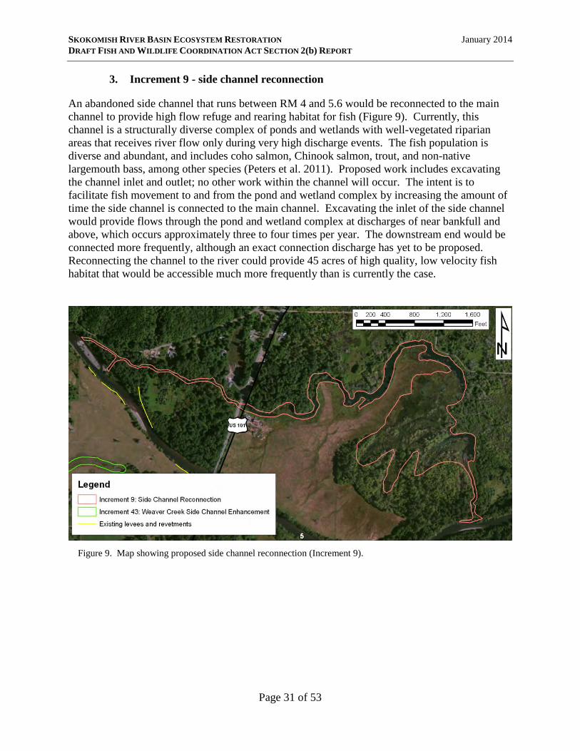
SKOKOMISH RIVER BASIN ECOSYSTEM RESTORATION January 2014 DRAFT FISH AND WILDLIFE COORDINATION ACT SECTION 2(b) REPORT
3. Increment 9 - side channel reconnection
An abandoned side channel that runs between RM 4 and 5.6 would be reconnected to the main channel to provide high flow refuge and rearing habitat for fish (Figure 9). Currently, this channel is a structurally diverse complex of ponds and wetlands with well-vegetated riparian areas that receives river flow only during very high discharge events. The fish population is diverse and abundant, and includes coho salmon, Chinook salmon, trout, and non-native largemouth bass, among other species (Peters et al. 2011). Proposed work includes excavating the channel inlet and outlet; no other work within the channel will occur. The intent is to facilitate fish movement to and from the pond and wetland complex by increasing the amount of time the side channel is connected to the main channel. Excavating the inlet of the side channel would provide flows through the pond and wetland complex at discharges of near bankfull and above, which occurs approximately three to four times per year. The downstream end would be connected more frequently, although an exact connection discharge has yet to be proposed. Reconnecting the channel to the river could provide 45 acres of high quality, low velocity fish habitat that would be accessible much more frequently than is currently the case.
Figure 9. Map showing proposed side channel reconnection (Increment 9).
Page 31 of 53

SKOKOMISH RIVER BASIN ECOSYSTEM RESTORATION January 2014 DRAFT FISH AND WILDLIFE COORDINATION ACT SECTION 2(b) REPORT
4. Increments 37 and 28 - Grange Levee and River Mile 9 Levee setbacks
Increment 37 will remove part of a 2,700-foot-long levee (termed the “Grange Levee”) located between RM 7.5 and 8 (Figure 10). The intent of this action is to reconnect floodplain habitat. A new setback levee will be constructed approximately 1,200 feet landward (south) of the existing levee. This will provide access to about 34 acres of riparian habitat, forest, and floodplain on the riverward side of the new setback levee. The new setback levee will be about 2,900 feet long and will provide a similar level of flood risk reduction as the existing levee.
Figure 10. Map showing proposed Grange Levee setback area (Increment 37). Overlapping yellow and pink lines denote existing levee to be removed or breached. Southern-most pink line denotes alignment of proposed setback levee. The white number 8 is the river mile.
Page 32 of 53

SKOKOMISH RIVER BASIN ECOSYSTEM RESTORATION January 2014 DRAFT FISH AND WILDLIFE COORDINATION ACT SECTION 2(b) REPORT
Increment 28 will remove part of a 4,450-foot-long levee (termed the “River Mile 9 Levee”) located between RM 8.3 and 9.2 (Figure 11). The intent of this action is to reconnect floodplain habitat. A new setback levee will be constructed approximately 200 to 300 feet landward (south) of the existing levee. This will provide access to about 23 acres of riparian habitat, forest, and floodplain on the riverward side of the new setback levee. The new setback levee will be about 4,460 feet long and will provide a similar level of flood risk reduction as the existing levee. Two strategically located sections of the existing Grange Levee totaling approximately 800 feet will be breached, as will four strategically located sections of the River Mile 9 Levee totaling approximately 950 ft. These breaches will allow flood waters to flow freely within the levee setback area, providing fish access to the riparian habitat. The River Mile 9 setback levee will be designed for shallow overtopping at 2‐yr and larger floods. Details have not yet been proposed for exact locations of the sections to be breached and disposal site(s) for the removed materials. Design and installation details for the new setback levee have also yet to be proposed.
Figure 11. Map showing proposed River Mile 9 setback area (Increment 28). Overlapping yellow and purple lines denote existing levee to be removed or breached. Southern-most purple line denotes alignment of proposed setback levee. The white number 9 is the river mile.
5. Increment 39 - Hunter Creek mouth restoration
This action involves excavating the mouth of Hunter Creek (RM 6.5). The proposal asserts that the outlet of Hunter Creek is relatively high, which may inhibit fish movement between the mainstem and Hunter Creek at low flows. The proposal also asserts that discharge from Hunter Creek into the Skokomish River mainstem may become restricted, particularly after Increment 40 is installed. Design details, including volume of material to be excavated, have yet to be proposed.
Page 33 of 53

SKOKOMISH RIVER BASIN ECOSYSTEM RESTORATION January 2014 DRAFT FISH AND WILDLIFE COORDINATION ACT SECTION 2(b) REPORT
6. Increments 40 and 43 - Hunter and Weaver Creek side channel restorations
These increments involve the construction of tributary channels to Hunter Creek (Increment 40; Figure 12) and Weaver Creek (Increment 43; Figure 13) to provide additional fish rearing and refuge habitat. Both creeks are perennial groundwater fed streams. Proposed work consists of excavating small channels along existing swales down to slightly below the water table. Many of these swales are relict channels, formerly active main channel and/or tributary channels that
Figure 12. Map showing proposed Hunter Creek side channel enhancement area (Increment 40).
Figure 13. Map showing proposed Weaver Creek side channel enhancement area (Increment 43).
Page 34 of 53

SKOKOMISH RIVER BASIN ECOSYSTEM RESTORATION January 2014 DRAFT FISH AND WILDLIFE COORDINATION ACT SECTION 2(b) REPORT
have naturally filled in with sediment over time (Bountry et al. 2009), presumably prior to Euro- American settlement in the region. Thus, although these increments comport with the broader watershed goals of ecosystem and salmon recovery, in and of themselves they are not channel restorations per se as much as they are channel enhancements or creations. Swales to be excavated lie predominantly within agricultural fields. Short lengths of each increment - 1,000 feet of the Hunter Creek increment and 1,000 feet of the Weaver Creek increment - lie within second-growth forest adjacent to agricultural lands. Constructed channels will have a 4-foot bottom width and approximately 5-foot depth. The total length of channels proposed for excavation are approximately 21,250 feet for Hunter Creek and 27,110 feet for Weaver Creek.
7. Increment 26: Dips Road setback
The Dips Road relocation, located between RM 9.5 and 9.7, is intended to provide additional floodplain habitat and reduce the stranding potential for fish (Figure 14). A 3,700-foot-long section of the road between the Vance Creek and Swift Creek bridges will be relocated about 400 feet landward (south). Approximately17 acres of riparian forest currently on the landward side of the existing road will be on the riverward side of the new road. The existing roadbed will be partially removed. Where the existing road embankment is higher than the adjacent ground both the asphalt and roadbed fill material will be removed. Where the existing road is lower than the adjacent ground level only the asphalt will be removed. River sediments are expected to deposit in the low areas and provide soil for future vegetation to grow. The new road will follow the alignment #2 provided by Mason County on November 13, 2012. This alignment generally runs halfway between the river and the bluff to the south. Refinement of the alignment will occur during the feasibility-level design phase. This action is considered to be a road relocation and as such will be entirely funded by non-federal sponsors.
Figure 14. Map showing proposed Dips Road setback area (Increment 26). Gray line closest to river denotes section of road proposed to be removed. Gray line farthest from river denotes proposed new road alignment.
Page 35 of 53
SKOKOMISH RIVER BASIN ECOSYSTEM RESTORATION January 2014 DRAFT FISH AND WILDLIFE COORDINATION ACT SECTION 2(b) REPORT
VII. PROJECT IMPACTS
A. Preferred Alternative / Tentatively Selected Plan
A full description and evaluation of project impacts is not possible since the PA/TSP is only at the conceptual stage of development and many project details have yet to be proposed. In general, there will be short-term negative impacts from construction of each action, including diminished water quality (turbidity and suspended sediment), noise disturbance from construction machinery, airborne particulates from soil disturbance, and vegetation removal and disturbance associated with construction of temporary equipment access routes and conducting activities at each work site. These construction-related effects are common to many restoration and conservation projects, and standard conservation measures and best management practices are generally followed to minimize the frequency, intensity, and duration of these impacts. The intent of the SRBER project is to restore habitat and provide long-term benefits to aquatic habitats and species from implementing the actions identified in the PA/TSP. For some proposed actions, the degree to which beneficial impacts will be realized, and whether benefits will outweigh negative impacts, depends on design aspects that have yet to be proposed. Potential beneficial and negative impacts of each proposed action are discussed below. A more thorough evaluation of effects of implementing the PA/TSP will be possible as the project advances into the design stage.
1. Car Body Levee removal
The Car Body Levee removal’s intended benefit is to restore perennial flow between RM 8 and 9 and thus restore year-round fish movement through this area. This action is expected to provide the following benefits:
• Upstream and downstream movement of adult and juvenile fish will no longer be blocked during late-summer low flow, potentially benefitting many species of concern, including Chinook salmon, summer chum salmon, bull trout, and coho salmon. Restoring passage is an important component for Chinook salmon recovery (SIT and WDFW 2010) and summer chum salmon reintroduction and recovery (WDFW and PNPTT 2000; Peters et al. 2011), primarily in terms of providing access to substantial spawning habitat above RM 9.
• The Car Body Levee, in combination with the River Mile 9 Levee, represents the most severe channel constriction in the study area (Peters et al. 2011). Removing these constrictions is expected to increase hydraulic energy and sediment transport capacity, thereby ameliorating the aggradation problem in this area.
• Potential use of this section of the river for main channel spawning and rearing will be restored, representing a net gain in habitat quantity over existing conditions.
• This action may help restore the historic island-braided channel pattern to this section of the river, which would benefit most if not all species of trout and salmon by increasing side channel habitat.
Page 36 of 53
SKOKOMISH RIVER BASIN ECOSYSTEM RESTORATION January 2014 DRAFT FISH AND WILDLIFE COORDINATION ACT SECTION 2(b) REPORT
• LWD installed to help redirect the channel is expected to provide additional complex
instream habitat features that will create pools and benefit most if not all species of salmon and trout, albeit on a very small scale.
The Corps has indicated that some portions of the existing levee could be left in place provided they do not inhibit the desired hydraulic functions of the project. Leaving remnant sections in place may result in negative unintended consequences. Remnant sections may pose a risk for fish stranding as water levels drop following high water events. Field and laboratory evidence suggests that anthropogenic structures can impede movement of fish back into the main channel and thus increase stranding-related mortality (Bradford 1997; Sommer et al. 2005). In addition, remnant sections may limit restoration of floodplain function. Poorly located remnant sections may diminish potential gains in floodplain flow area, which is critical to alleviating impacts of levee-associated channel constrictions. Other interactions between the river and reconnected floodplain may also be affected by remnant sections, including slowing channel migration, impeding avulsions, limiting LWD recruitment, inhibiting sediment deposition in the floodplain, and restricting organic matter transfers. The additional flow into the North Fork channel from the redirected South Fork may increase channel size and common river-related impacts in the North Fork channel. The affected North Fork channel runs through agricultural lands and scrub-shrub vegetation with few mature trees, although no formal vegetation surveys have been performed. Historically, the affected North Fork reach was part of the broader active floodplain and channel migration zone, as evidenced by historic 500 to 2,000-year-old relict channels (Bountry et al. 2009) and more recent extensive gravel bars and side channels (Godaire et al. 2007 cited in SIT and WDFW 2010) throughout the affected area. Thus, levee removal will reconnect these historic floodplain lands with the active channel. The Car Body Levee is suspected to have derelict automobiles incorporated into its construction. Removal of these old automobiles may release automotive-related toxic contaminants from leaking tanks (engine oil, gasoline, etc.) or from already contaminated soils and sediments. The Corps has indicated that they will investigate the extent of derelict automobiles in the levee, existing contamination in the adjoining soils and sediments, and potential for release of contamination associated with removing the automobiles and additional levee materials. The results of the investigation will dictate what measures are appropriate for minimizing potential for release of toxic contaminants into the environment and for removing existing contaminated soils and sediments. Proper implementation of the investigation, cleanup, and removal will minimize adverse impacts associated with toxic contaminants.
Page 37 of 53
SKOKOMISH RIVER BASIN ECOSYSTEM RESTORATION January 2014 DRAFT FISH AND WILDLIFE COORDINATION ACT SECTION 2(b) REPORT
2. Increment 35 - upstream LWD installation
The primary stated beneficial impacts of LWD installation are to increase channel meandering and bar formation, and provide cover for fish. If designed and constructed appropriately, these intended benefits as well as other ancillary benefits will be realized. These include:
• Bank stabilization resulting in reduced bank erosion and reduced sediment inputs. • Channel stabilization resulting in reduced redd stranding and reduced stranding of fish
hiding or overwintering in the substrate. • Sediment and bed stabilization resulting in reduced redd scour and fill, and reduced
crushing of fish hiding or overwintering in the substrate. • Reduced sediment transport resulting in reduced rate of aggradation downstream. • Increased hydraulic and channel complexity resulting in pool formation and increased
quantity and quality of main channel fish rearing habitat. This benefit may be maximized by ensuring that sufficient volumes of wood and root wads are submerged at lower river flows.
• Generally increasing LWD levels in this reach to those more closely approximating historic natural levels. Such high natural levels are widely known to provide numerous functions and benefits including but not limited to those identified above.
Due to the large size of the Skokomish River, these benefits will be maximized by incorporating LWD into engineered log jams as opposed to placement of single logs. Benefits may also be maximized by ensuring that root wads are incorporated as appropriate. LWD installations have at times been misused, either intentionally or unintentionally, to inhibit meandering, channel migration, and the formation of natural geometries and morphologies. Such misuse can “lock” a channel in place and can force the channel into a morphology that is not natural and/or not what the channel would otherwise tend toward for the given geologic and hydrologic setting. These can have negative impacts to fish habitat, habitat-forming processes, and fish populations. These can also negate or inhibit benefits described above from being realized. Lacking design details for LWD placement, this report cannot assess whether or to what degree these negative impacts may be realized. Source location(s) for LWD have yet to be identified. The Corps has indicated a preference to use conifer species for LWD installations, but has also suggested that cottonwoods are easily acquired and may be incorporated. Use of LWD may require cutting mature trees if stockpiled wood resources are not available. If mature trees are cut for use in aquatic restoration, this will likely have negative impacts to habitat for terrestrial species. A fuller discussion of impacts will not be possible until source area(s) are identified.
3. Increment 9 - side channel reconnection
The primary beneficial impacts of the side channel reconnection are to increase the amount of time the side channel is connected to the main channel and facilitate fish movement in and out of the pond and wetland complex. This will increase access to, egress from, and usability of the existing high quality rearing and refuge habitat located within the side channel. During high
Page 38 of 53
SKOKOMISH RIVER BASIN ECOSYSTEM RESTORATION January 2014 DRAFT FISH AND WILDLIFE COORDINATION ACT SECTION 2(b) REPORT
river discharges the reconnected channel would provide a low velocity refuge. During most of the year the channel would provide pond habitat for fish rearing. A potential negative impact may be increased predation on juvenile salmon and trout by the largemouth bass population that currently exists in the side channel.
4. Increments 37 and 28 - Grange Levee and River Mile 9 Levee setbacks
The primary beneficial impact of these levee setbacks is to reconnect floodplain habitat. Floodplain reconnection is expected to increase connectivity with and/or promote development of lateral habitats such as side channels and off-channel ponds. These types of habitats provide highly productive rearing areas and important slow-water refuge areas during elevated discharges for many fish species. Increased floodplain connectivity also allows for more natural channel migration and channel access to LWD source areas. Finally, the existing River Mile 9 and Grange Levees, in combination with the Car Body Levee, represent the most severe channel constrictions in the study area (Peters et al. 2011). Reducing these constrictions by setting back the levees is expected to increase the river’s hydraulic energy and sediment transport capacity, thereby ameliorating the aggradation problem in this area. Similar to the Car Body Levee removal action, the Corps has indicated that some portions of the existing Grange and River Mile 9 levees could be left in place. Thus, the same concerns over fish stranding risk, hydraulic function, and river-floodplain interactions that were discussed in the Car Body Levee removal section (VII.A.1.) apply here as well. Vegetation disturbed by notching or removal of the existing levee and installation of the proposed setback levee consists of early- to mid-stage second growth forest, although no formal vegetation surveys have been completed. Some agricultural fields may also be disturbed during installation of the River Mile 9 setback levee and the eastern portion of the Grange setback levee. Land cover in the reconnected floodplain consists largely of early- to mid-stage forest with some smaller areas of cleared land and agricultural fields.
5. Increment 39 - Hunter Creek mouth restoration
The primary stated benefits of this project are to provide year-round access between Hunter Creek and the mainstem Skokomish River, and to minimize backwatering in Hunter Creek. However, there are no data to confirm the necessity of this intervention. Benefits are thus uncertain and cannot be asserted with confidence. Negative impacts would include temporary disturbance and increased suspended sediment and turbidity from material removal, potential injury or harm to species in the immediate vicinity of the excavation work, and potential loss of legacy sediments which may or may not include spawning gravels.
6. Increments 40 and 43 - Hunter and Weaver Creek side channel restorations
The primary stated benefits of these actions are to provide additional fish rearing and refuge habitat. If designed and constructed appropriately, these actions have the potential to provide substantial quantity and quality off-channel rearing and refuge habitat that would benefit numerous species of salmon and trout in the system. The extent to which these benefits may be realized depends in part on diversity and complexity in the constructed channels as well as the
Page 39 of 53
SKOKOMISH RIVER BASIN ECOSYSTEM RESTORATION January 2014 DRAFT FISH AND WILDLIFE COORDINATION ACT SECTION 2(b) REPORT
nature and extent of riparian buffers. In-stream structure (LWD) and heterogeneity in flow regime (flowing water channels and blind or “dead end” channels), morphology (varied depths; pools & riffles), and substrate (gravels, cobbles, silt, etc.) would all contribute to net positive impacts. However, the current proposal lacks the necessary information to determine whether or to what extent these may be included. In its current form, the proposal describes seemingly homogenous channels of uniform width and depth lacking in diversity and complexity. The Corps has indicated that this type of featureless channel is not what is intended and that design details have yet to be identified for creating ecologically beneficial channels. The Corps has indicated that riparian buffers will be incorporated, but has not yet provided any additional details. In the absence of such design details, potential negative impacts of various possible scenarios include the following:
• Because the new channels will be constructed almost entirely within existing agricultural fields, negative impacts associated with agricultural runoff may arise. Improperly managed drainage from agricultural fields can create a host of problems for adjacent and downstream waterbodies, including increased sediment loads, increased turbidity, increased nutrient load, eutrophication, and inputs of agricultural chemicals that can be toxic to aquatic organisms (Needelman et al. 2007; Pierce et al. 2012). These may negatively impact the entire aquatic ecosystem, including primary producer, macroinvertebrate, and fish communities, from the point of entry in Hunter Creek downstream to the subestuary and Hood Canal. Negative impacts may be minimized by incorporating riparian buffers, in-channel vegetation, and other measures (e.g., Evans et al. 2007; Needelman et al. 2007; Strock et al. 2010; Messer et al. 2012; Pierce et al. 2012).
• Installation of the proposed channels without adequate riparian shading would likely lead to elevated water temperatures which may propagate into Hunter and Weaver Creeks.
• Open, homogenous channels lacking in complexity and diversity would likely not be used for rearing by juvenile salmon and trout, or would be used at low densities. Such channels would likely also increase predation risk on rearing or refuging juveniles.
7. Increment 26: Dips Road setback
The primary stated benefit is to reconnect 17 acres of floodplain riparian forest and reduce the stranding potential for fish. Benefits of setting back the road and reconnecting the floodplain may include:
• Increase the channel migration zone. • Increase potential for formation of side channels and off-channel habitats. • Provide long-term access to LWD supply. • Improve connectivity between main channel and any existing off-channel riparian
habitats. The existence, extent, and quality of existing off-channel habitats is currently unknown.
Approximately 800 feet of riprap separate the channel from the existing road on the western end of the proposed project site. Currently there are no definitive plans to either remove or leave this
Page 40 of 53

SKOKOMISH RIVER BASIN ECOSYSTEM RESTORATION January 2014 DRAFT FISH AND WILDLIFE COORDINATION ACT SECTION 2(b) REPORT
material in place. Leaving the material in place would lessen the degree to which the above stated benefits are realized.
B. Other plans
The No Action Alternative (Alternative 1) would allow causes and consequences of degradation to persist and perhaps worsen. See Section V for a fuller discussion of how no action is likely to affect the fish and wildlife resources in the study area. The Riverbed Excavation Alternative (Alternatives 45 and 60) would result in significant negative impacts, including loss of salmonid and other fish habitat, loss of spawning gravels, sublethal effects on salmon, trout and other aquatic species due to suspended sediments, loss of invertebrate forage base, increased bank and channel instability, isolation of side channels from water sources and fish use due to lowering of the main channel, and dewatering of adjacent wetlands. There is also a high degree of risk and uncertainty associated with dredging in alluvial channels because they can respond in significant and unexpected ways (Skidmore et al. 2011). The need to dispose of large volumes of excavated material would result in additional negative impacts. The significant risk and negative ecological impacts of these alternatives have led the Corps to exclude these alternatives from further consideration.
VIII. EVALUATION OF ALTERNATIVES
The study area is clearly in need of restoration to improve habitat conditions for listed and non-listed fish and other aquatic species, and for general aquatic ecosystem health. The no action alternative (Alternative 1) would allow causes and consequences of degradation to persist and perhaps worsen. The riverbed excavation alternatives (Alternatives 45 and 60) are highly ecologically damaging, highly risky, and carry potentially severe unintended consequences. The Service has consistently opposed these alternatives in their various forms over the course of the GI and plan formulation. Furthermore, the Corps recognized that this alternative would result in unacceptably high economic and social costs, and severe adverse environmental impacts (USACE 2012). For these reasons, this alternative has been excluded from further consideration. The PA/TSP (Alternative 28) has the potential to provide meaningful restoration benefits within the study area, provided that certain design criteria and additional conservation measures are incorporated. If implemented appropriately, the PA/TSP will address many high priority restoration actions identified by the Service (Peters et al. 2011), the Corps, local sponsors, and other stakeholders (USCAE 2012). However, the PA/TSP does not include actions that address one far-reaching high-priority recommendation identified by the Service during the GI (Peters et al. 2011): re-formation of island-braided channel pattern through use of engineered logjams. This action would help stabilize active channel sediments, facilitate sediment transport, and increase habitat quantity and complexity, all critical needs in the study area (see Section II.B.2). As discussed in Section II.B.2, the island-braided channel pattern existed in part and perhaps most of the study area prior to anthropogenic degradation. The Service believes that, where appropriate, re-forming an island-braided pattern through use of engineered logjams would yield greater restoration benefits than some of the actions currently presented in the PA/TSP.
Page 41 of 53
SKOKOMISH RIVER BASIN ECOSYSTEM RESTORATION January 2014 DRAFT FISH AND WILDLIFE COORDINATION ACT SECTION 2(b) REPORT
Despite the aforementioned shortcomings, the PA/TSP is likely to ameliorate and/or reverse some of the causes and consequences of ecosystem degradation. The PA/TSP is anticipated to improve habitat conditions in the lower watershed and benefit many target and non-target species and the aquatic ecosystem as a whole. With proper designs and conservation measures, risks associated with the PA/TSP are low and benefits are expected to outweigh the negative impacts.
IX. RECOMMENDATIONS FOR FISH AND WILDLIFE CONSERVATION
The Service supports the PA/TSP, but is providing the following list of concerns and recommendations to minimize potentially adverse effects and maximize benefits to fish and wildlife resources associated with the various proposed actions. Recommendations are divided into two tiers. Tier 1 recommendations are considered essential for minimizing potential negative impacts of the actions and ensuring that intended benefits are realized. Tier 2 recommendations are those that will enhance overall restoration effectiveness in the study area, and provide additional benefits beyond those currently represented in the PA/TSP.
A. Tier 1 recommendations: Ensuring PA/TSP effectiveness
1. The Service does not support LWD designs that are likely to inhibit channel meandering and migration, and the formation of natural geometries and morphologies. We recommend that the Corps ensure that a proper reach analysis is conducted and that designs for layout and placement of LWD are appropriate, achieve the desired objectives, and do not function in an unintended manner. Such unintended consequences could “lock” the channel in place and force the river into a channel pattern or morphology that is not natural and/or not what the channel would otherwise tend toward for the given geologic and hydrologic setting. These can have negative impacts to fish habitat, habitat-forming processes, and fish populations that may outweigh any benefits.
2. For all three levee breaches and setbacks (Car Body, Grange, and River Mile 9), the
Service recommends evaluating impacts on fish stranding risk, hydraulic function, and river-floodplain interactions of leaving remnant levee sections in place. Results of such evaluations should inform and guide decisions on where to strategically locate breaches and remnant sections to minimize negative impacts and maximize hydrologic and ecological benefits. Evaluations may indicate excessive negative consequences of leaving one or more remnant sections in place, in which case the Corps should consider removing these section.
3. The Service does not support tributary side-channel enhancement designs (Increments 40
and 43) that do not include provisions for protecting water quality associated with runoff from the surrounding agricultural fields. This may be accomplished in various ways, including planting riparian buffers and in-channel vegetation, installing water control structures, and other measures (e.g., Evans et al. 2007; Needelman et al. 2007; Strock et al. 2010; Messer et al. 2012; Pierce et al. 2012).
Page 42 of 53

SKOKOMISH RIVER BASIN ECOSYSTEM RESTORATION January 2014 DRAFT FISH AND WILDLIFE COORDINATION ACT SECTION 2(b) REPORT
4. The Service does not support designs for restoration and enhancement of tributary side-
channels (Increments 40 and 43) that do not include provisions for maintaining or improving water temperatures. Riparian buffers that include native trees and woody shrubs provide shade that help maintain cool summertime temperatures, as well as provide added habitat and water quality protection benefits.
5. The Service does not support designs for restoration and enhancement of tributary side-
channels (Increments 40 and 43) that result in homogenous and featureless channel forms that lack complex habitat elements. To the greatest extent practical, tributary side-channels should include abundant in-stream structures (LWD) and be designed in a manner that provide heterogeneity in flow regimes (areas with flowing water channels and blind channels with no flow), morphology (varied depths; pools and riffles), and substrate (gravels, cobbles, silt, etc.). Channels exhibiting such diversity and complexity would maximize fish utilization and rearing densities. Complex and diverse channels and instream habitat features would also minimize predation risk on rearing or refuging juveniles. Failing to incorporate sufficient structure, diversity, and complexity may result in negative impacts and consequences that outweigh any realized benefits.
6. The Service does not support leaving existing riprap associated with the current Dips
Road in place after the new road alignment is constructed. Leaving riprap in place would inhibit natural channel meandering and riverine processes. Physical structures necessary for protection of the proposed roadway should be installed as far away from the river as practical.
7. There are no data to support or demonstrate any ecological benefits of the Hunter Creek
mouth excavation (Increment 39). The Service recommends either removing this action altogether, or gathering data sufficient to demonstrate an ecological need that will outweigh negative impacts.
8. We recommend the Corps coordinate with the Services, tribes, and permitting agencies
throughout the designing of the SRBER project to expedite ESA Section 7 consultation and other permitting needs. Early coordination can: 1) provide opportunities for the Service and pertinent agencies to suggest conservation measures for avoiding, reducing, or minimizing potential adverse effects to listed species; 2) identify design alternatives that can benefit recovery of listed species; and, 3) provide technical assistance on specific species habitat requirements that could be incorporated into the project.
B. Tier 2 recommendations: Generating additional benefits
1. The river reach (RM 9 to 11) proposed to receive LWD additions from Increment 35 historically exhibited an island-braided pattern. This channel pattern generally provides stable sediment routing and superior habitat for a variety of fish species, including some listed species. Loss of this channel pattern throughout the study area has been cited as a primary contributor to habitat loss, stock declines, and general ecosystem degradation (SIT and WDFW 2010; Peters et al. 2011). The Service recommends investigating and
Page 43 of 53

SKOKOMISH RIVER BASIN ECOSYSTEM RESTORATION January 2014 DRAFT FISH AND WILDLIFE COORDINATION ACT SECTION 2(b) REPORT
designing engineered LWD jams that will facilitate re-formation of this type of channel pattern. Peters et al. (2011) provides a brief description of how this might be accomplished.
2. It appears highly likely that the river from RM 3.2 to 9 exhibited an island-braided
channel pattern. Because of the high value of this channel pattern to fish and fish habitat, the Service recommends considering additional evidence for its possible presence. If the weight of evidence suggests that the island-braided pattern likely existed in this area, the Service further suggests considering measures for restoring this pattern to this part of the river.
3. Proposed actions for the Car Body Levee removal may help facilitate re-formation of an
island-braided pattern between RM 7.8 and 9. However, the proposed actions alone may be insufficient to rapidly restore this type of channel pattern. Thus, in coordination with recommendation IX.B.2. above, the Service recommends investigating additional measures that may be incorporated into the proposed action to expedite formation of an island-braided pattern in this location.
4. The Service recommends evaluating whether levee setbacks can be increased by: a)
setting back levees between the proposed Grange and River Mile 9 setbacks (RM 8 to 8.3), and to the east of the proposed Grange setback (RM 7 to 7.5); and, b) increasing the setback distance of the proposed River Mile 9 setback and the east and west ends of the proposed Grange setback. Increasing the setback distances in this area will further reduce hydraulic constrictions, provide more floodplain connection to the river, and facilitate natural channel migrations and riverine processes.
5. Benefits of the Car Body Levee removal may be maximized by incorporating
enhancements to the North Fork channel between the old and new channel confluences (RM 7.8 to 9). The Service recommends evaluating this area for potential LWD additions, riparian planting, and other such enhancements.
X. SUMMARY AND THE SERVICE POSITION
The Service believes that the PA/TSP is the best alternative of those proposed by the Corps. The PA/TSP will provide meaningful restoration benefits within the study area, provided that certain design criteria and additional conservation measures described in this report are incorporated. Risks associated with the PA/TSP are low and benefits will outweigh negative impacts. The PA/TSP will ameliorate and/or reverse some of the causes and consequences of ecosystem degradation and therefore benefit many target and non-target species, the aquatic ecosystem as a whole, and the broader watershed. The Corps should consider opportunities for incorporating additional ecological benefits. Evaluating and incorporating actions for restoring an island-braided channel pattern, as appropriate, would be particularly valuable. The high ecological value of the island-braided pattern suggests that this measure would yield significant benefits. Specifically, significant
Page 44 of 53

SKOKOMISH RIVER BASIN ECOSYSTEM RESTORATION January 2014 DRAFT FISH AND WILDLIFE COORDINATION ACT SECTION 2(b) REPORT
additional improvements in sediment stabilization, sediment transport, habitat complexity, habitat sustainability, and abundance of fish populations and other aquatic organisms may be realized. Because the alternatives reviewed in this report were conceptual in nature and included very limited design details, the Service was unable to thoroughly evaluate potential project impacts. Design aspects that would negatively impact fish and wildlife resources and that would not be supported by the Service have been included, as have additional recommendations that would enhance benefits to fish and wildlife resources in the study area. We look forward to working with the Corps in developing more detailed evaluations of project impacts and optimum designs and measures for maximizing benefits and minimizing negative impacts.
Page 45 of 53
SKOKOMISH RIVER BASIN ECOSYSTEM RESTORATION January 2014 DRAFT FISH AND WILDLIFE COORDINATION ACT SECTION 2(b) REPORT
XI. REFERENCES
Ardren, W.R., P.W. DeHaan, C.T. Smith, E.B. Taylor, R. Leary, C.C. Kozfkay, L. Godfrey, M. Diggs, W. Fredenberg, J. Chan, C.W. Kilpatrick, M.P. Small, and D.K. Hawkins. 2011. Genetic structure, evolutionary history, and conservation units of bull trout in the coterminous United States. Transactions of the American Fisheries Society 140:506-525.
Arscott, D.B., K. Tockner, and J.V. Ward. 2000. Aquatic habitat diversity along the corridor of
an Alpine floodplain river (Fiume Tagliamento, Italy). Archiv für Hydrobiolie 149:679–704.
Ballantyne, C.K. 2002. Paraglacial geomorphology. Quaternary Science Reviews 21:1935-2017. Beechie, T., E. Beamer, and L.Wasserman. 1994. Estimating coho salmon rearing habitat and
smolt production losses in a large river basin, and implications for habitat restoration. North American Journal of Fisheries Management 14:797-811.
Beechie, T., and H. Imaki. 2013. Predicting natural channel patterns based on landscape and
geomorphic controls in the Columbia River basin, USA. Water Resources Research, accepted article, doi:10.1002/2013WR013629.
Beechie, T.J., M. Liermann, M.M. Pollock, S. Baker, and J. Davies. 2006. Channel pattern and
river-floodplain dynamics in forested mountain river systems. Geomorphology 78:124-141.
Bellmore, J.R., C.V. Baxter, K. Martens, and P.J. Connolly. 2013. The floodplain food web
mosaic: a study of its importance to salmon and steelhead with implications for their recovery. Ecological Applications 23:189–207.
Berry, H.D., A.T. Sewell, S. Wyllie-Echeverria, B.R. Reeves, T.F. Mumford, Jr., J.R. Skalski,
R.C. Zimmerman, and J. Archer. 2003. Puget Sound Submerged Vegetation Monitoring Project: 2000-2002 Monitoring Report. Nearshore Program, Washington Department of Natural Resources. Olympia, WA. 60 p.
Bountry, J.A., J.E. Godaire, R.E. Klinger, and D. Varyu. 2009. Geomorphic analysis of the
Skokomish River, Mason County, Washington. Report No. SRH-2009-02. United States Department of the Interior, Bureau of Reclamation. Denver, CO. 130 p.
Bradford, M.J., 1997. An experimental study of stranding of juvenile salmonids on gravel bars
and in sidechannels during rapid flow decreases. Regulated Rivers: Research and management 13:395-401.
Burge, L.M. 2006. Stability, morphology and surface grain size patterns of channel bifurcation in
gravel-cobble bedded anabranching rivers. Earth Surface Processes and Landforms 31:1211-1226.
Page 46 of 53

SKOKOMISH RIVER BASIN ECOSYSTEM RESTORATION January 2014 DRAFT FISH AND WILDLIFE COORDINATION ACT SECTION 2(b) REPORT
Correa, G. 2003. Salmon and Steelhead Habitat Limiting Factors: Water Resource Inventory
Area 16, Dosewallips-Skokomish Basin. Washington State Conservation Commission. 257 p.
Desloges, J.R., and M.A. Church. 1989. Wandering gravel-bed rivers. The Canadian Geographer
33:360-364. DeVries, P.E. 2000. Scour in low gradient gravel bed rivers: patterns, processes, and
implications for the survival of salmonid embryos. Water Resources Series Technical Report No. 160, Department of Civil and Environmental Engineering, University of Washington, Seattle, WA.
Eaton, B.C., R.G. Millar, and S. Davidson. 2010. Channel patterns: braided, anabranching and
single thread. Geomorphology, 120: 353-364. England, J.F. Jr. 2007. Flood Frequency, Flow Duration and Trends: Skokomish Geomorphic
Study, Skokomish River, Washington. Final Report. United States Department of the Interior, Bureau of Reclamation. Denver, CO. 30 p.
Evans, R.O., K.L. Bass, M.R. Burchell, R.D. Hinson, R. Johnson, and M. Doxey. 2007.
Management alternatives to enhance water quality and ecological function of channelized streams and drainage canals. Journal of Soil and Water Conservation 62: 308-320.
Fox, M. and S. Bolton. 2007. A regional and geomorphic reference for quantities and volumes of
instream wood in unmanaged forested basins of Washington state. North American Journal of Fisheries Management 27:342-359.
Fraley, J.J., and B.B. Shepard. 1989. Life history, ecology and population status of migratory
bull trout (Salvelinus confluentus) in the Flathead Lake and River system, Montana. Northwest Science 63:133-143.
Francis, R.A., D. Corenblit, and P.J. Edwards. 2009. Perspectives on biogeomorhphology,
ecosystem engineering and self-organisation in island-braided fluvial ecosystem. Aquatic Sciences 71:290-304.
Fresh, K.L.2006. Juvenile Pacific Salmon in Puget Sound. Puget Sound Nearshore Partnership
Report No. 2006-06. U.S.Army Corps of Engineers, Seattle District Seattle, WA. 21 p. Gayaldo, P.F. 2002. Eelgrass (Zostera marina) Restoartion Techniques. PhD Dissertation.
University of Washington, College of Forest Resources. Seattle, WA. 137 p. GeoEngineers, Inc. 2006. Chanel Migration and Avulsion Potential Analyses: Skokomish River
Valley, Mason County, Washington. File 2221-026-00. Prepared for Mason County Public Works Department.
Page 47 of 53

SKOKOMISH RIVER BASIN ECOSYSTEM RESTORATION January 2014 DRAFT FISH AND WILDLIFE COORDINATION ACT SECTION 2(b) REPORT
Godaire, J., J. Bountry, R. Klinger, J. England, and D. Varyu. 2007. Geomorphology of the
Skokomish River, Washington. Powerpoint presentation. U.S.Bureau of Reclamation, Technical Service Center, Denver, CO.
Gottesfeld, A.S, M.A. Hassan, J. F. Tunnicliffe, and R.W. Poirier. 2004. Sediment dispersion in salmon spawning streams: the influence of floods and salmon redd construction. Journal of the American Water Resources Association 40(4):1071-1086.
Gurnell, A.M., and G.E. Petts. 2002. Island-dominated landscapes of large floodplain rivers, a
European perspective. Freshwater Biology 47:581-600. Gurnell, A., K. Tockner, P. Edwards, and G. Petts. 2005. Effects of deposited wood on
biocomplexity of river corridors. Frontiers in Ecology and the Environment 3:377-382. Huang, H.Q., and G.C. Nanson. 2007. Why some alluvial rivers develop anabranching patterns.
Water Resources Research 43, W07441, doi:10.1029/2006WR005223. Jansen, J.D., and G.C. Nanson. 2010. Functional relationships between vegetation, channel
morphology, and flow efficiency in an alluvial (anabranching) river. Journal of Geophysical Research 115, F04030, doi:10.1029/2010JF001657.
Jay, D.A., and C.A. Simenstad. 1996. Downstream effects of water withdrawal in a small, high-
gradient basin: erosion and deposition on the Skokomish River delta. Estuaries 19:501-517.
Jeffres, C.A., J.J. Opperman, and P.B. Moyle. 2008. Ephemeral floodplain habitats provide best
growth conditions for juvenile Chinook salmon in a California river. Environmental Biology of Fishes 83:449-458.
Leopold, L.B., and M.G. Wolman. 1957. River Channel Patterns: Braided, Meandering and
Straight. Professional Paper 282-B. U.S.Geological Survey, Washington, DC. Messer, T.L., M.R. Burchell II, G.L. Grabow, D.L. Osmond. 2012. Groundwater nitrate
reductions within upstream and downstream sections of a riparian buffer. Ecological Engineering 47:297-307.
Miller, B. A., and S. Sadro. 2003. Residence time and seasonal movements of juvenile coho
salmon in the ecotone and lower estuary of Winchester Creek, South Slough, Oregon. Transactions of the American Fisheries Society 132:546–559.
Mongillo, P.E., and M. Hallock. 1997. Distribution and Habitat of Native Nongame Stream
Fishes of the Olympic Peninsula. Technical Report FRD 97-05. Washington Department of Fish and Wildlife. Olympia, WA. 45 p.
Page 48 of 53

SKOKOMISH RIVER BASIN ECOSYSTEM RESTORATION January 2014 DRAFT FISH AND WILDLIFE COORDINATION ACT SECTION 2(b) REPORT
Morley, S.A., P.S. Garcia, T.R. Bennett, and P. Roni. 2005. Juvenile salmonid (Oncorhynchus
spp.) use of constructed and natural side channels in Pacific Northwest rivers. Canadian Journal of Fisheries and Aquatic Sciences 62:2811-2821.
Murphy, M. L., J. Heifetz, J.F. Thedinga, S.W. Johnson, and K.V. Koski. 1989. Habitat
utilization by juvenile Pacific salmon (Oncorhynchus) in the glacial Taku River, southeast Alaska. Canadian Journal of Fisheries and Aquatic Sciences 46: 1677-1685.
Needelman, B.A., P.J.A. Kleinman, J.S. Strock, and A.L. Allen. 2007. Improved management of
agricultural drainage ditches for water quality protection: An overview. Journal of Soil and Water Conservation 62:171-178.
Nehlson, W., J.E. Williams, and J.A. Lichatowich. 1991. Pacific salmon at the crossraods: stocks
at risk from California, Oregon, Idaho, and Washington. Fisheries 16:4-21. NMFS (National Marine Fisheries Service). 2005. Critical habitat for 12 Evolutionarily
Significant Units (ESUs) of salmon and steelhead (Oncorhynchus spp.) in Washington, Oregon, and Idaho. Federal Register 70 (2 September 2005): 52,630-52,858.
NMFS (National Marine Fisheries Service). 2007. Final Supplement to the Hood Canal and
Eastern Strait of Juan de Fuca Summer Chum Salmon Recovery Plan. National Marine Fisheries Service, Northwest Region. Portland, OR. 53 p.
NMFS (National Marine Fisheries Service). 2011. 5-Year Review: Summary and Evaluation of
Puget Sound Chinook , Hood Canal Summer Chum, and Puget Sound Steelhead. National Marine Fisheries Service, Northwest Region. Portland, OR. 43 p.
NMFS (National Marine Fisheries Service). 2013. Endangered and Threatened Species:
Designation of Critical Habitat for Lower Columbia River Coho Salmon and Puget Sound Steelhead. Federal Register 78 (14 January 2013): 2,725-2,796.
Peters, R. J. 1996. An evaluation of habitat enhancement and wild fry supplementation as a
means of increasing coho salmon production of the Clearwater River, Washington. Doctoral dissertation. University of Washington, Seattle, WA.
Peters, R., Z. Li, K. Denton, M. Liermann, S. Sanders, R. Tabor, C. Cook-Tabor, and P. Bakke.
2011. Biological Sampling in the Skokomish River Basin, Washington: Army Corps of Engineers General Investigation. U.S.Fish and Wildlife Service. Lacey, WA. 221 p.
Peterson, N. P. 1982. Immigration of juvenile coho salmon (Oncorhynchus kisutch) into riverine
ponds. Canadian Journal of Fisheries and Aquatic Sciences 51:1197-1204. Pierce, S.C., R. Kröger, and R. Pezeshki. 2012. Managing artificially drained low-gradient
agricultural headwaters for enhanced ecosystem functions. Biology 1:794-856.
Page 49 of 53
SKOKOMISH RIVER BASIN ECOSYSTEM RESTORATION January 2014 DRAFT FISH AND WILDLIFE COORDINATION ACT SECTION 2(b) REPORT
PSSTRT (Puget Sound Steelhead Technical Recovery Team). 2013. Identifying historical
populations of steelhead within the Puget Sound Distinct Population Segment. Final Review Draft. 149 p.
Quinn, T.P. 2005. The behavior and ecology of Pacific salmon and trout. American Fisheries
Society, Bethesda, Maryland. Rieman, B.E., and J.D. McIntyre. 1993. Demographic and habitat requirements for conservation
of bull trout. General Technical Report INT-302. United States Forest Service, Intermountain Research Station. Ogden, UT. 37 p.
Roni, P., and T.P. Quinn. 2001. Density and size of juvenile salmonids in response to placement
of large woody debris in western Oregon and Washington streams. Canadian Journal of Fisheries and Aquatic Sciences 58:282-292.
Ruckelshaus, M.H., K.P. Currens, W.H. Graeber, R.R. Fuerstenberg, K. Rawson, N.J. Sands, and
J.B. Scott. 2006. Independent Populations of Chinook Salmon in Puget Sound. NOAA Technical Memo NMFS-NWFSC-78. National Marine Fisheries Service, Northwest Fisheries Science Center. Seattle, WA. 125 p.
Schuett-Hames, D.E., N.P. Peterson, R. Conrad, and T.P. Quinn. 2000. Patterns of gravel scour
and fill after spawning by chum salmon in a western Washington stream. North American Journal of Fisheries Management 20:610-617.
SCI and SA (Skillings-Connolly, Inc. and Simons and Associates). 1999. South Fork of the
Skokomish River and Vance Creek: Hydraulic and Geomorphic Analysis and Recommendations for Action. Project S-C 99033. Prepared for Mason County Department of Community Development.
Simenstad, C.A. 2000. Estuarine landscape impacts on Hood Canal and Strait of Juan de Fuca
Summer Chum Salmon and Recommended Actions. Appendix Report 3.5. Pages A3. 111-A3. 132 in Washington Department of Fish and Wildlife and Point No Point Treaty Tribes. An Implementation Plan to Recover Summer Chum Salmon in the Hood Canal and Strait of Juan de Fuca Region. Washington Department of Fish and Wildlife. Olympia, WA.
SIT (Skokomish Indian Tribe) and WDFW (Washington Department of Fish and Wildlife).
2010. Recovery Plan for Skokomish River Chinook Salmon. Skokomish Indian Tribe, Skokomish, WA; Washington Department of Fish and Wildlife, Olympia, WA. 208 p.
Skidmore, P.B., C.R. Thorne, B.L. Cluer, G.R. Pess, J.M. Castro, T.J. Beechie, and C.C. Shea.
2011. Science Base and Tools for Evaluating Stream Engineering, Management, and Restoration Proposals. NOAA Technical Memorandum NMFS-NWFSC-112. National Marine Fisheries Service, Northwest Fisheries Science Center. Seattle, WA. 255 p.
Page 50 of 53

SKOKOMISH RIVER BASIN ECOSYSTEM RESTORATION January 2014 DRAFT FISH AND WILDLIFE COORDINATION ACT SECTION 2(b) REPORT
Sommer, T.R., W.C. Harrell, and M.L. Nobriga. 2005. Habitat use and stranding risk of juvenile
Chinook salmon on a seasonal floodplain. North American Journal of Fisheries Management 25:1493-1504.
SSPS (Shared Strategy for Puget Sound). 2007. Puget Sound Salmon Recovery Plan, Volume 1.
Shared Strategy for Puget Sound. Seattle, WA. 472 p.
Stover, S.C., and D.R. Montgomery. 2001. Channel change and flooding, Skokomish River, Washington. Journal of Hydrology 243:272-286.
Strock, J.S., P.J.A. Kleinman, K.W. King, and J.A. Delgado. 2010. Drainage water management
for water quality protection. Journal of Soil and Water Conservation 65:131A-136A. Sumioka, S.S., D.L. Kresch, and K.D. Kasnick. 1998. Magnitude and frequency of floods in
Washington. U.S.Geological Survey Water Resources Investigations 97-4277. SWAT (Skokomish Watershed Action Team). 2007. Restoring the Skokomish Watershed: A
Three-Year Action Plan. hccc.wa.gov/Downloads/Downloads_GetFile.aspx?id=297866&fd=0
Todd, S., N. Fitzpatrick, A. Carter-Mortimer, and C. Weller. 2006. Historical Changes to
Estuaries, Spits, and Associated Tidal Wetland Habitats in the Hood Canal and Strait of Juan de Fuca Regions of Washington State. Technical Report 06-1. Point No Point Treaty Council, Kingston, WA. 91 p.
USACE (United States Army Corps of Engineers). 2000. Skokomish River GI Recon Study:
905(b) Analysis. United States Army Corps of Engineers, Seattle District. Seattle, WA. 27 p.
USACE (United States Army Corps of Engineers). 2011. Skokomish River Basin Flooding and
Sedimentation Baseline, Final Draft. United States Army Corps of Engineers, Seattle District. Seattle, WA.
USACE (United States Army Corps of Engineers). 2012. Ecosystem Restoration, Skokomish
River Basin, Mason County, Washington: Integrated Feasibility Report and Environmental Impact Statement Feasibility Scoping Meeting Read-Ahead. United States Army Corps of Engineers, Seattle District. Seattle, WA. 245 p.
USACE (United States Army Corps of Engineers). 2013. Skokomish River Basin, Mason
County, Washington Ecosystem Restoration: DRAFT Integrated Feasibility Report and Environmental Impact Statement. United States Army Corps of Engineers, Seattle District. Seattle, WA. 120 p.
Page 51 of 53

SKOKOMISH RIVER BASIN ECOSYSTEM RESTORATION January 2014 DRAFT FISH AND WILDLIFE COORDINATION ACT SECTION 2(b) REPORT
USBOR (United States Bureau of Reclamation). 2009. Flood Frequency Analysis: Vance Creek,
Washington. United States Department of the Interior, Bureau of Reclamation. Denver, CO.
USFS (United States Forest Service). 2004. South Fork Skokomish Watershed restoration
Summary. United States Forest Service. Olympia, WA. USFWS (United States Fish and Wildlife Service). 2004. Draft Recovery Plan for the Coastal-
Puget Sound Distinct Population Segment of Bull Trout (Salvelinus confluentus): Volume 2 of 2, Olympic Peninsula Management Unit. United States Fish and Wildlife Service. Portland, OR.
USFWS (United States Fish and Wildlife Service). 2008. Bull Trout (Salvelinus confluentus) 5-
Year Review: Summary and Evaluation. United States Fish and Wildlife Service. Portland, OR.
USFWS (United States Fish and Wildlife Service). 2013. Status Review of the West Coast
Distinct Population Segment of the Fisher as Endangered or Threatened. Federal Register 78 (19 March 2013): 16,828-16,829.
USFWS (United States Fish and Wildlife Service). undated. Species Fact Sheet: River lamprey
Lampetra ayresii. United States Fish and Wildlife Service. Lacey, WA. http://www.fws.gov/wafwo/species/Fact%20sheets/Riverlampreyfinal.pdf.
Ward, J.V., K. Tockner, D.B. Arscott, and C. Claret. 2002. Riverine landscape diversity.
Freshwater Biology 47:517-539. Ward, J.V., K. Tockner, and F. Schiemer. 1999. Biodiversity of floodplain river ecosystems:
ecotones and connectivity. Regulated Rivers: Research and Management 15:125-139. WDFW (Washington Department of Fish and Wildlife). 2002. Salmonid Stock Inventory (SaSI).
Washington Department of Fish and Wildlife. Olympia, WA. http://wdfw.wa.gov/conservation/fisheries/sasi/.
WDFW (Washington Department of Fish and Wildlife). 2013a. Priority Habitats and Species
(PHS). Washington Department of Fish and Wildlife. Olympia, WA. http:// http://wdfw.wa.gov/mapping/phs/.
WDFW (Washington Department of Fish and Wildlife). 2013b. Salmonid Stock Inventory
(SaSI). Washington Department of Fish and Wildlife. Olympia, WA. http://wdfw.wa.gov/conservation/fisheries/sasi/.
WDFW (Washington Department of Fish and Wildlife) and PNPTT (Point No Point Treaty
Tribes). 2000. An Implementation Plan to Recover Summer Chum Salmon in the Hood Canal and Strait of Juan de Fuca Region. Washington Department of Fish and Wildlife. Olympia, WA. 424 p.
Page 52 of 53

SKOKOMISH RIVER BASIN ECOSYSTEM RESTORATION January 2014 DRAFT FISH AND WILDLIFE COORDINATION ACT SECTION 2(b) REPORT
WDFW (Washington Department of Fish and Wildlife) and PSIT (Puget Sound Indian Tribes).
2007. Chinook Management Report 2006-2007. Washington Department of Fish and Wildlife, Olympia, WA. Northwest Indian Fisheries Commission, Lacey, WA.
WDFW (Washington Department of Fish and Wildlife) and PSTIT (Puget Sound Treaty Indian
Tribes). 2010. Puget Sound Chinook Comprehensive Harvest Management Plan: Annual Report Covering the 2009-1010 Fishing Season. Washington Department of Fish and Wildlife. Olympia, WA. 41 p.
WEST Consultants, Inc. 2006. Purdy Creek Bridge Replacement Hydraulics and Scour
Evaluation. Prepared for the Washington State Department of Transportation. WEST Consultants, Inc. Bellevue, WA.
Wydoski, R.S., and R.R. Whitney. 2003. Inland Fishes of Washington. American Fisheries
Society, Bethesda, MD, in association with University of Washington Press, Seattle, WA.
Page 53 of 53

FISH AND WILDLIFE COORDINATION ACT
PLANNING AID LETTER

United States Department of the Interior
Colonel Anthony Wright
FISH AND WILDLIFE SERVICE '
Western. Wash,!~¥t~%'f;ish ~g1g:Wildlife Office 5 w D~s~~~\i[;;];')[ .. SE, Suite 102
Lacey, Washington 98503 ·
U.S. Army Corps of Engineers Seattle District P. 0. Box 3755 CENWS-~M:-CP Seattle, Washington· 98124-3755
Attn: Mamie Bouwer
SEP 2 6 2008
Subject: Project Management Plan for Feasibility Phase Study of Skokomish River Basin
Dear Colonel Wright: .
We have reviewed the ProjecfManagement Plan (PMP), finalized on July 6, 200:6, for the ecosystemr¢st.o.r~ti0nandf1ood damage reduction project on the SkokomishRiver in Mason County, Washington. ThePMP provides the basis for conducting the feasibility phase of project development. The p11rpo.se o.·· .. f the feasibility phase is to investiga.te and fommlate pote.ntial alternatives to· address floodingreduction measures and environmental· restoration.actions.
This planning aid letter is provided as technical assistance and does not constitute the final report authorized by Subsection 2(b) of the Fish and Wildlife Coordination Act (16 U.S.C. 661 et seq.). The following paragraphs contain our comments on the PMP.
General Comments
The PMP identi:@.es the baseline conditions and the studies to be.conducted in order to supply the information need~Q'.to fo11il and evalu.ate alternatives for ecosystem restor~tion and flood damage reduction ofth~ S~tikolhishRiver. The Skokomish River GI Recon Study,905(b).Analysis (Corps 2000) statesthe "unnatural sediment deposltion has been attributed to decreased. peak and average flows fromthe North Fork because of the Cushman Hydtopower projectand.'to

Colonel Anthony Wright 2
increased sediment from the South Fork because of timber harvest activities." The 905(b) Recon Study recognizes "that the influence of the upper watersheds must be addressed in order to fully rectify problems indentified in the lower watershed." Many of the alternatives listed in the PMP provide options for short term flood reduction and habitat restoration measures in the lower watershed. Only a few options are discussed for directly addressing the sources of the problem, increased sediment and decreased flows, or for providing for long term sustainability of a restored watershed. We believe more emphasis should be placed on the following: 1) assisting the current efforts of cooperators to implement road management plans designed to reduce sediment inputs from the upper watershed, 2) increasing riparian forest restoration to supply future large woody debris, and 3) increasing flows from the North Fork.
We think the feasibility phase study should also identify and consider the effects that global warn1ing may have on the alternatives for this project. Several changes have been identified that are occurring now or will occur over the next 50 to 100 years (Mote et al. 2005, Glick et al. 2007): increases in average air and water temperatures, reductions in summer freshwater inflow to Puget Sound, changing precipi ation patterns with more frequent severe weather events, rises in sea level, and reductions in m y coastal and wetland habitats. Some of these changes could be of particular concern to this pr 0ect. Accelerated sea level rise combined with high river flows greatly increases the severit of floods and shoreline erosion events (Mote et al. 2005). Changes in the types and location of tidal wetlands could reduce the ability for these habitats to support salmonids, especially juv nile Chinook and chum salmon. Spawning habitat for forage fish, which make up a critical pa of the marine food web, could also be affected by reduction in the area of estuarine beaches (Gli k 2007).
A synthesis of the literature and c rrrent studies could identify the predicted and potential effects of global warming and the possible vulnerabilities of the alternatives to these effects. This infonnation would be important t consider when evaluating the project alternatives. The effects of global wanning are not factors hat can be controlled by this project, but the long-term success and benefits of the project can be ffected by the predicted and pot~ntial effects of global warming, especially rises in sea 1 el.
Specific comments on listed pos ible actions
Five ecosystem restoration measu es were brought forward from the reconnaissance phase study for evaluation during the feasibili phase study: dredging to expedite channel conveyance restoration, dikes and bank protec ion, natural drainage patterns restoration, selected acquisition of floodplain easements and flood proofing, and an alternative to include a combination of the listed measures. These restoratio measures were used as a base from which to develop more detailed project and implementati n studies. The PMP contains a draft list of recovery/flood damage reduction actions for the kokomish GI feasibility study. The draft list is divided into five main categories of possible a tions: 1) mainstem realignment, 2) sediment control, 3) road removal/alteration, 4) Cushman D m operations, and 5) other actions.

Colonel Anthony Wright 3
Mai:nstem.realignrnertt
Mainstem.reaLignmi:mt in0,ludes the ,Possible actions of dike removal and new dikes or setback levees,. recoru+~cno:ti ()ffres;hwater:;wetlands .and side channels, riparian cG)nridor restoration or enhanceiji~nt, e:ngirreered:10gjam · c.onstruction, and floodplain stabilization and enhancement. Dikereniovaiand setl5.acklevees may have minimal directimpactstu.the aquatic environment depending on location. Sefhack: levees are often recommended as a less damaging 'alternative to other flood reduction measures: Dike removal and setback leve'e.s will allow for a wider river channel migratio~ zohe, teconnectioµ with historic floodplain areas, and the opportunity to restorenative>rjparianvegefatiofralong the river.
Other possible actions discussed in the PMP are to construct two new ch:annels:{800 ft each) in. the estuarytoteconnectfteshw9'ter wetlands with the floodplain and torerouteVance Creek (500 ft of11ewchannel)to.cqnnectwith Swift Creek instead oftheSouth Fork Skokomish River. These acti6nsfu<typrovisfehabitathenefits for fish and wild1ife, such as rearing habitat for salmonids,lmtitis unclear how rerouting Vance Creek will reduce flood impacts. Routing more water to Swift. Qree~ with its smaller bankfull width could cm:1se bank erosion and impacts· to fish habitat in Swift Creek. Also, the bridge over Swift Creek will need to he evaluated forsuitability with increased water flows, Constructing new channels can cause significanVirnpacts to wetlands and streani ha:bitatthroughdoss of riparian habitat and increasedsedimenterosion ·and turbidity. These.ad~erse biological effects need to be addressed andmeasures.taken to minimize or mitigate for those effects.
We supportthe PMP option of restoring riparian forests in the Skokomish Valley floodplain. Riparian forests can become a source .for future recruitment oflarge wood that is important to maintaining c]lannel complexity; stabilizing banks, and decreasing sediments entering the river. Riparian forests can provide shade to reduce water temperatures and provide habitat for other wildlife including.reptiles ·<ind aii~hibians. Constructing engineered logjams and placem€nt of other large woodyd~bris will~!lyl"~ase channel complexity and aid in creating imp©rtant fish habitat features s11ch as pools, sid(f,channels, and stable spawning habitat that are lacking in the river. Adding;l(;l;rge wootj.!.is i~pottant to restoring habitat for salmonids in the short term, but even more important is providil1g~riparian forests to make the ecosystem more self sustaining in the long term.
Possible floodplain staoilizatl.on·a:nGl enhancement actions listed in the PMP include construction of 2 or .3 level §ptea(iel"'dike.si surface roughening, precision land fomting, subsurfacedtainage, and a diversion chart11el these actfons can have potential adverse impacts to fish and'trreir habitat. These actiot1s, ~speeially constructing a diversion channel, can cause increased bank erosion, sublethaLef'fect$tc{fishfromincreased turbidity, loss. of inventebiate prey base; and dewatering ofadj:acentwetlands.;<Niitigation measures can be.implemente,d''to decrease.the impacts to .wildlifeand·nabitat,bufmore information from the current Skokomish River; studies will be necessary to 'evalu:atethetsP:drttenn impacts of construction and the potentfatforJong terrn effects. and benefits.
Colonel Anthony Wright
Sediment control
The PMP lists three possible sediment control actions: sediment stabilization, South Fork mainstem stabilization, and dredging. The U.S. Forest Service (USPS) and Green Diamond Timber Company, owners ofthe majority of upper watershed lands, have completed and still plan to rebuild or decommission forest roads on their properties in the upper watersheds of the South and North Fork Skokomish and Vance Creek. The goal is to eliminate unstable side slopes, disperse storm water runoff from direct flow into streams, and decommission unnecessary roads. The feasibility study should evaluate more options to assist with implementation of those plans. Reducing sediment input from forest roads will address the source of sediments entering the river and provide long term benefits for ecosystem restoration and flood reduction in the floodplain.
4
The South Fork mainstem stabilization option proposes to stabilize sedimentsin the first 2 miles of the South Fork by installing fish-passable weirs. The PMP describes the weir design as similar to weirs installed in Goldsborough Creek but on a much larger scale. Construction of concrete weirs on a large scale in the South Fork could result in loss of salmonid spawning habitat and significant riparian habitat. Given the width of the floodplain, the high sediment loads, and high flood flows, construction of weirs in the first 2 miles of the South Fork would be susceptible to weir failures and sedimentation. Also, if continued maintenance of the weirs is necessary due to sediment accumulations or weir failures, then the need for maintaining access roads should be addressed. Reducing the amount of sediment that reaches the lower Skokomish Valley is very important, but possible options must also consider the longevity of the.actions taken and feasibility oflong term maintenance requirements. This action needs to be more fully evaluated to address the short term and long term requirements and/or effects.
Dredging of 5 miles of mainstem channel upstream of the Highway (Hwy) 10 I Bridge, selectively removing gravel at specific locations, and physically creating stream channels, sinuosity, and gradient may expedite channel conveyance and habitat formation but can have adverse impacts to the environment. As discussed above for constructing new channels and installing weirs, the potential impacts of these actions can affect bank stability, spawning habitat, migration corridors, prey base, and water quality and turbidity. Some ofthe impacts can be reduced through mitigation measures, but some habitat functions could require a year to recover or reestablish. The short term impacts must be evaluated against the potential long term benefits.
Road Removal/ Alteration
Possible actions include improving, rerouting, or removing roads in the SkokomishRiver floodplain. As of September 2008, the Washington Department of Transportation has· begun construction to replace the Hwy 101 Purdy Creek Bridge with a longer, three-span pre-cast concrete girder bridge. The bridge project is designed to increase floodplain connectivity and includes wetland mitigation. These improvements can be included in the evaluation of possible actions considered in the PMP. The PMP assumes that the Washington Department of Transportation will design and provide estimates for replacing the Hwy I 0 I Bridge over the mainstem Skokomish to remove fill or install culverts to improve floodplain connectivity problems associated with the existing bridge. If not already considered, designs for replacing the bridge should also evaluate raising the structure to avoid flooding during 2-year and 5-year flood

Colonel Anthony Wright 5
I
events'. .. Anothyr]J9;.ssible a;gtion,:~$,f p. i-erm1t~ Pµblic Utility Di~trie:;t pQwer line.s.·t() follow existing roadaligrnnenfsYs0,·tfiat:t}1epo~erlines andserviceroadwaysinthe floo<lpl(lincan·Q.,erep:ioved. Oth~r r0at,l r~lfioiiaL;act.ibns;cdtsc11s'.sb~ are removing parts. ofBourg~lt ang Old Skokomi$h Roads and installi11g.p~.~f~i}d'eat¢d; so~f~d~,long.bridges ·on Reservation·:Ro't(L Jh~'toadt~m9v-al actions. ~~U.ld?ecr~~s~.se:dirµen\~~ut~ 1fr?rritheroa~s and .would proviA~ ~0r.bette:;~cx~dplai~ con~ect1v1t)' wrt~ ll11~~n:aJ · eff ectstp wrl~l1fe and habtt~t. We sug~est evaltl~t111.g actxo~~to raise and improve therema1mng roads. to:prov1de access durmg sma11J:l0od. events andto red1ace the
' ' ·. '. . .· '' ' c' ' ' .. 1. ' ,' ' ' potential for ern&io];l of toftds dwriri:g flood events.
Cushman.DamFERC:AdioRS . I .
Low peak:andavera,ge river flows ~ue to water withdrawal at the Cushman Hydroelecttib Dam on the North Fotkhas.peen id~mtifihd as one of the primary reasons for "unnaturaLse.diment deposition''. in:the Skokornish Rivet and increased flooding (Corps 2000). Restoring flows to the lower ·skokomish Riv eris imp0rtan:tfor sediment conveyance arid to achieve long term flood reductionand restorationofthe Skokomish Valley floodplain. Many oftfo~ potential options withi.n the. scope o:fthe·J1I feasibility :smdy provide for measures. that would :begin the process· of sediment conveyance. and~ptovide fot immediate needsin the fl0odpl?-i11 .. The benefit offhese actions m1:1;y be short lived ifnatutal processes can not be gradually restored: Removal of.dams or constru.ctionofathit(l.dainis 11ot likely to. occur in the foreseeable .future. Through.the licen@ing process withTacoll1a Power, North Fork minimum flows· have been increased to 240 cfs as of March 2008. Alilp, l}Se'ttlement agreement is underway to discuss,grachial recovery of flows frorn.tb,e Nortl1Fork, flushlng flows of approximately 2,500 acre .feet twice a Year, and fish passage stmctures to allow (l.Ct.~ss'to habitat in the upper North Fork. The fea1)ibility study should include· anassessinentofdarrent increased flows from the North ForkSkokomishRiver in combination with/theotheractions under 9onsideration.
Other Actions.
Other· flood red11etton artdrestofation actions, which may be, but are not necessarily, part of the GI, include)evee rem0yal around th~ Hunter Property east of the Skokornish River nearHwy 106, acquisition 0ffloo~lplain easements along the North Fork and mainstem Skokomish River, and the USPS replacing culverts that block fish passage to streams in the upper watershed. As discussed previously, we·agree that dike removal to allow for a wider river channeLmigration zoneand.imwroved:conne.ctivityiRthe floodplain will be beneficial.in.the lo:µgtertn,·and depending on ilw time ofyear, have relatively minimal effects (e.g., sediments andfurbidity) to federally listed. an.CJ:designatederitfoal habitat from removal activities. We su,ppoiJ: the options of acquirip.g riparian\andfloo4'Pl~in~etts~ments and the USPS upgraging ofculvertsin the'tl;pper watershed streains. We futthe,fs~g~est that more options· be· develop~d for a~si,sttJWgother entities; including 0U.ying·ec91()gicaily important areas from willing land owners and assisting the USPS in their1culv:ertupgrad'es.
Summary
Wereiteratetliatev:aluatio:nofthewhole watershed is important to addressing thyprofulems in the Skokomish\[all~y flO(D.p;pJ<:\~11.· We recommend pursuing m01:13 acti9;n~,tlu.~t: a: .. · Tue
Ci11;r:i·~--···· : ''.fr actions addressing these items are outside the direct
Colonel Anthony Wright
jurisdiction of the GI, then the Corps should assist agencies, sponsors, and land owners in implementing the actions where pos~ible. ·
. . , . gmg t e channel may have significant adverse impacts to erally proposed and listed fish and wildlife. ~1illtrdn~, such as replenishing
spawning gravel, can minimize impacts to instream habitat, but quantification and assurance of long term benefits to fish and other aquatic organisms are needed to compensate for the short term adverse effects. In light of the potential for effects to ESA listed fish and wildlife, we
L • • L, . 'R,Gl!>w.r»'""~"'·""·"''l'-"'-"eli"'~-'N,;,·"'-•""""•''~·"-"'1~~~· .. ,,,, ., ~' ~"'"'""'""''·""'""'""''X'-"·f'l>"·"'"'''W"'ll}7ii"'W'lifil~ ""'S'IIBg~©&Jt.:iw;@lgaooft::i!l.mtigiitJ11iti§*Ei"rl"''@0'Ti"stTr't;'cui!run"'f)r0'eesrs~s'l'l1.>JTli\\a'¥J"Jlei]'1!iitlr1@il!a1r'l!'e¥1¥a:'t!1~e"a:e¥ferrs"'n~\¥&1!0een
i"&~lltilt~<1~~~~2.,.,~~,~j~~~\!i,9;?J~~~~~a~"\:i~~§~~~~•;m;p~@ill.
We support the Corps' current and continued efforts for open communication and cooperation among the many agencies, entities, and groups involved in various flood reduction and restoration actions in the Skokomish River watershed.
Thank you for the opportunity to review and provide comments on this document. Should you have any questions, please contact Shirley Burgdorf of my staff at (360) 534.:..9340 or at the above letterhead address.
crely, l . -W Ken~ger ~·
Western Washington Fish and Wildlife Office
LITERATURE CITED
. Skokomish River GI Recon Study, 905(b) Analysis. Seattle District,. Seattle, Washington. 27 pages.
llnllt~l:tl8:\il~18(Dro5. Uncertain uture: 1 e change and1ts effects on Puget Sound- Foundation Document. Climate
Impacts Group, Center for Science in the Earth System, Joint Institute for the Study of the Atmosphere and Oceans, University of Washington. 37 pages .
. ~lii~~iii*~~~~]~A~~}~~~71~~~~~~~:n~-~::t~~~:r::nd ~~:~~~~~~~~~ ~o~~~::t~~ Oregon .. July 2007. National Wildlife Federation, Seattle, Washington. 104 pages.
~~mlt~~~
~\ C-nc_L <(S~ - ,g .<l'··t-t LVY'-C~JJ~'-Q
6

NATIONAL MARINE FISHERIES SERVICE
APPROVAL FOR SECTION 4(d) LIMIT 8 BIOLOGICAL OPINION

Evan R. Lewis
UNITED STATES DEPARTMENT OF COMMERCE National Oceanic and Atmospheric Administration NATIONAL MARINE FISHERIES SERVICE West Coast Region Oregon and Washington Coastal Area Office 510 Desmond Drive SE, Suite 103 Lacey WA, 98503
February 3, 2015
Chief, Environmental and Cultural Resources Branch Department of the Army Seattle District, Corps of Engineers P.O. Box 3755 Seattle, WA 98124-3755
Re: Confirming use of the Washington State Habitat Restoration Program, ESA 4( d) Limit 8, as ESA review for the Skokomish River Ecosystem Restoration Project
Attention: Nancy Gleason
Dear Mr. Lewis:
In 2007 the NMFS approved the Habitat Restoration Program (HRP) as a conservation program for habitat restoration projects under the Endangered Species Act Section 4(d) Rule, Limit 8. The state of Washington's Recreation and Conservation Office (RCO) is responsible for administration of this program.
We provided comments to your office on the larger Skokomish River Draft Feasibility Report last April and have been following the development of the related Skokomish River Ecosystem Restoration Project. We understand that the RCO has approved use of the HRP for this project. We agree that this project fits within the HRP, Limit 8 for NMFS species. If you have questions regarding this project or Limit 8, please contact Randy Mcintosh of my staff at [email protected], 360-534-9309 .
. #T:r 1e Matt Longebaugh Central Puget Sound Branch Chief
Cc: Nancy Gleason, COE

WASHINGTON STATE RECREATION AND CONSERVATION OFFICE
APPROVAL FOR SECTION 4(d) LIMIT 8 BIOLOGICAL OPINION
Natural Resources Building 1111 Washington St. S.E. Olympia, WA 98501
P.O. Box 40917 Olympia, WA 98504-0917
February 17, 2015
STATE OF WASHINGTON
RECREATION AND CONSERVATION OFFICE
Nancy Gleason, MES. Fish Biologist U.S. Army Corps of Engineers- Seattle District Aquatic Resources Division PO Box 3755 Seattle, WA 98124
~360) 902-3000
lTY 360) 902-1996' Fax: 360) 902-3026
E-mail: [email protected] Web site: www.rco.wa.gov
Subject: Skokomish River Ecosystem Restoration General Investigation - Confirmation for use of SRFB Limit 8 Self-certification Form
Dear Nancy:
The purpose of this letter is to confirm the US Army Corps of Engineers may use the Salmon Recovery Funding Board's (SRFB) "Self-certification of Proposed Habitat Restoration Activity Consistency with the Habitat Restoration Program, 4(d) Rule, Limit 8" for restoration actions proposed through the Skokomish River Ecosystem Restoration General Investigation.
Recovery actions identified in the Puget Sound Chinook Salmon Recovery Plan and the Hood Canal Summer Chum Salmon Recovery Plan were reviewed under the Endangered Species Act (ESA). As such, the Limit 8 Self-certification form acknowledges ESA review and compliance for those recovery actions identified in the recovery plans. Furthermore, the restoration actions proposed by the USACE in the Skokomish River Basin are identified in and consistent with the recovery plans.
Please feel free to contact me if you have any questions or concerns.
Sincerely,
Mike Ramsey, Salmon
Cc: Loretta Swanson, Mason County Joseph Pavel, Skokomish Tribe John Bolender, Mason Conservation District
Recreation and Conservation Funding Board • Salmon Recovery Funding Board
Washington Invasive Species Council• Governor's Salmon Recovery Office
Habitat and Recreation Lands Coordinating Group

Self-certification of Proposed Habitat Restoration Activity
Consistency with the
Habitat Restoration Program, 4(d) Rule, Limit 8 In order for a proposed habitat restoration activity to be consistent with the Habitat Restoration Program (HRP), the project proponent needs to review the elements of the HRP and certify, using the checklist below. The HRP includes habitat protection and restoration projects funded by the SRFB that meet the following characteristics:
□ Are part of a habitat portion of a salmon recovery plan approved by a Regional Salmon Recovery Organization and the State of Washington and published in the Federal Register by NMFS; and
□ Are part of an adopted Implementation Schedule developed by a Regional Organization to implement the habitat portion of a Salmon Recovery Plan; and
□ Are funded in part or wholly with Washington State and/or Pacific Coastal Salmon Recovery Fund (PCSRF) monies managed by the SRFB and are consistent with the technical and procedural criteria outlined by SRFB; and
□ Are being done for the purpose of habitat restoration; and □ Are projects that fit within a specific list of eligible actions:
In-Stream Passage
In-Stream Diversion Screening In-Stream Habitat Riparian Habitat Restoration Upland Habitat Restoration or Protection
Estuarine and Marine Nearshore Habitat Restoration
__________________________ ___________________
/s/ Project Proponent Date
SRFB TECHNICAL GUIDANCE FOR HABITAT RESTORATION, INCLUDING STREAMBANK PROTECTION, FISH PASSAGE, SCREENING, AND INVENTORY INFORMATION Stream Habitat Restoration and Integrated Streambank Protection: WDFW, in concert with other State agencies, has developed guidelines that facilitate the consistent application of good science and practices for project designs, construction, and operations affecting aquatic systems. http://wdfw.wa.gov/hab/ahg/ The WDFW provides technical assistance to SRFB applicants for the design and development of barrier correction and screening projects. WDFW provides design standards and performs technical review of fish passage and other habitat restoration and development projects. This technical review is required for approval through the Hydraulic Project Approval (HPA) process and is especially critical for fish passage and screening projects. Additional information is available on the WDFW Web page at: http://www.wdfw.wa.gov/hab/engineer/habeng.htm#upstrm Project Applicants are encouraged to utilize the WDFW Priority Index (PI) system. It provides a standardized methodology for the assessment and prioritization of fish passage barriers and water diversion screens. To assist applicants in developing the PI, WDFW has developed the Fish Passage Barrier and Screening Assessment and Prioritization Manual. Additional information is available on the WDFW Web page at: http://www.wdfw.wa.gov/hab/engineer/fishbarr.htm. Fish Passage Projects: All fish passage projects must meet state fish passage criteria. The WDFW has developed Fish Passage Design at Road Culverts Manual to guide in the implementation of fish passage projects. WDFW has also developed a Fish Passage Data Design Form that is included in the application materials and is available electronically on the IAC/SRFB web site at http://www.iac.wa.gov/srfb/docs.htm. Screening Projects: All screening projects must meet state fish screening criteria. The WDFW has developed the draft guidelines for fish screens. This is available at: http://www.wdfw.wa.gov/hab/engineer/fishscrn.htm Inventory Projects: WDFW has an established protocol for fish passage barrier and screening inventories, which should be followed. The protocol can be found in the Fish Passage Barrier and Screening Assessment and Prioritization Manual available on the WDFW Web page at: http://www.wdfw.wa.gov/hab/engineer/fishbarr.htm.

U.S. FISH AND WILDLIFE SERVICE
CONCURRENCE WITH USE OF PROGRAMMATIC BIOLOGICAL OPINION ON
FISH PASSAGE AND RESTORATION PROJECTS
NOTE: Throughout the plan formulation and environmental coordination processes of the feasibility study, the project team was using local site names to refer to each site where measures could be implemented for ecosystem restoration. During the project's recent feasibility-level design phase, site names were formalized in the Final Feasibility Report and Environmental Impact Statement; therefore, some site names have changed since initial environmental compliance and coordination efforts were completed early in the study. The final list of sites in the recommended plan includes the following:
• Confluence Levee Removal • Upstream Large Woody Debris • Side Channel Reconnection • Wetland Restoration at River Mile 9 • Wetland Restoration at Grange

Electronic Approval for use of the 2008 Fish Passage and Restoration Programmatic
U.S. Army Corps of Engineers Civil Works levee setback projects
in the Skokomish River (FWS# 01EWFW00-2015-TA-0253, 13410-2008-F-0209)
On January 15, 2015, the U.S. Fish and Wildlife Service (Service) received your letter, the Memorandum for the Services, and Specific Project Information Form requesting consultation for the U.S. Army Corps of Engineers Civil Works Skokomish River levee setback project. The U.S. Army Corps of Engineers (Corps) made a “likely to adversely affect" determination for the bull trout (Salvelinus confluentus) and a "may affect, not likely to adversely affect" determination for designated bull trout critical habitat. The project is located near the town of Skokomish, in Mason County, Washington (T21N, R4W, Section 8). The proposed project includes: 1) removing the Car Body levee (5,400 ft), 2) removing portions of the existing Grange and River Mile 9 levees, 3) setting back the Grange and River Mile 9 levees (2,750 and 4,370 feet of setbacks, respectively), 4) reconnecting 45 acres of off-channel habitat, 5) constructing 14 engineered log jams (ELJ), and 6) installing numerous single logs and clusters of large wood. Access to the sites may require up to 13 temporary stream crossings (depending on the flows), and there will be as many as 60 sites where in-water work could occur (14 ELJs, 13 stream crossings, two sites for reconnecting the off-channel habitat, one levee breach, and 30 log clusters). The actual number of instream work locations will likely be less, depending on flow conditions at the time of construction and minimization measures that will be implemented (e.g. constructing ELJs along edges of gravel bars). Any trees that are removed to provide access to the sites and which meet the size criteria will be used in construction of the ELJs. Access and construction of the project will occur during summer low flow conditions, and diversion and/or isolation of work areas will comply with the protocols established in the 2008 Fish Passage and Restoration Programmatic. Fish will be removed using dip nets, seines, and electrofishing (if necessary). Turbidity monitoring will occur during all in-water work and will comply with the conditions issued in the water quality certification issued by the Washington Department of Ecology. Construction activities will take two in-water work seasons to complete. The purpose of the project is to restore instream habitat complexity and floodplain connectivity for bull trout and other listed salmonids. The project is located in the Skokomish River core area for bull trout. Based on telemetry studies, bull trout in the Skokomish River Core Area are fluvial and do not show signs of anadromy. Based on the 5-year review, the bull trout population in this core area is rapidly declining. The number of adults in the South Fork Skokomish River is estimated to be approximately 50 individuals. The nearest potential bull trout spawning habitat is approximately 15 miles upstream of the project site in Brown Creek and documented spawning occurs upstream of river mile 20 in the mainstem. Water temperatures in the South Fork Skokomish River at the project site are cool (at or below 15oC, based on water quality monitoring data at Potlatch) and suitable for bull trout year-round. Based on the cool water temperature and good habitat quality, we anticipate adult, subadult, and larger juvenile bull trout to be present in the project area

during project implementation. Given the proposal for isolation, dewatering, and removal of fish from the work sites, there is the potential that bull trout could be stranded and/or exposed to high levels of turbidity during construction. Because of the level of temporary physical disturbance and increased turbidity, the Service anticipates incidental take of subadult and juvenile bull trout that remain within the proposed project sites after diversion of the water. We also expect dewatering and fish handling (seining, capture, electrofishing) of individual fish to result in significant disturbance and stress. The project reach is designated as critical habitat. The final revised rule designating bull trout critical habitat (75 FR 63898 [October 18, 2010]) identifies nine Primary Constituent Elements (PCEs) essential for the conservation of the species. The following PCEs are present in the action area and may be affected by the proposed action: Springs, seeps, groundwater sources, and subsurface water connectivity (hyporheic flows) to contribute to water quality and quantity and provide thermal refugia. The proposed action is designed to improve flows and connectivity to the floodplain along the South Fork Skokomish River. Reconnection to the floodplain and installation of the ELJs will intercept groundwater sources, improve hyphoreic connections, and create scour pools. Because the project is designed to improve fish access to off-channel and cold-water habitats and thermal refugia, the long-term effects of the action on this PCE are considered beneficial. Migration habitats with minimal physical, biological, or water quality impediments between spawning, rearing, overwintering, and freshwater and marine foraging habitats, including but not limited to permanent, partial, intermittent, or seasonal barriers. The proposed action may result in temporary impacts to water quality and disturbance associated with elevated levels of suspended sediments and disturbance at the time of installation of the ELJs and river crossings. Construction of the inlet and outlet to the side channel and widening of the levee breach will produce pulses of increased turbidity during the first high flows. Increased turbidity will be short-term and will not preclude bull trout movement through the area during and after construction. Because the Grange and River Mile 9 levees will not be removed in their entirety, there is the possibility of fish stranding behind the remaining sections after high flows. The potential for stranding will not be known until after the first flooding of the area. Long-term effects of the proposed action are expected to be beneficial because the ELJs are designed to provide interspersed thermal refugia in the river reach and the reconnected side-channel habitat will provide foraging habitat. Therefore, construction-related effects to this PCE are considered insignificant and long-term effects are anticipated to be beneficial. An abundant food base including terrestrial organisms of riparian origin, aquatic macroinvertebrates, and forage fish. The proposed action may affect the food base of bull trout through short-term degradation of water quality and removal of some shrubs and overhanging vegetation. Upon completion of the proposed action, we anticipate that riparian vegetation will recover. The river reach provides habitat for juvenile salmonids and a diversity of aquatic macro-invertebrates. The ELJs will improve both instream habitat complexity and the food base in the action area because the LWD structures will attract aquatic macroinvertebrates and

juvenile fish which are prey species for bull trout. Therefore, long-term effects to this PCE are considered beneficial. Complex river, stream, lake, reservoir, and marine shoreline aquatic environments, and processes that establish and maintain these aquatic environments, with features such as large wood, side channels, pools, undercut banks and unembedded substrates, to provide a variety of depths, gradients, velocities, and structure. The primary objective of the project is to restore floodplain functions and increase habitat and channel complexity in the action area through the addition of large wood, levee setbacks and reconnection of historic side channels. No measurable short- or long-term construction-related impacts to this PCE are anticipated. Therefore, effects to this PCE are considered entirely beneficial. A natural hydrograph, including peak, high, low, and base flows within historic and seasonal ranges or, if flows are controlled, minimal flow departure from a natural hydrograph. The proposed action would alter the hydrograph of the South Fork Skokomish River through the installation of ELJs that are designed to create scour pools and create cold water refugia and the removal and setback of the levees designed to reconnect the river with the floodplain and create off-channel habitat for juvenile salmonids. Logging practices in the lower watershed has resulted in a reduction in the amount of natural wood in the channel that historically kept substrate materials sorted and moving through transport reaches. Because the primary purpose of the project is to reconnect the river with the floodplain and to restore natural channel complexity and hydrologic function, long-term effects to this PCE are considered beneficial. Incidental Take Statement Given the duration of in-water work (two in-water work seasons), the Service anticipates individual bull trout that are in the project area to be exposed to elevated levels of turbidity and disturbance associated with access crossings, installation of the ELJs, and excavation to reconnect the historic off-channel habitat. We also expect dewatering and fish handling (seining, capture, electrofishing) of individual fish to result in significant disturbance and stress, and the stranding of fish would result in death. Most, if not all, of the adult bull trout will be upstream of the project reach in their natal streams preparing to spawn at the time that work will be conducted. Some non-reproductive adults, smaller subadults and juvenile bull trout may be present in the action area; however, we expect the number of fish that may be present and exposed to construction to be small, given the time of year that work will be done (summer low flow) and the small bull trout population size in the Skokomish Core Area. Adverse effects to juvenile and subadult bull trout are anticipated from activities that generate high levels of turbidity and disturbance associated with use of heavy equipment, reconnecting the side channel, widening the levee breach, and placement of wood in the channel. In-water work is scheduled to occur between July 15 and September 15 over two consecutive years. Elevated levels of turbidity are expected to extend up to 300 ft downstream and 100 ft upstream of each

in-water work site (4.5. miles total1). All non-breeding adult, subadult, and juvenile bull trout that are present in the project reach and area of elevated turbidity will experience significant impairment of feeding, sheltering, and normal behavior (Harassment) during installation of the ELJs. If fish are stranded after high flows, this would result in injury or death (Harm) of individual fish. Because adult and subadult bull trout are highly mobile and can easily detect and avoid equipment and in-water activities, we do not anticipate these larger life history stages of bull trout to be physically injured or killed during dewatering and fish handling. Given the extremely low population and distance from the nearest spawning areas, we do not anticipate young-of-the-year to be present in the project area. However, habitat conditions and water temperatures in the project reach are suitable and older juveniles (1 to 2 years old) may be present in the project reach during construction. Juvenile bull trout are strongly associated with substrates and their instinct is to hide (especially during the day) rather than flee when disturbed. Juvenile bull trout are also largely nocturnal to avoid predation. Given their affinity to hide in undercut banks and intersticial spaces of cobbles and boulders, we anticipate that any juveniles that are present during in-water work and fish handling could be crushed or injured. The extent of take is along the lower river between river miles 5 and 10: Car Body levee - 5,400 feet, Grange and River Mile 9 levees are 2,750 and 4,370 feet long, 45 acres of off-channel habitat will be reconnected, and in-water work sites associated with ELJs and stream crossings. All individuals that are present in areas where construction will be conducted in the wetted channel or in areas where fish removal is conducted will be stressed or could be injured or killed. The duration of take is anticipated to be between July 15 and September 15 over two in-water work seasons. Turbidity monitoring and fish capture reports should be sent to the U.S. Fish and Wildlife Service, 510 Desmond Dr SE, Suite 102, Lacey WA 98503, attention Shirley Burgdorf. Restoration of habitat complexity for bull trout will enhance the quality of suitable habitat with associated positive effects on long-term survival and recovery of the species. Therefore, the long-term effects of the action are considered beneficial. The proposed action meets all of the applicable criteria in the Fish Passage and Habitat Enhancement Restoration Programmatic (Programmatic) for Activity Category 2: Insteam Structures – ELJs and placement of live stakes, Category 3: Levee Removal and Modification, and Category 4: Side Channel/Off Channel Habitat Restoration and Reconnection. As per the criteria set forth in the Programmatic, the Service is responding via this electronic format to give approval to cover the proposed action under the Programmatic. The U.S. Fish and Wildlife Service tracking number for this project is 01EWFW00-2015-TA-0253. If you have any questions, please contact Shirley Burgdorf at (360) 534-9340 or Martha Jensen at (360) 753-9000, of this office.
1 Distanced calculated from summing the area of anticipated turbidity (400 ft) for each potential in-water work site (60 total sites).
NATIONAL HISTORIC PRESERVATION ACT
SECTION 106 COMPLIANCE
NOTE: Throughout the plan formulation and environmental coordination processes of the feasibility study, the project team was using local site names to refer to each site where measures could be implemented for ecosystem restoration. During the project's recent feasibility-level design phase, site names were formalized in the Final Feasibility Report and Environmental Impact Statement; therefore, some site names have changed since initial environmental compliance and coordination efforts were completed early in the study. The final list of sites in the recommended plan includes the following:
• Confluence Levee Removal • Upstream Large Woody Debris • Side Channel Reconnection • Wetland Restoration at River Mile 9 • Wetland Restoration at Grange
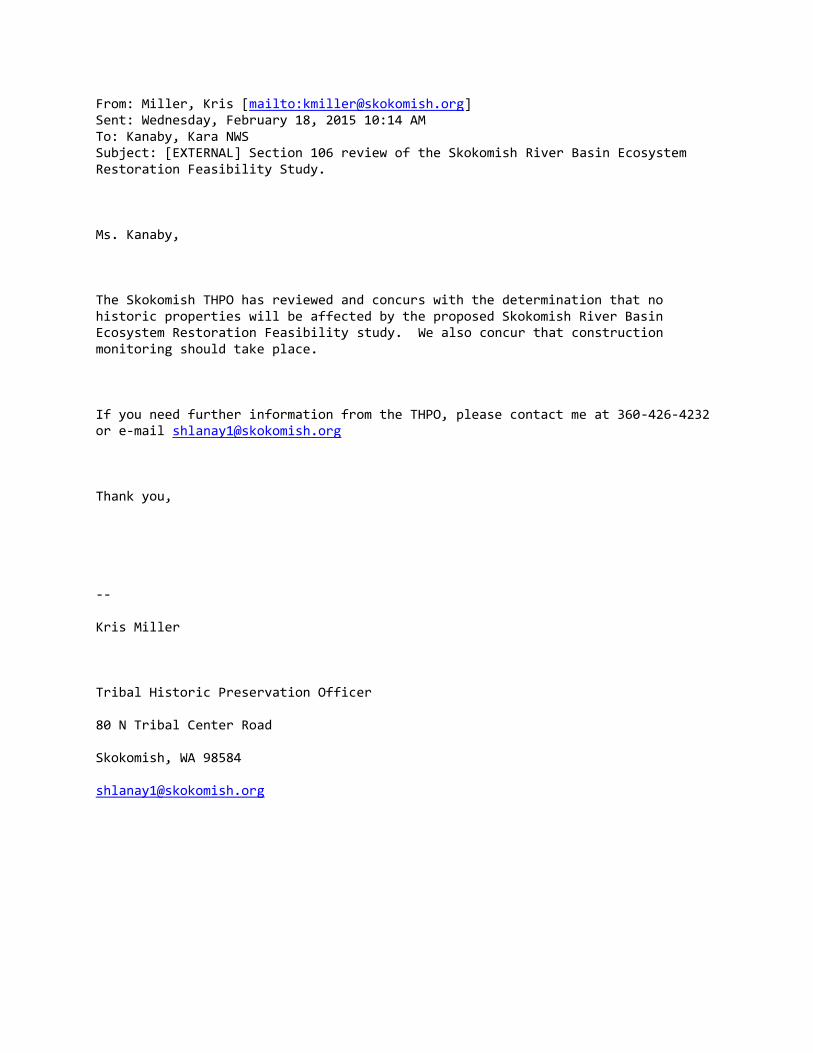
From: Miller, Kris [mailto:[email protected]] Sent: Wednesday, February 18, 2015 10:14 AM To: Kanaby, Kara NWS Subject: [EXTERNAL] Section 106 review of the Skokomish River Basin Ecosystem Restoration Feasibility Study. Ms. Kanaby, The Skokomish THPO has reviewed and concurs with the determination that no historic properties will be affected by the proposed Skokomish River Basin Ecosystem Restoration Feasibility study. We also concur that construction monitoring should take place. If you need further information from the THPO, please contact me at 360-426-4232 or e-mail [email protected] Thank you, -- Kris Miller Tribal Historic Preservation Officer 80 N Tribal Center Road Skokomish, WA 98584 [email protected]

State of Washington • Department of Archaeology & Historic Preservation
P.O. Box 48343 • Olympia, Washington 98504-8343 • (360) 586-3065
www.dahp.wa.gov
February 10, 2015
Mr. Evan Lewis
Environmental & Cultural Resources
Seattle District
Corps of Engineers
PO Box 3755
Seattle, Washington 98124
Re : Skokomish River Basin Ecosystem Restoration Project
Log No.: 120513-01-COE-S
Dear Mr. Lewis:
Thank you for contacting our department. We have reviewed the professional archaeological
survey report you provided for the proposed Skokomish River Basin Ecosystem Restoration
Project, Mason County, Washington.
We concur with your determination of No Historic Properties Affected with the stipulation for
professional archaeological monitoring. We look forward to further consultations and the draft
Monitoring Plan. Please provide the draft in an unlocked Word file.
We would appreciate receiving any correspondence or comments from concerned tribes or other
parties that you receive as you consult under the requirements of 36CFR800.4(a)(4).
These comments are based on the information available at the time of this review and on behalf
of the State Historic Preservation Officer in compliance with the Section 106 of the National
Historic Preservation Act, as amended, and its implementing regulations 36CFR800.4.
Should additional information become available, our assessment may be revised, including
information regarding historic properties that have not yet been identified. Thank you for the
opportunity to comment and a copy of these comments should be included in subsequent
environmental documents.
Sincerely,
Robert G. Whitlam, Ph.D.
State Archaeologist
(360) 890-2615 mobile
email: [email protected]

REPLY TO ATTENTION OF
DEPARTMENT OF THE ARMY SEATTLE DISTRICT, CORPS OF ENGINEERS
P.O. BOX 3755 SEATTLE, WASHINGTON 98124-3755
Environmental and Cultural Resources Branch
The Honorable Guy Miller, Chairman Skokomish Indian Tribe North 80 Tribal Center Road Shelton, Washington 98584
FEB 0 9 2015
Subject: Section 106 Review of the National Historic Preservation Act for the Skokomish River Basin Ecosystem Restoration Feasibility Study.
Dear Chairman Miller,
The United States Army Corps of Engineers (Corps), in conjunction with the Skokomish Indian Tribe (Tribe) and Mason County, is proposing to construct an ecosystem restoration project in the Skokomish River Valley. As you know, the Skokomish River Basin is located on the Olympic Peninsula in northwestern Washington at the southern end of Hood Canal. The study area is approximately 11 square miles and includes the lower Skokomish watershed, the Skokomish Valley, and Skokomish River estuary (see Figure 1 of enclosed report). The river is the largest source of fresh water to Hood Canal and is of critical importance to the overall health of Hood Canal. Alteration of the river environment and encroachment on the floodplain by man-made structures has degraded the natural ecosystem processes necessary to support critical fish and wildlife habitat throughout the basin. Furthermore, extensive river aggradation has led to a loss of hydraulic connectivity preventing salmon access to upstream habitat and spawning areas.
The Corps contacted your office via letter in 2005 when the feasibility study was initiated to invite your participation in the study process and to solicit any concerns the Tribe may have in the early planning stages. The Corps and Tribe have met many times but in 2010 the Corps and the Tribe had a face-to-face meeting to discuss the project and specifically asked for any knowledge and concerns on properties which may be of religious and cultural significance to the Tribe. In November 2013 the Corps again contacted your office as we had just identified our tentatively selected plan (TSP) and were beginning the process of producing feasibility level designs. Our letter again asked for any knowledge or concerns about cultural resources within the project area and, invited you to participate in the preparation of a programmatic agreement (PA) for this undertaking. In the past year, we have further refined their conceptual level designs and feel that delaying identification efforts through the preparation of a PA is no longer

-2-
necessary. We would like to take this opportunity to reengage you in the cultural resource aspects of the project.
The purpose of this letter is to update you on the status of the project and to summarize efforts that the Corps has taken to date to identify historic properties that may be affected by the undertaking and provides the agency determinations and findings as provided at 36 C.F.R.§ 800.4 and 5. The Corps has determined that no historic properties affected by the proposed undertaking. It should also be noted that the Corps is requiring monitoring as part of the project undertaking in order to ensure appropriate protection and treatment of any unanticipated discoveries of cultural resources should any be found during the project implementation phase.
In our 2013 letter the Corps defined the entire study area as the area of potential effects (APE) for the purpose of the PA However, the Corps has further refined the APE to include the proposed project footprints for each project component including access roads and staging areas. The acreage for the revised APE is 282 acres.
In order to compare the preliminary alternatives and identify potential impacts to cultural resources, the Corps conducted a literature review and windshield survey in 2009. Sources reviewed included previous inventory reports and site forms, historic maps, and ethnographic literature. The windshield survey was designed to characterize the nature of the resources present in the basin and to determine if there were any historic structures or other clearly visible resources that should be avoided during alternative development. In addition, the Corps gathered information from local residents through oral histories.
Based on the development of the TSP the Corps conducted a cultural resource survey of the components that make up the TSP on January 81
h, 151h, and 23rct, 2015.
The cultural resource survey included recording the Car Body levee, River Mile (RM) 9 levee and the Grange levee. In addition, shovel testing occurred at the proposed setback location for the RM 9 levee and at one of the side channel reconnection areas. Only one of the side channel reconnection areas could be surveyed. The second side channel reconnection area was inaccessible and was covered by standing water during the summer. For the RM 9 levee, shovel testing only occurred on property where the private property owners had signed rights of entry. The proposed setback location for the Grange levee was not surveyed due to lack of permission from private property owners to access their land. The LWD locations were not surveyed as the locations for the LWD are within the current main stem channel of the Skokomish River. In addition, the proposed access routes would cross private property where landowner permission has not been granted.
Subsurface shovel probes at both the proposed RM 9 setback alignment and the side channel reconnection at RM 5.6 were negative for cultural material. Three areas were unable to be surveyed: 1) The proposed setback levee for Grange levee was not surveyed due to lack of land owner permission for access; 2) The channel reconnection

-3-
site at RM 4 was inaccessible and unable to be surveyed; and 3) Areas where logjams are proposed to be placed within the Skokomish River channel were not surveyed.
The Corps is requiring construction monitoring during construction for the following locations to ensure no cultural resources are inadvertently discovered: 1) Construction of the RM 9 setback levee, and 2) The channel reconnection locations at RM 4 and 5.6. While the channel reconnection location at RM 4 was not surveyed both are relict channels of the Skokomish River and reconnection would involve re-excavating the former inlet and outlet of these channels. In addition, excavation would only be deep enough to allow water to pass into the channel during higher flows.
For the proposed setback for the Grange Levee, the Corps will only conduct a cultural resource report after landowner permission to construct the setback levee across private property has been received. As indicated earlier, the placement of the LWD is within the current Skokomish River channel. Should the proposed locations of the LWD change the Corps will review the locations to determine if a cultural resource survey may also be warranted.
Based on the Corps internal guidelines for flood control systems and structures the Corps has determined that the Car Body levee, and the RM 9/Grange levee are not eligible for listing in the National Register of Historic Places (NRHP). Though both the Car Body levee and the RM 9/Grange levee are fifty years of age these levees are a ubiquitous type of levee and are not distinguished for their engineering value. In addition, both the Car Body levee and the RM 9/Grange levee show clear loss of essential integrity due to loss of linear continuity due to breaches, and both levees are experiencing erosion. While both the Car Body levee and the RM 9/Grange levee were built to protect agricultural fields from flooding these levees did not play a central role in the agricultural development of the Skokomish River Valley. Finally, neither the Car Body levee nor the RM 9/Grange levee can provide additional information beyond what is already known about the settlement and development of the watershed.
The Corps believes we have made a reasonable and good faith effort to identify historic properties that might be affected by the undertaking. Based on the results of the records search, field investigations and information gathered through consultation, the Corps has determined that no historic properties will be affected by the proposed Skokomish River Basin Ecosystem Restoration Feasibility Study. However, Corps is requiring construction monitoring.

-4-
If you have specific questions or if we can provide any clarification about this request or should you have any other concerns regarding cultural or historic resources, please contact Ms. Kara Kanaby (Lead Archaeologist) by telephone at (206) 764-6857 or by email at [email protected].
Enclosure
Cc: (with enclosures) Kristine Miller Tribal Historic Preservation Officer Skokomish Indian Tribe North 80 Tribal Center Road Shelton, Washington 98584
Sincerely,
£tff Environmental and Cultural Resources Branch

REPLY TO ATIENTION OF
DEPARTMENT OF THE ARMY SEATTLE DISTRICT, CORPS OF ENGINEERS
P.O. BOX 3755 SEATTLE, WASHINGTON 98124-3755
Environmental and Cultural Resources Branch
Allyson Brooks, Ph.D. Washington State Historic Preservation Officer Department of Archaeology and Historic Preservation P.O. Box 48343 Olympia, WA 98504
FEB 0 9 2015
Subject: Section 106 Review of the National Historic Preservation Act for the Skokomish River Basin Ecosystem Restoration Feasibility Study. Log No.# 120513-01-COE-S
Dear Dr. Brooks:
The United States Army Corps of Engineers (Corps), in conjunction with the Skokomish Indian Tribe and Mason County, is proposing to construct an ecosystem restoration project in the Skokomish River Valley. The Skokomish River Basin is located on the Olympic Peninsula in northwestern Washington at the southern end of Hood Canal. The study area is approximately 11 square miles and includes the lower Skokomish watershed, the Skokomish Valley, and Skokomish River estuary (see Figure 1 of enclosed report). The river is the largest source of fresh water to Hood Canal and is of critical importance to the overall health of Hood Canal. Alteration of the river environment and encroachment on the floodplain by man-made structures has degraded the natural ecosystem processes necessary to support critical fish and wildlife habitat throughout the basin. Furthermore, extensive aggradation has led to a loss of hydraulic connectivity preventing salmon access to upstream habitat and spawning areas.
The Corps first contacted your office about this project in November of 2013. At that time, we had just identified our tentatively selected plan (TSP) and were beginning the process of producing feasibility level designs. Our letter asked for any knowledge or concerns about resources within the project area and it invited you to participate in the preparation of a programmatic agreement (PA) for this undertaking. In the past year, the Corps and its partners have further refined their conceptual level designs and delaying identification efforts through the preparation of a programmatic agreement is no longer necessary. We would like to take this opportunity to reengage you in the project.
The purpose of this letter is to update you on the status of the project and to summarize efforts that the Corps has taken to date to identify historic properties that may be affected by the undertaking and provides the agency determinations and

-2-
findings as provided at 36 C.F.R.§ 800.4 and 5. We request your agreement with our finding that there will be no historic properties affected by the proposed undertaking. It should also be noted that the Corps is requiring monitoring as part of the project undertaking in order to ensure appropriate protection and treatment of any unanticipated discoveries of cultural resources should any be found during the project implementation phase.
In our letter dated November 15th, 2013, alternative descriptions were provided and the letter noted that the project partners would likely recommend Alternative 2c which included the removal of Car Body levee and installation of large woody debris (LWD) upstream. The Corps has further refined the conceptual designs and has chosen a TSP. preferred alternative also referred to as the Tentatively Selected Plan (TSP). The TSP is compromised of several components that include the removal of Car Body levee, upstream LWD, side channel reconnection of two relict side channels at river mile (RM) 5.6 and 4; the construction of two setback levees for the Grange levee and the RM 9 levee (see figures 2,3,4,5 and 6 in enclosed report). In our 2013 letter the Corps defined the entire study area as the area of potential effects (APE) for the purpose of the PA. However, the Corps has further refined the APE has defined the area of potential effect (APE) to include the proposed project footprints for each project component including access roads and staging areas. The acreage for the revised APE is 282 acres.
The Corps has sought information from the Skokomish Indian Tribe regarding places which they attach religious and cultural significance and to identify any concerns they have with the project. The Corps has notified and requested information from the Skokomish Tribe in a face-to-face meeting in 2010. As one of our sponsor for this project the Corps has remained in communication with the Skokomish Tribe throughout the course of the project.
In order to compare the preliminary alternatives and identify potential impacts to cultural resources, the Corps conducted a literature review and windshield survey in 2009. Sources reviewed included previous inventory reports and site forms, historic maps, and ethnographic literature. The windshield survey was designed to characterize the nature of the resources present in the basin and to determine if there were any historic structures or other clearly visible resources that should be avoided during alternative development. In addition, the Corps gathered information from local residents through oral histories.
Based on the development of the TSP the Corps conducted a cultural resource survey of the components that make up the TSP on January 8th, 15th, and 23rd, 2015. The cultural resource survey included recording the Car Body levee, RM 9 levee and the Grange levee. In addition, shovel testing occurred at the proposed setback location for the RM 9 levee and at one of the side channel reconnection areas. Only one of the side channel reconnection areas could be surveyed. The second side channel reconnection area was inaccessible and was covered by standing water during the summer. For the RM 9 levee, shovel testing only occurred on property where the
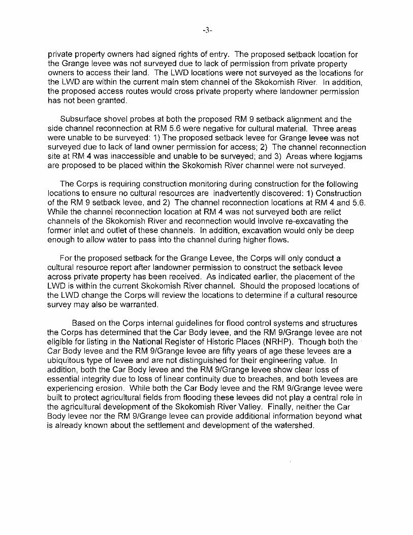
-3-
private property owners had signed rights of entry. The proposed setback location for the Grange levee was not surveyed due to lack of permission from private property owners to access their land. The LWD locations were not surveyed as the locations for the LWD are within the current main stem channel of the Skokomish River. In addition, the proposed access routes would cross private property where landowner permission has not been granted.
Subsurface shovel probes at both the proposed RM 9 setback alignment and the side channel reconnection at RM 5.6 were negative for cultural material. Three areas were unable to be surveyed: 1) The proposed setback levee for Grange levee was not surveyed due to lack of land owner permission for access; 2) The channel reconnection site at RM 4 was inaccessible and unable to be surveyed; and 3) Areas where logjams are proposed to be placed within the Skokomish River channel were not surveyed.
The Corps is requiring construction monitoring during construction for the following locations to ensure no cultural resources are inadvertently discovered: 1) Construction of the RM 9 setback levee, and 2) The channel reconnection locations at RM 4 and 5.6. While the channel reconnection location at RM 4 was not surveyed both are relict channels of the Skokomish River and reconnection would involve re-excavating the former inlet and outlet of these channels. In addition, excavation would only be deep enough to allow water to pass into the channel during higher flows.
For the proposed setback for the Grange Levee, the Corps will only conduct a cultural resource report after landowner permission to construct the setback levee across private property has been received. As indicated earlier, the placement of the LWD is within the current Skokomish River channel. Should the proposed locations of the LWD change the Corps will review the locations to determine if a cultural resource survey may also be warranted.
Based on the Corps internal guidelines for flood control systems and structures the Corps has determined that the Car Body levee, and the RM 9/Grange levee are not eligible for listing in the National Register of Historic Places (NRHP). Though both the Car Body levee and the RM 9/Grange levee are fifty years of age these levees are a ubiquitous type of levee and are not distinguished for their engineering value. In addition, both the Car Body levee and the RM 9/Grange levee show clear loss of essential integrity due to loss of linear continuity due to breaches, and both levees are experiencing erosion. While both the Car Body levee and the RM 9/Grange levee were built to protect agricultural fields from flooding these levees did not play a central role in the agricultural development of the Skokomish River Valley. Finally, neither the Car Body levee nor the RM 9/Grange levee can provide additional information beyond what is already known about the settlement and development of the watershed.

-4-
The Corps has made a reasonable and good faith effort to identify historic properties that might be affected by the undertaking. Based on the results of the records search, field investigations and information gathered through consultation, the Corps has determined that no historic properties will be affected by the proposed Skokomish River Basin Ecosystem Restoration Feasibility Study. However, Corps is requiring construction monitoring as noted previously.
At this time, the Corps is requesting the Washington SHPO's review and agreement with our finding that there will be no historic properties affected by the project. We appreciate your consideration of our request. If you have specific questions or we can provide any clarification, please contact Ms. Kara Kanaby (Lead Archaeologist) by telephone at (206) 764-6857 or by email at [email protected].
Enclosure
Sincerely,
Evan Lewis, Chief Environmental and Cultural Resources Branch

State of Washington • Department of Archaeology & Historic Preservation
P.O. Box 48343 • Olympia, Washington 98504-8343 • (360) 586-3065
www.dahp.wa.gov
December 5, 2013
Mr. Rolla L. Queen
Environmental Resources Section
Corps of Engineers – Seattle District
PO Box 3755
Seattle, Washington 98124-3755
Re: Skokomish River Basin Ecosystem Restoration Feasibility Study
Log No.: 120513-01-COE-S
Dear Mr. Queen:
Thank you for contacting our department. We have reviewed the materials you provided for the
proposed Skokomish River Basin Ecosystem Restoration Feasibility Study, Mason County,
Washington.
We look forward to further consultations and the development of a Programmatic Agreement to
address the totality of the Project and its elements.
Please keep us apprised of your next steps and we look forward to participating in future
meetings and consultations..
We would also appreciate receiving any correspondence or comments from concerned tribes or
other parties that you receive as you consult under the requirements of 36CFR800.4(a)(4).
These comments are based on the information available at the time of this review and on behalf
of the State Historic Preservation Officer in compliance with the Section 106 of the National
Historic Preservation Act, as amended, and its implementing regulations 36CFR800.4. Should
additional information become available, our assessment may be revised.
Thank you for the opportunity to comment and we look forward to receiving information on the
results of your efforts.
Sincerely,
Robert G. Whitlam, Ph.D.
State Archaeologist
(360) 586-3080
email: [email protected]
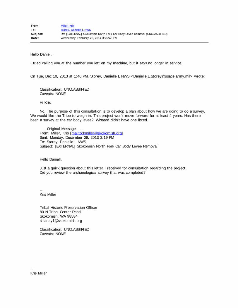
From: Miller, KrisTo: Storey, Danielle L NWSSubject: Re: [EXTERNAL] Skokomish North Fork Car Body Levee Removal (UNCLASSIFIED)Date: Wednesday, February 26, 2014 3:25:46 PM
Hello Daniell,
I tried calling you at the number you left on my machine, but it says no longer in service.
On Tue, Dec 10, 2013 at 1:40 PM, Storey, Danielle L NWS <[email protected]> wrote:
Classification: UNCLASSIFIED Caveats: NONE Hi Kris, No. The purpose of this consultation is to develop a plan about how we are going to do a survey. We would like the Tribe to weigh in. This project won't move forward for at least 4 years. Has therebeen a survey at the car body levee? Wisaard didn't have one listed. -----Original Message----- From: Miller, Kris [mailto:[email protected]] Sent: Monday, December 09, 2013 3:19 PM To: Storey, Danielle L NWS Subject: [EXTERNAL] Skokomish North Fork Car Body Levee Removal Hello Daniell, Just a quick question about this letter I received for consultation regarding the project. Did you review the archaeological survey that was completed? -- Kris Miller Tribal Historic Preservation Officer 80 N Tribal Center Road Skokomish, WA 98584 [email protected] Classification: UNCLASSIFIED Caveats: NONE
--Kris Miller

Tribal Historic Preservation Officer80 N Tribal Center RoadSkokomish, WA [email protected]

REPLY TO ATTENTION OF
DEPARTMENT OF THE ARMY SEATTLE DISTRICT, CORPS OF ENGINEERS
P.O. BOX 3755 SEATTLE, WASHINGTON 98124-3755
Environmental and Cultural Resources Branch
Allyson Brooks, Ph.D. State Historic Preservation Officer Department of Archaeology and Historic Preservation Post Office Box 48343 Olympia, Washington 98504-8343
NOV 1 5 201:i
SUBJECT: Development of a Programmatic Agreement for the Skokomish River Basin Ecosystem Restoration Feasibility Study
Dear Dr. Brooks:
U.S. Army Corps of Engineers (Corps) has partnered with the Skokomish Indian Tribe and Mason County to study and evaluate potential ecosystem restoration projects within the Skokomish River Basin under the authority of the Corps' General Investigation (GI) Program. The purpose of the study is to evaluate ecosystem degradation in the Skokomish River Basin; to formulate and evaluate potential solutions to these problems; and to recommend a series of feasibility level projects that have a federal interest and are supported by the non-federal sponsors. The study will culminate in the completion of a programmatic level environmental impact statement (EIS) and feasibility level design of the preferred alternative that will be sent to the Chief of Engineers for approval and then submitted to Congress for authorization and eventually appropriations. Project specific environmental documents will be developed as the projects are further defined. Because this is a feasibility study and effects on historic properties cannot be fully determined prior to approval of an undertaking (in this case Congressional Authorization) the Corps is seeking to execute a programmatic agreement (PA) with your office pursuant to 36 CFR 800. 14(b) in order to fulfill its responsibilities under Section 106 of the National Historic Preservation Act (NHPA).
The Skokomish River Basin is located on the Olympic Peninsula in northwestern Washington at the southern end ofHood Canal. The study area is approximately 11 square miles and includes the lower Skokomish watershed, the Skokomish Valley, and Skokomish River estuary (Figure 1 ). The river is the largest source of fresh water to Hood Canal and is of critical importance to the overall health of Hood Canal. Alteration of the river environment and encroachment on the floodplain by man-made structures has degraded the natural ecosystem processes necessary to support critical fish and wildlife habitat throughout the basin. Furthermore, extensive aggradation has led to a loss of hydraulic connectivity preventing salmon access to upstream habitat and spawning areas.
The Corps is currently analyzing two action alternatives that are composed of groupings of restoration projects. Each alternative was developed with a "base" measure that addresses the need for increased quantity and quality of pool habitats in the river as well as year-round fish passage near the confluence. Up to eight incremental measures or projects (e.g., side channel

-2-
reconnections, levee setbacks, placement of large woody debris, etc.) were added to these "bases" to capture supplementary benefits. A description of the alternatives is provided below.
Alternative Descriptions
Alternative 1: No Action Alternative
No project would be recommended under the No Action Alternative.
Alternative 2: Car Body Levee Removal (3 Scales)
Alternative 2 consists of a "base" measure that removes the levee on the north side of the mainstem near the original North Fork confluence, refened to locally as the car body levee. Mainstem flows would then be diverted into the North Fork channel and reenter the mainstem at the confluence location (Figure 2). This would bypass the area where the river goes dry during the summer and would provide improved fish migration. A portion of flood flows would continue to flow in the channel.
Eight possible restoration projects or increments could be added to this "base'' to form complete alternatives. Different scales of each alternative were developed based on the nwnber of increments added to the "base." Please see Figure 2 for a better explanation of what these increments would entail.
Car Body Levee Removal Car Body Levee Removal Car Body Levee Removal Scale (Alternative 2A) (Alternative 2B) (Alternative 2C) Base Alternative #3: Car Body Base Alternative #3: Car Body Base Alternative #3: Car Body Levee Removal Levee Removal Levee Removal Increment #35: Upstream L WD Increment #35: Upstream LWD Increment #35: Upstream L WD Installation Installation Installation Increment #9: Side Channel lncrement #9: Side Channel Reconnection Reconnection Increment #37: Grange Levee Increment #37: Grange Levee Setback Setback Increment #28: River Mile 9 Increment #28: River Mile 9 Levee Setback Levee Setback Increment #39: Hunter Creek Increment #39: Hunter Creek Mouth Restoration Mouth Restoration Increment #40: Hunter Creek Increment #40: Hunter Creek Side Channel Restoration Side Channel Restoration Increment #43: Weaver Creek Side Channel Restoration Increment #26: Dips Road Setback

-3-
Alternative 3: Riverbed Excavation (2 Scales)
Under this alternative, the summer low flow problem would be addressed through two different scales of dredging (Figure 3). Under Alternative 2A, 2.5 million cubic yards would be removed from the mainstem channel between river miles 0 and 9. Under Alternative 2B, l.2 million cubic yards would be removed between river miles 3.5 and 9. Under both scales of Alternative 2, there would be a need for periodic maintenance to remove sediment accumulations. Dredged material would be placed in the estuary and nearshore of Annas Bay. This beneficial-reuse of material would provide suitable hard substrate for shellfish attachment. The eight possible increments discussed above would be added to both scales of this alternative.
In order to compare the preliminary alternatives and identify potential impacts to cultural resources, the Corps conducted a literature review and windshield survey. Sources reviewed included previous inventory reports and site forms, hjstoric maps, and ethnographic literature. Completed in 2009, the windshield survey was designed to characterize the nature of the resources present in the basin and to determine if there were any historic structures or other clearly visible resources that should be avoided during altemaLive development. The Corps also requested information about cultmal resource concerns from the Skokomish fndian Tribe 's Tribal Historic Preservation Officer in a face to face meeting in 2010 and gathered information from local residents through oral histories.
Conceptual designs have been developed for the two actjon alternatives and a draft integrated Feasibility Report/Environmental Impact Statement (EIS) has been prepared. At this time Alternative 2C has been identified as the preferred alternative in the draft integrated feasibility report/EIS. Alternative 3 is not recommended due to the deleterious effects dredging could have on other aspects of fish habitat as well as the an1icipated costs of continued maintenance dredging. Selection of the preferred alternative will be confirmed after the Draft Feasibility Report/EIS has gone through public review.
After public review, the Corps and project sponsors will begin to develop "feasibilitylevel" designs (typically a 35% design) of the preferred alternative. These designs will be included with the Final Feasibility Report/EIS and submitted to the Chief of Engineers and eventually Congress. After Congressional approval of the project and appropriations are received, the Corps would prepare environmental assessments (EA)s or a supplemental EIS for each of the restoration projects. rt is anticipated that traditional Section 106 identification efforts such as cultural resource surveys would occur at this stage.
The Corps would like to take this opportunity to invite you to participate in this next phase of the study both tJu·ough your comments on the preferred alternative and through the preparation of the PA. We anticipate that the PA would layout a clear process for defining the area of potential effect; define the level of inventory and evaluation efforts as the preferred alternative is further refined; and propose best management practices or standard treatments for specific property types or effects.
In addition to the Skokomish Indian Tribe and Mason County, the Corps has identified the City of Shelton and the Mason County Historic Preservation Commission as potential participants in the development of the PA. The Corps is also notifying the Advisory Council on
-4-
Historic Preservation (ACHP) as required at 36 CPR 800.6(a)(l)(i)(c) and inviting them to participate. We would appreciate yow- assistance identifying additional consulting parties.
We look forward to collaborating with your office on the development of this PA. For more information about this project or clarification about this request, please contact Danielle Storey, Cultural Resources Lead, via telephone at (206) 764 4466 or via email at [email protected]. I may be reached by telephone at (206) 316-3096 or by email at [email protected].
Sin,ty, jjlf /t/1, ,,_ r;JAAll~)J ~ ii I. y
~ v' Rolla Queen, Chief Cultural Resources Section
Enclosures
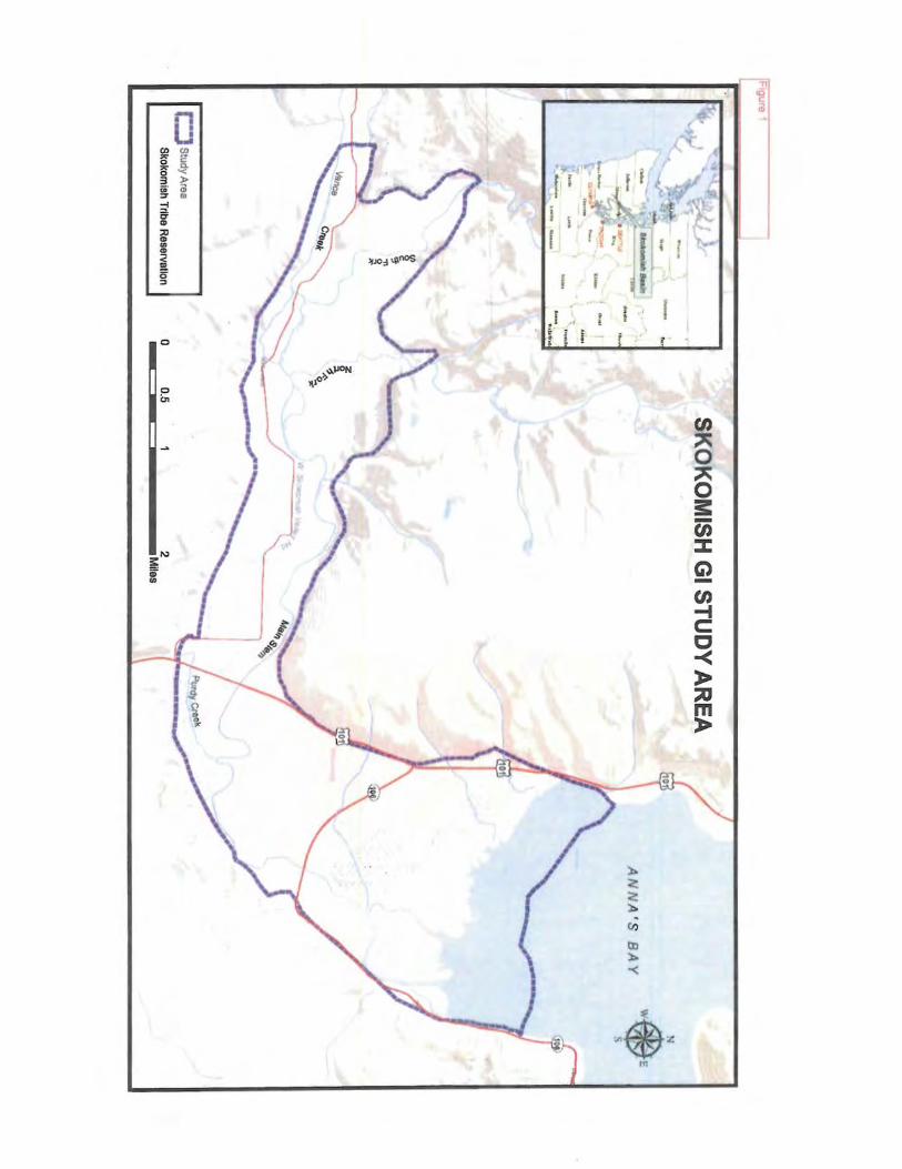
0
I ,, ~ · : i. ~·
tA -t c: c -< )> ::u m )>
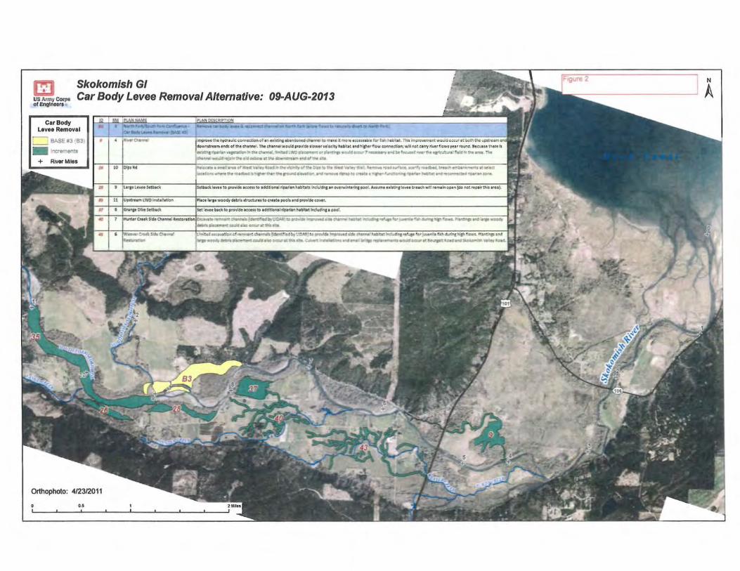
Cl Skokomish GI US Army Corpe 01 Engtneera
Car Body Levee Removal Alternative: 09-AUG-2013
Car Body Levee Removal
~ _ _ BASE 113 B3
- "O"e-erts River Miies
Orthophoto: 4/2312011
0.5
1:::~::~ :=~===n:~;:::.,:::~:;::,~:~0'::1
,1:.::;~.':;~~ ::·~;; ~:::~'::~e>~~~~;: =:~;;,:~;;;,~~~r::C::'a~':;::~::r~f:, .._ .... ,~ .. .....-:11~,,.N~-- ._..ff'.W'Or'•e.......-·4•'f4·... 14~ , .• ...uaa-.•· ldtrit'~ .,...""t~· ,.e~ · ... ,_.,. -.._ a.""'* o..o,.crot ... oo--.1tt._oow-· ... •-.,...ot"•
10 ID11'• •d ·~•""''•t"flto"W\it«\'t.._."°9o•h~•'NO.~t,.'Atttva•..,w.••t"M11t"O.,~.tu~~~r.:ie"lll_~.:~
.OC.~~ ......... ~"Ct.-.C'Sr....,• ..... ~ ... ,.. ........ !- ...... .. ...... !O I •tt ···'"'Cl ...... "Ol ...... ~ .. ~.-.=~....-.M"'~ ....
t ; uratt .. t \·tt Stibtc\ S.lbK'lt Mvtt :o pn:>v4t t :Ct H ;o tckl:tf,ont l r(ptf t"I ttl~tU ·nc:tt/~ tftO\otrv.~tllns 0001. AHlimt: ubUrt kvH bru t.hd r«m1in 0';11:3fdo r..ot rtPl.ir !._,, t•tt).
[Vpt;U-Hf"\ l\VO 1~1tt1ttb"' Pbce t&•pwooOy~;s s:-.xt-:xutoue-ate ooolJtl'!dorov!'de<owt .
• lh"t*-S.•1*\ k : .n"H bt~ :o p:-o-F4t ac«H :0 a«!~!'lll tfpt -it!';Ntfttt ~ t COO:..
1 l~A-tCrtt\ SdeO..-.;AtJ:o•tOonlt~ ............ --" ....... '~ .. 1..j,JI ....
..... ~co...cl .. KC."f'~t-"•fr'llll'
..,.'o. "!!""" ....................... ...-.. " .... ....
' 1v:..-~_.,t .• ......., . .,... 1 ......... .,~e',.w!~·w· .... ~ti,:..·"'••' ·~~'-twd~~~·~~~"'t"t•••:· ,,_..•~ ~1 ... ~...:r .. ..owt oo•"'!""'SS'-... " ........ ...-.~:.-4•-09CICW"ei~•"-. ~ .,.,. ~9""PN1~~ ...aoa:1at......_!-.e.Kr'CI~-""· -'•·•..,..
N
A

m Skokomish GI us Mriy eor.,. of!.vn-t
Riverbed Excavation Alternative: 09-AUG-2013
Riverbed Excavation
BASE#1 '.61
- oicre<"er:s + River Moles
Orthophoto: 4/2312011
4 l~O.~
!O I"~ •"
t IL•l'lf:t.nttSetblct
fVP't,u•-i LWOWtate~
I IG--trctO'\eSetbKt
... ,~!"'!Ill~~ '""VO...eft~-*~....o~of a°'~'a."ICIO..-"'ld~- tll._~lt.,...t t~!f'!'~t"l~U"..Tblt~~-0"*9oo:o1att«hN.-r."'U"'.ll~;
~t"t•...,.._o't.'lt~"!"le. :. r....~· __..i:irowbe,...., ... _..,m1.t~•,_._..,~_..c:o-'T'l9C~•"!IDtc.~·-.r~o;nrea"' -0"°"1tc~•~.1
~·~·":.._..._..-r. l=-'~:~~:>. ~;.wo9re(......cor1M"t.1t11..-MD1,f~.., .. -.. ... ,~ ...... t11i1~ ,-" -~~ ...... - :N =""9- -.,.Jrd,.*~Odc.tle'W a~h~tl'ldO'!'.'!etltt
~~ar.r. : ..... o!v..est•o'W .... -..ctk:... .. ~t!~OWU:!'ll''Ats!~litt-'-t~~....,.K•~'"ONIMd.111'~...-~·t.....:t oca;.oo,a-..,..~~· · ~: ... ~~··11!,... ~ --~ · ~°"' ... ~ •• - ~,;'l/C ........ "09"'.l"' .. ~~WIC~~"'iOll ..... 1"""'
Setb•<t '.ttte to proWSc uceu to add:tionl.l rfp•""•-" hl~ats ""1.:.ct!l!f a" ovenYt~~"'I POot. Au.mt U•:.rcJc\"H b'Hch wa re.."N3r cc;e.n (do rot re;i.t~ th'i ru).
IPlace l•fJt wo.octy ddldJ struct\ll'H to etHte poo~ •!Id~ covit1.
Set~~ to ptCW5dt K«H to ~l'(p•f'".1.nNbttet iricW'-C• ooo'~
1 ltNntttOtt'tSldtO!tNlt!lltttont.:or.IEJuva?e.:>~cha"W)t!slldtt'lV"-ecSbf'UONl)toorW'dt.,._owd~d'-•~"•btat ·"ICW__,.·e'-.efotfwtnler.s.h~h"Ptan..~•1"!16tCJ•nd:a.ritw.oo~ debris p:,,ce:Mc:t «>'*I -~'°C«W It tJo.!s sU.
:WU\'tf Out S:-dt 0.....,..411 1~atavai;o.,orrt:<T~:d"A1r•b~~brUONl)tcpr.cw'dt~ff•·~chll..,.. tub:."lttltid.dircttf"ftfO'~e.-4.-"td.:qKPf!cws.K•!'!t-TaJ•~ ~.upwoodvdt:br".s ~M:~"l!cod.d a:SOo«ur 1t tfot'_s t :O.e. C.....,t"1.tN:ta.r.r~ 1-"Mftl"'lt' ~ rto.•<t~ wotM~ •l~'C.Ao--ld..-d ~Vaky~otd
N
A

REPLY TO ATTENTION OF
DEPARTMENT OF THE ARMY SEATILE DISTRICT, CORPS OF ENGINEERS
P.O. BOX 3755 SEATILE, WASHINGTON 98124-3755
Environmental and Cultural Resources Branch
The Honorable Guy Miller, Chairman Skokomish Indian Tribe North 80 Tribal Center Road Shelton, Washington 98584
Dear Chairman Miller:
NOV 1 5 2013
As you are aware, the U.S. Anny Corps of Engineers (Corps) has partnered with the Skokomish Indian Tribe and Mason County to study and evaluate potential ecosystem restoration projects within the Skokomish River Basin under the authority of the Corps' General Investigation Program. The purpose of the study is to evaluate ecosystem degradation in the Skokomish River Basin; to formulate and evaluate potential solutions to these problems; and to recommend a series of feasibility level projects that have a federal interest and are supported by both the Skokomish Indian Tribe and Mason County. The Corps contacted your office via letter in 2005 when the feasibility study was initiated to invite your participation in the study process and to solicit any concerns you may have at the early planning stages. Since that point in time, two action alternatives have been developed (Appendix A). The Corps would like to take this opportunity to re-engage your participation as a consulting party under Section I 06 of the National Historic Preservation Act (NHPA). We are specifically seeking to execute a programmatic agreement (PA) with your office pursuant to 36 CFR 800.14(b) in order to fulfill our responsibilities under Section 106 of the NHP A.
Conceptual designs have been developed for the two action alternatives and a draft integrated feasibility report/environmental impact statement (FR/EIS) has been prepared. A summary of the alternatives is included in Appendix A. At this time Alternative 2C bas been identified as the preferred alternative. Alternative 3 is not recommended due to the deleterious effects dredging could have on other aspects of fish habitat as well as the anticipated costs of continued maintenance dredging. Selection of the preferred alternative will be confirmed after the draft FR/EIS has gone through public review.
After public review, the Corps and project sponsors will begin to develop "feasibilitylevel" designs (typically a 35% design) of the preferred alternative. These designs will be included with the Final Feasibility Report/EIS and submitted to the Chief of Engineers and eventually Congress. After Congressional approval of the project and appropriations are received, the Corps would prepare environmental assessments (EAs) or a supplemental EIS for each of the restoration projects. It is anticipated that traditional Section I 06 identification efforts such as cultw·al resource surveys would occur at this stage.
Because this is a feasibility study and effects on historic properties cannot be fully determined prior to approval of an undertaking (in this case Congressional Authoriz.ation is needed to undertake design and construction) the Corps is proposing to use a phased process to

-2-
identify and evaluate historic properties until the specific aspects or locations of the alternatives are more fully refined. This process would be codified in the PA. We anticipate that the PA would lay out a clear process for defining the area of potential effect; define the level of inventory and evaluation efforts as the preferred alternative is further refined; and propose best management practices or standard treatments for specific property types or effects.
We are contacting you both as a Tribe with traditional and cultural resource interests and concern within the study area and as a Tribe with a designated Tribal Historic Preservation Officer (THPO) whose lands fall within the study area. The Corps has also identified the State Historic Preservation Officer, Mason County, the City of Shelton and the Mason County Historic Preservation Commission as potential participants in the development of the PA. The Corps is notifying the Advisory Council on Historic Preservation (ACHP) as required at 36 CFR 800.6(a)(l)(j)(c) and inviting them to participate. We would appreciate your assistance identifying any additional consulting parties.
We look forward to collaborating with your office on the development of this PA. For more information about this project or clarification about this request, please contact Danielle Storey, Cultural Resow-ces Lead, via telephone at (206) 764 4466 or via email at Daniclle.l..Slorcy.!t_usucc.army.m11. I may be reached by telephone at (206) 316-3096 or by email at Rolla.LQ!!.ccn(u usacc.army .nul.
Enclosure
Cc: (with enclosures) Kristine Miller Tribal Historic Preservation Officer Skokomish Indian Tribe North 80 Tribal Center Road Shelton, Washington 98584
Rolla Queen, Chief Cultural Resources Section
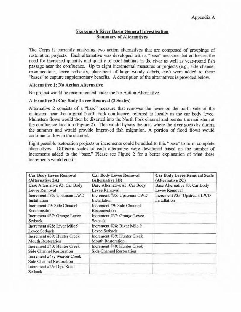
Skokomish River Basin General lnvestigation Summary of Alternatives
Appendix A
The Corps is currently analyzing two action alternatives that are composed of groupings of restoration projects. Each alternative was developed with a "base" measure that addresses the need for increased quantity and quality of pool habitats in the river as well as year-round fish passage near the confluence. Up to eight incremental measures or projects (e.g., side channel reconnections, levee setbacks, placement of large woody debris, etc.) were added to these "bases" to capture supplementary benefits. A description of the alternatives is provided below.
Alternative 1: No Action Alternative
No project would be recommended under the No Action Alternative.
Alternative 2: Car Body Levee Removal (3 Scales)
Alternative 2 consists of a "base" measure that removes the levee on the north side of the mainstem near the original North Fork confluence, referred to locally as the car body levee. Mainstem flows would then be diverted into the North Fork channel and reenter the mainstem at the confluence location (Figure 2). This would bypass the area where the river goes dry during the summer and would provide improved fish migration. A portion of flood flows would continue to flow in the channel.
Eight possible restoration projects or increments could be added to this "base" to form complete alternatives. Different scales of each alternative were developed based on the number of increments added to the "base." Please see Figure 2 for a better explanation of what these increments would entail.
Car Body Levee Removal Car Body Levee Removal Car Body Levee Removal Scale (Alternative 2A) (Alternative 2B) (Alternative 2C) Base Alternative #3: Car Body Base Alternative #3: Car Body Base Alternative #3: Car Body Levee Removal Levee Removal Levee Removal Increment #35: Upstream LWD Increment #35: Upstream L WO Increment #35: Upstream L WD Installation fnstallation Installation Increment #9: Side Channel Increment #9: Side Channel Reconnection Reconnection Increment #37: Grange Levee Increment #37: Grange Levee Setback Setback Increment #28: River Mile 9 Increment #28: River Mile 9 Levee Setback Levee Setback Increment #39: Hunter Creek Increment #39: Hunter Creek Mouth Restoration Mouth Restoration fncrement #40: Hunter Creek Increment #40: Hunter Creek Side Channel Restoration Side Channel Restoration Increment #43: Weaver Creek Side Channel Restoration Increment #26: Dips Road Setback

Appendix A
Alternative 3: Riverbed Excavation (2 Scales)
Under this alternative, the summer low flow problem would be addressed through two different scales of dredging (Figure 3). Under Alternative 2A, 2.5 million cubic yards would be removed from the mainstem channel between river miles 0 and 9. Under Alternative 2B, 1.2 million cubic yards would be removed between river miles 3.5 and 9. Under both scales of Alternative 2, there would be a need for periodic maintenance to remove sediment accumulations. Dredged material would be placed in the estuary and nearshore of Annas Bay. This beneficial reuse of material would provide suitable hard substrate for shellfish attachment. The eight possible increments discussed above would be added to both scales of this alternative.

rigure 1
·-
CJ Study Area
Skokomlah Tribe Reservation
..
-- ;
-..... ,
z 0 ;:i.
~,(> o~
"'
SKOKOMISH GI STUDY AREA
0 2 --====--===-------Miles
0.5
"./
ANNA'S BAY w$ E
s
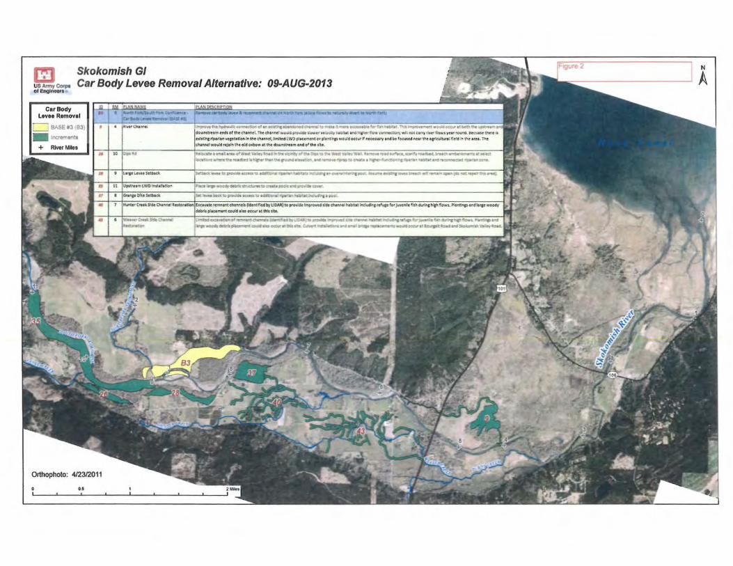
Skokomlsh GI • us Anny COfpe of l!ngl,,_•
Car Body Levee Removal Alternative: 09-AUG-2013
Car Body Levee Removal
;. "~ BASE #3 831
- ;nct'9'l'ents + River MMes
Orthophoto: 4/2312011
10 1-·· ' l ltftt ltwt S.tbac\
UPtl/H .,,, lWO l~tt!ll tro ..
• l<h ... :>'lt $ttbocl<
~t,..~.:SCC'0""'19C:1Vcf t•9t r.,.aot_.._.c.•- ••""•~ ,.....,...: + 1tH'.,,."",,.r ~! - s ~Viro...ICIOCCU'l!bo~"'~"'...-....,.. .... downttfume:ndt of tl'e c'°11nnel ihe c.f\a"ll'lt' Y.O""d ptOV.ot "''"'' .,, O<•\'r l14ul•t •.nctn•lhft f ow COANCLOfl; w. .. notnrty r.ver f:owt yea1 rouno. &cMse l.l'lt'• tt tx1strna ripl1i1nve:1~;1tlol'lt1 the c't-1nn.eC. hitedl \Y) pl1ct"Mnt or pf1ntrnc1 wor,,.d occurY M:CtSH'V 1rKtbt focvs.d ~u lflu1r!ct/tutillCe~ .,..,_ t'w 110. f "'e cN!\M1would1eJol"t tl'!e oid Ollbow tt lht dOwnst•ttM tnd o ' tht •ttt.
titO:Ctf..,.,t .... O''Wlifft\i1..ey*ON"'tr'f:"'°"'trO'U"l:>Vttol ... lttt.!._ ..... ,'ftt .., .. .._.."'O~,_;~~rMdwd,&lil't.ct'e'!!!Ot~I~~
oa·'°"'~:.!'le"O~ ·~~"Wl~FO.nd• .... •~"'4~,...toet11i.tJ!itrll~~·r»U:a..s~~&o'!'Jt,
·~-...-~~•Mll'"...Jtee·~~·~~~·~-=--11~ ... N':!!t"'t'JOO\.~~-....~~~!",...,,!GO'."!Ot ..... •~~ .......
'9.Kt ' ..... 90031ii~t:.-...c--r•toC"MW' ....... ft'vlilite911<t•-
~ ~:iedl.:0Cpi'O'WOll1Can::~')f."5pt~.1 "":11~:. - "'-- ... po. ....
7 l~r (ttt'C ~ ChtMC" "tJtOt&tlon)bov•te tt!J'.ltl~t cN~ (kler.Q;'ff by UOAA.) to p•oWSt fmp'owd 116t ,...,.,... ... bit.It rncfud'ra rt:'Up for ~it r.;1.~ N"""I w;p-:o-.,s.. P"A!\&p •I'd t.tp WOO(ft/
deMs:P:~l"'..v.t ~ f!.JO «<ir•t Ws • •
'WK ...... ............... ~.,-~ ...... ~~~ .... ,,.~~"'~MJ "'' .., ... , ..,.......,,.=--ra-.Gla"°"'•~ ...... ~·-OHl ................ ___ -..o,_
N
A

Skokomish GI I!] us Amr/ Corpe OI E'191nwa
Riverbed Excavation Alternative: 09-AUG-2013
Riverbed Excavation
BASE#' B'
- "'Cf"9'""!er'~S + River Miles
Orthophoto: 412312011
O.$
.c 1~ir .... a.~
• to IOtps~ct
• 9 1 .............. ~
• 111~
0 ' 8 l~"lt :-.<.e St.lMC'
·~;"tiMMe~r•t
.... .rnpro .. t tne lrj'aii ..... ; conned.on of t n tA •;,nf t\HlnOrOl"CO W hftt> to mt .. t It mort i<:ttn•I>• tor f1•Aht1.11ttt. Tr- s; 1fl'IP,-O\'tmtnt .,.ouo ottur tt cotl" •-.. dowrutru.m e~sof lhe <.t-tMel. the c~tl":OtlwCHU provfde ,~o'4tt vt!ccityh1bitt t tnd ~after flow comtction;wtll l'IOt urrytf'i'tt fJows ynr rouf'ld, atcuast t1'Jt.tt t1 tx:r1tk\Jr;p11'1nvt1t; t\lo" In \M chennel. lf'wl..'14 LWO p!tCtmtrt orp!t~ wouldottut I! ntctUtty tndbe fo<wstd nttr tl"t tpkUtu~· fie~ln t!w: ttH. TM cMMt! ~rt:ob the old oxbow t t ~ dowr..sttu-i t!\dof t"9 slt:t.
llte!ocate• •~'I •~n of West v.·•ey 80.d ... t"wt/'cfrllt'fof the~ to t~t WtstVtlityWd. ltt,,,.,,n: rot d surllct, Jetf"v '°'c9:it4. btt~•-~~•"\mt'ttJ tt set--tet '"ICJ··c"'tw._... • ._.~,, .... ,..,.,... • ._.....~,..~.·-.··- ....,...--...e""'Cno.•O"M"".e•~'-'!'...,....~...-.·w~~ .... ~-1--tccr.MDit•:aa~~f'P~!llMt ... ~~~-.. ~~~~~
'.:. .............. ~ .....
N
A
CLEAN WATER ACT SECTION 404(b)(1)
CLEAN WATER ACT SECTION 404 ANALYSIS
Skokomish River Basin Ecosystem Restoration General Investigation
Mason County, Washington
Prepared by:
U.S. Army Corps of Engineers
Seattle District
Environmental and Cultural Resources Branch
April 2015

Skokomish River Basin Ecosystem Restoration – Clean Water Act Section 404(b)(1) Analysis 1
1 INTRODUCTION
The purpose of this document is to record the U.S. Army Corps of Engineers (Corps) compliance evaluation of the proposed actions within the Skokomish River Ecosystem Restoration General Investigation in Mason County, Washington, pursuant to the Clean Water Act (CWA), and the General Regulatory Policies of the Corps. Specifically, Section 404 of the CWA requires an evaluation of impacts for work involving discharge of fill material into the waters of the U.S., and evaluation guidance can be found in the CWA 404(b)(1) Guidelines [40 CFR §230.12(a)]. The General Regulatory Policies of the Corps of Engineers [33 CFR §320.4(a)] provide measures for evaluating permit applications for activities undertaken in navigable waters.
Attachment A provides the Corps’ analysis of compliance with the CWA Section 404(b)(1) and the General Regulatory Policy requirements.
1.1 Project Background
The purpose for the proposed action is to work within the defined study area to enact solutions within the Corps’ authority to restore ecosystem process, structure, and function in the aquatic environment by addressing the primary problems identified during the feasibility study. Effort toward improving the aquatic ecosystem should include addressing lack of wetland and side‐channel connections, increasing channel complexity, increasing large woody debris (LWD), increasing pool depth and frequency, restoring degraded riparian conditions, improving conditions in the reach of the river that dries up each summer, and improving channel capacity to the maximum extent practicable. Restoration of ecosystem structures, functions, and processes will benefit nationally significant resources in the study area.
The Skokomish River Basin is located on the Olympic Peninsula in northwestern Washington (Figure 1, inset). The study area is approximately 11 square miles comprised of the lower Skokomish watershed, the Skokomish Valley, and Skokomish River estuary (Figure 1). The area is characteristic of the enormous beauty and versatile environment of Hood Canal and Puget Sound.
The Skokomish watershed drains approximately 230 square miles from three major tributary basins, the North Fork (118 square miles), the South Fork (76 square miles) and Vance Creek (29 square miles). The river collects flow from these steep, mountainous basins and drains into a flat, alluvial plain approximately ¾ to 1½ miles wide known as the Skokomish Valley. Richert Springs, Hunter, Weaver, and Purdy Creeks are predominantly spring fed tributaries that flow through agricultural lands in the southern portion of the Skokomish Valley floodplain before entering the mainstem Skokomish River. The Skokomish River mainstem flows through the Skokomish Valley to the Skokomish estuary, consisting of the mouth of the Skokomish River and the delta that is tidally influenced. It is the largest and most complex river estuary in Hood Canal. The Skokomish River empties into Annas Bay at the southern end of Hood Canal, an arm of Puget Sound.
The Skokomish River Basin is a large and complex watershed. Numerous Federal, State, and local agencies are working within their respective authorities to implement restoration projects throughout the watershed. While previous and continuing restoration efforts are having localized benefits, there remains a need for larger‐scale action by the Corps. The Corps has several significant and unique opportunities to address problems in the Lower South Fork, Skokomish River mainstem, and tributaries (Weaver Creek, Vance Creek, and Purdy Creek) where many impacts from the upper watershed are manifested. As a result, the study area for the General Investigation (GI) has focused on the lower 11 miles of the river. Figures 1 and 2 show the location of the Skokomish River Basin and GI study area.
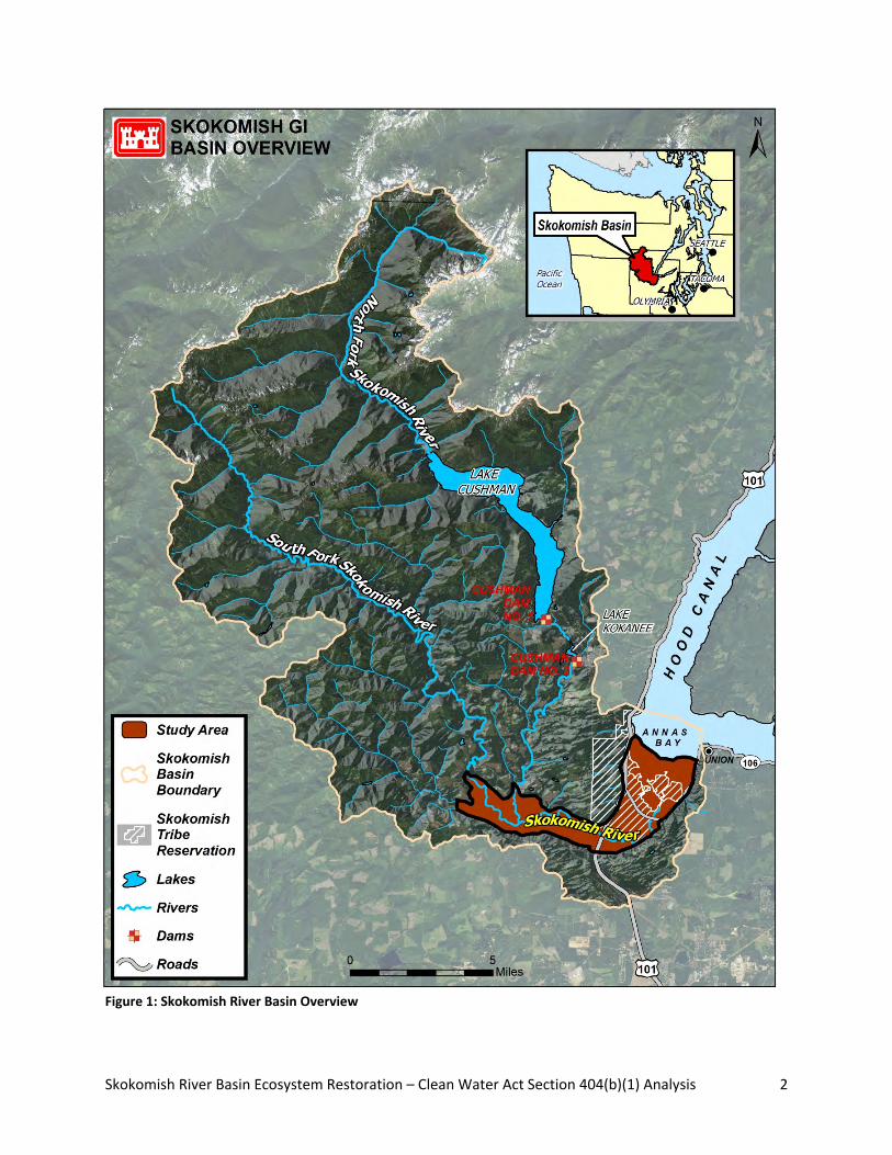
Skokomish River Basin Ecosystem Restoration – Clean Water Act Section 404(b)(1) Analysis 2
Figure 1: Skokomish River Basin Overview
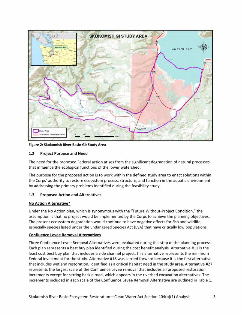
Skokomish River Basin Ecosystem Restoration – Clean Water Act Section 404(b)(1) Analysis 3
Figure 2: Skokomish River Basin GI: Study Area
1.2 Project Purpose and Need
The need for the proposed Federal action arises from the significant degradation of natural processes that influence the ecological functions of the lower watershed.
The purpose for the proposed action is to work within the defined study area to enact solutions within the Corps’ authority to restore ecosystem process, structure, and function in the aquatic environment by addressing the primary problems identified during the feasibility study.
1.3 Proposed Action and Alternatives
No Action Alternative*
Under the No Action plan, which is synonymous with the “Future Without‐Project Condition,” the assumption is that no project would be implemented by the Corps to achieve the planning objectives. The present ecosystem degradation would continue to have negative effects for fish and wildlife, especially species listed under the Endangered Species Act (ESA) that have critically low populations.
Confluence Levee Removal Alternatives
Three Confluence Levee Removal Alternatives were evaluated during this step of the planning process. Each plan represents a best buy plan identified during the cost benefit analysis. Alternative #11 is the least cost best buy plan that includes a side channel project; this alternative represents the minimum Federal investment for the study. Alternative #18 was carried forward because it is the first alternative that includes wetland restoration, identified as a critical habitat need in the study area. Alternative #27 represents the largest scale of the Confluence Levee removal that includes all proposed restoration increments except for setting back a road, which appears in the riverbed excavation alternatives. The increments included in each scale of the Confluence Levee Removal Alternative are outlined in Table 1.
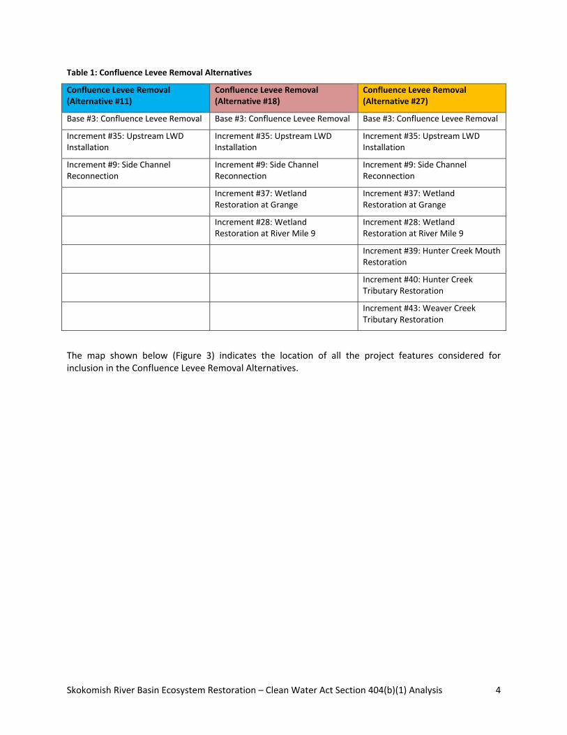
Skokomish River Basin Ecosystem Restoration – Clean Water Act Section 404(b)(1) Analysis 4
Table 1: Confluence Levee Removal Alternatives
Confluence Levee Removal (Alternative #11)
Confluence Levee Removal (Alternative #18)
Confluence Levee Removal (Alternative #27)
Base #3: Confluence Levee Removal Base #3: Confluence Levee Removal Base #3: Confluence Levee Removal
Increment #35: Upstream LWD Installation
Increment #35: Upstream LWD Installation
Increment #35: Upstream LWD Installation
Increment #9: Side Channel Reconnection
Increment #9: Side Channel Reconnection
Increment #9: Side Channel Reconnection
Increment #37: Wetland Restoration at Grange
Increment #37: Wetland Restoration at Grange
Increment #28: Wetland Restoration at River Mile 9
Increment #28: Wetland Restoration at River Mile 9
Increment #39: Hunter Creek Mouth Restoration
Increment #40: Hunter Creek Tributary Restoration
Increment #43: Weaver Creek Tributary Restoration
The map shown below (Figure 3) indicates the location of all the project features considered for inclusion in the Confluence Levee Removal Alternatives.

Skokomish River Basin Ecosystem Restoration – Clean Water Act Section 404(b)(1) Analysis 5
Figure 3: Confluence Levee Removal Alternatives

Skokomish River Basin Ecosystem Restoration – Clean Water Act Section 404(b)(1) Analysis 6
Riverbed Excavation Alternatives
Two Riverbed Excavation alternatives were evaluated during this step of the planning process. Alternative #45 represents a smaller scale of riverbed excavation alternative. It should be noted that this plan is a cost effective plan only, and not one of the best buy plans. The cost effectiveness analysis did not indicate this plan is a best buy; however, it was analyzed with other alternatives because it meets the critical needs of the study area while requiring a smaller extent of dredging compared to Alternative #60. Alternative #60 represents the largest‐scale best buy plan and represents the most significant Federal investment for this study. The increments included in each scale of the riverbed excavation alternative are outlined in Table 2.
Table 2: Riverbed Excavation Alternatives
Riverbed Excavation (Alternative #45) Riverbed Excavation (Alternative #60)
Base #5: Riverbed Excavation (RM 3.5‐9) Base #1: Riverbed Excavation (RM 0‐9)
Increment #35: Upstream LWD Installation Increment #35: Upstream LWD Installation
Increment #9: Side Channel Reconnection Increment #9: Side Channel Reconnection
Increment #37: Wetland Restoration at Grange Increment #37: Wetland Restoration at Grange
Increment #28: Wetland Restoration at River Mile 9 Increment #28: Wetland Restoration at River Mile 9
Increment #40: Hunter Creek Tributary Restoration Increment #40: Hunter Creek Tributary Restoration
Increment #43: Weaver Creek Tributary Restoration Increment #43: Weaver Creek Tributary Restoration
Increment #26: Wetland Restoration at Dips Road Increment #26: Wetland Restoration at Dips Road
The map shown below (Figure 4) indicates the location of the project features included in the largest scale of the Riverbed Excavation Alternative (Plan #60). Alternative #45 is the same, but with a shorter length of riverbed excavation.

Skokomish River Basin Ecosystem Restoration – Clean Water Act Section 404(b)(1) Analysis 7
Figure4. Riverbed Excavation Alternative

Skokomish River Basin Ecosystem Restoration – Clean Water Act Section 404(b)(1) Analysis 8
2 POTENTIALLY ADVERSE EFFECTS (INDIVIDUALLY OR CUMULATIVELY) ON THE AQUATIC ENVIRONMENT
2.1 Effects on Physical, Chemical, or Biological Characteristics of the Aquatic Ecosystem
2.1.1 Physical
Confluence Levee Removal Alternatives #11, 18, and 27
Removing the Confluence Levee and diverting the South Fork into the North Fork near the pre‐2003 confluence would provide a year‐round connection to the South Fork. The combined discharges would provide a continuous low flow channel in what is now the North Fork channel. The reach of the South Fork that runs subsurface in late‐summer/early‐fall would be abandoned during those low flow periods. These alternatives would have little effect on flooding since the South Fork channel would still convey flood discharges, and both sides of the river frequently flood in this location already.
Removing the Confluence Levee would divert much of the South Fork water and bedload into the existing North Fork channel. The abandoned reach of the South Fork would remain active during high flows. Bedload deposit would begin to aggrade the combined South Fork/North Fork channel. Based on the recent deposition rates, the initial deposition rate in the combined channel could be in the 0.1 +/‐ 0.05 feet/year range. As the channel aggrades, it will meander across the floodplain, forming and abandoning gravel bars. During the 50‐year project life, there could be two to three feet of deposition across the entire 1,000‐ to 2,000‐foot wide floodplain between the old and new confluences and north of the existing channel. Levee removal would greatly reduce the risk of the avulsion to the south near river mile (RM) 9.
Riverbed Excavation Alternatives #45 and #60
Alternative #60, excavation of the mainstem and South Fork Skokomish Rivers from RM 0‐9, would increase the channel capacity and is expected to greatly reduce the chances of the South Fork channel running subsurface in late summer/early fall. The riverbed excavation would average 8 to 11 feet deep. The river would be returned to a cross‐section size similar to what may have existed in the early 1900s. The proposed excavation would produce a river channel with an approximate 50% annual chance of exceedance (ACE), or two‐year flood capacity, considerably reducing the flood risk in the valley. Floods larger than the 50% ACE would still cause overbank flooding, but to a lesser degree than present. The increased channel capacity allows the placement of LWD habitat structures in the river without increasing the flood risks in the valley.
The smaller scale of this alternative, #45, is excavation of RM 3.5‐9. This would have the same channel dimensions as the longer excavation alternative, but starts just upstream of where the southern floodwaters re‐enter the mainstem. It would provide 50% ACE flow capacity in the excavated reach and reduce flood risks in much of the valley. Downstream of RM 3.5, channel capacity and flooding would be unchanged. LWD habitat structures could be placed in the excavated reach of the river and flood risks would still be less than they are now.
For both alternatives #45 and #60, the excavated riverbed would have less capacity for subsurface flow (less gravel to transmit water through) and is expected to place the thalweg below the existing water table. Both of these factors should help to maintain surface flows in the mainstem and South Fork during summer low flow conditions. The excavation would allow the placement of LWD to form pool habitat. LWD jams would be small, typically four to six logs, and placed to encourage meandering and bar formation. A few LWD structures would be placed along the riverbank to reduce the risk of accelerated bank erosion due to the channel excavation.

Skokomish River Basin Ecosystem Restoration – Clean Water Act Section 404(b)(1) Analysis 9
The higher in‐channel discharges would increase the bedload transport and reduce deposition from RM 9 downstream to Highway 101 (RM 5). The bankfull bedload transport at Highway 101 could increase from approximately 2,500 tons/day to around 10,000 tons/day. Between Highway 101 and RM 3.5 there would be a proportional increase in deposition, as the minimum bedload transport capacity (less than 200 tons/day) occurs just upstream of RM 3.5. Downstream of RM 3.5, bedload transport potential would increase, but transport would be limited by the amount of material available to be scoured from the riverbed. The average bedload deposition rate is expected to remain at about 0.08 to 0.14 feet per year range observed in recent years. At that deposition rate, sediment accumulation in the excavated channel would aggrade the riverbed by about two feet in 20 years, lowering the channel capacity from 50% ACE (17,500 cfs) to 75% ACE (13,500 cfs). It is recommended that maintenance be done at 20‐year intervals to retain the design channel capacity. If the channel is not excavated to maintain the channel capacity, it could return to its pre‐excavation capacity in roughly 65 to 75 years.
2.1.2 Chemical
The proposed action alternatives would not create a significant hazard to the public or the environment through transport, use, or disposal of hazardous materials. There are no CERCLA‐regulated substances involved with any of the proposed restoration sites. There are a few old cars at Confluence Levee that are parked above ground and do not appear to be contaminating the surrounding area.
2.1.3 Biological
For both groups of alternatives, riparian wildlife such as mink, beaver, and river otter may be disrupted by construction; however, none of the alternatives would have a significant negative effect on the animals or their habitat. Resulting conditions for these species would likely improve with any of the action alternatives.
Confluence Levee Removal Alternatives #11, 18, and 27
Fish
Construction for removal of the Confluence Levee would have no in‐water work and minimal disturbance for fish as machinery works on the riverbank. Construction work for the increments associated with all three alternatives would involve some in‐water work and would therefore have short‐term disturbance to fish species still present during the fish work window that is timed for when juvenile salmon are absent, 15 July to 15 September. Turbidity is the primary concern for stress to fish species. Background turbidity during the summer is typically very low. Construction methods would employ best management practices (BMPs) to minimize turbidity. Alternative, #27 would have 141 in‐water workdays; Alternatives #18 and #11 would have 94 and 26 in‐water workdays, respectively.
Confluence Levee removal would resolve the problem of the river going subsurface in the summer months by providing a bypass to this reach as the South Fork combines with the North Fork. The benefit of this year‐round connection for fish is that adult salmon migrating upstream would have access to their spawning areas and would not have to endure delays to migration and the complete blockage of access to critical spawning habitat.
Vegetation (Wetland, Riparian, Estuarine)
Construction impacts to vegetation from implementation of Alternative #27 would be a temporary clearing of approximately 1.15 acres of upland vegetation bordering on riparian zones for staging areas for the Confluence Levee removal, and for the restoration of Hunter and Weaver Creeks. This alternative would have approximately 5 acres of wetland fill to construct the wetland embankments that would result in a net gain of 51 acres of riparian wetlands; an additional 1 acre of wetland vegetation would be
Skokomish River Basin Ecosystem Restoration – Clean Water Act Section 404(b)(1) Analysis 10
disturbed for the Side Channel Reconnection increment. Alternative #18 would have 0.92 acre of uplands cleared for staging areas and the same amount of wetland impacts and restoration as #27. Alternative #11 would have 0.1 acre of upland vegetation cleared for staging and access and 1 acre of wetland vegetation disturbance. The Corps would select staging areas based partly on avoidance of large trees and would replant all staging areas at the end of construction. Vegetation would be expected to reach pre‐construction conditions within approximately three years.
The proposed actions would have great benefits to riparian and wetland vegetation. Implementation of Alternative #27 would involve 242 acres of mixed riparian and wetlands habitats. The proposed restoration would result in improvement of existing wetland and riparian zones and connection of uplands to riverbank, creating new riparian zones through breaching agricultural berms and constructing wetland embankments. Alternative #18 would provide the same types of improvements, but to less acreage at 200 total acres of wetlands and riparian zone improved or created. Alternative #11 would provide reconnection of 68 acres of riparian uplands at the location of the Confluence Levee removal and reconnection of a 44‐acre wetland to the mainstem river. Alternatives #27 and #18 would each have approximately 6 acres of wetland fill or disturbance to gain their large area of wetland benefits. Alternative #11 would have a temporary impact to 0.7 acre of wetlands. None of these three alternatives would have a significant effect on eelgrass in the estuary.
Riverbed Excavation Alternatives #45 and #60
Fish
Alternatives #45 and #60 would have significant short‐term detrimental effects to all fish species in the Skokomish River due to the wide‐scale sediment excavation. These alternatives are designed to remove the top 8 to 10 feet of riverbed sediments for 9 miles in #60 and for 4.5 miles in #45. This work would remove the benthic macroinvertebrates that serve as the primary food source for most fish, and would likely kill most of the sculpin and lamprey species present in the length of channel that would be dredged. Construction would adhere to fish work windows, but these are timed to protect salmon that are in the channel only during juvenile and adult life stages. Sculpin and lamprey inhabit the river throughout their lives, and are less capable of avoiding dredge machinery. Loss of these fish populations could take many years to recover.
Such broad‐scale alteration of the river bottom would cause significant risk to salmon habitat. Salmon spawn throughout the lower 12 miles of the river. Gravel size at the depths achieved by dredging is assumed similar to the top layers; however, sediment removal directly alters the channel geometry and risks creating morphology that is unfavorable to salmonids. Some risks include the following: salmon have a narrow range of parameters for spawning depth, velocity, and substrate size (Bjornn and Reiser 1991), and therefore may not find appropriate spawning habitat for one or more years as sediments stabilize and channel morphology adjusts (Kondolf et al. 2002); disturbed substrate has a lower velocity threshold for scour of eggs incubating in the gravel (NOAA Fisheries 2004); and such significant quantity of gravel removal can reduce the amount of water that flows through the hyporheic zone, which can lead to elevated water temperatures without the cooling effect of intragravel flow. A variety of other biological consequences are associated with sediment extraction from streams (Collins 1995, Kondolf et al. 2002).
Benefits of river sediment excavation for both Riverbed Excavation alternatives are that providing the capacity for the 50% ACE would greatly reduce the problem of fish stranding on high ground after being flooded out of the river and then trapped with no channel access back into the river. Additionally, the increased flow capacity would allow for placement of LWD habitat structures throughout the excavated

Skokomish River Basin Ecosystem Restoration – Clean Water Act Section 404(b)(1) Analysis 11
reach of river without exacerbating flooding in the valley. Dredging would also resolve the problem of flow going subsurface in the late summer. If this alternative were selected as the preferred alternative, the Corps would further investigate the quantification and magnitude of the fish‐stranding problem, as well as pursue an analysis of whether the assumed benefits outweigh the impacts and speculated risks.
Vegetation (Wetland, Riparian, Estuarine)
Both of these alternatives would have the same acreage of staging areas at approximately 1.15 acres. Construction impacts to vegetation would be the same as described for the Confluence Levee Removal Alternative #27. Alternatives #45 and 60 include all of the increments; therefore, both would improve the same acreage of wetland and riparian vegetation as Alternative #27 at approximately 242 acres, and would impact approximately 6 acres of wetlands to achieve the overall benefits and net gain in wetlands.
2.2 Effects on Recreational, Aesthetic, Historical, and Economic Values
Significant recreation activities (boating, camping, bicycling, hunting, etc.) occur outside the study area in the upper watershed or beyond Annas Bay. The alternatives would not have more than a negligible effect on fishing activity within the study area. The cultural resources survey did not identify any significant cultural resources. The Corps has determined a finding of no historic properties affected and will require monitoring during construction. See Section 4.3 for additional information.
2.3 Findings
Based on the analysis of the alternative actions, the Confluence Levee Removal Alternative #18 is the least environmentally damaging practicable alternative because while it has more wetland fill than Alternative #11, it has net gain of 51 acres of wetlands restored. Under this plan, the proposed action is not exempt from Section 404 of the CWA due to placement of LWD within the river channel and/or wetland fill activities. A thorough and detailed analysis of alternatives appears in the Feasibility Report/Environmental Impact Statement prepared for this project.
3 ALL APPROPRIATE AND PRACTICABLE MEASURES TO MINIMIZE POTENTIAL HARM TO THE AQUATIC ECOSYSTEM
3.1 Impact Avoidance Measures
The Corps objective in ecosystem restoration planning is to contribute to national ecosystem restoration (NER). Contributions to NER (outputs) are increases in the net quantity and/or quality of desired ecosystem resources. The NER Plan must reasonably maximize ecosystem restoration benefits compared to costs, consistent with the Federal objective. The selected plan must be shown to be cost effective and justified to achieve the desired level of output. Five project alternatives were considered (See Section 2 above). After analysis of all relevant environmental benefits and impacts, the Corps has identified Alternative #18 as the recommended plan (NER Plan) and as the environmentally preferred alternative per NEPA regulations at 40 CFR 1505.2 (b).
Impact avoidance measures in the design include the following:
• The Corps would schedule work to occur during designated periods often referred to as fish
windows as established by WDFW per Washington Administrative Code (WAC) 220‐110‐271.
• The Corps would schedule work outside of bird nesting season.

Skokomish River Basin Ecosystem Restoration – Clean Water Act Section 404(b)(1) Analysis 12
• Each construction contractor would be required to prepare an Environmental Protection Plan
for approval by a Corps staff biologist.
• Traffic alterations would be designed to minimize impediments, with the shortest and least
disruptive detours possible, and in coordination with the relevant transportation agency.
3.2 Impact Minimization Measures
In accordance with Corps policy, minimization of ecosystem, cultural, and socio‐economic impacts will be a significant project consideration [ER 1105‐2‐100]. The Corps will take all practicable steps during construction of the project to minimize impacts to these resources. Contingencies will be in place in case any of the water quality protection measures fail to achieve their intended function. The Corps will observe all construction windows to ensure that impacts to sensitive species will be avoided or minimized, to include ESA‐listed salmonids and bald eagles.
Restoration sites would involve in‐water work and areas of ground clearing. Protecting water quality from stormwater runoff requires best management practices (BMPs) to avoid excessive runoff and elevated turbidity in the receiving water body. It is important to avoid excessive pulses of sediment that are more than what the surrounding aquatic life can easily tolerate. The project would have a Stormwater Pollution Prevention Plan including a Temporary Erosion and Sedimentation Control Plan approved by a Corps staff biologist. Construction contractors would be required to obtain a Construction Stormwater Permit under Section 402 of the Clean Water Act. Standard construction stormwater BMPs can be incorporated into site designs, operational procedures, and physical measures on site. These are examples of frequently used BMPs:
• Minimize area of ground disturbance and vegetation clearing.
• Use the site’s natural contours to minimize run‐off and erosion.
• Do not expose the entire site at one time; avoid bare soils during rainy months.
• Stabilize erodible surfaces with mulch, compost, seeding, or sod.
• Use features such as silt fences, gravel filter berms, silt dikes, check dams, and gravel bags for
interception and dissipation of turbid runoff water.
3.3 Compensatory Mitigation Measures
No mitigation is proposed. The project is restoration and has the overall effect of enhancing wetlands and increasing their total area in the Skokomish Valley, which offsets any wetland impact. Access roads and staging areas have been located as far from wetlands as is practicable and will be re‐planted and replaced to function in‐kind after the project is completed.
3.4 Findings
Avoidance, minimization, and mitigation measures are conceptual at this stage. Further development will occur during the later design phase outlining specific measures. The Corps has determined that all appropriate and practicable measures will be taken to minimize potential harm to the environment.

Skokomish River Basin Ecosystem Restoration – Clean Water Act Section 404(b)(1) Analysis 13
4 OTHER FACTORS IN THE PUBLIC INTEREST
4.1 Fish and Wildlife
The Corps has coordinated the General Investigation with local Native American Tribes and state and Federal resource agencies to minimize impacts to fish and wildlife resources. The Corps has completed ESA Section 7 consultation for the proposed Federal action.
4.2 Water Quality
This project will not violate the state water quality standards found at WAC 173‐201A. Confluence Levee removal would have minimal or no in‐water work; however, several project components will involve in‐water disturbance of substrates and thereby cause turbidity in the channel. These include installation of LWD at the upstream end of the study area, channel excavation for reconnection of the side channel at RM 4, and approximately 15 temporary culverts for equipment access across the river. Implementing these actions will cause localized turbidity during construction. The Corps will implement all BMPs and adhere to fish work windows established by Washington Department of Fish and Wildlife to minimize effects.
4.3 Historical and Cultural Resources
The cultural resources survey did not identify any significant cultural resources. The Corps has determined a finding of no historic properties affected and will require monitoring during construction. The SHPO concurred with the Corps determination of no historic properties affected in a letter dated February 10, 2015 and requested a draft of the monitoring plan for review prior to the start of construction. In addition, the Corps sent a letter on February 9, 2015 to the Skokomish Indian Tribe that provided project updates and described the results of the cultural resources survey. The Skokomish Indian Tribal Historic Preservation Officer responded by email on February 18, 2015 and concurred that no historic properties would be affected and agreed that construction monitoring should take place.
4.4 Environmental Benefits
The Corps is proposing to conduct restoration efforts along the Skokomish River in the lower Skokomish Valley. The purpose of this project is ecosystem restoration and this project has significant net benefits to the environment. The proposed action includes a levee removal, placement of LWD, wetland restoration, and a side channel reconnection to restore structures, functions, and processes in the Skokomish River Basin.
4.5 Conclusion
Based on the analyses presented in project NEPA and ESA documents, as well as the following 404(b)(1) Evaluation and General Policies for the Evaluation of Permit Applications analysis, the Corps finds that this project complies with the substantive elements of Section 404 of the Clean Water Act.

Skokomish River Basin Ecosystem Restoration – Clean Water Act Section 404(b)(1) Analysis 14
Attachment A
Clean Water Act 404(b)(1) Evaluation [40 CFR §230]
404(b)(1) Evaluation [40 CFR §230]
Potential Impacts on Physical and Chemical Characteristics [Subpart C]:
1. Substrate [230.20]
No substrate will be added to the Skokomish River except for large boulders that will anchor the LWD installed throughout RM 9 to 11, and at the breach location at the Confluence Levee removal site. The substrate characteristics such as grain size distribution and percent fines are not anticipated to change. A small amount of excavation will be required to remove substrate from the Side Channel Reconnection project component. This material will be hauled off site. New substrate will be exposed in the inlet and outlet channels; this will be native material and no new material will be added.
2. Suspended particulates/turbidity [230.21]
Construction of 3 of the 5 project components will have short‐term increases to turbidity (wetland restoration will have no in‐water work). Elevated turbidity will come from approximately 15 temporary stream‐crossing culverts for access to the Confluence Levee removal site and LWD installation sites. Other potential sources of turbidity will come from excavation and installation of the bar‐apex log jams, 5‐log clusters, and single logs anchored with boulders. The third source of turbidity will occur during excavation of the inlet and outlet channels for Side Channel Reconnection. Environmental effects of these project components are described in the Final Feasibility Report/Environmental Impact statement (FR/EIS) and Appendix H of the FR/EIS. All potential sources of turbidity will be avoided and minimized. Heavy equipment needed to perform in‐water work will be staged in upland areas and will not enter the Skokomish River except in isolated work areas. All in‐water work will be conducted during the prescribed work windows and during low water levels to minimize water quality impacts. The project will use BMPs to ensure state water quality standards are maintained during construction. The Corps will conduct water quality monitoring during in‐water work to ensure compliance with these standards. Should monitoring indicate that state water quality maximum standards for turbidity are exceeded, work would be halted and modified such that standards are met.
3. Water [230.22]
The project is not expected to add any nutrients to the water that could affect the clarity, color, odor, or aesthetic value of the water, or that could reduce the suitability of the Skokomish River for aquatic organisms or recreation. Coniferous LWD, which is resistant to breakdown (and therefore has low biochemical oxygen demand), will be placed to enhance fish habitat. The Upstream LWD project component is anticipated to increase pool area, which would provide cooler water temperatures in the deeper levels of the pools for the benefit of aquatic organisms. Side Channel Reconnection will provide higher flows from the Skokomish River to the large pond/wetland area, which may have the effect of increasing dissolved oxygen to the pond area to benefit aquatic organisms.

Skokomish River Basin Ecosystem Restoration – Clean Water Act Section 404(b)(1) Analysis 15
4. Current patterns and water circulation [230.23]
The purpose of the ecosystem restoration project is to restore natural processes of current patterns and circulation in the Skokomish River that have been degraded due to historical LWD removal and levee construction as well as aggradation that cut off access by aquatic organisms to the large pond/wetland area around RM 5. The 5 components of this project will add LWD to restore more natural current patterns to RM 9 to 11, remove the levee that causes significant constriction of flows for more than 1 mile of the river, reconnect flow to an abandoned channel that is now a disconnected pond, and restore a net gain of 51 acres of wetlands that will be reconnected to the river.
5. Normal water fluctuations [230.24].
None of the components of this project will affect the hydrologic regime of the Skokomish River. The Side Channel Reconnection component will affect water fluctuations in the disconnected pond/wetland area around RM 5. This is anticipated to provide significantly beneficial increases to habitat quantity and quality for juvenile salmonids, particularly coho salmon that are anticipated to use the large pond area as over‐wintering habitat once access is provided through excavation of inlet and outlet channels. No negative effects are anticipated from this change in water level fluctuations in the 44‐acre pond/wetland area.
6. Salinity gradients [230.25]
No change is expected as all project components are upstream from tidal influence.
Potential Impacts on Biological Characteristics of the Aquatic Ecosystem [Subpart D]:
1. Threatened and endangered species [230.30]
For the proposed project, the Corps has submitted the Specific Project Information Form to NMFS and USFWS on January 14, 2015 for review of Section 7 of the Endangered Species Act compliance under the Washington State Fish Passage and Habitat Enhancement Restoration Programmatic
Biological Opinion (NMFS Reference No. 2008/03598; USFWS Reference No. 13410‐2008‐F‐0209).
The proposed Federal action is compliant with ESA based on two separate Programmatic Biological Opinions. Project designs incorporate all necessary components to comply with the requirements of the Programmatic Biological Opinion for Fish Passage and Restoration Projects (FPRP) issued in 2008. For species under the jurisdiction of USFWS, the Corps submitted a Specific Project Information Report and received a verification letter on February 20, 2015 that the project is compliant with the FPRP Biological Opinion.
For species under the jurisdiction of NMFS, approval authority is granted to the State of Washington in the ESA Section 4(d) Rule, Limit 8 Programmatic Biological Opinion. The Corps received a letter from NMFS dated February 3, 2015 confirming their approval of the Habitat Restoration Program (HRP) under the ESA Section 4(d) Rule, Limit 8, as administered by the Washington Recreation and Conservation Office (RCO). NMFS also stated their agreement that the project fits within the Habitat Restoration Program. The Corps certifies that the project is consistent with all of the elements of the Habitat Restoration Program 4(d) Rule, Limit 8 Programmatic Biological Opinion and communicated this to the Washington Recreation and Conservation Office. The project occurs within the Puget Sound Salmon Recovery Region covered in this Biological Opinion, and the proposed Federal action is listed in the Mid Hood Canal Chinook Recovery Planning Chapter of the Puget Sound Salmon
Skokomish River Basin Ecosystem Restoration – Clean Water Act Section 404(b)(1) Analysis 16
Recovery Plan. The Corps received a letter from the Washington Recreation and Conservation Office on February 17, 2015 providing their approval of the project’s ESA coverage under the 4(d) Limit 8 Programmatic Biological Opinion.
2. Fish, crustaceans, mollusks, and other aquatic organisms in the food web [230.31]
There may be temporary impacts to aquatic organisms during construction for the temporary stream crossings, diversion of water for LWD installation, and excavation for reconnection of the channel. The primary causes of impacts to aquatic organisms will be turbidity and disturbance of the riverbed during excavation. However, aquatic habitat quality conditions are expected to improve greatly following construction. Upstream LWD installation will provide rearing and refuge habitat for fish and greatly increased area of substrate for the production of aquatic insects and other benthic organisms. Planting the stream banks at the Side Channel Reconnection inlet and outlet channels with native vegetation will provide shading that functions as a thermal refuge during warm summer days as well as providing a source of organic input for the food chain and insect drop as a direct source of food for fish and amphibians.
3. Other wildlife [230.32]
Birds and other wildlife may be temporarily displaced during construction due to noise and presence of construction vehicles. Because these impacts would only occur during the period of construction, and the great majority of standing trees would be retained, impacts are expected to be negligible and temporary. Replacing non‐native plant species by planting native trees and shrubs in all areas disturbed by construction would increase the extent and species diversity on the site and create additional opportunities for foraging, nesting, cover, and refuge for a wide variety of species.
Potential Impacts on Special Aquatic Sites [Subpart E]:
1. Sanctuaries and refuges [230.40]
Not applicable. This portion of the Skokomish River is not designated by local, state, or Federal regulations to be managed principally for the preservation and use of fish and wildlife resources. The areas of construction are not within sanctuaries or refuges.
2. Wetlands [230.41]
The Side Channel Reconnection includes 0.73 acres of temporary impact to a Category 1 riverine wetland. Compensatory mitigation is not proposed because the project purpose is ecosystem restoration and has the overall effect of enhancing wetlands and increasing their total area in the Skokomish Valley. Access roads and staging areas have been located as far from wetlands as is practicable and will be re‐planted and replaced to function in‐kind after the project is completed. The two wetland restoration sites involve breaching agricultural berms and constructing new wetland embankments, which will involve 5 acres of fill of existing wetlands. However, this will have a net gain of 51 acres of wetland restoration and improvement.
3. Mud flats [230.42]
Not applicable. The project area has no mud flats.
4. Vegetated shallows [230.43]
Not applicable. The project area has no vegetated shallows.
5. Coral reefs [230.44]
Not applicable. The project area has no coral reefs.
Skokomish River Basin Ecosystem Restoration – Clean Water Act Section 404(b)(1) Analysis 17
6. Riffle and pool complexes [230.45]
The Upstream LWD project component is anticipated to have significant benefits for increasing quality and quantity of riffle and pool complexes for 2 miles of the South Fork Skokomish River. The bar‐apex log jams, 5‐log clusters, and anchored single logs are anticipated to re‐create the pools and riffles that occurred historically before significant LWD removal operations occurred in the early to mid‐1900s.
Potential Effects on Human Use Characteristics [Subpart F]:
1. Municipal and private water supplies [230.50]
The project will have no effects to any municipal or private water supplies.
2. Recreational and commercial fisheries [230.51]
All in‐water work will occur during the designated fish window. The proposed project will not prevent access to recreational or commercial fishing.
3. Water‐related recreation [230.53]
Significant recreation activities (boating, camping, bicycling, hunting, etc.) occur outside the study area in the upper watershed or beyond Annas Bay. The proposed project would have no effect on fishing activity within the study area. Public access for recreation directly in the Skokomish River will only be precluded at the specific construction locations to protect public safety. Public access will still be available along the rest of the many miles of river outside of the construction zones. No permanent effects to water‐related recreation will occur.
4. Aesthetics [230.53]
During construction, heavy equipment noise and exhaust will cause some minor disturbance. The proposed action will have no long‐term effects to scenic resources or visual characteristics.
5. Parks, national and historic monuments, national seashores, wilderness areas, research sites and similar preserves [230.54]
No such structures or areas are designated in the project area.
Evaluation and Testing [Subpart G]:
1. General evaluation of dredged or fill material [230.60]
Fill material will be large boulders for anchoring logs and large logs with rootwads attached sourced from local forests for three project components. For the two wetland restoration sites, the new wetland embankments will be constructed of clean material and may use some of the native material excavated for breaching the agricultural berms. All imported material would be free from contamination.
2. Chemical, biological, and physical evaluation and testing [230.61]
The Corps will conduct water quality sampling according to the protocol approved by the Washington Department of Ecology for the following parameters: turbidity, dissolved oxygen, and pH. Construction may be halted if deemed necessary under the water quality monitoring. No contaminated material will be used in the proposed action.

Skokomish River Basin Ecosystem Restoration – Clean Water Act Section 404(b)(1) Analysis 18
Actions to Minimize Adverse Effects [Subpart H]:
1. Actions concerning the location of the discharge [230.70]
Selecting locations for the LWD and boulders involved hydraulic modeling to determine appropriate locations for the engineered log jams designed for ecosystem restoration. All excavated material will be hauled off site, or used beneficially as planting substrate where appropriate. Construction methods and BMPs will minimize the extent of any turbidity plumes. The Corps will minimize the total number and size of temporary culverts installed for access to the construction areas.
2. Actions concerning the material to be discharged [230.71]
The size and quantity of boulders will be minimized to only what is required for anchoring the LWD. No materials other than boulders and LWD are proposed for fill directly in the riverbed. The wetland embankments constructed for wetland restoration will consist of clean material and may use native material from the excavated breaches in the existing agricultural berms.
3. Actions controlling the material after discharge [230.72]
Construction methods and BMPs will minimize the extent of any turbidity plumes. Material to be added to the site includes boulders and LWD. There may be a pulse of sedimentation following any diversion of the river to isolate work areas resulting in short term turbidity increases. Localized shifting of sediments may continue sporadically as the river adjusts to the removal of Confluence Levee, log jam installations, and Side Channel Reconnection. The new wetland embankments will be planted with native species, which will have time to become established prior to the first inundation.
4. Actions affecting the method of dispersion [230.73]
As described above, the installed LWD structures are expected to be stable after construction and not disperse although shifting may occur. The wetland embankments are designed for overtopping and are anticipated to remain in place.
5. Actions related to technology [230.74]
No specific advanced technologies are anticipated for use at this time.
6. Actions affecting plant and animal populations [230.75]
The Corps will coordinate construction activities and features with state and Federal resource agencies to minimize impacts to fishery and wildlife resources. There will be temporary disturbance to wildlife in the project vicinity due to noise from operation of machinery. All areas cleared for staging, access, and construction will be replanted with native species.
7. Actions affecting human use [230.76]
The 5 project components are not expected to diminish water quality, but may temporarily impact the aesthetics of the aquatic site and its recreational use through exclusion from access for a short period during construction.
8. Other actions [230.77]
Best management practices will be used in the proposed construction to ensure that no unnecessary damage to the environment occurs during construction.

Skokomish River Basin Ecosystem Restoration – Clean Water Act Section 404(b)(1) Analysis 19
General Policies for Evaluating Permit Applications [33 CFR §320.4]
1. Public Interest Review [320.4(a)]
The benefits expected to accrue have been compared to the reasonably foreseeable detriments, and all factors relevant to the proposal have been considered as documented in the FR/EIS. The Corps finds the proposed action of ecosystem restoration to be in compliance with the 404(b)(1) guidelines and not contrary to public interest.
2. Effects on wetlands [320.4(b)]
The Side Channel Reconnection project component will have a temporary impact to 0.73 acres of wetland as the inlet and outlet channels are excavated. This impact will be temporary and all cleared vegetation will be replaced with native plantings. No net loss of wetland functions is anticipated because this represents a very small portion of the 44‐acre wetland area. The purpose of this project component is to provide fish access to the pond area and to increase the frequency of inundation to the former river channel that is now a 44‐acre wetland. The two wetland restoration project components will involve approximately 5 acres of wetland fill due to new wetland embankments construction for a net gain of 51 acres of wetlands restored and improved.
3. Fish and wildlife [320.4(c)]
The Corps coordinated project planning and design with the National Marine Fisheries Service, U.S. Fish and Wildlife Service (USFWS), the Washington Department of Fish and Wildlife, and the Washington Department of Ecology regarding minimizing impacts of construction and maximizing ecosystem benefits through project design. In accordance with the Fish and Wildlife Coordination Act, the Corps received a Coordination Act Report from USFWS.
4. Water quality [320.4(d)]
The Corps certifies that this project will not violate Water Quality Standards as set forth by the Clean Water Act. The Corps has consulted with the Washington Department of Ecology regarding compliance with Section 401 of the Clean Water Act.
5. Historic, cultural, scenic, and recreational values [320.4(e)]
The project area does not occur in areas specifically designated for protection of historic, cultural, scenic, or recreational values. In accordance with Section 106 of the National Historic Preservation Act, the Corps has determined a finding of no historic properties affected and will require monitoring during construction at the Side Channel Reconnection locations at RM 4 and RM 5.6 and at the two wetland restoration sites where agricultural berms will be breached and new wetland embankments will be constructed.
6. Effects on limits of the Territorial Sea [320.4(f)]
Not applicable, since the project will not occur in coastal waters.
7. Consideration of property ownership [320.4(g)]
The project areas occur across a mix of public, private, and tribal ownership. Access for construction equipment and materials will be via public rights‐of‐way and real estate rights of entry and will be obtained prior to construction. Effects of the project will not change the ability of private property owners to use their property or access navigable waters.

Skokomish River Basin Ecosystem Restoration – Clean Water Act Section 404(b)(1) Analysis 20
8. Activities affecting coastal zones [320.4(h)]
The Corps has determined that the proposed project complies with the policies, general conditions, and activities as specified in the Mason County Shoreline Master Program. The proposed action will be consistent to the maximum extent practicable with the State of Washington Shoreline Management Program and policies and standards of the Mason County Shoreline Management Program. A Coastal Zone Management Act consistency determination has been prepared and will be submitted to WDOE for review during final design phase
9. Activities in marine sanctuaries [320.4(i)]
Not applicable; the area is not a marine sanctuary.
10. Other federal, state, or local requirements [320.4(j)]
The Corps has completed ESA consultation and the project is in compliance with two separate Programmatic Biological Opinions. Project designs incorporate all necessary components to comply with the requirements of the Programmatic Biological Opinion for Fish Passage and Restoration Projects (FPRP) as well as the Programmatic Biological Opinion for Section 4(d) Limit 8 issued by NMFS. Washington Department of Natural resources will provide authorization for working in aquatic lands of Washington State.
11. Safety of impoundment structures [320.(k)]
Not applicable; no impoundment structure will be built in this project.
12. Water supply and conservation [320.4(m)]
No permit is needed concerning water supply.
13. Energy conservation and development [320.4(n)]
Not applicable.
14. Navigation [320.4(o)]
Not applicable.
15. Environmental benefits [320.4(p)]
The project will have significant environmental benefits through removal of 5,400 feet of levee that constricts river flows, installation of 2 miles of LWD structures for improving quality and quantity of fish habitat, reconnection of the river to a 44‐acre wetland area for fish access, and restoration and improvement of two riparian wetlands that will be reconnected to the river.
16. Economics [320.4(q)]
The project has been analyzed for maximizing its cost effectiveness for contribution to the National Ecosystem Restoration plan. Construction of the 5 project components will contribute to employment and profits as the work will be contracted to a private company.
17. Mitigation [320.4(r)]
Compensatory mitigation is not required on this project as there will be a net gain of 51 acres of wetlands at the site of the 5 acres of fill due to wetland embankment construction.

COASTAL ZONE MANAGEMENT ACT
CONSISTENCY DETERMINATION

1
COASTAL ZONE MANAGEMENT ACT CONSISTENCY DETERMINATION
Skokomish River Ecosystem Restoration Project January 2015
The ecosystem restoration actions are activities undertaken by a Federal agency; the following constitutes a Federal consistency determination with the enforceable provisions of the Washington Coastal Zone Management Program. 1. INTRODUCTION The proposed Federal action applicable to this consistency determination is the Skokomish River Ecosystem Restoration Project (Project) activities along the Skokomish River, as described below. This determination of consistency with the Washington Coastal Zone Management Act is based on review of applicable sections of the State of Washington Shoreline Management Program and policies and standards of the Mason County Shoreline Master Program. U. S. Army Corps of Engineers (Corps) is proposing to conduct restoration along the Skokomish River in the lower Skokomish Valley. The proposed action includes breaching agricultural berms and constructing wetland embankments, a levee removal, placement of large woody debris, and a side channel reconnection to restore structures, functions, and processes in the Skokomish River Basin. The Confluence levee is located across the river from the agricultural berm at River Mile 9. Around the North Fork/South Fork confluence, seasonal dry channel conditions in the South Fork have prevented upstream migration of salmon in the late summer/early fall period. Removal of the Confluence levee and diversion of the South Fork into the North Fork would provide a continuous low flow channel near the confluence, bypassing a subsurface flow reach and providing improved fish migration. A portion of flood flows would stay in the old channel. Installed LWD would direct flow in the new channel and improve fish habitat. The wetland restoration at River Mile 9, located from RM 8.3 to 9.2, is intended to restore and improve riparian wetlands and to reduce the stranding potential for fish. The new wetland embankment will be constructed landward (south) varying distances, generally around 200‐300 feet. Four strategically located sections of the existing agricultural berm will be breached. These breaches will allow flood waters to flow freely within the opened area, providing salmon access to the riparian wetland habitat with a return path to the river. The wetland restoration at Grange, located from RM 7.5 to 8, is intended to restore and improve riparian wetlands and to reduce the stranding potential for fish. The new wetland embankment would be constructed landward (south) up to 1,200 feet. Two sections of the existing agricultural berm will be breached; these breaches will allow flood waters to flow freely within the wetland restoration area, providing salmon access to the riparian wetland habitat with a return path to the river. Upstream large woody debris, located from RM 9 to 11, would include placement and installation of anchored wood and Engineered Log Jams (ELJs). Small wood clusters, single logs, as well as larger ELJs will be installed in this reach to encourage low flow channel meandering and mid‐channel bar formation and provide multiple types of habitat benefits for salmon.

2
An abandoned channel that lies between RM 4 and 5.6 would be reconnected to the mainstem to provide high flow refuge and rearing habitat for fish. Restoration would involve constructing improvements to the channel inlet and outlet, while most of the channel will not be disturbed. The reconnected channel will only be connected to the mainstem Skokomish River during high discharges and would not convey river flows year round. During high river discharges, the reconnected channel would provide low velocity refuge. During most of the year, the channel would provide pond habitat for fish rearing. 2. STATE OF WASHINGTON SHORELINE MANAGEMENT PROGRAM The Coastal Zone Management Act of 1972, as amended, requires Federal agencies to carry out their activities in a manner that is consistent to the maximum extent practicable with the enforceable policies of the approved state Coastal Zone Management (CZM) Programs. The Shoreline Management Act of 1972 (RCW 90.58) is the core of authority of Washington’s CZM Program. Primary responsibility for the implementation of the SMA is assigned to local governments. Mason County, in which the proposed ecosystem restoration project is located, fulfilled this requirement with the Shoreline Master Program. 3. MASON COUNTY SHORELINE MASTER PROGRAM The Mason County Shoreline Master Program Shoreline Designation Map was used to determine project consistency with the designated shoreline type. The proposed project area is approximately 280 acres located in the lower Skokomish watershed in the Skokomish Valley. The designation for the Skokomish River Ecosystem Restoration Project footprint in Mason County’s Shoreline Management Program is Conservancy. Mason County is in the process of updating their Shoreline Master Program. The current established Shoreline Management Program contains policies governing a wide range of shoreline activities and uses such as agriculture, commercial and residential development, shoreline stabilization, and recreational development. There are no policies governing ecosystem restoration activities that are directly applicable to the proposed project; however, some of the proposed project features are similar in nature to features discussed in the current policy. For this consistency determination, the Corps has addressed items contained in the current policy as well as the draft updated Program. Applicable portions of the Mason County SMP are presented below with the Corps consistency indicated in bold italics. Current Chapter 17.50 Mason County Shoreline Master Program Use Regulations
17.50.060 Use Regulations Flood Protection and Shoreline Stabilization
1. The County shall require and utilize the following information during its review of shoreline stabilization and flood protection procedures:
River channel hydraulics and floodway characteristics up and downstream from the project area;
Existing shoreline stabilization and flood protection works within the area;
Physical, geological and soil characteristics of the area; and
Predicted impact upon area shore and hydraulic processes, adjacent properties and shoreline and water uses.

3
The Corps has analyzed the all of the above listed information/data regarding the river’s hydrology and hydraulics, existing shoreline stabilization, geomorphology, and soil characteristics for the existing conditions used in the formulation of restoration plans. The predicted impacts of the proposed Project have been designed to restore ecosystem processes. This analysis was presented in the draft Feasibility Report/Environmental Impact Statement (FR/EIS), which has gone through a public review.
2. Conditions of Hydraulic Project Approval, issued by Washington State Department of Fisheries, may be incorporated into permits issued for flood protection and shoreline stabilization. This Project is a Federal action and therefore is not subject to obtaining state permits such as Hydraulic Project Approval. The wetland embankments are designed to restore wetlands and will provide the same level of flood protection that presently exists. No shoreline stabilization is included in the Project. 3. The County shall require professional design of shoreline stabilization and flood protection works where such projects may cause interference with normal river geohydraulic processes, leading to erosion of other upstream and downstream shoreline properties, or adverse effects to shoreline resources and uses. The Project’s interdisciplinary team includes Certified Professional Engineers specializing in civil design and hydraulic engineering. 4. Groins on rivers, streams and lakes may be considered as a Conditional Use PROVIDED the applicant can demonstrate the appropriateness of the designed structure and that alternative shore protection measures would prove more detrimental to the geohydraulics and natural resource within the water body. No groins are proposed for this Project. 5. Diking may be permitted as a Conditional Use PROVIDED:
a. Diking is set back to the edge of the floodway; b. Timing and construction shall be coordinated with WDF and WDW; c. Diking shall be designed and constructed to meet Soil Conservation Service technical manual standards and shall, at a minimum include (1) layered compaction, (2) removal of debris (i.e., tree stumps, tires, etc.), and (3) revegetation and maintenance until ground cover is established.
This Project is an ecosystem restoration project with the purpose of restoring floodplain connectivity and aquatic habitat. The Project will breach the existing agricultural berms and construct wetland embankments to restore and improve riparian wetlands. The wetland embankments will provide the same level of protection to the existing structures. All in‐water work will occur with the designated fish window for the Skokomish River as established by WDFW per Washington Administrative Code 220‐110‐271. 6. Flood protection measures shall be planned and constructed based on a state approved flood control management plan, when available, and in accordance with the National Flood Insurance Program. This Project is an ecosystem restoration project with the purpose of restoring floodplain connectivity and aquatic habitat. The proposed wetland embankments are designed to maintain the current level

4
of protection for the existing structures and therefore would not result in a modification to the existing flood control management plan. Chapter 17.50 Draft Mason County Shoreline Master Program Regulations (1/17/13) 17.50.060 Use Regulations 7. IN‐STREAM STRUCTURES
3. When permitted, in‐stream structures and their support facilities shall be: a. Constructed and maintained in a manner that does not degrade the quality of affected waters
or the habitat value associated with the in stream and riparian area; and b. Located and designed based on reach analysis to avoid the need for structural shoreline
armoring. The ELJs that will be installed for the purpose of ecosystem restoration will be constructed and maintained to improve the habitat value of the stream and riparian area and have been designed based on hydraulic modeling of the Skokomish River and situated to prevent the need for shoreline armoring.
4. All in‐water diversion structures shall be designed to permit the natural transport of bedload materials. All debris, overburden and other waste materials from construction shall be disposed of in such a manner that prevents their entry into a water body. The ELJs that will be installed to divert flow from the South Fork through the excavation at the Confluence Levee will continue to permit natural bedload transport. All debris or waste from construction will be prevented from entering the water.
5. When installing instream structures, natural in‐stream and in‐water features such as snags, uprooted trees, or stumps should be left in place unless it can be demonstrated that they are a threat to public safety. During installation of the ELJs, all naturally occurring woody debris will be left in place or utilized to the advantage of ecosystem restoration in the aquatic environment.
6. In‐stream structures shall not prevent upstream or downstream migration of anadromous fish. The purpose of the Project is ecosystem restoration, therefore, all components are designed to maintain or restore upstream and downstream migration of anadromous fish.
8. The County shall require any proposed in‐stream structure to be professionally engineered and designed prior to final approval. The Project’s interdisciplinary team includes Certified Professional Engineers specializing in civil design and hydraulic engineering.
9. No in‐stream structure shall be installed without the developer having obtained all applicable federal, state, and local permits and approvals, including but not limited to a Hydraulic Project Approval (HPA) from the State Department of Fish and Wildlife.
5
This Project is a Federal action and therefore is not subject to obtaining state or local permits such as Hydraulic Project Approval. The Project is in compliance with all applicable Federal laws.
10. The County shall require the proponent of an in‐stream structure proposal to provide the following information prior to final approval unless the County determines that the issues are adequately addressed via another regulatory review process:
a. A site suitability analysis that provides the rationale and justification for the proposed structure. The analysis shall include a description and analysis of alternative sites, and a thorough discussion of the environmental impacts of each.
b. A hydraulic analysis prepared by a licensed professional engineer that describes anticipated effects of the project on stream hydraulics, including potential increases in base flood elevation, changes in stream velocity, and the potential for redirection of the normal flow of the affected stream.
c. A Habitat Management Plan prepared by a qualified professional biologist that describes the anticipated effects of the project on fish and wildlife resources; provisions for protecting in‐stream resources during construction and operation, and measures to compensate for impacts that resources that cannot be avoided.
d. A description of sites proposed for the depositing of debris, overburden, and other waste materials generated during construction.
e. For hydropower facilities, the proposed location and design of powerhouses, penstocks, accessory structures and access and service roads.
f. Proposed provisions for accommodating public access to and along the affected shoreline, as well as any proposed on‐site recreational features.
The Project has undergone the complete process to comply with the National Environmental Policy Act as well as multiple reviews within and external to the Corps. Each applicable item named above has been incorporated into the FR/EIS and will be included in the final designs. 12. RESTORATION PROJECTS
1. Restoration shall be carried out in accordance with an approved restoration plan prepared by a qualified professional containing, where applicable, an analysis of existing conditions, identification of the area to be restored, proposed corrective actions, including installation of native species, performance standards, monitoring schedule, planting plans, erosion and sedimentation control plans, and grading plans as necessary and in accordance with the policies and regulations of this Program. The Project is proposed as a result of the Skokomish River General Investigation Feasibility Study and has been documented in the FR/EIS, which contains an analysis of existing conditions, identification of the area to be restored, proposed corrective actions, including installation of native species, performance standards, and monitoring schedule. The final designs will contain erosion and sedimentation control plans, and grading plans. 17.50.065 Shoreline Modification Activities 4. FLOOD PROTECTION 1. The County shall require and utilize the following information, prepared by qualified engineers,
hydrologists, and ecologists during its review of flood protection projects: a) River channel hydraulics and floodway characteristics up and downstream from the project
area; b) Existing shoreline stabilization and flood protection works within the area;
c) Physical, geological and soil characteristics of the area; and

6
d) Predicted impact upon area shore and hydraulic processes, adjacent properties and shoreline and water uses, including: i. analysis of the flood frequency, duration and severity and expected health and safety risks
as a rationale and justification for the proposed structure.
ii. potential increases in base flood elevation, changes in stream velocity, and the potential for redirection of the normal flow of the affected stream.
iii. a description of proposed plans to remove vegetation. Impacts on valuable recreation resources and aesthetic values such as point and channel bars, islands and other shore features and scenery.
e) A Habitat Management Plan that identifies how impacts will be avoided, minimized and/or mitigated. The plan shall include requirements for monitoring of any mitigation actions.
f) Proposed provisions for accommodating public access to and/or along the affected shoreline in funded public projects, as well as any proposed on‐site recreational features.
The Corps has analyzed the all of the above listed information/data regarding the river’s hydrology and hydraulics, existing shoreline stabilization, geomorphology, and soil characteristics for the existing conditions used in the formulation of restoration plans. The predicted impacts of the proposed Project have been designed to restore ecosystem processes. This analysis was presented in the draft Feasibility Report/Environmental Impact Statement (FR/EIS), which has gone through a public review. The Project’s interdisciplinary team includes Certified Professional Engineers specializing in civil design and hydraulic engineering.
2. Conditions of Hydraulic Project Approval, issued by Washington State Department of Fish and
Wildlife, may be incorporated into permits issued for flood protection and shoreline stabilization. This Project is a Federal action and therefore is not subject to obtaining state permits such as Hydraulic Project Approval. The wetland embankments are designed to restore wetlands and will provide the same level of flood protection that presently exists. No shoreline stabilization is included in the Project. 3. The County shall require professional design of flood protection projects, where permitted, to
ensure such projects do not cause interference with normal river geohydraulic processes, leading to erosion of other upstream and downstream shoreline properties, or adverse effects to shoreline resources and uses.
The Project’s interdisciplinary team includes Certified Professional Engineers specializing in civil design and hydraulic engineering. 4. Flood control structures shall be permitted only when credible engineering and scientific evidence
demonstrates that: a) They are necessary to protect existing, lawfully established developments; or new, lawfully
established bridges, utility lines, and other public utility and transportation structures where no other feasible alternative exists or the alternative would result in unreasonable and disproportionate cost; and
b) Non‐structural flood protection measures are infeasible; and

7
c) Impacts to habitat are avoided and minimized to the greatest extent feasible and can be successfully mitigated consistent with FEMA Region X guidance from the 2008 Biological Opinion on the Federal Flood Insurance Program; and
d) They are consistent with an adopted comprehensive flood hazard management plan if available; and
e) They are consistent with Mason County Code Chapter 14.22 and the County Comprehensive Plan.
This Project is an ecosystem restoration project with the purpose of restoring floodplain connectivity and aquatic habitat. The Project would breach the existing agricultural berms and construct wetland embankments to restore the hydrology of the floodplain wetlands. The proposed wetland embankments would not result in a modification to the existing flood control management plan. 6. All flood control structures shall be prohibited in Natural and Aquatic environments; except that limited elements of flood control structures may be permitted in Aquatic environments where such location is necessitated by the design of the flood control project. This Project is an ecosystem restoration project with the purpose of restoring floodplain connectivity and aquatic habitat. The Project would breach the existing agricultural berms and construct wetland embankments to provide the same level of protection to the existing structures. 7. Flood control structures may be considered as a Conditional Use in Urban Commercial, Urban Residential, Rural and Conservancy designations. Where allowed, flood control structures shall meet all requirements of this program, and PROVIDED:
a. Shall be set back from the ordinary high water mark or channel migration zone consistent with incorporated Resource Ordinance buffers b. Shall be located outside of the mapped floodway; c. Shall be located landward of associated wetlands and wetland buffers, as determined consistent with the incorporated Resource Ordinance. d. In instances when multiple buffers apply, shall be setback to the landward‐most edge of all such buffers and setbacks.
The project area is designated as Conservancy. This Project is an ecosystem restoration project with the purpose of restoring floodplain connectivity and aquatic habitat. The Project would breach the existing agricultural berms and construct wetland embankments to provide the same level of protection to the existing structures.
8. Timing and construction shall be coordinated with WDFW and other applicable state, and federal agencies, including acquiring necessary permits and approvals; Construction of the project would be in the drier summer months to facilitate access and construction. All in‐water work will occur with the designated fish window for the Skokomish River as established by WDFW per Washington Administrative Code 220‐110‐271. 9. Flood control structures should be designed and constructed to applicable Washington Department of Fish and Wildlife Aquatic Habitat Guidelines technical manual standards.

8
During the next phase of the project (pre‐construction engineering, and design), the above mentioned WDFW manual standards will be consulted as more detailed designs are developed. 10. Flood protection measures shall be planned and constructed based on a state approved flood control management plan, when available, and in accordance with the National Flood Insurance Program and the County Flood Damage Prevention Ordinance. This Project is an ecosystem restoration project with the purpose of restoring floodplain connectivity and aquatic habitat. The proposed wetland embankments would not change the current level of protection for the existing structures and therefore would not result in a modification to the existing flood control management plan. 11. Removal of beaver dams to control or limit flooding shall be allowed provided that the project proponent coordinates with the Department of Fish and Wildlife and obtains all necessary permits and approvals from the state. No beaver dams are in the project footprint. 12. New flood control structures, such as publicly funded dikes and levees, shall dedicate and improve public access pathways unless such improvements would cause unavoidable health or safety hazards to the public, inherent and unavoidable security problems, unacceptable and unmitigable significant ecological impacts, unavoidable conflict with the proposed use, or a cost that is disproportionate and unreasonable to the total long‐term cost of the development. The proposed wetland restoration areas do not have public access; the land is under private ownership. This project would have a negligible effect (primarily related to temporary access disruption during construction) on fishing activities. 13. Removal of gravel for flood protection purposes shall be consistent with an adopted flood hazard reduction plan and only after a biological and geomorphological study demonstrates that extraction has a long term benefit to flood hazard reduction, does not result in a net loss of shoreline ecological functions, and is part of a comprehensive flood management solution. Gravel removal is not proposed for the Project. 4. Federal Water Pollution Control Act The Corps concludes that the project is subject to regulation under Sections 401 and 404 of the Clean Water Act because of permanent fill of wetlands and the placement of large woody debris within the river channel. Therefore, the project does require a 401 water quality certification (WQC) and 404(b)(1) evaluation. The Corps has documented substantive compliance with Section 404 of the Clean Water Act via the 404(b)(1) guidelines that incorporated in the Final F/EIS. The Corps will obtain a WQC prior to construction involving placement of dredged or fill material in waters of the U.S., and then comply with the WQC conditions.
5. Clean Air Act The proposed project has been analyzed for conformity applicability pursuant to regulations implementing Section 176(c) of the Clean Air Act. Effects on air quality would be minimal and only

9
during construction, the project is exempted from the conformity requirements because it would not exceed de minimis levels of emissions. For this reason, a conformity determination is not required for this project. 6. State Environmental Policy Act The proposed action is a Federal action subject to NEPA and is exempt from SEPA. NEPA compliance is documented in the Final FR/EIS and subsequent Record of Decision. 7. Energy Facility Site Evaluation Council (EFSEC) Law EFSEC does not apply to the proposed action since the proposed project does not involve energy facilities in the State of Washington. 8. Ocean Resources Management Act The proposed action is located in a river that drains into Puget Sound, a water body connected to the Pacific Ocean through the Strait of Juan de Fuca. The enforceable policies of Ocean Resources Management Act (Chapter 43.143 RCW) apply only to coastal waters of the Pacific Ocean, and do not apply to the proposed action. 9. Conclusion. Based on the above evaluation, the Corps has determined that the proposed ecosystem restoration activities substantively comply with the policies, general conditions, and activities as specified in the Mason County Shoreline Master Program as well as the other five enforceable policies applicable to the Coastal Zone Management Program. The proposed action is thus considered to be consistent to the maximum extent practicable with the State of Washington Coastal Zone Management Program.

WASHINGTON DEPARTMENT OF ECOLOGY
HTRW INFORMATION

STATE OF WASHINGTON
DEPARTMENT OF ECOLOGY· PO Box 47600 " Olympia, WA 98504-7600 o 360-407-6000
711 for Washington Relay Service 0 Persons with a speech disability can call 877-833-6341
Mamie Brouwer Project Manager, Civil Works Branch U.S. Army Corps of Engineers Seattle District, CENWS-PM-CP-CJ P.O. Box 3755 Seattle, WA 98124
Dear Ms. Brouwer,
This letter is intended to provide the Corps of Engineers with additional information regarding the car body levee site proposed as part of the Skokomish River Basin Ecosystem Restoration General Investigation (GI) Study. The GI study team recently identified the Tentatively Selected Plan (TSP) which includes removal of a car body levee near the confluence of the North and South Forks of the Skokomish River. The Seattle District has requested confirmation from the Washington Department of Ecology that the proposed car body levee project site contains no known hazardous or toxic waste.
A review of Depaiiment of Ecology's toxic cleanup site database has confirmed that the car body levee area of the Skokomish River Basin contains no known hazardous or toxic waste. There are no cleanup projects active or proposed at this site at this time, and there are no active cleanup sites within the Skokomish River Basin.
Should hazardous or toxic waste be discovered during the removal of the levee, that discovery. should be rep01ied to Ecology following the procedures for reporting a spill outlined on Ecology's website: http://www.ecy.wa.gov/programs/spills/other/rep01iaspill.htm.
Respectfully, ·1' I , I
// iy--l
~·istopher M. Grinnell Toxics Cleanup Program Washington Department of Ecology

UNITED STATES ENVIRONMENTAL PROTECTION AGENCY REGION 10
Ms. Nancy C. Gleason U.S. Anny Corps of Engineers CENWS-EN-ER P.O. Box 3755 Seattle, Washington 98124
1200 Sixth Avenue, Suite 900 Seattle, WA 98101-3140
April 7, 2014
OFFICE OF ECOSYSTEMS. TRIBAL AND
PUBLIC AFFAIRS
Re: Skokomish River Basin Ecosystem Restoration Draft Integrated Feasibility Report and Environmental Impact Statement - EPA Region 10 Project Number I 0-056-COE
Dear Ms. Gleason:
The U.S. Environmental Protection Agency has reviewed the Skokomish River Basin Ecosystem Restoration Draft Integrated Feasibility Report and Environmental Impact Statement (DEIS). We are submitting comments in accordance with our responsibilities under the National Environmental Policy Act and Section 309 of the Clean Air Act. We appreciate this opportunity to review the proposed restoration plans.
In order to address significant degradation of natural processes that sustain ecological functions of the watershed, the Corps of Engineers proposes to take actions that restore aquatic ecosystem processes, structure, and function in the lower 11 river miles of the Skokomish River Basin. The Corps conducted a General Investigation and Feasibility Study which revealed the need for and potential solutions to providing year-round fish passage around the confluence of the North and South Forks, reconnecting and restoring side channel and tributary networks, improving riparian and floodplain habitats, and improving pool depth and frequency.
In addition to the No Action Alternative, five action alternatives are proposed. Three of these (Alternatives 7, 23, and 28) stem from the base action of removing the car body levee on the north side of the mainstem; two (Alternatives 45 and 60) stem from the base action of riverbed excavation or dredging. Both base actions would include limited placement oflarge woody debris (LWD). These alternatives were developed through a cost-effectiveness/incremental cost analysis (CE/ICA), whereby the Corps included a progressive number and array ofrestoration actions or increments within the Basin to meet the purpose and need. The Tentatively Selected Plan, also known as the Preferred Alternative, is Alternative 27, which is the same as Alternative 28 but without the Dips Road Setback increment.
We are rating the Draft EIS and its Preferred Alternative 27 as LO, Lack of Objections. An explanation of the EPA rating system is enclosed for your use. We support the Corps' efforts to restore ecosystem process, structure, and function in the lower Skokomish River Basin and appreciate that the Skokomish Tribe, resource agencies, and Mason County have been involved in the watershed studies and the generation of alternatives. To ensure that intended outcomes are achieved, we recommend that the Preferred Alternative be selected, implemented, and subsequently monitored, evaluated and, where necessary, modified, with continued hands-on involvement of these same partners.

We agree, as stated in the DEIS, that the broad-scale alteration of the river bottom that would result from the Riverbed Excavation Alternatives 45 and 60 would cause significant risk to salmon habitat, and we do not support their selection. We do support the full range of actions and increments included in Alternative 28, and encourage project partners to seek alternative funding sources to implement the Dips Road Setback as well as the other proposed increments contained in Alternative 27.
In the enclosure, we offer additional comments and recommendations for your consideration in preparing the Final EIS. We thank you for the opportunity to review the Skokomish River Basin Draft Feasibility Report and Ecosystem Restoration EIS, and look forward to successful implementation. If you would like to discuss these comments or need more information, please contact me at 206-553-1601 or via electronic mail at [email protected], or Elaine Somers of my staff at 206-553-2966 or via electronic mail at [email protected].
Sincerely,
Christine B. Reichgott, Manager Environmental Review and Sediment Management Unit
Enclosure
()Printed on Recycled Paper

U.S. Environmental Protection Agency Detailed Comments for the
Skokomish River Basin Draft Integrated Feasibility Report and EIS
Upper Watershed Characterization - current condition and trend While problems, opportunities, and objectives for restoration are examined within the context of the entire watershed, the focus of the proposed project is within the lower 11 miles of the watershed. The Draft EIS discusses the activities that have led to degradation within the Skokomish River Basin, including those that have affected the upper South Fork Skokomish, but provides little information regarding the restoration actions that have occurred in the upper watershed. It would be helpful to include more information regarding the historic and current restoration efforts upstream of the project area, because the condition of the upper watershed has bearing on the success of efforts downstream.
Recommendation: In the Affected Environment and Environmental Consequences sections of the EIS, include more information regarding the nature and location of historic and current restoration actions in the upper South Fork Skokomish and the resulting ecological conditions and trends that would contribute to the relative success of the proposed actions.
Water Quality Adequate water quality and appropriate water temperatures are among the basic requirements for anadromous fish in the system (p. 73). Water quality problems noted in the project area include warm temperatures, low dissolved oxygen, and high levels of bacteria and nutrients. These factors also contribute to low oxygen conditions in Hood Canal. The location and design of restoration actions can contribute to reducing these water quality problems in the project area and estuary.
Recommendation: As project design is refined, locate and design restoration actions, such as levee setbacks and riparian plantings, to reduce pollutant inputs and improve water quality within the project area and downstream estuary to the maximum possible extent.
Large Woody Debris The Draft EIS (p. 22) states that the general goal is to use 64 logs per river mile that are two to three feet in diameter and 15 to 30 feet long for constructing engineered logjams (ELJs). Because these are large logs, it is important to ensure that restoration actions in the project area do not result in loss of important late old structure trees/stands elsewhere with associated ecological impacts.
Recommendation: Be mindful of the origin and associated impacts of obtaining large logs for the ELJs. To minimize impacts, consider sourcing logs that are certified by the Forest Stewardship Council, or that are obtained from federal lands administered under the Northwest Forest Plan. Tree root wads, where obtainable, are also valuable in ELJ s.
Hazardous, Toxic Waste While Corps policy regarding Hazardous, Toxic, and Radioactive Waste sites allows consideration of alternative project plans that avoid HTRW sites (Appendix I, p. I), we wish to convey that we fully support and encourage the removal of the car body levee as a base action for the proposed Skok<imish ecosystem restoration. Due to the current lack of information regarding potential soil/water/sediment contamination from the I 950s-era cars used to construct the car body levee and the fact that this has been frequently inundated in recent decades, we have no basis upon which to register a high level of concern for residual contamination. However, when the Corps conducts sampling this summer, we offer the following recommendations:
0 Ptfntedon Recyded Pf1fHJ1
Recommendations: • Research the types of contaminants typically found in junk yards beneath car storage
areas and test for those components. This should include metals, petroleum products, and antifreeze.
• Test the soil and sediments both upstream and downstream of the car body mass. If there is no detection upstream, use the results as a control or background sample. Then test beneath and downstream of the car bodies for the same suite of analytes.
• Report any contamination encountered to the Washington Department of Ecology hotline. For further information, contact Kris Grinnell at Ecology at 360-407-7382.
0 PrlnNHI on Recycled Paper

REPLY TO ATTENTION OF
DEPARTMENT OF THE ARMY SEATTLE DISTRICT, CORPS OF ENGINEERS
P.O. BOX 3755 SEATTLE, WASHINGTON 98124-3755
Subject: Skokomish River Basin Ecosystem Restoration Integrated Feasibility Report and Environmental Impact Statement
Ms. Elaine Somers U.S. Environmental Protection Agency, Region 10 1200 Sixth Avenue, Suite 900 Seattle, Washington 98101
Dear Ms. Somers:
OCT 5 20\5
The U.S. Army Corps of Engineers, Seattle District (Corps) received your letter dated April 7, 2014, documenting the U.S. Environmental Protection Agency's (EPA) review of the Draft Skokomish River Basin Ecosystem Restoration Integrated Feasibility Report and Environmental Impact Statement (FR/EIS). This letter serves as the Corps) response per 40 CFR 1503.4. The documentation of the response contained herein was inadvertently omitted from the Final FR/EIS but will be added to the Final FR/EIS that is posted to the EPA website.
Throughout the Skokomish River Basin Feasibility Study, the Corps investigated opportunities to address significant degradation of natural processes that sustain ecological functions in the watershed. This effort resulted in Alternative #27 becoming the Agency Preferred Alternative as described in the Draft FR/EIS, which included removal of one large levee, setting back two levees, two tributary restorations, and a side channel reconnection. The EPA rated the Draft FR/EIS and its Agency Preferred Alternative as LO, Lack of Objections. EPA's general recommendation was to implement and monitor the Agency Preferred Alternative (#27). Based on subsequent coordination efforts among the Corps, the non-federal sponsors, and local landowners in the study area, Alternative #18 was selected as the Recommended Plan. Alternative #18 includes all of the same components as #27 except for the two tributary sites, and is more acceptable in terms of landowner willingness and support. The Recommended Plan achieves critical needs for restoration in the study area. The Corps will implement the Monitoring and Adaptive Management Plan as described in Appendix E of the Final FR/EIS.
In addition to the general recommendation, EPA provided detailed recommendations for the Corps' consideration while preparing the Final FR/EIS. The Corps reviewed the EPA's recommendations at the outset of feasibility-level design phase. Detailed recommendations included the following subject matter: upper watershed characteristics affecting the study area, opportunities to improve water quality, sources of large logs for the engineered log jams, and investigating residual contaminants associated with removal of car bodies from the large levee.

-2-
The Corps incorporated these recommendations to the maximum extent practicable either into the feasibility-level designs, into the text of the Final FR/EIS or its appendices, or through coordination with local stakeholders in the Skokomish Valley. The following points describe the recommendations that were incorporated into the Recommended Plan:
a. Upper watershed characterization - The Corps has participated in field trips with the Skokomish Watershed Action Team to learn more about past and present restoration around the watershed. Additional information was used in a risk analysis regarding sediment input rate and its effects to the restoration designs.
b. Water Quality - The feasibility-level designs include expanding wetland areas through levee breaching and removal with a planting plan calling for all native shrubs and trees at the highest recommended density to accelerate ground coverage and canopy development. The monitoring and adaptive management plan provides performance criteria for vegetation.
c. Source of large woody debris - The non-federal sponsors, Mason County and the Skokomish Indian Tribe, have informed the Corps that logs of the required dimensions with rootwads can be obtained from multiple sources including the U.S. Forest Service through their forest management practices that allow thinning of timber stands under protocols of the Northwest Forest Plan. The Corps will verify source of logs during final design phase and ensure that restoration actions do not cause unnecessary ecological impacts.
d. Hazardous, Toxic, and Radioactive Waste (HTRW)- The Corps completed a Phase II HTRW investigation in July 2014. There were no sampling results that warranted further evaluation or investigation within the sites of the recommended plan including the large levee containing car bodies (see Appendix I of the Final FR/EIS for more information). During construction, the cars will be considered solid waste that will be disposed of at an appropriate disposal site.
The Corps appreciates the EPA's attention to this valuable restoration project and review of the Final FR/EIS. If you have any questions, please contact my staff Ms. Nancy Gleason at (206) 764-6577 or [email protected].
Sincerely,
/~ Evan Lewis Chief, Environmental and Cultural
Resources Branch


![Welcome! []mason/iucee/IUCEE08-mason-day1-post.pdf · A. Mason IUCEE Workshop: VLSI Design, Day 1 1 July 2008 •VLSI Design Workshop •Andrew Mason ... • Synopsys __3__ • Xilinx](https://static.documents.pub/doc/80x56/5e7e4d8ca5a41a2e16094ef1/welcome-masoniuceeiucee08-mason-day1-postpdf-a-mason-iucee-workshop.jpg)


