Slip on faults in the Imperial Valley triggered by the 4 April 2010 Mw 7.2 El Mayor‐Cucapah earthquake revealed by InSAR Meng Wei, 1 David Sandwell, 1 Yuri Fialko, 1 and Roger Bilham 2 Received 26 August 2010; revised 8 November 2010; accepted 19 November 2010; published 13 January 2011. [1] Radar interferometry (InSAR), field measurements and creepmeters reveal surface slip on multiple faults in the Imperial Valley triggered by the main shock of the 4 April 2010 El Mayor‐Cucapah M w 7.2 earthquake. Co‐seismic offsets occurred on the San Andreas, Superstition Hills, Imperial, Elmore Ranch, Wienert, Coyote Creek, Elsinore, Yuha, and several minor faults near the town of Ocotillo at the northern end of the mainshock rupture. We documen- ted right‐lateral slip (<40 mm) on northwest‐striking faults and left‐lateral slip (<40 mm) on southwest‐striking faults. Slip occurred on 15‐km‐ and 20‐km‐long segments of the San Andreas Fault in the Mecca Hills (≤50 mm) and Durmid Hill (≤10 mm) respectively, and on 25 km of the Supersti- tion Hills Fault (≤37 mm). Field measurements of slip on the Superstition Hills Fault agree with InSAR and creepmeter measurements to within a few millimeters. Dislocation models of the InSAR data from the Superstition Hills Fault confirm that creep in this sequence, as in previous slip events, is confined to shallow depths (<3 km). Citation: Wei, M., D. Sandwell, Y. Fialko, and R. Bilham (2011), Slip on faults in the Imperial Valley triggered by the 4 April 2010 Mw 7.2 El Mayor‐ Cucapah earthquake revealed by InSAR, Geophys. Res. Lett., 38, L01308, doi:10.1029/2010GL045235. 1. Introduction [2] Surface slip triggered by nearby earthquakes is com- mon on faults in the Salton Trough region of Southern California [Rymer et al., 2002], a regional pull‐apart basin formed at a releasing step over between major right‐lateral faults associated with the Pacific and the North American plate boundary (Figure 1) [Elders et al., 1972]. The “trough” is filled with sediments mainly from the Colorado River and surrounded by Mesozoic basement rocks and Tertiary vol- canic rocks [Dorsey, 2010]. Previous studies have docu- mented triggered slip on faults in the Imperial Valley during more than 8 earthquakes in the last 50 years [Hudnut et al., 1989; Rymer et al., 2002]. Between earthquakes steady surface creep on these faults occurs at rates of a few mm/yr, interrupted by episodic creep events [Rymer et al., 2002; Wei et al., 2009]. Sieh and Williams [1990] infer an asso- ciation between shallow creep in unconsolidated sediments with inferred high pore pressures. Marone et al. [1991] and Du et al. [2003] provide a theoretical basis for both steady creep and episodic creep events along the respective faults. They show that in response to steady loading, a velocity‐ strengthening zone in the uppermost 3 km can host creep events, whose occurrence time may be advanced by shaking during the passage of seismic waves. [3] In this study we document triggered slip on faults in the Imperial Valley associated with the 4 April 2010 El Mayor‐Cucapah Mw 7.2 earthquake using radar interfer- ometry (InSAR) imagery, field surveys, and creepmeter data. Co‐seismic offsets occurred on more than ten faults in this area. We estimate the depth of the triggered slip on the Superstition Hills Fault using dislocation modeling. We find that the results are consistent with previous inferences that slip extends only through the uppermost few kilometers roughly corresponding to the basement depth (3–5 km) [Wei et al., 2009]. The study illustrates that InSAR is an effective tool for measuring small fault offsets. Finally, we discuss the implications for the long‐term slip budget. Compre- hensive accounts of triggered slip are potentially important for slip budget analysis in the Imperial Valley region as well as seismic hazard assessment. 2. Data and Methods [4] We processed ENVISAT and ALOS InSAR data to study the spatial distribution of slip triggered by the main shock of the 2010 El Mayor‐Cucapah earthquake. All InSAR data were processed using GMTSAR, a newly developed software package utilizing Generic Mapping Tools (GMT). The Shuttle Radar Topography Mission (SRTM) Digital Elevation Model [Farr et al., 2007] was used to remove the topographic phase. The best measurements of triggered slip were obtained with 5.6 cm wavelength C‐band ENVISAT data, which we found to be less noisy and yielding larger backscatter than the 23.6 cm wavelength L‐band ALOS data, especially in the dry lakebed areas such as near the Superstition Hills Fault area. ALOS data were used where either ascending or descending ENVISAT data were unavailable. To maintain the best spatial resolution, all post‐ processing was done in the radar coordinates using minimal filtering (Gaussian filter with 0.5 gain at 100 m wavelength). Along each fault where we identified triggered slip from the InSAR data, we extracted phase profiles in several locations of the largest offsets. Each of these profiles is 400 meters wide and 4 km long. We estimated the offset as the differ- ence between the maximum and minimum value in the best fitting curve within 200 m of the fault. [5] In addition to InSAR observations, we measured offsets in the field on the Superstition Hills Fault (SHF), the San Andreas Fault (SAF) and the Imperial Fault (IF). Abrupt triggered slip with negligible afterslip was recorded by creepmeters on the SHF (23 mm) and the southern SAF (≈5 mm). In these creepmeter data, the slip occurred between two 5‐minute samples and was complete by the 1 Scripps Institution of Oceanography, La Jolla, California, USA. 2 CIRES and Department of Geological Sciences, University of Colorado at Boulder, Boulder, Colorado, USA. Copyright 2011 by the American Geophysical Union. 0094‐8276/11/2010GL045235 GEOPHYSICAL RESEARCH LETTERS, VOL. 38, L01308, doi:10.1029/2010GL045235, 2011 L01308 1 of 6
Transcript
Slip on faults in the Imperial Valley triggered by the 4 April 2010Mw 7.2 El Mayor‐Cucapah earthquake revealed by InSAR
Meng Wei,1 David Sandwell,1 Yuri Fialko,1 and Roger Bilham2
Received 26 August 2010; revised 8 November 2010; accepted 19 November 2010; published 13 January 2011.
[1] Radar interferometry (InSAR), field measurements andcreepmeters reveal surface slip on multiple faults in theImperial Valley triggered by the main shock of the 4 April2010 El Mayor‐Cucapah Mw 7.2 earthquake. Co‐seismicoffsets occurred on the San Andreas, Superstition Hills,Imperial, Elmore Ranch, Wienert, Coyote Creek, Elsinore,Yuha, and several minor faults near the town of Ocotilloat the northern end of the mainshock rupture. We documen-ted right‐lateral slip (<40 mm) on northwest‐striking faultsand left‐lateral slip (<40 mm) on southwest‐striking faults.Slip occurred on 15‐km‐ and 20‐km‐long segments of theSan Andreas Fault in the Mecca Hills (≤50 mm) and DurmidHill (≤10 mm) respectively, and on 25 km of the Supersti-tion Hills Fault (≤37 mm). Field measurements of slip onthe Superstition Hills Fault agree with InSAR and creepmetermeasurements to within a few millimeters. Dislocationmodels of the InSAR data from the Superstition Hills Faultconfirm that creep in this sequence, as in previous slip events,is confined to shallow depths (<3 km). Citation: Wei, M.,D. Sandwell, Y. Fialko, and R. Bilham (2011), Slip on faults in theImperial Valley triggered by the 4 April 2010 Mw 7.2 El Mayor‐Cucapah earthquake revealed by InSAR, Geophys. Res. Lett., 38,L01308, doi:10.1029/2010GL045235.
1. Introduction
[2] Surface slip triggered by nearby earthquakes is com-mon on faults in the Salton Trough region of SouthernCalifornia [Rymer et al., 2002], a regional pull‐apart basinformed at a releasing step over between major right‐lateralfaults associated with the Pacific and the North Americanplate boundary (Figure 1) [Elders et al., 1972]. The “trough”is filled with sediments mainly from the Colorado River andsurrounded by Mesozoic basement rocks and Tertiary vol-canic rocks [Dorsey, 2010]. Previous studies have docu-mented triggered slip on faults in the Imperial Valley duringmore than 8 earthquakes in the last 50 years [Hudnut et al.,1989; Rymer et al., 2002]. Between earthquakes steadysurface creep on these faults occurs at rates of a few mm/yr,interrupted by episodic creep events [Rymer et al., 2002;Wei et al., 2009]. Sieh and Williams [1990] infer an asso-ciation between shallow creep in unconsolidated sedimentswith inferred high pore pressures. Marone et al. [1991] andDu et al. [2003] provide a theoretical basis for both steadycreep and episodic creep events along the respective faults.They show that in response to steady loading, a velocity‐
strengthening zone in the uppermost 3 km can host creepevents, whose occurrence time may be advanced by shakingduring the passage of seismic waves.[3] In this study we document triggered slip on faults
in the Imperial Valley associated with the 4 April 2010El Mayor‐Cucapah Mw 7.2 earthquake using radar interfer-ometry (InSAR) imagery, field surveys, and creepmeterdata. Co‐seismic offsets occurred on more than ten faults inthis area. We estimate the depth of the triggered slip on theSuperstition Hills Fault using dislocation modeling. We findthat the results are consistent with previous inferences thatslip extends only through the uppermost few kilometersroughly corresponding to the basement depth (3–5 km) [Weiet al., 2009]. The study illustrates that InSAR is an effectivetool for measuring small fault offsets. Finally, we discussthe implications for the long‐term slip budget. Compre-hensive accounts of triggered slip are potentially importantfor slip budget analysis in the Imperial Valley region as wellas seismic hazard assessment.
2. Data and Methods
[4] We processed ENVISAT and ALOS InSAR data tostudy the spatial distribution of slip triggered by the mainshock of the 2010 El Mayor‐Cucapah earthquake. All InSARdata were processed using GMTSAR, a newly developedsoftware package utilizing Generic Mapping Tools (GMT).The Shuttle Radar Topography Mission (SRTM) DigitalElevation Model [Farr et al., 2007] was used to remove thetopographic phase. The best measurements of triggered slipwere obtained with 5.6 cm wavelength C‐band ENVISATdata, which we found to be less noisy and yielding largerbackscatter than the 23.6 cm wavelength L‐band ALOSdata, especially in the dry lakebed areas such as near theSuperstition Hills Fault area. ALOS data were used whereeither ascending or descending ENVISAT data wereunavailable. To maintain the best spatial resolution, all post‐processing was done in the radar coordinates using minimalfiltering (Gaussian filter with 0.5 gain at 100 m wavelength).Along each fault where we identified triggered slip from theInSAR data, we extracted phase profiles in several locationsof the largest offsets. Each of these profiles is 400 meterswide and 4 km long. We estimated the offset as the differ-ence between the maximum and minimum value in the bestfitting curve within 200 m of the fault.[5] In addition to InSAR observations, we measured
offsets in the field on the Superstition Hills Fault (SHF),the San Andreas Fault (SAF) and the Imperial Fault (IF).Abrupt triggered slip with negligible afterslip was recordedby creepmeters on the SHF (23 mm) and the southern SAF(≈5 mm). In these creepmeter data, the slip occurredbetween two 5‐minute samples and was complete by the
1Scripps Institution of Oceanography, La Jolla, California, USA.2CIRES and Department of Geological Sciences, University of
Colorado at Boulder, Boulder, Colorado, USA.
Copyright 2011 by the American Geophysical Union.0094‐8276/11/2010GL045235
GEOPHYSICAL RESEARCH LETTERS, VOL. 38, L01308, doi:10.1029/2010GL045235, 2011
next sample. The timing coincided with the passage ofthe seismic waves. Our field survey of the SHF on 9 April,5 days after the mainshock, revealed surface offsets alongmore than 10 km of the fault, approximately coincident withthe same areas that experienced surface slip during aspontaneous creep episode in 2006 (Figure 2) [Wei et al.,2009]. We measured offsets up to 37 mm following themethod described by Rymer et al. [2002] and Wei et al.[2009]. On 2 May, 28 days after the mainshock, we con-ducted a survey of the SAF and IF. Since a portion of theSAF had already been surveyed (M. Rymer, personalcommunication, 2010), we searched for cracks along an un‐surveyed area between the Salton Sea Park Headquartersand Bat Cave Buttes where the interferograms show smallphase discontinuities, and where three creepmeters alsoindicate significant slip (∼5 mm). The search for freshcracks was guided by the high‐resolution topographicimagery (0.5 m resolution) of the fault trace from the
B4 LiDAR survey [Bevis et al., 2005]. We also searchedfor cracks along two segments of the IF, at E. HarrisRoad (W115.53905, N32.88366) and E. McCabe Road(W115.42576, N32.75197). Fresh cracks showing mostlyextensional motion were observed on these paved roads,whereas‐mostly right‐lateral with minor extensional motionwas mainly observed in the dirt on the sides of these roads(see Tables S1 and S2 of the auxiliary material).1
3. Results
[6] InSAR data, field measurements and creepmetersrevealed triggered slip on the San Andreas, Superstition Hills,Imperial, Elmore Ranch, Wienert, Coyote Creek, Elsinore,Yuha faults, and several minor faults near the northern end
Figure 1. Map of Southern California and Northern Baja California. Black solid lines are major faults. Yellow solid linesare faults with observed offsets. Dashed black lines are National and State borders. Black horizontal bars indicate creep-meters operating before April 2010. White horizontal bars indicate creepmeters installed after the earthquake. White staris the epicenter of the 4 April 2010 El Mayor‐Cucapah earthquake. Red dots are aftershocks within one month after themain rupture with magnitude greater than 5, blue 4–5, and green 3–4. Earthquake data are from the Southern CaliforniaEarthquake Center. The mainshock rupture, as revealed by aftershocks and radar interferometry, occurred on largelyunmapped faults east of the Laguna Salada Fault. The gray boxes show the locations of InSAR data in Figure 2. Faultnames are abbreviated as follows: ERF, Elmore Ranch fault; SHF, Superstition Hills fault; SMF, Superstition Mountainsfault; WF, Wienert fault; YF, Yuha Fault.
1Auxiliary materials are available in the HTML. doi:10.1029/2010GL045235.
WEI ET AL.: SLIP TRIGGERED BY EL MAJOR‐CUCAPAH L01308L01308
2 of 6
of the Laguna Salada Fault (Figure 1). For all but three ofthese faults the dominant fault motion is right‐lateral strike‐slip. The exceptions are sinistral slip on the northeast‐striking Elmore and Yuha faults, and a northeast‐strikingfault about 10 km southeast of the Yuha Fault (Table 1).Because the sense of surface displacements agrees with thelong‐term fault motion, and the radar phase is essentiallydiscontinuous across the fault trace, we concluded that theobserved deformation is due to localized fault slip and not abroad response of compliant fault zones to static stresschanges [Fialko, 2004]. Because no significant aftershocksoccurred on fault segments that slipped during the timeperiod of our observation (4 April–2 May, 2010), we do notattribute any of the observed slip to aftershocks. Creepmeterdata confirm that slip was an abrupt step without significantafterslip.
4. San Andreas Fault
[7] The southern San Andreas Fault is believed to have ahigh potential for generating a future large earthquake [e.g.,Fialko, 2006; Field, 2007]. The seismic moment of such alarge earthquake could be reduced by the existence ofshallow creep on the SAF triggered by a local or regionalevent. Triggered slip on this section of the SAF has beenobserved after numerous nearby earthquakes [Rymer et al.,2002]. Triggered slip associated with the 2010 El Mayor‐
Cucapah was observed along 35 km of the southern SAF onthe Mecca Hills (15 km) and the Durmid Hill (20 km)segments of the fault as defined by Bilham and Williams[1985]. Maximum slip of ∼30 mm was observed in theMecca Hills in 2010, where ∼20 mm of triggered slip alsooccurred in association with the 1968 Borrego Mountainand 1992 Landers earthquakes [Rymer, 2000]. Comparableslip was also triggered in the Mecca Hills by the 1986 NorthPalm Springs, the 1987 Superstition Hills [Williams et al.,1988], and the 1999 Hector Mine earthquakes [Rymeret al., 2002]. Fault offsets between North Shore and SaltCreek are discontinuous and poorly expressed. In this areano triggered slip was reported due to the Landers [Rymer,2000] or Hector Mine earthquakes [Rymer et al., 2002].Creepmeters at Ferrum, Salt Creek and 1 km south of BatCave Buttes (Figure 1) each recorded about 5 mm of slip,and minor surface cracking consistent with 5 mm of slipcould be traced ±1 km of the southern most creepmeter.[8] We used ALOS descending data and ENVISAT des-
cending data to distinguish horizontal from vertical triggeredoffsets on the SAF. ENVISAT ascending data was not usedbecause the Mecca Hills, where the greatest slip occurred isout of the scene coverage (Figure S1). Assuming no faultnormal displacement, we estimated 32.3 ± 8.1 mm ofhorizontal motion and 8.8 ± 3.8 mm of vertical motion (SWside down) on the SAF. The assumption of negligible fault‐normal displacement is supported locally at two locations on
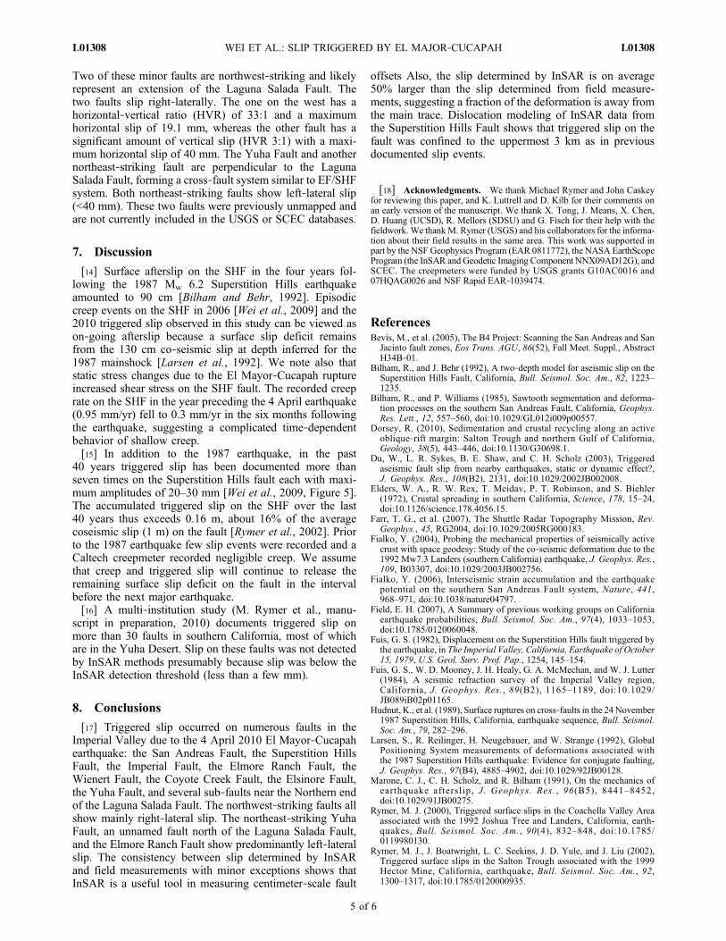
Figure 2. (a) InSAR data in radar coordinates show triggered slip on the Superstition Hills Fault and the Elmore RanchFault. Solid black lines are the fault traces. White arrow points to North. (b) A photo taken in the field. (c) Slip along theSuperstition Hills Fault. (d) Comparison of InSAR measurements with field measurements for the 2010 triggered slip.Dashed line represents the line of ratio 1:1. Solid cross shows the InSAR and Field measurements with uncertainty insegments.
WEI ET AL.: SLIP TRIGGERED BY EL MAJOR‐CUCAPAH L01308L01308
3 of 6
Durmid Hill where experimental fault‐normal creepmetershad been installed a few months earlier. At both locationsfault‐normal displacements were <10% of the horizontalslip, an estimate that is limited in accuracy by knowledge ofthe local strike of the fault.
5. Superstition Hills Fault
[9] The SHF has a long history of triggered slip caused bynearby earthquakes in the last several decades [Wei et al.,2009]. For the 2010 earthquake, field measurements andInSAR data show that the entire shallow portion of theSuperstition Hills Fault slipped, with a maximum offset ofabout 37 mm near its southern end. This observation isinconsistent with a model postulating that triggered slip isenhanced at a more distant end of a fault with respect to theseismic source [Fuis, 1982; Rymer et al., 2002]. Slip on theSHF was predominantly right‐lateral with minor verticalmotion (Table 1). The distribution of offsets along the faultstrike is similar to the distribution mapped in 2006 [Weiet al., 2009] (Figure 2c) as well as to the afterslip follow-ing the 1987 event. The similarity of slip patterns in 1987,2006, and 2010 suggests that all slip is in response to theshallow slip deficit produced by the 1987 earthquake.[10] We extracted twenty‐six InSAR profiles from inter-
ferograms across the 25‐km‐triggered segment of the SHFand converted them to horizontal slip using the known radarincidence angles. The field measurements were binned inthe same fashion as the InSAR profiles. The mean value andstandard deviation of the binned field measurements providean estimate of the uncertainties in the field data (Figure 2d).The comparison shown in Figure 2d illustrates that theInSAR measurements are on average 50% larger than the
field measurements. This suggests that a fraction of defor-mation occurs away from the main trace and probably reflectsgreater slip on the fault in the subsurface. Overall the gen-erally good agreement between InSAR and field measure-ments validates InSAR as a tool for measuring small faultoffsets.[11] The broad coverage of the flanks of the fault provided
by InSAR also allows one to estimate the depth of thetriggered slip. A single profile was extracted and interpretedusing an anti‐plane dislocation model similar to that of Weiet al. [2009]. The model shows that creep extends to a depthof only 3–4 km (Figure S2), similar to the results obtainedfrom slip data from the 2006 event [Wei et al., 2009] andindicates that triggered slip is confined to the thick sedi-mentary cover imaged by seismic studies [Fuis et al., 1984].
6. Other Faults
[12] In addition to the SAF and SHF, we also quantifiedtriggered slip on the Imperial, Elmore Ranch, Wienert,Coyote Creek, Elsinore, Yuha faults, and three minor faultsat the northern end of the Laguna Salada Fault. As with theSAF and SHF, repeated slip occurred on the same sections onthe Imperial, Weinert, and Coyote Creek faults (Figure S3).In contrast, this is the first report of triggered slip on theElmore Ranch Fault (Figures 2a and S1) and the ElsinoreFault (Figure S4). This may only be a consequence of thesefault segments being remote and hardly accessible for fieldstudies.[13] Slip was also observed on several minor faults near
the town of Ocotillo (Figure 1) near the northern end of the2010 surface rupture zone (Figure S1). These minor faultsare in an area that shows small offsets in the interferograms.
Table 1. InSAR Derived Slip Amplitude and Direction on Major Faults
Profile IDa Latitude Longitude LOS1 (mm)b LOS2 (mm)b Horizontal (mm)c Vertical (mm)d
aProfile ID number matches the number in Figure S1.bPositive: increase in range direction.cPositive: right‐lateral.dPositive: east side up.
WEI ET AL.: SLIP TRIGGERED BY EL MAJOR‐CUCAPAH L01308L01308
4 of 6
Two of these minor faults are northwest‐striking and likelyrepresent an extension of the Laguna Salada Fault. Thetwo faults slip right‐laterally. The one on the west has ahorizontal‐vertical ratio (HVR) of 33:1 and a maximumhorizontal slip of 19.1 mm, whereas the other fault has asignificant amount of vertical slip (HVR 3:1) with a maxi-mum horizontal slip of 40 mm. The Yuha Fault and anothernortheast‐striking fault are perpendicular to the LagunaSalada Fault, forming a cross‐fault system similar to EF/SHFsystem. Both northeast‐striking faults show left‐lateral slip(<40 mm). These two faults were previously unmapped andare not currently included in the USGS or SCEC databases.
7. Discussion
[14] Surface afterslip on the SHF in the four years fol-lowing the 1987 Mw 6.2 Superstition Hills earthquakeamounted to 90 cm [Bilham and Behr, 1992]. Episodiccreep events on the SHF in 2006 [Wei et al., 2009] and the2010 triggered slip observed in this study can be viewed ason‐going afterslip because a surface slip deficit remainsfrom the 130 cm co‐seismic slip at depth inferred for the1987 mainshock [Larsen et al., 1992]. We note also thatstatic stress changes due to the El Mayor‐Cucapah ruptureincreased shear stress on the SHF fault. The recorded creeprate on the SHF in the year preceding the 4 April earthquake(0.95 mm/yr) fell to 0.3 mm/yr in the six months followingthe earthquake, suggesting a complicated time‐dependentbehavior of shallow creep.[15] In addition to the 1987 earthquake, in the past
40 years triggered slip has been documented more thanseven times on the Superstition Hills fault each with maxi-mum amplitudes of 20–30 mm [Wei et al., 2009, Figure 5].The accumulated triggered slip on the SHF over the last40 years thus exceeds 0.16 m, about 16% of the averagecoseismic slip (1 m) on the fault [Rymer et al., 2002]. Priorto the 1987 earthquake few slip events were recorded and aCaltech creepmeter recorded negligible creep. We assumethat creep and triggered slip will continue to release theremaining surface slip deficit on the fault in the intervalbefore the next major earthquake.[16] A multi‐institution study (M. Rymer et al., manu-
script in preparation, 2010) documents triggered slip onmore than 30 faults in southern California, most of whichare in the Yuha Desert. Slip on these faults was not detectedby InSAR methods presumably because slip was below theInSAR detection threshold (less than a few mm).
8. Conclusions
[17] Triggered slip occurred on numerous faults in theImperial Valley due to the 4 April 2010 El Mayor‐Cucapahearthquake: the San Andreas Fault, the Superstition HillsFault, the Imperial Fault, the Elmore Ranch Fault, theWienert Fault, the Coyote Creek Fault, the Elsinore Fault,the Yuha Fault, and several sub‐faults near the Northern endof the Laguna Salada Fault. The northwest‐striking faults allshow mainly right‐lateral slip. The northeast‐striking YuhaFault, an unnamed fault north of the Laguna Salada Fault,and the Elmore Ranch Fault show predominantly left‐lateralslip. The consistency between slip determined by InSARand field measurements with minor exceptions shows thatInSAR is a useful tool in measuring centimeter‐scale fault
offsets Also, the slip determined by InSAR is on average50% larger than the slip determined from field measure-ments, suggesting a fraction of the deformation is away fromthe main trace. Dislocation modeling of InSAR data fromthe Superstition Hills Fault shows that triggered slip on thefault was confined to the uppermost 3 km as in previousdocumented slip events.
[18] Acknowledgments. We thank Michael Rymer and John Caskeyfor reviewing this paper, and K. Luttrell and D. Kilb for their comments onan early version of the manuscript. We thank X. Tong, J. Means, X. Chen,D. Huang (UCSD), R. Mellors (SDSU) and G. Fisch for their help with thefieldwork. We thankM. Rymer (USGS) and his collaborators for the informa-tion about their field results in the same area. This work was supported inpart by the NSF Geophysics Program (EAR 0811772), the NASA EarthScopeProgram (the InSAR and Geodetic Imaging Component NNX09AD12G), andSCEC. The creepmeters were funded by USGS grants G10AC0016 and07HQAG0026 and NSF Rapid EAR‐1039474.
ReferencesBevis, M., et al. (2005), The B4 Project: Scanning the San Andreas and San
Jacinto fault zones, Eos Trans. AGU, 86(52), Fall Meet. Suppl., AbstractH34B‐01.
Bilham, R., and J. Behr (1992), A two‐depth model for aseismic slip on theSuperstition Hills Fault, California, Bull. Seismol. Soc. Am., 82, 1223–1235.
Bilham, R., and P. Williams (1985), Sawtooth segmentation and deforma-tion processes on the southern San Andreas Fault, California, Geophys.Res. Lett., 12, 557–560, doi:10.1029/GL012i009p00557.
Dorsey, R. (2010), Sedimentation and crustal recycling along an activeoblique‐rift margin: Salton Trough and northern Gulf of California,Geology, 38(5), 443–446, doi:10.1130/G30698.1.
Du, W., L. R. Sykes, B. E. Shaw, and C. H. Scholz (2003), Triggeredaseismic fault slip from nearby earthquakes, static or dynamic effect?,J. Geophys. Res., 108(B2), 2131, doi:10.1029/2002JB002008.
Elders, W. A., R. W. Rex, T. Meidav, P. T. Robinson, and S. Biehler(1972), Crustal spreading in southern California, Science, 178, 15–24,doi:10.1126/science.178.4056.15.
Farr, T. G., et al. (2007), The Shuttle Radar Topography Mission, Rev.Geophys., 45, RG2004, doi:10.1029/2005RG000183.
Fialko, Y. (2004), Probing the mechanical properties of seismically activecrust with space geodesy: Study of the co‐seismic deformation due to the1992 Mw7.3 Landers (southern California) earthquake, J. Geophys. Res.,109, B03307, doi:10.1029/2003JB002756.
Fialko, Y. (2006), Interseismic strain accumulation and the earthquakepotential on the southern San Andreas Fault system, Nature, 441,968–971, doi:10.1038/nature04797.
Field, E. H. (2007), A Summary of previous working groups on Californiaearthquake probabilities, Bull. Seismol. Soc. Am., 97(4), 1033–1053,doi:10.1785/0120060048.
Fuis, G. S. (1982), Displacement on the Superstition Hills fault triggered bythe earthquake, in The Imperial Valley, California, Earthquake of October15, 1979, U.S. Geol. Surv. Prof. Pap., 1254, 145–154.
Fuis, G. S., W. D. Mooney, J. H. Healy, G. A. McMechan, and W. J. Lutter(1984), A seismic refraction survey of the Imperial Valley region,California, J. Geophys. Res., 89(B2), 1165–1189, doi:10.1029/JB089iB02p01165.
Hudnut, K., et al. (1989), Surface ruptures on cross‐faults in the 24 November1987 Superstition Hills, California, earthquake sequence, Bull. Seismol.Soc. Am., 79, 282–296.
Larsen, S., R. Reilinger, H. Neugebauer, and W. Strange (1992), GlobalPositioning System measurements of deformations associated withthe 1987 Superstition Hills earthquake: Evidence for conjugate faulting,J. Geophys. Res., 97(B4), 4885–4902, doi:10.1029/92JB00128.
Marone, C. J., C. H. Scholz, and R. Bilham (1991), On the mechanics ofearthquake aftersl ip, J. Geophys. Res. , 96(B5), 8441–8452,doi:10.1029/91JB00275.
Rymer, M. J. (2000), Triggered surface slips in the Coachella Valley Areaassociated with the 1992 Joshua Tree and Landers, California, earth-quakes, Bull. Seismol. Soc. Am., 90(4), 832–848, doi:10.1785/0119980130.
Rymer, M. J., J. Boatwright, L. C. Seekins, J. D. Yule, and J. Liu (2002),Triggered surface slips in the Salton Trough associated with the 1999Hector Mine, California, earthquake, Bull. Seismol. Soc. Am., 92,1300–1317, doi:10.1785/0120000935.
WEI ET AL.: SLIP TRIGGERED BY EL MAJOR‐CUCAPAH L01308L01308
5 of 6
Sieh, K. E., and P. W. Williams (1990), Behavior of the southernmost SanAndreas fault during the past 300 years, J. Geophys. Res., 95(B5), 6629–6645, doi:10.1029/JB095iB05p06629.
Wei, M., D. Sandwell, and Y. Fialko (2009), A silent Mw 4.7 slip eventof October 2006 on the Superstition Hills fault, southern California,J. Geophys. Res., 114, B07402, doi:10.1029/2008JB006135.
Williams, P. L., S. F. McGill, K. E. Sieh, C. R. Allen, and J. N. Louie(1988), Triggered slip along the San Andreas fault after the 8 July
1986 North Palm Springs earthquake, Bull. Seismol. Soc. Am., 78(3),1112–1122.
R. Bilham, CIRES and Department of Geological Sciences, University ofColorado at Boulder, Campus Box 399, 2200 Colorado Ave., Boulder, CO80309‐0399, USA.Y. Fialko, D. Sandwell , and M. Wei, Scripps Insti tut ion of
Oceanography, 9500 Gilman Dr., La Jolla, CA 92093‐0225, USA.([email protected])
WEI ET AL.: SLIP TRIGGERED BY EL MAJOR‐CUCAPAH L01308L01308