Information and images from resources held in Local History Collections, Redland City Council Libraries. Local History in catalogue [email protected]or 3829 8311 SMBI Southern Moreton Bay Islands RSC slide courtesy Jan Haughton WARNING: Aboriginal and/or Torres Strait Islander peoples should be aware that this document may contain the images and/or names of people who have passed away.
Transcript
Information and images from resources held in Local History Collections, Redland City Council Libraries. Local History in catalogue [email protected] or 3829 8311
SMBI Southern Moreton Bay Islands
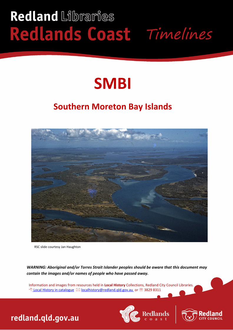
RSC slide courtesy Jan Haughton
WARNING: Aboriginal and/or Torres Strait Islander peoples should be aware that this document may contain the images and/or names of people who have passed away.
Contents Quandamooka people ............................................................................................... 1 Convicts .................................................................................................................... 3 Sugar and cotton ....................................................................................................... 3 Oysters ...................................................................................................................... 5 Timber ....................................................................................................................... 5 Other ventures .......................................................................................................... 6 Boats ......................................................................................................................... 7 Karragarra Island ...................................................................................................... 7 Lamb Island............................................................................................................... 8 Macleay Island .......................................................................................................... 9 Russell Island .......................................................................................................... 11 1950 onwards .......................................................................................................... 13 Sources: .................................................................................................................. 20
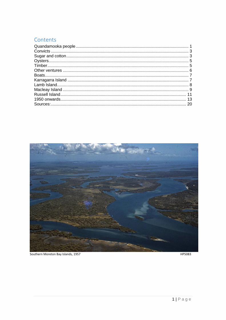
Southern Moreton Bay Islands, 1957 HP5083
2 | P a g e
Quandamooka people
The area from Stradbroke to the mainland and including the bay islands was most likely inhabited by Coobenpil people, who named many of the islands. Archaeologists have proven continuous Aboriginal habitation for 20,000 years on North Stradbroke Island. Aborigines collected oysters before Europeans established an industry and their collection was non-destructive, unlike Europeans who decimated many oyster beds within 50 years of settlement. Oyster shells were collected by Europeans for burning to produce lime, which was used in cement and mortar as well as brick-making.
Image CC2
Several archaeological sites are on the four bay islands that are made of bedrock, meaning that they must have existed either as islands or hills when the ocean was around 35km away. The Queensland Museum holds a pounding stone that was found on Russell Island; these were used for pounding Bungwall fern roots or Bunya nuts into flour, for making a kind of flat bread known later as Johnny or Journey Cakes. Aboriginal people are believed to be the world’s first bakers, with pounding stones having been dated back to 30,000 years ago. During Aboriginal times, the islands would have been covered in bushland vegetation and there would have been burning and uses of timber and rocks in a sustainable way. Aborigines also hunted dugongs sustainably for thousands of years, however Europeans managed to nearly wipe them out through mass hunting for their oil.
Dugong hunting in Moreton Bay c1890, HP0002
Many ancient shell middens were completed obliterated, and the industry only ceased when the live oyster industry proved to be more profitable.
3 | P a g e
Convicts
There are records of early settlers on the Southern Moreton Bay Islands (SMBI) being convicts:
William Elliott: owned land in 1872 which was leased by Gilbert Burnett for timber. John Clowes: a former convict, arrived at Russell Island in the 1850s, and started oyster shell burning on crown land, where he had a kiln. He took up 27 acres of oyster lease in 1870. Thomas Flood: was involved in oyster shell lime burning and timber-getting on Lamb Island with Thomas Lucas. Isaac Lucas: a timber-cutter with William Hutchinson jnr on Karragarra Island in the 1850s. Maps show Hutchinson was the island’s owner. Joseph Brown: during the 1850s he worked an oyster lease and felled timber on southern Russell Island. He bought land on Russell in the first subdivision of 80-acre lots in 1870. Edwin Clarke: worked oyster beds on the eastern side of Lamb Island; Clarke’s Point is named after him. He burned oyster shells for lime as well. Thomas Lucas took over his oyster beds when the Moreton Bay Oyster Company was formed in 1868.
Sugar and cotton Land was first advertised for sale on the bay islands in the NSW Government Gazette 19 August 1859, but the sale was cancelled because of the approaching separation of Queensland from NSW. The Coffee and Sugar Act of 1864 resulted in Crown Land being available for selection for sugar, cotton and coffee growers. Cotton and sugar were both grown in this area. Queensland Premier RGW Herbert (1860-1866) applied for a lease on Lamb Island but the Island was smaller than the minimum size for a lease so he wanted to include Karragarra Island as well, but this was refused. John “Tinker” Campbell was one of earliest to select land on islands; he grew sugar for a year and possibly built the saltworks at Canaipa Point in 1865 before building new salt works on Pininpinin Point Macleay Island in 1866, using his son Robert’s lease. He sold the Russell Island lease to WR Alexander in late 1867, who is said to have operated a rum distillery rather than saltworks or sugar refinery. In 1870 Campbell tried growing cotton for J and G Harris, but the venture failed when the world market dropped after the American civil war ended.
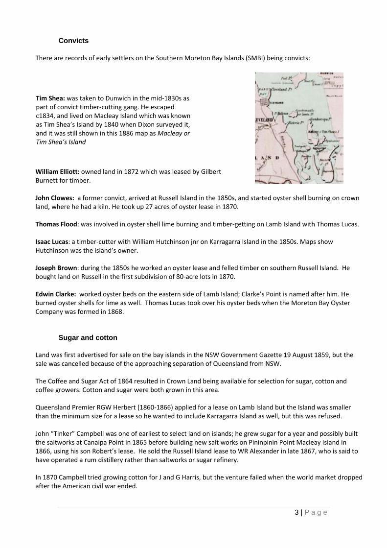
Tim Shea: was taken to Dunwich in the mid-1830s as part of convict timber-cutting gang. He escaped c1834, and lived on Macleay Island which was known as Tim Shea’s Island by 1840 when Dixon surveyed it, and it was still shown in this 1886 map as Macleay or Tim Shea’s Island
4 | P a g e
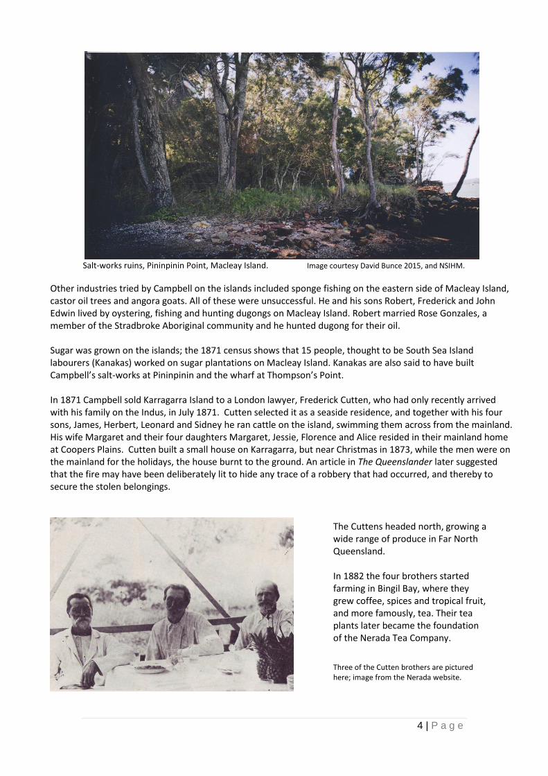
Salt-works ruins, Pininpinin Point, Macleay Island. Image courtesy David Bunce 2015, and NSIHM.
Other industries tried by Campbell on the islands included sponge fishing on the eastern side of Macleay Island, castor oil trees and angora goats. All of these were unsuccessful. He and his sons Robert, Frederick and John Edwin lived by oystering, fishing and hunting dugongs on Macleay Island. Robert married Rose Gonzales, a member of the Stradbroke Aboriginal community and he hunted dugong for their oil. Sugar was grown on the islands; the 1871 census shows that 15 people, thought to be South Sea Island labourers (Kanakas) worked on sugar plantations on Macleay Island. Kanakas are also said to have built Campbell’s salt-works at Pininpinin and the wharf at Thompson’s Point. In 1871 Campbell sold Karragarra Island to a London lawyer, Frederick Cutten, who had only recently arrived with his family on the Indus, in July 1871. Cutten selected it as a seaside residence, and together with his four sons, James, Herbert, Leonard and Sidney he ran cattle on the island, swimming them across from the mainland. His wife Margaret and their four daughters Margaret, Jessie, Florence and Alice resided in their mainland home at Coopers Plains. Cutten built a small house on Karragarra, but near Christmas in 1873, while the men were on the mainland for the holidays, the house burnt to the ground. An article in The Queenslander later suggested that the fire may have been deliberately lit to hide any trace of a robbery that had occurred, and thereby to secure the stolen belongings.
The Cuttens headed north, growing a wide range of produce in Far North Queensland. In 1882 the four brothers started farming in Bingil Bay, where they grew coffee, spices and tropical fruit, and more famously, tea. Their tea plants later became the foundation of the Nerada Tea Company.
Three of the Cutten brothers are pictured here; image from the Nerada website.
5 | P a g e
Oysters
An 1884 map shows oyster leases 19, 40, 16 and 18 around Macleay and Lamb Islands. Oystering was biggest fishery in southern Queensland for years; at its peak the industry employed about 200 people. Lamb Island – One of the earliest European settlers on the Bay Islands was Thomas Lucas, who was born near London in 1836 and came to Australia aboard The Queen of the South in 1865. He settled on Lamb Island at Corroboree Point and was a pioneer of the oyster farming industry in Moreton Bay. He married in 1886 at the age of 49, and died at age 58 in 1895. His grave is on the hill above the Lamb Island jetty, and is the only one on the island. One of the main attractions of the oyster industry was in fact converting the shells to lime rather than the fish itself. Lime was much in demand in the building industry. One of the main sources was middens. As they ran out of middens and other deposits, but this practice was banned in 1863 and as a result the live oyster trade took over. The oyster fishery died out because of mud worm 1895-1901, but recovered and re-built to a peak in 1910. At that time every available spot in Moreton Bay that would support an oyster was under lease. Licensed banks in the Bay totalled 849 leases covering 10,100 ha. During the heyday of the industry, many oystermen lived in rough camps on the bay islands. Dwellings comprised simple shacks made of bark and slab, as well as sugar-bags, with two-room cottages being built as incomes improved. They used small cutters and flat-bottomed dinghies for transport. In 1889 the need to control the industry was recognised and the Queensland Government gazetted 26 reserves around the Bay and Sandy Strait where for an annual fee oystermen could camp, build houses and fence small allotments etc. One of the biggest oystering families in the 20th century was the Levinges, an Aboriginal family of North Stradbroke Island. Albert Levinge managed the Moreton Bay Oyster Company’s operations at Dunwich, and in 1916 he took over the company’s camp at Currigee. His sons also took up trade, and their company was named the Levinge Oyster Company after WWII. It went into receivership in 1965.
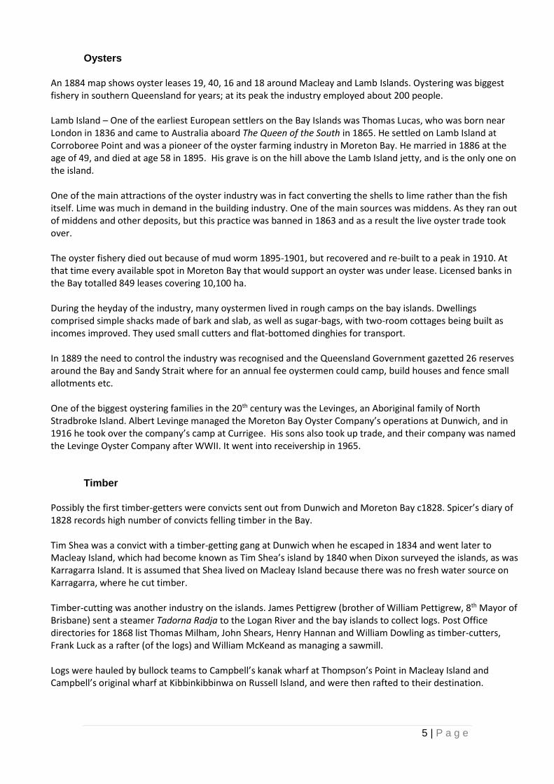
Timber Possibly the first timber-getters were convicts sent out from Dunwich and Moreton Bay c1828. Spicer’s diary of 1828 records high number of convicts felling timber in the Bay. Tim Shea was a convict with a timber-getting gang at Dunwich when he escaped in 1834 and went later to Macleay Island, which had become known as Tim Shea’s island by 1840 when Dixon surveyed the islands, as was Karragarra Island. It is assumed that Shea lived on Macleay Island because there was no fresh water source on Karragarra, where he cut timber. Timber-cutting was another industry on the islands. James Pettigrew (brother of William Pettigrew, 8th Mayor of Brisbane) sent a steamer Tadorna Radja to the Logan River and the bay islands to collect logs. Post Office directories for 1868 list Thomas Milham, John Shears, Henry Hannan and William Dowling as timber-cutters, Frank Luck as a rafter (of the logs) and William McKeand as managing a sawmill. Logs were hauled by bullock teams to Campbell’s kanak wharf at Thompson’s Point in Macleay Island and Campbell’s original wharf at Kibbinkibbinwa on Russell Island, and were then rafted to their destination.
6 | P a g e
Laurel Horton collection: bullock dray Redland Bay, c1871 HP4373
In the 1890s Gilbert Burnett and his sons leased/owned land on the islands for timber. He built the Eucalypta to transport timber from the islands to his sawmill on Hilliards Creek. In the 1890s the Acclimatisation Society introduced new species on islands, including mango trees, some of which are still growing there. In the early 1900s Mark Jackson logged intensively and in the 1940s Joe Laverty held a contract for the supply of railway sleepers. He sold the contract in 1960 to land developer Cecil Rose.
Other ventures Cattle were swum across in a bid to open the islands as pastoral leases, but they didn’t thrive so most leases were abandoned. A tax on imported salt in the colony in the early days led people to try to make their own. It was a paying proposition until the 1870s when the salt tax was lifted. W R Alexander established salt-making plant on Russell Island in 1871, although there is some debate whether these works were set up by Alexander, or by John (Tinker) Campbell. A Macleay island site was first auctioned in 1871 and the land bought by Robert Turner who leased it to the Willes family later. Campbell later built a saltworks on Macleay Island which is still largely intact, and Welsby claims that Campbell had also built the first saltworks on Russell Island. Physical evidence shows bricks similar to those at his Macleay Island site. Pineapples were introduced in 1905 to the islands. The first to grow them were Mark Jackson on Russell Island, the Lovells, Hines, Brooks and Robertsons on Lamb Island, the Noyes on Karragarra and the Norths on Macleay and Garden Islands. Bananas were grown at same time by William Branch Snr on Russell Island. Tomatoes, pawpaws, passionfruit were all grown in the 1950s and later avocadoes.
7 | P a g e
Boats
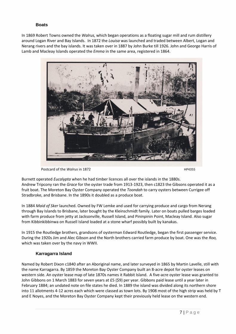
In 1869 Robert Towns owned the Walrus, which began operations as a floating sugar mill and rum distillery around Logan River and Bay Islands. In 1872 the Louisa was launched and traded between Albert, Logan and Nerang rivers and the bay islands. It was taken over in 1887 by John Burke till 1926. John and George Harris of Lamb and Macleay Islands operated the Emma in the same area, registered in 1864.
Postcard of the Walrus in 1872 HP4355
Burnett operated Eucalypta when he had timber licences all over the islands in the 1880s. Andrew Tripcony ran the Grace for the oyster trade from 1913-1923, then c1823 the Gibsons operated it as a fruit boat. The Moreton Bay Oyster Company operated the Toondah to carry oysters between Currigee off Stradbroke, and Brisbane. In the 1890s it doubled as a produce boat. In 1884 Maid of Sker launched. Owned by FW Lemke and used for carrying produce and cargo from Nerang through Bay Islands to Brisbane, later bought by the Kleinschmidt family. Later on boats pulled barges loaded with farm produce from jetty at Jacksonville, Russell Island, and Pininpinin Point, Macleay Island. Also sugar from Kibbinkibbinwa on Russell Island loaded at a stone wharf possibly built by kanakas. In 1915 the Routledge brothers, grandsons of oysterman Edward Routledge, began the first passenger service. During the 1920s Jim and Alec Gibson and the North brothers carried farm produce by boat. One was the Roo, which was taken over by the navy in WWII.
Karragarra Island Named by Robert Dixon c1840 after an Aboriginal name, and later surveyed in 1865 by Martin Lavelle, still with the name Karragarra. By 1859 the Moreton Bay Oyster Company built an 8-acre depot for oyster leases on western side. An oyster lease map of late 1870s names it Rabbit Island. A five-acre oyster lease was granted to John Gibbons on 1 March 1883 for seven years at £5 ($9) per year. Gibbons paid lease until a year later in February 1884; an undated note on file states he died. In 1889 the island was divided along its northern shore into 11 allotments 4-12 acres each which were classed as town lots. By 1908 most of the high strip was held by T and E Noyes, and the Moreton Bay Oyster Company kept their previously held lease on the western end.
8 | P a g e
Noyes homestead was built in 1900 by Dick Scott for his wife Edith Willes from Russell Island. In 1916 the remainder of the island was bought by Eric and Thomas Noyes for £422 ($770). Brother Fred Noyes joined them, and then Eric Noyes bought land on Lamb Island.
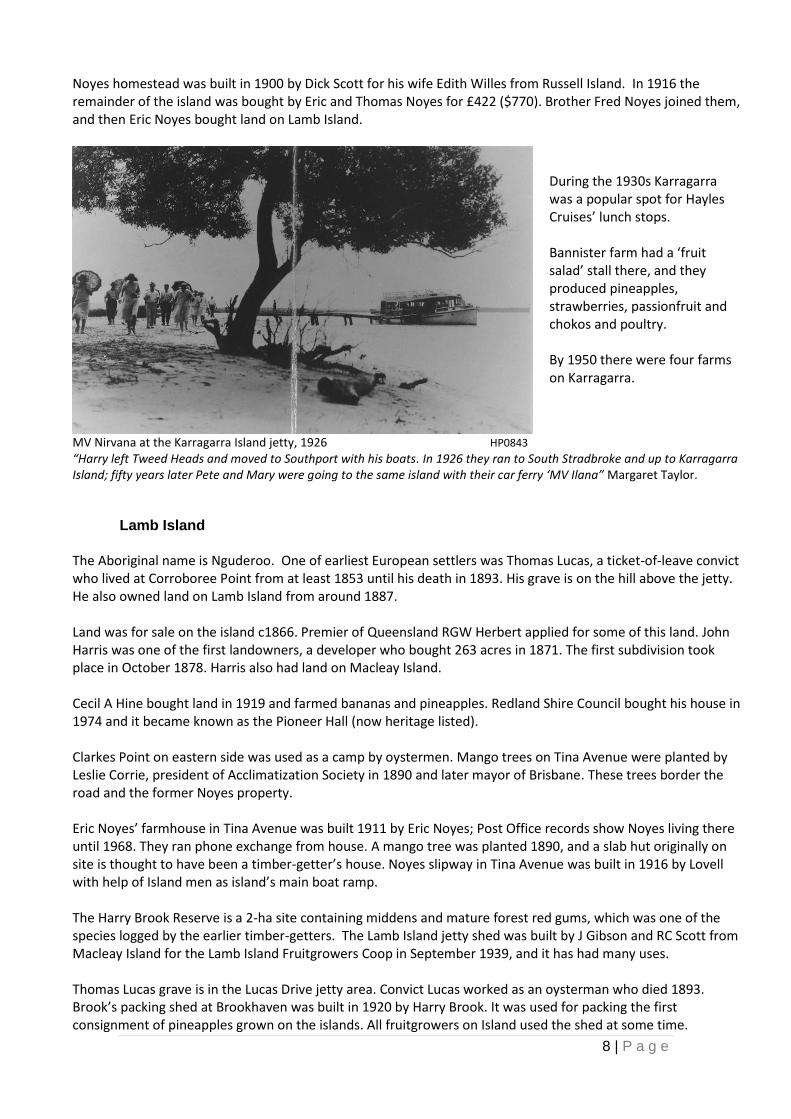
MV Nirvana at the Karragarra Island jetty, 1926 HP0843
“Harry left Tweed Heads and moved to Southport with his boats. In 1926 they ran to South Stradbroke and up to Karragarra Island; fifty years later Pete and Mary were going to the same island with their car ferry ‘MV Ilana” Margaret Taylor.
Lamb Island
The Aboriginal name is Nguderoo. One of earliest European settlers was Thomas Lucas, a ticket-of-leave convict who lived at Corroboree Point from at least 1853 until his death in 1893. His grave is on the hill above the jetty. He also owned land on Lamb Island from around 1887. Land was for sale on the island c1866. Premier of Queensland RGW Herbert applied for some of this land. John Harris was one of the first landowners, a developer who bought 263 acres in 1871. The first subdivision took place in October 1878. Harris also had land on Macleay Island. Cecil A Hine bought land in 1919 and farmed bananas and pineapples. Redland Shire Council bought his house in 1974 and it became known as the Pioneer Hall (now heritage listed). Clarkes Point on eastern side was used as a camp by oystermen. Mango trees on Tina Avenue were planted by Leslie Corrie, president of Acclimatization Society in 1890 and later mayor of Brisbane. These trees border the road and the former Noyes property. Eric Noyes’ farmhouse in Tina Avenue was built 1911 by Eric Noyes; Post Office records show Noyes living there until 1968. They ran phone exchange from house. A mango tree was planted 1890, and a slab hut originally on site is thought to have been a timber-getter’s house. Noyes slipway in Tina Avenue was built in 1916 by Lovell with help of Island men as island’s main boat ramp. The Harry Brook Reserve is a 2-ha site containing middens and mature forest red gums, which was one of the species logged by the earlier timber-getters. The Lamb Island jetty shed was built by J Gibson and RC Scott from Macleay Island for the Lamb Island Fruitgrowers Coop in September 1939, and it has had many uses. Thomas Lucas grave is in the Lucas Drive jetty area. Convict Lucas worked as an oysterman who died 1893. Brook’s packing shed at Brookhaven was built in 1920 by Harry Brook. It was used for packing the first consignment of pineapples grown on the islands. All fruitgrowers on Island used the shed at some time.
During the 1930s Karragarra was a popular spot for Hayles Cruises’ lunch stops. Bannister farm had a ‘fruit salad’ stall there, and they produced pineapples, strawberries, passionfruit and chokos and poultry. By 1950 there were four farms on Karragarra.
9 | P a g e
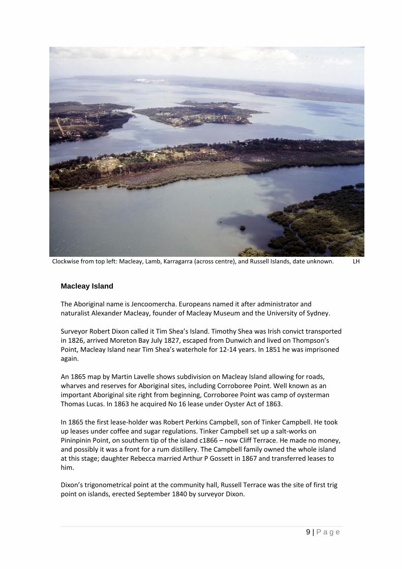
Clockwise from top left: Macleay, Lamb, Karragarra (across centre), and Russell Islands, date unknown. LH
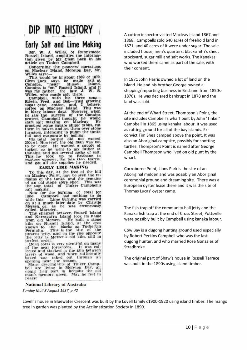
Macleay Island The Aboriginal name is Jencoomercha. Europeans named it after administrator and naturalist Alexander Macleay, founder of Macleay Museum and the University of Sydney. Surveyor Robert Dixon called it Tim Shea’s Island. Timothy Shea was Irish convict transported in 1826, arrived Moreton Bay July 1827, escaped from Dunwich and lived on Thompson’s Point, Macleay Island near Tim Shea’s waterhole for 12-14 years. In 1851 he was imprisoned again. An 1865 map by Martin Lavelle shows subdivision on Macleay Island allowing for roads, wharves and reserves for Aboriginal sites, including Corroboree Point. Well known as an important Aboriginal site right from beginning, Corroboree Point was camp of oysterman Thomas Lucas. In 1863 he acquired No 16 lease under Oyster Act of 1863. In 1865 the first lease-holder was Robert Perkins Campbell, son of Tinker Campbell. He took up leases under coffee and sugar regulations. Tinker Campbell set up a salt-works on Pininpinin Point, on southern tip of the island c1866 – now Cliff Terrace. He made no money, and possibly it was a front for a rum distillery. The Campbell family owned the whole island at this stage; daughter Rebecca married Arthur P Gossett in 1867 and transferred leases to him.
Dixon’s trigonometrical point at the community hall, Russell Terrace was the site of first trig point on islands, erected September 1840 by surveyor Dixon.
10 | P a g e
Sunday Mail 8 August 1937, p.42
Lovell’s house in Bluewater Crescent was built by the Lovell family c1900-1920 using island timber. The mango tree in garden was planted by the Acclimatization Society in 1890.
A cotton inspector visited Macleay Island 1867 and 1868. Campbells sold 640 acres of freehold land in 1871, and 40 acres of it were under sugar. The sale included house, men’s quarters, blacksmith’s shed, stockyard, sugar mill and salt works. The Kanakas who worked there came as part of the sale, with their consent. In 1871 John Harris owned a lot of land on the island. He and his brother George owned a shipping/importing business in Brisbane from 1850s-1870s. He was declared bankrupt in 1878 and the land was sold. At the end of Wharf Street, Thompson’s Point, the site includes Campbell’s wharf built by John ‘Tinker’ Campbell in 1865 using kanaka labour. It was used as rafting ground for all of the bay islands. Ex-convict Tim Shea camped above the point. It was also an Aboriginal campsite, possibly for spotting turtles. Thompson’s Point is named after George Campbell Thompson who lived on old punt by the wharf. Corroboree Point, Lions Park is the site of an Aboriginal midden and was possibly an Aboriginal ceremonial ground and dreaming site. There was a European oyster lease there and it was the site of Thomas Lucas’ oyster camp. The fish trap off the community hall jetty and the Kanaka fish trap at the end of Cross Street, Pottsville were possibly built by Campbell using kanaka labour. Cow Bay is a dugong hunting ground used especially by Robert Perkins Campbell who was the last dugong hunter, and who married Rose Gonzales of Stradbroke. The original part of Shaw’s house in Russell Terrace was built in the 1890s using island timber.
11 | P a g e
McCaskell’s house on High Central Road was built in the1930s using island timber. ‘Eastbourne’ on Eastbourne Terrace was an early holiday home built c1920s-30s. The Arboretum on Western Road has mango trees planted by the Acclimatization Society in the 1890s. Tim Shea’s water hole off Sandpiper Street is a natural waterhole listed in the Lavelle survey of 1865. It provided islanders with fresh drinking water. Roger’s well on Eastbourne Terrace is timber-lined, hand-dug, and well-built c1920s. It supplied island with bore water until reticulated water came 1996. Iron Stem: the current navigation marker and light named “Iron Stem” is a short distance offshore from the end of Attunga Street, Macleay Island. It shows the location of submerged rocks which present a hazard to boating. The origins of the name aren’t recorded, but the first marker was placed there many, many years ago by Macleay Island locals to warn of the unseen danger. They placed a large iron pole in the middle of the rocks. It is quite possible that the iron pole was the ‘stem’ of an old boat. Source: Marine Parks (Department of National Parks, Sport and Racing), Mike Carr (Manly) 13 December 2017
Russell Island The island was named in the 1840s after Lord John Russell, the Secretary of State for the colonies. It was originally surveyed in 1840s. By 1859 the Moreton Bay Oyster Company had leases on island. John ‘Tinker’ Campbell had a 640 acre land lease by 1866 and built a jetty at Kibbinkibbinwa Point to load timber and sugar. He later moved to Macleay Island. John SW Willes began farming on the island after the Campbells moved, and he bought WR Alexander’s salt-works in 1868. His home was Canaipa House at northeast end of island; near the current Royal Queensland Yacht Club. Another 1868 farmer listed in Post Office directories was Mr Daubery. In 1871 the salt tax on imported salt was lifted, so salt production was no longer profitable. Willes concentrated on farming. He grew about 30 acres of sugar using kanaka labour on the Canaipa estate that he leased from Robert Turner. In 1882 a ship loaded with sugar was wrecked and Mrs Willes began lighting a lamp on a high post near their house for next 38 years. There was possibly a massacre of Aborigines near the bora ground on the southern end of the island when a Cleveland policeman shot some of them after a local landowner reported drunken revelry; possibly at a corroboree. Timber was rafted from rafting grounds near the present water taxi jetty. Surveyor Warner’s map of 1872 divides the island into 80-acre blocks with roads separating the blocks. It shows swamps and drainage systems. John Clowes, a ticket-of-leave convict, was one of earliest landowners, buying 27 acres of his oyster lease in 1870. Possibly the first block was sold to Robert Turner 1871 who paid £484 ($880) for land including the north east peninsula to Canaipa Point, and possibly included existing improvements which would account for the big sum of money paid. One early selector was Christian Mersen who selected 183 acres in December 1871 and applied for more land in 1873. However he didn’t pay rent and the land was re-opened for selection in 1876. He burnt coral for lime near the site of the coral burners’ jetty on John Clowes’ property; a kiln on the site known as Tuckerbin Permultu was on Clowes’ land. Marsen Channel between Russell and Karragarra Islands is named after Mersen (now known as Marsden Channel).
E Northridge was an early selector, who sold to Price Fletcher. Then in 1879 the land was transferred to William Wallace Elliott, another ticket-of-leave convict. Later buyers in 1871 were: John Clowes a ticket-of-leave convict; Hamilton Wallis; Gilbert Burnett; and Joseph Brown, also a ticket-of-leave convict. Clowes worked as lime burner on his own land. A map of 1872 shows Elliott, who was a ticket-of-leave convict, owned land which was leased by Gilbert Burnett. In 1876 William Elliott bought land, and then Christian Marson later. Government Gazette in 1887 lists Canaipa Passage’s Stradbroke Island side as a reserve for camping, for the use of oyster licensees. Robert Turner was listed as owner of land opposite Straddie on Canaipa Passage, but was never recorded as having lived there. This also where John Willes lived; he arrived on Russell Island attracted by the salt plant being operated by Alexander and Armour, Brisbane merchants. Salt-making proved unsatisfactory so he turned to farming and oystering. He raised five children in his house, called Canaipa. The Willes family is memorable because Mrs Katherine Victoria Willes used to light lamp on a post at night to guide her husband home. She kept doing this after she no longer needed to, because it had become one of the main navigational aids of that part of the Bay, so much so that the Government continued doing it when she stopped. Fred Willes farmed on Russell and acted as postmaster/postman for islands. Russell Island state school on Centre Road opened in 1916, and moved to its present site in 1926. St Peter’s Parish Hall, was built in the 1920s. Mrs Fischer’s grave is in Waikiki Beach Road. Mrs Fischer arrived with the Jacksons in 1906.
Mark Jackson arrived in 1905, and farmed mainly pineapples on the western side. He opened a pineapple cannery in 1915 which employed up to 20 people. Jackson’s cannery closed during depression. He started a sawmill but dwindling island supplies led to its closure. He supplied timber for the Methodist Church, which was soon eaten by white ants and pulled down. The area was known locally as ‘the church ground’. Church services were held in house of Mr and Miss Hender until the present hall was built on land owned by Fred Willes.
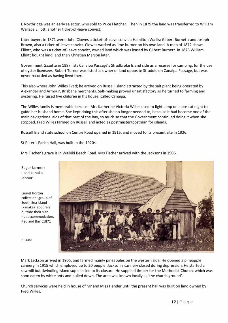
Sugar farmers used kanaka labour. Laurel Horton collection: group of South Sea Island (kanaka) labourers outside their slab hut accommodation, Redland Bay c1871 HP4383
13 | P a g e
Jackson freighted fruit and produce on barges from his jetty at his property called Jacksonville. He opened Bay View Picture Theatre, which burnt down in 1960. He was Illiterate himself, but donated 5 acres for a school oval and built a swimming pool enclosure with a shark barrier.
The Branch family arrived in 1913, and first worked as contract clearers for Willes then selected their own land and grew bananas.
In 1916 Russell Island state school started; the school building was carried across the bay on a boat. It was first erected near Black Cat Swamp, and then moved to its present location in 1926. The first teacher was Eileen Willes, granddaughter of John Willes. Canaipa precinct, northeast Russell Island is the site of the original Campbell jetty and salt-works (from the 1860s), the Willes oyster leases, Katherine Willes’ lady of the lamp, and the Aboriginal crossing to Stradbroke Island.
Willes’ homestead at 10 Alison Street, built in the 1890s, owned by the family until the 1960s. William Willes’ house at Cavendish Street was built by Willes family c1890s.
Jackson houses: one on the corner of Beth and Jackson Roads, one in Mark Street, built 1920s. Jacksonville is the site of settlement in 1920s including private houses, a picture theatre, pineapple cannery/timber mill, enclosed swimming pool, timber jetty for fruit, loading barge.
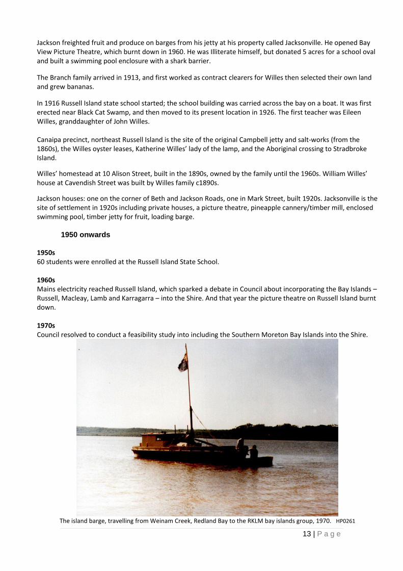
1950 onwards 1950s 60 students were enrolled at the Russell Island State School. 1960s Mains electricity reached Russell Island, which sparked a debate in Council about incorporating the Bay Islands – Russell, Macleay, Lamb and Karragarra – into the Shire. And that year the picture theatre on Russell Island burnt down. 1970s Council resolved to conduct a feasibility study into including the Southern Moreton Bay Islands into the Shire.
The island barge, travelling from Weinam Creek, Redland Bay to the RKLM bay islands group, 1970. HP0261
14 | P a g e
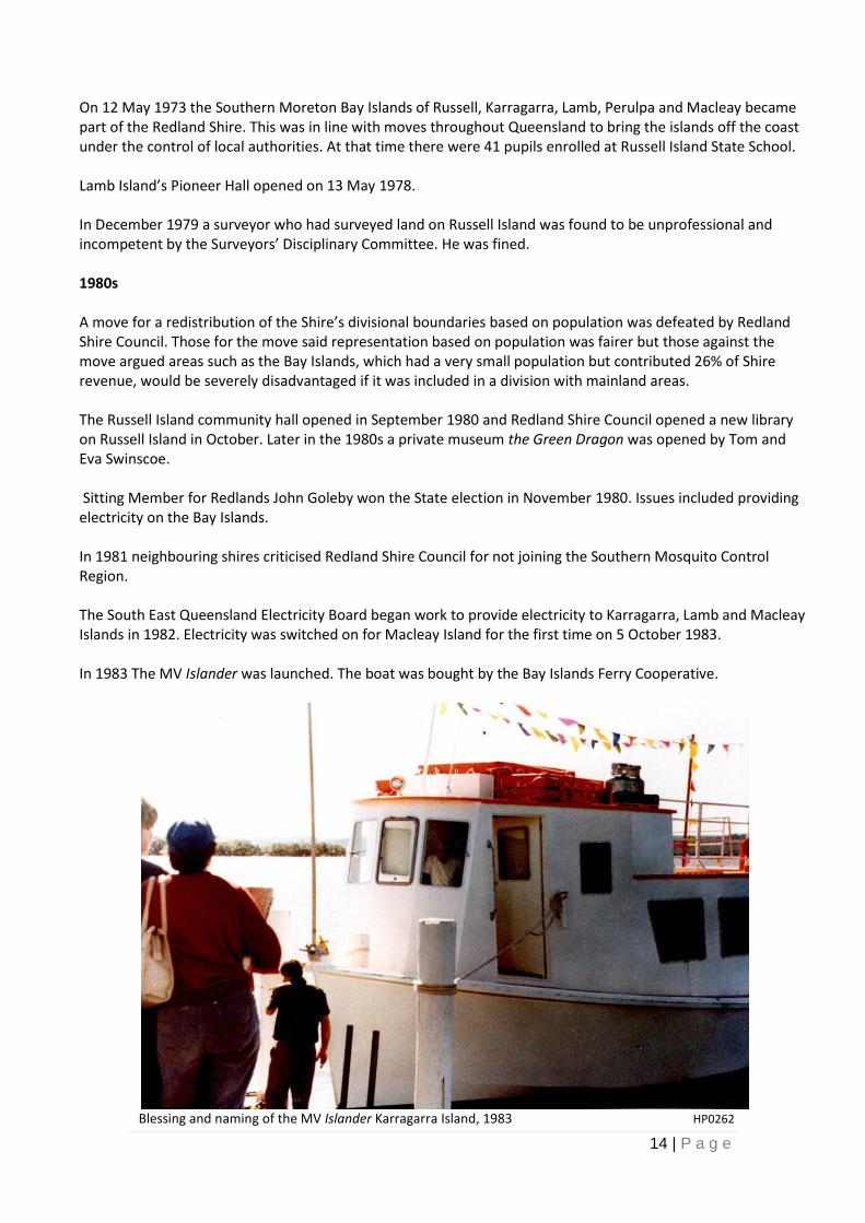
On 12 May 1973 the Southern Moreton Bay Islands of Russell, Karragarra, Lamb, Perulpa and Macleay became part of the Redland Shire. This was in line with moves throughout Queensland to bring the islands off the coast under the control of local authorities. At that time there were 41 pupils enrolled at Russell Island State School. Lamb Island’s Pioneer Hall opened on 13 May 1978. In December 1979 a surveyor who had surveyed land on Russell Island was found to be unprofessional and incompetent by the Surveyors’ Disciplinary Committee. He was fined. 1980s A move for a redistribution of the Shire’s divisional boundaries based on population was defeated by Redland Shire Council. Those for the move said representation based on population was fairer but those against the move argued areas such as the Bay Islands, which had a very small population but contributed 26% of Shire revenue, would be severely disadvantaged if it was included in a division with mainland areas. The Russell Island community hall opened in September 1980 and Redland Shire Council opened a new library on Russell Island in October. Later in the 1980s a private museum the Green Dragon was opened by Tom and Eva Swinscoe. Sitting Member for Redlands John Goleby won the State election in November 1980. Issues included providing electricity on the Bay Islands. In 1981 neighbouring shires criticised Redland Shire Council for not joining the Southern Mosquito Control Region. The South East Queensland Electricity Board began work to provide electricity to Karragarra, Lamb and Macleay Islands in 1982. Electricity was switched on for Macleay Island for the first time on 5 October 1983. In 1983 The MV Islander was launched. The boat was bought by the Bay Islands Ferry Cooperative.
Blessing and naming of the MV Islander Karragarra Island, 1983 HP0262
15 | P a g e
In 1983 the Shire’s population was about 52,000. North Stradbroke and Bay Islands had a combined population of 3,525. Russell Island’s school had 78 pupils enrolled. The Russell Island land fraud conspiracy trial ended in March 1983 without a verdict. Eight people had been accused of conspiring to defraud the public by deceitfully inducing people to buy land on Russell Island between 1968 and 1979. It was the longest fraud trial in the history of British justice. In 1984 Council began planning for bringing water from the North Stradbroke Island to the mainland via a pipeline to the Southern Moreton Bay Islands and on to the mainland. In January 1985 State Cabinet announced the proposed Stradbroke Island bridge would go via Russell Island. Island residents opposing the bridge were joined by conservationists. Shire Chairman Merv Genrich said the route was the best option if the bridge had to go ahead. Five tenders were received by the State Government for the bridge and in June Premier Joh Bjelke-Petersen said the bridge would go ahead provided the successful tenderer could ensure there was no financial risk for the State Government. Bay Islanders lobbied Council to introduce tree protection legislation after they became concerned at the number of real estate agents and developers clearing blocks on the Islands. In 1985 a new jetty at Russell Island was completed, and in 1986 Macleay Island state school opened. The Licensing Court granted a resort licence to the proposed $1.5 million Perulpa Bay Resort Village on Macleay Island. And the island bridge saga continued, with Premier Joh Bjelke-Petersen announcing in February that the bridge would not proceed for the foreseeable future because it was not commercially viable. In August 1987 the Russell Island Development Association told a meeting of 400 islanders that a proposal was to go to State Cabinet in two weeks for private enterprise to build a bridge to Pannikin, Russell and Stradbroke Islands. That month State Cabinet was looking at a report known as the Moreton Bay Water Transport Study. 1988 Bi-Centenary year Redlands Australia Day award winner was Peggy Saunders (Citizen of the Year). And the bridge debate still continued: Cleveland traders joined the debate expressing concern that it would take trade away from their businesses. Meanwhile an anti-bridge group was formed on Russell Island. And in March, the recently re-elected Shire Chairman Merv Genrich said that as the Shire’s plans to bring underground water to the mainland came into being, the bridge’s chances decreased because 95% of the Island would have to be declared a water catchment reserve. This would mean that insufficient crown land would be left for residential development to pay for the bridge. The State Government had always intended to give the developer land for subdivisions in exchange for the developer paying for the bridge. Meanwhile, Russell Island Development Association (RIDA) members threatened to stop paying rates if the bridge to Russell Island did not go ahead, and a company owning land on Russell Island was investigated by the Fraud Squad after being accused of trying to sell drainage problem land on the Island to the Sydney market. By November the Russell Island branch of the National Party had begun moves to have the Islands secede from the Redland Shire. The year 1989 began with the bridge again: while waiting for a State Government decision on whether or not the bridge would go ahead, Premier Mike Ahern said the bridge was not the only issue; something would also have to be done about the small blocks and drainage problem land.
16 | P a g e
1989 Redlands Australia Day Citizen of the Year was Lyn Garner of Macleay Island. The Moreton Bay Strategic Plan was released in 1989, bringing the Bay under the control of one over-riding Plan. The Plan identified conservation areas and areas where particular types of development would be permitted. Council received an application for consent to develop a 32 hectare resort on the corner of Centre and Glendale Roads, Russell Island. Meanwhile, the Perulpa Resort on Macleay Island was no closer to fruition. The State Government announced in 1989 that it planned to pass a development Act for Russell Island to ensure orderly development. Deputy Premier Bill Gunn said the Act was a firm indication the bridge would be built but before then the planning mess had to be cleared up. Council announced a massive resumption of drainage problem land from developers as preparation for the new Act. This raised fears among the landowners that resumptions would be at the Valuer-General’s valuation rather than the higher market value. By November the State Government had turned its focus from the bridge to solving the problems associated with drainage problem land, stating that the latter had to be solved before a bridge was built. 1990s Stage one of the RSL and Services Club on Russell Island officially opened. Telephone subscribers on Moreton, North Stradbroke and Macleay Islands were issued new telephone numbers. Macleay Island resident and scientist, Dr Patrick Ffyske Howden, released his latest book Prosperity from a pittance - or free at last. The book was a guide to self-sufficiency living. Bay Islands Cooperative formed to establish suitable water transport between the Bay Islands and the mainland. The ‘Giant’s Grave’, a knoll which rises from a 13 hectare saltwater swamp on Russell Island, was saved from resumption. Russell Island was connected to the town water supply. Redland Shire Council resumed 10 blocks of land on Russell Island for a proposed water tower. Russell Island Girl Guides and Brownies was established. Local Government Minister, Tom Burns, called for a report regarding allegations that Drainage Problem land below the high water mark on Russell Island may not legally be controlled by Redland Shire Council and therefore could not attract general rates charges. Subsequently the State Government introduced retrospective legislation to make this land part of Redland Shire. The Russell Island development Association (RIDA), submitted an application to install a barge service from Lagoon Island to Rocky Point, Russell Island. The Royal Queensland Yacht Squadron bought a tract of waterfront land at Canaipa Point, Russell Island. Lamb Island Hall committee was formed under the chairmanship of Cr Peter Robinson. Over 32 hectares of land on Russell Island was purchased by Redland Shire Council for purposes of recreation and community activity.
17 | P a g e
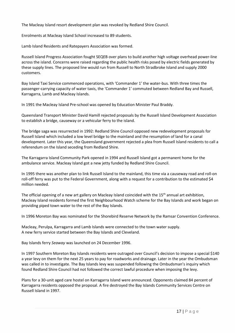
The Macleay Island resort development plan was revoked by Redland Shire Council. Enrolments at Macleay Island School increased to 89 students. Lamb Island Residents and Ratepayers Association was formed. Russell Island Progress Association fought SEQEB over plans to build another high voltage overhead power-line across the island. Concerns were raised regarding the public health risks posed by electric fields generated by these supply lines. The proposed line would run from Russell to North Stradbroke Island and supply 2000 customers. Bay Island Taxi Service commenced operations, with ‘Commander 1’ the water-bus. With three times the passenger-carrying capacity of water taxis, the ‘Commander 1’ commuted between Redland Bay and Russell, Karragarra, Lamb and Macleay Islands. In 1991 the Macleay Island Pre-school was opened by Education Minister Paul Braddy. Queensland Transport Minister David Hamill rejected proposals by the Russell Island Development Association to establish a bridge, causeway or a vehicular ferry to the island. The bridge saga was resurrected in 1992: Redland Shire Council opposed new redevelopment proposals for Russell Island which included a low level bridge to the mainland and the resumption of land for a canal development. Later this year, the Queensland government rejected a plea from Russell Island residents to call a referendum on the Island seceding from Redland Shire. The Karragarra Island Community Park opened in 1994 and Russell Island got a permanent home for the ambulance service. Macleay Island got a new jetty funded by Redland Shire Council. In 1995 there was another plan to link Russell Island to the mainland, this time via a causeway road and roll-on roll-off ferry was put to the Federal Government, along with a request for a contribution to the estimated $4 million needed. The official opening of a new art gallery on Macleay Island coincided with the 15th annual art exhibition, Macleay Island residents formed the first Neighbourhood Watch scheme for the Bay Islands and work began on providing piped town water to the rest of the Bay Islands. In 1996 Moreton Bay was nominated for the Shorebird Reserve Network by the Ramsar Convention Conference. Macleay, Perulpa, Karragarra and Lamb Islands were connected to the town water supply. A new ferry service started between the Bay Islands and Cleveland. Bay Islands ferry Seaway was launched on 24 December 1996. In 1997 Southern Moreton Bay Islands residents were outraged over Council’s decision to impose a special $140 a year levy on them for the next 25 years to pay for roadworks and drainage. Later in the year the Ombudsman was called in to investigate. The Bay Islands levy was suspended following the Ombudsman’s inquiry which found Redland Shire Council had not followed the correct lawful procedure when imposing the levy. Plans for a 30-unit aged care hostel on Karragarra Island were announced. Opponents claimed 84 percent of Karragarra residents opposed the proposal. A fire destroyed the Bay Islands Community Services Centre on Russell Island in 1997.
18 | P a g e
Then in 1999, the bridge again: One Nation Queensland Local Government spokesman Jack Paff called for bridges to be built between the Bay Islands to reinvigorate the islands’ economies. 2000s Redland residents swimming in Moreton Bay risked severe skin rashes and allergies from an algal bloom close to local beaches. And the bridge yet again: the Russell Island Development Association said Redland Shire ratepayers should each pay a $100 per year levy to fund a bridge to Russell and North Stradbroke islands. Fires and ember attacks triggered a review of emergency services responses, and a Community Champions group of volunteers was formed. Island jetties and the Weinam Creek marina were upgraded, and a development proposal for the very busy marina and car park sparked controversy and debate.
QImagery : SMBI, 1983
Up until 1970, growth in the Redlands had been slow and steady, and then it boomed. There had been no new schools opened since 1916, until Cleveland High School opened 44 years later in 1962. The next primary school, Alexandra Hills, didn’t open until 1975. That was the start of a boom, during which time many new schools have opened, giving us a nearly 40 schools.
19 | P a g e
So what had happened to trigger this rapid growth?
We had a permanent water supply after the Leslie Harrison Dam was built (1968).
Sewerage resolved the many drainage problems that had existed throughout the Shire, and which had been preventing high-density development (1976).
A four-lane road was built between Capalaba and Brisbane (1982) then extended to Cleveland (1988) making a daily commute much faster, and the Redlands became an attractive prospect for those wishing to live outside of the city, while still being able to work there.
The trains returned (1986) which added another option for commuters.
The Commonwealth Games (1982) and Expo 88 (1988) brought many visitors to the area along the new fast roads, and many stayed or came back later to live in the Redlands.
As farmland was developed, the infrastructure that had existed to ensure produce reached markets in prime condition had started to disintegrate; this in turn made it harder for the remaining farms to sustain their viability, and so the temptation to sell to developers became harder for farmers to resist as the demand for housing increased.
20 | P a g e
Sources:
Mary Howells: Places of the Redlands
Tracy Ryan: Redlands master timeline 1770 – 2010
Cleveland Shire Council: Minutes and Rates records
Tingalpa Shire Council: Minutes and Rates records
Redland Shire Council: Minutes and Rates records
Rural Press: Redland Times and Bayside Bulletin
Redland Libraries: Local History Collections including Oral Histories and Images
Queensland State Library
Queensland State Archives
National Library of Australia: Trove
National Archives of Australia
Queensland Births, Deaths & Marriages
Historical Title Deeds
Post Office directories
Ancestry Library edition
Redland City Council Cemeteries Register
Queensland Heritage Register
Queensland Government historical maps and aerial imagery
Other sources as noted in document The document has been prepared for general reading rather than as an academic document. For that reason, referencing has not been included in it. However, all research has been thoroughly and diligently undertaken to academic standards by using primary sources as much as possible; existing academic papers, theses, and books; and by cross-checking information across more than one source. Personal recollections from memoirs or Oral Histories have all been cross-checked against historical records unless otherwise stated. Detailed references are available on request. Names and places, and language: Names, places and language have been included as recorded in their original context. While every effort has been made to avoid offensive material, historical records reflect the norm that existed at that time, and it is important that they are reproduced truthfully.
21 | P a g e
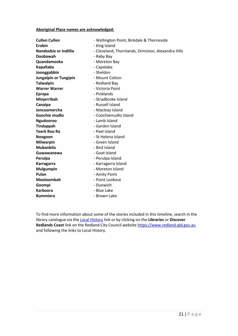
Aboriginal Place names are acknowledged: Cullen Cullen - Wellington Point, Birkdale & Thorneside Erobin - King Island Nandeebie or Indillie - Cleveland, Thornlands, Ormiston, Alexandra Hills Doobawah - Raby Bay Quandamooka - Moreton Bay Kapallaba - Capalaba Joonggabbin - Sheldon Jungalpin or Tungipin - Mount Cotton Talwalpin - Redland Bay Warrer Warrer - Victoria Point Eprapa - Pinklands Minjerribah - Stradbroke Island Canaipa - Russell Island Jencoomercha - Macleay Island Goochie mudlo - Coochiemudlo Island Ngudooroo - Lamb Island Tindappah - Garden Island Teerk Roo Ra - Peel Island Noogoon - St Helena Island Milwarpin - Green Island Mubanbila - Bird Island Guwawanewa - Goat Island Perulpa - Perulpa Island Karragarra - Karragarra Island Mulgumpin - Moreton Island Pulan - Amity Point Mooloombah - Point Lookout Goompi - Dunwich Karboora - Blue Lake Bummiera - Brown Lake
To find more information about some of the stories included in this timeline, search in the library catalogue via the Local History link or by clicking on the Libraries or Discover Redlands Coast link on the Redland City Council website https://www.redland.qld.gov.au and following the links to Local History.