U.S. Department of the Interior U.S. Geological Survey Sodium Carbonate Resources of the Green River Formation By John R. Dyni Denver, Colorado Open-File Report 96-729 This report is preliminary and has not been reviewed for conformity with U.S. Geological Survey editorial standards (or with the North American Stratigraphic Code). Any use of trade, product, or firm names is for descriptive purposes only and does not imply endorsement by the U.S. Government.
Transcript
U.S. Department of the Interior
U.S. Geological Survey
Sodium Carbonate Resources of theGreen River Formation
ByJohn R. DyniDenver, Colorado
Open-File Report 96-729
This report is preliminary and has not been reviewed for conformity with U.S. Geological Surveyeditorial standards (or with the North American Stratigraphic Code). Any use of trade, product, or firmnames is for descriptive purposes only and does not imply endorsement by the U.S. Government.
Browsing Instructions
THERE ARE TWO METHODS OF BROWSING THROUGH THIS DOCUMENT USING BOOKMARKS Click the Bookmarks and Page icon in the toolbar or choose Bookmarks and Page from the View menu to display bookmarks for the document. Click the page icon to the left of a bookmark name to move to the page view specified by that bookmark. USING HYPERTEXT LINKS Point and click on the first reference to figures or tables within the text to move to the page view of the specified link.
Sodium Carbonate Resources of theGreen River Formation
ByJohn R. Dyni
U.S. Geological SurveyBox 25046, M.S. 939
Denver Federal Center, CO 80225
ABSTRACT
Marly lacustrine rocks of the Eocene Green River Formation, which occupy parts of
several basins in Wyoming, Colorado, and Utah, contain world-class resources of oil
shale and sodium carbonate minerals. The formation contains the world's largest known
resource of natural sodium carbonate as bedded trona (Na2CO3.NaHCO3
.2H2O) in
southwest Wyoming as well as the second largest known resource of sodium carbonate as
bedded and nodular nahcolite (NaHCO3) in northwest Colorado. Five companies
currently mine three beds of trona in Wyoming and one company mines a bed of
nahcolite in Colorado.
Other sodium carbonate minerals in the Green River Formation that may have future
economic potential include dawsonite (NaAl(OH)2CO3), eitelite (Na2CO3.MgCO3), and
shortite (Na2CO3.2CaCO3). Several sodium carbonate brines in Utah and Wyoming may
have economic value for soda ash and for water-soluble organic acids.
INTRODUCTION
The lacustrine Green River Formation of Eocene age, which occupies several
sedimentary basins in Wyoming, Colorado, and Utah (fig. 1), has long been known for
its oil shale resources but less so for its enormous deposits of sodium carbonate minerals.
Large deposits of sodium carbonate salts occur in the three-state area. These deposits
include relatively pure beds of trona, nahcolite, and eitelite; nonbedded aggregates,
nodules, and crystals of nahcolite; microscopic crystals of dawsonite in oil shale; veinlets
and crystals of shortite; and brines of which some are highly enriched in organic acids.
Five sodium carbonate occurrences including two in Utah, one in Colorado, and two in
Wyoming, are being mined or have potential economic value.
The occurrences include deposits of bedded trona in the Green River Basin in southwest
Wyoming, deposits of nahcolite and dawsonite commingled with high-grade oil shale in
the Piceance Creek Basin in northwest Colorado, and bedded sodium carbonate salts near
the town of Duchesne in the Uinta Basin, northeast Utah. The formation also contains
two sodium carbonate brines that may have potential economic value. One of these
brines occurs in a confined aquifer, the Birds-nest zone, in the eastern Uinta Basin about
30 miles south and east of Vernal, Utah. The other sodium carbonate brinenoteworthy
for its unusually high content of soluble organic matterunderlies several townships at
shallow depths near the communities of Farson and Eden in the northeastern part of the
Green River Basin, Wyoming (fig. 1).
In this paper, the geologic setting of the Green River Formation is presented and the
economic geology of each of the five occurrences of sodium carbonate and their potential
for commercial development is described.
D:\IMF96\FIG01.DRW
107111
113
43
38
Rifle
GrandJunction
ABA
WRU
WB
GRB
UB
Duchesne
PCB
FB
EXPLANATION
Sodium carbonatebrine
SWB
Bedded halite and sodiumcarbonate salts
Bedded trona
Nahcolite
Black sodiumcarbonate water
41
112
Bonanza
0 50 MI
0 50 100 KM
GDB
Figure 1. Map showing the areal distribution of the Green River Formation and the locations of five
sodium carbonate deposits in Utah, Colorado, and Wyoming. ABA, Axial Basin Anticline;
FB, Fossil Basin; GDB, Great Divide Basin; GRB, Green River Basin; PCB, Piceance Creek Basin;
Other ions found in concentrations of less than 1 mg/l: As, Ba, Cr, Fe, Li, Mn, Hg, and Zn. See Scott andPantea (1982a and 1982b) for additional analytical details.
_____________________________________________________________________1 The sum of CO3+HCO3 and total dissolved solids which were not determined in the original analyses
were estimated by Scott R. Charlton, University of Colorado, by the USGS WATC computer program.
Further exploration of the Bird's-nest brine field in the vicinity of the Coyote Wash and
Red Wash core holes in T. 9 S., Rs. 22 and 23 E. and surrounding area (fig. 6) may
reveal exploitable reserves of sodium carbonate brine. Dissolved components in amounts
that might be troublesome in developing this resource include chloride, sulfate and
fluoride.
COLORADO NAHCOLITE DEPOSITS
A large resource of nahcolite is commingled with oil shale in the Parachute Creek
Member of the Green River Formation in the northern part of the Piceance Creek Basin
in northwest Colorado. The geology of the deposit is well documented by numerous
studies, although details of the stratigraphic distribution and grade of nahcolite in
selected zones and beds need to be determined.
In the Piceance Creek Basin, the Green River Formation is divided, in ascending order,
into the Anvil Points, Garden Gulch, and Parachute Creek Members and it is overlain by
sandstone and siltstone of the Uinta Formation (fig. 7). Most of the significant deposits
of oil shale and all of the sodium carbonate resources are found in the Parachute Creek
Member.
In the deeper northern part of the Piceance Creek Basin, the Parachute Creek Member
contains a saline facies which includes beds of nahcolite and halite, scattered crystals,
nodules, and coarse-crystalline aggregates of nahcolite commingled with high-grade oil
shale. Also included in the saline facies is dawsonite which occurs as microscopic
crystals that compose part of the microcrystalline matrix of the oil shale.
The top of the nahcolite-bearing oil shale is a dissolution surface above which ground
waters have dissolved nahcolite and halite forming a "leached zone" of vuggy brecciated
oil shale sequence several hundred feet thick. The leached zone extends upward into
lower part of the Mahogany oil-shale zone, a unit of high-grade oil shale traceable
throughout the basin. The top of the leached zone is defined by the stratigraphically
highest occurrence of solution breccia that marks the former presence of a bed of
nahcolite or mixed halite and nahcolite (Dyni,1981, plates 1 and 2). This top can be
considered to be the top of the original bedded saline facies in the Parachute Creek
Member, although crystal cavities and vugs are found scattered through the upper part of
the Parachute Creek Member above the Mahogany oil-shale zone (fig. 7).
D:\I
MF
96\F
IG07
.DR
W
EX
PLA
NA
TIO
N
Dol
omiti
c o
il s
hale
ab
c
(a)
nahc
olite
-fre
e(b
) w
ith n
ahco
lite
aggr
egat
es(c
) w
ith n
ahco
lite
vugs
and
sol
utio
n
bre
ccia
s
Bed
ded
whi
te c
oars
e-cr
ysta
lline
nah
colit
e an
dbr
own
mic
rocr
ysta
lline
nahc
olite
Bed
ded
halit
e an
dna
hcol
ite
Zon
e of
dis
sem
inat
edna
hcol
ite in
oil
shal
e
C34
C15
4C
177
C17
9
600
500
Parachute Creek Member
LOV
E B
ED
700
C5
400
Mah
ogan
y Z
one
LEA
CH
ED
ZO
NE
GREEN RIVER FORMATION
Anv
il P
oint
s M
embe
r
Gar
den
Gul
ch M
embe
r
Bas
e of
nah
colit
e fa
cies
700
800
600
500
400
Dis
solu
tion
surf
ace
(Dat
um)
BO
IES
BE
D
Top
of b
edde
dsa
line
faci
es
800
600
500
400
300
700
500
800
400
700
600
300
700
600
500
400
300
800
900
400
100 0
200
300
Pic
eanc
e C
reek
surf
ace
sect
ion
Low
erU
inta
For
mat
ion
Figure 7. Generalized stratigraphic cross section of the nahcolite deposits in the Parachute Creek Member of the Green
River Formation in the northern part of the Piceance Creek Basin, Colorado. Line of cross section is shown in fig. 8.
Depths in meters.
1000
100
R10
0WR
99W
R98
WR
97W
T 2 N
R96
WR
95W
T 1 N
T 1 S T 2 S
T 3 S
R10
1W
500
C17
7
C5 C17
9C15
4C34
Low
er P
icea
nce
Cre
ek o
utcr
opA
rea
of m
ixed
halit
e an
dna
hcol
ite
C-b
C-a
min
eH
orse
Dra
w
Bas
e of
Gre
enR
iver
Fm
.
Bas
e of
Gre
enR
iver
Fm
.
05
10 M
I
05
1015
KM
Whi
te R
iver
Nah
colit
e M
iner
als
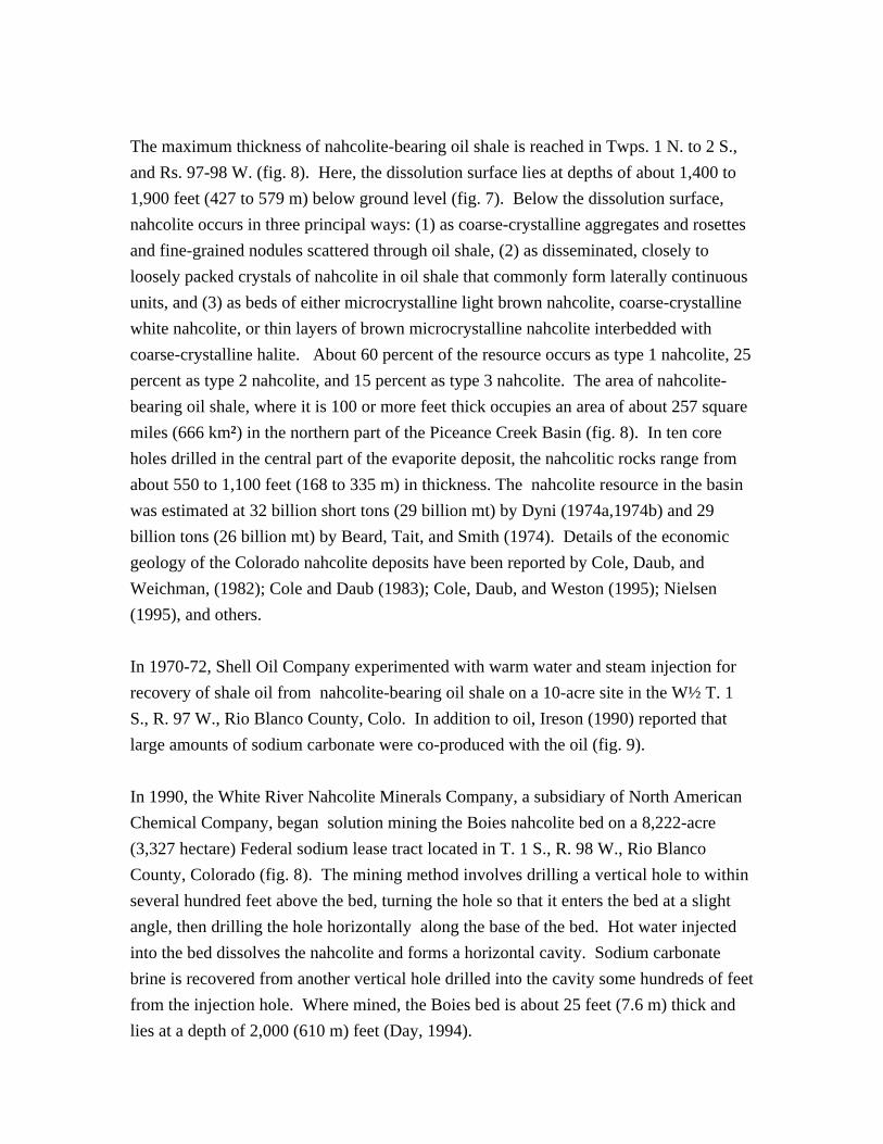
Figure 8. Thickness of nahcolite-bearing oil shale in the northern part of the
Piceance Creek Basin. Thickness contours in feet. Patterned areas are active
Federal sodium leases. C-a and C-b are inactive Federal oil-shale lease tracts.
The maximum thickness of nahcolite-bearing oil shale is reached in Twps. 1 N. to 2 S.,
and Rs. 97-98 W. (fig. 8). Here, the dissolution surface lies at depths of about 1,400 to
1,900 feet (427 to 579 m) below ground level (fig. 7). Below the dissolution surface,
nahcolite occurs in three principal ways: (1) as coarse-crystalline aggregates and rosettes
and fine-grained nodules scattered through oil shale, (2) as disseminated, closely to
loosely packed crystals of nahcolite in oil shale that commonly form laterally continuous
units, and (3) as beds of either microcrystalline light brown nahcolite, coarse-crystalline
white nahcolite, or thin layers of brown microcrystalline nahcolite interbedded with
coarse-crystalline halite. About 60 percent of the resource occurs as type 1 nahcolite, 25
percent as type 2 nahcolite, and 15 percent as type 3 nahcolite. The area of nahcolite-
bearing oil shale, where it is 100 or more feet thick occupies an area of about 257 square
miles (666 km2) in the northern part of the Piceance Creek Basin (fig. 8). In ten core
holes drilled in the central part of the evaporite deposit, the nahcolitic rocks range from
about 550 to 1,100 feet (168 to 335 m) in thickness. The nahcolite resource in the basin
was estimated at 32 billion short tons (29 billion mt) by Dyni (1974a,1974b) and 29
billion tons (26 billion mt) by Beard, Tait, and Smith (1974). Details of the economic
geology of the Colorado nahcolite deposits have been reported by Cole, Daub, and
Weichman, (1982); Cole and Daub (1983); Cole, Daub, and Weston (1995); Nielsen
(1995), and others.
In 1970-72, Shell Oil Company experimented with warm water and steam injection for
recovery of shale oil from nahcolite-bearing oil shale on a 10-acre site in the W½ T. 1
S., R. 97 W., Rio Blanco County, Colo. In addition to oil, Ireson (1990) reported that
large amounts of sodium carbonate were co-produced with the oil (fig. 9).
In 1990, the White River Nahcolite Minerals Company, a subsidiary of North American
Chemical Company, began solution mining the Boies nahcolite bed on a 8,222-acre
(3,327 hectare) Federal sodium lease tract located in T. 1 S., R. 98 W., Rio Blanco
County, Colorado (fig. 8). The mining method involves drilling a vertical hole to within
several hundred feet above the bed, turning the hole so that it enters the bed at a slight
angle, then drilling the hole horizontally along the base of the bed. Hot water injected
into the bed dissolves the nahcolite and forms a horizontal cavity. Sodium carbonate
brine is recovered from another vertical hole drilled into the cavity some hundreds of feet
from the injection hole. Where mined, the Boies bed is about 25 feet (7.6 m) thick and
lies at a depth of 2,000 (610 m) feet (Day, 1994).
0 20 40 60 800
5
10
15
20
25
30
35
TH
OU
SA
ND
S O
F K
ILO
GR
AM
S
DAYS
DA
ILY
SO
DIU
M B
ICA
RB
ON
AT
E P
RO
DU
CT
ION
100
65° C
WARM-WATER INJECTION(250 bbls water/day)
120° C
182° C
STEAMINJECTION(575 bbls/day)
Figure 9. Daily production of sodium bicarbonate from Shell in situ shale-oil
recovery experiment in the Piceance Creek Basin (from Ireson, 1990).
Currently, eight Federal sodium leases have been issued on about 16,900 acres (6,839
hectares) in the basin (fig. 8). Over the past few years, another company has been
drilling exploratory core holes in the basin for possible leasing of sodium minerals.
In addition to the Boies bed (L-5A), several other nahcolite beds in the Piceance Creek
Basin may be economical to solution mine including the L-4D (Love bed) and R-5C, R-
5E and R-5G beds (Dyni, 1981, plates 1 and 2).
Solution mining nahcolite in the Piceance Creek Basin presents some unusual problems.
Because the Boies bed is close to the dissolution surface (fig. 7), a breakthrough into the
overlying water-bearing leached zone could be detrimental to solution mining in the bed.
Furthermore, the Boies bed grades laterally into mixed halite and nahcolite toward the
basin chemical depocenter which could contaminate mining solutions with sodium
chloride. The Boies bed as shown by Dyni (1981, plates 1 and 2) actually consists of two
beds, the lower one being thinner, but also containing halite. Because oil shale cannot be
mined or damaged under current sodium leasing regulations, the major part of the
nahcolite resource, which occurs as crystalline aggregates scattered through oil shale,
will be difficult to mine for soda ash alone. Solution mining of nahcolite beds in the
basin may render parts of the overlying oil shale unsuitable for future in situ or
underground mining.
EDEN-FARSON BRINE FIELD
H.B. Lindeman (1954) first called attention to amber sodium carbonate brine found at
depths of 400 to 600 feet (122 to 183 m) in the Green River Basin near the communities
of Eden and Farson, about 30 miles (48 km) north of Rock Springs, Wyoming. The
discovery of brine was made by the John Hay water well drilled in 1938 in SE¼ sec. 4,
T. 23 N, R. 106 W., Sweetwater County, Wyoming. Subsequent exploratory drilling
(fig. 10) identified many drill holes that encountered black sodium carbonate brine (Dana
and Smith 1973, 1976). Analyses of brine from four wells by Phillips (1978, table 2)
revealed as much as 4-6 weight percent sodium carbonate-bicarbonate and as much as 5.8
weight percent of water-soluble humic and fulvic acids. Even larger amounts of these
components were reported from other wells by Dana and Smith (1973, 1976).
R 106 W
T25N
T24N
T23N
R 106 WR 107 WR 108 W
Eden
Farson
9.0/?
11.4/5.415.4/8.5
9.0/5.2
EXPLANATION
15.4/8.5
Wells yielding blacktrona water; first numberis total dissolved solids inwt pct and second numberis dissolved organic acidsin wt pct
Bone Drawwell
28
U.S
. 187
U.S. 187
John Hay water well
Figure 10. Map showing locations of wells containing sodium carbonate brine and
dissolved organic matter in the Eden-Farson brine field in the northeastern part of the
Green River Basin, Sweetwater County, Wyoming (from Dana and Smith, 1976,
and Phillips, 1978).
In 1992, a shallow well was drilled for water by the U.S. Bureau of Reclamation in Bone
Draw in the NE¼SE¼ sec. 32, T. 24 N., R. 107 W., about 6 miles (10 km) southwest of
Eden. The well encountered an artesian flow of black sodium carbonate brine at 460 feet
(140 m). The well flowed an estimated 29,000 barrels (4,611 cu. meters) of brine in two
weeks before it could be sealed. A sample of the brine was analyzed by the Water
Resources Division of the U.S. Geological Survey, Denver, Colorado, and the results are
given in table 2.
Table 2.Chemical analysis of brine from the U.S. Bureau of Reclamation Bone Draw well 1.
The black sodium carbonate brine is found in oil shale of the Wilkins Peak Member of
the Green River Formation. The brine appears to be in several discontinous permeable
zones because water flows and concentrations of dissolved solids, (including water-
soluble organic matter) are highly variable between wells (figure 10).
Dana and Smith (1976) concluded from examination of drill core from one bore hole that
the brine is confined to one or more bedding planes in otherwise impermeable oil shale
of the Wilkins Peak Member. These authors noted that a number of the wells in the brine
field are artesian and suggested that the brine in the aquifer is pressurized by lithostatic,
rather than hydrostatic or gas, pressure. Because of the unusual type of aquifer, the size
of the brine field and the composition of the brine cannot be easily determined.
According to Dana and Smith (1976) the stratigraphic interval in which the brine is
found lies between 67 and 93 feet (19 and 28 m) below the top of the Wilkins Peak
Member. In the trona district to the southwest, this would place the aquifer just above
the highest bed (25) of trona in the member.
The origin of the brine cannot be directly linked to dissolution of sodium carbonate salts
inasmuch as solution breccias or cavities were not found in the oil shale enclosing the
suspected brine aquifer (Dana and Smith, 1976). However, Culbertson (1966, p. B160)
suggested that the source of the sodium carbonate in the Eden area was from dissolution
of shortite, which is a common salt in the Wilkins Peak Member, rather than from
bedded trona. Although salt cavities are absent in the core studied by Dana and Smith
(1976), the brine may have formed further south in the basin and migrated updip along
bedding and fracture planes northward toward the Eden area.
The brine has economic potential as a source of soda ash and organic acids. The
precipitated organic acids yield as much as 73.3 percent oil upon destructive distillation.
The organic acids may also find specialized uses, such as a soil conditioner (R.J. Hite,
1996, personal comm.). Dana and Smith (1976, p. 12) reported a well capable of
flowing at a rate of 6,800-6,900 barrels (1,081-1,097 cu. meters) of brine per day, which
could yield 62 tons (56 mt) of soda ash and 130 tons (118 mt) of organic acids per day.
Several companies have examined the brine for possible exploitation, but none to date
have pursued development of the resource. The Eden-Farson brine field may be
mineable on a small scale, especially if the organic acids find specialized uses that may
command a high unit price. Also, the occurrence of sodium carbonate brine elsewhere in
the Green River Basin should not be overlooked.
WYOMING TRONA DEPOSITS
The world's largest known resource of natural sodium carbonate is found in bedded trona
in the Green River Formation in the Green River Basin in Sweetwater County, southwest
Wyoming. The formation is divided in ascending order into the Tipton Shale, Wilkins
Peak Member, and the Laney Shale. The trona resource lies wholly within the Wilkins
Peak Member. The Wilkins Peak ranges from about 600 to 1,350 feet (183 to 411 m) in
thickness and consists of marlstone, oil shale, trona, siltstone, mudstone, and numerous
laterally persistent thin layers of tuff.
As many as 42 beds of trona were noted by Culbertson (1966). He numbered the thickest
and economically most important of these beds from 1 to 25 in ascending order (figs. 11
and 12). The trona beds are nearly flat lying. Dips are commonly about 1° or less. Faults
are uncommon; however, several strike-slip shear zones have been recently mapped on
the surface on the east side of the basin by Gordon Marlatt, University of Wyoming
graduate student (personal comm, 1996). Some trona beds grade laterally into mixed
halite and trona toward the depocenter in the southern part of the basin. In some beds in
the lower part of the evaporite sequence, nahcolite is abundant. I have noted from X-ray
diffraction studies of mine and core samples that as the depositional center of mixed
halite and trona of bed 17 is approached in the southern part of the basin, nahcolite,
wegscheiderite, northupite, and possibly shortite become locally abundant, as well as
quartz. The occurrence of these additional minerals may be important in room-and-pillar
mining because they may influence the processing of trona as well as impart different
physical properties to the mined trona.
The generalized lithology of the Wilkins Peak Member in the Union Pacific Railroad, El
Paso core hole 44-3, in the southern part of the basin is shown in figure 13. Many of the
lower trona beds are shown on the log. Two stratigraphic cross sections showing the
distribution of the trona beds in different parts of the basin are shown in figures 11 and
12.
SN
DE
AR
DO
RF
F 1
FE
DE
RA
L 1
-676
5
B24
DA
CO
3
BU
CK
BO
AR
D R
AN
CH
1
B22
CU
RR
EN
T C
RE
EK
1
B4
B5
B7
B9
B11
B12
B13B14
B15
B16
B17
GO
V'T
1D
AC
O 4
BE
RG
ER
1
B10B11
B9B12
B14
B23
CH
AM
PLI
N 0
97A
-1D
YM
ON
D 1
B18
DA
TU
M
B15
B16
B17
B13
1400
1200
1000
800
1600
1400
1600
1800
1200
1400
1000
800
600
1200
1200
1000
1400
800
1000
1200
1400
1600
1000
1200
1400
1600
1800
2000
1600
1400
B2312
00
1800
2200
B10
2000
1400
1200
1000
1600
1800
B25
1200
1000
800
1400
1600
BA
SE
OF
WIL
KIN
S P
EA
K M
EM
BE
R
1400
1600
B18 18
00 B1
B2B
3B8
B6
1200
1000
VE
RT
ICA
L S
CA
LE IN
FE
ET
;D
RIL
L H
OLE
S E
QU
ALL
Y S
PA
CE
D
EX
PLA
NA
TIO
N
NU
MB
ER
ED
TR
ON
A B
ED
(HA
LIT
IC F
AC
IES
NO
T S
HO
WN
)
B17
Figure 11. South-north stratigraphic cross section of the trona deposits in the
Green River Basin, Wyoming. Line of section shown in fig. 15.
WH
ITE
MO
UN
TA
IN 1
VIN
NE
LL 1
B17
B15
B16
B18
B24
B23
DA
TU
M
NW
B22
DE
AR
DO
RF
F1
B10
B11
B2
B3
B4 B
5 B
6 B7
B8
B9 B
12
B15
B14
B13
B12
B14
CH
AM
PLI
N
157A
-1
SP
IDE
R C
RE
EK
1
B22
GR
EE
NR
IVE
R 3
B1
B16
SE
TG
2-22
-201
0
TG
1-34
-201
0
B17
AR
CO
2
GR
EE
N R
IVE
R1-
1
B21
B19
B20
BA
SE
OF
WIL
KIN
SP
EA
K M
EM
BE
R
100
2000
300
400
900
1000
1100
1200
1300
1400
1500
1600
1700
1800
1900
800
900
1000
1100
1200
1300
1400
1500
1600
1700
900
1000
1100
1200
1300
1400
1500
1600
1700
1800
1100
1200
1300
1400
1500
1700
1800
1900
1600
1100
1200
1300
1400
1500
1100
1200
1300
1400
1100
1200
1300
1400
1500
EX
PLA
NA
TIO
N
NU
MB
ER
ED
TR
ON
A B
ED
VE
RT
ICA
L S
CA
LE IN
FE
ET
;D
RIL
L H
OLE
S E
QU
ALL
Y S
PA
CE
D
(HA
LIT
IC F
AC
IES
NO
T S
HO
WN
)
B17
Figure 12. Northwest-southeast stratigraphic cross section of the trona deposits in
the Green River Basin, Wyoming. Line of section shown in fig. 15.
D:\IMF96\FIG13.DRW
EXPLANATION
Trona
Volcanic tuff
B-1, numbered bed
Oil shale
Mudstone, siltstone,and marlstone
0.5-1.0' TUFF?
DEPTH
WIL
KIN
S P
EA
K M
EM
BE
R
0.35' FIREHOLE TUFF
TUFF
0.14' TUFF
1008.8
(Feet)
0.9' MAIN TUFF
0.2' TUFF
0.5' TUFF
2192.4
SH
OR
TIT
E F
AC
IES
B-1
B-2B-3
B-4B-5B-6B-7B-8
B-9B-10B-11
B-13B-12
B-17
B-16B-15
B-14
B-18
B-23
Wasatch Formation
Gre
en R
iver
For
mat
ion
TOLLGATE (LAYERED) TUFF?
TIPTONSHALE MEM
Figure 13. Generalized lithologic log of the Union Pacific Railroad, El Paso 44-3 core hole
in the SE¼SE¼ sec. 3, T.15 N., R.109 W., Sweetwater County, Wyoming (modified from
Trudell, 1975). Core hole location shown in fig. 15.
The trona beds are remarkable for their purity. Sulfate minerals are essentially absent,
and other than halite, the chief impurities are marlstone stringers and vertical seams of
mudstone. Chemical analyses of several trona beds are given by Wiig, Grundy, and
Dyni (1995, table 1). Currently, FMC, General Chemical, and Solvay Minerals mine
trona bed 17, TG Soda Ash mines bed 20, and Oriental Chemicals mines beds 24 and 25
(Leigh, 1991).
Trona bed 17 is one of the most important trona beds in the district. The bed, where it is
more than 4 feet (1.2 m) thick, underlies about 775 square miles(2,007 km2) and ranges
from 4 to 17 feet (1.2 to 5.2 m) in thickness (figure 14). Southward in the basin, the
trona grades laterally into mixed halite and trona.
Twenty-two of the 25 numbered beds are estimated to contain 127 billion tons (115
billion mt) of trona ore, or 76 billion tons (69 billion mt) of trona in beds containing less
than 2 percent halite. These 22 beds, where they are 4 or more feet (1.2 or more meters)
thick, underlie areas ranging from 50 to more than 775 square miles (129 to more than
2,007 km2) at depths of 650 to 3,000 feet (198 to 914 m) below the surface (Wiig,
Grundy, and Dyni, 1995). Trona contains 70.3 weight percent sodium carbonate; it takes
about 2 tons of trona ore to produce 1 ton of soda ash.
Additional resources of sodium carbonate in the Green River Formation include shortite,
which occurs in abundant crystals, pods, and veinlets scattered through marly lacustrine
strata interbedded with the trona. Less commonly, some shortite may be in bedded layers
a few centimeters thick. Shortite contains 34.6 percent sodium carbonate by weight.
A visual estimate of shortite in drill core from the John Hay core hole 1 in the SE¼NW¼
sec. 2, T. 18 N., R. 110 W., Sweetwater County was made by Fahey and Mrose (1962,
figure 7). Shortite averaged about 11 percent for a sequence 550 feet (168 m) thick
between the depths of 1,250 and 1,800 feet (381 and 579 m), and 16.7 percent for a 230-
foot-thick (70 m) sequence between the depths of 1,330 and 1,560 feet (405 and 475 m).
Assuming a similar grade for a one square mile 1.6 km2) block around this bore hole, as
much as 203 million tons (184 million mt) of shortite, or 70 million tons (64 million mt)
of sodium carbonate, per square mile is indicateda substantial resource.
2
2
2
2
2
24
4
4
4
4
4
6
6
6
6
6
8
8
8
8
8
10
1010
10
10
10
10
10
12
12
12
12
14
120000 160000 200000 240000 280000
160000
200000
240000
280000
320000
360000
400000
STATE PLANE COORDINATES
EASTINGS, FT
NO
RT
HIN
GS
, FT
.
TG Soda Ash
Solvay Minerals
General Chem.
FMC
Oriental Chem.
Figure 14. Isopach map, in feet, of trona bed 17. Dotted line indicates a trough of thinned trona
in the central part of the bed (modified from Wiig, Grundy, and Dyni, 1995).
Because of its mode of occurrence, shortite (or sodium carbonate) would be difficult to
mine separately, although some sodium carbonate from the mineral might be extractable
by solution mining.
The Wyoming trona district currently produces about 9 million tons (8.2 million mt) of
refined soda ash annually from five underground mines that extract a total of about 18
million tons (16.3 million mt) of trona ore (personal comm., Ray Harris, 1996). See
papers by Wiig, Grundy, and Dyni (1995), Burnside and Culbertson (1979), and Brown
(1995) for additional resource, production, and mining details.
Mining is by vertical shaft using room-and-pillar, short- and long-wall techniques. At
three mines, additional sodium carbonate is recovered from waste waters from the
processing plant which are used to slurry tailings to abandoned parts of the mines. These
waters dissolve additional trona from the pillars, then are pumped back to the surface to
recover the sodium carbonate. The technique has proven to be economical and will
probably be employed by the remaining mines in the district.
Earlier attempts to solution mine trona from vertically drilled holes have been
unsuccessful. However, solution mining using horizontally drilled holes as used in the
Piceance Creek Basin, Colorado, has not yet been attempted, but the method will
probably be tested soon in the Wyoming trona district. The method may be especially
useful in the southern part of the basin where the trona beds are thicker and lie at greater
depths than those being mined today.
Solution mining appears to offer major advantages over room-and-pillar techniques.
Drilling injection and production wells should cost less than the cost of sinking shafts
and opening underground workings. Solution mining will provide safer operating
conditions because underground miners will not be needed. Room-and-pillar mining of
trona beds in the deeper part of the basin, which would require larger pillars for safety
and lower the recovery of trona ore, should pose no serious problems for solution
mining. Concurrent solution mining of multiple trona beds should also be feasible.
Approval of mining plans should assure trona-land owners that important trona beds are
not made unmineable by multi-bed solution mining, land subsidence is controlled,
potential oil and gas production is not impaired, and significant parts of the trona
resource are not lost by high-grading the thicker and purer beds of trona in the lower part
of the deposit.
Ownership of the trona lands is divided between the Federal Government (55.7 percent),
Union Pacific Resources as part of a railroad land grant (38.1 percent), and the state of
Wyoming (6.2 percent). Figure 15 shows the boundary of the Federal known sodium
leasing area, the five trona mine permit areas, and two lines of stratigraphic sections. A
good summary of the soda ash industry was published recently by Kostick (1995).
The trona resources are summarized in figure 16. Trona bed 2 underlies 439 square miles
(1,137 km2) where it is 4 or more feet (1.2 or more meters) thick and contains the largest
resource of trona of any bed estimated at 11.6 billion tons (10.5 billion mt) of which 97
percent of the bed is essentially halite-free. Trona bed 17, where it is 4 or more feet
thick, underlies about 775 square miles (2,007 km2) and contains almost as much
trona11.5 billion tons (10.4 billion mt), but only 66 percent contains little or no halite
(Wiig, Grundy, and Dyni, 1995, table 9). Note that the trona beds above bed 18 and
below bed 5 are free, or nearly free, of halite.
SUMMARY
The geology and economic potential of five occurrences of sodium carbonate deposits in
the Eocene Green River Formation are briefly described. The two largest of these are the
deposits of bedded trona and disseminated shortite in southwest Wyoming and bedded
and nonbedded nahcolite and fine-grained disseminated dawsonite commingled with
high-grade oil shale in northwest Colorado.
Other lesser known deposits that may have economic potential include bedded eitelite
near Duchesne, Utah, and two sodium carbonate brines, one in the eastern Uinta Basin,
Utah, and the other near Farson and Eden in the northeastern part of the Green River
Basin, Wyoming.
220 290230 240 250 260 270 280
UTM EAST (KM)
4550
4560
4570
4580
4590
4600
4610
4620
4630
4640
UT
M N
OR
TH
(K
M)
Green RiverLittleAmerica
ORIENTAL CHEMICAL
GENERAL CHEMICAL
SOLVAY MINERALS
TG SODA ASH
FMC
BLM KNOWN SODIUMLEASING AREA
UIN
TA
CO
UN
TY
SW
EE
TW
AT
ER
CO
UN
TY
LIN
CO
LN C
OU
NT
Y
S
N
NW
SE
EL PASO 44-3
10
0 2 4 6 8 MI10
0 5 15 KM
Figure 15. Map showing the Known Sodium Leasing Area established by the U.S. Bureau ofLand Management, Wyoming state trona mine permit areas, and lines of stratigraphic sectionsshown in figs. 11 and 12.
TR
ON
A B
ED
25
24
21
20
19
18
17
16
15
14
12
11
10
9
8
7
6
5
4
3
2
1
(BILLIONS OF SHORT TONS)
TRONA (<2% HALITE)
TRONA (>2% HALITE)
0 2 4 6 8 10 12
Figure 16. Trona resource estimates, in short tons, for 22
numbered beds of trona in the Wyoming trona district.
Data are based on beds that are 4, or more, feet thick.
Note that trona beds 1-4 and 19-25 are halite-free or
nearly halite-free.
The sodium carbonate resources in the Green River Formation will continue to provide
most of the soda ash to domestic markets as well as acquire an increasing share in foreign
markets for the foreseeable future. The technical success of solution mining bedded
nahcolite in Colorado suggests that a similar operation would be successful in the
Wyoming trona district. Solution mining beds of trona through horizontally drilled
holes, may substantially lower mining costs and improve mine safety. Potential
environmental problems such as disposal of plant tailings, waste waters, and stack-gas
effluents including carbon dioxide could be reduced by solution mining methods.
REFERENCES
Beard, T.N., Tait, D.B., and Smith, J.W., 1974, Nahcolite and dawsonite resources in the
Green River Formation, Piceance Creek Basin, Colorado in Murray, D.K., Energy
resources of the Piceance Creek Basin, Colorado, 25th field conference: Rocky
Mountain Assoc. Geologists, p. 101-122.
Bradley, W.H., 1931, Origin and microfossils of the oil shale of the Green River
Formation of Colorado and Utah: U.S. Geological Survey Prof. Paper 168, 58 p.
Brown, N.A., 1995, Union Pacific instrumental in developing Wyoming trona: Mining