Per. Mineral. (1999), 68, 2, 93-108 �} PERIODICO di MINERALOGIA established in1930 An Inteational Journal of MINERALOGY, CRYSTALLOGRAPHY, GEOCHEMISTRY, ORE DEPOSITS, PETROLOGY, VOLCANOLOGY and applied topics on Environment, Archaeomet and Cultural Heritage Soi� gas investigations over sulphide ore-bearing fractures - the Fontalc1naldo case study (Boccheggiano and Niccioleta mining district - southern Tuscany, Italy) FRANCESCO ASTORRI1, SALVATORE LOMBARDI1 * and FABRIZIO PAOLONI2 1 Dipartimento di Scienza della Terra, Universita di Roma «La Sapienza», P.le Aldo Moro 5 I-00185 Roma Italy 2 Acquater S.p.A., San Lorenzo in Campo, Pesaro, Italy ' ' Submitted December1998 - Accepted Apri/1999 ABSTRACT.- The application of soil-gas analysis to sulphide exploration has been evaluated at F � nt � lcinald ? . (southern Tuscany, Boccheggiano- Niccioleta mmmg district). Samples were collected for He, Rn and C0 2 analysis and compared with deep sulphide-bearing fractures identified using borehole and geophysical data. The selected gases were chosen because they are proven fault tracers. In addition C0 2 has the added benefit that it can also give indirect information on the presence of buried sulphide deposits, as sulphide mineral oxidation produces sulphuric acid which in turn reacts with host-rock carbonate mineral; to for� carbon di � xide. Elevated He, 222 Rn and C0 2 concentratiOns have been found over fault and fracture systems defined on the basis of geological a . nd g . eophysical mapping; further N-S trending lme � twns have also been highlighted, including a possible northward extension of the Boccheggiano Fault. The surveys also indicated systematic soil- gas anomalies related to mineral occurrences, with the most consistent patterns (i.e. elevated C0 2 values) occurring over the main sulphide orebodies present in the area. The present research indicates that soil-gas techniques can provide useful information on the presence of ore-bearing fractures, especially during initial reconnaissance exploration or where other geochemical data are * Corresponding author, E-mail: [email protected]scarce because of unfavourable geological conditions (i.e. impermeable covers). RIASSUNTO.- Nell'ambito di una ricerca eseguita nel 1990 in cooperazione tra l'Universita di Roma e la Rimin Spa nell' area facente capo al distretto minerario delle Colline Metallifere (Toscana Meridionale), sono state applicate metodologie di prospezione dei gas del suolo al fine di individuare la presenza in profondita di mineralizzazioni a solfuri intruse in faglie sepolte al di sotto di una spessa coltre argillosa scarsamente permeabile. Con il presente lavoro si e voluta verificare la possibilita di acquisire informazioni geochimiche relative alia presenza di mineralizzazioni in aree dove lo spessore e la scarsa permeabilita di certi litotipi, come le argille ed i flysch argillosi, possono permettere la migrazione in superficie di specie gassose endogene ma non la migrazione in soluzione dei traccianti co � u ? emente usati nelle tecniche di prospezione tradiZIOnale (stream sediments, analisi di elementi in tracce nei suoli ecc.). E stata quindi effettuata, tra il 1990 ed il 1992, una campagna di prospezione nel corso della quale sono stati prelevati in totale 5 42 campioni di gas del suolo. Tra le specie gassose anahzzate le piu significative sono risultate essere He, 222 Rn e C0 2 . Tali gas, come e noto � ostituiscono buoni traccianti di fratture sepolte : moltre la C0 2 risulta essere un valido indicatore
Transcript
Per. Mineral. (1999), 68, 2, 93-108
�} PERIODICO di MINERALOGIA established in1930
An International Journal of MINERALOGY, CRYSTALLOGRAPHY, GEOCHEMISTRY, ORE DEPOSITS, PETROLOGY, VOLCANOLOGY
and applied topics on Environment, Archaeometry and Cultural Heritage
Soi� gas investigations over sulphide ore-bearing fractures - the Fontalc1naldo case study (Boccheggiano and Niccioleta mining district -
southern Tuscany, Italy)
FRANCESCO ASTORRI1, SALVATORE LOMBARDI1* and FABRIZIO PAOLONI2
1 Dipartimento di Scienza della Terra, Universita di Roma «La Sapienza», P.le Aldo Moro 5 I-00185 Roma Italy 2 Acquater S.p.A., San Lorenzo in Campo, Pesaro, Italy
' '
Submitted December 1998 - Accepted Apri/1999
ABSTRACT.- The application of soil-gas analysis to sulphide exploration has been evaluated at F�nt�lcinald? .(southern Tuscany, BoccheggianoNiccioleta mmmg district). Samples were collected for He, Rn and C02 analysis and compared with deep sulphide-bearing fractures identified using borehole and geophysical data. The selected gases were chosen because they are proven fault tracers. In addition C02 has the added benefit that it can also give indirect information on the presence of buried sulphide deposits, as sulphide mineral oxidation produces sulphuric acid which in turn reacts with host-rock carbonate mineral; to for� carbon di�xide. Elevated He, 222Rn and C02 concentratiOns have been found over fault and fracture systems defined on the basis of geological a.nd g.eophysical mapping; further N-S trending lme�twns have also been highlighted, including a possible northward extension of the Boccheggiano Fault. The surveys also indicated systematic soilgas anomalies related to mineral occurrences, with the most consistent patterns (i.e. elevated C02 values) occurring over the main sulphide orebodies present in the area. The present research indicates that soil-gas techniques can provide useful information on the presence of ore-bearing fractures, especially during initial reconnaissance exploration or where other geochemical data are
scarce because of unfavourable geological conditions (i.e. impermeable covers).
RIASSUNTO.- Nell'ambito di una ricerca eseguita nel 1990 in cooperazione tra l'Universita di Roma e la Rimin Spa nell' area facente capo al distretto minerario delle Colline Metallifere (Toscana Meridionale), sono state applicate metodologie di prospezione dei gas del suolo al fine di individuare la presenza in profondita di mineralizzazioni a solfuri intruse in faglie sepolte al di sotto di una spessa coltre argillosa scarsamente permeabile. Con il presente lavoro si e voluta verificare la possibilita di acquisire informazioni geochimiche relative alia presenza di mineralizzazioni in aree dove lo spessore e la scarsa permeabilita di certi litotipi, come le argille ed i flysch argillosi, possono permettere la migrazione in superficie di specie gassose endogene ma non la migrazione in soluzione dei traccianti co�u?emente usati nelle tecniche di prospezione tradiZIOnale (stream sediments, analisi di elementi in tracce nei suoli ecc.). E stata quindi effettuata, tra il 1990 ed il 1992, una campagna di prospezione nel corso della quale sono stati prelevati in totale 542 campioni di gas del suolo. Tra le specie gassose anahzzate le piu significative sono risultate essere He, 222Rn e C02. Tali gas, come e noto
�ostituiscono buoni traccianti di fratture sepolte : moltre la C02 risulta essere un valido indicatore
94 F. AsTORRI, S. LOMBARDI and F. PAOLONI
della presenza in profondita di mineralizzazioni a solfuri. I processi ossidoriduttivi che si innescano in tali ambienti rendono infatti le acque di circolazione fortemente aggressive nei confronti della calcite con consumo di 02 e liberazione di C02. I risultati delle campagne di prospezione hanno evidenziato, mediante 1' esame dell a mappe di distribuzione dei gas, la buona correlazione delle anomalie di He, 222Rn e C02 con i sistemi di faglie e fratture individuati mediante le indagini geofisiche. Lo studio degli andamenti delle anomalie suggerisce inoltre la probabile esistenza di lineamenti tettonici orientati nord-sud non riportati nelle carte geologiche e/o sismiche; di questi il piu importante sembra essere la prosecuzione verso nord della nota Faglia di Boccheggiano. Per quanto attiene la relazione tra anomalie di fuga e corpi mineralizzati si e potuto riscontrare che incrementi significativi delle specie gassose analizzate, in particolare la C02, coincidono con le aree mineralizzate. Oltre a cio si e potuto verificare che il metodo d'indagine proposto consente di acquisire informazioni sulla presenza di probabili mineralizzazioni sepolte sia in terreni permeabili (Formazione del Calcare Cavernosa) che in sedimenti scarsamente permeabili come quelli flyshoidi (Argille a Palombini). Cio puo rivelarsi particolarmente utile sia nelle prime fasi dell' esplorazione mineraria, in cui particolarmente elevato risulta il rischio di insuccesso in relazione ai costi di prospezione, sia in aree nelle quali le sfavorevoli condizioni idrogeologiche non consentono 1 'utilizzo dei metodi tradizionali di prospezione.
Soil-gas methods are becoming increasingly accepted in the broad spectrum of geochemical exploration techniques, and numerous recent studies have defined geochemical haloes at the surface which are associated with buried mineral resources (Hinkle and Harms, 1978; Reimer and Bowles, 1979; Lovell et al. , 1980; Lovell and Hale, 1 98 3; Ball et al. , 1 985; McCarthy et al. , 1986). In areas undergoing sulphide weathering, 02 is consumed while C02 can be formed by the reaction of acidic
groundwater (usually present around oxidising sulphide deposits) with host-rock carbonate minerals (Lovell et al. , 1979; Lovell and Hale, 198 3; Lovell et al. , 198 3; Ball et al. , 1985; Peachey et al. , 1985; Hinkle et al. , 1990; Reid and Rasmussen, 1990). Sulphur gas species derived from sulphide mineral alteration may be also present (Taylor et al. , 1982; Hinkle, 1984; Hinkle and Dilbert, 1984; Stedman et al. , 1984; Nicholson et al. , 1988; Ball et al. , 1990; Hinkle et al. , 1 990; Kesler et al. , 1 990). Tectonic discontinuities, along which geothermal fluids circulate and deposit sulphide minerals, can provide preferential pathways for gases ascending to the surface (Reimer and Bowles, 1979; Rose et al. , 1979; Gregory and Dunance, 1985; Malmqvist et al. , 1989; Duddridge et al. , 1991).
A co-operative research study between the Earth Sciences Department of «La Sapienza» University of Rome and the Italian mining company Rimin SpA permitted the assessment of the soil-gas method for sulphide ore exploration. Research canied out during 1990 and 1 992 consisted of the collection and analysis of soil gas samples near Fontalcinaldo ( Boccheggiano-Niccioleta mining district, southern Tuscany), a known pyrite deposit which has an extensive geological data-base for comparison with the soil-gas results.
The objectives of the research were to study:
- The use of He, 222Rn and C02 as tracers of concealed faults and fractures, which are potential hosts for sulphide mineralisation.
- The use of C02 as a tracer of deep-seated sulphide-bearing fractures.
- The acquisition of geochemical data in areas where traditional geochemical methods, based on trace-element migration in groundwater, may fail because of the thickness and low permeability of certain lithotypes. One of the innovative aspects of this work, with respect to similar studies, is the attempt to overcome the limitations imposed by the presence of thick and/or low permeable sediments over the Fontalcinaldo deposit.
Soil gas investigations over sulphide ore-bearing fractures- the Fontalcinaldo case study 95
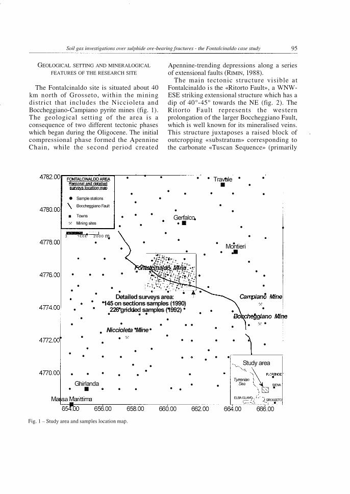
GEOLOGICAL SETTING AND MINERALOGICAL FEATURES OF THE RESEARCH SITE
The Fontalcinaldo site is situated about 40 km north of Grosseto, within the mining district that includes the Niccioleta and Boccheggiano-Campiano pyrite mines (fig. 1). The geological setting of the area is a consequence of two different tectonic phases which began during the Oligocene. The initial compressional phase formed the Apennine Chain, while the second period created
FONTALCINALOO AREA • Rggional and detgjlgg survevs location moo
Apennine-trending depressions along a series of extensional faults (RIMIN, 1988).
The main tectonic structure visible at Fontalcinaldo is the «Ritorto Fault», a WNWESE striking extensional structure which has a dip of 40°-45° towards the NE (fig. 2). The Ritorto Fault represents the western prolongation of the larger Boccheggiano Fault, which is well known for its mineralised veins. This structure juxtaposes a raised block of outcropping «substratum» corresponding to the carbonate «Tuscan Sequence» (primarily
• • Tra�le • • Ill •
• • • •
• • • Gerfalco.
•Ill • • • • Montieri • • .11111 • •
• • •
• Detailed suJVeys area: • • •
•
-145 on sections samples (1990) 22E)Ogridded samples (,992) •
171.50 172.00 172.50 Fig. 2 - Geological sketch map of the Fontalcinaldo area.
the «Calcare Cavernosa» Formation and the underlying Triassic Boccheggiano Schistose sequences) and a collapsed area to the north (the Pavone River Graben) where the same lithological sequence is overlain by the allocthonous Ligurid Complex. These latter sediments mainly consist of the Cretaceous « Argille a Palombini» Formation, a lowpermeable clayey flysch which ranges in thickness from 500 metres near the Ritorto Fault to 800 metres at the centre of the graben (RIMIN, 1988). Seismic data also show the presence of sub-parallel normal faults below the flysch which follow the Ritorto Fault direction and which lower the calcareous «substratum» towards the north. Although the extension of these faults to surface is likely, there is no clear geological or geophysical evidence of them occurring in the overlying flysch. This is probably due to erosion which eliminated any previous surface expression or to the plastic-homogeneous nature of these sediments which precludes seismic detection
111111111111111111111111111111 I o 250 500 750 1000 m
173.00 173.50 174.00
of any discontinuity (Chiantore V., ISMES, p.c.). N-S and NE-SW trending lineaments are also present in the eastern and north-western portion of the area (RIMIN, 1988).
The sulphide orebodies occur primarily as pyrite lenses along the Ritorto Fault plane ( Fontalcinaldo mine), as well as partially infilling the tectonic contact between the Ligurid Complex and the Calcare Cavernosa Formation at an average depth of 20-25 m. Surficial alteration haloes containing oxides and silicates overlay the main ore-bodies (Gregorio et al. , 1980).
Minor sulphur mineralisation was intercepted in holes (S 1 and S2) drilled over an airborne magnetic anomaly that also corresponds with weak soil-geochemistry anomalies. This mineralisation infills the tectonic breccias of the Ritorto Fault and related fractures at a depth of 500-800 metres below surface and consist mainly of disseminated sulphide minerals (such as pyrite, galena and sphalerite) and iron oxides (magnetite); trace gold and
Soil gas investigations over sulphide ore-bearing fractures- the Fontalcinaldo case study 97
relatively consistent amounts of Ag minerals are also present (RIMIN, 1988).
SAMPLING AND ANALYSIS METHODOLOGY
The soil-gas surveys were performed during two stages (see fig. 1). In September 1990 a preliminary survey was performed at Fontalcinaldo. One hundred forty five samples were taken every 50-100 meters along 6 N-S oriented sections, perpendicular across the Ritorto (Boccheggiano) Fault (see fig. 3 for details). Bad weather conditions precluded any soil gas collection in 1991.
In June and July 1992 two gridded surveys were performed, both at Fontalcinaldo and in the surrounding areas respectively. In the first, an integration of 1 990 data set was accomplished through the collection of 226
N
OA (")
�
:A' + + + + Cerro a/ tlico Farm
• + + + +
reconaissance soil gas on a grid with a sample spacing of 200 m. In the second, in order to best evaluate background values, an additional set of 171 samples were taken over a 150 km2
area (mesh spacing about 1 kilometre). He, 222Rn and C02 were selected for
analysis. Other species, such as methane and sulphur gases, were not addressed because they usually have very low soil-gas concentrations above sulphide deposits (Taylor et al., 1982; Hinkle, 1 984; Hynkle and Dilbert, 1 984; Stedman et al., 1984; Nicholson et al., 1988; Ball et al., 1990; Hynkle et al., 1990; Kesler et al., 1990) and sufficiently sensitive instruments were not available at the time of the surveys.
Soil-gas samples were collected by driving a hollow steel probe 0.5 m into the ground, inserting a syringe needle through an upper septum port on the probe and withdrawing the gas. 222�n was determined in the field by
FONTALCINALDO AREA Prelimina!Y surv�
Samule site location map
/7:.. Drills and mining bore holes
\ Main visible tectonic structures
+ + + + S1 Padovan311o Farm � E'+
+ + + +
A
) t + + + +
t 8
+
�2C' 8' + + + + +
+ + c
+ +D' +
+ + + +
+ + + +
+ +
+ +
+ + + + +
� ++ \ � ++ eo n.+ � a...v
L-------�------�------�----------------------------� 171.0 171.5 172.0 172.5 173.0 173.5 174.0 Fig. 3- Location map for soil-gas samples collected during the preliminary survey.
98 F. AsTORRI, S. LOMBARDI and F. PAOLONI
TABLE 1
Statistical parameters for each gas species including recalculated 222 Rn parameters for samples collected overflysch and calcareous sediments.
1990 Soil gas preliminary survey Sample distance on sections : 50- 1 OOm.
222Rn (Bq/1) Mean Std. Dev. Count Minimum Maximum Anomaly Thr.
35.4 I 57 1 144 I O 1 576.8 I 5o
C02% Mean Std. Dev. Count Minimum Maximum Anomaly Thr.
2.35 1 1.90 1 140 I o.o3 1 12.2 1 3.9
0 He (ppb) Mean Std. Dev. Count Minimum Maximum Anomaly Thr.
166 1 2 14 1 139 l -340 1 905 1 182
222Rn (Bq/1) (Fiysch) Mean Std. Dev. Count Minimum Maximum Anomaly Thr.
25.98 1 26.52 1 10 1 lo 1 229 1 32
222Rn (Bq/1) (C02 Calcareous sediments) Mean Std. Dev. Count Minimum Maximum Anomaly Thr.
I 1 43 lo 1 229 I 55
1992 Detailed soil gas survey (mesh 200 m x 200 m)
222Rn (Bq/1) Mean Std. Dev. Count Minimum Maximum Anomaly Thr.
16 1 16 1 226 lo 1 1 16 1 40
C02% Mean Std. Dev. Count Minimum Maximum Anomaly Thr.
2.5 1 2 1 226 lo 1 10 1 3.2
�He (ppb)
Mean Std. Dev. Count Minimum Maximum Anomaly Thr.
66 1 1 13 1 226 l -265 1 406 1 136
222Rn (Bq/1) (Fiysch) Mean Std. Dev. Count Minimum Maximum Anomaly Thr.
12 1 13 1 148 l o 1 78 1 20
222Rn (Bq/1) (C02 Calcareous sediments) Mean Std. Dev. Count Minimum Maximum Anomaly Thr.
I 1 78 lo 1 229 1 33
1992 Regional soil gas survey (mesh: 1.5 km x 1.5km)
222Rn (Bq/1) Mean Std. Dev. Count Minimum Maximum Anomaly Thr.
12 1 2 1 1 17 1 l o I 145 1 26
C02% Mean Std. Dev. Count Minimum Maximum Anomaly Thr.
0.9 I o.89 1 17 1 lo 1 5.2 lt.l �He (ppb)
Mean Std. Dev. Count Minimum Maximum Anomaly Thr.
22 j 93 1 17 1 l -205 !445 1 67
Soil gas investigations over sulphide ore-bearing fractures- the Fontalcinaldo case study 99
introducing soil-gas samples into a portable alpha-particle counter, while other gases were stored in stainless steel samplers and analysed in the laboratory by gas-chromatographic and mass-spectrometric methods. Radon activity is expressed as Bq/1 while helium levels are given as the difference ( 8He) between sample and atmospheric (5220 ppb) concentrations.
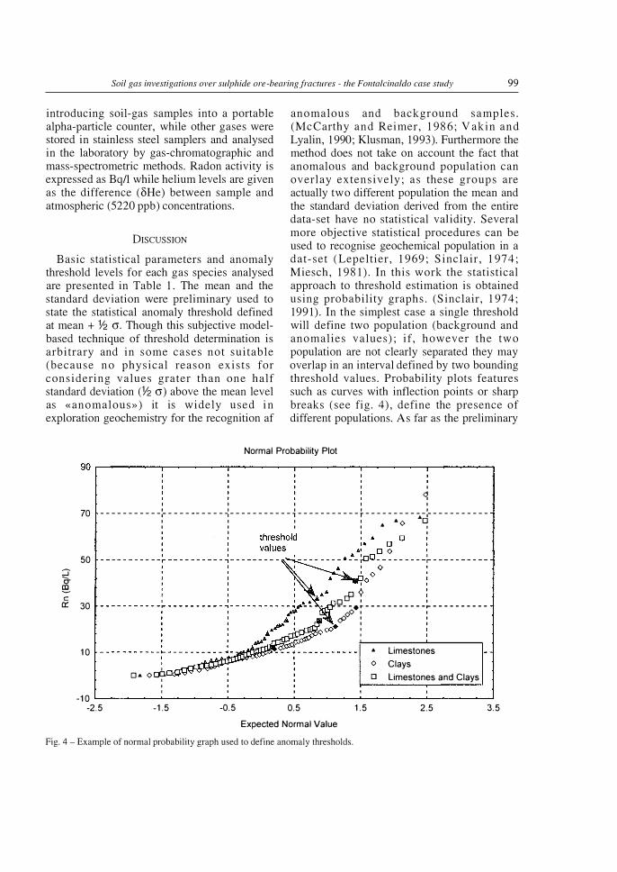
DISCUSSION Basic statistical parameters and anomaly
threshold levels for each gas species analysed are presented in Table 1 . The mean and the standard deviation were preliminary used to state the statistical anomaly threshold defined at mean+% a. Though this subjective modelbased technique of threshold determination is arbitrary and in some cases not suitable (because no physical reason exists for considering values grater than one half standard deviation (% a) above the mean level as «anomalous») it is widely used in exploration geochemistry for the recognition af
anomalous and background samples. (McCarthy and Reimer, 1 986; Vakin and Lyalin, 1990; Klusman, 1993). Furthermore the method does not take on account the fact that anomalous and background population can overlay extensively; as these groups are actually two different population the mean and the standard deviation derived from the entire data-set have no statistical validity. Several more objective statistical procedures can be used to recognise geochemical population in a dat-set (Lepeltier, 1 969; Sinclair, 1 974; Miesch, 1981). In this work the statistical approach to threshold estimation is obtained using probability graphs. (Sinclair, 1 974; 1991). In the simplest case a single threshold will define two population (background and anomalies values); if, however the two population are not clearly separated they may overlap in an interval defined by two bounding threshold values. Probability plots features such as curves with inflection points or sharp breaks (see fig. 4 ), define the presence of different populations. As far as the preliminary
Fig. 5 - Geochemical cross sections D-D' a) and F-F' b) performed during the preliminary survey at Fontalcinaldo.
survey is concerned the values of each transect were plotted and compared with the Ritorto Fault outcrop as well as the surface projection of its related faults (figs. 5 a-b) . .1.He and C02 show anomalous peaks, i.e. higher than the respective threshold values of 182 ppb and 3.9%, which may be fault related. Radon levels remain higher than 50 Bq/1 over the Calcare Cavernosa Formation but show a sharp decreasing over the flysch, probably related both to a source rock difference and different permeability between the two lithotypes. To highlight the presence of «hidden» radon peaks in clay sediments samples collected over the Argille Palombini formation and Calcare Cavernosa formation were statistically treated as a two separated subset of data. These newly calculated radon values were considered anomalous if they exceeded the threshold of 32 Bq/1 over the flysch - as this value also represents the quantity of Rn generated by the
average uranium content present in argillaceous sediments, (Etiope, 1995) - and 55 Bq/1 over limestones. Moreover, in order to best compare the geological and geochemical data, plan view diagrams were produced with geochemical data, the surface trace of the Ritorto Fault and the surface projection of deep seismic discontinuities identified in the carbonate substratum (fig. 6a-b-c). In general He, C02 and re-calculated 222Rn anomalies tends to overlay the tectonic structures of the area over both outcropping lithotypes ( «Calcare Cavernosa» and « Argille a Palombini» formations); in particular the good correlation between anomalous gas patterns and fractures (faults) revealed by geophysics in the carbonate «substratum» suggests the presence of lines of weakness in the flysch which act as preferential pathways for ascending gases. The high C02 values recorded along the Ritorto Fault close to Fontalcinaldo mine and « Italia» mining
Soil gas investigations over sulphide ore-bearing fractures - the Fontalcinaldo case study
N
A
+ 222-Rn (&;1) Urrestone
+ Oto 9 D 9to25
� 181 25 to 36 ro [) 36 to 56
222-Rn (Bqll) F/ysch
+ 0 to 12 D 12 to 24 181 24 to 32 [) 32 to 36 • 36 to 500
nctua anomaly 222Rn
/7:1. �:h��5minin;J
\ =r��letectonic
, Deep seisrric ' dscontinuities
� • 56 to 500 �---------y---------T--------�--------�--------�--------�----��
171.0 171.5 172.0 172.5 173.0 Fig. 6a- Plan view 222Rn-anomaly map showing point values.
N
A
Delta-He (ppb) + o to 114 .6. 114 to 182
� .1..4 182 to 301 o; � 301 to 1000
171.0 171.5 172.0
/ /
) £
172.5 173.0 Fig. 6b Plan view �He-anomaly map showing point values.
173.5
173.5
174.0
FONTALCINAL.OO AREA Preliminary survev
Punctual anomaly map Delta-He
/7:1. �:�!rrining
\ ���r��le tectonic
Deep seisrric ' discontinuities
� � +
+ ... Barletti Spring
101
102 F. AsTORRI, S. LoMBARDI and F. PAOLONI
N
�A -FarrJ1'
+, ,. .-" -+ ------
_()-"
FONTALONALDO AREA Preliminarv survey
Punctual anomaly map Carbon !Aoxide
A �����s mn�
\ �����e tectonc
Deepseisnic
,.'"'/{! 81 _.-- -+----- __ e�d_oy�r:llo Farm �
' discontinuities
'',B2 f''',,E. .f', I ()''..,, __
I
---- .::!-_-
C02%(v/v)
J + 0.0 to 1.7 <:::! () 1.7 to 3.9 eo 8 3.9 to 12.2 ,t � � ��--------�------��----����--���----��----���--� 171.0 171.5 172.0 172.5 173.0 173.5 174.0
Fig. 6c Plan view COranomaly map showing point values.
borehole as well as in correspondence of drillholes S 1 and S2 are worth noting, as they imply the reaction of sulphuric acid with limestone and thus may be important from a mineral exploration point of view.
Geostatistically-produced contour maps obtained by processing the 226 samples uniformly collected over the same area in 1992, show He, 222Rn and C02 anomalies (see table 1) which are associated with either WNW-ESE or N-S tectonic lineaments, as shown in fig. 7ab-c. Moreover He, C02 and 222Rn contour maps also suggest the possible existence of N-S tectonic lineaments in the central and north western section which are not delineated in the geological or geophysical maps.
The local presence of a N-S tectonic trend appear to be clearly confirmed by observing regional contour maps as shown in fig. 8a-b-c. Besides to reproducing the regional WNWESE tectonic trend (as they are prevalently distributed along the Boccheggiano Fault), He, 222Rn and C02 distribution show clearly N-S
trending anomalies close to Niccioleta and Campiano mining sites. In particular C02 contour lines also indicate the presence of a tectonic lineament north of Campiano that probably corresponds, as deduced from structural field data, to the northern extension of Boccheggiano Fault. The existence of such a structure would play an important role in the regional tectonic style of the study area and might also justify the constant occurrence of the previously mentioned N-S-trending gas anomalies at Fontalcinaldo.
In addition to the classical statistical procedures described above an alternative statistical approach aimed to further aid in the structural interpretation has also been applied. This method consists of fitting consecutive punctual anomaly values on the samplelocation maps in order to define «linear anomalies». Lines were drawn between points showing values higher than the thresholds levels; moreover, points showing very different values from the local background were also
l{) C"":i � """
0 C"":i CO � l{) � f'... """
0 C\i CO � � co � � co � l{) c::i CO f'... """
Soil gas investigations over sulphide ore-bearing fractures - the Fontalcinaldo case study
N
AfJ �
"<;)
90 80 70 60 50
) 0
FONTALCINALDO AREA Detaj!ed qrjddgd syrvey
Map of isnya!ues of 222 Rn
Drills and mining bore holes Main visible tectonic structures Deep seismic discontinuities
103
Fig. 7 a - Anomaly contour map showing distribution of 222Rn in soil gas samples collected at Fontalcinaldo during the detailed gridded survey.
l.()
��--_. ______ _. ______ ���--��
l.()
� �--���--��--���--����
FONTALCINALDO AREA Detailed gridded survey
Map of isovalues of D�He
Drills and mining bore holes
Main visible tectonic structures Deep seismic discontinuities
Fig. 7 b - Anomaly contour map showing distribution of L'\He in soil gas samples collected at Fontalcinaldo during the detailed gridded survey.
104 F. AsTORRI, S. LOMBARDI and F. PAOLONI
L() M CO 1'-"<t 0 M CO 1'-"<t L() N CO 1'-"<t 0 � � � co � � co 1'-"<t L() d CO 1'-"<t1
FONTALCINALDO AREA Detailed gridded survey Map of isovalues of C02
Drills and mining boreholes
Fig. 7 c- Anomaly contour map showing distribution of C02 in soil gas samples collected at Fontalcinaldo during the detailed gridded survey.
included even if they were not above the calculated threshold values. The statistical distribution of the resulting lines were then plotted on rose diagrams and compared with the regional and local tectonic trends. These results are shown for 222Rn in fig. 9, (C02 and DHe are similar); as can be seen a reasonable correlation exists between these trends and those of deep and surficial tectonic lineaments defined by geophysical and geological field studies, moreover a reasonable percentage of anomaluos linear trends reveal the presence of probably hidden N-S tectonic structures.
As deduced from the data discussed above, these results also suppm1 the conclusion that soilgas surveys are able to aid in the structural mapping of areas having low pe1meabilities. The following describes the work conducted to ascertain the presence of sulphide mineralisations which may fill such tectonic structures.
As indicated by the regional contour maps, COb Rn and He anomalies appear to correlate well with the main mining areas (Niccioleta,
Boccheggiano-Campiano, Fontalcinaldo ); in particular, high C02 anomalies indicate the possible occurrence of sulphuric acid-limestone reactions.
The detailed survey conducted in the Fontalcinaldo area supports the regional profiles. C02 increases ( 6- 12% v /v) were recorded over the Ritorto Fault in the southern portion of the area where weak soil-chemistry anomalies have been observed and where sulphide mineralisation has been detected in drillholes S 1 and S2 (fig. 7 c) high C02 values, as well as other gases, were also noted close to P. Cerro al Vico and the Barletti Spring (near the north-western and eastern edges of the area, respectively) over fractures for which mineral occurrence data has not been collected. In this second case the concomitant presence of high C02, He and Rn concentrations may suggest the presence of sulphide mineralisation, although further studies which address sulphur gas detection are needed to verify this hypothesis.
Soil gas investigations over sulphide ore-bearing fractures - the Fontalcinaldo case study 105
+ + + Tra.Vale + + + 0 + + + +
' 0 + � Gas Anomaly trends + + + GerfalcEt-
+ + +•
+
+ + +
+ + + + + +
+
+ + + + + �
.00 Fig. Sa - Anomaly contour map showing distribution of 222Rn in soil gas samples collected around Fontalcinaldo during the regional gridded survey.
Fig. Sb - Anomaly contour map showing distribution of llHe in soil gas samples collected around Fontalcinaldo during the regional gridded survey.
106 F. ASTORRI, S. Lotv!BARDI and F. PAOLONI
656.00 658.00 660.00 662.00
Travale 11
M e
ine
\ooo 2o6o m. 664.00 666.00
Fig. Se - Anomaly contour map showing distribution of C02 in soil gas samples collected around Fontalcinaldo during the regional gridded survey.
Calculation Method .... Frequency
Class Interval .. . . . . . . 10 Degrees
Length Filtering · · · · · · Activated
Min.inn.un Length 0.6
Maximum Length 1.2 Azimuth Filtering ... .. . Deactivated
Data Type . .. . . ...... . . Bidirectional
280 Rotation Amount · · · · · · · 90 Degrees
Population · · · · · · · · · · · · 230 270
Maximum Percentage . .. . 13.9 Percent
Mean Percentage · · · · · · · 5.5 Percent
Standard Deviation . . . . 3.48 Percent
Vector Mean . . .. . . .... . 87.29 Degrees
Confidence Interval ... 18.9 Degrees
R-maq · · · · · · · · · · · · · · · · · 0. 62
Fig. 9- Rose diagrams showing statistical distribution of the anomalous trends resulting from 222Rn linear anomalies.
Soil gas investigations over sulphide ore-bearing fractures- the Fontalcinaldo case study 107
CONCLUSIONS
The present study on the application of soilgas analysis for sulphide-ore exploration at Fontalcinaldo have revealed several important facts. Soil-gas surveys may be able to collect geochemical information in areas where thick, low-permeability clay deposits preclude the use of traditional geochemical methods based on trace-element aqueous migration. At Fontalcinaldo He, Rn and C02 show anomalies over both the investigated lithotypes (carbonate Tuscan Sequence and clayey Ligurid Flysch) and the method does not seem to be disturbed by the nature of the terrains. Earlier studies on the application of soil-gas methods to mineral exploration only regarded ore deposits overlain by thin, permeable sediments. In contrast, the soil-gas investigations performed at Fontalcinaldo are related to deposits overlaid by very thick and low-permeability sediments.
Fault and fracture systems act as preferential pathways for the upward migration of deepseated gases and thus control surficial gas distribution. Traverse and gridded surveys performed at different times and scales give the same type of information on the structural setting of the investigated area, as well as on the possible location of sulphide ore-bearing fractures.
Regional soil-gas distributions appear to be controlled by the Boccheggiano Fault, which bisects the area along a WNW-ESE trend; C02 contour lines also suggest the probable occurrence of a northward extension of this fault in the vicinity of Campiano.
Detailed surveys performed at Fontalcinaldo show elevated soil-gas values over both the Ritorto Fault and over known structures in the eastern and western edge of the area. The occurrence over the flysch of gas anomalies running parallel to the Ritorto Fault direction (WNW-ESE) indicates the possible presence of hidden fracture related to deep seismic discontinuities identified in the carbonate substratum. Furthermore, contour maps also highlight the occurrence of N -S trending lineaments, reflecting the role played by the
above-discussed northward prolongation of the Boccheggiano Fault in terms of the local tectonic style.
In addition to the favourable results obtained both on the delineation of hidden tectonic structures and the acquisition of geochemical data in low-permeable clay sediments, soil-gas techniques may provide valuable information on the location of sulphide-ore-bearing fractures. As observed in the regional survey, C02, He and Rn seem to correlate well with major mining areas, thereby showing promise in the detection of sulphide deposits. Moreover, increased C02 levels have been recorded at Fontalcinaldo over known mineralised fractures in correspondence with the presence of Rn and He. The presence of other anomalies (C02 and other gases) detected over faults where no mineral-deposit data are available suggest that further studies on sulphur gas distribution would aid interpretation.
Considering the C02 distribution and the limitations placed on the research by the unfavourable geological conditions (depth and disseminated nature of the deposits) the reported results may be considered very promising.
REFERENCES
BALL T.K., NICHOLSON R.A. and PEACHEY D. (1985) - Gas geochemistry as an aid to detection of buried mineral deposits. Trans. Instn. Min. Metall., 94, 181-188.
BALL T.K., CROW M.J., LAFFOLEY N., PIPER D. and RIDGWAY J. (1990)- Application of soil-gas geochemistry to mineral exploration in Africa. J. Geochem. Explor., 38, 103-115.
DUDDRIGE G.A., GRANGER P. and DURRANCE E.M. (1991) - Fault detectio n using soil gas geochemistry. Quart. J. Engineering Geol., 24, 427-435.
ETIOPE G., (1995) - Migrazione e comportamento del «geogas» in bacini argillosi. PhD thesis.
GREGORIO F., LATTANZI P. and TANELLI G. (1980)Contributo alia definizione dei giacimenti toscani di Niccioleta, Gavorrano, Boccheggiano e Campiano: studio del/a sphalerite. Rend. Soc. It. Min. Petrol., 36, 279-294.
GREGORY R.G. and DURRANCE E.M. ( 1985) -
Helium, carbon dioxide and oxygen soil gases:
108 F. AsTORRI, S. LOMBARDI and F. PAOLONI
Small-scale variation over fractured ground. J. Geochem. Explor., 24, 29-49.
HINKLE M.E. and HARMS T.F. (1978)- CS2 and COS in soil gas of the Roosevelt Hot Springs Knmvn Geothermal resource area, Beaver County Utah. J. Res. U.S. Geol. Surv., 6, 571-578.
HINKLE M.E. (1984) Using volatile constituents of soils and soil gases to determine the presence of Copper-Zinc ore bodies at Johnson C amp, Arizona. J. Geophys. Res., 91, 12359-12365.
HINKLE M.E. and DILBERT C. A. (1984) - Gases and trace elements in soils at the North Silver Bell deposit, Pima County, Arizona. J. Geochem. Explor., 20, 323-326.
HINKLE M.E. and KANTOR J.A. (1978) - Collection and analysis of soil gas emanating from buried sulphide mineralisations, Johnson Camp area, Cochise County, Arizona. J. Geochem. Explor., 9, 209-216.
HINKLE M. E. , RYDER M. E. , SUTLEY S.J. and BoTINELLY T. (1990) - Production of sulphur gases and Carbon dioxide by synthetic weathering of crushed drill cores from the S.Cruz porphyry copper deposit near Casa Grande, Pinal County, Arizona. J. Geochem. Explor., 38, 43-67.
KESLER S.E, GERDENICH M.J., STEININGER R.C and SMITH C. (1990) -Dispersion of soil gas around micron gold deposits. J. Geochem. Explor., 38, 117-132.
KESLER S.E. and GARDNER M. (1986) - Factors affecting soil gas anomalies in overburden. J. Geophys. Res., 91, 12339-12342.
KLUSMANN R. (1993) - Soil gas and related methods for natural resources exploration. John Wiley & Sons, 483 pp.
LEPELTIER C. (1969) - A simplified statistical treatment of geochemical data by graphical representation. Econ. Geol., 64, 538-550.
LOVELL J. and HALE M. (1983)- Application of soilair carbon dioxide and oxygen measurements to mineral exploration. Trans. Instn. Min. Metall., 92.
LOVELL J.S., HALE M. and WEBB J.S. (1983)- Soil air carbon dioxide and oxygen measurements as a guide to concealed mineralisation in semiarid and arid regions. J. Geochem. Explor., 19, 305-317.
LOVELL J.S. , HALE M. and WEBB J.S. (1980)Vapour geochemistry in mineral exploration. Min. Mag., 143, 229-239.
LOVELL J.S., HALE M. and WEBB J.S. (1979) -Soil air disequilibria as a guide to concealed mineralisation at Keel, Eire. Prospecting in areas of Glaciated Terrain. I.M.M., London, 45-50.
MALMQVIST L., ISAKSSON M. and KRISTIANSSON K.
(1989)- Radon migration through soil and bedrock. Geo Explor., 26, 135-144.
McCARTHY J.H. Jr, LAMBE R.N. and DIETRICH J.A.
(1986) - A c ase study of soil gases as an Exploration Guide in glaciated Terrain - Crandon Massive Sulphide Deposit, Wisconsin . Econ. Geol., 81, 1408-1420.
McCARTHY J.H.Jr. and REIMER G.M. (1986) -Advances in soil gas geochemical exploration for natural resources: some current examples and practices. J. Geophys. Res., 91, B, 12327-12338.
MIESCH A. T. (1981) - Estimation of the geochemical threshold and its statistical significance. J. Geochem. Exp1or., 16, 49-76.
NICHOLSON R.A., PEACHEY D. and BALL T.K. (1988) . - Tests on use of sulphur gases in soils to detect
hidden mineralisations. Trans. Instn. Min. Metall., 97, 57-63.
OAKS B.W. and HALE M. (1987)- Dispersion Patterns of Carbonyl Sulphide above Mineral deposits. J. Geochem. Explor., 28, 235-49.
PEACHEY D., NICHOLSON R.A and BALL T.K. (1985) - Discussion on use of Carbon dioxide and
oxygen in soil gases to detect hidden orebodies. Trans. Instn. Min. Metall., 94, 201-203.
REID A.R. and RASMUSSEN J.D. (1990)- The use of soil gas C02 in the exploration for sulphide -bearing breccia pipes in northern Arizona. J. Geochem. Explor., 38, 87-101.
REIMER G.M. and BOWLES C.G. (1979)- Soil gas helium concentrations in the vicinity of a uranium deposit, Red Desert, Wyoming. USGS Open-file Report, 975, 9 pp.
RIMIN S.p.a. (1988) - Relazione conclusiva sui lavori svolti nel permesso di ricerca «Fontalcinaldo». Ministero Industria, Commercia e Artigianato, 22 pp.
ROSE A.W., HAWKES H.E. and WEBB, J.S. (1979)Geochemistry in Mineral Exploration, Academic Press, New York, N.Y., 494-497.
SINCLAIR A.J. (1974)- Selection of threshold values in geochemical data using probability graphs. J. Geochem. Explor., 3, 129-149.
SINCLAIR A.J. (1991)- A fundamental approach to threshold estimation in exploration geochemistry: probability plots revisited. Geochem. Explor., 41, 1-22.
STEDMAN D.H., CREECH, M.Z. , KESLER S.E. and GARDNER M. (1984)- Formation of CS2 and COS from decomposition of metal sulphides. Geophys. Res. Lett., 1, 858-860.
TAYLOR C.H., KESLER S.E. and CLOKE P.L. (1982) - Sulphur gases produced by the decomposition
of sulphide minerals: application to geochemical exploration. J. Geochem. Explor., 17, 165-85.
V AKIN E.K. and LYALIN G.N. (1990) Soil gas anomalies and the detection of vvater-conducting zones within geothermal systems. Geochemistry of gaseous elements and compounds, Thoephrastus Pub. S.A., Athens.


![Metallurgical Performance of Ageing Crushed Ore and Nanthakumar [2] also conducted extensive testwork on fresh and stockpiled copper-nickel sulphide ores. In this case, the impact](https://static.documents.pub/doc/80x56/5ccc17f188c99356318b8285/metallurgical-performance-of-ageing-crushed-ore-and-nanthakumar-2-also-conducted.jpg)
