Soil Formation -2 Jenny (1941) formulated the hypothesis that soil is formed as a result of the interaction of many factors, the most important of which are:climate (cl), living organisms (o),relief (r), parent material (p),time (t). Jenny's approach was to consider these soil forming factors as control variables, independent of the soil as it evolved, and also independent, but not necessarily so of each other. He then attempted to define the relationship between any soil property 's' and the most important soil forming factors by a function of the form: s = f (cl, o, r, p, t, ......) The dots indicate that factors of lesser importance such as mineral accession from the atmosphere, or fire, might need to be taken into account. Equation 3.1 assumes that there is a causal relationship between s and the soil forming factors. Jenny (1980) redefined the soil forming factors as 'state' variables and included ecosystem properties, vegetation and animal properties, as well as soil properties. Parent material and relief define the initial state for soil development, climate and organisms determine the rate at which chemical and biological reactions occur in the soil (the pedogenic processes), and time measures the extent to which a reaction will have proceeded. There is a logical progression: of environment (i.e. the soil forming factors) -> processes -> soil properties underlying the soil formation. When only one factor prevails on the others the range of soils formed is called a sequence. Climosequence . biosequences , toposequences , lithosequences and chronosequences of soils have been recognized in various parts of the world. Indeed, the main virtue of Jenny's attempt to quantify the relationship between soil properties and soil forming factors lies not in the prediction of exact values of s at a particular site, but rather in identifying trends in properties and soil groups that are associated with readily observable changes in climate, parent material, etc. Climate Climate involves both local (microclimatic) and global (macroclimatic) considerations. The key components of climate in soil formation are moisture and temperature. Soil moisture depends on several factors: The form and intensity of precipitation (water, snow, sleet) Its seasonal variability The transpiration and evaporation rate Slope Aspect Depth of soil profile Soil texture / permeability of the parent material
Transcript
Soil Formation -2 Jenny (1941) formulated the hypothesis that soil is formed as a result of the interaction of many factors, the most important of which are:climate (cl), living organisms (o),relief (r), parent material (p),time (t). Jenny's approach was to consider these soil forming factors as control variables, independent of the soil as it evolved, and also independent, but not necessarily so of each other. He then attempted to define the relationship between any soil property 's' and the most important soil forming factors by a function of the form:
s = f (cl, o, r, p, t, ......)
The dots indicate that factors of lesser importance such as mineral accession from the atmosphere, or fire, might need to be taken into account. Equation 3.1 assumes that there is a causal relationship between s and the soil forming factors. Jenny (1980) redefined the soil forming factors as 'state' variables and included ecosystem properties, vegetation and animal properties, as well as soil properties. Parent material and relief define the initial state for soil development, climate and organisms determine the rate at which chemical and biological reactions occur in the soil (the pedogenic processes), and time measures the extent to which a reaction will have proceeded. There is a logical progression: of environment (i.e. the soil forming factors) -> processes -> soil properties underlying the soil formation.
When only one factor prevails on the others the range of soils formed is called a sequence. Climosequence. biosequences, toposequences, lithosequences and chronosequences of soils have been recognized in various parts of the world. Indeed, the main virtue of Jenny's attempt to quantify the relationship between soil properties and soil forming factors lies not in the prediction of exact values of s at a particular site, but rather in identifying trends in properties and soil groups that are associated with readily observable changes in climate, parent material, etc.
Climate
Climate involves both local (microclimatic) and global (macroclimatic) considerations. The key components of climate in soil formation are moisture and temperature.
Soil moisture depends on several factors:
The form and intensity of precipitation (water, snow, sleet)
Its seasonal variability
The transpiration and evaporation rate
Slope
Aspect
Depth of soil profile
Soil texture / permeability of the parent material
A method of defining the soil moisture regime of the soil is using water balance calculations. Such a calculation is based on the measurement of rainfall distribution, a calculation of the potential evapotranspiration, and an assessment of surface runoff and infiltration
The primary topographic attributes slope and aspect have a major impact on soil moisture
The depth of soil profiles also influences the soil moisture content. Thick soil profiles are able to store large amounts of water. The shallower a soil profile the less water can be stored . Such soils are prone to low soil moisture contents.
Soil texture influences the soil moisture content, where assumed the same climatic conditions, sandy soils have the tendency for low soil moisture content, silty soils for average soil moisture contents, and clayey soils for high soil moisture contents . This is due to the different pore space distribution in coarse and fine textured soils. Sandy soils have a high amount of macropores (pore diameter > 10 micrometer ), silty soils a high amount of medium-sized pores (pore diameter 0.2 - 10 micrometer) , and clayey soils a high amount of fine pores ( pore diameter < 0.2 micrometer) .
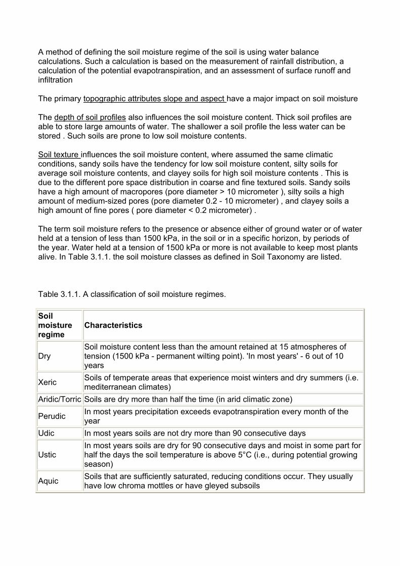
The term soil moisture refers to the presence or absence either of ground water or of water held at a tension of less than 1500 kPa, in the soil or in a specific horizon, by periods of the year. Water held at a tension of 1500 kPa or more is not available to keep most plants alive. In Table 3.1.1. the soil moisture classes as defined in Soil Taxonomy are listed.
Table 3.1.1. A classification of soil moisture regimes.
Soil moisture regime
Characteristics
Dry Soil moisture content less than the amount retained at 15 atmospheres of tension (1500 kPa - permanent wilting point). 'In most years' - 6 out of 10 years
Xeric Soils of temperate areas that experience moist winters and dry summers (i.e. mediterranean climates)
Aridic/Torric Soils are dry more than half the time (in arid climatic zone)
Perudic In most years precipitation exceeds evapotranspiration every month of the year
Udic In most years soils are not dry more than 90 consecutive days
Ustic In most years soils are dry for 90 consecutive days and moist in some part for half the days the soil temperature is above 5°C (i.e., during potential growing season)
Aquic Soils that are sufficiently saturated, reducing conditions occur. They usually have low chroma mottles or have gleyed subsoils
When soil moisture is high, as in wet or humid climates, there is a net downward movement of water in the soil for most of the year, which usually results in greater leaching of soluble materials, sometimes out of the soil entirely, and the translocation of clay particles from upper to lower horizons. In arid climates there is net upward movement of water in the soil, due to high evapotranspiration rates, which results in upward movement of soluble materials (e.g. salts). These accumulated materials can become cemented (-> pans), which are impenetrable to roots and lower infiltration tremendously.
3.1.2) Temperature
Temperature varies with lattitude and altitude, and the extent of absorption and reflection of solar radiation by the atmosphere. Solar radiation (direct radiation and diffuse radiation) increases with elevation, differs seasonally, and is influenced by cloud cover or other atmosperic disturbance (e.g. air pollution). The absorption of the solar radiation at the soil surface is affected by many variables such as soil color, vegetation cover, and aspect. In general, the darker the soil color, the more radiation is absorbed and the lower the albedo. The effect of vegetative cover on absorption varies with density, height, and color of the vegetation. Hence the absorption differs in areas with decidious trees (soil surface is shaded by trees most of the year) and arable land (soil surface is not shaded throughout the year). Light, or whitish-colored, soil surfaces tend to reflect more radiation . When incoming solar radiation is reflected, there is less net radiation to be absorbed and heat the soil. Snow is especially effective in reflecting the incoming solar radiation. Soil moisture controls also the heating up or cooling down of soils. Water has a high specific heat capacity (1 cal g-1 C), whereas dry soils have a specific heat capacity of about 0.2 cal g-1 C. This means that sandy soils cools and heats more rapidly than soils high in silt or clay. Once a wet soil is warmed, it takes longer to cool than a dry soil. In the Northern Hemisphere, south-facing slopes tend to be warmer and thus more droughty than north-facing slopes.
Temperature affects the rate of mineral weathering and synthesis, and the biological processes of growth and decomposition. Weathering is intensified by high temperatures, hence weathering is stronger in the tropics than in humid regions. Temperature also influences the degree of thawing and freezing (physical weathering) in cold regions. Biological processes are intensified by rising temperatures. Reaction rates are roughly doubled for each 10°C rise in temperature, although enzyme-catalysed reactions are sensitive to high temperatures and usually attain a maximum between 30 and 35 °C.
From Dokuchaev on (about 1870 ), many pedologist in Europe and North America regarded climate as predominant in soil formation. The relationship between climatic zones and broad belts of similar soils that streched roughly east-west across Russia inspired the zonal concept of soils. Zonal soils are those in which the climatic factor, acting on the soil for a sufficient length of time, is so strong as to override the influence of any other factor. Intrazonal soils are those in which some local anomaly of relief, parent material or vegetation is sufficiently strong to modify the influence of the regional climate. Azonal or immature soils have poorly differentiated profiles, either because of their youth or bacause some factor of the parent material or environment has arrested their development. In the U.S. the zonal concept was used in soil classification as published in the USDA Yearbook of Agriculture (Baldwin et al., 1938).
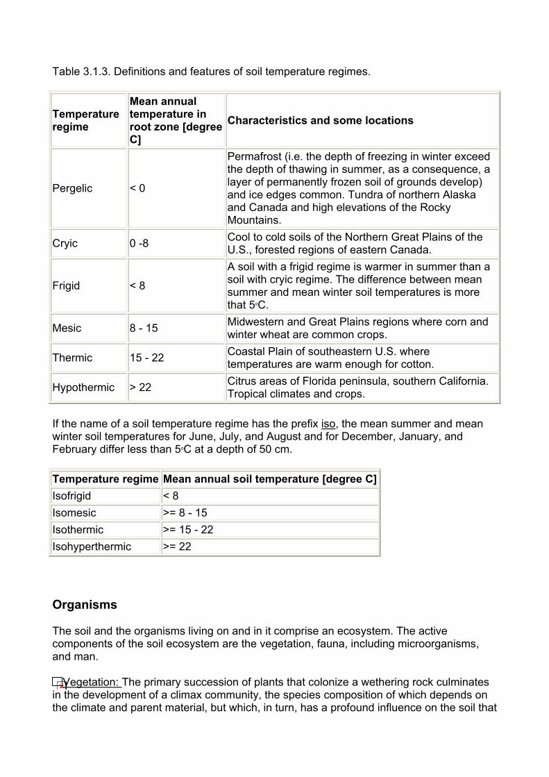
Table 3.1.3. Definitions and features of soil temperature regimes.
Temperature Mean annual temperature in root zone [degree Characteristics and some locations
Pergelic < 0
Permafrost (i.e. the depth of freezing in winter exceed the depth of thawing in summer, as a consequence, a layer of permanently frozen soil of grounds develop) and ice edges common. Tundra of northern Alaska and Canada and high elevations of the Rocky Mountains.
Cryic 0 -8 Cool to cold soils of the Northern Great Plains of the U.S., forested regions of eastern Canada.
Frigid < 8
A soil with a frigid regime is warmer in summer than a soil with cryic regime. The difference between mean summer and mean winter soil temperatures is more that 5oC.
Mesic 8 - 15 Midwestern and Great Plains regions where corn and winter wheat are common crops.
Thermic 15 - 22 Coastal Plain of southeastern U.S. where temperatures are warm enough for cotton.
Hypothermic > 22 Citrus areas of Florida peninsula, southern California.
regime C]
Tropical climates and crops.
If the name of a soil temperature regime has the prefix iso, the mean summer and mean winter soil temperatures for June, July, and August and for December, January, and February differ less than 5oC at a depth of 50 cm.
Temperature regime Mean annual soil temperature [degree C]Isofrigid < 8 Isomesic >= 8 - 15 Isothermic >= 15 - 22 Isohyperthermic >= 22
Organisms
The soil and the organisms living on and in it comprise an ecosystem. The active components of the soil ecosystem are the vegetation, fauna, including microorganisms, and man.
Vegetation: The primary succession of plants that colonize a wethering rock culminates in the development of a climax community, the species composition of which depends on the climate and parent material, but which, in turn, has a profound influence on the soil that
is formed. Deciduous forest seems to accelerate soil formation compared to grassland on the same parent material under similar climatic conditions. Differences in the chemical composition of leaf leachates can partly account for a divergent pattern of soil formation. For example acid litter of pines or heather favors the development of acid soils with poor soil structure, whereas litter of decidous trees favors the development of well structured soils.
Meso-/Macrofauna: Earthworms are the most important of the soil forming fauna in temperate regions, being supported to a variable extent by the small arthropods and the larger burrowing animals (rabbits, moles). Earthworms are also important in tropical soils, but in general the activities of termites, ants, and beetles are of greater significance, particularly in the sub humid to semiarid savanna of Africa and Asia. Earthworms build up a stone-free layer at the soil surface, as well as intimately mixing the litter with fine mineral particles they have ingested. The surface area of the organic matter that is accessible to microbial attack is then much greater. Types of the mesofauna comprise arthropods (e.g. mites, collembola) and annelids (e.g earthworms, enchytraeids).
Table 3.2.1. Earthworm biomass in soils under different land use (White, 1987)
Microorganisms: The organic matter of the soil is colonized by a variety of soil organisms, most importantly the microorganisms, which derive energy for growth from the oxidative decomposition of complex organic molecules. During decomposition, essential elements are converted form organic combination to simple inorganic forms (mineralization). Most of the microorganisms are concentrated in the top 15 - 25 cm of the soil because C substrates are more plentiful there. Estimates of microbial biomass C range from 500 to 2,000 kg /ha to 15-cm depth (White, 1987). Types of microorganisms comprise bacteria, actinomycetes, fungi, algae, protozoa, and soil enzymes.
Man: Man influences soil formation through his impact to the natural vegetation, i.e. his agricultural practices, urban and industrial development. Heavy machinery compacts soils and decreases the rate of water infiltration into the soil, thereby increasing surface runoff and erosion. Land use and site specific management (e.g. application of fertilizer, lime) also act on soil development.
Reference
White R.E., 1987. Introduction to the Principles and Practices of Soil Science. Blackwell Scientific Publ. , Palo Alto, CA.
Relief
Major topographical features are easily recognized in the field (e.g. mountains, valleys, ridges, crests, sinks , plateaux, floodplains). For detailed description of topography Digital elevation models (DEMs) are used. In a DEM each pixel of a landscape is described by a data triplet consisting of Easting, Northing, and the elevation .DEMs are available in different quality. Examples for DEMs are given in the following:
Topographic attributes such as slope, aspect, specific catchment area, plan and profile curvature can be derived from DEMs using surface fitting functions of a GIS (geographic information system) or topographic programs such as TAPES-G (Gallant et al., 1996).
Table 3.3.1. Selected primary topographic attributes important in pedology.
altitude elevation climate, vegetation type, potential energy
slope gradient overland and subsurface flow, velocity and runoff rate
aspect slope azimuth solar radiation catchment area area draining to catchment outlet runoff volume specific catchment area upslope area per unit width of contour runoff volume
flow path length maximum distance of water flow to a point in the catchment erosion rates, sediment yield
profile curvature
describes the shape of a slope in a downward direction and indicates the rate of change in gradient
water flow, flow velocity, sediment transport processes (erosion, deposition)
plan curvature
describes the shape of the slope in a direction perpendicular to the slope and indicates the rate of change in gradient
converging/diverging flow, soil water content
Figure 3.3.2. Landform elements of a hillslope.
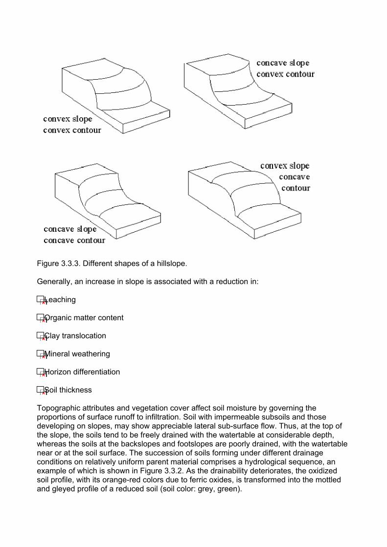
Figure 3.3.3. Different shapes of a hillslope.
Generally, an increase in slope is associated with a reduction in:
Leaching
Organic matter content
Clay translocation
Mineral weathering
Horizon differentiation
Soil thickness
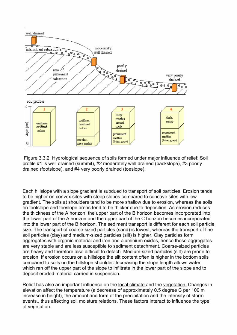
Topographic attributes and vegetation cover affect soil moisture by governing the proportions of surface runoff to infiltration. Soil with impermeable subsoils and those developing on slopes, may show appreciable lateral sub-surface flow. Thus, at the top of the slope, the soils tend to be freely drained with the watertable at considerable depth, whereas the soils at the backslopes and footslopes are poorly drained, with the watertable near or at the soil surface. The succession of soils forming under different drainage conditions on relatively uniform parent material comprises a hydrological sequence, an example of which is shown in Figure 3.3.2. As the drainability deteriorates, the oxidized soil profile, with its orange-red colors due to ferric oxides, is transformed into the mottled and gleyed profile of a reduced soil (soil color: grey, green).
Figure 3.3.2. Hydrological sequence of soils formed under major influence of relief: Soil profile #1 is well drained (summit), #2 moderately well drained (backslope), #3 poorly drained (footslope), and #4 very poorly drained (toeslope).
Each hillslope with a slope gradient is subdued to transport of soil particles. Erosion tends to be higher on convex sites with steep slopes compared to concave sites with low gradient. The soils at shoulders tend to be more shallow due to erosion, whereas the soils on footslope and toeslope areas tend to be thicker due to deposition. As erosion reduces the thickness of the A horizon, the upper part of the B horizon becomes incorporated into the lower part of the A horizon and the upper part of the C horizon becomes incorporated into the lower part of the B horizon. The sediment transport is different for each soil particle size. The transport of coarse-sized particles (sand) is lowest, whereas the transport of fine soil particles (clay) and medium-sized particles (silt) is higher. Clay particles form aggregates with organic material and iron and aluminium oxides, hence those aggregates are very stable and are less susceptible to sediment detachment. Coarse-sized particles are heavy and therefore also difficult to detach. Medium-sized particles (silt) are prone to erosion. If erosion occurs on a hillslope the silt content often is higher in the bottom soils compared to soils on the hillslope shoulder. Increasing the slope length allows water, which ran off the upper part of the slope to infiltrate in the lower part of the slope and to deposit eroded material carried in suspension.
Relief has also an important influence on the local climate and the vegetation. Changes in elevation affect the temperature (a decrease of approximately 0.5 degree C per 100 m increase in height), the amount and form of the precipitation and the intensity of storm events., thus affecting soil moisture relations. These factors interact to influence the type of vegetation.
Parent Material
The nature of the parent material has a decisive effect on the properties of soils. Properites of the parent material that exert a profound influence on soil development include texture, mineralogical composition, and degree of stratification. Soil may form directly by the weathering of consolidated rock in situ (a residual soil), saprolite (weathered rock), or it may develop on superficial deposits, which may have been transported by ice, water, wind or gravity. These deposits originated ultimately from the denudation and geologic erosion of consolidated rock. Consolidated material is not strictly parent material, but serves as a source of parent material after some physical and /or chemical weathering has taken place. Soils may form also on organic sediments (peat, muck) or salts (evaporites). The chemical and mineralogical compositions of parent material determine the effectiveness of the wethering forces. During the early stages of soil formation, rock disintegration may limit the rate and depth of soil development. The downward movement of water is controlled largely by the texture of the parent material. Furthermore, parent material has a marked influence on the type of clay minerals in the soil profile.
Time
Time acts on soil formation in two ways:
The value of a soil forming factor may change with time (e.g. climatic change, new parent material).
The extent of a pedogenetic reaction depends on the time for which it has operated.
Very old soils are formed on weathered consolidated rocks (e.g. granite, basalt), where the rocks were formed more than 500 million years ago (Paleozoikum). In Africa or Australia such old soils may be found.
The climate has changed over geological time, the most recent, large changes were associated with alternating glacial and interglacial periods of the Pleistocene. Europe and North America sustained four distinct ice invasions, whereas each glacial period was separated by long interglacial ice-free intervals. Those were times of warm or semitropical climate. The total length of the Pleistocene ice age is estimated 1 - 1.5 million years. The glaciers disappeared from Northern America approximately 12,000 years ago. As the glacial ice was pushed forward soil was swept away, hills were rounded, valleys filled and the underlying rocks were severely ground and gouged. Finally, when the ice melted a mantle of glacial drift remained, a new regolith and fresh parent material for soil formation. The influence of parent material is much more apparent in the soils of glaciated regions, where insufficient time has elapsed sine the ice retreated to permit the full development of soils. Youngt soils are fomed on alluvial or lacustrine materials generally have not had as much time to develop as the surrounding upland soils. Young in age are also colluvial soils, where sediment transport occured recently.
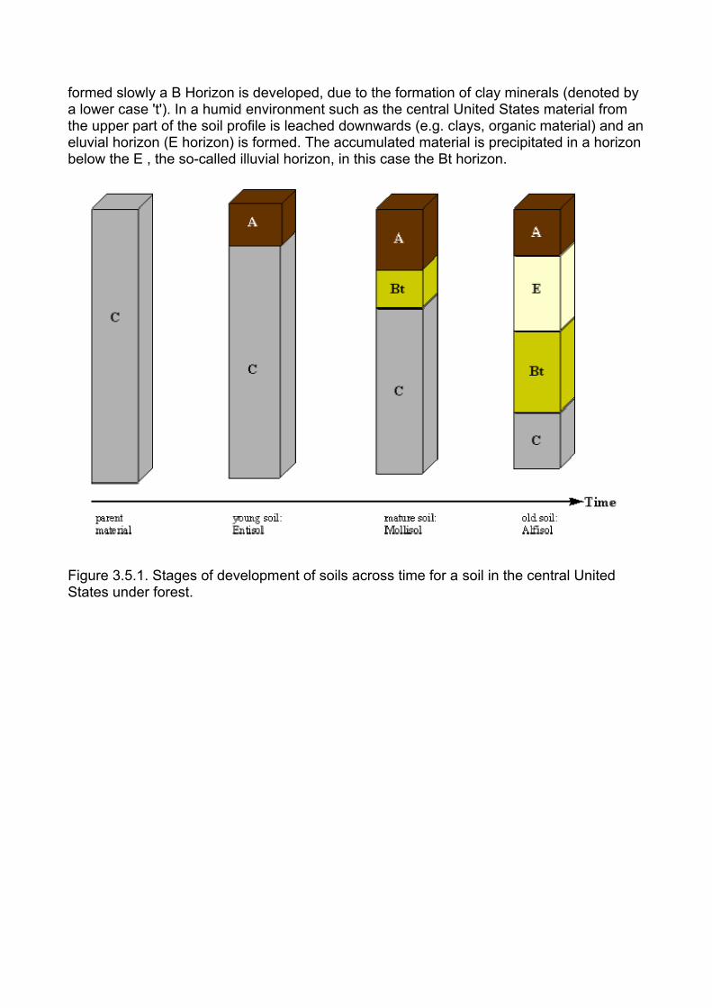
In Figure 3.5.1 a hypothetical soil development across time is shown. The parent material might be relatively unweathered bedrock. After weathering of bedrock and the accumulation of organic matter at the soil surface there occurs the development of an A horizon, due to processes such as decomposition and mineralization. After an A horizon is
formed slowly a B Horizon is developed, due to the formation of clay minerals (denoted by a lower case 't'). In a humid environment such as the central United States material from the upper part of the soil profile is leached downwards (e.g. clays, organic material) and an eluvial horizon (E horizon) is formed. The accumulated material is precipitated in a horizon below the E , the so-called illuvial horizon, in this case the Bt horizon.
Figure 3.5.1. Stages of development of soils across time for a soil in the central United States under forest.