South Dakota State University Open PIRIE: Open Public Research Access Institutional Repository and Information Exchange Agricultural Experiment Station Technical Bulletins SDSU Agricultural Experiment Station 1984 Soil Survey Laboratory Data and Pedon Descriptions of Some South Dakota Soils G.D. Lemme Follow this and additional works at: hp://openprairie.sdstate.edu/agexperimentsta_tb is Article is brought to you for free and open access by the SDSU Agricultural Experiment Station at Open PIRIE: Open Public Research Access Institutional Repository and Information Exchange. It has been accepted for inclusion in Agricultural Experiment Station Technical Bulletins by an authorized administrator of Open PIRIE: Open Public Research Access Institutional Repository and Information Exchange. For more information, please contact [email protected]. Recommended Citation Lemme, G.D., "Soil Survey Laboratory Data and Pedon Descriptions of Some South Dakota Soils" (1984). Agricultural Experiment Station Technical Bulletins. 76. hp://openprairie.sdstate.edu/agexperimentsta_tb/76
Transcript
South Dakota State UniversityOpen PRAIRIE: Open Public Research Access InstitutionalRepository and Information Exchange
Agricultural Experiment Station Technical Bulletins SDSU Agricultural Experiment Station
1984
Soil Survey Laboratory Data and PedonDescriptions of Some South Dakota SoilsG.D. Lemme
Follow this and additional works at: http://openprairie.sdstate.edu/agexperimentsta_tb
This Article is brought to you for free and open access by the SDSU Agricultural Experiment Station at Open PRAIRIE: Open Public Research AccessInstitutional Repository and Information Exchange. It has been accepted for inclusion in Agricultural Experiment Station Technical Bulletins by anauthorized administrator of Open PRAIRIE: Open Public Research Access Institutional Repository and Information Exchange. For more information,please contact [email protected].
Recommended CitationLemme, G.D., "Soil Survey Laboratory Data and Pedon Descriptions of Some South Dakota Soils" (1984). Agricultural ExperimentStation Technical Bulletins. 76.http://openprairie.sdstate.edu/agexperimentsta_tb/76
Soil Conservation Service and Agricultural Experiment Station, South Dakota State University
Soil Survey Laboratory Data and Pedon Descriptions
of Some South Dakota Soils
-------~ • p
TB 82 August 1984
~ ::--.::::.._=-- ----- - --- ~ ----
-~~
AX 072
Soil Survey Laboratory Data and Pedon Descriptions of Some
South Dakota Soils.1
G.D. Lemme, C.A. Dobie and Soil Survey Staff-USDA2
The Plant Science Department of South Dakota State University and the
soil survey staff of the Soil Conservation Service (SCS), and the U.S.
Forest Service (,usFS) in South Dakota cooperatively sampled and analyzed
selected chemical and physical properties of some soils during 1983.
This report contains pedon descriptions prepared by SCS, USFS and SDSU
personnel and corresponding laboratory data compiled by SDSU pedology staff.
The soil series indicated within this publication are tentative at the time
of its preparation.
Particle size analysis for the fine earth fraction was performed by the
pipette method. Total clay content is expressed on a carbonate .and organic
matter free basis. Sand fractions were determined by sieving. Coarse frag
ments ( 2111n diameter) are expressed on a volume basis.
Calcium carbonate content was determined by Funely and Grerrmer's method.
The SAR and EC data are from water extracts. A modified Walkley method was
used to obtain organic carbon values.
Individuals assisting with the lab analysis were as follows: D. Bennett,
C. Miller, and S. Winter. Material was typed by B. Hartman. Stan_dard SCS
laboratory methods were followed throughout the study.
1. Funded in part by Soil ConservationService, and U.S. Forest Service and South Dakota Agricultural Experiment Station.
2. Assistant Professor and Undergraduate, Plant Science Department, South Dakota State University, SCS State Soil Scientist, State Office staff, and Survey Party Leaders.
Published in accordanct" with an Act passed in 1881 bv the 14th legulat1ve Assemblv. Dakota Temtorv, establishing the Dakota Agri culture College and with the Act of re-organization passt"d in 1887 bv the 17th Lt"g1slat1ve Assemblv. which establisht'd the Agricultural Expenment Station at South Dakota State Un1vers1tv
Organic Carbonate Denth 1/3 Bar 15 Bar 15 Bar CEC/ CEC Carbon EC as CaC03
(inches 9m 9m 9m/Cl av Clav mec/1(1nnm % SAR mmhos/cm %
7-22 1.3
-
'
5
Soil Classification: Fine-loamy, mixed Pachic Haploborolls Series: Arnegard Pedon No.: S83SD031-13 Area: Corson County, South Dakota Location: 600 feet east and 85 feet north of the southwest corner of
sec. 36, T, 20 N., R. 28 E. Vegetation: Corn stubble Parent Material: Alluvium Physiography: High terrace Relief: Convex Slope: 3 percent Aspect: West Permeability: Moderate Drainage: Well Ground Water: Below 6 feet Moisture: Moist to 35 inches Erosion: Slight Date: October 1983 Profile by: Kenneth Heil
(Colors are for dry soil unless otherwise stated).
Ap--0 to 7 inches; dark grayish brown (lOYR 4/2) loam, very dark grayish brown (lOYR 3/2) moist; weak fine and medium subangular blocky structure parting to weak medium and fine granular; slightly hard, friable; neutral; abrupt smooth boundary.
Bwl--7 to 11 inches; dark grayish brown (2.SY 4/2) loam, very dark grayish brown (2.5Y 3/2) moist; weak medium prismatic structure parting to weak medium subangular blocky; slightly hard, friable; neutral; clear smooth boundary.
Bw2--ll to 16 inches; grayish brown (2.5Y 5/2) loam, very dark grayish brown (2.SY 3/2) moist; weak medium prismatic structure parting to weak medium subangular blocky; slightly hard, friable; neutral; gradual smooth boundary.
B3--16 to 22 inches; grayish brown (2.5Y 5/2) loam, very dark grayish brown (2.5Y 3/2) moist; weak coarse subangular blocky; slightly hard, friable; neutral; clear smooth boundary.
Cl--22 to 60 inches; grayish brown (2.5Y 5/2) loam, dark grayish brown (2.5Y 4/2) moist; massive; slightly hard; neutral.
Horizons sampled: Ap (0 to 7 inches) B (7 to 22 inches)
6
Series: Barnum
Pedon No: S83SD033-8
Area: Custer County, South Dakota
Location: 175 ft south and 300 ft west of the northeast corner of Sec. 11, T6S, RlE
- . .
TOTAL% SILT t SAND%
DEPTH Clay Silt Sand -· Med Coar VF F M C vc 1 ne (inches) .002- .05- .002 .005 .02 .05- .10- .25- .5- 1 - Textural
Organic Carbonate DerJth 1/3 Bar 15 Bar 15 Bar CEC/ CEC Carbon EC . as CaC03
(inches Qm Qm 9111/Cl av Clay mea/lonam % SAR mmhos/cm %
7
Soil Classification: Fine-loamy, mixed (calcareous) , nesic Ustic Torrifluvent Series: Barnum Pe.don No.: S83sP033-8 Area: CUster County, South Dakota I..Dcation: 175 feet south and 300 feet west of the northeast comer of sec. 11,
T. 6 S., R. 1 E. Vegetation: Western wheatgrass, needleandthread, blue grama, prairie dropseed Parent Material: Alluvium Physiography: LcM Terrace Slope: 1 percent Aspect: Southeast Erosion: None to slight Penceability: Moderate Drainage: Well drained Ground Water: Deep ~isture: ~ist to 5 inches, dry belc,,,, Root Distribution: Many to 5 inches, cx:rmon to 12 inches; ff!!N to 30 inches Elevation: 3850' Sampled by: Ed Ensz and Scott Anderson
(Colors are for dry soil unless otheJ:Wise stated) •
Al-0 to 2 inches; yellowish red (5YR 5/6) very fine sandy loam, reddish brown (5YR 4/4) noist; very weak nedium granular structure; soft, very friable; strong effervescence; mildly alkaline; clear srrooth boundary.
A2-2 to 5 inches; reddish yellc,,,, (5YR 6/6) loam, yellc,,,,ish red (5YR 4/6) noist; "Weak fine and nedium subangular blocky structure; soft, very friable; strong effervescence; mildly .alkaline; gradual srrooth boundary.
Cl-5 to 32 inches; reddish yellc,,,, (5YR 6/6) loam, yellc,,,,ish red (5YR 4/6) rroist; massive; soft, very friable; strong effervescence; mildly alkaline; abrupt srrooth boundary.
Ab-32 to 44 inches; brc,.,m. (7.5YR 5/4) loam, dark brc,.,m. (7.SYR 3/4) rroist; rrassive; soft, very friable; strong :effervescence; mildly alkaline; gradual wavy boundary . .. C2-44 to 50 inches; yellc,,,,ish red (5YR 5/6) loam, reddish brown (5YR 4/ 4) rroist; massive; soft, very friable; strong effervescence; Ir0dera.tely alkaline; gradual wavy boundary.
I C3-50 to 60 inches; yellc,,,,ish red (SYR 5/8) loam, yellc,,,,ish red (SYR 4/6) rroist; massive; soft, very friable; strong effervescence; m::xierately alkaline.
Horizons sampled: For SDSU Al 0-2 inches A2 2-5 inches Cl 5-32 inches
For Dept of Transportation ~ J 0-5 inches
Cl 5!.:32 inches C2). 44-60 inches C3)
Series: Bullflat
Peden No: S83SD033-3
Area: Custer County, South Dakota
8
Location: 1580 ft east and 260 ft south of the northwest corner of Sec. 16, TSS, R6E
-· -TOTAL I SILT Z SANO I
DEPTH Clay Silt Sand ~ine Med Coar VF F M C vc (inches) .002- .05- .002 .005 .02 .05- .10- .25- .5- 1 - Textural
Organic Carbonate DerJth 1/3 Bar 15 Bar 15 Bar CEC/ CEC Carbon EC as CaC03
(inches Qm Qm Qm/Cl av Clav mec/1Qnnm % SAR ITlllhos/cm OI ,0
9
Soil Classification: Fine-silty, mixed, Typic Argiboroll Series: Bullflat Peden No.: S83SD033•3 Area: Custer County, South Dakota location: 1580 feet east and 260 feet south of the northwest comer of sec. 16
T. 5 S., R. 6 E. Vegetation: Western wheatgrass, green needlegrass, Kentucky bluegrass Parent Material: Alluvium of sedimentary rock Physiography: High upland terrace Relief: A flat Slope: 1 percent Aspect: Northeast Erosion: Slight Pel:meabili ty: Moderate Drainage: Well Grourrl Water: Deep ?-Disture: .Moist to 21 inches; dry below :Root Distribution: Abundant to 8 inches; few to 34 inches Elevation: 4330' 5ani>led by: F.d Ensz ·
(Colors are for dry soil unless othel:Wise stated).
A-0 to 7 inches; dark grayish brown (lOYR 4/2) silt loam, very dark brown (lOYR 2/2) II'Oist; xroderate fine granular structure; soft, very friable; slightly acid; clear srrooth boundary.
Btl-7 to 10 inches; yellowish brc,r,,m (lOYR 5/ 4) silty clay loam, dark yellowish brown (lOYR 3/4) II'Oist; weak fine and medium subangular blocky structure parting to noderate medium granular hard, friable; neutral; clear srrooth boundary.
Bt2-10 to 16 inches; dark yellowish brown (lOYR 4/4) silty clay loam, dark brown (7.SY 4/4) Iteist; weak rredium prismatic structure parting to m:xierate medium subangular blocky; very hard, friable; neutral; clear srrooth boundary.
Bt3-16 to 21 inches yellowish brown (lOYR 5/4) silty clay loam, dark brown (lOYR 4/3) Iteist; ~ak medium and coarse prisrnatic structure partjJlg to weak medium subangular blocky; very hard,friable; neutral; abrupt waV'j boundary.
ECk-21 to 26 inches; very pale brown (lOYR 7/3) silty clay loam, pale brown (lOYR 63) II'Oist; weak coarse subangular blocky structure; hard, friable; strong effervescence; -m:xierately alkaline; clear srrooth boundary.
IICl-26 to 34 inches; light yellowish brown (lOYR 6/4) gravelly clay loam, dark brc,,,m (lOYR 4/3) Iteist; massive; slightly hard, friable; 30 percent by volurre of fragrrents of rock; strong effervescence; II'Oderately alkaline; clear srrooth boundary.
IIC2-34 to 60 inches; light yellowish "brown (lOYR /Ii°/ 4) very ccbbly clay loam, dark brown (lOYR 4/3) II'Oist; massive; slightly hard, friable; 40 percent by volurre of fragrrents of rock; strong effervescence; II'Oderately alkaline.
Organic Carbonate Oeoth 1/3 Bar 15 Bar 15 Bar CEC/ CEC Carbon EC as CaC03
(inches 9m 9m Qm/Cl av Clav mec/lQOnm % SAR ITlllhos/cm %
11 Soil Classification: Loamy-skeletal, micaceous Typic Eutroboralf , Series: Buska Peden No.: S82SD033-36 Area: Custer County, South Dakota Location: 1800 feet south and 2280 feet east of the northwest oomer of sec. 28
T. 3 S., R. 5 E. Vegetation: Ponderosa pine, beaiberry, poverty oatgrass, roughleaf ricegrass Parent Material: Micaceous schist Physiography: Mountain sideslope Relief: D ooncave Slope: 10 percent Aspect: East Erosion: Slight Penreability: M:xierate Drainage: Well Ground Water: Deep Moisture: Moist to 5 inches; dry below Root Distril:ution: Abundant to 20 inches; feM to 40 inches Elevation: 5380' San;,led by: Scott Anderson
(Colors are for dry soil unless otheI:wise stated) •
0-1 inch to O; forest litter.
A-0 to 2 inches; dark gray (lOYR 4/1) loam, black (lOYR 2/1) noist; weak fine granular; soft, very friable; 5 percent by volume of fragrrents of rock; neutral; abrupt smx>th boundary.
E-2 to 24 inches; pale brown (lOYR 6/3) loam, brown (lOYR 4/3) noist; weak rredium and fine platy structure; slightly hard, very friable; 10 percent by volurre of fragrrents of rock; neutral; clear wavy boundary.
Bt-24 to 43 inches; yellowish brcwn (lOYR 5/4) and light yellowish brown (lOYR 6/4) very channery loam, dark yellowish brown (lOYR 4/ 4) noist; weak rredium subangular blocky structure; hard, fiiln; 40 percent by volume of fragments of rock; slightly acid; gradual wavy boundal:y.
C-43 to 60 inches; light olive brcwn (2.SY 5/4) very channery loam; dark grayish brown (2.5Y 4/2) noist; massive; loose, friable, 50 percent by volurre of fragrrents of rock; slightly acid.
Horizons sampled: For SDSU ~ J 0-24 inches
Bt 24-43 inches C 43-60 inches
I
For Dept. of Transportation ~ J 0-24 inches
Bt 24-43 inches C 43-60 inches
12
Series: Conata
Pedon No: S82SD033-l0
Area: Custer . County, South Dakota
Location: 2300 ft east and 2000 ft north of the southwest corner of Sec. 24, T4S, R6E
TOTAL% SILT t SAND% DEPTH Clay Silt Sand ~ine Med Coar VF F M C vc
Organic Carbonate Oenth 1/3 Bar 15 Bar 15 Bar CEC/ CEC Carbon EC as CaC03
(inches 9m 9m 9m/C1 av Clav mec/100am % SAR mmhos/cm %
0-3 43.0 33.1 0.67 < 1 0.9 0.69
3-8 42.0 33.1 0.64 < 1 0.5 11.2
8-18 43.9 27.5 0.89 < 1 0.4 19.5
18-32 41.8 28.0 1.23 < 3 0.5 5.4
13
Soil Classification: Loamy, mixed (calcareous), rresic, shallow Ustic Torriorthent Series: Conata Peden No.: S82SD033-10 Area: CUster County, South Dakota wcation: 2300 feet east and 2000 feet north of the southwest comer of sec. 24
T. 4S.,R.6E. Vegetation: Little bluestem, needleandthread, junegrass Parent Material: White River materials that were reworked by water Physiography: Sideslope of old terrace :Relief: F convex Slope: 33 percent Aspect: Southeast Erosion: Slight PeIIl£ability: Moderate Drainage: Well Ground Water: Deep Moisture: Moist to 4 inches; dry below Root Distribution: Abundant to 18 inches; few to 32 inches Elevation: 4000' San;>led by: Ed Ensz
(Colors are for dry soil unless otherwise stated).
A-0 to 3 inches; dark grayish brown (lOYR 4/2) cobbly silty clay loam, vecy dark grayish brown (lOYR 3/2) ncist; weak fine and nedium granular structure; soft, 25 percent by volune of fragments of rock; mildly alkaline; clear srrooth boundary.
AC-3 to 8 inches; brown (lOYR 5/3) silty clay loam, dark brown (lOYR 3/3) ITDist, dark grayish brown (lOYR 4/2) ncist crushed; \o.'eak rredium prismatic structure parting to weak fine and nedium subangu1ar blocky; slightly hard, friable; strong effervescence; mildly alkaline; clear wavy boundary.
Cl-8 to 18 inches; vecy pale brown (lOYR 7 /3) light silty clay loam, brown (lOYR 5/3) ITDist; vecy weak coarse prismatic structure parting to .weak fine and rredium subangular blocky; hard, friable; violent effervescence; ItDderately alkaline; gradual wavy boundary. -·
Crl-18 to 32 inches; vecy pale brown (lOYR 8/3) loamy reworked mudstone; vecy pale brown (lOYR 7/3) iroist; massive; hard, friable; violent effervescence; iroderately alkaline; ~l wavy boundary.
Cr2-32 to 60 inches; vecy pale brown (lOYR 8/4) and white (lOYR 8/1) stratified loamy ra..urked mudstone and cerrented loamy and gravelly mudstone; massive; vecy hard, fiI:m; violent effervescence; iroderately alkaline.
Horizons sarrpled: For SDSU A 0-3 inches AC 3-8 inches Cl 8-18 inches Crl 18-32 inches
~l D:: :=sportation
c1J Crl 18-32 inches Cr2 32-60 inches
14
Series: Do1and
Pedon No: S83SD101-42
Area: Moody County, South Dakota
Location: 2490 ft north and 127 ft east of the southwest corner of Sec. 17, Tl08N, R47W
--TOTAL% SILT Z SAND%
DEPTH Clay Silt Sand -ine Med Coar VF F M C vc (inches) .002- .05- .002 .005 .02 .05- .10- .25- .5- 1 - Textura 1
Organic Carbonate De1Jth 1/3 Bar 15 Bar 15 Bar CEC/ CEC Carbon EC as CaC03
(i nches Qm 9m 9m/Clav Clay mea/lOOam % SAR rrmhos/cm %
0-8 2.7
15
Soil ClasFoification: fine-loamy, mixed, Udic Haploborolls Series: Doland Peden No.: S83SD10l-42 Area: 1!oody County, South ~akota Location: 2490 feet north and 127 feet east of the southwest corner , of
Sec. 17, T. 108 N., R. 47 W. f-u.RA: 102A Cli~ate: Subhumid Ve~etation: Alfalfa Parent Material: Loamy eolian material over glacial till Physiography: Plane upland sideslope Elev~tion: 1680 feet above sea level Relief: Gently sloping Slope: 3 percent Aspect: . South facing Drainage: ~ell drained Ground liater: Dee~er than 60 inches Erosion: Slight Permeability: Moderate to 28 inches, Morlera tely slow 28 to 60 inches ~tcniness: None PH ~'.ethod: :1eter Date: November 10, 1983 Sampled by: Bruce o. Kunze Horizons sar.ipled: Ap O to .~ inches
Bw1 8 to 13 inches Bw2 13 to 23 inches Ek 23 to 28 inches 2Bk 28 to 37 inches C2 37 to 60 inches
(co1ors are for dry soil unless otherwise stated).
Ap--0 to 8 inches; very dark grayish brown (10YR 3/2) loam, very dark brown (10YH 2/2) l'IOist; weak fine granular structure; slightly hard, fri?..ble, slightly sticky and slightly plastic; slightly acid; abrupt smooth boundary.
Bw1--8 to 13 inches; dark grayish brown (10YR 4/2) loam, very dark grayish br0wn ( 10YR 3/2) moist; we!".k medium prismatic ::;tructure pRrtins to weak medium subang,1lar blocky; sli r,htly hard, friable, slightly sticky and sli~htly plastic; sli~htly Reid; clear wavy boundary.
Bw2--13 to 23 inches; brown (10YR 5/3) loam, dark brown (10YR l+/3) moiat; wenk medium pri5~Ptic ~tructure parting to weak medium subangular ~locky; slightly hard, friable, sli~htly sticky and slightly plastic; neutral; clear wavy boundary.
Bk~23 to 2R inches; pale yellow (2.5Y 7/4) silt loam, li~ht olive brown (2.5Y 5/4) moi~t; weak medium prinmatic structure parting to weak medium;subangular blocky; sli ghtly hard, friable, slightly sticky and sliehtly plastic; common fine accu~ulations of carbona.te; strong effervescence; moderAtely aHaline; clear s!!looth boundary.
2Bk--2P to 37 inches; ~ale ye]low (2.5Y 7/4) clay loam, li r ht o]ive brown (2.5Y 5/4) moist; connon fine distinct yellowish brown (10YR 5/6) and very dark brown (10Y?. 2/2) mottles; weak medium prismatic structure parting to weak medium subRngular blocky; very lard, firm, sli ["htly sticky nnd f;li r,htly plafltic; common fine accur.mlations o: cRrbonate; stronp; effervescence; moderc>tely c>.lkaline; gr adual wavy boundary.
2C--3? to 60 inches; pale yellow (2.5 7/4) clay loan, lif ht olive brown (2.5Y 5/4) moi s t; CO'."' '.': On fine dir,tinct yellO\,i s h hrown ( 1nm 5/6) and vP.ry dark hro\.ln ( 10YH ?./20 ~cttles; nn·sivc; very hnrrl, firm, sli r htly sticky ~nd sliFhtly plastic; few fine accunulati cnR of carhonate; stron~ effprvesc ence; moderRtely e.J.kaline.
16
Series: Doland
Pedon No: S83SD101-43
Area: Moody County, South Dakota
Location: 1683 ft south and 77 ft west of the northeast corner of Sec. 3, T108N, R49W
·- . -TOTAL% SILT t SANO%
DEPTH Clay Silt Sand ~ine Med Coar VF F M C vc (inches) .002- .05- i-002 .005 .02 .05- .10- .25- .5- 1 - Textural
Organic Carbonate 01:r)th 1/3 Bar 15 Bar 15 Bar CEC/ CEC Carbon EC as CaC03
(inches 9m Qm 9m/Clav Clav mec/1/'lOnm % SAR nmhos/cm %
0-8 2.7
17
Soil Clasoification: fine-loruny, mixed, Udic Haploborolls Series: Doland Pedon No.: S83SD10l-43 Area: Moody County, South Dakota Locati"on: 1683 feet south and 77 :feet west of the northeast corner of
Sec. 3, T. 108 N., R. 49 W. MLRA: 102A Climate: Subhumid Vegetation: Soybean stubble Parent tfaterial: Loamy eolian :?'laterial over glacial till Physiography: Plane upland sideslope Elevation: 164o feet above sea level Relief: Gently sloping Slope: 3 percent Aspect: West facing Drai~age : Well drained Ground Water: Deeper than 60 inches Erosion: Slight Per.neability: Moderate to 28 inches, Moderately slow 28 to 60 inches Stoniness: None pH Method : Meter Date: tlovember 22, 1983 Sarnpled: by.: Bruce o. Kunze Horizons Sa~pled: Ap Oto 8 inches
Bw1 8 to 15 inches Bw2 15 to 28 inches 2Bk 28 to 37 inches 2C 37 to 60 inches
(colors are for dry soil unless otherwise stated).
Ap--0 to 8 inches; very dark grayish brown (10YR 3/2) loam, very dark brown (10YR 2/2) moist; weak fine r,ranular structure; sli~htly h~rd, friable, slightly sticky and slightly ulastic; sliehtly acid; abrnpt smooth boundary.
Bw1--8 to 15 inches; dark grayish brown (10YR 4/2) loam, very dark grayish brown (10YR 3/2) moist; weak Medium prir,matic structure parting to weak medium subangular blocky; slip,htly hard, friable, slightly sticky and slightly ~lastic; neutral; clear wavy boundary.
Bw2--15 to 2~ inches; brown (10YR 5/3) loam, dark brown (10YR 4/3) moist; weak medium prismatic structure parting to weak medium subangular blocky; sli ghtly hard, friable, slightly sticky and slightly plastic; neutrRl; clear smooth boundary.
2Bk--2R. to 37 inches; light yellowish brO\•m (2.5Y 6/4) clay loAm, licht olbe brown. (2.5Y 5/4) moist; common fine distinct yellowish brown (10YR 5/6) and cray (10YR 6/1) mottles; weak ~edium prismatic structure parting to weak medium subanr;ular blocky; very hard, firm , slightly sticky and sli ehtly plastic; common fine accumulPtions of carbonate; stronp, effervescence; moderRtely elk~line; gradual wavy boundary.
2C-37 to 60 inches; li1-~ht yellowish brown (2.5 6/4) clay loan, li ght olive brown (2.5Y 5/4) moist; cc,i~on fine distinct yeJlowish brown (10YH 5/6) and eray (10YR 6/1) Mottles; nassive; very hard, firm slightly sticky and sli ~htly plar:tic; few fine accurnuL1ti0ns of carhonate; strong effervescence; moderately alkaline .
18
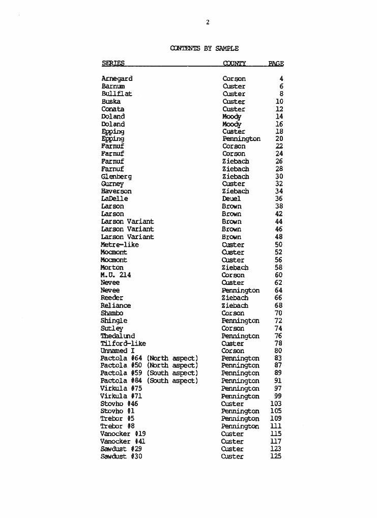
Series: Epping
Peden No: S83SD103P-14-RC
Area: Custer County, South Dakota
Location: 2425 ft east and 150 ft north of southwest corner of Sec. 1, T4S, R8E
-TOTAL% SILT Z SANO%
DEPTH Clay Silt Sand ""ine Med Coar VF F M C vc (inches) .002- .05- .002 .005 .02 .05- .10- .25- .5- 1 - Textura 1
Organic Carbonate nenth 1/3 Bar 15 Bar 15 Bar CEC/ CEC Carbon EC as CaC03
(inches 9m 9m 9m/C1ay Cl av rnea/100nm % SAR rrmhos/cm %
0-3 23.0 14.8 0.73 0.97 19.78 < 1 0.6 10 .4
3-8 24.8 16.6 0.53 0.61 18.97 < 1 0.5 22 . 1
8-14 26.4 16.6 0.52 0.57 17.97 < 1 0.5 23.1
14-60 25.4 15.4 0.49 0.59 18.44 5 0.5 27.0
19
Date: S-25-8)
Soll Classification: Loa.ray, mixed (calcareous), mesic, shallow Ustic Torriorthent
Series: Epping Ped.on No.s S83SD103P-14-RC Area: Custer County, South Dakota Locations 2,425 feet east and 1.50 feet north of southwest corner, sec.
1,~. 4 S,, R, 8 E, Climates Semi-arid Native Vegetations Blue grama, litUe bluestem, bu.ffalograss, sideoats,
grama, western wheatgrass . Parent Material: Siltstone of White River Group Physiographys Upland Topography: Strongly sloping Drainages Well drained Ground Water: Deep Erosion: Slight Permeability: Moderate Moisture: Moist to J inches Sampled by: Robert Nielsen and Kathleen Emerson Date: 8/8J
(Colors a.re for dry soil unless otherwise stated.)
A--0 to J inches; dark grayish brown (10YR 4/2) loam, very dark grayish brown (10YR J/2) moist; weak fine and very fine granular structure; soft, very friable; strong effervescence; mildly alkaline; clear smooth boundary.
AC--J to 8 inches; gray (10YR 5/1) loam, dark grayish brown (10YR 4/2) moist; weak medium and coarse subangula.r blocky structure; slighUy ha.rd, friable; strong effervescence1 moderately alkaline; clear smooth boundary,
Series: Epping Pedon No: S83SD103P-47 Area: Pennington County, South Dakota Location, 240 feet west and )20 feet north of the Southeast corner of
Sec. 6, T. 4 S., R. 14 E. Climate: Semi-arid Veeetation: Shallow rangesite: Little bluestem, qreen Needlegrass,
Needleandthread, Threadleaf sedge, Blue gra.ma, Sideoats grama., June ~rass, Three awn, forbs, Yucca
Parent Material: Loamy Brule and ::!hadron mud.stone of the lfhite River F'or. Physiography: Upland, deeply entrenched, steep Topography: Complex, convex, hilly Drainage: Somewhat excessive Ground water: Deep Erosion a None to slight Permeability: Moderate Moisture: Dry throughout Sampled by: rdn Date: 11/83
(Colors are for dry soil unless otherwise stated.)
A--0 to 3 inches; grayish brown (10YR 5/2) silt loam, dark grayish brown (10YR 4/2) moist; weak medium and fine granular structure; slightly hard, friable, slightly sticky; many fine and medium roots; slit:ht effervescence; clear smooth boundary.
AC--) to 8 inches; grayish brown (10YR 5/2) silty clay loam, dark grayish brown (10YR 4/2) moist; moderate medium subangular blocky structure; slightly hard, friable, slightly sticky; common fine and medium roots; strong effervescence; gradual wavy boundary.
C--8 to 14 inches;light brownish gray (10YR 6/2) shaley silty clay loam, grayish brown (10YR 5/2) moist; massive; slightly hard, friable, sliehtly sticky, few fine roots; strong effervescence; gradual wavy boundary.
Cr--14 to 60 inches; grayish brown (10YR 5/2) loamy mudstone; extremely harda slight effervescence.
All horizons sampled.
22
Series: Farnuf
Pedon No: S83SD031-15
Area: Corson County, South Dakota
Location: 240 ft east and 100 ft west of the southeast corner of Sec. 20, T22N, R28E
OTAL: SILT t SANO%
DEPTH Clay Silt Sand -ine Med Coar VF F M C vc (inches) .002- .as- .002 .005 .02 .05- .10- .25- .5- 1 - Textural
Denth 1/3 Bar 15 Bar 15 Bar CEC/ CEC Carbon EC as CaC03 (inches ' Qm 9m Qm/Cl av Clay mea/lOQnm % SAR rrmhos/cm %
23
Soil Classification: Fine-loamy, mixed Typic Argiborolls Series: Farnuf Pedon No.: S83SD031-15 Area: Corson County, South Dakota Location: 240 feet east and 100 feet west of the southeast corner of
sec. 20, T. 22 N., R. 28 E. Vegetation: Stubble Parent Material: Alluvium Physiography: Upland terrace Relief: Convex Slope: 1 percent Aspect: West Permeability: Moderate Drainage: Well Ground Water: Below 6 feet Moisture: Moist to 30 inches Erosion: Slight Date: October 1983 Profile by: Kenneth Heil
(Colors are for dry soil unless otherwise stated).
Ap--0 to 7 inches; dark brown (lOYR 3/3) loam, very dark grayish brown (lOYR 3/2) moist; weak coarse subangular blocky structure parting to weak fine and medium granular; slightly hard, friable; slightly acid; abrupt smooth boundary.
Bt--7 to 24 inches; grayish brown (2.5Y 5/2) clay loam, dark grayish brown (2.5Y 4/2) moist; moderate medium prismatic structure parting to moderate medium subangular blocky; slightly hard, friable; neutral; gradual wavy boundary.
B3--24 to 32 inches; grayish brown (2.5Y 5/2) clay loam, dark grayish brown (2.5Y 4/2) moist; weak medium prismatic structure parting to weak medium and coarse subangular blocky; mildly alkaline; clear wavy boundary.
Bk--32 to 42 inches; grayish brown (2.5Y 5/2) clay loam, dark grayish brown (2.5Y 4/2) moist; weak coarse subangular blocky structure; slightly hard, friable; common, medium accumulations of carbonates; strong effervescence; mildly alkaline; clear wavy boundary.
C--42 to 60 inches; grayish brown (2.5Y 5/2) loam, olive brown (2.5Y 4/4) moist; massive; slightly hard, friable; slight effervescence; mildly alkaline.
Horizons sampled: A (0 to 7 inches) B (7 to 24 inches)
24
Series: Farnuf
Pedon No: S83SD03l-105
Area: Corson County, South Dakota
Location: 1700 ft west and 2500 ft north of the southeast corner of Sec. 4, T19N, R29E
- . -TOTAL: SILT Z SANO%
DEPTH Clay Silt Sand ... , ne Med Coar VF F M C vc (inches) .002- .05- .002 .005 .02 .as- .10- .25- .5- 1 - Textural
Organic Carbonate DerJth 1/3 Bar 15 Bar 15 Bar CEC/ CEC Carbon EC as CaC03
(inches 9m 9m 9m/Cl av Clay mea/lOOam % SAR mmhos/cm %
25
Soil Classification: Fine-loamy, mixed Typic Argiborolls Series: Farnuf Pedon No.: S83SD031-105 Area: Corson County, South Dakota Location: 1,700 feet west and 2,500 feet north of the southeast corner of
sec. 4, T. 19 N., R. 29 E. Vegetation: Native grass Parent Material: Alluvium Physiography: Upland terrace Relief: Convex Slope: 4 .percent Aspect: East Permeability: Moderate Drainage: Well Ground Water: Below 6 feet Moisture: Moist to 40 inches Erosion: Slight Date: October 1983 Profile by: Kim Kempton
(Colors are for dry soil unless otherwise stated).
A--0 to 5 inches; dark grayish brown (lOYR 4/2) loam, very dark grayish brown (lOYR 3/2) moist; moderate medium prismatic structure parting to moderate fine granular; slightly hard, friable; neutral; clear wavy boundary.
Bt--5 to 15 inches; brown (lOYR 4/3) clay loam, dark brown (lOYR 3/3) moist; strong medium prismatic structure parting to moderate medium subangular blocky; slightly hard, friable; neutral, clear wavy boundary.
Bk--15 to 23 inches; light brownish gray (2.5Y 6/2) clay loam, dark grayish brown (2.5Y 4/2) moist; moderate medium prismatic structure parting to weak medium subangular blocky; slightly hard, friable; few fine accumulations of carbonates; strong effervescence; moderately alkaline; gradual wavy boundary.
BCk--23 to 41 inches; light brownish gray (2.5Y 6/2) loam, dark grayish brown (2.SY 4/2) moist; weak medium prismatic structure; soft, friable; few fine accumulat i ons of carbonates; strong effervescence; moderately alkaline; diffuse boundary.
C--41 to 60 inches; grayish brown (2.5Y 5/2) loam, dark grayish brown (2.5Y 4/2) moist; massive; soft, friable; strong effervescence; strongly alkaline.
Horizons sampled: A (Oto 5 inches) B (5 to 15 inches)
Series: Farnuf loam
Peden No: S83SD137-5
Area: Ziebach County, South Dakota
26
Location: 70 ft north and 1420 ft of the southeast corner of Sec. 17, T14N, R19E
- .. TOTAL% SILT t SAND%
DEPTH Clay Silt Sand ... . Med Coar VF F M C vc 1ne (inches) .002- .05- .002 .005 .02 .05- .10- .25- .s- 1 -
Organic Carbonate · Oeoth 1/3 Bar 15 Bar 15 Bar CEC/ CEC Carbon EC as CaC03 (inches 9m 9m 9m/Cl av Clav mec/10nnm % SAR rnnhos/cm %
· 0-6 19. 1 14.8 0.74 1. 9
n-, 1 ?1 1 1? 1n n.LlA , . 1
13-20 20 . 5 11.3 0.58
•.
27 Soil Classification: Fine-loamy, mixed Typic Argi.borolls Series: Farnuf loam Peden No.: S83SD137-5 . Area: Ziebach County, South Dakota T..DCation: 70 feet north and 1420 feet of the southeast corner of sec . 17, T. 14 N., rt. 19 E. Vegetation: Wheat stubble Parent Material: Alluvium Physiography: High terrace Relief: Nearly level Slope: 2 percent Aspect: South Penreabili ty: Moderate Drainage: Well Ground Water: Below 6 feet z.t>isture: z.t>ist to 48 inches Erosion: None to slight Salt: None Stoniness: None Date: April 18, 1983 Sanpled by: wayne Bachman and Alan Hardison
(Colors are for dry soil unless othe:tWise stated) .
Ap-0 to 6 inches; dark grayish brown (lOYR 4/2) loam, very dark grayish brown (lOYR 3/2) ncist; weak medium subangu.lar blocky structure parting to rroderate iredium granular; slightly hard, friable, slightly sticky, slightly plastic; clear sm::ioth boundary.
Btl-6 to 13 inches; dark brown (lOYR 4/3) clay loam, very dark grayish brown (lOYR 3/2) ncist; weak coarse pri~tic structure parting to rroderate iredium subangu.lar blocky; hard, friable; slightly sticky and plastic; clear wavy boundary.
Bt2-13 to 20 inches; brown (lOYR 5/3) clay loam, dark brown (lOYR 4/3) ncist; weak coarse prismatic structure parting to rroderate iredium subangu1ar blocky; hard, friable, slightly sticky and plastic; clear wavy boundary.
Bk-20 to 30 inches; light brownish gray (2.5Y 6/2) loam, grayish brown (2.SY 5/2) ncist; weak coarse subangu.lar blocky structure; hard, friable, slightly sticky and slightly plastic; ff?.11 fine accunulations of carbonate; strong effervescence; gradual wavy boundary.
C-30 to 60 inches; light gray (2.SY 7/2) loam, grayish brown (2.SY 5/2) ncist; massive; hard, friable, slightly sticky and slightly plastic; strong effervescence.
Horizons sampled: Ap (O to 6 inches) Btl (6 to 13 inches) Bt2 (13 to 20 inches)
28
Series: Farnuf 1oam
Pedon No: S77S0137-18
Area: Ziebach County, South Dakota
Location: 970 ft south and 2110 ft east of the northwest corner of Sec. 34, T15N, R20E
TOTAL% SILT t SANO%
DEPTH Clay Silt Sand ~· ine Med Coar VF F M C vc (inches) .002- .05- .002 .005 .02 .05- .10- .25- .5- 1 - Textura1
Organ ic Carbonate De:Jth 1/3 Bar 15 Bar 15 Bar CEC/ CEC Carbon EC as CaC03
(inches Qm 9m 9m/C1 av C1ay mea/lOOom % SAR rrmhos / cm %
0-R :,n F. 11 i; n c::-:i 2 . 2
R- 1 i; :, 1 F. 11 7 0 Ak 1 1
29 Soil Classification: Fine-loamy, mixed Typic Argilx:,rolls Series: Farnuf loam Ped.on No.: $77$0131-18 Area: Ziebach County, South Dakota I.Dcation: 970 feet south and 2110 feet east of the northwest corner of sec. 34, T. 15N.,R.20E. Vegetation: Western wheatgrass, needleandthread, green needlegrass Parent Material: Alluvium Physiography: High terrace Relief: Nearly level Slope: 1 perc:ent Aspect: Northwest Penneability: Moderate Drainage: Well Ground Water: Below 6 feet r-t:>isture: r-t:>ist to 18 inches Erosion: None Salt: None Stoniness: None Date: October 21,1977 Sanpled by: Wayne Bachnan and Al.an Hardison
(Colors are for dry soil unless otherwise stated) •
A-0 to 8 inches; dark grayish brown (lOYR 4/2) loam, very dark grayish brown (lOYR 3/2) noist; weak IIedium and fine subangu1ar blocky structure parting to noderate rce:li.um granular; hard, very friable, slightly sticky and slightly plastic; many roots; clear wavy boundary.
Btl-8 to 11 inches; brown (lOYR 4/3) silty clay loam, dark brown (lOYR 3/3) ItDist; m:xlerate IIedium subangular blocky structure parting to rroderate fine subangular blocky; hard, friable, sticky and slightly plastic; many roots; clear wavy boundary.
Bt2-ll to 15 inches; brown (lOYR 5/3) silty clay loam, dark brown (lOYR 3/3) ItDist; rroderate IIedium prismatic structure parting to weak IIedium subangu1ar blocky: hard, friable, sticky and plastic; camon roots; clear wavy boundary.
Bkl-15 to 24 inches; pale brown (lOYR 6/3) silt loam, pale brown (lOYR 5/3) ItDist; m:xlerate coarse prismatic structure parting to weak medium suba.n;ular blocky; hard, friable, slightly sticky and slightly plastic; camcn roots; few fine acC\.lrtlllations of carbonates; strong effervescence; gradual wavy boundary.
Bk2-24 to 44 inches; pale brown (lOYR 6/3) silt loam, brown (lOYR 5/3) ItDist; weak coarse subangu1ar blocky structure; hard, friable, slightly sticky and slightly plastic; few roots; feM fine aCC\mllations of carbonate; strong effervescence; gradual wavy boundary.
C-44 to 60 inches; brown (lOYR 5/3) loam, dark brown (lOYR 4/3) ItDist; massive; hard, friable, slightly sticky and slightly plastic; few roots to 48 inches; slight effervescence.
Horizons sanpled: A (0 to 8 inches) Ccrrbined Btl and Bt2 (8 to 15 inches)
Series: Glenberg loam
Pedon No: S82SD137-15
Area: Ziebach County, South Dakota
30
Location: 1870 ft north and 1200 ft west of the southeast corner of Sec. 14, T8N, R22E
-TOTAL~ SILT t SANO%
DEPTH Clay Silt Sand -ine Med Coar VF F M C vc (inches) .002- .05- ~002 .005 .02 .05- .10- .25- .5- 1 - Textural
Organic Carbonate De1Jth 1/3 Bar 15 Bar 15 Bar CEC/ CEC Carbon EC as CaC03
(inches ' 9m 9m Qm/Clav Clay mea/lOOam % SAR mmhos/cm OI lo
31 Soil Classification: Coarse-loamy, mixed (calcareous) rresic, Ustic Torrifluvents Series: Glenberg loam Peden No.: S82SD137-l5 Area: Ziebach County, South Dakota Location: 1870 feet oorth and 1200 feet west of the southeast corner of sec. 14, T. 8 N., R. 22 E. Vegetation: Kochia, sunflower, Japanese brare Parent Material: Alluvium Physiography: Low terrace Relief: Nearly level Slope: 1 percent Aspect: None Penreability: M:>derate Drainage: Well Ground Water: Below 6 feet lwbisture: lwbist to 17 inches Erosion: Slight to none Salt: None Stoniness: None Date: August 26, 1982 Sarcpled by: wayne Bachman and Alan Hardison
(Colors are for dry soil unless othenn.se stated) •
~o to 4 inches: grayish brown (lOYR 5/2) loam, dark grayish brown (lOYR 4/2) ncist: weak fine subangular blcx:Jcy structure parting to weak fine granular: slightly hard, friable, slightly sticky, slightly plastic: strong effervescence, clear srrooth boundary.
Cl-4 to 10 inches: grayish brown (lOYR 5/2) loam, dark grayish brown (lOYR 4/2) ncist: weak nail.um subangular blcx:Jcy structure: slightly hard, friable, slightly sticky and slightly plastic: strong effervescence: clear wavy boundary.
C2-10 to 17 inches: grayish brown (lOYR 5/2) fine sandy loam, dark grayish brown (lOYR 4/2) ncist: weak thin and ne:lium plates and single grained: loose: vecy friable: strong effervescence: clear wavy boundary.
C3-l 7 to 25 inches: grayish brown (lOYR 5/2) clay loam, vecy dark grayish brown (lOYR 3/2) ncist: Itederate thin plates: slightly hard, friable, slightly sticky and plastic: strong effervescence: clear wavy boundary.
C4-25 to 40 inches: grayish brown (lOYR 5/2) loam, dark grayish brown (lOYR 4/2) ncist: weak thin plates: slightly hard, friable, slightly sticky and slightly plastic: strong effervescence: gradual wavy boundary.
C5-40 to 55 inches: grayish brown (lOYR 5/2) silt loam, dark grayish brown (lOYR 4/2) ncist: weak thin plates: slightly hard, friable, slightly sticky and slightly plastic: strong effervescence: clear wavy boundary.
C6-55 to 60 inches: grayish brown (lOYR 5/2) fine sandy loam, dark grayish brown (lOYR 4/2) ncist: ""'11eak nail.um plates: loose, vecy friable: strong effervescence.
Horizons san;:,led: canbined 10 to 40 inch control section
32
Series: Gurney
Peden No: S82SD033-12
Area: Custer County, South Dakota
Location: 1700 ft east and 1200 ft south of the northwest corner of Sec. 22, . T5S, R2E
. . TOTAL: SILT t; SAND%
DEPTH Clay Silt Sand c:ine Med Coar VF F M C vc (inches) .002- .05- i.002 .005 .02 .05- .10- .25- .5- 1 - Textura 1
Organi c Carbonate OerJth 1/3 Bar 15 Bar 15 Bar CEC/ CEC Carbon EC as CaC03
(inches Qm Qm 9111/Cl av Clay mea/lOOam % SAR IIITihos/cm %
33
Soil Classification: Fine-silty, mixed, rresic Typic Argiboroll Series: Gurney Peden No.: S82SD033-l2 Area: CUster County, South Dakota Location: 1700 feet east and 1200 feet south of the northwest corner of sec. 22
T. 5 S., R. 2E. Vegetation: Needleandthread, western wheatgrass, carex Parent Material: Lirrestone Physiography: Upland open rreadCM in forest Relief: D concave · Slope: 8 percent Aspect: Northeast Erosion: Slight Pel:rneability: Moderate Drainage: Well Ground Water: Deep Moisture: Moist to 5 inches; dry belCM :Root Distribution: Abundant to 8 inches; few to 20· inches Elevation: 4680' Sampled by: Ed Ensz
(Colors are for dry soil unless otheJ:Wise stated).
A-0 to 5 inches; dark grayish brown (lOYR 4/2) silt loam, very dark grayish brc:,.,m (lOYR 3/2) m::>ist; weak fine and rredium granular structure; soft, friable; mildly alkaline; clear srrooth boundary.
Bt-5 to 8 inches; brown (lOYR 4/3) light silty clay, dark brown (lOYR 3/3) noist; · weak rredium and fine subangular blocky structure; slightly hard, friable; mildly alkaline; abrupt wavy boundary.
Btk-8 to 14 inches; pale brown (lOYR 6/3) silt loam, brown (lOYR 4/3) noist; rroderate medium prismatic structure parting to moderate rredium and coarse subangular blocky; slightly hard, friable; strong effervescence; moderately alkaline; gradual wavy boundary.
:OC-14 to 20 inches; very pale brown (lOYR 7/3) silt loam, b;rc:,wn (lOYR 5/3) noist; weak coarse prismatic structure; slightly hard, friable; strong effervescence; moderately alkaline; gradual wavy boundary.
Cl-20 to 32 inches; pale brown (lOYR 6/3) loam, brown (lOYR 5/3) noist; massive; slightly hard, ·friable; strong effervescence; rcoderately alkaline; abrupt wavy boundary.
R-32 to 60 inches; white and pink indurated lirrestone.
Horizons sarrpled: For SDSU A 0-5 inches Bt 5-8 inches Btk 8-14 inches
Series: Haverson silt loam
Peden No: S83SD137-10
Area: Ziebach County, South Dakota
34
Location: 2490 ft north and 550 ft west of the southeast corner of Sec . 17, T9N, R19E
TOTAL% SILT Z SANO %
DEPTH Clay Silt Sand .. ine Med Coar VF F M C vc (i nches) .002- .05- .002 .005 .02 .05- .10- .25- .s- 1 - Textura 1
Organi c Carbonate Oel')th 1/3 Bar 15 Bar 15 Bar CEC/ CEC Carbon EC as CaC03
(i nches em 9m 9m/C1 ay Clay mec/lOOam % SAR ITITihos/cm %
0-3 21. 0 16 .9 0.57 3.2
10-40 24.0 13 .0 0.46 2.6
35 Soil Classification: Fine-loamy, mixed (calcareous), nesic Ustic Torrifluvents Series: Haverson silt loam Peden No.: S83SD137-10 Area: Ziebach County, South Dakota I..Dcation: 2,490 feet north and 550 feet west of the southeast comer of section 17, T. 9N., R. 19E. Vegetation: Western wheatgrass, blue grama Parent Material: Alluvium Physiography: Floodplain Relief: Level Slope: 0 to 1 percent Aspect: West Penneability: Moderate Drainage: Well Ground Water: Below 6 feet z.t:>isture: Dry Erosion: None to slight Salt: None Stoniness: None Date: July 12,1983 Sarrpled by: Wayne Bachman and Alan Hardison
(Colors are for dry soil unless otherNise stated) •
A-0 to 3 inches; dark grayish brown (lOYR 4/2) silt loam, very dark grayish brown (lOYR 3/2) rroist; 'Weak fine granular structure; soft, very friable, slightly plastic; catm:,n roots; slight effervescence; clear srrooth boundary.
Cl-3 to 16 inches; grayish brown (lOYR 5/2) silty clay loam sqatified with thin lenses of silt loam; dark grayish brown (lOYR 4/2) rroist; 'Weak medium prismatic structure parting to 'Weak fine and medium platy; slightly hard, friable, slightly sticky and slightly plastic; ccmron roots to 7 inches; feM roots below 7 inches; strong effervescence; gradual wavy boundary.
C2-16 to 49 inches; grayish brown (lOYR 5/2) silt loam stratified with thin lenses of silty clay loam, dark grayish brown (lOYR 4/2) rroist; 'Weak rredium platy structure; soft, friable; slightly plastic; feM roots; strong effervescence; gradual wavy boundary. .
C3-47 to 60 inches; grayish brown (lOYR 5/2) loam stratified with thin lenses of fine sandy loam and loam, dark grayish brown (lOYR 4/2) rcoist; soft, very friable, slightly plastic; violent effervescence.
Horizons sarrpled: A (0 to 3 inches) 10 to 40 inch control section
Series: LaDelle - loam
Pedon No: S83SD039-15
Area: Deuel County, South Dakota
36
Location: 900 ft east and 800 ft north of the southwest corner of Sec. 8, T117N, R47W
- - . TOTAL i SILT t SANO%
I
DEPTH Clay Silt Sand -ine Med Coar VF F M C vc (inches) .002- .05- 002 .005 .02 .as- .10- .25- .5- l - Textura 1
Organic Carbonate Oe:,th 1/3 Bar 15 Bar 15 Bar CEC/ CEC Carbon EC as CaC03
(inches Qm Qm Qm/Cl av Cl av mea/lOOam % SAR ITITihos/cm %
0-8 2.4
8-17 2.0
17-34
34-46 3
4fi-60 3.9
37
Soil Classification: Fine Sil't7, mixed, CWlml.ic Udic Haploborolls Series: LaDelle Loam Pedon ?lo.: S8JSDOJ9-l5 .ueas Deuel eounv' South Dakota Locations 900 feet eaat and 800 feet north of the southwest oorDer of
Sec. ts, T. 117 B, L 4"( W. Climate: Mean ammel pnoipitation ia about 22 inches and •an •mmal air
temperature ia about 44 degrees Y. Vegetation: CW.tinted Parent Katerial: Sil V and lo&IQ' alluvium ~i~: Broad .fl.at bottom land below prairie ooteau ~pograp}Q's Ifearly 1 ..... 1, 1/2 to l puoent eut aspect. Drainap s Moderately wll Groanc1 water: Below 5 !Ht Broaions Sli&ht Pe:meabili vs Moderate Moisture: Moist ~t Dates .November 3, 19UJ Sampled b71 ~th Y. Miller .lP-0 to U iDcJlea; duk grrq (lOD4/l) loaa, blaclc {10TB2/l) moist, moderate !iM and medium granular atructureJ llllebtly hard, triable; aliBbt efferveacenceJ mildly' alkal1ne, abrupt amooth 'boandary •
.&.--8 to 17 inches; Dark grrq (lotll4/l) loaa, black (10D2/l) aoiat; moderate aedi:ma IIUbangalar blocq structure; hard, 1'riable; c~ fine and medium accuimlationa ot carbonate; strong efternacence; mildly' •lkalfne, clear wavy boundar7 •
. :ev-17 to 34 inches; Grq (lOIBS/1) silv cJ.q loaa, verr c1uk grq (1om3/1) aoiat; weak Mdium priaatio structure parting to moderate medium auhangalar blocq; bard, 1'riable; •liBbtlT aticlq and ~tly plastic, fflV fine accumla.tiona ot carbonate; strong efferveacence; mildly' •lkelfne; abrupt V&"f7 bcnmdar7.
CZ-.34 to 46 inches; liBbt grrq (2sr,/2 •ilv 0~ lea, srq1ah brown (2,t;/2) aoiat; oonaon fine distinct strong brown (7SYBS/6) mottles; weak coarse and Mdiua saban&Ular bloclq structure; hard, friable, sliBbtIT niclq and slightly plaatic; ocaaon fine accuimlaticma of salts; fflV fine accumulations of carbonate; strong effervescence; llOderately •lkeline; clear wavy boandarJ.
c-46 to 6o inches; liBbt brownish grrq (2sY6/2) ailv clq loam, grqiah brown (2,IS/2) 110iat; comon fine and medium prominent ;yellowish red {SD4/6) aottlea; maaaive; verr bard, f.iDl; allBbtly sticq and slightly plaatic; comon fine and medium accuamlationa of carbonate; strong effervescence; moderately eJkal ine.
ill horizons were sampled.
38
Series: Larson
Pedon No : S83SD13-57
Area: Brown County, South Dakota
Location: 2220 ft north and 525 ft east of the southwest corner of Sec. 20, Tl26N, R61W
. TOTAL% SILT Z SANO%
DEPTH Clay Silt Sand -ine Med Coar VF F M C vc (inches) .002- .05- .002 .005 .02 .05- .10- .25- .5- 1 - Textural
I Carbonate DerJth 1/3 Bar 15 Bar 15 Bar CEC/ CE:: EC as CaC03
(inches Qm Qm Qm/Clav Clav mea/lQOmn p_H SAR n111hos/cm %
0- 15 5.8
15-19 7.1
19-27 8.9 .22.0 2.3 1.0
27-41 9.0 29.4 2.6 2.8
41-47 9.1 · 34. 9 3.0 9.1
39
Soil Classification: Fine-loamy, mixed Udic Natriboroll Series: Larson Pedon No.: S83SD013-57 Area: Brown County, South Dakota Location: 2220 feet north and 525 feet east of the southwest corner of
sec. 20, T. 126 N., R. 61 W. Climate: Mean annual temperature 43°F; mean annual precipitation 19" Vegetation: Alfalfa Parent Material: Lacustrine Physiography: Nearly level Lake Plain Topography: Plain Drainage; Moderately well Ground Water: Greater than 5 feet Erosion: None Permeability: Slow Moisture: Moist throughout Sampled by: Loren Schultz, Steve Fischer, Jim Clausen, and Tom Martin Described by: James Clausen
(Colors are for dry soil unless otherwise stated).
Ap--0 to 6 inches; dark gray (lOYR 4/1) very fine sandy loam, black (lOYR 2/1) moist; weak very fine granular structure; slightly hard, friable; slightly acid; abrupt smooth boundary.
A--6 to 15 inches; dark gray (lOYR 4/1) very fine sandy loam, black (lOYR 2/1) moist; weak medium subangular blocky structure parting to weak very fine granular; slightly hard, friable; slightly acid; clear smooth boundary.
E--15 to 19 inches; gray (lOYR 5/1) very fine sandy loam, very dark grayish brown (lOYR 3/2) moist; common fine faint yellowish brown (lOYR 5/6) mottles; weak very thin platy structure; slightly hard, very friable; neutral; abrupt wavy boundary.
Btl--19 to 23 inches; grayish brown (2.5Y 5/2) clay loam, very dark grayish brown (2.5Y 3/2) moist; strong coarse and medium columnar structure parting to moderate coarse and medium angular blocky; very hard, friable; thin continuous gray (lOYR 5/1) coatings on the tops of columns; tongues of bleached sand grains on faces of peds; moderately alkaline; clear wavy boundary.
Bt2--23 to 27 inches; grayish brown (2.5Y 5/2) clay loam, very dark grayish brown (2.5Y 3/2) moist; moderate coarse and medium prismatic structure parting to moderate coarse and medium angular blocky; very hard, friable; tongues of bleached sand grains on faces of peds; strongly alkaline; clear wavy boundary.
Btk--27 to 41 inches; grayish brown (2.5Y 5/2) clay loam, very dark grayish brown (2.5Y 3/2) moist; moderate coarse and medium prismatic structure parting to moderate medium angular blocky; very hard, friable; common medium and fine accumulations of carbonate; strong effervescence; strongly alkaline; clear wavy boundary.
Bk--41 to 47 inches; light brownish gray (2.5Y 6/2) silt loam, dark grayish brown (2.SY 4/2) moist; weak coarse and medium prismatic structure parting to weak medium angular blocky; hard, friable; many fine, medium and coarse accumulations of carbonate; violent effervescence; very strongly alkaline; gradual wavy boundary.
41
C--47 to 60 inches; light gray (2.5Y 7/2) silt loam, light brownish gray (2.5Y 6/2) moist; common fine and medium faint gray (lOYR 6/1) and common fine distinct yellowish brown (!OYR 5/6) mottles; massive; slightly hard, friable; strong effervescence; strongly alkaline.
Horizons sampled: A & Ap, 0 to 15 ·inches E, 15 to 19 inches Btl & Bt2, 19 to 27 inches Btk, 27 to 41 inches Bk, 41 to 47 inches
42
Series: Larson
Peden No: S83SD013-59
Area: Brown County, South Dakota
Location: 1320 ft east and 105 ft north of the southwest corner of Sec. 29, T126N, R61W
TOTAL% SILT t SANO% DEPTH Clay Silt Sand '"ine Med Coar VF F M C vc
Carbonate Denth 1/3 Bar 15 Bar 15 Bar CEC/ CEC EC as CaC03
(inches Qm Qm Qm/Clay Clav mec/lQQnm PH SAR mmhos/cm %
0-15 6.0
21-30 8.3 26.3 3.2 0.6
30-37 8.8 31.5 4. 1 ? ?
43
Soil Classification: Fine-loamy, mixed Udic Natriboroll Series: Larson Pedon No.: S83SD0l3-59 Area: Brown County, South Dakota Location: 1320 feet east and 105 feet north of the southwest corner of
sec. 29, T. 126 N., R. 61 W. Climate: Mean annual temperature 43°F; mean annual precipitation 19" Vegetation: Alfalfa Parent Material: Lacustrine Physiography: Nearly level Lake Plain Topography: Plain Drainage; Moderately well Ground Water: Greater than 5 feet Erosion: None Permeability: Slow Moisture: Moist to 6 inches Sampled by: Steve Fischer and Jim Clausen Described by: James Clausen
(Colors are for dry soil unless otherwise stated).
Ap--0 to 7 inches; dark gray (lOYR 4/1) very fine sandy loam, black (lOYR 2/1) moist; weak fine and very fine subangular blocky structure; slightly hard, friable; slightly acid; abrupt smooth boundary.
A--7 to 15 inches; dark gray (lOYR 4/1) very fine sandy loam, black (lOYR 2/1) moist; weak medium and fine subangular blocky structure; slightly hard, friable; slightly acid; clear wavy boundary.
E--15 to 21 inches; grayish brown (lOYR 5/2) very fine sandy loam, very dark grayish brown (lOYR 3/2) moist; weak thick platy structure; slightly hard, very friable; neutral; abrupt wavy boundary.
Bt--21 to 30 inches; grayish brown (2.5Y 5/2) silty clay loam, very dark grayish brown (2.5Y 3/2) moist; moderate medium columnar structure parting to moderate medium angular blocky; hard, friable; ~hin continuous grayish brown (lOYR 5/2) coatings on tops of columns; mildly alkaline clear wavy boundary.
Btk--30 to 37 inches; dark grayish brown (2.SY 4/2) silty clay loam, very~ark grayish brown (2.5Y 3/2) moist; moderate medium prismatic structure parting to moderate medium subangular blocky; hard, friable; common very fine and fine accumulations of carbonate; strong effervescence; moderately alkaline; clear wavy boundary.
Bk--37 to 42 inches; dark grayish brown (2.5Y 4/2) silty clay loam, very dark grayish brown (2.5Y 3/2) moist; weak coarse and medium subangular blocky structure; slightly hard, friable; many fine and medium accumulations of. carbonate; violent effervescence; strongly alkaline; clear wavy boundary.
C2--51 to 60 inches; light gray (2.5Y 7/2) silt loam, olive brown (2.5Y 4/4) moist; common fine and medium faint gray (lOYR 6/1) and few fine distinct yellowish brown (lOYR 5/6) mottles; massive; slightly hard, friable; strong effervescence; moderately alkaline.
Horizons sampled: A & Ap, 0 to 15 inches Bt, 21 to 30 inches Btkl, 30 to 37 inches
Series: Larson Variant
Pedon No: S83SD013-56
Area: Brown County, South Dakota
44
Location: 2442 ft north and 1131 ft west of the southeast corner of Sec. 19, T126N, R61W
TOTAL% SILT,; SAND%
DEPTH Clay Silt Sand ~ine Med Coar VF F M C vc (inches) .002- .05- .. 002 . 005 .02 .05- .10- .25- .5- 1 - Textura 1
Carbonate D~nth 1/3 Bar 15 Bar 15 Bar CEC/ CEC EC as CaC03
(inches 9m 9m 9m/Clav Cl av mec/100nm pH SAR rmihos/cm %
0-8 6.5
8-15 9.0 65.2 2.6 1.2
15-24 9.7 43.2 4.0 1.0
24-34 9.9 298.8 29.3
34-45 9.7 84.1 4.0 24.0
45
Soil Classification: Coarse-loamy, mixed Leptic Natriboroll Series: Larson Variant Pedon No.: S83SD013-56 Area: Brown County, South Dakota Location: 2442 feet north and 1131 feet west of the southeast corner of
sec. 19, T. 126 N., R. 61 W • . Climate: Mean annual temperature 43°F; mean annual precipitation 19" Vegetation: Alfalfa Parent Material: Lacustrine Physiography: Nearly level Lake Plain Topography: Concave Drainage; Somewhat poorly drained Ground Water: Greater than 5 feet Erosion: None Permeability: Slow Moisture: Moist throughout Sampled by: Loren Schultz and Tom Martin Described by: James Clausen
(Colors are for dry soil unless otherwise stated).
Ap--0 to 8 inches; dark gray (lOYR 4/1) very fine sandy loam, black (lOYR 2/1) moist; weak medium and fine subangular blocky structure parting to weak fine granular
slightly hard, very friable; neutral; abrupt smooth boundary.
Bt 1--8 to 15 inches; dark grayish brown (lOYR 4/2) loam, very dark grayish brown (lOYR 3/2) moist; moderate coarse columnar structure parting to weak coarse and medium subangular blocky; very hard, friable; thin continuous gray (lOYR 6/1) coatings on tops of columns; few fine nests of salt; slight effervescence; strongly alkaline; clear wavy boundary.
Bt 2--15 to 24 inches; grayish brown (2.5Y 5/2) loam, dark grayish brown (2.5Y 4/2) moist; moderate coarse prismatic structure parting to moderate medium and fine subangular blocky; very hard, friable; few fine nests of salt; bleached sand grains on faces of peds; slight effervescence; strongly alkaline; clear wavy boundary.
I Bkl--24 to 34 inches; white (2.SY 8/0) loam, light gray (2.5Y 7/2) moist; weak coarse prismatic structure parting to weak medium and fine subangular blocky; hard, friable; grayish brown (2.5Y 5/2) tongues on faces of peds; violent effervescence; very strongly alkaline; · clear wavy boundary.
Bk2--34 to 45 inches; white (2.5Y 8/2) silt loam, light brownish gray (2.5Y 6/2) moist; common fine faint gray (lOYR 6/1) and common fine distinct yellowish brown (lOYR 5/6) mottles; weak coarse and medium subangular blocky structure; hard, friable; grayish brown (2.5Y 5/2) tongues on faces of peds; few manganese concretions, violent effervescence; very strongly alkaline; gradual wavy boundary.
C--45 to 60 inches; white (2.5Y 8/2) silt loam, light brownish gray (2.5Y 6/2) moist; many medium and fine faint gray (lOYR 6/1), many medium and fine distinct yellowish brown (lOYR 5/6), and few fine prominent dark brown (7.5YR 3/4) mottles; massive; slightly hard, friable; laminations 1 to 2 mm thick; few manganese concretions; strong effervescence; strongly alkaline.
Horizons sampled: Ap 0 to 8 inches Bt1' 8 to 15 inches Bt2, 15 to 24 inches Bkl, 24 to 34 inches Bk2, 34 to 45 inches
Series: Larson Variant
Pedon No: S83SD13-58
Area : Brown County, South Dakota
46
Location: 1280 ft east and 90 ft north of the southwest corner of Sec. 29, T126N, R61W
- .
TOTAL% SILT Z SAND% Clay Silt Sand -· Med
I VF F r
DEPTH 1ne Coar M C vc (inches) .002- .05- i.002 .005 .02 .05- . 10- .25- .5- 1 - Textural
Carbonate Denth 1/3 Bar 15 Bar 15 Bar CEC/ CEC EC as CaC03
(inches 9m 9m 9m/Cl av Clay mea/1QOnm pH SAR rmihos/cm %
0-6 6.3
8-16 8.7 39.4 4.5 1.0 I
16-31 8.7 35 .8 · 5.3 0.4
47
Soil Classification: Coarse-loamy, mixed Leptic Natriboroll Series: Larson Variant Peden No.: S83SD013-58 Area: · Brown County, South Dakota Location: 1280 feet east and 90 feet north of the southwest corner of
sec. 29, T. 126 N., R. 61 W. Climate: Mean annual temperature 43°F; mean annual precipitation 19" Vegetat·ion: Alfalfa Parent Material: Lacustrine Physiography: Nearly level Lake Plain
. Topography: Concave Drainage; Somewhat poorly Ground Water: Greater than 5 feet Erosion: None Permeability: Slow Moisture: Moist throughout Sampled by: Steve Fischer, Jim Clausen, and Tom Martin Described by: James Clausen
(Colors are for dry soil unless otherwise stated).
Ap--0 to 6 inches; dark gray (lOYR 4/1) very fine sandy loam, black (lOYR 2/1) moist; weak medium and fine subangular blocky structure parting to weak fine granular; slightly hard, friable; slightly acid; abrupt smooth boundary.
E--6 to 8 inches; gray (lOYR 5/1) very fine sandy loam, very dark grayish brown (lOYR 3/2) moist; common fine faint yellowish brown (lOYR 5/6) mottles; weak very thin platy structure parting to weak fine granular; slightly hard, friable; neutral; abrupt wavy boundary.
Bt--8 to 12 inches; grayish brown (2.5Y 5/2) loam, dark grayish brown (2.5Y 4/2) moist; few fine faint yellowish brown (lOYR 5/6) mottles; moderate coarse and medium columnar structure parting to moderate coarse and medium subangular blocky; very hard, friable; thin continuous gray (lOYR 5/1) coatings on tops of columns; few manganese stains; moderately alkaline; clear wavy boundary.
Btkl--12 to 16 inches; grayish brown (2.5Y 5/2) clay loam, dark grayish brown (2.5Y 4/2) moist; moderate coarse and medium prismatic structure parting to moderate medium and fine subangular blocky; very hard, friable; common medium and fine accumulations of carbonate. ; strong effervescence; strongly alkaline; clear wavy boundary.
Btk2--16 to 31 inches; gray (lOYR 6/1) silty clay loam, very dark grayish brown (lOYR 3/2) moist; moderate coarse and medium prismatic structure parting to moderate medium and fine subangular blocky; hard, friable; few fine accumulations of carbonate; violent effervescence; very strongly alkaline; gradual wavy boundary.
Bk--31 to 45 inches; light gray (SY 7/1) silty clay loam, olive gray (SY 5/2) moist; weak coarse and medium subangular blocky structure parting to weak medium and fine subangular blocky; slightly hard, friable; violent effervescence; strongly alkaline; gradual wavy boundary.
C--45 to 60 inches; white (2.5Y 8/2) silt loam, light brownish gray (2.5Y 6/2) moist; common medium and fine faint gray (lOYR 6/1) and few fine faint yellowish brown (lOYR 5/6) mottles; massive; slightly hard, friable; strong effervescence; moderately alkaline.
Horizons sampled: Ap, 0 to 6 inches Bt & Btkl, 8 to 16 inches Btk2, 16 to 31 inches
Series: Larson Variant
Pedon No: S83SD13-60
Area: Brown County, South Dakota
48
Location: 1420 ft east and 250 ft north of the southwest corner of Sec. 23, T126N, R61W
TOTAL% SILT t SAND%
DEPTH Clay Silt Sand ine Med Coar VF F M C vc (inches) .002- .05- .002 .005 .02 .05- .10- .25- .s- l - Textura 1
Carbonate DerJth 1/3 Bar 15 Bar 15 Bar CEC/ CEC EC as CaC03
(inches 9m Qm 9m/Clav Clay mea/lOOam pH SAR mmhos/cm %
0-4 6.9
4-16 9.5 · 91.6 4.8 2.5
49
Soil Classification: Coarse-loamy, mixed Leptic Natriboroll Series: Larson Variant Pedon No.: S83SD013-60 Area: Brown County, South Dakota Location: 1420 feet east and 250 feet north of the southwest corner of
sec. 23, T. 126 N., R. 61 W. Climate: Mean annual temperature 43°F; mean annual precipitation 19" Vegetation: Native Grass-Saltgrass Parent Material: Lacustrine Physiography: Nearly level Lake Plain Topography: Concave Drainage; Somewhat poorly drained Ground Water: Greater than 5 feet Erosion: None Permeability: Slow Moisture: Moist throughout Sampled by: - Steve Fischer and Jim Clausen Described by: James Clausen
(Colors are for dry soil unless otherwise stated).
A--0 to 4 inches; dark gray (lOYR 4/1) loam, black (lOYR 2/1) moist; weak medium and fine subangular blocky structure parting to weak very fine granular; slightly hard, friable; neutral; abrupt wavy boundary.
Btl--4 to 10 inches; dark gray (lOYR 4/1) loam, black (lOYR 2/1) moist; strong coarse and medium columnar structure; very hard, friable; thin continuous gray (lOYR 5/1) coatings on tops of columns; few medium and fine accumulations of carbonate; slight effervescence; very strongly alkaline; clear wavy boundary.
Bt2--10 to 16 inches; dark grayish brown (lOYR 4/2) loam, very dark grayish brown (lOYR 3/2) moist; moderate coarse and medium prismatic structure parting to moderate medium subangular blocky; very hard, ·friable, sticky; few fine and medium accumulations of carbonate; slight effervescence; very strongly alkaline; clear wavy boundary.
I Bk--16 to 28 inches; light gray ·' (2.5Y 7/2) silt loam, light yellowish brown (2.5Y 6/4) moist; few fine distinct strong brown (7.SYR 4/6) and common fine distinct yellowish brown (lOYR 5/6):~:~jcoarse and medium subangular blocky structure; hard, friable, sticky; dark grayish brown (lOYR 4/2) tongues on faces of peds; strong effervescence; very strongly alkaline; gradual wavy boundary.
Cl--28 to 48 inches; light gray (2.SY 7/2) silt loam, light olive brown (2.5Y 5/4) moist; few fine distinct strong brown (7.SYR 4/6), common medium and fine faint gray (lOYR 6/1) and many medium and fine distinct yellowish brown (lOYR 5/6) mottles; massive; slightly hard, friable; slight effervescence; very strongly alkali ne; gradual wavy boundary.
C2--48 to 60 inches; light gray (2.5Y 7/2) silt loam, light olive brown (2.5Y 5/4) moist; few fine distinct strong brown (7.5YR 4/6), common medium and fine faint gray (lOYR 6/1) and many medium and fine distinct yellowish brown (lOYR 5/6) mottles; massive; slightly hard, friable; laminations 1 to 2 mm thick; slight effervescence; very strongly alkaline.
Horizons sampled: A, 0 to 4 inches Bt, 4 to 16 i nches
Series: Metre-1 i ke
Peden No: S82SD033-l1
Area: Custer County, South Dakota
50
Location : 1400 ft south and 200 ft west of the northeast corner of Sec. 26, T4S, R6E
- . -TOTAL% SILT t SAND%
DEPTH Clay S11 t Sand ~ine Med Coar VF F M C vc (inches) .002- .05- i-002 .005 .02 .05- .10- .25- .5- 1 - Textura 1
Organic Carbonate OerJth 1/3 Bar 15 Bar 15 Bar CEC/ CEC Carbon EC as CaC03
(i nches 9m 9m Qm/Clay Clay mea/lOOam % SAR rrmhos/cm %
0-5 49 .7 36.5 0.56 4.1 d 1.2
5-10 53.1 37.9 0.55 2.7 d 0.6
10-18 51.1 34.9 0.54 2.0 1 0.5
18-26 54.3 37.6 0.58 0.9 2 0.5
26-36 46.0 31.6 0.43 .3 1. 5 0.4
16-h(l 44 .1 14.7 0.46 1.2 2.5 0. 7
51
Soil Classification: Ve:ry-fine, rrontrrorillonitic, mesic Torrertic Haplustoll Series: Metre-like Peden No.: S82SD033-ll .L\rea: Custer County, South Dakota I£x:ation: 1400 feet south and 100 feet -west of the northeast oomer of sec. 26
T. 4 S., R. 6 E. Vegetation: Westem wheatgrass, Kentucky bluegrass, green needlegrass, blue grarna Parent Material: White River fonration Physiography: Swales and toeslopes Relief: D ooncave Slope: 10 percent Aspect: South Erosion: Slight Pel:Ireability: Ve:ry slew Drainage: well Ground Water: Deep .fl.oisture: Moist to 5 inches; dry below Root Distribution: camon to 10 inches; few to 26 inches Elevation: 4000' Sarrpled by: F.d Ensz
(Colors are for dry soil unless otheJ:wise stated) •
A-0 to 5 inches; ve:ry dark grayish brown (lOYR 3/2) clay, very dark brown (lOYR 2/2) rroist; rroderate fine and medium, subangular blocky structu,re; hard, friable; neutral; clear snooth boundary.
Bl-5 to 10 inches; ve:ry dark gray (lOYR 3/1) clay, black (lOYR 2/1) rroist; rroderate nedium prisna.tic structure parting to strong medium subangular blocky; ve:ry hard, ve:ry finn; mildly alkaline; clear wavy boundary.
B2-10 to 18 inches; dark gray (lOYR 4/1) clay, ve:ry dark grayish brown (lOYR 3/2) rroist; rroderate medium ·and ooarse prismatic structure parting to rroderate rrediurn subangular blocky; ve:ry hard, extremely fiIIn; weak effe:cvescence; rroderately alkaline; clear wavy boundary.
B3-18 to 26 inches; dark gray (lOYR 4/1) and light reddish };)rown (5YR 6/4) clay, ve:ry dark grayish brown (lOYR 3/2) and reddish brown (5YR 5/4) rroist; weak coarse prismatic structure; ve:ry hard, extremely fil:m; strong effe:cvescence; rroderately alkaline; clear wavy boundary.
OCk-26 to 36 inches; reddish brown (5YR 5/4) and 1reddish gray (5YR 5/2) clay, reddish brown (5YR 4/4) and dark reddish gray (5YR 4/2) rroist; weak ve:ry coarse prismatic structure; ve:ry hard; extremely finn; strong effe:cvescence; comron medium acCUimJ.lations of ca.rl:>onates; rooderately alkaline; gradual wavy bounda:ry.
Cr-36 to 60 inches; reddish brown (SYR 5/4) clayey i:nudstone; ve:ry hard, extrerrely finn; strong effe:cvescence, few fine accumulations ,;If carbonates; mildly alkaline.
Organ ic Carbonate Denth 1/3 Bar 15 Bar 15 Bar CEC/ CEC Carbon EC as CaC03
(inches Qm Qm 9m/C1 av Clay mec/10Qam % SAR rrmhos/cm %
-
53
Soil Classification: wamy-skeletal, mixed Typic Eutroboralf Series: Mocmont Peden No. : S82SD033-28 1'.rea: 0.;ste:::- Co~t:t, Sc~t:: Dakota Location: 1340 feet north and 1000 feet east of the southwest corner of sec. 11,
T. 3 S. , R. 5 E. Vegetation: Ponderosa pine, beal:berry, poverty oatgrass, junegrass, sedges Parent Material: Pegmatite Physiography: ~.cuntain sides lope Relief: E convex Slope: 25 percent Aspect: North Erosion: Slight Pel:neability: Moderate Drainage: Well Ground Water: Deep t-bisture: t-bist to 5 inches; dry below Root Distribution: Abundant to 20 inches; few to 48 inches Elevation: 5200' Sarrq;>led by: Scott Anderson
(Colors are for dI:y soil unless othenn.se stated).
A-0 to 1 inch; dark gray (lOYR 4/1) gravelly loam, very dark gray (lOYR 3/1) rroist; weak fine and rredium granular structure; soft, very friable; 15 percent by volurre of fragrrents of rock; neutral; abrupt srrooth boundary.
El-1 to 10 inches; light brownish gray (lOYR 6/2) gravelly loam, brown (lOYR 4/3) rroist; weak fine platy structure parting to weak fine granular; soft, very friable; 20 percent by volurre of fragrrents of rock; slightly acid; abrupt srrooth boundary.
E2-10 to 15 inches; very pale brown (lOYR 7 /3) gravelly loam, light yellowish brc:,,m (lOYR 6/ 4) rroist; weak fine platy structure parting to rcoderate rredium granular; soft, very friable; 20 percent by volurre of fragrrents of rock; slightly acid; clear wavy boundary.
/
B/E-15 to 20 inches; light yellowish brown (lOYR 6/4) gravelly clay loam, yellowish brown (lOYR 5/4) rroist (Bt); very pale brown (lOYR 7/3) gravelly loam, light yellowish brown (lOYR 6/ 4) rroist (E) ; rroderate rcedium subangu1ar blocky structure; slightly hard, friable; 30 percent by volurre of fragrrents of rock; slightly acid; gradual wavy boundary.
I
Btl-20 to 33 inches; strong brc:,..m (7 .SYR 5/6) very gravelly clay loam, brown (7 .5YR 4/ 4) rroist; weak rredium prismatic structure parting to rroderate fine and rredium subangular blocky; hard, finn; 40 percent by volume of fragrrents of rock; rredium acid; gradual ~vy boundary.
Bt2-33 to 43 inches; light yellowish brown (lOYR 6/14) very gravelly clay loam, yellowish brown (lOYR 5/ 4) rroist; weak nedium prismatic structure parting to rroderate rredium subangular blocky; very hard, fil:m; 45 percent by volume of fragments of rock; rredium acid; gradual wavy boundary.
Br3-43 to 47 inches; light yellowish brc:,,m (lOYR 6/4) very gravelly clay loam, yellowish brown (lOYR 5/ 4) rroist; weak coarse prismatic structure parting to rroderate rredium subangular blocky; very hard, fil:m; 45 percent by volume of fragrcents of rock; rredium acid; gradual wavy boundary.
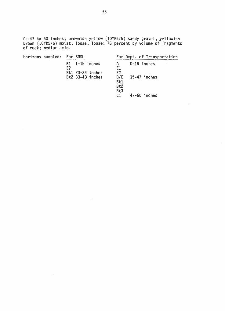
55
C--47 to 60 inches; brownish yellow (10YR6/6) sandy gravel, yellowish brown (10YR5/6) moist; loose, loose; 75 percent by volume of fragments of rock; medium acid.
Horizons sampled: For SDSU El 1-15 inches E2 Btl 20-33 inches Bt2 33-43 inches
For Dept. of Transportation A 0-15 inches El E2 8/E 15-47 inches Btl Bt2 Bt3 Cl 47-60 inches
56
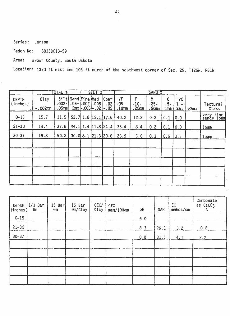
Series: Hocmont
Pedon No: S82SD033-29
Area: Custer County, South Dakota
Location: 1250 ft east and 1960 ft north of the southwest corner of Sec. 10, T3S, R5E
TOTAL% SILT t SANO 1
DEPTH Clay Silt Sand ~ine Med Coar VF F M C vc (inches) .002- .05- .002 .005 .02 .05- .10- .25- .5- 1 - Textura·1
Organic Carbonate Denth 1/3 Bar 15 Bar 15 Bar CEC/ CEC Carbon EC as CaC03
(inches 9m 9m Qm/Clav Clav mer:/1Q0nm % SAR ITlllhos/cm %
57 Soil Classification: I.oamy-skeletal, mixed Typic Eutroboralf Series: Mo cr.io n t Peden No.: S82SD033-29 Area: Custer County, South Dakota Location: 1250 feet east and 1960 feet north of the southwest comer of sec. 10,
T. 3 S., R. 5 E. Vegetation: Pine, bearberry, poverty oatgrass, junegrass Parent Material: Pegmatite Physiography: Broad :rrountain ridge Relief: B convex · Slope: 5 percent Aspect: Northeast Erosion: · Slight Pemeability: Moderate Drainage: Well Ground Water: Deep Moisture: Dcy to 11 inches; :rroist below Root Distribution: Abundant to 22 inches; few to 40 inches Elevation: 5400' Sarrpled by: Scott Anderson
(Colors are for dry soil unless otheoo.se stated).
0-1 inch to O; forest litter. ·
A-0 to 1 inch; very dark gray (lOYR 3/1) sandy loam, black (lOYR 2/1) :rroist; weak fine granular structure; soft, very friable; 15 percent by volume of fragments of rock; abrupt srrooth boundary.
E-1 to 8 inches; pale brown (lOYR 6/3) gravelly loam, yellowish brown (lOYR 5/ 4) :rroist; weak fine platy structure; soft, very friable; 20 percent by volurre of fragrcents of rock; clear srrooth boundary.
B/E-8 to 11 inches; yellc:Mi.sh brown (lOYR 5/4) gravelly clay loam, dark yellowish brown (lOYR 4/4) :rroist, (Bt); very pale brown (lOYR 7/3) gravelly loam, yellowish brown (lOYR 5/4) :rroist (E); weak rredium and fine subangular blocky structure; hard, finn; 30 percent by volume . of fragrcents of rock; clear wavy ?Cundary. Btl-11 to 22 inches; yellowish brown (lOYR 5/4) gravelly clay loam, dark yellowish brown (lOYR 4/4) :rroist; weak coarse prisma.tic structure parting to rroderate rredium subangular blocky; very hard, finn; 40 percent by volurre of fragments of rock; clear wavy boundary • .
Bt2-22 to 34 inches; light yellowish brown (lOYR 6/4) gravelly clay loam, strong brown (7 .5YR 5/6) :rroist; weak coarse prismatic structure parting to rrcderate rredium subangular blocky; vecy hard, finn; 45 percent by volume of fragrrents of rock; gradual wavy boundary.
Bt3-34 to 43 inches; light yellowish brown (lOYR Si4) gravelly clay loam, yellcwish br~111 (lOYR 5/6) rroist; weak coarse prismatic structure parting to weak rredium subangular blocky; vecy hard, finn; weak effervescence; 45 percent by volume of fragrcents of rock; gradual wavy boundary.
C-43 to 60 inches; white (lOYR 8/2) vecy gravelly loam, light yellowish brown (lOYR 6/4) :rroist; slightly hard, vecy friable.; 60 percent by volurre of fragments of rock; violent effervescence.
Horizons sarrpled: For SDSU Btl 11-22 inches
58
Series: Morton
Pedon No: S83SD137-13
Area: Ziebach County, South Dakota
Location: 520 ft south and 235 ft east of the northwest corner of Sec. 5, TllN, R23E
- . -· TOTAL% SILT t SANO%
DEPTH Clay Silt Sand -ine Med Coar VF F M C vc (inches) .002- .05- .002 .005 .02 .05- .10- .25- .5- 1 - Textura 1
Organic Carbonate Der,th 1/3 Bar 15 Bar 15 Bar CEC/ CEC Carbon EC as CaC03
(inches 9m 9m Qm/Clav Clay mea/lOOam % SAR mmhos/cm %
0-7 20.1 11.2 0.50 1.4
7-15 23.0 13.6 0.50 1.0
15-19 23 .7 14.0 0.54 0.8
59 Soil Classification: Fine-silty, mixed Typic Argiboroll Series: Morton Peden No.: S83SD137-l3 Area: Ziebach County, South Dakota T .ocation: 520 feet south and 235 feet east of the nortl'Mest corner of sec. 5 , T. 11 .-l., R. 23 E. Vegetation: Wheat stubble Parent Material: Sandstone Physiography: Upland Relief: Gently sloping Sl~: 3 percent Aspect: Sooth Pei::rceability: Moderate Drainage: Well Ground Water: Below 6 feet Moisture: Moist to 6 inches Erosion: Slight Salt: None Stoniness: None Date: August 24, 1983 Sarcpled by: Alan Hardison
(Colors are for dry soil unless otheJ:wise stated) •
~O to 7 inches; dark grayish brown (lOYR 4/2) silt loam, very dark grayish brown (lOYR 3/2) rcoist; weak rredi.um granular structure; slightly hard, very friable, slightly plastic, clear soooth boundary.
Btl-7 to 15 inches; brown (lOYR 4/3) silty clay loam, dark brown (lOYR 3/3) rcoist; no:ierate rredium prismatic structure parting to m:xierate rredium subangu1ar blocky; very hard, friable, slightly sticky and plastic; clear wavy boundary.
Bt2-15 to 19 inches; brown (lOYR 4/3) silty clay loam, dark grayish brown {lOYR 4/2) rcoist; m::>derate rredium subangular blocky structure parting to m::>derate fine subangular, very hard, friable, slightly sticky and plastic; clear wavy boundary.
Bk-19 to 32 inches; light olive brown (2.5Y 5/4) silt loam, dark grayish brown {2.5Y 4/2) rcoist; I'!Dderate rredium subangular blocky structure; very hard, friable, slightly plastic; camon rredi.um aco.mulations of carlx>nate; violent effervescence; gradual wavy boundary.
Cr-32 to 60 inches; light olive b:rown (2.5Y 5/4) sandstone, dark grayish brown (2.5Y 4/2) rcoist; strong effervescence.
Horizons sarcpled: Ap (0 to 7 inches) Btl {7 to 15 inches) Bt2 {15 to 19 inches)
60
Series: M.U. 214
Pedon No: S83SD031-11
Area : Corson County, South Dakota
Location: 1600 ft east and 455 ft north of the southwest corner of Sec . 30, T22N~ R28E
- . . TOTAL% SILT Z SAND%
DEPTH Clay Silt Sand ... .. ,ne Med Coar VF F M C vc (inches) .002- .05- .002 .005 .02 .05- .10- .25- .s- 1 - Textural
Organic Carbonate Oenth 1/3 Bar · 15 Bar 15 Bar CEC/ CEC Carbon EC as CaC03
(inches 9m Qm 9m/Clav Clav men/1Q0nm % SAR nmhos / cm %
Soil Classification: Unclassified Series: M.U. 214 Pedon No.: S83SD03l-ll Area: Corson County, South Dakota
61
Location: 1,600 feet east and 455 feet north of the southwest corner of sec. 30, T. 22 N., R. 28 E.
Vegetation: Small grain stubble Parent Material: Silty alluvium Physiography: Undulating upland Relief: Convex Slope: 3 percent Aspect: South Permeability: Moderate Drainage: Well Ground Water: Below 6 feet Moisture: Moist to 35 inches Erosion: Slight Date: October 1983 Profile by: Kenneth Heil
(Colors are for dry soil unless otherwise stated).
Ap--0 to 8 inches; dark grayish brown (lOYR 4/2) silt loam, very dark grayish brown (lOYR 3/2) moist; weak fine and medium subangular blocky structure parting to weak medium and fine granular; slightly hard, friable; slightly acid; abrupt smooth boundary.
Bwl--8 to 11 inches; dark brown (lOYR 4/3) silt loam, dark grayish brown (lOYR 4/2) moist; moderate medium and fine prismatic structure parting to moderate fine
Bw2--ll to 22 inches; dark brown (lOYR 4/3) silt loam, dark grayish brown (lOYR 4/2) moist; weak medium and fine prismatic structure parting to moderate fine subangular blocky; hard, friable; neutral; clear wavy boundary.
Bk--22 to 27 inches; light brownish gray (2.SY 6/2) silt loam, dark grayish brown (lOYR 4/2) moist; weak coarse prismatic structure; slightly hard, friable; common fine and medium accumulations of carbonates; strong effervescence; mildly alkaline; gradual wavy boundary.
Ck--27 to 35 inches; light brownish gray (2.SY 6/2) silt loam, grayish brown (2.SY 5/2) moist; weak coarse subangular blocky structure; slightly hard, friable; common fine and medium accumulations of carbonates; strong effervescence; mildly alkaline; clear wavy boundary.
Organic Carbonate Denth 1/3 ·Bar 15 Bar 15 Bar CEC/ CEC Carbon EC as CaC03
(inches Qm Qm Qm/Cl ay Clay mer./10nnm % SAR rrmhos/cm %
63
Soil Classification: Coarse-silty, mixed (calcareous) mesic Ustic Torriorthent Series: Nevee Peden No.: S83SD033-14 Area: Custer County, South Dakota Location: 2600 feet south and 2000 feet east of the northwest corner of sec. 7,
T. 6 S., R. 2E. Vegetation: Blue grama, needleandthread, sedges Parent Material: Residuum of spearfish foDnation Physiography: Upland Relief: B cx::mplex Slop2: 4 percent Aspect: Northwest Erosion: M:derate Penneability: Moderate . Drainage: Well Ground Water: Deep Moisture: M:)ist to 7 inches, dry belc:M Ib:lt Distribution: Camon to 5 inches, few to 20 inches Elevation: 3985' Sanpled by: Fod Krauss
(Colors are for dry soil unless othel:Wi.se stated).
Al-0 to 4 inches; yellc:Mish red (5YR 5/6) silt loam, reddish brc::,.,1Il (5YR 4/4) ITOist; weak fine granular structure; slightly hard, very friable; strong effervescence; clear wavy boundary.
A2-4 to 8 inches; yellowish red (5YR 5/6) silt loam, yellowish red (5YR 4/6) ITOist; weak medium subangular blocky structure parting to weak fine granular structure; slightly hard, very friable; strong effervescence; gradual wavy boundary.
Cl-8 to 18 inches; yellowish red (SYR 5/6) silt loam, yellowish red (SYR 4/6) rroist; massive; slightly hard, very friable; violent effervescence; gradual waV'j boundary.
C2-18 to 36 inches; reddish yellow (5YR 6/6) silt loam, yella'lish red (5YR 5/6) ncist; massive; slightly hard, very friable; violent effervescence, ccmron fine distinct masses o; carbonates; gradual wavy boundary. . . C3-36 to 60 inches; yellowish red (5YR 5/6) silt loam, yellowish red (5YR 4/6) rroist; massive; slightly hard, very friable; violent effervescence.
Horizons SartI)led: For SDSU ~} 0-8 inches
Cl l 8-36 inches C2)
For Al A2
Cl} C2
rtation
8-36 inches
.,
64
Series: Nevee
Pedon No : S81SD103-6
Area: Pennington County, South Dakota
Location: 1150 ft west and 50 ft south of the northeast corner of Sec. 21, TlN, R7E
.. . . -·
TOTAL% SILT Z SANO%
DEPTH Clay Silt Sand -· Med Coar VF F M C vc 1ne (inches) .002- .05- .002 .005 .02 .05- .10- .25- .5- 1 - Textural
Organic Carbonate Deoth 1/3 Bar 15 Bar 15 Bar CEC/ CEC Carbon EC as CaC03
(inches 9m 9m 9m/C1av Clav mea/100am % SAR mmhos/cm %
,-
65
Soil Classification: Coarse-silty, mixed (calcareous) rnesic Ustic Torriorthent Series: Nevee Pedon No.: S81S0103-6 Area: Permington County, South Dakota Location: 1150 feet west and 50 feet south of the northeast corner of sec. 21,
T. 1 N., R. 7E. Vegetation: Blue grana, little bluest.em, brane Parent Material: Residu\Jm of spearfish fonration Physiography: Uplands Relief: D convex Slope: 15 percent . Aspect: North Erosion: Moderate Pemeabili ty: Moderate Drainage: Well Ground Water : Deep Moisture: Dry throughout F.oot Distribution: Abundant tq 8 inches; few to 18 inches Elevation: 3480' Sanpled by: F.d Ensz
(Colors are for dry soil unless otherwise stated) • .. Al-0 to 4 inches; yellowish red (SYR 4/6) loam, reddish brown (SYR 4/4) ITOist; weak fine granular structure; soft, very friable; strong effervescence; Il'Cderately alkaline; clear sroooth boundary.
Organic Carbonate Deoth 1/3 Bar 15 Bar 15 Bar CEC/ CEC Carbon EC as CaC03
(tnches 9m 9m Qm/Cl av Clay mea/lOOam % SAR 11111hos/cm %
0-5 18.4 14.2 0.60 1. 7
5-12 19.2 15.6 0.49 1.1
12-20 18.4 15.2 0.54
67
Soil Classification: Fine-loamy, mixed Typic Argiboroll Series: Reeder Peden No.: S$2SD137-5 Area: Ziebach County, South Dakota l£lcation: 140 feet south and 2340 feet west of the oortheast corner of sec. 26, T. 12 N., R. 23 E. Vegetation: Wheat stubble Parent Material: San:istone Physiography: Upland Relief: Gently sloping Slope: 4 :percent Aspect: North Pell'reability: M:xlerate Drainage: Well Ground water: Below 6 feet M:>isture: M:>ist throughout Erosion: Slight Salt: None Stoniness: None to few on surface Date: June 28, 1982 Sanpled by: wayne Bachman and Alan Hardison
(Colors are for dry soil unless otherwise stated).
Ap-0 to 5 inches; dark grayish brown (lOYR 4/2) loam, very dark grayish brown (lOYR 3/2) rroist; -weak medium subangular blocky structure parting to m::>derate medium granular; hard, friable, slightly sticky and slightly plastic, clear sirooth boundary.
Btl-5 to 12 inches; brown (lOYR 4/3) clay loam, dark brown (lOYR 3/3) rroist; m::derate medium prismatic structure parting to m::derate medium subangular blocky; hard, friable, slightly sticky and plastic; gradual wavy boundary.
Bt2-12 to 20 inches; light olive brown (2.SY 5/4) clay loam, olive brc,.m (2.5Y 4/4) rroist; m::>derate medium prismatic structure parting to m::>derate medium subangular blocky; very hard, friable, slightly sticky and plastic; gradual wavy boundary.
Bk-20 to 35 inches; light yellowish brown (2.SY 6/4) loam, olive brown (2.SY 4/4) rroist; -weak coarse subangular blocky structure; hard, friable, slightly sticky and slightly plastic; few medium accurrulations .of carlxmate; strong effez:vescence; gradual wavy boundary.
Cr-35 to 60 inches; light yellowish brown (2.SY 6/4) sandstone, olive brown (2.SY 4/4) rroist; ff?.,I fine accurrulations of carlxmate; strong effervescence.
Horizons sarrpled: Ap (0 to 5 inches) Btl (5 to 12 inches) Bt2 (12 to 20 inches)
Series: Reliance
Peden No: S83SD137-14
Area: Ziebach County, South Dakota
68
Location: 440 ft south, 345 ft east of the northwest corner of Sec. 29, T7N, R19E
TOTAL% SILT t; SAND% DEPTH Clay Silt Sand .. ine Med Coar VF F M C vc
Soil Classification: Fine, montmorillonitic, mesic, Typic Argiustolls Series: Reliance Pedon No.: S83SD137-14 Area: Ziebach County, South Dakota Location: 440 ft south, 345 ft east of the northwest corner of Sec. 29, T7N, R19E Vegetation: Western wheatgrass, blue gra111T1a, needleandthread Parent Material: Alluvium Physiography: High Terrace Relief: Nearly level Slope: 1 percent Aspect: South Penneability: Moderately slow Drainage: Well Ground Water: Below 6 feet Moisture: Moist below 50 inches Erosion: None to slight Salt: None Stoniness: None Date: September 7, 1983 Sampled By: Wayne Bachman and Alan Hardison
(Colors are for dry soil unless other wise stated).
A -- 0 to 7 inches; dark grayish brown (10YR4/2) silty clay loam, very dark grayish brown (10YR3/2) moist; weak medium subangular blocky structure parting to moderate medium granular; slightly hard, friable, sticky and plastic; many fine roots; slightly acid; clear wavy boundary. (5 to 10 inches thick).
Btl -- 7 to 14 inches; dark brown (10YR4/3) silty clay, very dark grayish brown (10YR3/2) moist; moderate medium prismatic structure parting to moderate medium subangular blocky; very hard, firm, sticky and plastic; co111T1on fine roots; neutral; clear wavy boundary.
Bt2 -- 14 to 23 inches; grayish brown (10YR5/2) silty clay, dark grayish brown (10YR4/2) moist; weak medium prismatic structure parting to moderate medium subangular blocky; very hard, firm, sticky and plastic; few fine roots; neutral; clear wavy boundary. (Combined thickness of the Bt horizon is 10 to 25 inches).
Bkl -- 23 to 38 inches; grayish brown (2.5Y5/2) silty clay loam, dark grayish brown (2.5Y4/2) moist; moderate medium subangular blocky structure parting to moderate fine subangular blocky; hard, friable, slightly sticky and plastic; few fine roots; co111T1on medium accumulations of carbonate; violent effervescence; moderately alkaline; gradual wavy boundary.
Bk2 -- 38 to 49 inches; grayish brown (2.5Y5/2) silty clay loam, dark grayish brown (2.5Y4/2) moist; moderate medium subangular blocky structure; hard, friable, slightly sticky and plastic; few fine roots; few medium accumulations of carbonate; strong effervescence; moderately alkaline; gradual wavy boundary. (Combined thickness of the Bk horizon is 15 to 30 inches).
C -- 49 to 60 inches; grayish brown (2.5Y5/2) silty clay loam, dark grayish brown (2.5Y4/2) moist; massive; hard, friable, slightly sticky and plastic; few fine roots; strong effervescence; moderately alkaline.
70
Series: Shambo
Pedon No: S83SD031-116
Area: Corson County, South Dakota
Location: 150 ft north and 2485 ft east of the southwest corner of Sec. 35, T22N, R28E
TOTAL I SILT t SAND% DEPTH Clay Silt Sand ~ine Med Coar VF F M C vc
Organic Carbonate DerJth 1/3 Bar 15 Bar 15 Bar CEC/ CEC Carbon EC as CaC03
(inches Qm 9m 9m/Clay Clay mea/lOOam % SAR mmhos/cm %
'
71
Soil Classification: Fine-loamy, mixed Typic Haploborolls Series: Shambo Peden No.: S83SD031-116 Area: Corson County, South Dakota Location: 150 feet north and 2,485 feet east of the southwest corner of
sec. 35, T. 22 N., R. 28 E. Vegetation: Native grass Parent Material: Alluvium Physiography: Upland terrace Relief: Convex Slope: 3 percent Aspect: North Permeability: Moderate Drainage: Well Ground Water: Below 6 feet Moisture: Moist to 24 inches Erosion: Slight Date: October 1983 Profile by: Kim Kempton
(Colors are for dry soil unless otherwise stated).
A--0 to 5 inches; dark grayish brown (2.5Y 4/2) loam, very dark grayish brown (2.5Y 3/2) moist; weak medium subangular blocky structure parting to moderate fine granular; slightly hard, friable; neutral; clear wavy boundary.
Bwl--5 to 10 inches; dark grayish brown (2.5Y 4/2) loam, very dark grayish brown (2.5Y 3/2) moist; moderate medium prismatic structure parting to moderate medium subangular blocky; slightly hard, friable; neutral; gradual wavy boundary.
Bw2--10 to 14 inches; grayish brown (2.5Y 5/2) loam, dark grayish brown (2.5Y 4/2) moist; moderate medium prismatic structure parting to moderate medium subangular blocky; slightly hard, friable; neutral; clear wavy boundary.
Bk--14 to 20 inches; grayish brown (2.5Y 5/2) loam, dark grayish brown (2.5Y 4/2) moist; moderate medium prismatic structure parting to weak medium subangular blocky; slightly hard, friable; few fine and common accumulations of carbonates; slight effervescence; mildly alkaline; gradual wavy boundary.
BCk--20 to 41 inches; light brownish gray (2.5Y 6/2) loam, dark grayish brown (2.5Y 4/2) moist; weak medium subangular blocky structure; slightly hard, friable; strong effervescence; mildly alkaline; gradual wavy boundary.
C--41 to 60 inches; grayish brown (2.5Y 5/2) loam, dark grayish brown (2.SY 4/2) moist; massive; soft, very friable; strong effervescence; moderately alkaline.
Horizons sampled: A (Oto 5 inches) B (5 to 14 inches)
72
Series: Shing1e
Peden No: S83SD013P-46
Area: Pennington County, South Dakota
Location: 1050 ft south and 590 ft west of the northeast corner of Sec. 35, T4N, R15E
-TOTAL% SILT t SANO%
DEPTH Clay Silt Sand ~ine Med Coar VF F M C vc (inches) .002- .05- .002 . 005 .02 .05- .10- .25- .5- 1 - Textura 1
Series• Shingle Pedon Nos S8JSD10;P-46 . . Area.a Pennington County, South Da.k'ota. Locations 1,050 feet south and 590 feet west of the NE corner of sec. 35,
T. 4 N., R. 15 E. Climate, Semi-arid Vegetation• Need1eandthread, Blue gra.ma., Little bluestem, Western wheatgrass,
prairie sandreed, plains muhl.y, dotted gayfeather Pa.rent Materials Fox Hills - interbedded sandstones and silty shales Physiography, Upland Topography• Complex, hilly Drainage• Well drained Ground Waters Deep Erosions None to slight Permeability, Moderate Moistures Moist to 3 inches Sampled bys Janet Oertly Date• 9/8J
(Colors are for dry soil unless otherwise stated).
A--0 to J inches; light olive brown (2.5Y 5/J) loam., dark brown (10YR 3/J) moist; moderate fine and very fine granular structures soft, very friable1 many fine and medium roots; slight effervescence; abrupt smooth boundary.
AC--J to 7 inches1 light yellowish brown (10'XR 6/4) clay loam, brown (10YR 4/J) moist; weak medium subangula.r blocky structure; slightly ha.rd, friable; common fine roots; strong effervescence; clear wavy bounda.r,y.
C--7 to 12 inches; light yellowish brown (2.5Y 6/4) silty clay loam, light olive brown (2.5Y 5/4) moist; massive; sl1ghty ha.rd friable;.few to common fine shale chips, common fine roots; ~olent effervescences diffuse wavy boundary.
Cr--12 to 60 inches; light gray (10YR 7/2) and yellow (10YR 7/6) interbedded sandstones, s1l ty shales and shales1 light brownish gray (2.5Y 6/J) and yellowish brown (10YR 5/6) moist1 softs strong effervescence.
All horizons sampled.
74
Series: Sutley
Peden No: S83SD031-l4
Area: Corson County, South Dakota
Location: 1850 ft north and 185 ft east of the southwest corner of Sec. 30, T22N, R30E
- ·~ - .. TOTAL% SILT% SAND%
DEPTH Clay Silt Sand '"ine Me.d Coar VF F M C vc (inches) .002- .05- .002 .005 .02 .05- .10- .25- .5- 1 - Textural
Organic Carbonate Oe:Jth 1/3 Bar 15 Bar 15 Bar CEC/ CEC Carbon EC as CaC03
(inches 9m Qm 9m/Cl av Clav mec/lQOam % SAR mmhos/cm %
75
Soil Classification: Coarse-silty, mixed Entic Haploborolls Series: Sutley Pedon No.: S83SD031-14 Area: Corson County, South Dakota Location: 1,850 feet north and 185 feet east of the southwest corner of
sec. 30, T, 22 N., R. 30 E. Vegetation: Sunflowers Parent Material: Loess Physiography: Gently rolling upland Relief: Convex Slope: 7 percent Aspect: West Permeability: Moderate Drainage: Well Ground Water: Below 6 feet Moisture: Moist to 35 inches Erosion: Moderate Date: October 1983 Profile by: Kenneth Heil
(Colors are for dry soil unless otherwise stated).
Ap--0 to 6 inches; grayish brown (2.5Y 5/2) silt loam, very dark grayish brown (2.5Y 3/2) moist; weak fine granular structure; slightly hard, friable; slight effervescence; mildly alkaline; abrupt smooth boundary.
Ck--6 to 14 inches; light brownish gray (2.5Y 6/2) silt loam, dark grayish brown (2.5Y 4/2) moist; moderate medium and coarse subangular blocky structure; slightly hard, friable; few fine and medium accumulations of carbonates; strong effervescence.; moderately alkaline; clear wavy boundary.
C--14 to 60 inches; light brownish gray (2.5Y 6/2) silt loam, dark grayish brown (2.5Y 4/2) moist; massive; slightly hard, friable; strong effervescence; moderately alkaline.
Horizons sampled: A (0 to 6 inches) B (6 to 40 inches)
76
Series: Thedalund
Peden No: S83SD103P-48
Area: Pennington County, South Dakota
Location: 350 ft west and 500 ft north of the southeast corner of Sec. 6, T4S, R14E
OTAL % SILT Z SAND%
DEPTH Clay Silt Sand r:1ne Med Coar VF F M C vc (inches) .002- .05- i.002 . 005 .02 .05- .10~ .25- .s- 1 - Textura 1
Organic Carbonate OerJth 1/3 Bar 15 Bar 15 Bar CEC/ CEC Carbon EC as CaC03
(inches 9m 9m 9m/Cl av Clay mea/100am % SAR rrmhos/cm %
0-5 32 . 6 23.5 0.47 < 1 5.6
5-11 28 .1 18.0 0.35 < 1 19.8
11-23 34 .6 22.4 0.40 2 17 .5
23-31 35.2 21. 3 0.45 4 19.2
77
Soil Clas~i f icat ion : loamy, mixed (calcareous), mesic Ustic Torriorthents
Series: Thedalund Pedon No: S83SD103P-48
I j
Area: Fennington County, South Dakota Location: J50 feet west and .500 feet north of the Southeast corner of
Sec. 6, T. 4 S., fl. 14 E. Climate: 3em1-Arid Vegetation: Thin Upland Rangesite: Green rl eedlegrass, Needleandt~ead, ·
Sideoats gra.ma., Blue gram.a., Threadleaf sedge, June grass, Li tile Bluestem
Parent Material: Loamy Brule and Chadron moo.stone of the White River For. Physiography: Deeply entrenched steep uplands Topog;raphy: Complex, convex, hilly Drainage: Somewhat excessive Ground Water: Deep Erosion: None to slight Permeability: Moderate Hoisture: Dry throughout Sampled by: rdn Date: 11/BJ
(Colors are for dry soil unless otherwise stated.)
A--0 to 5 inches; grayish brown (10YR 5/2) loam, dark grayish brown (10YR 4/2) moist; weak medium and fine granular structure; slighily hard, friable, slighily sticky; many fine and mediWll roots; strong effervescence; clear smooth boundary.
AC--5 to 11 inches; light brownish gray (10YR 6/2) clay loam, grayish brown (10YR 5/2) moist;weak medium subangular blocky structure; slightly hard, friable, slighily sticky; many fine and medium roots·; strong effe~escence; gradual smooth boundary.
Cl--11 to 23 inches; grayish brown (10YR 5/2) clay loam, dark grayish brown (10YR 4/2) moist; massive; slighily hard, friable, slightly sticky, common fine roots in the upper part and few fine roots in the lower part; strong effervescence, gradual wavy boundary.
Organic Carbonate Deoth 1/3 Bar 15 Bar 15 Bar CEC/ CEC Carbon EC as CaC03
(i riches 9m em 9m/Cl av Clay mea/lQQnm % SAR mmhos/cm %
79
Soil Classification: Fine-silty, mixed, rresic Torriorthentic Haplustoll Series: Tilford-like Peden No.: S83SD033-l3 Area: Custer County, South Dakota IDCation: 800 feet west and 2400 feet south of the northeast corner of sec. 29,
T. 5 S., R. 2 E. Vegetation: Western wheatgrass, green needlegrass Parent Material: Residuum of spearfish fomation Physiography: Upland Relief: A-srooth Slope: 1 i:;ercent Asi:ect: Southeast Erosion: Slight Penreability: Moderate. Drainage: Well Ground Water: Deep t-t:>isture: Dry Root Distribution: Abundant to 10", few to 16" Elevation: 4230' Sarrpled by: SCX>tt Anderson
{Colors are for dry soil unless otherwise stated).
Ap-0 to 4 inches; dark brown {7.SYR 4/4) loam, dark reddish brown {SYR 3/3) rcoist; ~ rredium granular structure; slightly ha.rd, vecy friable; slight effervescence; abrupt wavy boundary.
Bwl-4 to 6 inches; dark brown {7.SYR 4/4} loam, dark reddish brown {5YR 3/4) rcoist; ~ xredi.um subangular blocky structure; slightly hard, friable; slight effervescence; clear wavy boundary.
Bw2-6 to 10 inches; brown {7.SYR 5/4) silty clay loam, reddish brown {5YR 4/4) ncderate rredium subangular blocky structure; very ha.rd, fil:m; strong effervescence; gradual wavy boundary.
Organic Carbonate Der>th 1/3 Bar 15 Bar 15 Bar CEC/ CEC Carbon EC as CaC03
(inches 9m 9m Qm/Cl av Clay mea/lOOam % SAR mmhos/cm %
Soil Classification: Unclassified Series: Unnamed I Pedon No.: S83SD031-12 Area: Corson County, South Dakota
81
Location: ~ mile west and 100 feet north of the southeast corner of sec. 24, T. 23 N., R. 27 E.
Vegetation: Small grain stubble Parent Material: Loess over alluvium Physiography: Undulating upland Relief: Convex Slope: 2 percent Aspect: Southwest Permeability: Moderate Drainage: Well Ground Water: Below 6 feet Moisture: Moist to 36 inches Erosion: Slight Date: October 1983 Profile by: Kenneth Heil
(Colors are for dry soil unless otherwise stated).
Ap~O to 8 inches; dark brown (lOYR 3/3) silt loam, very dark grayish brown (lOYR 3/2) moist; weak fine and medium subangular blocky structure parting to weak fine and medium granular; slightly hard, friable; slightly acid; abrupt smooth boundary.
Bwl--8 to 13 inches; olive brown (2.5Y 4/4) silt loam, dark grayish brown (lOYR 4/2) moist; moderate medium prismatic structure parting to moderate medium subangular blocky; slightly hard, friable; neutral; clear smooth boundary.
Bw2--13 to 20 inches; light olive brown (2.5Y 5/4) silt loam, olive brown (2.5Y 4/4) moist; weak medium and coarse prismatic structure parting to weak fine and medium subangular blocky; slightly hard, friable; neutral; clear smooth boundary.
Bk--20 to 27 inches; grayish brown (2.5Y 5/2) silt loam, dark grayish brown (2.SY 4/2) moist; weak coarse subangular blocky structure; slightly hard, friable; few fine to coarse accumulations of carbonates; strong effervescence; moderately alkali ne; abrupt smooth boundary.
2Ck--27 to 49 inches; light brownish gray (2.5Y 5/2) clay loam, dark grayish brown (2.5Y 4/2) moist; hard, friable; conunon medium and coarse accumulations of carbonates; strong effervescence; moderately alkaline; smooth boundary.
339 N azimuth, under a dense forest canopy of ponderosa pine at 1512 meters elevation, S~, Sec. 16, TIS, R6E, Pennington County. (Colors are for dry soil unless otherwise stated).
2-0cm; decomposed and partially decomposed pine needles and twigs.
0-4cm; dark grayish brown (10YR4/2) channery silt loam, black (10YR2/1) moist; weak very fine granular structure; soft, very friable; 25% by volume coarse fragments of slate; very strongly acid; abrupt wavy boundary.
4-22cm; pale brown (10YR6/3} channery silt loam, yellowish brown (lOYRS/4) moist; moderate very fine granular structure; soft, very friable; 30% by volume coarse fragments of slate; many fine and common medium roots; strongly acid; clear wavy boundary.
22-52cm; brown and light brown (7.SYRS/4 and 6/4) very channery clay loam, dark brown (7.5YR4/4) moist; strong very fine subangular blocky structure; slightly hard, friable; 40% by volume coarse fragments of slate; common fine and few coarse roots; thin clay films on faces of some peds; moderately acid; clear wavy boundary.
52-72cm; brown (lOYRS/3) very channery loam, dark brown (10YR4/3) moist; weak very fine subangular blocky structure, slightly hard, friable; 50% by volume coarse fragments of slate; few fine and few common roots; strongly acid; gradual wavy boundary.
72-90+cm; brown (lOYRS/3) very channery very coarse sandy loam, dark brown (10YR4/3) moist; massive; soft, very friable; 70% by volume coarse fragments of slate; strongly acid.
PARTICLE SIZE(% of TOTAL) CLAY RATIO DEPTH TOTAL -- SAND FRACTION SILT FRACTION C. FRAG. RATIO Sa to
SOIL HORIZON (cm) Sand Silt Clay__ vc C H F VF C H --~-; h}'._ Vol. Bt/E Si+Cl -
Peden Description: Pactola very channery silt loam, 30% backslope, aspect 3°N azimuth within a clearing of ponderosa pine forest at 1573 m elevation, N~, Sec. 21, TIS, R6E, Pennington County. (Colors are for dry soil unless otherwise stated).
Oe
A
E
BE
Bt
BC
C
6-0cm; decomposed and partially decomposed pine twigs and bearberry leaves.
0-4cm; very dark grayish brown (10YR3/2) very channery silt loam, black (10YR2/1) moist; moderate very fine granular structure; soft, very friable; 35% by volume coarse fragments of slate; many very fine and medium roots; extremely acid; clear wavy boundary.
4-23cm; light brownish gray (10YR6/2) very channery silt loam, brown (lOYRS/3) moist; weak very fine subangular blocky structure; soft, very friable; 40% by volume coarse fragments of slate; many very fine and medium roots; very strongly acid; clear wavy bo\llldary.
23-36cm; strong brown and pinkish gray (7.5YR5/6 and 7/2) very flaggy silt loam, dark brown and yellowish brown (7.5YR4/4 and 10YR5/4) moist; moderate very fine subangular blocky structure; slightly hard, friable; 40% by volume coarse fragments of slate; common fine and medium roots; strongly acid; clear wavy boundary.
36-64cm; strong brown (7.5YR5/6) very flaggy clay loam, dark brown (7.5YR4/4) moist; moderate, medium subangular blocky structure; slightly hard, friable; 50% by volume coarse fragments of slate; common fine to few medium roots; thin clay films on faces of some peds; strongly acid; gradual wavy boundary.
64-84cm; yellowish brown (10YR5/4) very flaggy loam, dark brown (10YR4/3) moist; weak fine subangular blocky structure; slightly hard, friable; 60% by volume coarse fragments of slate; few medium roots; strongly acid; clear wavy boundary.
+ · 84-104 cm; brown (10YR5/3) extremely stony loam, dark brown (IOYR4/3) moist; massive; slightly hard, friable; 75% by volume coarse fragments of slate; moderately acid.
Remarks: Intermittent accumulations of transported material from Bt adhering to coarse fragments in BC horizon.
The A horizon is highly variable in thickness, ranging from 1 to 4 cm across face of pedon.
Pedon Description: Pactola silt loam, 23% backslope, aspect 133°N azimuth, under a sparse forest canopy of ponderosa pine-bur oak at 1524 meters elevation,~. Sec. 22, TlS, R6E, Pennington County. (Colors are for dry -soil unless otherwise stated).
Oa 2-0cm; decomposed and partially decomposed pine needles and grass . litter.
A 0-2cm; very dark gray (10YR3/1) silt loam, black (10YR2/1) moist; moderate fine granular structure; soft, very friable; 5% by volume coarse fragments of slate; common very fine to fine roots; very strongly acid; abrupt wavy boundary.
El 2-2lcm; brown (10YR4/3) channery loam, very dark gray (10YR3/1) moist; weak very fine subangular blocky structure; soft, very friable; 20% by volume coarse fragments of slate; common very fine and few medium roots; moderately acid; clear wavy boundary.
E2 21-28cm; brown (10YR4/3) very channery loam, very dark grayish brown (10YR3/2) moist; weak very fine granular structure; soft, very friable; 35% by volume coarse fragments of slate; common very fine and few medium roots; moderately acid; abrupt wavy boundary.
Bt 38-SOcm; dark yellowish brown (10YR4/4) very stony silt loam, dark brown (10YR3/3) moist; moderate fine subangular blocky structure; slightly hard, friable; 55% by volume coarse fragments of slate; common very fine to fine roots; moderately acid; abrupt wavy boundary.
C 50-70+cm; light olive brown (2.5YR5/4) extremely stony fine sandy loam, dark brown (10YR3/3) moist; massive; soft, very friable; 65% by volume coarse fragments of slate; few very fine to fine roots; slightly acid.
Remarks: 'A'· Horizon thickness varies from 2 to 5 cm across pedon face.
Taxonomic Class:
Pedon Description:
91
Pactola (south aspect) - Site #84
Loamy-skeletal, mixed, Typic Eutroboralfs.
Pactola channery silt loam, 36% backslope, aspect 0 106 N azimuth, under moderately dense forest
canopy of ponderosa pine-bur oak at 1500 meters elevation. 5~, Sec. 16, TlS, R6E, Pennington County. (Colors are for dry unless otherwise indicated).
Oe 4-0cm; decomposed and partially decomposed pine needles, oak leaves, and twigs.
A 0-4cm; very dark grayish brown (10YR3/2) channery silt loam, black (10YR2/1) moist; moderate fine granular and moderate fine subangular blocky structure; soft, very friable; 10% by volume coarse fragments of slate; common fine and very fine roots; moderately acid; clear wavy boundary.
E 4-9cm; brown (10YR5/3) channery silt loam, dark brown (10YR4/2) moist; moderate fine subangular blocky structure; soft, very friable; 30% by volume coarse fragements of slate; common fine and very fine roots; moderately acid; clear wavy boundary.
Btl 9-SOcm; brown (7.5YR5/3) extremely flaggy clay loam, dark brown (7.5YR4/4) moist; strong medium and fine subangular blocky structure; slightly hard, friable; 60% by volume coarse fragments of slate; few medium and fine roots; thin clay films on faces of peds; moderately acid; clear wavy boundary.
Bt2 50-74cm; yellowish brown (10YR5/4) extremely flaggy clay loam, dark yellowish brown (10YR4/4) moist; moderate medium subangular blocky structure; slightly hard, firm; 60% by volume coarse fragments of slate; few medium and fine roots; thin clay films on faces of peds; moderately acid; clear wavy boundary.
2BC 74-85cm; strong brown (7.5YR5/6) very channery loam, dark brown (7.SYR4/4) moist; weak very fine subangular blocky structure; slightly hard, friable; 50% by volume coarse fragments of slate; few fine roots, moderately acid; clear wavy boundary.
2C 85-107+; strong brown and yellowish brown (7.SYRS/6 and 10YR6/6) channery loam, brown and dark brown (10YR4/4 and 7.SYR4/4) moist; weak very fine subangular blocky structure; soft, very friable; 30% by volume coarse fragments of slate; few fine roots; slightly acid.
Remarks: Transported material from Btl into Bt2, Bt2 into BC, and from BC into C horizon is evident in cracks adjacent to coarse fragments.
93
Pactola (south aspect) - Site #84 (continued)
Remarks: (Continued) Discontinuous E horizon occurs below A horizon, de.scribed as brown (lOYRS/3) channery silt loam, moderate fine and very fine subangular blocky structure; soft, very friable, abrupt wavy boundary.
Pressure faces evident on some peds within Btl and Bt2 horizons.
PARTICLE SIZE(% of TOTAL) CLAY RATIO DEPTH TOTAL -- SAND FRACTION SILT FRACTION C. FRAG. RATIO Sa to
SOIL HORIZON (cm) Sand Silt Clay __ _yf_ _ C H F VF C H F % by Vol. Bt/E Si+Cl
Peden Description: Virkula s!lt loam, 9% concave grassed footslop~. aspect 15 N azimuth, under a moderate forest canopy of ponderosa pine at 1524 meters elevation, S~, Sec. 10, TIS ~ RSE, Pennington County. (Colors are for dry soil unless otherwise stated).
A 0-3cm; very dark grayish brown (10YR3/2) silt loam, black (10YR2/1) moist; weak fine granular structure; soft, very friable; many very fine to fine roots; very strongly acid; abrupt smooth boundary.
E
Btl
Bt2
C
3-22cm; pale brown (10YR6/3) silt loam, dark brown (10YR4/3) moist; weak very fine subangular blocky and weak very fine granular structure; soft, very friable; many very fine to fine roots; strongly acid; clear wavy boundary.
22-64cm; brown (7.5YR5/4) silty clay loam, dark brown (7 . 5YR4/4) moist; strong fine and medium subangular blocky structure; slightly hard, friable; common fine and medium roots; thin clay films on faces of peds; strongly acid; clear wavy boundary.
64-78cm; light yellowish brown (10YR6/4) silty clay loam, dark yellowish brown (10YR4/4) moist; moderate very fine subangular blocky structure; slightly hard, friable; few very fine roots; thin clay films on faces of peds; strongly acid; clear wavy boundary.
78-lOO+cm, brown (lOYRS/3) loam, brown (lOYRS/3) moist; massive; slightly hard, friable; 10% by volume coarse fragments of slate; moderately acid.
Remarks: Coarse fragments of slate not encountered until 90 cm depth.
Pedon Description: Virkula silt loam, 9% slope, aspect 309°N azimuth, under a dense forest canopy of ponderosa pine at 1463 meters elevation,~. Sec. 13, TlS, RSE, Pennington County. (Colors are for dry soil unless otherwise stated).
Oe
A
E
Btl
Bt2
C
2-0cm; partially decomposed and decomposed pine needles and litter.
0-2cm; very dark gray (10YR3/1) silt loam, black (10YR2/1) moist; weak very fine granular structure; soft, very friable; many very fine to medium root; strongly acid; abrupt wavy boundary.
2-15cm; pale brown (10YR6/3) silt loam, dark yellowish brown (10YR4/4) moist; weak medium platy parting to medium fine subangular blocky structure; soft, very friable; common very fine to few fine roots; strongly acid; clear wavy boundary.
15-4lcm; brown (7 . 5YR5/4) silty clay loam, dark brown (7.5YR4/4) moist; strong very fine and fine subangular blocky structure; slightly hard, friable; few very fine to fine roots; thin clay films on faces of peds; strongly acid; clear wavy boundary.
41-55cm; light yellowish brown (10YR6/4) silty clay loam, dark yellowish brown (10YR4/4) moist; moderate fine subangular blocky structure; slightly hard, friable; few fine roots; thin clay films on faces of some peds; strongly acid; clear wavy boundary.
+ 55-75 cm; grayish brown (2.5YR5/2) channery loam, dark grayish brown (10YR4/2) moist; massive; soft, friable; 20% by volume coarse fragments of slate; moderately acid.
Remarks: The A horizon thickness varies from 0.5 to 3 cm across face of pedon.
PARTICLE SIZE(% of TOTAL) CLAY RATIO DEPTH TOTAL -- SAND FRACTION SILT FRACTION C. FRAG. RATIO Sa to
SOIL HORIZON (cm) Sand Silt Clay __ Vf: __ - c ___ M -- F VF C M F % by Vol. Bt/E Si+Cl
aspect 238 N azimuth, under a moderately dense forest canopy of ponderosa pine at 2,018 meters elevation,~ of Sec. 33, T2S, R3E, Custer County. (Colors are for day soil unless otherwise stated).
2-0cm; partially decomposed and decomposed forest litter.
0-12cm; brown (10YR5/3) silt loam, dark brown (10YR4/3) moist; weak medium platy parting to weak fine subangular blocky structure; slightly hard, friable; common fine and medium roots; moderately acid; clear wavy boundary.
12-20cm; brown (7.5YR5/4) silty clay, dark brown (7.5YR4/4) moist, and dark brown (7.5YR4/2) coatings on faces of peds; strong very fine blocky structure, hard, firm; few fine and medium roots; moderately acid; clear wavy boundary.
20-37cm; brown and light brown (7.5YR5/4 and 6/4) silty clay, dark yellowish brown (10YR4/4) moist, and dark brown (7.5YR4/2) coatings on faces of peds; strong fine blocky structure; hard, firm; 5%- by volume fragments of limestone; few medium roots; slightly acid; clear wavy boundary.
+ 37-45 cm; brown (10YR5/3) very stony silty clay loam, brown (10YR5/3) moist; massive; slightly hard, friable; 60% by volume limestone fragments; violent effervescence; mildly alkaline.
Pedon Description: Stovho silt loam, 10% slightly concave slope, aspect 218°N azimuth, within a grassed clearing of a ponderosa pine forest at 2073 meters elevation, S~, Sec. 30, TlS, R3E, Pennington County. (Colors are for dry soil unless otherwise stated).
E
Bt
BCl
BC2
C
0-15cm; light brownish gray (10YR6/2) silt loam, dark brown (10YR4/2) moist; weak fine granular and subangular blocky structure; soft, friable; 5% by volume coarse fragments of limestone; many very fine to fine roots; strongly acid; clear wavy boundary.
15-38cm; brown (7.5YR5/4 and 5/2) silty clay, dark brown (7.5YR4/2) moist, and dark brown (7.5YR3/2) coatings on faces of peds; strong medium blocky structure; hard, firm; 5% by volume coarse fragments of limestone; common very fine to fine roots; moderately acid; clear wavy boundary.
38-48cm; brown (10YR5/3) silty clay loam, dark yellowish brown (10YR4/4) moist, and dark grayish brown (10YR4/2) coatings on faces of some peds; slightly hard, friable; 10% by volume coarse fragments of limestone; common fine roots; strong effervescence; mildly alkaline; clear wavy boundary.
48-66cm; pale brown (10YR6/3) gravelly silty clay loam, brown (10YR5/3) moist; weak very fine subangular blocky structure; slightly hard, friable; 15% by volume coarse fragments of limestone; few .fine roots; violent effervescence; mildly alkaline; abrupt wavy boundary.
+ 66-80 cm; very pale brown and reddish yellow (10YR7/3 and 7.5YR6/6) very gravelly silty clay loam, light yellowish brown and brown (10YR6/4 and 7 .5YR5/4) moist; massive; 45% by volume coarse fragments of limestone; violent effervescense; mildly alkaline.
Remarks: Thin lenses of A horizon present but too intermittent to sample.
Evidence of Bt horizon material transported into C horizon via pedogenic. cracks.
PARTICLE SIZE(% of TOTAL) CLAY RATIO DEPTH TOTAL -- SAND FRACTION SILT •'RACTION C. FRAG. RATIO Sa to
SOIL HORIZON (cm) Sand Silt Clay vc C H F VF C H F % bx_ Vol. Bt /E Si+Cl
Pedon Description: Trebor ve~ flaggy silt loam, 7% convex slope, aspect 207 N azimuth, under a sparse forest canopy of ponderosa pine at 2,073 meters elevation, S~ of Sec. 30, TlS, R3E, Pennington County. (Colors are for dry soil unless otherwise stated).
Oa
E
Bt
BC
C
3-0cm; decomposed and partially decomposed forest litter.
0-3cm; dark grayish brown (10YR4/2) very flaggy silt loam, very dark grayish brown (10YR3/2) moist; weak medium platy structure parting to weak very fine subangular blocky; slightly hard; friable; 35% by volume fragments of limestone; many very fine and fine roots; moderately acid wavy boundary.
3-30cm; dark brown (7.SYR4/4) extremely flaggy silty clay, dark brown (7.SYR3/2) moist; and dark brown (10YR3/2) coatings on faces of some peds; strong very fine blocky structure; hard, firm; 65% by volume fragments of limestone; common very fine and medium roots; neutral; abrupt wavy boundary.
30-37cm; grayish brown (lOYRS/2) extremely flaggy silty clay loam, dark grayish brown (10YR4/2) moist; weak very fine subangular blocky structure; slightly hard, friable; 80% by volume coarse fragments of limestone; common very fine to few medium roots; strong effervescence; neutral; abrupt wavy boundary.
37-4S+cm; pale brown and very pale brown (10YR6/3 and 7/4) extremely flaggy silty loam, brown and light yellowish brown (lOYRS/3 and 6/4) moist; massive; slightly hard, friable; 80% by volume coarse fragments of limestone; few medium roots; violent effervescence; mildly alkaline.
Remarks: Dark grayish brown (10YR4/2) coatings (organs) surrounding some roots in BC and C horizons.
Pedon Description: Trebor extremely stony silt loam, 11% slightly convex slope, aspect 253°N azimuth, under a dense forest canopy of ponderosa pine at 2073 meters elevation, S~, Sect. 30, TIS, R3E, Pennington County. (Colors are for dry soil unless otherwise stated).
Oe 2-0cm; partially decomposed and decomposed pine needles and litter.
E 0-7cm; brown (7.5Yr5/2) extremely stony silt loam, dark brown (7.5YR4·/2) moist; weak medium platy structure; soft, very friable; 70% by volume coarse fragments of limestone; common fine to medium roots; very strongly acid; clear wavy boundary.
Bt
C
7-28cm; dark brown (7.5YR4/4) extremely stony silty clay, dark brown (7 .5YR4/4) moist, and dark b-rown (7 .5YR4/2) coatings on faces of some peds; strong fine blocky structure; slightly hard, friable; 80% by volume coarse fragments of limestone; common fine to medium roots; neutral; abrupt irregular boundary.
+ 28-40 cm; grayish brown (lOYRS/2) extremely stony silty clay loam, dark yellowish brown (10YR4/4) moist; massive; soft, very friable; 90% by volume coarse fragments of limestone; few fine roots; violent effervescence; neutral.
Remarks: Raw organic matter has been transported into the C horizon via cracks between coarse fragments. Dark brown humus and Bt material also transported into C horizon via cracks. Therfore 7.5YR4/4 colors also present in C.
Intermittent BE horizon with color of lOYRS/4 observed but too thin to sample.
PARTICLE SIZE(% of TOTAL) CLAY RATIO DEPTH TOTAL ~~SAND FRACTION SILT FRACTION C. FRAG. RATIO Sa to
SOIL HORIZON (cm) Sand Silt Clay_ VC C H F VF C H F % by Vol. Bt/E Si+Cl ---· - - ·--------------- --- -
slope, aspect 330 N azimuth, under a moderate forest canopy of ponderosa pine at 1,618 meters elevation, N~ of Sec. 31, T3S, R2E, Custer County. (Colors are for dry soil unless otherwise stated).
3 to 0cm; partially decomposed pine needles, twigs and grass.
0 to 8cm; dark grayish brown (10YR4/2) channery silt loam, very dark grayish brown (10YR3/2) moist; moderate fine subangular blocky structure; slightly hard; friable; 20% by volume limestone fragments; common fine to medium roots; slightly acid; abrupt wavy boundary.
8 to 11cm; brown (7.5YR5/4) very channery clay loam, dark brown (7.5YR4/4) moist; moderate fine subangular blocky structure; hard, firm; 35% by volume limestone fragments; common fine to medium roots; very slight effervescence; neutral; abrupt wavy boundary.
11 to 17cm; brown (10YR5/2) very channery clay loam, dark brown (7.5YR4/2) moist; weak fine subangular blocky structure; hard, firm; 40% by volume limestone fragments; few fine to medium roots; strong effervescence; mildly alkaline; clear wavy boundary.
17 to 30cm; light gray (10YR7 / 2) very channery loam, brown (10YR5/3) moist; slightly hard, friable; 40% by volume limestone fragments; few fine to medium roots; violent effervescence; mildly alkaline; clear wavy boundary.
+ 30-50 cm; pinkish gray (7.5YR7/2 and 5YR7/2) very channery loam, light reddish brown and reddish gray (5YR6/3 and 5/2) moist; weak very fine subangular blocky structure; slightly hard, friable; 507. by volume limestone fragments; few fine roots; violent effervescence; mildly alkaline.
Taxonomic Class:
Pedon Description:
117
Vanocker - Site #41
Loamy-skeletal, mixed, Typic Eutroboralfs.
Vanocker loam, 22% south-facing slope, aspect 320°N azimuth, under a dense forest canopy of ponderosa pine at 1,585 meters elevation,~. Sect. 31, T3S, R2E, Custer County. (Colors are for dry soil unless otherwise indicated).
Oe 3-0cm; partially decomposed and decomposed pine needles and twigs.
A 0-Scm; very dark grayish brown (10YR3/2), black (10YR2/l) moist; weak very fine subangular blocky and granular structure; soft, very friable; common very fine roots; moderately acid; abrupt wavy boundary.
E 5-7cm; brown (7.5YR5/2) loam; dark brown (7.5YR4/2) moist; weak very fine subangular blocky structure; soft, very friable; common very fine to fine roots; neutral; abrupt wavy boundary.
Bt 7-12cm; brown (7,5YR5/4) very flaggy loam, dark brown (7.5YR4/4) moist; very dark grayish brown . (10YR3/2) coatings on faces of some peds; moderate fine subangular blocky structure; slightly hard, friable; 35% ·b.y volume coarse fragments of sandy limestone; common very fine to fine roots; very slight effervescence; neutral; abrupt wavy boundary.
BCl 12-17cm; grayish brown (10YR5/2) very flaggy loam, dark grayish brown (10YR4/2) moist; moderate very fine and ·fine subangular blocky structure; soft, very friable; 40% by volume coarse fragments of sandy limestone; common very fine to fine roots; violent effervescence, mildly alkaline; clear wavy boundary.
BC2 17-29cm; light brownish gray (10YR6/2) very flaggy loam, brown (10YR4/3) moist; weak very fine and fine subangular blocky structure; soft, very friable; 60% by volume coarse fragments of sandy limestone; common. very fine. to fine roots; violent effervescence; mildly alkaline; clear wavy boundary.
Cl 29-46cm; light brownish gray (10YR6/2) very stony loam, brown (10YR4/3) moist; massive; slightly hard, friable; 75% by volume coarse fragments of sandy limestone; common fine to fine medium roots; violent effervescence; mildly alkaline; abrupt wavy boundary.
2C2 46-60+cm; light gray and white (10YR7/2 and 8/1) extremely stony fine sandy loam, brown and very pale brown (10YR5/3 and 7/4) moist; massive; soft, very friable; 75% by volume coarse fragments of sandy limestone; violent effervescence; mildly alkaline.
119
Vanocker - Site #41 (continued)
Remarks: The A horizon varies in thickness from 1-4 cm across pedon face.
The E horizon varies in thickness from Oto 3 cm ·across pedon face. Evidence of some E material transported through cracks into Bt horizon.
PARTICLE SIZE(% of TOTAL) CLAY RATIO DEPTH TOTAL -- SAND FMCTION SILT FRACTION C. FRAG. RATIO Sa to
SOIL HORIZON (cm) Sand Silt Clay VC C H F VF C H F % by Vol. Bt/E Si+Cl
Sawdust channery loam, 20% south-facing slope, aspect 153°N azimuth, under a very sparse forest canopy of ponderosa pine at 1,628 meters elevation, NW~ of Sect. 31, T3S, R2E, Custer County. (Colors are for dry soil unless otherwise stated).
A 0-lOcm; dark grayish brown (10YR4/2) channery loam, very dark -brown (10YR2/2) moist; weak fine granular structure; soft, very friable; 25% by volume coarse fragmepts of limestone; common very fine roots; strong effervescence; mildly alkaline; clear wavy boundary.
AC 10-26cm; light brownish gray (10YR6/2) very channery clay loam, brown (10YR4/3) moist; moderate fine subangular blocky structure; soft very friable; 45% by volume fragments of limestone; common very fine roots; violent effervescence; mildly alkaline; clear wavy boundary. ·
C 26-35+cm; pinkish grey (7.SYR6/2) extremely flaggy loam, brown (7.SYR5/2) moist; massive; slightly hard, friable; 70% by volume fragments of limestone; few very fine roots; violent · effervescence; moderately alkaline.
Pedon Description: Sawdust fine sandy loam, 21% south-facing slope 0
Oe
A
BA
BW
BC
C
aspect 168 N azimuth, under a moderate forest canopy of ponderosa pine at 1,640 meters elevation, NW~ Sect. 31, T3S, R2E, Custer County. (Colors are for dry soil unless otherwise stated).
3-0cm; partially decomposed and decomposed pine needles and grass litter.
0-4cm; very dark grayish brown (10YR3/2) fine sandy loam, black (10YR2/1) moist; weak very fine granular structure; soft, very friable; 10% by volume coarse fragments of limestone; many very fine roots; strongly acid; abrupt smooth boundary.
4-llcm; brown (7.5YR4/2) very flaggy fine sandy loam, dark brown (7.5YR3/2) moist; weak fine subangular blocky structure; soft, very friable; 40% by volume coarse fragments of limestone; many very fine to cotmnon medium roots; neutral; abrupt wavy boundary.
ll-20cm; light brown (7.5YR6/4) extremely stony sandy clay loam, brown (7.5YR4/4) moist; moderate very fine subangular blocky structure; slightly hard, friable; 80% by volume coarse fragments of limestone; few very fine to common medium roots; strong effervescence; mildly alkaline; abrupt wavy boundary.
20-33cm; brown (lOYRS/3) extremely stony fine sandy loam, dark brown (7.5YR4/4) moist; weak very fine granular structure; soft, very friable; 80% by volume coarse fragments of limestone; few very fine to cotmnon medium roots; violent effervescence; mildly
· alkaline; abrupt wavy boundary.
+ 33-45 cm; pale brown (10YR6/3) extremely stony loam, brown (lOYRS/3) moist; massive; slightly hard, friable; 80% by volume coarse fragments of limestone; few very fine to medium roots; violent effervescence; moderately alkaline.
PARTICLE SIZE (% of TOTAL)- ·· CLAY RATIO DEPTH TOTAL ~~SAND FRACTION SILT FRACTION C. FRAG. RATIO Sa to
SOIL HORIZON (cm) Sand Silt Clay VC C H F VF C H F % by Vol. Bt /E Si+Cl