Soil properties and microclimate of two predominant landscapes in the Brazilian semiarid region: Comparison between a seasonally dry tropical forest and a deforested area
Thieres George Freire da Silva a,*, Maria Gabriela de Queiroz b, Sergio Zolnier b, Luciana Sandra Bastos de Souza a, Carlos Andre Alves de Souza a, Magna Soelma Beserra de Moura c, Gherman Garcia Leal de Araújo c, Antonio Jose Steidle Neto d, Thalyta Soares dos Santos a, Andre Laurenio de Melo a, Jose Francisco da Cruz Neto a, Marcelo Jose da Silva a, Hygor Kristoph Muniz Nunes Alves a
a Rural Federal University of Pernambuco, Serra Talhada, Pernambuco, Brazil b Federal University of Viçosa, Viçosa, Minas Gerais, Brazil c Brazilian Agricultural Research Corporation, Petrolina, Pernambuco, Brazil d Federal University of Sao Joao del-Rei, Sete Lagoas, Minas Gerais, Brazil
A R T I C L E I N F O
Keywords: Climate Farmland abandonment Land-use Land degradation Changes in soil nutrients
A B S T R A C T
The Brazilian semiarid region has been subjected to strong man-made actions since the 1970s, which have resulted in landscape transformation. The scientific literature presents several studies on the soil properties or microclimate of different types of landscapes; however, less attention was having been paid to the surface contrast between native vegetation and bare soil. The objective of this research was to evaluate the soil prop-erties and microclimate of two common landscapes in the Brazilian semiarid region, a seasonally dry tropical forest (Caatinga) and a deforested area. Soil and microclimate data were obtained from two sites, both located in the State of Pernambuco, Brazil. Soil samples were collected on six dates and from layers, and microclimate variables were measured for three years. Soil properties and microclimatic data were evaluated using the Mann- Whitney test, as well as regression and principal component analysis. Successive years of agricultural practices affected the bulk density, promoting an increase in the total porosity of the soil in the deforested area site. In addition, changes were verified in the magnitude of many chemical properties (pH, P, K+, Mg2+, Cu2+, Fe, Mn, Zn2+ and Ca2+), indicating soil degradation. Compared with the Caatinga forest site, the minimum air tem-perature was 2.3 ◦C, and the maximum vapor pressure deficit was 7% higher in the deforested area site, and it is very likely that Caatinga removal there will lead to a reduction in precipitation. The results suggest that Caatinga vegetation removal followed by agricultural practices and subsequent land abandonment promotes significant changes in soil properties and the microclimate, which can contribute to advances in desertification and affects agricultural activities in the Brazilian semiarid region.
1. Introduction
The Brazilian semiarid region is the wettest and largest semiarid environment in the world. According to Brazil’s National Food and
Nutrition Security Council (2019), this region encompasses an area of 982,566 km2, where annual precipitation ranges from 400 to 800 mm. It represents 18.2% of the national territory and 53% of the Brazilian Northeast region, comprising 1133 municipalities. Its population is
* Corresponding author at: Academic Unit of Serra Talhada, Rural Federal University of Pernambuco, Gregorio Ferraz Nogueira, Jose Tome de Souza Ramos, PO Box: 063, 56909535, Serra Talhada, Pernambuco, Brazil.
approximately 22 million inhabitants, most of which live in rural areas. Historically, the Brazilian semiarid region has been explored for diverse purposes and thus subjected to strong man-made actions since the 1970s, resulting in a drastic change of the landscape. Climate, extrac-tivism, inadequate farming management and overgrazing are the main factors that have changed the native vegetation which comprises the Caatinga dry forest.
It is estimated that half of the original Caatinga vegetation cover has already been modified (Menezes et al., 2012; Schulz et al., 2016). Currently, part of the original Caatinga domain was replaced by large farming areas composed of sugarcane and fruit crops. In addition, there are small farms which consist of subsistence crops such as beans, corn, sorghum and forage cactus, as well as grassland. Therefore, conservation units share space with native areas that have suffered some kind of anthropic impact (Akhzari et al., 2015; Silva et al., 2019a, 2017; Souza et al., 2011; Teixeira et al., 2008). Moreover, landscapes with a pre-dominance of herbaceous plants combined with bare soil are observed in areas with failure of rainfed agricultural activity, which then became abandoned farmlands. The removal of native vegetation increases soil fragility and modifies the biogeophysical (physical attributes of the soil) and biogeochemical (greenhouse gas emissions) cycles, as well as energy and water exchange (Althoff et al., 2018; Beltran-Przekurat et al., 2012; Souza et al., 2015; Teixeira et al., 2008). This practice leads to transition of sub-humid-to-semiarid and semiarid-to-arid environments (Becerril-Pina et al., 2015).
Landscape characterization with different levels of anthropic disturbance improves the understanding of the impacts of land use on climate and the effect of the latter on the native and farmed landscapes (Hardwick et al., 2015; Teixeira et al., 2008; Zhao et al., 2017). The scientific literature presents several studies related to the effects of vegetal cover modification on the physical and chemical properties of the soil and microclimate, considering different types of landscapes (Blecourt et al., 2019; Hajabbasi et al., 1997; Lemenih et al., 2005; Oliveira et al., 2020; Vagen et al., 2006). These results are important to understand how deforestation influences soil properties and the regional microclimate (Medeiros et al., 2017; Ozkan and Gokbulak, 2017; Pan-day et al., 2015; Salazar et al., 2016; Silva et al., 2017).
Deforestation and subsequent cultivation reduce all soil quality properties over the long term, especially when land management is not sustainable (Lemenih et al., 2005). Poor soil quality decreases the yield of natural soil and can reduce the organic matter and total nitrogen by up to 50% and the soluble ions by 10%–15%, compared with undis-turbed forest soil (Hajabbasi et al., 1997). In areas of biomass burning for land clearing, it is common to observe an increase in the available phosphorus and exchangeable basic cations (Ca2+, Mg2+ and K+) compared with natural forest soils (Vagen et al., 2006). Blecourt et al. (2019) cited that changes in land use can reduce the carbon stocks in woodlands to 20%. The establishment of agriculture from deforestation of native vegetation results in problems for the structure and quality of the soil. For example, Bertossi et al. (2016) verified that deforestation decreased the soil organic matter content in the grazing and coffee areas, without altering the physical characteristics of the soil in the grazing area. On the other hand, coffee cultivation caused changes in the soil quality (lower soil density, flocculation degree and aluminium satura-tion, and higher clay content dispersed in water, Ca2+ content and available P) in comparison with the grazing and forest areas, which indicated the need for adequate soil management.
From a climatic point of view, deforestation impacts directly on water cycles, due to changes in the convective circulation of regional precipitation formation. However, it depends on the spatial scale of disturbance. Small-scale deforestation (up to 1 km) produces no signif-icant impact on the transpiration flux and thus on precipitation, while large-scale deforestation (greater than 200 km) promotes a reduction in precipitation recycling, decreasing downwind precipitation over large areas (Chambers and Artaxo, 2017). However, the simultaneous occurrence of climate variability with deforestation masks the effects of
deforestation on water balance. In the Brazilian semiarid region, alterations in physical and chemical
soil characteristics, as well as microclimate conditions promoted by deforestation, contribute to the desertification advance, increasing the difficulty of carrying out agricultural activities (Becerril-Pina et al., 2015). Few studies used in situ data to assess the impacts of Caatinga deforestation (Medeiros et al., 2017; Silva et al., 2017; Teixeira et al., 2008) and none have been conducted to evaluate deforestation and farmland abandonment with bare soil. Our hypothesis is that the removal of native Caatinga vegetation for agricultural purposes and the subsequent abandonment of land promote significant changes in soil fertility and in the local microclimate with more damaging impacts than those reported in the literature for areas that have been deforested but have maintained agricultural activities or areas undergoing regenera-tion processes or those that have been subjected to reforestation pro-grams. This type of study helps us to understand how deforestation of the native vegetation affects agricultural activities. Furthermore, it re-duces advancement of the desertification process, gives support to the expansion of reforestation actions and promotes improvement of agri-cultural governance in semiarid environments. Thus, the objective of this research was to evaluate the soil properties and microclimate of two predominant landscapes in the Brazilian semiarid region, a seasonally dry tropical forest characterized by Caatinga vegetation and another by a deforested area.
2. Material and methods
2.1. Study area
The study was carried out in the central area of the semiarid region of the State of Pernambuco, Brazil (Fig. 1A), specifically between the municipalities of Betania, Floresta, Carnaubeira da Penha, Mirandiba and Serra Talhada (Fig. 1B). Two types of landscape were evaluated (Fig. 2): Caatinga - CAA (8◦18′31′ ′S; 38◦31′04′ ′W, 379 m above sea level) and deforested area - DEFA (8◦18′22′ ′S; 38◦30′43′ ′W, 380 m above sea level). The CAA site is characterized by a seasonally dry tropical forest that presents evidence of grazing by cattle, goats and sheep, as well as sporadic vegetation removal for firewood use. In the deforested area, small-scale farming activities have been conducted since the 1920s. Over the decades, there has been conversion of the cleared forest lands to intensive subsistence farming or pasture with exotic species. Currently, DEFA is occupied by herbaceous species combined with bare land during the low precipitation months.
In both landscapes, the soils were grouped within the class of Chromic Luvisols (Fig. 1C), with a clear difference between horizons A and Bt, that is, abrupt textural change, according to the soil surveys contained in a Brazilian database and the classification system of the Embrapa (2013). This database was compiled from the Radambrasil project and other regional surveys, which contain the soil type and profile description (Cooper et al., 2005). Chromic Luvisol is a soil typical of landscapes with water deficiency and encompasses approximately 15% of the Brazilian semiarid region. The sandy texture is the result of the original rock (metamorphic) and weathering process (Oliveira et al., 2009), whereas variations in the physical properties of the soil depend on the weathering process, area homogeneity, land use, tillage practices and plant species (Medeiros et al., 2017; Oliveira et al., 2020). The experimental sites are situated in a region with little relief variation (Miranda, 2005) (Fig. 1B).
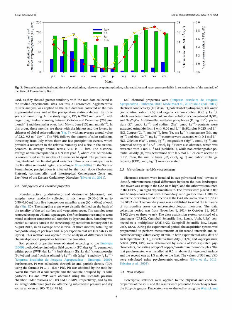
The climatological normal is presented in Fig. 3. The reference evapotranspiration (ET0) (Allen et al., 1998), solar radiation (Rs) and vapor pressure deficit of the air (VPD) were obtained from the data collected from two complete climatological stations located in the mu-nicipalities of Floresta and Serra Talhada. In turn, average precipitation was obtained from data from three pluviometric stations, one located in the municipality of Betania and two in the municipality of Floresta. Of nine precipitation stations in the region, only these three stations were
T.G.F. da Silva et al.
Soil & Tillage Research 207 (2021) 104852
3
Fig. 1. Site location in the central area of the semiarid region of the State of Pernambuco, Brazil. (A) Position of the State of Pernambuco in Brazilian the semiarid region. (B) Relief of the State of Pernambuco, Brazil. (C) Type of soil in experimental sites. (D) Location of the soil sampling areas (60 × 60 m) in the experi-mental sites.
Fig. 2. Sites of the Caatinga domain (CAA) and deforested area (DEFA) during wet (A and B), transition wet-dry (C and D) and dry periods (E and F), respectively.
T.G.F. da Silva et al.
Soil & Tillage Research 207 (2021) 104852
4
used, as they showed greater similarity with the rain data collected in the studied experimental sites. For this, a Hierarchical Agglomerative Cluster analysis was applied to the rain database collected at the two experimental sites and at the precipitation stations during the three years of monitoring. In the study region, ET0 is 2023 mm year− 1, with larger magnitudes occurring between October and December (203 mm month− 1) and the smaller ones, from May to June (132 mm month− 1). In this order, these months are those with the highest and the lowest in-cidences of global solar radiation (Fig. 3), with an average annual value of 22.2 MJ m-2 day− 1. The VPD follows the pattern of solar radiation, increasing from July when there are few precipitation events, which provides a reduction in the relative humidity and a rise in the air tem-perature. In average annual terms, VPD is 1.3 kPa. The historical average annual precipitation is 489 mm year− 1, where 75% of this total is concentrated in the months of December to April. The patterns and magnitudes of the climatological variables follow other municipalities in the Brazilian semi-arid region, according to Silva (2004). In the State of Pernambuco, precipitation is affected by the local slope (Borborema Plateau), continentally, and Intertropical Convergence Zone and East-West of the Eastern Ondulatory Disorders (Silva et al., 2011).
2.2. Soil physical and chemical properties
Non-destructive (undisturbed) and destructive (deformed) soil samples were randomly collected in six layers (0.00–0.10 m to 0.50–0.60 m) from five homogenous sampling areas (60 × 60 m) of each site (Fig. 1D). The sampling areas were visually defined on the basis of the tonality of the soil surface and vegetation cover. The samples were removed using an Uhland-type auger. The five destructive samples were mixed to obtain composite soil samples by layer and date. Sampling was carried out on six dates in the same sampling areas from January 2016 to August 2017, in an average time interval of three months, totalling six composite samples per layer and 36 per experimental site (six dates x six layers). This method was applied to the analysis of differences in the chemical-physical properties between the two sites.
Soil physical properties were obtained according to the Embrapa (2009) methodology, including field capacity (FC, dag kg− 1), permanent wilting point (PWP, dag kg− 1), bulk density (Ds, kg dm-3), total porosity (Pt, %) and total fractions of sand (g kg− 1), silt (g kg− 1) and clay (g kg− 1) (Empresa Brasileira de Pesquisa Agropecuaria - Embrapa, 2009). Furthermore, Pt was calculated through Ds and particle density (PD), using the formula Pt = 1 - (Ds / PD). PD was obtained by the ratio be-tween the mass of a soil sample and the volume occupied by its solid particles. FC and PWP were obtained using the Richards pressure chamber under tensions of 0.03 and 1.5 MPa, respectively, and by the soil weight difference (wet soil after being subjected to pressure and dry soil in an oven at 105 ◦C for 48 h).
Soil chemical properties were (Empresa Brasileira de Pesquisa Agropecuaria - Embrapa, 2009; Medeiros et al., 2017; Melo et al., 2017) electrical conductivity (EC, dS m− 1), potential of hydrogen (pH) in water (soil:solution ratio 1:2.5) and organic carbon content (OC, g kg− 1), which was determined with cold oxidant solution of concentrated H2SO4 and Na2Cr2O7. Additionally, available phosphorus (P, mg dm-3), potas-sium (K+, cmolc kg− 1) and sodium (Na+, cmolc kg− 1) contents were extracted using Mehlich-1 with 0.05 mol L− 1 H2SO4 plus 0.025 mol L− 1
HCl. Copper (Cu2+, mg kg− 1), iron (Fe, mg kg− 1), manganese (Mn, mg kg− 1) and zinc (Zn2+, mg kg− 1) contents were extracted with 0.1 mol L− 1
HCl. Calcium (Ca2+, cmolc kg− 1), magnesium (Mg2+, cmolc kg− 1) and potential acidity (H++Al3+, cmolc kg− 1) were also obtained, which was extracted with 1 mol L− 1 KCl (Mehlich-1), while non-exchangeable po-tential acidity (H) was determined with 0.5 mol L− 1 calcium acetate at pH 7. Then, the sum of bases (SB, cmolc kg− 1) and cation exchange capacity (CEC, cmolc kg− 1) were calculated.
2.3. Microclimatic variable measurements
Electronic sensors were installed in two galvanized steel towers to identify micrometeorological differences between the two landscapes. One tower was set up in the CAA (8 m high) and the other was mounted in the DEFA (3 m high) experimental site. The towers were placed in flat and homogeneous areas with a boundary ratio greater than 1:100 to-wards the prevailing wind direction at the CAA site and a ratio of 1:60 at the DEFA site. The boundary area was established to avoid the influence of surrounding areas on micrometeorological measures. The data collection period was from November 1, 2014 to October 31, 2017 (1102 days or three years). The data acquisition system consisted of a datalogger (CR10X, Campbell Scientific Inc., Logan, Utah, USA) con-nected to a multiplexer (AM16/32, Campbell Scientific Inc., Logan, Utah, USA). During the experimental period, the acquisition system was programmed to perform measurements at 60-second intervals and re-cord the average values every 10 min. In both experimental sites, data of air temperature (T, ◦C), air relative humidity (RH, %) and vapor pressure deficit (VPD, kPa) were determined by means of two aspirated psy-chrometers, consisting of type-T copper/constantan thermocouples. The first psychrometer was installed at 0.5 m above the vegetated surface and the second one at 1.5 m above the first. The values of RH and VPD were calculated using psychrometric equations (Silva et al., 2011; Teixeira et al., 2008).
2.4. Data analysis
Descriptive statistics were applied to the physical and chemical properties of the soils, and the results were presented for each layer from the Boxplots graphs. Dispersion was evaluated by using the Warrick and
Fig. 3. Normal climatological conditions of precipitation, reference evapotranspiration, solar radiation and vapor pressure deficit in central region of the semiarid of the State of Pernambuco, Brazil.
T.G.F. da Silva et al.
Soil & Tillage Research 207 (2021) 104852
5
Nielsen (1980) classification: low variability (CV < 12%), average variability (12 ≤ CV ≤ 62%) and high variability (CV > 62%). The data normality was verified by the Shapiro-Wilk, Anderson-Darling, Lilliefors and Jarque-Bera tests. A Mann-Whitney test at the 1% and 5% proba-bility was applied for each layer to examine the significance of the Caatinga removal on soil physical and chemical properties. Principal component analysis (PCA) was used to identify the physical and chem-ical properties in the soil profile most responsible for variations within and between the two experimental sites. PCA was applied to the mean values of the physical and chemical properties on six dates and six depths (0.05, 0.15, 0.25, 0.35, 0.45 and 0.55 m).
Linear regression analysis was used to identify microclimatic dif-ferences between the two experimental sites. Thus, daily values of the maximum (TMAX, RHMAX and VPDMAX), average (TAVE, RHAVE and VPDAVE) and minimum (TMIN, RHMIN and VPDMIN) temperature, air relative humidity and vapor pressure deficit were used. The Snedecor F test was applied to verify the significance of the regression (p ≤ 0.05).
For analysis of the effect of deforestation on precipitation, the data were grouped into four periods according to the local water regime: wet, wet-dry (transition), dry and dry-wet (transition), resulting in 12 periods between November 1, 2014, and October 31, 2017. The periods were defined on the basis of the total precipitation and the number of days with precipitation (>1 mm), according to methodology suggested by De Queiroz et al. (2019). The relative differences between the accumulated precipitation values per period (mm and %) of the two sites were ana-lysed. This procedure was adopted to smooth out the spatial variability of this variable and to identify the effect of vegetation cover removal. These accumulated values were also submitted to linear regression analysis to verify the significance of this difference.
3. Results
3.1. Soil physical and chemical properties
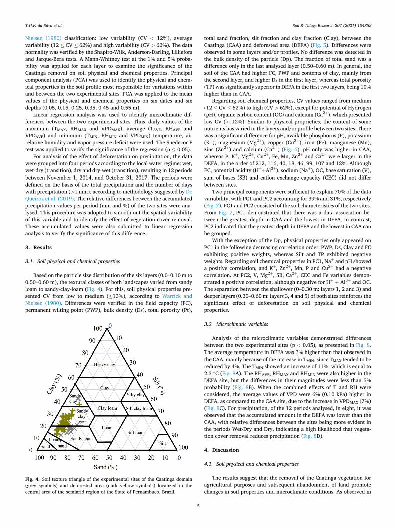
Based on the particle size distribution of the six layers (0.0–0.10 m to 0.50–0.60 m), the textural classes of both landscapes varied from sandy loam to sandy-clay-loam (Fig. 4). For this, soil physical properties pre-sented CV from low to medium (≤13%), according to Warrick and Nielsen (1980). Differences were verified in the field capacity (FC), permanent wilting point (PWP), bulk density (Ds), total porosity (Pt),
total sand fraction, silt fraction and clay fraction (Clay), between the Caatinga (CAA) and deforested area (DEFA) (Fig. 5). Differences were observed in some layers and/or profiles. No difference was detected in the bulk density of the particle (Dp). The fraction of total sand was a difference only in the last analysed layer (0.50–0.60 m). In general, the soil of the CAA had higher FC, PWP and contents of clay, mainly from the second layer, and higher Ds in the first layer, whereas total porosity (TP) was significantly superior in DEFA in the first two layers, being 10% higher than in CAA.
Regarding soil chemical properties, CV values ranged from medium (12 ≤ CV ≤ 62%) to high (CV > 62%), except for potential of Hydrogen (pH), organic carbon content (OC) and calcium (Ca2+), which presented low CV (< 12%). Similar to physical proprieties, the content of some nutrients has varied in the layers and/or profile between two sites. There was a significant difference for pH, available phosphorus (P), potassium (K+), magnesium (Mg2+), copper (Cu2+), iron (Fe), manganese (Mn), zinc (Zn2+) and calcium (Ca2+) (Fig. 6). pH only was higher in CAA, whereas P, K+, Mg2+, Cu2+, Fe, Mn, Zn2+ and Ca2+ were larger in the DEFA, in the order of 212, 116, 40, 18, 46, 99, 107 and 12%. Although EC, potential acidity (H++Al3+), sodium (Na+), OC, base saturation (V), sum of bases (SB) and cation exchange capacity (CEC) did not differ between sites.
Two principal components were sufficient to explain 70% of the data variability, with PC1 and PC2 accounting for 39% and 31%, respectively (Fig. 7). PC1 and PC2 consisted of the soil characteristics of the two sites. From Fig. 7, PC1 demonstrated that there was a data association be-tween the greatest depth in CAA and the lowest in DEFA. In contrast, PC2 indicated that the greatest depth in DEFA and the lowest in CAA can be grouped.
With the exception of the Dp, physical properties only appeared on PC1 in the following decreasing correlation order: PWP, Ds, Clay and FC exhibiting positive weights, whereas Silt and TP exhibited negative weights. Regarding soil chemical properties in PC1, Na+ and pH showed a positive correlation, and K+, Zn2+, Mn, P and Cu2+ had a negative correlation. At PC2, V, Mg2+, SB, Ca2+, CEC and Fe variables demon-strated a positive correlation, although negative for H+ + Al3+ and OC. The separation between the shallower (0–0.30 m: layers 1, 2 and 3) and deeper layers (0.30–0.60 m: layers 3, 4 and 5) of both sites reinforces the significant effect of deforestation on soil physical and chemical properties.
3.2. Microclimatic variables
Analysis of the microclimatic variables demonstrated differences between the two experimental sites (p < 0.05), as presented in Fig. 8. The average temperature in DEFA was 3% higher than that observed in the CAA, mainly because of the increase in TMIN, since TMAX tended to be reduced by 4%. The TMIN showed an increase of 11%, which is equal to 2.3 ◦C (Fig. 8A). The RHAVE, RHMAX and RHMIN were also higher in the DEFA site, but the differences in their magnitudes were less than 5% probability (Fig. 8B). When the combined effects of T and RH were considered, the average values of VPD were 6% (0.10 kPa) higher in DEFA, as compared to the CAA site, due to the increase in VPDMAX (7%) (Fig. 8C). For precipitation, of the 12 periods analysed, in eight, it was observed that the accumulated amount in the DEFA was lower than the CAA, with relative differences between the sites being more evident in the periods Wet-Dry and Dry, indicating a high likelihood that vegeta-tion cover removal reduces precipitation (Fig. 8D).
4. Discussion
4.1. Soil physical and chemical properties
The results suggest that the removal of the Caatinga vegetation for agricultural purposes and subsequent abandonment of land promote changes in soil properties and microclimate conditions. As observed in
Fig. 4. Soil texture triangle of the experimental sites of the Caatinga domain (grey symbols) and deforested area (dark yellow symbols) localized in the central area of the semiarid region of the State of Pernambuco, Brazil.
T.G.F. da Silva et al.
Soil & Tillage Research 207 (2021) 104852
6
the present study, it is expected that textural properties and soil particle size in two areas with the same classification will show little variability. We observed a slight difference in the clay fraction, which influences PWP. The highest clay content in the CAA implies more micropores, promoting higher soil water adsorption (Coelho et al., 2014). In turn, Ds values are more influenced by agricultural practices conducted on the land after deforestation. Lower Ds values were observed in the DEFA than in the CAA, reflecting an increase in total porosity (Pt). The agri-cultural practices exert a strong impact on soil physical properties but can also be influenced by cover crop species (Oliveira et al., 2020).
The CAA is affected by the grazing of animals such as cattle, goats and sheep, and sporadically by the removal of vegetation for use as firewood, without machinery input. Therefore, the absence of agricul-tural practices justifies high values of Ds and low values of Pt. In contrast, there have been no agricultural practices for years (i.e. ploughing and harrowing) in the DEFA. Actually, its surface is covered by herbaceous species combined with bare soil, and there are herding animals. This practice is quite common in small farms of the Brazilian semiarid region and has not yet demonstrated allowing deep soil compaction. However, herding animals, as well as rainfall impacts on bare soil, disrupt the soil surface particles, promoting reduction of water infiltration and movement to deeper layers, which may complicate agricultural cultivation (Medeiros et al., 2017; Ozkan and Gokbulak,
2017). In natural ecosystems, chemical properties of the soil extract are
affected by phytosociological fluctuation, litterfall deposition, plant absorption, meteorological conditions, soil texture and the leaching process (Ozkan and Gokbulak, 2017). In agricultural areas, soil chemical properties also depend on fertilization and crop rotation practices (Bertossi et al., 2016; Medeiros et al., 2017; Oliveira et al., 2020).
Magnitude alterations of many soil chemical components (pH, P, K+, Mg2+, Cu2+, Fe, Mn, Zn2+ and Ca2+) indicate soil degradation. A key factor in the levels of nutrients in CAA sites is litter cycling, which maintains minimum available levels for plants (Melo et al., 2017; De Queiroz et al., 2020). In the DEFA, with about 100 years of deforestation and long-term agricultural cultivation, low precipitation and high adsorption of nutrients increase the contents of elements such as P, K+, Mg2+, Cu2+, Fe, Mn, Zn2+ and Ca2+ (Melo et al., 2017). As mentioned in the literature, soil P exists in many forms, and only a small amount of the total P is available for plant uptake, besides being continually replen-ished from less available P (Blecourt et al., 2019). K+, Mg2+, Cu2+, Fe, Mn, Zn2+ and Ca2+ contents are affected by pH. In the DEFA, pH was slightly lower than CAA, which justifies the lower availability for the plants and higher accumulation of these elements (Melo et al., 2017). Effects of land use and changes in land cover on physic-chemical prop-erties are mentioned in several studies (Medeiros et al., 2017; Ozkan and
Fig. 5. Boxplot of the soil physical properties at different soil layers (0.00–0.10, 0.10–0.20, 0.20–0.30, 0.30–0.40, 0.40–0.50 and 0.50–0.60 m) in the Caatinga domain and deforested area localized in the central area of the semiarid region of the State of Pernambuco, Brazil. *, ** indicate significant differences by Mann- Whitney test at 1% and 5% probability, respectively, within the same layer between the experimental sites. Figures with a white background indicate that there was no difference between in the profiles of the two experimental sites, while the dark grey and light grey background show that there were differences at a 1% and 5% probability, respectively, by the same test. The red arrows up and down indicate the sites that presented the highest and lowest magnitude, respectively.
T.G.F. da Silva et al.
Soil & Tillage Research 207 (2021) 104852
7
Gokbulak, 2017; Schulz et al., 2016). The native vegetation deforestation by cattle grazing or crop pro-
duction can promote degradation and then induce desertification because grazing reduces the support vegetation and compacts the soil, increasing surface runoff with nutrient translocation. This process is even worse when combined with unsustainable agricultural production practices that result in low crop yields and economic returns to farmers, also leading to a discontinuity in agricultural activity and farmland abandonment (Bertossi et al., 2016; Becerril-Pina et al., 2015).
The separate grouping of the shallower (0–0.30 m) and deeper layers (0.30–0.60 m) of both sites reinforces the significant effect of defores-tation on soil physical and chemical properties. A similar trend was observed by Medeiros et al. (2017), when PCA was applied to the soil physical and chemical data of five areas, three with different natural regeneration stages of the vegetation (early-ER, intermediate-IR and late-LR) and two layers: 0–0.05 and 0.05–0.10 m. The PCA grouped three areas (ER, IR and LR) from the first layer, which supports that soil chemical, microbiological and biochemical parameters responded to natural regeneration stages.
4.2. Microclimatic variables
The slight decrease in TMAX in the DEFA site when compared with the CAA can be justified by increases in the surface albedo and wind speed during the diurnal period, reducing the radiation balance above the soil surface. In contrast, the significant rise in TN is associated with the en-ergy stored in the soil profile during the diurnal period, which is dissi-pated at night, warming up the air by irradiation (Silva et al., 2019a, 2019b; Teixeira et al., 2008). Domain deforestation causes TAVE to rise but depends on the type of vegetation removed, location and time of year, affecting the leaf area index seasonality, and consequently, solar energy penetration into the soil (Salazar et al., 2016). The increase in vapor pressure deficit also was observed by Silva et al. (2017) in pasture area when compared with the CAA, and by Hardwick et al. (2015) in palm crops as well as exploited and primary forest plantations (1.2, 0.3 and 0.2 kPa). Under higher VPD, the potential evapotranspiration can be increased (Montenegro and Ragab, 2012), reducing the soil moisture and further complicating rainfed cultivation.
Despite the spatial variability associated with precipitation even within the same surface, with the methodological procedures adopted in
Fig. 6. Boxplot of the chemical properties at different soil layers (0.00–0.10, 0.10–0.20, 0.20–0.30, 0.30–0.40, 0.40–0.50 and 0.50–0.60 m) in the Caatinga domain and deforested area localized in the central area of the semiarid region of the State of Pernambuco, Brazil. *, ** indicate significant differences by Mann-Whitney test at 1% and 5% probability, respectively, within the same layer between the experimental sites. The Figures with a white background indicate that there was no difference between the profiles of the two experimental sites, while the dark grey and light grey backgrounds show that there were differences at the 1% and 5% probability, respectively, by the same test. The red arrows up and down indicate the sites that presented the highest and lowest magnitude, respectively.
T.G.F. da Silva et al.
Soil & Tillage Research 207 (2021) 104852
8
this study it was possible to detect a probable and significant reduction in the magnitude of this variable in the DEFA site when compared with the CAA site, indicating that, besides possible intensification of the po-tential evapotranspiration, it is expected that the deforestation of the Caatinga domain promoted a reduction of the precipitation. This result is very possibly due to the decrease in the air humidity promoted by vegetation through transpiration. Plant cover has a positive effect on
local precipitation, and the volume is decreased due to vegetation cover reduction (Nega et al., 2019). Excessive removal of vegetation (>55% of the original surface) can significantly reduce the regional level of pre-cipitation (Panday et al., 2015). It is stated that more than 50% of the Caatinga vegetation cover has already been deforested (Althoff et al., 2018), which may justify the reduction in precipitation. Under this condition, there is a significant decrease in actual evapotranspiration in
Fig. 6. (continued).
Fig. 7. Association between the physical and chemical properties of the soil at different soil depths (Layer 1: 0.00–0.10, Layer 2: 0.10–0.20, Layer 3: 0.20–0.30, Layer 4: 0.30–0.40, Layer 5: 0.40–0.50 and Layer 6: 0.50–0.60 m) in sites of Caatinga (CAA) and deforested area (DEFA) localized in the central area of the semiarid region of the State of Pernambuco, Brazil. In Figure A, red circles indicate properties associ-ated with PC1 and blue circles indicate prop-erties associated with PC2. In Figure B, red squares indicate the soil layers and sites asso-ciated with PC1 and blue squares, the soil layers and sites associated with PC2.
T.G.F. da Silva et al.
Soil & Tillage Research 207 (2021) 104852
9
the dry season and a small increase in the wet season, impacting on the precipitation (Silva et al., 2019a,2019b). These results confirm the importance of the ecosystem services provided by the forest on the precipitation regime, and consequently for food production, greenhouse gas mitigation and climate regulation, as well as ensuring the economic stability of a region (Strand et al. 2018).
5. Conclusion
We examined two predominant landscapes of the Brazilian semiarid region and observed that Caatinga vegetation removal followed by agricultural practices and subsequent land abandonment affects the bulk density, promoting an increase in the total porosity of the soil. This result can be explained by low machinery use, which is a common practice on the small farms of the Brazilian semiarid region. Moreover, changes were verified in the magnitude of many chemical properties (pH, P, K+, Mg2+, Cu2+, Fe, Mn, Zn2+ and Ca2+), indicating soil degra-dation. Regarding the microclimate, Caatinga removal increased the air temperature and vapor pressure deficit, and it is very likely that reduces precipitation. Thus, we conclude that the changes in soil properties and microclimate promoted by Caatinga removal can contribute to advancement of desertification and affects agricultural activities in the Brazilian semiarid region.
Declaration of Competing Interest
The authors report no declarations of interest.
Acknowledgements
The authors of this paper would like to thanks the Research Support Foundation of the State of Pernambuco (APQ-0215-5.01/10 and APQ- 1159-1.07/14) and the National Council for Scientific and Technolog-ical Development (475279/2010-7, 476372/2012-7, 305286/2015-3, 309421/2018-7, and 152251/2018-9) for the financial support and to Coordination for the Improvement of Higher Education Personnel
(Finance Code 001) by the study grant.
References
Akhzari, D., Pessarakli, M., Ahandani, S.E., 2015. Effects of grazing intensity on soil and vegetation properties in a Mediterranean Rangeland. Commun. Soil Sci. Plant Anal. 46, 1–9. https://doi.org/10.1080/00103624.2015.1089272.
Althoff, T.D., Menezes, R.S.C., Pinto, A.S., Pareyn, F.G.C., Carvalho, A.L., Martins, J.C.R., Carvalho, E.X., Silva, A.S.A., Dutra, E.D., Sampaio, E.V.S.B., 2018. Adaptation of the century model to simulate C and N dynamics of Caatinga dry forest before and after deforestation. Agric. Ecosyst. Environ. 254, 26–34. https://doi.org/10.1016/j. agee.2017.11.016.
Becerril-Pina, R., Mastachi-Loza, C.A., Gonzalez-Sosa, E., Díaz-Delgado, C., Ba, K.M., 2015. Assessing desertification risk in the semi-arid highlands of central Mexico. J. Arid Environ. 120, 4–13. https://doi.org/10.1016/j.jaridenv.2015.04.006.
Beltran-Przekurat, A., Pielke, R.A., Eastman, J.L., Coughenour, M.B., 2012. Modelling the effects of land-use/land-cover changes on the near-surface atmosphere in southern South America. Int. J. Climatol. 32, 1206–1225. https://doi.org/10.1002/joc.2346.
Bertossi, A.P.A., Rocha Júnior, P.R., Ribeiro, P.H., Menezes, J.P.C., Cecílio, R.A., Andrade, F.V., 2016. Soil cover and chemical and physical attributes in oxisol in the Atlantic Forest Biome. Revista Arvore 40, 219–228. https://doi.org/10.1590/0100- 67622016000200004.
Blecourt, M., Grongroft, A., Baumann, S., Eschenbach, A., 2019. Losses in soil organic carbon stocks and soil fertility due to deforestation for low-input agriculture in semi- arid southern Africa. J. Arid Environ. 165, 88–96. https://doi.org/10.1016/j. jaridenv.2019.02.006.
Coelho H. R., V., Montenegro M. G. L., S., Almeida N., C., Lima R. V., E., Ribeiro Neto, A., Moura S. S., G., 2014. Dinamica do uso e ocupaçao do solo em uma bacia hidrografica do semiarido brasileiro. Revista Brasileira de Engenharia Agrícola e Ambiental 18, 64–72. https://doi.org/10.1590/S1415-43662014000100009.
Cooper, M., Mendes, L., Silva, W., Sparovek, G., 2005. A national soil profile database for Brazil available to international scientists. Soil Sci. Soc. Am. J. 69, 649–652. https:// doi.org/10.2136/sssaj2004.0140.
De Queiroz, M.G., Silva, T.G.F., Zolnier, S., Souza, C.A.A., Souza, L.S.B., Steidle Neto, A. J., Araújo, G.G.L., Ferreira, W.P.M., 2019. Seasonal patterns of deposition litterfall in a seasonal dry tropical forest. Agric. For. Meteorol. 279, 107712 https://doi.org/ 10.1016/j.agrformet.2019.107712.
De Queiroz, M.G., Silva, T.G., Zolnier, S., Jardim, A.M.R.F., Souza, C.A.A., Araujo Junior, G.N., Morais, J.E.F., Souza, L.S.B., 2020. Spatial and temporal dynamics of soil moisture for surfaces with a change in land use in the semi-arid region of Brazil. Catena 188, 104457. https://doi.org/10.1016/j.catena.2020.104457.
Fig. 8. Relationships between the microcli-matic variables of the Caatinga domain (CAA) and deforested area (DEFA) localized in the central area of the semiarid region of the State of Pernambuco, Brazil. Air temperature (A), air relative humidity (B), vapor pressure deficit (C) and precipitation (D). In Fig. 7D, the precipita-tion data were accumulated and presented for 12 periods: (1) Dry-Wet (10/26/2014 to 2/20/ 2015), (2) Wet (2/21/2015 to 7/23/2015), (3) Wet-Dry (7/27/2015 to 8/21/2015), (4) Dry (8/22/2015 to 12/7/2015), (5) Dry-Wet (12/8/ 2015 to 1/6/2016), (6) Wet (1/7/2016 to 2/1/ 2016), (7) Wet-Dry (2/2/2016 to 7/26/2016), (8) Dry (7/27/2016 to 11/17/2016), (9) Dry- Wet (11/18/2016 to 2/20/2017), (10) Wet (2/21/2017 to 7/1/2017), (11) Wet-Dry (7/2/ 2017 to 9/21/2017) and (12) Dry (9/22/2017 to 10/31/2017).
Empresa Brasileira de Pesquisa Agropecuaria - Embrapa, 2009. Manual De Analises Químicas De Solos, Plantas E Fertilizantes. 2 Nd. Empresa Brasileira de Pesquisa Agropecuaria, Brasília, DF.
Empresa Brasileira de Pesquisa Agropecuaria - Embrapa, 2013. Sistema brasileiro de classificaçao de solos. 3 rd. Empresa Brasileira de Pesquisa Agropecuaria, Rio de Janeiro.
Hajabbasi, M.A., Jalalian, A., Karimzadeh, H.R., 1997. Deforestation effects on soil physical and chemical properties, Lordegan, Iran. Plant Soil 301–308. https://doi. org/10.1023/A:1004243702208.
Hardwick, S.R., Toumi, R., Pfeifer, M., Turner, E.C., Nilus, R., Ewers, R.M., 2015. The relationship between leaf area index and microclimate in tropical forest and oil palm plantation: forest disturbance drives changes in microclimate. Agric. For. Meteorol. 201, 187–195. https://doi.org/10.1016/j.agrformet.2014.11.010.
Lemenih, M., Karltun, E., Olsson, M., 2005. Assessing soil chemical and physical property responses to deforestation and subsequent cultivation in smallholders farming system in Ethiopia. Agric. Ecosyst. Environ. 105, 373–386. https://doi.org/10.1016/ j.agee.2004.01.046.
Medeiros, E.V., Duda, G.P., Santos, L.A.R., Lima, J.R.S., Almeida-Cortez, J.S., Hammencker, C., Lardy, L., Cournac, L., 2017. Soil organic carbon, microbial biomass and enzyme activities responses to natural regeneration in a tropical dry region in Northeast Brazil. Catena 151, 137–146. https://doi.org/10.1016/j. catena.2016.12.012.
Melo, V.F., Orrutea, A.G., Motta, A.C.V., Testoni, A.S., 2017. Land use and changes in soil morphology and physical-chemical properties in southern Amazon. Revista Brasileira de Ciencia do Solo 41, 1–14. https://doi.org/10.1590/ 18069657rbcs20170034.
Menezes, R., Sampaio, E., Giongo, V., Perez-Marin, A., 2012. Biogeochemical cycling in terrestrial ecosystems of the Caatinga Biome. Braz. J. Biol. 72, 643–653. https://doi. org/10.1590/S1519-69842012000400004.
Miranda, E.E., 2005. Brazil in Relief. Embrapa Satellite Monitoring, Campinas (accessed 6 July 2020). http://www.relevobr.cnpm.embrapa.br.
Montenegro, S., Ragab, R., 2012. Impact of possible climate and land use changes in the semi arid regions: a case study from North Eastern Brazil. J. Hydrol. 434–435, 55–68. https://doi.org/10.1016/j.jhydrol.2012.02.036.
Nega, W., Tesfaw, B., Fetene, A., 2019. Remote Sensing Applications : Society and Environment An assessment of the vegetation cover change impact on rainfall and land surface temperature using remote sensing in a subtropical climate, Ethiopia. Remote. Sens. Appl. Soc. Environ. 16, 100266 https://doi.org/10.1016/j. rsase.2019.100266.
Oliveira, L.B., Fontes, M.P.F., Ribeiro, M.R., Ker, J.C., 2009. Morfologia e classificaçao de luvissolos e planossolos desenvolvidos de rochas metamorficas no Semiarido do Nordeste Brasileiro. Revista Brasileira de Ciencia do Solo 33, 1333–1345. https:// doi.org/10.1590/S0100-06832004000100014.
Oliveira, F.C.C., Ferreira, G.W.D., Souza, J.L.S., Vieira, M.E.O., Pedrotti, A., 2020. Soil physical properties and soil organic carbon content in northeast brazil: long-term. Sci. Agric. 77, e20180166 https://doi.org/10.1590/1678-992x-2018-0166.
Ozkan, U., Gokbulak, F., 2017. Effect of vegetation change from forest to herbaceous vegetation cover on soil moisture and temperature regimes and soil water chemistry. Catena 149, 158–166. https://doi.org/10.1016/j.catena.2016.09.017.
Panday, P.K., Coe, M.T., Macedo, M.N., Lefebre, P., Castanho, A.D.A., 2015. Deforestation offsets water balance changes due to climate variability in the Xingu
River in eastern Amazonia. J. Hydrol. 523, 822–829. https://doi.org/10.1016/j. jhydrol.2015.02.018.
Salazar, A., Katzfey, J., Thatcher, M., Syktus, J., Wrong, K., McAlpine, C., 2016. Deforestation changes land-atmosphere interactions across South American biomes. Glob. Planet. Change 139, 97–108. https://doi.org/10.1016/j. gloplacha.2016.01.004.
Schulz, K., Voigt, K., Beusch, C., Almeida-Cortez, J., Kowarik, I., Walz, A., Cierjacks, A., 2016. Grazing deteriorates the soil carbon stocks of Caatinga forest ecosystems in Brazil. For. Ecol. Manage. 367, 62–70. https://doi.org/10.1016/j. foreco.2016.02.011.
Silva, V.P.R., 2004. On climate variability in Northeast of Brazil. Journal of Arid Environmental 58, 575–596. https://doi.org/10.1016/j.jaridenv.2003.12.002.
Silva, V.P.R., Pereira, E.R.R.P., Azevedo, P.V., Sousa, F.A.S., Sousa, I.F., 2011. An analysis of rainfall and rainy days in the northeastern region of Brazil. Revista Brasileira de Engenharia Agrícola e Ambiental 15, 131–138. https://doi.org/ 10.1590/S1415-43662011000200004.
Silva, P.F.D., Lima, J.R.D.S., Antonino, A.C.D., Souza, R., Souza, E.S., Silva, J.R.I., Alves, E.M., 2017. Seasonal patterns of carbon dioxide, water and energy fluxes over the Caatinga and grassland in the semi-arid region of Brazil. J. Arid Environ. 147, 71–82. https://doi.org/10.1016/j.jaridenv.2017.09.003.
Silva, T.G.F., Souza, C.A.A., Moura, M.S.B., Marin, R.M., carvalho, H.F.S., Leitao, M.M.V. B.R., Galvíncio, J.D., 2019a. Energy balance, leaf emission and radiation use efficiency by sugarcane under cultivation with and without straw. Rev. Bras. Meteorol. 34, 69–78. https://doi.org/10.1590/0102-778633401.
Silva, H.J.F., Gonçalves, W.A., Bezerra, B.G., 2019b. Comparative analyzes and use of evapotranspiration obtained through remote sensing to identify deforested areas in the Amazon. Int. J. Appl. Earth Obs. Geoinf. 78, 163–174. https://doi.org/10.1016/ j.jag.2019.01.015.
Souza, L.S.B., Moura, M.S.B., Sediyama, G.C., Silva, T.G.F., 2011. Eficiencia do uso da agua das culturas do milho e do feijao-caupi sob sistemas de plantio exclusivo e consorciado no semiarido brasileiro. Bragantia 70, 715–721. https://doi.org/ 10.1590/S0006-87052011000300030.
Souza, L.S.B., Moura, M.S.B., Sediyama, G.C., Silva, T.G.F., 2015. Balanço de energia e controle biofísico da evapotranspiraçao na Caatinga em condiçoes de seca intensa. Pesquisa Agropecuaria Brasileira 50, 627–636. https://doi.org/10.1590/S0100- 204X2015000800001.
Teixeira, A.H.C., Bastiaanssen, W.G.M., Ahmad, M.D., Moura, M.S.B., Bos, M.G., 2008. Analysis of energy fluxes and vegetation-atmosphere parameters in irrigated and natural ecosystems of semi-arid Brazil. J. Hydrol. 362, 110–127. https://doi.org/ 10.1016/j.jhydrol.2008.08.011.
Vagen, T.G., Andrianorofanomezan, M.A.A., Andrianorofanomezan, S., 2006. Deforestation and cultivation effects on characteristics of oxisols in the highlands of Madagascar. Geoderma 131, 190–200. https://doi.org/10.1016/j. geoderma.2005.03.026.
Warrick, A.W., Nielsen, D.R., 1980. Spatial variability of physical properties in the field. In: HILLEL, D. (Ed.), Applications of Soil Physics. Academic Press, New York, NY, USA.
Zhao, W., Hu, Z., Li, S., Guo, Q., Liu, Z., Zhang, L., 2017. Comparison of surface energy budgets and feedbacks to microclimate among different land use types in an agro- pastoral ecotone of northern China. Sci. Total Environ. 599–600, 891–898. https:// doi.org/10.1016/j.scitotenv.2017.04.200.


![THE IMPACT OF ALTERNATIVE SOIL TILLAGE ON SOIL ......P[eter] (2012). The Impact of Alternative Soil Tillage on Soil Resistance and CO 2 Emissions, Chapter 30 in DAAAM International](https://static.documents.pub/doc/80x56/6111311bc227415001007bc4/the-impact-of-alternative-soil-tillage-on-soil-peter-2012-the-impact.jpg)


