HAL Id: hal-01761340 https://hal.archives-ouvertes.fr/hal-01761340 Preprint submitted on 9 Apr 2018 HAL is a multi-disciplinary open access archive for the deposit and dissemination of sci- entific research documents, whether they are pub- lished or not. The documents may come from teaching and research institutions in France or abroad, or from public or private research centers. L’archive ouverte pluridisciplinaire HAL, est destinée au dépôt et à la diffusion de documents scientifiques de niveau recherche, publiés ou non, émanant des établissements d’enseignement et de recherche français ou étrangers, des laboratoires publics ou privés. Some Churches Dedicated to the Holy Wisdom and their Sunrise Orientation Amelia Carolina Sparavigna, Lidia Dastrù To cite this version: Amelia Carolina Sparavigna, Lidia Dastrù. Some Churches Dedicated to the Holy Wisdom and their Sunrise Orientation. 2018. hal-01761340
Transcript
HAL Id: hal-01761340https://hal.archives-ouvertes.fr/hal-01761340
Preprint submitted on 9 Apr 2018
HAL is a multi-disciplinary open accessarchive for the deposit and dissemination of sci-entific research documents, whether they are pub-lished or not. The documents may come fromteaching and research institutions in France orabroad, or from public or private research centers.
L’archive ouverte pluridisciplinaire HAL, estdestinée au dépôt et à la diffusion de documentsscientifiques de niveau recherche, publiés ou non,émanant des établissements d’enseignement et derecherche français ou étrangers, des laboratoirespublics ou privés.
Some Churches Dedicated to the Holy Wisdom andtheir Sunrise Orientation
Amelia Carolina Sparavigna, Lidia Dastrù
To cite this version:Amelia Carolina Sparavigna, Lidia Dastrù. Some Churches Dedicated to the Holy Wisdom and theirSunrise Orientation. 2018. �hal-01761340�
Some Churches Dedicated to the Holy Wisdom and their
Sunrise Orientation
Amelia Carolina Sparavigna1 and Lidia Dastrù2
1 Department of Applied Science and Technology, Politecnico di Torino, Italy2 Ricercatrice Indipendente, Torino, Italy
Here we discuss the orientation of some churches dedicated to Hagia Sophia, the HolyWisdom. We can see that four of them have alignment along the direction of the sunrise
on solstices (one of the churches is Hagia Sophia in Constantinople). Our discussionfocuses, in particular, on alignments of the churches with respect to the decumani of the
town in which we find them, in the case the town had a planning of Roman origin(Constantinople, Thessaloniki and Sofia). For Hagia Sophia in Nicaea, we consider its
Hellenistic grid-plan with its streets, the plateiai, corresponding to the Roman decumani.
Submitted HAL, April 8, 2018.
The Holy Wisdom, in Greek Hagia Sophia, is a concept identified by the theology with
the Son of God. For this reason, throughout the Orthodox world in particular, we can
find several churches dedicated to the Holy Wisdom. These churches have as their
model the basilica of Constantinople, which is simply known as Hagia Sophia [1]. The
extant building dates to the 6th century. As explained in [2], we find dedication of some
churches to the Holy Wisdom also in Italy, in the case of churches built prior to the
Great Schism, the Schism of 1054 that separated the Roman Catholic Church and the
Eastern Orthodox churches.
Near-contemporary to the basilica in Constantinople, we have Saint Sofia in Sofia,
Bulgaria. In Thessaloniki, Greece, a church dedicated to Hagia Sofia was built in the 8th
century. Moreover, we find Santa Sofia in Benevento, built in the 8th century too, and
Santa Sofia in Venice of the 9th century. Of course, churches dedicated to Holy Wisdom
have to be distinguished from churches dedicated to the martyr Sophia of Rome, or to
one of the other saints with this name.
Here we will focus our discussion on the orientation of the churches dedicated to the
Holy Wisdom, built before the 10th century. We can see that they are aligned along the
direction of the sunrise, with their apses on the eastern part of the church. Hagia Sophia
in Constantinople and Thessaloniki are oriented to the sunrise on winter solstice,
whereas Santa Sofia in Venice and Benevento are oriented to the sunrise on the summer
solstice. We will discuss in particular the alignment of the churches in Constantinople,
Thessaloniki and Sofia, with respect to the decumanus of their towns, which had a
roman origin and consequently a roman town-planning based on a regular grid of
streets. For the analysis Hagia Sophia in Nicaea, we consider its hellenistic grid-plan
with its streets, the plateiai, corresponding to the roman decumani.
Figure 1: Hagia Sophia in Constantinople and the direction of sunrise on winter solstice.
Constantinople
As explained in [3], a book which is discussing Hagia Sophia in Constantinople, the
influx of light into its interior is directly dependent on the orientation of the building in
relation to the sun. In [3], it is stressed that the basilica has its longitudinal axis aligned
along the azimuth of the sunrise on the shortest day of the year (winter solstice).
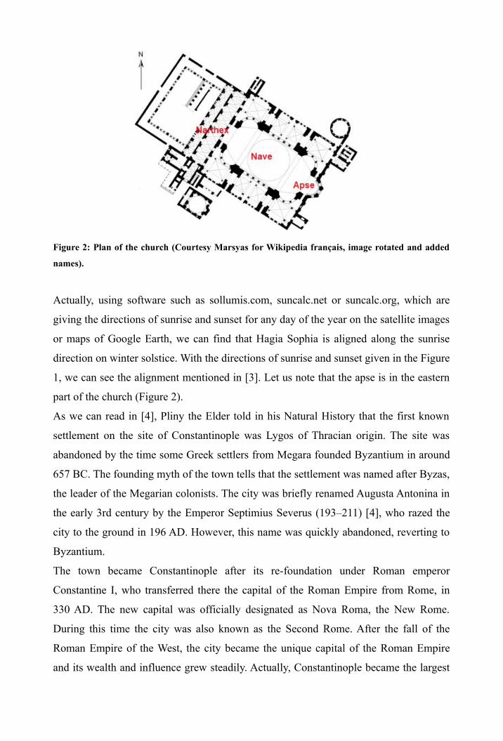
Figure 2: Plan of the church (Courtesy Marsyas for Wikipedia français, image rotated and added
names).
Actually, using software such as sollumis.com, suncalc.net or suncalc.org, which are
giving the directions of sunrise and sunset for any day of the year on the satellite images
or maps of Google Earth, we can find that Hagia Sophia is aligned along the sunrise
direction on winter solstice. With the directions of sunrise and sunset given in the Figure
1, we can see the alignment mentioned in [3]. Let us note that the apse is in the eastern
part of the church (Figure 2).
As we can read in [4], Pliny the Elder told in his Natural History that the first known
settlement on the site of Constantinople was Lygos of Thracian origin. The site was
abandoned by the time some Greek settlers from Megara founded Byzantium in around
657 BC. The founding myth of the town tells that the settlement was named after Byzas,
the leader of the Megarian colonists. The city was briefly renamed Augusta Antonina in
the early 3rd century by the Emperor Septimius Severus (193–211) [4], who razed the
city to the ground in 196 AD. However, this name was quickly abandoned, reverting to
Byzantium.
The town became Constantinople after its re-foundation under Roman emperor
Constantine I, who transferred there the capital of the Roman Empire from Rome, in
330 AD. The new capital was officially designated as Nova Roma, the New Rome.
During this time the city was also known as the Second Rome. After the fall of the
Roman Empire of the West, the city became the unique capital of the Roman Empire
and its wealth and influence grew steadily. Actually, Constantinople became the largest
and wealthiest city in Europe during the 4th–13th centuries and also a center of culture
and education of the Mediterranean basin. It was also defined the Megalopolis of the
world.
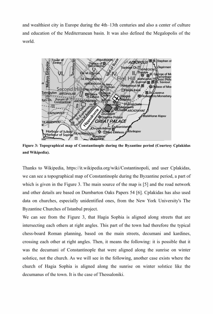
Figure 3: Topographical map of Constantinople during the Byzantine period (Courtesy Cplakidas
and Wikipedia).
Thanks to Wikipedia, https://it.wikipedia.org/wiki/Costantinopoli, and user Cplakidas,
we can see a topographical map of Constantinople during the Byzantine period, a part of
which is given in the Figure 3. The main source of the map is [5] and the road network
and other details are based on Dumbarton Oaks Papers 54 [6]. Cplakidas has also used
data on churches, especially unidentified ones, from the New York University's The
Byzantine Churches of Istanbul project.
We can see from the Figure 3, that Hagia Sophia is aligned along streets that are
intersecting each others at right angles. This part of the town had therefore the typical
chess-board Roman planning, based on the main streets, decumani and kardines,
crossing each other at right angles. Then, it means the following: it is possible that it
was the decumani of Constantinople that were aligned along the sunrise on winter
solstice, not the church. As we will see in the following, another case exists where the
church of Hagia Sophia is aligned along the sunrise on winter solstice like the
decumanus of the town. It is the case of Thessaloniki.
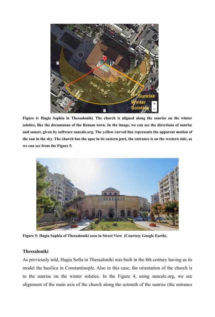
Figure 4: Hagia Sophia in Thessaloniki. The church is aligned along the sunrise on the winter
solstice, like the decumanus of the Roman town. In the image, we can see the directions of sunrise
and sunset, given by software suncalc.org. The yellow curved line represents the apparent motion of
the sun in the sky. The church has the apse in its eastern part, the entrance is on the western side, as
we can see from the Figure 5.
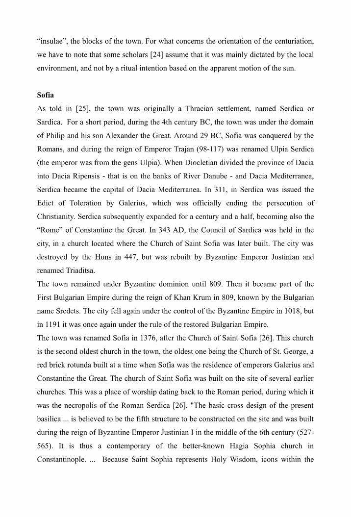
Figure 5: Hagia Sophia of Thessaloniki seen in Street View (Courtesy Google Earth).
Thessaloniki
As previously told, Hagia Sofia in Thessaloniki was built in the 8th century having as its
model the basilica in Constantinople. Also in this case, the orientation of the church is
to the sunrise on the winter solstice. In the Figure 4, using suncalc.org, we see
alignment of the main axis of the church along the azimuth of the sunrise (the entrance
is in the western part of the church, Figure 5). This alignment was proposed in [7],
where it is also discussed that the church had its axis fixed by the ancient decumanus of
the town. It means that this decumanus had the same solstice alignment too.
For what concerns the town, let us remember that Thessaloniki was founded around 315
BC by the Macedon King Cassander. After the fall of the kingdom of Macedonia, in 148
BC Thessaloniki became the capital of the Roman province of Macedonia. Later, the
town became the capital of all the Greek provinces of the Roman Empire, besides being
an important trade center on the Via Egnatia, the road that was linking Rome, through
Dyrrhachium (Durazzo in Italian), with Byzantium [8]. In Thessaloniki, the Via Egnatia
was also the largest of the decumani, that is, the main road of the town.
In [7], the author studied the orientation of 32 churches in Thessaloniki, which were
built from the 4th to the 20th century. The work investigated a possible astronomical
alignment to “any significant solar date or to the date of the patron saint’s festival”. The
author found that the majority of buildings (16) follow the city grid, which is fixed by
the Roman decumanus. “Buildings outside the Roman city have a variety of
orientations. There are 7 cases of alignment on the patron’s saint day (5 positive and 2
indecisive). However, the alignment may be to the sunrise (3) or to the byzantine Third
Hour (4), the time the Divine Liturgy reaches its climax” [7]. In [7], the author
concluded that the analysis of the churches in Thessaloniki is fundamental for the study
of the orientation of byzantine churches in general, “as it points to multiple solutions to
the problem of the orientation towards the sunrise on patron saint’s feast day”.
We have seen that two churches dedicated to Hagia Sophia are oriented to the sunrise on
the winter solstice. However, it is probable that these churches had been constrained to
this alignment, because the places where they were built had the streets oriented to this
specific sunrise. Actually, an alignment of the decumani to the sunrise on solstices is
exhibited by several Roman towns [9-16].
In general, as discussed in [17-24], the Romans had a method of land surveying, known
as centuriation or limitation, which was based on a regular grid of streets. The main
streets are known as decumanus and kardo. In the Latin literature on surveying, it is told
that the decumanus maximus, the main decumanus, was oriented towards the sunrise on
the day of the foundation or on a date of specific importance for the town [17]. The
kardo maximus was fixed perpendicular to the decumanus, the two streets dividing the
town in four main parts. Other parallel decumani and kardines were creating the
“insulae”, the blocks of the town. For what concerns the orientation of the centuriation,
we have to note that some scholars [24] assume that it was mainly dictated by the local
environment, and not by a ritual intention based on the apparent motion of the sun.
Sofia
As told in [25], the town was originally a Thracian settlement, named Serdica or
Sardica. For a short period, during the 4th century BC, the town was under the domain
of Philip and his son Alexander the Great. Around 29 BC, Sofia was conquered by the
Romans, and during the reign of Emperor Trajan (98-117) was renamed Ulpia Serdica
(the emperor was from the gens Ulpia). When Diocletian divided the province of Dacia
into Dacia Ripensis - that is on the banks of River Danube - and Dacia Mediterranea,
Serdica became the capital of Dacia Mediterranea. In 311, in Serdica was issued the
Edict of Toleration by Galerius, which was officially ending the persecution of
Christianity. Serdica subsequently expanded for a century and a half, becoming also the
“Rome” of Constantine the Great. In 343 AD, the Council of Sardica was held in the
city, in a church located where the Church of Saint Sofia was later built. The city was
destroyed by the Huns in 447, but was rebuilt by Byzantine Emperor Justinian and
renamed Triaditsa.
The town remained under Byzantine dominion until 809. Then it became part of the
First Bulgarian Empire during the reign of Khan Krum in 809, known by the Bulgarian
name Sredets. The city fell again under the control of the Byzantine Empire in 1018, but
in 1191 it was once again under the rule of the restored Bulgarian Empire.
The town was renamed Sofia in 1376, after the Church of Saint Sofia [26]. This church
is the second oldest church in the town, the oldest one being the Church of St. George, a
red brick rotunda built at a time when Sofia was the residence of emperors Galerius and
Constantine the Great. The church of Saint Sofia was built on the site of several earlier
churches. This was a place of worship dating back to the Roman period, during which it
was the necropolis of the Roman Serdica [26]. "The basic cross design of the present
basilica ... is believed to be the fifth structure to be constructed on the site and was built
during the reign of Byzantine Emperor Justinian I in the middle of the 6th century (527-
565). It is thus a contemporary of the better-known Hagia Sophia church in
Constantinople. ... Because Saint Sophia represents Holy Wisdom, icons within the
church depict Sophia as Christ Emmanuel, a young figure of Christ seated on a
rainbow" [26].
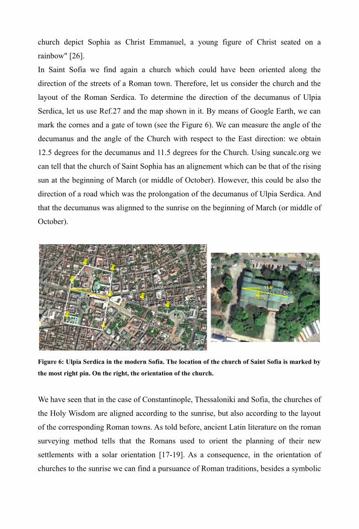
In Saint Sofia we find again a church which could have been oriented along the
direction of the streets of a Roman town. Therefore, let us consider the church and the
layout of the Roman Serdica. To determine the direction of the decumanus of Ulpia
Serdica, let us use Ref.27 and the map shown in it. By means of Google Earth, we can
mark the cornes and a gate of town (see the Figure 6). We can measure the angle of the
decumanus and the angle of the Church with respect to the East direction: we obtain
12.5 degrees for the decumanus and 11.5 degrees for the Church. Using suncalc.org we
can tell that the church of Saint Sophia has an alignement which can be that of the rising
sun at the beginning of March (or middle of October). However, this could be also the
direction of a road which was the prolongation of the decumanus of Ulpia Serdica. And
that the decumanus was alignned to the sunrise on the beginning of March (or middle of
October).
Figure 6: Ulpia Serdica in the modern Sofia. The location of the church of Saint Sofia is marked by
the most right pin. On the right, the orientation of the church.
We have seen that in the case of Constantinople, Thessaloniki and Sofia, the churches of
the Holy Wisdom are aligned according to the sunrise, but also according to the layout
of the corresponding Roman towns. As told before, ancient Latin literature on the roman
surveying method tells that the Romans used to orient the planning of their new
settlements with a solar orientation [17-19]. As a consequence, in the orientation of
churches to the sunrise we can find a pursuance of Roman traditions, besides a symbolic
orientation to the "cosmic sign of the rising sun which symbolizes the universality of
God" [28].
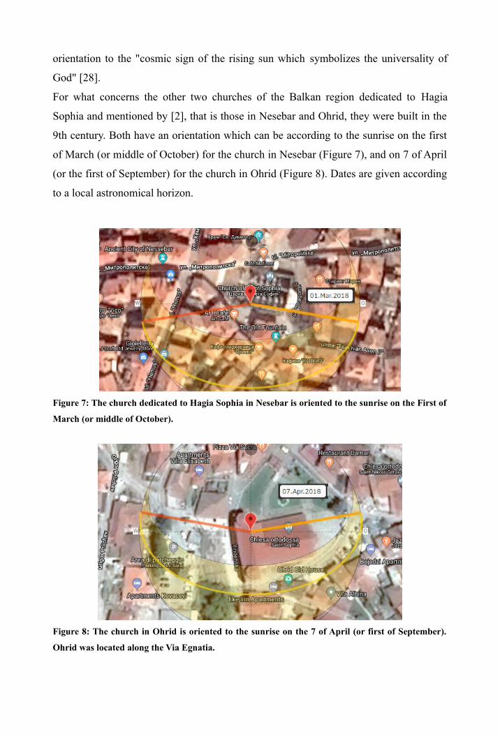
For what concerns the other two churches of the Balkan region dedicated to Hagia
Sophia and mentioned by [2], that is those in Nesebar and Ohrid, they were built in the
9th century. Both have an orientation which can be according to the sunrise on the first
of March (or middle of October) for the church in Nesebar (Figure 7), and on 7 of April
(or the first of September) for the church in Ohrid (Figure 8). Dates are given according
to a local astronomical horizon.
Figure 7: The church dedicated to Hagia Sophia in Nesebar is oriented to the sunrise on the First of
March (or middle of October).
Figure 8: The church in Ohrid is oriented to the sunrise on the 7 of April (or first of September).
Ohrid was located along the Via Egnatia.
Nicaea
The Nicaea (or Nicea), in northwestern Anatolia, is mainly known in the history of the
Christian Church as the site of the First and Second Councils of Nicaea. The ancient
town is located within the modern İznik. As told in [29], the place is said to have been
colonized by Bottiaeans or by soldiers of Alexander the Great's army. “Whatever the
truth, the first Greek colony on the site was probably destroyed by the Mysians” [29].
Antigonus Monophthalmus, one of Alexander's successors, made a second foundation
of the city ca. 315 BC as Antigoneia. “Following Antigonus' defeat and death at the
Battle of Ipsus in 301 BC, the city was captured by Lysimachus, who renamed it
Nicaea” in tribute to his wife [29]. Sometime before 280 BC, Nicaea came under the
control of the kings of Bithynia, and then, along with the rest of Bithynia, Nicaea came
under the rule of the Roman Republic in 72 BC.
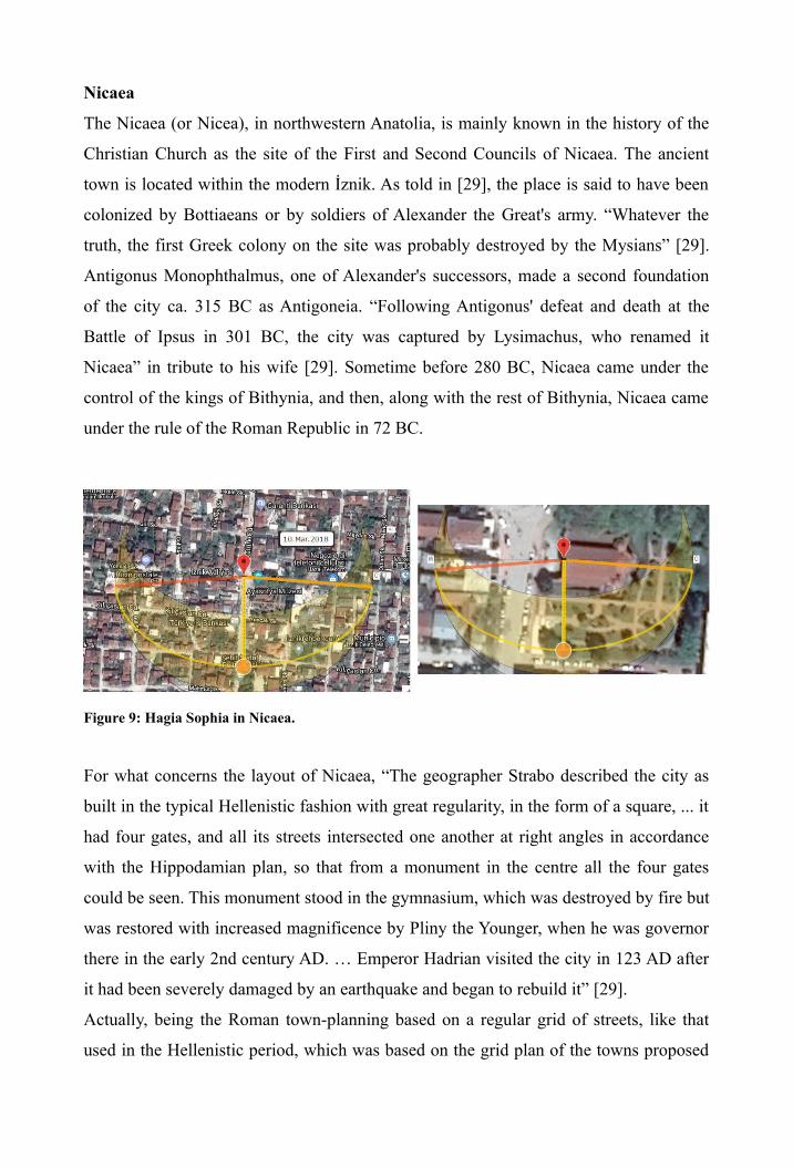
Figure 9: Hagia Sophia in Nicaea.
For what concerns the layout of Nicaea, “The geographer Strabo described the city as
built in the typical Hellenistic fashion with great regularity, in the form of a square, ... it
had four gates, and all its streets intersected one another at right angles in accordance
with the Hippodamian plan, so that from a monument in the centre all the four gates
could be seen. This monument stood in the gymnasium, which was destroyed by fire but
was restored with increased magnificence by Pliny the Younger, when he was governor
there in the early 2nd century AD. … Emperor Hadrian visited the city in 123 AD after
it had been severely damaged by an earthquake and began to rebuild it” [29].
Actually, being the Roman town-planning based on a regular grid of streets, like that
used in the Hellenistic period, which was based on the grid plan of the towns proposed
by Hippodamus of Miletus (498 - 408 BC), it seems probable that Hadrian had
maintained the original layout of the streets of Nicaea. In the Hellenistic town-planning,
the main streets were the plateiai, the analog of the Roman decumani.
Nicaea has its Hagia Sophia of the Byzantine period. The church was built by Justinian I
in the 6th century [30]. It was in this building that the Second Council of Nicaea met in
787. As we can see from the Figure 9, the church has an orientation which is the same of
the plateiai (decumani) of the town. A solar orientation is possible, for sunrise on March
10 or October 3, according to the astronomical horizon.
Santa Sofia in Italy
As told in [2], “The dedication of the Hagia Sophia of Constantinople under Justin II
served as a template for the dedication of other Byzantine churches as well as early
medieval churches in Italy prior to the Great Schism”. And therefore we have Santa
Sofia in Benevento built in the 8th century, and Santa Sofia in Venice built in the 9th
century. Let us consider them.
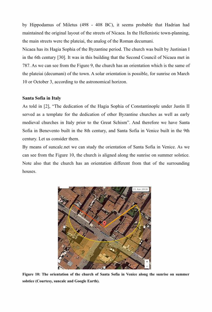
By means of suncalc.net we can study the orientation of Santa Sofia in Venice. As we
can see from the Figure 10, the church is aligned along the sunrise on summer solstice.
Note also that the church has an orientation different from that of the surrounding
houses.
Figure 10: The orientation of the church of Santa Sofia in Venice along the sunrise on summer
solstice (Courtesy, suncalc and Google Earth).
In [31], we read that a wooden church of Saint Sofia in Venice is documented in
chronicles from 886. The construction of the church began in 1020, but it was the
subject of a major reconstruction from 1507-1534. Then a late-1600s reconstruction was
made by architect Antonio Gaspari.
For what concerns the church in Benevento, we learn from [32] that this church is one
of the main surviving examples of Lombard architecture. The church was founded by
the Lombard Arechis II of Benevento around 760. The edifice was modeled on the
Palatine Chapel of King Liutprand in Pavia. After the defeat of Desiderius by
Charlemagne, and the consequent fall of the Lombards in the northern Italy (774), Santa
Sofia in Benevento became the national church of the Lombards, who had taken shelter
in the Duchy of Benevento [32]. Arechis dedicated the church to the Hagia Sophia, like
the basilica in Constantinople.
“The church was severely damaged by an earthquake in 1688 and another in 1702. …
Cardinal Orsini, the future Pope Benedict XIII, had the church rebuilt in Baroque style.
The restoration work, started in 1705, transformed the plan from a stellar to a circular
one, added two side chapels, and changed the appearance of the apse, of the façade and
of the pillars. … In 1957 most of the original appearance was restored, basing on
evidence from historical documentation, with the exception of the Baroque façade”
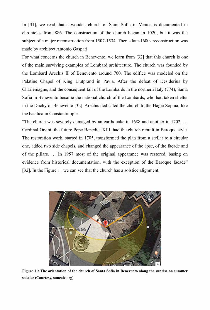
[32]. In the Figure 11 we can see that the church has a solstice alignment.
Figure 11: The orientation of the church of Santa Sofia in Benevento along the sunrise on summer
solstice (Courtesy, suncalc.org).
For what concerns the case of Venice, the rii and calli, the “streets” of the town have a
regularity which deserve of being investigated in a future work. For Benevento, the
Roman town had three main decumani, two of them can be identified with Via Garibaldi
e Via Annunziata. Their direction is close to the direction of the sunrise on the winter
solstice, and therefore different form the orientation of Santa Sofia.
Discussion
In this article we have discussed the orientation of some churches dedicated to the Hagia
Sophia and built before the 10th century. They had as a model Hagia Sophia in
Constantinople. For this church, and for Hagia Sophia of Thessaloniki and Sofia,
Bulgaria, we can find a solar orientation. But this orientation is the same of the streets of
the Roman town in which they were built. The same is true for the Hagia Sophia in
Nicaea, which has the same orientation of the grid of the streets of the town, which is
probably the same grid of the Hellenistic period. As a consequence, it is possible that
the orientation of these churches was constrained by the local urban planning, and not
deliberately chosen by their architects. We have also investigated other churches
dedicated to Hagia Sophia, in Venice and Benevento, and also those in Padua, Drama
and Nicosia, of the 10th and 11th century. These churches display a solar orientation
too. Other churches dedicated to the Holy Wisdom are given in the list
en.wikipedia.org/wiki/List_of_churches_dedicated_to_Holy_Wisdom. From the satellite
images, it is not easy to determine the position of the apse in the churches, but they do
not seems to display an orientation to the direction of the sunrise.
References
[1] Owen Jarus. March 1, 2013. Hagia Sophia: Facts, History & Architecture. Live
Science, Available at www.livescience.com/27574-hagia-sophia.html
[2] en.wikipedia.org/wiki/Holy_Wisdom
[3] Nadine Schibille (2016). Hagia Sophia and the Byzantine Aesthetic Experience,