24
Somerleyton Conservation Area Management Plan Written by Dr. Paul Bradley and James Darwin, and the Waveney District Council Design & Conservation Team March 2011

Somerleyton Conservation Area
Management Plan
Written by
Dr. Paul Bradley and
James Darwin, and the
Waveney
District Council
Design &
Conservation Team
March 2011
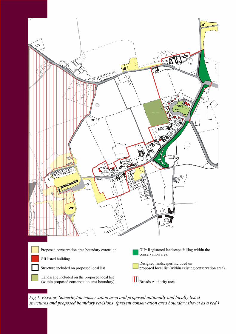
Fig 1. Existing Somerleyton conservation area and proposed nationally and locally listed
structures and proposed boundary revisions (present conservation area boundary shown as a red )
Proposed conservation area boundary extension GII* Registered landscape falling within the
conservation area.
GII listed building
Designed landscapes included on
Structure included on proposed local list proposed local list (within existing conservation area).
Landscape included on the proposed local list
(within proposed conservation area boundary). Broads Authority area

Somerleyton Conservation Area
Management Plan
This plan aims to address the issues and
recommendations for action that have
arisen from the conservation area
appraisal undertaken in 2010. A
photographic survey has been completed,
and change will be regularly monitored.
Contents
Page 2: Map of Somerleyton showing
proposed revisions to the boundary of
the conservation area, and buildings
which make a positive contribution to
the area (local list).
Page 3: Introduction
Page 4: Maintenance and
conservation
Page 5: Boundary revision
Page 5: Action
Page 6: Map showing significant green
spaces, registered parkland and
designed landscapes within the
proposed extensions to the conservation
area
Page 7: Map showing important views
within the existing and proposed
conservation area.
Page 11: Appendix 1: Addresses within
proposed extensions to the Somerleyton
Conservation Area
Page 12: Appendix 2: Local list
descriptions within proposed extensions
to the Somerleyton conservation area
Page 20: Appendix 3: Local list
descriptions for buildings in
Somerleyton outside the proposed
conservation area
Page 23: Appendix 4: Structures
outside the proposed Somerleyton
conservation area for assessment for
spot listing
Broads Authority area

Maintenance and conservation
Prevalent and traditional building
materials and details
All new development within the
conservation area should demonstrate an
awareness of the established local style,
materials and details. For reference, a
selection of these is given on pages 17 & 18
of the Somerleyton conservation area
appraisal.
Condition and buildings at risk
Generally the buildings of Somerleyton are
well cared for. There are no buildings
thought to be at serious risk, although a
number of proposed locally listed historic
farm buildings are showing signs of
disrepair.
Green Spaces and trees
It is desirable to preserve these important
spaces in an undeveloped form. They are
shown coloured green on the map on page 6.
Of particular note are The Green and the
associated allotments to the west, which add
considerable character to the conservation
area, as well as important amenity space.
Pressure for development often leads to the
subdivision of larger gardens to provide
space for new houses. Given the
considerable contribution the well-kept
gardens of Somerleyton make to the
character of the conservation area and to the
setting of individually designated historic
assets, any further moves to build within
them should be approached with
considerable caution
Fig 2, General view of The Green
Fig 3, General view of The Street
Fig 4, General view of the
allotments, to the rear of The Green
Boundary Revision
Suggested boundary changes
Currently excluded from the
conservation area are significant historic
elements of the village to the north,
southeast and west, namely:
• West Lodge, Market Lane. Mid
nineteenth century gate lodge to
Somerleyton Hall.
• No’s 1 to 22, Brickfields Cottages.
Three rows of mid nineteenth century
workers’ cottages.
• Remains of Belgian kiln at former
bricks works site.
• The Cut or Wherry Dyke - site of Sir
Christopher Cockerell’s pioneering
experiments in the development of the
hovercraft and adjoining cottage.
(Broads Authority area)
• Dukes Head Public House and
outbuildings, Slugs Lane. (Broads
Authority area)
• Sections of the brick wall encircling
the Somerleyton Estate.
• Nos. 21-24 (cons) Claypit Cottages,
St. Olaves Road. A late eighteenth or
early nineteenth century terrace of 4
cottages.
Article 4(2) directions for extensions
It is recommended that the article 4(2)
direction, needed to bring the
Somerleyton conservation area
protection in line with most other
conservation areas in Waveney, be
imposed also within the proposed
extensions to it. (See ‘Further Protection
through an Article 4(2) direction’,
below).
Owners or occupiers of premises within
the Broads Authority area of the
extended conservation area are advised
to check with the Broads Authority
before carrying out works.
Proposed locally listed structures and
landscapes within extensions to the
conservation area
Shown on the maps on page 2 and page 7,
and described in Appendix 2.
Action
Further protection through an Article 4
(2) direction
In Somerleyton the potential degradation
of elements of façades of buildings, which
is not prevented by the standard
conservation area legislation already in
place, in particular of doors and windows,
is cause for concern, and serious
consideration should be given to the
provision of added protection through an
Article 4(2) direction. This is already in
place in all the towns, and many of the
village conservation areas in Waveney.
Article 4(2) directions make further
restrictions on permitted development
rights to residential properties in
conservation areas. Once these have been
imposed in an area, it means that planning
permission will be required to make any
change of design or material to any part of
the property facing a public thoroughfare.
Because these controls are a removal of
what would otherwise be ‘permitted
development’, the planning application is
free. Elevations of a property not visible
from a public place are not affected and
these enjoy the normal ‘permitted
development’ rights for a conservation
area.
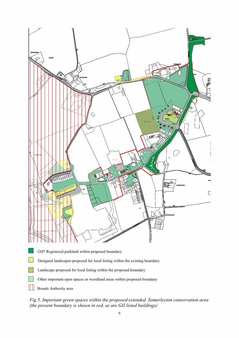
Proposed Boundary Revisions
6
GII* Registered parkland within proposed boundary
Designed landscapes proposed for local listing within the existing boundary
Landscape proposed for local listing within the proposed boundary
Other important open spaces or woodland areas within proposed boundary
Broads Authority area
Fig 5. Important green spaces within the proposed extended Somerleyton conservation area
(the present boundary is shown in red, as are GII listed buildings)

7
Fig 6. Map showing key views in Somerleyton denoted with arrows (present conservation area
boundary marked in red)
Proposed conservation area boundary GII listed buildings
GII* registered landscape within the boundary Structures included on the proposed
local list
Proposed local listed landscapes (within existing
conservation area boundary) Proposed locally listed landscape (within
proposed conservation area boundary)
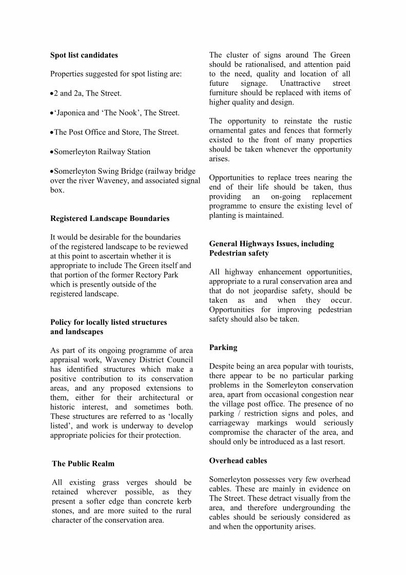
Spot list candidates
Properties suggested for spot listing are:
•2 and 2a, The Street.
•‘Japonica and ‘The Nook’, The Street.
•The Post Office and Store, The Street.
•Somerleyton Railway Station
•Somerleyton Swing Bridge (railway bridge
over the river Waveney, and associated signal
box.
Registered Landscape Boundaries
It would be desirable for the boundaries
of the registered landscape to be reviewed
at this point to ascertain whether it is
appropriate to include The Green itself and
that portion of the former Rectory Park
which is presently outside of the
registered landscape.
Policy for locally listed structures
and landscapes
As part of its ongoing programme of area
appraisal work, Waveney District Council
has identified structures which make a
positive contribution to its conservation
areas, and any proposed extensions to
them, either for their architectural or
historic interest, and sometimes both.
These structures are referred to as ‘locally
listed’, and work is underway to develop
appropriate policies for their protection.
The Public Realm
All existing grass verges should be
retained wherever possible, as they
present a softer edge than concrete kerb
stones, and are more suited to the rural
character of the conservation area.
The cluster of signs around The Green
should be rationalised, and attention paid
to the need, quality and location of all
future signage. Unattractive street
furniture should be replaced with items of
higher quality and design.
The opportunity to reinstate the rustic
ornamental gates and fences that formerly
existed to the front of many properties
should be taken whenever the opportunity
arises.
Opportunities to replace trees nearing the
end of their life should be taken, thus
providing an on-going replacement
programme to ensure the existing level of
planting is maintained.
General Highways Issues, including
Pedestrian safety
All highway enhancement opportunities,
appropriate to a rural conservation area and
that do not jeopardise safety, should be
taken as and when they occur.
Opportunities for improving pedestrian
safety should also be taken.
Parking
Despite being an area popular with tourists,
there appear to be no particular parking
problems in the Somerleyton conservation
area, apart from occasional congestion near
the village post office. The presence of no
parking / restriction signs and poles, and
carriageway markings would seriously
compromise the character of the area, and
should only be introduced as a last resort.
Overhead cables
Somerleyton possesses very few overhead
cables. These are mainly in evidence on
The Street. These detract visually from the
area, and therefore undergrounding the
cables should be seriously considered as
and when the opportunity arises.

Future development
Policy CS01 of the Waveney Core
Strategy 2009 directs most new
development, including housing, to the
main towns, with only limited
opportunities within larger villages.
Generally, it will be expected that
development will take place on previously
developed land and take into particular
account Core Strategy Policies CS02,
CS11 and CS17, Development
Management Policies DM02, DM22 and
DM20, and Planning Policy Statement
PPS5 ‘Planning for the Historic
Environment’.
Fig 8, ‘Japonica ‘ and ‘The Nook’, The Street
Somerleyton Conservation Area— Parking and Pedestrian Safety
Fig 7, Post Office, The Street

Fig 10 , Claypit Cottages, No’s 21 to 24, Saint Olaves Road
Fig 9, West Lodge to Somerleyton Hall, Market Lane
Appendix 1:
Addresses within proposed extensions to
the Somerleyton conservation area.
NORTH EXTENSION.
Market Lane
West Lodge
Park wall
WEST EXTENSION.
St. Olaves Road
No’s 21 to 24 (cons), Claypit Cottages
The Green
Allotments behind The Green
SOUTH WEST EXTENSION.
Slugs Lane
Dukes Head Public House and outbuildings
Brickfields (off Slugs Lane)
No’s 1 to 22 Brickfields Cottages
Staithe Cottage and outbuildings
Staithe Lane
Lime Kiln Cottage and outbuilding
Wherry Dyke and Crown Boat Yard
Remains of Belgian brick kiln at former brick
works site
Fig 7. West Lodge, Market Lane
Fig 12, Park wall, Market Lane
Fig 13, Dukes Head Public House, Slugs
Lane
Somerleyton Conservation Area—Addresses of properties in proposed extensions
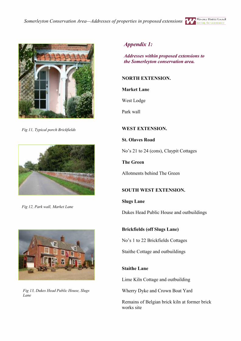
Fig 11, Typical porch Brickfields

Appendix 2:
Proposed locally listed buildings, sites
of industrial archaeological interest,
and designed landscapes within the
Somerleyton conservation area
extensions.
Nb. It is possible that the West Lodge and
park wall to Somerleyton Hall enjoy
additional protection as curtilage
structures to the GII* listed Hall. The
lodge and walls also fall within the Hall’s
GII* registered landscape.
NORTH EXTENSION
Market Lane (Eastern Side)
Park Wall
A substantial brick wall marking the
boundary of Somerleyton Hall park which
runs along the eastern side of Market Lane
starting at the West Lodge and terminating
at the entrance drive to Park Cottage. The
wall was probably constructed as part of
Sir Morton Peto’s improvements to the
estate c1850. It is built of English bond
with semi-circular brick coping resting on
a projecting canted brick course.
Projecting plinth. (Please note that parts of
this wall are already within the
conservation area). Forms the boundary of
the GII* registered landscape.
West Lodge
Lodge House to Somerleyton Hall
probably designed by John Thomas for Sir
Samuel Morton Peto, altered mid twentieth
century. The lodge was built shortly after
1848 when this drive was created, and is
described within the 1861 sales particulars
for the estate. A single-storey thatched
structure in cottage ornee style which is
similar in form to a single-storey slate-
roofed estate cottage on the Blundeston
Rd. Roughcast rendered brick with painted
wooden casement windows, overhanging
eaves, and simple wooden bargeboards.
Principal elevation to drive of two bays,
the right-hand bay projects and has a gable
and a thatched-roofed bay window. Within
the projecting bay’s western elevation is a
boarded door with a substantial lean-to
porch with a thatched roof supported on
tree trunks. Within the porch is a simple
painted wooden fixed bench supported on
brackets. Market Lane elevation has a
twentieth century replacement canted
wooden bay window with one twelve-light
and two six-light wooden casements and a
projecting parapet. The eastern elevation
has two painted small-light wooden
casements with stone sills. The southern of
these is recessed and probably original, the
northern is however flush to the outer face
of the wall and likely to be a late twentieth
century replacement. A pair of prominent
neo-Tudor chimneystacks built at a right-
angle to the principal façade form a
prominent rooftop feature. Projecting
string course, decorative stepped corbel
table and octagonal chimneypots.
Associated iron gates, gate piers and
railings not included. Early twentieth
century photographs show the lodge with a
more elaborate thatched roof covering,
turned spear-headed wooden finials to the
gables, and a further decorative
chimneystack. The Lodge House stands
within the GII* registered historic park and
garden to Somerleyton Hall.

WEST EXTENSION
St. Olaves Road
Nos. 21-24 (cons) Saint Olave’s Road
A unified symmetrical terrace of four late
eighteenth or early nineteenth century cottages
which are built of brick, and have an
overhanging pantile roof. Nos. 21 and 24 have
front doors in the terrace’s return elevations.
Six bay principal façade to St Olave’s Road.
Ground floor windows and doors under shallow
brick arched lintels. Upper floor window tops
beneath eaves. All painted wooden casement
windows are later twentieth century
replacements, as are the half-glazed front doors.
Hipped black pantile roof with two prominent
chimneystacks. Chimneystacks with projecting
string courses. Painted cast iron rainwater
goods.
The Rev’d Brooks History of Herringfleet gives
the terrace the name ‘Clay Pit Cottages’ and
suggests that it was erected shortly after 1800.
Brooks also suggests that the terrace was
originally thatched. Although the external
joinery within this terrace has been replaced it
retains both its symmetry and its architectural
unity, and is thus one of the least altered groups
of historic labourer’s cottages in the area.
The Green
Allotments to the rear of Nos. 8-17 (cons) The
Green
Mid nineteenth century allotments created by
Sir Samuel Morton Peto of Somerleyton Hall
for his estate workers, to supplement their small
gardens. The allotments stand behind the GII
listed dwellings on ‘The Green’ and are
approached by a drive between Nos. 12 & 14
on that thoroughfare. An integral part of the
planned community created by Peto and
maintained by his successors the Crossley
family. The allotments are shown in their
present form on the 1884 Ordnance Survey
map. Included for their own intrinsic value as
key part of the planned development of estate
worker’s cottages at Somerleyton and their
important role as part of the setting of the listed
buildings on The Green.
SOUTH WEST EXTENSION
Slugs Lane
Duke’s Head Public House, Slugs Lane
A substantial detached public house of early
eighteenth origins, with its’ gable end to Slugs
Lane, and its’ principal elevation facing onto
the car park. It stands at the head of Staithe
Lane which led to the former main ferry
crossing point on the River Waveney in this
area. The pub appears in White’s Directory of
1844 under its present name, but is believed to
have been a public house since at least 1800. In
the later nineteenth and early twentieth
centuries the Dukes Head’s pleasure grounds
were a popular visitor attraction appearing on
many postcards of the period.
The earliest remaining section of the building
appears to be the three bays furthest from Slugs
Lane, this section of the building was extended
to the rear in the early nineteenth century, and
then again in the mid nineteenth when a two-
storey brick outshot was added. In the later
eighteenth or early nineteenth century a further
two-storey two-bay extension was added
between the original building and Slugs Lane.
The Duke’s Head is built of red brick with a
two storey five bay principal façade. It has a
steeply pitched roof with wooden dormers, the
Somerleyton Conservation Area - Local List for proposed extension areas

car park face of which is faced in grey
pantiles. All other roof slopes are faced
with red clay pantiles. Its first floor
windows are uniform horned four-light
sashes. Ground floor windows are later
twentieth century casements set beneath
shallow brick arched lintels with
projecting keystones. The keystone of
the window nearest Slugs lane is of
gauged brick. Twentieth century wooden
glazed lean-to porches. Two
chimneystacks to ridge, the central one
probably surviving from the earliest
phase of the building’s fabric.
Return elevation to car park shows
original steeply pitched gable with
tumbled brickwork preserved within
later, wider and shallower, gabled end.
The roof line of a long removed
secondary pitched roof over a former
single-storey rear extension is also
preserved within this gable. Small four-
pane wooden casement window placed
centrally within original gable beneath
brick lintel. Rear outshot has four-light
wooden casement beneath shallow brick
arched lintel. The remaining first floor
casement window has no discernable
lintel and is possibly of relatively recent
origins. Ground floor has projecting
flat-roofed continuous wooden glazed
frontage of small paned casements
divided by narrow plain wooded
pilasters which also continues around
the rear elevation of the outshot. Half-
glazed wooden double doors. The return
elevation to Slugs Lane has tumbled
brickwork to gable end and a single
twentieth century metal casement
window. Rear elevation has small pane
wooden casements and a dentiled eaves
cornice but is otherwise much altered.
Twentieth century flat roofed rear range
and family room extension are not of
special interest. Ground floor now
largely open-plan but retaining
chimneybreasts in bar areas; original
stair position now lost. The Duke’s Head
is probably the earliest surviving
building within the village of
Somerleyton itself although some
outlying farmsteads are of a much earlier
date. It forms part of a notable group
with its outbuildings. (Broads Authority
Area)
Range of outbuildings to Duke’s Head
Public House, Slugs Lane
Long L-shaped single-storey range of cart
sheds standing at a right-angle to the
road, with end and rear elevations facing
directly onto the public highway. These
outbuildings form part of a group with
the Duke’s Head Pub opposite. Built in
two distinct phases the earliest dating
from the early nineteenth century. At the
junction of Staithe Lane and Slugs Lane
is a wooden framed and weatherboarded
range which projects at a right-angle
towards Staithe Lane. The Slugs Lane
elevation of the buildings is entirely
Fig 14, Duke’s Head outbuildings from Staithe
Lane
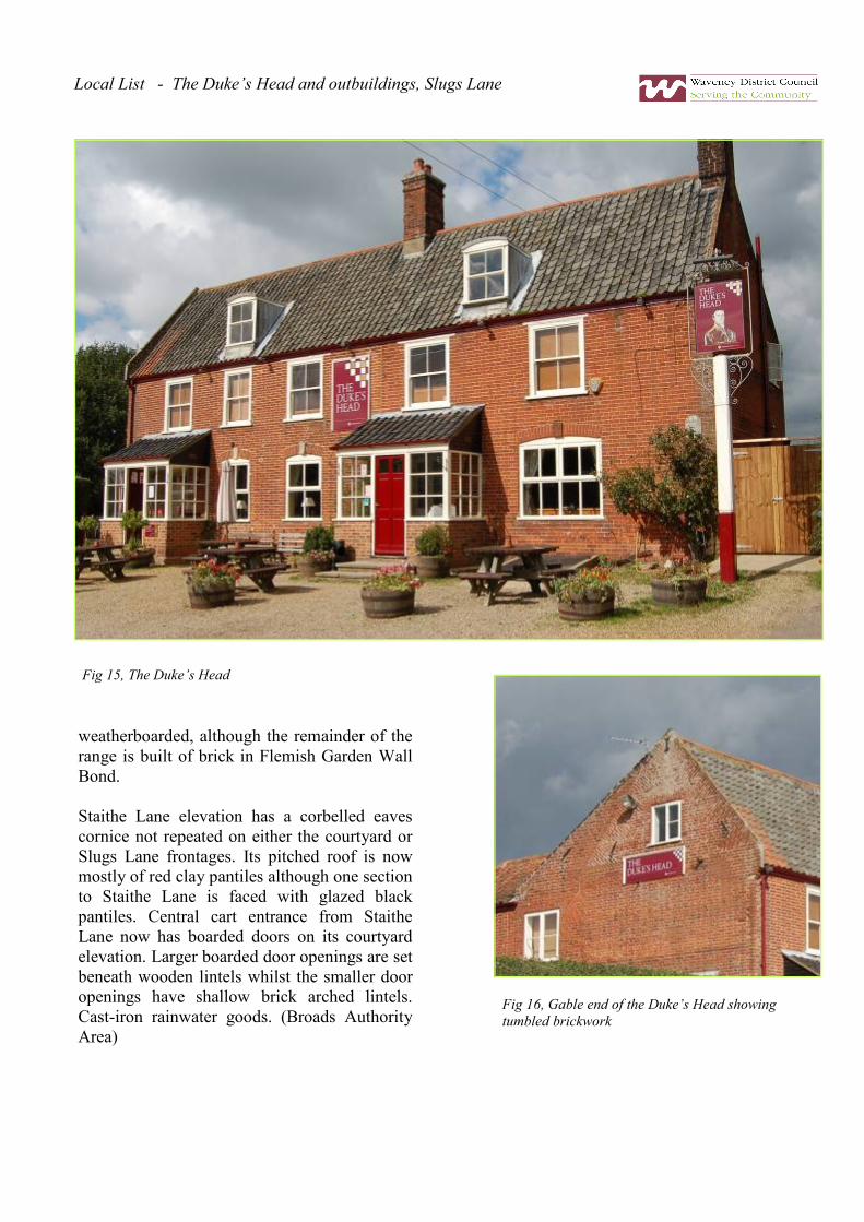
weatherboarded, although the remainder of the
range is built of brick in Flemish Garden Wall
Bond.
Staithe Lane elevation has a corbelled eaves
cornice not repeated on either the courtyard or
Slugs Lane frontages. Its pitched roof is now
mostly of red clay pantiles although one section
to Staithe Lane is faced with glazed black
pantiles. Central cart entrance from Staithe
Lane now has boarded doors on its courtyard
elevation. Larger boarded door openings are set
beneath wooden lintels whilst the smaller door
openings have shallow brick arched lintels.
Cast-iron rainwater goods. (Broads Authority
Area)
Fig 15, The Duke’s Head
Fig 16, Gable end of the Duke’s Head showing
tumbled brickwork
Local List - The Duke’s Head and outbuildings, Slugs Lane

Brickfields (off Slugs Lane)
Nos. 1-12 Brickfields (cons) including
garden wall to north of No.1
A two storey terrace of twelve cottages
which is made up of six pairs of
mirrored semi-detached dwellings. One
of three surviving terraces of
workers’ cottages.
Built for employees of Charles and
Tomas Lucas brick makers, probably
in the mid to late 1860s. The terrace
was primarily occupied by employees
of the successive owners of their
brickworks until its closure in 1939.
Many of the cottages were
subsequently occupied as army billets
during World War Two in association
with a large ammunition dump created
within the former brickworks. The
cottages were renovated and internally
altered between 1973 and 1975 when
their original outbuildings were also
demolished and replaced. At the same
time the houses were re-orientated,
their former entrance facades
becoming the rears of each property.
The present day garden fronts of many
of the properties have since been
altered. The terrace is reputedly
constructed of Lucas Brothers’ bricks
with their characteristic L-stamp.
Red brick facing with white Suffolk
brick pilasters, chimneystacks, lintels
and eaves cornice. The outer most
pilaster at each end of the terrace is
provided with a simple brick capital.
Above is a red clay pantile roof with
slightly projecting eaves resting on a
simple wooden eaves cornice, with a
band of white Suffolk bricks beneath.
Each cottage is of two bays and two-storeys.
Outer bay of each cottage projects and has
corner pilasters and ornate painted wooden
porches with gently sloping red clay pantile
roofs. Substantial chimney stack with
grouped flues on ridge at outer edge of each
property, chimneypots removed. Window
frames and doors largely replaced in 1973-75
and then again in recent years with UPVC.
Garden wall to north of No.1 Brickfields
Cottages built of brick with half-round brick
coping resting on a projecting string course a
characteristic Somerleyton feature.
Fig 17, A typical brickfields terraced cottage
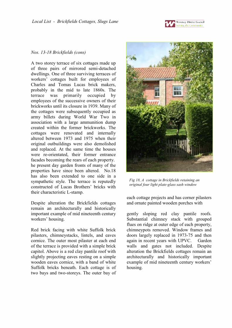
Nos. 13-18 Brickfields (cons)
A two storey terrace of six cottages made up
of three pairs of mirrored semi-detached
dwellings. One of three surviving terraces of
workers’ cottages built for employees of
Charles and Tomas Lucas brick makers,
probably in the mid to late 1860s. The
terrace was primarily occupied by
employees of the successive owners of their
brickworks until its closure in 1939. Many of
the cottages were subsequently occupied as
army billets during World War Two in
association with a large ammunition dump
created within the former brickworks. The
cottages were renovated and internally
altered between 1973 and 1975 when their
original outbuildings were also demolished
and replaced. At the same time the houses
were re-orientated, their former entrance
facades becoming the rears of each property.
he present day garden fronts of many of the
properties have since been altered. No.18
has also been extended to one side in a
sympathetic style. The terrace is reputedly
constructed of Lucas Brothers’ bricks with
their characteristic L-stamp.
Despite alteration the Brickfields cottages
remain an architecturally and historically
important example of mid nineteenth century
workers’ housing.
Red brick facing with white Suffolk brick
pilasters, chimneystacks, lintels, and eaves
cornice. The outer most pilaster at each end
of the terrace is provided with a simple brick
capitol. Above is a red clay pantile roof with
slightly projecting eaves resting on a simple
wooden eaves cornice, with a band of white
Suffolk bricks beneath. Each cottage is of
two bays and two-storeys. The outer bay of
each cottage projects and has corner pilasters
and ornate painted wooden porches with
gently sloping red clay pantile roofs.
Substantial chimney stack with grouped
flues on ridge at outer edge of each property,
chimneypots removed. Window frames and
doors largely replaced in 1973-75 and then
again in recent years with UPVC. Garden
walls and gates not included. Despite
alteration the Brickfields cottages remain an
architecturally and historically important
example of mid nineteenth century workers’
housing.
Local List - Brickfields Cottages, Slugs Lane
Fig 18, A cottage in Brickfields retaining an
original four light plate-glass sash window
18
Nos. 19-22 Brickfields (Cons) and
garden walls to rear.
A two storey terrace of four cottages
made up of two pairs of mirrored
semi-detached dwellings standing on a
fine site overlooking the river. One of
three surviving terraces of workers’
cottages built for employees of
Charles and Tomas Lucas brick
makers, probably in the mid to late
1860s. The terrace was primarily
occupied by employees of the
successive owners of their brickworks
until its closure in 1939. Many of the
cottages were subsequently occupied
as army billets during World War Two
in association with a large ammunition
dump created within the former
brickworks. The cottages were
renovated and internally altered
between 1973 and 1975 when their
original outbuildings were also
demolished and replaced. At the same
time the houses were re-orientated,
their former entrance facades
becoming the rears of each property.
The present day garden fronts of many
of the properties have since been
altered. No.18 has also been extended
to one side in a sympathetic style.
The terrace is reputedly constructed of
Lucas Brothers’ bricks with their
characteristic L-stamp. Red brick
facing with white Suffolk brick
pilasters, chimneystacks, lintels, and
eaves cornice. The outer most pilaster
at each end of the terrace is provided
with a simple brick capitol. Above is a
red clay pantile roof with slightly
projecting eaves resting on a simple
wooden eaves cornice, with a band of
white Suffolk bricks beneath. Each
cottage is of two bays and two-storeys.
The outer bay of each cottage projects
and has corner pilasters and ornate
painted wooden porches with gently
sloping red clay pantile roofs.
Substantial chimney stack with
grouped flues on ridge at outer edge of
each property. Window frames and
doors largely replaced. Gable end
has pilasters and projecting stack with
decorative central arched recess.
Associated garden walls to rear have
carved stone copings. Garden fences
gates etc to fronts not included.
Despite alteration the Brickfields
Cottages remain an architecturally and
historically important example of mid
nineteenth century workers’ housing.
Fig 20, Staithe Lane looking towards Slugs
Lane, outbuildings to the Duke’s Head
Fig 19, No’s 20 to 22, Brickfields

19
Staithe Lane
Outbuilding at Lime Kiln Cottage
Long low waterside structure of a sin-
gle-storey. Built of brick with a red clay
pantile roof and overhanging eaves, and
probably of early nineteenth century
date. Its’ waterside frontage has a single
wooden casement window and a two-
panelled door. Gable end rendered. A
relatively unaltered late Georgian struc-
ture in a highly prominent location.
The 1889 tithe redemption map shows a
kiln in this area and a further substantial
group of unidentified buildings which
have largely not survived. These may
possibly be the blacksmith’s shop, sta-
bles, and coal store mentioned on a deed
of 1849 quoted by Audrey and Arnold
Butler in their Somerleyton Brickfields,
within which these buildings are also
illustrated. Lime Kiln Cottage itself is
not included. (Broads Authority Area)
Wherry Dyke and Crown Boat Yard
Slip way and cut created in the early
nineteenth century to allow for the effi-
cient transport of brick-filled wherries
from Somerleyton Brickworks. The cut
was probably dug for John Green of The
White House who obtained the
neighbouring land from the Anguish
family of Somerleyton Hall c1805. The
Green family paid an annual sum to the
parish for its use as the land through
which it was cut was allocated for the
relief of the poor. From 1950 to 1959 the
cut and the adjacent premises were asso-
ciated with the experiments of Sir Chris-
topher Cockerell which led to the devel-
opment of the first prototype hovercraft.
Sir Christopher Cockerell lived for a
time on an ex Royal Navy pinnace
moored here. (Broads Authority Area)
Remains of Belgian Kiln at former
Bricks Works Site
Reputedly the remains of the first Bel-
gian kiln in England, erected by the
Somerleyton Brick Company in 1900. Its
elliptical shape is now demarcated by a
concrete surround and remains of its
brick footings. The remains of the kiln
are the most significant survival of what
was arguably one of the country’s most
important brickworks during the mid and
later nineteenth century. A nearby plaque
briefly documents the site’s history and
significance. Production began c1790
and ceased in 1939. This large site also
contains the foundations of an earlier
Hoffman Kiln. The design of the Belgian
Kiln was first patented in 1891. After
closure in 1939 the site was used for the
storage of ammunition. Much of the
brickworks was still extant at the time of
the publication of the 1951 OS Map but
was largely demolished soon afterwards.
The chimneystacks remained until 1959
when they were blown up.
To the west are the ruins of an earlier
industrial structure comprised of a single
storey brick wall with a doorway; this
forms an important part of the kiln’s set-
ting. The immediate area is likely to
contain substantial archaeological re-
mains of the former works.
Local List - Staithe Lane

20
Appendix 3:
Local list descriptions for buildings in
Somerleyton outside the proposed
conservation area
Slugs Lane
Garden House
A substantial detached double-pile plan
dwelling which stands in an isolated posi-
tion amidst mature landscaped grounds. The
house is probably of early nineteenth cen-
tury date and is built of painted brick. Of
two storeys, with a three bay principal fa-
çade which appears to have been con-
structed in two phases as there is a straight
joint running the full height of the building
to the right of the entrance door. Four
hornless twelve-light sash windows set be-
neath shallow brick-arched lintels to the left
and right of an off-centre four panelled Vic-
torian door; steeply pitched slate covered
roof. Good iron gate and railings to Slugs
Lane. Nineteenth century Ordnance Survey
maps show that ‘The Garden House’ was
once associated with a substantial market
garden and orchard which was located in
the fields between it and the White House
on The Street. It was approached at that
time via a drive way running from beside
Pond Cottages on The Street to the rear of
the property, the gate piers associated with
this entrance are locally listed under ‘Pond
View’, The Street. The orchard was still
extant in 1958 but had disappeared by
1975.
Fig 21, Outbuilding to the
Dukes Head Public House,
Slugs Lane
Fig 22, No’s 13 to 18,
Brickfields Cottages
Fig 23, Brickworks ruins
near the Belgian Kiln

21
Fig 24, Somerleyton Railway
Station
Fig 25, Distant view of Somerley-
ton Swing Bridge
Station Road
Railway Station
Neo-Tudor Railway Station consisting of
waiting rooms, station master’s house, and
integral water tower. A substantial and
ornate brick structure of 1846-47 built at
the expense of Sir Samuel Moreton Peto of
Somerleyton Hall and originally containing
a private waiting room for visitors to his
mansion. Probably designed by John Tho-
mas, Peto’s retained architect. Altered mid
to late c20th when attached platform can-
opy removed and waiting room converted
to living accommodation. Constructed of
brick with painted stone dressings beneath
a steeply pitched Welsh slate roof. Integral
former station master’s house of two sto-
reys now faces into substantial private gar-
den adjacent to car park. Central gable with
two storey canted bay window. Former
waiting room range of a single storey with
substantial and ornate gabled porch to for-
mer entrance façade. Door openings to the
platform blocked although the original
stone doorcases have been retained. On its
roof is a brick stack with a substantial and
highly decorative terracotta chimneypot.
Mullioned windows with twentieth century
replacement wooden frames within.
Railway Swing Bridge and Signal Box
Railway Swing Bridge over river Waveney
and associated piers and brick clad signal
box; constructed in 1904-1905 for the
Great Eastern Railway Company to replace
an earlier narrower structure. Of wrought
iron and cast steel, with a brick and timber
supporting structure at each river bank.
Bridge itself opens by means of girders ro-
tating on cast steel wheels, and is reputed
to weigh 120 tonnes. One other bridge of
Fig 26, Remains of Belgian
Kiln
Local List - Station Road

22
this type survives over the Yare at Reedham in
Norfolk. Attached is a large two storey signal
box the upper floor of which faces the track; this
is a version of a standard Great Eastern Railway
design introduced in 1886, which was especially
modified to allow the bridge operating gear to be
housed alongside the standard signal gear. Lower
floor partially built into embankment. Over-
hanging shallow pitched slate roof and plain
painted wooden bargeboards, the roof pitch to
the line being steeper than that at the rear. Signal
box approached by timber decked footbridge and
steps. (TM476967)
Waveney Grange Farm and Associated Farm
Buildings
Substantial brick gentleman’s farmhouse of two
storeys with later eighteenth century façade; ex-
tended in nineteenth century. The farmhouse
stands within substantial mature gardens which
had gained there present form by the time of the
publication of the 1884 OS map; it stands set
back within them facing the Station Road.
Pitched slate roof to principal range and tile roof
to rear wing and attached outbuildings, central
brick ridge stack to principal range. To the east
on the opposite side of the drive is a substantial
L-shaped single storey range of early nineteenth
century farm buildings which originally formed
part of a larger farm complex grouped around a
courtyard. Built of brick with tile roofs, integral
cart shed facing drive. At entrance to farmyard
is a further two storey brick cart shed of three
bays with a boarded timber upper storey and
hipped tile roof. Cart openings supported on
square section timber pillars. Lean-to tile roofed
range attached to Station Road end and single
storey brick structure to rear. All twentieth cen-
tury farm and subsidiary buildings excluded from
this entry. Despite the partial demolition of its
Fig 27, Duke’s Head Inn
Fig 28, Slugs Lane
Fig 29, No. 19 Brickfields

23
historic farm buildings, Waveney Grange
Farm remains an important example of a sub-
stantial gentleman’s farmstead which proba-
bly gained its present form around the time of
the Somerleyton enclosure award.
Appendix 4:
Structures outside the proposed Somerleyton
conservation area for assessment for spot
listing
Somerleyton Railway Station.
Somerleyton Swing Bridge (railway bridge,
over the river Waveney and associated signal
box).
Fig 32, An Edwardian photograph of West Lodge, Market Lane, before its was altered
Fig 30, Duke’s Head Barns
Fig 31, Former Cart entrance to
Duke’s Head Barns from Slugs
Lane

If you would like this document in a large print, in other formats or in a language other than in English, we will do our best to help. Please call the Design & Conservation Team on 01502 523077 or e-mail [email protected] www.waveney.gov.uk
Design & Conservation Telephone: (01502) 523077 Fax: (01502) 514130 Email: pbc @ waveney.gov.uk Planning
Telephone: (01502) 514617 Fax: (01502) 514130 Email: [email protected] Building Control Telephone: (01502) 523044 Inspection answer-phone: (01502) 500040 Fax: (01502) 514130 Email: [email protected]
www.broads-authority.gov.uk Planning & Strategy
Telephone: (01603) 610734 Fax: (01603) 756069 Email: [email protected]


