68
Sorrento Valley Skyway Feasibility Study Prepared for: Prepared by: FINAL REPORT: January 2017

Sorrento Valley Skyway Feasibility Study
Prepared for:
Prepared by:
FINAL REPORT:
January 2017
Acknowledgements
San Diego Association of Governments (SANDAG)
Dave Schumacher
Jennifer Williamson
WSP | Parsons Brinckerhoff
Zafar Alikhan
Chris Wahl
Seth Torma
Jeff Howard
Hon Consulting, Inc.
Katherine Hon
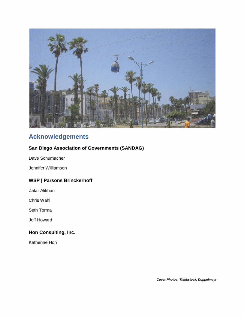
Cover Photos: Thinkstock, Doppelmayr
Sorrento Valley Skyway Feasibility Study
Page i
Table of Contents
Chapter 1: Introduction .............................................................................................. 1-1
1.1 Study Objectives ....................................................................................................... 1-4
1.2 Relevant Studies ....................................................................................................... 1-4
1.3 Study Process ........................................................................................................... 1-5
Chapter 2: Identified Conditions & Needs ................................................................ 2-1
2.1 Study Area Geography, Land Use, and Key Activity Centers .................................... 2-1
2.2 Existing and Planned Transportation Facilities .......................................................... 2-6
2.3 Physical Features ................................................................................................... 2-13
2.4 Project Needs ......................................................................................................... 2-14
Chapter 3: Aerial Cableway Technology .................................................................. 3-1
3.1 Aerial Cableway Overview ........................................................................................ 3-1
3.2 Technology Considerations ....................................................................................... 3-1
3.3 Operations and Capacity........................................................................................... 3-5
3.4 System Components ................................................................................................. 3-6
3.5 Fire, Life, Safety ...................................................................................................... 3-11
Chapter 4: Market Assessment ................................................................................. 4-1
4.1 Travel Patterns ......................................................................................................... 4-1
4.2 Market Demand Testing ............................................................................................ 4-3
4.3 Aerial Cableway Markets .......................................................................................... 4-4
Chapter 5: Study Alternatives ................................................................................... 5-1
5.1 Alternatives Development ......................................................................................... 5-1
5.2 Transit Propensity and Station Siting ........................................................................ 5-3
5.3 Alignment Alternatives .............................................................................................. 5-5
Chapter 6: Evaluation of Alternatives ....................................................................... 6-1
6.1 System Cost Estimates ............................................................................................. 6-1
6.2 Ridership .................................................................................................................. 6-3
6.3 Cost Effectiveness .................................................................................................... 6-6
6.4 Community and Environmental Considerations ......................................................... 6-8
6.5 Additional Routing Options ...................................................................................... 6-11

Sorrento Valley Skyway Feasibility Study
Page ii
Chapter 7: Regulatory Requirements ....................................................................... 7-1
7.1 General Regulatory Requirements ............................................................................ 7-1
Chapter 8: Potential Funding Sources ..................................................................... 8-1
8.1 Unique Funding Sources........................................................................................... 8-1
8.2 Traditional Funding Sources ..................................................................................... 8-2
Chapter 9: Summary of Findings .............................................................................. 9-1
List of Tables
Table 1 Worldwide Aerial Cableway Systems ........................................................................ 3-2
Table 2 Aerial Cableway System Specifications ...................................................................... 3-6
Table 3 Study Area Trip Activity .............................................................................................. 4-1
Table 4 Urban Cableways in the United States ....................................................................... 4-4
Table 5 Quantitative Summary of Accessibility ........................................................................ 5-3
Table 6 Estimated Capital Costs ............................................................................................. 6-2
Table 7 Estimated O&M Costs for Alignment Alternatives ....................................................... 6-3
Table 8 Estimated Daily Ridership by Station .......................................................................... 6-4
Table 9 Average O&M Cost per Boarding ............................................................................... 6-6
Table 10 Environmental Considerations for the UCSD Alternative .......................................... 6-9
Table 11 Environmental Considerations for the UTC Alternative ........................................... 6-10
List of Figures
Figure 1 Regional Vicinity ........................................................................................................ 1-2
Figure 2 Project Study Area .................................................................................................... 1-3
Figure 3 Project Schedule ....................................................................................................... 1-4
Figure 4 Study Process ........................................................................................................... 1-5
Figure 5 Existing Land Use and Key Activity Centers .............................................................. 2-3
Figure 6 Typical AM Peak Hour Roadway Traffic Conditions .................................................. 2-4
Figure 7 Typical PM Peak Hour Roadway Traffic Conditions .................................................. 2-5
Figure 8 Existing and Planned Roadways ............................................................................... 2-7
Figure 9 Existing and Planned Transit Service ...................................................................... 2-10
Figure 10 Existing and Future Bicycle and Pedestrian Facilities ............................................ 2-12
Figure 11 Typical End Station Plan ......................................................................................... 3-8
Figure 12 Typical Station Section with Connection to LRT ...................................................... 3-9
Figure 13 Distribution of Study Area Trip Origins and Destinations ......................................... 4-2
Figure 14 Mode of Access for Corridor Model Sensitivity Tests ............................................... 4-3
Figure 15 Accessibility at Select Passenger Stations .............................................................. 5-4
Figure 16 Alignment Alternatives ............................................................................................ 5-7
Figure 17 Estimated Daily Boardings and Passenger Loads ................................................... 6-5
Sorrento Valley Skyway Feasibility Study
Page iii
Figure 18 Summary of Alignment Alternatives ........................................................................ 6-7
Figure 19 Alignment/Station Options ..................................................................................... 6-12
Figure 20 Small Starts Process ............................................................................................... 8-3
List of Appendices Appendix A: Geologic Assessment
Appendix B: System Component Information
Appendix C: Cost Estimate Information
Appendix D: Regulatory Requirements
Appendix E: Additional Forecasting Results
Sorrento Valley Skyway Feasibility Study
Page 1-1
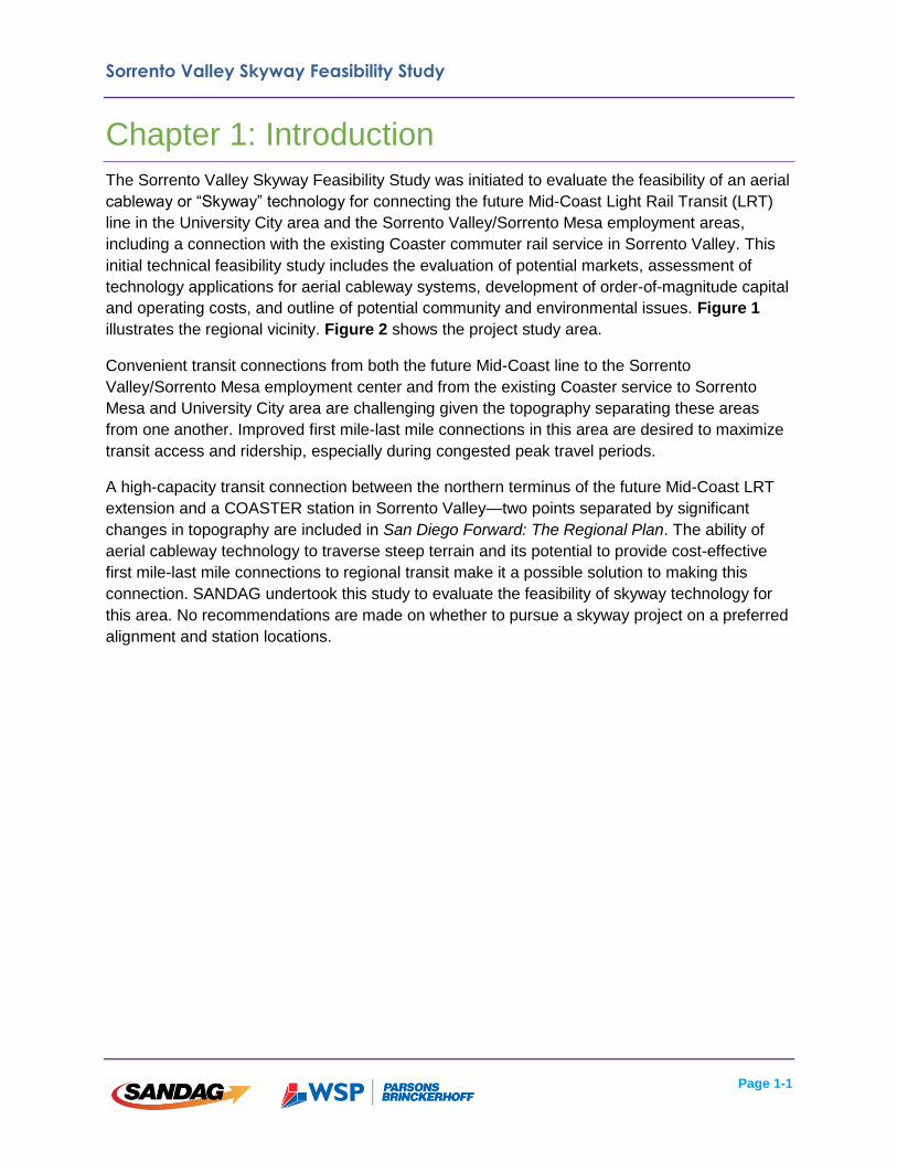
Chapter 1: Introduction
The Sorrento Valley Skyway Feasibility Study was initiated to evaluate the feasibility of an aerial
cableway or “Skyway” technology for connecting the future Mid-Coast Light Rail Transit (LRT)
line in the University City area and the Sorrento Valley/Sorrento Mesa employment areas,
including a connection with the existing Coaster commuter rail service in Sorrento Valley. This
initial technical feasibility study includes the evaluation of potential markets, assessment of
technology applications for aerial cableway systems, development of order-of-magnitude capital
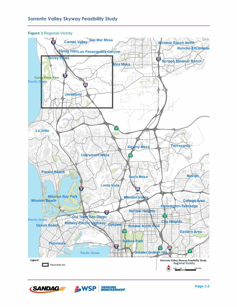
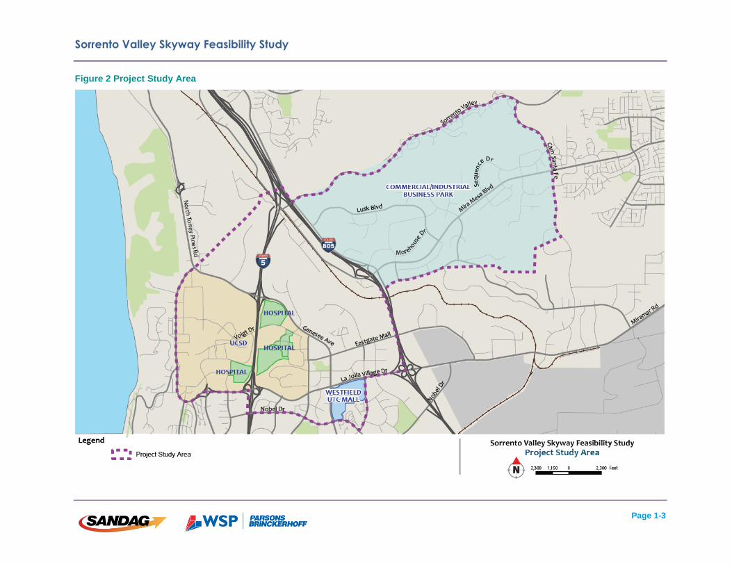
and operating costs, and outline of potential community and environmental issues. Figure 1
illustrates the regional vicinity. Figure 2 shows the project study area.
Convenient transit connections from both the future Mid-Coast line to the Sorrento
Valley/Sorrento Mesa employment center and from the existing Coaster service to Sorrento
Mesa and University City area are challenging given the topography separating these areas
from one another. Improved first mile-last mile connections in this area are desired to maximize
transit access and ridership, especially during congested peak travel periods.
A high-capacity transit connection between the northern terminus of the future Mid-Coast LRT
extension and a COASTER station in Sorrento Valley—two points separated by significant
changes in topography are included in San Diego Forward: The Regional Plan. The ability of
aerial cableway technology to traverse steep terrain and its potential to provide cost-effective
first mile-last mile connections to regional transit make it a possible solution to making this
connection. SANDAG undertook this study to evaluate the feasibility of skyway technology for
this area. No recommendations are made on whether to pursue a skyway project on a preferred
alignment and station locations.
Sorrento Valley Skyway Feasibility Study
Page 1-2
Figure 1 Regional Vicinity
Sorrento Valley Skyway Feasibility Study
Page 1-3
Figure 2 Project Study Area
Sorrento Valley Skyway Feasibility Study
Page 1-4
1.1 Study Objectives
Key objectives for the Sorrento Valley Skyway Feasibility Study include:
Evaluate market demand for a new transit connection or connection(s) within the
study area;
Identify the appropriate form of aerial cableway technology to be implemented;
Develop ways to integrate aerial cableway with existing and proposed regional transit
services;
Identify potential system options/alternatives;
Estimate system-wide ridership for potential options/alternatives;
Identify potential funding sources for both capital and operations and maintenance
(O&M) costs; and
Identify key challenges and solutions such as topography, utility conflicts, and
regulatory requirements.
Project study alternatives were developed with each of these objectives considered, and is
discussed in greater detail in Chapter 5.
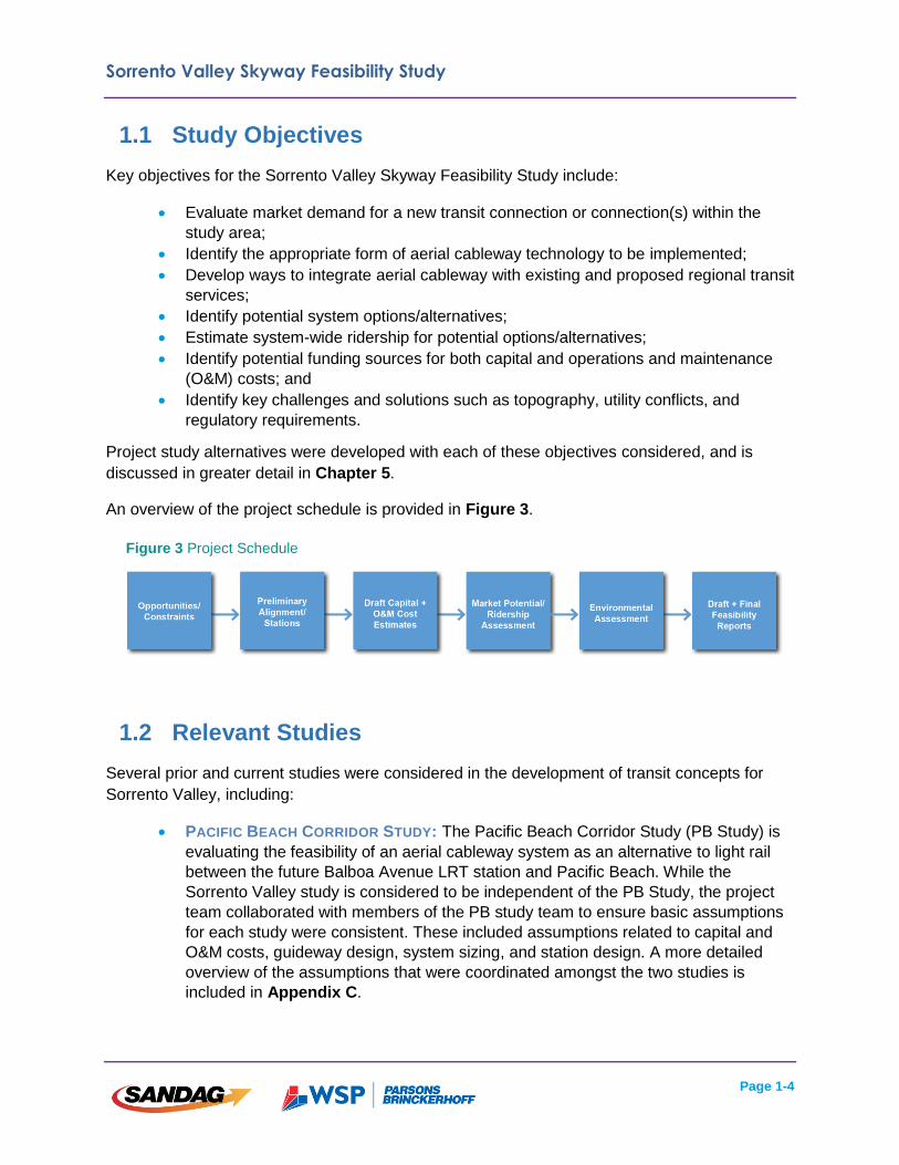
An overview of the project schedule is provided in Figure 3.
1.2 Relevant Studies
Several prior and current studies were considered in the development of transit concepts for
Sorrento Valley, including:
PACIFIC BEACH CORRIDOR STUDY: The Pacific Beach Corridor Study (PB Study) is
evaluating the feasibility of an aerial cableway system as an alternative to light rail
between the future Balboa Avenue LRT station and Pacific Beach. While the
Sorrento Valley study is considered to be independent of the PB Study, the project
team collaborated with members of the PB study team to ensure basic assumptions
for each study were consistent. These included assumptions related to capital and
O&M costs, guideway design, system sizing, and station design. A more detailed
overview of the assumptions that were coordinated amongst the two studies is
included in Appendix C.
Figure 3 Project Schedule
Sorrento Valley Skyway Feasibility Study
Page 1-5
BAY TO BALBOA SKYWAY FEASIBILITY STUDY: An unconnected but recent study for
an aerial cableway system between downtown San Diego and Balboa Park was
previously completed.
MID-COAST CORRIDOR TRANSIT PROJECT FINAL DESIGN: Design elements of the
completed Mid-Coast LRT project were taken into consideration by the project team.
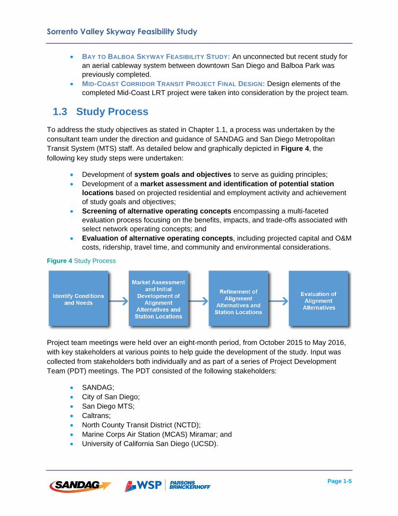
1.3 Study Process
To address the study objectives as stated in Chapter 1.1, a process was undertaken by the
consultant team under the direction and guidance of SANDAG and San Diego Metropolitan
Transit System (MTS) staff. As detailed below and graphically depicted in Figure 4, the
following key study steps were undertaken:
Development of system goals and objectives to serve as guiding principles;
Development of a market assessment and identification of potential station
locations based on projected residential and employment activity and achievement
of study goals and objectives;
Screening of alternative operating concepts encompassing a multi-faceted
evaluation process focusing on the benefits, impacts, and trade-offs associated with
select network operating concepts; and
Evaluation of alternative operating concepts, including projected capital and O&M
costs, ridership, travel time, and community and environmental considerations.
Figure 4 Study Process
Project team meetings were held over an eight-month period, from October 2015 to May 2016,
with key stakeholders at various points to help guide the development of the study. Input was
collected from stakeholders both individually and as part of a series of Project Development
Team (PDT) meetings. The PDT consisted of the following stakeholders:
SANDAG;
City of San Diego;
San Diego MTS;
Caltrans;
North County Transit District (NCTD);
Marine Corps Air Station (MCAS) Miramar; and
University of California San Diego (UCSD).
Sorrento Valley Skyway Feasibility Study
Page 2-1
Chapter 2: Identified Conditions & Needs
The Identified Conditions and Needs section outlines the existing conditions in the study area
and describes various reasons why a skyway system would enhance mobility throughout the
study area.
2.1 Study Area Geography, Land Use,
and Key Activity Centers
The project study area is located in northern San Diego within portions of the University City,
Torrey Pines, and Mira Mesa communities. The study area is generally bounded by the UCSD
campus to the west, northern University Towne Center (UTC) to the north, the Westfield UTC
Mall to the south, and Sorrento Mesa to the east. The eastern and western portions of the study
area are bisected by Sorrento Valley, which includes a prominent escarpment running north to
south just west of I-805. This steep natural feature creates a natural boundary between
UCSD/UTC and Sorrento Mesa, an impediment to additional surface transportation
connections.
UCSD
UCSD has over 33,000 students and 29,000 faculty/staff members on campus1. The campus
includes several different types of land use, including institutional education and research
facilities, medical centers, and student housing. I-5 bisects the university campus, creating two
distinct subareas. The western half of the campus primarily consists of student-based activity
centers, including education facilities and on-campus housing. The eastern portion of UCSD is a
center for medical facilities and research on campus and includes Scripps Memorial Hospital
and the soon to be completed Jacobs Medical Center, among others. UCSD is also home to
several event centers which host a variety of musical- and art-based performances, attracting
visitors from across the region throughout the year. Key activity centers include the RIMAC
Arena and the La Jolla Playhouse, among others.
An additional 15,000 employee’s work at the Scripps Research Institute and other nearby
employment centers adjacent to UCSD.2
University Towne Centre
The University Towne Centre area is located just east and north of UCSD within the University
City Community. The area includes a mix of commercial retail and office uses, as well as
several single- and multi-family residential developments. The presence of several high-density
commercial office buildings combined with the Westfield UTC Mall makes the UTC area a key
1 University of California, San Diego. 2015. Obtained online at http://studentresearch.ucsd.edu/_files/stats-data/enroll/total.pdf and http://legacy-its.ucop.edu/uwnews/stat/headcount_fte/oct2015/er1sdh.pdf. 2 United States Census Bureau. 2014. Obtained online at http://onthemap.ces.census.gov/.
Sorrento Valley Skyway Feasibility Study
Page 2-2
regional activity center in the San Diego region. Additional expansions that include residential,
retail, and office space are also under development.
Sorrento Valley
Sorrento Valley is located just east of the UTC area and includes a mix of light industrial,
commercial office, open space land use, and medical facilities. I-805 runs parallel to the valley
and creates a physical boundary between Sorrento Valley and Sorrento Mesa to the east.
Sorrento Mesa
Located just east of Sorrento Valley, Sorrento Mesa primarily consists of commercial retail and
office space, with small pockets of residential and retail land use scattered throughout the mesa.
The mesa is home to many science- and technology-based businesses which attract employees
from locations throughout the region. Approximately 40,000 employees work in Sorrento Mesa
for Qualcomm and other major employers.
Existing land use and key activity centers within the study area are shown in Figure 5.
Existing typical traffic conditions are shown in Figure 6 and Figure 7.

Sorrento Valley Skyway Feasibility Study
Page 2-3
Figure 5 Existing Land Use and Key Activity Centers
Sorrento Valley Skyway Feasibility Study
Page 2-4
Figure 6 Typical AM Peak Hour Roadway Traffic Conditions
Source: Google Maps (2016)
Sorrento Valley Skyway Feasibility Study
Page 2-5
Figure 7 Typical PM Peak Hour Roadway Traffic Conditions
Source: Google Maps (2016)

Sorrento Valley Skyway Feasibility Study
Page 2-6
2.2 Existing and Planned Transportation
Facilities
A description of the existing transportation system within the study area is provided in this
section.
Existing Freeways
I-5 and I-805 provide regional access to destinations within the study area. I-5 provides access
throughout San Diego County and into Orange County and Los Angeles as well. I-805 connects
to I-5 within the study area and runs south to a connection with I-5 just north of the Mexican
border. I-5 and I-805 carry approximately 180,000 and 220,000 vehicles per day, respectively,
through the study area. As shown above in Figure 6 and Figure 7, freeways in the study area
experience high levels of congestion, specifically in the PM peak. Congestion along each of the
freeways results in increased peak hour travel times to and from activity centers within the study
area.
Existing Roadways
Several major arterial roadways exist within the study area and provide connections between
regional freeways and local destinations. Due to the topography and development patterns, the
majority of roadways within the study area tend to follow circuitous routes. Large blocks with
setbacks and large parking lots abound. The combination of these characteristics creates an
auto-centric and somewhat pedestrian unfriendly environment which may create impediments to
non-auto circulation. Key roadways include Genesee Avenue, La Jolla Village Drive/Miramar
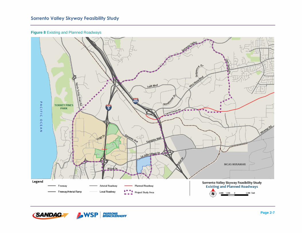
Road, Torrey Pines Road, and Mira Mesa Boulevard. A map of existing and planned roadways
is shown in Figure 8.
In addition to circuitous routing and limited connectivity, arterial roadways in the study area also
experience high levels of congestion (as shown in Figure 6 and Figure 7 above). The
combination of limited connectivity and high levels of congestion limits mobility within the study
area.
Sorrento Valley Skyway Feasibility Study
Page 2-7
Figure 8 Existing and Planned Roadways
Sorrento Valley Skyway Feasibility Study
Page 2-8
Existing and Planned Transit Service
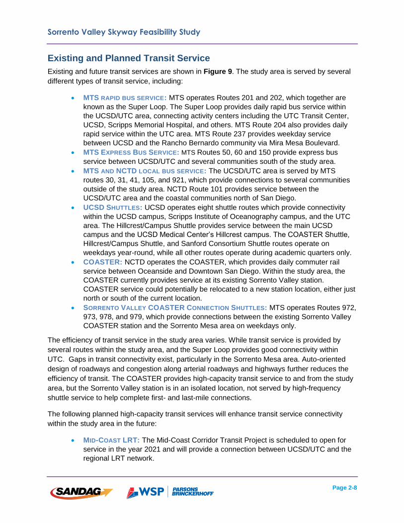
Existing and future transit services are shown in Figure 9. The study area is served by several
different types of transit service, including:
MTS RAPID BUS SERVICE: MTS operates Routes 201 and 202, which together are
known as the Super Loop. The Super Loop provides daily rapid bus service within
the UCSD/UTC area, connecting activity centers including the UTC Transit Center,
UCSD, Scripps Memorial Hospital, and others. MTS Route 204 also provides daily
rapid service within the UTC area. MTS Route 237 provides weekday service
between UCSD and the Rancho Bernardo community via Mira Mesa Boulevard.
MTS EXPRESS BUS SERVICE: MTS Routes 50, 60 and 150 provide express bus
service between UCSD/UTC and several communities south of the study area.
MTS AND NCTD LOCAL BUS SERVICE: The UCSD/UTC area is served by MTS
routes 30, 31, 41, 105, and 921, which provide connections to several communities
outside of the study area. NCTD Route 101 provides service between the
UCSD/UTC area and the coastal communities north of San Diego.
UCSD SHUTTLES: UCSD operates eight shuttle routes which provide connectivity
within the UCSD campus, Scripps Institute of Oceanography campus, and the UTC
area. The Hillcrest/Campus Shuttle provides service between the main UCSD
campus and the UCSD Medical Center’s Hillcrest campus. The COASTER Shuttle,
Hillcrest/Campus Shuttle, and Sanford Consortium Shuttle routes operate on
weekdays year-round, while all other routes operate during academic quarters only.
COASTER: NCTD operates the COASTER, which provides daily commuter rail
service between Oceanside and Downtown San Diego. Within the study area, the
COASTER currently provides service at its existing Sorrento Valley station.
COASTER service could potentially be relocated to a new station location, either just
north or south of the current location.
SORRENTO VALLEY COASTER CONNECTION SHUTTLES: MTS operates Routes 972,
973, 978, and 979, which provide connections between the existing Sorrento Valley
COASTER station and the Sorrento Mesa area on weekdays only.
The efficiency of transit service in the study area varies. While transit service is provided by
several routes within the study area, and the Super Loop provides good connectivity within
UTC. Gaps in transit connectivity exist, particularly in the Sorrento Mesa area. Auto-oriented
design of roadways and congestion along arterial roadways and highways further reduces the
efficiency of transit. The COASTER provides high-capacity transit service to and from the study
area, but the Sorrento Valley station is in an isolated location, not served by high-frequency
shuttle service to help complete first- and last-mile connections.
The following planned high-capacity transit services will enhance transit service connectivity
within the study area in the future:
MID-COAST LRT: The Mid-Coast Corridor Transit Project is scheduled to open for
service in the year 2021 and will provide a connection between UCSD/UTC and the
regional LRT network.

Sorrento Valley Skyway Feasibility Study
Page 2-9
FUTURE LRT SERVICE (PURPLE LINE): The most recent RTP, San Diego Forward,
includes a planned LRT line that would run from San Ysidro to Carmel Valley via
Mid-City, Kearny Mesa, and Sorrento Valley. Within the study area, this planned LRT
line would likely include a connection to the COASTER in Sorrento Valley.
OTHER ENHANCEMENTS TO BUS SERVICES: The most recent RTP, San Diego
Forward, includes the provision of several rapid bus lines within the study area.
Sorrento Valley Skyway Feasibility Study
Page 2-10
Figure 9 Existing and Planned Transit Service

Sorrento Valley Skyway Feasibility Study
Page 2-11
Bicycle and Pedestrian Circulation
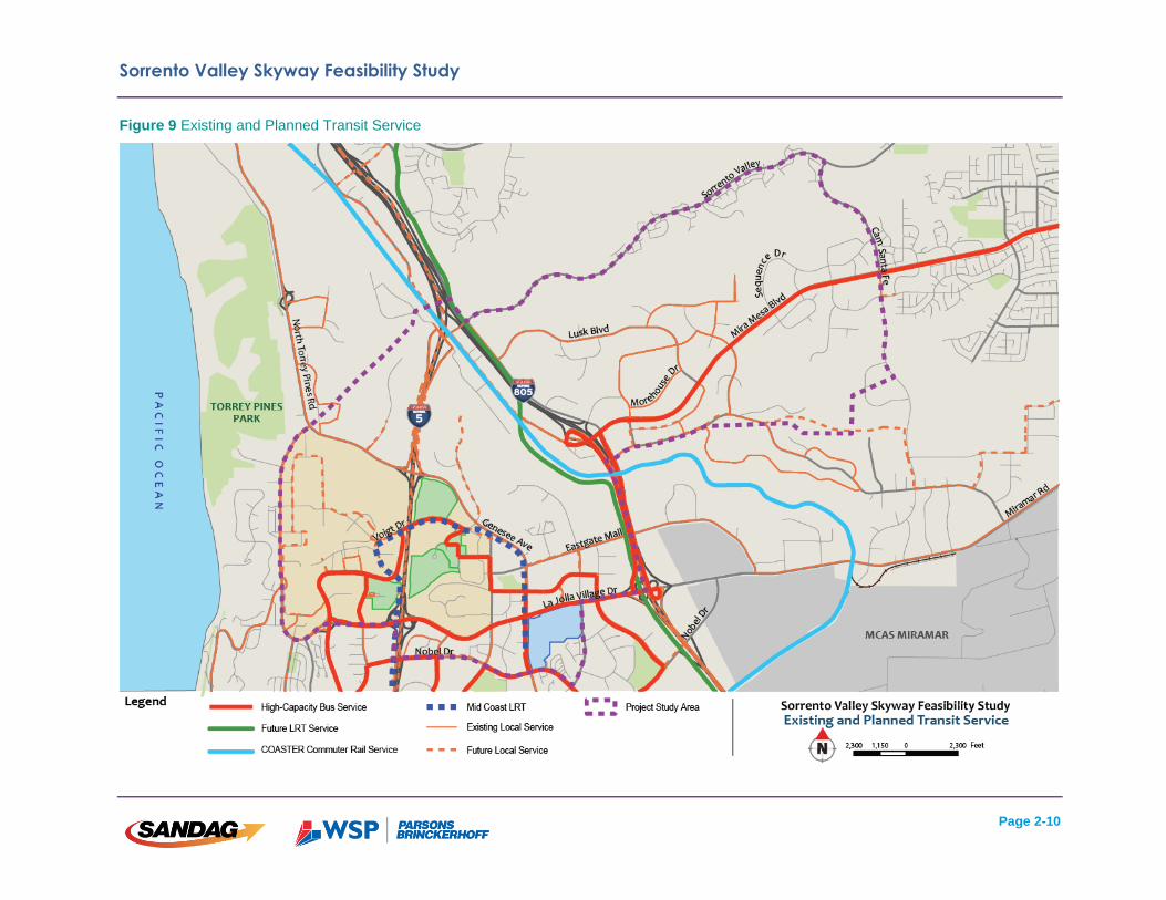
Bicycle and pedestrian networks generally follow the existing arterial roadways. Travel ways
within the study area are primarily designed for auto use. The combination of high-speed
roadways, large lot development, and topographic variability creates a generally pedestrian- and
bicycle-unfriendly environment. However, there may be opportunities to improve connections,
particularly in the Sorrento Mesa area. A map of existing and future pedestrian and bicycle
facilities is shown in Figure 10.
Sorrento Valley Skyway Feasibility Study
Page 2-12
Figure 10 Existing and Future Bicycle and Pedestrian Facilities

Sorrento Valley Skyway Feasibility Study
Page 2-13
2.3 Physical Features
Physical features within the study area are described in this section.
Topography
Topography within the study area varies depending on location. The UCSD and UTC areas are
primarily situated on top of a series of mesas. Portions of both the UCSD campus and
commercial business parks within UTC are situated on plateaus that extend out from the mesa
and are separated by canyons of varying depths.
Sorrento Valley is separated from the UCSD/UTC area by a prominent escarpment just west of
I-805. This land feature rises approximately 300 feet above Sorrento Valley and acts as a
natural barrier between the two areas. To the east, Sorrento Mesa rises gradually from Sorrento
Valley and features a relatively level surface on which the existing commercial business parks
are located.
Geology
A preliminary geologic assessment was performed as part of this study to evaluate the relative
bearing capacities of soils along potential alignments and identify any active seismic faults or
recorded landslides. In general, soils within the study area hold load bearing capacities at a
variety of levels ranging from low to high. Load bearing capacities would need to be evaluated
further and in more detail during the design phase of a potential system. A more detailed
summary of soil load bearing capacities is included in Appendix A.
Based on the preliminary geologic assessment, it is anticipated that two to three potentially
active faults intersect potential cableway alignments. Additionally, a landslide is highly
suspected along the escarpment to the east of Towne Centre Drive. The potential location of
transit system infrastructure (i.e. stations and towers) would need to be carefully evaluated at a
later stage in order to avoid active faults and recorded landslides. A map of active faults and
recorded landslides is included in Appendix A.
An evaluation of the proposed aerial cableway system's ability to operate within the physical
constraints of the study area is included in Chapter 6.
Sorrento Valley Skyway Feasibility Study
Page 2-14
2.4 Project Needs
As outlined above, the need for potential transit improvements in the study area is warranted for
a variety of reasons, including:
GROWTH IN ACTIVITY: There are currently approximately 125,000 employees, 50,000
residents, and 34,000 university students within the study area. Strong growth is
expected to continue in the University City area and an additional two million square
feet of mixed-use development could potentially occur in retail centers and at UCSD
and the adjacent research institutes.
IMPROVED TRANSIT CONNECTIVITY: As noted above, existing transit services are
constrained by topography and auto congestion. Continued growth in the study area
will result in an increase in congestion along highways and local roadways that serve
the area. Transit improvements will be needed to provide travelers with an efficient
mode of transportation to, from, and within the study area.
PRESERVATION OF ENVIRONMENTALLY SENSITIVE AREAS: The study area includes
visible open space areas, flood zones, coastal areas, cultural resources, and
biological resource areas within slopes and canyons. Transit enhancements that are
implemented would need to minimize impacts to environmentally sensitive areas
within the study area.
IMPROVED REGIONAL CONNECTIVITY: In addition to the existing COASTER, the study
area will be served by the Mid-Coast LRT extension in the future. A connection
between these two high-capacity lines is considered an important link that would
improve connectivity within the study area and region.
CONFORMANCE WITH REGIONAL AND STATE POLICIES: San Diego Forward: The
Regional Plan and Sustainable Communities Strategy integrate transportation and
land use policy to achieve greenhouse gas (GHG) emission reductions consistent
with California State requirements. A new high-capacity transit connection could
provide opportunities for smart growth at station areas, helping to achieve regional
and state GHG reduction targets.
PROVISION OF SKYWAYS AS HIGH-FREQUENCY FIRST-MILE/LAST-MILE
CONNECTORS: San Diego Forward: The Regional Plan references the potential use
of skyways to improve first-mile/last-mile connections for short-distance trips in the
region, specifically in dense urban environments. Skyways are well-suited to
traversing freeways, canyons, hills, and other man-made obstacles that exist within
the study area.

Sorrento Valley Skyway Feasibility Study
Page 3-1
Chapter 3: Aerial Cableway Technology
3.1 Aerial Cableway Overview
Urban applications of aerial cableway technology have been successfully integrated into transit
networks in various cities around the globe. These systems offer an additional transit option to
overcome obstacles in the built or natural environment such as, freeways, water bodies, or
significant changes in topography (e.g. canyons and valleys) to improve “first-mile/last-mile”
connections to major regional transit lines. Other potential benefits in urban aerial cableway
systems include low capital cost, minimal footprint, low energy consumption and reduced
emissions, and the ability to bypass congested roadways.
The success of this type of system as a high-capacity transit mode can be seen in other cities
internationally, including the Singapore Cable Car expansion in 2015; Rio de Janeiro’s cableway
launch in 2013; and the expansion of La Paz, Bolivia’s cableway system with six new urban
lines. While aerial cableway has enjoyed a high level of success in other countries, a multi-point
urban cableway system in the United States has not yet been implemented.
3.2 Technology Considerations
Aerial cableway has been used as a form of transportation for decades, but is relatively new to
urban areas in the United States. Aerial cableway has been used mostly for limited markets
including ski areas and amusement parks. Recently, however, several cities throughout the
country have shown interest in how the technology could be applied in their respective urban
areas. Internationally, extensive aerial cableway systems have evolved and carry large volumes
of commuters as a viable alternative to traditional urban transit methods such as buses and rail.
Línea Roja, La Paz, Bolivia (Source: Doppelmayr)
Metrocable. Caracas, Venezuela (Source: Doppelmayr)

Sorrento Valley Skyway Feasibility Study
Page 3-2
Large systems exist throughout South America, Asia, and Europe. Examples from several
South American cities, London and Singapore are presented in Table 1
Table 1 Worldwide Aerial Cableway Systems
pph = persons per hour p/day = passengers per day
In the United States, recent urban cableway projects include:
Portland Aerial Tram: Opened in 2006, this system provides service between
Portland’s the city's South Waterfront district and the main Oregon Health & Science
University campus;
Roosevelt Tram, New York: The first urban mass transport application of aerial
tramways in the United States was completed in 1976 on Roosevelt Island in New
York City.
Location (date built)
System Length (mi)
# of Stations (system wide)
Operational Capacity
Integrated with Transit Network?
Why technology was chosen?
La Paz, Bolivia "Mi Teleferico" Built 2014-2015
6.1 11 3,000 pph Yes
Overcome steep topography and traffic congestion, reduce pollution
Caracas, Venezuela "Metrocable de Caracas" Built 2007-2012
4.1 7 2,000 pph Yes
Overcome steep topography and provide social services at stations
Medellin, Colombia "Metrocable Medellin" Built 2004-2010
5.8 10
30,000 p/day Yes Overcome steep topography and connect barrios to rest of city
Rio de Janeiro, Brazil "Teleferico do Alemao" Built 2011
2.2 6 Approx. 2,000 pph
Yes
Build tourism, improve social conditions in the "favelas" (settlements of urban poor) on hillsides by connecting residents to rail network
London, United Kingdom "Emirates Air Line" Built 2012
0.7 2 2,500 pph Yes
Connect exhibition areas for Olympic Games over the Thames River and to the subway system
Singapore "Singapore Cable Car" Built 1974, extended to Sentosa 2015
1.1 3 1,400 pph No
Tourist attraction from Mount Faber spanning Keppel Harbour and steep topography to Sentosa resort island
Sorrento Valley Skyway Feasibility Study
Page 3-3
Aerial cableway technology tends to be utilized in lieu of traditional modes of transit when some
or all of the following conditions are present:
Natural or man-made obstacles exist, which make implementation of traditional
transit applications, such a light rail, difficult or impractical;
Congested roadway and/or poor roadway connectivity that impact bus transit travel
times and reliability;
Opportunities for future expansion exist.
Aerial cableway systems offer several potential advantages over traditional modes of transit,
including:
Construction impacts are typically minimized by the smaller system footprint and
shorter construction duration;
May have lower capital costs (on a per mile basis) compared to other fixed-guideway
technologies;
Environmental impacts can be minimized as aerial cableway systems typically have
a smaller footprint.
Disadvantages of aerial cableway systems include the following:
System expansion can be limited and/or costly;
Requires transit operator to develop operations & maintenance expertise with a new
technology, though it can potentially be contracted out;
Depending on the specific aerial cableway technology used, it is more sensitive to
inclement weather, as high winds and electrical storms that could require a
temporary shutdown of the system;
Traditional system evacuation procedures have been developed for resort-based
systems, while urban-based evacuation procedures are in the process of being
developed;
Insurance premiums are typically higher than traditional modes of transit due to the
high elevation of operations, and newer technology application.

Sorrento Valley Skyway Feasibility Study
Page 3-4
Aerial cableway systems generally
utilize one of three system
technologies: aerial tramway, mono-
cable detachable gondola (MDG), and
tri-cable detachable gondola (3S).
Tricable Detachable Gondola (3S). Source: Doppelmayr.

Sorrento Valley Skyway Feasibility Study
Page 3-5
The MDG technology is proposed for this study for the following reasons:
It is the most widespread technology used worldwide;
It is more versatile and can be utilized in an urban, multiple-station system in a more
cost-effective manner;
It would likely provide the capacity to handle the passenger loads estimated within
the study area;
It is typically used in areas with low and moderate wind speeds.
3.3 Operations and Capacity
The typical travel speed for the aerial cableway systems would be 1,200 feet per minute (13.6
mph). While unloading and loading passengers at stations, cabins would travel at a slower
speed of sixty (60) feet per minute and take approximately one minute to pass through each
station. A cabin capacity of eight (8) passengers was assumed for the purpose of this study.
Assuming 8-passenger cabins, at maximum operation an aerial system could serve up to 2,400
persons per hour (pph) per direction.
Monocable Detachable Gondola (MDG). Source: Doppelmayr.

Sorrento Valley Skyway Feasibility Study
Page 3-6
3.4 System Components
This section provides a summary of system specifications. Details for each component are
discussed below. Aerial cableway technology specifications are shown in Table 2.
Stations
Aerial cableway stations would vary in size,
depending on passenger throughput and
location within the system
END STATION: Overall, an end station
footprint would be approximately 50 feet by
110 feet in size. The width can increase if an
end station is elevated to provide vertical
access features such as elevators and
stairs.
At one end station, more room would be
required for cabin storage and maintenance
facilities. Specific storage requirements
would vary based on ridership demands.
The cabin storage area would be located
either adjacent to the station platform or
placed under a station, depending on
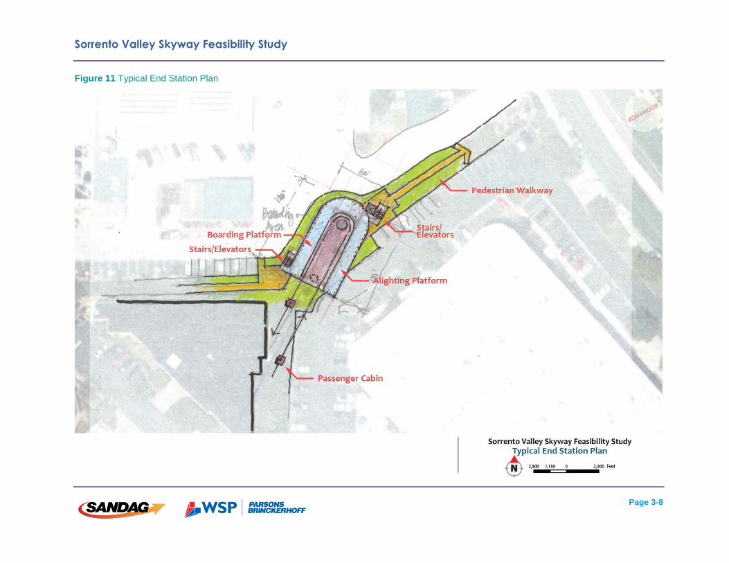
constraints at the station site. A typical end station is shown below in Figure 11.
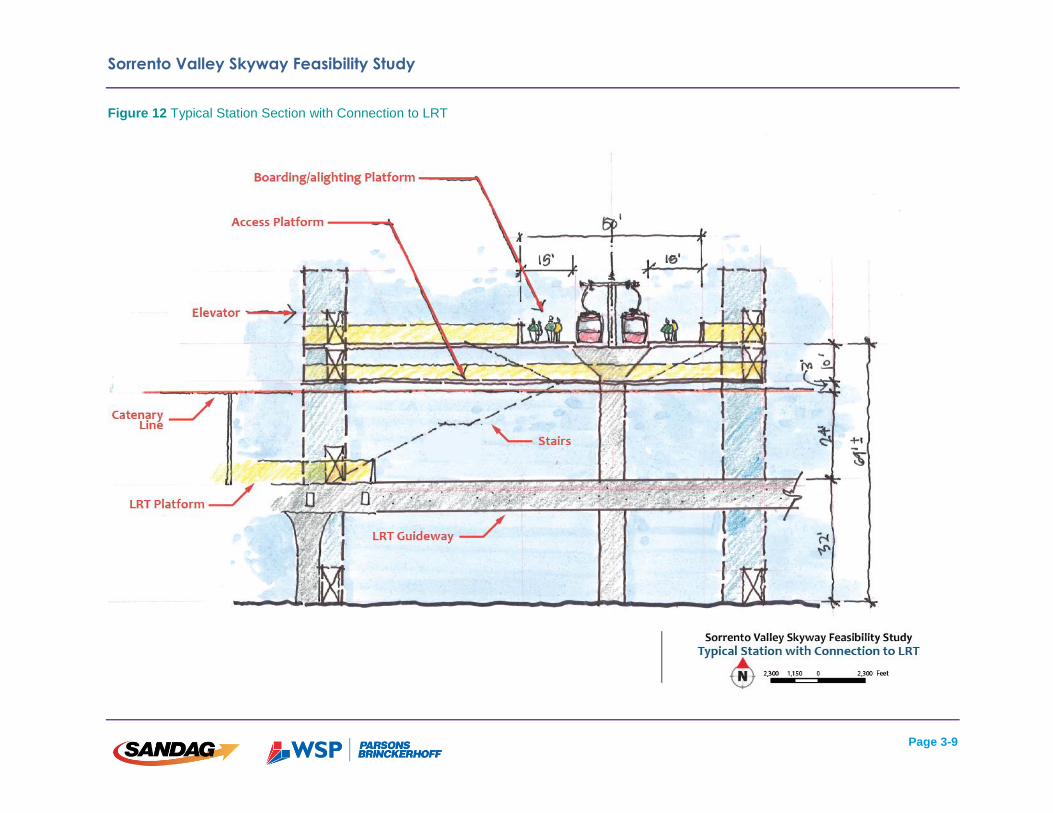
INTERMEDIATE STATION: An intermediate station would be approximately 50 feet by 180 feet in
size, and would require more room to
incorporate elevators and stairs. Intermediate
stations require more length due to both the
boarding and alighting occurring on one side
for each direction, whereas at the end station
the boarding takes place on one side and the
alighting occurs on the other side of the
station platform. A potential intermediate
station is shown in Figure 12.
TURN TERMINALS: Aerial cableway systems
are sometimes required to turn corners due to
constraints in the natural or built environment.
This can be achieved with either turning
towers, or more commonly, turning terminals.
At turning terminals, passenger cabins slow
Table 2 Aerial Cableway System Specifications
Source: Doppelmayr
Mi Teleférico, La Paz, Bolivia (Source: Doppelmayr)

Sorrento Valley Skyway Feasibility Study
Page 3-7
down to a speed of approximately 300 feet per minute in order to transfer from one cable loop to
another and change course.
At a minimum, turn terminals require the same electromechanical components as an
intermediate station, but do not require the same ancillary components, such as elevators and
ticketing machines, that are required at stations where passengers board and alight. Turn
terminals can be designed to allow for passenger access where necessary. Turn terminals that
do not allow for passenger access would be approximately 50 feet by 130 feet in size. Turn
terminals that allow for passenger access would be similar in size to an intermediate station at
approximately 50 feet by 180 feet, as additional length is needed to allow for boardings and
alightings to occur on each side of the terminal.
System attendants would be present at all stations where passengers board and alight the
system. Each station would include two attendants, one on each platform, who would group
passengers together and assist them in boarding and alighting the system. In order to improve
security, station attendants would be responsible for grouping passengers together in a manner
that would reduce the chances of a security incident on board. A more detailed overview of fire,
life, and safety regulations is included below in Section 3.5.
Sorrento Valley Skyway Feasibility Study
Page 3-8
Figure 11 Typical End Station Plan
Sorrento Valley Skyway Feasibility Study
Page 3-9
Figure 12 Typical Station Section with Connection to LRT
Sorrento Valley Skyway Feasibility Study
Page 3-10
Towers
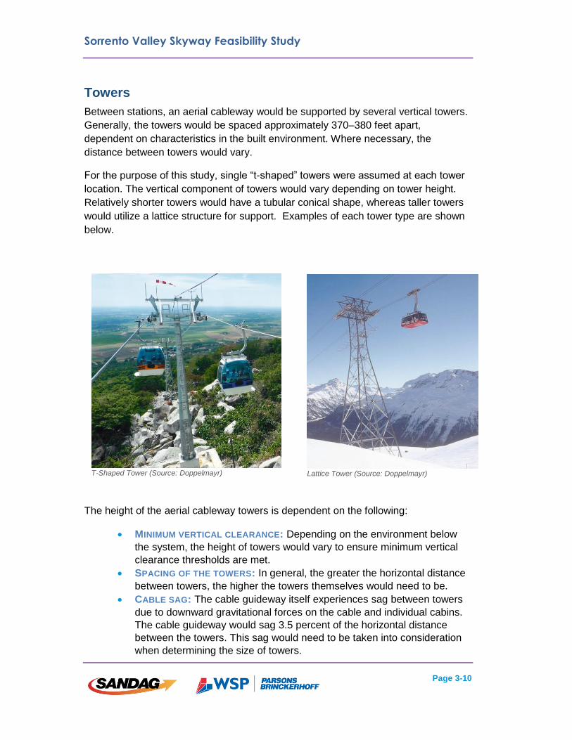
Between stations, an aerial cableway would be supported by several vertical towers.
Generally, the towers would be spaced approximately 370–380 feet apart,
dependent on characteristics in the built environment. Where necessary, the
distance between towers would vary.
For the purpose of this study, single “t-shaped” towers were assumed at each tower
location. The vertical component of towers would vary depending on tower height.
Relatively shorter towers would have a tubular conical shape, whereas taller towers
would utilize a lattice structure for support. Examples of each tower type are shown
below.
The height of the aerial cableway towers is dependent on the following:
MINIMUM VERTICAL CLEARANCE: Depending on the environment below
the system, the height of towers would vary to ensure minimum vertical
clearance thresholds are met.
SPACING OF THE TOWERS: In general, the greater the horizontal distance
between towers, the higher the towers themselves would need to be.
CABLE SAG: The cable guideway itself experiences sag between towers
due to downward gravitational forces on the cable and individual cabins.
The cable guideway would sag 3.5 percent of the horizontal distance
between the towers. This sag would need to be taken into consideration
when determining the size of towers.
Lattice Tower (Source: Doppelmayr)
T-Shaped Tower (Source: Doppelmayr)

Sorrento Valley Skyway Feasibility Study
Page 3-11
Cabins and Cable
For the purpose of this study, passenger cabins were assumed to be about 6.5 feet
by 6 feet by 7 feet in size, accommodating a maximum of eight (8) passengers at a
time (see Appendix B). The cabins could be modified to include features designed
to enhance the overall passenger experience, such as enhanced ventilation, air
conditioning, and internet access (Wi-Fi). Cabins could also be fitted with bicycle
racks on the exterior of the cabins, making them a more attractive option for cyclists
and as a first- and last-mile option. The cabins would be connected to a woven steel
cableway, which would run in a continuous loop throughout the system.
Cabins could be equipped with on-board one-or two-way communication systems.
Systems could be used to communicate with passengers in the event of an
emergency or for security reasons. A more detailed overview of fire, life, and safety
regulations is included below in Section 3.5.
Power
The cableway would be powered by one 500-horsepower motor, resulting in a power
usage of 360 kilowatts (KW) or about 0.15 KW/pph. This would allow for the system
to function at a maximum operating capacity (2,400 pph). Though many systems
typically do not initially operate at maximum capacity, designing the power system to
handle the maximum operating capacity eliminates the need to expand the system in
order to serve increases in passenger demand.
3.5 Fire, Life, Safety
Fire, life and safety regulations would need to be taken into consideration when
designing a skyway system, and are described in more detail below. These issues
were also taken into consideration when developing system alternatives and
calculating capital costs.
Fire
Fire safety is taken into account both in the design of aerial cableway system
components, as well as how the system is routed through urban areas. Aerial
cableway systems are designed in order to reduce the risk of serious harm to
passengers and employees, as well as the system itself. Fire smoke detectors are
included in all station and mechanical facilities, and all of the materials within each
passenger cabin are fire resistant.
The most critical system component that could be affected in the event of a fire is the
cableway itself, as prolonged exposure to excessive heat could compromise the
structural integrity of the cable. This issue can be mitigated by keeping the system in
motion, thus reducing the amount of time any one portion of the cable is exposed to
Sorrento Valley Skyway Feasibility Study
Page 3-12
excessive heat. In the event of a fire that impacts the cable, passengers would
unload at the next downstream station, and passengers would be prohibited from
boarding the system. More detailed procedures would need to be identified in a
system operating plan.
Additionally, California state code requires a vertical envelop be maintained over the
top of any existing structures to allow for firefighting access to the structure itself.
This would need to be taken into consideration during the design phase of a system.
Furthermore, it is usually required that any buildings or structures in close proximity
to an aerial cableway system be equipped with fire alarms that notify the cableway
operators of a fire event, allowing for proper emergency procedures to be followed.
Life and Safety
Aerial cableway system operation would be possible at wind speeds of up to 60 mph,
although full speed operation is only possible up to wind speeds of around 40 mph.
In the event wind speeds increase to 40-60 mph, the system can operate at slow
speeds, which would typically be done with the purpose of unloading the system.
System evacuation measures would need to be established before operations begin,
and would require coordination with local emergency services departments.
During operations, an attendant would be present at each station to monitor the
safety and security of aerial cableway passengers as they board and alight the
system as well as pass through the station.
In the event of an electrical failure, aerial cableway systems are designed to allow for
cabins to be manually circulated into the next downstream station in order to allow
passengers to safely alight from the system. Doppelmayr is currently exploring
options for a more robust safety system that would allow for a full system evacuation
in the event of a major mechanical failure. Costs for a more robust safety system
were included in the capital cost estimate for each of the alignment alternatives.
Sorrento Valley Skyway Feasibility Study
Page 4-1
Chapter 4: Market Assessment
The Market Assessment at this stage of the process entailed identifying travel
patterns within the study area and the region, conducting estimates of potential
market demand using the regional travel demand forecast model to test potential
demand for transit connections in the region, and assessing aerial cableway transit
for this study area, a large number within the region.
4.1 Travel Patterns
Based on an evaluation of the travel patterns, there are strong attractors within the
study area compared to the San Diego Region. The Sorrento Mesa employment
center is the second largest trip attractor in the region. UCSD, Scripps, the Torrey
Pines Mesa, and UTC are also major destinations. The study area is forecasted to
attract approximately 420,000 daily trips in 2035.
Figure 13 displays the density of origins and destinations within the study area.
Table 3 shows a quantitative summary of trip activity within the study area.
As a result of large employment centers, forecast employment is estimated at over
125,000 and existing employment is high relative to the region. Population is primarily
concentrated at the west end of the study area near the UCSD campus. The UCSD
activity center also contains multi-family residential areas, with plans for midrise
residential in the future.
Table 3 Study Area Trip Activity
This data shown above illustrates that highly concentrated nodes of trip attraction,
including employment, would be well served by a frequent transit circulator service
during peak periods, with efficient connections to regional transit services.
Population Employment
Study Area 49,200 125,200
UCSD Activity Center 15,000 43,400
UTC Activity Center 33,500 30,600
Sorrento Mesa Activity Center 700 41,500

Sorrento Valley Skyway Feasibility Study
Page 4-2
Figure 13 Distribution of Study Area Trip Origins and Destinations
Sorrento Valley Skyway Feasibility Study
Page 4-3
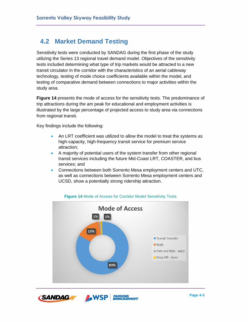
4.2 Market Demand Testing
Sensitivity tests were conducted by SANDAG during the first phase of the study
utilizing the Series 13 regional travel demand model. Objectives of the sensitivity
tests included determining what type of trip markets would be attracted to a new
transit circulator in the corridor with the characteristics of an aerial cableway
technology, testing of mode choice coefficients available within the model, and
testing of comparative demand between connections to major activities within the
study area.
Figure 14 presents the mode of access for the sensitivity tests. The predominance of
trip attractions during the am peak for educational and employment activities is
illustrated by the large percentage of projected access to study area via connections
from regional transit.
Key findings include the following:
An LRT coefficient was utilized to allow the model to treat the systems as
high-capacity, high-frequency transit service for premium service
attraction;
A majority of potential users of the system transfer from other regional
transit services including the future Mid-Coast LRT, COASTER, and bus
services; and
Connections between both Sorrento Mesa employment centers and UTC,
as well as connections between Sorrento Mesa employment centers and
UCSD, show a potentially strong ridership attraction.
Figure 14 Mode of Access for Corridor Model Sensitivity Tests
Sorrento Valley Skyway Feasibility Study
Page 4-4
4.3 Aerial Cableway Markets
The market for aerial cableway technology is untested in the San Diego region.
However, it is a potential solution for first and last mile connections. This technology
can be used as a major trunk-line transit service or a local circulator. Aerial cableway
could be attractive to both choice riders and transit-dependent passengers due to its
high-frequencies, reliability, and ability to provide efficient first-mile/last-mile
connections.
For this study, aerial cableway solutions were identified to serve as local circulators
given the need for connections to regional transit services and between large activity
centers in close proximity to each other.
Several urban aerial cableway systems have been implemented or are under study
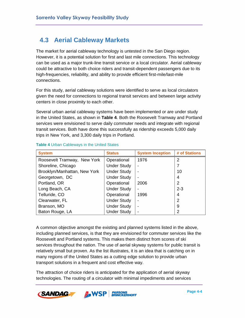
in the United States, as shown in Table 4. Both the Roosevelt Tramway and Portland
services were envisioned to serve daily commuter needs and integrate with regional
transit services. Both have done this successfully as ridership exceeds 5,000 daily
trips in New York, and 3,300 daily trips in Portland.
Table 4 Urban Cableways in the United States
A common objective amongst the existing and planned systems listed in the above,
including planned services, is that they are envisioned for commuter services like the
Roosevelt and Portland systems. This makes them distinct from scores of ski
services throughout the nation. The use of aerial skyway systems for public transit is
relatively small but proven. As the list illustrates, it is an idea that is catching on in
many regions of the United States as a cutting edge solution to provide urban
transport solutions in a frequent and cost effective way.
The attraction of choice riders is anticipated for the application of aerial skyway
technologies. The routing of a circulator with minimal impediments and services
System Status System Inception # of Stations
Roosevelt Tramway, New York Operational 1976 2
Shoreline, Chicago Under Study - 7
Brooklyn/Manhattan, New York Under Study - 10
Georgetown, DC Under Study - 4
Portland, OR Operational 2006 2
Long Beach, CA Under Study - 2-3
Telluride, CO Operational 1996 4
Clearwater, FL Under Study - 2
Branson, MO Under Study - 9
Baton Rouge, LA Under Study - 2
Sorrento Valley Skyway Feasibility Study
Page 4-5
characteristics was estimated to provide a high level of trip attraction from the region,
similar to urban rail technologies. The novelty of aerial skyway has also been proven
internationally to attract choice riders at a higher rate compared to other premium
transit services such as urban rail and BRT. In the United States, additional projects
will provide more evidence regarding this trend.
One key trend that is established within the San Diego region and other similar
metropolitan areas in the United States is that travel time reliability is the number one
factor in attracting choice riders. With the frequency of trip availability (approximately
30 seconds) and the high reliability of aerial skyway technologies compared to
conventional transit technologies, aerial cableway is able to serve the primary need
of choice riders, in addition to serving desired travel patterns. In addition, the privacy
of individual or select group vehicles may enhance the experience of transit users.
Providing service that fills the gap of first and last mile connections through aerial
skyway applications could also enhance transit attractiveness in the region for both
captive and choice riders by providing efficient and cost effective connections.
Sorrento Valley Skyway Feasibility Study
Page 5-1
Chapter 5: Study Alternatives
5.1 Alternatives Development
Several factors were taken into consideration when developing the study alignment
alternatives. These factors are discussed in greater detail below.
Provide Service to UCSD
One of the factors guiding the development of alternatives was to provide a direct
connection to UCSD. A connection would provide travelers with access to the many
education and research facilities, medical centers, and student housing on the UCSD
campus.
The future Voigt Drive LRT station was identified as the preferred connection location
on the UCSD campus because it is the closet point to Sorrento Mesa, which
minimizes travel times for passengers connecting to and from the Mid-Coast LRT
extension.
Provide Service to UTC
As noted above, the UTC area includes several activity centers, including the
Westfield UTC Mall and several residential and commercial land uses. Providing a
skyway connection to the UTC area would allow travelers access key activity centers
within the study area.
Additionally, the UTC Transit Center is a regional transit hub, currently served by 12
local, express, and rapid bus services, and the future terminus of the Mid-Coast LRT
extension. Providing a connection to the UTC Transit Center would connect the
skyway system to each of the existing and planned transit services, as well as
providing high-capacity service to the UTC Transit Center itself.
Connect to Sorrento Valley COASTER Station
As outlined in Section 2.2, the existing Sorrento Valley COASTER station is in an
isolated location and the efficiency of existing circulator shuttle service is hindered by
circuitous roadways, gaps in connectivity, and congested arterial roadways.
Additionally, rail grade crossing operations at the existing COASTER station cause
an increase in traffic congestion near I-5 and Sorrento Valley Road. As such, the
feasibility of relocating the existing Sorrento Valley COASTER station was evaluated
in the Project Report for I-5/Sorrento Valley Road Interchange Improvements (City of
San Diego, 2015). One of the relocation locations identified in the study is just south
of the intersection of Carroll Canyon Road and Sorrento Valley Road.
For the purpose of this study, each of the system alternatives assumes a connection
to the COASTER in Sorrento Valley would occur at a relocated station location near

Sorrento Valley Skyway Feasibility Study
Page 5-2
the intersection of Carroll Canyon Road and Sorrento Valley Road. This is due to the
fact that 1) the feasibility of relocating the Sorrento Valley COASTER station south
from its existing location has been evaluated and found to be feasible, 2) relocating
the station is listed as a capital improvement project in the current SANDAG
expenditure plan, and 3) routing skyway service north to serve the existing
COASTER station would both increase the capital cost required as well as decrease
ridership as a result of increased end-to-end travel times.
Connect to Future LRT Service
San Diego Forward: The Regional Plan includes plans for an additional LRT
extension, The Purple Line, within the study area. Within the study area, the Purple
Line would roughly follow the I-805 corridor and connect with the commuter rail
system at the Sorrento Valley COASTER station. Providing a skyway station at a
relocated Sorrento Valley COASTER station would allow for an additional connection
to the regional LRT system.
Provide Service to Sorrento Mesa
Sorrento Mesa contains a large concentration of employment. Due to topographic
constraints, arterial roadways serving the Sorrento Mesa generally follow circuitous
routes, and access to the area is limited. The combination of a large concentration of
employment and circuitous roadways results in congested arterial roadways,
especially during peak commute times. The provision of skyway stations in Sorrento
Mesa would allow travelers the option of using a high-frequency circulator service to
access jobs in the area.
The provision of a park-and-ride lot at the easternmost station would provide an
option for auto access for residents of Mira Mesa and communities east and north of
Sorrento Mesa.
Additional Objectives
In addition to the factors listed above, the following objectives were used to help
guide the development of alignment alternatives:
Minimize impacts to existing infrastructure, specifically buildings.
Provide passenger access at locations where significant infrastructure is
required to turn the system (i.e. turn terminals).
Achieve each of the aforementioned objectives while minimizing potential
capital expenditures for the potential build project.
Overcome topographic constraints.

Sorrento Valley Skyway Feasibility Study
Page 5-3
5.2 Transit Propensity and Station Siting
Transit propensity implies the tendency of a person to use transit as a form of
transportation, and is based on a number of factors, including proximity of housing
and employment to transit stations. In order to maximize potential ridership,
maximizing walk access to station sites is critical, especially in the Sorrento Mesa
area dominated by auto-oriented street patterns.
Using SANDAG Series 13 modeling data, the project team evaluated transit
accessibility for residents and employees. The project team evaluated access to
adjacent development at the individual building level to assess where existing
pedestrian connections could be enhanced and where opportunities exist for creating
new pedestrian connections. This information was used to determine where best to
site individual stations in order to maximize walk access.
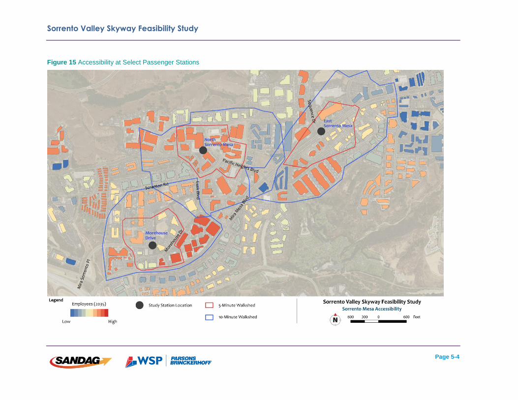
Through the analysis described above, the project team sited stations in Sorrento
Mesa in order to serve the most densely developed areas within the mesa itself.
Stations were sited in locations that also would afford the opportunity to use potential
pedestrian enhancements as shown in Figure 15. Additionally, stations were sited in
locations in order to minimize out of direction travel for the skyway system itself, as
well as to avoid taller buildings.
A quantitative summary of the number of residents and employees within a 5- and 10-
minute walkshed of select stations is shown below in Table 5.
Figure 15 below displays accessibility to and from select stations.
Table 5 Quantitative Summary of Accessibility
Station Morehouse Drive
North Sorrento Mesa
East Sorrento Mesa
Housing/Employment within 5-Minute Walk
2,600 4,000 4,200
Housing/Employment within 10-Minute Walk
5,700 10,600 9,500
Note: numbers are rounded to the nearest 100 persons.
Sorrento Valley Skyway Feasibility Study
Page 5-4
Figure 15 Accessibility at Select Passenger Stations

Sorrento Valley Skyway Feasibility Study
Page 5-5
5.3 Alignment Alternatives
The UCSD and UTC alternatives were developed based on the alignment objectives
described above. An overview of both the UCSD and UTC alignment alternatives is
provided below.
UCSD Alternative
The UCSD alternative begins at the East UCSD/Voigt Drive station, near the
intersection of Voigt Drive and Campus Pointe Drive on the east side of the UCSD
campus. This station would include a connection to the Mid-Coast LRT extension at
the future Voigt Drive station, simultaneously providing service to UCSD and tying
into the regional LRT system. Moving east, the alignment traverses two canyons
between Genesee Avenue and Towne Center Drive and down the escarpment just
south of the existing LOSSAN rail corridor, and above the LOSSAN rail tracks to a
connection with a potential relocated Sorrento Valley COASTER station near
Sorrento Valley Road and Carroll Canyon Road. A skyway station at a relocated
Sorrento Valley COASTER station could also tie in to the potential Purple Line LRT
service at this location.
Continuing east, the alignment passes over both I-805 and the existing electric
transmission and distribution lines just east of I-805. The system would likely require
tall towers in order to achieve minimum clearance thresholds above existing
transmission and distribution lines. The system would continue east over low-rise
commercial office buildings into Sorrento Mesa where a station would be provided
just north of Morehouse Drive.
The system would then continue north over low-rise commercial office buildings to a
station at North Sorrento Mesa, near the intersection of Pacific Heights Boulevard
and Barnes Canyon Road. The system would then move east over several low- and
mid-rise commercial office buildings, ultimately terminating at a station at East
Sorrento Mesa, near the intersection of Mira Mesa Boulevard and Sequence Drive.
The East Sorrento Mesa station could include a park-and-ride lot to allow for
improved auto access for residents to the east.
UTC Alternative
The UTC alternative begins at the UTC Transit Center, which would include a
connection to the Mid-Coast LRT extension at the future UTC Transit Center station,
connecting the skyway system to nearby commercial employment, retail, and
residential activity centers, as well as several other local and high-capacity bus lines.
Moving northeast, the system would include an intermediate station at the
intersection of Eastgate Mall and Towne Centre Drive. The project team determined

Sorrento Valley Skyway Feasibility Study
Page 5-6
that the skyway system requires turns in order to avoid several tall buildings in the
area. The intersection of Eastgate Mall and Towne Centre Drive was identified as
a location for the system to turn. Additional infrastructure would be required to turn
the system, which increases capital costs. Providing passenger access at a location
where a turn is needed requires a minimal amount of additional capital investment.
Given the presence of nearby commercial office and retail activity and a relatively
low additional investment needed to provide access to passengers, it was
determined that providing a station at Eastgate Mall and Towne Centre Drive would
be beneficial.
Moving north from Eastgate/Towne Centre, the alignment would traverse over low-
rise commercial office buildings and down the escarpment just west of the existing
LOSSAN rail corridor, and above the LOSSAN rail tracks to a connection with a
potential relocated Sorrento Valley COASTER station near Sorrento Valley Road
and Carroll Canyon Road.
The UTC Alternative is identical to the UCSD alternative east of the Sorrento Valley
COASTER station, with stations at Morehouse Drive, North Sorrento Mesa, and
East Sorrento Mesa. Similar to the UCSD Alternative, the East Sorrento Mesa
station could include a park-and-ride lot to allow for improved auto access for
residents in Mira Mesa and communities to the east and north.
The alignment alternatives are shown in Figure 16. A detailed evaluation of the
alignment alternatives is included in Chapter 6.

Sorrento Valley Skyway Feasibility Study
Page 5-7
Figure 16 Alignment Alternatives

Sorrento Valley Skyway Feasibility Study
Page 6-1
Chapter 6: Evaluation of Alternatives
Chapter 6 provides concept level evaluation two primary alignment alternatives. One alternative
provides service to UCSD; and another provides service to UTC. The detailed evaluation
includes projected capital and operation and maintenance (O&M) cost estimates, projected
ridership, community and environmental considerations, and regulatory requirements.
A more detailed assessment of each alternative is included below.
6.1 System Cost Estimates
Cost estimates were prepared to provide an estimate of both the capital costs to construct each
alternative and the annual O&M costs to support the on-going operation of each proposed
system.
Capital Costs
Capital costs for each of the alternatives have been prepared at a conceptual level, but the
estimates utilized a detailed build-up cost model developed specifically for this project. Cost
categories are summarized using the Federal Transit Administration’s (FTA) Standard Cost
categories rolled up into the following components:
Aerial guideway and elements;
Station infrastructure;
Cabin maintenance facilities;
Site work and special conditions;
Systems;
Right-of-way (ROW), land and existing improvements ;
Cabins; and
Professional services.
Construction costs associated with each of the above components for both UCSD and UTC
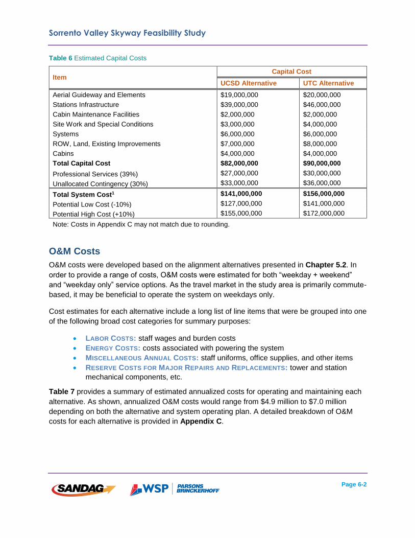
alignment alternatives are itemized in Table 6. As shown in Table 6, the capital cost would
range from $127 million to $172 million; depending on the alternative. A detailed cost
breakdown for each of the alternatives is provided in Appendix C.
Sorrento Valley Skyway Feasibility Study
Page 6-2
Table 6 Estimated Capital Costs
O&M Costs
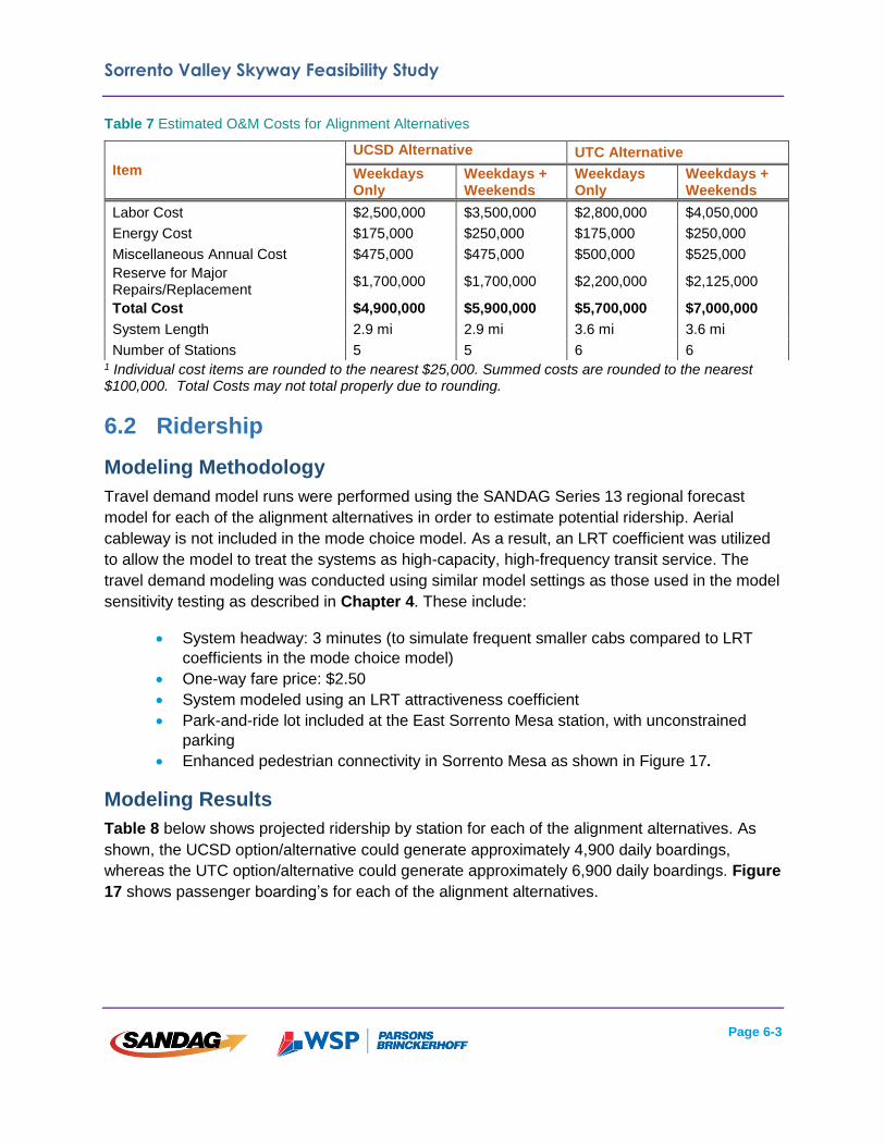
O&M costs were developed based on the alignment alternatives presented in Chapter 5.2. In
order to provide a range of costs, O&M costs were estimated for both “weekday + weekend”
and “weekday only” service options. As the travel market in the study area is primarily commute-
based, it may be beneficial to operate the system on weekdays only.
Cost estimates for each alternative include a long list of line items that were be grouped into one
of the following broad cost categories for summary purposes:
LABOR COSTS: staff wages and burden costs
ENERGY COSTS: costs associated with powering the system
MISCELLANEOUS ANNUAL COSTS: staff uniforms, office supplies, and other items
RESERVE COSTS FOR MAJOR REPAIRS AND REPLACEMENTS: tower and station
mechanical components, etc.
Table 7 provides a summary of estimated annualized costs for operating and maintaining each
alternative. As shown, annualized O&M costs would range from $4.9 million to $7.0 million
depending on both the alternative and system operating plan. A detailed breakdown of O&M
costs for each alternative is provided in Appendix C.
Item Capital Cost
UCSD Alternative UTC Alternative
Aerial Guideway and Elements $19,000,000 $20,000,000
Stations Infrastructure $39,000,000 $46,000,000
Cabin Maintenance Facilities $2,000,000 $2,000,000
Site Work and Special Conditions $3,000,000 $4,000,000
Systems $6,000,000 $6,000,000
ROW, Land, Existing Improvements $7,000,000 $8,000,000
Cabins $4,000,000 $4,000,000
Total Capital Cost $82,000,000 $90,000,000
Professional Services (39%) $27,000,000 $30,000,000
Unallocated Contingency (30%) $33,000,000 $36,000,000
Total System Cost1 $141,000,000 $156,000,000
Potential Low Cost (-10%) $127,000,000 $141,000,000
Potential High Cost (+10%) $155,000,000 $172,000,000
Note: Costs in Appendix C may not match due to rounding.
Sorrento Valley Skyway Feasibility Study
Page 6-3
Table 7 Estimated O&M Costs for Alignment Alternatives
1 Individual cost items are rounded to the nearest $25,000. Summed costs are rounded to the nearest $100,000. Total Costs may not total properly due to rounding.
6.2 Ridership
Modeling Methodology
Travel demand model runs were performed using the SANDAG Series 13 regional forecast
model for each of the alignment alternatives in order to estimate potential ridership. Aerial
cableway is not included in the mode choice model. As a result, an LRT coefficient was utilized
to allow the model to treat the systems as high-capacity, high-frequency transit service. The
travel demand modeling was conducted using similar model settings as those used in the model
sensitivity testing as described in Chapter 4. These include:
System headway: 3 minutes (to simulate frequent smaller cabs compared to LRT
coefficients in the mode choice model)
One-way fare price: $2.50
System modeled using an LRT attractiveness coefficient
Park-and-ride lot included at the East Sorrento Mesa station, with unconstrained
parking
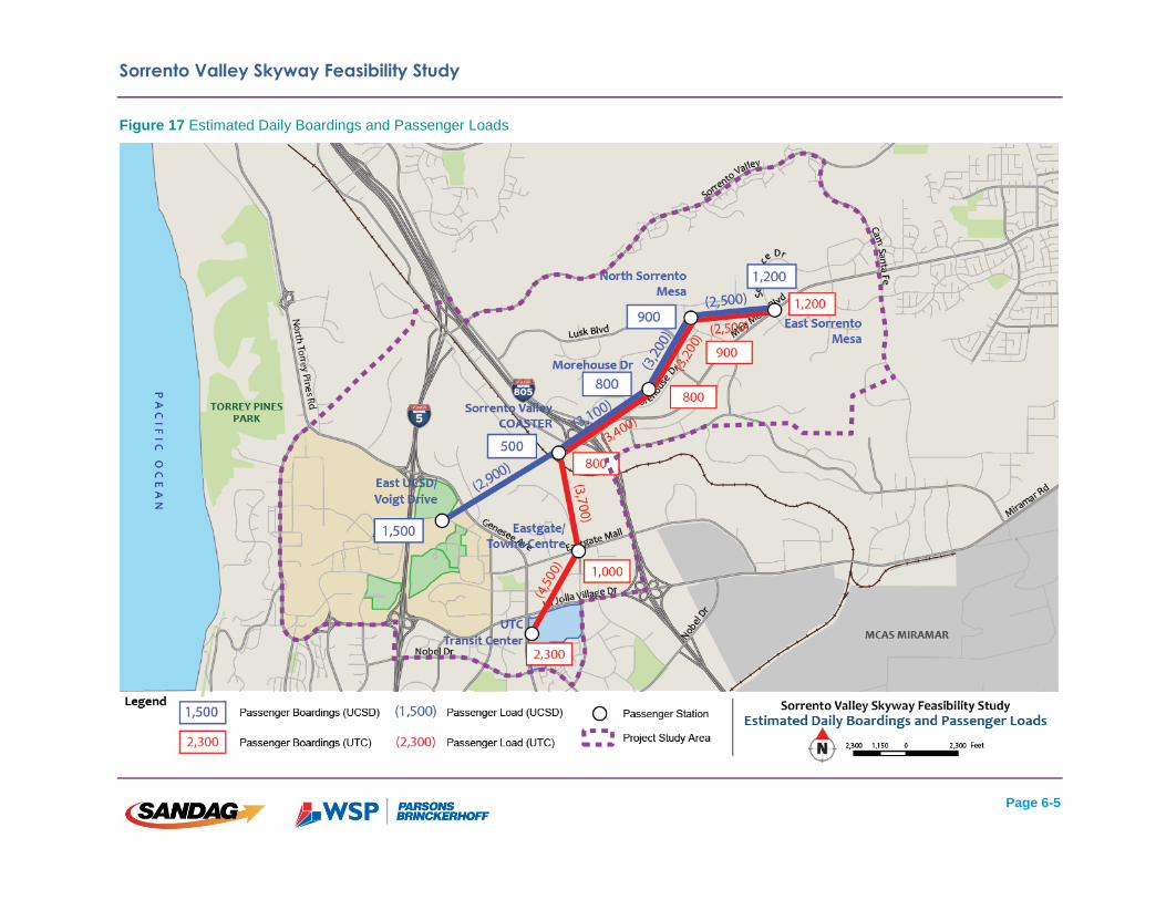
Enhanced pedestrian connectivity in Sorrento Mesa as shown in Figure 17.
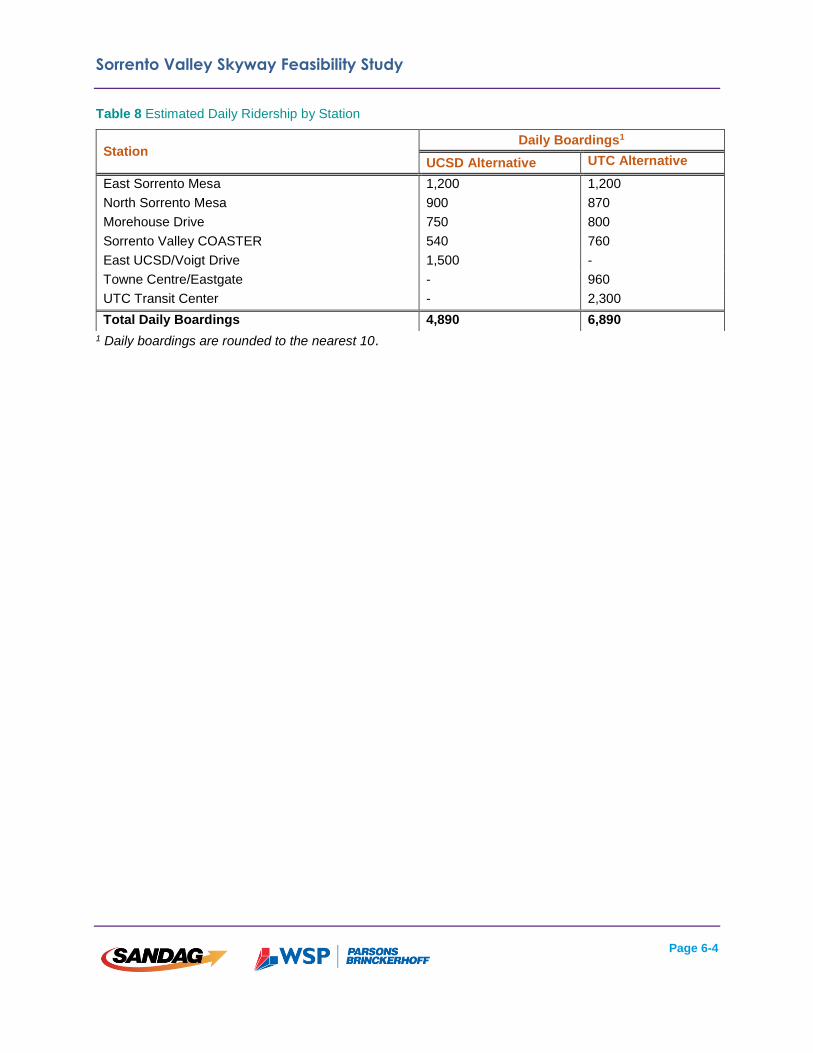
Modeling Results
Table 8 below shows projected ridership by station for each of the alignment alternatives. As
shown, the UCSD option/alternative could generate approximately 4,900 daily boardings,
whereas the UTC option/alternative could generate approximately 6,900 daily boardings. Figure
17 shows passenger boarding’s for each of the alignment alternatives.
Item
UCSD Alternative UTC Alternative
Weekdays Only
Weekdays + Weekends
Weekdays Only
Weekdays + Weekends
Labor Cost $2,500,000 $3,500,000 $2,800,000 $4,050,000
Energy Cost $175,000 $250,000 $175,000 $250,000
Miscellaneous Annual Cost $475,000 $475,000 $500,000 $525,000
Reserve for Major Repairs/Replacement
$1,700,000 $1,700,000 $2,200,000 $2,125,000
Total Cost $4,900,000 $5,900,000 $5,700,000 $7,000,000
System Length 2.9 mi 2.9 mi 3.6 mi 3.6 mi
Number of Stations 5 5 6 6
Sorrento Valley Skyway Feasibility Study
Page 6-4
Table 8 Estimated Daily Ridership by Station
1 Daily boardings are rounded to the nearest 10.
Station Daily Boardings1
UCSD Alternative UTC Alternative
East Sorrento Mesa 1,200 1,200
North Sorrento Mesa 900 870
Morehouse Drive 750 800
Sorrento Valley COASTER 540 760
East UCSD/Voigt Drive 1,500 -
Towne Centre/Eastgate - 960
UTC Transit Center - 2,300
Total Daily Boardings 4,890 6,890
Sorrento Valley Skyway Feasibility Study
Page 6-5
Figure 17 Estimated Daily Boardings and Passenger Loads

Sorrento Valley Skyway Feasibility Study
Page 6-6
6.3 Cost Effectiveness
To illustrate the effectiveness of each of the alternatives, average O&M cost per boarding was
calculated. Average weekday passenger boardings from the travel demand model were
annualized by a factor of 315, which is equal to the annualization factor for the entire MTS
transit system. The annual O&M costs above were then divided by the projected annual
boardings to estimate the average cost per boarding. Annualization factors are calculated
assuming daily service; O&M costs for the “weekday + weekend” service option were used to
calculate overall cost-effectiveness.
In Table 9 shown below, the average cost per boarding is slightly lower for the UTC system
($3.23 per boarding) than the UCSD Alternative ($3.83 per boarding).
Table 9 Average O&M Cost per Boarding
Item UCSD Alternative UTC Alternative
Annual O&M Cost $5,900,000 $7,000,000
Annual Passenger Boardings1 1,540,400 2,170,400
Projected O&M Cost per Boarding $3.83 $3.23 1 Annual passenger boardings calculated by using an annualization factor of 315, which is the average of the entire MTS transit system. Projected ridership numbers are rounded to the nearest 100 boardings. A summary of each alternative is shown in Figure 18.

Sorrento Valley Skyway Feasibility Study
Page 6-7
Figure 18 Summary of Alignment Alternatives

Sorrento Valley Skyway Feasibility Study
Page 6-8
6.4 Community and Environmental
Considerations
An initial high-level environmental evaluation was undertaken as part of this study to determine
key items that would need to be taken into consideration in future studies. The evaluation
addresses potential environmental issues within the study area at a generalized level based on
existing data sources, including aerial imagery, existing geospatial (SanGIS) data, and on
information available in documentation of other ongoing projects within the study area (e.g. the
Mid-Coast Corridor Transit Project).
For purposes of this initial environmental evaluation, generalized corridors for both the UCSD
and UTC alternatives were divided into four segments from west to east, as follows:
SEGMENT 1: UCSD campus from project start through I-5 (UCSD only)
SEGMENT 2: UCSD campus from I-5 through Genesee Avenue (UCSD only)
SEGMENT 3: Genesee Avenue through I-805
SEGMENT 4: I-805 to project terminus
UCSD Alternative
An overview of the UCSD alternative is shown in Table 10. As shown, the majority of items that
identified for further consideration are within Segment 3 (Genesee Avenue to I-805).
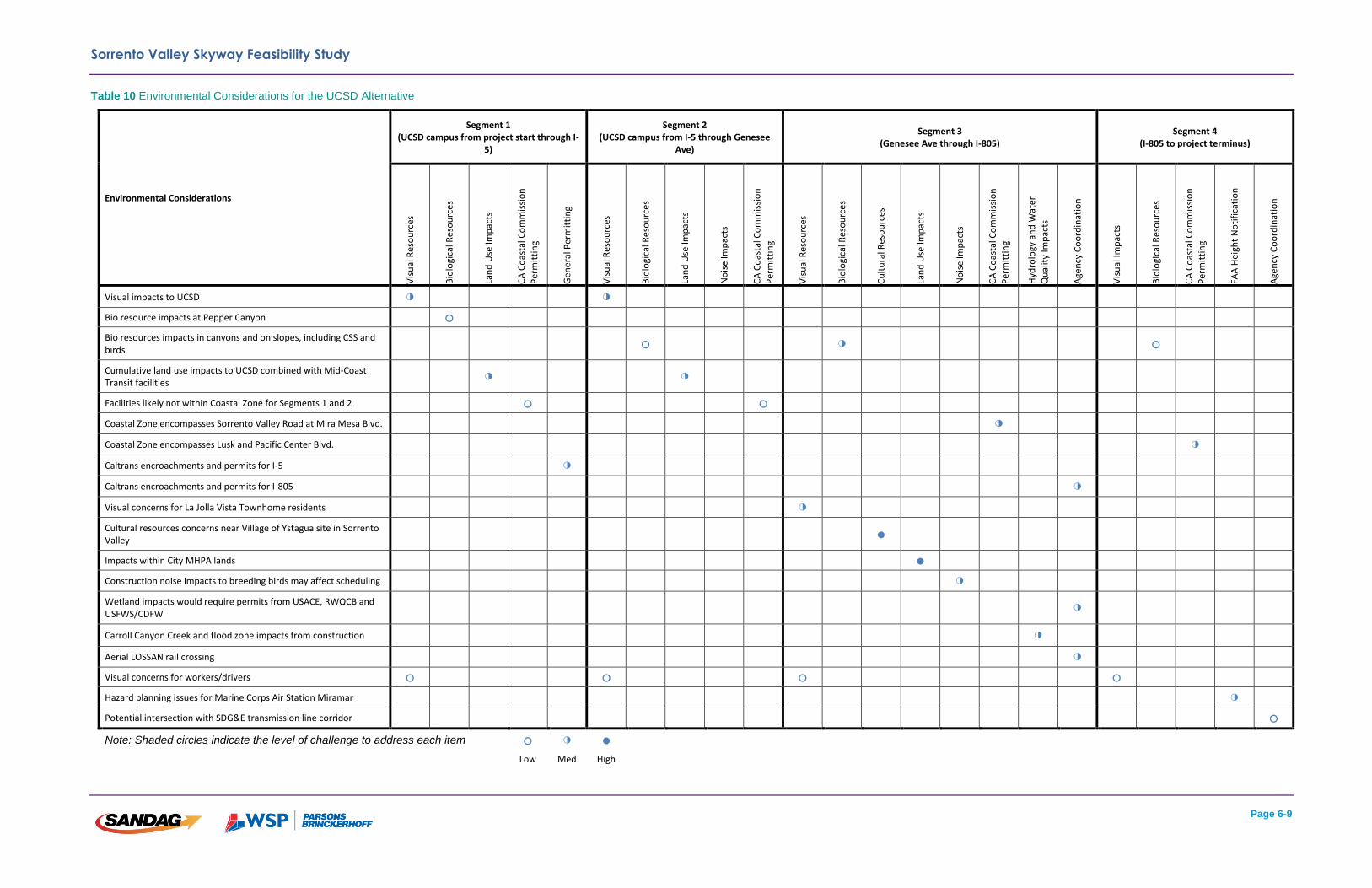
Sorrento Valley Skyway Feasibility Study
Page 6-9
Table 10 Environmental Considerations for the UCSD Alternative
Environmental Considerations
Segment 1 (UCSD campus from project start through I-
5)
Segment 2 (UCSD campus from I-5 through Genesee
Ave)
Segment 3 (Genesee Ave through I-805)
Segment 4 (I-805 to project terminus)
Vis
ual
Res
ou
rces
Bio
logi
cal R
eso
urc
es
Lan
d U
se Im
pac
ts
CA
Co
asta
l Co
mm
issi
on
Per
mit
tin
g
Gen
era
l Per
mit
tin
g
Vis
ual
Res
ou
rces
Bio
logi
cal R
eso
urc
es
Lan
d U
se Im
pac
ts
No
ise
Imp
acts
CA
Co
asta
l Co
mm
issi
on
Per
mit
tin
g
Vis
ual
Res
ou
rces
Bio
logi
cal R
eso
urc
es
Cu
ltu
ral R
eso
urc
es
Lan
d U
se Im
pac
ts
No
ise
Imp
acts
CA
Co
asta
l Co
mm
issi
on
Per
mit
tin
g
Hyd
rolo
gy a
nd
Wat
er
Qu
alit
y Im
pac
ts
Age
ncy
Co
ord
inat
ion
Vis
ual
Imp
acts
Bio
logi
cal R
eso
urc
es
CA
Co
asta
l Co
mm
issi
on
Per
mit
tin
g
FAA
Hei
ght
No
tifi
cati
on
Age
ncy
Co
ord
inat
ion
Visual impacts to UCSD ◑ ◑
Bio resource impacts at Pepper Canyon ○
Bio resources impacts in canyons and on slopes, including CSS and birds
○ ◑ ○
Cumulative land use impacts to UCSD combined with Mid-Coast Transit facilities
◑ ◑
Facilities likely not within Coastal Zone for Segments 1 and 2 ○ ○
Coastal Zone encompasses Sorrento Valley Road at Mira Mesa Blvd. ◑
Coastal Zone encompasses Lusk and Pacific Center Blvd. ◑
Caltrans encroachments and permits for I-5 ◑
Caltrans encroachments and permits for I-805 ◑
Visual concerns for La Jolla Vista Townhome residents ◑
Cultural resources concerns near Village of Ystagua site in Sorrento Valley
●
Impacts within City MHPA lands ●
Construction noise impacts to breeding birds may affect scheduling ◑
Wetland impacts would require permits from USACE, RWQCB and USFWS/CDFW
◑
Carroll Canyon Creek and flood zone impacts from construction ◑
Aerial LOSSAN rail crossing ◑
Visual concerns for workers/drivers ○ ○ ○ ○
Hazard planning issues for Marine Corps Air Station Miramar ◑
Potential intersection with SDG&E transmission line corridor ○
Note: Shaded circles indicate the level of challenge to address each item ○ ◑ ●
Low Med High
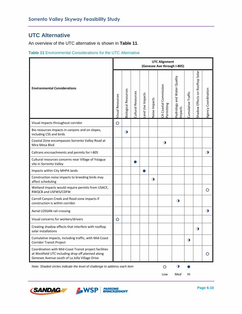
Sorrento Valley Skyway Feasibility Study
Page 6-10
UTC Alternative
An overview of the UTC alternative is shown in Table 11.
Table 11 Environmental Considerations for the UTC Alternative
Environmental Considerations
UTC Alignment (Genesee Ave through I-805)
Vis
ual
Res
ou
rces
Bio
logi
cal R
eso
urc
es
Cu
ltu
ral R
eso
urc
es
Lan
d U
se Im
pac
ts
No
ise
Imp
acts
CA
Co
asta
l Co
mm
issi
on
Per
mit
tin
g
Hyd
rolo
gy a
nd
Wat
er Q
ual
ity
Imp
acts
Cu
mu
lati
ve T
raff
ic
Shad
ow
Eff
ects
on
Ro
oft
op
So
lar
Age
ncy
Co
ord
inat
ion
Visual impacts throughout corridor ○
Bio resources impacts in canyons and on slopes, including CSS and birds
◑
Coastal Zone encompasses Sorrento Valley Road at Mira Mesa Blvd.
◑
Caltrans encroachments and permits for I-805 ◑ Cultural resources concerns near Village of Ystagua site in Sorrento Valley
●
Impacts within City MHPA lands ● Construction noise impacts to breeding birds may affect scheduling
◑
Wetland impacts would require permits from USACE, RWQCB and USFWS/CDFW
○
Carroll Canyon Creek and flood zone impacts if construction is within corridor
◑
Aerial LOSSAN rail crossing ◑ Visual concerns for workers/drivers ○
Creating shadow effects that interfere with rooftop solar installations
◑
Cumulative impacts, including traffic, with Mid-Coast Corridor Transit Project
◑
Coordination with Mid-Coast Transit project facilities at Westfield UTC including drop off planned along Genesee Avenue south of La Jolla Village Drive
○
Note: Shaded circles indicate the level of challenge to address each item ○ ◑ ●
Low Med Hi
Sorrento Valley Skyway Feasibility Study
Page 6-11
6.5 Additional Routing Options
Each of the alignment alternatives listed above could be modified based on budget constraints
or the need to expand a system. Options for each are described in more detail below. Each
additional option is shown in Figure 19. Cost estimates are included in Appendix C.
Minimum Operating Segments
A set of minimum operating segments (MOS) were identified as optional system routing
configurations. These MOS could be constructed in a scenario where capital funds are
constrained. Both of the MOS are routed in a manner that would not preclude the ability to
expand each system in the future.
The following feasible MOS have been identified. They have been evaluated for cost, ridership,
and feasibility:
UCSD MOS (North Sorrento, Morehouse, Voigt Drive); and
UTC MOS (North Sorrento, Morehouse, UTC).
As shown above in Figure 18, the capital cost for the UCSD and UTC MOS would range from $84
million to $126 million, depending on the alternative.
System Expansion
The following expansion options could be implemented if the opportunity to expand the system
arose, however expansion capabilities would need to be accommodated in the initial system
design:
Expansion farther west into UCSD; and
Expansion to East Sorrento Mesa (from MOS).
Expansion farther into UCSD would cost approximately $50 million, and expansion to East
Sorrento Mesa would cost approximately $30 million.

Sorrento Valley Skyway Feasibility Study
Page 6-12
Figure 19 Alignment/Station Options

Sorrento Valley Skyway Feasibility Study
Page 7-1
Chapter 7: Regulatory Requirements
This early review of regulatory requirements was initiated given the potential implementation of
aerial cableway, which would be a new technology to the San Diego region. All of the regulatory
requirements were taken into consideration when developing each of the system routing
options/alternatives as described above in Chapter 6. Regulatory requirements were also
included in determining system capital costs. More detailed information is included in Appendix
D.
7.1 General Regulatory Requirements
The design of an aerial system would likely require adherence to regulations from several
different governing bodies as identified below.
CALTRANS: Coordination with Caltrans would be necessary for clearance and permitting
requirements to ensure construction of the skyway would not cause any adverse effects within
Caltrans rights-of-way.
CALIFORNIA DIVISION OF OCCUPATIONAL SAFETY AND HEALTH (CAL/OSHA): Cal/OSHA is the
primary agency in charge of permitting aerial passenger tramways. The design and operation of
an aerial system would require conformance with several statues and standards.
CALIFORNIA PUBLIC UTILITIES COMMISSION (CPUC): The CPUC has jurisdiction over light rail
transit corridors, which includes potential intersections with the planned Mid-Coast Corridor LRT
extension on the UCSD campus. An aerial system would need to be designed in a manner that
conforms to minimum clearance thresholds as defined by the CPUC.
CALIFORNIA COASTAL COMMISSION: Portions of each of the proposed skyway alignments are
located in the California Coastal Zone, which generally requires a Coastal Development Permit
(CDP) for new development. The City of San Diego would be the permitting agency, as it has
delegation authority from the California Coastal Commission (CCC) to issue CDPs through its
certified Local Costal Program (LCP). However, because a cableway is a major public works
project, the City’s issuance of a CDP most likely will be appealable to the CCC. If an appeal
hearing uncovers any substantial issues pertaining to the project’s consistency with either the
LCP or the California Coastal Act of 1976, the ultimate permit decision will be elevated to the
CCC. A cableway could be a strong candidate for a CDP due to its consistency with the broad
policy goals of both the LCP and the Coastal Act, which include enhancing coastal access,
reducing greenhouse gas emissions, and promoting public transit and non-automobile
circulation.
FEDERAL TRANSIT ADMINISTRATION (FTA): Should an aerial system qualify as a federal funds
recipient from the FTA, it would be subject to environmental review under the National
Environmental Policy Act (NEPA).
Sorrento Valley Skyway Feasibility Study
Page 7-2
MARINE CORPS AIR STATION (MCAS) MIRAMAR: Portions of each alternative are located within
the Federal Aviation Administration (FAA)’s Height Notification Area for MCAS Miramar
airspace, and are subject to development height restrictions. The height of skyway structures
would need to be carefully evaluated in order to ensure that they do not encroach into the
navigable airspace for MCAS Miramar.
Alternatives developed during this study were evaluated at a preliminary level to meet the
restrictions and requirements specified in the aforementioned resources. MCAS Miramar also
provided a review of acceptable vertical profiles for cableway elements and towers, and they
provided input to the study team through meetings and analysis provided by their engineering
team.
UCSD MEDICAL HELICOPTER AIR OPERATIONS: Two of the medical facilities on the east side of
the UCSD campus, Scripps Memorial Hospital and the soon to be completed Jacobs Medical
Center, have helicopter landing pads that are used for medical helicopter operations. The height
of system structures would need to be carefully evaluated in order to ensure that they do not
encroach into the existing or planned helicopter flight paths.
AMERICAN WITH DISABILITIES ACT (ADA): A skyway system would by necessity be ADA
compliant. Level-access boarding would enable boardings for passengers with mobility
challenges. An attendant would be available at each station platform to assist passengers, if
needed. Elevators would be present at each station, providing passengers with access to the
station platform. Most aerial cableway systems can accommodate ADA requirements, or be
modified through design specifications to meet required standards for public transport
operations.
VERTICAL CLEARANCE REQUIREMENTS: Portions of each operating system alternative have the
potential to traverse over existing infrastructure at various points throughout the study area. Any
potential system would need to be designed in order to ensure that minimum vertical clearance
thresholds are met. Potential vertical clearance thresholds include:
Existing roadways: 25 feet
Existing freeways: 18 feet
Existing Los Angeles – San Diego – San Luis Obispo (LOSSAN) Rail Corridor right-
of-way: 25 feet
Existing buildings: varies based on land use (coordination with fire department would
be needed)
Existing electric transmission and distribution lines: 6-12 feet
LRT overhead catenary wires: 3-4 feet
More detailed information regarding the regulatory requirements and sources listed above is
included in Appendix D.

Sorrento Valley Skyway Feasibility Study
Page 8-1
Chapter 8: Potential Funding Sources
This section describes some of the possible funding and financing opportunities available for the
Sorrento Valley Skyway Project. As with many transit projects, a combination of unique and
more traditional funding sources would likely be required. There is a wide array of potential
funding options for the skyway project as discussed in the following subsections.
8.1 Unique Funding Sources
P-3 and Joint Development Opportunities
A variety of potential public/private partnership and value capture opportunities would be
available for the project. The scale, value, and productivity of aerial cableway projects can be
attractive for P3 arrangements. These can range from equity partnerships to full Design Build
Operate Maintain (DBOM) arrangements. In addition, proprietary systems in some cases and
specialized maintenance requirements often make P3 arrangements essential to both the
construction and operations of systems.
Public/Private Partnership Opportunities: An aerial cableway system could be a candidate
for a public/private partnership (P3). Through P3, a private entity would invest its own money
through borrowing or equity and assume much of the risk associated with construction of the
system. P3 has been utilized on several large-scale transportation projects across the United
States, many of which require a multi-billion dollar investment from a private entity. The
relatively low capital investment on an aerial cableway system could be appealing to private
entities. SANDAG/MTS would likely be the owner of an aerial system, as it is envisioned as a
link within the regional transit network.
Opportunities for P3 for the proposed Sorrento Valley aerial cableway should be explored based
on the following:
International experience shows a broad level of private investment in this technology;
Ridership projections are robust;
Major activity centers can be served;
San Diego is a large draw for tourist trips in addition to daily commute trips within the
study area;
Joint development opportunities may exist within proposed station areas; and
The Design-Build-Operate-Maintain project delivery method is common for this type
of technology, especially with the limited amount of expertise for the operations and
maintenance (although, over time, the resources can be built up by an agency
operator).
Value Capture Opportunities: Value capture includes a variety of techniques to extract value
or fees due to the value a transit project brings to the community. These techniques include joint
development at station sites, assessment districts and tax increment financing (TIF).

Sorrento Valley Skyway Feasibility Study
Page 8-2
With the elimination of redevelopment agencies in California, there is a new approach to TIF.
Incremental property taxes can now be captured through a Joint Powers Authority (JPA). Details
include the following:
JPA participants would include cities, counties, and possibly school districts;
Powers would be limited to tax sharing only for the transit activities (either to fund the
system or to support Transit Oriented Development (TOD) for designated transit
areas);
Percentage of shared taxes available would be negotiated among the JPA
participants.
Another financing technique is a Community Facilities District or other assessment district. A
new assessment district for the project could be formed or the project could be funded through
expanding an existing assessment district or districts. In order to implement these financing
techniques, SANDAG could take the following actions:
Work with the City of San Diego and other stakeholders to develop support for a
corridor based Community Facilities District or other assessment district;
Determine an assessment rate that would not place a particular burden on the
property owners;
Use its own land and resources to create transit-oriented land uses around stations;
Capitalize on joint development opportunities; and/or
Evaluate air rights sale or long-term lease.
Commercial Sponsorship and Advertisement Revenue
An aerial cableway system could secure funding from commercial sponsorship and/or
advertisement revenue, including the following:
System Naming Rights: An aerial system could secure sponsorship and naming
rights, similar to the agreement in place with Emirates Airlines and the London
Underground in London, United Kingdom.
System and Station Naming Rights: Naming rights could be sold for each station
location, similar to the planned agreement between MTS and UCSD to name each of
the future LRT stations along the Mid-Coast Corridor Transit Project.
8.2 Traditional Funding Sources
Federal Funding
The Federal Transit Administration (FTA)’s Small Starts program offers an opportunity to
acquire funding for the capital cost of constructing an aerial cableway system. Each of the
alternatives would meet the basic eligibility requirements as a fixed guideway, with an
anticipated capital cost of less than $300 million. The Small Starts program could provide up to
$100 million in funding.

Sorrento Valley Skyway Feasibility Study
Page 8-3
Small Starts is a discretionary program with a unique set of procedures, FTA approval steps,
and project evaluation criteria. Figure 20 illustrates the process. In addition, the New Starts
program could provide funding, but given the relatively small scale of the project, only the Small
Starts process is discussed.
Figure 20 Small Starts Process
Challenges and issues associated with securing federal funding include the following:
The procedural steps are shown in Figure 20, with FTA engagement at critical
approval steps.
There is no certainty of receiving a grant until the grant is actually awarded; all of the
pre-grant steps are carried out “at risk.” Federal funding also brings with it other
federal requirements, such as the National Environmental Policy Act, that are
overlaid on the Small Starts process.
The project would need to get at least a medium rating on FTA’s project justification
and local financial commitment criteria. The justification criteria are mobility
improvements, environmental benefits, congestion relief, land use, economic
development, and cost effectiveness. At this stage of project planning, it is unclear
how well the project would rate on these criteria.
The system would also be eligible for other federal funding, including the following options:
Grants for Transportation Investment Generating Economic Recovery (TIGER)
program offers another discretionary program where SANDAG might compete for
funds. TIGER might be a good fit for an aerial cableway system, as the program
seeks to help projects that do not naturally fit into the regular funding programs.
Grants tend to be no more than $20 million.
FTA formula program (Section 5307) and the flexible funding programs under the
Federal-Aid Highway Program (Surface Transportation Program, CMAQ) are other
potential sources of federal funding for the system. As formula programs, they do not
have the benefit of bringing new money to the San Diego region. Although eligible for
these funds, the system would compete with other San Diego MTS and SANDAG
priorities.
Sorrento Valley Skyway Feasibility Study
Page 8-4
State Funding
The following public and private sources could be used for implementation of the system or for
annual O&M:
California Cap and Trade Sustainable Communities Grants: This relatively new
program was initiated in 2015. Some facts are:
o The State has allocated 20 percent of auction proceeds under the State Cap
& Trade program
o The program allocated $120 million in FY 2015 and $200 million in FY 2016
o Two eligible Project Area Types are TOD and Integrated Connectivity
Projects (ICP)
o Eligible projects are TOD Neighborhoods, Districts or Corridors
o This program ties together transit, affordable housing and infrastructure
o TOD Area loans/grants are $1 million to $15 million
o ICP Area loans/grants are $500,000 to $8 million
California Cap and Trade Transit and Intercity Rail Capital Program (TIRCP):
Initiated in 2015, this program provides grants from the Greenhouse Gas Reduction
Fund to projects that will help reduce greenhouse gas (GHG) emissions by reducing
vehicle miles traveled. Some details are:
o Allocated 10 percent of auction proceeds under the State Cap & Trade program
o $100 million allocated in FY 2016
o Competitive process run by the California State Transportation Agency
(CalSTA)
o Projects would improve/expand rail service/ridership, focus on integrating with
other rail and transit (including high-speed rail), improve rail safety, and prioritize
disadvantaged communities
o Eligible applicants are public agencies (including Joint Powers Authorities) that
operate existing or planned intercity rail, commuter passenger rail, urban rail
transit service, bus services
Local Funding
SANDAG Funds: The system could be eligible for the discretionary SANDAG grant, the Smart
Growth Incentive Program, which is a part of the SANDAG TransNet sales tax measure
program.
Transportation Infrastructure Finance and Innovation Act (TIFIA) Direct Loan Program:
Administered by US Department of Transportation (DOT), a TIFIA loan typically finances up to
33 percent of project cost for projects valued at $50 million or more. The project also has to be
eligible for federal funding. If the project were to require financing that is not available or
preferred from SANDAG or the private sector, then a TIFIA loan might be an option.
Sorrento Valley Skyway Feasibility Study
Page 8-5
Other Revenues: Other revenues possibly available to support the operations and
maintenance of an aerial cableway system include the following:
Fare Revenues: Based upon ridership, the system would generate fares that would,
in part, fund the operations of the system.
Transient Occupancy Tax (TOT): SANDAG could request a share of existing TOT
fees or an increased allocation to the system.
Sorrento Valley Skyway Feasibility Study
Page 9-1
Chapter 9: Summary of Findings
The initial phase of this transit study has provided an assessment of several key factors
regarding the applicability of aerial cableway technology, and design elements for several
alignment options/alternatives. Findings of the study reveal the following:
Based on travel demand estimates using the regional forecast model, high potential
ridership with good per mile trip productivity is apparent for urban circulator options,
as studied, with multiple stops. This finding applies to connections between UTC and
Sorrento Mesa, and connections between the UCSD area and Sorrento Mesa.
Options/alternatives with a connection to a relocated COASTER Station, or not, both
show feasibility in terms of potential users of a new service to provide regional
connections within the study area.
System components such as aerial cableway, tower heights, and station
configurations have been identified that are feasible and cost effective, including
potentially acceptable vertical and horizontal envelopes that minimize impacts,
especially as related to residential impacts, since there are few residential uses in
the corridor.
The aerial cableway technology poses few physical impacts to the land surface given
the small footprint of towers, stations, and ancillary facilities.
Aerial cableway solutions can be designed to effectively accommodate transfers to
regional transit services and local transit services, both operationally and physically.
Safety and regulatory considerations, many of which are unique to an aerial
technology, have been identified as well as potential proven safeguards and
mitigations.
An initial review of community and environmental issues reveals that some issues
will need to be addressed in greater detail, but no fatal flaws have been identified.
Agency stakeholders within the study area and region are generally supportive of
concepts shown and the potential for additional evaluation of aerial cableway
concepts identified in this study.
Although this study does not provide an official recommendation of alignment and technology, it
frames many of the key issues related to the potential of aerial cableway concepts, if considered
in the future. Based on the overall analysis, this technology, and the alignment concepts (or
variations thereof) show viability to serve mobility and community objectives. These concepts
should be evaluated against other feasible transit technologies and concepts in the next phase
of study and should incorporate community input through future outreach activities.


