231
Sourcebook on the Integration of Natural Hazards into the Environmental Impact Assessment Processs i

Sourcebook on the Integration of Natural Hazards into the Environmental Impact Assessment Processs i

Sourcebook on the Integration of Natural Hazards into the Environmental Impact Assessment Processs ii

Sourcebook on the Integration of Natural Hazards into the Environmental Impact Assessment Processs iii
Incorporating Disaster Risk Reduction into the Project Cycle
Sourcebook on the Integration of Natural Hazards into the Environmental Impact
Assessment (EIA) Process
NHIA-EIA SOURCEBOOK
Disaster Mitigation Facility for the Caribbean (DMFC)
Adaptation to Climate Change in the Caribbean (ACCC) Project

Sourcebook on the Integration of Natural Hazards into the Environmental Impact Assessment Processs iv

Sourcebook on the Integration of Natural Hazards into the Environmental Impact Assessment Processs v
Table of ContentsPreface................................................................................................................................................... viList.of.Figures...................................................................................................................................... viiAnnexes............................................................................................................................................... viiiAcknowledgments................................................................................................................................ ixGlossary.................................................................................................................................................. xAcronyms............................................................................................................................................... xi
Sourcebook.on.the.Integration.of.Natural.Hazards.into.the.EIA.Process..Section.1..Introduction 1.0 Background.......................................................................................................................................................... 1 1.1 SourcebookontheIntegrationofNaturalHazardsintotheEIAProcess.................................................................. 2 1.2 RationaleforincorporatingnaturalhazardsintotheEIAprocess............................................................................ 3 1.3 OverviewofprevalentnaturalhazardsintheCaribbean........................................................................................ 3 1.4 Naturalhazardriskmanagement.......................................................................................................................... 5 1.5 Climatevariabilityandchange.............................................................................................................................. 6
Section.2..Integrating.Natural.Hazards.into.the.EIA.process 2.0 Background.......................................................................................................................................................... 8 2.1 Step1:DefineProjectandAlternatives................................................................................................................ 11 2.2 Step2:PreliminaryHazardandVulnerabilityAssessment...................................................................................... 12 2.3 Step3:Screening................................................................................................................................................ 15 2.4 Step4:Scoping................................................................................................................................................... 16 2.5 Step5:AssessmentandEvaluation...................................................................................................................... 17 2.6 Step6:Developenvironmentalmanagementplans.............................................................................................. 22 2.7 Step7:Cost-BenefitAnalysis............................................................................................................................... 23 2.8 Step8:MonitoringProgramme........................................................................................................................... 23 2.9 Step9:PrepareFinalReport............................................................................................................................... 23 2.10 Step10:ProjectAppraisal.................................................................................................................................... 23 2.11Step11:ImplementationandMonitoring............................................................................................................... 24
Section.3..Cumulative.Effects 3.0 Introduction........................................................................................................................................................ 25 3.1 CumulativeEffectsDefined................................................................................................................................. 25 3.2 CumulativeAssessmentofNaturalHazardEffectsandthe EnvironmentalImpactAssessmentProcess.......................................................................................................... 26 3.3 CumulativeEffectsAssessment........................................................................................................................... 26 3.4 WhereistheCumulativeEffectsAssessmentPlacedinthe EnvironmentalImpactAssessmentSubmission?................................................................................................... 30
Section.4..Integrating.Natural.Hazards.into.EIAs.at.the.National.Level 4.0 Background........................................................................................................................................................ 31 4.1 PossibleModalitiesforIncorporatingNaturalHazardsand ClimateChangeImpactsintotheEIAProcess...................................................................................................... 32 4.2 IntegrationofClimateChangeAdaptationintotheEIAProcesswithinCARICOMCountries– PracticalConsiderations...................................................................................................................................... 32
Section.5.References............................................................................................................................56Annexes. ...............................................................................................................................................58

Sourcebook on the Integration of Natural Hazards into the Environmental Impact Assessment Processs vi
The Sourcebook on the Integration of Natural Hazards into the Environmental Impact Assessment (EIA) Process (NHIA-EIA Sourcebook) has been developed as a collaborative effort between the Caribbean Development Bank (CDB), through its Disaster Mitigation Facility for the Caribbean (DMFC) and the Caribbean Community (CARICOM) Adapting to Climate Change in the Caribbean (ACCC) Project.
Disaster.Mitigation.Facility.for.the.CaribbeanThe Disaster Mitigation Facility for the Caribbean was established in CDB’s Projects Department in 2000 as a partnership between CDB and the United States Agency for International Development Office of Foreign Disaster Assistance. Designed to strengthen the capacity of CDB’s 17 borrowing member countries for disaster risk reduction, the Facility has two primary objectives: (i) to strengthen CDB’s institutional capacity for natural hazard risk management and (ii) to assist the Bank’s 17 borrowing member countries (BMCs) with the adoption and implementation of successful disaster mitigation policies and practices. The overall thrust of the project has been to promote the mainstreaming of disaster risk reduction into CDB-financed development projects as well as into national development planning. The primary objectives are being realized through eight principal outputs:Objective 1:
Revised CDB disaster risk management strategy, which places greater emphasis on disaster mitigation; Revised CDB Environmental Review Guidelines which integrate natural hazard risk considerations;CDB Projects and Economics staff trained to identify opportunities for incorporating natural hazard risk into project formulation; and CDB-financed capital and technical assistance projects in which natural hazard risk considerations inform project design.Objective 2:
New/revised disaster mitigation policies and plans in BMCs; Strengthened national and regional disaster management institutions;More risk reduction tools and practices; and More informed and involved natural hazard risk management stakeholders.For further information, please visit our website: http://www.caribank.org or contact [email protected]
Adaptation.to.Climate.Change.in.the.Caribbean.
(ACCC).Project
Adaptation to climate variations and change, and to sea level rise, is of fundamental economic and social importance to the countries of the Caribbean. The Adapting to Climate Change in the Caribbean (ACCC) Project is funded by the Canadian International Development Agency (CIDA) and was implemented during the period October 2001 to March 2004. The project builds on the initial experience gained through the Caribbean Planning for Adaptation to Climate Change (CPACC) project, which concluded in December 2001. This US$2.1 million project involves nine individual components that continue from CPACC in order to consolidate, extend and make sustainable climate change responses. They are also designed to lead into and complement the Global Environment Facility (GEF) program, Mainstreaming Adaptation to Climate Change (MACC). The nine components of the ACCC Project include:Component 1: Development of Business Plan for Caribbean Climate Change CentreComponent 2: Public Education and Outreach (PEO)
Component 3: Risk Management Approach to Physical PlanningComponent 4: Strengthening Regional Technical CapacityComponent 5: Adaptation Planning in Environmental AssessmentsComponent 6: Strategies for Adaptation in the Water SectorComponent 7: Adaptation Strategies to Protect Human HealthComponent 8: Adaptation Strategies for Agriculture and FoodComponent 9: Fostering Collaboration with non- CARICOM CountriesThe outcomes from this initiative aim to ensure that:• The Caribbean Community Climate Change Centre becomes a
sustainable institution for coordinating all climate change related activities in the Region;
• The Region builds climate change adaptation into planning and assessment processes in key economic and social sectors;
• The scientific and technical competence to address climate change issues is strengthened in the Region;
• National and regional agencies can constructively engage in international climate change negotiations; and
• Citizens, the private sector and governments of the Region have the knowledge to support and conduct appropriate climate change responses.
CARICOM countries participating in the ACCC Project:Antigua and Barbuda JamaicaBahamas St. LuciaBarbados St. Kitts and NevisDominica St. Vincent and the GrenadinesGrenada Trinidad and TobagoGuyanaThe ACCC Project is executed through the Canadian Executing Agency (CEA) which comprises Canadian firms, de Romilly and de Romilly Limited, and GCSI – Global Change Strategies International Inc. Day-to-day implementation is the responsibility of the Regional Project Implementation Unit (RPIU), based in Barbados which was originally established for the CPACC Project. However, implementation is the full responsibility of the Caribbean Community (CARICOM) Secretariat. For further information, please visit our website: http://www.caribbeanclimate.org
© 2004 Caribbean Development BankAll rights reserved. No part of this publication may be photocopied, recorded or otherwise reproduced, stored in a retrieval system or transmitted in any form or by any electronic or mechanical means without the prior permission of the copyright owner.
Preface
Note: This document is a work in progress. Comments and suggestions for improvement of the document are welcome and should be submitted to the Caribbean Development Bank, P.O. Box 408, Wildey, St. Michael, Barbados at Telephone: (246) 431-1600, Telefax: (246) 426-7269 or Email: [email protected].
It is recommended that reference to this document should be made as follows:Caribbean Development Bank (CDB) and Caribbean Community Secretariat (CARICOM), 2004. Sourcebook on the Integration of Natural Hazards into the Environmental Impact Assessment (EIA) Process. Caribbean Development Bank, Barbados.

Sourcebook on the Integration of Natural Hazards into the Environmental Impact Assessment Processs vii
List of Figures
Figure 1 Recent Disaster History in the Caribbean........................................................................................1
Figure 2 Categories of Natural Hazard Risk Management Actions ...............................................................6
Figure 3 Potentially Hazardous Natural Phenomena Associated with Climate Change and
Climate Variability ..........................................................................................................................7
Figure 4 EIA Flowchart .................................................................................................................................8
Figure 5 Generic Natural Hazards EIA Flowchart ..........................................................................................9
Figure 6 Estimating Frequency or Probability of an Event ..........................................................................12
Figure 7 Potential Sources of Hazard Information ......................................................................................13
Figure 8 Estimating Impact Severity ..........................................................................................................14
Figure 9 Risk Management Process ............................................................................................................18
Figure 10 Identification of Risk Management Options .................................................................................19
Figure 11 Potential Evaluation Criteria .........................................................................................................20
Figure 12 Climate Change Adaptation Options ............................................................................................21
Figure 13 Status of EIA Procedures Incorporating Climate Change .............................................................31

Sourcebook on the Integration of Natural Hazards into the Environmental Impact Assessment Processs viii
Annexes Section 1. Define Project and Alternatives ...............................................................................60 1.0 Project Information FormSection 2. Preliminary Hazards and Vulnerability Assessment ..................................................71 2.0 Overview of Inventory of Hazard and Vulnerability Assessments, Digital Data in the Caribbean 2.1 Types and Sources of Hydrologic and Atmospheric Hazard Information 2.2a Types and Sources of Geologic Hazards Information 2.2b Additional Resources on Hazard Information in the Caribbean 2.3 IDB Hazard Impact Checklist for Water and Sanitation Projects
Other checklists under development viz. Environment and Natural Resources, Transportation, Energy, Health, Housing, Education, Agriculture, Modernisation of the State, Micro-enterprise Development, may be inserted here.
Section 3. Screening........ .........................................................................................................119 3.0 Risk Assessment Matrix Section 4. Scoping........... .........................................................................................................122 4.0 Sample EIA Terms of Reference (including Natural Hazard Considerations)Section 5. Assessment and Evaluation ....................................................................................126 5.0 Handbook for Estimating Socio-Economic and Environmental Impacts of Disasters 5.1 Establish Baseline 5.1.1 Examples of Caribbean Hazard Assessments 5.1.2 Status of Hazard Maps Vulnerability Assessments and Digital Maps in the Caribbean 5.2 Predict Impacts 5.2.1 Vulnerability Assessment of Utilities and Institutional Buildings 5.2.2 Vulnerability and Capacity Assessment (VCA) 5.2.3 Vulnerability Assessment Techniques and Applications (VATA) 5.3 Evaluate Management, Mitigation and Adaptation Options 5.3.1 Report on the Comparison of Building “Codes” and Practices 5.3.2 Natural Hazard Risk Management Good Practices 5.3.3 Hazard-by-Hazard Listings of Mitigation Measures 5.4 Select Preferred Alternative 5.5 Determine Feasibility 5.5.1 Costs and Benefits of Hazard Mitigation for Building and Infrastructure Development: A Case Study in Small Island Developing States 5.5.2 Costs and Benefits of Building Resilient Infrastructure: The Case of Port Zante in St. Kitts and NevisSection 6. Develop Environmental Management Plan ............................................................191Section 7. Cost-Benefit Analysis .............................................................................................192Section 8. Monitoring Programme ..........................................................................................193Section 9. Prepare Final Report ...............................................................................................194Section 10. Project Appraisal .....................................................................................................195 10.0 Sample Project Appraisal (Review Checklist)Section 11. Implementation and Monitoring ............................................................................201Section 12. Climate Change References ....................................................................................203 12.0 Summary of Climate Change Scenarios for the Caribbean Region 12.1 Climate Change Induced Hazards 12.2 Guide to the Use of Risk Management Procedures to Address Scientific Uncertainty 12.3 Summary of Anticipated Impacts Resulting from Climate Change and Climate Variability in the Caribbean Region

Sourcebook on the Integration of Natural Hazards into the Environmental Impact Assessment Processs ix
Acknowledgments
The following natural hazard, environmental impact assessment and climate change specialists contributed to the develop-ment of the NHIA-EIA Sourcebook.
Mr. Rafi Ahmad, Lecturer in Geology, Unit for Disaster Studies, Department of Geography and Geology, University of the West Indies, Trinidad and Tobago
Dr. Vasantha Chase, Head, Environment and Sustainable Development Unit, Organisation for Eastern Caribbean States, St. Lucia
Ms. Judi Clarke, Component Manager, RPIU/ACCC Project, Barbados
Ms. Cheryl Dixon, Operations Officer (Environment), Project Financing Division, CDB, Barbados
Mrs. Eleanor Jones, Managing Director, Environmental Solutions Limited, Jamaica
Mr. Ian King, Project Officer, CARICOM/ACCC Project, Barbados
Ms. Premila Kumar, Senior Environmental Officer, Department of the Environment, Fiji Islands
Mr. Franklin McDonald, Chief Executive Officer, National Environment and Planning Agency, Jamaica
Professor Leo Moseley, Dean of the Faculty of Pure and Applied Sciences, University of the West Indies, Barbados
Dr. Reynold Murray, Environmental Services Coordinator, Ministry of Health and Environment, St. Vincent and the Grenadines
Mr. Taito Nakalevu, Climate Change Adaptation Officer, South Pacific Regional Environmental Programme, Samoa
Mr. Derrick Oderson, Environmental Officer, Ministry of Physical Development and Environment, Barbados
Ms. Elizabeth Riley, Programme Manager Mitigation and Research, Caribbean Disaster Emergency Response Agency, Barbados
Mr. George de Romilly, President, de Romilly and Romilly Limited, Canada
Dr. George Sammy, Environmental Engineer, Ecoengineering Consultants Limited, Trinidad and Tobago
Mr. David Simmons, President, Simmons and Associates Inc., Barbados
Mr. Cletus Springer, Principal Consultant, Impact Consultancies Services Inc., St. Lucia
Mr. Clairvair Squires, Portfolio Manager, Project Financing Division, CDB, Barbados
Mr. Steven Stichter, Natural Hazards Specialist, Caribbean Region, Organisation of American States, United States of America
Ms. Joyce Thomas, Economic Affairs Division, Ministry of Finance, Grenada
The contribution of the Organisation of American States Unit for Sustainable Development and Environment as consultants to the project is acknowledged.
Project Coordinators: Dr. Cassandra Rogers, Consultant Project Manager, Disaster Mitigation Facility for the Caribbean, Project Supervision Division, CDB, Barbados
Dr. Ulric Trotz, Project Manager, ACCC, Barbados

Sourcebook on the Integration of Natural Hazards into the Environmental Impact Assessment Processs x
Adaptation. Adjustment in natural or human systems to a new or changing environment. Adaptation to climate change refers to adjustment in natural or human systems in response to actual or expected climatic stimuli or their effects, which mod-erates harm or exploits beneficial opportunities. Various types of adaptation can be distinguished, including anticipatory and reactive adaptation, private and public adaptation, and autono-mous and planned adaptation. [IPCC]
Climate Change and Variability. A change of climate which is attributed directly or indirectly to human activity that alters the composition of the global atmosphere and which is in addition to natural climate variability observed over com-parable time periods. [UNFCCC] Climate variability refers to fluctuations in climate over a shorter term - the departures from long-term averages or trends, over seasons or a few years, such as those caused by the El Niño Southern Oscillation phenomenon. [James P. Bruce]
Disaster. A serious disruption of the functioning of a com-munity or a society causing widespread human, material, eco-nomic or environmental losses which exceed the ability of the affected community/society to cope using its own resources. [UN ISDR]
Disaster Risk Reduction. The systematic development and application of policies, strategies and practices to minimise vulnerabilities and disaster risks throughout a society, to avoid (prevention) or to limit (mitigation and preparedness) adverse impact of hazards, within the broad context of sustainable devel-opment. [UN ISDR]
Environmental Impact Assessment (EIA). Environ-mental impact assessment is a process to:
• identify and assess the potential environmental impacts of a proposed project, evaluate alternatives, and design appropriate mitigation, management and monitoring measures;
• ensure that the development options under consider-ation are environmentally sound and sustainable, and that any environmental consequences are recognised early in the project cycle and taken into account in project design. [World Bank]
Geological Hazard. Natural earth processes or phenom-ena, which may cause the loss of life or injury, property damage, social and economic disruption or environmental degradation. [UN ISDR]Geological hazard includes processes of a geological, neotectonic, geophysical, geomor-phologic, geotechnical and hydrogeological nature. Examples of geological hazards are: earthquakes, tsunamis; volcanic activity and emissions; mass movements (land-slides, rockslides, rockfall, liquefaction, submarine slides, etc.); subsidence, surface collapse and geological fault activity.
Hazard. A potentially damaging physical event, phenomenon and/or human activity, which may cause loss of life or injury,
property damage, social and economic disruption or environ-mental degradation. [UN ISDR]The term Natural Hazards, as used throughout this document, includes all potentially damaging natural phenomena, which my cause loss of life or injury, property dam-age, social and economic disruption or environmental degradation. Natural hazards include both hydrometerological and geologic hazards. Naturally-occurring hazards which may also have human induced triggers such as landslides and climate change, are considered ‘natural hazards’ in the context of this work.
Hydrometeorological Hazards. Natural processes or phenomena of atmospheric, hydrological or oceanographic na-ture, which may cause loss of life or injury, property damage, social and economic disruption or environmental degradation. [UN ISDR]Examples of hydrometeorological hazards are: floods, debris and mud flows; tropi-cal cyclones, storm surges, thunder/hailstorms, rain and wind storms, blizzards and other severe storms; drought, desertification, wild-land fires, heat waves, sand or dust storms; permafrost and avalanches.
Mitigation [regarding natural hazards]. Structural and non-structural measures undertaken to limit the adverse impact of natural hazards, environmental degradation and technological hazards. [ISDR]
Mitigation [regarding climate change]. A human in-tervention to reduce the sources or enhance the sinks of green-house gases. [IPCC 2001.]
Natural Hazard Impact Assessment. A study under-taken to identify, predict and evaluate natural hazard impacts (from existing hazards as well as those which may result from the project) associated with a new development or the extension of an existing facility. This is achieved through an assessment of the natural hazards that are likely to affect or result from the project and an assessment of the project’s vulnerability and risk of loss from hazards. An NHIA is an integral component of and extension to the environmental review process and environmen-tal impact assessment in that it encourages explicit consideration and mitigation of natural hazard risk. [CDB]
Risk [1]. The probability of harmful consequences, or expect-ed loss (of lives, people injured, property, livelihoods, economic activity disrupted or environment damaged) resulting from in-teractions between natural or human induced hazards and vul-nerable/capable conditions. [ISDR]
Risk [2]. The chance of injury or loss as defined as a mea-sure of the probability and severity of an adverse effect to health, property, the environment, or other things of value. [ACCC]
Risk Assessment. The overall process of risk analysis and risk evaluation. Risk analysis is the systematic use of information to identify hazards and to estimate the chance for, and severity of, injury or loss to individuals or populations, property, the envi-ronment, or other things of value. Risk evaluation is the process by which risks are examined in terms of costs and benefits, and evaluated in terms of acceptability of risk considering the needs, issues, and concerns of stakeholders.
Glossary

Sourcebook on the Integration of Natural Hazards into the Environmental Impact Assessment Processs xi
Risk Management. The systematic application of manage-ment policies, procedures, and practices to the tasks of analysing, evaluating, controlling, and communicating about risk issues. [ACCC] There are three dimensions to Natural Hazard Risk Management: risk identification, risk reduction and risk trans-fer. [CGCED]
Vulnerability [regarding climate change]. The degree to which a system is susceptible to, or unable to cope with, ad-verse effects of climate change, including climate variability and
Sources
Adapting to Climate Change in the Caribbean (ACCC), 2003. Caribbean Risk Management Techniques for Climate Change.
CGCED 2002. Caribbean Group for Cooperation in Economic Development (CGCED), Natural Hazard Risk Management in the Caribbean, June 2002. (http://www.worldbank.org/cgced)
IPCC 2001. Climate Change 2001: Impacts, Adaptation and Vulnerability. IPCC Third Assessment Report, 2001.
UNISDR 2002. UN International Strategy for Disaster Reduction (UN ISDR), Living with Risk—Annex 1, July 2002. (http://www.unisdr.org/unisdr/Globalreport.htm)
World Bank 1999. World Bank Operational Policy 4.01 “Environmental Assessment”—Annex A (1999).
extremes. Vulnerability is the function of the character, magni-tude, and rate of climate variation to which a system is exposed, its sensitivity, and its adaptive capacity. [IPCC]
Vulnerability [regarding natural hazards]. A set of conditions and processes resulting from physical, social, eco-nomical, environmental factors [and development decisions], which increase the susceptibility of a community [or project] to the impact of hazards. [ISDR]

Sourcebook on the Integration of Natural Hazards into the Environmental Impact Assessment Processs xii
ACCC ......... Adapting to Climate Change in the Caribbean Project
BEST ........... Bahamas Environment Science and Technology
CARICOM . Caribbean Community
CDB ........... Caribbean Development Bank
CEA ............ Cumulative Effects Assessment
CEC ............. Certificate of Environmental Clearance
CGCED ...... Caribbean Group for Cooperation in Economic Development
CIDA .......... Canadian International Development Agency
DMFC ........ Disaster Mitigation Facility for the Caribbean
DoE ............. Department of Environment
EAB............. Environmental Assesment Board
EIA ............. Environmental Impact Assessment
EIS............... Environmental Impact Statement
EMA ............ Environmental Management Act
EMLUP ....... Environmental Management and Land Use Planning for Sustainable Development
EPA ............. Environment Protection Act
IDB ............. Inter-American Development Bank
IPCC ........... Intergovernmental Panel on Climate Change (part of the UNFCCC)
ISDR ........... International Strategy for Disaster Reduction
MACC ......... Mainstreaming Adaptation to Climate Change
NEAC .......... National Environmental Appraisal Committee
NGO ........... Non-governmental Organization
NHIA .......... Natural Hazard Impact Assessment
NHRM ........ Natural Hazard Risk Management
NRCA ......... Natural Resources Conservation Authority
OAS............. Organisation of American States
PPA .............. Physical Planning Act
PPD ............. Physical Planning Division
TCPA ........... Town and Country Planning Act
TOR ............ Terms of Reference
UNFCCC .... UN Framework Convention on Climate Change
UN ISDR .... UN International Strategy for Disaster Reduction
VEC ............ Valued Ecosystem Component
Acronyms

Sourcebook on the Integration of Natural Hazards into the Environmental Impact Assessment Processs �
1.0....BackgroundThe Caribbean region is subject to a broad range of
potentially hazardous natural phenomena, which have formed and continue to shape the region. Hurricanes and tropical storms, earthquakes, volcanoes, landslides and flooding are significant environmental systems and processes in the Region. Social, political and institutional systems have so interacted with these processes that livelihoods and social, economic and physical infrastructure often suffer physical damage, economic loss, dislocation and loss of life. As economic and population growth continue in the Caribbean, new developments can either exacerbate existing hazardous conditions and vulnerability, or they can contribute to the reduction of overall hazard risk.
The purpose of this document is to enable the development review process in particular environmental impact assessments (EIA) - to better encourage and promote development design that limits or reduces vulnerability to natural hazards.
In an attempt to ensure that natural hazard risk is explicitly addressed during the project cycle, the Caribbean Development Bank (CDB) has developed guidelines for natural hazard impact assessment (NHIA) and their integration into EIA procedures. Current EIAs focus on the impact of the project on the environment; the NHIA is designed to identify the linkages between natural hazards and the project through an assessment of the natural hazards that are likely to affect or result from the project and an assessment of the project’s vulnerability to and risk of loss from hazards. An NHIA is an integral component of and extension to the environmental review process and EIA in that it encourages explicit consideration and mitigation of natural hazard risk.
The appraisal of natural hazard risk as part of the EIA process is a preventive approach to ensure that appropriate hazard mitigation measures are incorporated into project design and subsequent implementation, where deemed necessary. This is expected to contribute to the minimisation of hazard risks associated with development projects.
In this context two documents have been developed:A Guide to the Integration of Natural Hazards into
the EIA Process; targeting CDB staff, and consisting of the Bank’s environmental review guidelines with natural hazard considerations included.
Introduction
A Sourcebook on the Integration of Natural Hazards, including climate change, into the EIA Process; developed by CDB’s Disaster Mitigation Facility for the Caribbean (DMFC) in collaboration with the Caribbean Community’s (CARICOM) Adapting to Climate Change in the Caribbean (ACCC) Project. The ACCC Project seeks to integrate climate change adaptation planning
Main Natural Disasters in the Caribbean (1979–2004)
Year Country (Hazard Type) Persons Affected
Damage US (000´s) *
1979 Dominica (David and Frederick) 72,100 $44,650
1980 St. Lucia (Allen) 80,000 $87,990
1988 Dominican Republic (Flood) 1,191,150
1988 Haiti (Gilbert) 870,000 $ 91,286
1988 Jamaica (Gilbert) 810,000 $ 1,000,000
1989 Montserrat (Hugo) 12,040 $ 240,000
1989 Antigua, St. Kitts/Nevis, Tortola, Montserrat (Hugo)
33,790 $ 3,579,000
1991 Jamaica (Flood) 551,340 $ 30,000
1992 Bahamas (Andrew) 1,700 $ 250,000
1993 Cuba (Storm) 149,775 $ 1,000,000
1993 Cuba (Flood) 532,000 $ 140,000
1994 Haiti (Storm) 1,587,000
1995 St Kitts & Nevis (Luis) 1,800 $ 197,000
1995 US Virgin Islands (Marilyn) 10,000 $ 1,500,000
1998 Dominican Republic (Georges) 975,595 $ 2,193,400
2000 Antigua/Barbuda, Dominica, Grenada, St. Lucia (Lenny)
$ 268,000
2004 Grenada (Ivan) $815,000
Figure 1: Recent Disaster History in the Caribbean
and management into EIA for national and regional development projects.
Guidelines for EIA that are used by CDB and the World Bank, as well as reviews of the EIA processes in CARICOM countries conducted by the Inter-American Development Bank (IDB) and the ACCC Project, have been used as the basis for the Sourcebook.
Section 1

Sourcebook on the Integration of Natural Hazards into the Environmental Impact Assessment Processs �
A complementary document to the Sourcebook, viz. Guide to the Integration of Climate Change Adaptation into the EIA Process, has been developed by ACCC and the South Pacific Regional Environmental Programme and is an important reference on CC-EIA.
1.1...Sourcebook.on.the.Integration.of..........Natural.Hazards.into.the.EIA.Process
The Sourcebook on the Integration of Natural Hazards into the EIA Process is intended to be a compilation of current and appropriate mechanisms for assessing, within EIA, the potential interaction between a proposed project and natural hazards. The combined process is referred to as Natural Hazard Impact Assessment–Environmental Impact Assessment (NHIA-EIA). The Sourcebook presents a generic approach to the NHIA-EIA process, which can be adapted to existing EIA processes at the national and regional levels. Appendices with appropriate checklists, references and examples are provided for each step in the NHIA-EIA process.
To guide the development of this Sourcebook, the following standards were established:
1. The NHIA-EIA process must be understandable and directly applicable by target users. In each step, the responsibilities of the NHIA-EIA preparer and of the reviewer will be clearly identified.
2. The NHIA process must be fully integrated into the existing EIA process, while maintaining the purpose and integrity of that process. Within the Caribbean Development Bank (CDB), for instance, NHIA will be integrated into CDB’s existing environmental assessment process as described in CDB’s Environmental Review Guidelines.
3. The Sourcebook should be easily updated.
1.1.1 Target AudienceDepending upon the type of development proposed
and the characteristics of the development site(s), a wide variety of development impacts are possible, across a variety of sectors and environments. Conducting an EIA of such development, therefore, is an inherently multi-disciplinary process, requiring a team with a broad range of knowledge and experience, potentially including expertise in disciplines such as air and water quality, ecology, wildlife habitat, coastal management, marine biology and waste management. Full incorporation of natural hazard risk considerations into the EIA process will require the addition of natural hazard expertise to most NHIA-EIA teams.
The target audie nce for the Sourcebook includes EIA practitioners and reviewers at the national and regional levels in the Caribbean. The Sourcebook is not a guide to the full EIA process. Rather, it focuses exclusively on the interventions into the EIA process that are necessary to ensure that natural hazard risk considerations are appropriately addressed. EIA preparers will find resources for natural hazard and vulnerability assessment and on related considerations that should be addressed throughout the preparation of the EIA. EIA reviewers will find guidance on issues that should be incorporated into the scope of work for an EIA and that should be addressed in the final EIA documents under review.
1.1.2 Structure and Use of the Sourcebook
The Sourcebook is intended to be a compilation of current and appropriate mechanisms for assessing, within EIA, the potential interaction between a proposed project and natural hazards. The main body of the Sourcebook is divided into four sections:
• Section 1 provides the rationale for and an overview of the NHIA-EIA process, as well as brief descriptions of the prevalent natural hazards in the Caribbean.
• Section 2 presents a generic EIA process and identifies how natural hazard risk considerations should be addressed in each step of the generic process.
• Section 3 discusses cumulative impacts from multiple natural hazards or from inter-hazard exacerbations.
• Section 4 presents special considerations for the incorporation of assessment of natural hazards into existing EIA processes at the national level within the Caribbean.
Sections 1 to 4 are primarily descriptive, providing the background and a framework for the integration of assessment of natural hazards into EIA within the region. Specific tools, checklists and methodologies for use or adaptation within NHIA-EIA are presented within the extensive annexes to the Sourcebook. The annexes are arranged according to the ten steps in the EIA Process as outlined in Section 2. As methodologies for hazard and vulnerability assessment are developed or updated and as experience with NHIA-EIA grows, new references and lessons will be added to this document as well as to the annexes. To facilitate this, the Sourcebook has been presented in a binder format.

Sourcebook on the Integration of Natural Hazards into the Environmental Impact Assessment Processs �
1.2. Rationale.for.Incorporating.Natural... Hazards.into.the.EIA.Process
The World Bank defines EIA as “…a process to:(a) identify and assess the potential environmental
impacts of a proposed project, evaluate alternatives, and design appropriate mitigation, management and monitoring measures; and
(b) ensure that the development options under consideration are environmentally sound and sustainable, and that any environmental consequences are recognised early in the project cycle and taken into account in project design.”
EIA is an existing process that is generally accepted and applied throughout the Caribbean. Natural hazards are an integral component of the environment. Traditionally however, EIAs have focused on the impact of the project on the environment, with less attention to the impacts of the environment on the project. In a hazard-prone region such as the Caribbean, it is essential that the interactions between the proposed project and natural hazards are fully and explicitly investigated. Full incorporation of natural hazards assessment into the EIA process requires only relatively minor adjustments to existing procedures. A review of the environmental review processes at the CDB, conducted by the Organisation of American States Unit for Sustainable Development and Environment, for instance, identified two gaps with regard to natural hazards in CDB’s existing Environmental Review Guidelines:
1. Natural hazards are currently only addressed implicitly within the Guidelines. This results in missed opportunities for considering natural hazard impacts upon the project and the impacts of the project on natural hazards.
2. The vulnerability of the project to impacts of natural hazards is not currently addressed.
1.2.1 Natural Hazard Impact AssessmentWhile the assessment of natural hazard impacts is well
established, NHIA is a relatively new term. CDB has defined NHIA as:“a study undertaken to identify, predict and evaluate natural hazard impacts associated with a new development or the extension of an existing facility (from existing hazards as well as those which may result from the project). This is achieved through an assessment of the natural hazards that are likely to affect or result from the project and an assessment of the project’s vulnerability and risk of loss from hazards. An NHIA is an integral component of and extension to the environmental review process and environmental impact assessment in that it encourages explicit consideration and mitigation of natural hazard risk.”
NHIA allows explicit consideration of natural hazards within impact assessment, including the impact of the hazards on the project, and the exacerbations of hazard impacts introduced by the project. The introduction and mainstreaming of NHIA is significant, because NHIA:
• provides a mechanism for incorporating natural hazard risk considerations into the project cycle;
• explicitly addresses natural hazard risk;
• promotes risk minimization and risk management through incorporation of hazard mitigation into project design; and
• is expected to enhance EIA practitioners’ understanding of natural hazard risk as an environmental issue.
EIAs are also increasingly addressing social impacts of proposed projects and activities. This link between social and environmental impacts is strengthened by the expansion of the EIA process to include natural hazard vulnerability assessment.
It is anticipated that in the future, once natural hazard assessment has been fully incorporated into the EIA procedures, separate references to NHIA and its definition will not be necessary.
1.3..Overview.of.Prevalent.Natural.........Hazards.in.the.Caribbean
Sections 1.31 and 1.32 are excerpted from the Organisation of American States’ Primer on Natural Hazard Management in Integrated Regional Development Planning (1991).
The Caribbean is vulnerable to a wide range of natural and man-made hazards. In the context of this document, natural hazards are considered broadly and include naturally occurring hazards as well as those that may have human-induced triggers. Climate variability and change is included within this list of natural hazards. Human-induced or technological hazards are not addressed in this document. However, the same approach described below for natural hazards can be applied to understand and assess the impacts of many human-induced hazards.
1.3.1 Atmospheric and Hydro-meteorological HazardsFurther information on atmospheric and hydro-meteorological is presented in Annex Section 2.1.
1.3.1.1 Flooding Two types of flooding can be distinguished viz:
• land-borne floods, or river flooding, caused by

Sourcebook on the Integration of Natural Hazards into the Environmental Impact Assessment Processs �
excessive run-off brought on by heavy rains; and
• sea-borne floods, or coastal flooding, caused by storm surges, often exacerbated by storm run-off from the upper watershed.
Tsunamis are a special type of sea-borne flood.
River flooding. Land-borne floods occur when the capacity of stream channels to conduct water is exceeded and water overflows banks. Floods are natural phenomena, and may be expected to occur at irregular intervals on all stream and rivers. Settlement of floodplain areas is a major cause of flood damage.
Coastal flooding. Storm surges are an abnormal rise in sea water level associated with hurricanes and other storms at sea. Surges result from strong on-shore winds and/or intense low pressure cells and ocean storms. Water level is controlled by wind, atmospheric pressure, existing astronomical tide, waves and swells, local coastal topography and bathymetry, and the storm’s proximity to the coast.
Most often, destruction by storm surge is attributable to:
• Wave impact and the physical shock on objects associated with the passing of the wave front.
• Hydrostatic/dynamic forces and the effects of water lifting and carrying objects.
The most significant damage often results from the direct impact of waves on fixed structures. Indirect impacts include flooding and undermining of major infrastructure such as highways and railroads.
Flooding of deltas and other low-lying coastal areas is exacerbated by the influence of tidal action, storm waves, and frequent channel shifts.
1.3.1.2 Tropical Storms and Hurricanes Hurricanes are tropical depressions which develop into
severe storms characterised by winds directed inward in a spiraling pattern toward the center. They are generated over warm ocean water at low latitudes and are particularly dangerous due to their destructive potential, large zone of influence, spontaneous generation, and erratic movement. Phenomena which are associated with hurricanes are:
• Winds exceeding 64 knots (74 ml./hr or 118 km/hr), the definition of hurricane force. Damage results from the wind’s direct impact on fixed structures and from wind-borne objects.
• Heavy rainfall which commonly precedes and follows hurricanes for up to several days. The quantity of rainfall is dependent on the amount
of moisture in the air, the speed of the hurricane’s movement, and its size. On land, heavy rainfall can saturate soils and cause flooding because of excess runoff (land-borne flooding); it can cause landslides because of added weight and lubrication of surface material; and/or it can damage crops by weakening support for the roots.
• Storm surge (explained above), which, especially when combined with high tides, can easily flood low-lying areas that are not protected.
1.3.1.3 Tsunamis Tsunamis are long-period waves generated by
disturbances such as earthquakes, volcanic activity, and undersea landslides. The crests of these waves can exceed heights of 25 meters on reaching shallow water. The unique characteristics of tsunamis (wave lengths commonly exceeding 100 km, deep-ocean velocities of up to 700 km/hour, and small crest heights in deep water) make their detection and monitoring difficult. Characteristics of coastal flooding caused by tsunamis are the same as those of storm surges.
1.3.2 Geologic HazardsFurther information on geologic hazards is presented in
Annex Sections 2.2.
1.3.2.1 Earthquakes Earthquakes are caused by the sudden release of slowly
accumulated strain energy along a fault in the earth’s crust. Earthquakes and volcanoes occur most commonly at the collision zone between tectonic plates. Earthquakes represent a particularly severe threat due to the irregular time intervals between events, lack of adequate forecasting, and the hazards associated with these.
• Ground shaking is a direct hazard to any structure located near the earthquake’s center. Structural failure takes many human lives in densely populated areas.
• Faulting, or breaches of the surface material, occurs as the separation of bedrock along lines of weakness.
• Landslides occur because of ground shaking in areas having relatively steep topography and poor slope stability.
• Liquefaction of gently sloping unconsolidated material can be triggered by ground shaking. Flows and lateral spreads (liquefaction phenomena) are among the most destructive geologic hazards.

Sourcebook on the Integration of Natural Hazards into the Environmental Impact Assessment Processs �
• Subsidence or surface depressions result from the settling of loose or unconsolidated sediment. Subsidence occurs in waterlogged soils, fill, alluvium, and other materials that are prone to settle.
• Tsunamis or seismic sea waves, usually generated by seismic activity under the ocean floor, cause flooding in coastal areas and can affect areas thousands of kilometers from the earthquake center.
1.3.2.2 Volcanoes Volcanoes are perforations in the earth’s crust through
which molten rock and gases escape to the surface. Volcanic hazards stem from two classes of eruptions:
• Explosive eruptions which originate in the rapid dissolution and expansion of gas from the molten rock as it nears the earth’s surface. Explosions pose a risk by scattering rock blocks, fragments, and lava at varying distances from the source.
• Effusive eruptions where material flow rather than explosions is the major hazard. Flows vary in nature (mud, ash, lava) and quantity and may originate from multiple sources. Flows are governed by gravity, surrounding topography, and material viscosity.
Hazards associated with volcanic eruptions include lava flows, falling ash and projectiles, mudflows, and toxic gases. Volcanic activity may also trigger other natural hazardous events including local tsunamis, deformation of the landscape, floods when lakes are breached or when streams and rivers are dammed, and tremor-provoked landslides.
1.3.2.3 Landslides.The term landslide includes slides, falls, and flows of
unconsolidated materials. Landslides can be triggered by earthquakes, volcanic eruptions, soils saturated by heavy rain or groundwater rise, and river undercutting. Earthquake shaking of saturated soils creates particularly dangerous conditions. Although landslides are highly localized, they can be particularly hazardous due to their frequency of occurrence. Classes of landslide include:
• Rockfalls, which are characterised by free-falling rocks from overlying cliffs. These often collect at the cliff base in the form of talus slopes which may pose an additional risk.
• Slides and avalanches, a displacement of overburden due to shear failure along a structural feature. If the displacement occurs in surface
material without total deformation it is called a slump.
• Flows and lateral spreads, which occur in recent unconsolidated material associated with a shallow water table. Although associated with gentle topography, these liquefaction phenomena can travel significant distances from their origin.
The impact of these events depends on the specific nature of the landslide. Rockfalls are obvious dangers to life and property but, in general, they pose only a localized threat due to their limited aerial influence. In contrast, slides, avalanches, flows, and lateral spreads, often having great aerial extent, can result in massive loss of lives and property. Mudflows, associated with volcanic eruptions, can travel at great speed from their point of origin and are one of the most destructive volcanic hazards.
1.4...Natural.Hazard.Risk.ManagementTraditional disaster management focuses on the activities
undertaken immediately surrounding a disaster event, with the intention of reducing the impact of a specific event. Over the past two decades, this approach has expanded to include a broad range of longer-term activities designed to reduce the overall vulnerability to natural hazards. This new approach, referred to as natural hazard risk management, is described in detail in the document Natural Hazard Risk Management in the Caribbean: Revisiting the Challenge (World Bank, 2002).
“Natural hazard risk management is significantly different from traditional preparedness and response activities. A traditional approach attempts to address existing problems, while hazard risk management focuses more on anticipating problems by ensuring that growth and development address the likelihood of hazards and their interaction with environmental systems. Whereas traditional preparedness and response mechanisms often focus on individual hazard events, risk management views hazard exposure as an ongoing process and aims at reducing vulnerability to these hazards across all sectors of society and the economy. Such an approach needs to become an integral part of economic planning and policy making. Outside of the traditional disaster management system, no comprehensive framework for coordinating multi-sectoral risk management activities has existed until recently. Two new regional initiatives, the development of a Strategy and Results Framework for Comprehensive Disaster Management in the Caribbean (CDM) and the establishment of the Disaster Mitigation Facility for the Caribbean (DMFC) within the Caribbean Development Bank, significantly enhance the potential for integration of risk management into the Region’s development agenda.”
The three main, interrelated categories of risk

Sourcebook on the Integration of Natural Hazards into the Environmental Impact Assessment Processs �
management actions risk identification, risk reduction and risk transfer are described in Figure 2.
Annex Section 5.3.2 lists natural hazard risk management good practices that can be adopted at the local, national and regional levels.
1.5...Climate.Variability.and.ChangeA summary of climate change scenarios for the Caribbean Region is presented in Annex Section 10.0.
Potential hazards expected from climate variability and climate change in the Caribbean include:
• increased surface temperatures;
• decreased precipitation;
• more frequent and intense storms*
• changing weather patterns;
• sea level rise; and
• changes in ultra-violet penetration levels.
The natural “hazards” associated with climate change include floods and droughts associated with changing rainfall patterns, coastal inundation associated with sea-level rise, and impacts from extreme events (storms and hurricanes). A summary of potentially hazardous natural phenomena associated with climate change are summarised in Figure 3. An explanation of some of the key natural hazards associated with climate change and climate variability is provided in Annex Section 10.
EIA should take into account anticipated impacts from climate change on:
*The Intergovernmental Panel on Climate Change (IPCC) projects that tropical cyclones (hurricanes) are unlikely to increase in frequency, but the most severe ones would increase in intensity in a warmer world. For heavy rain events, an increase in frequency is also projected.
• Risk Identification. Steps taken to understand existing vulnerabilities, including their location and severity. A broad range of activities contributes to the identification and understanding of natural hazard risk: hazard data collection and mapping, vulnerability assessment, risk assessment and post-disaster assessment.
• Risk Reduction. Risk reduction activities are designed to mitigate damage from hazard events. These activities address existing vulnerability through such measures as retrofit, strengthening and relocation. Actions taken to reduce future vulnerability, such as the implementation and enforcement of building standards, environmental protection measures, land use planning that recognises hazard zones and resource management practices, will provide significant benefits over the long term.
• Risk Transfer. In cases where it is not possible to eliminate risk, it is important to strengthen fiscal resilience and to reduce financial risk through mechanisms that ensure funds are readily available to rectify the damage or replace the facility should a loss occur. Utilizing the insurance mechanisms is appropriate for risks that cannot be mitigated through structural or ex-ante damage reduction measures, and against events that have the potential to cause large economic losses.
Figure 2: Categories of Natural Hazard Risk Management Actions
• the natural environment – air, water, and land;
• human health and safety and anticipated impacts to human health and safety;
• social aspects (involuntary resettlement, impact on the lives of indigenous peoples, cultural assets); and
• transboundary and global environmental aspects.
The primary effect of climate change will be to exacerbate known meteorological hazards (flooding, tropical storms, drought) through increases in variability of climate phenomena, with accompanying increases in frequency and/or intensity of extreme events.
The following areas have high potential for impacts from climate change and consequently, particular attention must be paid to interactions with these components within EIAs:
• Biodiversity and Wildlife;
• Ecosystems and their Goods and Services (Agriculture, Forestry, Fisheries, Aquaculture, Coastal Zones and Marine Ecosystems);
• Hydrology and Water Resources;
• Soils and Land Resources;
• Human Settlements (including buildings and structures);
• Energy and Industry;
• Insurance and other Financial Services;

Sourcebook on the Integration of Natural Hazards into the Environmental Impact Assessment Processs �
• Human Health; and
• Socioeconomic Development.
Among the sectors with greatest vulnerability to climate change impacts are:
• Tourism (temperature changes in region and abroad, sea level rise, water availability);
• Coastal area infrastructure (sea level rise, more frequent and more severe storms);
• Housing and other infrastructure (heavier, short duration rains and storms, water availability);
• Agriculture (higher temperatures, changes in rainfall patterns, more CO2 in atmosphere);
• Water resources (greater evaporation, changes in rainfall, increasing demands in warmer climate, salt water intrusion with sea level rise);
• Human Health (greater risks of vector and water borne diseases, greater heat stress, and exposure to ultra-violet radiation); and
• Biodiversity and natural ecosystems (greater risks of loss of vulnerable coastal and marine ecosystems including wetlands and coral reefs, increased risk of desertification and loss of biodiversity, impact on migratory species).
1.5.1 Challenges for the EIA Process.
Many projects for which EIAs are required have relatively long life spans, that is, in excess of twenty years. These include physical infrastructure such as buildings, roads, and airports and port and harbour facilities. It is therefore important to project how changing climate variables may influence the project and nearby resources, society and environment.
One of the most compelling reasons for considering climate change in EIAs is that every project is designed with some assumption about the climate in which it will function. The conventional way is to assume that the climate of the
past is a reliable guide to the future. This is no longer a good assumption. Thus design criteria must be based on probable future climate, or the estimated climate change over the life of the project. Accordingly, EIAs of projects and activities should consider not only the effects of emissions or sequestration of greenhouse gases, (e.g. energy or reforestation projects), but also the impacts of impending climate-related changes on the project or activity. In addition to an evaluation of the impacts of the project on the environment – which is the traditional practice – the EIA process must also consider the impacts of the ever changing environment on the project.
Estimates of ranges of climate change impacts already exist. Climate change scenarios produced by the IPCC, based on global models, are presented in Annex Section 10.0. These existing climate change scenarios, however, contain a large measure of uncertainty. Tools for addressing this uncertainty within impact assessments are presented in this document. Work is also underway within the Caribbean, under the ACCC and Mainstreaming Adaptation to Climate Change (MACC) projects, to develop climate scenarios that are specific to the Caribbean region.

Sourcebook on the Integration of Natural Hazards into the Environmental Impact Assessment Processs �
2.0...BackgroundThe purpose of an EIA is to
ensure that the development options under consideration are environmentally sound and sustainable, and that any environmental consequences are recognised early in the project cycle and taken into account in project design (World Bank, 2002). EIAs identify ways of improving projects environmentally, and of minimizing, mitigating, or compensating for adverse impacts. The process also provides a formal mechanism for inter-agency coordination and for addressing concerns of affected groups and local non-governmental organizations (NGOs).
The breadth, depth, and type of analysis in the EIA process depend on the nature, scale, and potential environmental impact of the proposed project. Consideration of natural hazards as an integral part of the environment requires assessment of the potential environmental impact on the proposed project.
Natural hazards are significant features of the environment in the Caribbean and therefore a well conducted EIA ought to consider the interaction of the project with environmental variables. This means that the project’s effect on the environment will be as
Section 2
Integrating Natural Hazards into the EIA process
EIA FLOW CHARTPROJECTSTAGE
FEASIBILITY
DESIGN
CONSTRUCTION
OPERATION
YES
DEFINE PROJECT AND ALTERNATIVES*
SCREENING ANDSCOPING*
TERM OF REFERENCE*
RE-EVALUATEPROJECT
BASELINE STUDIES*
PREDICTIMPACTS
SELECT ALTERNATIVE
“RED FLAG”EIA NOT REQUIRED
YES
NO
NO
PREPARE EIS AND SUBMIT TO REGULATORS
DESIGN MITIGATIONMEASURES
IMPLEMENT MITIGATIONMEASURES
MONITOR ACTUALIMPACTS
APPEAL DECISIONRE-EVALUATE OR DISCONTINUE
EIA
NO DISCONTINUE
PURSUE?
IMPACTACCEPTABLE?
PROJECT FEASIBLE?
PROJECT APPROVED?
RESULT?
YES
YES
PUBLIC CONSULTATION
In different jurisdictions, the publicis consulted in one or several of the following steps:
• define project and alternatives• screening and scoping• terms of reference• baseline studies• identifying mitigation measures• selecting alternatives• project approval/refusal
Source: EcoEngineering Consultants Limited , Trinidad and Tobago (2003)
Figure 4: EIA Flow Chart

Sourcebook on the Integration of Natural Hazards into the Environmental Impact Assessment Processs �
The Generic Natural Hazards - EIA FLOW CHART
EIA
DISCONTINUE
NO
YES
YES
Pursue?ScreeningResult
AcceptableImpact?
Project Feasible?
Yes
Re-evaluateProject
Step 1: Define Project and Alternatives
Step 2: Preliminary Hazard and Vulnerability Assessment
Step 3: Screening
Step 4: Scoping
Establish baseline
Predict Impacts
Select PreferredAlternative
Step 6: Develop Environmental Management Plan
Determine Feasibility
Evaluate Options
Step 9: Prepare Final Report
Step 10: Project Appraisal
Step 11: Implementation and Monitoring
Monitor Actual Impacts
Operation
Construction
Design
Identify MitigationMeasures
“Red Flag” EIA not required
Step 8: Monitoring Programme
Ste
p 5:
Ass
essm
ent
and
Eval
uatio
n
DISCONTINUE
Feas
ibili
ty
Figure 5: The Generic Natural Hazards - EIA Flowchart

Sourcebook on the Integration of Natural Hazards into the Environmental Impact Assessment Processs �0
critical in the analysis as the impact of the environmental variables on the project.
Consideration of risk forms part of project evaluation through the project cycle, and vulnerability to specific hazards are essential to risk analysis in the context of project viability and sustainability. Mechanisms for improving project selection, siting, planning, design, and implementation in vulnerable areas will be facilitated through the NHIA process. In addressing anticipated adverse impacts from natural hazards, the implementation of appropriate mitigation and adaptation planning and management mechanisms must be considered.
A key factor affecting public acceptability of and support for any proposed development is the level and nature of public consultation that has been undertaken and the amount of public input obtained in the project design. It is well understood that, to be effective, the EIA process should ensure transparency in all decision-making; provide timely, adequate and accurate information to the public; and provide access to the public to all relevant documents that are not confidential.
The same considerations also apply to NHIA-EIA. There will be instances (especially with private sector development) where information may not be fully disclosed and is protected by law to ensure confidentiality to protect a legitimate economic interest, the location of valuable cultural property, intellectual property rights, issues affecting international relations and national defense.
The key steps in the EIA process are presented in Figure 4 shows the EIA process when natural hazard considerations are fully integrated. It can be seen that the consideration of natural hazards creates few additional requirements when undertaking any EIA, and does not require any structural change to the overall EIA process.
In the following sections a step-by-step description of the EIA process is provided. The objective, information needs and process is presented for each step in the generic EIA process, followed by a discussion of the natural hazard considerations and analyses to be addressed in that step.

Sourcebook on the Integration of Natural Hazards into the Environmental Impact Assessment Processs ��
• Objective:Preliminary identification of significant hazards and hazard impacts to inform EIA screening and scoping (Steps 3 and 4).
• Informationneeds:• Prevalent hazards in project’s zone of
influence—frequency, distribution and magnitude. Climate scenarios. Factors influencing hazard occurrence. Disaster history.
• Characteristics of the project—the site, structures and processes
• Understanding of vulnerability to hazard impacts.
• Process:• Using existing information and expert
knowledge, estimate frequency or probability of hazard events [initial hazard identification]
• Estimate severity of impacts on project components and zone of influence [initial assessment of vulnerability]
2.1..Step.1:.Define.Project.and.Alternatives
NaturalHazardComponentsofStep1
• Objective: Clearly describe proposed project, and identify alternatives to project and approaches to implementation.
• Informationneeds:
- Project information: plan(s), design(s), costs, expected benefits
- Project scope: spatial and temporal boundaries
- Site information: location, environment, hazards, development and social setting
• Process: Prepare project description and information on the site(s) identified, as per requirements of review agency, with natural hazard-related information added, as necessary.
• Responsibility: Client/proponent.
An application for an EIA should present detailed information concerning the nature, scope, setting (legal, financial, institutional) and timing for the proposed project or activity. The project/activity description should contain sufficient information to frame the EIA investigation so that time and resources are concentrated in areas where potential impacts are most significant. The description of the project/activity should identify environmental or social issues of concern, including any natural hazards that may affect project design, construction, implementation, or abandonment, and outline any alternatives that may be technically feasible. At the very least, all impact assessments should consider the ‘no project’ alternative (i.e. what the impacts would be if the project were not carried out). Any concerns or issues affecting local communities should be identified.
The initial project information form is intended to provide the EIA reviewing agency with sufficient information to understand the range and complexity of environmental issues raised by the project and the project site. Typically, the first use of the information provided on a project information form is to determine if an EIA is required. Consequently, the content of such forms is generally derived from the enabling authority or legislation for environmental assessment. While descriptions of the project and the project site are central components of all such forms, additional details may be required to review the potential natural hazard impacts or vulnerabilities.
At a minimum, the following information should be included in the initial project definition and description:
Project Design criteria (e.g. building code used)
Project site Soils, Geology
Slopes and drainage
Location relative to coast, rivers
Hazard or damage history
Project scope Timeframe for construction, use and abandonment
A sample project information form is included in Annex Section 1.0.

Sourcebook on the Integration of Natural Hazards into the Environmental Impact Assessment Processs ��
2.2...Step.2:.Preliminary.Hazard.and..........Vulnerability.Assessment..........(Qualitative.Analysis)
Natural Hazard Components of This Step in the EIA:
During initial screening of the project, the project team should undertake a preliminary hazard and vulnerability assessment to identify and evaluate impacts of potential natural hazards impacts on the project’s area of influence. This preliminary assessment will typically be qualitative in nature. The purpose of this step is to gather sufficient in-formation to inform the Screening and Scoping steps that follow.
The following questions should be considered during any preliminary hazard and vulnerability assessment un-dertaken during screening, and answered more fully dur-ing project preparation:
The process for “Estimating Frequency or Probability of an Event” and “Estimating Severity of the Impacts”*, as outlined in Figures 6 and 8, can be used to identify project and ecosystem components that are at high risk to impacts from natural hazards that would warrant further quantifi-cation in the EIA. Hazards and impacts that are identified as low to medium risks would not require further assess-ment. A low-impact or low-frequency hazard or impact
• What are the relevant natural hazard impacts that may affect the project?
• What, if any, project elements are likely to be affected significantly by natural hazards?
Estimating Frequency or Probability of an Event
The purpose of this particular exercise is to deter-mine the relative frequency with which the vari-ous risk scenarios can be expected to occur over a given period of time. [Typically this can be based on historical data that can be had from a number of sources. These can include regional and/or coun-try specific scientific studies and research papers, records of extra-regional countries and areas, and insurance company records, to name a few.] Such data should indicate how often particular risk sce-narios have occurred in the past, and used to form a judgement as to the likelihood of their occurrence in the future, assuming a stable unchanging world.
The “Frequency or Probability Rating” shown be-low and the “Risk Assessment Matrix” can be used to define the magnitude of potential risks.
does not automatically mean that the hazard or impact will be classified as low risk. Both low-impact but frequently occurring hazards and low-frequency but high impact haz-ards can be costly and destructive. The matrices provided assist with identifying all hazards and impacts that should be investigated further.
At this stage, these assessments are conducted using existing information from generally available sources and expert knowledge.
Hazard Very Unlikely to Happen
Occasional Occurrence
Moderately Frequent
Occurs Often
Virtually Certain to Occur
Hazards from risk scenario (deal with each separately)
Not likely to occur during the planning period
May occur sometime but not often during the planning period
Likely to occur at least once during the planning period
Likely to occur several times during the planning period
Happens often and will happen again during the planning period
*Adapted from Caribbean Risk Management Techniques for Climate Change (ACCC, 2003).
Figure 6: Estimating Frequency or Probability of an Event

Sourcebook on the Integration of Natural Hazards into the Environmental Impact Assessment Processs ��
2.2.1 Initial Hazard IdentificationThe purpose of this step is to identify those hazards that
have the potential to impact the project vicinity within the timeframe for project construction, use and abandonment. Only those hazards identified as significant will be investi-gated further in the EIA. The hazard probability screening matrix provided in Figure 8 is a useful tool for conducting this assessment. The information requirements for com-pleting this matrix determine the level of information to be collected in the initial hazard identification.
The primary natural hazards in the Caribbean are de-scribed in Section 1.3. Each of these hazards should be considered during the initial hazard identification for po-tential impact on the project and its vicinity. Hazard maps are increasingly available throughout the region and an inventory of the existing hazard maps, vulnerability assess-ments and data was completed in early 2004. Sources of hazard and hazard map information are listed in Annex Sections 2 and 5.
impact. Potential alternative information sources for con-sideration when hazard maps are not available are noted in Figure 7.
In addition to the review of existing hazards, the initial hazard identification should consider exacerbations to ex-isting hazards due to the project. For instance, improper development in a floodplain or inappropriate cutting of a slope could introduce or exacerbate flooding or landslide hazards, respectively.
Climate Change. Selection of an appropriate climate change scenario for use in assessing the potential impact on the project is important, as vulnerability can be magnified or minimised depending upon the scenario used. For the purpose of undertaking the initial assessment of vulnerability to climate change, it is recommended that climate change pro-jections by the IPCC be used, in conjunction with projections for the Caribbean region (see Annex Section 10.0). In addi-tion, the use of the range of outcomes, rather than a single
projection, can give the EIA analyst the opportu-nity to judge the probable ranges of impacts on the project, and of the project on future resources, society and environment in the affected area.
2.2.2 Initial Assessment of Vulnerability
Once the hazards of potential concern to the project have been identified, the vulnerability of the project and project components to the impacts of these hazards must be reviewed. This evalua-tion will identify project and ecosystem compo-nents that are at high risk to impacts from natural hazards. This determination involves the iden-tification of key project elements and projected impacts from natural hazards in and around the project area of influence. Vulnerability of project components must be reviewed against all hazards identified in the previous step as having poten-tially significant impacts.
In undertaking the initial vulnerability assess-ment for the project, the project team needs to be cognisant of the fact that vulnerability varies substantially by sector and region within countries and also by socio-economic groups. Consequently, specific project components to be screened for impact will be determined by the project type, location and expected type(s) of impacts, whether social, physical and/or economic. Due to the variety of elements and impacts to review in vulnerability assessment, it is not possible to develop one standard vulnerability assessment methodology.
As mentioned above, the longer lifespan of most proj-
For most areas, however, site-specific hazard maps do not exist. For this initial assessment of natural hazards, available sources can be used to determine which hazards require further investigation. When collecting informa-tion, it is important to determine—whether qualitatively or quantitatively—both the potential magnitude and the frequency of occurrence of the hazard within the vicinity of the project site. Both aspects are important, as a frequently occurring hazard with moderate impacts can over time be more damaging than a less frequent hazard with higher

Sourcebook on the Integration of Natural Hazards into the Environmental Impact Assessment Processs ��
ESTIMATING SEVERITY OF THE IMPACTS(Source: CARICOM, 2003)
Estimating severity usually focuses on determining the potential health, property damage, environmental or financial impacts of risk scenarios. In the case of commercial enterprises, financial impacts are most important when dealing with a profit-maximizing concern. However, in the context of natural hazard assessment, the work team can choose to include non-financial criteria such as the loss of life, effect on GDP, environmental impacts or any other relevant measure that is suited to best expressing the potential impacts in measurable terms. The risk management team develops an impact severity rating scale appropriate to the risk scenarios such as the table shown below:
Economic Factors Environmental Factors
Impact
Degree Displace- ment Health
Loss of Livelihood
Cultural Aspects
Property Loss
Financial Loss
GDP Impact
Air Water Land Eco-systems
Very low
Low
Moderate
Major
Extreme
TABLE 2: Impact Rating Matrix
In undertaking the preliminary evaluation for the project, the project team needs to be cognisant of the fact that vulnerability varies substantially by sector and region within countries and also by socio-economic groups. The use of the risk management process will assist in the identification of high risk/impact projects that require detailed study. For example, such a process will determine the relevant vulnerability of major capital expenditure on physical infrastructure such as sea defence structure which because of its long physical life and its ability to influence future land use pattern may present a higher vulnerability (risk/impact) than the construction of a secondary school in a flood plain or a 50/100 room hotel in a coastal location.
To evaluate and review the impacts of natural hazards including climate change on any project as part of the screen-ing process, the independent EIA expert or advisory panel should be skilled in natural hazard assessment and climate change modelling.
Figure 8: Estimating Impact Severity
ects requires an assessment of project–climate relationships under the scenario of projected changes in climate regimes. A summary of anticipated impacts resulting from climate change and climate variability in the Caribbean is provided
in Annex Section 10. The hazard impact severity screening matrix provided in
Figure 8 is a useful tool for conducting this assessment.

Sourcebook on the Integration of Natural Hazards into the Environmental Impact Assessment Processs ��
2.3....Step.3:.Screening
Natural Hazard Components of This Step in the EIA:
At this stage of the project cycle, the EIA Administrator (with the project proponent’s concurrence) assigns the pro-posed project to an EIA category, reflecting the potential environmental and natural hazard risks associated with the project. This classification step determines whether an EIA is required and, if so, the level of impact assessment that must be undertaken.
The specific EIA categories and criteria for assignment of projects to categories are defined in the EIA rules/regu-lations for each implementing jurisdiction. However, the following categories and criteria are generally applied by EIA programs:
• Category A (Full EIA Report) for significant impacts: A proposed project is classified as Category A if it is highly likely to have significant adverse envi-ronmental impacts that are sensitive, diverse, or unprecedented.
• Projects should also be assigned to Category A if the anticipated short-term to mid-term impacts from natural hazards are highly likely to result in significant adverse social, economic, structural or environmental impacts. These impacts may affect an area broader than the sites or facilities subject to physical works.
• Category B (Focus EIA Report) for limited impacts: A proposed project is classified as Category B if its potential adverse environmental impacts on hu-man populations or environmentally important areas are present, but less adverse than those of Category A projects.
• Objective: Determine, based on information provided, whether a) the project is likely to have a significant
effect on the environment and b) natural hazards are likely to have significant effects on the project, and
therefore require further study.
• Information needs: Initial project description and output of initial vulnerability assessment.
• Process: Using information from initial hazard and vulnerability assessment, assign appropriate category
based on frequency, probability and severity of impacts.
• Responsibility: Reviewing agency.
• Projects should also be assigned to Category B if the anticipated short-term to mid-term impacts from natural hazards are likely to result in social, economic, structural or environmental impacts, but ones that are less adverse than those of Cat-egory A projects. These impacts are site-specific; few if any of them are irreversible; and in most cases natural hazard mitigation and climate change adaptation measures can be designed more readily than for Category A projects.
• Category C for minimal or no impacts: A proposed project is classified as Category C if it is likely to have minimal or no adverse environmental im-pacts, or minimal anticipated short, medium or long-term impacts from natural hazards. In such circumstances a detailed EIA report is seldom re-quired.
The EIA Administrator and/or the project proponent records in the Project Document:
1. the key environmental issues (including resettlement, impacts on the lives of indigenous peoples, and con-cerns about cultural assets);
2. anticipated natural hazard impacts and project-rel-evant climate change scenarios in the short, medium and long term;
3. the project category and the type of EIA needed; and
4. proposed consultation with project-affected groups and local non-governmental organizations (NGOs), including a preliminary schedule of consultations.
Where existing environmental and development con-trol regulations and legislation affect the proposed project,

Sourcebook on the Integration of Natural Hazards into the Environmental Impact Assessment Processs ��
the EIA administrator should consult with the responsible agencies or institutions to ensure that the necessary level of assessment is undertaken to ensure compliance.
To evaluate and review the impacts of climate change on any project as part of the screening process, the independent EIA expert or advisory panel should be able to apply appropriate climate scenarios using a risk management approach, as described in Annex Section 3.0 .
Sample matrices to assist with the screening of hazard frequency and impact are presented in Figures 6 and 8.
2.4...Step.4:.Scoping.(Category.A.and.........Category.B.by.Study)
• Objectives: Identify and agree upon the critical issues to be addressed in the EIA and the information and analy-ses required for inclusion in the environmental assessment report to determine acceptability and feasibility of the project.
• Information needs:
- Baseline data on project site, existing detailed hazard maps and assessments
- Significant hazards and potential impacts on project and zone of influence/ project boundaries identified in screening
- Relevant legislation and institutions.
- Climate change assessments
• Process: Identify information needs regarding significant hazards and vulnerabilities. Specify analyses that must be conducted to complete project assessment. Agree on the terms of reference/scope of work for the impact assessment.
• Responsibility: Reviewing agency.
The purpose of the scoping step is to agree on the issues to be investigated in the EIA and on the scope of work (or terms of reference) to carry out those investigations. The terms of reference then serve as the roadmap for the actual work on the EIA and determine the resources and exper-tise required to undertake it. A sample terms of reference with natural hazard considerations included is presented in Annex Section 4.0.
In instances where natural hazards are likely to result in significant impacts (i.e. Category A and B projects), the EIA team identifies and prioritises significant impacts for assessment. All EIAs:
(i) examine the project’s potential negative and positive environmental impacts, compare them with those of feasible alternatives (including the “without project” situation), and recommend any measures needed to prevent, minimise, mitigate,
or compensate for adverse impacts and improve environmental performance; and
(ii) identify short, medium and long-term natural haz-ard impacts, evaluate social, economic, structural or environmental impacts arising from natural hazards, identify and evaluate appropriate mitiga-tion, adaptation and management mechanisms, and recommend any measures needed to adapt to (prevent, minimise, mitigate) or compensate for adverse natural hazard impacts.
The scope of EIA for a Category B project may vary from project to project, but it is narrower than that of a Category A EIA. A Category B EIA is also referred to as a Focus Report.
In this “scoping” stage of the EIA process agreement should be reached on the following aspects:
• Project Description and Definition of Spatial Bound-aries – the definition of the project and its area of influence;
• Definition of Other Project Boundaries – the iden-tification of temporal boundaries affecting project activities over the entire life cycle of the project (including time frame for natural hazard impacts that are to be evaluated), and the identification of regulatory, legislative, administrative and custom-ary aspects affecting the project or project activi-ties;
• Baseline Environmental Setting – data to be col-lected and monitored for the identification of ecological, climatic, cultural and social features

Sourcebook on the Integration of Natural Hazards into the Environmental Impact Assessment Processs ��
relevant to the spatial and temporal boundaries of project activities;
• Climate Change Scenario – where climate change has been identified as potentially impacting the project, appropriate climate change scenario(s) must be selected for use in the detailed assess-ment; and
• Stakeholder involvement – the guidelines for stake-holder involvement, including frequency and kinds of involvement should be included in the scoping discussions. To assist in any public con-sultation process it is essential that project-rele-vant climate change scenarios be agreed upon and made available to the public together with other EIA documentation
The scope of the assessments to be undertaken in the EIA will determine the range of expertise required on the EIA preparation team.
2.5...Step.5:.Assessment.and.Evaluation..........(Category.A.and.Category.B.Study)
• Objective: Fully assess and characterise significant natural hazards, their potential impact on the project and potential effects on those hazards introduced by the project.
• Information needs:
- Baseline data
- Hazard studies and maps indicating past incidence
- Factors influencing hazard occurrence
- Climate change scenarios
• Process:
1. Establish baseline.
2. Predict impacts.
3. Evaluate management, mitigation and adaptation options.
4. Select preferred alternative.
5. Determine feasibility
• Responsibility: Client/Proponent to undertake assessment, including detailed vulnerability assessment, using specialists (natural hazards, engineering, social), as appropriate.
Natural Hazard Components of This Step in the EIA:
Guided by the subject areas and project components iden-
tified in the scoping, the next step is to undertake an as-sessment and evaluation (EIA study) of:
• the impacts of the project and project activities on the existing environment and social context;
• the impact of significant hazards on the project and project activities.
This baseline and vulnerability information is used to determine if the potential impacts of the project and of natural hazards on the project are acceptable. Where these impacts are determined to be unacceptable, management, mitigation and adaptation options must be identified to bring the impacts into an acceptable range. A preferred alternative, with the necessary management, mitigation and adaptation options included, can then be selected and its feasibility determined. While presented as a linear process, the components of this step comprise an iterative process and may be revisited multiple times before arriving at an acceptable preferred alternative. For example, once new management, mitigation and adaptation options have been introduced, it will be necessary to predict the project impacts with these options added to the project design. Also, feasibility of the management, mitigation and adap-tation options will inform the selection of the final pre-ferred alternative.

Sourcebook on the Integration of Natural Hazards into the Environmental Impact Assessment Processs ��
Legend
What mitigation/adaptation options can be used to reduce risk?
What specific losses may occur at this location?
Where are the hazards? At what severity ?
Hazard Information Past Incidence: Studies/Maps factors influencing occurrence
Climate change scenarios
Location, frequency, severity,
Site and Feature Characteristics Physical site characteristics,
Structural strength, Content exposure, Specific loss estimates
Input Information
Questions to be answered by the
analysis
Analysis Step
Element of Concern Critical facilities, natural resources, agriculture,
population /development (existing and proposed)
Hazard Assessment
Vulnerability Assessment
Identification of Risk Reduction Options
Economic Analysis of Risk Reduction
Options
Formulation of Desired R isk Reduction
Strategy
What may be damaged? What types of losses can be expected?
Detailed Risk Management Process: (Assessment and Evaluation)
RiskAssessment
Figure 9: Detailed Risk Management Process: (Assessment and Evaluation)

Sourcebook on the Integration of Natural Hazards into the Environmental Impact Assessment Processs ��
Identification of Risk Management Options
Hazard Identification and Impact
Characterisation
Magnitude of impacts
Vulnerabi lity and Risk
Assessment Frequency of impacts
Risk controlled to acceptable
level?
Option to reduce magnitude
Option to reduce frequency
NO
NO
YES
[Adapted from Environmental Hazard and Risk Assessment, World Bank Environmental Assessment Sourcebook Update #21]
Figure 10: Identification of Risk Management Options

Sourcebook on the Integration of Natural Hazards into the Environmental Impact Assessment Processs �0
STAPLEE evaluation criteria
Is the measure:
• Socially acceptable?
• Technically feasible?
• Administratively feasible?
• Politically acceptable?
• Legal? (Does authority exist?)
• Economically feasible?
• Environmentally sound?
Figure 11: Potential Evaluation Criteria

Sourcebook on the Integration of Natural Hazards into the Environmental Impact Assessment Processs ��
Strategy A: Prevention of Loss, Tolerating Loss and Spreading/Sharing Loss
• Prevention of loss involves anticipatory actions to reduce the susceptibility of an exposure unit to the impacts of climate.
• Tolerating loss (includes enhancing the resilience of natural systems) involves situations where adverse im-pacts are accepted in the short term because they can be absorbed by the exposure unit without long term damage.
• Spreading or sharing loss involves actions which distribute the burden of impact over a larger region or popu-lation beyond those directly affected by the climatic event.
Strategy B: Changing Use or Activity
• Changing use or activity involves a switch of activity or resource use to adjust to the adverse as well as the positive consequences of climate change.
Strategy C: Relocation
• Relocation involves situations where the preservation of an activity is considered more important than its location, and migration occurs to areas that are more suitable under the changed climate.
Strategy D: Restoration
• Restoration aims to restore a system to its original condition following damage or modification due to cli-mate.
Figure 12: Climate Change Adaptation Options

Sourcebook on the Integration of Natural Hazards into the Environmental Impact Assessment Processs ��
2.5.5 Determine feasibilityCosts associated with appropriate management, mitiga-
tion and adaptation measures have implications for project viability. Accordingly, the assessment should include an evaluation of the economic implications of such measures to provide a meaningful indicator to decision-makers. This economic evaluation should include Benefit Cost Analysis (BCA) of alternative management, mitigation and adapta-tion options. The purpose of the natural hazard component of cost/benefit analysis is to identify and incorporate into the feasibility analysis the costs (design, implementation) of additional protection for natural hazards and benefits of damage and loss avoided. Benefits of the project without natural hazard protections must be reduced to account for potential loss.
When integrating the concerns of natural hazards miti-gation into the EIA procedures, one or more mitigation options are usually identified. To be able to select the pre-ferred option, one needs to compare costs and benefits of each. Several techniques exist, and a good description can be found in Chapter 2 of the Primer on Natural Hazard Management in Integrated Regional Development Plan-ning (OAS, 1991).
The BCA, along with other non-financial methods such as interactive matrices, ranking and scaling-weight-ing methods, allows the environmental decision-maker to determine not only the financial feasibility of a project, but also compare fundamentally similar alternatives so that the one with the highest ratio is implemented. However, to be applicable, all the significant impacts and potential benefits of the natural hazard mitigation project must be defined in financial terms. Money value for time and the cost of rules and regulations also need to be clearly defined. Good knowledge of nonmarket valuation techniques, as related to BCA, is required to efficiently conduct such an analysis.
2.6...Step.6:.Develop.Environmental............Management.Plan.Natural Hazard Components of This Step in the EIA:
Environmental management plans that are developed as part of the EIA process are not normally designed to address the impacts of natural hazards. The procedures for developing environmental management plans must be updated to incorporate natural hazard management, miti-gation and adaptation options. The basis for the natural hazard components of the environmental management
• Objective: Develop management, mitigation and adaptation plans to address natural hazard vulnerabilities and risks identified and develop appropriate monitoring programmes to ensure the implementation and effectiveness of the hazard mitigation/climate change adaptation programme.
• Process:
- Environmental management plan developed that incorporates the management, mitiga-tion and adaptation measures identified during assessment and evaluation (Step 5).
- Monitoring plans for environmental im-pacts and project implementation devel-oped.
• Responsibility: Proponent prepares environ-mental management and monitoring plans.
plan would have been established in Steps 5.2 (“Predict impacts”) and 5.3 (“Evaluate management, mitigation and adaptation options”) above. Available frameworks for natural hazard management, mitigation and adaptation options are outlined in Figure 2 (“Categories of Natural Hazard Risk Management ”) and Figure 12 (“Climate Change Adaptation Options”). Further information on these management options is available in the document Guide to the Integration of Climate Change Adaptation into the Environmental Impact Assessment (EIA) Process (CARICOM, 2004).
In addition, the final report must outline a monitor-ing program to track actual impacts. Within the context of natural hazards, this monitoring program is critical to ensure that the actual hazard impacts experienced by the project do not differ significantly from the impacts that were estimated in the EIA analyses. The program should be designed to monitor, within the project vicinity:
• natural hazards affecting the area;
• natural hazard impacts on key social, economic and environmental indicators; and
• impacts of the project on natural hazards.
The results from the monitoring program will assist in identifying and addressing unanticipated impacts in the

Sourcebook on the Integration of Natural Hazards into the Environmental Impact Assessment Processs ��
development of a database to guide, evaluate and refine management, mitigation and adaptation measures and in evaluating project activities. The monitoring program should be incorporated into an enforceable monitoring agreement.
2.7...Step.7:.Cost-Benefit.AnalysisA cost benefit-analysis should be undertaken to deter-
mine the economic viability of proposed adaptation mea-sures. A cost-benefit analysis is a conceptual framework for the evaluation of investment projects. It differs from a straightforward financial appraisal in that it considers all gains (benefits) and losses (costs) regardless of to whom they accrue (although usually confined to the residents of any country). A benefit is then any gain in “utility”; a cost is any loss of utility as measured by the “opportunity cost” of the proposed project. In practice, many benefits or damages are not readily estimable in monetary terms (e.g. destruction of community ties). Costs will be measured in terms of the actual money costs of the project.1
2.8...Step.8:.Monitoring.ProgrammeThe final report must outline a monitoring programme
to track actual impacts. Within the context of natural hazards, this monitoring programme is critical to ensure that the actual hazard impacts experienced by the project do not differ significantly from the impacts that were estimated in the EIA analyses. The programme should be designed to monitor, within the project vicinity:
• natural hazards affecting the area;
• natural hazard impacts on key social, economic and environmental indicators; and
• impacts of the project on natural hazards.
The results from the monitoring programme will assist in identifying and addressing unanticipated impacts, in the development of a database to guide, evaluate and refine management, mitigation and adaptation measures and in evaluating project activities. The monitoring programme should be incorporated into an enforceable monitoring agreement.
2.9...Step.9:.Prepare.Final.ReportNatural Hazard Components of This Step in the EIA:
The purpose of the final EIA report is to convey the results of the various analyses conducted during the assessment and to describe the preferred project alternative, which has been updated to include the management, mitigation and adaptation measures necessary to address 1 Economic Evaluation of Environmental Impacts: A Workbook, Asian Development Bank, 1996
• Objective: Finalize a project document that incorporates the management, mitigation and adaptation measures necessary to address natural hazard vulnerabilities and risks identified and includes an appropriate monitoring programme for project implementation and impacts.
• Process:
- Detailed study report finalized with the results of the hazard and vulnerability assess-ments.
- Environmental management plan, which includes identified management, mitigation and adaptation measures, incorporated into project plan.
- Monitoring programmes integrated into proj-ect plan.
• Responsibility: Proponent prepares final report, which includes necessary management, mitigation and adaptation measures and monitoring pro-grammes.
the identified natural hazard risks. The final report will incorporate the findings of the environmental, hazard and vulnerability assessments and will identify the management, mitigation, adaptation and monitoring mechanisms necessary to minimise or eliminate negative effects on the environment from the project and significant impacts from the environment, including natural hazards, upon the project.
2.10...Step.10:.Project.AppraisalNatural Hazard Components of This Step in the EIA:
• Objective: Determine viability and acceptability of project against established criteria.
• Process:
- Technical review by responsible authority against established criteria.
- Approval or rejection of project.
• Responsibility: Leading agency e.g. CDB or responsible authority (national-level).

Sourcebook on the Integration of Natural Hazards into the Environmental Impact Assessment Processs ��
A project appraisal of the natural hazard components of an EIA must confirm that:
• all potentially significant hazards, as identified in the EIA scoping, have been analyzed using appro-priate methodologies;
• appropriate and sufficient management, mitiga-tion and/or adaptation measures have been iden-tified and incorporated into project design for all potentially significant impacts identified in the detailed hazard and vulnerability assessments; and
• it is technically, financially and administratively feasible to implement the necessary natural hazard risk management measures in the proposed proj-ect.
• Objective: Ensure that the specified mitigation/adaptation and monitoring measures are implemented
in the project and that the selected measures are appropriate.
• Information needs:
- Management, mitigation and adaptation programme.
- Natural hazard and project monitoring information.
• Process:
- Ensure that mitigation/adaptation measures are included in project design and (where applicable)
loan terms.
- Monitor implementation of specified measures.
- Monitor effectiveness of specified measures during implementation.
• Responsibility: Project proponent.
A sample project appraisal/review checklist that includes natural hazard considerations is included in Sec-tion 10 of the Annex.
2.11...Step.11:.Implementation.and............MonitoringNatural Hazard Components of This Step in the EIA:The project proponent is responsible for ensuring that the project is developed in accordance with the provisions of the final Environmental Management Plan for the proj-ect, which includes the approved management, mitigation and adaptation measures to address natural hazard con-siderations. The EIA Administrator ensures that regular reports are submitted by the project proponent outlining the results of any monitoring that has been undertaken. Lessons from project implementation and monitoring are to be captured to inform the design and implementation of similar projects in the future.

Sourcebook on the Integration of Natural Hazards into the Environmental Impact Assessment Processs ��
Cumulative Effects*3.0...Introduction
A conventional project and site-specific approach to EIA has its limitations when it comes to assessing potential cumulative impacts or effects of the proposed development and of natural hazards affecting the project. This is because the impact of any single development or natural hazard event may be considered insignificant when assessed in isolation, but may be significant when evaluated in the context of the combined effect of all reasonably foreseeable future development or natural hazard events that may impact on the project/activity in question. For this reason, the explicit assessment of cumulative effects is considered essential to the integration of natural hazard considerations into the EIA process.
As in the previous sections of the Sourcebook, this discussion of cumulative effects focuses on the incremental changes to the EIA (or in this case cumulative impact assessment) process that are required to fully address natural hazard considerations. Although cumulative impacts can result from either multiple development and/or natural hazard impacts over space and time, the primary focus of this section will be on cumulative impacts from multiple natural hazard impacts or their interactions. Also as in other sections of the Sourcebook¸ climate change is included as one of the natural hazards considered.
3.1...Cumulative.Effects..........Defined
Cumulative effects are changes to the environment that are caused by a human action or natural event in combination with other past, present and future human actions and events.
Section 3
*Adapted from “Cumulative Effects Assessment in Environmental Assessment”. Environmental Assessment Guidelines. Asian Development Bank (ADB). 2003, and “Cumulative Effects Assessment Practitioners Guide” Canadian Environmental Assessment Agency. 1999.
A cumulative effects assessment (CEA) is an assessment of those effects. In practice, the assessment of cumulative effects requires consideration of some concepts that are not always found in conventional approaches followed in EIAs. Specifically, CEAs are typically expected to:
• assess effects over a larger (i.e., “regional”) area that may cross jurisdictional boundaries; [Includes effects due to natural perturbations affecting environmental components and human actions.]

Sourcebook on the Integration of Natural Hazards into the Environmental Impact Assessment Processs ��
• assess effects during a longer period of time into the future;
• consider effects on Valued Ecosystem Components (VECs) due to interactions with other actions, and not just the effects of the single project under review;
• include other past, existing and future (e.g., reasonably foreseeable) actions and events; and
• evaluate significance in consideration of other than just local, direct effects.
Cumulative effects are not necessarily that much different from effects examined in an EIA. In fact, they may be the same. Many EIAs have focused on a local scale in which only the “footprint” or area covered by each action’s component is considered. Some EIAs also consider the combined effects of various components together (e.g., coastal development, shore-front protection, and impacts on coastal ecosystems). A CEA further enlarges the scale of the assessment. For the practitioner, the challenge is determining how large an area around the action should be assessed, how long in time, and how to practically assess the often complex interactions among the actions or events. In all other ways, CEA is fundamentally the same as EIA and, therefore, often relies on established EIA practice.
3.2...Cumulative.Assessment.of.Natural.........Hazard.Effects.and.the.Environmental..........Impact.Assessment.Process.
Cumulative effects generally refer to impacts that are additive or interactive (synergistic) in nature and result from multiple activities over time, including impacts from the project/activity that is the subject of the EIA. An assessment of such effects is a critical element when addressing natural hazard considerations in view of the diversity of impacts (e.g., changes in precipitation, temperature, frequency of extreme events, etc.) and the protracted time horizon that must be considered.
In the context of natural hazards, it must be recognised that cumulative effects:
1) are caused by the aggregate of past, present and future events acting upon the natural and human environment as altered by ongoing natural and anthropogenic activities;
2) are the total effect, including both direct (e.g. sea-level rise) and indirect effects (coastal flooding arising from sea-level rise) on a given resource, ecosystem and human community;
3) need to be analysed in terms of the specific resource, ecosystem, and human community being affected;
4) cannot be practically analysed beyond a reasonable boundary – the list of natural hazard effects must focus on those that are meaningful and that occur within a practical time frame;
5) may result from the accumulation of similar impacts (e.g. several years of drought) or the synergistic interaction of different impacts (e.g. sea-level rise, flooding from increased precipitation, and increased storm surge following hurricane activity);
6) will last for many years beyond the life of the project;
7) should be assessed in terms of the capacity of the affected resource, ecosystem, and human community and ability to mitigate or adapt to such impacts.
Assessment of cumulative effects is increasingly seen as representing best practice in conducting environmental impact assessments.
Cumulative effects occur as interactions between actions and events, between actions/events and the environment, and between components of the environment. These “pathways” between a cause (or source) and an effect are the focus of an assessment of cumulative effects. The magnitude of the combined effects along a pathway can be equal to the sum of the individual effects (additive effect) or can be an increased effect (synergistic effect).
3.3...Cumulative.Effects.Assessment..Ideally, cumulative climate change effects should be
assessed relative to a goal in which the effects are managed. Terms such as ecological carrying capacity, ecosystem integrity or resilience, long-term population viability and sustainable development are often cited as goals to be accomplished by CEAs. What these terms represent is important and their successful implementation would substantially improve the value of an assessment and significantly contribute towards the implementation of a successful climate change adaptation plan.
However, expectations of what should be accomplished in a CEA often exceed what is reasonably possible given our knowledge of all natural hazard impacts, the resilience of natural ecosystems, available information, level of effort required to obtain more information, and the limits of analytical techniques in predicting the effects of natural

Sourcebook on the Integration of Natural Hazards into the Environmental Impact Assessment Processs ��
hazard events on the environment. These terms should not be used in a CEA unless they are carefully defined; otherwise, the uncertainty associated with their meaning will later bring into question the usefulness of the CEA.
Ideally, all aspects of a CEA are done concurrently with the EIA, resulting in an assessment approach that makes no explicit distinction between the two “parts”. In practice, however, the substantive work in a CEA is often done after the initial identification of effects has been completed in an EIA. In this way, the early identification of direct project effects “paves the way” for cumulative effects to be assessed.
The process of analysing cumulative natural hazard effects is an enhancement of the traditional EIA (see Section 2) components: (i) Preliminary Hazard and Vulnerability Assessment (Step 1) (ii) Scoping (Step 4), and (iii) Assessment and Evaluation - describing the affected environment and - determining the consequences (Step 5). Generally, it is also critical to incorporate cumulative impacts analysis into the development of natural hazard mitigation and climate change adaptation alternatives (Step 5), since it is only by identifying and modifying alternatives in the light of the projected cumulative impacts that adverse consequences can be effectively addressed.
The following text in not intended to be an authoritative guide to CEAs since such guidance documents are readily available*. What is presented below is step-by-step guidance on key issues and questions that need to be considered when undertaking assessments of cumulative natural hazard effects.
3.3.1 Step 2: Preliminary Hazard and Vulnerability Assessment (See Section 2.2)
The CEA is initiated through the identification, as part of the Preliminary Hazard and Vulnerability Assessment, of future natural hazard events and conditions (or combinations of such events and conditions) that might impact the proposed project/activity. During initial screening of the project, the project team should identify and evaluate potential cumulative impacts from natural hazards on the project’s area of influence. The following questions should be considered during screening, and answered more fully during project preparation/evaluation:
1) What are the foreseeable and likely cumulative natural hazard impacts that might affect the project?
The range of natural hazard impacts should have been identified utilizing the process outlined in Section 2. The
cumulative effects assessment requires that the combined effect of all reasonably foreseeable future hazard events that may impact on the project/activity in question be identified and assessed. There are two main causes of uncertainty in such analyses. Firstly, the identification of foreseeable effects from natural hazard events on the project/activity within a reasonable time frame, and secondly the identification of likely combinations of natural hazard events and impacts within the given period of time.
“How far ahead in the future” to consider in an assessment of cumulative natural hazard effects depends on what the assessment is trying to accomplish. Comparison of incremental changes over time requires the use of historical records for establishing an environmental baseline. The possibility of new events requires the need to look ahead into the future. When considering potential future impacts from hazards that are affected or driven by climate change, the use of climate change scenarios (see Section 2) provides a useful approach to determining temporal boundaries. Scenarios represent a point in time with specific disturbances and environmental conditions. Incremental changes between scenarios can then be compared to assess the relative contribution of various actions to overall cumulative effects within the study area.
In practice, temporal boundaries often reflect the operational life or phases of the project under review (e.g., exploration, construction, operations, abandonment). The temporal boundary traditionally used in CEAs is often associated with a single year or range of years according to the operational phases of the project under review (e.g., 2003-2005). For the purpose of undertaking cumulative climate change effects assessment it is recommended that temporal boundaries and time-dependent changes in discrete units of time (e.g., as sequential time scenarios) be consistent with internationally recognised periods for assessing climate change impacts (i.e. tri-decades centred on the 2020’s (2010-2039), 2050’s (2040-2069), and 2080’s (2070-2099)). It is considered that climate scenarios based on the 2020, 2050, and 2080 timeframes will provide the most useful basis for undertaking the cumulative climate change effects assessments.
Selection of future natural hazard including climate change events (or combinations of such events) must consider the certainty of whether the event (or combination of such events) will actually occur. The evaluation should categorize future events into three types:
* See “Cumulative Effects Assessment Practitioners Guide” Canadian Environmental Assessment Agency. 1999, and “Framework for Cumulative Risk Assess-ment”. National Centre for Environmental Assessment, United States Environment Protection Agency. 2003.
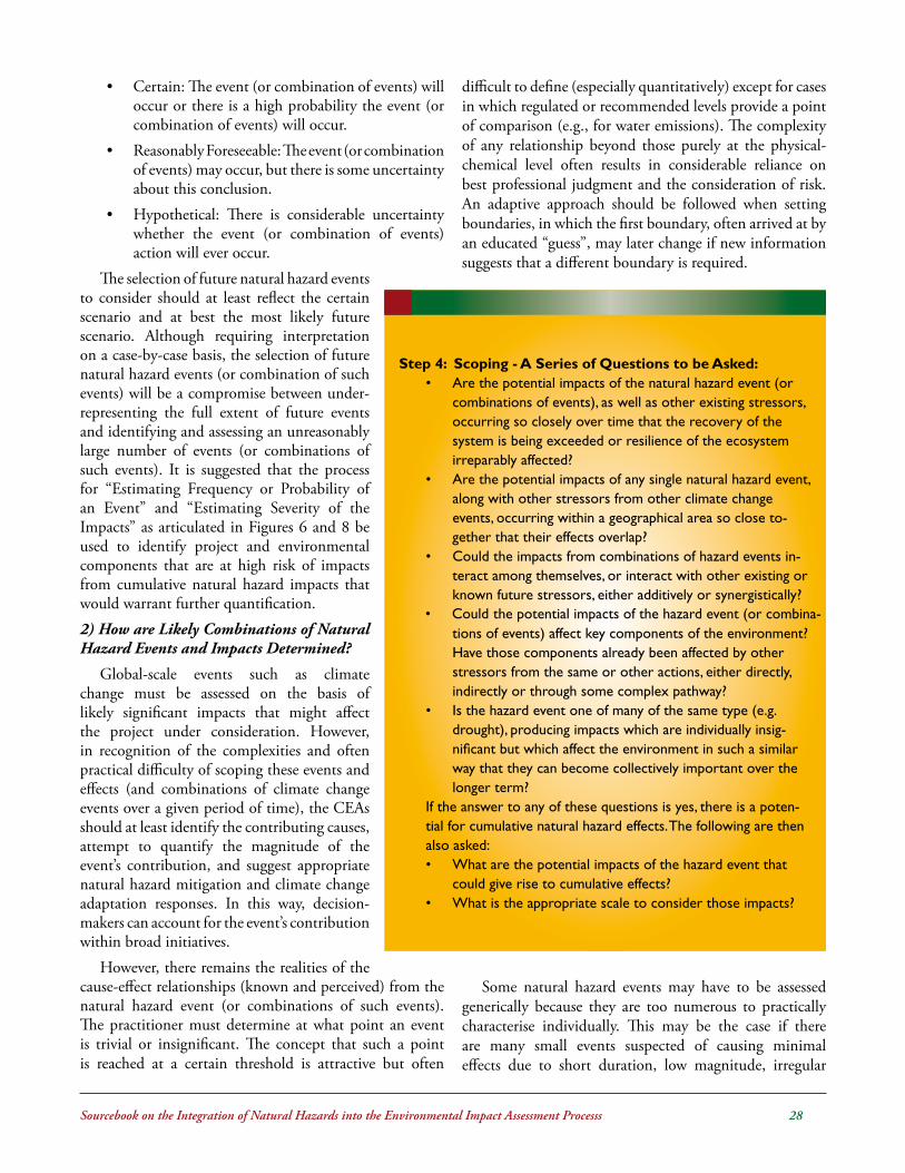
Sourcebook on the Integration of Natural Hazards into the Environmental Impact Assessment Processs ��
• Certain: The event (or combination of events) will occur or there is a high probability the event (or combination of events) will occur.
• Reasonably Foreseeable: The event (or combination of events) may occur, but there is some uncertainty about this conclusion.
• Hypothetical: There is considerable uncertainty whether the event (or combination of events) action will ever occur.
The selection of future natural hazard events to consider should at least reflect the certain scenario and at best the most likely future scenario. Although requiring interpretation on a case-by-case basis, the selection of future natural hazard events (or combination of such events) will be a compromise between under-representing the full extent of future events and identifying and assessing an unreasonably large number of events (or combinations of such events). It is suggested that the process for “Estimating Frequency or Probability of an Event” and “Estimating Severity of the Impacts” as articulated in Figures 6 and 8 be used to identify project and environmental components that are at high risk of impacts from cumulative natural hazard impacts that would warrant further quantification.2) How are Likely Combinations of Natural Hazard Events and Impacts Determined?
Global-scale events such as climate change must be assessed on the basis of likely significant impacts that might affect the project under consideration. However, in recognition of the complexities and often practical difficulty of scoping these events and effects (and combinations of climate change events over a given period of time), the CEAs should at least identify the contributing causes, attempt to quantify the magnitude of the event’s contribution, and suggest appropriate natural hazard mitigation and climate change adaptation responses. In this way, decision-makers can account for the event’s contribution within broad initiatives.
However, there remains the realities of the cause-effect relationships (known and perceived) from the natural hazard event (or combinations of such events). The practitioner must determine at what point an event is trivial or insignificant. The concept that such a point is reached at a certain threshold is attractive but often
difficult to define (especially quantitatively) except for cases in which regulated or recommended levels provide a point of comparison (e.g., for water emissions). The complexity of any relationship beyond those purely at the physical-chemical level often results in considerable reliance on best professional judgment and the consideration of risk. An adaptive approach should be followed when setting boundaries, in which the first boundary, often arrived at by an educated “guess”, may later change if new information suggests that a different boundary is required.
Some natural hazard events may have to be assessed generically because they are too numerous to practically characterise individually. This may be the case if there are many small events suspected of causing minimal effects due to short duration, low magnitude, irregular

Sourcebook on the Integration of Natural Hazards into the Environmental Impact Assessment Processs ��
and unpredictable occurrences, or temporary duration. If there are numerous events, it helps if they are organized by some categories in recognition of the similar types of effects they may cause. For example, they can be organized by:
• Nature of event over period of time (e.g. floods, droughts, hurricane activity, increased precipitation during the 2000-2020 year period);
• Impacts of a combination of events on single sector (e.g. flood and drought impacts upon agricultural sector during the 2000-2020 year period, sea-level rise and impacts from extreme events upon coastal resources during the 2000-2020 year period); and/or
• Combination of events in a single year on multiple sectors.
In such cases, the preliminary hazard and vulnerability assessment must rely on publicly available information as much as possible. Any limitations this places on the assessment must be clearly stated. If no or little information is available, it is difficult to predict cumulative effects unless the practitioner assumes certain project attributes. These assumptions should be clearly stated, and the uncertainty this causes in the assessment should be explained. A reasonable attempt to collect information must at least be demonstrated. Lack of usable information about other actions can have important implications to the certainty associated with predictions made in a CEA.
3.3.2 Step 4: Scoping (See Section 2.4)This scoping step is important as it assists the practitioner
in beginning to understand one of the most fundamental cumulative effects assessment questions: what is affecting what? Good scoping in the initial stages of the study will mean that the assessment effort will focus on the most likely effect’s pathways of concern.
One approach to accomplishing this, a common step in many EIAs, is to first identify environmental components (e.g. air, water, biodiversity, human health) that may be affected by various natural hazards impacting upon the project being assessed. Then, environmental and hazard components that may be affected by other actions in the region of interest (e.g. other anthropogenic activities within
the spatial boundary) can be identified. The scoping could then proceed to focus on the relationships between specific impacts from various natural hazard events and specific ecosystem components.
3.3.3 Step 5: Assessment and Evaluation (See Section 2.5)
A matrix describing various attributes affecting each valued ecosystem component is then completed. The attributes are: existing stressors affecting the valued ecosystem component; pathways of change (cause-effect linkages); consequences (i.e., resulting trends of valued ecosystem components); and contribution of the action to overall changes. Natural hazard mitigation and climate change adaptation measures are also identified.
The effects are evaluated, using best professional judgment, by asking if the identified changes affect the integrity of the environment. These changes are then compared with existing goals (e.g. ecological carrying capacity, ecosystem integrity or resilience).
All information is documented, uncertainties identified, and feedback and monitoring requirements identified for inclusion in the final report.

Sourcebook on the Integration of Natural Hazards into the Environmental Impact Assessment Processs �0
3.3.4 Step 6: Develop Environmental Management Plan (See Section 2.6)
Managing cumulative effects in a cumulative natural hazard effects assessment requires, as a start, the same type of adaptation and monitoring measures that would be recommended in an EIA. Mitigating or adapting to a local natural hazard effect as much as possible is the best way to reduce cumulative effects; however, to be most effective, management, mitigation, adaptation and monitoring programs must be long term and regionally based.* This can be costly, require a few years to complete, and require broader data collection and decision-making involvement than has historically been the case with EIAs. Monitoring programs for individual actions, for example, are usually designed with the involvement of national administrative bodies.
The management, mitigation and adaptation measures applied in cumulative effects assessments may be considerably different from those applied in traditional EIAs. These adaptation measures can be applied to developments other than the proposed development (e.g., through the establishment of integrated water resource management plans). Several administrative jurisdictions and stakeholders will usually fall within an assessment’s study area. In many cases, the co-operation of these other interests may be required to ensure that recommended adaptation measures are successfully implemented. Effective planning and management of CEA mitigation and adaptation, therefore, often imply the need for national stakeholder involvement to solve national concerns. Considerable reliance is placed on national efforts to implement adaptation programs for cumulative climate change effects, such as initiatives to create coordinating bodies that direct or recommend further land use, monitoring and other effects-related research. Participants are usually selected from government departments, stakeholder groups and commercial interests. The objectives of these initiatives are generally to protect
ecosystems that are under stress, and disperse permanent and transient human activities to reduce the magnitude of cumulative effects.
Recommendations for national initiatives of this type may be the only means of addressing, managing, mitigating and adapting to complex cumulative effects issues. It is generally unreasonable to expect a single proponent to bear the burden of adaptation measures to address effects attributable to other actions and events in the region. Often it is more practical and appropriate for regulatory agencies to initiate and help implement these national initiatives, with project proponents providing data relevant to their project’s effects.
3.4....Where.is.the.Cumulative.Effects..........Assessment.Placed.in.the............Environmental.Impact.Assessment..........Submission?
There are at least four options for placing the CEA:
• within a separate “CEA chapter” after the EIA portion (this is the most common approach);
• as a stand-alone document, separately bound from the EIA report;
• integrated within the EIA as a unique sub-section, appearing at the end of each major section assessing effects on major environmental components (e.g. water, air, vegetation); or
• fully integrated with the EIA as cross-sectoral issues are raised and examined.
The approach taken will depend on the practitioner’s philosophy of cumulative effects (i.e., as inseparable from the EIA or as a unique and different view) and on which approach is most readily accomplished given the division of labour used in assembling the assessment report.
*Another response to addressing effects is compensation (usually financial) for losses in some form to a person or personal property. Compensation, however, is not adaptation.

Sourcebook on the Integration of Natural Hazards into the Environmental Impact Assessment Processs ��
4.0...BackgroundIn 2003, a review was undertaken of existing EIA sys-
tems in the CARICOM states* to determine the extent to which climate change impacts are addressed in the existing EIA procedures in the Region. (While this study focused on climate change issues, its results and recommendations are also applicable to the integration of natural hazard considerations into EIA and are replicated here in this context).
The study shows that very few of the countries have established formal mechanisms for assessing the impacts of climate change on the environment. The existing EIA practice in the CARICOM states involves following the traditional approach to undertaking EIAs which focuses on assessment of the impacts of proposed projects or activity on the environment.
In order for CARICOM states to satisfy the mandate provided by Article 4 (1) (f ) of the United Nations Framework Convention on Climate Change (UNFCCC) EIA systems in these countries need to be developed and strengthened. The table below (Figure 13) provides a summary of the status of the incor-poration of climate change impacts into EIA systems in the CARICOM states.
As a general rule, most of the CARICOM states consider climate change impacts on proposed projects and activities on an ad hoc basis. Climate change impacts are usually con-sidered, for example, in respect of impacts as-sociated with sea level rise. Only two of the twelve CARICOM countries, Grenada and Trinidad and Tobago, have developed formal mechanisms for assessing the impacts of cli-mate change. In practice all the other CARI-COM countries consider the likely impacts of climate change on the natural resources and sensitive ecosystems on a case by case basis.
Section 4
Integrating Natural Hazards into EIAs at the National Level
* Review of Environmental Impact Assessment (EIA) Procedures in CARICOM States Participating in the Adapting to Climate Change in the Caribbean (ACCC) Project – Oderson. (2003).
In Trinidad and Tobago the considerations and Terms of Reference (TORs) for a particular EIA are influenced by several factors which include scale, nature of proposal, location, etc. Climate change impacts are considered in this context. The particular EIA depends on the agreed TORs and while there are no prescribed criteria governing the content, style etc. of EIA reports consideration is given to international standards such as those contained in the World Bank EIA Guidelines.

Sourcebook on the Integration of Natural Hazards into the Environmental Impact Assessment Processs ��
In Grenada the EIA review committee uses the relevant information relating to climate change impact for specific projects when establishing TORs and making a determina-tion on EIA proposals.
4.1...Possible.Modalities.for.Incorporating........Natural.Hazards.and.Climate.Change..........Impacts.into.the.EIA.Process
The incorporation of climate change considerations into the EIA process in the CARICOM states may be achieved through the adoption of the following measures:
1. Establishment of formal EIA procedures
2. Provision of clear criteria for screening and scop-ing environmental impacts
3. Provision of clear EIA guidelines for the prepara-tion of EIA reports
4. Provision of clear criteria governing EIA experts
4.1.1 Establishment of Formal EIA Procedures
An informal and ad hoc approach to undertaking EIA does not facilitate or encourage the systematic assessment of climate change impacts on proposed projects and ac-tivities. Seven of the twelve CARICOM states have es-tablished legal provisions governing EIA procedures. The majority of these enactments deal with physical planning while the remainder focus on environmental protection, conservation and management.
The enactment of EIA legislation gives certainty and clarity to the EIA process. It provides a framework for regulating, administering and managing EIAs. The legisla-tion allows for the clear identification of the obligations and duties of the proponent and government agency re-sponsible for administering the EIA process. As a result it removes the uncertainty and arbitrariness associated with ad hoc and informal EIA procedures.
4.1.2 Provision of Clear Criteria for Screening and Scoping Environmental Impacts
The screening of projects and activities is a critical as-pect of the EIA process. The provision of clear criteria for the screening of proposed development (see Section 2) may ensure that all projects and activities which are likely to be significantly affected by climate change impacts are carefully assessed with a view to preventing or reducing the impacts.
The scoping exercise (see Section 2) is used to prepare the terms of reference and scope of works for the conduct of the EIA study. As a result the provision of clear criteria such as checklists will ensure that the scoping process identifies the significant climate change impacts on the proposed project or activity. The development of a checklist can assist with the review and evaluation of the EIA report.
4.1.3 Provision of Clear EIA Guidelines for the Preparation of EIA Reports
Although all the CARICOM states give some guidance to proponents for the preparation of EIA reports only seven of these countries have developed formal EIA guidelines and procedures contained in EIA regulations or as EIA manuals. The EIA guidelines and procedures ensure that the contents of EIA reports address all the necessary issues in order to prevent or reduce the impacts associated with the proposed project or activity.
The development of clear EIA guidelines and procedures can therefore be used to ensure that the EIA process and report address climate change impacts. In Guyana and Jamaica EIA guidelines have been developed for specific sectors. Model EIA guidelines can be developed to address the issue of natural hazards. The model guidelines for climate change should be flexible enough to allow each CARICOM state to adapt the guidelines to suit its own national circumstance and priorities.
4.1.4 Provision of Clear Criteria Governing EIA Experts
None of the CARICOM states have established a roster of EIA experts even though several of the countries have developed legislation governing the qualification, skills, knowledge and experience which must be possessed by persons conducting EIA. This approach may be used to ensure that persons conducting EIAs and assessing natural hazard impacts possess the requisite qualification, skills, knowledge and experience on natural hazards, hazard mitigation, climate change and climate change adaptation policies and measures. The same standard will have to be applied to government experts who review and assess EIAs.
4.2...Integration.of.Climate.Change..........Adaptation.into.the.EIA.Process.with.........in.CARICOM.Countries.–.Practical..........Considerations.
The following section provides an overview of the environmental impact assessment (EIA) process and
* Based on “Review of Environmental Impact Assessment (EIA) Procedures in CARICOM States Participating in the Adapting to Climate Change in the Caribbean (ACCC) Project” – Oderson. (ACCC) 2003.

Sourcebook on the Integration of Natural Hazards into the Environmental Impact Assessment Processs ��
procedures in CARICOM countries*, and identifies, on a country-by-country basis, mechanisms for integrating natural hazard management, mitigation and adaptation considerations into such processes and procedures.
4.2.1 Antigua and BarbudaThere is no express statutory basis for requiring EIAs
in Antigua and Barbuda. In practice consideration of environmental impacts on development occurs through planning legislation. A new Physical Planning Act has been prepared and will establish a formal EIA process. This proposed Act defines EIA as:
“The process of collection, analysis, evaluation and review of information on the likely effects of a proposed development on the environment and the means to overcome adverse effects which enables the Authority to determine whether development permission should be granted and with what conditions, the procedure for which is prescribed in regulations made under this Act.”
Section 23 of the proposed Physical Planning Act, 2002 stipulates that an EIA must be carried out in respect of an application for a development permit for development activities listed in the Third Schedule of the Act.
Notwithstanding the mandatory class of proposals which requires an EIA, the Development Control Authority (the “Authority”) has the discretion under s.23(2) to request an EIA in respect of applications for development not listed in the Third schedule. In making this decision the Authority should give regard to:
• the nature of the proposed development
• the geographical scale and location
• the extent of the changes to the environment likely to be caused by the proposed development
• the degree of scientific uncertainty
• any development plan for the area.
The proponent may enquire of the Authority in writing whether an EIA is required. Where the Authority determines that an EIA is needed, it must notify the proponent of this in writing within 60 days of the receipt of an application for a development permit. The Authority has the responsibility for setting out the Terms of Reference (TORs) for the EIA and the time frame within which it must be submitted.
The applicant is required by s.23(5) to submit an EIA statement in such form and containing such information as may be prescribed in EIA regulations. Once an applicant has been notified by the Authority about the
need for conducting an EIA, there is a statutory duty on the Authority and other public agencies, if requested, to facilitate consultation with the developer to ensure access to information under the agency’s control.
In addition, the Authority has a duty to notify any other agency or Government department having responsibility for the issue of any licence, permit, approval, consent or other document of authorisation in connection with any matter affecting the proposed development. Once the agency or Government department has been notified accordingly, it is prohibited from granting the licence, permit, approval, consent or other document.
The Authority is prohibited under s.23(7) from granting a development permit unless the EIA is taken into consideration. The Minister is empowered under s.23(10) to cause a register to be compiled of persons with the requisite qualification, skills, knowledge and experience to carry out EIAs. Any person who is on the register is deemed by the Act to be approved by the Minister to prepare EIAs for Antigua and Barbuda.
Section 85(2)(g) of the draft Physical Planning Act authorises the Minister to make regulations to provide for the procedures for EIA and the form of EIA statements. There are draft EIA Regulations for Antigua and Barbuda which are not yet in force. The EIA Regulations prescribe procedures for conducting and reviewing EIAs. They prescribe the form and minimum content of EIAs which include:
• a description of the proposed development
• a description of the potentially affected environment
• a description of practical alternatives
• an assessment of the likely or potential environmental impacts
• an identification and description of mitigation measures and alternatives
• an indication of gaps in knowledge and uncertainties which may be encountered during EIA
• an indication of whether the environment of any other State or areas beyond the national jurisdiction is likely to be affected by the proposed development or alternatives
• a brief non-technical summary of the information provided under the above headings.

Sourcebook on the Integration of Natural Hazards into the Environmental Impact Assessment Processs ��
The EIA Regulations provide for conducting an initial environmental evaluation before TORs are finalized. The Authority is required to publish a notice of commence-ment of the EIA in the Gazette and post it in the area of the proposed development.
During the course of the EIA, the Authority has the discretion to require the applicant to undertake consulta-tion with interested members of the public, with a view to providing project information and to recording the concerns of the community. The Authority has the power under the EIA Regulations to prescribe the procedures for the public consultation.
When the EIA statement has been submitted, the Authority has the responsibility to examine it to ensure it conforms to the TORs. Where the EIA statement is inadequate, the Authority may require the applicant to conduct further work and amend the EIA. The Authority and the applicant must agree on the new deadline. The Authority must facilitate public access to the EIA once it has been reserved.
Integrating Natural Hazard Mitigation and Climate Change Adaptation Considerations into the EIA Process in ANTIGUA AND BARBUDAIt is recommended that the following measures be implemented to support the integration of natural hazard mitigation and climate change adaptation considerations into the EIA process in Antigua and Barbuda:(a) Revision of Definition of EIA It is recommended that the definition of EIA under the Physical Planning Act be revised to also address the
impacts of the environment (i.e. natural hazards and climate change) on the project.(b) Establishment of Formal EIA Procedures It is recommended that legislation (Physical Planning Act and EIA Regulations) be enacted to provide certainty
and clarity to the EIA process, and to provide a framework for regulating, administering and managing EIAs. Such legislation should allow for the clear identification of the obligations and duties of the proponent and the Development Control Authority as the government agency responsible for administering the EIA process.
(c) Provision of Clear Criteria for Screening & Scoping Environmental Impacts It is recommended that an EIA Manual be developed to provide clear criteria and checklists for screening and
scoping to ensure identification of the significant natural hazard impacts on the proposed project or activity. The development of such checklists can assist with the review and evaluation of the EIA report.
(d) Provision of Clear EIA Guidelines for the Preparation of EIA Reports It is recommended that an EIA Guide be prepared to assist developers and EIA practitioners in undertaking the
EIA process. Such a Guide should ensure that the EIA process addresses natural hazard impacts. The provision of Model Terms of Reference for addressing natural hazard mitigation and climate change adaptation considerations would also assist applicants undertaking an EIA, and ensure consistency in approach.
(e) Provision of Clear Criteria Governing EIA Experts It is recommended that criteria be established governing the qualification, skills, knowledge and experience that
persons conducting EIAs must possess. This approach may be used to ensure that persons conducting EIAs and assessing natural hazard impacts possess the requisite qualification, skills, knowledge and experience on natural hazards, hazard mitigation, climate change and climate change adaptation policies and measures. The same standard will have to be applied to government experts who review and assess EIAs.
Under the draft legislation the Minister responsible for Physical Planning has oversight of the EIA process. The Minister is empowered to make regulations to govern the process of conducting and reviewing EIAs. In addition the Minister also has the discretion to approve a register of EIA practitioners. The Development Control Authority is responsible for administering and implementing the EIA procedures.
4.2.2 The BahamasAlthough there is no legislation providing for EIAs in
the Bahamas, the government is presently considering the development of EIA legislation. However, the Department responsible for physical planning may request an EIA de-pending upon the nature of the proposed project. EIAs are undertaken by administrative directive for major develop-ment proposals that may alter the physical landscape of a particular environment. The Town Planning Committee is responsible for land use development applications and associated EIAs. The Director of Planning, as technical ad-

Sourcebook on the Integration of Natural Hazards into the Environmental Impact Assessment Processs ��
visor to the Town Planning Committee, reviews EIAs and makes recommendations.
The Bahamas Environment Science and Technology (BEST) Commission, which was established in 1994, is responsible for EIAs. The BEST Commission currently is a part of the portfolio of the Ministry of Health and Environment and has been given the mandate to advise Government in a timely fashion on the environmental im-pact of various development proposals submitted for the Commission’s review, and to conduct site visits for proj-ects under EIA review. The BEST Commission, which comprises representatives of various government agencies, serves as an EIA coordinating agency. In this capacity, the BEST Commission coordinates the review, assessment and monitoring of EIAs.
There are no prescribed categories of projects which trigger the EIA process. The BEST Commission uses Re-sort Development Guidelines and proponents are often advised to follow the format of these guidelines for the de-velopment of EIAs. The BEST Commission is currently developing EIA Guidelines in the following sectors:
• Housing Developments; • Marinas & Ports;
• Agricultural Developments & Operations; • Industrial Operations; • Energy Industries; • Manufacturing; • Extractive Processing; • Development in Sensitive Areas; and
• Aquaculture and Mariculture Developments.
All non-Bahamian and/or foreign companies seeking to provide EIA services in The Commonwealth of the Baha-mas are required to have the following prior to commenc-ing any related activities leading to the development of an EIA document for review:
1. Pre-Approval by the BEST Commission to produce an EIA document
2. Local business license
3. Work permits for all persons involved in the production of the EIA document.
All local companies seeking to provide EIA services re-quire pre-approval by the BEST Commission, in addition to the following:
1. Current business license
Integrating Natural Hazard Mitigation and Climate Change Adaptation Considerations into the EIA Process in THE BAHAMASIt is recommended that the following measures be implemented to support the integration of natural hazard mitiga-tion and climate change adaptation considerations into the EIA process in The Bahamas:(a) Establishment of Formal EIA Procedures It is recommended that legislation be enacted to provide certainty and clarity to the EIA process, and to provide
a framework for regulating, administering and managing EIAs. Such legislation should allow for the clear iden-tification of the obligations and duties of the proponent and the BEST Commission as the government agency responsible for administering the EIA process.
(b) Provision of Clear EIA Guidelines for the Preparation of EIA Reports It is recommended that the sector Guidelines currently being developed by the BEST Commission ensure that
the EIA process addresses natural hazard impacts. The provision of Model Terms of Reference for addressing natural hazard mitigation and climate change adaptation considerations would also assist applicants undertaking an EIA and ensure consistency in approach.
(c) Provision of Clear Criteria for Screening & Scoping Environmental Impacts It is recommended that the sector guidelines currently being developed by the BEST Commission provide clear
criteria for screening and scoping to ensure identification of the significant natural hazard impacts on the pro-posed project or activity. The development of such checklists can assist with the review and evaluation of the EIA report.
(d) Provision of Clear Criteria Governing EIA Experts It is noted that the BEST Commission has established criteria governing the qualification, skills, knowledge and
experience that persons conducting EIAs must possess. This approach may be used to ensure that persons conducting EIAs and assessing natural hazard impacts possess the requisite qualification, skills, knowledge and experience on natural hazards, hazard mitigation, climate change and climate change adaptation policies and measures.

Sourcebook on the Integration of Natural Hazards into the Environmental Impact Assessment Processs ��
2. Valid work permits for all foreign persons involved in the production of the EIA document.
Public participation in the EIA process is generally en-couraged through public meetings and consultations with agencies outside the review process. EIA reports are gener-ally not made available to the public, except where public meetings are held as part of the EIA process.
4.2.3 BarbadosThere is no expressed legal provision for undertaking
EIAs in Barbados. In practice s.17(1) of the Town and Country Planning Act, Cap 240 is used by the Chief Town Planner to request applicants for development permission to submit EIAs. Section 17(1) provides that:
“…the Chief Town Planner may by notice in writing sent to the applicant require such information as he thinks fit.”
In 1998, the Government of Barbados undertook a comprehensive review of its environmental management and physical planning framework, in a study entitled “En-vironmental Management and Land Use Planning for Sustainable Development” (EMLUP). One of the recom-mendations of this study is related to the establishment of an EIA process in Barbados. Although the EMLUP study proposed a new Environmental Management Act (EMA) the recommendation was made to locate the EIA process within the Town and Country Planning Act (TCPA). Three specific EMLUP recommendations relate to:
• Amendment to the Town and Country Planning Act (TCPA);
• Preparation of EIA Guidelines; and
• The establishment of an EIA Review Panel.
The EMLUP study has recommended that amendments be made to the TCPA to authorise the Chief Town Planner and the proposed Chief Environmental Officer to require EIAs for proposed developments. It is recommended that the Physical Development Plan should contain a list of classes of development for which EIA is required. It is rec-ommended that the Chief Town Planner should provide guidelines for conducting and reviewing EIAs. The guide-lines should provide for:
• Terms of Reference for preparation of EIAs;
• Consultation with government agencies and the public; and
• Designation of an EIA review panel.
Draft EIA Guidelines have been prepared, which are used in practice for conducting and reviewing EIAs in Bar-bados. The Chief Town Planner is currently preparing fi-
nal EIA Guidelines, which will take into consideration the existing draft. The existing draft EIA Guidelines seek to clarify the following concerns with the EIA process:
1. Environmental Evaluation – it is recommended that government should use a flexible process to streamline and limit the scope of EIAs and the time frame.
2. Triggering Mechanism – three triggers have been recommended (i) a mandatory list of projects which automatically require an EIA; (ii) the Chief Town Planner and the Chief Environmental Of-ficer should have the discretion to trigger an EIA on a case by case basis; (iii) the developer should be able to initiate an EIA.
3. The role of the proponent and government re-viewers.
4. Terms of Reference – it is recommended that the proponent should prepare the TORs and submit them to the Review Panel for consideration and approval. In practice the TORs are prepared by the Chief Town Planner after consultation with relevant government agencies.
5. Pre-submission – proponents are encouraged to meet with relevant government agencies which have an interest in the proposal as early as possible to identify the specific concerns of the agency.
6. Public Consultation – it is recommended that regulations to the TCPA be developed to allow for public consultation on applications involving EIAs.
7. Conditions of approval – it is recommended that conditions of approval for development should require the proponent to carry out all mitigation measures proposed by the EIA; monitoring to ver-ify impacts are being controlled; regular reporting to particular technical agencies; immediate report-ing where monitoring shows that the development is in significant non-conformity with standards; and implementation of contingency measures where mitigation measures are not working.
8. Submission and Approval of EIA – it is recom-mended that upon completion of the EIA the proponent submit the EIA report to the Review Panel which may make one of three decisions, (i) approve the EIA as satisfactory thereby enabling a planning decision to be made by the Chief Town Planner or Minister; (ii) require proponent to pro-vide further information; (iii) reject the EIA and

Sourcebook on the Integration of Natural Hazards into the Environmental Impact Assessment Processs ��
Integrating Natural Hazard Mitigation and Climate Change Adaptation Considerations into the EIA Process in BARBADOSIt is recommended that the following measures be implemented to support the integration of natural hazard mitiga-tion and climate change adaptation considerations into the EIA process in Barbados:(a) Establishment of Formal EIA Procedures It is recommended that legislation be enacted to provide certainty and clarity to the EIA process, and to provide
a framework for regulating, administering and managing EIAs. Such legislation should allow for the clear identifi-cation of the obligations and duties of the proponent and the Chief Town Planner as the government authority responsible for administering the EIA process.
(b) Provision of Clear EIA Guidelines for the Preparation of EIA Reports It is recommended that the draft EIA Guidelines currently being developed by the Town and Country Develop-
ment Planning Office be adopted and revised as necessary to ensure that the EIA process addresses natural hazard impacts. The provision of Model Terms of Reference for addressing natural hazard mitigation and climate change adaptation considerations would also assist applicants undertaking an EIA, and ensure consistency in ap-proach.
(c) Provision of Clear Criteria for Screening and Scoping Environmental Impacts It is recommended that the draft EIA Guidelines currently being developed by the Town and Country Develop-
ment Planning Office provide clear criteria for screening and scoping to ensure identification of the significant natural hazard impacts on the proposed project or activity. The development of such checklists can assist with the review and evaluation of the EIA report.
(d) Provision of Clear Criteria Governing EIA Experts It is recommended that criteria be established governing the qualification, skills, knowledge and experience that
persons conducting EIAs must possess. This approach may be used to ensure that persons conducting EIAs and assessing natural hazard impacts possess the requisite qualification, skills, knowledge and experience on natural hazards, hazard mitigation, climate change and climate change adaptation policies and measures. The same stan-dard will have to be applied to government experts who review and assess EIAs.
recommend that a refusal of planning permission be made by Chief Town Planner.
9. Economic Impact Assessment – it is recommend-ed that economic and financial considerations should be incorporated into the EIA.
The draft EIA Guidelines recommend that the EIA Review Panel should comprise government personnel whose primary role should include:
• The expeditious review of documents and provi-sion of comments.
• Participate in Review Panel Meetings.• Review and comment on various aspects of the
EIA. Reviewers should limit comments to areas within their expertise or direct concern of their agency.
• Advise Chief Town Planner on the quality of the EIA.
EIAs are currently administered by the Town and Country Development Planning Office, through an in-ter-agency mechanism that involves other relevant govern-ment agencies. This is not supported by expressed legal au-thority but occurs because s.17 (1) is currently used as the
basis for requesting EIAs. The EMLUP study recommends a consolidation of this process by making amendments to the TCPA. The Minister responsible for Town Planning has oversight of the EIA process.
4.2.4 Belize
In Belize, the Environmental Impact Assessment (EIA) process is established by the Environmental Protection Act, Chapter 328 and the EIA Regulations (1995). The Envi-ronmental Protection Act (EPA) was enacted in 1992 and revised in 2000. However, the Environmental Protection Act does not define EIA. The Act under s.20 stipulates that any person intending to undertake any project, pro-gramme or activity which may significantly affect the envi-ronment shall cause an EIA to be carried out by a suitably qualified person and submit it to the Department of Envi-ronment (DoE) for evaluation and recommendations.
The EPA requires that the EIA must identify and evalu-ate the effects of developments on specified components of the environment including:
• Human beings;
• Flora and fauna;

Sourcebook on the Integration of Natural Hazards into the Environmental Impact Assessment Processs ��
• Soil;
• Water;
• Air and climatic factors;
• Material assets, including the cultural heritage and the landscape;
• Natural resources; and
• Ecological balance.
It is a requirement of the legislation that EIAs must include mitigation measures which the proponent intends to take to reduce adverse effects on the environment, and a statement of reasonable alternative sites. The primary objective of EIAs is to protect and improve human health and living conditions and to preserve the reproductive ca-pacity of ecosystems.
Proponents are required by the EPA to consult with public and other interested bodies or organizations when undertaking an EIA. The Department of Environment (DoE) has the discretion under the Act to prepare its own EIA and to synthesise the views of the public an interested bodies. The DoE is empowered to approve the EIA and must, in doing so, attach conditions that are reasonably required on environmental grounds.
The EPA empowers the Minister to make regulations prescribing the types of projects, programmes or activities for which an EIA is required. The regulation may also prescribe the procedures, contents, guidelines and other matters relevant to conducting and reviewing EIAs. It is an offence under the EPA for any person to fail to carry out an EIA as required by the Act or related regulations.
The Environmental Impact Assessment Regulations (1995) have been made pursuant to s.21 of the EPA and seek to regulate the conducting and review of EIAs in Be-lize and establish criteria and procedures which should be used to determine whether an activity is likely to have sig-nificant effects on the environment.
The EIA Regulations create a general obligation on all persons, agencies and institutions (public or private) un-less exempted by the Regulations, to apply to the DoE for a determination as to whether an EIA is required before embarking on a proposed project or activity. The EIA Reg-ulations prescribe minimum requirements for EIAs that include:
• A description of the proposed activities;
• A description of the potentially affected environ-ment;
• A description of practical alternatives;
• A description of mitigation measures; and
• An indication of gaps in knowledge and uncer-tainty which may be encountered in collecting and analysing the data.
The procedural steps of the EIA process in Belize have been prescribed by Regulation 6 and include the following three components:
1. a screening of the project by the DoE;
2. a review of the EIA by the National Environmen-tal Appraisal Committee; and
3. the design and implementation of a follow up programme.
The EIA Regulations provide three possible triggering mechanisms for EIA in Belize:
1. All undertakings, projects and activities listed un-der Schedule I must have an EIA and the scope and extent of the EIA must be determined by the DoE;
2. The DoE has the discretion to request an EIA in respect of undertakings, projects and activities listed under Schedule II; and
3. Regulation 9 identifies a class of projects and ac-tivities that is exempted from the EIA process, such as educational projects, computer process-ing projects, projects within a Commercial Free Zone, and projects undertaken during national emergencies for which temporary measures have been taken by the Government.
Under Regulation 12, a Proponent may request the DoE to provide EIA guidelines for the preparation of the EIA and the DoE may provide the guidelines for a fee. The Regulations prescribe a time limit within which the DoE must screen applications to determine whether an EIA is required.
The Proponent is required to prepare draft TORs and submit then to the DoE for the purposes of an EIA. The DoE shall prescribe the contents of the draft TORs and shall, after examining the draft TORs, advise the propo-nent about their adequacy. The TORs must be agreed and approved in writing by the DoE before the EIA can com-mence.
The EIA Regulations mandate the developer to under-take consultation with interested members of the public who fall within or immediately adjacent to the proposed site during the preparation of the EIA. The Regulations stipulate that the purpose of the public consultation is to

Sourcebook on the Integration of Natural Hazards into the Environmental Impact Assessment Processs ��
provide information concerning the proposal and to re-cord the concerns of the local community. In addition the DoE has the discretion at any time during the EIA study to request written submissions from interested person and may forward the comments to the developer.
The EIA Regulations clearly set out the format and con-tents of the EIA and establish the procedures for the review of the EIA. The DoE has 60 days within which to com-municate its decision on the EIA to the developer. Where an EIA is inadequate the DoE has the discretion, with the recommendation of the National Environmental Appraisal Committee (NEAC), to request the developer to conduct further studies and provide further information, to amend the EIA accordingly and to resubmit the EIA by a mutu-ally agreed date.
The DoE, on the recommendation of the NEAC, may require a public hearing in respect of any undertaking, project or activity for which an EIA has been requested. In determining whether to request a public hearing the DoE shall consider:
• the magnitude and type of environmental im-pacts, the amount of investment, the nature of the geographical area, and the commitment of natural resources;
• the degree of public interest in the proposal; and
• the complexity of the problem.
There are several actors involved with the EIA process
in Belize. The Minister responsible for the Environment has been given specific statutory duties under the EPA and the EIA Regulations. The Minister has been empowered under the EPA to make EIA Regulations and under the EIA Regulations the Minister has the power to appoint a tribunal to hear appeals. The Tribunal reports its finding to the Minister who has the power under the EIA Regula-tions to allow the appeal, permit the project or dismiss the appeal.
The DoE has the overall responsibility for administering and implementing the EIA procedures and regulations. Regulation 25 of the EIA Regulations establishes the National Environmental Appraisal Committee whose main functions include:
1. Reviewing all EIAs; and
2. Advising the DoE of circumstances where a public hearing is desirable or necessary.
The NEAC shall comprise the following members:
• the Chief Environmental Officer;
• the Commissioner of Lands;
• the Housing and Planning Officer;
• the Chief Forest Officer;
• the Fisheries Administrator;
• the Chief Hydrologist;
Integrating Natural Hazard Mitigation and Climate Change Adaptation Considerations into the EIA Process in BELIZEIt is recommended that the following measures be implemented to support the integration of natural hazard mitiga-
tion and climate change adaptation considerations into the EIA process in Belize:(a) Provision of Clear Criteria for Screening & Scoping Environmental Impacts It is recommended that the Environmental Impact Assessment Regulations (1995) be revised or amended to
provide clear criteria in the checklists for screening and scoping to ensure identification of the significant natural hazard impacts on the proposed project or activity. The development of such checklists can assist with the re-view and evaluation of the EIA report.
(b) Provision of Clear EIA Guidelines for the Preparation of EIA Reports It is recommended that the Environmental Impact Assessment Regulations (1995) be revised or amended to
ensure that the EIA process addresses climate change impacts. The provision of Model Terms of Reference for addressing climate change adaptation considerations would also assist applicants undertaking an EIA, and ensure consistency in approach.
(c) Provision of Clear Criteria Governing EIA Experts It is recommended that criteria be established governing the qualification, skills, knowledge and experience that
persons conducting EIAs must possess. This approach may be used to ensure that persons conducting EIAs and assessing natural hazard impacts possess the requisite qualification, skills, knowledge and experience on natural hazards, hazard mitigation, climate change and climate change adaptation policies and measures. The same stan-dard will have to be applied to government experts who review and assess EIAs.

Sourcebook on the Integration of Natural Hazards into the Environmental Impact Assessment Processs �0
• the Archaeological Commissioner;
• the Director of Geology and Petroleum;
• the Chief Agricultural Officer; and
• two non-governmental representatives.
Regulation 27(2) of the EIA Regulations empowers the Minister to appoint a Tribunal to hear and determine ap-peals and report their findings to the Minister.
4.2.5 The British Virgin Islands The present legislation does not specifically refer to
EIAs but the Minister for Physical Planning will have the responsibility of making regulations for EIA procedures and conducting EIA statements under the Draft Planning Act, 2004. The Minister will also be empowered to issue a register of those respective individuals that satisfy the pre-scribed qualifications, skills, knowledge and experience set out in the regulations allowing these individuals to con-duct environmental impact statements (EIS) in respect of the territory. Any person who is on the register is deemed by the Act to be approved by the Minister to prepare EIA statements. The draft development guidelines outline spe-cifically which type of project would require EIAs to be developed and implemented, and clearly state the require-ments to be included in the Environmental Impact State-ment.
The Development Control Authority, appointed by the Governor in council under the Land Development (Con-trol) Ordinance (Cap 241) is responsible for reviewing all private and public projects of the territory and is given the power to regulate its own procedure.
Applications that are submitted for shoreline alterations and modifications of submerged lands are required under s.16 of the Land Development Control Guidelines, 1972 to submit an EIA. As part of the EIA, the applicant would be required to submit:
1. A written report of an investigation on the site and adjacent properties into the environmental conditions, ecology, hydrogeology and water mass transports;
2. A complete written description of the proposed site including contours and profiles, showing pho-tographs;
3. A complete description of the proposed works which would include supervisory and control pro-cedures; and
4. A final report that describes the actual work ac-complished and a description of the final site ge-ometry and movement of materials.
The Draft Planning Act under s.26(3) empowers the Authority to request EIAs for environmentally sensitive areas and can request that an EIS be developed and imple-mented on projects that the Authority deems would cause adverse environmental impact.
The Draft Planning Act under s.26(3) clearly states that the Authority shall determine whether an Environmental Impact Assessment of the proposal is required. The EIA will include:
(a) the nature of the development activity;(b) the geographical extent, scale and location of the
proposed development;(c) the extent and significance of the changes to the
environment likely to be caused by the proposed development;
(d) the extent of general knowledge about the nature of the proposed development and its likely impact on the environment;
(e) any development plan for the area;(f ) any other matter as may be prescribed.
The Authority under the Draft Planning Act 2004 will be prohibited under Section s.27 (4) from granting a de-velopment permit unless the EIA is taken into consider-ation.
Environmental Impact Assessments will be requested for areas deemed sensitive to development such as those outlined in the draft development guidelines:
1. Large scale residential developments2. Medium to large commercial projects3. Mining operations and other manufacturing de-
velopments4. Private energy reserves5. Developments near any bodies of water:
a) Developments in close proximity to coast-lines; and
b) Developments that may impact watersheds.The draft development guidelines also outline the re-
quirements to conduct EIAs, which would include:• A detailed description of the proposed develop-
ment• Site history; including the current and historical
land use • A description of the potentially affected environ-
ment; including characteristics of the marine en-vironment where applicable

Sourcebook on the Integration of Natural Hazards into the Environmental Impact Assessment Processs ��
• The identification of potential environmental im-pacts
• An indication of any adjacent property that is likely to be affected by the proposed development or alternatives.
• A description of mitigation alternatives
• Long term monitoring measures
• A non-technical summary and recommendations
4.2.6 Cayman IslandsCurrently there is no formalised process for incorpo-
rating EIAs in the Cayman Islands’ development approval process. There is no mandatory requirement under the Development & Planning Law or in the environmental legislation. However, EIAs maybe required by the Central Planning Authority (CPA) (also known as the Planning Board) pursuant to Appendix 3, of the Development Plan 1997.
Appendix 3 states that:
“The submission of an Environmental Impact Statement (EIS) for development projects which, because of the charac-teristics of the site or the particulars of the proposal, may be required in order for the Authority to carefully examine the
Integrating Climate Change Adaptation Considerations into the EIA Process in the BRITISH VIRGIN ISLANDS It is recommended that the following measures be implemented to support the integration of climate change adapta-tion considerations into the EIA process in the British Virgin Islands:
(a) Revision of Definition of EIA
It is recommended that the definition of EIA under the Physical Planning Act be revised to also address the impacts of the environment (i.e. natural hazards and climate change) on the project.
(b) Establishment of Formal EIA Procedures
It is recommended that legislation (Physical Planning Act and EIA Regulations) be enacted to provide certainty and clarity to the EIA process, and to provide a framework for regulating, administering and managing EIAs. Such legislation should allow for the clear identification of the obligations and duties of the proponent and the Development Control Authority as the government agency responsible for administering the EIA process.
(c) Provision of Clear Criteria for Screening and Scoping Environmental Impacts
It is recommended that an EIA Manual be developed to provide clear criteria and checklists for screening and scoping to ensure identification of the significant natural hazards impacts on the proposed project or activity. The development of such checklists can assist with the review and evaluation of the EIA report.
(d) Provision of Clear EIA Guidelines for the Preparation of EIA Reports
It is recommended that an EIA Guide be prepared to assist developers and EIA practitioners in undertaking the EIA process. Such a Guide should ensure that the EIA process addresses natural hazard impacts. The provision of Model Terms of Reference for addressing natural hazard mitigation and climate change adaptation consider-ations would also assist applicants undertaking on EIA, and ensure consistency in approach.
potential impacts of the development prior to the determina-tion of the application.
An Environmental Impact Statement shall include the ap-propriate plans, information and data in sufficient detail to enable the Authority to determine, examine and assess the po-tential environmental impacts of the proposal.”
This provision is not often used, the Department of Environment (DoE) and the Planning Department review the EIA and make recommendations to the CPA.
DoE is in the process of presenting the National Con-servation Bill, 2003 which has yet to be tabled in Parlia-ment. Broadly speaking the Bill seeks to “…promote and secure biological diversity and the sustainable use of natu-ral resources in the Cayman Islands.” The Bill is divided into seven Parts, forty-three Sections and two Schedules. Section 36 of the Bill specifies that the “…Director (DoE) may, in his discretion, require an Environmental Impact Assessment study to be carried out of the proposed deci-sion, undertaking, approval or action.” This section also states what the EIA should assess, who can prepare the EIA, what the fees should be and who pays, what monitor-ing is required, when a certificate of completion should be issued and that there should be an appeal process.

Sourcebook on the Integration of Natural Hazards into the Environmental Impact Assessment Processs ��
Integrating Climate Change Adaptation Considerations into the EIA Process in the CAYMAN ISLANDS
In the absence of a mandatory requirement for EIAs at any level, it is impossible to suggest a process to integrate natural hazard and climate change considerations. The following commentary is a proposal for the establishment of a national EIA process.
(a) Revision of EIA Process
Amend the Development and Planning Law (2003 Revision) to make it mandatory for EIAs depending on the nature of the proposal or its location. EIAs should be within the domain of the Central Planning Authority and not the Department of Environment or any council/authority/commission set up under the proposed legislation. The decentralisation of the development review process will only cause confusion and frustration among the various stakeholders.
It is recommended that the following measures be implemented to support the integration of climate change adaptation considerations into the future EIA process in the Cayman Islands:
(b) Establishment of Formal EIA Procedures
It is recommended that legislation be enacted to provide certainty and clarity to the EIA process, and to provide a framework for regulating, administering and managing EIAs. Such legislation should allow for the clear identification of the obligations and duties of the proponent and the Director of Planning as the government authority responsible for administering the EIA process.
(c) Provision of Clear EIA Guidelines for the Preparation of EIA Reports
It is recommended that the Planning Department and DoE develop EIA Guidelines that include provisions for the addressing climate change impacts. The provision of Model Terms of Reference for addressing climate change adaptation considerations would also assist applicants undertaking an EIA, and ensure consistency in approach.
(d) Provision of Clear Criteria for Screening and Scoping Environmental Impacts
It is recommended that the EIA Guidelines provide clear criteria for screening and scoping to ensure identification of the significant climate change impacts on the proposed project or activity. The development of such checklists can assist with the review and evaluation of the EIA report.
(e) Provision of Clear Criteria Governing EIA Experts
It is recommended that criteria be established governing the qualification, skills, knowledge and experience that persons conducting EIAs must possess. This approach may be used to ensure that persons conducting EIAs and assessing climate change impacts possess the requisite qualification, skills, knowledge and experience on climate change and adaptation policies and measures. The same standard will have to be applied to government experts who review and assess EIAs.
4.2.7 DominicaThe EIA process in Dominica is governed by the Physical
Planning Act. The main purpose of the Act is to make provision for the orderly and progressive development of land in both urban and rural areas and to preserve and improve the amenities; for the grant of permission to develop land and for other powers of control over the use of land; for the regulation of the construction of buildings and related matters; to confer additional powers in respect of the acquisition and development of land for planning purposes and for other matters connected therewith.
The Act defines EIA as:
“The process of collection, analysis, evaluation and review of information on the likely effects of a proposed development on the environment and the means to overcome adverse effects.”
Section 23 of the Physical Planning Act (PPA) stipulates that unless the Physical Planning and Development Authority (the Authority) otherwise determines, an EIA must be prepared for any application seeking permission for any of the development prescribed in the Second Schedule of the Act. The Second Schedule lists 18 matters for which an EIA must be prepared.

Sourcebook on the Integration of Natural Hazards into the Environmental Impact Assessment Processs ��
The Authority has the discretion to request the submission of an EIA where it is of the opinion that significant environmental harm could result. The PPA requires the Authority to screen applications to determine whether an EIA is required. In screening applications for development permission the Authority is required to consider a number of prescribed factors which include:
• The nature of the proposed development
• The geographical extent, scale and location of the proposal
• The extent and significance of changes to the environment
• The extent of general knowledge about the nature of the proposed development and its likely impacts on the environment
• Any development plan for the area
The Act prescribes a time-frame for the EIA process. Once it is determined that an EIA is required the Authority has a specified time limit (30 days) within which to notify the applicant at the same time setting out the TORs. The
PPA requires that the proponent must submit an EIA statement in a form and containing such information as may be prescribed by the Authority.
In the case where the Authority issues a notice for an EIA, the PPA is mandated to inform any agency or department of Government having responsibility for the issue of any license, permit, approval consent and any matter affecting the development.
The Act confers power on the Minister to make Regulations prescribing the qualification, skills, knowledge and experience to be possessed by persons preparing EIA statements. The Minister may also cause a register of persons qualified in preparing EIA statements to be created. Any person who is listed on the register is deemed by the PPA to be approved to prepare EIA statements in Dominica. Under section 88 of the PPA the Minister is empowered to make Regulations that may provide the procedures for EIA and the form of EIA statements.
The Chief Physical Planner has the discretion to consult in writing with any public officer or to any person who appears to him to be able to provide information relevant
Integrating Natural Hazard Mitigation and Climate Change Adaptation Considerations into the EIA Process in DOMINICAIt is recommended that the following measures be implemented to support the integration of natural hazard miti-gation and climate change adaptation considerations into the EIA process in Dominica:(a) Revision of Definition of EIA It is recommended that the definition of EIA under the Physical Planning Act be revised to address the impacts
of the environment (i.e. natural hazards and climate change) on the project. The following is suggested “The process of collection, analysis, evaluation and review of information on:(i) the likely effects of a proposed development on the environment;(ii) the likely effects of the environment, including natural hazard and climate change effects, on the proposed
development; and the means to overcome adverse effects.”
(b) Provision of Clear Criteria for Screening and Scoping Environmental Impacts It is recommended that Regulations be promulgated under the Physical Planning Act to provide clear criteria
in the checklists for screening and scoping to ensure identification of the significant natural hazard impacts on the proposed project or activity. The development of such checklists can assist with the review and evaluation of the EIA report.
(c) Provision of Clear EIA Guidelines for the Preparation of EIA Reports It is recommended that Regulations be promulgated under the Physical Planning Act to provide guidance on
the EIA process and ensure that the EIA process addresses natural hazard impacts. The provision of Model Terms of Reference for addressing natural hazard mitigation and climate change adaptation considerations would also assist applicants undertaking an EIA, and ensure consistency in approach.
(d) Provision of Clear Criteria Governing EIA Experts It is recommended that criteria be established governing the qualification, skills, knowledge and experience
that persons conducting EIAs must possess. This approach may be used to ensure that persons conducting EIAs and assessing natural hazard impacts possess the requisite qualification, skills, knowledge and experience on natural hazards, hazard mitigation, climate change and climate change adaptation policies and measures. The same standard will have to be applied to government experts who review and assess EIAs.

Sourcebook on the Integration of Natural Hazards into the Environmental Impact Assessment Processs ��
to an application for development permission. The Act mandates any public Authority that is consulted by the Chief Physical Planner for comments, to submit those comments within a specified period of time (28 days). The Physical Planning and Development Authority has the discretion to invite any Authority or person consulted for comments to speak at any meeting convened to consider the relevant application.
`The Act establishes the Physical Planning and Development Authority (Authority) in s.4 and it is charged with the responsibility of administering and implementing the EIA. The Act converts an existing institution, the Development and Planning Corporation, into the Physical Planning and Development Authority. The main responsibility of the Authority under section 4 (4) is to advance the purposes of the Act. It is the Minister responsible for Physical Planning who has been assigned statutory duties under the PPA in respect of the EIA process.
4.2.8 GrenadaIn Grenada, the EIA process is governed by the Physical
Planning and Development Control Act, 2002. The purpose of the Act is to make a fresh provision for the control of physical development, to continue the Land Development Authority, to require the preparation of the physical plans for Grenada, to protect the natural and cultural heritage, and for related matters.
The specific objectives of the Act as contained in s.3 are to:
1. ensure that appropriate and sustainable use is made of all publicly-owned and privately-owned land in Grenada in the public interest;
2. maintain and improve the quality of the physical environment in Grenada, including its amenity;
3. provide for the orderly subdivision of land and the provision of infrastructure and services in relation thereto;
4. maintain and improve the standard of building construction so as to secure human health and safety; and
5. protect and conserve the natural and cultural heritage.
Section 25 of the Act makes provision for EIAs in Grenada. Under this section the Planning and Development Authority has the power to, in addition to requesting further information, require an EIA to be carried out in respect of any application for permission to develop land. This includes an application for approval in principle.
The Second Schedule of the Act contains a list of activities which require an EIA unless the Land Development Authority for good cause determines otherwise. Before the Land Development Authority can grant permission, the Act mandates that the EIA report must be taken into account.
The Minister responsible for planning and development is empowered by s.25(4) to make regulations providing for:
a) criteria and procedures for determining whether a development is likely to significantly affect the environment;
b) the procedures for setting the scope of the EIA;
c) the minimum contents of a report on an EIA;
d) the qualifications, skills, knowledge or experience which must be possessed by persons conducting EIAs;
e) the procedures for public participation in the EIA process and public scrutiny of any report on EIA; and
f ) the consideration by the Land Development Authority of an application in respect of which an EIA is required, including the criteria and procedures for review of the report.
Under the Act, if the Authority notifies an applicant that an EIA is required, the Physical Planning Unit and any other public agency must, if requested by the applicant, enter into consultation with the applicant to determine whether that agency has in its possession any information which the applicant considers to be relevant. The Act prohibits any agency or department of Government from issuing any licence, permit, approval, consent or other document of authorisation in connection with an application that requires an EIA unless the Land Development Authority gives notice.
The institution with lead responsibility for EIA procedures in Grenada under the Physical Planning and Development Control Act (2002) is the Planning and Development Authority. The Planning and Development Authority is a creature of statute and according to s.6 of the Act comprises the following members:
a) A chairperson;
b) Three persons form the private sector representing the areas of business, finance, law, natural science, land surveying, architecture and engineering; and
c) The Chief Technical Officers responsible for (i) physical planning, (ii) public works, (iii) health

Sourcebook on the Integration of Natural Hazards into the Environmental Impact Assessment Processs ��
services, (iv) agriculture, (v) housing, and (vi) water and sewage.
The Planning and Development Authority is the agency empowered under the law to request applicants to submit EIAs. This is done through the issuing of EIA notices to the applicant. At the same time that an EIA notice is issued to the applicant, the Planning and Development Authority must inform agencies and departments of government which have responsibility for issuing licences, permits, approvals, and consents for matters connected to the proposed project. The Planning and Development Authority is prohibited from granting permission for the development of land for which an EIA has been requested unless it has first taken into account the EIA report.
The Minister with responsibility for planning and development has the discretion under the Act for making EIA regulations. The Physical Planning Unit and any other public agency with relevant information has a statutory duty under the Act to enter into consultation with the applicant and to make such information available to the applicant.4.2.9 Guyana
The Environmental Impact Assessment (EIA) process in Guyana is based on a formal legal framework. There are two pieces of legislation governing EIA in Guyana the
Environmental Protection Act (EPA) No.11 of 1996 and Environmental Impact Assessment Guidelines 2000.
The Environmental Protection Act (EPA) was enacted in 1996 and amended in 2000. The main purpose of the EPA is to provide for the management, conservation, protection and improvement of the environment, the prevention or control of pollution, the assessment of the impact of economic development, the sustainable use of natural resources and for matters incidental thereto or connected therewith.
This Act is divided into 10 Parts:
1. Preliminary Section;
2. Establishment and Functions of Agency;
3. Administration;
4. Environmental Impact Assessments;
5. Prevention and Control of Pollution;
6. Financial Assurance;
7. Investigations, Prosecutions, Civil Proceedings;
8. Establishment and Jurisdiction of Environmental Appeals Tribunal;
9. Environmental Trust Fund and Finances; and
10. Miscellaneous.
Integrating Natural Hazard Mitigation and Climate Change Adaptation Considerations into the EIA Process in GRENADA
It is recommended that the following measures be implemented to support the integration of natural hazard mitigation and climate change adaptation considerations into the EIA process in Grenada:
(a) Provision of Clear Criteria for Screening and Scoping Environmental Impacts
It is recommended that Regulations be promulgated under the Physical Planning and Development Control Act (2002) to provide clear criteria in the checklists for screening and scoping to ensure identification of the significant natural hazard impacts on the proposed project or activity. The development of such checklists can assist with the review and evaluation of the EIA report.
(b) Provision of Clear EIA Guidelines for the Preparation of EIA Reports
It is recommended that Regulations be promulgated under the Physical Planning and Development Control Act (2002) to provide guidance on the EIA process and ensure that the EIA process addresses natural hazard impacts. The provision of Model Terms of Reference for addressing natural hazard mitigation and climate change adaptation considerations would also assist applicants undertaking an EIA, and ensure consistency in approach.
(c) Provision of Clear Criteria Governing EIA Experts
It is recommended that Regulations be promulgated under the Physical Planning and Development Control Act (2002) to establish criteria governing the qualification, skills, knowledge and experience which persons conducting EIAs must possess. This approach may be used to ensure that persons conducting EIAs and assessing natural hazard impacts possess the requisite qualification, skills, knowledge and experience on natural hazards, hazard mitigation, climate change and climate change adaptation policies and measures. The same standard will have to be applied to government experts who review and assess EIAs.

Sourcebook on the Integration of Natural Hazards into the Environmental Impact Assessment Processs ��
The EPA establishes the requirement for EIAs in Guyana. Part IV contains provisions regulating EIAs. Under this Part, s.11, any developer whose project falls within the classes of projects listed in the fourth schedule or any other project that may significantly affect the environment, is required to apply to the Environmental Protection Agency (referred to as “Agency”) for an Environmental Permit. Section 10 of the EPA defines EIA as an assessment as provided for under Part IV of the Act.
There is a prescribed form that an applicant seeking an Environmental Permit must submit along with specific information. This includes information on
• the site, design and size of the project;• possible effects on the environment;• the duration of the project; and• a non-technical explanation of the project.In the case where it is not clear whether a project will
significantly affect the environment, the developer must submit a summary of the project to the Agency, containing the same information as in the case of an application for an Environmental Permit. For this class of projects, the Agency decides whether to exempt the project from having to undertake, or it may require it to do so, in which case it must place a public notice in a local daily newspaper.
Where the Agency exempts a project other than under s.11(3) any person who may be affected by that project has the right of appeal against the decision of the Agency. The legislation prescribes the procedures for the appeal which must be made to Environmental Assessment Board (EAB).
The EPA stipulates that only an independent and suitably qualified person approved by the Agency can carry out an EIA*. The legislation establishes the procedures for undertaking EIAs and the contents of the EIA Report (statement). Section 11 (4) specifies what persons conducting EIAs must consider and s.11(5) details what EIAs must contain.
Persons undertaking EIAs are required to identify, describe and evaluate the direct and indirect effects of the proposed project on the environment. The legislation lists those environmental receptors that must be assessed such as human beings; flora and fauna and species habitat; water; soil; air and climatic factors; material assets, the cultural heritage and the landscape; natural resources; and the ecological balance between ecosystems.
Under s.11(5) every EIA must contain:• a description of the project (location, production
processes, emissions, etc.);
• an outline of the main alternatives;• a description of likely significant effects;• an indication of difficulties (technical, expertise,
knowledge, etc.) encountered during the study;• description of best available technology;• description of any hazards or dangers which may
arise from the project and an assessment of the risk to the environment;
• a description of mitigation measures;• a statement of the degree of irreversible damage;• an emergency response plan;• a rehabilitation and restoration programme; and• a non-technical summary of the information.
The Agency is compelled to publish a notice of the proposal in a daily newspaper, at the expense of the developer, before the EIA starts. Members of the public have a specified time period (28 days) within which to make written submissions to the Agency asking questions and raising matters to be considered by the EIA. There is no qualification in the legislation indicating which members of the public have a right to make submissions.
The Agency is responsible for developing the Terms of Reference (TORs) and scope of the EIA and must consult with the developer before doing so and must consider submissions made by the public.
The EPA under s.12 authorises the Agency to approve or reject the project after considering a number of factors including public submissions, the recommendations of the Environmental Assessment Board and the EIA and Environmental Impact Statement (EIS). The Act requires the Agency to publish its decision and the grounds for making that decision.
Under s.13 the Agency stipulates that a decision by the Agency to grant an environmental permit shall be subject to a number of statutory conditions. The Agency has a statutory duty not to issue an environmental permit unless it is satisfied that the developer can comply with the terms and conditions of the permit and that the developer can pay compensation for any loss or damage which may arise from the project or a breach of any of the terms and conditions of the permit.
The environmental permit takes precedence over other development consents. The EPA (s.14) prohibits other public agencies responsible for issuing development consents in relation to matters where an environmental authorisation is needed, from so doing unless such
*This can be contrasted with the Dominican Physical Planning Act which authorises the Minister to make Regulations in respect of the qualifications of persons preparing EIA Reports as opposed to conducting EIAs.

Sourcebook on the Integration of Natural Hazards into the Environmental Impact Assessment Processs ��
environmental permit has been issued. The Act provides that any development consent given is subject to the terms of the environmental authorisation.
It is an offence under the EPA where any person fails to carry out an EIA or starts a project without obtaining an environmental permit as required by the law. Under s.16 of the EPA the Minister is empowered to make Regulations establishing criteria and thresholds to determine which projects may have significant effects on the environment.
The EPA also regulates other activities which on their own may not have a significant effect on the environment. In the case of activities that, because of their location in a particular place will have cumulative effects that significantly affect the environment, the Agency must request the submission of an EIA.
The Environmental Impact Assessment Guidelines 2000 (Vol.1): Rules and Procedures for Conducting and Reviewing EIAs is a manual jointly prepared by the Environmental Protection Agency and the Environmental Assessment Board (EAB). The purpose of these guidelines is to provide the Environmental Protection Agency, the EAB, sector agencies, private sector, NGOs, members of
the public and consultants with a set of approved guidelines for the conduct and review of EIAs in Guyana.
The EIA guidelines operate in harmony with Part IV of the EPA and represent the first volume in a series of volumes dealing with specific matters, such as:
• Generic EIA guidelines (Vol. 2); and
• Sector Specific EIA Guidelines, for example Mining (Vol. 3); Electricity (Vol. 4); and Forestry (Vol. 5).
The EIA guidelines for conducting and reviewing EIAs sets out the processes involved in undertaking and reviewing EIAs. It clearly describes the role of the various actors in the process. The EIA guidelines define the various components of the EIA. The EIA process in Guyana consists of three components:
1. The Environmental Baseline Study;
2. Environmental Assessment; and
3. Environmental Impact Statement.
The EIA may be submitted to the Agency in its constituent components or as a single document. The
Integrating Natural Hazard Mitigation and Climate Change Adaptation Considerations into the EIA Process in GUYANAIt is recommended that the following measures be implemented to support the integration of natural hazard mitiga-tion and climate change adaptation considerations into the EIA process in Guyana:(a) Revision of Definition of EIA It is recommended that the definition of EIA under the Environmental Protection Act (EPA) No. 11 of 1996 and
Environmental Impact Assessment Guidelines 2000 be revised to also address the impacts of the environment (i.e. natural hazards and climate change) on the project.
(b) Provision of Clear Criteria for Screening and Scoping Environmental Impacts It is recommended that procedures established under the Environmental Protection Act (EPA) No. 11 of 1996
and Environmental Impact Assessment Guidelines 2000 provide clear criteria for screening and scoping to ensure identification of the significant natural hazard impacts on the proposed project or activity. The develop-ment of such checklists can assist with the review and evaluation of the EIA report.
(c) Provision of Clear EIA Guidelines for the Preparation of EIA Reports It is recommended that procedures established under the Environmental Protection Act (EPA) No. 11 of 1996
and Environmental Impact Assessment Guidelines 2000 ensure that the EIA process addresses climate change impacts. The provision of Model Terms of Reference for addressing natural hazard mitigation and climate change adaptation considerations would also assist applicants undertaking an EIA, and ensure consistency in approach.
(d) Provision of Clear Criteria Governing EIA Experts It is recommended that the criteria established under Environmental Protection Act (EPA) No. 11 of 1996
governing the qualification, skills, knowledge and experience which persons conducting EIAs must possess, be reviewed to ensure to that persons conducting EIAs and assessing natural hazard impacts possess the requisite qualification, skills, knowledge and experience on natural hazards, hazard mitigation, climate change and climate change adaptation policies and measures. The same standard will have to be applied to government.

Sourcebook on the Integration of Natural Hazards into the Environmental Impact Assessment Processs ��
baseline study provides information on the state of the environment within the sphere of influence of the project before the project is implemented. This information forms the input to the environmental assessment where it is analysed to predict and quantify likely impacts.
The Environmental Assessment is a process that involves the identification and assessment of impacts of the proposed project and its alternatives. Consideration is also given to mitigation measures to prevent or reduce negative impacts.
The Environmental Impact Statement is a summary of the findings of the other two components, that is, the baseline study and the environmental assessment. It includes an Environmental Management Plan.
The EIA guidelines set out the rules and procedures of the EAB. The guidelines contain an EIA Review Checklist. The checklist is in a matrix format which lists the elements to be evaluated with provision for comments/recommendations and rating.
The Environmental Protection Agency is the main body responsible for the administration and implementation of the Environmental Protection Act. Part II of the Act provides for the establishment of the Agency and identifies its functions which include, inter alia:
“To ensure that any development activity which may cause an adverse effect on the natural environment be assessed before such activity is commenced and that such adverse effect be taken into account in deciding whether or not such activity should be authorised”
The EPA establishes the EAB with responsibility for conducting public hearings into EIA appeals; and as may be necessary into EIA and EIS to recommend to the Agency:
• whether the EIA or EIS should be accepted, amended or rejected;
• whether an environmental permit should be issued by the Agency; and
• what terms and conditions should be included in the environmental permit.
One of the main functions of the EAB is to ensure a participatory and consultative approach to EIA development by facilitating the participation of the public and regulatory agencies in the EIA process, especially as it relates to the preparation and review of the scope of work and TORs. The legislation is silent on which Minister has responsibility for the EIA process.
4.2.10 Jamaica
The EIA process in Jamaica is governed by the Natural Resources Conservation Authority Act, 1991 (NRCA), the Natural Resources Conservation (Permits and Licences) Regulations, 1996 and the Natural Resources Conservation Authority Guidelines for Conducting Environmental Impact Assessments, 1998.
Under s.10 of the NRCA the Natural Resources Conservation Authority (referred to as the “Authority”) is empowered to request an applicant for a permit or the person responsible for undertaking a specified class of development, construction or any enterprise in a prescribed area to submit to the Authority an EIA containing prescribed information. The Authority may also require an applicant to furnish it with such documents or information which the Authority thinks fit.
There is no expressed definition of EIA in the NRCA however the EIA Guidelines defines EIA as:
“A study of the effects of a proposed action on the environment”.
The Authority can request an EIA where it is of the opinion that the activities of the enterprise, construction or development are having or are likely to have an adverse effect on the environment. The Act compels the applicant to comply with the requirement. The request for an EIA must be by notice in writing to the applicant. The legislation provides that the notice must state the time within which the assessment shall be submitted to the Authority.
Once the Authority issues a notice requesting an EIA the NRCA mandates the Authority to inform any agency or department of Government having responsibility for the issue of any licence, permit, approval or consent in connection with any matter affecting the environment that a notice has been issued. The Act prohibits such agency or department, having been notified, from granting the licence, permit, approval or consent. It is an offence under the Act where any person who is an applicant for a permit refuses or fails to submit an EIA as required by the Authority.
Section 38 (1) (b) of the NRCA gives the Minister the discretion to make regulations that may contain provisions in relation to the description or category of enterprise, construction or development in respect of which an EIA is required by the Authority. The Act binds the Crown.
Under the Natural Resources Conservation (Permits and Licences) Regulations, 1996 regulation 18, the Authority may, upon the evaluation of an application for a permit or licence, require the applicant to furnish any document, information or EIA pursuant to section 10 of the NRCA.

Sourcebook on the Integration of Natural Hazards into the Environmental Impact Assessment Processs ��
There are no EIA regulations in Jamaica but under the Permit and Licence system of 1997, permits and licences are required in a prescribed area and for prescribed categories of activities.
The Natural Resources Conservation Authority Guidelines for Conducting Environmental Impact Assessments, 1998 describe the steps and procedures for conducting and reviewing EIAs in Jamaica. The EIA process in Jamaica involves:
• Preliminary activities including scoping or setting terms of reference for the EIA, selecting the consultant to do the EIA, and review of existing legislation;
• Submission of Draft TOR to the Authority for approval;
• Conducting the EIA study;
Integrating Natural Hazard Mitigation and Climate Change Adaptation Considerations into the EIA Process in JAMAICA
It is recommended that the following measures be implemented to support the integration of natural hazard mitiga-tion and climate change adaptation considerations into the EIA process in Jamaica:
(a) Revision of Definition of EIA
It is recommended that the definition of EIA under the Natural Resources Conservation Authority Guidelines for Conducting Environmental Impact Assessments, 1998 be revised to also address the impacts of the environ-ment (i.e. natural hazards and climate change) on the project.
(b) Provision of Clear Criteria for Screening and Scoping Environmental Impacts
It is recommended that procedures established under the Natural Resources Conservation Authority Guidelines for Conducting Environmental Impact Assessments, 1998 provide clear criteria for screening and scoping to ensure identification of the significant natural hazard impacts on the proposed project or activity. The develop-ment of such checklists can assist with the review and evaluation of the EIA report.
(c) Provision of Clear EIA Guidelines for the Preparation of EIA Reports
It is recommended that procedures established under the Natural Resources Conservation Authority Guidelines for Conducting Environmental Impact Assessments, 1998 ensure that the EIA process addresses natural hazard impacts. The provision of Model Terms of Reference for addressing natural hazard mitigation and climate change adaptation considerations would also assist applicants undertaking an EIA, and ensure consistency in approach.
(d) Provision of Clear Criteria Governing EIA Experts
It is recommended that the criteria be established under the Natural Resources Conservation Authority Guidelines for Conducting Environmental Impact Assessments, 1998 governing the qualification, skills, knowledge and experience which persons conducting EIAs must possess be reviewed to ensure that persons conducting EIAs and assessing natural hazard impacts possess the requisite qualification, skills, knowledge and experience on natural hazards, hazard mitigation, climate change and climate change adaptation policies and measures. The same standard will have to be applied to government experts who review and assess EIAs.
• Collecting background data and information;• Public involvement;• Identification of impacts in terms of magnitude
and significance;• Socio-economic analysis of project effects/
impact;• Recommending mitigation action for each impact
identified;• Analysis of alternatives of the project (economic
and environmental);• Training requirements of the project;• Development of a monitoring programme/plan;
and
• Documenting the study in the EIA report.

Sourcebook on the Integration of Natural Hazards into the Environmental Impact Assessment Processs �0
Annex 2 of the EIA Guidelines provides a description or category of enterprise, construction or development which requires EIA in accordance with s.38(1)(b) of the NRCA. Annex 3 provides a basic checklist which can be used to compile the description of the environmental setting. These include:
1. Basic land conditions including the geological conditions, soil conditions and archaeological value of site;
2. Biotic community conditions, which include plant and animal;
3. Watershed conditions; and4. Atmospheric conditions.
Section 3 Part I of the NRCA, which establishes the Natural Resources Conservation Authority, (referred to as the “Authority”), provides that the Authority is responsible for the administration and implementation of the EIA process. 4.2.11 St. Kitts and Nevis
The EIA process in St. Kitts and Nevis is regulated under the Development Control and Planning Act (2000).
Part IV, section 26 and Schedule 3 of the Act identifies categories of proposals that require an EIA. Categories of projects that require a mandatory EIA include:
• Hotels of more than 12 rooms, and residential sub-divisions of more than 6 plots/units;
• Industrial plants, hydro-electric and diesel power plants;
• Quarrying and mining activities, land reclamation, dredging, dams/reservoirs; filling ponds;
• Airports, marinas, ports and harbours;• Gas pipelines and projects resulting in significant
emissions into the environment;• Solid waste operations and sanitary landfills;• Activities involving the discharge of radio-active
materials; and• Development in environmentally sensitive area
(wetlands, marine parks, etc.).
The Physical Planning Division (PPD) is responsible for receiving applications and undertaking preliminary screening exercises. The PPD is the Secretariat of the
Integrating Natural Hazard Mitigation and Climate Change Adaptation Considerations into the EIA Process in ST. KITTS AND NEVIS
It is recommended that the following measures be implemented to support the integration of natural hazard mitiga-tion and climate change adaptation considerations into the EIA process in St. Kitts and Nevis:
(a) Provision of Clear Criteria for Screening and Scoping Environmental Impacts
It is recommended that Regulations be promulgated under the Development Control and Planning Act (2000) to provide clear criteria in the checklists for screening and scoping to ensure identification of the significant natural hazard impacts on the proposed project or activity. The development of such checklists can assist with the review and evaluation of the EIA report.
(b) Provision of Clear EIA Guidelines for the Preparation of EIA Reports
It is recommended that Regulations be promulgated under the Development Control and Planning Act (2000) to provide guidance on the EIA process and ensure that the EIA process addresses natural hazard impacts. The provision of Model Terms of Reference for addressing natural hazard mitigation and climate change adaptation considerations would also assist applicants undertaking an EIA, and ensure consistency in approach.
(c) Provision of Clear Criteria Governing EIA Experts
It is recommended that Regulations be promulgated under the Development Control and Planning Act (2000) to establish criteria governing the qualification, skills, knowledge and experience which persons conducting EIAs must possess. This approach may be used to ensure that persons conducting EIAs and assessing natural hazard impacts possess the requisite qualification, skills, knowledge and experience on natural hazards, hazard mitigation, climate change and climate change adaptation policies and measures. The same standard will have to be applied to government experts who review and assess EIAs.

Sourcebook on the Integration of Natural Hazards into the Environmental Impact Assessment Processs ��
Development Control and Planning Board (DCPB), which is the lead agency for EIAs and is responsible for final review and approval of the EIA, taking into consideration recommendations of the PPD.
Although there are no formal guidelines to assist in the EIA process, the Physical Planning Division (PPD) provides guidance on a case-by-case basis. A draft outline of the EIA report requirements is provided to applicants. However, the final Terms of Reference for the EIA report is based on the results of project screening and scoping. Review criteria and methods for assessing the EIA report have not been established.
Public participation in the EIA process is encouraged through a process of public notices in local newspapers. No mechanism has been established that guarantees public access to the EIA report.
4.2.12 St. LuciaIn St. Lucia the EIA system is governed by the proposed
Physical Planning and Development Control Act (No. 29 of 2001). Under s.22 of the Act the Head of the Physical Planning and Development Division has the power to request an applicant for planning permission to prepare an EIA. This includes an application for approval in principle. The fourth Schedule of the Act identifies those activities which will normally require an EIA unless the Head of the Physical Planning and Development Division determines otherwise.
The Minister responsible for planning and development is given the discretion under the Act to make EIA regulations, in consultation with the Head of the Physical Planning and Development Division. The Act prescribes that the regulations must provide for the following:
a. the criteria and procedures for determining whether an activity is likely to significantly affect the environment;
b. the procedures for settling the scope of works of the EIA to be carried out by the applicant;
c. the minimum contents of the Environmental Impact Statement;
d. the qualifications, skills, knowledge or experience which must be possessed by persons conducting EIA;
e. the procedures for public participation in the EIA process and public scrutiny of the Environmental Impact Statement; and
f. the consideration by the Head of the Physical Planning and Development Division of an
application in respect of which an EIA has been required, including the criteria and procedures for review of the Environmental Impact Statement.
Under the Act, if the Head of the Physical Planning and Development Division notifies the applicant that an EIA must be provided, the Minister and any other public agency in possession of relevant information is required to enter into consultation with the applicant and to provide such information to the applicant. In addition, once an EIA notice is given to an applicant the Head of the Physical Planning and Development Division must inform any agency or department of Government having responsibility for the issue of any licence, permit, approval, consent or other document of authorisation in connection with the proposed project, and the agency or department of government is prohibited from granting such licence, permit, approval, consent or other document of authorisation unless it has been duly notified by the Head of the Physical Planning and Development Control Division.
The Head of the Physical Planning and Development Control Division will have the lead responsibility for the EIA process in St. Lucia in accordance with the proposed Physical Planning and Development Act. The Head of the Physical Planning and Development Division has been assigned specific functions in respect of the EIA system that include the following:
• The screening of applications in accordance with s.22(2) to determine whether the proposal falls within the list of activities listed in the Fourth Schedule
• Requesting an applicant to submit an EIA by notice
• Informing relevant agencies and departments of Government of the EIA notice
The Minister responsible for planning and development has been empowered by the Act, in consultation with the Head of the Physical Planning and Development Division, for making EIA regulations. Under s.22(5) of the Act the Minister is mandated to consult with and share relevant information in his possession with the applicant for the preparation of an EIA.
The Head of the Physical Planning and Development Division is prohibited from granting permission for the development of land for which an EIA has been requested unless it has first taken into account the EIA.

Sourcebook on the Integration of Natural Hazards into the Environmental Impact Assessment Processs ��
4.2.13 St. Vincent and the GrenadinesGenerally, there is no legal basis for EIAs in St. Vincent
and the Grenadines and such evaluations are undertaken on a case-by-case basis. However, under the Waste Management Act (No. 31 of 2000), section 11 requires an EIA to be undertaken for all waste management facilities. Part IV of the Act establishes the EIA process for any waste management facility. The initial step in the process is an application for a “pre-evaluation” that must be submitted to the Physical Planning and Development Board (termed the “planning authority”) established under the Town and Country Planning Act (1992). Within 10 working days of receiving any application, the planning authority undertakes a screening to determine whether an EIA is required. The planning authority will advise the applicant that:
a. a comprehensive EIA is required;
b. a “focus report” is required; or
c. no further information is required and the project will be recommended to cabinet for approval.
Where either an EIA or a focus report is required, the planning authority shall provide the applicant with TOR for the evaluation that is to be undertaken. Thereafter, the
Integrating Natural Hazard Mitigation and Climate Change Adaptation Considerations into the EIA Process in ST. LUCIA
It is recommended that the following measures be implemented to support the integration of natural hazard mitiga-tion and climate change adaptation considerations into the EIA process in St. Lucia:
(a) Provision of Clear Criteria for Screening and Scoping Environmental Impacts
It is recommended that Regulations be promulgated under the Physical Planning and Development Control Act to provide clear criteria in the checklists for screening and scoping to ensure identification of the significant natural hazard impacts on the proposed project or activity. The development of such checklists can assist with the review and evaluation of the EIA report.
(b) Provision of Clear EIA Guidelines for the Preparation of EIA Reports
It is recommended that Regulations be promulgated under the Physical Planning and Development Control Act to provide guidance on the EIA process and ensure that the EIA process addresses climate change impacts. The provision of Model Terms of Reference for addressing natural hazard mitigation and climate change adaptation considerations would also assist applicants undertaking an EIA, and ensure consistency in approach.
(c) Provision of Clear Criteria Governing EIA Experts
It is recommended that Regulations be promulgated under the Physical Planning and Development Control Act to establish criteria governing the qualification, skills, knowledge and experience which persons conducting EIAs must possess. This approach may be used to ensure that persons conducting EIAs and assessing natural hazard impacts possess the requisite qualification, skills, knowledge and experience on natural hazards, hazard mitigation, climate change and climate change adaptation policies and measures. The same standard will have to be applied to government experts who review and assess EIAs.
applicant shall undertake, at his/her own expense a study and report that complies with the requirements of the TOR. Section 13 of the Waste Management Act outlines the scope of any EIA report that shall be submitted for consideration, including:
a. Description of the proposed activity, and any technically feasible alternatives;
b. Description of the environmental setting;
c. Description of the social and environmental impacts that may result during construction, operation, decommissioning or abandonment;
d. Description of the residual adverse environmental and social impacts;
e. An environmental protection plan;
f. A waste management plan outlining waste reduction programs, monitoring and surveillance programs, mitigation measures.
The planning authority may require the applicant to provide any additional information that may be required. Section 15 of the Waste Management Act requires the planning authority to render a decision on the EIA report.

Sourcebook on the Integration of Natural Hazards into the Environmental Impact Assessment Processs ��
It shall be the responsibility of the applicant under the provisions of section 16 of the Waste Management Act to implement any monitoring program, environmental protection plan, or mitigation measure that constitutes a condition of any approval granted by the planning authority. The planning authority is permitted to undertake inspections at any stage and issue an order to stop work in the event of non-compliance with any condition. A fine may be imposed on any person who: (i) contravenes any condition of an approval; (ii) carries out any construction activities before an approval is granted; or (iii) contravenes any order to stop work. Section 17 of the
Integrating Natural Hazard Mitigation and Climate Change Adaptation Considerations into the EIA Process in ST. VINCENT AND THE GRENADINES
It is recommended that the following measures be implemented to support the integration of natural hazard mitiga-tion and climate change adaptation considerations into the EIA process in St. Vincent and the Grenadines:
(a) Establishment of Formal EIA Procedures
In order to address activities outside the scope of the EIA process outlined in the Waste Management Act, it is recommended that legislation be enacted to provide certainty and clarity to the EIA process, and to provide a framework for regulating, administering and managing EIAs. Such legislation should allow for the clear identifica-tion of the obligations and duties of the proponent and the Physical Planning and Development Board as the government agency responsible for administering the EIA process.
(b) Provision of Clear Criteria for Screening and Scoping Environmental Impacts
It is recommended that an EIA Manual be developed to provide clear criteria and checklists for screening and scoping to ensure identification of the significant natural hazard impacts on the proposed project or activity. The development of such checklists can assist with the review and evaluation of the EIA report.
(c) Provision of Clear EIA Guidelines for the Preparation of EIA Reports
It is recommended that an EIA Guide be prepared to assist developers and EIA practitioners in undertaking the EIA process. Such a Guide should ensure that the EIA process addresses natural hazard impacts. The provision of Model Terms of Reference for addressing climate change adaptation considerations would also assist applicants undertaking an EIA, and ensure consistency in approach.
(d) Provision of Clear Criteria Governing EIA Experts
It is recommended that criteria be established governing the qualification, skills, knowledge and experience which persons conducting EIAs must possess. This approach may be used to ensure that persons conducting EIAs and assessing climate change impacts possess the requisite qualification, skills, knowledge and experience on natural hazard, hazard mitigation, climate change and climate change adaptation policies and measures. The same standard will have to be applied to government experts who review and assess EIAs.
Waste Management Act empowers the planning authority to issue guidelines to regulate various aspects of the EIA process.
In instances other than those regulated under the Waste Management Act, EIAs are conducted on a case-by-case basis, with little by way of guidance to the applicants or organisations involved in the process. Persons or organisations undertaking an EIA use their own discretion as to whether the public shall participate in the process. An EIA that has been submitted to the planning authority is generally made available to the public.

Sourcebook on the Integration of Natural Hazards into the Environmental Impact Assessment Processs ��
4.2.14 Trinidad and Tobago
The environmental impact assessment process in Trinidad and Tobago forms part of the “Certificate of Environmental Clearance (CEC)” system that has been established under section 35 of the Environmental Management Act 2000.
Enacted in 1994 the Environmental Management Act provides for the management of the environment within Trinidad and Tobago through the establishment and operation of the Environmental Management Authority (EMA). This Act was subsequently repealed and replaced in 2000. There were no significant differences in the new Act. The Act, set out in nine Parts, establishes the Environmental Management Authority (EMA) in Part II, invests the Authority with functions and powers in Part III, and deals with environmental management matters in Parts IV, V and VI.
Section 26 of the Environmental Management Act empowers the Environmental Management Authority to make rules for the purpose of giving effect to the requirements of the Act. Acting under this provision, and to give effect to some of the goals and objectives of the National Environmental Policy, the Environmental Management Authority has developed and promulgated the Certificate of Environmental Clearance Rules 2001. These rules outline the process and procedures to be applied in any application for a CEC under section 36 of the Act.
The objective of the CEC is the attainment of integrated environmental management on a national level. To achieve this objective, proposed activities need to be assessed to consider likely impacts, environmental risks, as well as mitigation and monitoring for potential adverse effects. The CEC is a certificate that may or may not be granted for a particular activity. If the Certificate of Environmental Clearance is granted, this certifies the environmental acceptability of the proposed activity, provided that all conditions contained in the CEC are fulfilled.
EIA is part of the CEC process and is undertaken to identify and evaluate specific environmental concerns of a proposed activity. Not all applications for a CEC will require an EIA. There is a charge for processing a CEC application that requires an EIA. This charge may vary from TTD5,000 up to TTD600,000 (USD800 up to USD100,000) depending upon the activity and complexity of the EIA evaluation. CEC applications that require an EIA are given special mention in the Certificate of Environmental Clearance Rules 2001 with respect to public consultation.
The Environmental Management Act has, by means of an attached Schedule to the CEC Order, outlined a designated list of activities that require CEC. These activities are considered to have the potential for significant adverse effects or risks to the environment, whether in the phase of establishment, expansion, operation, decommissioning or abandonment. Designated activities are listed in the following broad categories:
• Agriculture;
• Heavy and Light Manufacturing Industry;
• Civil Works;
• Natural Resource/Mineral Extraction and Processing;
• Waste Disposal;
• Transport Operations and Construction of Associated Infrastructure; and
• Other Service-Oriented Industries.
The key steps in the process are as follows:
Step 1 - Submission of Application (including project description)
Step 2 - Screening and Acknowledgement (within 10 working days of receipt of Application)
Step 3 – Determination whether:
- CEC is not required,
- CEC is required but no EIA,
- CEC and EIA are required
IF CEC and EIA are required:
Step 4 – Applicant Notified of Proposed TOR for the EIA (within 21 working days of notification that CEC and EIA required);
Step 5 - Either TOR are Agreed, or the Applicant may Request a Modification to the terms of Reference;
Step 6 - Final TOR Issued (within 10 working days of request for modification);
Step 7 - Submission of EIA Report by Applicant;
Step 8 – Notification of Decision (within 10 working days of receipt of EIA report).
The Environmental Management Authority (EMA) has prepared a Guide (CEC Review Manual) for the review of EIA reports. The Guide has been developed to ensure consistency in the EIA review process. The Guide provides checklists for Screening and Scoping, the evaluation of “alternatives”, and to assist in the review process.

Sourcebook on the Integration of Natural Hazards into the Environmental Impact Assessment Processs ��
Integrating Natural Hazard Mitigation and Climate Change Adaptation Considerations into the CEC/EIA Process in TRINIDAD AND TOBAGO
It is recommended that the following measures be implemented to support the integration of natural hazard mitiga-tion and climate change adaptation considerations into the CEC/EIA process in Trinidad and Tobago:
(a) Provision of Clear Criteria for Screening and Scoping Environmental Impacts
It is recommended that the “CEC Review Manual” be amended to provide clear criteria in the checklists for screening and scoping to ensure identification of the significant natural hazard impacts on the proposed project or activity. The development of such checklists can assist with the review and evaluation of the EIA report.
(b) Provision of Clear EIA Guidelines for the Preparation of EIA Reports
It is recommended that the Guide for the Application for a Certificate of Environmental Clearance be modified to ensure that the EIA process addresses natural hazard impacts. The provision of Model Terms of Reference for addressing climate change adaptation considerations would also assist applicants undertaking an EIA as part of the CEC process, and ensure consistency in approach.
(c) Provision of Clear Criteria Governing EIA Experts
It is recommended that criteria be established governing the qualification, skills, knowledge and experience which persons conducting EIAs must possess. This approach may be used to ensure that persons conducting EIAs and assessing natural hazard impacts possess the requisite qualification, skills, knowledge and experience on natural hazards, hazard mitigation, climate change and climate change adaptation policies and measures. The same stan-dard will have to be applied to government experts who review and assess EIAs.

Sourcebook on the Integration of Natural Hazards into the Environmental Impact Assessment Processs ��
Section 5
References
American Society of Civil Engineers, 2002. “Minimum Design Loads for Buildings and Other Structures”, ASCE 7-02.
Asian Development Bank (ADB), 2003. Cumulative Effects Assessment in Environmental Assessment. Environmental Assessment Guidelines.
Caribbean Disaster Emergency Response Agency, 2004. Status of Hazard Maps, Vulnerability Assessments and Digital Maps in the Caribbean. Draft Report CDERA 2004.
Canadian Environmental Assessment Agency (CEAA), 1999. Cumulative Effects Assessment Practitioners Guide.
Caribbean Community (CARICOM) Secretariat, 1985. CUBiC Part 2 - Structural Design Requirements; Section 3 - Earthquake Load
Caribbean Community (CARICOM) Secretariat, 2003. Caribbean Risk Management Techniques for Climate Change.
Caribbean Community (CARICOM) Secretariat, 2004. Guide to the Integration of Climate Change Adaptation into the Environmental Impact Assessment (EIA) Process.
Caribbean Uniform Building Code (CUBiC), 1985.CUBiC Part 2 - Structural Design Requirements; Section 2 - Wind Load.
Government of Barbados. (1998) Environmental Impact Assessment Guidelines and Procedures for Barbados.
Government of Jamaica. (1998) Guidelines for Conducting Environmental Impact Assessments. Natural Resources Conservation Authority.
Government of Trinidad and Tobago. (2001) CEC Review Manual. Environmental Management Authority (EMA).
Government of Trinidad and Tobago (2001) A Guide to the Application for a Certificate of Environmental Clearance. Environmental Management Authority (EMA).
Inter American Development Bank, 2003. Natural Hazard Checklist for Water and Sanitation Projects. (Natural hazard checklists also under development by the IDB for the following sectors: Environment and Natural Resources, Transportation, Energy, Health, Housing, Education, Agriculture, Modernisation of the State, Micro-enterprise Development)
International Federation of Red Cross (IFRC). Vulnerability and Capacity Assessment Available at http://www.ifrc.org/what/disasters/dp/planning/vca/index.asp
Intergovernmental Panel on Climate Change,2001. Climate Change 2001: Impacts, Adaptation and Vulnerability. IPCC Third Assessment Report.
National Environment and Planning Agency (NEPA), Jamaica.: http://www.nepa.gov.jm
National Oceanographic and Atmospheric Administration (NOAA), USA. Vulnerability Assessment Techniques and Applications. Available at http://www.csc.noaa.gov/vata

Sourcebook on the Integration of Natural Hazards into the Environmental Impact Assessment Processs ��
Oderson, D.F., 2003. Review of Environmental Impact Assessment (EIA) Procedures in CARICOM States Participating in the Adapting to Climate Change in the Caribbean (ACCC) Project
Organisation of American States, 1991. Primer on Natural Hazard Management in Integrated Regional Development Planning. Department of Regional Development and Environment.
United Nations Economic Commission for Latin America and the Caribbean, 2003. Handbook for Estimating Socio-Economic and Environmental Impacts of Disasters. This document is available at http://www.proventionconsortium.org/toolkit.htm
UN International Strategies for Disaster Reduction (UN ISDR). 2002. Living with Risk-Annex 1. (http://www.unisdr.org/unisdr/Globalreport.htm)
United States Environment Protection Agency (US EPA), 2003. Framework for Cumulative Risk Assessment.
Tanner, JG. & Shepherd, JB., 1997. Seismic Hazard in Latin America and the Caribbean - Final Report. Instituto Panamericano de Geografía y Historia; Volume 1-5.
World Bank, 2002. Natural Hazard Risk Management in the Caribbean—Revisiting the Challenge. Available at http://www.worldbank.org/cgced.
World Bank, 2002. Natural Hazard Risk Management in the Caribbean—Revisiting the Challenge, Annex 1. Available at http://www.worldbank.org/cgced.
World Bank (WB), 1999. World Bank Operational Policy 4.01 : Environmental Assessment- Annex A
World Bank Environment Division. March 1995. The World Bank and the UN Framework Convention on Climate Change. ESSD/World Bank.
World Bank Environment Division. December 1997. Environmental Hazard and Risk Assessment. Environmental Assessment Sourcebook Update.
World Bank Environment Division. January 1999. Environmental Assessment. (OP 4.01).
World Bank Environment Division. January 1999. Environmental Assessment Guidelines. (BP 4.01).
World Bank Environment Department. July 1991. Environmental Assessment Sourcebook. Volume 1 – Policies, Procedures and Cross-Sectoral Issues.

Sourcebook on the Integration of Natural Hazards into the Environmental Impact Assessment Processs ��
Section..1.. Define.Project.and.Alternatives 1.0 Project Information Form
Section..2. Preliminary.Hazard.and.Vulnerability.Assessment 2.0 Overview of Inventory of Hazard and Vulnerability Assessments, Digital Data in
the Caribbean
2.1 Types and Sources of Hydrologic and Atmospheric Hazard Information
2.2a Types and Sources of Geologic Hazards Information
2.2b Additional Resources on Hazard Information in the Caribbean
2.3 IDB Hazard Impact Checklist for Water and Sanitation Projects
Otherchecklistsunderdevelopmentviz:EnvironmentandNaturalResources,
Transportation,Energy,Health,Housing,Education,Agriculture,Modernisationofthe State,Micro-enterpriseDevelopment,maybeinsertedhere.
Section.3. Screening.Matrices 3.0 Risk Assessment Matrix
Section.4. Scoping. 4.0 Sample Terms of Reference for EIA (including Natural Hazard considerations)
Section.5. Assessment.and.Evaluation 5.0 Handbook for Estimating Socio-Economic and Environmental Impacts of Disasters
5.1 Establish Baseline
5.1.1 Examples of Caribbean Hazard Assessments
5.1.2 Status of Hazard Maps Vulnerability Assessments and Digital Maps in the
Caribbean (see Annex Section 2.0)
5.2 Predict Impacts
5.2.1 Vulnerability Assessment of Utilities and Institutional Buildings
5.2.2 Vulnerability and Capacity Assessment (VCA)
5.2.3 Vulnerability Assessment Techniques and Applications (VATA)
5.3 Evaluate Management, Mitigation and Adaptation Options
5.3.1 Report on the Comparison of Building “Codes” and Practices
5.3.2 Natural Hazard Risk Management Good Practices
5.3.3 Hazard-by-Hazard Listings of Mitigation Measures
ANNEXES

Sourcebook on the Integration of Natural Hazards into the Environmental Impact Assessment Processs ��
5.4 Select Preferred Alternative
5.5 Determine Feasibility
5.5.1 Costs and Benefits of Hazard Mitigation for Building and Infrastructure
Development: A Case Study in Small Island Developing States
5.5.2 Costs and Benefits of Building Resilient Infrastructure: The Case of Port Zante in St. Kitts and Nevis
Section.6. Develop.Environmental.Management.Plan.
Section.7. Cost-Benefit.Analysis.
Section.8. Monitoring.Programme
Section.9. Prepare.Final.Report.
Section.10. Project.Appraisal. 10.0 Sample Project Appraisal (Review Checklist)
Section.11. Implementation.and.Monitoring
Section.12. Climate.Change.References. 12.0 Summary of Climate Change Scenarios for the Caribbean Region
12.1 Climate Change Induced Hazards
12.2 Guide to the Use of Risk Management Procedures to Address Scientific Uncertainty
12.3 Summary of Anticipated Impacts Resulting from Climate Change and
Climate Variability in the Caribbean Region

Sourcebook on the Integration of Natural Hazards into the Environmental Impact Assessment Processs �0
Define Project and Alternatives
1.0. Project.Information.Form
Annex Section 1

Sourcebook on the Integration of Natural Hazards into the Environmental Impact Assessment Processs ��
THE NATURAL RESOURCES CONSERVATION AUTHORITY ACTTHE NATURAL RESOURCES CONSERVATION AUTHORITY
(PERMITS AND LICENCES) REGULATIONS 1996
PROJECT INFORMATION FORMNote: Please read the following before completing this form.1. This document is designed to provide information on your project to the Natural Resources Conservation
Authority in accordance with section 10 (1) (a) of the Act in order to determine if the project requires the preparation of an Environmental Impact Assessment (EIA).
2. Please attach certified copies of all statutory approvals and planning permission granted to date and copies
of all applications made and not yet determined.
3. This application form must be completed in order to avoid delay in its processing. Where attached sheets
and other technical documents are utilised in lieu of the space provided, indicate appropriate cross-references. Paragraphs that are not applicable to your application should be marked N/A.
4. This form is supplemental to your permit application form and may be subject to further verification and public review. Provide any additional information that you believe will be useful in processing your application.
5. It is expected that completion of this form will be dependent on information that is currently available to you and will not involve new studies, investigation and research. Where such studies are required in order to provide the information please indicate and specify in each instance.
A. PROJECT NAME AND OWNERSHIP
1) NAME AND ADDRESS OF APPLICANT:
______________________________________________ __________________________________________(SURNAME) (FIRST NAME)
___________________________________________________________________________________________(STREET)
___________________________________________________________________________________________(TOWN AND PARISH)
______________________________________________ _______________________________________(TELEPHONE) (FAX)
___________________________________________________________________________________________(E-MAIL)
Source: National Environment and Planning Agency (NEPA): http://www.nepa.gov.jm
Annex Section 1.0

Sourcebook on the Integration of Natural Hazards into the Environmental Impact Assessment Processs ��
2) NAME AND ADDRESS OF OWNER (if different from applicant)
______________________________________________ _________________________________________(SURNAME) (FIRST NAME)
___________________________________________________________________________________________(STREET)
___________________________________________________________________________________________(TOWN AND PARISH)
3) NAME OF PROJECT
___________________________________________________________________________________________
4) LOCATION OF PROJECT: (Provide map as well as address)
___________________________________________________________________________________________(STREET)
___________________________________________________________________________________________(TOWN AND PARISH)
4.1) Do you own the property on which you propose to carry to out this development project. Yes No4.2) If Yes please attach certified copies of Proof of Ownership4.3) If No, what is the nature of your interest in this property. Please attach supporting documents, justifying
your claim
5) NAMES AND ADDRESSES OF ADJOINING PROPERTY OWNERS:
___________________________________________________________________________________________
___________________________________________________________________________________________
___________________________________________________________________________________________
B. PROJECT TYPE
Description or prescribed category of enterprise, construction or development for which approval is sought:(Check and identify as many as are appropriate.)
1. Power generation plants2. Electrical transmission lines and substations greater than 69 kV 3. Pipelines and conveyors, including underground cables, gas lines and other such infrastructure with diameter of 15 cm and over.4. Port and harbour developments5. Development projects subdivisions of 10 or more lots housing projects of 10 houses or more

Sourcebook on the Integration of Natural Hazards into the Environmental Impact Assessment Processs ��
hotel/resort complex of more than 12 rooms airports including runway expansion greater than 20% office complex greater than 5000 square metres6. Ecotourism projects7. Water treatment facilities including water supply, desalination plants, sewage and industrial waste water8. Mining and mineral processing bauxite minerals - including aggregate, construction and industrial minerals peat metallic sand non-metallic9. Metal processing non-ferrous metals ferrous metals foundry operations, metal plating 10. Industrial projects chemical plants pulp, paper and wood processing petroleum production, refinery, storage and stockpiling food processing plants fish and meat processing plants tanneries detergents manufacturing, including manufacturing of soap distillery, brewing and fermenting facilities cement and lime production manufacture of textiles manufacturing of pesticides or other hazardous or toxic substances paint manufacture boxing plants manufacture of containers and packaging materials including cans, bottles, boxes and cartons manufacturing of edible fats, oils and associated processes citrus, coffee, cocoa, coconut, sugarcane processing factories solar salt production11. Construction of new highways, arterial roads and major road improvement projects12. River basin development projects13. Irrigation or water management projects including improvements14. Land reclamation and drainage projects15. Watershed development and soil conservation projects including river training, check dams, and retaining walls 16. Modification, clearance or reclamation of wetlands17. Solid waste treatment and disposal facilities18. Hazardous waste storage or treatment or disposal facilities19. Processing of agricultural waste20. Cemeteries and crematoriums21. Introduction of species of flora, fauna and genetic material22. Slaughterhouse and abattoir23. Felling of trees and clearing of land of 10 hectares or over for agricultural development24. Clear cutting of forested areas of 3 hectares and over on slopes greater than 25 degrees25. Other. Please specify! _________________________________________________________________
If your project falls within the first 24 categories, then a permit under Section 9 of the NRCA Act is required.
Note: Other licences may be required if sewage or trade effluent are proposed to be discharged (Section 12). These licences are subject to an Environmental Impact Assessment being submitted to the Authority. Contact the NRCA for further information.

Sourcebook on the Integration of Natural Hazards into the Environmental Impact Assessment Processs ��
C. SITE DESCRIPTION (physical setting of overall project, both developed and undeveloped areas)
1. General character of land: generally uniform slope ____ or generally uneven and rolling or irregular ____ (check one)2. Approximate percentage of proposed site with slopes 0-10%; 10-25%; 25% or greater.3. What is the predominant soil type (s) on the project site? upland plateaux soils; alluvial soils; highland soils4. Are there bedrock outcroppings on project site? Yes; No5. Are there any karst or limestone i.e. sinkhole conditions on site? Yes; No6. Is the project located in flood plain or coastal zone or water catchment area? No If no, specify__________________________________________________________________________
_____________________________________________________________________________________7. Site is below Sea level; at Sea level; above the 10 m contour line.8. Are there any water wells on or adjacent to the site? No; Yes; if yes please describe
_____________________________________________________________________________________
_____________________________________________________________________________________
_____________________________________________________________________________________9. Are there any rivers or streams or drainages within or adjacent to the project site? No; Yes; If yes, name the water body _______________________________________________10. Are there any lakes, ponds or wetland areas within or contiguous to the project site? No; Yes; If yes, name the water body ________________________________________________11. Present site land use: Urban; suburban; rural; industrial; commercial; agriculture; forest; other (please specify):________________________________________________________12. Is the project site presently used by the community or neighbourhood as an open space or recreational area? No; yes; If yes, identify ____________________________________________________
D. BIOLOGICAL RESOURCES FLORA1. General plant ecosystem and dominant types Forests inland coastal
Fields agricultural pasture open field Wetlands mangroves morass and swamps seagrasses
Any other ecosystem types yes no, if yes please indicate. _________________________ _________________________ _________________________

Sourcebook on the Integration of Natural Hazards into the Environmental Impact Assessment Processs ��
2. Name the watershed that your project is being developed in __________________________________
3. Are there exotic species present at the site? Yes No
If yes, state the scientific and common names of these exotic species. __________________________________________________________________________________ __________________________________________________________________________________ __________________________________________________________________________________
4. Do you plan to introduce exotic species? Yes No
If yes, state the scientific and common names of these exotic species and their places of origin. __________________________________________________________________________________ __________________________________________________________________________________ __________________________________________________________________________________
5. Are there any endangered animal species in the area where your project is to be developed?
Yes No If yes, state their scientific and common names. __________________________________________________________________________________ __________________________________________________________________________________ __________________________________________________________________________________
6. Are there specimens of scientific or aesthetic interest in your project development area?
Lignum Vitae Blue Mahoe Orchids Ferns Mangroves Sea grasses Royal Palms Bromeliads Feeder trees for birds
Any others (i) _______________________ (ii) _______________________ (iii)_______________________ 7. Are there endemic species present at the site? Yes No
If yes, state their scientific and common names. _______________________________________________________________________________ _______________________________________________________________________________ _______________________________________________________________________________
8. What is the degree of disturbance of the plant community?
pristine semi-degraded totally degraded

Sourcebook on the Integration of Natural Hazards into the Environmental Impact Assessment Processs ��
FAUNA
1. General types
Vertebrates
Mammals Birds Fishes Amphibians Reptiles
Invertebrates
Insects Corals (coral reefs) Sponges Crustaceans Any others (i) ______________________ (ii) ______________________ (iii) ______________________
Please provide a species list for general fauna types indicated.
2. Habitat type
Forests inland coastal Fields agricultural pasture open field
Wetlands mangroves morass and swamps Seagrass Coral reefs Sea (marine) Freshwater/brackish water River/stream (any flowing body of water), state the name/names ________________ Pond/lakes (any standing body of water), state the name/names _________________
Any others Yes No If yes, please state (i) __________________________ (ii) __________________________ (iii) __________________________
3. Are there any commercially valuable species in the area? Yes No

Sourcebook on the Integration of Natural Hazards into the Environmental Impact Assessment Processs ��
If yes, state scientific and common names
_______________________________________________________________________________ _______________________________________________________________________________ _______________________________________________________________________________
PROTECTED AREAS
1. Is your proposed project located in an existing Protected Area? Yes No
If yes, then name the Protected Area: ________________________________________________
E. PROJECT DESCRIPTION
1. Provide physical dimensions and scale of the project (fill in dimensions as appropriate) a) Total contiguous area owned by project sponsor _______ hectares b) Project area developed: hectares initially _________; hectares ultimately ________ c) Project area to remain undeveloped _______ hectares
2. Operational aspects of the project a) Will there be sewage or trade effluent discharge during construction and or operation ? No; Yes If yes describe the type(s), amount(s) and source(s). (If a discharge application has been prepared please attach.) b) Is it sewage or trade effluent? (tick please) c) Please indicate what effect if any your project will or is likely to have on the following. (tick appropriate categories) Land resources, Water resources, Air quality (including noise), Ecological resources, Visual resources, Open space and recreation, Growth and character of community, Energy, Transportation, Human health d) Will there be air emissions (including fugitive dust) produced during construction and operation? No; Yes; If yes describe type(s) and source(s)______________________________________________
_____________________________________________________________________________________
_____________________________________________________________________________________
e) Will there be any other poisonous, noxious or polluting matter discharged during construction and operation? No; Yes; If yes describe type(s) and source(s)_____________________________________
_____________________________________________________________________________________
____________________________________________________________________________________
f ) Will blasting occur during construction? No; Yes g) Will project routinely produce odours (more than one hour per day) No; Yes h) Total water usage per day ______ litres/day; source: surface; underground; other:_______ i) If water supply is from wells indicate pumping capacity _______ litres per min. j) Is surface or underground liquid waste involved? No; Yes. If yes indicate the type of waste (sewage, trade, including leachate, etc.)______________________________________________________
_____________________________________________________________________________________

Sourcebook on the Integration of Natural Hazards into the Environmental Impact Assessment Processs ��
k) If surface disposal, name receiving water body (fresh water, gully or marine) into which effluent will be discharged into.
_____________________________________________________________________________________ l) Will the project use herbicides or pesticides? • No; • Yes. If yes, specify type(s)
_____________________________________________________________________________________
_____________________________________________________________________________________ m) How many hectares of vegetation (trees, shrubs, ground cover) will be removed from the site? ____ ha n) Will the project involve the construction of access roads? No; Yes; o) Will surface area of existing water bodies e.g. streams, rivers, bays etc be increased or decreased by the project? No; Yes; If yes, how much? ____.
Give detail______________________________________
_____________________________________________________________________________________
p) Will project require relocation of people; houses; or facilities? No. If yes, give details: _____________________________________________________________________________________
_____________________________________________________________________________________ q) Does the project involve the disposal of solid waste? No; Yes; If yes, will existing municipal solid waste facility(s) be used? No; Specify location: ___________________________________
_____________________________________________________________________________________
3. Where the project is a waste treatment and disposal facility please complete the following: 3.1 Nature of waste disposal facility (please tick) - a) Landfill; b) Transfer station - incorporating also, (i) static compaction; (ii) pulverization; (iii) baling; c) Treatment plant involving - (i) pulverization; (ii) composting; (iii) incineration; (iv) chemical treatment; (v) other treatment (please specify);____________________________________________ ____________________________________________________________________

Sourcebook on the Integration of Natural Hazards into the Environmental Impact Assessment Processs ��
3.2 Estimated maximum quantities of general waste of the following description delivered or to be delivered daily at the facility: Liquid Sludge Solid (tonnes) (tonnes) (tonnes)
a) domestic and commercial wastes -
(i) untreated; ______ ______ ______
(ii) pulverized or compost; ______ ______ ______
(iii) baled; ______ ______ ______
(iv) incinerator residues; ______ ______ ______
b) medical, surgical and veterinary wastes; ______ ______ ______
c) hazardous wastes
d) non-hazardous industrial wastes -
(i) potentially combustible substances; ______ ______ ______
(ii) inert and non-flammable substances; ______ ______ ______
e) wastes from the construction industry; ______ ______ ______
f ) old cars, vehicles and trailers; ______ ______ ______
g) sewage, sludge etc.; ______ ______ ______
h) mine and quarry waste; ______ ______ ______
i) farm waste. ______ ______ ______
3.3 Current or anticipated maximum rate of use of the facility. (Specify as tonnes per day of landfill sites and tonnes per hour for treatment plant.) _________________________________________________________
3.4 State capacity of treatment plant: Current capacity ____________ million litres per day (ML/d) Total design capacity ____________ ML/d Proposed operational capacity ____________ ML/d
4. Project approvals: a) Is there any other GOJ licence or approval required? No; Yes ; If yes list approvals with responsible department or body______________________________________________________________
____________________________________________________________________________________
____________________________________________________________________________________
____________________________________________________________________________________
b) List any previous licences or permits granted in respect of this project:
Date Project Title Reference No.
Issued: ___________ ______________________________________________ _____________

Sourcebook on the Integration of Natural Hazards into the Environmental Impact Assessment Processs �0
Denied: ___________ ______________________________________________ ____________
Other: ___________ ______________________________________________ ____________
c) Are there any town or local approvals?• No; • Yes. If yes, list approvals and responsible agency.
_____________________________________________________________________________________
_____________________________________________________________________________________
_____________________________________________________________________________________
E. OTHER INFORMATIONAL DETAILS
Attach any other additional information as may be needed to clarify your project.
PREPARER’S NAME: _________________________________________________________________________
PREPARER’S SIGNATURE ____________________________________________________________________
TITLE: ______________________________________________________________________________________
REPRESENTING: _____________________________________________________________________________
DATE: ______________________________________________________________________________________

Sourcebook on the Integration of Natural Hazards into the Environmental Impact Assessment Processs ��
Preliminary Hazards and Vulnerability Assessment.
2.0. Overview.of.Inventory.of.Hazard.and.Vulnerability.. .. Assessments,.Digital.Data.in.the.Caribbean.
2.1. Types.and.Sources.of.Hydrologic.and.Atmospheric... Hazards.Information
2.2.a. Types.and.Sources.of.Geologic.Hazards.Information
2.2.b. Additional.Resources.on.Hazard.Information.in.the... Caribbean.2.3. IDB.Hazard.Impact.Checklist.for.Water.and.Sanitation... Projects.
Other checklists under development viz: Environment and Natural Resources, Transportation, Energy, Health, Housing, Education, Agriculture, Modernisation of the State, Micro-enterprise Development, may be inserted here.
Annex Section 2

Sourcebook on the Integration of Natural Hazards into the Environmental Impact Assessment Processs ��
Hazard mapping and vulnerability assessment are the important first steps for any initiative for disaster reduction. In promoting these activities for CDERA member states on the long-term basis in future, it is essential first of all to know their current status and to compile a database of relevant information and materials.
From 2002-2005, the Caribbean Disaster Emergency Response Agency (CDERA) is implementing two major regional initiatives which are designed to reduce vulnerability to natural and technological hazards. These are the Japanese International Cooperation Agency (JICA) supported Caribbean Disaster Management (CADM) Project and the Canadian International Development Agency supported; Organization of American States executed Caribbean Hazard Mitigation Capacity Building Programme. The hazard mitigation planning component of the latter is being implemented in close collaboration with the Caribbean Development Bank’s Disaster Mitigation Facility for the Caribbean. Hazard maps, vulnerability assessment studies, and digital maps are critical inputs to both initiatives.
This survey conducted over the period August - October 2003 reviewed the status of these thematic activities in twenty (20) countries/territories: sixteen (16) CDERA Participating States: Anguilla, Antigua and Barbuda, The Bahamas, Barbados, Belize, The British Virgin Islands, Dominica, Grenada, Guyana, Jamaica, Montserrat, St. Kitts and Nevis, St. Lucia, St. Vincent & the Grenadines, Trinidad & Tobago, and Turks & Caicos Islands; and 4 non-participating States: Haiti, Martinique, Suriname and Puerto Rico.
The objectives of the Survey were as follows:
1. To determine the status of hazard maps and vulnerability assessment studies and their use in the socio-economic planning and management of the Caribbean.
2. To determine critical success factors, gaps and best practices in the preparation and use of hazard maps and vulnerability assessment studies in the Caribbean.
3. To compile a database of hazard maps, vulnerability assessment reports, and digital maps available in the Caribbean.
Hazards considered under the survey included natural hazards such as floods, hurricanes, landslides, coastal disasters (surge, wave, and erosion), earthquakes, and volcanic eruptions as well as technological hazards. The types of vulnerability assessment considered were structural, economic, and human assessments.
1.3 Status of Hazard Maps, Vulnerability Assessments, and Digital Maps in the Caribbean Methodology
The study was conducted using an eight-step approach as shown in Table 1.1.
Status of Hazard Maps, Vulnerability Assessments and Digital Maps in the Caribbean
Excerpt from DRAFT final report prepared by Caribbean Disaster Emergency Response Agency (CDERA). See (CDERA) 2004. Further information available from CDERA Tel. No: 246 425-0386. The data collected under this study will be made available in a web accessible database, through the CDERA web site (www.cdera.org).
Step # Activity
1 .................. Design of questionnaire
2 .................. Design of relational database
3 .................. Distribution of questionnaire to
prospective respondents
4 .................. In-country collection of information
5 .................. Preparation of country reports
6 .................. Data entry into the relational data-
base
7 .................. Preparation of customized reports
8 .................. Preparation of final regional report
Table 1.1: Methodological Steps of the Study
Annex Section 2.0

Sourcebook on the Integration of Natural Hazards into the Environmental Impact Assessment Processs ��
In Step 1, a questionnaire was designed and approved by the CDERA. The approved questionnaire was translated into French for the benefit of respondents from Haiti and Martinique, and to Dutch for the benefit of respondents from Suriname. The questionnaire comprised 4 sections. Section I solicited personal and contact information on the respondents. Section II focused on Hazard Mapping initiatives that have been undertaken in the country. Critical information solicited included: purpose of the mapping, methodology used, uses and users of the hazard map produced, and limitations in the use of the hazard map. Section III of the questionnaire was on Vulnerability Assessment Studies initiated for the country. As in Section II, information on purpose, method, uses and users, and limitations were also solicited. Section IV was designed to obtain information on GIS digital maps existing in the country. Apart from the list of digital maps, information on map datum and map projection, and map scale were also solicited. A copy of the questionnaire is in Appendix I.
Step 2 involved the design of a relational database for storing and analysing data. Microsoft AccessTM database software was chosen for this purpose. Using the approved questionnaire, primary and relate tables were designed as well as a user interface for data entry into the system. The database is composed of the following flat data and linked tables:
1. Respondent
2. Hazards maps
2.1 Categories
2.2 Users-uses
3. Vulnerability Assessment
3.1 Categories
3.2 Users-uses
4. Digital maps
A data dictionary of the database can be found in the project Database Report (a separate document).
In Step 3, CDERA contacted the National Disaster Coordinators (NDCs) of each state, informed them of the need for the study and provided them with digital copies of the questionnaire. The NDCs in turn sent copies of the questionnaires to relevant agencies in their countries. In countries where the consultants have established personal contacts with relevant agencies, copies of the questionnaires were sent to these persons directly. Appendix II contains the contact information on respondents and the NDCs contacted for this study. The NDCs provided the in-
country support needed for the study. The distribution of the questionnaire was followed by scheduling of dates for country visits.
Step 4 is in-country data collection. Country visits were arranged with the objectives to:
a. articulate the objectives of the survey and seek information on hazard and disaster issues confronting the countries,
b. conduct interviews with prospective respondents, and
c. collect copies of relevant information (if made available).
The country visits normally involved meeting the key persons in the relevant agencies, conducting interviews that would yield responses to the questionnaire, and conducting site visits where resources permitted.
Step 5 addressed the preparation of country reports using a standardized template. This was followed by compilation of the completed questionnaire and other supporting documentation collected during the visits. The draft country reports were sent by CDERA to the respective countries for review and feedback. The final country reports were prepared using comments and feedback received.
Step 6 focused on the entry of responses obtained from the questionnaire into the database designed in Step 2. The advantage of entering the responses in a database as opposed to a spreadsheet is the ability to query the database and produce reports based on the needs of the user. The user-interface designed for data entry is in the user manual which can be found in the project Database Report.
In Step 7, a verification of the data entered into the database was undertaken. This was followed by the generation of customized reports. The following reports were created:
a. Hazard map reports
b. Users-uses of hazard maps reports
c. Vulnerability assessments reports
d. Users-uses of vulnerability assessment reports
e. Respondents report
Copies of these reports can be found in the project Database Report. With training, NDCs would be able to use the database to obtain information on HMVASDM activities in the Caribbean.
Step 8 was the preparation of a final regional report that captures key issues on HMVASDM in the Caribbean (this report).

Sourcebook on the Integration of Natural Hazards into the Environmental Impact Assessment Processs ��
The strength of this methodology lies in the following:
a. Willingness of respondents to provide the relevant information.
b. Personal and informal interaction between the NDC, respondents and the consultants.
c. Adequacy of time for respondents to review and prepare responses before the country visits took place.
d. Use of database software that allows for easy updating of information collected.
e. Knowledge of the Consulting Team of key persons and agencies in the 20 states visited.
The methodology, however, suffers from the following weaknesses:
a. Unavailability of some critical information.
b. Short time frame for the completion of the study.
c. Newness of some of the responses requested from the respondents e.g.
• Users and uses
• Limitations of the outputs
d. Inadequate feedback from some respondents
e. Responses reflected respondent’s individual knowledge and not documented information or collective knowledge of the agency.
3.0...Hazard.Mapping.InitiativesThe hazards that are confronting the Caribbean can be
classified into two: region-wide hazards and local hazards. Region-wide hazards are those in which the area of impact has wider spatial extent that crosses national boundaries such as storm, wind, surge, seismic, and volcanic hazards. On the other hand, the sphere of influence of local hazards is usually limited to the boundaries of a state or a specific locale in the state. The treatment of these two classes has been different in the region. Region-wide hazards tend to attract external funding compared to local hazards. In the following sections, a summary of the both the region-wide and local hazards is provided.
3.1...Region-wide.Hazards.MapsAt the regional level, two seismic hazard mapping
and one storm hazard mapping initiatives have been undertaken in the Caribbean. One of the seismic hazard
map initiatives was produced as part of the routine work of the Seismic Research Unit (SRU) at the University of the West Indies (UWI), while the other was produced for the Organization of American States (OAS) as part of the Caribbean Disaster Mitigation Project (CDMP). The regional storm hazard maps were also produced by the OAS/CDMP.
3.1.1 Seismic Hazard MapsTwo sets of seismic hazard maps were produced for
the region, as shown in Tables 3.1a and 3.1b. Both were produced by the SRU for the engineering community at a resolution of 0.25 degrees. The first set of seismic hazard maps (Figures 3.1, 3.2, and 3.3) was produced for the OAS/CDMP Regional Seismic Hazard Assessment Project in 1998. They were generalized hazard maps, showing ground acceleration, ground velocity and Modified Mercalli Intensities (MMI). The second set of seismic hazard maps produced in 1999 showed Modified Mercalli Scale (MMS), the Peak Ground Acceleration (PGA) and the Secondary Ground Acceleration (SGA) values. The methodology used to produce the hazard maps was the outcome of a collaborative effort in 1997 that improved upon previous methodologies used, resulting in the 1999 maps being an improvement on the 1998 maps.
Figure 3.1: Expected Modified Mercalli Intensity map produced by SRU, 1998

Sourcebook on the Integration of Natural Hazards into the Environmental Impact Assessment Processs ��
Figure 3.2: Expected Peak Ground Velocity map produced by SRU, 1998
Figure 3.3: Modified Mercalli Intensities for the Caribbean produced by SRU, 1998
Country/Territory Purpose Scale Date produced Primary sources
Limitations
Anguilla Antigua and Barbuda Bahamas Barbados Belize BVI Dominica Grenada Guyana Haiti Jamaica Montserrat St. Kitts and Nevis Saint Lucia St. Vincent Suriname
Turks and Caicos Islands Trinidad and Tobago
To produce page-size maps of ground acceleration, ground velocity and Modified Mercalli Intensities
0.25º grid resolution
1998 OAS
No information was available
Table 3.1a: Seismic Hazard Maps produced for Caribbean Disaster Mitigation Project (CDMP) Regional Seismic Hazard Assessment Project

Sourcebook on the Integration of Natural Hazards into the Environmental Impact Assessment Processs ��
Country/Territory Purpose Scale Date produced Primary sources
Limitatio ns
Anguilla Antigua and Barbuda Bahamas Barbados BVI Dominica Grenada Guyana Jamaica Montserrat St. Kits and Nevis Saint Lucia St. Vincent
Turks and Caicos Islands Trinidad and Tobago
To map general level of earthquake hazard in the Caribbean in the terms of the Modified Mercalli Scale and PGA and SGA values
0.25º grid resolution
1999 Seismic Research Unit
No information was available
Table 3.1b: Seismic Hazard Maps produced by Seismic Research Unit

Sourcebook on the Integration of Natural Hazards into the Environmental Impact Assessment Processs ��
At a national level, seismic hazard maps have been produced for the BVI, Haiti, Jamaica, Martinique and Puerto Rico. Some details of those national initiatives are shown in Table 3.1c.
Country/ Territory
Purpose Scale Date produced
Primary sources Limitati ons
BVI Identify areas vulnerable to liquefaction
1:25,000 1997 Seismic Research Unit, UWI
No information was provided
Haiti To assess the capacity of the country to respond to natural and human induced disaster
1:300,000 2002 Le Bureau d´Oxfam-GB, Haiti
No information was provided
Jamaica To identify areas prone to earthquakes, KMA
Unknown July 1999 The University of the West Indies [UWI], Mona.
No information was provided
To guide land use planning and development, South coast of Jamaica
1:500,000 1998 unknown No information was provided
Preliminary hazard assessment for Jamaica
1:250,00 1987 Mines and Geology Division
No information was provided
Martinique To show areas prone to earthquakes
1:10,000 Sept 2002 Préfecture de la Région Martinique; Direction Départementale de l'Équipement (DDE)
No information was provided
Ground shaking Unknown 2002 URS Corporation; Universidad Metropolitana (UMET)
No limitations were given
To map expected seismic ground motions for 500 & 2500 year periods
1:450,000 2002 US Geological Survey, CGHT
No limitations were given
Puerto Rico
To map areas prone to liquefaction
1:450,000 2002 URS Corporation; Universidad Metropolitana (UMET)
No limitations were given
Table 3.1c: Other Seismic Hazard Maps
Sample copies of Caribbean regional seismic hazards maps including those of Puerto Rico and Martinique are shown in Appendix III-1.v. (Further information available from CDERA. Refer to footnote on page 72.)

Sourcebook on the Integration of Natural Hazards into the Environmental Impact Assessment Processs ��
3.1.2 Storm-related Wind, Wave and Surge Hazard Maps
One set of regional storm-related wind, wave and surge [SWS] hazard maps was produced by the OAS/CDMP for the entire Caribbean. In addition to this, several countries have undertaken country-focused SWS hazard maps. The OAS/PGDM project produced medium scale 1:50,000
Table 3.2a: OAS/CDMP- Storm-related wind, wave and surge hazard maps
Note 1: List of Countries/Territories: Antigua & Barbuda, Barbados, Belize, BVI, Dominica, Grenada, Haiti, Jamaica, Montserrat, St. Kitts and Nevis, Saint Lucia, St. Vincent and the Grenadines, Tobago
Country/ Territory
Purpose Scale Date produced
Limitations
Regional 1
Preparation of an atlas of probable storm effects
1km2 grid 2000 No information provided
Belize Assessment of potential hazards generated by tropical storms (SWS hazard)
1:50,000 1995 Use of 20 metres contour, which is too small a scale to be effective
Jamaica To estimate the level of surge for any gi ven return period and produce flood return period maps - Montego Bay
unknown 1997 No information provided
Table 3.2b: Other- Storm-related wind, wave and surge hazard maps
Country/ Territory
Purpose Scale Date produced
Primary sources
Limitations
Antigua and Barbuda
Hazard mitigation plan development (SWS hazards)
1:50,000 2001 National Office of Disaster Services
Maps in need of updating; lack of current digital data
BVI To identify areas vulnerable to SWS hazard
1:25,000 1996 Hazard and Risk Assessment Project (HRAP)
No information provided
Haiti To assess the capacity of the country to respond to natural and human induced disaster
1:300,000 2002 Le Bureau d´Oxfam-GB, Haiti
No information provided
Jamaica To identify areas most likely to be affected by SWS hazards - Kingston
unknown June 1999 Natural Resources Conservation Authority [NRCA]
No information provided
SWS hazard maps for Antigua and Barbuda, and St. Kitts and Nevis in 2001. Tables 3.2a and 3.2b show the SWS hazard maps prepared through the OAS/CDMP and other initiatives.

Sourcebook on the Integration of Natural Hazards into the Environmental Impact Assessment Processs ��
Country/ Territory
Purpose Scale Date produced
Primary sources
Limitations
Martinique To map areas affected by storm surges and coastal erosion
1:25,000 1999 Bureau de Recherche Géologique et Minières (BRGM)
Map scale not detailed enough for local level planning
To show areas prone to storm surges, erosion
1:10,000 2002 Préfecture de la Région Martinique; Direction Départementale de l'Équipement (DDE)
No information provided
Bahamas To map storm surge and inundation resulting from hypothetical hurricanes using the SLOSH model
A grid of a telescoping system with 90 arc lengths and 104 radials
2000 National Weather Service of the Bahamas
See note 1
Montserrat To identify areas at risk from storm surge
1:2,500 2003 Emergency Operations Centre (EOC)
Exists in hard copy format
Puerto Rico To map areas prone to high -wind hazard
1:450,000 2002 Universidad Metropolitana (UMET)
No information provided
St. Kitts and Nevis
Hazard mitigation plan development (SWS hazards)
1:25,000 2001 Department of Physical Planning, Natural Resources & Environment (DPPNRE)
Scale of mapping did not support local area planning; lack of current digital data
Table 3.2b: Other- Storm-related wind, wave and surge hazard maps
Note 1: Outdated maps, low resolution of final maps, anomalous water heights, exclusion of local wave, tides, rainfall, and flooding data from the model. Problems in determining maximum wind speed. Technical jargon used in the atlas plus its limited distribution prevented its wide use and circulation. The atlas does not apply to the entire country.
Sample copies of storm hazard maps for the following countries/territories: Anguilla and Martinique are shown in Appendix III-2. (Further information available from CDERA. Refer to footnote on page 72.)

Sourcebook on the Integration of Natural Hazards into the Environmental Impact Assessment Processs �0
3.1.3 Volcanic Eruption Hazard Maps
Five countries/territories have undertaken the production of volcanic eruption hazard maps in the region. These are Dominica, Grenada, Martinique, Saint Lucia and St. Kitts and Nevis. The scales of these maps are mainly at 1:25,000 except for Dominica, which was done at 1:50,000 and Martinique, done at 1:10,000. Mapping scale is also an issue for users of these maps. A scale of 1:10,000 or larger is being advocated particularly for local area planning. Table 3.3 shows the countries which have produced volcanic eruption hazard maps in the region.
Table 3.3: Volcanic Hazard Maps produced for Caribbean countries
Country/ Territory
Purpose Scale Date produced
Primary sources Limitations
Dominica To map & assess volcanic hazards
1:50,000 June 2000 Physical Planning Section & Seismic Research Unit, (SRU) UWI
No limitations were noted
Grenada To identify areas prone to natural hazards and recommend mitigation measures
1:25,000 June 1988 OAS; Physical Planning Division, Ministry of Finance and Planning
No limitations were noted
Martinique To map areas likely to be affected by volcanic hazards
Unknown Unknown Bureau de Recherche Géologique et Minières (BRGM) http://www.brgm.fr /risques/antilles/
No limitations were noted
Montserrat To determine volcanic hazard zones
1:25,000 2003 EOC Scale of the hazard maps does not allow for the identification of individual elements at risk
St. Kitts and Nevis
Development of hazard mitigation plan
1:25,000 2001 Seismic Research Unit, UWI
Scale of mapping did not support local area planning. Constraint to the use of the maps at the community level of disaster management because of a lack of training in map reading.
Saint Lucia To map areas likely to be affected by volcanic hazards
1:25,000 2002 Physical Planning Section, Min. of Phys. Plan ning, Environment & Housing; SRU
No limitations were noted.
Sample copies of volcanic hazards maps for the following countries/territories: Dominica, the island St. Kitts, and Martinique are shown in Appendix III-3. (Further information available from CDERA. Refer to footnote on page 72.)
3.2...Local.hazard.mapsNatural hazards whose impacts are small in extent and are contained within the political or geographic extent of a
country or territory are classified in this report as local hazards. Coastal/inland flooding, landslides, coastal/inland ero-sion and fire belong to this class of hazards.

Sourcebook on the Integration of Natural Hazards into the Environmental Impact Assessment Processs ��
3.2.1 Flood Hazard MapsFlooding is the most common hazard affecting Caribbean territories. It is influenced mostly by heavy rainfall, land
use pattern, and the geomorphological properties of the territories. Jamaica is the most flood-affected country and hence has undertaken the largest number (11) of flood hazard mapping initiatives in the region. This is followed by Puerto Rico with two (2) flood hazard maps as shown in Table 3.4.
Country/ Territory
Purpose Scale Date produced
Primary sources
Limitations
Anguilla Disaster preparedness
1:2,500 2000 ODP Methodology used to identify the hazard zones is limited
Disaster preparedness
1:2,500 2003 ODP Methodology used to identify the hazard zones is limited
Antigua and Barbuda
Hazard mitigation plan development
1:50,000 2001 National Office of Disaster Services
See Note 1
Barbados Development control and planning
1:2,500 unknown Ministry of Public Works
No information was provided.
Development control and planning
1:1,000 1994 Coastal Zone Management Unit
1. Unavailability of adequate profile data and topographic data. 2. Limited areal extent (south and west coasts of the island).
Belize To determine flood risk category
1:50,000 1999 Land Information Centre
The scale of flood risk maps are generally too coarse for local application.
BVI Identify areas at risk to flooding
1:25,000 1996 Department of Disaster Management
Accurate delineation of flood prone zones was affected by the small quantities of floodwater and a lack of detailed topographic data.
Dominica To undertake flood hazard mapping of the Roseau River Basin.
Unknown Dec 2002 CDERA No information was given
Grenada (Multi -hazard map) To identify areas prone to natural hazards and recommend mitigation measures
1:25,000 June 1988 OAS; Physical Planning Division, Ministry of Finance and Planning
No information was provided
Haiti To assess the capacity of the country to respond to natural and human induced disaster
1:300,000 2002 Le Bureau d´Oxfam -GB, Haiti
The project report is not yet made official and its distribution is limited.
1:4,000 1994 Water Resources Authority
Planning, insurance, disaster mitigation
1:5,000 1994 Water Resources Authority
Jamaica
Unknown 1:10,000 1988 ODPEM
No information was provided
Table 3.4: Flood Hazard Maps produced for Caribbean countries

Sourcebook on the Integration of Natural Hazards into the Environmental Impact Assessment Processs ��
Country/ Territory
Purpose Scale Date produced
Primary sources
Limitations
To identify evacuation routes & traffic control points for flood prone areas
1:22,500 unknown Office of Disaster Preparedness and Emergency Management [ODPEM]
1:5,000 unknown Disaster mitigation, and planning 1:5,000 2004
Water Resources Authority
To show flood prone areas
1:5,000 May 1994 Underground Water Authority
To show flood plains associated with rivers
1:4,000 May 1994 Underground Water Authority
To define water levels in the Morass Area
1:4,800 April, 2002 National Irrigation Commission
To model flood frequency and rainfall/runoff
1:50,000 unknown Underground Water Authority
To identify critical hazard areas
1:25,000 2001 Forestry Department
unknown (Flood & Landslide)
1:5,000 1987 Geological Survey Division
To map areas prone to landslides & floods
1:250,000 unknown ODPEM
Jamaica
To guide land use plannin g and development
1:500,000 1998 unknown
Jamaica Preliminary hazard assessment
From 1:250,000
1987 Mines and Geology Division
No information was provided
St. Kitts and Nevis
Development of hazard mitigation plan
1:25,000 2001 Physical Planning Unit, St. Kitts
See Note 1
Turks and Caicos Islands
To inform all development planning.
1:5,000 1:10,000
1999 Planning Department & Department of Disaster Management and Emergencies
No information was provided
To map areas prone to flooding
Unknown Unknown Bureau de Recherche Géologique et Minières (BRGM) http://www.brgm.fr/ risques/antilles/
Martinique
To show areas prone to flooding
1:10 000 Sept 2002 Préfecture de la Région Martinique; Direction Départementale de l'Équipement (DDE)
No information was provided
Puerto Rico To prepare maps based on the 100-year flood
1:450,000 2002 Universidad Metropolitana
No limitations were given
Disaster mitigation for coastal flooding
Unknown 2002 URS Corporation; Universidad Metropolitana
No limitations were given
Table 3.4: Flood Hazard Maps produced for Caribbean countries

Sourcebook on the Integration of Natural Hazards into the Environmental Impact Assessment Processs ��
Note 1:1. Scale of mapping did not support local area planning.2. Coarse contour intervals and limited data on flood heights. 3. The models used to predict flooding were forced to make assumptions and use mean values. 4. Use of mean values reduced the impact of extreme events in the results of the studies.5. Short period of data collection limited amount of data available for analysis and the quality of the map produced. 6. More local knowledge should have been incorporated into the data used for modeling. 7. Constraint to the use of the maps at the community level of disaster management because of a lack of training in map reading.
Sample copies of flood hazard maps are shown in Appendix III-4. (Further information available from CDERA. Refer to footnote on page 72.)

Sourcebook on the Integration of Natural Hazards into the Environmental Impact Assessment Processs ��
Table 3.5: Landslide Hazard Maps produced for Caribbean countries
3.2.2 Landslide hazard mapsJamaica has considerable experience compared to other Caribbean territories in the production of landslide hazard maps, as shown in Table 3.5. Most of the maps are prepared using locally available resources of the University of the West Indies, Mona campus; staff of the Mines and Geology Division; and the Forestry Department.

Sourcebook on the Integration of Natural Hazards into the Environmental Impact Assessment Processs ��
Country/ Territory
Purpose Scale Date produced
Primary sources Limitations
To provide information for planners, developers, local authorities, Rio Grande area
1:50,000 2001 Mines and Geology Division See Note 1
Landslide susceptibility for areas in Portland
1:50,000 February, 2000
Ministry of Energy, Geology Division
Unknown 1:75,000 2002 Office of Disaster Preparedness and Emergency Management (ODPEM)
To identify critical hazard areas (Landslide hazard & flood)
1:25,000 2001 Forestry Department
Unknown (Flood and landslide)
1:5,000 1987 Geological Survey Division
To map areas prone to landslides & floods (Multiple: [Flood, Landslide, & Soil erosion)
1:250,000 unknown ODPEM
Jamaica
To guide land use planning and development (Flood, Eart hquake, Landslide)
1:500,000 1998 unknown
Not provided
Martinique To map areas of landslide occurrence
Unknown Unknown Bureau de Recherche Géologique et Minières (BRGM) http://www.brgm.fr/ risques/antilles/
No information was provided
To map areas prone to earthquake-induced landslides
1:450,000 2002 URS Corporation Puerto Rico
To map areas prone to rain-induced landslides
1:450,000 2002 URS Corporation; Universidad Metropolitana
No limitations were given
Table 3.5: Landslide Hazard Maps produced for Caribbean countries
Note 1: 1. Arbitrary distance between the hazard zones.2. Hazard zones indicated an area’s susceptibility to landslides. The prediction was based on the analyses of previous land-
slide occurrences and other related factors, for example, geology and slope. 3. Hazard zones studied were not an ideal indication of the size, type of landslide or the distance that it may travel.

Sourcebook on the Integration of Natural Hazards into the Environmental Impact Assessment Processs ��
Table 3.5: Landslide Hazard Maps produced for Caribbean countries
Note 2:Legend of the Debris Risk Severity map needed an accompanying explanation on the purpose of the map, a better interpretation of the areas at risk and the parameters used in their derivation, as the map is being used without its accompanying report.
Note 3:1. Map was not in digital format2. It could only be used for comparison among areas 3. Not detailed enough for specific areas.

Sourcebook on the Integration of Natural Hazards into the Environmental Impact Assessment Processs ��
3.2.3 Other hazard maps
Maps of other hazards have been prepared in the Caribbean. These include: drought, fire, inland and coastal erosion, oil spills, and tsunami. The detail of these are provided in Table 3.6.
Table 3.6: Other Hazard Maps produced in the Caribbean countries
Country/ Territory
Type of hazard
Purpose Scale Date produced Primary sources Limitations
Antigua andBarbuda
Drought Hazard mitigation planning development
1:50,000 2001 National Office of Disaster Services
Lack of current digital data
Inland erosion
Hazard mitigation plan development
1:50,000 2001 National Office of Disaster Services
Lack of current digital data
BVI Oil spill Oil spill prevention
1:25,000 2000 NOAA Map needs revision
Haiti Geological Faults
To assess the capacity of the country to respond to natural and human induced disaster
1:300,000 2002 Le Bureau d´Oxfam-GB, Haiti
No information was provided
Human-induced erosion
To assess the capacity of the country to respond to natural and human induced disaster
1:300,000 2002 Le Bureau d´Oxfam-GB, Haiti
No information provided
Nevis Drought Hazard mitigation planning development
1:25,000 2001 Department of Physical Planning Natural Resources & Environment (DPPNRE)
Scale of mapping did not support local area planning; maps are not current
Puerto Rico Tsunami To produce tsunami generated flood maps of: 1.Contour plot of sea surface elevation 2. Inland flood limit
1:450,000 2003 University of Puerto Rico, Mayaguez (UPRM)
No information provided

Sourcebook on the Integration of Natural Hazards into the Environmental Impact Assessment Processs ��
4.0...Vulnerability.Assessment.Studies
Hazard management involves the following step-wise ap-proach:
a. Hazard identification, quantification and moni-toring
b. Mapping of areal extentc. Vulnerability assessmentd. Establishment of policy, law and tools such as an
early warning system towards its mitigation or re-duction of impacts.
Vulnerability Assessment Studies are a necessary next step after hazard mapping. Upon the quantification of the areal extent of the hazards, it becomes necessary that an assess-ment of all the vulnerable elements with zones of impacts of that hazard be undertaken.
Table 4.1 presents an inventory of Vulnerability Assess-ment Studies (VAS) that have been undertaken in the re-
gion. The study found a total of 56 studies. The general purposes of Vulnerability Assessment Studies in the region are for:• Disaster mitigation• Identification of vulnerable elements• Quantification of economic losses• Improvement of structural design• Assessment of management plans• Location of facilities• Response planning• Assessment of adaptation measures• Evacuation planning• Establishment of community development plans• Control of impacts• Risk assessment• Calculation of damage potentials

Sourcebook on the Integration of Natural Hazards into the Environmental Impact Assessment Processs ��
Country/ Territory
Year Title of Project
Type of Assessment
Type of Hazard Purpose of Assessment
Anguilla 2000 Anguilla Drainage Study Multiple Flood Mit igating incident of flood
2000 Anguilla Slope Stability Study Multiple Landslide Identifying unstable slope areas
1996 Coast and Beach Stability in Lesser Antilles Economic
Coastal erosion
Assessment and management of beach resources
1999 Vulnerability of Schools & Shelters to Natural Hazard Structural Multiple
Towards improvement in structural design
Antigua and Barbuda 1996
Coast and Beach Stability in Lesser Antilles Economic
Coastal erosion
Assessment and management of beach resources
1999 Vulnerability of Schools & Shelters to Natural Hazard Structural Multiple
Towards improvement in structural design
2001
Hazard Vulnerability Assessment Multiple Multiple Disaster mitigation planning
Barbados 2002 Potential Impacts of Sea level Rise Multiple Multiple
To assess the effects of sea level rise
1996 Storm water Drainage Study Multiple Flood To delineate flood-prone areas
1999 Evaluation of Tsunami Impacts: North-West Barbados Multiple Tsunami
To investigate likely inundation at the Marina
Belize 2001 Hurricane Rehabilitation & Disaster Preparedness Structural Hurricane Location analysis of shelters
2001 Hurricane Rehabilitation & Disaster Preparedness Structural Flood Location analysis of shelters
2001 Hurricane Rehabilita tion & Disaster Preparedness Structural
Seismic activities Location analysis of shelters
2001 Investigation of the Belize River Economic Flood
To understand the flooding problem
2000 Hazard Risk Assessment Structural Storm surge Reduction of vulnerability & improving response
2000 Hazard Risk Assessment Structural Flood Reduction of vulnerability & improving response
2000 Hazard Risk Assessment Structural Fire Reduction of vulnerability & improving response
Dominica 1996 Coast and Beach Stability in Lesser Antilles Economic
Coastal erosion
Assessment and management of beach resources
Probable Maximum Loss of Critical Infrastructure Economic Hurricane
To calculate losses due to wind hazard
1996 Risk Assessment of Electrical Utilities Economic Hurricane Disaster mitigation
2001 Initial National Comm. Underthe UN Framework & Co Multiple
Greenhouse Gas Emission
Minimising negative impact of climate change
1999 Landslide Dam in the Layou River
Structural and Human Landslide
To assist with monitoring of landslide activity
1996 Wave Hazard Assessment West Coast of Dominica Structural Storm surge
To assess the impact of wave hazard
BVI 1996 Coast and Beach Stability in Lesser Antilles Economic
Coastal erosion
Assessment and management of beach resources
1997 Hazard and Risk Assessment Project [HRAP] Multiple Multiple Identify impacts of hazards
Quantitative Risk Assessment Projects Structural Multiple Identification of areas at risk
Table 4.1: Inventory of Vulnerability Assessment Studies in the Caribbean

Sourcebook on the Integration of Natural Hazards into the Environmental Impact Assessment Processs �0
Table 4.1: Inventory of Vulnerability Assessment Studies in the Caribbean
Grenada 1996 Coast and Beach Stability in Lesser Antilles Economic
Coastal erosion
Assessment and management of beach resources
2001 Coastal Vulnerability Assessment Study Multiple
Sea Level Rise
To identify resources vulnerable to sea level rise
Guyana 2002 Vulnerability Assessment to Sea Level Rise
Bio -geophysical & Socio-econ
Sea Level Rise
To assess the effects of sea level rise
Haiti 1996 Coast and Beach Stability in Lesser Antilles Economic
Coastal erosion
Assessment and management of beach resources
Assessment of floodplain: Artibonite
Human and Economic Flood Evacuation planning
1999 Hazard Mitigation & Vulne. Reduction: Jeremie Multiple Multiple
To establish community disaster programs
Jamaica 2001 Hazard & Fluvial Assessment Multiple Floods & Landslides
Examine feasibility of national park location
Assessment of beach erosion Negril Economic
Coastal erosion
To address the concern of coastal erosion
1996 Montego Bay 100 - year Hurricane Coastal Flooding Multiple Flood
River & harbour engineering flood control
1996 Milk River Floodplain mapping Multiple Flood Flood control and hydrological appraisal
Hydrological Appraisal of flood damage: Western Jamaica Multiple Flood
Flood control and hydrological appraisal
1993 Montego Bay 100 - year Hurricane Coastal Flooding Multiple Flood To determine causes of run-off
1997 Nightingale Grove Vulne rability Assessment Structural Flood To recommend mitigation plans
Martinique GEMITIS Multiple Earthquake To evaluate the consequences of an earthquake
2003 Plan for the Prevention of Natural Risk (PPR)
Structural and Human Multiple
To map different degrees of vulnerability
Montserrat 1996 Coast and Beach Stability in Lesser Antilles Economic
Coastal erosion
Assessment and management of beach resources
2003 Integrated Vulnerability Assessment of Montserrat Human Multiple
Delineation of hazard zones & assessment of risk
Puerto Rico 2002 Composite Hazard Map Structural Multiple To calculate damage potential for each hazard
St. Lucia 1996 Coast and Beach Stability in Lesser Antilles Economic
Coastal erosion
Assessment and management of beach resources
Probable Maximum Loss of Critical Infrastructure Economic Hurricane
To calculate losses due to wind hazard
1996 Risk Assessment of Electrical Utilities Economic Hurricane Disaster mitigation
Country/Territory
Year
Title of Project
Type of Assessment
Type of
Hazard
Purpose of Assessment
2001Climate Change Vulnerability & Adaptation Assess. Economic
Sea level Rise
Assessment of adaptation measures

Sourcebook on the Integration of Natural Hazards into the Environmental Impact Assessment Processs ��
The type of vulnerability assessment ranges from eco-nomic, human and structural to multiple. Table 4.2 pro-vides the type of assessment, hazard type and the vulner-able elements that were assessed. Economic assessment is the most popular and these were done mostly on coastal resources. This is followed by multiple assessments. Struc-tural assessment is mainly done for storm, wind and surge hazard. Multiple hazards usually comprise wind and surge hazard while multiple assessments usually comprise a mix
of human and structural, and human and economic. In Guyana, the multiple assessments included the assessment of impacts on bio-geophysical elements. The use of multiple assessments is becoming popular because of cost-efficiency. Its value may be diminished if the impacts of individual el-ements are lumped. The common vulnerable elements as-sessed are coastal resources; critical infrastructure; schools and shelters; and field assets of electricity agencies.
Table 4.1: Inventory of Vulnerability Assessment Studies in the Caribbean
Country/Territory
Year
Title of Project
Type of Assessment
Type of
Hazard
Purpose of Assessment
St. Kitts and Nevis 1996
Coast and Beach Stability in Lesser Antilles Economic
Coastal erosion
Assessment and management of beach resources
1999 Vulnerability of Schools & Shelters to Natural Hazard Structural Multiple
Towards improvement in structural design
1999 Probable Maximum Loss of Critical Infrastructure Economic Hurricane
To calculate losses due to wind hazard
2001 Hazard Vulnerability Assessment: St. Kitts & Nevis Multiple Hurricane
Preparation of disaster mitigation plans
St. Vincent 1996 Coast and Beach Stability in Lesser Antilles Economic
Coastal erosion
Assessment and management of beach resources
1996 Risk Assessment of Electrical Utilities Economic Hurricane Disaster mitigation
Suriname 1999 Country Study: Vulnerability to Climate Change
Human & Economic
Sea Level Rise
To asses the impact of sea level rise
Turks and Caicos 1996
Coast and Beach Stability in Lesser Antilles Economic
Coastal erosion
Assessment and management of beach resources

Sourcebook on the Integration of Natural Hazards into the Environmental Impact Assessment Processs ��
Type of Assessment
Country/ Territory Hazard Type Vulnerable Elements
Purpose of Assessment
Regional (in 11 countries/territories)
Coastal erosion
Tourist industry
Assessment and management of beach resources
Belize Flood
Land use
To understand the flooding problem
Dominica, St. Lucia, and St. Kitts
Hurricane
Infrastructure
To calculate losses due to wind hazard
Dominica, St. Lucia, and St. Vincent Hurricane
Assets of Electricity Companies
Disaster mitigation
Jamaica Coastal erosion
Coastal developments
To address the concern of coastal erosion
Economic
St. Lucia Sea level Rise
Coastal ecosystems: agriculture, water, tourism
Assessment of adaptation measures
Human
Montserrat Multiple
Human development
Delineation of hazard zones & assessment of risk
Suriname
Sea Level Rise
Socio-economic activities and the environment
To asses the impact ofsea level rise
Human and Economic
Haiti Flood Life & property Evacuation planning
Anguilla Flood
Communities, Agriculture, and Infrastructure
Mitigating incident of flood
Anguilla Landslide
Infrastructure
Identifying unstable slope areas
Antigua Multiple
Critical Facilities
Disaster mitigation planning
Barbados Multiple
Agriculture, Tourism, Water Supply, and Fisheries
To assess the effects of sea level rise
Barbados Flood
To delineate flood-prone areas
Barbados Tsunami
Buildings, infrastructure, and facilities
To investigate likely inundation at the Marina
Multiple
Dominica Sea Level Rise
Ecosystem, infrastructure
Minimising negative impact of climate change
Grenada Sea Level Rise
Beaches, Infrastructure, Buildings, Hotels
To identify resources vulnerable to sea levelrise
Haiti Multiple
Human and economic
To establish community disaster programs
Jamaica Floods and Landslides
Property
Examine feasibility of national park location
Jamaica Flood
Life and Property
River and harbour engineering flood control
CBritish Virgin Islands Multiple Buildings, Utilities,
ritical FacilitiesIdentify impacts of hazards
Table 4.2: Type of Assessment and the Vulnerable Elements Assessed

Sourcebook on the Integration of Natural Hazards into the Environmental Impact Assessment Processs ��
Table 4.2: Type of Assessment and the Vulnerable Elements Assessed
Type of Assessment
Country/Territory Hazard Type Vulnerable Elements
Purpose of Assessment
Jamaica Flood
Life and Property
Flood control and hydrological appraisal
Jamaica Flood
Life and Property
Flood control and hydrological appraisal
Jamaica Flood
Life and Property
To determine causes of run-off
Martinique Earthquake
Public Buildings
To evaluate the consequences of an earthquake
St. Kitts and Nevis Hurricane
Critical facilities
Preparation of disaster mitigation plans
Anguilla, Antigua, and St. Kitts Multiple Schools and shelters
Towards improvement in structural design
Belize Multiple: Hurricane, flood, Seismic
Shelters
Location analysis of shelters
Belize Multiple: Storm surge, flood, fire
Buildings, Transportation
Reduction of vulnerability and improving response
Dominica
Storm surge
Seawalls, Roads, Jetties
To assess the impact of wave hazard
Jamaica Flood
Buildings and population To recommend mitigation plans
Puerto Rico Multiple
Buildings
To calculate damage potential for each hazard
Structural
Multiple
British Virgin Islands Multiple Buildings and Natural Resources
Identification of areas at risk
Dominica Landslide
Settlements and Infrastructure
To assist with monitoring of landslide activity Structural and
Human
Martinique Multiple
Buildings and roads
To map different degrees of vulnerability
Bio -geophysical and Socio-econ
Guyana Sea Level Rise
Agriculture, Human, Tourism, Water supply, Fish
To assess the effects of sea level rise

Sourcebook on the Integration of Natural Hazards into the Environmental Impact Assessment Processs ��
5.0.Digital.Maps.InitiativesIn the past decade, there has been an increase in the
production of digital maps in the Caribbean. Increased awareness of the utility of Geographic Information Systems (GIS) is largely responsible for the creation of these digital maps. The Database Report provides a listing of digital maps available in each of the countries studied, with the exception of Haiti and The Bahamas. Although the study was not able to compile the list of digital maps in Haiti and The Bahamas, the two countries have a well-established national digital map database that contains base maps relevant to hazard mapping and vulnerability assessment.
The study notes that there are several agencies within a country producing digital maps. There is little effort in coordinating the initiatives of these agencies. Table 5.1 contains the number of agencies which are repositories of digital maps in each country/territory. These pose management challenges. The absence of a national data clearinghouse means the community of users would have to go from one agency to another in order to get the datasets required for their works. Aside from this, the users have the responsibility of ascertaining the completeness and quality of the datasets obtainable from each agency.
Country/Territory Number of Agencies Anguilla 2 Antigua and Barbuda 4
Barbados1 1
Belize 1 8
Dominica1
3
Grenada
3
Guyana1
5
Haiti1
1
11
Jamaica 20
Martinique
1
Montserrat
4
Puerto Rico
10
St. Kitts and Nevis
3
Saint Lucia
4
St. Vincent and the Grenadines
1
Suriname
5
Bahamas 1
1
British Virgin Islands1
5
Trinidad and Tobago1 Turks and Caicos Islands
Table 5.1 Numbers of Agencies with GIS Data
Note 1: These countries have a central agency with active responsibility of generating national digital maps
Critical to Hazard Maps and Vulnerability Assessment Studies is the availability of the following digital maps in each country: elevation/contour, land use, hydrology, soils, geology, vegetation, and infrastructure/roads/buildings. Table 5.2 gives an overview of the existing digital maps in the Caribbean. The currency and accuracy of these maps need to be evaluated before they are used for any project. Efforts to obtain information on existing digital data in Haiti and The Bahamas were futile.

Sourcebook on the Integration of Natural Hazards into the Environmental Impact Assessment Processs ��
The existence of digital hazard maps was also considered. Table 5.3 provides a list of hazard maps that are available in digital GIS formats in the countries. The existence of digital hazard maps in GIS formats will support continuity and improvement on previous works. The availability of digital GIS-based hazard maps within the countries/territories also posed a challenge. In cases where the hazard mapping projects were undertaken by foreign consultants, the outputs in digital formats (not screen dumps and JPEGs) are not normally logged with the relevant national agency.
With the exception of the OAS/PGDM that created a website www.oas.org/pgdm/data/gis_data.htm for the dissemination of project inputs and outputs datasets, the availability of these critical resources is a challenge. The unconstrained dissemination of digital GIS-based maps will reduce duplication of efforts and increase usability of the maps. Of the twenty countries, only the following embraced the notion of a national GIS database:
Haiti, The Bahamas, Trinidad and Tobago, Puerto Rico, and Martinique.
Table 5.2 Existence of Critical Digital Maps
Country/Territory Elev
atio
n
Land
use
Wat
erco
urse
s
Soils
Geo
logy
Veg
etat
ion
Build
ings
Util
ities
Roa
ds
Anguilla √ √ √ √ Antigua and Barbuda √ √ √ √ √
Barbados Bahamas No information was provided
No information was provided
√
√ √ √ √ √ √ √ √
Belize √ √ √ √ √ √ Dominica √ √ √ √ √ √ Grenada √ √ √ √ √ √ √ √ Guyana Haiti
√ √ √ √ √ √ √
Jamaica √ √ √ √ √ √ √ Martinique √ √ √ √ √ Montserrat √ √ √ √ √ Puerto Rico √ √ √ √ √ √ St. Kitts and Nevis √ √ √ √ √ √ √ √ √ Saint Lucia √ √ √ √ √ √ √ √ √ St. Vincent and the Grenadines √ √ √ √ √ Suriname √ √ √ √ √ √ √
British Virgin Islands √ √ √ √ √ √
Trinidad and Tobago √ √ √ √ √ √ √ √ √ Turks and Caicos Islands √ √ √ √ √ √

Sourcebook on the Integration of Natural Hazards into the Environmental Impact Assessment Processs ��
Table 5.3 Existing Digital Hazard Maps (HM) in the Caribbean
The map scale, datum and projection of existing digital maps are of concern to all hazard maps and vulnerability assessment studies (HMVAS) projects. It is very important that HMVAS projects are undertaken using datasets that are of the same map scale, map datum, and map projections. A change in any of these characteristics in one or more of the datasets will significantly affect the ability to combine all the datasets in a unified manner for HMVAS activity. For example, when digital landuse map data compiled from a
1:10,000 scale map are overlaid with digital contour map compiled from 1:50,000 scale map, the result would be a dilution of map resolution and creation of inaccuracy in the spatial analysis. Similar inaccuracy will occur when datasets based on different map datum and map projections are combined. Table 5.4 provides a list of map datum, ellipsoid, and map projections used by the countries with the exception of Haiti and Martinique.
Country/Territory Seis
mic
HM
Stor
m/W
ind/
W
ave
HM
Vol
cani
c Er
uptio
n H
M
Floo
d H
M
Land
slid
e H
M
Eros
ion
HM
Mul
tiple
HM
Tot
al
Anguilla 2 1 - 2 1 1 - 7 Antigua and Barbuda 2 4 - 1 1 1 - 9
Barbados 2 1 - 2 1 - - 6 Belize 1 3 - 1 5
Dominica 2 - 1 - 1 - 1 5 Grenada 2 1 - - - - 1 4 Guyana 3 - - - - - - 3 Haiti 1 1 - - - - 1 3 Jamaica 1 4 - 11 7 1 - 24 Martinique 2 2 2 2 2 - - 10 Montserrat 2 4 1 - - - - 7 Puerto Rico 3 1 - 4 2 - - 10 St. Kitts and Nevis 4 5 1 1 - 2 - 13 Saint Lucia 2 1 1 - 3 - - 7 St. Vincent and the Grenadines 2 1 - - 1 - - 4 Suriname 1 - - - - - - 1
Bahamas 2 1 - - - - - 3
3 9British Virgin Islands 5 - 1 - - -
Trinidad and Tobago 2 1 - - - - - 3 Turks and Caicos Islands 2 - - 1 - - - 3
Total 41 36 6 26 19 5 3 132

Sourcebook on the Integration of Natural Hazards into the Environmental Impact Assessment Processs ��
Table 5.4: Map Parameters of Caribbean Countries/Territories
TM Transverse Mercator; UTM Universal Transverse Mercator, BWI British West Indies Grid; NAD North American Datum; WGS World Geodetic System, JAD Jamaica Datum
Another utilization challenge of digital maps is the variety of available digital file formats. The ESRITM data formats: ArcINFOTM and ArcView ShapefileTM are the most common data formats used in the region. Table 5.5 provides the type of data formats of existing digital maps in the region. Although most popular GIS software
provide for the conversion from one format to another, the ability of these conversion routines to undertake a two-way conversion without loss of integrity cannot be guaranteed.
The other issue of concern is the lack of metadata prepared for existing digital datasets. This impinges on the ability of the data user to have a perspective of the origin of the data and other characteristics needed to be known before a decision is made whether or not to use a particular dataset.
Country/Territory Datum Ellipsoid Projection/Grid 1. Anguilla Anguilla 1957
NAD 1927 Clarke 1880 Clarke 1866
TM/BWI TM
2. Antigua Antigua 1943 Clarke 1880 modified
TM/BWI TM/National Grid 1943
3. Barbuda NAD27 NAD83
Clarke 1866 GRS80
UTM
4. Bahamas Cape Canaveral NAD27 NAD83
Clarke 1866 GRS80
5. Barbados HMS Challenger Astro 1938
Clarke 1880 GRS80
TM/BWI TM/National Grid
6. Belize NAD27 NAD83
Clarke 1866 GRS80
TM
7. British Virgin Islands NAD83 Puerto Rico
Clarke 1866
UTM
8. Dominica Dominica 1945 NAD27
Clarke 1880 modified Clarke 1866
TM/BWI UTM
9. Grenada Grenada 1953 NAD27
Clarke 1880 modified Clarke 1866
TM/BWI
10. Guyana Prov. SA 1956 International 1924 UTM 11. Haiti NAD27
NAD27 Clarke 1866 Clarke 1866
TM with UTM Grid Haiti Lambert
12. Jamaica Jamaica 1875 JAD69 JAD2001 Ft. Charles NAD27 NAD83
WGS84 Clarke 1880 Clarke 1866 GRS80
Jamaica Old Grid Jamaica National Grid Lambert Conformal Conic Lambert Conic Orthomorphic
13. Martinique International 1924 UTM 14. Montserrat Montserrat 1958 Clarke 1880 modified TM/BWI 15. Puerto Rico NAD27
NAD83 Puerto Rico
Clarke 1880 Clarke 1888 Clarke 1866
State Plane Coordinates1927 UTM zone 20N
16. St. Kitts and Nevis St. Kitts 1955 WGS84 Clarke 1880 modified
TM/BWI
17. Saint Lucia St. Lucia 1955 Clarke 1880 modified International 1924
TM/BWI
18. St. Vincent and the Grenadines
St. Vincent 1945 NAD27
Clarke 1880 modified Clarke 1889
TM/BWI UTM
19. Suriname Zanderij International 1924 WGS84
Suriname TM UTM zone 21N
20. Tobago Mt. Dillon 1949 Clarke 1858 Cassini Soldner 21. Trinidad Naparima 1955
Naparima 1972 International 1924 South American 1969 Clarke 1855
TM/UTM zone 20N
22. Turks and Caicos Islands NAD27 NAD83
Clarke 1866 GRS80
TM

Sourcebook on the Integration of Natural Hazards into the Environmental Impact Assessment Processs ��
Table 5.5 Formats of Digital Maps in the Caribbean
Country/ Territory Arc
INFO
Shap
efile
Map
Info
Can
vas
file
Gra
ss r
aste
r
Geo
TIF
F
MG
E .d
ng
Aut
oCA
D
Anguilla √ Antigua and Barbuda √
Barbados √ √ √ Belize √
Dominica √ Grenada √ Guyana √ √ Haiti Jamaica √ √ √ √ √ √ Martinique √ √ Montserrat √ Puerto Rico √ St. Kitts and Nevis √ Saint Lucia √ √ St. Vincent and the Grenadines √ Suriname √ √ √
Bahamas
British Virgin Islands √ √
Trinidad and Tobago √ √ √ √ Turks and Caicos Islands √ √ √

Sourcebook on the Integration of Natural Hazards into the Environmental Impact Assessment Processs ��
Types and Sources of Hydrologic and Atmospheric Hazards Information Outline of Course Module1 by Tony Gibbs, BSc, DCT(Leeds), FICE, FIStructE, FASCE, FConsE, FRSA September 2003
1This is the outline of session 3 presented to the staff of the Caribbean Development Bank as part of the course organised by the Organization of American States in October 2003.
Annex Section 2.1
1...General. a) Formationofcyclones b) Structureofcyclones c) Geographicaldistributionoftropicalstormsand
hurricanesintheCaribbean
2.. Climate.Change.and.its.Effects.on.the.Windstorm.Phenomena.
a) IncreasesinFrequencyandIntensityofWindstorms b) TheGreenhouseEffect c) DeforestationandIndustrialisation
3.. Factors.Affecting.the.Wind.Speed. a) GroundRoughness b) Topography c) HeightaboveGround d) AveragingPeriodforMeasurement
4.. Factors.in.Determining.the.Effect.of.Wind.on.Buildings.
a) Speed(rotationalplusforwardmotion) b) TheSaffir/Simpsonscale c) Direction d) Duration e) CollateralDamagefromFlyingDebris f) CollateralDamagefromRainfall g) Whatreallyisahurricaneasseenbyinfrastructure?
5.. Examples.of.Failures. a) CatastrophicFailures b) ComponentFailures
6.. Waves.and.Storm.Surge.
7.. Effects.of.Windstorms.on.Agriculture.and.Forests.
8.. Torrential.Rain. a) Inlandflooding b) Intensity-Duration-FrequencyCurves
9.. Sources.of.Information. a) TheCaribbeanInstituteofMeteorologyand
Hydrology b) TheUniversityoftheWestIndies c) TheUniversityofWesternOntario d) TheNationalHurricaneCentre e) MeteoFrance f) Caribbeannationalmeteorologicaldepartments g) TheCaribbeanUniformBuildingCode h) TheBahamasBuildingCode i) CaymanIslandsBuildingCode

Sourcebook on the Integration of Natural Hazards into the Environmental Impact Assessment Processs �00
Types and Sources of Hydrologic and Atmospheric Hazards Information Course Module Session 32 by Tony Gibbs, BSc, DCT(Leeds), FICE, FIStructE, FASCE, FConsE, FRSA September 2003
1.1.History.
Much is not known about the storms which occurred in the Caribbean in the years before the advent of Columbus. But, of course, the European did not bring hurricanes to the Caribbean. Indeed the very name is derived from the Mayan storm god Hunraken and the Arawak word hurican, which meant the devil wind. The greatest of all recorded hurricanes occurred from 10 to 18 October 1780. Nearly 20,000 people perished as the storm hit virtually every island from Tobago in the south-east through the Windward and Leeward Islands and across to Hispaniola and Cuba. In the last 60 years in the Caribbean another 20,000 people have lost their lives because of hurricanes.
The Caribbean lies in the North Atlantic Ocean, one of the six main tropical areas of the Earth where hurricanes may develop every year. Within the 117 years between 1886 and 2002, approximately 1050 tropical storms have been recorded in the North Atlantic. About half of these attained hurricane strength.
The destructive potential of a hurricane is significant due to high wind speeds and torrential rains that produce flooding and
occasional storm surge with heights of several metres above normal sea level.
The pattern in recent times has been a reduction of deaths and injuries (because of better warning systems and other preparedness activities) and an increase in property damage (because of commercially-driven unsuitable building practices and locations).
Country Number of known,significant,
hurricane eventssince 1492
Country Number of known,significant,
hurricane eventssince 1492
Anguilla 9 Haiti 30
Antigua 36 Jamaica 65
Bahamas 72 Martinique 41
Barbados 52 Montserrat 13
Barbuda 8 Nevis 24
Belize 27 Puerto Rico 94
Bermuda 44 St Eustatius 16
Virgin Islands 31 St Kitts 80
Cayman Islands 17 St Lucia 16
Cuba 150 Sint Maarten & Saba 14
Dominica 43 St Vincent 9
Dominican Republic 62 Tobago 8
Grenada 10 Trinidad 14
Guadeloupe 49 Turks and Caicos 13
Guyana 0
1.General.
2This is the paper for session 3 presented to the staff of the Caribbean Development Bank as part of the course organised by the Organization of American States in October 2003.
Annex Section 2.1

Sourcebook on the Integration of Natural Hazards into the Environmental Impact Assessment Processs �0�
Hurricanes are low-frequency events. Damaging hurricanes in post-Columbian times (since 1492) in the Caribbean are summarised in the following table:
Because of the long periods between hurricanes in any one community it is very difficult to persuade policy makers to give proper attention to the issue of mitigation of damage from these events. In the parliamentary democracies of the region, where the life of a parliament is a maximum of 5 years, the 1-in-50-year event is not considered a priority.
Also, destruction by a hurricane is commonly regarded as an “act of God” and therefore not preventable. This phrase is even enshrined in the laws of these countries and in the insurance policies of the region.
1.2 Formation
Cyclones are formed when an organised system of revolving winds, clockwise in the Southern Hemisphere and anti-clockwise in the Northern Hemisphere, develop over tropical waters. The classification of a cyclone is based on the average speed of the wind near the centre of the system. In the North Atlantic they are called tropical depressions for wind speeds (1-minute average) up to 17 metres per second (m/s). Tropical storms have wind speeds in the range 18 m/s to 32 m/s. When the wind speeds exceed 32 m/s the system is called a hurricane in the Caribbean.
A hurricane is a large-scale, low-pressure weather system. It derives its energy from the latent heat of condensation of water vapour over warm tropical seas. In order to develop, a hurricane requires a sea temperature of at least 26EC which must be maintained for several days for the system to sustain itself. A large expanse of sea surface is required for the formation of a hurricane, about 400 kilometres (km) in diameter. A mature hurricane may have a diameter anywhere from 150 km to 1,000 km with sustained wind speeds often exceeding 52 m/s near the centre and with still higher gusts.
1.3 Structure of Hurricanes
A unique feature of a hurricane is the eye. The system of revolving winds does not converge to a point, but becomes tangential to the wall of the eye at a radius of 8 to 12 km from the geometric centre of the disturbance. The eye is an area of light winds, thin cloud cover and the lowest barometric pressure. The eye provides a convenient frame of reference for the system and can be tracked with radar, aircraft or satellite.
1.4 Temporal and Geographical Distribution of Tropical Storms and Hurricanes
The normal criterion for the design of buildings to resist hurricane force winds is the 1-in-50-year wind, ie a wind which on average is not expected to be exceeded more that once in 50 years. For buildings of a critical nature it is common practice in hurricane-resistant design to cater for a wind speed with a statistical return period of more than 50 years. Depending on the circumstances, a 1-in-100-year hurricane or a 1-in-200-year hurricane may be appropriate. This has the same effect as increasing the “safety factor” or the design wind speed.
1.5 Interventions in the Project Cycle
With the sole exception of Guyana, all Caribbean Development Bank (CDB) borrowing member countries (BMCs) have been struck directly by hurricanes in the last 100 years. Trinidad & Tobago, the most southerly BMC, sustained a direct hit on the southern part of Trinidad on 27 June 1933.
Consideration of the hurricane hazard should occur in feasibility studies, project preparation and appraisal reports. Hurricanes should form part of the environmental classification and the initial environmental evaluation stages of the project cycle.
1.6 Sources of Information
Sources of information include The Caribbean Institute of Meteorology and Hydrology, The University of the West Indies, The University of Western Ontario Boundary Layer Wind Tunnel Laboratory, The (US) National Hurricane Centre, MeteoFrance, Caribbean national meteorological departments, The Caribbean Uniform Building Code, The Bahamas Building Code and the Cayman Islands Building Code.
2 Climate Change and its Effects on the Windstorm Phenomena
Much controversy surrounds this subject. There is certainly no unanimity among scientists about the extent of global warming and effect of global warming on the weather patterns of this planet.
2.1 Increases in Frequency and Intensity of Windstorms
There is a general feeling that windstorms have increased in frequency and severity in recent decades. This “feeling” is unreliable as a measure of the facts. Certainly there has been a dramatic and irrefutable increase in economic losses

Sourcebook on the Integration of Natural Hazards into the Environmental Impact Assessment Processs �0�
during the past two decades as compared with earlier decades. But this has more to do with demographics than with the weather. The trend is for population shifts towards coastlines which are more vulnerable to windstorms and for greater concentration of populations in urban areas as opposed to dispersed rural agricultural communities. Then there is the much better reporting of disasters through global television networks. As recently as 1976 an earthquake in Tangshan (China) killed several hundred thousand people and yet went largely unreported for months. Much less cataclysmic events are known of instantly around the world today.
Nevertheless, it is worth examining the possible effects of climate change on the frequency and severity of wind hazards.
2.2 The Greenhouse EffectThe main source of energy for our planet is the sun. In
spite of the considerable amount of energy provided by the sun (about 20,000 times as much as the total of all man-made power stations on earth) the temperature of the earth would be 30 degrees celsius colder were it not for the blanketing effect of the atmosphere. This is the so-called greenhouse effect. The atmosphere consists mainly (99.9%) of nitrogen, oxygen and argon. The remaining trace gases are mainly water vapour, carbon dioxide, ozone and methane. An important function of these trace gases is to absorb the thermal radiation emitted by the earth and send it back to the earth’s surface thus reducing dramatically the loss of heat. An increase in these greenhouse gases is therefore blamed for global temperature rise. Global temperatures have been measured accurately and reliably for over 100 years. The absolute rise has been quite small (less than 1 degree celsius) during this period. However the rate of rise has increased quite dramatically during the past twenty years, hence the alarm. On 26 October 2000, CNN reported that pollution was adding to severe global warming. There is new evidence showing that man-made pollution has “contributed substantially” to global warming and the earth is likely to get a lot hotter than previously predicted, according to a UN-sponsored panel of hundreds of scientists. There is stronger evidence of the human influence on climate. The UN report is clearly saying that global warming is a real problem and it is getting worse. There are still some doubters, including Michael Schlesinger - a climatologist at the University of Illinois, who said that despite the new information there is still insufficient knowledge about natural climate to make such assessments. Nevertheless the new estimates of warming pose a risk of devastating consequences within this century.
2.3 Deforestation and Industrialisation
Natural forests covered 35% of the earth’s surface as recently as the nineteenth century. Now that figure has been reduced by a third. This has resulted in a significant change in the water and radiation balance of the planet. An even more important development is the use of fossil fuels (coal and oil) for our energy needs. This leads directly to an increase in the carbon dioxide content of the atmosphere. Various models predict a range of temperature rises for the planet. That range is between 1 and 5 degrees celsius over the next sixty years. Two-thirds of this increase is attributable to increases in carbon dioxide and chlorofloro-carbons (CFCs). (CFCs are used as propellants in sprays and in refrigerators and foamed plastics.)
2.4 Interventions in the Project Cycle
No specific and numeric guidance can be provided based on current, generally-accepted, scientific information.
In conceptual terms the longer the anticipated useful life of a project the more likely it is to be affected by climate change. If it is assumed that global warming would lead to more frequent or stronger hurricanes, then a time-related factor could be applied to design wind speeds to allow for climate change. Such a factor could also be used to adjust wave heights, storm surge heights and rainfall frequencies and intensities.
Such mathematical manipulation would occur in the implementation (engineering design) phase of projects.
3...Factors.Affecting.the.Reported.Wind.......Speed3.1 Ground Roughness
The wind near the surface of the earth is very turbulent and is greatly affected by the frictional effect of the ground. The greater this friction the slower the average speed and the greater the turbulence. In order of increasing friction one can move from the open ocean far from land; to flat, open countryside; to undulating countryside with trees; to suburban areas with low-rise buildings; to the centre of large cities.
3.2 Topography
Experience teaches us that wind speeds are affected by the shape of the land over which the wind flows. Wind accelerates as it flows upwards and across hills and ridges. On the other hand the leeward sides of such ridges exhibit lower wind speeds due to the sheltering effect of the hill. Wind blowing parallel to narrow valleys accelerate due to the Venturi effect.

Sourcebook on the Integration of Natural Hazards into the Environmental Impact Assessment Processs �0�
An interesting experiment was carried out on a model of the small island of Nevis on this phenomenon in 1985 at The University of Western Ontario Boundary Layer Wind Tunnel Laboratory.
As part of the Caribbean Disaster Mitigation Project wind hazard maps have been produced by TAOS Output System. The 100-year Wind Hazard Map for Antigua is an example.
3.3 Height above GroundWind speeds increase with height above ground up
to what is known as the gradient height. At this gradient height (and above) the wind speed is relatively constant. Gradient height varies depending on ground roughness. Over open country gradient height is at approximately 300 metres whereas over the centre of a large city it would be at approximately 500 metres. Figure 4 illustrates this factor.
Recent research using dropwindsondes have shown how complex is the relation between height above the surface and wind speed. These studies continue and will eventually lead to revisions in the power-law and logarithmic relationships which inform most wind-load standards in current use.
3.4 Averaging Period for MeasurementWind speeds vary from place-to-place and from
moment-to-moment. There may be such a thing as an instantaneous wind speed but it is not easy to measure nor is it useful for engineering design purposes. In practice reported wind speeds are averages over periods which depend on the type of anemometer and on the traditions in the country. In Australia (and, until 1995, in the United Kingdom) the 3-second gust is the reporting standard for engineering purposes. In the USA, until very recently, they used the unusual concept of “the fastest mile” wind speed because their anemometers measured “a mile of wind” as it passed the instrument. (The USA now uses the 3-second gust.) The International Organisation for Standardisation (ISO) uses a 10-minute average as does the Eurocode and Canada (and now the United Kingdom) uses a 1-hour average. The Caribbean Uniform Building Code (CUBiC) follows the ISO standard and the Barbados National Building Code uses the 3-second gust. As an example of the effect of this factor, a wind speed of 100 kilometres per hour averaged over one hour would be equivalent to
a wind speed of about 150 kilometres per hour averaged over three seconds.3
3.5 Interventions in the Project CycleBecause the wind speed “seen” by a particular facility is
affected the four factors described above, it is inadequate simply to use a “basic” or “reference” wind speed in performance specifications or as a project criterion.
Different “codes” and standards define and describe wind forces and speeds differently. Since Caribbean clients have to deal with different standards regimes it is important to be able to convert from one standard to another. The main parameters used in defining wind speeds are:
• averaging period
• return period
• height above ground
• upstream ground roughness
• topography
Thus, in the commonly-used OAS/NCST/BAPE “Code of Practice for Wind Loads for Structural Design”4 the definition reads:
“The basic wind speed V is the 3-second gust speed estimated to be exceeded on the average only once in 50 years ..... at a height of 10 m above the ground in an open situation .....”
The Caribbean Uniform Building Code (CUBiC)5 uses reference velocity pressures based on 10 minute average wind speeds for 50-year return periods.
The client, in consultation with (and advice from) its consultant, should make conscious decisions with respect to desired levels of safety for different facilities. These decisions can be translated into return periods.
These considerations affect directly the implementation (engineering design stage) phase of projects.
4...Factors.in.Determining.the.Effect.of.......Wind.on.Buildings4.1 Speed
The destructive potential of a hurricane is significant due to high wind speeds, in the main.
The Saffir/Simpson scale is often used to categorize hurricanes based on wind speed and damage potential. The following five categories of hurricanes are recognised:
3An available illustration shows the Durst curve which has been in use since the 1960s. In 1992 Krayer and Marshall proposed an adjusted S curve for tropical cyclone regions. This adjustment was refuted in 1998 by the work of Peter Vickery. At present, therefore, the Durst curve is recommended for both tropical and extra-tropical cyclones.4BNS CP28 - Code of Practice for Wind Loads for Structural Design; sponsored by the Organization of American States, the National Council for Science & Technology and the Barbados Association of Professional Engineers; prepared by Tony Gibbs, Herbert Browne and Basil Rocheford; November 1981.5CUBiC Part 2 - Structural Design Requirements; Section 2 - Wind Load; 1985

Sourcebook on the Integration of Natural Hazards into the Environmental Impact Assessment Processs �0�
4.2 DirectionBuildings and other structures usually vary in shape
and strength depending on the compass direction from which they are viewed. Wind storms may attack from any direction but their effective severity does depend on their angle of attack or their direction. For example the particular location may be shielded by hills or, unfortunately, the location may be in a valley (parallel with the wind direction) causing the acceleration of the wind. Also most destructive winds happen in circular formations which have translational motion as well. In such circumstances the forward speed of the entire system must be added or subtracted from the circular speed to obtain the effective speed (the algebraic sum of the translational and rotational speeds). Thus, in most hurricanes in the Caribbean, the north quadrant of a system has higher overall wind speeds than the south quadrant.
4.3 DurationTropical cyclones last for days and because of their slow
forward motion (15 to 25 kilometres per hour) their impact on a particular community or structure can last for hours. The frequency of gusting in a well-developed hurricane can be as high as 3 hertz. That means about 10,000 cycles of loading in an hour. Fatigue of materials thus becomes an important consideration in determining the vulnerability of structures.
4.4 Collateral Damage from Flying Debris
There is a growing recognition that it is not sufficient to consider only the wind when addressing the damage potential of hurricanes. With the increasing use of glass in building envelopes, and relative increase in the value of contents over the value of buildings, damage from flying debris has become an important factor. Conscious attention to this issue has its identifiable start about 30 years ago.
However the building industry has been reluctant to embrace the need for protection against missiles and the regulatory authorities have not, generally, been sufficiently bold to impose such protection on the industry. In a well-developed windstorm the air is laden with all manner of loose objects which serve to intensify the hazard.
4.5 Collateral Damage from Rainfall
Breaches to building envelopes by impact damage or wind-pressure failure make the contents vulnerable to water damage from the heavy rains which often accompany windstorms. Even when there is no clear breach in the envelope, wind-driven rains are able to enter otherwise secure buildings.
4.6 What is a Hurricane?
The following quotation describes the reality of a hurricane:
“The real environment in a hurricane consists of strong, turbulent winds (sustained for many hours), that change slowly in direction as the storm passes, and carry large amounts of debris while accompanied by torrential rains.”
Prof Joseph Minor (modified by Tony Gibbs)
4.7 Interventions in the Project Cycle
These considerations affect directly the implementation (architectural/engineering design) phase of projects. Some of these issues (eg duration, collateral damage from flying debris and collateral damage from rainfall) are matters of detailing. To address these matters effectively requires the auditing of construction details.
5...Examples.of.Failures5.1 Catastrophic Failures
The uplift forces from hurricane winds can sometimes pull buildings completely out of the ground. In contrast to designing for gravity loads, the lighter the building the larger (or heavier) the foundation needs to be in hurricane resistant design. Ignoring this precept has led to some dramatic failures of long-span, steel-framed warehouses as well as conventional schools.
Steel Frames are often damaged by hurricanes. A common misconception is that the loss of cladding relieves the loads from building frameworks. There are common circumstances where the opposite is the case and where the
Wind Speed (1-minute average)
Category m/s mph Damage
HC1HC2HC3HC4HC5
33 - 4243 - 4950 - 5859 - 69> 69
74 - 95 96 - 110111 - 130131 - 155
> 155
MinimalModerateExtensiveExtreme
Catastrophic

Sourcebook on the Integration of Natural Hazards into the Environmental Impact Assessment Processs �0�
wind loads on the structural frame increase substantially
with the loss of cladding. Usually the weakness in steel frames is in the connections. Thus economising on minor items (bolts) has led to the overall failure of the major items (columns, beams and rafters).
Masonry buildings are usually regarded as being safe in hurricanes. There are countless examples where the loss of roofs has triggered the total destruction of un-reinforced masonry walls.
The key to safe construction of timber buildings is in the connection details. The inherent vulnerability of light-weight timber houses coupled with poor connections is a dangerous combination which has often led to disaster.
The design of reinforced concrete frames is usually controlled by the seismic hazard. In countries where this is not an issue care still needs to be exercised to ensure that the concrete frames can accommodate the wind forces. There have been a few isolated examples where ignoring this has led to disaster.
5.2 Component FailuresRoof sheeting is perhaps the commonest building
component subject to failure in hurricanes. The causes are usually inadequate fastening devices, inadequate sheet thickness and insufficient frequencies of fasteners in the known areas of greater wind suction.
Of particular interest in recent hurricanes was the longitudinal splitting of rafters with the top halves disappearing and leaving the bottom halves in place. The splitting would propagate from holes drilled horizontally through the rafters to receive holding-down bars.
After roof sheeting, windows and doors are the components most frequently damaged in hurricanes. Of course, glass would always be vulnerable to flying objects so that hurricane shutters, laminated glass and polycarbonate “glazing” are indicated. The other area of vulnerability for windows and doors is the hardware - latches, bolts and hinges.
It is not uncommon for un-reinforced masonry walls to fail in severe hurricanes. Cantilevered parapets are most at risk. But so are walls braced by ring beams and columns.
5.3 Interventions in the Project CycleThese considerations affect directly the implementation
(architectural/engineering design) phase of projects. Most of these issues should be addressed by designers during analysis and detailing. Control and oversight of these processes can only be exercised effectively by independent auditing of the detailed designs of projects.
6...Storm.SurgeStorm surge is associated with hurricanes and consists
of unusual volumes of water flowing onto shorelines. Storm surge has been responsible for much of the damage caused by hurricanes, especially in large, low-lying coastal settlements.
6.1 Components of Storm SurgeStorm surge is a complex phenomenon which behaves
quite differently from one shoreline to another. The several main components governing their behaviour are:Astronomical Tide: water levels due to tidal
variation;Initial Water Level: elevated basin-wide water levels caused by larger storms;Pressure Deficit: elevated water levels caused by
low pressure systems;Inland Runoff: raised water levels in rivers and
sea outfalls due to prolonged rainfall;
Current Surge: ocean currents caused by high winds leading to the “piling up” of shallow waters;
Wave Setup: water accumulating from continuous trains of waves breaking on the shoreline;
Wave Action & Runup: effect of actual waves superimposed on the above factors.
6.2 FloodingThe increase in coastal settlement has put much of
our economic investment at risk from sea damage. Future rises in sea level can only make this condition more acute. Storm surge caused by hurricanes causes the most dramatic damage. (Waves cause damage without accompanying surge but they are also superimposed on storm surge.)
As well as causing flooding and damage to coastal structures, storm surge may also precipitate flooding further inland through the blockage of the outfalls of drainage systems.
6.3 Interventions in the Project Cycle
These considerations must be dealt with at the earliest stages of projects. Projects under consideration along coastlines should include storm surge and wave exposure in the environmental classification and initial environmental evaluation stages. Feasibility studies and

Sourcebook on the Integration of Natural Hazards into the Environmental Impact Assessment Processs �0�
project preparation aspects of the cycle should address consciously these phenomena.
It has to be said that these are matters for specialists. However, the published work by Charles Watson6 as part of the Caribbean Disaster Mitigation Project7 provides first assessments of storm surge and waves for all Caribbean countries.
7....Effects.of.Windstorms.on.Agriculture........and.Forests7.1 Structural Issues
Some economic crops have virtually no resistance to the wind. These usually are crops with very short life cycles. A prime example of such crops is the banana plant. A tropical storm with 50-kilometre-per-hour winds would wreak havoc in a banana plantation. Decorative palms grown specifically for sale also come into this category.
Bamboo plants, palms in their natural state and sugar cane can resist winds fairly successfully. But even these relatively strong trees are damaged and destroyed by severe winds.
In regions where windstorms are infrequent even very large and old species of trees have inadequate roots to resist severe windstorms.
In cases where trees have been strong enough to resist the force of the wind there has nevertheless been the loss of forests because of the stripping of the protective barks from the trees. The appearance of a tropical forest after a major hurricane is not dissimilar to that of a forest fire.
7.2 Seeding
In the 1960s the United States embarked on a series of experiments named Project Storm Fury. The idea was to reduce the strength of hurricanes by seeding them during the early stages of development. This project was blamed for the droughts in some Caribbean islands at the time. This points to one of the beneficial effects of tropical storms being the production of rain. Hurricanes also serve to dissipate excess heat from the lower latitudes.
7.3 Interventions in the Project Cycle
These considerations must be dealt with at the earliest stages of projects. Agricultural projects should include the effects of hurricane winds in the environmental
classification and initial environmental evaluation stages. Feasibility studies and project preparation aspects of the cycle should address consciously this matter.
8...Torrential.Rains8.1 Overview
Although hurricanes are often accompanied by heavy rains, severe rainfall events resulting in flooding are also, and frequently, associated with troughs and tropical depressions. The risk of flooding is therefore not restricted to, nor more likely to occur, during hurricane events.
Generally, lower lying areas will be more susceptible to flooding than higher and sloping ground.
The damage caused by flooding depends on the type and elevation of facilities in the location. The results of flooding may range from the inconvenience of temporarily submerged driveways to the loss of equipment and finishes inside flooded buildings and consequential disruption of the functions.
Flooding has been the cause of many of the deaths and of much property damage as well. Clearly location is critical when it comes to flood risk. Low-lying lands, river banks and lands adjacent to gullies are to be avoided if possible. If not, deliberate drainage measures must be taken. Usually this is a municipal responsibility, at least in terms of overall control, since what happens to one property can easily be affected by a neighbour’s actions.
The other factor affecting rain runoff and flooding is upstream development, usually outside of the control of the client for a particular facility. It is not unlikely that well-designed drainage systems prove to be inadequate some time after they have been implemented because of greater runoff than could reasonably have been anticipated at the time of design. This typically happens when land use upstream is changed due eg to urban expansion. Therefore it is appropriate to adopt a conservative approach to the selection of rainfall design criteria.
8.2 Intensity-Duration-Frequency CurvesIntensity-Duration-Frequency curves have been
developed for several territories in the region and may be available through the Caribbean Institute for Meteorology and Hydrology in Barbados.
6The Arbiter of Storms (TAOS)7The project lasted from 1993 to 1999, was funded by the United States Agency for International Development and managed by the Organiz ation of American States.

Sourcebook on the Integration of Natural Hazards into the Environmental Impact Assessment Processs �0�
In defining rainfall as a design criterion for a project, intensity should be stated. So that one may state that a particular aspect of infrastructure “shall be designed for a 5-minute intensity of 150 mm per hour”. The Intensity-Duration-Frequency curves will permit the designer to adjust for the area of the catchment and distance from the particular facility. If the Intensity-Duration-Frequency curves are provided, the client may simply specify a return period by stating that a particular aspect of infrastructure “shall be designed for rainfall with a return period of once in 50 years”.
Traditionally, quite short return periods have been selected for design rain storms. It was quite common for facilities to be designed for 1-in-20-year storms. Much
damage and disruption is caused with increasing frequency by torrential rains. There needs to be a reassessment of this design criterion. For critical facilities, a return period of 50 years is the suggested minimum appropriate standard.
8.3 Interventions in the Project CycleRainfall must be considered at the earliest stages of
projects. Projects under consideration should include torrential rain in the environmental classification and initial environmental evaluation stages. Feasibility studies and project preparation aspects of the cycle should address consciously this phenomenon.
Such considerations also affect directly the implementa-tion (architectural/engineering design) phase of projects.

Sourcebook on the Integration of Natural Hazards into the Environmental Impact Assessment Processs �0�
Types and Sources of Geologic Hazard Information Outline of Course Module1 by Tony Gibbs, BSc, DCT(Leeds), FICE, FIStructE, FASCE, FConsE, FRSA September 2003
1This is the outline of session 4 presented to the staff of the Caribbean Development Bank as part of the course organised by the Organization of American States in October 2003.
Annex Section 2.2a
1.. The.Tectonic.Setting.of.the.Caribbean. a) Molnar and Sykes, 1969
b) F. J. McDonald and J. Turnovsky
c) John B. Shepherd and W. P. Aspinall
d) J. E. Case & T. A. Holcomb USN00 and Peter & Westbrook, 1976
e) Westbrook, 1970
2.. Seismic.Research.Unit.of.UWI.and.the.Engineering.Community.
a) John Tomblin
b) John Shepherd
3.. The.Pan-American.Institute.of.Geography.and.History.Project.
4.. The.USAID/OAS-CDMP.Project.Results.and.Derived.“Code”.Values.
5.. Seismic.Events.in.the.Caribbean. a) Dorel
b) John Tomblin
6.. Regional.Conferences. a) The First Caribbean Conference on Earthquake
Engineering, January 1978
b) The CCEO Regional Seminar on Earthquake Engineering, February 1983
c) The First Caribbean Conference on Natural Hazards, October 1993
d) The Second Caribbean Conference on Natural Hazards, 1996
e) The Third Caribbean Conference on Natural Hazards, October 1999
7.. Interventions.in.the.Project.Cycle.(Earthquakes).
8.. Volcanic.Activity.9.. Tsunamis. a) Kick’em Jenny
b) Martin S. Smith and John Shepherd, Dec 1992
10..Sources.of.Information. a) The Seismic Research Unit of The University of the
West Indies
b) The University of Puerto Rico, Mayaguez
c) US Geological Survey, Bolder, Colorado
d) The University of the West Indies, Jamaica
e) Montserrat Volcano Observatory
f ) Institute Physique du Globe Paris
g) Fundación Venezolana Sísmica
h) The Caribbean Uniform Building Code
i) Cayman Islands Building Code

Sourcebook on the Integration of Natural Hazards into the Environmental Impact Assessment Processs �0�
1...The.Tectonic.Setting.of.the.Caribbean.1.1 Overview
The Tectonic Setting of the Caribbean3 is characterised by a series of plate boundaries surrounding the entire area, with the western boundaries displaced to the Pacific side of Central America . As can be seen, all of the Commonwealth Caribbean countries, with the exceptions of Bahamas and Guyana, lie close to these boundaries. The Caribbean Plate is moving eastward with respect to the adjacent North American and South American Plates at a rate of approximately 20 millimetres per year. A moderate level of inter-plate activity is generated along these boundaries. Along the northern margin, including areas in the vicinities of Jamaica and the Virgin Islands, moderate earthquakes of shallow depth are generated. Near the plate boundaries there are also intra-plate earthquakes. In the northern Caribbean these intra-plate earthquakes are caused by internal deformation in a slab of the North American Plate. Concentrations of these earthquakes occur at depths of up to 200 kilometres.
F. J. McDonald and J. Turnovsky4:
“The Cayman Fracture Zone which extends eastward from Honduras to Hispaniola is the boundary between the Caribbean and North American Plates in the area and is a tectonically active feature along which future seismic events may be expected.”
Drs. John B. Shepherd and W. P. Aspinall5:
“All three segments of the Cayman Trough are seismically active but the number of fault-plane solutions obtained to date is small.”
“All of these solutions are consistent with the idea that the Cayman Trough forms part of the northern boundary of the
Caribbean lithospheric plate ....”
John B Shepherd6:
“The mid-Cayman Rise is a currently-active spreading centre opening at a rate of 20 mm per year ...”
“Historically no great earthquake is known to have originated in the mid-Cayman rise and, worldwide, earthquakes in sea floor spreading centres rarely exceed magnitude 5 ...”
“This (mid-Cayman to Haiti) is one of the more complex sections of the circum-Caribbean plate boundary.”
On 22 September 2003 (the 48th anniversary of Hurricane Janet in Barbados and Grenada) there was a significant earthquake event in the Dominican Republic. Preliminary assessments of the magnitude placed it at Mb = 6.5 or Ms = 6.07. This was a moderately strong earthquake.
Fortunately it occurred at 45 minutes past midnight when the schools were empty. One of the more dramatic collapses was to a 3-storey school classroom where the two lower storeys collapsed completely. Undoubtedly many school children would have been killed were the school to be in session at that time.
Seismic events in the Eastern Caribbean are principally associated with a subduction zone at the junction of the Caribbean Plate and the North American Plate. The North American Plate dips from east to west beneath the Caribbean Plate along a north-south line just east of the main island arc. This leads to a moderate level of inter-plate seismicity. Superimposed on this is a pattern of intra-plate activity. There is a concentration of such activity in the Leeward Islands where the subduction of the Barracuda Rise imposes additional stresses on both the “subducted”
2This is the paper for session 4 presented to the staff of the Caribbean Development Bank as part of the course organised by the Organization of American States in October 2003. 3The illustration is an often-published document originally prepared by the researchers Molnar and Sykes in 1969. 4both of Mines and Geology Division, Ministry of Mining and Natural Resources, Jamaica (From the Proceedings of the First Caribbean Conference on Earthquake Engineering, January 1978) 5“Estimating Earthquake Risk in Jamaica”, Seismic Research Unit, UWI, Trinidad (From the Proceedings of the First Caribbean Conference on Earthquake Engineering, January 1978) 6“Seismicity of the Greater and Lesser Antilles”, Seismic Research Unit, UWI, Trinidad (From the Proceedings of the First Caribbean Conference on Earthquake Engineering, January 1978) 7Magnitude is a quantitative measure of the size of an earthquake, related indirectly to the energy released, which is independent of the place of observation. Mb is body wave magnitude and Ms is surface wave magnitude.
Types and Sources of Geologic Hazard Information Course Module Session 42 by Tony Gibbs, BSc, DCT(Leeds), FICE, FIStructE, FASCE, FConsE, FRSA October 2003

Sourcebook on the Integration of Natural Hazards into the Environmental Impact Assessment Processs ��0
North American Plate and the overriding Caribbean Plate. The earthquakes there are generally shallow. In the region north-west of Trinidad there is another concentration of earthquake activity where the strike of the plate boundary changes direction. These earthquakes are of intermediate depth.
The main features of the Eastern Caribbean are complex. The structure in the region of Barbados is particularly interesting since it shows the island sitting directly above the junction of the Caribbean and North American Plates.
Seismic Research Unit of UWI and the Engineering Community Over the past fifty years a considerable amount of research has been carried out on the seismicity of the Caribbean by the Seismic Research Unit (SRU) of The University of the West Indies (UWI). The engineering community has been requesting more and more assistance from the SRU in interpreting the fundamental research and developing “code” values for seismic forces for use in structural design.
The most recent published work in this field is that of SRU’s head, Dr. John Shepherd.
3...The.Pan-American.Institute.of.Geography......and.History.Project.
The Pan-American Institute of Geography and History (PAIGH) is based in Mexico City. The Geophysical Commission of PAIGH was the executing agency for a major project (funded by IDRC8) for preparing Seismic Hazard Maps for Latin America and the Caribbean and headed by Dr. J. G. Tanner. Dr. John B. Shepherd participated in this project as the Caribbean specialist. The final report and mapping from this project was issued in 1997. Some of the information is available on the Internet on the OAS web site. Volume 5 of the Final Report includes seismic hazard maps for the Caribbean.
4. The. USAID/OAS-CDMP. Project. Results.......and.Derived.“Code”.Values.
The Caribbean Disaster Mitigation Project took the results of the PAIGH study and put them in a form to be more usable by the Caribbean. The scale for the resulting hazard maps is larger and more related to the islands.
Work on interpreting the hazard maps for use in the various earthquake loading standards in use in the Caribbean continues.
5...Seismic.Events.in.the.Caribbean.Several earthquakes have caused severe damage
throughout the Caribbean archipelago in post-Columbian historic times. The seventeenth century earthquake in Jamaica and the nineteenth century earthquake in Guadeloupe are particularly well known. The researcher, Dorel, has constructed iso-seismal maps of several events of the nineteenth and twentieth centuries.
Dr. John Tomblin9: “...there are several significant seismicity gaps in the circum-Caribbean belt, including one of spectacularly large dimensions, from the Cayman Islands through Jamaica to Haiti.” This 1,200 km long segment of the tectonic belt has had no earthquake of magnitude greater than 5.4 since 1964, and the elastic strain energy now accumulated in this segment, calculated on the space and time length of the gap and the mean rate of energy release around the Caribbean borders, amounts to a single event of Richter magnitude 8?, .....”
“....(this area) showed normal activity between 1898-1952, ...”
The previous subsections talked about the Cayman Trough. This has been recognised as a potential source of earthquakes since the early part of the century. The Cayman Islands sit on a submarine ridge running east-west and about 50 kilometres north of the Cayman Trough (known as the Oriente Fracture Zone in this area). The Oriente Fracture Zone is a strike-slip fault intersecting a spreading centre (the mid-Cayman Rise) and is thus called a transform fault. Such faults are known to be potential sources of major earthquakes.
The Swan Fracture Zone is another strike-slip fault intersecting the mid-Cayman Rise about 200 kilometres south of the Cayman Islands and is thus another transform fault.
Finally, the level of seismicity in most of the Caribbean is considered to be moderate to severe. It is certainly sufficiently important not to be ignored.
6...Regional.Conferences.The First Caribbean Conference on Earthquake
Engineering was held in Trinidad in January 1978. At that event several papers were presented by seismologists (and other interested professionals) from the Caribbean, Europe and the Americas on the seismic hazard in the region.
8International Development Research Centre, Ottawa, Canada
9“Earthquake Parameters for Engineering Design in the Caribbean” by Dr. John Tomblin, Head, Seismic Research Unit, The University of the West Indies (UWI), Trinidad (From the Proceedings of the First Caribbean Conference on Earthquake Engineering, January 1978)

Sourcebook on the Integration of Natural Hazards into the Environmental Impact Assessment Processs ���
The CCEO Regional Seminar on Earthquake and Wind Engineering took place in Trinidad in February 1983 with significant involvement by the Pan-Caribbean Disaster Preparedness and Prevention Project (PCDPPP).
The First Caribbean Conference on Natural Hazards took place in Trinidad in October 1993. (This coincided with the 40th anniversary of the SRU.) The Second took place in Jamaica in 1996. The Third took place in Barbados in 1999 with significant involvement by the Caribbean Disaster Emergency Response Agency (CDERA).
The proceedings of all of these conferences make useful and interesting background reading on the subject.
7...Interventions.in.the.Project.Cycle.......(Earthquakes).
With the sole exceptions of Guyana and The Bahamas , all Caribbean Development Bank (CDB) borrowing member countries (BMCs) are in areas subject to earthquakes.
Consideration of the earthquake hazard should occur in feasibility studies, project preparation and appraisal reports. Earthquakes should form part of the environmental classification and the initial environmental evaluation stages of the project cycle.
So-called “zone factors” referenced in standards and codes are not uniformly defined. Even base rock accelerations are not uniformly defined. Because of this it is never sufficient simply to state a zone factor or an acceleration in performance specifications or as a project criterion.
Different “codes” and standards define and describe design seismic forces differently. These definitions assume that the analyses of structures and the detailing of structures will comply with the stipulations in the same “codes” and standards.
The Caribbean Uniform Building Code (CUBiC)10
provides zone factors for most CDB BMCs. These zone factors assume that the relevant project is a building. Heavy industrial and civil engineering projects are not specifically covered, although some guidance may be obtained from CUBiC for such works. These other structures “require special consideration of their response characteristics and environment which is beyond the scope of these provisions.”
CUBiC:Part-2: Section-3 assumes that buildings of irregular geometry or irregular structural configuration
will be subjected to dynamic analysis. Most importantly, CUBiC:Part-2: Section-3 assumes that structures are detailed to behave in a ductile manner during the “design earthquake” as defined in the standard.
CUBiC:Part-2: Section-3 provides a procedure for vary-ing the design of a facility depending on its importance. The client, in consultation with (and advice from) its consultant, should make conscious decisions with respect to desired levels of safety for different facilities. These decisions can be translated into return periods or, more directly, into “importance factors” as defined in the standard.
These are salient matters which affect directly the implementation (engineering design) phase of projects.
8...Volcanic.Activity.The direct damage caused by volcanic eruptions and, in
particular, the indirect consequences of such catastrophic events, have been largely neglected by financial institutions (insurers and banks). Further, there are hardly any compendium texts which describe the various parameters determining damage and which furnish enough data to permit quantitative risk assessment. Information on quantitative risk assessment on a probabilistic basis is scattered over a large number of (mainly) research publications not readily accessible to the lay reader.
Volcanism and earthquakes are interrelated in various ways. Sea-floor spreading generates new crust, most of which is consumed by the process of subduction. Part of this material, however, resurfaces through volcanism, for instance in the Eastern Caribbean. A further correlation between volcanism and seismic activity can be seen in the peculiar earthquakes which precede many eruptions and sometimes persist as long as volcanic activity lasts. There is a further similarity between exposure to earthquakes and to volcanism. In both cases the loss potential has been growing because of the increase in the number of investments in such zones and because of the higher vulnerability of a society increasingly reliant on technology.
Volcanoes are not only malevolent but also scenic. They create jobs and stimulate tourism. The ejecta also refertilise the soil and sometimes even produce bumper crops. It is not surprising, therefore, that settlements are found near volcanoes.
Five large volcanic eruptions occurred in 1902 in the Caribbean and Central America. Two of those were in the Eastern Caribbean. La Soufrière in St Vincent erupted on
10CUBiC Part 2 - Structural Design Requirements; Section 3 - Earthquake Load; 1985 7

Sourcebook on the Integration of Natural Hazards into the Environmental Impact Assessment Processs ���
7th May killing 2,000 persons. Mont Pelée in Martinique erupted violently the following day killing 30,000 persons. The term “Peléean” type of eruption came from the 1902 event which was the first time that a pyroclastic flow was noted when a “nuée ardante” or “glowing cloud” destroyed St Pierre.
Two craters of Mont Pelée are inside the old caldera (Caldeira de l’Etang Sec). At the time of the 1902 event the younger crater had a pronounced notch in its rim pointing towards St Pierre. Activity started with fumaroles on 2nd April. On 23rd April there were ash falls and a smell of sulfur in St Pierre. On 25th April there were explosions in the Etang Sec. By 27th April a 200 metre diameter lake had formed. The following days saw livelier activity with loud explosions. On 5th May a sugar mill 3 kilometres north of St Pierre was destroyed by a rushing flow of boiling mud, killing all the workmen and causing a small tsunami, enough to flood lower St Pierre, when it entered the sea. On 6th May the population tried to leave St Pierre but the governor blocked the roads, probably for political reasons. On the morning of 8th May a great column of vapour rose into the air, four big explosions occurred, a black cloud rose high into the sky, another cloud shot out sideways through the notch and descended as a “nuée ardante”into St Pierre at 160 kilometres per hour killing 30,000 people.
Several of the islands of the Eastern Caribbean are volcanic in origin. The volcanoes there are considered to be either active or dormant. (Prof. John Shepherd of the SRU, at a recent meeting, stated that volcanoes are either “dead” or “active” but never “dormant”.) There are several known volcanoes in the Lesser Antilles of the Caribbean.
Grenada has the only known submarine volcano (Kick ‘em Jenny) in the region. It is located just north of mainland Grenada. The first recorded eruption reportedly occurred in 193911. Studies dating back to 1972 indicate that minor eruptions have been occurring on a fairly regular basis and that the summit of the volcanoes is growing at a rate of approximately 4 metres (13 feet) per annum.
The potential hazard of Kick ‘em Jenny to Grenada and the rest of the Eastern Caribbean lies in the form of tsunamis, should a major under-water volcanic eruption occur.
Most of the islands of the Eastern Caribbean are of volcanic origin and still possess active (or dormant?) volcanoes.
Consideration of the volcanic hazard should occur in feasibility studies, project preparation and appraisal reports. Volcanoes should form part of the environmental classification and the initial environmental evaluation stages of the project cycle.
9...Tsunamis.Tsunami, a word of Japanese origin, is the internationally-
accepted term for radially-spreading, long-period, gravity waves caused by any large-scale, sea-surface disturbance of an impulsive nature. A tsunami (or seismic sea wave or, colloquially, a tidal wave) is a series of ocean waves. The majority of tsunamis are related to tectonic displacements associated with earthquakes at plate boundaries. However, tsunamis can also be generated by erupting volcanoes, landslides12 or underwater explosions. In the open ocean, tsunamis may have wavelengths of up to several hundred kilometres but heights of less than 1 metre. Because this ratio is so large, tsunamis can go undetected until they approach shallow waters along a coast. As a wave approaches the shore, height and velocity change. Moreover, the waves generated by a tsunami are not comparable to ordinary water waves, and considerable draw-down (and run-up) occurs. Their height as they crash upon the shore mostly depends on the geometry of the submarine topography offshore, but they can be as high as 30 metres.
The loss of energy of these waves is very small. They can cause catastrophic damage at transoceanic distances. One of the more important natural hazard events in the post-Columbian history of Barbados was the tsunami generated by the Lisbon earthquake of 175513.
The first tsunami of post-Columbian times in Venezuela happened at Cumaná in 1530 and is said to have had 8-metre waves. In the mid-19th century a tsunami killed several persons in St Thomas, an event which delayed the purchase by the USA of the present US Virgin Islands from Denmark.
Risk assessment today is hampered because of difficulties in translating losses of the past into present conditions and because of the low frequency of large earthquakes. The seismic gaps in the earthquake belts along the oceans and in coastal regions pose a great problem. “In the Central American region alone approximately six gaps can be discerned which may one day cause tsunamigenic earthquakes.”14
11The best accounts of the eruptions are by Catholic priest, Father Devas, who was resident in the island at that time. 12The general subject of landslides will be dealt with by Dr Cassandra Rogers of the CDB as part of the course for CDB staff organised by the Organization of American States in October 2003.13Robert H Schomburgk’s “The History of Barbados”, 184814Herbert Tiedemann writing for the Swiss Reinsurance Company in 1992

Sourcebook on the Integration of Natural Hazards into the Environmental Impact Assessment Processs ���
The accumulation of very valuable properties, largely related to the all-important tourism industry, has greatly aggravated the exposure to tsunami damage.
A tsunami travels at an average velocity of 500 to 600 kilometres per hour (km/h) rising to a maximum of 800 km/h. Therefore within one hour of a major occurrence at Kick ‘em Jenny, many of the islands of the Eastern Caribbean will be affected. The travel times from Kick ‘em Jenny and the wave heights at the various islands resulting from a “realistic” scenario for a volcanic event at Kick ‘em Jenny have been determined in a 1992 study by Martin S. Smith and John Shepherd.
It is not clear that any of the CDB BMCs are free of the tsunami hazard.
Specialist advice should be sought in consideration of the tsunami hazard in feasibility studies, project preparation and appraisal reports. If appropriate, tsunamis should form part of the environmental classification and the initial environmental evaluation stages of the project cycle.
10...Sources.of.Information.The main sources of information on geological hazards
in the Caribbean are listed below. a) The Seismic Research Unit of The University of
the West Indies
b) The University of Puerto Rico, Mayaguez c) US Geological Survey, Bolder, Colorado d) The University of the West Indies, Jamaica e) Montserrat Volcanoes Observatory f ) Institute Physique du Globe Paris g) Fundación Venezolana Sísmica h) The Caribbean Uniform Building Code i) Cayman Islands Building Code
In the cases of scientific research institution (a to g), the information is not usually in a form directly useable in engineering design work. The other major problem is inconsistency. It would appear that no two institutions agree on hazard levels. Also, research is ongoing and is naturally ahead of the practice of engineering. Therefore the same institution may well provide several different answers to the same question over a period of (say) two decades.
The hazard values in standards documents (h and i) are more convenient for use in engineering designs. They are never up-to-date but that does not mean that they should be ignored. They are meant to represent the community’s consensus on appropriate levels of safety for the built environment. The proper use of these hazard values is associated with consistent and comprehensive attention to the analytical and detailing requirements of the standards from which these values are taken.

Sourcebook on the Integration of Natural Hazards into the Environmental Impact Assessment Processs ���
Additional Resources on Hazard Information in the Caribbean
Usefulinformationonthevarioushazardsandhazardassessmentsmaybeobtainedfromthefollowingreports,recentlyproducedaspartofaCDB-CDERACollaborationontheDevelopmentofHazardMitigationPlansforBelize,GrenadaandSaintLucia.
Winds.and.Coastal.Floods.CaribbeanDevelopmentBank(CDB),2006.StormHazardAssessmentforSaintLuciaandSanPedro/AmbergrisCaye,Belize.PreparedbyKineticAnalysisCorporation.
CDB,2006.BelizeWindHazardAtlas,May2006
CDB,2006,BelizeCoastalFloodHazardAtlas,May2006
CDB,2006SaintLuciaWindHazardAtlas,May2006
CDB,2006SaintLuciaFloodHazardAtlas,May2006
Inland.(Riverine).FloodsCDB.2005.FloodhazardmapsofGrenadaandSaintLucia.PreparedbyVincentCooper.
Includesdescriptionsandmapsofthefloodhazardof:
• theislandofGrenada
• St.John’sRiverCatchment,Grenada
• theislandofSaintLucia
• CastriesWatershed,SaintLucia
Coastal.ErosionCaribbeanDisasterEmergencyResponseAgency(CDERA),2005.CoastalerosionhazardmapsofGrenadaand
Belize.PreparedbyCEACLimited.
Includesdescriptionsandmapsofthecoastalerosionhazardof:
• AmbergrisCaye,Belize
• theislandofGrenada
• detailedmappingofGrandAnseBeach,Grenada
Annex Section 2.2b

Sourcebook on the Integration of Natural Hazards into the Environmental Impact Assessment Processs ���
LandslidesCDB,2005.LandslidehazardassessmentofGrenadaandSaintLucia.PreparedbyCIPAInc.
Includesdescriptionandmapsoflandslidehazardin:
- theislandsofGrenada
- theislandofSaintLucia
- CastriesWatershed,SaintLucia
Other.Sources.of.Information
VolcanoesLindsay,J.,Robertson,R.,Shepherd,JandAli,S.(eds),2005.VolcanicHazardAtlasoftheLesserAntilles.SeismicResearchUnit,TheUniversityoftheWestIndies,TrinidadandTobago,W.I.
Providesdetailedup-to-datesummariesofthevolcanichistoryandhazardsassociatedwiththelivevolcanoesin11islandsintheLesserAntilles.
Seehttp://www.uwiseismic.com
LandslidesYoung,S.andVoight,B.2005.LandslidesinDominica:areviewandrecommendationsfordisastermanagementactions.PreparedfortheBritishHighCommission,2005

Sourcebook on the Integration of Natural Hazards into the Environmental Impact Assessment Processs ���
Annex Section 2.3b
Water and Sanitation Projects (Regular Loans) Checklist for the Preparation of the Concept Paper and Supervision of its Execution
Source: DRAFT IDB Natural Hazard Checklist for Water and Sanitation Projects. Natural Hazard Checklists also under development by the IDB for the following sectors: Environment and Natural Resources, Transportation, Energy, Health, Housing, Education, Agriculture, Modernisation of the State, Micro-enterprise Development. Contact: Kari Keipi, IDB.
I
BACKGROUND
Comments
1. Is there historical information on natural disasters in the area where the project will take place?
Yes No Partially
2. Will the project operate in an area where there is a recurrence of natural disasters?
Yes No Partially
3. What is the frequency, magnitude and relevant location of potential natural disasters?
Threat Evaluation
4. Is the population that will benefit from the water and sanitation (W&S) project settled in an area that faces the risk of natural disasters?
Yes No Partially
If the previous questions are answered affirmatively, the rest of the checklist should be completed.
II
FRAMEWORK
Comments
1. Are the governmental policies, regulatory norms and responsibilities assigned to disaster risk management in the W&S area adequate?
Yes No Partially
2. Are the State and Civil Society aware of the risk situation?
Yes No Partially
3. Which are the existing instruments or activities for reducing the vulnerability and risk?
4. What services do the responsible units provide with regard to risk management?
5. What are the responsibilities of the W&S sector within the local or national risk management plan or strategy?
6. Is there an adequate institutional capacity in the W&S sector for avoiding exposure to the recurrence of natural disasters?
Yes No Partially
Political and Institutional Framework
7. Do the government, its dependent entities and the private companies of the W&S sector have a financial strategy for rehabilitation and reconstruction in case of disasters?
Yes No Partially

Sourcebook on the Integration of Natural Hazards into the Environmental Impact Assessment Processs ���
III
PROGRAM
Comments
1. Are there mechanisms in place destined to updating information on new threats?
Yes No Partially
2. Are there previous disaster experiences in the country that would be applicable to the project? (Lessons learnt)
Yes No Partially
3. What type of natural phenomena have been considered in the design of infrastructure? ( ) Flooding ( ) Hurricanes ( ) Earthquakes ( ) Volcanoes ( ) Land slides ( ) Pollution ( ) Drought ( ) Forest fires ( ) Others
4. Do the W&S technical norms include risk reduction measures?
Yes No Partially
5. Was the W&S infrastructure designed considering the current technical disaster risk management and vulnerability reduction norms?
Yes No Partially
6. Is the infrastructure’s location adequate for vulnerability reduction?
Yes No Partially
7. Are there measures in place in order to guarantee the provision of drinking water if a disaster occurs? (Tanker trucks, contracts with transportation companies, others)
Yes No Partially
8. Is there back-up equipment for the disposal of wastewater in affected areas?
Yes No Partially
Structural Measures
9. Are the services, components, equipment and infrastructure classified as critical, essential and non-essential?
Yes No Partially
1. Are there territorial planning instruments in place that will allow determining the threatened areas?
Yes No Partially
2. Does the program include an evaluation of vulnerability and the production of natural threat maps? (Frequency, probable magnitude and location)
Yes No Partially
3. Will the program include a public information, training and awareness campaign about the potential risks for the community in the W&S area? (E.g. Chlorine leaks, opening of dams due to an increase in the volume of a waterway.)
Yes No Partially
Non - Structural Measures
4. Does the program require plans or instruments for emergency response? (Contingency plans, etc.)
Yes No Partially
5. Are education and training actions required for the program staff with regard to risk reduction management?
Yes No Partially
6. Does the program require periodical and routine maintenance activities directed to diminishing vulnerability?
Yes No Partially
7. Does the program’s cost chart identify areas that allow for the risk management activities contemplated?
Yes No Partially

Sourcebook on the Integration of Natural Hazards into the Environmental Impact Assessment Processs ���
IV
EXECUTION
Comments
1. In the concession contract or regulatory frameworks, are the responsibilities and obligations of the W&S service providers clearly stated with regard to preparation and response to emergency and disaster situations?
Yes No Partially
2. Are the service providers’ responsibilities with regard to natural threat prevention and vulnerability mitigation activities clearly established?
Yes No Partially
3. Are there economic incentives for promoting prevention and mitigation?
Yes No Partially
4. Are public-private coordination mechanisms required for attending to the program’s needs after the occurrence of a natural disaster?
Yes No Partially
5. Does the program involve the community in its disaster risk management?
Yes No Partially
6. Does the program’s monitoring and evaluation system incorporate the follow-up and supervision of the risk management activities?
Yes No Partially
V
RISKS AND BENEFITS
Comments
1. Do the natural disaster threats represent a risk for the attainment of the program’s goals?
Yes No Partially
2. Have the necessary measures for risk reduction been taken?
Yes No Partially Vulnerability and Risk Evaluation
3. Is the W&S area related to the entities in charge of threat monitoring and analysis?
Yes No Partially
1. Is the W&S regulating body’s responsibility clearly defined with regard to risk management in that particular area?
Yes No Partially
2. Does the project’s executing entity have agile administrative mechanisms for emergency response?
Yes No Partially Institucional Viability
3. Are there professionals in charge of vulnerability reduction and contingencies within the entity beneficiary of the W&S project?
Yes No Partially
1. Are there special reserve funds for disasters, and their prevention for W&S investments?
Yes No Partially
2. Have arrangements been made for contingency credit lines?
Yes No Partially
3. Is there financial protection through insurance policies? • Do they consider infrastructure
protection? • Do they consider the protection of the
operational losses of the W&S companies?
Yes No Partially Yes No Partially Yes No Partially
Financial Viability
4. Is there an evaluation of the project entity’s financial vulnerability?
Yes No Partially
1. Is there an anticipated estimation of the risk of potential economic losses and of the program’s risk reduction measures?
Yes No Partially
Economic Viability
2. Has an analysis of the sensibility of profitability in case of potential disaster situations been made?
Yes No Partially

Sourcebook on the Integration of Natural Hazards into the Environmental Impact Assessment Processs ���
Annex Section 3
Screening 3.0. Risk.Assessment.Matrix

Sourcebook on the Integration of Natural Hazards into the Environmental Impact Assessment Processs ��0
Risk Assessment1
Once the frequency/probability of an event and severity of impacts have been estimated, an evaluation matrix such as the one shown below can be used to determine the significance of the potential hazard impacts for a project. An acceptability value
Source: Guide to the Integration of Climate Change Adaptation into the Environmental Impact Assessment (EIA) Process. Adapting to Climate Change in the Caribbean project, 2004.
Maj
or
Impa
ct S
ever
ity
Extr
eme
Low
Mod
erat
e
Occurs Often
Virtually Certain to Occur
Very Unlikely to Happen
Occasional Occurrence
Moderately Frequent
Frequency/Probability
Very
low
Ext reme risk : This indicates an unacceptable level of risk that requires immediate controls to move the activity out of the extreme range
High risk : This level will require high priority control measures to reduce risk to an acceptable level.
Moderate risk : Some controls will be required to move this risk scenario to lower levels.
Low risk : Probably no controls are needed. However, depending upon stakeholder perceptions, some low level controls or other actions such as public education and awareness may be desirable
Negligible risk : Scenarios in this category probably do not need to be considered further.
is assigned to each based on the scale used by your risk manage-ment team. An EIA team would decide on the comparative rat-ings based on the level of risk for the shaded areas, such as the one illustrated below:
The following activities may be conducted to assist in this step.
Estimate the costs of the impacts and any benefits that may be apparent. For example, if reduced water availability may make it too costly to irrigate a golf course, there will be costs in lost tourist patronage of the golf course. If the golf course closes, there may be benefits to the community if the land reverted to residential housing.
• Consider and analyse perceptions of key stakeholders, including the general public.
• Assess the acceptability of risks, cost, benefits etc to stakeholders (including governments, communities,
economic sectors, etc.). It is important to remember that people who deal regularly with risks view them differently from laypersons. This makes an interactive dialogue with stakeholders very important at this step to accurately determine the level of acceptability of the risk to the various stakeholder groups.
• Increase the dialogue with key stakeholders and begin identifying various risk control, avoidance or preven-tion strategies for risks that are unacceptable.
• Ensure that all important information is stored in the risk information library.
1Extract from Caribbean Risk Management Techniques for Climate Change (ACCC 2003)
Risk Assessment Matrix
Annex Section 3.0

Sourcebook on the Integration of Natural Hazards into the Environmental Impact Assessment Processs ���
Annex Section 4
Scoping
4.0...Sample.Terms.of.Reference.for.EIA.
........(including.Natural.Hazard.Considerations)

Sourcebook on the Integration of Natural Hazards into the Environmental Impact Assessment Processs ���
Sample Terms of Reference (TOR) for EIA
Definitions: “Environment” and “Environmental Impacts”, as used in the report, are to include natural hazards (including climate change) and natural hazard impacts.
1. Introduction. This section should:
(a) state the purpose and objectives of the EIA;
(b) identify the development project to be assessed;
(c) identify natural hazard and climate change elements that may affect the development project; and
(d) explain the executing arrangements for the environmental assessment.
2. Background Information. Pertinent background for the potential parties who may conduct the environmen-tal assessment, whether they are consultants or government agencies, would include a brief description of the major components of the proposed project, a statement of the need for it and the objectives it is intended to meet, the implementing agency, a brief history of the project (including alternatives considered), its current status and timetable, and the identities of any associated projects. If there are other projects in progress or planned within the zone of influence of the proposed project which may compete for or utilise the same natural resources, they should also be identified here.
3. Objectives. This section will summarise the general scope of the environmental assessment which shall be to assess:
(a) the impacts of the proposed project on the environment; and
(b) the impacts of natural hazards and climate change on the proposed project,
and discuss its timing in relation to the processes of project preparation, appraisal and implementation.
4. Environmental Assessment Requirements. This section should identify any regulations and guidelines that will govern the conduct of the assessment or specify the content of its report. They may include any or all of the following:
• national laws and/or regulations on environmental reviews and impact assessments;
• regional, parish/district environmental assessment regulations;
• environmental assessment regulations of any other financing organizations involved in the project; and
• applicable national or regional Guides for the integration of natural hazard and climate change considerations into the EIA process.
5. Study Area. Specify the:
(a) spatial or geographic boundaries of the study area for the assessment (e.g. water catchment, air shed);
(b) temporal boundaries for major project activities (design, construction, operation, decommissioning, abandonment); and
(c) natural hazard or climate change elements affecting the spatial or temporal boundaries of the proposed project.
4.0...Sample.Terms.of.Reference.for.EIA..........(including.Natural.Hazard.Considerations)
Annex Section 4.0

Sourcebook on the Integration of Natural Hazards into the Environmental Impact Assessment Processs ���
Sample Terms of Reference (TOR) FOR EIA cont’d
6. Scope of Work. In some cases, the tasks to be carried out by a consultant will be known with sufficient certainty to be specified completely in the TOR. In other cases, information deficiencies need to be allevi-ated or specialised field studies or modeling activities performed to assess environmental, socio-econom-ic, natural hazard and climate change impacts, and the consultant will be asked to define particular tasks in more detail for contracting agency review and approval. Task 4 in the Scope of Work is an example of the latter situation.
7 Tasks:
Description of the Proposed Project. Provide a brief description of the relevant parts of the project, using maps (at appropriate scale) where necessary, and including the following information: location; general lay-out; size, capacity, any natural hazard or climate change element affecting the temporal or spatial bound-aries of the proposed project; etc; pre-construction activities; construction activities; schedule; staffing and support; facilities and services; operation and maintenance activities; required off-site investments; and life span.
Description of the Environment Assemble, evaluate and present baseline data on the relevant environ-mental characteristics of the study area that are relevant to project siting or design, or to the formulation of mitigation measures. Include information on any changes anticipated before the project commences.
(a) Physical environment: geology; topography; soils; climate and meteorology; air quality; surface and groundwater hydrology; coastal and oceanic parameters; existing sources of air emissions; existing water pollution discharges; and receiving water quality; areas vulnerable to flooding, inundation, land-slides, erosion and other impacts from natural hazards or climate change.
(b) Biological environment: flora; fauna; rare or endangered species; sensitive habitats, including parks or preserves, significant natural sites, etc.; species of commercial importance; species with potential to become nuisances, vectors or dangerous; species or ecosystems vulnerable to natural hazard or climate change impacts.
(c) Socio-cultural environment (include both present and projected where appropriate): population; land use; planned development activities; community structure; employment; distribution of income, goods and services; recreation; public health; cultural properties; tribal peoples; customs, aspirations and attitudes; socio-economic activities vulnerable to natural hazard or climate change impacts
Description of the Vulnerability of the Project to Natural Hazards and Climate Change: Describe the vulnerability of the project to natural hazards and climate change impacts including the frequency, magnitude and distribution of any natural hazard or climate change element affecting the spatial or temporal boundaries of the proposed project. Assemble, evaluate and present baseline data on the relevant natural hazard/climate change characteristics of the study area that are relevant to project siting or design, or to the formulation of mitigation or adaptation measures. Include information on any changes anticipated before the project commences,.
Legislative, Regulatory and Related Considerations. Describe the pertinent regulations and standards governing environmental quality, health an safety, protection of sensitive areas, protection of endan-gered species, siting, land use control, etc., at international, national, and where relevant at the local levels including relevant Multilateral Environmental Agreements (MEAs). (The TOR should specify those that are known and require the consultant to investigate for others).

Sourcebook on the Integration of Natural Hazards into the Environmental Impact Assessment Processs ���
Sample Terms of Reference (TOR) FOR EIA cont’d
Determination of (a) Potential Impacts of the Proposed Project; and (b) Impacts of Natural Hazards and Climate Change on the Proposed Project. In this analysis, distinguish between significant positive and nega-tive impacts, direct and indirect impacts, cumulative impacts, and immediate and long-term impacts. Identify impacts which are unavoidable or irreversible. Wherever possible, describe impacts quantitatively, in terms of social/environmental costs and benefits. The analysis of potential impacts of the proposed project is to include an assessment of potential exacerbations or reduction of natural hazard impacts, both on- and off-site. Characterise the extent and quality of available data, explaining significant information deficiencies and any uncertainties associated with predictions of impact. If possible, give the TOR for studies to obtain the missing information. (Identify the types of special studies likely to be needed for this project category.)
Analysis of (a) Feasible Alternatives to the Proposed Project, and (b) Feasible Mitigation and Adaptation Plans to address significant impacts from Natural Hazards and Climate Change. Describe feasible alter-natives and feasible mitigation and adaptation plans that were examined in the course of developing the proposed project and identify other alternatives which would achieve the same objectives. Alternatives con-sidered must address natural hazard impacts that have been identified. The concept of alternatives extends to siting, design, technology selection, construction techniques and phasing, and operating and maintenance procedures. Compare alternatives in terms of potential environmental impacts; capital and operating costs; suitability under local conditions; and institutional, training and monitoring requirements. When describ-ing the impacts, indicate which are irreversible or unavoidable and which can be mitigated, managed or addressed under an appropriate climate change adaptation plan. To the extent possible, quantify the costs and benefits of each alternative, incorporating the estimated costs of any associated mitigation/adaptation measures. Include the alternative of not constructing the project, in order to demonstrate environmental conditions without it.
Development of Management, Mitigation and Adaptation Plan to Address Negative Impacts. Recommend feasible and cost-effective measures to prevent or reduce significant negative impacts to acceptable levels. Estimate the impacts and costs of those measures, and of the institutional and training requirements to implement them. Consider compensation to affected parties for impacts which cannot be mitigated, man-aged or addressed under an appropriate adaptation plan. Prepare a management plan including proposed work programmes, budge estimates, schedules, staffing and training requirements, and other necessary sup-port services to implement the mitigating measures.
Identification of Institutional Needs to Implement Environmental Assessment Recommendations. Review the authority and capability of institutions at the local and national levels and recommend steps to strengthen or expand them so that the management, mitigation and adaptation plans and any monitoring program in the environmental assessment can be implemented. The recommendations may extend to new laws and regulations, new agencies or agency functions, intersectoral arrangements, management procedures and training, staffing, operation and maintenance training, budgeting, and financial support. The role of Climate Change Focal Points and National Disaster Management Agencies involved in the review of any environmen-tal assessment and in any monitoring and evaluation should be outlined.
Development of a Monitoring Plan. Prepare a detailed plan to monitor the implementation of management, mitigation or adaptation measures and the impacts of (a) the project during construction and operation, and (b) climate change during all phases of the project (design, construction, operation, abandonment and decommissioning). Include in the plan an estimate of capital and operating costs and a description of other inputs (such as training and institutional strategy.)

Sourcebook on the Integration of Natural Hazards into the Environmental Impact Assessment Processs ���
Sample Terms of Reference (TOR) FOR EIA cont’d
Assist in Inter-Agency Coordination and Public/NGO Participation. Assist in coordinating the environmental assessment with other government agencies, in obtaining the views of local NGOs and affected groups, and in keeping records of meetings and other activities, communications, and comments and their disposition. Describe the process and procedures whereby hazard maps and climate change scenarios were made avail-able for the public consultation process. (The TOR should specify the types of activities e.g., inter-agency scoping session, environmental briefings for project staff and inter-agency committees, support to environ-mental advisory panels, public forum).
8. Report. The environmental assessment report should be concise and limited to significant environmental, natural hazard and climate change issues. The main text should focus on findings, conclusions and recom-mended actions, supported by summaries of the data collected and citations for any references used in interpreting those data. Detailed or uninterpreted data are not appropriate in the main text and should be presented in appendices or a separate volume. Unpublished documents used in the assessment may not be readily available and should also be assembled in an appendix. Organise the environmental assessment report according to the outline below.
(a) Executive Summary;
(b) Policy, Legal and Administrative Framework;
(c) Description of the Proposed Project including overall goals and objectives;
(d) Description of the Environment including natural hazards and climate change;
(e) Significant Environmental, Natural Hazard and Climate Change Impacts;
(f) Analysis of Alternatives;
(g) Management, Mitigation and Adaptation Plan;
(h) Environmental Management and Training;
(i) Monitoring Plan including for Natural Hazards and Climate Change;
(j) Inter-Agency and Public/NGO Involvement;
(k) List of References; and
(l) Appendices:
(i) List of Environmental Assessment Preparers;
(ii) Records of Inter-Agency and Public/NGO Communications; and
(iii) Date and Unpublished Reference Documents.
9. Consulting Team
Environmental assessment requires interdisciplinary analysis. Identify in this paragraph which specialisations ought to be included on the team for the particular project category. Team should include members trained in the integration of natural hazards/climate change into the EIA process.
10. Schedule. Specify dates for inception report progress reviews, interim and final reports, and other significant milestones.
11. Other Information. Include here lists of data sources, project background reports and studies, relevant pub-lications, and other items to which the consultant’s attention should be directed, including climate change scenarios and climate impact data, vulnerability maps.

Sourcebook on the Integration of Natural Hazards into the Environmental Impact Assessment Processs ���
Assessment and Evaluation
5.0. Handbook.for.Estimating.Socio-Economic.and.Environmental.Impacts.of.Disasters
5.1. Establish.Baseline.
5.1.1 Examples of Caribbean Hazard Assessments
5.1.2 Status of Hazard Maps Vulnerability Assessments and Digital Maps in the Caribbean
5.2. Predict.Impacts
5.2.1 Vulnerability Assessment of Utilities and Institutional Buildings
5.2.2 Vulnerability and Capacity Assessment (VCA)
5.2.3 Vulnerability Assessment Techniques and Applications (VATA)
5.3. Evaluate.Management,.Mitigation.and.Adaptation.Options
5.3.1 Report on the Comparison of Building “Codes” and Practices
5.3.2 Natural Hazard Risk Management Good Practices
5.3.3 Hazard-by-Hazard Listings of Mitigation Measures (relevant information to be inserted as they become available)
5.4. Select.Preferred.Alternative.
5.5. Determine.feasibility
5.5.1 Costs and Benefits of Hazard Mitigation for Building and Infrastructure Development: A Case Study in Small Island Developing States
5.5.2 Costs and Benefits of Building Resilient Infrastructure: The Case of Port Zante in St. Kitts and Nevis
Annex Section 5

Sourcebook on the Integration of Natural Hazards into the Environmental Impact Assessment Processs ���
This new version of the ECLAC Handbook describes the methods required to assess the social, economic and environmental effects of disasters, breaking them down into direct damages and indirect losses and into overall and macroeconomic effects. The Handbook is not aimed at identifying the origins of disasters or defining the actions to be undertaken during the emergency or humanitarian assistance stage, since these tasks fall within the jurisdiction of other institutions and bodies. Although this second version of the Handbook contains significant improvements, it is not a finished product. Rather, we view it as a work in progress to be enriched continuously by the experience and contributions of its users as they apply it to the unique challenges of each new disaster. The Handbook focuses on the conceptual and methodological aspects of measuring or estimating the damage caused by disasters to capital stocks and losses in the production flows of goods and services, as well as any temporary effects on the main macroeconomic variables. This new edition also contemplates both damage to and effects on living conditions, economic performance and the environment.
The Handbook describes a tool that enables one to identify and quantify disaster damages by means of a uniform and consistent methodology that has been tested and proven over three decades. It also provides the means to identify the most affected social, economic and
environmental sectors and geographic regions, and therefore those that require priority attention in reconstruction. The degree of detail of damage and loss assessment that can be achieved by applying the Handbook will, however, depend on the availability of quantitative information in the country or region affected. The methodology presented here allows for the quantification of the damage caused by any kind of disaster, whether man-made or natural, whether slowly evolving or sudden. The application of the methodology also enables one to estimate whether there is sufficient domestic capacity for dealing with reconstruction tasks, or if international cooperation is required.
Although this Handbook provides methods for evaluating different types of situations, it is not intended to be all encompassing. However, the concepts and examples provided will afford the analyst the basic tools needed to examine cases not explicitly covered in this text.
The Handbook is divided into five sections. The first describes the general conceptual and methodological framework. The second section outlines the methods for estimating damage and losses to social sectors, with separate chapters on housing and human settlements, education and culture, and health. The third section concentrates on services and physical infrastructure, including chapters on transport and communications; energy; and water and sanitation.
5.0..Handbook.for.Estimating.Socio-economic.and.........Environmental.Impacts.of.Disasters
Source: Extract from the Introduction to the Handbook for Estimating Socio-Economic and Environmental Impacts of Disasters, UN ECLAC 2003. The full source of this document is available at http://www.proven-tionconsortium.org/toolkit.htm
Annex Section 5.0

Sourcebook on the Integration of Natural Hazards into the Environmental Impact Assessment Processs ���
Annex Section 5.1
Establish Baseline
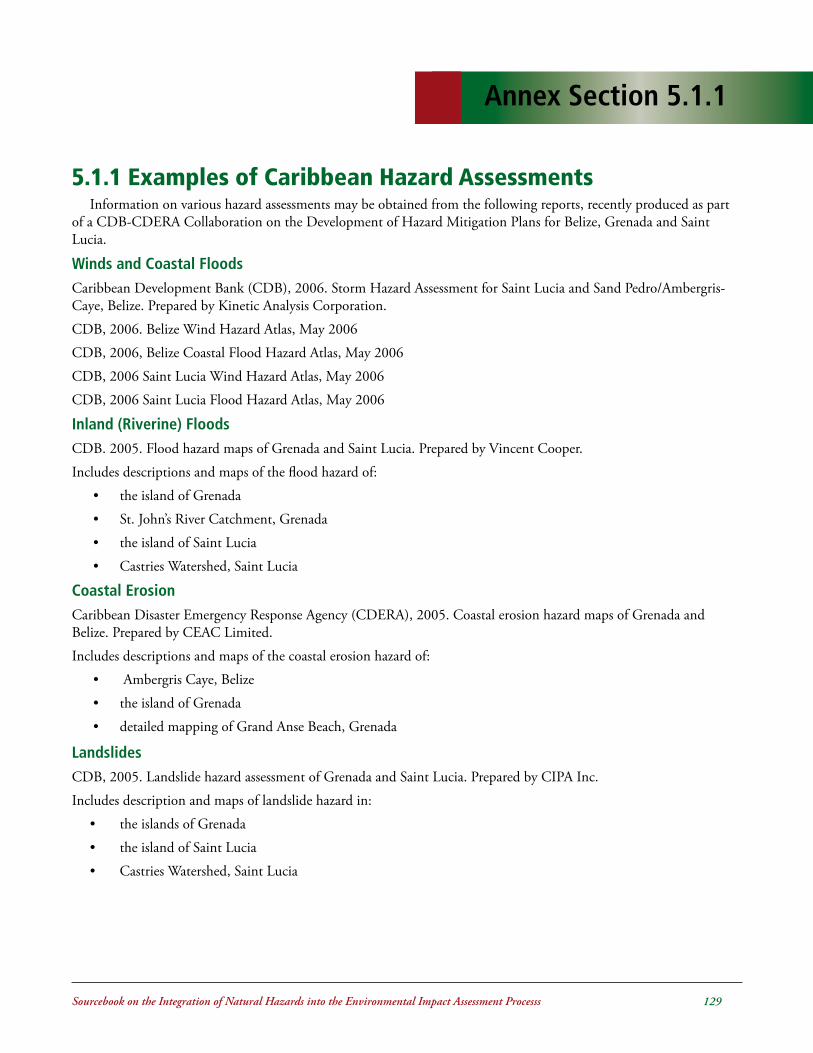
Sourcebook on the Integration of Natural Hazards into the Environmental Impact Assessment Processs ���
Annex Section 5.1.1
5.1.1.Examples.of.Caribbean.Hazard.Assessments.Information on various hazard assessments may be obtained from the following reports, recently produced as part
of a CDB-CDERA Collaboration on the Development of Hazard Mitigation Plans for Belize, Grenada and Saint Lucia.
Winds and Coastal Floods Caribbean Development Bank (CDB), 2006. Storm Hazard Assessment for Saint Lucia and Sand Pedro/Ambergris-Caye, Belize. Prepared by Kinetic Analysis Corporation.
CDB, 2006. Belize Wind Hazard Atlas, May 2006
CDB, 2006, Belize Coastal Flood Hazard Atlas, May 2006
CDB, 2006 Saint Lucia Wind Hazard Atlas, May 2006
CDB, 2006 Saint Lucia Flood Hazard Atlas, May 2006
Inland (Riverine) FloodsCDB. 2005. Flood hazard maps of Grenada and Saint Lucia. Prepared by Vincent Cooper.
Includes descriptions and maps of the flood hazard of:
• the island of Grenada
• St. John’s River Catchment, Grenada
• the island of Saint Lucia
• Castries Watershed, Saint Lucia
Coastal ErosionCaribbean Disaster Emergency Response Agency (CDERA), 2005. Coastal erosion hazard maps of Grenada and Belize. Prepared by CEAC Limited.
Includes descriptions and maps of the coastal erosion hazard of:
• Ambergris Caye, Belize
• the island of Grenada
• detailed mapping of Grand Anse Beach, Grenada
LandslidesCDB, 2005. Landslide hazard assessment of Grenada and Saint Lucia. Prepared by CIPA Inc.
Includes description and maps of landslide hazard in:
• the islands of Grenada
• the island of Saint Lucia
• Castries Watershed, Saint Lucia

Sourcebook on the Integration of Natural Hazards into the Environmental Impact Assessment Processs ��0
Other.Hazard.Assessments.
VolcanoesLindsay, J., Robertson, R., Shepherd, J and Ali, S. (eds), 2005. Volcanic Hazard Atlas of the Lesser Antilles. Seismic
Research Unit, The University of the West Indies, Trinidad and Tobago, W.I.
Provides detailed up-to-date summaries of the volcanic history and hazards associated with the live volcanoes in 11 islands in the Lesser Antilles.
See http://www.uwiseismic.com

Sourcebook on the Integration of Natural Hazards into the Environmental Impact Assessment Processs ���
Annex Section 5.1.2
Status of Hazard Maps, Vulnerability Assessments and Digital Maps in the Caribbean
This.Document.is.Located.in.Annex.Section.2.0.

Sourcebook on the Integration of Natural Hazards into the Environmental Impact Assessment Processs ���
Annex Section 5.2.1
Vulnerability Assessment of Utilities and Institutional Buildings Outline of Course Module1
Tony Gibbs, BSc, DCT(Leeds), FICE, FIStructE, FASCE, FConsE, FRSA October 2003
1. Introduction
2. Terms.of.Reference.for.Design.Consultants
3. Standards.for.Design 3.1 General
3.2 Design Criteria for Wind
3.3 Design Criteria for Earthquake
3.4 Design Criteria for Torrential Rain
3.5 Design Criteria for Storm Surge and Tsunami
4. Non-structural.Components.. 4.1 General
4.2 Fixed Components to be Considered by Design Professionals
4.3 Movable Items to be Addressed
5. Vulnerability.Audits.and.Setting.Implementation.Priorities.. 5.1 Vulnerability Audits
5.2 Priorities
A-I. . Terms.of.Reference.for.Design.Consultants
A-II.. Check.List.for.Non-structural.Components.for.Earthquakes
A-III. Check.List.for.Non-structural.Components.for.Hurricanes
1Extracted from CDB Training Course on “Incorporation of Natural Hazard Risk Management into Development Programmes and Projects”, Caribbean Development Bank, 2003.

Sourcebook on the Integration of Natural Hazards into the Environmental Impact Assessment Processs ���
1....IntroductionThis document is based in large measure on work
undertaken by Tony Gibbs over the past eight years for the Caribbean Disaster Mitigation Project3 and the DIPECHO Project4. However, this document has been edited specifically for the staff of The Caribbean Development Bank as part of the course organised by the Organisation of American States in October 2003.
The depth to which a vulnerability assessment of a facility should be undertaken depends mainly on the timetable for implementing actions identified during the assessment. A thorough, quantitative analysis is warranted when it has been determined to carry out remedial actions and as part of the implementation phase of a project. A less thorough, qualitative assessment should be satisfactory as part of an exercise to screen a portfolio of facilities with a view to prioritising retrofitting actions. Such a qualitative assessment is also appropriate for feasibility studies and project preparations prior to CDB project appraisals.
This document outlines the requirements for both qualitative assessments and quantitative analyses.
2...Terms.of.Reference.for.Assessment.and.......Retrofit.Consultants
It is considered that more reliable and predictable performance of the consulting team and better results for the project overall will be facilitated by detailed teams of reference being prepared by the client and agreed with the consultants. To assist in this process, suggested terms of reference are provided in Appendix I “Terms of Reference for Design Consultants” of this document.
The Appendix deals with briefing; specific discussion on natural hazards and agreement of performance expectations; steps in the monitoring of consultants and approval stages; document search and interviews; field surveys and
Vulnerability Assessment of Utilities and Institutional BuildingsCourse Module Session 62
Tony Gibbs, BSc, DCT(Leeds), FICE, FIStructE, FASCE, FConsE, FRSA - October 2003
laboratory tests; preliminary appraisals, conceptual design and project definition; design stage II; the tender process and the construction stage.
3...Standards.For.Assessments.and.......Retrofitting3.1 General
Codes of practice and standards should be used for the assessment of projects to achieve more consistent and predictable performance and to improve levels of safety.
Very commonly consultants use the minimum standards of codes, usually because of commercial pressures. Also, most codes are for general construction and not specific to the needs of critical infrastructure projects.
There is also the problem of aiming at unnecessarily high and expensive standards. Clients (in consultation with their consultants) should select, on informed and rational bases, appropriate design criteria for facilities of differing importance. Suggestions for critical facilities are made in the following sections 3.2 to 3.5 to assist in this process, but not to preempt such consultation and selection.
Clients should recognise the need to review, on an ongoing basis, the conditions of their facilities and their standards. Standards do change as knowledge increases.
3.2.....Design.Criteria.for.Wind3.2.1 Basic Wind Speeds and Reference Pressures
Various codes and standards define and describe wind forces and speeds differently. Since Caribbean clients have to deal with different standards regimes it is important to be able to convert from one standard to another. The main parameters used in defining wind speeds are:
• averaging period
2Extracted from CDB Training Course on “Incorporation of Natural Hazard Risk Management into Development Programmes and Projects”, Caribbean Development Bank, 2003.3This project was funded by the United States Agency for International Development and managed by the Organization of American States 4This project was funded by the Disaster Preparedness Programme of the Humanitarian Aid Office of the European Commission and managed by the Pan American Health Organization.
Annex Section 5.2.1

Sourcebook on the Integration of Natural Hazards into the Environmental Impact Assessment Processs ���
• return period
• height above ground
• upstream ground roughness
• topography
Thus, in the commonly-used OAS/NCST/BAPE “Code of Practice for Wind Loads for Structural Design”5 the definition reads:
“The basic wind speed V is the 3-second gust speed estimated to be exceeded on the average only once in 50 years ..... at a height of 10 m above the ground in an open situation .....”
3.2.2 Caribbean Uniform Building Code (CUBiC)6
Table 1 gives the CUBiC reference pressures (50-year return periods) along with corresponding wind velocities for different averaging periods for most of CDB’s BMCs.
3.2.3 Averaging PeriodsThe OAS/NCST/BAPE “Code of Practice for Wind
Loads for Structural Design” uses an averaging period of 3 seconds. CUBiC uses an averaging period of 10 minutes. Several Caribbean countries are, or will be, using the USA standard ASCE 77 in their national codes. This standard uses an averaging period of 3 seconds.
3.2.4 Return PeriodThe client, in consultation with (and advice from) its
consultant, should make conscious decisions with respect to desired levels of safety for different facilities. These decisions can be translated into return periods. The longer the return period the greater the level of safety. For most critical facilities, a return period of 100 years is the suggested minimum appropriate standard.
3.3...Design.Criteria.for.EarthquakeMuch less is known about the earthquake hazard than
about the wind and rainfall hazards in the Caribbean.
Because of this, and because of the ongoing research in this field, there is the need for regular reviews of design criteria by the construction industry in general and by consultants in particular. There may also be the justification for site-specific and project-specific studies for large or critical facilities.
For most projects, the guidance provided by existing standards and research papers would suffice. Some of these documents are listed below.
3.3.1 Caribbean Uniform Building Code (CUBiC)8
Table 2 gives the CUBiC zone factors (Z) for different locations in the region. The table also shows the corresponding values for the Uniform Building Code (USA) and the popular Structural Engineers Association of California (SEAOC) code.
3.3.2 PAIGH9 ResearchMaps were prepared of the Caribbean region with
isolines of accelerations due to earthquakes based on a research programme which was completed in 1994 and published in 199710 . The Caribbean part of the project was under the leadership of Dr John Shepherd. The maps show the Peak Horizontal Ground Acceleration or PGA (0.2 second) and the Spectral Ground Acceleration or SGA (1.0 second). They are based on a 10% probability of being exceeded in any 50-year period.
More recently Professor John Shepherd of the SRU11
updated the maps for the Eastern Caribbean to include data up to the end of 2002. These later maps show the spectral ground acceleration at periods of 0.2 seconds and 1.0 seconds with 2% probability of exceedance in any 50-year period. This brings the Eastern Caribbean maps into line with current practice in the United States. These parameters are the bases for the NEHRP12 , ASCE 713 and IBC14 standards. These USA standards documents are likely to inform the future earthquake loading standards of most Caribbean countries.
5BNS CP28 - Code of Practice for Wind Loads for Structural Design; sponsored by the Organization of American States, the National Council for Science & Technology and the Barbados Association of Professional Engineers; prepared by Tony Gibbs, Herbert Browne and Basil Rocheford; November 1981.6CUBiC Part 2 - Structural Design Requirements; Section 2 - Wind Load; 19857American Society of Civil Engineers “Minimum Design Loads for Buildings and Other Structures”, ASCE 7-02 (the most recent edition), Chapter 6.0 Wind Loads, adopted by reference in the International Building Code (a USA model code)8CUBiC Part 2 - Structural Design Requirements; Section 3 - Earthquake Load; 19859Instituto Panamericano de Geografía y Historia10Seismic Hazard in Latin America and the Caribbean - Final Report; Instituto Panamericano de Geografía y Historia; Volume 1 (JG Tanner, JB Shepherd); Volume 5 (JB Shepherd, JG Tanner, CM McQueen, LL Lynch); 199711Seismic Research Unit of The University of the West Indies in Trinidad12National Earthquake Hazards Reduction Program (of the USA)13American Society of Civil Engineers “Minimum Design Loads for Buildings and Other Structures”, ASCE 7-02 (the most recent edition), Chapter 9.0 Earthquake Loads14International Building Code IBC2003 (a USA model code)

Sourcebook on the Integration of Natural Hazards into the Environmental Impact Assessment Processs ���
3.3.3 Importance FactorEarthquakes are not yet amenable to statistical analysis
and to the determination of return periods in the same way as windstorms or rain. Nevertheless the client, in consultation with the consultant, must still make conscious decisions with respect to desired levels of safety for different facilities. These decisions are translated into importance factors in codes and standards. These factors usually vary from 1.0 to 1.5. For critical facilities, an importance factor of 1.2 is the suggested minimum appropriate standard.
3.3.4 ConceptSatisfactory earthquake-resistant design requires more
than the faithful following of the mathematical requirements of standards documents. Appropriate geometry of the overall building or structure and appropriate structural systems are critical for success.
3.3.5 DetailingGood conceptual design and good analysis must be
complemented by good detailing in order to achieve satisfactory performance of buildings and other facilities in earthquakes.
3.4...Design.Criteria.for.Torrential.Rain3.4.1 Design Graphs
Intensity-duration-frequency curves have been developed for several territories in the region and may be available through the Caribbean Institute for Meteorology and Hydrology in Barbados.
3.4.2 Return PeriodTraditionally, quite short return periods have been
selected for design rain storms. It was quite common for facilities to be designed for 1-in-20-year storms. Much damage and disruption is caused with increasing frequency by torrential rains. There needs to be a reassessment of this design criterion. For critical facilities, a return period of 50 years is the suggested minimum appropriate standard.
3.4.3 Changing Conditions
The other factor affecting rain runoff and flooding is upstream development, usually outside of the control of the client for a particular facility. It is not unlikely that well-designed drainage systems prove to be inadequate some time after they have been implemented because of greater runoff than could reasonably have been anticipated at the time of design. This typically happens when land use upstream is changed due, e.g., to urban expansion. Therefore it is appropriate to adopt a conservative approach to the selection of rainfall design criteria.
3.5..Design.Criteria.for.Storm.Surge.and.........Tsunami3.5.1 Storm Surge
This complex phenomenon is of interest for coastal sites. Computer models are available for developing storm-surge scenarios for coastlines. One such model is TAOS (The Arbiter of Storms) developed by Charles C Watson and tailored for the Caribbean under the USAID/OAS-CDMP15 programme. This model is now operational at the Caribbean Institute for Meteorology and Hydrology in Barbados.
3.5.2 Tsunami
This hazard may come about from a likely eruption of the Kick ‘em Jenny submarine volcano just north of Grenada. It is not commonly remembered that the great Lisbon (Portugal) earthquake of 1755 generated a significant tsunami in Barbados and in the 19th century many lives were lost in the (now) US Virgin Islands due to a tsunami generated by a nearby earthquake.
3.5.3 Advice
The studies of both of these hazards are highly specialised subjects for which expert advice should be sought for all low-lying, coastal developments.
15Caribbean Disaster Mitigation Project; funded by the United States Agency for International Development; implemented by the Organization of American States

Sourcebook on the Integration of Natural Hazards into the Environmental Impact Assessment Processs ���
Location qref
CUBiC
10 min
CUBiC
1 hr 1 min
(or "fastest mile")
3 sec
Antigua 0.82 37 35 45 56
Barbados 0.70 34 32 41 51
Belize - N
Belize - S
0.78
0.55
36
30
34
29
43
37
54
45
Dominica 0.85 38 36 46 57
Grenada 0.60 32 30 38 47
Guyana 0.20 18 17 22 27
Jamaica 0.80 37 35 44 55
Montserrat 0.83 37 36 48 59
St. Kitts and Nevis 0.83 37 36 48 59
St. Lucia 0.76 36 34 43 57
St. Vincent 0.73 35 33 42 56
Tobago 0.47 28 26 38 42
Trinidad - N
Trinidad - S
0.40
0.25
26
20
25
19
31
25
39
30
Notes qref = pressures in kilopascals
(kPa)
wind speeds in metres per second (ms-1)
Table1: Reference Wind Velocity Pressures and Wind Speeds (50-year return period) (taken from CUBiC)

Sourcebook on the Integration of Natural Hazards into the Environmental Impact Assessment Processs ���
Territory Z Value CUBiC
& UBC 85
Z Factor UBC ‘88
& SEAOC ‘90
Zone Number SEAOC
Antigua 0.75 0.3 3
Barbados 0.375 0.15 - 0.2 2
Belize - (areas within 100km of southern border, i.e. including San Antonio and Punta Gorda but excluding Middlesex, Pomona and Stann Creek)
Belize - (rest of)
0.75 0.50
0.3 0.2
3 2+
Dominica 0.75 0.3 3
Grenada 0.50 0.2 2+
Guyana - (Essequibo) Guyana - (rest of)
0.25 0.00
0.1 1+
Jamaica 0.75 0.3 3
Montserrat 0.75 0.3 3
St. Kitts/Nevis 0.75 0.3 3
St. Lucia 0.75 0.3 3
St. Vincent 0.50 0.2 2+
Tobago 0.50 0.2 2+
Trinidad - (NW) Trinidad - (rest of)
0.75 0.50
0.3 0.2
3 2+
Table2: Z Values (taken from CUBiC) and Equivalent Seismic Zone Factors and Numbers)

Sourcebook on the Integration of Natural Hazards into the Environmental Impact Assessment Processs ���
4.....Non-structural.Components.
4.1 General
Non-structural components are the orphans of the building industry. No one pays proper attention to their safety. They include ceilings, windows, doors, external cladding and many other components of buildings. Non-structural components comprise 60 to 80 percent of the cost of a building. Since con-sulting structural engineers usually do not get paid for designing these elements they are not dealt with by this group. Since the training of architects does not equip them to address the strength and stability issues associated with these elements they leave these matters to the suppliers and contractors. Codes and standards are almost silent on these matters. The sup-pliers and contractors, recognising that no one is pay-ing attention to strength and stability issues, concern themselves mainly with function, appearance and price. A high percentage of the losses in hurricanes and earthquakes is due to the failure of such non-structural elements.
It is understood that the structural design of non-structural components in Colombia is now becoming a clearly recognised function with a particular (addi-tional) member of the design team being allocated the task.
4.2 Fixed Components to be Considered by Design Professionals
In the case of earthquakes all non-structural com-ponents of the building require attention. They in-clude electrical and mechanical systems, ceilings, par-titions, cupboards and shelves, windows and doors.
Assistance to the designer is provided in Appendix II – “Check List for Non-structural Components for Earthquakes”.
In the case of hurricanes and torrential rain the non-structural components warranting attention are all of those comprising the building envelope and all of those located outside of the building envelope. Since the design aim for hurricane resistance is to have no significant damage to the building (in contrast to the
traditional design aims for earthquake resistance) it is assumed that the building envelope is not breached during the event.
Apart from roofs, the elements requiring the most attention for hurricanes are windows and external doors. Sadly, these are often neglected even when buildings are formally designed by professionals. Glass windows and doors are, of course, very vulnerable to flying objects, and there are many of these in hurri-canes. There are only two solutions: use impact-resis-tant glazing (expensive but highly desirable) or cover the glass with storm shutters (inconvenient). For new buildings the challenge is to design storm shutters which are integrated into the permanent structure, have another role which they could play every year (eg sun shading and burglar proofing) and enhance the appearance of the building. It is not sufficient to protect fragile glass however. Attention must also be paid to securing external doors with strong bolts or braces and to fixing door and window frames firmly to the walls.
Assistance is provided in Appendix III – “Check List for Non-structural Components for Hurri-canes”.
4.3 Movable Items to be Addressed
In addition to the building itself (structure and non-structure) there are the items of movable equip-ment and furniture. In the case of earthquakes (which provide no warning as to the exact time of occurrence) there is the need to secure the stability of some such objects.
5....Vulnerability.Audits.and.Setting.
......Implementation.Priorities
5.1 Vulnerability Audits
Various audits of critical facilities have been carried out during the past decade under the management of the OAS and PAHO with funding from USAID and ECHO respectively. The reports on these audits are generally available in the public domain.
In addition, useful post-disaster information and assessments can be obtained from the reports such as

Sourcebook on the Integration of Natural Hazards into the Environmental Impact Assessment Processs ���
“Case Study of the Effects of Hurricane Luis on the Buildings and other Structures of the Electricity Sec-tion of the Antigua Public Utilities Authority, Feb-ruary 1996” available from OAS and “Survey of the Damage Done to the Government Health Service Fa-cilities in Antigua, Hurricane Luis, September 1995” available from PAHO.
Useful guidance on the process for audits may be obtained from the document “Vulnerability Assess-ment of Shelters in the Eastern Caribbean” prepared for the Organization of American States under the USAID/OAS Caribbean Disaster Mitigation Project by Tony Gibbs, Consulting Engineers Partnership Ltd , November 1998.
5.2...Priorities
This issue can only be addressed with respect to a particular country. Damage mitigation is best done in a phased programme so as not to disrupt the principal functions of the system. Further, damage mitigation is an ongoing exercise and not a one-time, crash pro-gramme. It ought to become an integral part of the culture of the country.
The speed with which the initial, catch-up phase proceeds depends on financial resources, the seri-ousness of the problem and the size of the problem. Techniques are available for assisting with the deci-sion-making process when determining priorities.

Sourcebook on the Integration of Natural Hazards into the Environmental Impact Assessment Processs ��0
1...BriefingThe consultants will receive briefs from the cli-
ent. In particular, the consultants will initiate specific discussions on natural hazards and reach agreement with the client on performance expectations for the project. The client’s policy position with respect to natural hazards and the performance expectations in the event of differing levels of severity of hurricanes, earthquakes, torrential rains and other phenomena is to be clearly articulated. Decisions must be made on the appropriate levels of safety for the facilities.
2..Specific.Discussion.on.Natural.Hazards.and.Agreement.of.Performance.Expecta-tions
Experience has shown that the design against nat-ural hazards is not something that can be taken for granted. At the outset the client should hold discus-sions with its consultants and clearly articulate the policy position with respect to natural hazards and the performance expectations in the event of differing levels of severity of hurricanes, earthquakes, torrential rains and other phenomena.
3. Steps. in. the. Monitoring. of. Consul-tants.and.Approval.Stages
3.1 Inception Report
3.2 Preliminary assessment, quantitative analy-sis and cost estimates
3.3 Review and “sign off” on agreed damage mitigation measures
3.4 Tender documents
3.5 Approved list of tenderers (construction contractors)
3.6 Contract award
3.7 Monthly reports during construction
APPENDIX I
Terms of Reference for Design Consultants
3.8 Taking possession of retrofitted facility and the maintenance period
3.9 Final certification and receipt of all manuals and as-built drawings
4.....Document.Search.and.Interviews
The consultant will request from the client and re-ceive all available reports related to the project and the site.
After study of the available documents the con-sultant will carry out interviews of the technical and other personnel of the client to supplement the infor-mation on the project obtained from the documents.
4.1 Inception Report
On completion of the document review and sup-plementary interviews the consultant will prepare an inception report including:
• the consultant’s understanding and interpretation of the terms of reference;
• changes to the terms of reference since the start of the assignment;
• an appraisal of the available information and an outline of the consequential field investigations to be conducted so as to complement the infor-mation already obtained, including any spe-cial investigations which may be required;
• an outline of the programme for the remainder of the assignment.
5. Field.Surveys.and.Laboratory.Tests
The consultant will carry out field surveys to sup-plement and confirm previously-obtained informa-tion. Such field surveys may include laboratory test-ing of materials taken from the site.
For the assessment of storm-water drainage provi-

Sourcebook on the Integration of Natural Hazards into the Environmental Impact Assessment Processs ���
sions it may be necessary for the consultant to under-take topographic surveys of the site.
For the assessment of foundation conditions affect-ing anchorage and the seismic response of facilities it will be necessary for the consultant to undertake geo-technical surveys of the site and it may be necessary to undertake geophysical surveys as well.
6....Preliminary.Assessment,.Quantitative........Analysis.and.Cost.Estimates
The consultant will interpret the brief and prepare preliminary retrofitting actions for consideration by the client.
The design, analysis and detailing of retrofitting ac-tions to make the buildings resistant to earthquakes and hurricanes are complex processes involving many issues.
6.1 Design Stage I Report
On completion of the work described in 5 and 6 the consultant will prepare a design stage I report includ-ing:
• the design standards and codes to be used on the project;
• the agreed design criteria for the project;
• preliminary proposals and drawings;
• outline specification;
• procurement procedures for the construction contractors and suppliers;
• conditions of contract - general and particular;
• cost estimates;
• an outline of the programme for the remainder of the assignment.
The client will review the report and hold discus-sions with the consultant (which may lead to revi-sions) and will conclude with the formal approval of the project, as defined in the report, for implementa-tion.
The vulnerability of a building to earthquakes and hurricanes is very often associated with the non-struc-tural components of the building. These components rarely receive the attention they deserve from the con-struction industry. As aides-mémoire Appendices II – “Check List for Non-structural Components for Earthquakes” and III – “Check List for Non-structur-al Components for Hurricanes” are included in this document addressing this issue.
In modern buildings those elements not part of the principal load-resisting system can account for up to 80% of the cost. Traditionally, structural engineers are not consciously and directly involved with these ele-ments. Architects, electrical engineers and mechani-cal engineers are usually responsible for them. These disciplines do not usually focus on wind and earth-quake resistance. In most cases the relevant persons are by no means equipped for the task of providing wind-resistant and earthquake-resistant components. The solution to this problem may involve the realloca-tion of design responsibilities among the members of the design team with a commensurate reallocation of compensation.
This stage effectively defines the project. It is there-fore most important that it be done thoroughly by the design team and be reviewed carefully by the client. The likelihood is that a satisfactory Design Stage I phase would lead to a successful project.
7....Design.Stage.II
The consultant will undertake the analysis and de-tailing of all aspects of the works to be constructed. This phase of the project will include:
• the iterative process of analysis and refinement of the designs;
• construction details;
• technical specifications;
• bills of quantities.
8....The.Tender.Process
The consultant will undertake the following tasks:

Sourcebook on the Integration of Natural Hazards into the Environmental Impact Assessment Processs ���
• prequalification of contractors and suppliers;
• inviting tenders;
• pre-tender meeting with the bidders;
• answering questions from bidders during the ten-der period;
• opening of tenders, review and reporting on ten-ders.
The tender process culminates with the client’s de-cision and the contract award by the consultant on behalf of the client.
9. Construction.Stage
The consultant will undertake the following tasks:
• conduct a pre-construction meeting with the cho-sen contractor;
• undertake supervision-in-chief, provide resident supervision in appropriate circumstances and ad-vise the client on the need for additional inspec-tors;
• conduct site meetings and prepare progress re-ports for issue to the client;
• check shop drawings and provide approvals when compliance with the contract documents is achieved;
• issue and administer variations and additions to the contract;
• certify payments to the contractor;
• issue the certificate of substantial completion;
• monitor latent defects during the maintenance period;
• deliver as-built drawings to the client.
At the end of the maintenance period the consultant will carry out a final inspection of the works and issue the final certificate for payment to the contractor.

Sourcebook on the Integration of Natural Hazards into the Environmental Impact Assessment Processs ���
This Appendix constitutes a list of items and issues to be considered in designing the non-structural com-ponents of facilities to counteract the effects of earth-quakes. Check lists are valuable as aides-mémoire for the exercise. For any particular project all of the items may not be relevant, but excluding items from a com-prehensive list is always easier than adding relevant items to a short list.
1. Electricity
1.1 Generator
1.1.1 Anchorage of the emergency generator
1.2 Batteries
1.2.1 Attachment of the batteries to the battery rack
1.2.2 Cross-bracing the rack in both directions
1.2.3 Battery rack bolted securely to a concrete pad
1.3. Diesel.Fuel.Tank
1.3.1 Attachment of the tank to the supports
1.3.2 Cross-bracing the tank supports in both directions
1.3.3 Bracing attached with anchor bolts to a concrete pad
1.4. Fuel.Lines.and.Other.Pipes
1.4.1 Lines and pipes attached with flexible connections
1.4.2 Able to accommodate relative movement across joints
APPENDIX II
Check List for Non-structural Components for Earthquakes
1.5. Transformers,.Controls,.Switchgear
1.5.1 Items properly attached to the floor or wall
1.6. Bus.Ducts.and.Cables
1.6.1 Able to distort at their connections to equipment without rupture
1.6.2 Able to accommodate relative movement across joints
1.6.3 Laterally braced
2. Fire.Fighting
2.1 Smoke Detectors and Alarms
2.1.1 Properly mounted
2.1.2 Control system and fire doors securely anchored
2.2. Fire.Extinguishers.and.Hose-reel... Cabinets
2.2.1 Cabinets securely mounted
2.2.2 Extinguishers secured with quick-release straps
2.3. Emergency.Water.Tank
2.3.1 Securely anchored to its supports
2.3.2 Supports braced in both directions
2.3.3 Supports or braces anchored to a concrete foundation
3. Propane.Tanks
3.1 The Tank

Sourcebook on the Integration of Natural Hazards into the Environmental Impact Assessment Processs ���
3.1.1 Securely anchored to its supports
3.1.2 Supports braced in both directions
3.1.3 Supports or braces anchored to a concrete foundation
3.2 Shut-off Valve
3.2.1 System with an automatic, earthquake- triggered, shut-off valve
3.2.2 If manual, provided with a wrench stored close by
3.3 Supply Pipes
3.3.1 Able to accommodate relative movement across joints and at the tank
3.3.2 Laterally braced
4. Plumbing
4.1 Water Heaters and Boilers
4.1.1 Securely anchored to the floor or wall
4.1.2 Gas line with a flexible connection to the heater or boiler to accommodate movement
4.2 Pumps
4.2.1 Anchored or mounted on vibration isolation springs with seismic lateral restraints
4.3 Hot and Cold-water Pipes and Wastewater Pipes
4.3.1 Pipes laterally braced at reasonable intervals
4.3.2 Flexible connections to boilers and tanks
4.3.3 Able to accommodate movement across joints
4.3.4 Pipe penetrations through walls large enough for seismic movement
4.3.5 Free of asbestos insulation (which can be broken in an earthquake)
4.4 Solar Panels
4.4.1 Securely anchored to the roof
5. Elevators
5.1 Cab
5.1.1 Properly attached to the guide rails
5.1.2 Alarm system for emergencies
5.2. Cables,.Counterweights,.Rails
5.2.1 Cables protected against misalignment during an earthquake
5.2.2 Counterweights properly attached to guide rails
5.2.3 Guide rails properly attached to the building structure
5.3. Motors.and.Control.Cabinets
5.3.1 Anchored
6. Air.Conditioning
6.1 Chillers, Fans, Blowers, Filters, Air Compressors
6.1.1 Anchored, or mounted on vibration isolation springs with seismic lateral restraints
6.2 Wall-mounted Units
6.2.1 Securely mounted
6.3 Ducts
6.3.1 Laterally braced
6.3.2 Able to accommodate movement at locations where they cross separation joints
6.4 Diffusers
6.4.1 Grills anchored to the ducts or to the ceiling grid or to the wall
6.4.2 Hanging diffusers adequately supported
7. Non-structural.Walls.and.Partitions
7.1 Concrete Block, Brick, Clay Block
7.1.1 Reinforced vertically and/or horizontally

Sourcebook on the Integration of Natural Hazards into the Environmental Impact Assessment Processs ���
7.1.2 Detailed to allow sliding at the top and movement at the sides
7.1.3 Restrained at the top and the sides against falling
7.2 Stud-wall and other Lightweight Walls
7.2.1 Partial-height partitions braced at their top edges
7.2.2 If they support shelving or cabinets, securely attached to the structure of the building
8. Ceilings.and.Lights
8.1 Ceilings
8.1.1 Suspended ceilings with diagonal bracing wires
8.1.2 Plaster ceilings with the wire mesh or wood lath securely attached to the structure above
8.2 Lighting
8.2.1 Light fixtures (eg lay-in fluorescent fixtures) with supports independent of the ceiling grid
8.2.2 Pendant fixtures with safety restraints (eg cables) to limit sway
8.2.3 Emergency lights mounted to prevent them falling off shelf supports
9. Doors.and.Windows
9.1 Doors
9.1.1 If exit doors are heavy metal fire doors that might jam in an earthquake, provision of a crowbar or sledge hammer readily available to facilitate emergency opening
9.1.2 Automatic doors with manual overrides
9.1.3 Directions in which the doors swing
9.2 Windows
9.2.1 Glazing designed to accommodate lateral movement
9.2.2 Large windows, door transoms and skylights with safety glass
10. Appendages.and.Sundries
10.1 Parapets, Veneer and Decoration
10.1.1 Parapets reinforced and braced
10.1.2 Veneers and decorative elements with positive anchorage to the building
10.2 Fences and Garden Walls
10.2.1 Designed to resist lateral forces
10.2.2 Masonry walls reinforced vertically and rigidly fixed to their bases
10.3 Signs and Sculptures
10.3.1 Signs adequately anchored
10.3.2 Heavy and/or tall sculptures anchored to prevent overturning
10.4 Clay and Concrete Roof Tiles
10.4.1 Tiles secured to the roof with individual fixings for each tile
11. Movable.Equipment
11.1 Communications
11.1.1 Radio equipment restrained from sliding off shelves
11.1.2 Telephones placed away from edges of desks and counters
11.1.3 Elevated loud speakers and CCTV anchored to the structure
11.2 Computers
11.2.1 Vital computer information backed up regularly and stored off site
11.2.2 Heavy computer equipment of significant height relative to width anchored or braced
11.2.3 Desktop items prevented from sliding off tables

Sourcebook on the Integration of Natural Hazards into the Environmental Impact Assessment Processs ���
11.2.4 Access floors braced diagonally or with seismically-certified pedestals
11.3 Storage of Records and Supplies
11.3.1 Shelving units anchored to walls
11.3.2 Shelves fitted with edge restraints or cords to prevent items from falling
11.3.3 Heavier items located on the lower shelves
11.3.4 Filing cabinet drawers latched securely
11.3.5 Heavily-loaded racks braced in both directions
11.3.6 Fragile or valuable items restrained from tipping over
11.3.7 Chemical supplies secured or stored in “egg crate” containers
11.4 Hazardous Items
11.4.1 Gas cylinders tightly secured with chains at top and bottom (or otherwise) and with chains anchored to walls
11.4.2 Chemicals stored in accordance with manufacturers recommendations
11.4.3 Cabinets for hazardous materials given special attention with respect to anchoring
11.5 Furniture
11.5.1 Heavy potted plants restrained from falling or located away from beds
11.5.2 Beds and tables and equipment with wheels provided with locks or other restraints to prevent them rolling unintentionally

Sourcebook on the Integration of Natural Hazards into the Environmental Impact Assessment Processs ���
This Appendix constitutes a list of items and is-sues to be considered in designing the non-structural components of facilities to counteract the effects of hurricanes. Check lists are valuable as aides-mémoire for the exercise. For any particular project all of the items may not be relevant, but excluding items from a comprehensive list is always easier than adding rel-evant items to a short list.
1. Roofs
1.1 Light-weight Coverings
1.1.1 Gauge of corrugated sheeting
1.1.2 Type and quality of corrugated sheeting
1.1.3 Valley fasteners for trapezoidal profiles
1.1.4 Ridge fasteners supplemented by spacer blocks under the ridges or by hurricane washers
1.1.5 Fastener spacings specified for interior areas and for perimeter areas (for approximately 15% of the roof dimension along eaves, gables and ridges)
1.1.6 Asphalt shingles (vulnerable in high winds) laid on waterproofing felt on top of plywood sheets which in turn are fastened by screws or annular nails to supporting timber rafters
1.1.7 Wooden shingles individually fixed to close boarding which in turn is fastened by screws or annular nails to supporting timber rafters
1.2 Other coverings
1.2.1 Slates individually fixed to close boarding
APPENDIX III
Hurricanes
Check List for Non-structural Components for Hurricanes
1.2.2 Concrete or clay tiles individually fixed to close boarding
NB:
i) In all cases the methods of fixing must, at least, comply with the manufacturers’ recommendations for specified hurricane locations
ii) If battens are used, the fastening of the battens to the close boarding must be at least as strong as the fastening of the covering to the battens
2 Windows
2.1 Made of laminated glass fixed to frames with structural silicon and able to resist, without breaching, the impact of flying objects such as an 8-foot long 2-inch by 4-inch piece of timber moving at 35 miles per hour (similar to the requirements of Dade, Broward and Palm Beach Counties of Florida)
or
2.2 Protected by pre-installed or pre-fabricated shutters which are able to resist without breaching the impact of flying objects such as an 8-foot long 2-inch by 4-inch piece of timber moving at 35 miles per hour
or
2.3 Made of timber or aluminium louvres with provisions for excluding the rain during storm conditions and which are able to resist without breaching the impact of flying objects such as an 8-foot long 2-inch by 4-inch piece of timber moving at 35 miles per hour

Sourcebook on the Integration of Natural Hazards into the Environmental Impact Assessment Processs ���
NB:
The windows or shutters must be secured to the walls, slabs, beams or columns near all corners of each panel or in accordance with the manufac-turers’ recommendations for specified hurricane locations.
3. External.Doors
3.1 Glass Sliding Doors
3.1.1 Made of laminated glass fixed to frames with structural silicon and able to resist without breaching the impact of flying objects such as an 8-foot long 2-inch by 4-inch piece of timber moving at 35 miles per hour
or
3.1.2 Protected by pre-installed or pre-fabricated shutters which are able to resist without breaching the impact of flying objects such as an 8-foot long 2-inch by 4-inch piece of timber moving at 35 miles per hour
3.1.3 Moving frames with a certificate from the sup-plier indicating compliance with the require-ments for the appropriate intensity of hurri-canes, including both strength and deflexions
3.1.4 Fixed perimeter frames secured to the walls, slabs, beams or columns by bolting or in accor-dance with the manufacturers’ recommenda-tions for specified hurricane locations
3.1.5 Tracks of the top and bottom rails deep enough to prevent the moving doors from be-ing dislodged in specified hurricanes
3.2 Roller Shutter (or Overhead) Doors
3.2.1 Certificates from the suppliers indicating com-pliance with the requirements for the appropri-ate level of hurricanes, including both strength and deflexions
3.2.2 Fixed perimeter frames secured to the walls, slabs, beams or columns by bolting or in accor-dance with the manufacturers’ recommenda-tions for specified hurricane locations
3.2.3 Side tracks deep enough to prevent the mov-ing doors from being dislodged in specified hurricanes unless some other mechanism is employed to prevent such an occurrence
3.3 Other Doors
3.3.1 Timber doors with solid cores or made up from solid timber members and able to resist without breaching the impact of flying objects such as an 8-foot long 2-inch by 4-inch piece of timber moving at 35 miles per hour
3.3.2 Each door leaf fixed by hinges or bolts in at least four locations adjacent to all corners
4. Other.Apertures
4.1 Protection from wind and rain provided by pre-installed or pre-fabricated shutters which are able to resist without breaching the im-pact of flying objects such as an 8-foot long 2-inch by 4-inch piece of timber moving at 35 miles per hour
4.2 Shutters secured to the walls, slabs, beams or columns near all corners of each panel or in accordance with the manufacturers’ recom-mendations for specified hurricane locations
5. Solar.Water.Heaters.and.Air-.. conditioners
5.1 Certificates from the suppliers indicating compliance with the requirements for the appropriate intensity of hurricanes for both manufacture and inst

Sourcebook on the Integration of Natural Hazards into the Environmental Impact Assessment Processs ���
Vulnerability and Capacity Assessment (VCA) is a basic process used to identify the strengths and weaknesses of National Societies in relation to disaster management.
The process is another step towards fulfilling the Inter-national Federation’s commitment to reduce the exposure of people around the world to the risks caused by natural and man-made hazards.
Typically, the assessment involves participative research driven by a National Society task group. Participants from many different levels of society including the National So-ciety, branches and communities work together in focus groups.
The process involves assessing people’s vulnerability and their capacities and gives National Societies an opportu-nity to collect relevant information about impending risks before the event occurs.
The results of the VCA can help the National Society to set up programmes to mitigate potential loss of life and property, as well as to improve the organisational systems, information flows and decision-making necessary to plan for both risk reduction and disaster response programmes.
The nature of VCA is flexible and needs to be designed and amended for each specific National Society. It is a tool
that can be used in a national context or targeted specific areas of a country and must be National Society driven at all stages to ensure ownership.
An important aspect of the assessment is to quickly identify what the various vulnerabilities are within a coun-try or area. People living along coastal areas or rivers may be vulnerable to seasonal storms and flooding. The in-habitants of countries with social, political and economic problems may face difficulties in achieving a satisfactory and sustainable quality of life.
When carrying out the process, it is also important to remember that National Societies may have specific organ-isational limitations that impede progress in developing their capacity to carry out more effective disaster prepared-ness and response programmes.
Within the planning process, VCA provides informa-tion about programme needs in disaster management and may also contribute towards the CAS process.
The full text of the VCA guidance document is avail-able at http://www.ifrc.org/what/disasters/dp/planning/vca/guidelines.asp
Source: ‘Introduction’ web page for Vulnerability and Capacity Assessment, International Federation of the Red Cross/Red Crescent. This web page is available at:
http://www.ifrc.org/what/disasters/dp/planning/vca/index.asp
Vulnerability and Capacity Assessment (VCA)
Annex Section 5.2.2

Sourcebook on the Integration of Natural Hazards into the Environmental Impact Assessment Processs ��0
Vulnerability Assessment Techniques and Applications (VATA) is a workshop series to provide opportunities to explore new ideas and partnerships in the development, analysis and application of vulnerability assessments for researchers and practitioners from government agencies, non-governmental organizations, academia, the private sector.
It originated as a collaboration between the Organi-zation of American States (OAS) and the United States
Vulnerability Assessment Techniques and Applications (VATA)
Annex Section 5.2.3
National Oceanographic and Atmospheric Administration (NOAA). The Caribbean Development Bank (CDB) has joined as a co-partner in the VAT process. CDB hosted the 3rd VATA meeting in December 2002.
One of the major resources of VATA is an online vul-nerability assessment tool locator available on the web: www.csc.noaa.gov/vata

Sourcebook on the Integration of Natural Hazards into the Environmental Impact Assessment Processs ���
Source: © Emergency Preparedness and Disaster Mitigation Program, Pan American Health Organisation, Caribbean Office, Barbados. Document available from http://www.disaster-info.net/carib/
Annex Section 5.3.1
Report on the Comparison of Building “Codes” and Practiceswhich are in use in the Caribbean (Bahamas, CUBiC, Dominican Republic, French Antilles, OECS) Focusing on Design and Construction of Healthcare Facilities by Tony Gibbs
1.. Codes.and.Standards.and.Practices
2.. Background
3. The.Hazards
4.. The.History.of.Caribbean.Standards.and.Codes.
5. Limitations.of.Standards
6.. The.Regulatory.Environment
7.. The.Wider.Caribbean
8. Conclusion

Sourcebook on the Integration of Natural Hazards into the Environmental Impact Assessment Processs ���
1...Codes.and.Standards.and.Practices Much confusion arises from the common usage of the
words “code” and “standard”. In particular, the word “code” is commonly used in place of “standard”. For example the Caribbean Uniform Building Code (CUBiC) is principally a set of technical standards. It would be appropriate to distinguish clearly between the two words, at least for the purposes of this paper.
The word “code” has a legal connotation. Codes are often part of the law of a country enacted either by statute or under powers to legislate delegated to a minister of government. Codes are usually accompanied by “regulations” and often refer to technical “standards”.
As inferred above, “standard” usually refers to a set of technical recommendations set out in an orderly manner to guide the practitioner in executing the design, fabrication and construction of (in this case) building works.
Actual practices may vary from both codes and standards. In the case of codes, this may come about because of ineffective enforcement mechanisms. In the case of standards, this may come about because the standards may not be mandated by the laws and regulations of the relevant state.2...Background
The region is afflicted by many natural hazards. The principal natural hazards affecting the region are hurricanes, earthquakes, torrential rains, volcanic eruptions, tsunamis, sea waves and storm surge. For the purposes of the design of buildings the hazards of hurricanes, torrential rains and earthquakes are the critical ones.
Engineers in the Caribbean have been using “codes of practice” and standards for almost as long as they were available to engineers in the metropolitan countries. Because of the colonial presence, most of these standards in the Commonwealth Caribbean were from the United Kingdom and in the French Antilles from European France. However, standards from the United States of America and Canada were also in use. The use of standards was generally subjective, uncontrolled and lacking in uniformity. The Caribbean cannot afford disasters. Disasters must be avoided. Hence there is an urgent and overdue need for codification of the building industry.
In previous generations there was little conscious engineered attention to earthquake-resistant design in the Caribbean. Much more attention had been paid to designing against hurricane-force winds. Even at present there are still many significant structures, including hospitals, which are not subjected to conscious earthquake-resistant design techniques.3...The.Hazards3.1 Wind Loading and Earthquake-resistant Design
The work in the area of wind loading has been considerable. Indeed there is now heightened interest in this issue. There are in existence several regional documents: the BAPE/CCEO1 document “Wind Loads for Structural Design”2, the CUBiC section on “Wind Loading3 and the Dominican Republic “Reglamento para el Análisis por Viento de Estructuras”4.
1 BAPE = Barbados Association of Professional Engineers - CCEO = Council of Caribbean Engineering Organisations 2 The latest edition of this document was funded by the Organisation of American States through the National Council of Science and Technology (Barbados) in 1981. It is a Barbados standard BNS CP28. 3 CUBiC:Part-2:Section-2:Wind Loads published in 1985 4 Prepared for Dirección General de Reglamentos y Sistemas, Secretaría de Estado de Obras Públicas y Comunicaciones by Grupo de Estabilidad Estructural in 1999
Annex Section 5.3.1
.
Report on the Comparison of Building “Codes” and Practiceswhich are in use in the Caribbean (Bahamas, CUBiC, Dominican Republic, French Antilles, OECS) Focusing on Design and Construction of Healthcare Facilities* by Tony Gibbs

Sourcebook on the Integration of Natural Hazards into the Environmental Impact Assessment Processs ���
.
Earthquake-resistant design has taken up more time in debate and study than any other single issue in the development of regional building standards. Undoubtedly this debate will continue and (hopefully) so too will the research effort.3.2 Other Hazards
Torrential rain is not dealt with in any building standard in the Caribbean. Yet the damage caused by this hazard is arguably greater (though less dramatic) than that caused by earthquakes and wind. Scientific guidance is available however. Lirios’ intensity-duration-frequency curves have been developed for several territories in the region and may be available through the Caribbean Institute for Meteorology and Hydrology in Barbados.
The complex phenomenon of storm surge is of interest for coastal sites. Computer models are available for
developing storm-surge scenarios for coastlines. One such model is TAOS (The Arbiter of Storms) developed by C Watson and tailored for the Caribbean under the Caribbean Disaster Mitigation Project (CDMP) managed by the Organisation of American States (OAS) and funded by the United States Agency for International Development (USAID).
The tsunami phenomenon has received the attention of regional scientists particularly with respect to the submarine volcano, Kick ‘em Jenny, just north of Grenada.
Both of these marine hazards are highly specialised subjects for which expert advice should be sought for all low-lying, coastal developments. Codes and standards are unlikely to be able address these matters satisfactorily at this time.

Sourcebook on the Integration of Natural Hazards into the Environmental Impact Assessment Processs ���
Annex Section 5.3.2
Natural Hazard Risk Management Good Practices

Sourcebook on the Integration of Natural Hazards into the Environmental Impact Assessment Processs ���
A..Risk.Management.CategoriesMany related, but slightly differentiated, definitions
exist for disaster management and mitigation concepts. This section describes the definitions that were adopted in creating the good practices matrices. These descriptions provide a context for review, discussion and use of these matrices; they are not intended as definitive explanations for these concepts.
• Table 1: Good practices—risk identification
• Hazard assessment and mapping
Hazard assessments are studies that provide information on the probable location and severity of dangerous natural phenomena and the likelihood of their occurrence within a specific time period in a given area. These studies rely heavily on available scientific information, including geologic, geomorphic, and soil maps; climate and hydrological data; and topographic maps, aerial photographs, and satellite imagery. Historical information, both written reports and oral accounts from long-term residents, also helps characterise potential hazardous events. Ideally, a natural hazard assessment promotes an awareness of the issue among all stakeholders in an affected area, evaluates the threat of natural hazards, and describes the distribution of historical or potential hazard effects across the study area.
Vulnerability assessment
Vulnerability assessments are systematic examinations of building elements, facilities, population groups or components of the economy to identify features that are susceptible to damage from the effects of natural hazards. Vulnerability is a function of the prevalent hazards and the characteristics and quantity of resources or population exposed (or “at risk”) to their effects. Vulnerability can be estimated for individual structures, for specific sectors or for selected geographic areas, e.g., areas with the greatest
development potential or already developed areas in hazardous zones.
• Socio-economic vulnerability. A social vulnerability assessment evaluates the vulnerability of the population and the economy to the effects of hazards. Both direct effects, such as personal injuries, and indirect effects, including interruption of employment and economic activities, disruption of social networks and increased incidence of disease are included. Significant differences in vulnerability typically exist among different segments of the population, due to factors such as quality of housing, financial stability and access to assistance.
• Physical vulnerability. A physical vulnerability assessment focuses on the vulnerability of the built environment, including buildings, homes, infrastructure and roads. Such an assessment includes reviews of the standards used in design and construction, locational vulnerability factors, current status and maintenance practices. Physical vulnerability assessments are useful tools for identifying deficiencies in current building and maintenance practices, for determining appropriate locations and uses for buildings and facilities and for prioritizing the use of resources for retrofit and upgrading of structures.
• Environmental vulnerability. Many environmental systems stabilise potential hazards or buffer their effects. Intact forest stands can support unstable steep slopes and reduce soil runoff and sedimentation. Coral reefs and mangroves can help anchor coastlines and reduce the impact of storm surges and waves. Degraded systems are less able to perform these functions and are more vulnerable to damage and are less resilient in recovery from hazard effects. Improper development, management or repeated hazard damage contribute to this degradation.
Annex Section 5.3.2
Natural Hazard Risk Management Good Practices
Source: Natural Hazard Risk Management in the Caribbean - Revisiting the Challenge, Annex 1, pp 6-21. World Bank 2002. Full document avilable at http://www.worldbank.org/cgced

Sourcebook on the Integration of Natural Hazards into the Environmental Impact Assessment Processs ���
Risk assessmentA risk assessment is an estimate of the expected loss to a
system exposed to a given hazardous event. It is a function of the probability of the hazard and the vulnerability of the components that can be affected by the hazard. Carrying out a risk assessment requires an estimate of the probability of experiencing the selected event and an understanding of the effects of such an event on the resources at risk—people, structures, employment and the economy—in the assessment area. A probable maximum loss study is one example of a risk assessment. Results of such an assessment are important for prioritizing investments in vulnerability reduction and for understanding insurance and reserve funds requirements.
• Table 2: Good practices—risk reduction
Physical measures
• Structural. Structural risk reduction measures include any actions that require the construction or strengthening of facilities or altering of the environment to reduce the effects of a hazard event. Measures to strengthen public- and private-sector buildings or facilities include flood- and wind-proofing, elevation, seismic retrofitting and burial (e.g. utilities). Such measures are designed to reduce or eliminate damage to structures and their contents and functions. Environment alteration measures are designed to stabilise an otherwise unstable or hazardous area, to redirect a hazard or to reinforce natural systems that buffer hazard effects. Such measures include sediment trapping structures, shore protection and flood control works, slope stabilization, brush clearing and wetlands protection.
• Non-structural. Non-structural measures are changes to policies and programs that guide future development and investment towards reduced vulnerability to hazards. Examples of non-structural measures include physical development planning, development regulations, acquisition of hazardous properties, tax and fiscal incentives and public education. Typically, non-structural measures are significantly less costly than structural measures, but they have little immediate effect on reducing vulnerability and require oversight by the government to ensure continued, proper implementation.
Socio-economic measuresSocial risk reduction measures are designed to address
gaps and weaknesses in the systems whereby communities and society as a whole prepare for and respond to disaster
events. These measures are typically the responsibility of the National Disaster Offices and associated district- or community-level organizations. Effective community- and national-level social networks and health systems can also contribute to assuring continuity and recovery after a disaster event. Weaknesses in these systems are often concentrated in disadvantaged areas and groups. Awareness programs addressing existing hazards and physical and social vulnerabilities are often central to social risk reduction.
Environmental measuresEnvironmental risk reduction measures are designed
to protect existing or rehabilitate degraded environmental systems that have the capacity to reduce the impacts of natural hazards. These can take the form of policies and programs, such as development control or environmental impact assessments, that reduce or eliminate the effect of human activities on the environment. They can also include physical measures that restore or fortify damaged environmental systems. Secondary effects of hazard events, such as oil spills caused by flooding, must also be addressed as they often cause more significant environmental damage than do primary effects.
Post-disaster measuresIn the aftermath of a disaster, there is great pressure
to repair damage quickly. However, the quality of the reconstruction and rehabilitation work that takes place during this period often determines how well the same system weathers future hazard events. Time and budget pressures and the difficulties in communication and transport in the post-disaster environment make it difficult to increase resilience during reconstruction. Putting in place pre-approved and tested reconstruction plans and procedures, with identified financing, can significantly reduce vulnerability to future hazard events, while overcoming the traditional time and budget constraints. Although reconstruction measures are a component of long-term response and recovery, they can form a critical component of a comprehensive risk reduction program, as the recovery period provides an important window of opportunity for implementing necessary risk reduction measures.
• Table 3: Good practices—risk transfer
Budget self-insurance The owner of a property—the government, a private company or an individual—allocates a modest yearly budget to spend on improved maintenance and on selected retrofit investments, which have the effect of reducing

Sourcebook on the Integration of Natural Hazards into the Environmental Impact Assessment Processs ���
future expected losses in the event of a disaster. This enables the owner either to forego the purchase of regular insurance or to accept a higher deductible, thus reducing the cost of insurance.
Market insurance and reinsurance Insurance provides coverage for damage and expenses that are beyond the potential for budget self-insurance. Market insurance stabilises loss payments through pre-payment in the form of regular premium payments. Once the extent of coverage has been agreed and premiums paid under an insurance contract, the insurer assumes the risk. Insurance makes available funds necessary to repair damage or rebuild shortly after a disaster event. Insurance costs for certain categories of buildings or uses, however, may be unaffordable. Coverage for some categories of natural hazards may also be unavailable. Business interruption insurance can help companies and their employees survive the recovery and rehabilitation period.
It is important to note that insurance as a mechanism does not reduce actual vulnerability and is inefficient from a cost perspective. Consequently, all efforts to reduce the vulnerability of the assets to be insured should be taken before transferring the risk through insurance. To be sustainable, insurance mechanisms should qualify risks and strive to bring in good risks, not serve as a dumping ground for bad or unwise risks. Great reliance on reinsurance in the Caribbean makes insurance prices in the region vulnerable to shocks unrelated to immediate disaster experiences in the region.
Public asset coverage Most public assets are not covered by insurance. Funds for rebuilding damaged assets must come from annual budgets or external sources. This puts great pressure on public budgets in the post-disaster period when economies are often particularly weak, as typically little has been set aside for budget self-insurance purposes. Insurance coverage for critical public assets will ensure that key infrastructure can be rebuilt or rehabilitated quickly if damaged in a hazard event. Selection of assets that merit insurance coverage should be based on careful prioritisation of public facilities and on comprehensive facility vulnerability assessments.
Risk pooling and diversification Insurance costs for geographically concentrated or relatively homogeneous groups or facilities are often high, due to the potential for simultaneous damage to all members of the group or category. Diversification of the risk pool, through banding with others from other areas or industries can result in reduced insurance premiums for all participants.
Risk financing
Risk financing mechanisms allow losses to be paid off in the medium- to long-term via some form of a credit facility. Alternative risk financing mechanisms provide cost-effective, multi-year coverage that assists with the stabilization of premiums and increases the availability of funds for insurance purposes. Examples of such mechanisms include credit backstop facilities and finite insurance mechanisms.
B.. Risk.Management.Actors Natural hazard risk management actions can be taken at many different levels. Typically, decisions that can be made and actions taken close to the individual- and community-level have more immediate and significant effects than do more distant ones. In cases where decision-making power and organizational mechanisms exist only at other levels, decisions and actions must be taken at those higher levels. The appropriate management level also depends upon the magnitude of the issue or impact. Problems that are broader or larger than can be handled by an individual community or, in some cases, country must be addressed by higher level actors.
• Local level
Civil society (communities and their organisations)
Many organizations and groups exist at the local level to serve communities, often focused on specific geographic areas. Churches, service organizations, school-related groups and sports clubs can serve as information conduits, provide mutual support for members and neighbors and identify practices and developments that increase or decrease hazard vulnerability. Although placed at the local level within this framework, it is clearly understood that civil society plays a strong role in risk management at the national and regional levels.
Local government—policy and technical
Local governments, where they exist and function, can guide local vulnerability reduction efforts through policies and through the provision of technical assistance, informed by a clear understanding of local conditions and experiences.
Local disaster committees
Most national disaster and emergency management organisations in the region support a network of local disaster committees. These committees implement the activities of the national disaster organisation, such as local

Sourcebook on the Integration of Natural Hazards into the Environmental Impact Assessment Processs ���
shelter management, and inform national disaster policies and actions through local disaster management planning.
• National level
Central planning and sectoral agencies—policy and technical National-level planning and sectoral agencies guide and implement national government policies and technical assistance. Both long-term planning activities and the day-to-day workings of the national government can significantly increase or decrease the current and long-term vulnerability of a country to natural hazards.
National disaster office National disaster offices (NDOs) are responsible for developing and implementing disaster preparedness, response and recovery efforts at the national and local levels. NDOs can also serve as the major champion of risk reduction initiatives. However, most mitigation actions and initiatives, by their nature, must be implemented by the sectoral agencies and organizations responsible for the infrastructure, assets, programs and individuals involved.
Business and industry—leadership and members Private companies and their organizations—chambers of commerce, business and trade associations and standards organizations—control the majority of the businesses and assets that make up a country’s economy. Their decisions on how to invest, build, maintain and insure these assets can have a significant effect on how well a country’s economy can weather and recover from a natural hazard event. Although placed at the national level within this framework, it is clearly understood that business and industry actors play a strong role in risk management at the local and regional levels as well.
• Subregional level
OECS framework The secretariat and specialised agencies of the Organisation of Eastern Caribbean States (OECS) provide assistance to OECS member countries, which can contribute to vulnerability reduction within the OECS sub-region. Development of appropriate model legislation, harmonization of existing legislation, and collaboration on sub-regional financial issues, such as risk pooling, are examples of appropriate actions that can be taken at the sub-regional level.Country-to-country collaboration
Effective horizontal cooperation, including sharing of lessons learned, good practices and post-disaster assistance, strengthens the resilience of the entire region to the effects of natural hazards.
• Regional level
Regional institutions Regional institutions, both private sector and inter-governmental, can play an important role in facilitating adoption of appropriate risk management practices by member countries and organizations.Bi- and Multi-lateral lending institutions and donors
Bi- and multi-lateral lending institutions can affect the vulnerability of the region to natural hazards through their lending programs. By ensuring that funded projects are appropriately sited and constructed, rather than funding newly vulnerable assets, these institutions can contribute to overall risk management.

Sourcebook on the Integration of Natural Hazards into the Environmental Impact Assessment Processs ���
Vul
nera
bilit
y A
sses
smen
t
Haz
ard
Ass
essm
ent
and
Map
ping
So
cio-
econ
omic
Phy
sica
l
Env
iron
men
tal
R
isk
Ass
essm
ent
Loc
al
Civil
Soc
iety
(C
omm
uniti
es a
nd
thei
r o
rgan
isatio
ns)
• Po
pula
tion
grou
ps a
re
awar
e of
loca
l haz
ards
. Ea
sy to
und
erst
and
haza
rd
map
s ar
e re
adily
ava
ilabl
e in
th
e co
mm
unity
and
the
loca
l ha
zard
hist
ory
is re
gula
rly
upda
ted
with
info
rmat
ion
abou
t new
eve
nts,
both
larg
e an
d sm
all.
Mar
kers
indi
catin
g th
e sit
e of
haz
ard
even
ts
post
ed a
s ap
prop
riate
. •
Loca
l gro
ups
are
trai
ned
to r
ecog
nise
indi
cato
rs o
f lo
cal h
azar
ds.
• Lo
cal
com
mun
ities
/gro
ups
com
mun
icat
e lo
cal h
azar
d in
form
atio
n up
war
d to
lo
cal a
nd n
atio
nal
inst
itutio
ns.
• Po
pula
tion
grou
ps a
re
awar
e of
the
ir v
ulne
rabi
lity.
Th
e co
mm
unity
par
ticip
ates
in
“wal
k-th
roug
h” m
appi
ng
exer
cise
to id
entif
y ha
zard
s an
d vu
lner
abilit
ies.
Com
mun
ity le
ader
ship
pr
ovid
es m
embe
rs w
ith h
azar
d m
aps
to g
uide
set
tlem
ents
. •
Tra
de a
ssoc
iatio
ns, s
ervi
ce
orga
nisa
tions
and
chu
rche
s di
ssem
inat
e ha
zard
pr
epar
edne
ss a
nd m
itiga
tion
info
rmat
ion
• Pu
blic
bui
ldin
g us
es
appr
opri
ate
to h
azar
d re
silie
nce
and
safe
ty.
Inve
ntor
ies
of p
opul
atio
n ce
nter
s an
d im
port
ant
stru
ctur
es c
ondu
cted
to a
sses
s vu
lner
abilit
y to
loca
l haz
ards
.
• Lo
cal g
roup
s tr
aine
d to
id
entif
y an
d pr
otec
t en
viro
nmen
tal s
yste
ms
that
sta
bilis
e po
tent
ial
haza
rds
or b
uffe
r ha
zard
ef
fect
s.
• Lo
cal g
roup
s id
entif
y th
e ro
le o
f env
iron
men
tal
man
agem
ent
prac
tices
tha
t in
crea
se v
ulne
rabi
lity
and
risk
(lo
cally
and
do
wns
trea
m),
and
iden
tify
and
asse
ss t
he c
ause
s of
en
viro
nmen
tal d
eclin
e (s
oil
eros
ion,
def
ores
tatio
n,
beac
h er
osio
n, lo
ss o
f m
angr
oves
, etc
) in
the
co
ntex
t of
loca
l haz
ard
hist
ory.
Com
mun
icat
e th
is
info
rmat
ion
upw
ard
to
loca
l and
nat
iona
l in
stitu
tions
.
• H
ighl
y vu
lner
able
gro
ups,
se
ttle
men
ts a
nd fa
cilit
ies
iden
tifie
d.
Tab
le 1
: Ris
k Id
enti
ficat
ion
– G
ood
Pra
ctic
esEn
tries
in th
e m
atrix
inclu
de b
oth
good
pra
ctice
s ou
tcom
es a
nd in
stru
men
ts. G
ood
prac
tices
out
com
es in
dica
te th
e de
sired
sta
te o
r obj
ectiv
e an
d ar
e de
signa
ted
by b
ulle
ts (•
) an
d pl
ain
text
. Goo
d pr
actic
es in
stru
men
ts a
re te
chni
cal a
nd in
stitu
tiona
l mec
hani
sms
that
nee
d to
be
depl
oyed
to re
ach
the
desir
ed o
utco
me;
inst
rum
ents
are
des
crib
ed in
ital
ics.

Sourcebook on the Integration of Natural Hazards into the Environmental Impact Assessment Processs ��0
Tab
le 1
: Ris
k Id
enti
ficat
ion
– G
oo
d P
ract
ices
Entr
ies
in th
e m
atrix
inclu
de b
oth
good
pra
ctice
s ou
tcom
es a
nd in
stru
men
ts. G
ood
prac
tices
out
com
es in
dica
te th
e de
sired
sta
te o
r ob
ject
ive a
nd a
re d
esig
nate
d by
bul
lets
(•)
and
plai
n te
xt. G
ood
prac
tices
inst
rum
ents
are
tech
nica
l and
inst
itutio
nal m
echa
nism
s th
at n
eed
to b
e de
ploy
ed to
rea
ch th
e de
sired
out
com
e; in
stru
men
ts a
re d
escr
ibed
in it
alics
.
Pol
icy
• U
se o
f ind
ivid
ual
emer
genc
y sh
elte
rs li
mite
d by
res
ults
of t
he
vuln
erab
ility
ass
essm
ent.
App
ropr
iate
use
s w
ell
adve
rtis
ed.
Des
igna
ted
emer
genc
y sh
elte
rs
asse
ssed
for
vuln
erab
ility
to
loca
l haz
ards
to d
eter
min
e ap
prop
riate
and
saf
e us
es.
• H
azar
d-pr
one
area
s id
entif
ied
Loca
l ord
inan
ces
revie
wed
and
am
ende
d to
inclu
de r
isk
redu
ctio
n in
itiat
ives.
Publ
ic-se
ctor
reg
ulat
ions
re
info
rce
appr
opria
te s
iting
an
d co
nstr
uctio
n st
anda
rds.
• In
vent
orie
s of
impo
rtan
t st
ruct
ures
con
duct
ed t
o as
sess
vul
nera
bilit
y to
loca
l ha
zard
s.
Appr
opria
te b
uild
ing
uses
de
term
ined
bas
ed o
n th
ese
asse
ssm
ents
.
• Lo
cal g
over
nmen
t m
onito
rs e
nvir
onm
enta
l qu
ality
and
com
mun
icat
es
info
rmat
ion
upw
ard
to
natio
nal i
nstit
utio
ns (
see
abov
e).
• Lo
cal g
over
nmen
t ha
s ac
cess
to
risk
map
s at
lo
cal l
evel
. N
ew lo
catio
n an
d st
ruct
ural
de
velo
pmen
t sta
ndar
ds
appr
opria
te to
haz
ards
in
dica
ted
on m
aps.
Loca
l G
over
nmen
t
Tech
nica
l
• H
azar
d m
aps
and
info
rmat
ion
are
avai
labl
e to
lo
cal c
om
mun
ities
in a
n ea
sy t
o un
ders
tand
form
an
d at
the
app
ropr
iate
sc
ale.
•
Inve
ntor
ies
of c
ritic
al
faci
litie
s co
mpl
eted
and
av
aila
ble
to c
omm
uniti
es.
• Pe
rman
ent
flood
and
st
orm
sur
ge le
vel m
arke
rs
erec
ted.
• C
ause
s of
haz
ard-
rela
ted
dam
ages
stu
died
and
re
med
ies
broa
dly
diss
emin
ated
.
• C
ause
s of
haz
ard-
rela
ted
dam
ages
stu
died
and
re
med
ies
broa
dly
diss
emin
ated
.
Loca
l Disa
ster
Co
mm
ittee
s
• D
isas
ter
Com
mitt
ees
have
acc
ess
to a
nd
unde
rsta
nd h
azar
d m
aps
at
loca
l lev
el.
• D
isas
ter
com
mitt
ees
have
id
entif
ied
high
ly v
ulne
rabl
e po
pula
tion
grou
ps.
• D
isas
ter
com
mitt
ees
have
id
entif
ied
high
ly v
ulne
rabl
e de
velo
pmen
t an
d in
fras
truc
ture
gro
ups.
• D
isas
ter
Com
mitt
ees
have
acc
ess
to a
nd
unde
rsta
nd r
isk
map
s at
lo
cal l
evel
.

Sourcebook on the Integration of Natural Hazards into the Environmental Impact Assessment Processs ���
Tab
le 1
: Ris
k Id
enti
ficat
ion
– G
oo
d P
ract
ices
Entr
ies
in th
e m
atrix
inclu
de b
oth
good
pra
ctice
s ou
tcom
es a
nd in
stru
men
ts. G
ood
prac
tices
out
com
es in
dica
te th
e de
sired
sta
te o
r ob
ject
ive a
nd a
re d
esig
nate
d by
bul
lets
(•)
and
plai
n te
xt. G
ood
prac
tices
inst
rum
ents
are
tech
nica
l and
inst
itutio
nal m
echa
nism
s th
at n
eed
to b
e de
ploy
ed to
rea
ch th
e de
sired
out
com
e; in
stru
men
ts a
re d
escr
ibed
in it
alics
.
Lead
ers
• Bu
sine
ss/in
dust
ry a
nd
gove
rnm
ent
lead
ers
coop
erat
e in
a fo
rmal
pr
oces
s to
iden
tify
faci
litie
s an
d se
rvic
es c
ritic
al t
o ec
onom
ic a
nd s
oci
al
deve
lopm
ent,
rega
rdle
ss o
f ow
ners
hip,
e.g
. util
ities
, m
edic
al, t
rans
port
atio
n an
d fin
anci
al.
• Bu
sine
sses
/indu
stry
to
iden
tify
risk
red
uctio
n in
terv
entio
ns t
o be
un
dert
aken
by
the
gove
rnm
ent
that
are
cr
itica
l to
its o
pera
tions
th
roug
h an
d af
ter
a ha
zard
ev
ent,
to d
eter
min
e as
sist
ance
and
gui
danc
e th
at t
he p
riva
te s
ecto
r ca
n pr
ovid
e to
the
go
vern
men
t. •
Busi
ness
es/in
dust
ry
supp
ort
deve
lopm
ent,
dist
ribu
tion
and
use
of
haza
rd m
aps.
• Le
ader
s in
volv
ed in
loca
l an
d na
tiona
l dis
aste
r co
mm
ittee
s.
• Pr
imar
y ha
zard
im
plic
atio
ns a
nd r
emed
ies
com
pile
d fo
r ea
ch m
ajor
se
ctor
. Pr
ivate
sec
tor
cons
truc
tion
conf
orm
s to
app
ropr
iate
bu
ildin
g st
anda
rds.
Cost
s of
bu
sines
s in
terr
uptio
n du
e to
di
rect
and
indi
rect
haz
ard
effe
cts
inclu
ded
in a
sses
smen
t. •
Phys
ical
dev
elop
men
t gu
ided
to
less
haz
ard-
pron
e ar
eas.
Pr
ivate
-sec
tor
ince
ntive
s re
info
rce
appr
opria
te s
iting
an
d co
nstr
uctio
n st
anda
rds.
• Sa
fer
build
ing
"sea
l of
appr
oval
" pr
ogra
m
deve
lope
d an
d im
plem
ente
d.
• En
viro
nmen
tal f
eatu
res
and
prot
ectiv
e sy
stem
s pr
otec
ted
in n
ew
deve
lopm
ents
. •
Envi
ronm
enta
l im
pact
as
sess
men
ts t
hat
incl
ude
atte
ntio
n to
haz
ards
use
d in
dec
isio
n m
akin
g.
• In
sura
nce
com
pani
es
have
upd
ated
ris
k as
sess
men
ts fo
r th
eir
port
folio
s.
By r
egul
atio
n in
sure
rs
esta
blish
aud
itabl
e pr
ecise
ca
tast
roph
e pe
ril li
abilit
y in
vent
orie
s. By
reg
ulat
ion
insu
rers
and
lend
ers
to
repo
rt th
eir
prog
ram
s fo
r di
scrim
inat
ory
prici
ng &
co
nditi
ons
refle
ctin
g di
stin
ctive
sto
rm p
rote
ctio
n ca
tego
ries
of s
truc
ture
s.
Busin
ess
and
In
dust
ry, F
inan
cial
Mem
bers
• A
vaila
ble
haza
rd m
aps
regu
larl
y us
ed in
dec
isio
n m
akin
g.
• Lo
cal b
usin
esse
s or
te
chni
cal v
olun
teer
s co
nduc
t st
ruct
ural
as
sess
men
ts o
f fac
ilitie
s.
• C
ompa
nies
hav
e co
mpl
eted
vul
nera
bilit
y au
dits
of t
heir
faci
litie
s an
d su
ppor
t ne
twor
ks.
S
ubre
gio
nal
O
ECS
Fram
ewor
k
• C
entr
al c
lear
ingh
ouse
es
tabl
ishe
d fo
r ha
zard
m
appi
ng a
nd a
sses
smen
t go
od p
ract
ices
.
• Li
nk b
etw
een
envi
ron-
men
tal d
egra
datio
n an
d ha
zard
s cl
earl
y st
ated
in
regi
onal
env
iron
men
tal
char
ter.
In
ter-C
ount
ry
Colla
bora
tion

Sourcebook on the Integration of Natural Hazards into the Environmental Impact Assessment Processs ���
Tab
le 1
: Ris
k Id
enti
ficat
ion
– G
oo
d P
ract
ices
Entr
ies
in th
e m
atrix
inclu
de b
oth
good
pra
ctice
s ou
tcom
es a
nd in
stru
men
ts. G
ood
prac
tices
out
com
es in
dica
te th
e de
sired
sta
te o
r ob
ject
ive a
nd a
re d
esig
nate
d by
bul
lets
(•)
and
plai
n te
xt. G
ood
prac
tices
inst
rum
ents
are
tech
nica
l and
inst
itutio
nal m
echa
nism
s th
at n
eed
to b
e de
ploy
ed to
rea
ch th
e de
sired
out
com
e; in
stru
men
ts a
re d
escr
ibed
in it
alics
.
N
atio
nal
Polic
y
• N
atio
nal D
isas
ter
Miti
gatio
n pr
ogra
m
esta
blis
hed,
with
cab
inet
-le
vel r
espo
nsib
ility
.
• G
over
nmen
t ag
enci
es
have
iden
tifie
d hi
ghly
vu
lner
able
pop
ulat
ion
grou
ps.
• R
isk
redu
ctio
n pr
iori
ties
esta
blis
hed
base
d on
soc
io-
econ
omic
impa
cts.
• H
azar
d vu
lner
abili
ty
asse
ssm
ent
requ
ired
as
part
of
pro
ject
app
rais
al.
• N
atio
nal d
evel
opm
ent
polic
ies
and
plan
s pr
otec
t na
tura
l sys
tem
s th
at
cont
ribu
te t
o ha
zard
st
abili
zatio
n or
miti
gatio
n.
• R
isk
map
s av
aila
ble
for
prev
alen
t ha
zard
s.
Cent
ral
Plan
ning
and
Se
ctor
al A
genc
ies
Tech
nica
l
• H
azar
d m
appi
ng
proc
edur
es a
nd
mec
hani
sms
esta
blis
hed
and
initi
ated
. Ph
ysica
l Pla
nnin
g D
epar
tmen
t pr
epar
es h
azar
d m
aps
for
each
haz
ard
and
inte
grat
es
thes
e in
to th
e na
tiona
l GIS
da
taba
se. A
ppro
pria
te
reco
rdin
g de
vices
and
m
echa
nism
s in
stal
led.
• H
azar
d vu
lner
abili
ty s
elf-
asse
ssm
ent
tech
niqu
es a
re
avai
labl
e to
all
soci
oeco
nom
ic g
roup
s.
• V
ulne
rabi
lity
redu
ctio
n m
easu
res
prio
ritiz
ed b
ased
on
soc
io-e
cono
mic
impa
cts
• Lo
cal a
gric
ultu
ral
assi
stan
ce p
rogr
ams
high
light
ris
k of
haz
ards
to
agri
cultu
re, a
ssis
t fa
rmer
s w
ith m
itiga
tion
mea
sure
s.
• D
evel
opm
ent
stan
dard
s ar
e re
silie
nt t
o pr
eval
ent
natu
ral h
azar
ds.
• St
anda
rds
deve
lope
d fo
r ap
prop
riat
e bu
ildin
g m
ater
ials
. St
anda
rds
enfo
rced
thro
ugh
cust
oms
and
stan
dard
s re
stric
tions
.
• In
dica
tors
of
envi
ronm
enta
l deg
rada
tion
deve
lope
d an
d m
onito
red.
C
ause
s of
deg
rada
tion,
pa
rtic
ular
ly w
hen
cont
ribu
ting
to h
azar
d ri
sk, i
dent
ified
and
m
onito
red.
•
Nat
iona
l 'St
ate
of t
he
Envi
ronm
ent'
repo
rt
prep
ared
, inc
ludi
ng
reco
gniti
on o
f lin
ks
betw
een
envi
ronm
enta
l qu
ality
and
haz
ards
.
• A
ll go
vern
men
t ag
enci
es
mai
ntai
n cu
rren
t in
vent
orie
s of
the
ir
phys
ical
ass
ets
Nat
iona
l Disa
ster
Offi
ce
• D
isas
ter
offic
e pr
omot
es
the
use
of h
azar
d in
form
atio
n de
velo
pmen
t an
d in
vest
men
t de
cisi
ons
acro
ss a
ll se
ctor
s of
go
vern
men
t an
d th
e ec
onom
y.
• N
DO
has
iden
tifie
d hi
ghly
vu
lner
able
pop
ulat
ion
grou
ps. N
DO
has
de
velo
ped
vuln
erab
ility
re
duct
ion
prog
ram
s ta
rget
ing
thes
e gr
oups
.
• N
DO
has
upd
ated
an
inve
ntor
y of
all
criti
cal
faci
litie
s, a
nd r
esul
ts o
f a
rece
nt v
ulne
rabi
lity
audi
t of
th
ese
faci
litie
s.
• Li
nk b
etw
een
envi
ronm
enta
l deg
rada
tion
and
haza
rds
high
light
ed in
aw
aren
ess
cam
paig
ns.
• N
DO
haz
ard
awar
enes
s ca
mpa
ign
incl
udes
in
form
atio
n on
link
be
twee
n ha
zard
s an
d th
e en
viro
nmen
t.

Sourcebook on the Integration of Natural Hazards into the Environmental Impact Assessment Processs ���
Tab
le 1
: Ris
k Id
enti
ficat
ion
– G
oo
d P
ract
ices
Entr
ies
in th
e m
atrix
inclu
de b
oth
good
pra
ctice
s ou
tcom
es a
nd in
stru
men
ts. G
ood
prac
tices
out
com
es in
dica
te th
e de
sired
sta
te o
r ob
ject
ive a
nd a
re d
esig
nate
d by
bul
lets
(•)
and
plai
n te
xt. G
ood
prac
tices
inst
rum
ents
are
tech
nica
l and
inst
itutio
nal m
echa
nism
s th
at n
eed
to b
e de
ploy
ed to
rea
ch th
e de
sired
out
com
e; in
stru
men
ts a
re d
escr
ibed
in it
alics
.
R
egio
nal
Regi
onal
Inst
itutio
ns
• R
egio
nal t
echn
ical
in
stitu
tions
pro
vide
map
ping
and
asse
ssm
ent
assi
stan
ceto
nat
iona
l gov
ernm
ents
.
Hea
ds o
f Sta
te o
f the
reg
ion
supp
ort a
nd fu
nd th
is ro
le fo
r re
gion
al in
stitu
tions
.
• C
entr
al b
anks
pro
vide
m
odel
ing
serv
ices
for
alte
rnat
ive
disa
ster
impa
cts.
• St
anda
rd v
ulne
rabi
lity
asse
ssm
ent
appr
oach
es
docu
men
ted.
Re
com
men
ded
vuln
erab
ility
redu
ctio
n te
chni
ques
for
com
mon
con
stru
ctio
n pr
actic
es
com
pile
d an
d av
aila
ble.
Mul
tilat
eral
Len
ding
In
stitu
tions
, Bila
tera
l Don
ors
• A
vaila
ble
haza
rd m
aps
regu
larl
y us
ed in
dec
isio
n m
akin
g.
• H
azar
d as
sess
men
t an
d m
appi
ng s
uppo
rted
in
deve
lopm
ent
prog
ram
s.
• M
itiga
tion
goal
s in
corp
orat
ed in
to
en
viro
nmen
tal p
rote
ctio
n/
•
Enha
ncem
ent
proj
ects
, an
d in
to e
nvir
onm
enta
l as
sess
men
ts fo
r ot
her
proj
ects
(pa
rtic
ular
ly
infr
astr
uctu
re d
evel
op-
men
t.)
• A
vaila
ble
risk
in
form
atio
n re
gula
rly
used
in
dec
isio
n m
akin
g.•
Ris
k as
sess
men
t an
d m
appi
ng s
uppo
rted
in
deve
lopm
ent
prog
ram
s.

Sourcebook on the Integration of Natural Hazards into the Environmental Impact Assessment Processs ���
Tab
le 1
: Ris
k Id
enti
ficat
ion
– G
oo
d P
ract
ices
Entr
ies
in th
e m
atrix
inclu
de b
oth
good
pra
ctice
s ou
tcom
es a
nd in
stru
men
ts. G
ood
prac
tices
out
com
es in
dica
te th
e de
sired
sta
te o
r ob
ject
ive a
nd a
re d
esig
nate
d by
bul
lets
(•)
and
plai
n te
xt. G
ood
prac
tices
inst
rum
ents
are
tech
nica
l and
inst
itutio
nal m
echa
nism
s th
at n
eed
to b
e de
ploy
ed to
rea
ch th
e de
sired
out
com
e; in
stru
men
ts a
re d
escr
ibed
in it
alics
.
P
hys
ical
Me
asur
es
S
truc
tura
l
No
n-S
truc
tura
l
So
cio
-ec
ono
mic
Mea
sure
s En
viro
nmen
tal
Mea
sure
s P
ost
-dis
aste
r M
easu
res
L
oca
l
Civil
Soc
iety
(Com
mun
ities
and
th
eir
orga
nisa
tions
)
Publ
ic di
spla
ys o
f exa
mpl
es o
f ap
prop
riate
and
inap
prop
riate
ha
zard
-resis
tant
bui
ldin
g te
chni
ques
ere
cted
.
• C
omm
uniti
es q
uest
ion
the
stan
dard
s of
all
new
co
nstr
uctio
n an
d of
maj
or
refu
rbis
hmen
t pr
ojec
ts.
• H
azar
d an
d vu
lner
abili
ty r
educ
tion
info
rmat
ion
inco
rpor
ated
into
sc
hool
cur
ricu
la.
• Po
vert
y-re
late
d vu
lner
abili
ty id
entif
ied
and
addr
esse
d.
• M
echa
nism
s an
d kn
owle
dge
requ
ired
to
iden
tify
envi
ronm
enta
l de
grad
atio
n de
velo
ped
and
impl
emen
ted.
• A
ppro
pria
te b
uild
ing
mat
eria
ls (
stra
ps, s
crew
s,
was
hers
, gal
vani
ze o
f su
ffici
ent
gaug
e) a
vaila
ble,
w
ith p
rope
r in
stal
latio
n in
stru
ctio
ns.
• C
ause
s of
dam
ages
re
view
ed a
nd
docu
men
ted.
•
Com
mun
ities
rev
iew
the
st
anda
rds
of a
ll re
pair
s.
Polic
y
• Lo
cal p
ublic
infr
astr
uctu
re
cons
truc
ted
outs
ide
haza
rdou
s ar
eas.
• N
o ho
usin
g in
haz
ard-
pron
e ar
eas
or h
ousi
ng
resi
lient
to
prev
alen
t ha
zard
s.
Com
mun
ity le
ader
ship
pro
vides
m
embe
rs w
ith h
azar
d m
aps
to
guid
e se
ttlem
ents
. Re
loca
tion
polic
ies
deve
lope
d an
d pr
oced
ures
sta
ndar
dize
d,
docu
men
ted
and
diss
emin
a-
ted.
•
Build
ing
Cod
e is
pub
lishe
d an
d tr
aini
ng c
ours
es a
re h
eld
regu
larl
y.
Publ
ic in
form
atio
n ca
mpa
igns
co
nduc
ted
to d
emon
stra
te c
ode
bene
fits,
laym
an s
umm
arie
s of
co
de r
equi
rem
ents
ava
ilabl
e.
•
Loca
l env
iron
men
tal
regu
latio
n (e
.g. t
ree
cove
r pr
eser
vatio
n, la
nd u
se a
nd
agri
cultu
ral s
tand
ards
) in
pl
ace
and
enfo
rced
.
• R
ecov
ery
plan
s, in
clud
ing
budg
et e
stim
ates
, hav
e be
en a
ppro
ved
by p
oliti
cal
lead
ers.
Loca
l G
over
nmen
t
Tech
nica
l
Loca
l Disa
ster
Co
mm
ittee
s
• Lo
cal C
omm
ittee
has
em
erge
ncy
cont
inge
ncy
plan
s, t
rain
ing
and
tech
nica
l ski
lls.
Mem
bers
hip
inclu
des
reco
gnise
d lo
cal l
eade
rs.
Loca
l Com
mitt
ee r
egul
arly
cond
ucts
haz
ard
awar
enes
s ca
mpa
igns
in
appr
opria
te m
edia
and
ac
cess
ible
lang
uage
.
• Li
nks
esta
blis
hed
with
lo
cal e
nvir
onm
enta
l or
gani
satio
ns.

Sourcebook on the Integration of Natural Hazards into the Environmental Impact Assessment Processs ���
Tab
le 1
: Ris
k Id
enti
ficat
ion
– G
oo
d P
ract
ices
Entr
ies
in th
e m
atrix
inclu
de b
oth
good
pra
ctice
s ou
tcom
es a
nd in
stru
men
ts. G
ood
prac
tices
out
com
es in
dica
te th
e de
sired
sta
te o
r ob
ject
ive a
nd a
re d
esig
nate
d by
bul
lets
(•)
and
plai
n te
xt. G
ood
prac
tices
inst
rum
ents
are
tech
nica
l and
inst
itutio
nal m
echa
nism
s th
at n
eed
to b
e de
ploy
ed to
rea
ch th
e de
sired
out
com
e; in
stru
men
ts a
re d
escr
ibed
in it
alics
.
Nat
iona
l
Polic
y
• A
ll ne
w p
ublic
bui
ldin
gs
conf
orm
to
appr
opri
ate
build
ing
code
s an
d st
anda
rds.
• Bu
ildin
g co
de is
the
bas
is
for
deve
lopm
ent
appr
oval
. A
dher
ence
to
the
code
is
enfo
rced
. Li
cens
ing
stan
dard
s tie
d to
bu
ildin
g co
de.
• Lo
catio
n of
hou
sing
and
in
fras
truc
ture
is g
uide
d by
la
nd u
se p
lans
tha
t in
corp
orat
e m
ulti-
haza
rd
vuln
erab
ility
red
uctio
n m
easu
res.
•
A t
rain
ed b
uild
ing
insp
ecto
rate
is in
pla
ce, w
ith
appr
opri
ate
pow
ers
to
revi
ew a
nd c
ontr
ol b
uild
ing
stan
dard
s.
• D
evel
opm
ent
stan
dard
s ar
e ta
ilore
d to
haz
ard
effe
cts
expe
cted
in e
ach
isla
nd o
r co
mm
unity
(e
.g. s
et s
torm
pro
tect
ion
stan
dard
s to
targ
et <
5%
av
erag
e lo
ss/d
amag
e to
st
ruct
ures
in a
Cla
ss II
I (<
125m
ph) s
torm
.) •
Qua
lity
stan
dard
s fo
r bu
ildin
g m
ater
ials
dev
elop
ed
and
enfo
rced
. •
Exte
rnal
rev
iew
s of
des
igns
an
d qu
ality
con
trol
co
nduc
ted
duri
ng
cons
truc
tion
of a
ll im
port
ant
faci
litie
s.
• D
efic
ienc
ies
in
infr
astr
uctu
re t
hat
incr
ease
vul
nera
bilit
y (e
.g. i
nade
quat
e sa
nita
tion
syst
ems)
id
entif
ied
and
addr
esse
d.
• En
viro
nmen
tal
man
agem
ent
and
prot
ectio
n po
licie
s an
d pr
ogra
ms
incl
ude
prot
ectio
n fo
r na
tura
l sy
stem
s th
at s
tabi
lize
haza
rdou
s ar
eas
or
miti
gate
haz
ard
effe
cts.
•
Envi
ronm
enta
l im
pact
as
sess
men
ts in
clud
e na
tura
l haz
ard
cons
ider
atio
ns a
nd a
re
used
(en
forc
ed)
in p
lann
ing
deci
sion
s.
• A
gric
ultu
re a
nd fo
rest
ry
prac
tices
do
not
degr
ade
prot
ectiv
e na
tura
l sys
tem
s.
• R
ecov
ery
plan
s an
d ac
tions
inco
rpor
ate
risk
re
duct
ion
actio
ns.
• Fi
nanc
ing
for
imm
edia
te
reco
very
act
ions
iden
tifie
d an
d av
aila
ble.
Cent
ral P
lann
ing
and
Sect
oral
Ag
encie
s
Tech
nica
l
• A
ppro
pria
te t
echn
ical
sta
ff ac
ross
all
agen
cies
are
fa
mili
ar w
ith a
nd u
se
build
ing
code
.
• Su
ffici
ent
trai
ning
and
bu
dget
pro
vide
d fo
r pr
oper
en
forc
emen
t of
dev
elop
men
t an
d en
viro
nmen
tal s
tand
ards
.
Nat
iona
l Disa
ster
Offi
ce
• N
DO
pro
mot
es r
isk
redu
ctio
n to
all
sect
ors
of
the
gove
rnm
ent
and
econ
omy.
• Po
litic
al le
ader
s' ro
les
are
clea
r an
d pu
blic
ex
pect
atio
ns a
re
unde
rsto
od.
• T
echn
ical
exp
erts
are
av
aila
ble
to e
xecu
te
thei
r fu
nctio
ns.
•
Stan
dard
s fo
r re
habi
litat
ion
and
new
co
nstr
uctio
n of
pos
t-di
sast
er a
sset
s re
view
ed
for
adeq
uacy
.

Sourcebook on the Integration of Natural Hazards into the Environmental Impact Assessment Processs ���
Tab
le 1
: Ris
k Id
enti
ficat
ion
– G
oo
d P
ract
ices
Entr
ies
in th
e m
atrix
inclu
de b
oth
good
pra
ctice
s ou
tcom
es a
nd in
stru
men
ts. G
ood
prac
tices
out
com
es in
dica
te th
e de
sired
sta
te o
r ob
ject
ive a
nd a
re d
esig
nate
d by
bul
lets
(•)
and
plai
n te
xt. G
ood
prac
tices
inst
rum
ents
are
tech
nica
l and
inst
itutio
nal m
echa
nism
s th
at n
eed
to b
e de
ploy
ed to
rea
ch th
e de
sired
out
com
e; in
stru
men
ts a
re d
escr
ibed
in it
alics
.
Lead
ersh
ip
• Pa
rtic
ipat
e in
civ
ic
orga
nisa
tions
tha
t pr
omot
e lo
ss r
educ
tion.
•
Coo
rdin
ate
with
the
go
vern
men
t on
com
mon
ri
sk m
anag
emen
t co
ncer
ns.
• H
azar
d in
form
atio
n us
ed t
o pr
ovid
e in
cent
ives
for
bett
er
deve
lopm
ent
prac
tices
. •
Publ
ic e
duca
tion
and
adve
rtis
ing
supp
ort
and
dem
onst
rate
vul
nera
bilit
y re
duct
ion
mea
sure
s.
• C
ompa
nies
adv
ertis
e an
d of
fer
bene
fits
for
vuln
erab
ility
re
duct
ion
mea
sure
s.
• Le
ader
s ar
e ac
tive
in
prep
ared
ness
co
mm
ittee
s an
d ac
tiviti
es.1
• C
ompa
nies
hav
e di
sast
er r
ecov
ery
plan
s,
whi
ch h
ave
been
co
ordi
nate
d w
ith
natio
nal a
nd lo
cal p
lans
.
• Le
ader
s an
d or
gani
satio
ns a
dopt
and
pr
omot
e th
e us
e of
in
tern
atio
nal s
tand
ards
th
at r
educ
e th
e po
tent
ial
impa
ct o
f dis
aste
rs a
nd
acci
dent
s on
the
en
viro
nmen
t. •
Lead
ers
and
gove
rnm
ent
deve
lop
com
plia
nce
stan
dard
s an
d m
easu
res
to
redu
ce v
ulne
rabi
lity
of t
he
envi
ronm
ent
to p
rim
ary
and
seco
ndar
y ha
zard
im
pact
s.
• 'S
eal o
f app
rova
l' fo
r en
viro
nmen
tally
sou
nd
busi
ness
pra
ctic
es e
xist
s an
d ap
plie
d.
Busin
ess
and
Indu
stry
Mem
bers
• T
echn
ical
org
anis
atio
ns
test
, mak
e av
aila
ble
and
prom
ote
met
hods
for
stre
ngth
enin
g st
ruct
ures
. •
In p
riva
te c
ontr
acts
, in
clud
e cl
ause
s fo
r th
e us
e of
spe
cific
sta
ndar
ds b
y de
sign
ers
and
cons
truc
tors
. •
Busi
ness
es c
ondu
ct
stru
ctur
al a
sses
smen
ts o
f fa
cilit
ies,
und
erta
ke h
azar
d-re
sist
ant
retr
ofit
as
requ
ired
. •
Com
mun
ity r
esid
ents
with
ap
prop
riat
e sk
ills
prov
ide
info
rmat
ion
and
serv
ices
to
iden
tify
and
solv
e st
ruct
ural
de
ficie
ncie
s.
• A
ppro
pria
te b
uild
ing
mat
eria
ls a
vaila
ble.
• A
ppro
pria
te b
uild
ing
mat
eria
ls a
re a
vaila
ble
for
sale
. •
Com
pani
es id
entif
y an
d pr
omot
e no
n-st
ruct
ural
m
itiga
tion
mea
sure
s, o
ffer
dem
onst
ratio
ns.
Low
-cos
t opt
ions
are
offe
red
by
volu
ntee
rs.
• In
sura
nce
prem
ium
re
duct
ions
ava
ilabl
e fo
r ap
plic
atio
ns o
f haz
ard-
resi
stan
t bu
ildin
g an
d re
trof
ittin
g te
chni
ques
. Bu
sine
sses
neg
otia
te
insu
ranc
e co
ntra
cts
in
adva
nce
of p
roje
ct d
esig
n,
taki
ng in
to a
ccou
nt s
tand
ards
an
d in
depe
nden
t re
view
s of
co
mpl
ianc
e.
• Sp
ecia
lised
bus
ines
ses
(tou
rism
, env
iron
men
tal
clea
nup)
hav
e co
ordi
nate
d re
spon
se
actio
ns w
ith t
he
gove
rnm
ent.
• Bu
sine
sses
hav
e te
sted
dis
aste
r pl
ans,
de
velo
ped
base
d on
lo
cal h
azar
d in
form
a-tio
n.
Plan
s in
clude
pre
para
-tio
ns to
sec
ure
empl
oyee
s' ho
mes
and
fam
ilies.
Inve
ntor
ies
adju
sted
in
reco
gniti
on o
f sea
sona
l th
reat
s
• T
echn
ical
org
anis
atio
ns
prom
ote
trai
ning
and
re
sear
ch t
o re
duce
en
viro
nmen
tal i
mpa
cts.
•
Busi
ness
/indu
stry
pu
blic
ly c
omm
unic
ates
its
envi
ronm
enta
l aw
aren
ess
and
prac
tices
, inc
ludi
ng
risk
red
uctio
n m
easu
res.
• C
ompa
nies
rev
iew
and
ad
just
inve
ntor
y le
vels
, ap
prop
riat
e to
sea
sona
l di
sast
er t
hrea
ts.
• C
ompa
nies
hav
e di
sast
er
reco
very
pla
ns t
hat
stri
ve
for
rapi
d re
-ope
ning
of
busi
ness
and
incl
ude
both
on
-site
and
off-
site
co
nsid
erat
ions
. •
App
ropr
iate
bui
ldin
g m
ater
ials
(st
raps
, scr
ews,
w
ashe
rs, g
alva
nise
of
suffi
cien
t ga
uge)
ava
ilabl
e,
with
pro
per
inst
alla
tion
inst
ruct
ions
.
1 S
ee, f
or e
xam
ple,
gui
delin
es a
t th
e C
ente
r fo
r In
tern
atio
nal D
isas
ter
Info
rmat
ion
(htt
p://w
ww
.cid
i.com
/).

Sourcebook on the Integration of Natural Hazards into the Environmental Impact Assessment Processs ���
Tab
le 1
: Ris
k Id
enti
ficat
ion
– G
oo
d P
ract
ices
Entr
ies
in th
e m
atrix
inclu
de b
oth
good
pra
ctice
s ou
tcom
es a
nd in
stru
men
ts. G
ood
prac
tices
out
com
es in
dica
te th
e de
sired
sta
te o
r ob
ject
ive a
nd a
re d
esig
nate
d by
bul
lets
(•)
and
plai
n te
xt. G
ood
prac
tices
inst
rum
ents
are
tech
nica
l and
inst
itutio
nal m
echa
nism
s th
at n
eed
to b
e de
ploy
ed to
rea
ch th
e de
sired
out
com
e; in
stru
men
ts a
re d
escr
ibed
in it
alics
.
S
ubre
gio
nal
OEC
S Fr
amew
ork
• M
odel
pla
nnin
g le
gisl
atio
n co
ntai
ns p
rovi
sion
s fo
r av
oida
nce
of h
azar
dous
are
as
and
prom
otio
n of
en
viro
nmen
tal m
anag
emen
t.
OEC
S Se
cret
aria
t sup
port
s ha
rmon
isatio
n of
pla
nnin
g le
gisla
tion
and
com
mon
gu
idel
ines
in e
nviro
nmen
tal
man
agem
ent.
• V
ulne
rabi
lity
asse
ssm
ent
and
redu
ctio
n te
chni
ques
in
clud
ed in
cur
ricu
la o
f un
iver
sitie
s an
d te
chni
cal
trai
ning
inst
itutio
ns.
• Pr
omot
e co
nsis
tenc
y of
de
velo
pmen
t an
d m
aint
enan
ce o
f bui
ldin
g st
anda
rds.
• A
sub
-reg
iona
l tr
opic
al c
yclo
ne w
arni
ng
syst
em is
ope
ratio
nal
and
prov
ides
war
ning
s to
OEC
S co
untr
ies.
• So
und
envi
ronm
enta
l po
licie
s an
d pr
actic
es
stan
dard
ised
.
Inte
r-Cou
ntry
Co
llabo
ratio
n
•
Mut
ual a
ssis
tanc
e pr
otoc
ols
betw
een
neig
hbor
s ar
e in
pla
ce.
R
egio
nal
Regi
onal
Inst
itutio
ns
• A
ll co
untr
ies
have
dis
aste
r m
anag
emen
t le
gisl
atio
n.
CDER
A pr
ovid
es s
uppo
rt to
co
untr
ies
in p
repa
ring
disa
ster
m
itiga
tion
legi
satio
n.
• Pr
ovid
e m
echa
nism
s fo
r on
goin
g ha
zard
res
earc
h an
d fo
r de
velo
pmen
t an
d m
aint
enan
ce o
f reg
iona
l bu
ildin
g st
anda
rds.
•
Vul
nera
bilit
y re
duct
ion
incl
uded
in u
nive
rsity
and
te
chni
cal i
nstit
utio
n cu
rric
ula.
• Pr
ovid
e m
echa
nism
fo
r po
st-e
vent
di
agno
stic
sur
veys
to
dete
rmin
e ca
uses
of
failu
res
and
reas
ons
for
succ
esse
s.
• M
odel
dis
aste
r le
gisl
atio
n co
ntai
ns e
nvir
onm
enta
l el
emen
ts.
• C
ondu
ct a
nd
diss
emin
ate
resu
lts o
f po
st-e
vent
dia
gnos
tic
surv
eys
to d
eter
min
e ca
uses
of f
ailu
res
and
reas
ons
for
succ
esse
s.
Mul
tilat
eral
Len
ding
In
stitu
tions
, Bila
tera
l Don
ors
•
Dis
burs
emen
t of
fund
s fo
r al
l cap
ital w
orks
con
ditio
nal
on c
ertif
ied
com
plia
nce
with
ag
reed
reg
iona
l sta
ndar
ds.
•
Envi
ronm
enta
lly s
ound
pr
actic
es (
part
icul
arly
in
rela
tion
to h
azar
ds)
used
in
all
oper
atio
ns a
nd
natio
nal/r
egio
nal a
ssis
tanc
e st
rate
gies
.
• Le
ndin
g A
genc
ies
appl
y ex
plic
it ri
sk r
educ
tion
cond
ition
s in
pos
t di
sast
er
reco
very
lend
ing.
Fu
ndin
g pr
ovid
ed fo
r re
pairs
on
ly if
dem
onst
rate
d im
prov
emen
ts a
re m
ade
to
dam
aged
facil
ities
.
Entr
ies
in t
he m
atri
x in
clud
e bo
th g
ood
prac
tices
out
com
es a
nd in
stru
men
ts. G
ood
prac
tices
ou
tcom
es in
dica
te t
he d
esir
ed s
tate
or
obje
ctiv
e an
d ar
e de
sign
ated
by
bulle
ts (
•) a
nd p
lain
tex
t. G
ood
prac
tices
inst
rum
ents
are
tec
hnic
al a
nd in
stitu
tiona
l mec
hani
sms
that
nee
d to
be
depl
oyed
to
reac
h th
e de
sire
d ou
tcom
e; in
stru
men
ts a
re d
escr
ibed
in it
alics
.

Sourcebook on the Integration of Natural Hazards into the Environmental Impact Assessment Processs ���
Tab
le 1
: Ris
k Id
enti
ficat
ion
– G
oo
d P
ract
ices
Entr
ies
in th
e m
atrix
inclu
de b
oth
good
pra
ctice
s ou
tcom
es a
nd in
stru
men
ts. G
ood
prac
tices
out
com
es in
dica
te th
e de
sired
sta
te o
r ob
ject
ive a
nd a
re d
esig
nate
d by
bul
lets
(•)
and
plai
n te
xt. G
ood
prac
tices
inst
rum
ents
are
tech
nica
l and
inst
itutio
nal m
echa
nism
s th
at n
eed
to b
e de
ploy
ed to
rea
ch th
e de
sired
out
com
e; in
stru
men
ts a
re d
escr
ibed
in it
alics
.
Bud
get
Sel
f In
sura
nce
Mar
ket
Insu
ranc
e an
d R
eins
uran
ce
Publ
ic A
sset
C
ove
rage
Ris
k P
oo
ling
and
Div
ersi
ficat
ion
R
isk
Fin
anci
ng
Lo
cal
Civil
Soc
iety
(C
omm
uniti
es a
nd th
eir
orga
nisa
tions
)
• H
ousi
ng-r
elat
ed N
GO
s of
fer
hurr
ican
e-re
sist
ant
hom
e im
prov
emen
t pr
ogra
ms
with
rev
olvi
ng
loan
fina
ncin
g th
at in
clud
e vu
lner
abili
ty r
educ
tion
and
atte
ntio
n to
bui
ldin
g st
anda
rds.
•
Chu
rche
s an
d co
mm
unity
org
anis
atio
ns
esta
blis
h co
ntin
genc
y fu
nds.
• A
ll re
side
ntia
l and
co
mm
erci
al p
rope
rtie
s ar
e in
sure
d to
act
ual v
alue
. Le
gisla
tion
man
datin
g in
sura
nce
for
prop
ertie
s va
lued
abo
ve c
erta
in
thre
shol
ds.
• O
pera
tors
of h
urri
cane
-re
sist
ant
hom
e im
prov
e-m
ent
prog
ram
s or
gani
se
grou
p in
sura
nce
prog
ram
s fo
r pa
rtic
ipan
ts in
the
ir
prog
ram
s.
•
Prom
ote
and
impl
emen
t ri
sk r
educ
tion
mea
sure
s to
re
duce
the
nee
d fo
r ri
sk
finan
cing
.
Polic
y
Loca
l go
vern
men
t Tech
nica
l
Loca
l Disa
ster
Co
mm
ittee
s

Sourcebook on the Integration of Natural Hazards into the Environmental Impact Assessment Processs ���
Tab
le 1
: Ris
k Id
enti
ficat
ion
– G
oo
d P
ract
ices
Entr
ies
in th
e m
atrix
inclu
de b
oth
good
pra
ctice
s ou
tcom
es a
nd in
stru
men
ts. G
ood
prac
tices
out
com
es in
dica
te th
e de
sired
sta
te o
r ob
ject
ive a
nd a
re d
esig
nate
d by
bul
lets
(•)
and
plai
n te
xt. G
ood
prac
tices
inst
rum
ents
are
tech
nica
l and
inst
itutio
nal m
echa
nism
s th
at n
eed
to b
e de
ploy
ed to
rea
ch th
e de
sired
out
com
e; in
stru
men
ts a
re d
escr
ibed
in it
alics
.
Nat
iona
l
Polic
y
• G
over
nmen
t al
loca
tes
cont
inge
nt d
isas
ter
fund
ing
in it
s an
nual
bud
get,
base
d on
act
uari
al p
roba
bilit
ies.
•
Gov
ernm
ent
enco
urag
es, t
hrou
gh t
ax
ince
ntiv
es, t
he c
reat
ion
of
priv
ate
cata
stro
phe
rese
rves
.
• T
he in
sura
nce
regu
lato
ry
func
tion
is a
dequ
atel
y em
pow
ered
and
fund
ed,
with
tra
ined
sta
ff fo
r co
ntro
lling
insu
rers
' fis
cal
heal
th a
nd c
atas
trop
he
peri
l lia
bilit
ies.
•
The
insu
ranc
e re
gula
tor
over
sees
the
im
plem
enta
tion
of h
azar
d m
aps
gove
rnin
g in
sure
rs'
leve
ls o
f cat
astr
ophe
per
il lia
bilit
ies.
Cat
astr
ophe
pe
ril p
rem
ium
pri
cing
le
vels
rec
ogni
se in
divi
dual
ri
sk c
hara
cter
istic
s.
• 'C
atas
trop
he L
oss
Tru
st
Fund
' mec
hani
sm
esta
blis
hed,
with
insu
rer
cont
ribu
tions
req
uire
d.
• Si
mpl
ified
insu
rer
clas
sific
atio
n sy
stem
, bas
ed
on in
tern
atio
nal g
ood
prac
tice,
dev
ised
and
im
plem
ente
d.
• Po
licy
deci
sion
to
insu
re
publ
ic p
rope
rtie
s to
re
duce
fisc
al r
isk.
St
art w
ith in
surin
g ke
y ec
onom
ic as
sets
, with
in
budg
et c
onst
rain
ts.
• In
sura
nce
of p
ublic
as
sets
, to
min
imis
e fis
cal
risk
s, p
ut in
to e
ffect
.1 Po
olin
g w
ould
pro
vide
low
er
insu
ranc
e pr
ice c
ontr
acts
. Al
so s
ee s
ub-r
egio
nal
appr
oach
bel
ow.
• Pu
blic
fund
or
mec
hani
sm e
stab
lishe
d to
in
dem
nify
poo
r, w
ith
pref
eren
ce fo
r in
divi
dual
s w
ho u
nder
took
miti
gatio
n m
easu
res.
M
echa
nism
to in
clude
fund
s fo
r vu
lner
abilit
y re
duct
ion
mea
sure
s.
• Pu
blic
insu
rabl
e as
sets
ag
greg
ated
und
er o
ne
polic
y.2
• G
over
nmen
ts h
ave
take
n on
som
e ex
tern
al c
redi
ts
incl
udin
g IB
RD
/IDA
to
supp
ort
reco
nstr
uctio
n an
d m
itiga
tion
for
disa
ster
ev
ents
. Ad
ditio
nal c
ontin
gent
cre
dit
facil
ities
sho
uld
also
be
cons
ider
ed to
sup
plem
ent
budg
ets
and
to h
ave
liqui
dity
on
han
d.
Cent
ral
Plan
ning
and
Se
ctor
al A
genc
ies
Tech
nica
l
N
atio
nal D
isast
er O
ffice
• Pr
e-fu
nded
con
tinge
nt
budg
ets
for
emer
genc
y re
spon
se a
nd lo
ss
redu
ctio
n ex
ist.
Em
erge
ncy
fund
s ar
e de
ploy
ed a
ccor
ding
to
cont
inge
ncy
plan
s, in
cludi
ng
for
adva
nce
vuln
erab
ility
redu
ctio
n ac
tions
.
• N
DO
pro
mot
es r
isk
redu
ctio
n fo
r in
sura
bilit
y pu
rpos
es.
1 Exa
mpl
e: B
arba
dos
Ligh
t an
d Po
wer
. 2 E
xclu
des
infr
astr
uctu
re, s
uch
as e
nerg
y fa
cilit
ies
and
airp
orts
, tha
t ar
e co
vere
d un
der
spec
ialis
ed p
olic
ies.

Sourcebook on the Integration of Natural Hazards into the Environmental Impact Assessment Processs ��0
Tab
le 1
: Ris
k Id
enti
ficat
ion
– G
oo
d P
ract
ices
Entr
ies
in th
e m
atrix
inclu
de b
oth
good
pra
ctice
s ou
tcom
es a
nd in
stru
men
ts. G
ood
prac
tices
out
com
es in
dica
te th
e de
sired
sta
te o
r ob
ject
ive a
nd a
re d
esig
nate
d by
bul
lets
(•)
and
plai
n te
xt. G
ood
prac
tices
inst
rum
ents
are
tech
nica
l and
inst
itutio
nal m
echa
nism
s th
at n
eed
to b
e de
ploy
ed to
rea
ch th
e de
sired
out
com
e; in
stru
men
ts a
re d
escr
ibed
in it
alics
.
Lea
ders
• In
sure
rs, l
ende
rs,
Cha
mbe
r of
Com
mer
ce
and
com
mun
ity le
ader
s fo
rm A
dvis
ory
Cou
ncil
to
insu
ranc
e re
gula
tor
with
th
e ai
m o
f pro
mot
ing
good
in
sura
nce
prac
tices
for
cata
stro
phe
peri
ls a
nd
vuln
erab
ility
red
uctio
n m
etho
ds.
• In
sura
nce
com
pani
es
deve
lop
and
prom
ote
sche
mes
tha
t pr
ovid
e in
cent
ives
for
risk
re
duct
ion.
• Pu
blic
aut
onom
ous
ente
rpri
ses
are
gene
rally
in
sure
d w
ith p
riva
te
insu
rers
. Po
olin
g m
etho
ds m
ay b
e m
ore
appr
opria
te a
nd le
ss
expe
nsive
for
othe
r pu
blic
asse
ts.
• In
dust
ry-s
peci
fic (
e.g.
to
uris
m, e
nerg
y)
mec
hani
sms
for
risk
po
olin
g an
d fin
anci
ng
esta
blis
hed.
1
• A
ltern
ativ
e ri
sk fi
nanc
ing
mec
hani
sms,
suc
h as
loan
fin
anci
ng a
nd fi
nite
in
sura
nce
avai
labl
e to
as
sist
com
pani
es r
ecov
er
from
haz
ard
even
ts.
Bu
sines
s an
d In
dust
ry
Mem
bers
• En
terp
rise
s m
aint
ain
a hi
gh s
avin
gs r
ate,
for
gene
ral s
elf-i
nsur
ance
pu
rpos
es.
• Pr
ivat
e co
mm
erci
al
prop
ertie
s ar
e in
sure
d to
ac
tual
val
ue.
Legi
slatio
n m
anda
ting
insu
ranc
e fo
r pr
oper
ties
valu
ed a
bove
cer
tain
th
resh
olds
. •
Priv
ate
firm
s pu
rcha
se
busi
ness
inte
rrup
tion
insu
ranc
e, a
s ap
prop
riat
e,
to in
clud
e co
mpe
nsat
ion
for
empl
oyee
s.
Sub
regi
ona
l
OEC
S Fr
amew
ork
• T
he c
omm
on in
sura
nce
legi
slat
ion
pres
ently
und
er
deve
lopm
ent
impl
emen
ted
acro
ss t
he r
egio
n.
Legi
slatio
n sh
ould
pro
mot
e,
amon
g ot
her
norm
s, ad
ditio
nal r
isk r
eten
tion
and
capi
tal s
elf s
uffic
ienc
y to
pr
even
t ove
r-lev
erag
ing
of
rein
sura
nce
and
asso
ciate
d pr
ice v
olat
ility,
whi
ch a
ffect
th
e de
velo
pmen
t of t
he
indu
stry
nat
iona
lly.
• A
pplic
atio
n of
insu
ranc
e ar
rang
emen
ts fo
r pu
blic
as
set
cove
rage
to
be
pilo
ted
usin
g su
breg
iona
l po
olin
g of
ass
ets
supp
orte
d by
the
Wor
ld
Bank
. Cu
rren
tly n
o su
ch
arra
ngem
ents
in p
lace
.
• M
echa
nism
est
ablis
hed
at t
he O
ECS
leve
l for
ris
k po
olin
g to
allo
w t
he
effic
ient
cov
erag
e of
pub
lic
asse
ts a
nd p
oten
tially
pr
ivat
e as
sets
.
• T
he u
se o
f con
tinge
nt
cred
it as
a s
uppl
emen
tary
in
stru
men
t to
mar
ket
rein
sura
nce
shou
ld b
e co
nsid
ered
, to
redu
ce
pric
e vo
latil
ity a
nd
mai
ntai
n ba
ckst
op c
apita
l.
Such
arr
ange
men
ts, c
oupl
ed
with
poo
ling,
per
mit
an
upsc
alin
g of
vol
ume
to m
ore
signi
fican
t lev
els,
for
othe
rwise
ver
y sm
all c
ount
ry
risk
port
folio
s.
1 Dev
elop
reg
iona
l ind
ustr
y-sp
ecifi
c po
ols,
whe
re r
egio
nal t
rade
org
anis
atio
ns e
xist
.

Sourcebook on the Integration of Natural Hazards into the Environmental Impact Assessment Processs ���
Tab
le 1
: Ris
k Id
enti
ficat
ion
– G
oo
d P
ract
ices
Entr
ies
in th
e m
atrix
inclu
de b
oth
good
pra
ctice
s ou
tcom
es a
nd in
stru
men
ts. G
ood
prac
tices
out
com
es in
dica
te th
e de
sired
sta
te o
r ob
ject
ive a
nd a
re d
esig
nate
d by
bul
lets
(•)
and
plai
n te
xt. G
ood
prac
tices
inst
rum
ents
are
tech
nica
l and
inst
itutio
nal m
echa
nism
s th
at n
eed
to b
e de
ploy
ed to
rea
ch th
e de
sired
out
com
e; in
stru
men
ts a
re d
escr
ibed
in it
alics
.
Inte
r-Cou
ntry
Co
llabo
ratio
n
• Ef
ficie
ncie
s of
ope
ratio
n an
d fu
rthe
r co
nsol
idat
ion
of t
he in
dust
ry p
ursu
ed
thro
ugh
inte
grat
ion
unde
r br
anch
ope
ratio
n, t
o im
prov
e its
via
bilit
y an
d pe
netr
atio
n.
R
egio
nal
Regi
onal
Inst
itutio
ns
• C
apita
l con
trib
utio
ns t
o C
arib
bean
Dev
elop
men
t Ba
nk h
elp
to e
nsur
e av
aila
bilit
y of
pos
t-di
sast
er
finan
cing
.
• R
egio
nal b
ody
of
insu
ranc
e re
gula
tors
es
tabl
ishe
d an
d em
pow
ered
to
deve
lop
harm
onis
ed r
isk
clas
sific
atio
n cr
iteri
a
for
the
regi
on.
•
Insu
ranc
e A
ssoc
iatio
n of
th
e C
arib
bean
(IA
C)
prom
otes
har
mon
isat
ion
of in
sura
nce
legi
slat
ion
and
docu
men
tatio
n w
ithin
the
re
gion
and
str
uctu
ral r
isk
redu
ctio
n ad
voca
cy b
y m
embe
rshi
p.
• O
vers
ight
rol
e of
the
IA
C r
evita
lized
. •
Mar
ket-
base
d in
sura
nce
ratin
g ag
ency
est
ablis
hed
to e
valu
ate
fisca
l hea
lth o
f pr
imar
y in
sura
nce
com
pani
es a
nd c
omm
on
re-in
sure
rs.
• C
AR
ICO
M S
ecre
tari
at
to p
rom
ote
risk
poo
ling
and
dive
rsifi
catio
n at
the
re
gion
al le
vel.
• R
egio
nal a
ssoc
iatio
ns
(e.g
. CH
A, C
AR
ILEC
) to
pr
omot
e ri
sk p
oolin
g an
d di
vers
ifica
tion
at t
he
regi
onal
leve
l.
• T
ax d
educ
tibili
ty o
f ris
k re
serv
e fu
nds
harm
onis
ed
regi
onal
ly.
Mul
tilat
eral
Len
ding
In
stitu
tions
, Bila
tera
l Don
ors
• M
ulti-
late
ral a
genc
ies
supp
ort
harm
onis
atio
n an
d st
reng
then
ing
of in
sura
nce
supe
rvis
ion
acro
ss t
he
regi
on.
• R
isk
pool
ing
effo
rts
impl
emen
ted
at O
ECS
leve
l, as
pot
entia
l pilo
t fo
r R
egio
nal a
rran
gem
ents
.1 •
Mul
ti-la
tera
l ins
titut
ions
su
ppor
t re
gion
al r
isk
pool
ing
effo
rts.
1 W
orld
Ban
k fu
nded
pro
ject
to
serv
e as
gui
de.

Sourcebook on the Integration of Natural Hazards into the Environmental Impact Assessment Processs ���
Annex Section 5.3.3
Hazard-by-Hazard Listings of Mitigation Measures
Relevant.information.is.to.be.inserted.as.it.becomes.available.

Sourcebook on the Integration of Natural Hazards into the Environmental Impact Assessment Processs ���
Select Preferred Alternative
Annex Section 5.4
Estimating.Severity.of.the.Impacts

Sourcebook on the Integration of Natural Hazards into the Environmental Impact Assessment Processs ���
Estimating severity usually focuses on determining the potential health, property damage, environmental or financial impacts of risk scenarios. In the case of commercial enterprises, financial impacts are most important when dealing with a profit-maximizing concern. However, in the context of natural hazard assessment, the work team can choose to include non-financial criteria such as the loss of life, effect on GDP, environmental impacts or any other relevant measure that is suited to best expressing the potential impacts in measurable terms. The risk management team develops an impact severity rating scale appropriate to the risk scenarios such as the table shown below:
1Adapted from Caribbean Risk Management Techniques for Climate Change (ACCC 2003)
Source: Guide to the Integration of Climate Change Adaptation into the Environmental Impact Assessment (EIA) Process. Adapting to Climate Change in the Caribbean project, 2004.
Impact Rating Matrix
The use of the risk management process will assist in the identification of high risk/impact projects that required detailed study. For example, such a process will determine the relevant vulnerability of major capital expenditure on physical infrastructure such as sea defence structure which because of its long physical life and its ability to influence future land use pattern may present a higher vulnerability (risk/impact) than the construction of a secondary school in a flood plain or a 50/100 room hotel in a coastal location.
To evaluate and review the impacts of natural hazards including climate change on any project as part of the
Social factors Economic factors Environmental factors Impact
Degree
Displace-ment
Health Loss of Livelihood
Cultural Aspects
Property Loss
Financial Loss
GDP Impact
Air Water Land Eco-systems
Very low Low Moderate Major Extreme
In undertaking the preliminary evaluation for the project, the project team needs to be cognisant of the fact that vulnerability varies substantially by sector and region within countries and also by socio-economic groups.
screening process, the independent EIA expert or advisory panel should be skilled in natural hazard assessment and climate change modelling.
Estimating Severity of the Impacts1
Annex Section 5.4

Sourcebook on the Integration of Natural Hazards into the Environmental Impact Assessment Processs ���
Annex Section 5.5.1
Costs and Benefits of Hazard Mitigation for Building and Infrastructure Development:A Case Study in Small Island Developing States

Sourcebook on the Integration of Natural Hazards into the Environmental Impact Assessment Processs ���
Annex Section 5.5.1
Abstract: Many factors determine the ability of a facility to withstand the effects of natural hazards. Decisions made throughout the life of an infrastructure project or a building—from design and construction through ongoing maintenance—affect the resilience and, consequently, the life span of these investments. To better understand the causes of building and infrastructure failure, the Caribbean Disaster Mitigation Project undertook a retrospective analysis of public and private projects in the Caribbean that have suffered damages from tropical storms. The purpose of this study is to examine the decision making process underlying the design and construction of these facilities, to determine whether the failures could have been prevented by appropriate design and construction principles and by effective use of hazard and vulnerability information in the planning of the project. From this study, it is clear that incorporation of hazard and vulnerability information into the earliest stages of project design or reconstruction is essential to ensure both hazard resilience and the lowest costs over the life of the project.
1...BackgroundThe ongoing public dialogue and academic research on
sustainable development focus predominantly on society’s use of non-renewable and renewable resources. Insufficient attention is paid to the manner in which governments, private sector investors and communities handle the threat of natural hazards to their development. Failure of lifeline infrastructure or significant public or private facilities can disrupt economic development and divert resources originally earmarked for new development to the repair or rehabilitation of what was damaged.
Failure of infrastructure due to natural hazards can have a strong, negative impact in small island economies. Due to their small size and population, such islands generally lack redundancy in key lifeline infrastructure.
Costs and Benefits of Hazard Mitigation for Building and Infrastructure Development:A Case Study In Small Island Developing States1
Small islands typically have one harbor, one international airport, one major hospital, one electric power plant. Rough topography imposes serious constraints on the layout of the road network, and the failure of one bridge or the flooding of one section of roadway can cut access to a significant proportion of the national population.
2...Institutional.ContextA recent report on the state of the infrastructure in
the Caribbean (IADB-CDB 1996) notes that much of the infrastructure in the Region suffers from insufficient maintenance, inadequate management practices, tariffs which are too low to support the services, accumulated debt and a history of political interference and discontented customers.
Contributing to the precarious state of the infrastructure is the Region’s vulnerability to natural disasters - hurricanes in particular, and the tendency of development decision makers, in the public as well as private sectors, to make decisions concerning major investment projects without due consideration of natural hazard risk.
Small island developing states are highly dependent on external sources for the financing of their economic and social infrastructure. Lending and procurement guidelines introduced by bilateral donors and multi-lateral financing agencies do not necessarily recognise the particular institutional and environmental conditions prevalent in the recipient countries. A financing agency’s priority on achieving economic return can lead to a neglect of the risks inherent in the natural hazards existing in the recipient country and to under-design of the facility. In the Caribbean, there are several known instances of structures that were built using design standards in force in the donor country that are inappropriate to the receiving country.
Furthermore, the institutional and regulatory mechan-isms that are meant to set and enforce standards for
Source: Caribbean Disaster Mitigation Project, Organization of American States. Available at: http://www.oas.org/en/cdmp/
1Presented at the Annual Conference of The International Emergency Management Society (TIEMS), Washington D.C., 1998.

Sourcebook on the Integration of Natural Hazards into the Environmental Impact Assessment Processs ���
development and construction are generally weak in small island developing states. Few of these countries have adopted an effective building code or the necessary regulations to enforce one. When a code has been adopted, with the mandated technical standards, the public sector often fails to dedicate sufficient resources—human or institutional—for proper code enforcement. Chronic economic problems of high unemployment and deficits in budget and balance of payment create pressures on the political directorate that can lead to the dilution of standards in public sector investments.
3....Hazard.Mitigation.in.Design.and.........Implementation.of.Infrastructure..........Projects
The best protection against natural hazards is to select project locations that are not hazard prone. It is not always
For most infrastructure projects, natural hazard mitigation should be addressed during the conceptual development of the project. The consultant1 contracted for the conceptual or preliminary design2 should present to the owner a report containing information on prevalent hazards and on available methods that can be used to avoid or to minimise the effects of the extreme natural events. Since the engineer who will be contracted for the detailed design will typically accept this preliminary design, it is essential that the existence and magnitude of any hazard that may affect the project be established during the preliminary design phase. The factors to be taken into account include:
• Siting of the facility to avoid flooding, soil erosion, exposure to high winds and unstable soils, and to minimise exposure to storm surge and high
possible, however, to avoid siting facilities in vulnerable areas. The effects of most natural hazards can be avoided or mitigated by applying design principles appropriate to the prevailing hazards. Therefore, the owner must be aware of the vulnerability of the facility at the earliest stage of the project design.
Project Identification
Pre-investment Study
Submission of Study
Review of Study
Review of Study
Proposal to Financing Agency
Project Appraisal
Project Approval
Detailed Design
Construction Inspection Final Inspection
Project Cycle
Preliminary Design Stage
Detailed Design Stage
Project Review
Construction
waves for harbors, docking facilities and coastal buildings;
• Design and shape of the buildings and structural system to minimise effects of high winds and earthquake forces, and, in the case of protection works, to avoid unwanted effects such as beach
1Since design and construction of most large infrastructure projects are contracted out to external engineers and consultants, such an arrangement will be assumed throughout this paper.
2In the Caribbean, engineers commonly use the terminology “Design Stage I” and “Design Stage II”, as developed by the Association of Consulting Engineers of the UK. Under Design Stage I, the consultant carries out all investigations necessary to produce a conceptual design, advises the client on special investigations that may be required (geotechnical, coastal dynamics, etc.), and prepares the necessary documents to allow the client to apply for approval in principle from the financing agency and the development control authority. Under Design Stage II, the consultant prepares detailed design drawings and tender documents, including specifications, schedules and bills of quantity. The consultant also advises the client on appropriate conditions to be incorporated in the contract documents, and assists the client in evaluating the proposals to the tender. In this paper, the term “preliminary design” is synonymous with “Design Stage I” and “detailed design” is used in place of “Design Stage II.”

Sourcebook on the Integration of Natural Hazards into the Environmental Impact Assessment Processs ���
erosion, accretion, or negative impact on coral reefs and wetlands;
• Construction materials that are corrosion resistant and of appropriate durability and strength.
Throughout the design and implementation process of an infrastructure project, there are several distinct but complementary instances where specific attention needs to be given to natural hazards and appropriate resources need to be dedicated to the necessary investigations. These instances can best be described in the typical project cycle, as shown below. A detailed description of each of these steps can be found in the annex to this paper.
4....Analysis.of.Infrastructure.Failures.The premise of hazard mitigation is that infrastructure
failures can be prevented or minimised by addressing hazards in the conceptual planning and preliminary design of the project and by enforcement of appropriate design and construction standards. To test this premise, the Caribbean Disaster Mitigation Project (CDMP) has supported research into how more effective use of hazard mitigation can decrease the likelihood of failure. A first study was carried out in Jamaica and addressed failures of buildings from hurricane Gilbert (September 1998) and from a moderate earthquake centered north of Kingston (January 1993). The study focused on factors in the design stage, the construction stage and in the choice of materials that contributed to the failures and how these factors should be modified to minimise the failures (CDMP–Pereira, 1995).
The subject of this paper is a recently initiated retrospective study of four Caribbean cases in which infrastructure investments suffered significant damages from natural hazards. The study examines the decision making process used in the design and construction, in the financing arrangements and in the selection of consultants for selected major facilities. The CDMP is a technical assistance project funded by the Office of Foreign Disaster Assistance of the US Agency for International Development (USAID) and implemented by the Organization of American States (OAS).
The four cases selected for this study were the Dominica Deepwater Port, bridges in St. Lucia, a university building in Jamaica and a private hotel in the US Virgin Islands3. The following criteria were used to select the four cases:
a) projects which have suffered significant damage
from hurricanes, earthquakes, heavy rainfall, or high seas;
b) projects for which the basic information—conceptual design, detail design and analysis, construction records, failure mode, choice of design consultants and construction contractors—would be available;
c) projects which are typical of development projects being constructed by Governments in the Region;
d) projects which have been planned and executed by the Governments using their own rules of procurement, or projects which have been financed and monitored by a multilateral financing agency and constructed under the rules of that financing agency; and
e) projects with different architecture and engineering challenges.
5....Case.Study.FindingsAt the time of the preparation of this paper, final
results were available for two of the four case studies: the Dominica Deepwater Port and the Norman Manley Library at the campus of the University of the West Indies in Mona, Jamaica.
5.1 Dominica Port
Original Project Description
The Dominica Deepwater Port is located in Woodbridge Bay just outside the capital city of Roseau. The Government of the Commonwealth of Dominica (“the Government”) constructed the facility to handle its exports of bananas more efficiently and to lower the handling costs of imports. Critical to the planning of this project was the requirement that construction and operation costs be covered by the income generated by port operation. An appraisal of the project by the CDB showed that the project as originally conceived could not pay for itself from funds generated by the Port and that both the financial rate of return and the economic rate of return were unacceptable at the time of appraisal. Subsequent to this appraisal, the project was reduced in scope to ensure financial viability. The final configuration of the port consisted of the following principal elements:
a) a wharf for ocean-going vessels and a berthing platform for inter-island schooners;
3 One private sector project was selected so that comparisons can be made between public sector and private sector procedures.

Sourcebook on the Integration of Natural Hazards into the Environmental Impact Assessment Processs ���
b) a reclaimed area of about 5 acres (top elevation +9’) with revetment of boulders and a reinforced concrete wall for protecting the reclaimed area; and
c) a transit shed of 10,000 square feet and a banana shed of 30,000 square feet.
Construction of the port started in September 1974 with financing from the Caribbean Development Bank (CDB) and funds supplied by the United States Agency for International Development (USAID) and the Government of Dominica. By March 1976, the wharves, reclaimed area, revetment and approach trestles were completed. The construction of the buildings and other ancillary works was completed in 1978.
Extreme Event and Damage Suffered
Hurricane David, a severe hurricane, passed over or close to the port in August 1979. David was classified as a strong category 4 hurricane (wind speeds of 131–155 mph) when it passed over the island. Published reports indicated that David had sustained winds with speeds in excess of 160 mph and wind gusts of 200 mph, which are wind speeds associated with a category 5 hurricane. A portion of the revetment that protected the reclaimed area were severely damaged, as were the port buildings, with the banana shed sustaining more extensive damage than the transit shed. The approach trestles and the other ancillary facilities also experienced significant damage. There was no evidence of any damage to the wharves.
Use of Hazard Information in Original Design and in Reconstruction
To establish a baseline for hazards for the original port design, the Delft Hydraulics Laboratory (Netherlands) was contracted to analyze the wave conditions in the vicinity of the port site for design. References to the Delft report4 suggest that some of the hazard conditions identified were:
a) a maximum significant wave height of 5m (15’) can be expected at the deep end of the wharf;
b) significant wave heights are to be expected about one day every ten years;
c) maximum wave heights of 1.5m (5’) can be expected in a given year;
d) wave heights associated with squalls will not be greater than 1m, in general;
e) hurricanes can be expected once every five years; and
f ) damage due to hurricane waves has occurred rarely, due to the limited depth in front of the coastline.
Due to poor scheduling of the background studies, the engineering firm contracted to undertake the original engineering and economic feasibility study did not receive a copy of the Delft report until June 1972. This was just after they had completed the feasibility study, which was based on a maximum significant wave height of 6’. It appears that, upon reviewing the Delft report, the preliminary design consultants defended their conceptual designs and found no reason to amend any of the conclusions and recommendations in their just-completed study.
Wind load pressures for the design of the transit shed were determined in accordance with the current Barbados Association of Professional Engineers Wind Code approved by the Caribbean Council of Engineering Organizations. A category 3 hurricane, with wind speeds of 111–130 mph5, was used as the design storm. For structural resistance to loads generated during earthquakes, the Structural Engineers Association of California (SEAOC) Zone 3 recommendations were used for the seismic engineering designs. The basis for the design of the banana shed, financed by CIDA, could not be ascertained.
Reconstruction
After the passage of David, an assessment of the damage was carried out and, shortly thereafter, designs were completed for the repairs and reconstruction work necessary to make the port functional again. The main restoration work consisted of land fill and shore protection; repairs and modifications to the fender systems; replacement of trestle approach slabs; repairs to the schooner wharf; paving of circulation roadway and open storage area; rehabilitation of port utilities (water supply, electricity, drainage); and construction of temporary revetment and reconstruction of the produce and transit sheds. Four-ton concrete dolos were also added to increase the resistance of the revetment, which protects the reclaimed area against wave attacks.
The CDB estimated the costs for the Port restoration/reconstruction work6 at US $3,933,000, as shown in the following table. This included an extra amount (estimated at US$1.15 million) for the additional protection of the entire revetment using four-ton dolos, as an alternative to raising the reclamation level above +9’.
4The original report could not be located while researching this study.
5According to the HURDAT database, compiled by the US National Hurricane Center, three category 3, four category 4 and one cat-egory 5 hurricanes passed through a 2-degree square centered on Dominica during the period from 1886 to 1996.

Sourcebook on the Integration of Natural Hazards into the Environmental Impact Assessment Processs ��0
Increased Investment in Studies, Engineering and Construction Needed to Avoid the Damage
Since the wharves were tested and found to be strong enough to resist David-force impacts, the additional costs for strengthening the rest of the port for a 15’ wave (assuming that this was similar to the ones which developed during David) would therefore require the following:
a) making the revetment more resistant to larger waves;
b) raising the level of the reclamation from +9’ to +15’ and;
c) raising and strengthening of the approach trestles.
For the buildings to resist David-force winds, they would have had to be designed for greater forces than the code indicated. The increased costs for the “David” design would have been due to increases in both structural and non-structural elements. Assuming no change to the geometric configurations of the buildings, most likely this would have led to the use of larger structural members. The cladding strength would also have had to be increased and/or its supports and fixings placed at closer centers.
Since the design consultants, who were appointed in accordance with the CDB procedures did not use the information contained in the original study carried out by Delft, they should have carried out further studies to satisfy themselves and the Government that the design would be adequate to resist the wave forces generated by hurricane winds. The cost of the further studies is estimated at US$30,000 (1975 dollars).
The total increased mitigation costs, in US dollars (1975), would therefore have been as follows:
For the Dominica Deepwater Port, the cost of reconstruction was relatively high—about 41percent of the original cost of the port. Most of this cost could have been avoided if the designs had taken into account the results of the Delft study and if the owner had engaged a review consultant to provide advice on the effectiveness of the design. Using the above estimated cost of mitigation measures, strengthening the facilities to withstand the forces from Hurricane David would have increased the original project cost by10 to 15 percent.
Lessons Learned
The retrospective look at the problems that arose with the failure of the revetment and consequent failure of the ancillary works on the platform showed that the damage was due in large part to the use of incorrect or inadequate hazard information and to the pressure on the designers to maintain the lowest possible construction cost. The consultants who carried out the conceptual design and feasibility study were responsible for determining the wave regime that would affect the port. Proper determination of the wave regime at the port required valid information about deepwater waves. Since the results of the oceanographic study were not made available to the consultants until after the conceptual design had been completed and the study was not adjusted after receipt of the report, inadequate or incorrect hazard information was incorporated into the project planning from its inception.
5.2...Norman.Manley.Law.School,..........University.of.the.West.Indies,.Jamaica.Original Project Description
The Norman Manley Law School (NMLS) was constructed in 1974–75 subsequent to a design competition. The building houses a library and lecture halls. The building is a two story reinforced concrete and concrete block masonry structure with a steel space frame roof covered with proprietary ‘tectum’ deck planks and ¾” mastic asphalt waterproofing. The floor area is approximately 7,000 square feet. The Government of Jamaica financed the project, at a cost of US$685,000.
The project consultants were selected through a design competition. The project conceptual design was reviewed by the University and by the Government of Jamaica. Although it is normal for architects and engineers in
6The estimation and comparison of construction and other costs took into account the change in exchange rate between the EC$ and the US$, and the annual inflation rates between 1975 and 1982.
Protective armour, raising the level of the platform $585,000 Strengthening of the buildings $ 15,000 Further studies $ 30,000 Engineering fees and management $ 25,000 Total $655,000
Reconstruction Cost (1982 dollars) $3,655,000 Professional fees and management $ 278,000 Total $3,933,000 Total (deflated to 1975 dollars) $2,310,000

Sourcebook on the Integration of Natural Hazards into the Environmental Impact Assessment Processs ���
Jamaica to be concerned about the need for resistance to hurricane winds and to earthquake forces, there is no clear evidence that the documents submitted by the consultants specifically included a strategy for hazard resistance.
Extreme Event and Damages Suffered
Hurricane Gilbert passed over Jamaica on 12 September 1988, reportedly producing winds in excess of 145 miles per hour. The roof of the law school was badly damaged in the storm, due to the removal of some of the ‘tectum’ deck planks and the waterproof covering. The structure of the roof itself did not fail in the storm. Post-Gilbert evaluation indicated that inadequate fixing of the deck planks to the supporting steel roof members, combined with some weakening of the roofing material by rain, caused the building damage. The failure of a clerestory window allowed the ingress of the wind, which contributed to the uplift pressure on the roof deck planks. Fortunately, the librarian had the foresight to secure some of the documents before the hurricane, so damage to the contents of the library was minimal.
Use of Hazard Information in the Original Design and in Reconstruction
The consultants stated that they had used the British Standard Code of Practice for Wind and the SEAOC earthquake recommendations for the structural design of the building. It is noted that the structure of the building was not damaged by the hurricane, and it can be assumed that the basic structure was competent to withstand the hurricane forces. However the fixings of the roof deck planks, which are critical items for lightweight roofs, were not adequate to resist the uplift forces generated by Hurricane Gilbert. The consultants stated that they had supplied the manufacturers of the proprietary roof with the calculated wind speeds and uplift forces but it would appear that the installation details were not properly checked.
Reconstruction
The University employed a project manager to oversee the reconstruction activities. As many campus buildings were damaged, the principal task of the project manager was to coordinate the reconstruction and to ensure speedy reoccupation of the damaged buildings. The scope of work for the project manager could not be found, but it seemed clear from discussions with University personnel that no firm instructions were given regarding the need to ensure hazard resistance in the reconstruction efforts. The design work needed for reconstruction was done by the building’s original designers, who were also responsible for inspecting the reconstruction work.
Only partial structural design changes were made to the roof cover, due to financial constraints and the urgency to re-occupy the building. The repair work consisted mainly of restoration of the decking, waterproofing of the roof and necessary redecoration. The fixing of the deck planks was improved by securely anchoring each plank to the supporting steel frame, and the waterproofing was re-laid. The consultants confirmed that the fixing details installed as part of the reconstruction would prevent the damage similar to what occurred under Hurricane Gilbert. The cost of the reconstruction was given as US$90,000 but the University took the opportunity to carry out some deferred maintenance, so the cost of repair due to the hurricane damage may have been somewhat overstated.
Increased Investment in Studies, Engineering and Construction Needed to Avoid the Damage
The consultants indicated that they had the information required for proper design of the buildings. The British wind code used is considered to be adequate for buildings in Jamaica and the earthquake code used is the standard code used by all Jamaican structural engineers. The only extra studies and engineering that would have been required would have been for testing the roof assembly for resistance to hurricane wind forces and for developing the fixing details for the roof deck planks. The supply and fixing of extra fastening mechanisms for the roof deck slabs and extra supervision of the installation, therefore, would account for the increased cost of mitigating the damage suffered in Hurricane Gilbert. US$13,000 would have covered any additional research and testing that might have been needed, as well as the costs of installation.
Lessons Learned
The NMLS building suffered damage because the roof deck planks were not securely fixed. Often, the responsibility for the details of non-structural elements is not made clear in the consulting contracts. It is normal for the structural engineer to be responsible for the roof structure and for the architect (or in this case the manufacturer) to assume the responsibility for the roof covering. In this case, it appears that the consultants were not aware that the roof deck planks had not been properly fixed. The University has improved its management of new construction on the campus, but the records of the NMLS were not readily available at the time of this study. The staff now concerned with the maintenance of the facilities should have all drawings and documentation of the buildings under their care.

Sourcebook on the Integration of Natural Hazards into the Environmental Impact Assessment Processs ���
6....Cost-Benefit.Analysis.of.Hazard.........Mitigation
The two case studies described above are retrospective studies, which attempt to answer the question, “What mitigation measures would have been required during the design and construction of each project to avoid losses from the particular extreme event that affected the projects?” For this purpose, one can consider a mitigation measure as an addition to the original design and construction of the project, designed to minimise the likelihood of failure due to the particular historic event. The mitigation measures introduce an incremental cost to the project at the time of construction, and produce a benefit—avoided loss—if and when an extreme event affects the project.
Incremental cost of the additional mitigation measures consists of: (a) the cost of additional investigations into the hazards that may affect the project and the vulnerability of the project to the hazards; (b) the cost of additional design work; and (c) the cost of additional construction.
The benefits associated with investment in additional mitigation measures derive from losses avoided due to a reduced probability of failure and a reduced expected loss per failure. These benefits accumulate over the lifetime of the project and are discounted for comparison to the incremental cost incurred at the project’s inception.
Whereas it is fairly straightforward to estimate the components of the incremental cost of hazard mitigation, it is much more difficult to estimate the components of avoided losses, i.e. the failure probabilities and the likely losses per failure. At the time of publication of this paper, the study had not yet attempted to make these estimates. Instead, the cost of reconstruction was taken as an approximation of the avoided losses, with the following adjustments:
(a) Price deflation: A construction cost index developed for Barbados was used to deflate reconstruction costs to the year of initial construction, i.e.1975.
(b) Depreciation: Since most governments in the Region do not apply depreciation in their valuation of key infrastructure assets such as ports and bridges, it was decided not to use a depreciation factor to determine the value of the structure. Instead, full replacement cost is used. It is recognised however that any infrastructure asset will need to be replaced and/or upgraded at some point in time, thus becoming less valuable the closer it comes to that point. Replacement costs therefore may overstate the value of the damage.
(c) Discounting: Applying a discount rate to damage suffered from future disasters has the effect of reducing the economic justification for applying mitigation measures at the outset of the project. The damage resulting from catastrophic failures caused by low probability events, such as wind forces corresponding to a class IV hurricane, will be heavily discounted, producing a negative benefit-cost ratio for any effective mitigation measure. Crowards (1997) notes that this apparent marginalizing of the future has led to calls for changes in the application of discounting, particularly in the context of sustainable development. It can be argued that lifeline infrastructure plays a critical role in achieving sustainable development. The decision to invest in failure prevention should not be dictated by the selection of a discount rate. It was therefore
Avoided losses over project lifetime T = B(T) = ∑+t
ti
tB
)1()(
Reduced probability of failure, year t
Reduced expected losses per failure, year t
= Avoided losses, year t :B(t)
Σ
Hazard and Vulnerability study Additional Design Costs Additional Construction Costs
Incremental Costs = of
Hazard Mitigation
decided to apply a zero discount rate to future avoided losses.
Applying no depreciation to the value of the structure, and using a zero discount rate on the cost of future reconstruction, each contribute to overstating the avoided losses, and thus make a stronger economic case for investing in mitigation. On the other hand, the cost of reconstruction is only a fair approximation for the direct damages. Catastrophic events cause indirect and collateral damages that often exceed the direct damages. Thus, using the cost of reconstruction has the effect of understating the avoided losses.

Sourcebook on the Integration of Natural Hazards into the Environmental Impact Assessment Processs ���
Table 1 summarises the costs associated with the original construction, reconstruction and additional costs associated with mitigating the damage incurred by the Dominica Deepwater Port and the Norman Manley Law School in Jamaica. For both projects, the cost of reconstruction significantly exceeded the cost of additional mitigation measures to avoid the damage. Thus, without accounting for any other potentially avoided losses, the benefits accrued clearly outweigh the added cost.
7....Conclusions.and.RecommendationsThe information available from the project files and
discussions with the owners and designers indicate that the failures were in large part preventable. A comparative analysis of the costs of original construction, of reconstruction and of additional mitigation for the Manley Library and the Dominica port showed that, the estimated additional costs required to mitigate the damage suffered amounted to less than 2 percent and 12 percent of the original cost, respectively, and were two to four times less than the
cost of reconstruction for the same two projects. Clearly, additional mitigation measures taken at the time of the original construction would have led to significant savings over the costs of reconstructing the facilities. It should be noted that the cost of reconstruction is a conservative estimate of the losses suffered by a failed project, since it does not include various indirect and collateral losses associated with the interruption in functioning of the damaged facility.
The critical junctures for addressing natural hazards lie early in the project cycle—in the pre-investment study and the review by the financing agency. As was the case with the Delft report for the Dominica sea port, hazard information that is identified or developed later in the cycle is less likely to be used. Design and material choices made in the detailed design and subsequent construction, which can significantly affect resilience to hazards, are based on the information available during these early project stages.
• The pre-investment study should clearly explain the
Item Norman Manley Law School Jamaica
Deep Sea Port Dominica
Original project cost (year) $685,000 (1975) $5,676,000 (1975)
Reconstruction cost (year) $90,000 (1990) $3,933,000 (1982)
Construction Price inflation (per year) 7.9% 7.9%
Deflated reconstruction cost (year) $28,800 (1975) $2,310,000 (1975)
Reconstruction cost as a percent of original development cost
4.2 % 40.7 %
Elements damaged Roof covering, some furniture Port buildings, reclamation, access bridges, ancillary infrastructure
Reconstruction cost allocation: � Construction � Engineering & Management
78% 22%
93% 7%
Additional mitigation cost: (year) � Studies � Engineering � Construction
$3,000 (1975) $2,000 (1975) $8,000 (1975)
$30,000 (1975) $25,000 (1975) $600,000 (1975)
Additional mitigation cost as percentage of original project cost
1.9 % 11.5 %
Additional mitigation cost as percentage of reconstruction cost
45.0 % 28.0 %
Table 1: Costs of Construction and Reconstruction for Selected Infrastructure Projects(All cost figures expressed as US $)

Sourcebook on the Integration of Natural Hazards into the Environmental Impact Assessment Processs ���
nature of the risks and the costs and benefits of the hazard mitigation strategy being recommended. Only with full information on hazards and vulnerability can the client and financing agency make informed decisions about appropriate design alternatives. The consultant undertaking the pre-investment study should be responsible for conducting or coordinating all necessary hazard and vulnerability assessments, to ensure that all are completed within the appropriate time.
• During project appraisal by the financing agency, analysis of the hazard information and the associated mitigation strategy should be standard, in the same way that environmental considerations are now integral parts of project review. Current appraisal procedures, which focus on financial and economic risks and benefits of the project while ignoring the risk posed by recurrent natural hazards, do not ensure the least-cost alternative over the lifetime of the project—or the loan.
• In post-disaster reconstruction of lifeline facilities, such as bridges along main roads, the window for incorporating hazard mitigation is also focused on the early stages of reconstruction. Consequently, planning for reconstruction must be carefully thought out—even where the urgency to reopen the facilities demands hasty action. It is recommended that the Ministry or institution overseeing the reconstruction insist that the consultants or in-house engineers responsible for the design of the works develop long term plans to enable the facility to resist the known hazards. Maintenance of important facilities, including institutional buildings, roads, waterways and bridge structures, is a critical component of a long-term hazard mitigation strategy.
• The practice of contracting an independent review consultant or ‘check’ agency, to review the work of the design consultants and periodically inspect construction, is strongly encouraged. Through this mechanism, the owner and/or the financing agency receive a professional opinion on the effectiveness of the hazard mitigation strategy being recommended and can monitor its implementation.
Incorporating Recommendations into Existing Project Design and Review Procedures
The preceding recommendations are meant to be implemented within the context of established procedures for project formulation, appraisal and implementation. Such procedures may vary widely according to the nature
of the project, of the owner or client, and of the financing source. Governments are more likely to seek financing from multilateral financing agencies, such as the World Bank, following published procedures for project review and procurement of engineering services. Private sector investors are more likely to use their own or commercial bank funding and will follow the applicable planning and review procedures. Insurance companies may impose additional requirements when catastrophe protection is sought for the investment.
Three distinct but complementary opportunities can be identified for interventions in existing procedures to more effectively incorporate disaster mitigation in infrastructure investment decision making. The first one is to fully integrate the assessment of natural hazards and the analysis of the potential impact of these hazards on the project into the existing environmental review guidelines or impact assessment (EIA) procedures. All multilateral and bilateral financing agencies, and most governments, require that infrastructure investment projects be subject to an EIA. Introducing natural hazard considerations into these procedures does not mean adding a new dimension to the EIA. It does however make explicit the fact that natural hazards are an integral part of the “environment.” As such, an EIA has to analyze the impact of the environment on the project, just as it analyzes the impact of the project on the environment. Since EIA studies are usually contracted out to consultants, the necessary natural hazard investigations, and the desired outputs of these investigations, need to be carefully crafted into the terms of reference for the EIA.
The second opportunity consists of fully integrating natural hazard risk into the economic and financial analysis of investment projects. Such analysis routinely addresses risk posed by uncertainty in prices on both costs and benefits but fails to address the risk posed by disruption of the project’s ability to produce the benefits due to hazardous events over its lifetime (Vermeiren, 1989). Various techniques have been developed to incorporate risk into the traditional cost-benefit analysis and are available to deal with the uncertainty inherent in the frequency and intensity of hazardous events (OAS, 1991). It is within this framework that the costs of alternative mitigation options and their benefits in terms of reduction in expected losses need to be evaluated.
The third opportunity to promote hazard mitigation occurs when the insurance industry is called upon to underwrite catastrophe protection for the investment project. It is clearly in the underwriter’s interest to minimise the likelihood of future payouts for damages

Sourcebook on the Integration of Natural Hazards into the Environmental Impact Assessment Processs ���
and/or business interruption caused by natural hazards. To achieve this, the project has to be designed using adequate standards and mitigation measures and has to be properly constructed. Insurance companies can ensure that these conditions are met by reviewing design and construction work with in-house engineering staff or contracted consultants. Alternatively, the insurance company can make such review a condition for obtaining insurance, in which case the owner of the project contracts the service of a check consultant, as recommended above.
The Caribbean Region is prone to a wide range of natural hazards. Incorporation of hazard information and mitigation techniques into infrastructure planning is critical in the quest towards sustainable development within the Region. Substantial institutional change remains to be made in the various institutions involved in infrastructure development to address hazard risk more effectively and to ensure a more disaster-resistant development.
References
Caribbean Disaster Mitigation Project and John Pereira, 1995. Cost and Benefit of Disaster Mitigation in the Construction Industry. Caribbean Disaster Mitigation Project publication series, Organization of American States, Washington DC.Crowards, Tom, 1997. “Discounting and Sustainable Development: Adjusting the Rate, Abandoning the Process, or Extending the Approach.” International Journal of Sustainable Development and World Ecology. March 1997.Inter-American Development Bank–Caribbean Development Bank, 1996. Infrastructure for Development: A Policy Agenda for the Caribbean.Organization of American States, 1991. Primer on Natural Hazard Management in Integrated Regional Development Planning. Unit for Sustainable Development and Environment, Organization of American States, Washington DC.Vermeiren, Jan, 1989. Natural Disasters: Linking Economics and the Environment with a Vengeance. Proceedings of the Caribbean Conference on Economics and the Environment. Caribbean Conservation Association, Barbados, 1989.

Sourcebook on the Integration of Natural Hazards into the Environmental Impact Assessment Processs ���
Sugg
este
d O
utlin
e Im
plem
enta
tion
Proc
edur
e fo
r In
frast
ruct
ure
Proj
ects
Phas
e W
ork
to b
e do
ne
Res
pons
ibili
ty
1. P
roje
ct
Iden
tific
atio
n Id
entif
y ne
ed a
nd p
roje
ct p
aram
eter
s. In
puts
and
exp
ecte
d ou
tput
s to
be
asse
ssed
. O
wne
r w
ith a
ssis
tanc
e of
fina
ncin
g ag
ency
2. P
re-in
vest
men
t st
udy
Stud
ies
to b
e ca
rrie
d ou
t as
appr
opria
te:
a)
dem
ogra
phic
and
land
use
ass
essm
ents
b)
id
entif
icat
ion
of h
azar
ds a
nd m
itiga
tion
stra
tegy
, inc
ludi
ng s
iting
of f
acili
ties
and
shap
e of
bui
ldin
gs t
o re
duce
the
effe
cts
of
the
iden
tifie
d ha
zard
s c)
To
pogr
aphi
c, h
ydro
logic
and
oce
anog
raph
ic s
urve
ys
d)
acco
mm
odat
ion
requ
irem
ents
,
e)
envi
ronm
enta
l im
pact
s as
sess
men
t and
str
ateg
y to
pre
vent
adv
erse
env
iron
men
tal e
ffect
s f)
prel
imin
ary
choi
ce o
f con
stru
ctio
n m
ater
ials
g)
Alte
rnat
ive
syst
ems
of d
esig
n an
d co
nstr
uctio
n h)
C
once
ptua
l dr
awin
gs t
o be
pre
pare
d sh
owin
g pr
inci
pal
syst
ems
to b
e us
ed. S
yste
ms
mus
t be
bas
ed o
n ha
zard
res
ista
nt
prin
cipl
es.
i) pr
elim
inar
y co
stin
gs,
j) pr
elim
inar
y id
entif
icat
ion
of b
enef
its a
nd d
eter
min
atio
n of
IRR
and
FRR.
It
is im
porta
nt th
at th
e st
udy
show
cle
arly
the
haza
rds w
hich
wou
ld im
pact
on
the
proj
ect a
nd th
e str
ateg
ies u
sed
to a
void
or m
itiga
te th
e ef
fect
s of
th
e ha
zard
s.
Ow
ner:
Scop
e of
wor
k fo
r st
udy
to
be
deve
lope
d w
ith
the
assis
tanc
e an
d ap
prov
al of
fina
ncin
g ag
ency
Con
sulta
nts:
to
carr
y ou
t th
e sp
ecia
lized
st
udie
s un
der
coor
dina
tion
of le
ad c
onsu
ltant
3. S
ubm
issio
n of
st
udy
Con
sulta
nt s
ubm
its s
tudy
to
the
owne
r an
d di
scus
ses
the
issue
s of
haz
ard
miti
gatio
n, e
nviro
nmen
tal
cont
rol
and
acco
mm
odat
ion
requ
irem
ents
. Le
ad C
onsu
ltant
4. R
evie
w o
f stu
dy
1.
Spec
ial c
heck
con
sulta
nt w
ith s
peci
fic e
xper
ienc
e in
sim
ilar
proj
ects
to
be e
ngag
ed b
y th
e ow
ner
to r
evie
w t
he p
re-in
vest
men
t st
udy
and
all d
ocum
enta
tion
and
plan
s. In
par
ticul
ar c
heck
con
sulta
nt m
ust
ensu
re t
hat
the
stud
y re
cogn
ises
the
know
n ha
zard
s an
d th
at th
e co
ncep
tual
des
ign:
a.
take
s in
to a
mou
nt th
e st
rate
gy fo
r m
itiga
ting
the
effe
cts
of th
e ha
zard
s, an
d b.
pr
ovid
es th
e ac
com
mod
atio
n re
quire
d.
2.
The
cons
ulta
nt a
dvise
s th
e ow
ner
on c
ompl
ianc
e of
the
pla
n w
ith t
he r
ecog
nise
d pr
inci
ples
for
res
istin
g th
e ef
fect
s of
the
ex
trem
e na
tura
l eve
nts.
3.
Stud
y is
furt
her
revi
ewed
by
the
owne
r an
d th
e fin
anci
al a
genc
y
Ow
ner
and
chec
k co
nsul
tant
5. P
ropo
sal
to
finan
cing
age
ncy
Ow
ner
subm
its fo
rmal
req
uest
to t
he fi
nanc
ing
agen
cy fo
r fin
anci
al a
ssis
tanc
e, b
ased
on
resu
lts o
f the
pre
-inve
stm
ent
stud
y an
d on
the
advi
ce o
f the
che
ck c
onsu
ltant
, and
incl
udin
g an
y am
endm
ents
sug
gest
ed b
y th
e fin
anci
ng a
genc
y O
wne
r, fin
anci
ng a
genc
y
6. P
roje
ct A
ppra
isal
1.
Fina
ncin
g ag
ency
exa
min
es in
form
atio
n av
aila
ble
and
requ
ests
furt
her
info
rmat
ion
if re
quir
ed. A
ppra
isal e
xam
ines
the
abili
ty o
f the
pr
ojec
t to
be s
elf-f
inan
cing
and
to b
e of
eco
nom
ic b
enef
it to
the
owne
r.
2.
Proj
ect
desig
n m
ust
show
min
imum
adv
erse
env
ironm
enta
l im
pact
and
max
imum
res
istan
ce t
o kn
own
haza
rds,
and
mus
t be
in
acco
rdan
ce w
ith a
ccep
tabl
e de
sign
prin
cipl
es a
nd c
odes
.
Fina
ncin
g ag
ency
(fin
anci
ng a
genc
y m
ay h
ire i
ts o
wn
cons
ulta
nts
to
revi
ew p
roje
ct in
form
atio
n)
7. P
roje
ct a
ppro
val
Fina
ncin
g ag
ency
app
rove
s pr
ojec
t with
sta
ndar
d co
nditi
ons
and,
bas
ed o
n th
e ap
prai
sal,
spec
ial c
ondi
tions
on:
a)
th
e te
chni
cal s
tand
ards
and
cod
es to
be
used
for
deta
iled
desig
n of
the
faci
litie
s b)
th
e us
e of
con
sulta
nts
for
tech
nica
l ins
pect
ion
of c
onst
ruct
ion
c)
any
addi
tiona
l stu
dies
to b
e ca
rrie
d ou
t d)
th
e en
gage
men
t of
a c
heck
con
sulta
nt t
o re
view
con
stru
ctio
n an
d to
ens
ure
com
plia
nce
with
the
app
rove
d dr
awin
gs a
nd
with
the
appr
opri
ate
stan
dard
s an
d co
des
Fina
ncin
g ag
ency

Sourcebook on the Integration of Natural Hazards into the Environmental Impact Assessment Processs ���
Sugg
este
d O
utlin
e Im
plem
enta
tion
Proc
edur
e fo
r In
frast
ruct
ure
Proj
ects
Phas
e W
ork
to b
e do
ne
Res
pons
ibili
ty
8. D
etail
ed d
esig
n C
onsu
ltant
’s co
ntra
ct to
incl
ude:
a)
su
perv
ision
of a
dditi
onal
inve
stig
atio
ns s
uch
as s
oil b
orin
gs th
at m
ay b
e re
quire
d fo
r st
ruct
ural
calc
ulat
ions
, b)
ad
here
nce
to r
ecog
nise
d st
anda
rds
and
code
s an
d to
the
miti
gatio
n st
rate
gy,
c)
adhe
renc
e to
env
ironm
enta
l sta
ndar
ds,
d)
deve
lopm
ent o
f con
stru
ctio
n pr
ogra
m a
nd c
ontr
act d
ocum
ents
. e)
m
ater
ials
to b
e ch
osen
in a
ccor
danc
e w
ith p
rocu
rem
ent g
uide
lines
and
par
ticul
arly
in a
ccor
danc
e w
ith t
he n
eed
for
haza
rd
miti
gatio
n.
Des
ign
cons
ulta
nts
9. C
onst
ruct
ion
1.
Con
stru
ctio
n co
ntra
ctor
cho
sen
in a
ccor
danc
e w
ith p
rocu
rem
ent g
uide
lines
of t
he fi
nanc
ing
agen
cy
2.
Con
trac
tor
to p
rovi
de c
onst
ruct
ion
prog
ram
and
oth
er in
form
atio
n as
req
uire
d by
the
cons
truc
tion
cont
ract
N
ote:
Gene
rally
the
cont
ract
docu
men
t use
d fo
r inf
rastr
uctu
re p
roje
cts i
s ba
sed
on th
e dr
aft p
repa
red
by th
e In
tern
ation
al F
eder
ation
of C
onsu
lting
En
ginee
rs (F
IDIC
)
Ow
ner,
cons
truc
tion
cont
ract
or
10. I
nspe
ctio
n 1.
In
spec
tion
of c
onst
ruct
ion
to b
e ca
rrie
d ou
t by
the
desig
n co
nsul
tant
s w
ith r
evie
ws
by th
e ch
eck
cons
ulta
nt. A
Res
iden
t eng
inee
r an
d ot
her
tech
nica
l sta
ff m
ay b
e em
ploy
ed fo
r co
ntin
uous
insp
ectio
n.
2.
Che
ck c
onsu
ltant
s to
car
ry o
ut p
erio
dic
insp
ectio
ns.
3.
Fina
ncin
g ag
ency
to c
arry
out
per
iodi
c in
spec
tions
4.
Fi
nanc
ing
agen
cy to
car
ry o
ut in
spec
tions
to e
nsur
e co
mpl
ianc
e w
ith th
e co
nditi
ons o
f loa
n ap
prov
al.
5.
Paym
ent c
ertif
icat
es to
be
issue
d in
acc
orda
nce
with
the
term
s of
the
cons
truc
tion
cont
ract
.
Des
ign
cons
ulta
nt
11. F
inal
insp
ectio
n 1.
D
esig
n co
nsul
tant
to c
arry
out
fina
l ins
pect
ion,
and
rep
ort t
o th
e ow
ner
on th
e fin
al co
sts
of th
e pr
ojec
t and
on
the
cont
ract
or’s
com
plia
nce
with
the
cont
ract
doc
umen
ts.
2.
As-
built
dra
win
gs to
be
prep
ared
by
the
desig
n co
nsul
tant
s an
d su
bmitt
ed to
the
owne
r an
d to
the
finan
cing
age
ncy.
3.
The
chec
k co
nsul
tant
s to
issu
e a
final
repo
rt to
the
ow
ner
on th
e co
mpl
ianc
e of
the
wor
k w
ith t
he a
ppro
ved
tech
nica
l sta
ndar
ds
and
code
s an
d w
ith th
e pr
inci
ples
est
ablis
hed
for
haza
rd r
esist
ant c
onst
ruct
ion
and
for
envi
ronm
enta
l con
trol
.
Des
ign
cons
ulta
nt a
nd c
heck
co
nsul
tant
1 Sin
ce d
esig
n an
d co
nstr
uctio
n of
mos
t la
rge
infr
astr
uctu
re p
roje
cts
are
cont
ract
ed o
ut t
o ex
tern
al e
ngin
eers
and
con
sulta
nts,
suc
h an
arr
ange
men
t w
ill b
e as
sum
ed th
roug
hout
thi
s pa
per.
2 I
n th
e C
arib
bean
, eng
inee
rs c
omm
only
use
the
ter
min
olog
y “D
esig
n St
age
I” a
nd “
Des
ign
Stag
e II”
, as
deve
lope
d by
the
Ass
ocia
tion
of C
onsu
lting
Eng
inee
rs o
f the
UK
. Und
er D
esig
n St
age
I, th
e co
nsul
tant
car
ries
out
all
inve
stig
atio
ns n
eces
sary
to
prod
uce
a co
ncep
tual
des
ign,
adv
ises
the
clie
nt o
n sp
ecia
l inv
estig
atio
ns t
hat
may
be
requ
ired
(geo
tech
nica
l, co
asta
l dyn
amic
s, et
c.),
and
prep
ares
the
nec
essa
ry d
ocum
ents
to
allo
w t
he c
lient
to
appl
y fo
r ap
prov
al in
pri
ncip
le fr
om t
he fi
nanc
ing
agen
cy a
nd th
e de
velo
pmen
t con
trol
aut
hori
ty. U
nder
Des
ign
Stag
e II,
the
con
sulta
nt
prep
ares
det
aile
d de
sign
draw
ings
and
ten
der
docu
men
ts, i
nclu
ding
spe
cific
atio
ns, s
ched
ules
and
bill
s of
qua
ntity
. The
con
sulta
nt a
lso a
dvise
s th
e cl
ient
on
appr
opri
ate
cond
ition
s to
be
inco
rpor
ated
in t
he c
ontr
act d
ocum
ents
, and
ass
ists
the
clie
nt in
eva
luat
ing
the
prop
osal
s to
the
tend
er. I
n th
is p
aper
, the
ter
m “
prel
imin
ary
desig
n” is
syn
onym
ous
with
“D
esig
n St
age
I” a
nd
“det
aile
d de
sign
” is
use
d in
pla
ce o
f “D
esig
n St
age
II.”
3 O
ne p
riva
te s
ecto
r pr
ojec
t was
sel
ecte
d so
tha
t co
mpa
riso
ns c
an b
e m
ade
betw
een
publ
ic s
ecto
r an
d pr
ivat
e se
ctor
pro
cedu
res.
4 T
he o
rigi
nal r
epor
t cou
ld n
ot b
e lo
cate
d w
hile
res
earc
hing
this
stud
y.
5 A
ccor
ding
to th
e H
URD
AT
data
base
, com
pile
d by
the
US
Nat
iona
l Hur
rica
ne C
ente
r, t
hree
cat
egor
y 3,
four
cat
egor
y 4
and
one
cate
gory
5 h
urri
cane
s pa
ssed
thr
ough
a 2
-deg
ree
squa
re
cent
ered
on
Dom
inic
a du
ring
the
per
iod
from
188
6 to
199
6.
6 The
est
imat
ion
and
com
pari
son
of c
onst
ruct
ion
and
othe
r co
sts
took
into
acc
ount
the
cha
nge
in e
xcha
nge
rate
bet
wee
n th
e EC
$ an
d th
e U
S$, a
nd th
e an
nual
infla
tion
rate
s be
twee
n 19
75 a
nd 19
82

Sourcebook on the Integration of Natural Hazards into the Environmental Impact Assessment Processs ���
Costs and Benefits of Building Resilient Infrastructure:
The.Case.of.Port.Zante.in.St..Kitts.And.Nevis
Annex Section 5.5.2

Sourcebook on the Integration of Natural Hazards into the Environmental Impact Assessment Processs ���
Infrastructure in hazard-prone countries needs to be designed and built so that it can withstand the environmental forces that are expected to affect it over its lifetime. Higher design standards and better construction will reduce the potential for damage from extreme events. How high these design and construction standards should be set will be determined by willingness to pay, and must be weighed against the acceptable level of expected damage, or risk. This can be accomplished with a cost-benefit analysis of different designs during project appraisal, where the cost of the hazard mitigation options is compared against the benefits in terms of net present value of avoided damage over the project’s lifetime. In simpler terms, such an analysis would settle the classic argument: is it worth investing more up-front to build a stronger facility, or can we afford to take a chance on the rare occurrence of a disaster?
Port Zante on the island of St. Kitts was nearing completion when it was struck by hurricane Georges in September 1999, and suffered significant damage. Repairs and reconstruction were well underway when the Port was struck a second time, by hurricane Lenny in November of 2000, again with significant damage as a result. In both cases, damage was caused primarily by the action of storm waves, enhanced by a relatively small storm surge.
How Big Are The Losses Suffered From Both Hurricanes?
Information provided by the Port Authority of St. Kitts and Nevis puts the original cost of construction of Port Zante at US$22.5M. Hurricane Georges struck when the project was nearly complete, causing estimated damage of US$10.1M. Payment on insurance claims for material
Costs and Benefits of Building Resilient Infrastructure:The.Case.of.Port.Zante.in.St..Kitts.And.NevisJan C. VermeirenOrganization of American StatesUnit for Sustainable Development and EnvironmentWashington, May 2002, updated April 2004
damage and business interruption amounted to US$8.1M. Reconstruction was started shortly afterwards, but was interrupted by Hurricane Lenny. Damage from that event amounted to US$14.1M, with the insurance paying out US$11.7M. The cost of reconstruction following Lenny, completed in late 2002, was estimated at US$26.2M
No concrete information was provided on the amount spent on reconstruction for the period between Hurricanes Georges and Lenny, but an estimate of US$4.0M was considered acceptable. Consequently, the government of St. Kitts and Nevis will have spent a total of US$32.9M on construction and reconstruction, net of insurance receipts. This amounts to US$10.4M more than the original construction cost, not counting the insurance premium payments. In addition, there is the loss of revenue and contributions to the national economy that Port Zante could have made had it not been under reconstruction during 4 years. It is estimated that the Port could have attracted an additional 50 vessels per year, representing around US$0.3M in docking and landing fees, and at least US$2.0M in expenditures in the local economy by passengers and crew.
What Could Have Been Done to Avoid the Losses? Good practice in building port facilities in the Caribbean
is to design the structures to withstand the one in 50-year storm. The pier in Plymouth, Montserrat had a similar exposure to hurricanes Georges and Lenny as the piers in Port Zante. It was built in 1993 with a design capable of withstanding the 50-year wave and has not suffered any damage to date. No information could be obtained on the design standard used for the original construction of
World Bank. June 2002. “Natural Hazard Risk Management in the Caribbean: Revisiting the Challenge.” Caribbean Group for Cooperation in Economic Development, Caribbean Country Management Unit, Report No. 24166 - LAC.
Annex Section 5.5.2

Sourcebook on the Integration of Natural Hazards into the Environmental Impact Assessment Processs ��0
Port Zante or the reconstruction after Hurricane Georges. The latest reconstruction after Hurricane Luis is led by Novaport, and reportedly was designed for a significant wave height of approximately 5.3m.
High waves are the principal cause of damage to Caribbean port facilities and sea defenses. The peak significant wave height at the location of Port Zante was estimated at 7.0m for hurricane Georges and 6.6m for hurricane Lenny1. These estimates are within the range corresponding to a 50-year wave for the same location2. If the facility had been designed and built from the outset to withstand a 50-year wave, it is highly unlikely that it would have suffered significant damage from either Hurricanes Georges or Lenny.
What Would It Have Cost to Design for a Higher Standard?
To answer this question accurately, one would have to carry out a thorough review of the actual design specifications and original construction documents. This would require some funding, which was not available at the time of this simple exercise. Nevertheless, experience from similar projects throughout the region, and consultations with marine design engineers, put this cost increase in the 10 to 15% range, or around US$3.0M. This amount is less than one third of the net additional cost for rebuilding the port, and only slightly more than the yearly income a fully operational Port Zante would have generated. Doing it right the first time definitely pays.
1Results of a numerical model simulation of hurricanes Georges and Lenny carried out by Watson Technical Consulting for the OAS, 2001.
2The 50-year significant wave height for the location of Port Zante is 6.0m MLE, or 8.9m at the 90% projection limit. See: http://cdcm.eng.uwi.tt This site operated by the University of the West Indies, Faculty of Engineering allows the user to obtain location-specific estimates for wind, wave and surge hazards for selected return periods.
Additional References:Vermeiren, Jan, Stichter, Steven, and Wason, Alwyn. 2003. “Costs and Benefits of Hazard Mitigation for Building and Infrastructure Development: A Case Study in Small Island Developing States.” Caribbean Disaster Mitigation Project, Organization of American States: Washington, D.C.

Sourcebook on the Integration of Natural Hazards into the Environmental Impact Assessment Processs ���
Annex Section 6
Develop Environmental Management Plan
Supporting.Information.to.be.Inserted.as.Deemed.Necessary

Sourcebook on the Integration of Natural Hazards into the Environmental Impact Assessment Processs ���
Annex Section 7
Cost-Benefit Analysis
Supporting.Information.to.be.Inserted.as.Deemed.Necessary

Sourcebook on the Integration of Natural Hazards into the Environmental Impact Assessment Processs ���
Annex Section 8
Monitoring Programme

Sourcebook on the Integration of Natural Hazards into the Environmental Impact Assessment Processs ���
Annex Section 9
Prepare Final Report
Supporting.Information.to.be.Inserted.as.Deemed.Necessary

Sourcebook on the Integration of Natural Hazards into the Environmental Impact Assessment Processs ���
Annex Section 10
Project Appraisal

Sourcebook on the Integration of Natural Hazards into the Environmental Impact Assessment Processs ���
Annex Section 10
1.. Description. of. the. Development,. the.Local. Environment. and. the. Baseline.condtions.
1.1 Policy, Legal and Administrative Framework: The adherence to national policies and legislation where necessary should be clearly outlined in the report.
1.1.1 The regulations, standards, policies and guidelines applicable to project should be referred to and reference to those applicable made in the report. The terms of reference for the environment impact assessment should be included and made available.
1.2 Description of the development: The purpose of the development should be described as should the physical characteristics, scale, design and where appropriate a description of the production process should be included.
1.2.1 The purposes and objectives of the development should be explained.
1.2.2 The design and size of the development should be described including diagrams, plans or maps.
1.2.3 The nature of the production processes intended to be employed in the completed development should be described with the appropriate layouts and the expected rate of production outlined.
1.3 Baseline conditions: A description of the affected environment as it is currently and as it could be expected to develop should be presented.
1.3.1 Local land use plans, guidelines and policies should be consulted and the other data collected to assist in the determination of the baseline conditions (biological and social) i.e., the probable future state of the environment
Sample Project Appraisal (Review checklist)
in the absence of the project, taking into account natural and man-induced fluctuations and human activities.
1.3.2 From this information a description of the project without the proposed development must be documented in the report.
1.3.3 Include historical background in terms of climate conditions, and anticipated climate change scenarios and impacts affecting the area of the proposed development.
1.4 Environment description: The area and location of the environment likely to be affected by the development proposals should be described.
1.4.1 The environment expected to be affected by the development should be indicated with the aid of a suitable map of the area – for example, does the study area fall within a Conservation Area/Protected Area/vulnerable area. Include hazard and/or vulnerability maps.
1.4.2 The affected environment should be defined broadly enough to include any potentially significant effects occurring away from the immediate construction site - for example the dispersion of pollutants, etc.
1.4.3 The boundaries of the development site should be defined and its location clearly shown on a map.
1.4.4 The uses to which this land will be put should be described and the different land use areas demarcated.
1.4.5 The duration of construction, operational and where appropriate, decommission phases should be estimated. Climate change impacts should be determined for each phase of the project.

Sourcebook on the Integration of Natural Hazards into the Environmental Impact Assessment Processs ���
1.5 Wastes:* The types and quantities of wastes which might be produced should be estimated, and the proposed disposal routes to the environment described, including a description of the vulnerability of the proposed route to natural hazards associated with climate change.
(*Wastes include all residual process materials, effluents and emissions).
1.5.1 The types and quantities of waste matter, and there residual material and the rate at which these will be produced should be estimated.
1.5.2 The ways which it proposed to treat these wastes and residuals should be indicated, together with the routes by which they will eventually be disposed of to the environment. If wastes are to be recycled the process should be outlined in the report.
2.....Identification.and.Evaluation.of.Key.........Environmental.(Including.Climate..........Change).and.Socio-economic.Impacts2.1 Identification of Environment Impacts: Methods
should be used which are capable of identifying all significant impacts of the project on the environment and identifying significant impacts on the project from climate change.
2.1.1 Impacts (including climate change impacts) should be identified using a systematic methodology such as a matrix, consultations, etc.
2.1.2 A brief description of the impact (including climate change impacts) identification method should be given, as should the rationale for using them.
2.2 Definition of environmental impacts: Potential impacts of the development on the environment as well as the potential impact from climate change on the development should be investigated and described. Impacts should be broadly defined to cover all potential effects on the environment, and all potential climate change impacts on the development and surrounding area.
2.2.1 An exhaustive list/matrix should be compiled including all:
(i) the direct effects and any indirect, cumulative, short-, medium- and long-term permanent and temporary, positive and negative effects of the project, and
(ii) the direct climate change impacts and any indirect, cumulative, short-, medium- and long-term permanent and temporary, positive and negative impacts from climate change on the project.
2.2.2 The above types of effects should be investigated and described with particular regard to identifying effects on or affecting biodiversity, soil, water, air, climate, landscape, material assets, human health risk and the interactions between these.
2.3 Assessment of socio-economic and environmental impact significance: The expected significance that the projected impacts will have for society and the environment should be estimated. The climate change models used for the assessment should be identified. The sources of quality standards, together with the rationale, assumptions and value judgements used in assessing significance should be fully described.2.3.1 The significance of an impact should be
assessed, taking into consideration national and international quality standards where available.
2.3.2 Where mitigating or climate change adaptation measures for impacts have been proposed, the significance of any impact remaining after mitigation or appropriate adaptation measures should be described.
2.4 Prediction of environmental impact (including climate change impacts) magnitude: The likely impacts of (a) the development on the environment; and (b) climate change on the development, should be described in exact terms wherever possible.2.4.1 The magnitude of the predicted impact should
be identified. Where possible, predictions of impacts should be expressed in measurable quantities with ranges and or confidence limits as appropriate.
2.4.2 The methods used to predict magnitude should be described and be appropriate to the size and importance of the project impact.
2.5 Definition and identification of potential socio-economic impacts: The effect of the development on the socio-economic characteristics of the project area should be investigated and described. This should also include the prediction of impacts that the project will have on the socio-economic characteristics of the area to be developed and the extent to which this may be affected by climate change impacts.

Sourcebook on the Integration of Natural Hazards into the Environmental Impact Assessment Processs ���
2.5.1 The socio-economic characteristics of the existing location should be identified.
2.5.2 The impacts of: (a) the proposed project; and (b) climate change on the socio-economic environment should be analyzed, including the use of land, the main economic activities (tourism, etc), and the socio-economic status and employment levels of nearby communities, and the existence of archaeological and historical sites.
2.5.3 These impacts should be categorised as either positive or negative.
3. ..Alternatives3.1 Alternatives: Feasible alternatives to the proposed
project should have been considered. These should be outlined in the Report, the socio-economic and environmental implication of each presented, and the reasons for their rejection briefly discussed, particularly where the preferred project is likely to have significant adverse environmental impacts or is likely to be severely compromised by prevailing and projected environmental issues.
3.1.1 Alternative sites should have been considered where these are practicable, available and cost-effective to the developer. The main environmental advantages and disadvantages of these should be discussed and the reasons for the final choice given.
3.1.2 Where available, alternative processes, designs and operating conditions should have been considered at an early stage of the project planning and the socio-economic and environmental implications of these investigated and reported where the proposed project is likely to have significant adverse environmental impacts.
3.1.3 The analysis of alternatives should include the “no-action” alternative.
4.....Mitigation.and.Adaptation4.1 Mitigation Measures: All significant adverse impacts of
the project on the environment and vice versa should be considered for mitigation. Evidence should be presented to show that proposed mitigation measures will be effective when implemented.
4.1.1 The mitigation of all significant adverse impacts should be considered and where
practicable, specific mitigation measures should be put forward. The cost of the mitigation action should be assessed and included in the Report.
4.1.2 It should be clear to what extent mitigation methods will be effective when implemented. Where the effectiveness is uncertain or depends on assumptions about operating procedures, climatic conditions etc., data should be introduced to justify the acceptance of these assumptions.
4.1.3 Any unmitigated impacts should be indicated and justification offered as to why these impacts were not mitigated for.
4.1.4 In the case of beneficial impacts it should be demonstrated how these can be maximised.
4.2 Commitment to mitigation: Developers should be committed to, and capable of, carrying out the mitigation measure and should present plans of how they propose to do so.
4.2.1 There should be a clear record of the commitment of the developer to the mitigation measures presented in the Report. Details of how the mitigation measures will be implemented and function over the time span for which they are necessary should be given.
4.3 Adaptation measures: All significant climate change impacts affecting the project should be considered in the formulation of appropriate adaptation measures. Evidence should be presented to show that proposed adaptation measures are consistent with any adaptation policy or programme being implemented at the national level, and will be effective when implemented.
4.3.1 The implementation of appropriate adaptation measures to address all significant adverse impacts should be considered and where practicable, specific adaptation measures should be put forward. The cost of the adaptation measures should be assessed and included in the Report.
4.3.2 It should be clear to what extent adaptation measures will be effective when implemented. Where the effectiveness is uncertain or depends on assumptions about operating procedures, climatic conditions, etc., data should be introduced to justify the acceptance of these assumptions.

Sourcebook on the Integration of Natural Hazards into the Environmental Impact Assessment Processs ���
4.3.3 Any significant climate change impacts that cannot be adequately addressed through appropriate adaptation measures should be indicated and justification offered as to why suitable adaptation measures were not provided for these impacts.
4.3.4 In the case of beneficial impacts it should be demonstrated how these can be maximised.
4.4 Commitment to adaptation: Developers should be committed to, and capable of carrying out the proposed adaptation measure and should present plans of how they propose to do so.
4.4.1 There should be a clear record of the commitment of the developer to the adaptation measures presented in the Report. Details of how the adaptation measures will be implemented and function over the time span for which they are necessary should be given.
5.....Monitoring5.1 Monitoring programme: Developers should include a
detailed monitoring plan and present how they intend to implement this plan.
5.1.2 A detailed environmental and climate change monitoring plan should be described outlining the reasons for the costs associated with the monitoring activities.
5.1.3 The plan should clearly state the institutional arrangements for carrying out the work, the parameters to be monitored, methods to be employed, standards or guidelines to be used, evaluation of results, schedule and duration of monitoring, initiation of action necessary to limit adverse impacts disclosed by monitoring, and format and frequency of reporting.
5.2 Environmental management and training: Developers should include a detailed management plan for all stages of the development.
5.2.1 The developer should include a detailed management plan outlining how the environment and any significant impacts from climate change will be managed or addressed during the implementation of both the construction and operational phases of the project.
5.2.2 The training programme for employees of the facility should be outlined.
5.2.3 The plan should also include any institutional needs for implementing the recommendations of the EIA report.
.6...Public/community.Involvement6.1 The public should be actively involved in the EIA
process using appropriate methods of garnering public opinion, including local knowledge of past events. The public should be provided with full information concerning any anticipated climate change impacts affecting the development.
6.1.1 Where applicable, the Non-Governmental Organisations (NGOs) and citizens within the community which the project is proposed to be implemented should be formally contacted in writing and be informed of the project. Comments should be sought from all parties who will be affected by the proposed action.
6.1.2 The methods employed to obtain public/community input should be described and assessed for appropriateness depending on the size of the audience and the expertise required and issues and concerns should be documented in accordance with the guidelines for Public Participation.
7....Communication.of.Results7.1 Layout: The layout of the Report should enable the
reader to find and assimilate data easily and quickly. External data sources should be acknowledged.
7.1.1 There should be an introduction briefly describing the project, the aims of the environmental assessment, and how these aims are to be achieved.
7.1.2 Information should be logically arranged in sections or chapters and the whereabouts of important data should be signalled in a table of contents or index.
7.1.3 Unless the chapters themselves are short, there should be chapter summaries outlining the main findings of each phase of the investigation.
7.1.4 When data, conclusions or quality standards from external sources are introduced, the original source should be acknowledged at that point in the text. Full reference should also be included either with the acknowledgement, at the bottom of the page or in a list of references.

Sourcebook on the Integration of Natural Hazards into the Environmental Impact Assessment Processs �00
7.1.5 Where climate change models and scenarios are used, the source of such models and scenarios should be identified. The risk management regime used to address any scientific uncertainty should be identified.
7.2 Presentation: Care should be taken in the presentation of information to make sure that it is accessible to the non-specialist.
7.2.1 Information should be presented so as to be comprehensible to the non-specialist. Tables, graphs and other devices should be used as appropriate. Unnecessary technical or obscure language should be avoided.
7.2.2 Technical terms acronyms and initials should be defined, either when first introduced into the text or in a glossary.
7.3 Emphasis: Information should be presented without bias and should receive the emphasis appropriate to its importance in the context of the environmental report.
7.3.1 Prominence and emphasis should be given to potentially severe adverse impacts as well as to potentially substantial favourable environmental and climate change impacts.
7.3.2 The Report should be unbiased. Adverse impacts should not be disguised by euphemisms or platitudes.
7.4 Executive Summary: There should be a clearly written executive summary of the main findings of the study and how they were reached.
7.4.1 There should be an executive summary of the main findings and conclusion of the study. Technical terms, lists of data and detailed explanations of scientific reasoning should be avoided.
7.4.2 The summary should cover all main issues discussed in the Report and contain at least a brief description of the project and the environment, a brief summary of anticipated significant climate change impacts to affect the development, an account of the main mitigation and adaptation measures to be undertaken by the developer and a description of any significant residual impacts.
7.4.3 A brief explanation of the method by which these data were obtained and an indication of the confidence which can be placed in them should also be included.
This document is an excerpt from the Draft EIA Report Review Manual, produced by the Jamaica National Environment and Planning Agency, December 2003.

Sourcebook on the Integration of Natural Hazards into the Environmental Impact Assessment Processs �0�
Implementation and Monitoring
Supporting.Information.to.be.Inserted.as.Deemed.Necessary
Annex Section 11

Sourcebook on the Integration of Natural Hazards into the Environmental Impact Assessment Processs �0�
Annex Section 12
12.0 Summary of Climate Change Scenarios for the Caribbean Region
12.1 Climate Change Induced Hazards
12.2 Guide to the Use of Risk Management Procedures to Address Scientific Uncertainty
12.3 Summary of Anticipated Impacts Resulting from Climate Change and Climate Variability in the Caribbean Region
Climate Change References

Sourcebook on the Integration of Natural Hazards into the Environmental Impact Assessment Processs �0�
Annex Section 12.0
1.0...Climate.ScenariosAs noted, scenarios of future climate are based mainly
on the output of Atmospheric – Ocean General Climate Models (or Global Circulation Models) AOGCMs. These use mathematical descriptions of atmospheric and oceanic motions, energy fluxes and water fluxes to simulate past, present and future climates. Past and present climates
Summary of Climate Change Scenarios for the Caribbean Region
Source: Guide to the Integration of Climate Change Adaptation into the Environmental Impact Assessment (EIA) Process. Carib-bean Community Secretariat, 2004.
are used to validate the models. Future climate is driven primarily by forcing due to greenhouse gases and aerosols, which tend to counteract the greenhouse effect. These human-induced influences now outweigh natural factors that affect global climate such as changes in solar radiation or volcanic emissions.

Sourcebook on the Integration of Natural Hazards into the Environmental Impact Assessment Processs �0�
The greenhouse gas and aerosol forcing is estimated by means of scenarios of future emissions. These can have a very wide range depending on the future evolution of world populations, economies, energy use, the sources of energy used, and extent of deforestation or afforestation. Our present (2002) atmosphere has about 30% more CO2 (the most abundant of the greenhouse gases) than in pre-industrial times. IPCCs range of emission estimates suggest that CO2 concentrations could be as much as triple pre-industrial by 2100 or could be less than double pre-industrial concentrations by 2100. The outcome depends primarily on the rate of growth of economies and of fossil fuel use and the vigour of measures to reduce the latter. This creates the greatest uncertainty in projections of future climate.
However, most climate model analyses have simply used a projection of greenhouse gas and aerosol forcing that increases at approximately the same rate as during the past decade. This also results in a range of outcomes because of the differences between models. Most of the available literature is based on such climate model analyses, and the following range of outcomes generally reflects these model differences, except as specifically noted. In cases where recent trends are consistent with projections, more confidence can be placed in the model outputs so some recent trends are cited. However where results are available using a broader range of future emission scenarios (the IPCC-SRES scenarios) these have been used (e.g. for sea level rise), and so reflect uncertainties in both future emissions and in the models.

Sourcebook on the Integration of Natural Hazards into the Environmental Impact Assessment Processs �0�
To address the uncertainty associated with future climate change, two climate change scenarios -- a ‘low case’ and a ‘high case’ scenario -- are specified. These two scenarios are estimates of the range of potential economic impacts due to climate change to 2050 and 2080. These scenarios are based on the third assessment report of the IPCC, Climate Change 2001. In particular, the increase in tropical cyclone (hurricane) peak wind and peak rainfall intensity are considered to be “likely” (65-90% confidence) by IPCC this century.
1.2...Temperature.and.PrecipitationTemperature increases by season for the two scenarios are
shown in Table 2.1. The temperature increase for the low scenario is 2oC and for the high scenario is 3.3oC. Night time temperatures are projected to rise more than daytime temperatures, thus narrowing the daily temperature range by 0.3oC to 0.7oC.
Temperature Increase (0C) Scenario 1 (low)
Temperature Increase (0C) Scenario 2 (high)
Dec. – Feb. 2050 2080
1.4 2.0
2.0 3.3
June – August 2050 2080
1.5 2.0
1.9 3.3
Note: A decrease in the daily temperature range of 0.3oC to 0.7oC is projected with greater warming at night than during the day.
Table 2.1 Temperature Increases by Season

Sourcebook on the Integration of Natural Hazards into the Environmental Impact Assessment Processs �0�
The precipitation scenarios are shown in Table 2.2. The low scenario shows decreases in precipitation throughout the year, with larger reductions during the rainy season. Precipitation is projected to rise under the high scenario, with a smaller increase during the rainy than during the dry season. It should be noted that the low and high values in the case of rainfall do not reflect low and high greenhouse gas emissions – they are simply the range of estimates from various sources.
Table 2.2 Precipitation Changes by Season
Precipitation Change % Scenario 1 (low)
Precipitation Change % Scenario 2 (high)
Dec. – Feb. 2050 2080
-1.5 -4.4
+13.1 +24.4
June – August 2050 2080
-18.4 -25.3
+17.1 +8.9
The variation among model outputs for precipitation as reflected in Table 2.2 is very high. The median values for the scenarios suggest:
• less rain in the rainy season (-6.9% for 2050 and -8.2% for 2080), and
• more rain in the dry season (+5.9% for 2050 and +8.2% for 2080).
Three points tend to reinforce the likelihood of reduced precipitation, in the rainy season at least:
• In general, the Caribbean receives less rain in El Niño years and IPCC suggests that future climate may be more “El Niño-like”.
• Trends in rainfall over the past few decades have been mostly downward in the Caribbean except for the northern islands of the Bahamas.
• Increased evaporation losses with higher temperatures will tend to overcome small increases in rainfall, with a net negative moisture balance especially in the rainy season.
1.3..Sea.Level.RiseClimate change causes sea levels to rise due to thermal
expansion of ocean waters and melting of glaciers and ice on land. The range of mean sea level rise for the period 1990 to 2100 as estimated by five models is 0.18 to 0.77 metres. For the full range of economic and energy development in IPCCs emission scenarios (SRES scenarios), mean sea level rise of 0.16 to 0.87 metres is anticipated by 2100. The mean sea level rise for earlier periods is shown in Table 2.3.
Table 2.3 Mean Sea Level Rise
SRES Mean Sea Level Changes Scenario 1 (low) Scenario 2 (high) 2050 2080 eventual
0.08m 0.13m 0.5 m
0.44m 0.70m 2.0m

Sourcebook on the Integration of Natural Hazards into the Environmental Impact Assessment Processs �0�
There is a long lag time from greenhouse gas emissions to sea level rise, so that mean sea level would continue to rise for more than 1500 years. If emissions were held constant after 70 years at twice pre-industrial levels, sea level would eventually rise to between 0.5 and 2.0 metres above present levels.
To compare to observed sea level rise to date, the longest observed record in the region is from Key West, Florida, where average increases of 0.17 m per decade have been observed since 1850. This is much more rapid than even the highest of the above projections for the Caribbean. The high projections thus seem more compatible with the observations to date. However, this should be tempered with the note that the northern Caribbean mean sea level increase, during the relatively short Topex/Poseidon satellite mission (1993-1998), was substantially greater than for the Southern Caribbean.
1.4...Extreme.Events1.4.1 Storm Surges
It is not the mean sea level that damages beaches and shorelines and causes major floods but the extreme high water under storm surges, tides, and waves. Probability analysis shows that for a location about one metre above present mean sea level and a sea level rise of 20 cm, storm surges and tidal flooding which now occur every 10 years on average, would occur twice per year -- a twenty-fold increase.
To indicate the potential magnitude of storm surge inundation, model calculations for a category 5 (most
severe) hurricane approaching the Bahamas from the east indicate a “maximum envelope of water” (MEOW) 5.2 m deep moving on shore in the Nassau area. The observed MEOW in the Bahamas from hurricane Andrew (category 4) was 2.4 to 3.0m1.
1.4.2 Tropical Storms and HurricanesWill tropical storms and hurricanes become more
frequent or severe in a changing climate?
The historical record indicates that the:
• Number of hurricanes plus tropical storms (that did not reach hurricane intensity) in Atlantic-Caribbean basin has increased from 7 to 10 per year since 18862.
• Number of hurricanes alone shows no long-term trend, but annual numbers are affected by the state of ENSO (fewer during El Niño and more during La Nina conditions), so a more “El Niño-like” climate would mean fewer hurricanes and less precipitation.
• Number of hurricanes reached the unprecedented number of 4 during 1999.
The climate change scenarios are presented in Table 2.4. The trend in the number of tropical storms and hurricanes is uncertain, so the number remains at 10 per year for both scenarios. The number of severe hurricanes (category 4 and 5 storms) is assumed to be 2 in the low case and to equal the 1999 level of 4 in the high case. The intensity (maximum wind speed) of the strongest hurricanes is projected to rise by 5% in the low scenario and by 15% in the high scenario3.
Table 2.4 Tropical Storms and Hurricanes
Scenario 1 (low)
Scenario 2 (high)
Number of tropical storms and hurricanes per year, 2050 and 2080
10
10
Number of severe hurricanes per year, 2050 and 2080 2
4
Increased wind speed of the strongest hurricanes, 2050 and 2080
5%
15%
1Rolle, The Bahamas Meteorological Service, personal communication. 2Martin and Weech, 2001.3Houghton, et al., 2001.

Sourcebook on the Integration of Natural Hazards into the Environmental Impact Assessment Processs �0�
Table 2.5 provides an estimate of the increase in insured losses with changes in hurricane intensity (maximum wind speed) for the United States. The losses increase exponentially -- a 5% increase in maximum wind increases damages by approximately 35% and a 15% increase in maximum wind speed increases damages by roughly 135%.
Table 2.5 Loss Potential in Future Hurricanes
Estimated 1990 Insured Losses if Maximum Wind Speed Increases by
Storm
Class
Year
Estimated 1990 Insured Losses (000’s)
5% 10%
15%
Hugo
4
1989
$3,658,887
$4,902,705 34%
$6,514,172 78%
$8,542,428 133%
Alicia
3
1983
$2,435,589
$3,382,775 39%
$4,312,884 77%
$5,685,853 133%
Camille
5
1969
$3,086,201
$4,120,733 34%
$5,438,332 76%
$7,095,008 130%
Source: Clark, 1997.
Scenario 1 (low)
Scenario 2 (high)
One day average rainfall, 2050 and 2080 +0.5 mm
+1.0 mm
20 year return period one-day rainfall 2050 2080
95mm 110 mm
1.4.2..Heavy.RainsDespite a decline in total rainfall, there has been
an increase in rain intensity on rain days in Guyana, Suriname and some islands. Such heavy rains are due to tropical waves and upper level troughs in the inter-tropical convergence zone and cause local flooding. There were 46 cases of such events between 1955 and 2000 (46 years) in Barbados, most of which caused floods and a few of which caused wind damage.
Table 2.6 Heavy Rains
Further increases in rain intensities are projected with one-day average rains increasing on average 0.5 mm (low) to 1.0 mm (high). The 20-year return period heavy one-day rainfalls over the Caribbean are approximately 80 mm/day on average (1973-93). These are expected to increase
by an average over the region of 15 mm/day (20%) by 2050 and 35 mm/day (40%) by 2090. These estimates are used as the low scenario in Table 2.6. No other literature is available as the basis for the high scenario4.
The number of flooding events from short duration intense rainfalls and the amount of flooding per event are thus projected to increase, even though total rainy season rainfall is likely to continue to decline.
4Zwiers and Kharin, 1998 and Kharin and Zwiers, 2000.

Sourcebook on the Integration of Natural Hazards into the Environmental Impact Assessment Processs �0�
Annex Section 12.1
Landslides.The term landslide includes slides, falls, and flows of
unconsolidated materials. Landslides can be triggered by earthquakes, volcanic eruptions, soils saturated by heavy rain or groundwater rise, and river undercutting. Earthquake shaking of saturated soils creates particularly dangerous conditions. Although landslides are highly localized, they can be particularly hazardous due to their frequency of occurrence. Classes of landslide include:
• Rockfalls, which are characterised by free-falling rocks from overlying cliffs. These often collect at the cliff base in the form of talus slopes which may pose an additional risk.
• Slides and avalanches, a displacement of overburden due to shear failure along a structural feature. If the displacement occurs in surface material without total deformation it is called a slump.
• Flows and lateral spreads, which occur in recent unconsolidated material associated with a shallow water table. Although associated with gentle topography, these liquefaction phenomena can travel significant distances from their origin.
The impact of these events depends on the specific nature of the landslide. Rockfalls are obvious dangers to life and property but, in general, they pose only a localized threat due to their limited areal influence. In contrast, slides, avalanches, flows, and lateral spreads, often having great areal extent, can result in massive loss of lives and property. Mudflows, associated with volcanic eruptions, can travel at great speed from their point of origin and are one of the most destructive volcanic hazards.
Flooding
Two types of flooding can be distinguished: (1) land-borne floods, or river flooding, caused by excessive run-off brought on by heavy rains, and (2) sea-borne floods, or coastal flooding, caused by storm surges, often exacerbated by storm run-off from the upper watershed and sea-level rise associated with climate change. Tsunamis are a special type of sea-borne flood.
Climate Change Induced Hazards
a. Coastal flooding Storm surges are an abnormal rise in sea water level
associated with hurricanes and other storms at sea. Surges result from strong on-shore winds and/or intense low pressure cells and ocean storms. Water level is controlled by wind, atmospheric pressure, existing astronomical tide, waves and swell, local coastal topography and bathymetry, and the storm’s proximity to the coast.
Most often, destruction by storm surge is attributable to:
• Wave impact and the physical shock on objects associated with the passing of the wave front; and
• Hydrostatic/dynamic forces and the effects of water lifting and carrying objects.
The most significant damage often results from the direct impact of waves on fixed structures. Indirect impacts include flooding and undermining of major infrastructure such as highways and railroads. Flooding of deltas and other low-lying coastal areas is exacerbated by the influence of tidal action, storm waves, and frequent channel shifts.
b. River flooding Land-borne floods occur when the capacity of stream
channels to conduct water is exceeded and water overflows banks. Floods are natural phenomena, and may be expected to occur at irregular intervals on all stream and rivers. Settlement of floodplain areas is a major cause of flood damage.
Hurricanes.Hurricanes are tropical depressions which develop into
severe storms characterised by winds directed inward in a spiraling pattern toward the center. They are generated over warm ocean water at low latitudes and are particularly dangerous due to their destructive potential, large zone of influence, spontaneous generation, and erratic movement. Phenomena which are associated with hurricanes are:
• Winds exceeding 64 knots (74 mi/hr or 118 km/hr), the definition of hurricane force. Damage results from

Sourcebook on the Integration of Natural Hazards into the Environmental Impact Assessment Processs ��0
the wind’s direct impact on fixed structures and from wind-borne objects.
• Heavy rainfall which commonly precedes and follows hurricanes for up to several days. The quantity of rainfall is dependent on the amount of moisture in the air, the speed of the hurricane’s movement, and its size. On land, heavy rainfall can saturate soils and cause flooding because of excess runoff (land-borne flooding); it can cause landslides because of added weight and lubrication of surface material; and/or it can damage crops by weakening support for the roots.
• Storm surge (explained above), which, especially when combined with high tides, can easily flood low-lying areas that are not protected.
Hazards.in.Arid.and.Semi-Arid.Areas.a. Desertification
Desertification, or resource degradation in arid lands that creates desert conditions, results from interrelated and interdependent sets of actions, usually brought on by drought combined with human and animal population pressure. Droughts are prolonged dry periods in natural climatic cycles. The cycles of dry and wet periods pose serious problems for pastoralists and farmers who gamble on these cycles. During wet periods, the sizes of herds are increased and cultivation is extended into drier areas. Later, drought destroys human activities which have been extended beyond the limits of a region’s carrying capacity.
Overgrazing is a frequent practice in dry lands and is the single activity that most contributes to desertification. Dry-land farming refers to rain-fed agriculture in semiarid regions where water is the principal factor limiting crop production. Grains and cereals are the most frequently grown crops. The nature of dry-land farming makes it a hazardous practice which can only succeed if special conservation measures such as stubble mulching, summer fallow, strip cropping, and clean tillage are followed. Desertified dry lands in Latin America can usually be attributed to some combination of exploitative land management and natural climate fluctuations.
b. Erosion and Sedimentation Soil erosion and the resulting sedimentation constitute
major natural hazards that produce social and economic
losses of great consequence. Erosion occurs in all climatic conditions, but is discussed as an arid zone hazard because together with salinization, it is a major proximate cause of desertification. Erosion by water or wind occurs on any sloping land regardless of its use. Land uses which increase the risk of soil erosion include overgrazing, burning and/or exploitation of forests, certain agricultural practices, roads and trails, and urban development. Soil erosion has three major effects: loss of support and nutrients necessary for plant growth; downstream damage from sediments generated by erosion; and depletion of the water storage capacity because of soil loss and sedimentation of streams and reservoirs, which results in reduced natural stream flow regulation.
Stream and reservoir sedimentation is often the root of many water management problems. Sediment movement and subsequent deposition in reservoirs and river beds reduces the useful lives of water storage reservoirs, aggravates flood water damage, impedes navigation, degrades water quality, damages crops and infrastructure, and results in excessive wear of turbines and pumps.
c. Salinisation Saline water is common in dry regions and soils derived
from chemically weathered marine deposits (such as shale) are often saline. Usually, however, saline soils have received salts transported by water from other locations. Salinization most often occurs on irrigated land as the result of poor water control, and the primary source of salts impacting soils is surface and/or ground water. Salts accumulate because of flooding of low-lying lands, evaporation from depressions having no outlets, and the rise of ground water close to soil surfaces. Salinization results in a decline in soil fertility or even a reduction in land available for agricultural purposes. In certain instances, farmland abandoned because of salinity problems may be subjected to water and wind erosion and become desertified.
Inexpensive water usually results in over-watering. In dry regions, salt-bearing ground water is frequently the major water resource. The failure to properly price water from irrigation projects can create a great demand for such projects and result in misuse of available water, causing waterlogging and salinization.

Sourcebook on the Integration of Natural Hazards into the Environmental Impact Assessment Processs ���
A guide has been developed to assist CARICOM country practitioners to select and implement feasible options for adaptation to climate change. The guide adopts a risk management approach for addressing the uncertainties associated with the present status of our knowledge of climate change. The methodology employed in this Manual is based on the Canadian National Standard Risk Management: Guidelines for Decision-Makers. The Manual follows the key steps of this standard. It is also informed in terms of its approach to dealing specifically with climate change risks by the Comprehensive Hazard and Risk Management (CHARM) process developed and utilised by the Pacific Island countries.
Why Do We Need a Risk Management Process to Help With Climate Adaptation Decisions?
Among the major environmental challenges facing the Caribbean are that of global climate change and increased climate variability that affect many aspects of Caribbean life and economy - agriculture, water availability, health, the coastal zone, tourism and, of course, the frequency and severity of disasters from storms, floods and droughts. Caribbean Governments, like those of other Small Island Developing States, have undertaken a strategy to adapt to climate change designed to improve the ability of social, economic and environmental systems to withstand the predicted impacts of climate change.
Adapting to climate variability and change is a problem involving risks and choices. The complexity of assessing the optimal course forward in the face of uncertainties about the needs, objectives, process or outcomes or any number of other parameters often encourages denial, delay or deferral of necessary action. The risk management process provides a framework for managing the selection
Annex Section 12.2
Guide to the Use of Risk Management Procedures to Address Scientific Uncertainty
of adaptation strategies for those aspects of climate variability and change impacts that create or increase a risk to the Caribbean region, its member states, citizens, infrastructure, economies and environment.
Risk management is a decision-making tool that assists in the selection of optimal, or the most cost-effective, strategies using a systematic, broadly accepted public process.
The inclusion of a wide variety of concerned stakeholders offers opportunities for raising awareness and bringing bright new ideas into the decision-making process. In addition, a carefully managed information and science-based process with a secure and accessible document record will benefit all users of the results.
In this environment of uncertainty a risk management approach is considered to be desirable for bringing some precision to the decision-making process in developing climate change adaptation options for implementation by countries. It will lead to a more measured regime of strategy development, evaluation, continuous monitoring and results measurement creating improvements in regional capacities and resilience.
To facilitate use of the risk management process, each step is accompanied by a concrete example of how it is applied to address an actual risk arising from a climate hazard. The example illustrates how to move from risk identification, through risk estimation and risk evaluation to the final selection of risk control actions adaptation to be implemented.
The Risk Management process used in the EIA decision-making process consists of the steps illustrated in Figure 15 below:
These are the main activities in the climate change

Sourcebook on the Integration of Natural Hazards into the Environmental Impact Assessment Processs ���
CO
MM
UN
ICA
TIO
NS
/ DO
CU
ME
NT
AT
ION
/ R
EV
IEW Setting the
Context
Analysing the Hazard
Estimating the Risk
Evaluating the Risk
Adaptation and Risk Control
Implementation and Monitoring
Risk Analysis
Risk Assessment
Risk Management
Figure 15: Steps in the Natural Hazard Risk Management Process
component of the natural hazard risk management process that must be included in the integration of natural hazard assessment into the EIA process. The various feedback loops ensure the process accounts for all information and perspectives. The figure also shows how the risk communications process with key stakeholders and the
public integrates with all stages of the process. It also shows that records are kept of all significant activities throughout the EIA process. The process is explained in detail in the Guide and an appropriate example illustrates each step to help understand the key elements.

Sourcebook on the Integration of Natural Hazards into the Environmental Impact Assessment Processs ���
IntroductionThe following summary of potential impacts from
climate change and climate variability in the Caribbean Region was developed during extensive regional and national stakeholder consultations undertaken for Component 4 of the Caribbean Planning for Adaptation to Climate Change (CPACC) project (1997-2001).
Beach.and.Shoreline.StabilityThe climate change factors that are most likely to impact
coastal stability are sea level rise, changes in hurricane patterns and storm surges. In the small-island and low-lying coastal states of the region the coastal zones usually have a high concentration of critical infrastructure, human settlements and social and economic activity. For example, ninety percent (90%) of the population of Guyana resides in the coastal strip where the main urban centres and commercial activities are found.
Beaches serve as buffer zones between the land and the water and many important birds, reptiles, and other animals nest and breed on the berm and the open beach. Sea turtles use many beaches in the Wider Caribbean to dig their nests and deposit their eggs. The beach also provides habitat for a multitude of burrowing species, such as crabs, clams, and other invertebrates. Beaches also have a significant economic value in the region as beach tourism is one of the major contributors to national economies. This is perhaps why there has already been significant interest and investment in coastal zone management all over the region.
Where coastlines are particularly vulnerable to incident waves (Dominica, Guyana and Belize) or where coastal areas are below sea level, as in the case of Georgetown, Guyana, sea defence structures have been erected. The present state of these structures is poor although in the past few years rehabilitation programmes have been developed.
Annex Section 12.3
Summary of Anticipated Impacts Resulting from Climate Change and Climate Variability in the Caribbean Region
Needless to say, increased storm surge activity and sea level rise impacting on inadequate structures and exposed areas can lead to complete inundation and lost lives in some cases, and biodiversity will be affected both directly and indirectly. Lost infrastructure and the consequent effect on economic activity can reduce opportunities for social and economic development.
Marine.EcosystemsMarine ecosystems in the Caribbean consist principally
of coral reefs, sea-grass beds, mangroves and other wetlands.
• Coral ReefsFor coral reefs to grow and remain healthy the seawater
in which they live must be shallow, clear, clean and warm. Water temperatures must remain between 18 and 30 degrees Celsius through out the year. A coral reef ecosystem provides a number of natural services and functions that are of economic importance to Caribbean countries. Some of these coral reef functions and services are:
• the generation of the white sand that forms many of the beaches in the Wider Caribbean region;
• natural attractions and a focus for a number of forms of tourist and local recreation, providing income from these activities;
• natural breakwaters that protect beaches and coastlines from erosion and infrastructure (roads, buildings, harbours) from direct exposure to and damage from waves, especially during storms;
• creating naturally protected bays and lagoons for recreational activities (swimming, water sports) and safe moorings for fishing and recreational vessels;

Sourcebook on the Integration of Natural Hazards into the Environmental Impact Assessment Processs ���
• providing habitat for economically valuable fishable resources (fish, lobster, crabs) to live and reproduce.
Despite what may seem as ideal conditions, coral reefs in the Caribbean continue to exhibit signs of stress and bleaching during ENSO1 events. Anticipated sea level rise and increased ocean temperatures are likely to increase incidents of coral damage and mortality, thereby reducing their physiological functions.
• Mangrove communities Mangroves are expected to respond to rising sea levels
and saline intrusion by retreating shoreward2 . This readjustment of mangroves will result in changing acreage and salinity levels and will also affect the fish resources since some commercial species have nursery areas in the mangroves. Mangroves also serve as protection against storms, tides, cyclones and storm surges and are used as filters for nutrients and to stabilise substrates. If the mangrove forest has to re-establish itself at a new location then many valuable functions will be lost. At the local level, persons who depend heavily on fish as their main source of protein would be affected when fish stocks are reduced, especially when there is competition from commercial fisheries.
Though adaptable to natural climate variability, storms may damage mangroves severely as was the case of Gilbert in Jamaica 3. These fragile ecosystems reach maturity in about 25 years and since the average inter-hurricane period for most of the region is less than that, their biomass is generally considered to be limited by hurricanes4 .
• Estuaries, Wetlands and WatershedsCoastal areas of the Wider Caribbean near major
watersheds often contain large lagoons of fresh or brackish water. Estuaries, coastal lagoons, and other inshore marine waters are very fertile and productive ecosystems. They serve as important sources of organic material and nutrients, and provide feeding, nesting and nursery areas for various birds and fishes. These ecosystems act as sinks of terrestrial run-off, trapping sediments and toxins, which may damage the fragile coral reefs. Fragile ecosystems in these areas are extremely vulnerable to climate change impacts.
• Water Resources No systematic water monitoring programmes exist in
most countries of the Region, essentially undermining any attempt to accurately assess vulnerability. However, the impacts of climate change combined with high demand during tourist season may affect the ability of countries to adequately deal with seasonal demand for water in water-scarce regions. Total precipitation and temporal distribution, are taken into consideration when assessing climate change effects. Countries in the Caribbean typically experience two distinct seasonal climatic types that can be classified as the rainy or wet season (around January to May) and the dry seasons (around June to December).
Climate change can present additional water management problems. Such problems may arise from increased flooding, impeded drainage and elevated water tables. It is projected that on Andros Island in the Bahamas, where the water table is only 30cm below the surface, high evaporation rates and increasing brackishness will eventuate with continued sea level rise . For many small islands, saline intrusion into the freshwater lens would be of great concern, especially where over-pumping of aquifers is already occurring (e.g. Barbados and the Bahamas). This would further diminish the amount of freshwater available for domestic and economic activity.
Studies have shown a decrease in precipitation in tropical and sub-tropical regions. Current climate change-induced models simulate an increase in precipitation in most equatorial regions but a general decrease in the sub-tropics. Potential changes in intense rainfall frequency are difficult to infer from GCMs, largely as a result of coarse spatial resolution. However there are indications that the frequency of heavy rainfall events and consequent flooding is likely to increase as a result of global warming. All water-related infrastructure can be directly damaged by severe weather events and decreased water availability has implications for health, sanitation, and agriculture. These impacts are expected to be country-specific as various factors will influence the possible effects.
Although comprehensive watershed management programmes have been developed for some Caribbean countries there is a need to undertake an inventory of all
1El Niño - Southern Oscillation (ENSO) phenomenon is a global event arising from large-scale interaction between the ocean and the atmosphere. The Southern Oscillation, a more recent discovery, refers to an oscillation in the surface pressure (atmospheric mass) between the southeastern tropical Pacific and the Australian-Indonesian regions. When the waters of the eastern Pacific are abnormally warm (an El Niño event) sea level pressure drops in the eastern Pacific and rises in the west. The reduction in the pressure gradient is accompanied by a weakening of the low-latitude easterly trades.2Snedaker, 1993, Vicente et al, 1993.3Bacon, 1989.4Lugo and Snedaker, 1974.

Sourcebook on the Integration of Natural Hazards into the Environmental Impact Assessment Processs ���
water resources to better assess and quantify likely impacts arising from climate change.
Food.and.Nutrition:.Agriculture.and.Fisheries
One of the sectors most vulnerable to climate change is agriculture. Hence, food security in the Caribbean is a pressing concern. This sector is of considerable importance to many economies in the region and, while the full extent of impacts on this sector are yet to be assessed and quantified, it is expected that climate change will impact food production by reducing yields and thereby affecting food security. Consequently, this will exacerbate other problems associated with this sector, namely soil erosion, land degradation and soil fertility loss. Soil salinisation will also result in crop failure and reduced arable land acreage. Further work must be undertaken to understand the impacts of climate change on the agricultural sector so that appropriate intervention options can be developed.
However, evidence of climate change can be found as persons directly involved in agricultural production have reported that some pests are remaining active outside of their typical season and there is an apparent change in temporal distribution of rainfall (i.e. change in length of wet or dry seasons).
A direct impact of rising sea levels will be inundation and the threat of saline intrusion into cultivation fields. Drainage during the raining seasons may require additional and more intensive pumping facilities. The possible intrusion of salt water into the water conservancies and estuaries needs to be examined since these are the prime sources of irrigation water.
If weather systems become more intense, then the effect of flooding conditions must be addressed. More frequent El Niño/La Niña events can subject the coast to cycles of drought/flood which can have serious effects on the soil and, therefore, on food production. Cattle and other livestock may not be spared because of the severity of the conditions associated with these rainfall extremes. Apart from the effect on rice and sugar, scarcities of cash crops will be a problem and an economic hindrance.
The state of the fisheries is intimately linked to the health and resilience of the coastal ecosystems. Coral reefs showing signs of degradation due to pollution will not support a healthy fishery. The clearance of mangroves removes important nursery areas of many commercially valuable species, which may consequently not survive to see adulthood.
Fish kills in Barbados, Grenada, Guyana, St. Lucia, St. Vincent and the Grenadines, and Trinidad and Tobago in 1999 have been linked to the influx of nutrient rich algae from the Orinoco River into the Caribbean Sea, causing low oxygen content and the consequent proliferation of deadly bacteria. Caribbean scientists also confirmed that the water temperatures were significantly higher that normal. Projected climate change induced flooding and increased ocean temperatures can be expected to result in increased fish kills of this nature.
Housing,.Settlement.and.InfrastructureMost settlements in the Caribbean are located in the
coastal regions, as this is also the location of much social and economic activity. Pre-existing conditions, where coastal development has been approved without consideration of prudent coastal zone management, and decaying sea defence structures make these areas all the more vulnerable to sea level rise and storm surges.
In 1999, the storm surges alone from Hurricane Lenny resulted in the devastation of a significant portion of coastal infrastructure all over the region. Jetties and other facilities were destroyed and houses were washed into the sea. With currently projected rates of sea level rise and flooding, coupled with the possibility of more intense and frequent extreme events such as cyclones (hurricanes) and associated storm surge, critical infrastructure such as social services, airports, port facilities, roads, coastal protection structures, tourism facilities and vital utilities will be at severe risk. Storm surges and sea level rise can result in the dislocation of coastal populations and will cause permanent inundation of the entire coastline in some areas if no response measures are taken.
TourismTourism is the main foreign exchange earner in
the region and the chief contributor to GNP for most countries. This sector also makes a significant contribution to employment, as for example in the Bahamas where tourism provided jobs for 70% of the country’s labour force in 1998.
Climate change impacts will affect this industry both directly and indirectly. Sea level rise, storm surges and hurricane activity can result in lost beaches, inundation and degradation of coastal ecosystems and infrastructure. Saline intrusion can affect water supplies thereby reducing the supply of water for domestic, commercial and agricultural purposes. The loss of coral reefs and the biodiversity that they support may also have a negative effect on tourism.

Sourcebook on the Integration of Natural Hazards into the Environmental Impact Assessment Processs ���
A significant proportion of tourist arrivals in the Caribbean occurs during the winter months as visitors from the north (the largest market) attempt to escape cold winters. Projected global warming may mean milder winters and thus reduce the appeal of the Caribbean as a destination. It is projected that tourism can be further harmed by increased airfares if airlines are heavily taxed for greenhouse gas emissions.
To ensure sustainability of the industry, some countries have already invested quite heavily in reinforcing infrastructure and in sound coastal zone management practices, including setback and waste disposal regulations.
Human.HealthThis sector possibly has the least information in the
region concerning climate change impacts. Perhaps impacts are too subtle, hence extensive research is not seen as a priority. The Caribbean has a favourable climate for many disease vectors. Therefore, climate-related chronic, contagious, allergic, and vector-borne diseases (e.g., Malaria and dengue fever, asthma and hay fever), linked to plants or fungi whose ranges and life cycles are strongly affected by climate and weather can be expected to increase with global warming.
Cuba has done extensive work on climate change impacts on health. Their national climate change committee, working in conjunction with the ministry responsible for health, has the authority to issue warnings to the country when they expect/suspect that there is danger of increased respiratory disorders associated with El Niño events. Their work on health also includes skin disorders resulting from over exposure to solar radiation.
At the southern end of the region, while there is a lack of data in Guyana, there have been reports that skin cancer is on the rise in a region of Guyana inhabited mostly by Amerindians (region 9). This report seems to suggest that Amerindians, who are repeatedly exposed to solar radiation, are being affected by higher incidences of UV-b radiation and possibly higher surface temperatures.
Climate-induced effects on other sectors such as agriculture, fisheries, water and coastal resources, and social and economic conditions might also affect human health. Decreases in food production might result in poorer diets, and rise in sea level and changed precipitation patterns may result in the deterioration of water supplies resulting in contamination. Greater numbers of humans could migrate from one area to another, changing the geographic ranges and susceptibility of human populations to many
diseases. In general, any event that reduces standards of living will have an adverse impact on human health.
Recent global studies have focused on the possible impact that changing climate, season, and weather variables might have on the incidence of disease. Clear links have not yet been established between climate change and human health. The more subtle impacts on health may not be readily discernible by the public, thereby making it difficult to mobilize public support for policy changes that may be required.
Forestry.and.Terrestrial.BiodiversityThe Caribbean has a highly variable incidence of
biological diversity, which is already threatened by anthropogenic stresses – human consumption of natural resources and conversion of natural habitats to other purposes; ever increasing populations that result in the encroachment of agricultural and other cultural activities into natural ecosystems, making it difficult for these systems to adapt by moving with natural climate variability; and reduced resilience of many species whose numbers have significantly reduced by hunting or harvesting.
Forest biodiversity in the Caribbean is very sensitive to changes in climate patterns. The removal of indigenous species for development activities or human settlement has caused micro-climates in cleared areas. These micro-climates are impacted by changing weather patterns and it is anticipated that exotic species must be introduced to re-forest such areas. Impacts of climate change on some species will arise from physiological stress from loss of habitats.
Increased levels of carbon dioxide in the atmosphere will be beneficial for some plant species but the overall effect will be negative. Other impacts are direct loss of forest cover and other habitats as well as many animal species due to heat stress or storm activity.
Other.Economic.and.Socio-cultural.Impacts
Climate change could have direct and indirect impacts on other sectors in the Caribbean region. The insurance industry, for instance, is highly sensitive to the intensity and frequency of disasters – climate change-induced or not. Because insurance premiums are based on assessment of risk of occurrence of a particular event, any indication of an increase in hurricane and storm activity can mean that premiums will increase. Within the past decade the cost of insurance has increased considerably – which is not surprising when insurance companies have had to pay out billions of dollars for damage from hurricanes and other

Sourcebook on the Integration of Natural Hazards into the Environmental Impact Assessment Processs ���
natural disasters which caused widespread socio-economic dislocation, injury and loss of life. In Antigua, following the passage of several hurricanes in the 1990’s, the cost of insurance for many coastal properties has become prohibitive, with many owners opting not to insure at all. Even in cases where there was no damage in the insular Caribbean itself – as with hurricane Andrew that devastated
Florida in 1992 - an increase in insurance premiums in the Caribbean subsequently occurred.
Certain traditional assets will also be at risk from climate change. These assets may include subsistence and traditional technologies (skills and knowledge), community structure and coastal villages and settlements.

Sourcebook on the Integration of Natural Hazards into the Environmental Impact Assessment Processs ���

Sourcebook on the Integration of Natural Hazards into the Environmental Impact Assessment Processs ���


