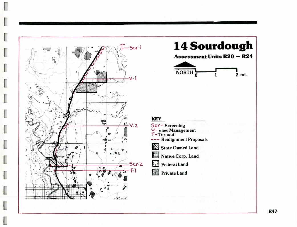
Management Unit 14 1 R46 Sourdough General Description Management Unit 14 begins approximately six miles north of Sourdough and extends nine miles south to milepost 145. The road corridor is semi- enclosed by mixed upland spruce and hardwood for- ests so lateral views are limited. The landscape immediately adjacent to the road contains many small lakes and clearings which add diversity to the foreground viewing experience. The distant Alaska Range is often seen on the northern hori- zon, and while traveling south, the Chugach Moun- tains define the distant horizon. There are also occasional, often filtered, views of the Wrangell Mountains to the east, and one nice view of the Gulkana River. Scenic resource values in this unit are fairly moderate except for one outstanding panorama of the Gulkana River, Alaska Range, and Trans-Alaska Pipeline which opens just as travelers enter Sourdough from the south. The visual absorption capability is fairly high due to gentle topography and dense roadside vegetation. Existing land uses do not signficantly detract from the area's scenic quality. 1 Periodic views of the Trans-Alaska Pipeline snaking across the horizon add visual interest and a human scale element to the drive through the gentley rolling terrain along the central Richardson Highway. The road in Unit 14 follows the gently rolling landscape creating a pleasant and varied driving experience. DOTPF has plans to straighten many of the existing curves, which would diminish the road's visual interest and recreational quali- ties. The right of way in the northern portion of the unit has a pleasant feathered edge created by brush and tree vegetation growing close to the road. Recent clearing of roadside vegetation in the right-of-way has severely impacted the road edge south of Sourdough. J 1 ] J 0
Transcript
Management Unit 141
R46
Sourdough
General DescriptionManagement Unit 14 begins approximately six milesnorth of Sourdough and extends nine miles southto milepost 145. The road corridor is semi-enclosed by mixed upland spruce and hardwood for-ests so lateral views are limited. The landscapeimmediately adjacent to the road contains manysmall lakes and clearings which add diversity tothe foreground viewing experience. The distantAlaska Range is often seen on the northern hori-zon, and while traveling south, the Chugach Moun-tains define the distant horizon. There are alsooccasional, often filtered, views of the WrangellMountains to the east, and one nice view of theGulkana River.
Scenic resource values in this unit are fairlymoderate except for one outstanding panorama ofthe Gulkana River, Alaska Range, and Trans-AlaskaPipeline which opens just as travelers enterSourdough from the south. The visual absorptioncapability is fairly high due to gentletopography and dense roadside vegetation.Existing land uses do not signficantly detractfrom the area's scenic quality.
1
Periodic views of the Trans-Alaska Pipeline snakingacross the horizon add visual interest and a humanscale element to the drive through the gentleyrolling terrain along the central Richardson Highway.
The road in Unit 14 follows the gently rollinglandscape creating a pleasant and varied drivingexperience. DOTPF has plans to straighten manyof the existing curves, which would diminish theroad's visual interest and recreational quali-ties. The right of way in the northern portionof the unit has a pleasant feathered edge createdby brush and tree vegetation growing close to theroad. Recent clearing of roadside vegetation inthe right-of-way has severely impacted the roadedge south of Sourdough.
Most existing land use is concentrated aroundSourdough. There, a memorable manmade element isthe historic Sourdough Roadhouse, which isAlaska's oldest roadhouse still operating in itsoriginal structure. The Bureau of Land Manage-ment (BLM) operates a small campground acrossSourdough Creek from the roadhouse. The creek ispopular for grayling fishing and the area aroundSourdough Campground is an important put in takeout site for float trips on the Gulkana River.The State of Alaska DNR has a sixty acre landsale planned across the road from Sourdough Camp-ground. Residential structures are a common fea-ture all along the Richardson Highway in Manage-ment Unit 14. In addition, the Trans-AlaskaPipeline and its associated access roads andclearings are dominant and intriguing landscapeelements.
Land Ownership &Management ResponsibilityThe primary landowner in Unit 14 Is the BLM.Interspersed with federal land are three largeNative allotments and several parcels of privateland adjacent to the road. Alyeska Pipeline Com-pany manages the right—of—way and other landsassociated with the pipeline which parallels theroad throughout this unit. The State of Alaskahas one parcel of land across from the Sourdoughcampground, sixty acres of which are scheduledfor disposal. The state DOTPF manages a 300foot right-of-way along the road.
Visual ResourceManagement ObjectivesDue to the complicated land ownership patterns
R48 and the road's multiple use character, visual
resource management objectives for ManagementUnit 14 relate to sensitive land use and develop-ment, enhancement, and appropriate right—of—waymanagement.
Sensitive Land Use and Development: To encourageappropriate private land development that main-tains sensitivity to scenic resource values, andto coordinate land management decisions and ac-tions of the various public and private land-owners and managing agencies within this area tomaintain and enhance existing scenic resourcevalues.
Enhancement: To improve existing opportunitiesfor viewing memorable natural and human landscapeelements and reduce the visibility of those fea-tures which detract from the quality of the vis-ual experience.
Appropriate Rlght-of-Way Management: To manageland within the right-of-way to create a naturalroad edge, open up views, and screen unattractivelandscape or development elements.
ManagementRecommendationsRight-of-Way Management__________The immediate visibility of lands within theright-of-way gives them importance for effectivescenic resource management. Along the RichardsonHighway, where land ownership patterns are apatchwork, the right—of—way offers the oppor-tunity to give some continuity to the drivingexperience. Because the Richardson is a highspeed, high volume highway, more intensive road-side management is needed to provide good visi-bility, provide space for snow removal and othermaintenance, and to minimize wildlife roadkills.
J _
Still, this can and should be done in a mannerthat is sensitive to the special scenic values ofthe road near Sourdough. Already, the right-of-way north of Sourdough is reasonably wellmanaged. Brush and tree vegetation grow close tothe roadbed, creating a natural edge. This prac-tice of retaining natural vegetation should con-tinue. South of Sourdough, on the other hand,recent clearings have resulted in unsightlyswathes; these edges are in need of revege-tation. In the future, right of way managementpractices should prohibit such wholesale clear-ing. Recommendations for appropriate managementinclude the following:
• Retain as much natural vegetation as possibleclose to the road, except where needed to openviews.
• Routine roadside maintenance and clearing activ-ities should be tailored to the site specificsituation in each unit, such as providing visi-bility around certain curves, opening up views,etc. The yearly maintenance program should bebased on an assessment of these needs andexisting landscape characteristics to determinethe necessary maintenance strip width and type ofcutting.
• Where intensive cutting has taken place (i.e.,south of Sourdough), the area should berevegetated with low lying plants.
• Remove all slash from existing or new clearings.
• Minimize the number of clearings across the right-of-way for access roads.
• Locate all visually disruptive uses, such asgravel pits, outside the right-of-way.
GreenbeltsDue to mixed ownership patterns and diversemanagement interests, greenbelts can be an effec-tive scenic resource management tool for publiclands adjacent to the highway. State and federalland managers should adopt a 100 foot wide green-belt beyond the road right-of-way. The DOTPF andBLM should develop and implement guidelines tocoordinate management practices on right—of—wayand greenbelt lands to provide enough land forthe maintenance and enhancement of scenicresource values. Their actions would serve as anexample to adjacent private landowners who wouldbe encouraged to respond in a similar fashion.
Within the greenbelt the following managementguidelines should be applied:
• Minimize cutting or thinning the naturalvegetation except where needed to open views
• Locate permanent structures outside the green-belt; if siting within the greenbelt is unavoid-able, locate the structure so that it is screenedfrom the road by vegetation or landforms '
• Design access roads through the greenbelts totake advantage of existing landforms and vege-tation to minimize the visual disturbance
Land Use & Development (LU)
Because of the mixed ownership pattern and thepattern of existing development, it is both prob-able and appropriate that land development willcontinue in this unit. Permanent and recre-ational residential construction will likely bethe predominant forms of any new land use activ-ity. As already mentioned, existing developmentdoes not detract from scenic values and, in many R49
cases, enhances the visual diversity of thedrive. The following considerations should applywhen developing roadside lands:
• Attempt to concentrate development aroundexisting nodes rather than dispersing It. Thearea north of Sourdough Is one which would beappropriate for additional development.
•Discourage development In the Sourdough area.Due to the vista point just south of Sourdough
t. and the recreational use and historic signifi-cance of the area, further development immedi-ately around Sourdough would be undesirable froma scenic resource and recreational perspective.
• Encourage more intensive development to locate inareas with high visual absorption capability andset these uses back from the road to minimizevisibility. : ., . vv-j<- '•
• Allow some dispersed recreational cabins andresidences along the remainder of the road Inthis unit to add variety and visual interest tothe drive. The design of the structures shouldbe compatible with the natural and historicflavor of the area. Clearings for these develop-ments could open up views.
• SE '. '-, ' . ' ' ,->1
• Encourage the development of additional recre-ation related facilities to accommodate peak sea-son demands for camping and fishing oppor-tunities.
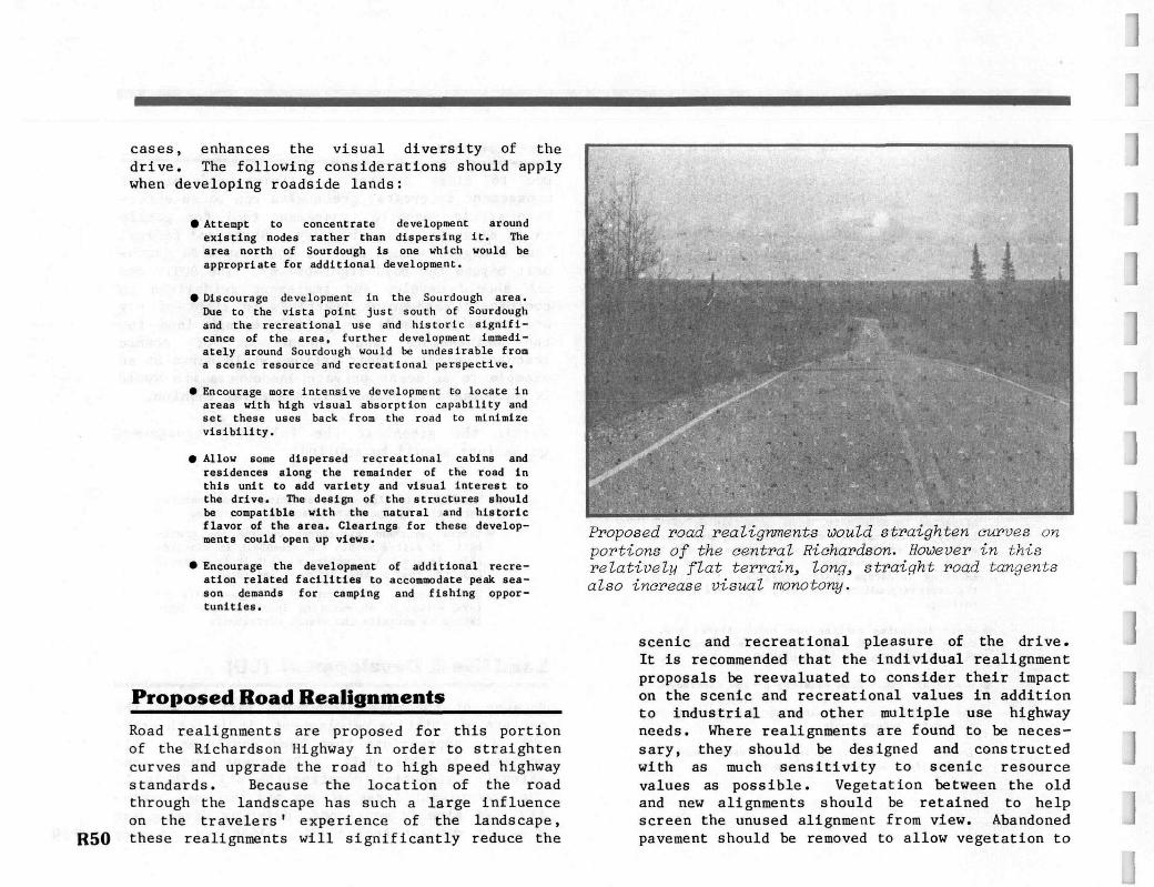
Proposed road realignments would straighten curves onportions of the central Richardson. However in thisrelatively flat terrain, long, straight road tangentsalso increase visual monotony.
]]1
J
J
R50
Proposed Road Realignments_______Road realignments are proposed for this portionof the Richardson Highway in order to straightencurves and upgrade the road to high speed highwaystandards. Because the location of the roadthrough the landscape has such a large influenceon the travelers' experience of the landscape,these realignments will significantly reduce the
scenic and recreational pleasure of the drive.It is recommended that the individual realignmentproposals be reevaluated to consider their impacton the scenic and recreational values in additionto industrial and other multiple use highwayneeds. Where realignments are found to be neces-sary, they should be designed and constructedwith as much sensitivity to scenic resourcevalues as possible. Vegetation between the oldand new alignments should be retained to helpscreen the unused alignment from view. Abandonedpavement should be removed to allow vegetation to
jl]
i luickly reclaim the old road bed. Duringrealignment construction, highway crews should
u take the opportunity to use the road equipment to[ open views towards the Wrangell Mountains byselectively thinning vegetation in those areas
ridentified under "View Management."
Screening (Scr)
RecreationThe area near Sourdough, as already mentioned, isextremely popular for a variety of recreationactivities including camping, fishing, photo-graphing the roadhouse, and river float trips.During the peak summer season, the campground isinadequate to meet demands for camping andpicnicking. Additional facilities should be pro-vided, either as an expansion of the existingcampground, or on nearby public or private lands.
The electric generator now used at the roadhousecauses considerable noise around the campgroundand thus it would be appropriate to locate anynew recreation facilities at some distance fromthe roadhouse. It is also recommended that asound barrier or berm be placed around the gener-ator to help reduce the noise impact.
A proposed realignment of the Richardson Highwaywould bypass Sourdough. From the point of viewof the scenic driving experience, it is recom-mended that the existing alignment be retained.However, if the new alignment is built, vege-tation on the northeast bank of Sourdough Creekshould be selectively thinned in order to retainviews of this historic landmark. Additionally,the existing alignment should be maintained as asafe entrance to the roadhouse and campground,with signs provided on the new road alignmentnoting the campground and historic site.
The Trans-Alaska Pipeline is the dominant man-made feature in this unit. Although the pipelineis a unique element of great visual interest,associated land uses such as access roads, ser-vice buildings,"and clearings have significantlydisrupted the natural and scenic character of thelandscape. Specifically, the following two areasrequire mitigation actions:
Scr-l Pipeline Road Crossings This crossing and anadjacent materials site located on the south endof Hogan Hill together create a highly visiblescar which is in strong contrast to surroundinglandforms, colors, and land covers. This area islocated in Management Unit 13, but is visiblefrom the northern portions of this unit. Thissite should be actively screened and reclaimed.Detailed reclamation recommendations are includedin Management Unit 13.
Scr-2 Pipeline Access Road: This gravel access road isvisible from the Richardson Highway on the hilljust south of Sourdough. The road is a blight inone of the moat significant views in this unit.Visibility of the access road could be consider-ably reduced by planting a row of trees along itseastern edge.
Turnouts (T)There is an overall shortage of turnouts alongthe central Richardson Highway. This is par-ticularly critical on this high speed, industrialthoroughfare where one must be off the road tosafely enjoy a view or take a driving break. Onescenic turnout is recommended for development inthis unit:
This site offers one of the most spectacularT - 1 views to the north along this portion of the
Richardson Highway. The surprise view reveals E51
the Gulkana River, Sourdough, the Alaska Range,and the first clear views of the pipeline northof Glennallen. This site is presentlyundeveloped, so It would require clearing, grad-ing, and surfacing. The view to the northwestcould be enhanced with selective thinning offoreground trees and tall brush.
help design the site to minimize the visualimpacts of development. Any structures should beset back from the road at least 100 feet andvegetation should be left intact to help screendevelopment. Access should be limited to oneroad.
View Management (V)Views from the Richardson Highway in this unitcan be enhanced by sensitive vegetation manage-ment in several locations:
V - 1 Views Cowards the Wrangell Mountains could beopened up through selective thinning on the eastside of the road.
V - 2 The opportunity exists here to open a long vieweast towards the Wrangells by carefully thinningand trimming some roadside vegetation.
State Land Sale
R52
The State DNR is planning to dispose of sixtyacres across the road from Sourdough Campground.This is a high recreation use area and is alsovisible as part of the most scenic panorama alongthis portion of the Richardson Highway. Becausethis parcel of land is visible from the road, itsparticularly important scenic values should beconsidered in the design and construction of anyproposed development. Successful land purchasersare encouraged to use a landscape architect to