Report of the Chief Planning Officer SOUTH AND WEST PLANS PANEL Date: 23 rd March 2017 Subject: Planning Application 16/05912/OT - Outline planning application (all matters reserved except for means of access to, but not within, the site) for up to 130 dwellings to include the demolition of 632 and 634 Whitehall Road on land at Whitehall Road, New Farnley, Leeds. APPLICANT DATE VALID TARGET DATE Redrow Homes Limited and Park Lane Homes Limited. 21 st September 2016 31 st March 2017 (PPA) RECOMMENDATION: DEFER and DELEGATE to the Chief Planning Officer for approval subject to conditions to cover those matters outlined below (and any others which he might consider appropriate) and the completion of a S106 agreement to secure the following: i. Affordable Housing – 15% (with a 60% social rent and 40% submarket split); ii. A contribution of £30,000 towards the creation of a 20mph speed limit on the neighbouring highways; iii. Public open space on site of the size to comply with Core Strategy Policy G4; iv. Provision of a Sustainable Travel Fund of £62,562.50; v. Travel Plan Review fee of £2,650. In the circumstances where the S106 has not been completed within 3 months of the resolution to grant planning permission, the final determination of the application shall be delegated to the Chief Planning Officer Electoral Wards Affected: Farnley and Wortley Specific Implications For: Equality and Diversity Community Cohesion Narrowing the Gap Originator: Kate Mansell Tel: 0113 378 8019 Ward Members consulted (referred to in report) Yes
Transcript
Report of the Chief Planning Officer SOUTH AND WEST PLANS PANEL Date: 23rd March 2017 Subject: Planning Application 16/05912/OT - Outline planning application (all matters reserved except for means of access to, but not within, the site) for up to 130 dwellings to include the demolition of 632 and 634 Whitehall Road on land at Whitehall Road, New Farnley, Leeds. APPLICANT DATE VALID TARGET DATE Redrow Homes Limited and Park Lane Homes Limited.
21st September 2016 31st March 2017 (PPA)
RECOMMENDATION: DEFER and DELEGATE to the Chief Planning Officer for approval subject to conditions to cover those matters outlined below (and any others which he might consider appropriate) and the completion of a S106 agreement to secure the following:
i. Affordable Housing – 15% (with a 60% social rent and 40% submarket split); ii. A contribution of £30,000 towards the creation of a 20mph speed limit on the
neighbouring highways; iii. Public open space on site of the size to comply with Core Strategy Policy G4; iv. Provision of a Sustainable Travel Fund of £62,562.50; v. Travel Plan Review fee of £2,650.
In the circumstances where the S106 has not been completed within 3 months of the resolution to grant planning permission, the final determination of the application shall be delegated to the Chief Planning Officer
Electoral Wards Affected: Farnley and Wortley
Specific Implications For: Equality and Diversity Community Cohesion Narrowing the Gap
Originator: Kate Mansell Tel: 0113 378 8019
Ward Members consulted (referred to in report) Yes
1. Time limit for application for approval of Reserved Matters and commencement. 2. Approval of outstanding details following outline permission. 3. Plans to be approved. 4. Reserved Matters in accordance with the Masterplan to a maximum of 130 dwellings. 5. Samples of walling, roofing and surfacing material to be approved. 6. Existing and proposed levels. 7. Details of means of enclosure. 8. Details of bin stores. 9. Retention of existing hedgerows and trees and any removal to be agreed. 10. Tree protection measures 11. Landscape scheme. 12. Implementation of landscape scheme. 13. Landscape management plan. 14. Biodiversity enhancement condition. 15. Method statement for the control of Japanese Knotweed. 16. Details of drainage infrastructure and balancing pond. 17. Feasibility study into the use of infiltration drainage methods. 18. Details of surface water drainage. 19. Method statement for interim drainage measures. 20. Travel Plan. 21. Approved Vehicular Access. 22. Specified Off-site Highway Works. 23. Cycle provision. 24. Footpath connections. 25. Statement of construction practice 26. Vehicle spaces to be laid out prior to development being occupied. 27. Maximum gradient to access 28. Maximum gradient to driveways 29. Provision of visibility splays of 2.4 metres x 120 metres at the Whitehall Road junction 30. Highway condition survey 31. Contamination reports and remedial works. 32. Unexpected contamination. 33. Verification reports. 34. Soil importation condition 35. Details to achieve 10% of energy needs from low carbon energy. 36. Electric vehicle provision. 37. Scheme of intrusive site investigations for the shallow coal workings. 1.0 INTRODUCTION 1.1 This outline planning application is presented to Plans Panel on the basis that it
represents a major development, which the Chair, in conjunction with the Chief Planning Officer considers is controversial. The site is identified as a Protected Area of Search (PAS) within the Saved Policies of the Adopted Unitary Development Plan (UDP) and it is retained as a PAS site within the Pre-Submission Draft Site Allocations Plan (SAP).
2.0 PROPOSAL 2.1 This application seeks outline planning permission for the residential development of
a 5.28 hectare site to deliver up to 130 dwellings, which could provide a combination of 1, 2, 3 and 4 bedroom units comprising a mixture of terraced, semi-detached and detached dwellings. The outline application seeks to consider the principle of development and the means of access into the site only. Matters of site layout, the
appearance of the dwellings, the scale of development and the landscaping of the site (the Reserved Matters) are reserved for future consideration and accordingly, such matters do not form part of the assessment of this application.
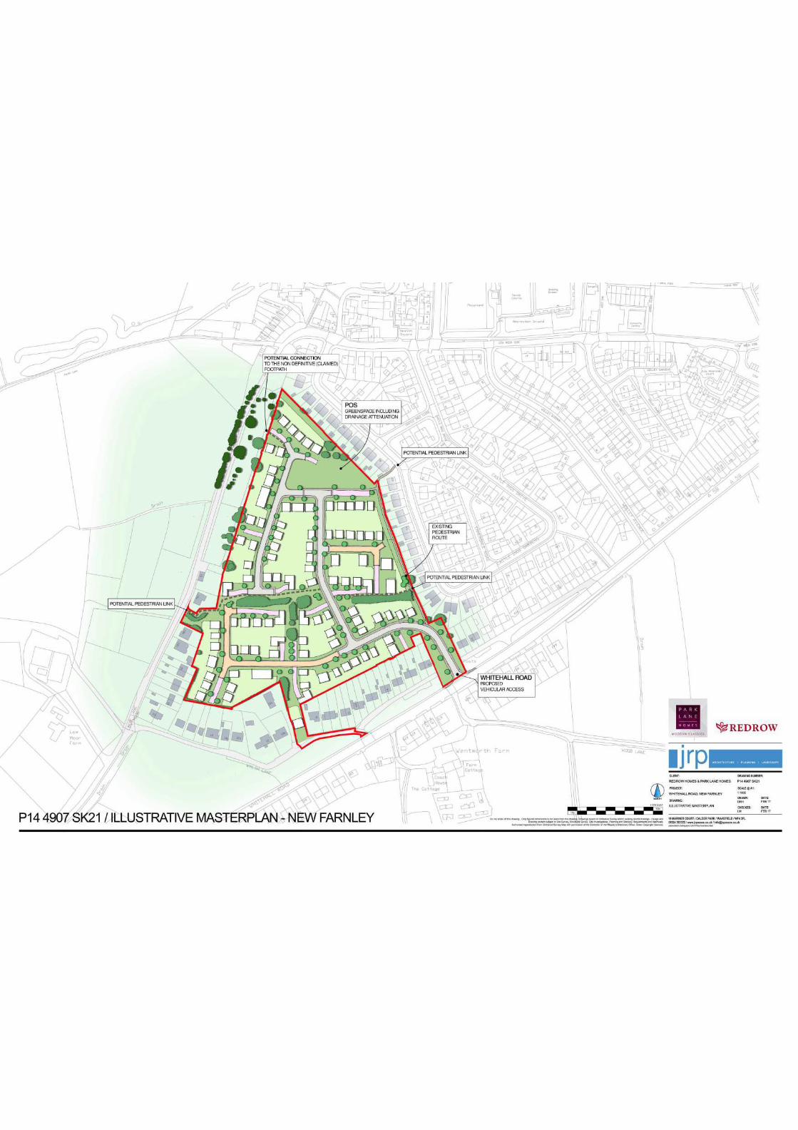
2.2 The application is supported by a Design and Access Statement and an illustrative
plan, which indicates that the site can accommodate circa 130 dwellings (maximum). The application also includes a Transport Assessment, which has been undertaken on the basis of 130 dwellings and this maximum figure therefore forms the basis for the assessment of this proposal.
2.3 Means of access is defined within the Town & Country Planning (General
Development Procedure) Order 2015 to cover accessibility for all routes to and within the site, as well as the way they link up to other roads and pathways outside the site. This application only relates however to the access to and not within the site.
2.4 In this case, a single vehicular access to the site is proposed from Whitehall Road
via a new priority junction positioned between Nos.630 and 636 Whitehall Road. The access will have a minimum 5.5-metre width with 2 metre footpaths to each side, the creation of which requires the demolition of Nos. 632 and 634 Whitehall Road. The application includes an illustrative Masterplan, which also indicates a potential pedestrian link from the site onto Low Moor Side Lane between 19a and 19b Low Moor Side Lane as well as utilizing the existing pedestrian route onto Castle Ing Gardens, between Nos. 40 and 42.
2.5 Members are advised to note that the proposed new vehicular access into the site
crosses an existing service road that runs to the front of properties at 658-594 Whitehall Road East. There are four existing access points onto Whitehall Road from this service road for these existing dwellings and there is also a grass verge with street lighting separating the service road from Whitehall Road East itself. There is presently some uncertainty regarding the status of this land; the Council’s records do not show this service road as falling within the limits of adopted highway although the applicant has provided a register of title, which suggests that the land was dedicated as highway under deeds dating back to 1933. However, this uncertainty does not preclude the determination of this application. To reflect the lack of certainty about the status of this land, the applicant has completed Certificate C of the planning application form, which is for use with Certificate B (where the applicant does not own the whole site and notice is served on other owners) but where not all the owners are known (as per the service road). Accordingly, the applicant has confirmed that an advert was placed in the Yorkshire Evening Post on 15th September 2016. Any subsequent issue in relation to land ownership is a civil matter for the applicant to resolve and not a matter that can halt the determination of a planning application where the appropriate notices have been served.
2.6 All other details pertaining to the Reserved Matters of layout, scale, appearance and
landscaping are for indicative purposes only such that they will be considered in detail at Reserved Matters stage.
2.7 The illustrative Masterplan indicates that the residential development will be
constructed around the access road that comprises a series of cul-de-sacs rather than a looped access around the site. The site is also the subject of a blanket Tree Preservation Order, which will impact upon the site layout. In this regard, an illustrative Parameters Plan indicates the retention of a T-shaped band of trees that runs east-west across the site parallel with 19a Low Moor Side Lane to the east and
66 Castle Ings Garden to the west and then extending southwards as well as the trees along the boundary of the site to Low Moor Side Lane, to the rear of some of the properties on Whitehall Road and to the rear of 26-32 Castle Ings Gardens. An area of public open space is indicated to the rear of 26-40 Castle Ings Gardens. The Design and Access Statement advises that the gross site area is 5.28 hectares of which 4.65 hectares will comprise residential development, 0.57 hectares of open space and 0.06 hectares of incidental land. Based upon 130 dwellings, this would result in a density of circa 25 units per hectare.
2.8 The appearance of the houses will be determined at Reserved Matters stage
although the submitted Design and Access Statement identifies that design influences will be informed by a contextual analysis of the area.
2.9 The scale of development is also a matter to be determined at Reserved Matters
stage although the submitted Design and Access Statement identifies the houses to be 2-storey. An indicative site section has also been submitted to indicate the relationship to the existing dwellings as the site slopes from Low Moor Side Lane to Castle Ings Gardens.
2.10 The landscaping of the site will also be determined at Reserved Matters stage. It is
noted, however, that the Design and Access Statement confirms that existing landscaping will be retained and integrated within the site with a central green swathe crossing the centre of the site to provide pedestrian connectivity as well as a new area of public open space to the north of the site.
2.11 To support their submission, in addition to an illustrative Masterplan, Parameters
Plan and Section (which are all for illustrative purposes only and would not become approved plans) the application also includes a Design and Access Statement, Planning Statement, Statement of Community Involvement, a Landscape and Visual Assessment, a Transport Assessment and Travel Plan, a Flood Risk Assessment and a Preliminary Ecological Appraisal, an Archaeology Survey and an Arboricultural Survey.
3.0 SITE AND SURROUNDINGS 3.1 The application site, which presently comprises open fields, extends to 5.28
hectares in New Farnley, approximately 4 miles to the south-east of Leeds City Centre. It is broadly triangular in shape and it is entirely enclosed on two sides by existing housing. The southern boundary of the site runs to the rear of dwellings at 2-20 Walsh Lane, including land between 10 and 10b Marsh Lane and then continues to the rear of 658 to 632 Whitehall Road with 632 and 634 identified for demolition to accommodate the site access. It is noted that No.12 Walsh Lane (Plane Tree Farmhouse) is a Grade II Listed late Eighteenth Century building. The eastern boundary runs to the rear of 12 to 74 Castle Ings Gardens. The western boundary adjoins Low Moor Side Lane; approximately one third of this boundary is situated to the rear of 19-29 Low Moor Side Lane with the remainder of the boundary set back from Low Moor Side Lane by a wide grass verge with hedging and planting along the edge of the field. The opposite side of the site is mainly open fields. Finally, it is noted that there are significant level changes across the site from west to east with Low Moor Side Lane at least 10 metres higher than the level of Castle Ings Gardens.
3.2 The site is the subject of an Area Tree Preservation Order, which protects all trees
located within the area defined by the TPO and applies to all the trees (with a stem
diameter of 75mm or more, measured at 1.5 metres above ground level) that were in existence when the TPO was made. The submitted Aboricultural Survey confirms that the site is comprised of rough grassland, which is divided by four mature, unmanaged hedgerows. In terms of trees, the majority of surveyed trees are located beyond the limits of the site, with crown spreads and root protection areas that overhang the site boundary. There are two oak trees located off site, within the rear gardens of properties adjacent to the southern site boundary, of which one is identified a notable mature oak tree of high value and quality. There are five further tree groups located within the site along the western boundary, and are all subject to a TPO. The survey considers that these groups are mostly self seeded scrub, comprising of hawthorn, willow, apple, elder and privet. Beyond the western site boundary are four further trees and two groups of trees that are all subject to a TPO and these mostly comprise semi mature sycamores. In the north of the site, close to the boundary, is a further group comprising mostly willow and hawthorn, which are subject to a TPO. Finally, there is a single rowan tree on Whitehall Road and two groups of trees on Walsh Lane comprising cypress and willow and sycamore.
3.3 A definitive footpath (No.147) presently runs along part of the eastern boundary of
the site, accessed from a footway between 40 and 42 Castle Ings Gardens and then between 632 and 634 Whitehall Road.
3.4. The character of the surrounding area is essentially residential comprising circa
1930s ribbon development along Whitehall Road, principally in the form of two-storey red brick and render semi-detached dwellings and a distinctive post-War housing estate at Castle Ings Gardens, which are largely red brick bungalows. The character of properties on Walsh Lane is more bespoke, comprising detached dwellings of varying styles set within guide generous plots. The dwellings on Low Moor Side Lane also vary in form between post-War red brick semis to more recent detached stone dwellings. Due to the narrowness of the lane and the open fields to the west, Low Moor Side Lane has a more rural character. The settlement of New Farnley, which includes these existing dwellings, lies principally to the east of the application site with the land to the west falling within the Green Belt and serving the purpose of separating Leeds and Bradford.
4.0 RELEVANT PLANNING HISTORY 4.1 There is no planning history directly relevant to the consideration of this application. 5.0 HISTORY OF NEGOTIATIONS 5.1 The applicant did seek to engage in some pre-application discussions in 2014
(PREAPP/14/01017) to discuss the matter of highway and design approach only. 6.0 PUBLIC/LOCAL RESPONSE 6.1 The application was initially advertised by means of site notices and a press notice
in the Yorkshire Evening Post, published on 14th October 2016. Following a minor modification to the description to make it clear that the access road would require the demolition of 632 and 634 Whitehall Road a further consultation exercise of objectors was undertaken.
6.2 At the time of writing this report, in total, 194 objection letters have been received in
total with some residents having responded to both consultations. In addition, two
petitions have been received with a total of 300 signatures. A summary of the issues raised by the objection letters and petitions is set out below:
• The field was supposed to be protected until 2028 as a PAS site – it is
designated as PAS land in the Publication Draft Housing Allocations Document;
• The New Farnley Vision Group have worked for years to put together the Village Design Statement, which includes the current Site Allocations Plan;
• The New Farnley Village Design Statement has now been accepted as SPD by
Leeds City Council and therefore has to be taken into account. It states that the development of this site should only be considered for development as part of the new Site Allocations Development Plan and following consultation with the local community. This application would contradict the Design Statement.
• This land does not form part of the Council’s housing strategy;
• There are more suitable plots of brownfield land to build upon and greenfield
sites should be preserved;
• Residents purchased their houses in good faith that the land at the back of their houses would be protected until 2028 as PAS land;
• The plans do not take into account the fact that [we] (the residents) own a small
portion of land, which has been transferred into their names.
• Insufficient community and service amenities in the area
• The Doctor’s Surgery in the village has recently closed and is now on the Ring Road;
• Very few amenities; no GP surgery and only one shop with oversubscribed local
schools;
• No Doctor/chemist or dental practices in the village;
• Traffic and congestion – it is already a problem at peak times.
• The service road fronting properties 590-658 Whitehall Road is not maintained as a public highway, nor are the two spur roads, which access Whitehall Road. The service road is a private road, owned and maintained (through insurances) by the residents and the developer does not have any rights over this road.
• Dangerous access
• Walsh Lane is very narrow and it could be used as a rat-run with increased
traffic;
• Whitehall Road cannot cope with the volume of traffic and Ringways roundabout is already gridlocked every work/school day;
• The access will cross the residents’ right of way and Whitehall Road is already
congested;
• Roads around the site are littered with potholes and in a poor state of repair,
which will be worsened by this development.
• There are at least 20 equestrian establishments between the Ring Road and Bradford and they need to use country lanes; this will increase traffic and be a risk to horses and riders;
• Bus services are inadequate;
• The highways review does not give full account of the impact of the development on the local road as it misses the key impact it will have on the resident’s right of way on Whitehall Road, which will be curtailed by the access route;
• The access road is directly opposite an access to the local farm and other private
dwellings, which will cause congestion;
• Too many houses being built on green fields;
• New Farnley should be kept as a village;
• Residents enjoy living in a semi-rural location and do not want additional housing, particularly as motorists drive around the village to avoid stationary traffic;
• The field contains a natural spring and is waterlogged at the back of Castle Ings
Gardens where the greenspace is proposed;
• Impact on flooding;
• There is an abundance of wildlife on the site including protected species (bats);
• Impact on daylight and outlook from the bungalows on Castle Ings Gardens.
• The site is not needed to fulfil housing need in the area in the short/medium term;
• The land is high risk as it contains mine shafts
• The residents query whether or not there are any laws to stop the developer
knocking down two houses to gain access, otherwise it is land locked.
• The application needs to be the subject of a full EIA as it exceeds the 5ha indicative threshold;
• The applicant did not engage in pre-application consultation, which is a breach of
the NPPF and the Leeds Statement of Community Involvement.
• A resident suggests that central government ask that local councils consider brownfield development over Greenfield;
• This application enhances encroachment and the Council should be
safeguarding such land as custodians of Green Belt land
• The plans do not consider the type of houses missing locally and there is no attempt to provide any communal or open space - where are the detached bungalows, playground?
6.3 Ward Members have been consulted on the application. Councillor Ann Blackburn has objected to the application on the following grounds:
a. The site is PAS land in the UDP and is safeguarded until 2018 in the Draft Site Allocations Plan, thereby it should not be considered for development until then.
b. Having traffic from circa 130 dwellings would substantially increase the amount
of traffic on the already busy Whitehall Road. Councillor Blackburn notes that the developers have done a desk top exercise that relates to what the amount of peak traffic was up to September 2015, but obviously the traffic has increased since then. The vehicles coming/going from the proposed vehicular access on Whitehall Road would cause traffic problems for the neighbouring residents who use the side road for vehicular entry to their houses. Any increase in traffic would also affect the nearby Walsh Lane and Low Moor Side Lane, which are very narrow country roads.
c. Councillor Blackburn is against any pedestrian links into the site as proposed
on Low Moor Side Lane. It would be dangerous to have a vehicular access from Low Moor Side Lane as this is a narrow country road, which regularly has horses travelling on it from the various riding schools on Low Moor Side Lane. Some of the residents on Castle Ings Gardens have an entry from their gardens onto the Public Right of Way 149, which currently runs at the side of the proposed vehicular entry of Whitehall Road, which she would see as a safety hazard.
d. Councillor Blackburn is also concerned that in the very recent plans, the
developer wants to take down some of the trees on site, and she objects to this as these are a haven for the birds and wildlife.
7.0 CONSULTATION RESPONSES
Statutory:
7.1. Coal Authority: The Coal Authority concurs with the recommendations of the Preliminary Geo-environmental Investigation Report, August 2016, prepared by Lithos Consulting Limited; that coal mining legacy potentially poses a risk to the proposed development and that further intrusive site investigation works should be undertaken prior to development in order to establish the exact situation regarding coal mining legacy issues on the site. The Coal Authority recommends that the LPA impose a Planning Condition should planning permission be granted for the proposed development requiring these site investigation works prior to commencement of development. In the event that the site investigations confirm that remedial works would be needed to treat the recorded mine entries beneath any parts of the site where built development is proposed, this should be conditioned to ensure that the site layout is amended to avoid them. The condition should also ensure that any remedial works identified by the site investigation to consolidate any shallow mine workings are undertaken prior to commencement of the development.
7.2 Highways: The means of access into the site has been amended in the course of the application and further information supplied in relation to the Transport Assessment, which is detailed in the report below. Overall, however, the Council’s Highways Officer concludes that the proposal is acceptable, subject to the requirements for a planning obligation, which will be secured by a Section 106 Legal Agreement to secure a contribution of £30,000 towards the introduction of a 20mph speed limit on neighbouring roads. It is considered that the proposed development is located in a sufficiently accessible location and it will provide a safe and secure access for pedestrians, cyclists and people with impaired mobility with appropriate parking provision such that the means of access is acceptable. Subject to the contributions in relation to off-site highway works, the development is also not considered to result in a severe residual cumulative highway impact to warrant a refusal such that it must be concluded that the proposed means of access is acceptable and the development is in accordance with Policy T2 of the Core Strategy and guidance within the NPPF.
Non-Statutory:
7.3 Landscape: Due to topography, existing perimeter trees and the bounding of much of the site by existing houses, visual impact issues centre mainly on views from the rear of existing houses. While the Design and Access Statement Opportunities and Constraints analysis identifies sensitive boundaries to existing dwellings, the proposed space for and provision of ‘buffer’ perimeter planting on the Masterplan looks somewhat sparse.
The Masterplan indicates that it is proposed to retain some of the existing trees/hedges and provide new planting, including a fair amount of tree planting along some of the internal road network. Existing hedge lines in the South of the site would be incorporated within a green ‘swathe’/corridor which would be a positive feature.
If the principle of development was accepted the following detail would need to be carefully addressed at Reserved Maters stage in finalising any layout - ensure realistic amenity standoff distances between retained and new trees and new houses; allow adequate space for perimeter planting to soften the development; provide an Arboricultural Method Statement and provide a detailed, high quality landscape scheme
7.4 Travelwise: In accordance with the SPD on Travel Plans the Travel Plan should be a required planning obligation along with the following:
a) Leeds City Council Travel Plan Review fee of £2,650 b) provision of a Residential Travel Fund of £62,562.50 towards a residential travel plan fund for the provision of Travel Plan measures for the dwellings on the development and/or other sustainable travel measures to encourage the use of sustainable travel modes by the residents of the dwellings to accord with Core Strategy Policy T2 and c) conditions relating to the provision of cycle parking, electric charging points and the implementation of the Travel Plan.
7.5 Flood Risk Management: On the basis that the developer agree with a proposed rate of discharge set by the Council’s FRM team, which the applicant has subsequently confirmed, FRM would do not have any objections to the proposed development.
7.6 Nature Conservation: The bat roost surveys are satisfactory and conclude that the building to be demolished does not have a bat roost at this time, and no trees on-site have significant bat roost potential. Bat commuting and foraging surveys have also taken place and are satisfactory to conclude that it is unlikely that the favourable conservation status of the species identified will be adversely impacted upon. It is noted that there are a number of locally valuable habitats that will be lost (semi-improved grassland and marshy grassland) and therefore conditions recommended to secure a Construction Environmental Management Plan and a Bio-diversity Enhancement Plan to help achieve no net loss of biodiversity as per the NPPF. A condition requiring a Method Statement to eradicate Japanese Knotweed is also proposed
7.7 Public Rights of Way (PROW): Public footpath No.147 Leeds runs along the eastern boundary of site. Although the footpath is to remain on its original line, it should be noted that the Rights of Way Review Committee Practice Guidance notes advise that if the way is to be enclosed by fencing, hedging or buildings then footpaths should be of a minimum width of 4 metres. Officers would like to see the footpath with a 2 metre wide surface within a 4 metre wide corridor. The surface should also be upgraded to a specification agreed with officers. Looking at the master plan, Officers note that the start of the footpath from Whitehall Road appears to run along the access road into the development. However, for safety reasons it would be advisable to divert the footpath onto a line through the public open space to the eastern side of the access road, which would be the safer option. They would also welcome the connection with the claimed footpath and the non-definitive footpath, which runs through the development site.
7.8 Children’s Services: Cobden Primary School is the nearest school to this development. It is over-subscribed and the Council is currently in discussion with them to see if they can offer additional places on a temporary basis for this year and next to meet existing demand although a permanent expansion is unlikely due to Highways concerns. Although Children’s Services would only expect the development to generate around 33 primary age pupils in total, or 5 per year group, this school would be unable to absorb any additional demand. There may be some available capacity to absorb this demand between Ryecroft Academy which is 1.7 miles walking distance from this site or at Gildersome Primary School which is also 1.7 miles away. Secondary place demand is increasing and discussions across the city are on-going to create extra capacity over the coming years.
7.9 West Yorkshire Archaeology: There are currently no apparent significant
archaeological implications associated with the proposed development 8.0 PLANNING POLICIES 8.1 Section 38 (6) of the Planning and Compulsory Purchase Act 2004 requires that
applications should be determined in accordance with the development plan unless material considerations indicate otherwise. The Development Plan for Leeds comprises the Adopted Core Strategy (2014), saved policies within the Leeds Unitary Development Plan (Review 2006) and the Natural Resources and Waste Development Plan Document (2013).
8.2 The site is identified on the LDF Policies Map as a Protected Area of Search. Adopted Core Strategy
8.3 The following Core Strategy policies are considered most relevant:
Spatial Policy 1: Location of development Spatial Policy 4: Regeneration Priority Programme Areas Spatial Policy 6: Housing requirement and allocation of housing land Spatial Policy 7: Distribution of housing land and allocations Spatial Policy 11: Transport infrastructure investment priorities Policy H1: Managed release of sites Policy H3: Density of residential development Policy H4: Housing mix Policy H5: Affordable housing Policy P10: Design Policy P11: Conservation and Listed Buildings Policy P12: Landscape Policy T1: Transport Management Policy T2: Accessibility requirements and new development Policy G4: New Greenspace provision Policy G8: Protection of species and habitats Policy G9: Biodiversity improvements Policy EN2: Sustainable design and construction Policy EN5: Managing flood risk Policy ID2: Planning obligations and developer contributions
Saved Policies - Leeds UDP (2006) 8.4 The following saved policies within the UDP are considered most relevant to the
determination of this application:
GP5: Development Proposals should resolve detailed planning considerations. N23/25: Landscape design and boundary treatment N34: Protected Area of Search sites (PAS) LD1: Detailed guidance on landscape schemes. Submission Draft Site Allocations Plan (SAP) (February 2017)
8.5 Within the Submission Draft Site Allocations Plan, the application site (SAP
reference HG3-17) is identified as a 5.7-hectare site with a capacity for 130 dwellings. It is identified as Safeguarded Land with Policy HG3 of the Submission Draft SAP stating that the SAP designates sites to be safeguarded from development for the Plan Period (to 2028) to provide a reserve of potential sites for longer-term development post 2028 and protect the Green Belt. The weight to be attached to the Submission Draft SAP (limited) is considered at Paragraph 10.12 below.
Relevant supplementary guidance: 8.6 Supplementary Planning Guidance provides a more detailed explanation of how
strategic policies of the Unitary Development Plan can be practically implemented. The following SPGs are most relevant and have been included in the Local Development Scheme, with the intention to retain these documents as 'guidance' for local planning purposes:
New Farnley Village Design Statement (Adopted as an SPD in April 2013) Street Design Guide SPD
Neighbourhoods for Living SPG13 Affordable Housing SPG (Interim Policy) Sustainable Design and Construction SPD Parking Standards SPD (January 2016)
National Planning Policy Framework (NPPF) 8.7 The National Planning Policy Framework (NPPF), published on 27th March 2012,
and the National Planning Practice Guidance (NPPG), published March 2014 replaces previous Planning Policy Guidance/Statements in setting out the Government’s planning policies for England and how these are expected to be applied. One of the key principles at the heart of the Framework is a presumption in favour of Sustainable Development.
8.8 The NPPF constitutes guidance for Local Planning Authorities and its introduction
has not changed the legal requirement that applications for planning permission must be determined in accordance with the development plan unless material considerations indicate otherwise.
8.9 The NPPF establishes at Paragraph 7 that there are three dimensions to
sustainable development: economic, social and environmental of which the provision of a strong, vibrant and healthy community by providing the supply of housing required to meet the needs of present and future generations is identified as a key aspect of the social role. Within the economic role, it is also acknowledged that a strong and competitive economy can be achieved by ensuring that sufficient land of the right type is available in the right places and at the right time to support growth and innovation.
8.10 Paragraph 17 sets out twelve core planning principles, including to proactively drive
and support sustainable economic development to deliver the homes, business and industrial units, infrastructure and thriving local places that the country needs, ensuring high quality design but also encouraging the effective use of land by reusing land that has been previously developed (brownfield land), provided that it is not of high environmental value.
8.11 With specific regard to housing applications, the NPPF states at paragraph 47 that
to boost the supply of housing, local planning authorities must identify and update annually a supply of specific deliverable sites sufficient to provide five years’ worth of housing against their housing requirements with an additional of 5% (moved forward from later in the plan period) to ensure choice and competition in the market of land. Deliverable sites should be available now, be in a suitable location and be achievable with a realistic prospect that housing will be delivered on the site within 5 years. It states that where there has been a record of persistent under delivery of housing, local planning authorities should increase the buffer to 20%.
8.12 Paragraph 49 of the National Planning Policy Framework states the following:
“Housing applications should be considered in the context of the presumption in favour of sustainable development. Relevant policies for the supply of housing should not be considered up-to-date if the local planning authority cannot demonstrate a five-year supply of deliverable housing sites.”
8.13 In the appeal decision dated 8th June 2016 in relation to land at Grove Road, Boston
Spa in accordance with APP/N4720/A/13/2208551, the Secretary of State took the
view that on the basis of the evidence available to him at that time, the Council was unable to demonstrate a deliverable 5-year supply of housing land. This conclusion has subsequently been reinforced by the Secretary of State decision(s) on the conjoined appeals at Breary Lane, Bramhope, Bradford Road, East Ardsley and Leeds Road, Collingham (the “Ken Barton Conjoined Appeals”), which were considered by Planning Inspector Ken Barton in Spring 2016. On 22nd December 2016, the Secretary of State issued his decision on these conjoined appeals and agreed with the Inspector’s conclusions that the appeals should be allowed. In reaching the decision on land at Bradford Road at East Ardsley (APP/N4720/W/15/3004034), which is representative of the other conjoined appeal decisions, the Secretary of State concluded the following (summarised): Paragraph 11: The Secretary of State agrees with the Inspector that on past performance, the buffer must be 20% - so that the 5-year housing land supply requirement across the City would be 31,898 or 6379 units per annum. Paragraph 12: The Secretary of State agrees with the Inspector’s conclusion that the failure [of Leeds City Council] to produce an Adopted SAP (Site Allocations Plan) until at least December 2017 means that there is no policy set out to show how delivery of any houses, never mind the magnitude required, will actually take place; that the safety margin of 2262 dwellings can soon be whittled away when realism is applied and that the Council has failed to demonstrate a robust 5 year housing land supply. The Secretary of State therefore agrees with the Inspector’s conclusion that the solution is to deliver housing now, including much needed affordable housing. Paragraph 13: Having regard to the Development Plan position, the Secretary of State agrees with the Inspector that there is no 5-year housing land supply. Therefore, whilst he agrees with the Inspector that the UDPR policy N34, which designates sites as a Protected Area of Search (PAS) is a policy for the supply of housing, he also agrees with the Inspectors conclusion that policy N34 cannot be considered up-to-date. He further agrees with the Inspector that, rather than being a restrictive policy, the purpose of Policy N34 was to safeguard land to meet longer term development needs, so that, as it envisages development, the appropriate test to apply is whether any adverse impacts of granting permission would significantly and demonstrably outweigh the benefits when assessed against the policies in the Framework as a whole.
8.14 Accordingly, the Council is now in the position that it does not have a 5 year housing supply and the policies within the Unitary Development Plan and Core Strategy that are relevant to the supply of housing are considered to be out of date. In determining which policies are defined as ‘relevant policies for the supply of housing’, in terms of those policies that should be considered out-of date, case law has determined that Paragraph 49 should be interpreted widely and applies to all policies which are restrictive of where housing development can go. Paragraph 14 of the NPPF is, therefore, now particularly relevant, which states the following:
“At the heart of the National Planning Policy Framework is a presumption in favour of sustainable development, which should be seen as a golden thread running through both plan-making and decision-taking.
For decision-taking this means:
Approving development proposals that accord with the development plan without delay; and where the development plan is absent, silent or relevant policies are out‑of‑date, granting permission unless:
–– any adverse impacts of doing so would significantly and demonstrably outweigh the benefits, when assessed against the policies in this Framework taken as a whole; or
–– Specific policies in this Framework indicate development should be restricted.”
It is important to note that an ‘out of date’ policy does not become irrelevant and it is therefore the case that an assessment must be made in respect of the weight to be attached to such policies in the planning balance of decision making overall.
8.15 In relation to highway matters, Paragraph 32 of the NPPF states that all developments that generate significant amounts of movement should be supported by a Transport Statement or Transport Assessment. Plans and decisions should take account of whether: the opportunities for sustainable transport modes have been taken up depending on the nature and location of the site, to reduce the need for major transport infrastructure safe and suitable access to the site can be achieved for all people; and improvements can be undertaken within the transport network that cost effectively limit the significant impacts of the development. Development should only be prevented or refused on transport grounds where the residual cumulative impacts of development are severe.
8.16 Finally, also of relevance to this application is guidance within the NPPF in relation
to policy implementation and the status to be given to emerging plans. Paragraph 216 of the NPPF advises decision-takers may also give weight to relevant policies in emerging plans according to:
(i) The stage of preparation of the emerging plan (the more advanced the preparation, the greater the weight that may be given);
(ii) The extent to which there are unresolved objections to relevant policies (the less significant the unresolved objections, the greater the weight that may be given); and
(iii) The degree of consistency of the relevant policies in the emerging plan to the policies in this Framework (the closer the policies in the emerging plan to the policies in the Framework, the greater the weight that may be given).
This is pertinent to the site allocation process in Leeds.
9.0 MAIN ISSUES
9.1 The main issues to consider in the determination of this application include the following:
i. Principle of development – Policy and Land Use ii. Housing Density and Housing Mix iii. Affordable Housing iv. Means of Access – Highways v. Layout, Scale and Appearance (including Green Space) vi. Landscaping
vii. Residential Amenity viii. Ecology ix. Flood Risk x. Sustainability xi. Flood Risk xii. Demolition of the existing dwellings
9.2 The Council must also consider representations received as part of the public
consultation exercise. 10.0 APPRAISAL
Principle of development 10.1 Within the January 2014 Policies Map, which comprises the Saved UDP Review
2006 policies and the Adopted Natural Resources and Waste Local Plan, the application site is identified as a Protected Area of Search for long-term development (PAS). On the Policies Map, the village settlement of New Farnley, including the application site, is shown as being surrounded by, but excluded from, the Green Belt. Members are also advised that a thorough review of all UDP PAS sites has been undertaken as part of the preparation of the Site Allocations Plan (SAP). As a result of a comprehensive comparative site assessment exercise, the Submissions Draft SAP does not propose that this land should be allocated for development, instead, proposing that it remains as safeguarded land. This is because, in terms of the site allocation process, other more sustainable and preferable sites are considered to be available to meet the needs over the plan period.
10.2 However, on the basis of the recent appeal decisions, Leeds City Council is unable
to demonstrate a 5-year housing land supply and it is considered to be consistently under-delivering. The key assessment in determining this application is therefore the extent to which weight can be attached to the policies of the existing and emerging Local Plan in light of a shortfall in the 5-year housing land supply. Therefore, there needs to be a balancing exercise within the parameter that there is a presumption in favour of granting permission unless any adverse impacts would significantly and demonstrably outweigh the benefits, when assessed against the policies in the NPPF as a whole.
10.3 It is very clear from the Secretary of State’s decision on the conjoined appeals noted
above that UDPR Policy N34, which relates to Protected Area of Search sites, is a policy for the supply of housing and it cannot be considered up-to-date. The appeal decisions also confirm the Secretary of State’s view that ‘Policy N34 is now time expired and that its use to prevent development would be contrary to the terms of the Framework’. Policy N34 must therefore attract little weight in the determination of this application.
10.4 Having regard to relevant policies within the Adopted Core Strategy, it is noted that the Core Strategy is up-to-date; it was published after the NPPF and was found to be sound. Accordingly, full weight can be attached to the distribution strategy for the appropriate location of development as set out in Core Strategy Spatial Policies SP1, SP6 and SP7.
10.5 Spatial Policy 1 of the Core Strategy relates to the location of development and confirms the overall objective is to concentrate the majority of new development
within and adjacent to urban areas, taking advantage of existing services, high levels of accessibility, priorities for urban regeneration and an appropriate balance between brownfield and greenfield land. It confirms that the largest amount of development will be located in the main urban area and major settlements with small settlements contributing to development needs subject to the settlement’s size, function and sustainability. As a consequence, the priority for identifying land for development is (i) previously developed land within the Main Urban Area/relevant settlement, (ii) other suitable infill sites within the Main Urban Area/relevant settlement and (iii) key locations identified as sustainable extensions to the Main Urban Area/relevant settlement. New Farnley is considered to a village rather than a smaller settlement and falls within the definition of ‘all other settlements’. Within the NPPF, the effective use of land by reusing brownfield land is encouraged but the development of Greenfield land is not precluded with the presumption in favour of sustainable development the primary determinant.
10.6 Clearly, the application site does not constitute previously developed land nor is it
adjacent to the main urban area but it is considered that these facts, in themselves do not warrant a refusal as the determination of this application must be on the basis of a planning balance in the context of the shortfall in the 5 year housing supply. In this regard, it is also the case that the site is adjoined by existing housing on two sides to Whitehall Road/Walsh Lane and Castle Ings Gardens and almost a third of its boundary to Low Moor Side Lane is bounded by existing housing. Additionally, along with the existing dwellings, the site is excluded from the Green Belt, by which it is surrounded such that there is no potential to further extend the settlement of New Farnley beyond the boundaries of the existing housing and this site such that the site effectively forms an infill within the village settlement of New Farnley.
10.7 Spatial Policy 6 of the Core Strategy relates to the City’s Housing Requirement and
the allocation of housing land. It confirms that the provision of 70,000 (net) new dwellings will be accommodated between 2012 and 2028 with a target that at least 3,660 per year should be delivered from 2012/13 to the end of 2016/17. Guided by the Settlement Hierarchy, Spatial Policy 6 confirms that the Council will identify 66,000 dwellings (gross) (62,000 net) to achieve the distribution in tables H2 and H3 in Spatial Policy 7 (which identifies a need for 4700 new homes in the Outer West Housing Market Character Area within which the site is located, representing 7% of the City-wide distribution) using the following considerations:
(i) Sustainable locations (which meet standards of public transport accessibility), supported by existing or access to new local facilities and services, (including Educational and Health Infrastructure); (ii) Preference for brownfield and regeneration sites; (iii) The least impact on Green Belt purposes; (iv) Opportunities to reinforce or enhance the distinctiveness of existing neighbourhoods and quality of life of local communities through the design and standard of new homes; (v) The need for realistic lead-in-times and build-out-rates for housing construction; (vi) The least negative and most positive impacts on green infrastructure, green
corridors, green space and nature conservation; (vi) Generally avoiding or mitigating areas of flood risk.
In response to these considerations, the following is advised:
10.8 (i) In terms of a sustainable location, the accessibility of the scheme is considered fully in the Transport section below at Paragraph 10.23, which will acknowledge that the site does sufficiently meet the Accessibility Standards established at Table 2, Appendix 3 of the Core Strategy such that it is considered to be a sufficiently sustainable and accessible location with suitable access to local facilities and services. With regard to access to facilities and services, including education and health infrastructure, the matter of education is considered fully below at Section 11.0.
10.9 With regard to health infrastructure, the provision of health facilities falls within the
remit of NHS England and at a local level, Leeds’ three Clinical Commissioning Groups (CCGs). The amount of new housing identified for Leeds up to 2028 would equate to, on average, 5-6 new GPs a year across Leeds based on a full time GP with approximately 1800 patients. The Site Allocations Plan cannot allocate land specifically for health facilities because providers plan for their own operating needs and local demand. Existing practices determine for themselves (as independent businesses) whether to recruit additional clinicians in the event of their registered list growing. Practices can also consider other means to deal with increased patient numbers, including increasing surgery hours. It is acknowledged that the GP practice that previously existed within New Farnley (New Farnley Surgery on West End) is now closed and the next nearest practice is Wortley Beck Health Centre (circa 1 mile) and then Gildersome Health Centre (circa 1.3 miles), both of whom are currently accepting patients. The nearest dental practice accepting patients is at 268 Tong Road (Whingate Dental Care) at a distance of circa 1.7 miles such that there are health facilities available.
10.10 (ii) to (vi) Whilst it is a Greenfield rather than Brownfield site, neither Spatial Policy 6
nor the NPPF preclude the development of Greenfield sites. It is also clearly outside of the Green Belt and will therefore not impact upon it. The standards and design of the development, which will be determined at Reserved Matters stage, should offer the opportunity to enhance the distinctiveness of the locality and provide a high quality design standard for new homes having regard to the New Farnley Village Design Statement SPD. The impact with regard to nature conservation and flood risk have been fully considered and are addressed in the report below but none of these issues are considered to preclude development commencing in accordance with Spatial Policy 6.
10.11 With specific regard to the managed release of sites, Policy H1 of the Core Strategy
confirms that the LDF Allocations Documents will phase the release of allocations according to the following five criteria to maintain a 5-year housing supply:
i. Location in regeneration areas, ii. Locations which have the best public transport accessibility, iii. Locations with the best accessibility to local services, iv. Locations with least impact on Green Belt objectives, v. Sites with least negative and most positive impacts on existing and proposed
green infrastructure, green corridors, green space and nature conservation. 10.12 As noted above, having regard to the Site Allocation Process it is acknowledged that
within the Submission Draft SAP, the application site remains as safeguarded land. It is also acknowledged that the NPPF (paragraph 85) makes clear that safeguarded / PAS land is not allocated for development and that planning permission for its permanent development should only be granted following a Local Plan review which proposes the development. However, with reference to Paragraph 212 of the
NPPF, the Submission Draft SAP can, at this point in time, be afforded limited weight due to its stage of preparation. Accordingly, the determination of this application is a balancing exercise within the parameter that there is a presumption in favour of granting permission. As will be set out in the report below, the site is sufficiently accessible to local services, with accessibility to public transport and it will have very limited impact upon the Green Belt, being outside of the Green Belt. With regard to Policy H1 (v), it will also provide some improvements to publicly accessible green space by providing on-site public open space and ecological enhancements, also detailed in the report below.
Conclusion – principle of development
10.13 Policies SP1, SP6 and SP7 of the Core Strategy, which provide a framework for directing housing development to the most sustainable locations, are considered to be broadly consistent with the NPPF, and so the principle of the approach promoted by them may be given significant weight. However, the site-specific policies that affect this site, most notably policy N34 of the UDP and emerging policy HG3-17 of the SAP may only be attributed limited weight.
10.14 The presumption in favour of sustainable development means that planning permission must be granted unless any adverse impacts of doing so would significantly and demonstrably outweigh the benefits when assessed against the policies in the NPPF taken as a whole. As will be demonstrated in the report below, the majority of the site is within suitable journey times (as established through Policy T2 of the Core Strategy) from a number of the key services and facilities. This, and the fact that the site is bounded on 3 sides by existing development and so its impact on the wider landscape is more limited and that there are no unresolved objections from other specialist consultees weighs in favour of the proposal.
10.15 Furthermore, whilst it is considered that it would be far more appropriate to the
decision on whether development should take place on this site to be made through the SAP process, where it can be considered alongside all of the other sites that offer potential to help meet the need for new housing in the Outer West area over the plan period, when assessed against the PPG test for prematurity it is not considered that the application is premature. As a result of all of the above, it is determined that there are no grounds to refuse the application on the principle of development at the current point in time and a site specific analysis is required as set out in the report below. It must therefore be considered in the context of the presumption in favour of sustainable development and, in accordance with guidance within the NPPF, approved without delay unless any adverse impacts of doing so would significantly and demonstrably outweigh the benefits, when assessed against the policies in the NPPF taken as a whole. This balancing exercise is considered at Paragraph 12 of this report following consideration of detailed matters set out below.
Housing Density and Housing Mix
10.16 Policy H3 of the Core Strategy relates to the appropriate density of development and advises that housing development in Leeds should meet or exceed the relevant net densities unless there are overriding reasons concerning townscape, character, design or highway capacity. In this case, as a ‘smaller settlement’ a minimum density of 30 dwellings per hectare would comply with Policy H3. The Design and Access Statement submitted to support this application envisages an average density of 25 dwellings per hectare based upon providing up to 130 dwellings, which is intended to have regard to character, design, highway capacity and the delivery of
on-site green space. It is therefore a matter that will be assessed fully at Reserved Matters stage.
10.17 Similarly, housing mix will also be assessed fully at Reserved Matters stage with the
applicant needing to have regard to the preferred housing mix set out at Table H4 of the Adopted Core Strategy to comply with Core Strategy Policy H4. The applicant will be required to submit a Housing Needs Assessment at that time addressing all tenures so that the needs of the locality can be taken into account at the time of the development.
Affordable Housing
10.18 Policy H5 of the Core Strategy sets out the requirement for on-site affordable housing, which is expected to comprise 15% of the development in this part of the City to be secured by means of a planning obligation via a Section 106 Legal Agreement. On a development of 130 houses, the Council would expect 20 of those to be identified for affordable housing, 40% of which should be disposed of to households on lower quartile earnings and 60% to households on lower decile earnings. The proposed development is therefore in accordance with Policy H5.
Housing for Independent Living
10.19 Policy H8 of the Core Strategy advises that developments of 50 or more dwellings are expected to make a contribution to supporting needs for independent living such as including the provision of bungalows or level access flats. The applicant is aware of the requirement and this will be assessed as part of the Reserved Matters submission.
Means of Access – Highways 10.20 Notwithstanding the principle of development, the means of access into the site is
the sole matter for determination as part of this application. With reference to the Development Plan, Policy T2 of the Core Strategy advises that new development should be located in accessible locations and with safe and secure access for pedestrians, cyclists and people with impaired mobility with appropriate parking provision. Appendix 3 of the Core Strategy also sets out accessibility standards for development. The NPPF seeks to support sustainable transport solutions but it advises at Paragraph 32 that development generating significant movements should be supported by a Transport Assessment and that development should only be prevented or refused on transport grounds where the residual cumulative impacts of development are severe.
Means of Access
10.21 The application proposes a single vehicular access from Whitehall Road. The access requires the demolition of 634 Whitehall Road and 632 Whitehall Road to enable a new access road of an appropriate 5.5-metre width with 2 metre footways on each side. The access is designed with a right turn lane from Whitehall Road. Following discussions with the Council’s Traffic, Road Safety, Cycle Team and the Abnormal Loads Officer, it is concluded that the proposed access arrangements are acceptable and they offer a safe and efficient means of accessing the site in accordance with Core Strategy Policy T2.
10.22 The detailed access provision within the site will be determined at Reserved Matters stage albeit that the submitted Illustrative Masterplan indicates an internal access road served from the proposed access onto Whitehall Road, which runs between 630 and 636 Whitehall Road and then to the rear of the gardens of 630 Whitehall Road and 72 and 74 Castle Ings Gardens. To protect the residential amenity of these adjoining occupiers the access road has a landscaped buffer of between 6 and 13 metres between the back edge of the pavement and the side boundaries of 630 and 636 Whitehall Road and with the exception of a small ‘pinch point’ in relation to an additional piece of garden space to the rear of 636 Whitehall Road that projects into the site, a buffer of between 3 metres and 15 metres to the rear gardens of 72 and 74 Castle Ings Gardens. The internal access road is currently designed as a series of 5 cul-de-sacs
10.23 With regard to accessibility, Core Strategy Policy T2 refers to Accessibility Standards, which are set out at Appendix 3 of the Core Strategy. They are based upon an average walking speed of 3 miles per hour. In relation to this site, the Accessibility Standards comprise the following:
Destination Standard Compliance of this site To Local Services Within a 15-minute walk. The Co-Operative food store
and Post Office on Low Moor Side Lane are within a 15-minute walk such that local services are accessible. The nearest Doctors Surgery is circa 1 mile from the site; it is accessed via three bus routes along Whitehall Road followed by a 0.4 mile walk such that it does not directly meet the standard of having a GP within a 20 minute walk or a 5 minute walk to a bus stop with a direct service at a 15 minute frequency albeit that the bus frequency is much greater but not direct.
To Employment Within a 5 minute walk to a bus stop offering a 15 minute frequency to a major public transport interchange Or, within a 40 minute journey time
A small proportion of the site in the north-west corner is just beyond 400 metres/5 minutes walk of a bus stop but at least 75% of the site (at more reasonably, circa 80% of the proposed dwellings) are within 400-metres/5 minute walk of bus stops on A58 Whitehall Road. During the weekday and Saturday, the services (Nos.209, 252, 254, 255 and 225 (westbound only) combine to provide an overall hourly two-way frequency of 12 buses per hour with 6
buses and hour on a Sunday, equating to one bus every 5 minutes Monday to Saturday and one bus every 10 minutes on Sundays with connections to Leeds, Halifax, Wakefield, Cleckheaton, Heckmondwike and Brighouse.
To Primary Education and Health
Within a 20 minute walk or a bus stop offering a direct service at a 15 minute frequency
Lawns Park Primary School is identified to be within a 25 minute walk of the entire site. Lower Wortley and Cobden Primary Schools are within a 20-minute journey via the bus stops on Whitehall Road.
To Secondary Education
Within a 30 min direct walk or 5 min walk to a bus stop offering a 15 min frequency to a major public transport interchange
Farnley Academy is within a 20-minute walk from the site.
To Town Centres/City Centre
Within 5 min walk to a bus stop offering a 15 min frequency service
Circa 75% -80% of the development is within 5 minutes of a bus stop with a 5-minute frequency service to the town centres above and Leeds City Centre.
10.24 In terms of compliance with the Council’s Accessibility Standards, it is recognised
that a small proportion of the development is more than 5 minutes walk from a bus stop with a 15 minute frequency, thus affecting accessibility principally to employment and town/city centres. The applicant notes that the bus stops on Whitehall Road receive a service frequency that far exceeds the minimum provision of a 15-minute frequency service and in fact, there are 12 buses per hour during weekdays and on Saturdays and 6 on Sunday.
10.25 However, it is considered that the site’s accessibility to goods and services forms
part of the overall balancing exercise, which is considered at Paragraph 12 of this report. Moreover, Policy T2 does not state that compliance with Appendix 3 is a requirement of meeting the policy but rather that new development should be located in accessible locations that are adequately served by existing or programmed highways, by public transport and with safe and secure access for pedestrians, cyclists and people with impaired mobility. Additionally, the test established in the NPPF with regard to highway matters is that development should only be prevented or refused on transport grounds where the residual cumulative impacts of development are severe. On balance, it is therefore considered that failure of part of the site to comply fully with the accessibility standards, particularly taking into account bus service frequency generally, would not itself warrant a recommendation of refusal. A failure to entirely meet the Accessibility Standards has recently been tested at the PAS Public Inquiries for Brearly Lane, Bramhope,
Bradford Road, East Ardsley and Leeds Road, Collingham. The Inspector and Secretary of State dismissed the Council’s accessibility concerns at these sites. Transport Assessment and Mitigation
10.26 The application includes the submission of a Transport Assessment to consider the
highway impact of the proposed development on the basis of up to 130 dwellings.
10.27 As part of their original submission, the applicant assessed the impact of the development by producing a bespoke vehicle trip rate based on surveys of a nearby residential estate (Beechfield). This was achieved using actual traffic surveys and an overall average of trips recorded on Tuesday, Wednesday and Thursday of the survey period. Whilst there were no objections in principle to this methodology, it was considered that the precise demographics and travel characteristics of the two sites may be different. There is no indication of the size of houses to be built whilst the surveyed housing estate in mainly 3 bed detached and semi-detached, and therefore, it was considered that this may not be comparable if large 4 – 5 bedroom dwellings were proposed. Accordingly, the applicant was asked to validate the proposed trip rate against TRICS data for similar sites to ensure that a suitable trip rate is being used to predict the impact of the development on the highway network. This showed that the surveyed trip rates were higher than both the average trip rates calculated from the TRICS database and Officers are are therefore satisfied that the surveyed trip rates from the Beechfield estate used in the TA are robust and that the traffic generation predicted is accurate and representative. This equates to a total of 13 arrivals and 53 departures in the AM Peak (0800 to 0900) and 50 arrivals and 26 departures in the PM peak (1700 to 1800). The modeling submitted within the Transport Assessment with regard to highway impact has been fully assessed by the Council’s he Urban Traffic Control team and they are content that the proposals would not be detrimental to the safe operation of the highway such that there is sufficient capacity on the highway network to accommodate this development in accordance with Core Strategy Policy T2.
10.28 Overall, it is therefore concluded that the proposal is acceptable in highway terms. Subject to relevant conditions and the requirements of the Section 106 Legal Agreement, it is concluded that the proposed development is located in a sufficiently accessible location and it will provide a safe and secure access for pedestrians, cyclists and people with impaired mobility with appropriate parking provision such that the means of access is acceptable. On this basis, the development is also not considered to result in a severe residual cumulative highway impact to warrant a refusal such that it must be concluded that the proposed means of access is acceptable and the development is in accordance with Policy T2 of the Core Strategy and guidance within the NPPF
Layout, Scale and Appearance (including Green Space)
10.29 Core Strategy Policy P10 reinforces the requirement for new development that is
based on a thorough contextual analysis to provide good design that is appropriate to its scale and function; that respects the scale and quality of the external spaces and wider locality and protects the visual, residential and general amenity of the area. Within the UDP, Saved Policy BD5 advises that new buildings should be designed with consideration of their own amenity. These policies reflect guidance within the NPPF. In this case, matters of layout, scale and appearance are reserved for future consideration at the Reserved Matters stage and are not part of the assessment of this outline application. However, this application submission
includes an Illustrative Plan and Design and Access Statement, which provides an indication of the form of future landscaping and development.
Layout 10.30 The detailed layout and the relationship between existing housing and the proposed
new housing will be fully considered at Reserved Matters stage. It is noted that the applicant has submitted an illustrative Masterplan as part of this outline application, as well as illustrative site sections, which indicate the relationship to the existing houses around the site. The site sections take into account the topography of the site. However, it is advised that neither the illustrative Masterplan nor the site sections would form part of the approval of this application and the layout will necessarily be fully assessed against the amenity and privacy standards established within the Council’s Neighbourhoods for Living SPG at Reserved Matters stage.
10.31 With regard to the provision of green space within the site, which will also influence
the layout, Policy G4 of the Core Strategy requires the provision of 80 square metres of green space per dwelling where they are in excess of 720 metres from a community park and for which are located in areas deficient of open space, which is in effect, the entire City. This is a requirement secured by a planning obligation via the Section 106 agreement. Should the site be developed for 130 houses, this would equate to a greenspace requirement of 1.04 hectares. The Design and Access Statement and illustrative Masterplan currently identify only 0.57 hectares of open space, which falls below the requirements of Core Strategy Policy G4. However, the exact provision of open space in accordance with Core Strategy G4 will be determined at Reserved Matters stage.
Scale
10.32 The submitted Design and Access Statement advises that in determining the
appropriate scale of development, consideration will be given to the character of the surrounding area albeit that the illustrative drawings indicate 2-storey dwellings, which is certainly the predominant character on Whitehall Road and Walsh Lane with Castle Ings Gardens being predominantly bungalows/dormer bungalows. Nevertheless, the detailed scale of the dwellings will be fully considered at Reserved Matters stage to take account of topography, residential amenity and design.
Appearance 10.33 The appearance of the dwellings will also be determined at the Reserved Matters
stage to ensure that it is a development that is based on a thorough contextual analysis to provide good design that is appropriate to its scale and function in accordance with Policy P10 and guidance within the NPPF.
10.34 Overall, it is concluded that matters of layout, scale and appearance will be
considered at the Reserved Matters stage but there is sufficient scope within the site and sufficient detail within the Design and Access Statement to ensure that a scheme can be delivered to meet the Council’s design aspirations established within Core Strategy Policy P10, guidance within the NPPF and guidance within the Council’s Neighbourhoods for Living SPG.
Landscaping
10.35 Policy P12 of the Core Strategy advises that the character, quality and bio-diversity of Leeds’ townscapes and landscapes will be conserved and enhanced. Within the UDP, Policy LD1 provides advice on the content of landscape schemes, including the protection of existing vegetation and a landscape scheme that provides visual interest at street level.
10.36 In this case, landscaping is reserved for future consideration as part of a Reserved
Matters submission. However, the submitted Design and Access Statement does establish a landscape strategy, which includes the intention to make the most of the existing landscape, vegetation, habitat and topography and to integrate the development within its surroundings as well as to promote bio-diversity. In terms of retaining the existing landscape features, bearing in mind the TPO across the site, the landscape strategy notes that the main group of hedgerows within the site will be retained and brought into positive management. In addition, the trees along the western site boundary to Low Moor Side Lane and the oak and birch trees adjacent to 630 Whitehall Road will also be protected. The parameters plan submitted with the application does indicate the removal of some trees to create the means of access into the site but this is mainly self-seeded scrub (Goat Willow/Pivot/Hawthorn) from within the site, which is determined to be of low quality. The landscape strategy does note that it is proposed to remove remnants of an existing hedgerow in the northern part of the site, which is identified as fragmented, to be replaced with hedge planting of an appropriate native species within the area of open space.
10.37 The Council’s Landscape Officer has advised that landscape details will need to be
carefully addressed at Reserved Maters stage in finalising any layout to ensure realistic amenity standoff distances between retained and new trees and new houses; allow adequate space for perimeter planting to soften the development and to secure a detailed, high quality landscape scheme as an Arboricultural Method Statement. It is proposed that these details be secured by conditions.
10.38 Subject to the above, it is considered that a successful landscape scheme can be
established in accordance with the objectives of Core Strategy Policy P12 and UDP Policy LD1 subject to the above conditions and the details to be submitted as part of a Reserved Matters Landscape submission.
Residential Amenity
10.39 Policy GP5 of the UDP advises that development proposals should resolve detailed
planning considerations including seeking to avoid problems of loss of amenity. The application site does adjoin existing residential development to the Accordingly, a detailed assessment of garden lengths and window to window distances will be undertaken at Reserved Matters stage, as well the imposition of conditions to ensure that means of enclosure, existing and proposed level changes within the site and any additional planting are also appropriate and adequate between existing and proposed properties. In view of the above, it is considered that a scheme can be developed at Reserved Matters stage that will comply with the requirements of Saved UDP Policy GP5 in terms of impacts on residential amenity.
Ecology
10.40 Policy G8 of the Core Strategy advises that enhancements and improvements to
bio-diversity will be sought as part of new developments. These policies reflect advice within the NPPF to contribute to and enhance the natural and local
environment. Paragraph 118 of the NPPF advises that when determining planning applications, local planning authorities should aim to conserve and enhance bio-diversity.
10.41 The application includes the submission of a Preliminary Ecological Appraisal, which
includes bat surveys. The appraisal notes that the site comprises a complex of fields, predominantly species-poor semi-improved grassland which has been disturbed through furrowing. Small patches of neutral semi-improved grassland are also present. The habitats within the site are determined to be largely of low conservation value, comprising species-poor grassland habitats and areas dominated by vegetation and bracken that consist of common species, widely replicated within the surrounding area. It is noted that the scrub, tall vegetation and trees/shrubs to the north-western boundary and the native hedgerows, which partially dissect the site, all offer nesting opportunities for a number of bird species as well as providing potential invertebrate habitat.
10.42 Recommendations within the Ecological Appraisal include the protection of existing
site features and mitigation for the loss of any on-site habitat and to try and enhance site biodiversity include the retention of hedgerows and trees wherever possible (which is largely proposed), planting of native species to the boundaries of the site where these are absent. Wildflower seeding in association with existing and new hedgerows using a mix suitable for woodland edges and semi-shaded spots is also recommended.
10.43 In terms of bats, the property at 632 Whitehall Road, which will be entirely
demolished, has been the subject of a bat survey and no signs of bats were noted. It has also been determined that there are no mature trees within the site and therefore no adverse impact upon roosting bats within trees is anticipated as a result of the development.
10.44 It is considered likely that a large variety of bird species would utilise habitats within
the site to nest including hedgerows, areas of dense scrub and trees and hedgerows, which will largely be retained within the proposed development. It is also recommended that new areas of native tree and shrub planting are introduced to maintain suitable breeding habitat for bird species currently using the site.
10.45 To address the recommendations of the Ecological Appraisal a condition to protect
existing trees and hedging (with the exception of the fragmented hedging indicated for removal in the north of the site) is proposed as well as a condition seeking details of lighting and to avoid illuminating the site boundaries and any new areas of planting. A further condition to seek details of measures to enhance bio-diversity within the site is proposed as well as a method statement for the eradication of Japanese knotweed. Subject to these conditions, it is concluded that the proposed development has the potential to provide the opportunity to conserve and enhance bio-diversity in accordance with Policy G8 and guidance within the NPPF. Flood Risk
10.46 Policy ENV5 of the Leeds Core Strategy advises that the Council will seek to
mitigate and manage flood risk by (as relevant in this case), reducing the speed and volume of surface water run-off as part of new-build developments.
10.47 The site is located within Flood Zone 1 of the Environment Agency’s indicative flood
map and as such, it is considered to be at a low risk of flooding. However, due to
the size of the site in excess of 1ha, the application includes the submission of a Flood Risk Assessment. The submitted FRA confirms that the site is in Flood Zone 1 and also that the Environment Agency surface water flood risk mapping shows that there are localised areas of low surface water flood risk in the centre of the site and on the eastern boundary. The development will result in a positive drainage scheme to manage drainage across the site to include some on site surface water storage to the existing combined sewer in Whitehall Road as well as some attenuation storage to take account of climate change. Floor levels will also be set typically 150mm above immediate surrounding ground levels which will provide mitigation against any overland surface water flooding from extreme events. It is proposed that foul flows connect to the existing public combined sewers in the vicinity of the site.
10.48 The Council’s Flood Risk Management Team have advised that the FRA and Drainage Strategy is generally acceptable subject to the developer accepting a specific rate of discharge to ensure that there is no increase in the volume of run-off from development sites for a range of storm durations over a given period. Flood Risk Management does not therefore have any objections to the proposed development subject to the imposition of a specific condition detailing the surface water drainage works. On this basis, it is concluded that the scheme will manage and mitigate flood risk in accordance with Policy ENV5 and guidance within the NPPF.
Sustainability 10.49 Core Strategy Policy EN1 requires that all developments of 10 dwellings or more will
be required to reduce total predicted carbon dioxide emissions to achieve 20% less than the Building Regulations and provide a minimum of 10% of total energy needs from local carbon energy. Policy EN2 then requires all developments of 10 or more dwellings to achieve Code Level 4 from 2013 and Code Level 6 from 2016. Following a fundamental review of technical housing standards the Government has withdrawn the Code for Sustainable Homes with effect from 27th March 2015 such that the objectives of Policy EN2 will not be sought. The applicant has advised within the Design and Access Statement that a key sustainable principle in the delivery of sustainable housing is the usage of the ‘fabric first’ approach as these thermal performance considerations will affect the building throughout its lifetime. However, a condition requiring the applicant to provide a minimum of 10% of total energy needs from local carbon energy to comply with Policy EN2 will be sought as a condition of this recommendation.
Demolition of 632 and 634 Whitehall Road
10.50 The creation of the new vehicular access into the application site will certainly require the demolition of 632 Whitehall Road and also the demolition of 634 Whitehall Road. Since April 2011, the demolition of a building such as these dwellings constitutes development such that it forms part of the consideration of this application. The dwellings comprise a pair of detached post-War bungalows constructed in red brick and white render with a hipped roof that form part of the ribbon development. Whilst they are both attractive properties in good condition, they are not considered to be of any particular architectural merit; they are neither Listed nor within a Conservation Area to warrant consideration as an undesignated heritage asset. They do, however, constitute family housing, which will be lost as a result.
10.51 It is acknowledged that the buildings are in close proximity to existing residential properties such that their demolition will have to be carefully managed to protect the amenity of adjoining residents, with particular regard to noise and dust. However, in this regard, it is noted that demolition also requires compliance with the Building Act 1984 and in issuing a Demolition Notice, it is the case that a number of conditions normally have to be complied with during the demolition works necessary to maintain public safety and public amenity such that this issue of amenity in relation to demolition is a matter dealt with under other legislation. In addition, a Construction Management Plan is also proposed as part of this application to protect the amenity of adjoining residents during the construction period. It is therefore considered that no objection to their demolition can be sustained in this instance.
11.0 PLANNING BALANCE
11.1 In this case, although the application site is a Protected Area of Search (PAS), it is part of a pool of land, which was considered to offer the potential to meet longer-term development needs. UDP Policy N34 is a policy for the supply of housing, as has been found in the recent appeal decisions mentioned above. Furthermore, as there is no 5 Year Housing Land Supply in Leeds, the policy cannot be considered up to date and Paragraph 14 of the NPPF must be considered. The Inspector has found that rather than being a restrictive policy, at paragraph 85 of the NPPF, bullet points 3 and 4 specifically relate to safeguarded land, which, whilst not allocated at the present time, meets longer term development needs. The test that then applies is whether any adverse impacts of granting permission significantly and demonstrably outweigh the benefits, when assessed against the policies in the framework as a whole. The conclusion of this test will be a material consideration to be weighed in the balance when considering whether material considerations exist to outweigh the presumption in favour of the development plan in accordance with Section 38(6).
11.2 Considerable weight must be attached to the fact that this application will make a reasonable contribution to housing supply within the City providing up to 130 units at a time when the Secretary of State has determined in the recent appeal decisions that the 5-year housing land supply requirement across the City is 6379 units per annum. It will therefore contribute to providing a supply of housing required to meet the needs of future generations and importantly, include a supply of affordable housing, which at 15% provision of the maximum of 130 homes would equate broadly to 20 units.
11.3 In terms of location of the development, whilst this is a Greenfield site within a
village settlement outside of the main urban area, it must be acknowledged that the development of greenfield sites is not precluded by either the Core Strategy or the NPPF. Importantly, this site is also distinguished by the fact that it represents an infill development within the settlement of New Farnley being adjoined by existing housing on two sides to Whitehall Road/Walsh Lane and Castle Ings Gardens and almost a third of its boundary to Low Moor Side Lane. Along the remainder of Low Moor Side Lane the site is set back behind a substantial grass verge with planting along the boundary such that the rural character of the Lane is largely retained. Additionally, the site is excluded from the Green Belt by which it is surrounded such that there is no potential to further extend either the settlement of New Farnley beyond the boundaries of the existing housing and this site, which provides a natural limit to the settlement.
11.4 In terms of social and environmental factors, it is noted that this proposal will result in the payment of the Community Infrastructure Levy, which although not a material consideration, could be utilised for a range of benefits including contributing towards secondary education provision, green infrastructure or public realm improvements. It will also result in the creation of a new area of publically accessible green space within the site. Subject to the imposition of appropriate planning conditions, it is determined that the proposal has the capacity to sufficiently protect and enhance the bio-diversity on site, as set out in the report above, introduce positive drainage onto the site to ensure that there is no flood risk and require that the houses are adapted to climate change through Building Regulations (fabric first) and the provision of 10% of energy needs from low carbon energy
11.5 In terms of potential adverse impacts, it is acknowledged that for local residents that
adjoin the site, the development will result in a visual change to the landscape from the existing open fields and their existing views. However, the right to a view is not a material planning consideration and with regard to their residential amenity, to include matters such as privacy and outlook, the application will be fully assessed at Reserved Matters stage to ensure that privacy and amenity distances between existing and proposed dwellings are sufficient and have due regard to the existing character but there is sufficient site capacity to ensure that such matters can be appropriately addressed.
11.6 It is also acknowledged that the proposed development will result in some increase
to traffic movements within the locality but it is not to the extent to constitute a severe cumulative impact. However, it will also bring about infrastructure improvements in terms of £30,000 to introduce a 20mph zone on neighbouring roads. Overall, it is concluded that on balance, these adverse impacts do not significantly and demonstrably outweigh the benefits of bringing the site forward to deliver housing and on that basis, the site is considered sustainable and in accordance with the NPPF. Thus, the presumption should be to approve without delay.
12.0 RESPONSE TO REPRESENTATIONS 12.1 The objections from local residents raise five key objections, which are largely
addressed within the report above but the following key points are noted:
a. In response to residents’ concerns that the field was supposed to be protected until 2028 as a PAS site – whilst it is safeguarded within the Submission Draft Site Allocations Plan, this can only be afforded limited weight at this time such that this application currently has to be assessed on a site-specific basis having regard to the presumption in favour of sustainable development.
b. With reference to the New Farnley Village Design Statement, which has been
adopted as an SPD by Leeds City Council, the intention of the Design Statement is to ‘identify the local distinctiveness of New Farnley, encourage improvement where it is needed and aims to protect the best of what is there now’. It is a Design Statement rather than a Neighbourhood Plan such that it advises developers that it should be used to find out what is important in the area they are working in as new development will have an impact on the appearance of the area. Accordingly, the Design Statement cannot be used as a reason to refuse this application in principle but rather, it will be important at the Reserved Matters stage to guide the layout, scale and appearance of the
development to ensure that the development will enhance the character of the area.
c. In terms of the view of residents that there are more suitable plots of brownfield
land to build upon and greenfield sites should be preserved; there is no presumption in favour of developing brownfield land over greenfield; the NPPF encourages the re-use of brownfield land but does seek to exclude greenfield development.
d. The assertion of residents that the service road fronting properties 590-658
Whitehall Road is a private road, owned and maintained (through insurances) by the residents and the developer does not have any rights over this road is a civil matter between the applicant and the residents; the matter does not preclude the determination of this application.
e. In response to the concern from Councillor Blackburn that she is against any pedestrian links into the site as proposed on Low Moor Side Lane, it is the view of Officers that introducing pedestrian and cycle links across the site is a positive attribute of the development to improve local footpath connections and to enhance pedestrian accessibility throughout the area. The footpath would adjoin Low Moor Side Lane at a point where there is a footway such that it is considered to deliver an appropriate connection.
13.0 PLANNING OBLIGATIONS AND COMMUNITY INFRASTRUCTURE LEVY
13.1 The Community Infrastructure Levy (CIL) Charging Schedule was adopted on 12th
November 2014 with the charges implemented from 6th April 2015 such that this application is CIL liable on commencement of development at a rate of £45 per square metre of chargeable floorspace. Due to the outline nature of this application, the floorspace is unknown at this stage. In any event, consideration of where any Strategic Fund CIL money is spent rests with Executive Board and will be decided with reference to the Regulation 123 list.
13.2 There is also a requirement for site-specific requirements to be secured via a
Section 106 agreement as detailed below and the various obligations will become operational if a subsequent reserved matters application is approved and implemented:
i. Affordable Housing – 15% (with a 60% social rent and 40% submarket split); ii. A contribution of £30,000 towards the creation of a 20mph speed limit on the
neighbouring highways; iii. Public open space on site of the size to comply with Core Strategy Policy G4; iv. Provision of a Sustainable Travel Fund of £62,562.50; v. Travel Plan Review fee of £2,650.
13.3 From 6th April 2010 guidance was issued stating that a planning obligation may only
constitute a reason for granting planning permission for development if the obligation is:
(i) Necessary to make the development acceptable in planning terms – Planning obligations should be used to make acceptable, development which otherwise would be unacceptable in planning terms.
(ii) Directly related to the development - Planning obligations should be so directly related to proposed developments that the development ought not to be permitted without them. There should be a functional or geographical link between the development and the item being provided as part of the agreement.
(iii) Fairly and reasonably related in scale and kind to the development – Planning obligations should be fairly and reasonably related in scale and kind to the proposed development.
All contributions have been calculated in accordance with relevant guidance, or are otherwise considered to be reasonably related to the scale and type of development being proposed.
14.0 CONCLUSION 14.1 This application seeks outline planning permission for up to 130 dwellings to
consider the principle of the development and means of access into the site only. Matters of appearance, landscaping, layout and scale are reserved for future consideration.
14.2 The application site is identified as a Protected Area of Search (PAS) on the UDP Policies Map and it also remains as safeguarded land within the Submissions Draft SAP as other more sustainable and preferable sites are considered to be available to meet the needs over the plan period. However, at this point in time, Policy N34, is time expired, conflicts with the objectives of the NPPF and can be afforded little weight. Similarly, due to its stage of preparation, the Submission Draft of the Site Allocations Plan (SAP) can also be afforded little weight. On this basis, whilst it would be preferable to determine whether development should take place on this site through the SAP process, it is considered there are insufficient grounds to refuse the application in principle at the current point in time and the assessment should be site-specific in the context of the presumption in favour of sustainable development.
14.3 It is accepted that the application does not fully meet the aspirations of Core Strategy Policy H1 or SP6 in terms of directing the majority of new development within and adjacent to the main urban area and seeking to encourage the re-use of brownfield land. But neither the Core Strategy nor the NPPF specifically exclude development on greenfield land outside of the main urban area and in this case, the site is distinguished by the fact that it represents an infill development within the settlement of New Farnley as set out in the report above. Of significant weight, however, is the fact that the scheme will bring forward up to 130 new dwellings to include 15% affordable housing and the fact that the means of access is considered to be safe and without any significant detriment to the adjoining highway. It is also considered to be sufficiently accessible to local services and facilities in accordance with the Council’s Accessibility Standards such that it is on balance, considered to represent a sustainable development with a presumption in favour of such development clearly expressed within the NPPF.
14.4 The planning balance exercise is set out at Section 12 of this report where it
concludes that any adverse impacts arising from this proposal are not considered to significantly and demonstrably outweigh the benefits of bringing the site forward to deliver housing and it is considered to represent a sustainable development. Therefore, having taken all representations received into account and given the compliance of this application relevant Polices within the Core Strategy, including
Spatial Policy 6 and 7, Policy H2, H3, T2, EN2, G8, P10 and ENV5 of the Core Strategy as well as Saved Policy GP5 of the UDP, it is on this basis, subject to conditions and a Section 106 Legal Agreement, that the application is recommended for approval.
Background Papers:
Application and history files. Certificate C signed by the agent.