PROGRESS REPORT 1 Coastal Acid Sulfate Soils Program (CASSP) 28 th February 2002 South Australian Inventory of Acid Sulfate Soil Risk (Atlas) Proposed marina site at Ceduna and potential acid sulfate soil at proposed Wallaroo marina site, SA. 30/04/02 CASSP Risk Mapping - Progress Report 1 - Web version 1
Transcript
PROGRESS REPORT 1
Coastal Acid Sulfate Soils Program (CASSP) 28th February 2002
South Australian Inventory of Acid Sulfate Soil Risk (Atlas)
Proposed marina site at Ceduna and potential acid sulfate soil at proposed Wallaroo marina site, SA.
30/04/02 CASSP Risk Mapping - Progress Report 1 - Web version 1
PROGRESS REPORT 1
Coastal Acid Sulfate Soils Program (CASSP) Milestone Report: 28th February 2002
1. Project title: South Australian Inventory of Acid Sulfate Soil Risk (Atlas) 2. Contact Details Organisation: CSIRO Land and Water Project Manager: Mr Richard Merry.
Phone: 08 8303 8422 Fax: 08 8303 8550 Email: [email protected] Postal Address: PMB No 2 Glen Osmond South Australia, 5064
3. Key Dates Project start date: 15th October 2001 Contract completion date: 31st December 2002 (report 28th February 2003) Project progress up to: 28th February 2002 4. Project activities Stage 1 of the project was to start at 15/10/2001 and finish 28/02/2002. The agreed activities and milestones are shown below.
roles, responsibilities and project objectives and endorse communication strategy
Steering Committee established, roles, responsibilities and objectives confirmed and communication strategy endorsed
1.2 Collect state mapping data and evaluate quantity and quality of available data.
Data collected and evaluated
1.3 Determine rules to efficiently complete map and select sites for further investigation
Rules determined and sites selected
1.4 Investigate using remote sensing methods to detect PASS and ASS
Remote sensing methods reviewed
1.5 Compile provisional PASS & ASS map using GIS and remote sensing (compilation sheets at 1:100 000)
Provisional map produced
1.6 Commence field verification and soil sampling (30 sites & 150 samples)
Field verification and soil sampling commenced
1.7 Commence laboratory characterisation Commence laboratory characterisation 1.8 Review existing state and local planning
approaches to Coastal ASS Review completed and provided to Coast Protection Board
Progress Report 1 Report against key milestones and performance indicators, including a statement of costs to be lodged with the Department within 30 days of completion of Stage 1. Due date 30/03/2002
All milestones have been met. A report against each milestone follows.
30/04/02 CASSP Risk Mapping - Progress Report 1 - Web version 2
Report against Milestones Activity 1.1 Establish project Steering Committee, confirm roles, responsibilities and project objectives and endorse communication strategy. Milestone 1.1 Steering Committee established, roles, responsibilities and objectives confirmed and communication strategy endorsed.
Report: Milestone met
a) Steering committee, roles and responsibilities The committees, groups and personnel that make up this project are shown schematically in the organisational chart (Figure 1) that follows this section. Appendix 1, with its Table, provides detail of membership, individual roles and responsibilities.
Figure 1: CASSP: South Australian Inventory of Acid Sulfate Soil Risk (Atlas)Organisational Chart
EA ReprestativeT Costa
Project PersonnelP Davies, W Hicks
M Skwarnecki, S ForresterD Maschmedt (PIRSA)
Research SupervisorDr Rob Fitzpatrick
CSIRO Land and Water
Project PersonnelDr E Barnett
Ms S Ditter (Pt Ad-Enf)
Policy SupervisorMr Doug Fotheringham
Office for Coast and MarineNatn'l Parks and Wildlife SA
Vic ContactMr R MacEwan
DNRE
Advisory CommitteeB Powell QNRM
Dr G Bowman NSW LAWCDr D Dent BRS
Project ManagerRichard Merry
CSIRO Land & Water
Project External Steering CommitteeNatCass
b) Objectives confirmed The objectives arose from interaction with NatCASS at the time of project establishment and agreed with finalisation of the contract. The project workshop held in Adelaide on 15th and 16th November 2001 did not provide specific advice that any of the stated objectives should be altered. However, advice was given that future project work in South Australia should be continued through a lead agency (preferably OCM) and that a multi-organisational committee (similar to ASSMAC in NSW or QASSIT in Queensland) should eventually be established in South Australia. c) Communication strategy A communication strategy was not specifically in place at the commencement of the project and would probably have been premature had one been developed. The November two day workshop assisted in forming the basis of the communication
30/04/02 CASSP Risk Mapping - Progress Report 1 - Web version 3
strategy presented in Appendix 2. It is anticipated that communications activities will further clarify during 2002 as potential stakeholder groups continue to be identified. Note: Initial project workshop: A meeting of participants with an association with the project was held on 15th November 2001 in Adelaide, followed the next day by a one day field trip to the Port Gawler-Middle beach area, north of Adelaide on Gulf St Vincent. An agenda is shown in Appendix 3. At the meeting, the project was explained and discussed among participants and advisors (see flow diagram). All listed participants were present, except for Dr Barnett who had not yet joined the project. Significant discussion took place with respect to lead organisations, coastal areas, the basis of risk mapping, data availability, communication ideas, interstate approaches, policy and planning. Also present were Dr Ian Tapley of CSIRO Exploration and Mining, an expert in remote sensing, and three representatives from DNRE, Victoria. They were Mr Richard MacEwan, Mr Austin Brown and Mr Paul Rampant. The presence of the latter was to enable some provision of ideas and interaction to benefit the future establishment of a similar project in Victoria.
Activity 1.2 Collect state mapping data and evaluate quantity and quality of available data. Milestone 1.2 Data collected and evaluated. Report: Milestone met
• CSIRO CAMRIS database – As part of the CAMRIS project, CSIRO re-interpreted Galloway's data, assigning morphostratigraphic units to each point in the Galloway's coastal sections and producing a "Australian Coastal Soils/Geomorphology Inventory and Management" data set. Galloway's coastal sections (Galloway et al., 19841) are 10 km long with the inland extent defined by a set of rules relating to the Holocene features. Within each section, Galloway chose points to interpret and classify by placing a 3km grid parallel the coastline and selecting points that fell on the grid intersections. However, much of the coastline by the nature of its geomorphic development has features that are parallel to it. This means that in some individual sections, the data has a bias, for example in a system of dunes, swales and back-barrier swamps, the sample could preferentially select dune crests and miss back barrier features or vice versa. When several sections are aggregated this bias is overcome, however such a scale is too large for the generation of the coastal ASS risk maps we wish to deliver. Additionally the Galloway data is only geo-referenced to the mid-point of each coastal section and unsuitable for modern GIS based data analysis. Some time was spent trying to locate the base photography and other associated data. Photographs and associated material was located in CSIRO archives for the complete Australian coastline EXCEPT for South Australia and the Northern Territory. These limitations and the availability of more suitable data meant that we chose not to use the CAMRIS/ Galloway data.
• Office for Coasts and Marine (SA DEH) coastal landform and vegetation mapping, part based on PIRSA mapping of upper Spencer Gulf - Evaluation of the SA OCM
1 RW Galloway, R Story, R Cooper and GA Yapp (1984) Coastal Lands of Australia. CSIRO Division of Water and Land Resources. Natural Resource Series No. 1. 53 pp.
30/04/02 CASSP Risk Mapping - Progress Report 1 - Web version 4
landform and vegetation mapping based on 1:40,000 scale aerial photography and already in digital form indicated that it should form an ideal base for the development of the South Australian ASS risk map. This map base is viewable as intertidal/marine maps of the SA Atlas at the following URL:
http://www.atlas.sa.gov.au/ In addition to the mapping, OCM have surveyed detailed transects for which much detail of landform and vegetation is available, but with little or no soil data.
Activity 1.3 Determine rules to efficiently complete map and select sites for further investigation Milestone 1.3 Rules determined and sites selected Report: Milestone met
Explain preliminary construction of risk classes based on OCM mapping a) Preliminary rules The OCM marine and intertidal mapping, with 63 landform/vegetation mapping units, is at much greater detail than required for development of the ASS risk maps. Previous experience and preliminary field trips suggested an initial simplification to about 9 risk classes, but without detailed knowledge of the ASS/PASS condition or spatial variability. The OCM maps were re-classified based on expected relationships between habitats and soils and the number of classes reduced (see Table 1). Table 1. Simplified map classes Map Legend Class Description 1 ASS Actual acid sulfate soils (existing ASS with very high risk) 2 PASSm Thick PASS - mangrove soil (potential acid sulfate soils mainly
in mangroves with high risk) 3 PASSb Moderately thick PASS - tidal streams (PASS underlying tidal
streams, not extensive laterally with moderate risk) 4 PASSs Thin PASS - intertidal (mainly in samphire with moderate risk) 5 PASSn Thin PASS - supratidal (mainly in samphire, salt bush or blue
bush associated with hyper saline soils where there is less frequent tidal inundation; moderate to low risk)
6 Sand Soils of sand dunes, ridges (No PASS and ASS; very low risk) 7 Calc. Calcareous soils (No PASS, high neutralising; no or very low
risk) 8 Marine Marine soils – subtidal and intertidal marine (PASS may be
present; ASS neutralised by tides and carbonates; no or very low risk)
9
Outside
Soils associated with other land uses adjacent to coastal landforms (eg, Soil Landscape Units as mapped by the PIRSA Land assessment; no or very low risk)
Field work has clearly indicated that some re-allocation of OCM classes is needed within the preliminary risk classes. This re-allocation is in part due to misjudgement of the amount of PASS in some landform units and to the need to evaluate the amount of whole and comminuted shelly material and fine carbonate contained in the soils and their potential to neutralise acid that may be generated. Full evaluation and
30/04/02 CASSP Risk Mapping - Progress Report 1 - Web version 5
modification of the risk classes cannot be completed until measurements have been completed of potential acidity and alkalinity. b) Process of site selection for sampling Site selection for soil sampling was based on the need to:
• Use any previous knowledge of existing ASS mapped areas in SA (i.e. Gillman and St. Kilda areas),
• be representative of OCM SA Atlas mapping classes, • be representative of the simplified preliminary risk map classes, • key into detailed survey transect lines of OCM, • be represented in as many areas of the state as possible, • include at least 30 sites for soil analysis, • include sites at risk due to actual or proposed development, • be accessible by vehicle or walking, • have prior approval for access, if possible.
Activity 1.4 Investigate using remote sensing methods to detect PASS and ASS Milestone 1.4 Remote sensing methods reviewed. Report: Milestone met
The possible use of remote sensing was discussed at the workshop and project meeting in November. OCM had previous experience with airborne remote sensing but was not successful in gaining a usable product. OCM then decided to develop their habitat maps from conventional colour aerial photography and this forms the basis of mapping used for this project. Satellite remotely-sensed ASTER imagery for the SA coastline were obtained, via the world wide web from NASA's Earth Observing System Data Gateway. Preliminary evaluation of the imagery suggests the potential to discriminate OCM’s vegetation habitats and possibly relate these to ASS risk class. This may provide a means to extend mapping beyond the OCM study areas in SA. It may also be very important as a basis for provision of national risk maps. Development of this approach further than this preliminary appraisal cannot be considered for the SA project, but the possibilities should be noted.
Activity 1.5 Compile provisional PASS & ASS map using GIS and remote sensing (compilation sheets
at 1:100 000) Milestone 1.5 Provisional map produced Report: Milestone met
The preliminary rules given above under Milestone 1.3 were used to simplify and re-draw the OCM landform/vegetation maps showing 63 habitat (landform/vegetation) classes to the 7 (preliminary) acid sulfate soil risk classes. Because base mapping was available at 1:50,000 scale or more detailed, maps were produced at this scale for use in field work. It is a simple operation, using GIS, to produce maps as required at broader (smaller) scale.
30/04/02 CASSP Risk Mapping - Progress Report 1 - Web version 6
Preliminary maps of ASS risk classes for four areas are shown in Figures 2a – 1d. Map classes are as in Table 1, OCM transects are red lines and ASS sampling sites are blue dots.
Figure 2a. Preliminary ASS map for Davenport Ck, west of Ceduna.
Figure 2b. Preliminary ASS map for Cowell, eastern Eyre Peninsula.
30/04/02 CASSP Risk Mapping - Progress Report 1 - Web version 7
Figure 2c. Preliminary ASS map for Gillman area, near Adelaide.
Figure 2d. Preliminary ASS map for Weeroona Island, near Pt Pirie.
30/04/02 CASSP Risk Mapping - Progress Report 1 - Web version 8
Activity 1.6 Commence field verification and soil sampling (30 sites & 150 samples).
Milestone 1.6 Field verification and soil sampling commenced. Report
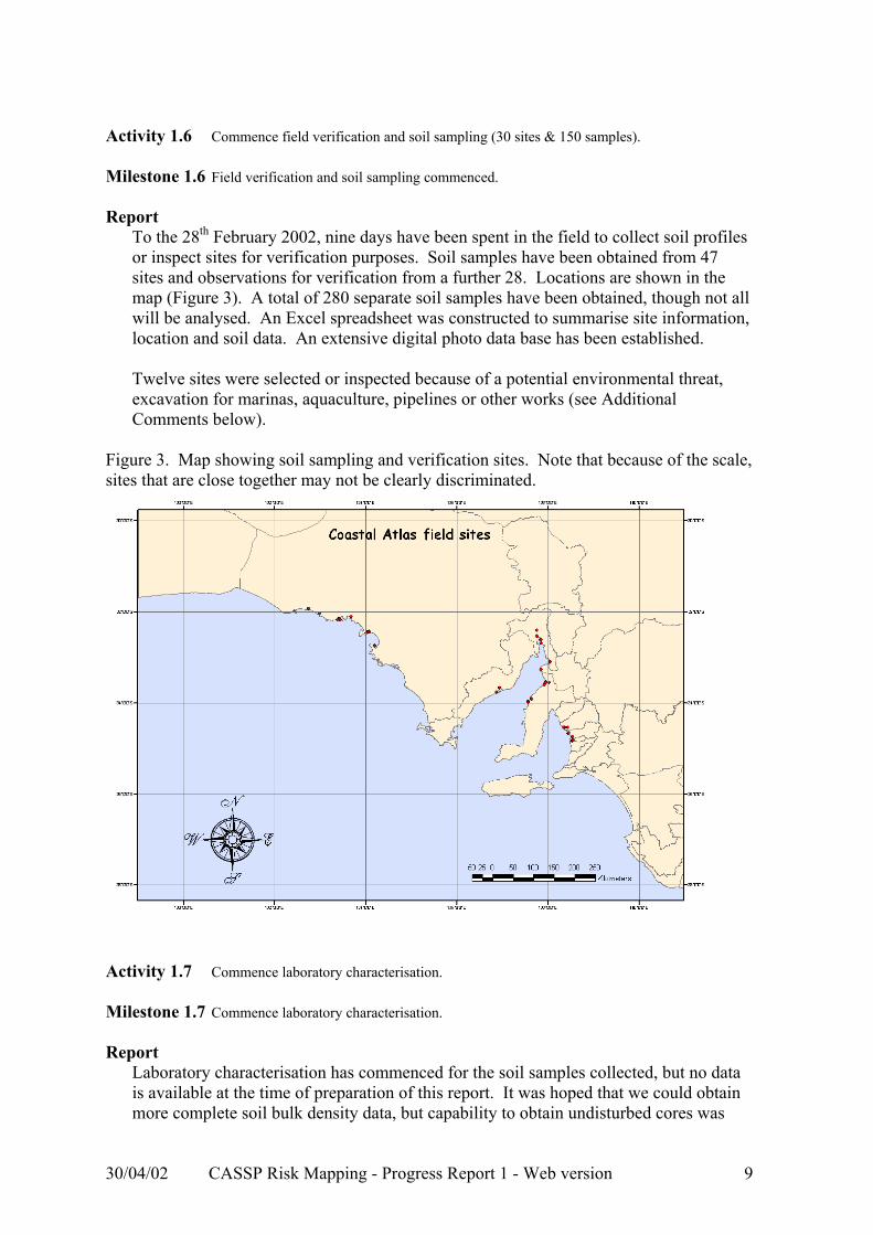
To the 28th February 2002, nine days have been spent in the field to collect soil profiles or inspect sites for verification purposes. Soil samples have been obtained from 47 sites and observations for verification from a further 28. Locations are shown in the map (Figure 3). A total of 280 separate soil samples have been obtained, though not all will be analysed. An Excel spreadsheet was constructed to summarise site information, location and soil data. An extensive digital photo data base has been established. Twelve sites were selected or inspected because of a potential environmental threat, excavation for marinas, aquaculture, pipelines or other works (see Additional Comments below).
Figure 3. Map showing soil sampling and verification sites. Note that because of the scale, sites that are close together may not be clearly discriminated.
Laboratory characterisation has commenced for the soil samples collected, but no data is available at the time of preparation of this report. It was hoped that we could obtain more complete soil bulk density data, but capability to obtain undisturbed cores was
30/04/02 CASSP Risk Mapping - Progress Report 1 - Web version 9
severely limited for saturated samples below the groundwater table or where samples were coarse, shelly and wet.
Activity 1.8 Review existing state and local planning approaches to Coastal ASS. Milestone 1.8 Review completed and provided to Coast Protection Board. Report
Dr Elizabeth Barnett commenced on planning aspects of the project on January 13th 2002. A list of contact people for coastal acid sulfate soil matters was compiled for each state. Each person was contacted and provided appropriate material for CASSP planning approaches current in each state. In addition, a literature and web site review was undertaken. This information was compiled into a draft report that reviewed existing state or local planning approaches. The draft report has been prepared for the SA Coast Protection Board and is to be presented to the Board on March 15th 2002 for their acceptance.
Additional Comments – Disturbed ASS/PASS sites An important aspect of this project, and a major reason for its establishment was to identify areas that may present problems when the soils are exposed to disturbance. To date we have inspected or sampled 12 sites. These include: 2 proposed marinas (Wallaroo and Ceduna) 1 abandoned prawn farm (Pt Broughton) 2 gypsum mines (Lake McDonnell and Clare Pt) 1 pipeline through fore dunes (Barcoo Inlet, Adelaide) 1 potential urban expansion (Fowlers Bay) 1 intertidal/offshore mineral exploration (Bird Island) 1 land drainage producing actual ASS (Gillman, Adelaide) 3 effects of causeways built for roads (Cowell, Weeroona Is, Yorkey’s Crossing) These activities have reinforced the generally poor understanding of soils and surficial sediments in these environments.
4. Brief description and analysis of Program Performance Indicators as per Item K.
Demonstration • A total of 16 people attended the 2 day workshop/field trip on 15th/16th
November (See Appendix 3 for the agenda). • Information and photos have already been supplied to EA for their web page. • A digital photo library containing several hundred pictures relating to SA ASS
is being prepared. • That awareness has been increased has been demonstrated by the project team
being requested to inspect and assess two proposed marina sites. Technique Effectiveness
30/04/02 CASSP Risk Mapping - Progress Report 1 - Web version 10
Although coastal habitat (landform and vegetation) mapping has been completed by OCM in South Australia and there is some geological stratigraphic information available, we believe that our sampling, inspection (of 75 sites at the time of this report) and analysis will provide the first real data to underpin knowledge of these areas. This means that we have the basis of material to fill what was previously a complete knowledge gap on spatial distribution and properties of coastal ASS.
5. Provide a brief analysis of overall project progress to date. Although the project started later than planned, great progress has been made in a short time. We believe we have met, or more than met, the agreed milestones.
30/04/02 CASSP Risk Mapping - Progress Report 1 - Web version 11
Appendix 1 Table: Roles of members of the project committees
Committee Member (Alternate staff member)
Representative Role
CSIRO Land & Water
Mr Richard Merry Senior Research Scientist CSIRO Land & Water Adelaide Laboratories Waite Rd, Urrbrae, SA PMB No. 2, Glen Osmond, SA 5064 Tel: (08) 8303 8422 Fax: (08) 8303 8550 Email: [email protected]
• Project Manager • Attend meetings • Liaise with EA/staff • Monitor funding and reporting • Participate in research
Environment Australia
Mr Trevor Costa CASSP coordinator Department of the Environment PO Box 787 Canberra ACT 2601 Tel: (02) 62741030 Email: [email protected]
• Contact for Environment Australia • Attend meetings when available or
required • Manage the contract • ensuring milestones are met in
timely fashion (oversee project progress)
• Provide project funding
Office for Coasts and Marine Dept. of Environment & Heritage
Doug Fotheringham Dept. of Environment & Heritage SA Water House, 77 Grenfell St. 6th flr Adelaide, SA Tel: (08) 82070825
Ms Shanti Ditter Policy Planner City of Port Adelaide Enfield 163 St Vincent St. Port Adelaide, SA PO Box 110 Port Adelaide SA 5015 Tel: (08) 8405 6727 Mob: 0404 035 784 Fax: (08) 8405 6666 Email: [email protected]
• Policy developer • Attend meetings
CSIRO Land & Water
Dr Robert Fitzpatrick CSIRO Land & Water Adelaide Laboratories Waite Rd, Urrbrae, SA PMB No. 2, Glen Osmond, SA 5064 Tel: (08) 8303 8511 Fax: (08) 8303 8550 Mobile: 040 882 4215 Email: [email protected]
• Report to NatCASS • Lead/ Manage scientific activities • Media activities • Pedology (mineralogical processes)
30/04/02 CASSP Risk Mapping - Progress Report 1 - Web version 12
Mr Phil Davies CSIRO Land & Water Adelaide Laboratories Waite Rd, Urrbrae, SA PMB No. 2, Glen Osmond, SA 5064 Tel: (08) 8303 8488 Fax (08) 8303 8550 Email: [email protected]
• GIS support • Remote sensing support • Field assistance
CSIRO Land & Water
Warren Hicks Bruce E. Butler Laboratory CSIRO Land & Water GPO Box 1666 Canberra, ACT 2601 Tel: (02) 6246 5949 Fax: (02) 6246 5965 Email: [email protected]
• Conduct soil chemistry • Geochemistry on soil solutions • Assist with interpretation and
analysis
CRC LEME
Dr Marian Skwarnecki CSIRO Land & Water Adelaide Laboratories Waite Rd, Urrbrae, SA PMB No. 2, Glen Osmond, SA 5064 Tel: (08) 8303 8737 Fax (08) 8303 8550 Email; [email protected]
• Geochemistry • Field geology
CSIRO Land & Water
Mr Sean Forrester CSIRO Land & Water Adelaide Laboratories Waite Rd, Urrbrae, SA PMB No. 2, Glen Osmond, SA 5064 Tel: (08) 8303 8707 Fax (08) 8303 8550 Email: [email protected]
• Field assistance • Laboratory assistance
CSIRO Land & Water/ CRC LEME
Mr Mark Raven CSIRO Land & Water Adelaide Laboratories Waite Rd, Urrbrae, SA PMB No. 2, Glen Osmond, SA 5064 Tel: (08) 8303 38497 Fax (08) 8303 8550 Email: [email protected]
• Conduct powder X-ray diffraction
analyses on selected soil samples to identify minerals.
• Assist with interpretation
Project External Steering Committee The Project’s external steering committee will be NatCASS. Reporting of project activity to the committee will be through Dr Rob Fitzpatrick who is also a member of this committee (CSIRO representative) and some members (Mr Bernie Powell - Queensland, Dr David Dent - BRS and Mr Trevor Costa - EA) of the project advisory committee who also sit on NatCASS. Mr Rob Tucker of OCM also sits on NatCASS. The Project Advisory Committee The project advisory committee consists of: Mr Bernie Powell Qld NRM Dr Greg Bowman NSW LAWC Dr David Dent BRS The role of these advisors will be to, from time to time:
• provide general advice on functioning of the project, • provide technical advice relating to environmental research, field and laboratory
work and risk mapping, and • provide advice relating to development of policy and planning guidelines.
30/04/02 CASSP Risk Mapping - Progress Report 1 - Web version 13
Appendix 2 Communication Strategy 1) Primary project communication will be to:
• EA – through milestone and other project reporting, • NatCASS – through presentation of reports by Dr R Fitzpatrick, • SA state agencies, such as the Coast Protection Board, through submission of
reports and recommendations. 2) Potential “stakeholder” groups with interest in the outcomes and outputs of this
project have been identified. Letters informing them of the project and its objectives will be drafted and organisational briefings provided through the identified “lead” organisation. The stakeholder groups identified include:
• Local Government Association (OCM are represented) • City of Port Adelaide Enfield (Policy Planner represented) • SA Water, United Water • State Transport Authority (highways) • Harbours • Aquaculture industry through PIRSA
3) Outputs in the form of maps and web sites will conform to accepted standards, with clear legends and informative interpretive material and will be generally available. The aim is to produce a web-based product linked to the SA Digital Atlas. 4) Some general principles have been generated that the project is to work towards in communication activities, for example:
• Face to face communication is regarded as important. • Interpretive material (e.g. popular brochures and booklets) and committee support is
important because map products can be alarming to people. • Should work towards establishing an ASSMAC/QAASIT -type committee in SA. • Media release at completion of project.
5) Specific communication products/activities will include:
• Prepare written information, in the form of pamphlets and booklets about ASS. These will be made available to such appropriate outlets as the mangrove communication/education centre at the St Kilda Mangrove Walk.
• Two EA signage boards have been erected at the St Kilda Mangrove Trail & Interpretative Centre and at the Gillman site.
• Paper presentation at the 5th International ASS Conference (Gold Coast August 2002), subject to acceptance.
30/04/02 CASSP Risk Mapping - Progress Report 1 - Web version 14
Appendix 3 Acid Sulfate Soils Workshop
South Australian Inventory of Acid Sulfate Soil risk (Atlas) 15th and 16th November 2001
Wine Research Institute Conference Room (9 am) Attending: Warren Hicks, Bernie Powell, Greg Bowman, David Dent, David Maschmedt,
Doug Fotheringham, Rob Fitzpatrick, Phil Davies, Richard Merry, Richard MacEwan, Austin Brown, Paul Rampant (Vic DNRE), Andrew Baker, Swanny Skwarnecki; Brett Thomas, Sean Forrester on Friday.
AGENDA Issues arising from Wednesday 14th Workshop: Lead organization in SA, WWW etc. Outline of project (see handout) • Discuss • Timelines • Contracts with DEH, and consultants (supply payment details - HOW?)
Data availability • DEH vegetation mapping (Doug Fotheringham) • CAMRIS, etc. (Greg Bowman and Warren Hicks) • PIRSA Soil map (Dave Maschmedt) • Other sets (Phil Davies)
Interstate experience • Map legends (Bernie Powell - David Dent) Field operations • Plans and approaches • Sampling strategies • When? Laboratory methods • Chemical (Warren, Bernie, David, Greg) • Mineralogical and geochemical (CRC LEME - Swanny and Rob) Planning and policy • Interstate experience (Bernie and Greg) • Plans and approaches (Doug Final Product/ Web site development, etc. • DEH - Atlas of South Australia (Doug)
Discussion Friday field trip • Field trip to Port Wakefield area
30/04/02 CASSP Risk Mapping - Progress Report 1 - Web version 15