Marine Parks ProjectDepartment of Environment, Water and Natural ResourcesGPO BOX 1047 Adelaide SA 5001www.marineparks.sa.gov.auMarine Parks, Topographic Data,Coastline (median high water) - DEWNR (dataset #807, Topography - Coastline, lastupdated April 2011)1 November 2012GeographicGeocentric Datum of Australia, 1994
THIS MAP IS INDICATIVE ONLY AND IS NOTINTENDED FOR NAVIGATIONAL PURPOSES
Scale Bar is approximate only
0 5
Nautical Miles
0 5
Kms
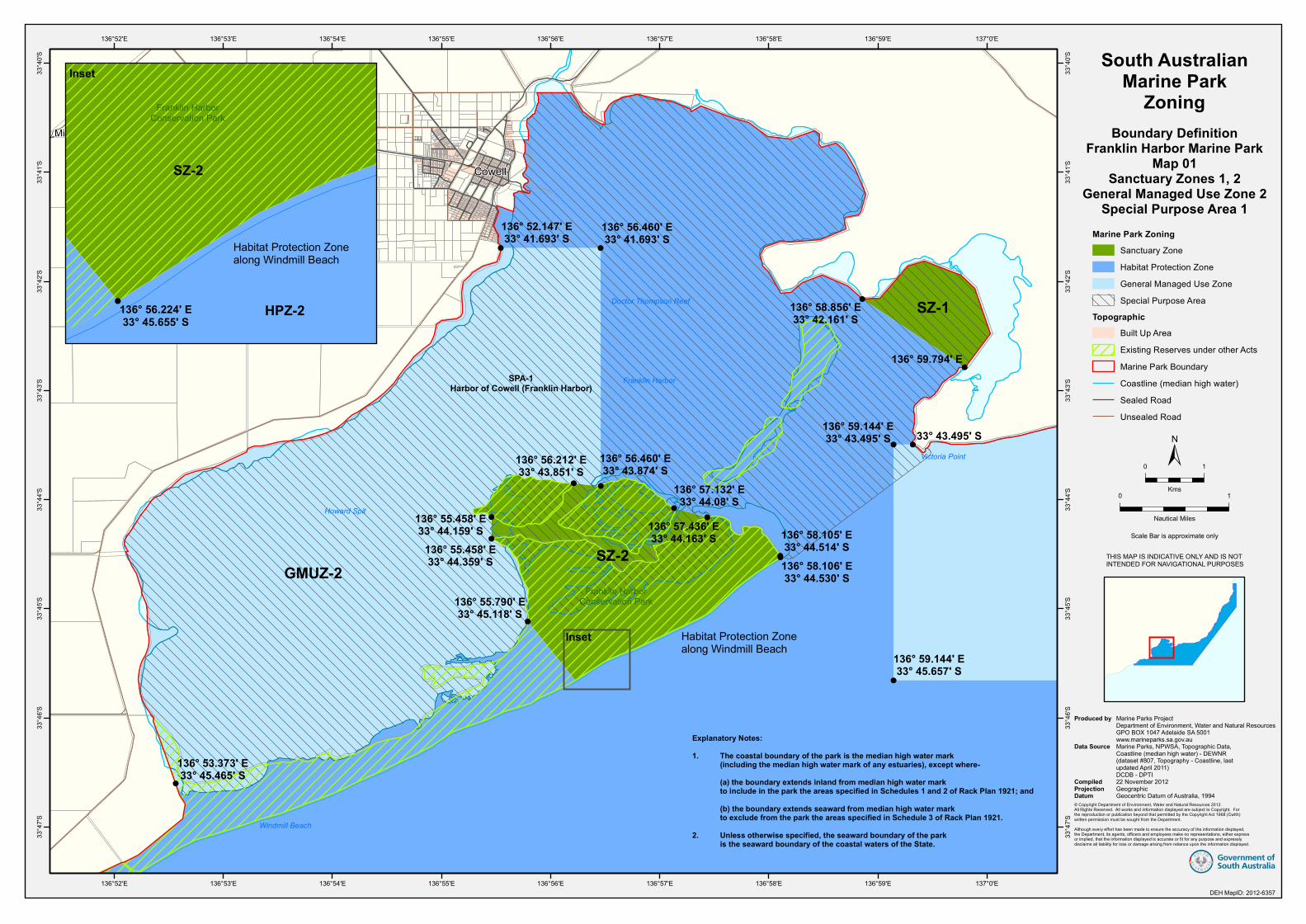
136° 58.105' E33° 44.514' S136° 58.106' E33° 44.530' S
137° 0.999' E33° 47.640' S
136° 54.742' E33° 47.640' S
SZ-1
Cowell
Millar Point
SPA-1Harbor of Cowell (Franklin Harbor)
GMUZ-2SZ-2
136° 59.144' E33° 45.657' S
136° 56.460' E33° 41.693' S
136° 52.147' E33° 41.693' S
136° 53.373' E33° 45.465' S
136° 56.212' E33° 43.851' S
136° 55.458' E33° 44.159' S
136° 55.458' E33° 44.359' S
136° 58.856' E33° 42.161' S
136° 55.790' E33° 45.118' S
33° 43.495' S136° 59.144' E33° 43.495' S
136° 59.794' E
136° 57.132' E33° 44.08' S
136° 56.460' E33° 43.874' S
136° 57.436' E33° 44.163' S
Franklin HarborConservation Park
Howard Spit
Windmill Beach
Victoria Point
Franklin Harbor
Doctor Thompson Reef
137°0'E
137°0'E
136°59'E
136°59'E
136°58'E
136°58'E
136°57'E
136°57'E
136°56'E
136°56'E
136°55'E
136°55'E
136°54'E
136°54'E
136°53'E
136°53'E
136°52'E
136°52'E33
°40'S
33°4
0'S
33°4
1'S
33°4
1'S
33°4
2'S
33°4
2'S
33°4
3'S
33°4
3'S
33°4
4'S
33°4
4'S
33°4
5'S
33°4
5'S
33°4
6'S
33°4
6'S
33°4
7'S
33°4
7'S
South AustralianMarine Park
ZoningBoundary Definition
Franklin Harbor Marine ParkMap 01
Sanctuary Zones 1, 2General Managed Use Zone 2
Special Purpose Area 1
DEH St andar d
Marine Park ZoningSanctuary ZoneHabitat Protection ZoneGeneral Managed Use ZoneSpecial Purpose Area
TopographicBuilt Up AreaExisting Reserves under other ActsMarine Park BoundaryCoastline (median high water)Sealed RoadUnsealed Road
Explanatory Notes:1. The coastal boundary of the park is the median high water mark (including the median high water mark of any estuaries), except where- (a) the boundary extends inland from median high water mark to include in the park the areas specified in Schedules 1 and 2 of Rack Plan 1921; and (b) the boundary extends seaward from median high water mark to exclude from the park the areas specified in Schedule 3 of Rack Plan 1921.2. Unless otherwise specified, the seaward boundary of the park is the seaward boundary of the coastal waters of the State.
DEH MapID: 2012-6357
THIS MAP IS INDICATIVE ONLY AND IS NOTINTENDED FOR NAVIGATIONAL PURPOSES
Marine Parks ProjectDepartment of Environment, Water and Natural ResourcesGPO BOX 1047 Adelaide SA 5001www.marineparks.sa.gov.auMarine Parks, NPWSA, Topographic Data,Coastline (median high water) - DEWNR (dataset #807, Topography - Coastline, lastupdated April 2011)DCDB - DPTI22 November 2012GeographicGeocentric Datum of Australia, 1994
SZ-2
HPZ-2
Franklin HarborConservation Park
136° 56.224' E33° 45.655' S
Inset
Inset
Habitat Protection Zone along Windmill Beach
Habitat Protection Zonealong Windmill Beach
!
!
!!!!
! !
! !
SZ-B
136° 45.810' E33° 50.107' S
136° 45.807' E33° 49.582' S
The Knob
Gibbon Point
Germein Point
Windmill Beach
Victoria Point
Franklin Harbor
Observation Point
SZ-4
SZ-3
137° 0.999' E33° 47.640' S
137° 0.999' E33° 50.107' S
136° 54.742' E33° 47.640' S
136° 52.323' E33° 48.768' S
136° 48.086' E33° 48.768' S
136° 48.086' E33° 50.107' S
136° 52.323' E33° 50.107' S
136° 54.742' E33° 50.107' S
Elbow Hill
Port Gibbon
137°0'E
137°0'E
136°58'E
136°58'E
136°56'E
136°56'E
136°54'E
136°54'E
136°52'E
136°52'E
136°50'E
136°50'E
136°48'E
136°48'E33
°44'S
33°4
4'S
33°4
6'S
33°4
6'S
33°4
8'S
33°4
8'S
33°5
0'S
33°5
0'S
33°5
2'S
33°5
2'S
33°5
4'S
33°5
4'S
South AustralianMarine Park
ZoningBoundary Definition
Franklin Harbor Marine ParkMap 02
Sanctuary Zones 3, 4
DE H S ta n da rd
Marine Park ZoningSanctuary ZoneHabitat Protection ZoneGeneral Managed Use ZoneSpecial Purpose Area
TopographicExisting Reserves under other ActsMarine Park BoundaryDCDB ParcelCoastline (median high water)Sealed RoadUnsealed Road
Explanatory Notes:1. The coastal boundary of the park is the median high water mark (including the median high water mark of any estuaries), except where- (a) the boundary extends inland from median high water mark to include in the park the areas specified in Schedules 1 and 2 of Rack Plan 1921; and (b) the boundary extends seaward from median high water mark to exclude from the park the areas specified in Schedule 3 of Rack Plan 1921.2. Unless otherwise specified, the seaward boundary of the park is the seaward boundary of the coastal waters of the State.
THIS MAP IS INDICATIVE ONLY AND IS NOTINTENDED FOR NAVIGATIONAL PURPOSES
Marine Parks ProjectDepartment of Environment, Water and Natural ResourcesGPO BOX 1047 Adelaide SA 5001www.marineparks.sa.gov.auMarine Parks, NPWSA, Topographic Data,Coastline (median high water) - DEWNR (dataset #807, Topography - Coastline, lastupdated April 2011)DCDB - DPTI31 October 2012GeographicGeocentric Datum of Australia, 1994
DEH MapID: 2012-6480
MunyarooConservation Park
MunyarooConservation Park
136° 59.144' E33° 43.495' S
Plank Point
Shoalwater Point
HPZ-1
GMUZ-1
136° 59.144' E33° 45.657' S
137° 14.953' E33° 40.225' S
137° 14.464' E33° 40.871' S
137° 23.891' E33° 28.440' S
137° 10.843' E33° 45.657' S
137° 16.725' E33° 37.901' S
33° 43.495' S
33° 39.680' S
33° 19.544' S
33° 37.901' S
137° 23.891' E33° 19.544' S
33° 39.047' S
SPA-2
Midgee
Lucky Bay
Mitchellville
137°20'E
137°20'E
137°15'E
137°15'E
137°10'E
137°10'E
137°5'E
137°5'E
137°0'E
137°0'E
33°2
0'S
33°2
0'S
33°2
5'S
33°2
5'S
33°3
0'S
33°3
0'S
33°3
5'S
33°3
5'S
33°4
0'S
33°4
0'S
33°4
5'S
33°4
5'S
South Australian Marine Park ZoningBoundary Definition - Franklin Harbor Marine Park
Map 03 - Habitat Protection Zone 1, General Managed Use Zone 1, Special Purpose Area 2
DEH St andar d
Marine Park ZoningSanctuary ZoneHabitat Protection ZoneGeneral Managed Use ZoneSpecial Purpose Area
TopographicExisting Reserves under other ActsMarine Park BoundaryCoastline (median high water)Sealed RoadUnsealed Road
Explanatory Notes:1. The coastal boundary of the park is the median high water mark (including the median high water mark of any estuaries), except where- (a) the boundary extends inland from median high water mark to include in the park the areas specified in Schedules 1 and 2 of Rack Plan 1921; and (b) the boundary extends seaward from median high water mark to exclude from the park the areas specified in Schedule 3 of Rack Plan 1921.2. Unless otherwise specified, the seaward boundary of the park is the seaward boundary of the coastal waters of the State.
DEH MapID: 2012-6359
Scale Bar is approximate only
0 5
Nautical Miles
0 5
Kms
THIS MAP IS INDICATIVE ONLY AND IS NOTINTENDED FOR NAVIGATIONAL PURPOSES
Marine Parks ProjectDepartment of Environment, Water and Natural ResourcesGPO BOX 1047 Adelaide SA 5001www.marineparks.sa.gov.auMarine Parks, NPWSA, Topographic Data,Coastline (median high water) - DEWNR (dataset #807, Topography - Coastline, lastupdated April 2011)DCDB - DPTI22 November 2012GeographicGeocentric Datum of Australia, 1994
See Map 01
See Map 02See Map 02
See Map 01
Franklin HarborConservation Park
In Special Purpose Area 3 (located outside the park boundary)and Special Purpose Area 4 the central coordinates have been
buffered by an equal radius of 0.5nm (926m).The portion of the buffered coordinates within the
Franklin Harbor Marine Park boundary is a special purpose area.Distortion occurs due to the geographic coordinate system.
Shoalwater Point
HPZ-2SPA-4
SPA-3
Cowell
Coolanie
Lucky Bay
Elbow Hill
Port Gibbon
Old Maratta
Millar Point
Mitchellville
Swallows Nest
137° 2.000' E33° 50.500' S
137° 7.461' E33° 50.107' S
136° 59.144' E33° 45.657' S
136° 56.460' E33° 41.693' S
136° 45.807' E33° 49.582' S
136° 45.810' E33° 50.107' S
137° 10.843' E33° 45.657' S
33° 43.495' S
136° 52.147' E33° 41.693' S
136° 56.460' E33° 43.874' S
136° 59.144' E33° 43.495' S
137° 3.000' E33° 48.000' S
137°10'E
137°10'E
136°45'E
136°45'E
137°5'E
137°5'E
137°0'E
137°0'E
136°55'E
136°55'E
136°50'E
136°50'E33
°35'S
33°3
5'S
33°4
0'S
33°4
0'S
33°4
5'S
33°4
5'S
33°5
0'S
33°5
0'S
33°5
5'S
33°5
5'S
South AustralianMarine Park
ZoningBoundary Definition
Franklin Harbor Marine ParkMap 04
Habitat Protection Zone 2Special Purpose Areas 3, 4
DEH St andar d
Marine Park ZoningSanctuary ZoneHabitat Protection ZoneGeneral Managed Use ZoneSpecial Purpose Area
TopographicBuilt Up AreaExisting Reserves under other ActsState Marine Park NetworkDCDB ParcelCoastline (median high water)Sealed RoadUnsealed Road
Explanatory Notes:1. The coastal boundary of the park is the median high water mark (including the median high water mark of any estuaries), except where- (a) the boundary extends inland from median high water mark to include in the park the areas specified in Schedules 1 and 2 of Rack Plan 1921; and (b) the boundary extends seaward from median high water mark to exclude from the park the areas specified in Schedule 3 of Rack Plan 1921.2. Unless otherwise specified, the seaward boundary of the park is the seaward boundary of the coastal waters of the State.
DEH MapID: 2012-6360
THIS MAP IS INDICATIVE ONLY AND IS NOTINTENDED FOR NAVIGATIONAL PURPOSES
Marine Parks ProjectDepartment of Environment, Water and Natural ResourcesGPO BOX 1047 Adelaide SA 5001www.marineparks.sa.gov.auMarine Parks, NPWSA, Topographic Data,Coastline (median high water) - DEWNR (dataset #807, Topography - Coastline, lastupdated April 2011)DCDB - DPTI22 November 2012GeographicGeocentric Datum of Australia, 1994
9
www.marineparks.sa.gov.au
Franklin HarborMarine Park Sanctuary Zone CoordinatesNovember 2012
Explanatory Notes
1. The coastal boundary of the park is the median high water mark (including the median high water mark of any estuaries), except where: