72
South Lakeland Housing and Employment Land Search Study

South Lakeland Housing and Employment Land Search Study

South Lakeland Housing and Employment Land Search StudySouth Lakeland Housing and Employment Land Search Study
Contents
1. Introduction 1.1 South Lakeland 1.2 The Context of the Study1.3 The Brief 1.4 The Nature of the Approach 1.5 The Structure of the Report
2. Strategic Analysis 2.1 Introduction 2.2 Physical Analysis 2.3 Market Analysis 2.4 Consultation
5. Conclusions 5.1 Development Potential for Employment / Housing 5.2 Implications for Strategy 5.3 Delivery5.4 Recommendations
Appendices 1 Strategic Mapping 2 Market Appraisal Report 3 Results of Public Consultations4 Policy / Document Review 5 Settlement Landscape Assessments6 Site Identifi cation Maps 7 Detailed Site Appraisals8 Suggested Sites
3. Site Identifi cation
3.1 Introduction3.2 Settlement Analysis 3.3 Site Identifi cation
4. Site Appraisals
4.1 Introduction 4.2 Site Appraisal Approach 4.3 Settlement/Site Appraisal Results 4.4 Site Categorisation
Executive Summary
South Lakeland Housing and Employment Land Search StudySouth Lakeland Housing and Employment Land Search Study
Dwdbtshud Rtll`qx

1
Executive Summary
1. Introduction The district of South Lakeland is located at the southern part of Cumbria County including parts of the Lake District and Yorkshire Dales National Parks. It covers an area of approximately 1,545 square kilometres with a population of some 102,900. It is largely rural in nature with a small number of larger settlements including Kendal, Ulverston, Grange-over-Sands, Kirkby Lonsdale and Milnthorpe and many small villages and hamlets. Whilst the district covers a wider area, the Local Development Framework for South Lakeland is concentrated on the area between the two National Parks, which has formed the study area for this piece of work. 1.1. Study Context The draft Regional Spatial Strategy (RSS) indicates an increase in the annual average housing requirement for South Lakeland (LDF area) from 265 dwellings to 400 dwellings. In addition, the North West Regional Development Agency (NWDA) has identified the potential of Kendal and the M6 / A590 corridor as a possible location for the development of new knowledge-based industries. A study of potential sites in this location has informed this work, along with an Urban Capacity Study (Partial Review, December 2006).
1.2. The Brief This study has been focused on potential urban extensions to the following settlements: Key Service Centres: Kendal, Ulverston, Grange-over-Sands, Milnthorpe,
and Kirkby Lonsdale.
Potential Local Service Centres: Burneside, Oxenholme, Natland, Levens, Endmoor, Burton in Kendal, Holme, Sandside / Storth, Arnside, Cartmel, Cark, Flookburgh, Penny Bridge/Greenodd, Kirkby-in-Furness, Swarthmoor and Great Urswick.
In addition, the study has examined the potential for a new local strategic employment site in the following locations: M6 Junction 36, Sedgwick Junction on the A590, Brettagh Holt Junction A590/A591, South of Milnthorpe Station, Gateway Proposal site, Crooklands, and other appropriate locations in the east of the district.
1.3. Nature of the Approach The study has been carried out in a two stage process as follows:
Stage 1: Strategic Analysis
The first stage of the work involved auditing the study area to identify main drivers and constraints for the location of new development. This has effectively categorized constraints and opportunities across the whole study area. There was deliberately no attempt to rank settlements or locations at this stage, rather the aim was to identify the ‘possible’.
Stage 2: Site Identification / Appraisal The consultant team also carried out a process of site identification based on a local assessment of each settlement and surrounding landscape context. These two processes were carried out in parallel, but independently. The identified sites were then subjected to an appraisal process to consider their development potential, sustainability credentials, and deliverability in market and physical terms.

2
2. Strategic Analysis In developing a strategic response, an understanding of the nature of the study area and its characteristics, constraints and opportunities is essential. To this end, the consultant team carried out a series of strategic audits to help define physical characteristics, local community views and market position, and to inform the appraisal of the identified sites. This was based on mapping data, site visits and was augmented and ratified following consultation with various stakeholders. 2.1. Physical Analysis The team have sought to identify the key physical characteristics of South Lakeland as well as the relevant designations with the following means of analysis: Landscape Character/Sensitivity, Ecology & Heritage, Existing Land Use, Development Proposals, Designated Areas, and Transport/Infrastructure.
‘Traffic Light’ Map The consultant team have adopted a ‘Traffic Lights’ approach to assessing development potential based on attributing each of the designations and constraints with a colour relative to their probable impact on development potential as follows: Red – Locations with International & National Designations Amber – Locations with Regional Designations Green – Locations with Local Designations
2.2. Consultation
The consultation process took the form of a number of specially arranged meetings with Parish and Town Councils and three all-day public consultation events utilising specially designed consultation forms and encouraging the use of ‘post-it’ notes for other issues. Overall, a large number of ‘post-it’ note comments and 69 separate questionnaire responses were received. Along with other written responses and feedback from Parish Councils, a detailed and varied picture built up of the issues affecting the area.
2.3. Property Market Baseline Report
To inform the search for new housing and employment sites, it is necessary to understand the drivers of development and investment decisions, and their context. Key contextual issues included the loss of higher grade employment and low prevailing wage levels, which allied to high and rising house prices, are creating a major affordability problem. Further, the district is rather reliant on a small number of economic sectors. The Economic Development Strategy therefore sought to diversify the local economy. It is also necessary to ensure travel and ICT infrastructure are in place and a range of high quality employment sites and premises are available to business. In this regard, monitoring of employment land supply shows that as at 31st March 2007, the total land supply available (including constrained sites) was 21.96Ha. The amount of unconstrained available sites has increased slightly since March 2004. Of the 21.96 ha, it is considered that the supply of unconstrained available sites at 31st March 2007 is 12.86 ha. There continues to be a shortage of high quality and easily developable sites in the district and there is pressure to develop sites for other uses. The total

3
take-up of employment land in South Lakeland over the 5 year period 2002/3-2006/7 was 6.18ha. This represents an average annual take up of 1.23ha (the Structure Plan requirement is by contrast 3.8ha per annum). At the average take up rate in the last 5 years, the current unconstrained supply represents 10.45 years.
3. Site Identification
Each settlement and employment area was visited in order to understand the character of the existing settlements and surrounding areas. The study is concerned with the direct expansion of existing settlements within the LDF area; therefore it does not cover any sites within the existing developable area of any settlement, nor does it cover any sites remote from the existing built areas.
3.1 Settlement Analysis Character Areas
Generally landscape within the study area is of high quality, as recognised by the high level of designation of landscapes of national, regional and local value.
Townscape Character and Context This assesses and describes the existing type and quality of the settlement and so understands the type and size of development that would fit with the existing settlement.
Landscape Character The understanding of the character of the landscape is fundamental in assessing the ability of the area to accommodate change. Some landscapes are more able to absorb change than others.
Topography and Views The topography of the landscape is important in that it controls views to and from settlements and within the wider landscape.
Development Potential Taking all of the above characteristics into consideration the landscape potential of each settlement to incorporate development along its boundaries has been considered and outlined.
3.2 Site Identification Housing Sites for Appraisal – Indicative Settlement Totals
Site / Settlement
Size (Ha) No. of Houses
Arnside 3.0 102 Burneside 2.4 96 Burton-in-Kendal 12.8 512 Cark 1.11 43 Cartmel 7.6 304 Endmoor 6.9 276 Flookburgh 9.04 361 Grange-over-Sands 20.18 806 Great Urswick 2.2 88 Holme 19.34 773
Site / Settlement
Size (Ha) No. of Houses
Kendal 53.79 2151
Kirkby-in-Furness 3.04 121
Kirkby Lonsdale 10.29 410
Levens 11.9 476
Milnthorpe 5.32 212
Natland 5.55 221
Oxenholme 0.91 36
Sandside and Storth 6.8 271
Swarthmoor 22.26 891
Ulverston 18.38 734

4
Mixed Use Sites for Appraisal – Settlement Totals
Employment Sites for Appraisal (Settlements)
Employment Sites for Appraisal (Potential Local Strategic Employment Sites)
Having assessed the settlements in the field and established basic areas for expansion, the settlements were further analysed as part of a desk based study to identify parcels of land that formed logical development sites.
4. Site Appraisals Having identified potential development sites across the study area, the next stage of the process was to appraise sustainability and deliverability.
4.1. Site Appraisal Approach The study has deliberately identified sites across both urban and rural settlements in line with the guidance from PPS3. In identifying these no attempt was made to assess the broader suitability for development. Even if a site was of high landscape value, it was included in the site appraisal because the site could have other benefits in being brought forward with any necessary site mitigation. Each of the identified sites has been appraised relative to two key criteria: Sustainability
In considering the sustainable credentials of the sites, factors including the following have been considered: The Environmental Context, Accessibility, and Facilities.
Deliverability This has included an assessment of factors including: Services, Location, Feasibility, and Viability.
4.2. Settlement/Appraisal Results In addition to new residential and mixed use development, the consultant team also appraised a number of potential sites for new employment development as well as potential local strategic employment sites in the
Site / Location Size Ha
Employment Land (Ha)
Number of Houses
Burneside 1.6 0.8 32 Burton in Kendal 2.7 1.35 54 Holme 8.56 4.28 171 Kendal 18.3 9.15 366 Milnthorpe 14.6 7.3 292 Ulverston 7.62 3.81 152
Site/Location Size Ha
Burneside 3.5 Cark 1.53 Holme 7.4 Kendal 13.4 Oxenholme 6.59 Ulverston 33.72
Site/Location Size Ha
A590/A591 Junction 51.4 Milnthorpe Station 13.6 M6 Junction 36 23.2 Crooklands 13.5 Gateway Proposal 8.8

5
east of the district. (This is in addition to those potential sites being considered by the NWDA for Regional Knowledge Based Employment Industries and is focussed on a strategic site to serve local growth and new businesses). Based on the appraisals undertaken, the consultant team have categorised the potential sites in terms of their sustainability / deliverability as follows: Sustainability
High – Low environmental impact, good accessibility by non car modes and close proximity to services / facilities Medium – Wider impacts, some accessibility, access to limited services Low – High environmental impact, poor accessibility, remote from services
Deliverability High – Highly attractive & deliverable with few constraints Medium – Possible with some investment / mitigation Low – Unlikely to be delivered due to constraints
4.3. Site Categorisation When taken together the two scoring parameters of sustainability and deliverability allow for a categorisation of sites. Importantly, at this stage these two parameters have been treated with equal weight. This results in the following categorisation of sites:
5. Conclusions
5.1. Development Potential
As a result of the analysis undertaken in this study a significant number of potential sites for development have been identified as follows: 64 housing sites with a potential for 222.81 Hectares (Ha) of
development land which would equate to 8,884 new homes based on an average density of 40 dwellings per Ha (gross).
7 mixed use sites over 6 settlements, leading to 53.38 Ha of development land. At an average density of 40 units per hectare (gross) this equates to 1067 new residential units alongside 26.69 Ha of land for employment uses.
8 employment sites equating to 66.14 Ha of development land were identified as potential extensions to 6 of the settlements, with 110.5 Ha across 12 potential Local Strategic Employment Sites also identified.
Importantly, however, this is an overly simplistic view and these sites have rightly been subject to further appraisal and categorisation relative to their sustainability and deliverability. This has resulted in the following broad potential being identified:
Employment Sites Mixed Use
Category Sustainability Deliverability Category 1 High High
High Medium Category 2 Medium High
Category 3 Medium Medium High Low Category 4 Low High Medium Low Category 5 Low Medium
Category 6 Low Low
Cat. No. of Sites
Size Ha
1 1 1.53 2 N/A N/A 3 3 20.32 4 1 3.5 5 8 83.39 6 7 67.9

6
Housing
In terms of housing potential, the picture is encouraging, with approximately 66% of the sites identified falling within Categories 2/3 and could be taken forward subject to some mitigative measures, whilst 19% are both highly sustainable and deliverable. Also, all of the mixed use sites identified fall within categories 1, 2 and 3 and therefore have potential for development The picture on employment is somewhat different. Few of the sites score highly in terms of sustainability and deliverability. Those that do are generally in proximity to existing centres. Strategic local employment sites generally score poorly, particularly in terms of sustainability due to their relative remoteness and poor access to services etc.
5.2. Residential Market Conclusions & Implications
It is clear that completions over the last few years are significantly below the January 2006 Submitted Draft RSS figure of 400 average net additional completions per annum. It is also clear that the amount of permissions has also been declining. One reason is the implementation of national, regional and sub regional planning policy. Developers are submitting fewer applications year on year, and also completing fewer numbers of homes. It is considered that this is primarily as a result of the shortage of residential development land, although there are also questions as to whether the local development industry has sufficient capacity to deliver the level of new housing proposed.
In economic terms, the imbalance of supply and demand is clearly driving prices upwards, highlighting the acuteness of affordability across the district. The benefit of high values is that more challenging sites can be considered, so whilst larger sites (up to 5ha) are likely to be preferred by developers, given the nature of supply and demand, much smaller sites are also likely to attract interest, something likely to be reflected across the entire district. These values are driving developers towards building apartments and large luxury homes in order to maximise site value, which in turn leads to a lack of mid-market three and four bedroom housing. These high values are also driving an increase in land values. 5.3. Employment Market Conclusions & Implications
Rental values for office accommodation in South Lakeland District, considered to be at £11- £12psf, are not sufficiently high to enable commercially viable development, although industrial/warehouse values, at
Cat. No. of Sites
Size Ha
1 3 17.3 2 2 10.16 3 2 25.92 4 N/A N/A 5 N/A N/A 6 N/A N/A
Cat. No. of Sites
Size Ha
No. of Homes
1 12 22.83 912 2 33 135.40 5410 3 9 33.7 1346 4 N/A N/A N/A 5 8 Sites 28.48 1120 6 2 Sites 2.4 96

7
£5.50 - £6.00psf are at this viable level. It is thought that the small amount of such new development is due to the constrained nature of supply and lack of capacity in the local development industry.
Demand for employment accommodation is highly focussed on Kendal. That said, other settlements (including Milnthorpe, Grange-over-Sands, Ulverston and Kirkby Lonsdale) do benefit from moderate levels of demand. This dispersed pattern of demand is supported by discussions with local agents who suggest many businesses are reluctant to move far from their historic base in order to retain their workforce.
This suggests that new employment sites are required to be allocated and should primarily provide for general industrial and warehousing businesses, particularly given that a site search for a knowledge based Business Park in South Lakeland is already being undertaken on behalf of the NWDA, which is likely to be office-led. The requirements of sites for industrial and warehousing uses include accessibility to the primary road network and to areas of population and as such, locations close to the A590/A65 corridor and the M6 are preferable. The marginal viability of employment development in the district, in particular for office uses, and the limited amount of recent development suggests that easily and cheaply developable sites are required.
5.4. Implications 1. There is the potential to focus new development in the key service
centres of Kendal and Ulverston. The other key service centres have proved difficult to put forward employment and mixed use sites.
2. Grange-over-Sands and Milnthorpe are both physically constrained and therefore, new sites would impact heavily on the environment. Kirkby
Lonsdale is also physically constrained, with an exceptional quality of surrounding landscape.
3. There is a good spread of sites across the local service centres with most centres having potential to accommodate some level of growth.
4. Holme demonstrates considerable potential for growth in addition to Ulverston and Kendal. However it is unlikely that the current services and facilities in the village will be sufficient to accommodate the cumulative impacts of this level of growth. There is potential here to perhaps build on the Government’s current agenda by pushing for this settlement to become an Eco Town providing a different housing offer for the district.
5. Swarthmoor also demonstrates considerable potential for expansion, which itself raises issues of its role in relation to the key service centre of Ulverston in the long term.
6. The potential for a local strategic employment site is difficult. There are sustainability issues with many of the sites in terms of their accessibility and proximity to services. The preferred sites in this sense are those that are more closely related to Kendal.
5.5. Delivery
Set out below are a number of key actions, applicable to all of the sites that will aid the delivery of development. Where there are additional specific delivery issues to be addressed for Category 1 and 2 sites, they are set out in the main report: Proactive identification of site owners, utilising the Land Registry where
necessary; A programme of liaison with site owners to assess interest in taking
development forward and to promote development; Preparation of Development Briefs for the larger sites, identifying the
scale and nature of development sought, in order to provide certainty to owners/developers;

8
5.6. Recommendations
The findings from this work will obviously form part of a wider evidence base in developing the emerging Core Strategy and ultimately the Allocations of Land Development Plan Document. The identified sites need to be considered with the results of the Strategic Housing Land Availability Assessment soon to be commissioned to provide a robust evidence base for future housing policy in South Lakeland in line with Government advice.
Once the Council have brought the two studies together, it is essential that further consultation is undertaken. The involvement of stakeholders and the public in the preparation of this work has now raised expectations and given the potential contentiousness of the issues involved further consultation through the LDF process is therefore a key requirement.

South Lakeland Housing and Employment Land Search StudySouth Lakeland Housing and Employment Land Search Study
Introduction 01

9
Section 1 Introduction
1.1. South Lakeland The district of South Lakeland is located at the southern part of Cumbria County including parts of the Lake District and Yorkshire Dales National Parks. It covers an area of approximately 1,545 square kilometres with a population of some 102,900. The district is largely rural in nature with a small number of larger settlements including Kendal, Ulverston, Grange-Over-Sands, Kirkby Lonsdale and Milnthorpe and many small villages and hamlets. Notwithstanding the fact that the district includes parts of the National Parks, there are a significant number of additional areas of landscape, natural, historic and cultural value recognised by a range of national and international designations. South Lakeland also enjoys the benefits of some important strategic transport infrastructure with both the M6 Motorway and the West Coast Main Rail line running through the east of the district. Whilst the district covers a wider area, the Local Development Framework for South Lakeland is concentrated on the area between the two National Parks. This geographical scope has also therefore formed the study area for this piece of work. (See section1.3. below).
Figure 1 South Lakeland District Map

10
1.2. The Context of the Study This study has been developed in the context of the emerging Regional Spatial Strategy for the North West and South Lakeland’s development of its own planning policy in the form of the Local Development Framework. Strategic Context Planning Policy Statement 3 on housing sets out a new policy approach for planning for housing, including the identification of sufficient land for the plan period of 15 years from the date of adoption, ensuring that the first five years of identified sites are deliverable and that a five year supply is maintained The draft Regional Spatial Strategy (RSS) establishes a hierarchy of Regional Centres, Regional Towns and Cities and Key Service Centres. In South Lakeland five Key Service Centres have been established and it is anticipated that these will accommodate moderate levels of growth. Kendal’s strategic role is further emphasised by the Lake District Economic Futures Policy Statement which recognises the town’s potential role in widening the economic base of the Lake District. In addition, the Local Development Framework (LDF) will identify a series of further Local Service Centres across the district that will be the focus for small scale development. The draft RSS indicates an increase in the annual average housing requirement for South Lakeland (LDF area) from 265 dwellings to 400 dwellings. This has now been confirmed in the recently published panel report. The development of the rural economy is a key theme of the draft RSS and in Cumbria in particular the creation of new enterprise and the sustaining of traditional economic activities is an identified aim. In achieving this
there needs to be an appropriate range and balance of employment sites identified, possibly as part of mixed use developments in the centres identified. In addition, South Lakeland enjoys a strategic position in close proximity to the M6 motorway and the North West Regional Development Agency (NWDA) have identified the potential of Kendal and the M6 / A590 corridor as a possible location for the development of new knowledge-based industries. A study of potential sites in this location is currently being undertaken and has informed this work. Local Context At a local level the stated aims for South Lakeland as set out in the community strategy are for:
1. The sustaining of the natural, built and heritage environment of South Lakeland;
2. A healthy & diverse economy 3. Accessibility of all residents to good quality affordable housing.
There are real issues here in terms of the ability of the Council to deliver on these stated aims in the context of current planning policy and the development of the Local Development Framework is seeking to address these through a creative, evidence based approach to new policy. In seeking to accommodate new housing in the district, an Urban Capacity Study (Partial Review, December 2006) has been undertaken. This demonstrates that there is an unconstrained supply of previously developed land for approximately 3 years based on the draft RSS requirements set out above (excluding commitments). In addition, there is

11
an identified need for 416 affordable homes annually for the next five years. In addition, the 2005 South Lakeland Employment Land and Premises Study outlines the need for approximately 60 Ha of employment land over the next 15 years (based on figures for March 2004 monitoring) to address the following issues:
1. The need to support better levels of economic activity with better sites and infrastructure.
2. The need to encourage retention/ creation of better paid jobs. 3. A shortage of readily available employment land.
In summary, there is an identified need to widen the housing and economic offer in South Lakeland to deliver strategic aims and to meet the needs of the community. 1.3. The Brief The stated aims of the study have been as follows:
1. Review the relevant policy context 2. Identify a broad range of alternative locations for future
residential, employment or mixed use developments 3. Develop a criteria based approach to assessing the identified
sites 4. Develop a methodology for prioritising sites and providing a
robust justification 5. Consultation with local communities to establish attitudes
towards expansion of settlements 6. Development of clear recommendations.
In responding to the identified aims the study has been focussed on potential urban extensions to the following settlements: Key Service Centres: Kendal Ulverston Grange-over-Sands Milnthorpe Kirkby Lonsdale Potential Local Service Centres: Burneside Oxenholme Natland Levens Endmoor Burton in Kendal Holme Sandside / Storth Arnside Cartmel Cark Flookburgh Penny Bridge/Greenodd Kirkby-in-Furness Swarthmoor Great Urswick. In addition, the study has examined the potential for a new local strategic employment site in the following locations:
M6 Junction 36 Sedgwick Junction on the A590, Brettagh Holt Junction A590/A591 South of Milnthorpe Station Gateway Proposal Site Crooklands Other appropriate locations in the east of the district

12
Figure 2 Map of settlements / locations considered

13
1.4. The Nature of the Approach
The study has been carried out in a two stage process as follows. Stage 1: Strategic Analysis The first stage of the work involved a series of audits of the study area to identify the main drivers and constraints for the location of new development. This included an analysis of the following 1 – Existing Land Use 2 – Ecology and Heritage 3 – Transportation Infrastructure 4 – Development Proposals 5 – Designated Areas 6 – Landscape Character/Sensitivity 7 – Market Analysis / Drivers 8 – Views of the Local Community The stage 1 process has been in effect a categorization of the constraints and opportunities across the whole study area to identify, based on an understanding of constraints and broad principles, the potential locations for development. There is deliberately no attempt to rank settlements or locations at this stage, rather the aim was to identify the ‘possible’. Stage 2: Site Identification / Appraisal At the same time as identifying the strategic constraints and opportunities for development, the consultant team carried out a process of site identification. This was based on a local assessment of each settlement
and the surrounding landscape context. These two processes were carried out in parallel, but importantly, also independently. The identified sites have then been subjected to an appraisal process to consider their potential in delivering development, their sustainability credentials and their deliverability in market and physical terms. In addition, for the priority sites actions have been identified to overcome identified issues and to allow the site to be developed. Consultation The study team has undertaken significant public and stakeholder consultation in the development of the study. Weekend events were held in the main settlements and evening presentations were made to the parish and town councils across the district in order to ascertain attitudes to growth / development.
The study has been prepared in close consultation with members of the South Lakeland District Council Planning Team.

14
Figure 3 Methodology Summary Flow Chart
1.5. The Structure of the Report The remainder of this report is structured as follows:
Section 2: Strategic Assessment. Presents the approach and outcomes from stage 1 of the process in identifying the key constraints and opportunities across the study area.
Section 3: Site Identification. Sets out the process of site
identification.
Section 4: Site Appraisal. Provides an overview of the site appraisal process and the key conclusions.
Section 5: Conclusions. Identifies the conclusions from the study,
the implications for policy and the potential next steps.

South Lakeland Housing and Employment Land Search StudySouth Lakeland Housing and Employment Land Search Study
Strategic Analysis 02

15
Section 2 Strategic Analysis 2.1. Introduction In developing a strategic response to the identification of land for new housing and employment development, an understanding of the nature of the study area and the various characteristics, constraints and opportunities that it presents is an essential pre-requisite. To this end, the consultant team carried out a series of strategic audits to help define the physical characteristics of South Lakeland, the views of the local communities and the market position and to inform the appraisal of the identified sites at Section 4 of this report. This has been based on mapping data, site visits and has been augmented and ratified following consultation with various stakeholders. The outcomes of this analysis have directly informed the outcomes of this report and are summarised below and in detail at Appendices 1, 2 and 3. The audits are dealt with in turn as follows:
1. Physical Analysis
2. Market Analysis 3. Community Consultation
2.2 Physical Analysis The team have sought to identify the key physical characteristics of South Lakeland as well as the relevant designations. Much of the work at this stage focussed on a detailed and comprehensive mapping exercise and these maps are included at Appendix 1. The following factors were considered.
Landscape Character / Sensitivity Whilst the area for this study falls outside the national parks, it is nonetheless a largely rural landscape of some considerable diversity and quality. The Cumbria Landscape Assessment identifies a number of different landscape types across the district. The Kendal area is dominated by drumlins and upland fringes; indeed, the drumlins cover a wide area, interspersed with coastal limestone. To the north and east of Kendal towards the Yorkshire Dales National Park, the landscape is more rugged and is made up of fells and scarps. Estuary and marsh landscape types dominate the Morecambe Bay area in the south. Further to the west the influence of the coast continues to be felt with areas of coastal limestone. In the east of the district the moorland and sandstone landscapes are more apparent. Much of this landscape is also protected. An Area of Outstanding Natural Beauty (AONB) designation covers the Arnside and Sandside area. Currently, ‘Landscape of County Importance’ designation covers much of the open landscape outside the AONB excluding Kendal in the north and the area around Milnthorpe in the south.
Left, Ruskin’s View, Kirkby Lonsdale. Right, views over River Kent estuary from Levens
16
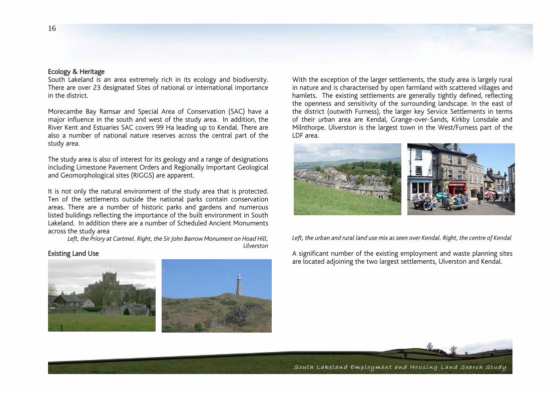
Ecology & Heritage South Lakeland is an area extremely rich in its ecology and biodiversity. There are over 23 designated Sites of national or international importance in the district. Morecambe Bay Ramsar and Special Area of Conservation (SAC) have a major influence in the south and west of the study area. In addition, the River Kent and Estuaries SAC covers 99 Ha leading up to Kendal. There are also a number of national nature reserves across the central part of the study area.
The study area is also of interest for its geology and a range of designations including Limestone Pavement Orders and Regionally Important Geological and Geomorphological sites (RIGGS) are apparent. It is not only the natural environment of the study area that is protected. Ten of the settlements outside the national parks contain conservation areas. There are a number of historic parks and gardens and numerous listed buildings reflecting the importance of the built environment in South Lakeland. In addition there are a number of Scheduled Ancient Monuments across the study area
Left, the Priory at Cartmel. Right, the Sir John Barrow Monument on Hoad Hill, Ulverston
Existing Land Use
With the exception of the larger settlements, the study area is largely rural in nature and is characterised by open farmland with scattered villages and hamlets. The existing settlements are generally tightly defined, reflecting the openness and sensitivity of the surrounding landscape. In the east of the district (outwith Furness), the larger key Service Settlements in terms of their urban area are Kendal, Grange-over-Sands, Kirkby Lonsdale and Milnthorpe. Ulverston is the largest town in the West/Furness part of the LDF area.
Left, the urban and rural land use mix as seen over Kendal. Right, the centre of Kendal A significant number of the existing employment and waste planning sites are located adjoining the two largest settlements, Ulverston and Kendal.

17
Development Proposals Given the nature of the district, the number of new developments coming forward within the study area is limited. In the main, the primary settlements of Kendal and Ulverston are where the main housing and employment allocations are focussed.
Left, new residential development in Swarthmoor. Right, new development in Kendal Kendal, in particular will be a focus for future development, with the Kendal Economic Regeneration Action Plan and the recent Kendal Canal Head Area Action Plan Issues and Options Report reflecting its significance in sub-regional and even regional terms and proposing a number of interventions. In addition, as previously mentioned the possibility is being considered for a potential new local strategic employment site to be located in the east of the district in proximity to the A590/M6 corridor if sufficient sites can not be found on the edge of settlements. There are also a number of larger waste & mineral planning sites, however these are located away from the urban areas.
Designated Areas In addition to the designations identified under ecology and heritage above, there are a number of other strategic designations that are of particular relevance. Most important in this respect is the flood plain. A Strategic Flood Risk Assessment (2nd draft) has been carried out for the district and this is shown at Appendix 1. The issue of flood risk is a significant one with large areas of the district, particularly in the central and western locations affected. The River Kent flood plain runs north-south through Kendal and through to Morecambe Bay and there are flood impacts north and east of Grange-over-Sands and Arnside. In the east of the study area, the River Lune runs south through Kirkby Lonsdale to Lancaster. The area to the east of Ulverston is affected by flood risk, as is Cartmel Sands and the area south of Flookburgh. Finally, Lyth Valley, west of Kendal, through which the River Gilpin runs, has a large flood plain which straddles the national park boundary
Left, views over the designated sands at Grange. Right, the Green Gap between Ulverston and Swarthmoor
There are also important local designations that will affect the ability to bring forward land for future development. The local plan policy of green gaps is particularly significant. This policy seeks to prevent coalescence between settlements and this is seen as being of significant sensitivity by local people.

18
Transport / Infrastructure The ability to effectively access new employment and housing is a key factor in the sustainability and deliverability of sites. Whilst the study area is predominantly rural in nature, it does enjoy relatively good infrastructure provision. The M6 motorway runs north/south through the east of the study area and is connected to Kendal via the A590/A591. The A590 runs east/west across the area from the M6 through Ulverston and on into Barrow in Furness. Other settlements are connected off this network via a number of A and B roads including the A5092, B5278, A6 and A65. In terms of public transport, the West Coast Main Line Railway runs parallel to the M6 north-south although Kendal itself is not on the West Coast Main Line. Oxenholme is the main station on the West Coast Main Line. The railway splits at Carnforth to pass Grange-over-Sands and Ulverston en-route to Barrow-in-Furness. The Cumbria Bus Network provides a good bus service to the larger towns although the smaller settlements and rural areas are not all provided with a regular bus service.
Left, A590 near Levens, Right, railway station at Cark
Conclusions - Areas of Constraint / Opportunity, the ‘Traffic Light’ Map The findings of the physical analysis have been drawn together to inform the appraisal of the identified sites at Section 4 of this report. The consultant team have adopted a ‘Traffic Lights’ approach to assessing the potential for development across the study area. This is based on attributing each of the designations / constraints with a colour relative to their probable impact on development potential. For example an AONB would be classified as red being potentially very prohibitive to employment or housing development, whereas derelict land would be green. The mapping has been developed as follows: Red - Locations with International & National Designations Designations / Constraints Mapped:
Strategic Flood Risk Assessment Zone 3 (active flood plain) -(2nd Draft SFRA), The National Park, Scheduled Ancient Monuments, Historic Parks & Gardens, Conservation Areas, Listed Buildings, AONBs, and Ancient Woodland. National and international designations clearly have a significant impact in terms of the ability of these locations to accommodate new development. In the case of South Lakeland and this study area, this is particularly the case, where an Area of Outstanding Natural Beauty designation covers Arnside and Sandside. Across from Grange-over-Sands, the Morecambe Bay Site of Special Scientific Interest (SSSI) is also found. This level of constraint also reflects the significance of the flood risk issue in the study area and the extensive areas of active flood plain.

19
Amber - Locations with Regional Designations Constraints Mapped: Strategic Flood Risk Assessment Zone 2 (flood prone) (2nd draft SFRA), Sites of Biological Importance, Regionally Important Geological and Geomorphological Sites, Cumbria Wildlife Trust Reserves, Minerals Planning Sites / Applications, Waste Planning Sites / Applications and Settlement Boundaries.
The Employment and Housing Land Search Study takes a more detailed and local landscape assessment of the areas around the existing settlement boundaries. The majority of the LDF/Study area is within a designated Landscape of County Importance. Although the ‘Landscapes of County Importance’ were mapped and informed the landscape analysis that has fed into the appraisal, for practical reasons to aid mapping, the areas were removed from the Strategic Mapping/Traffic Light Plan. Inclusion would have made graphical representation of the detailed site search difficult. This is illustrated on the plans at Appendix 1 which show the traffic lights map both with and without this designation. They have, however, informed the landscape analysis that has fed into the appraisal. The removal of the Landscapes of County Importance from the mapping process has naturally reduced the level of amber areas that are shown. Much of the amber designations are therefore taken up with the settlement boundaries of the current settlements. These have been classified in this way to reflect the fact that these are not the focus for this work, but that the team have been looking for urban extension sites and that there may therefore be some overlap here.
Finally, much of the study area is covered by areas that are flood prone. However, much of this overlaps with the more significant active flood risk areas designated as red above. Green – Locations with Local Designations Designations / Constraints Mapped: Important Green Space, Tree Preservation Orders, Existing Employment sites, Housing & Employment Local Plan Allocations, Leisure Scheme, Community Facilities Allocation, Derelict Land, Public Car Parking Allocation, Green Gaps, Playing Field Allocations. In consultation with South Lakeland District Council, the team have sought to limit the mapping of local designations to those that will potentially impact on this study process. Whilst the majority of the local designations apply to locations within the settlement boundaries and therefore have a more limited impact on the site appraisal process, there are locations where they do impact on the edge of settlements, particularly in the form of playing fields and derelict land. In addition, whilst green gaps are local planning designations, and have therefore been mapped as such on the traffic lights maps, in terms of the site analysis, they were felt to be of sufficient significance to be classified as ‘amber’ and this is reflected in the appraisals at Section 4 of this report. Whilst certain designations are beyond the remit of the LDF process, other designations such as green gaps and open space can be reviewed as part of the LDF process.

20
Potential Employment and Residential Sites Potential employment and residential sites put forward by the public, SLDC and others prior to the commencement of the study in March 2007 are shown on the ‘traffic light’ plans and these potential sites have been considered as part of the site search. In addition, sites which came forward in the study’s consultation process (up to May 2007) with the public, SLDC and others for consideration as allocations in the LDF are listed and considered in Appendix 8. Accumulated Constraints Map Each of the mapping layers has been built up separately and then overlain to show a broader, more complete picture. It is important to note that where this process has resulted in two designations / constraints overlapping, the more significant takes precedence. Therefore a green would be overlain by an amber and an amber by a red. In overlaying the mapping layers, there are of course significant areas of the study area where there are no designations that apply. In these cases the mapping has left these as ‘white’ rather than covering this whole area as green to allow for a differentiation between local designations and no designations. This has provided a comprehensive strategic analysis that has then been applied to each of the identified sites at Section 4 of this report. Figure 4 Overall Traffic Light Map (Over)

21
Including Landscapes of County Importance

22
2.3. Market Analysis Employment Supply Whilst South Lakeland benefits from a larger amount of both office and industrial premises than comparable authorities in the area, with unsatisfied demand for commercial sites (Lake District Economic Futures Report, 2004), the overall supply of employment sites (Local Plan allocated and sites with planning permission) is highly constrained. It is considered that there was just 8.03ha (as at 31 03 04) of unconstrained and readily available employment land in the LDF area and that the majority of this is not of a high quality. Three years on, as at March 2007, there are now considered to be nine sites, without significant constraints and available for development, totalling 12.86 ha. The increase is due in part to 4.70ha of land at phase 2 Low Mill Tannery, Ulverston, being serviced. Demand The total take-up of employment land in South Lakeland over the 5 year period 2002/3-2006/7 was 6.18ha. This represents an average annual take up of employment land in South Lakeland of 1.23ha. This relates to a Structure Plan requirement of 3.8ha per annum. At the average take up rate in the last 5 years (2002/3-2006/7), the current supply without significant constraints represents10.45 years supply Demand for employment accommodation in South Lakeland District is highly focussed on Kendal, as evidenced by recent take-up, business surveys and enquiries to SLDC. This is re-enforced by anecdotal evidence provided by local property agents who confirm that Kendal is a principal focus of demand in the area, particularly for office based uses. That said, other settlements (including Milnthorpe, Grange-over-Sands, Ulverston and
Kirkby Lonsdale) do benefit from moderate levels of demand. This is as a result of the locational inertia of many businesses, which seek to remain in the same location so as to retain existing skilled and/or experienced work forces. The large majority of enquiries for employment accommodation to South Lakeland District Council are for industrial/warehousing premises, with only 25% of inquiries being for office uses. That said, office based businesses are more likely to deal with commercial agents to satisfy property requirements. Based on analysis of inquiries and discussions with local agents, demand for office premises is focussed on smaller units, particularly of less than 3,000sq.ft and 3,000-10,000sq.ft. Demand for industrial premises is more evenly spread in terms of sizes sought with 3,000 – 10,000 and 20,000 – 50,000sq.ft most sought after. NWDA Knowledge Based Employment Land Search Study This Study on behalf of the NWDA defines ‘knowledge-based sectors’ as including BioTech; Environmental Technologies; Advanced Engineering; Food & Drink; Digital & Creative; and Professional Services. It suggests that demand will be derived from start-ups/higher education ‘spin-out’ businesses; satellite offices of established companies; and growing indigenous businesses. The study concludes that such businesses will seek units ranging in size from 500sq.ft – 5,000sq.ft sought, potentially in a single multi-let building of up to 50,000sq.ft. Based on these assumptions, a site of a minimum size of 1.5ha was sought, preferably with the potential to expand to between 3-5ha. Potential locations include Kendal, an urban extension to Kendal; the A590/A65 Corridor; and Junction 36 of the M6. A short-list of sites was created, and the conclusions in the Draft Report of June 2007 highlighted

23
the top four ranking sites (in order) to be at Milnthorpe Road (east), Burton Road (South), Milnthorpe Road (West), and Kendal Canal Head. Values & Viability Rental values for office accommodation in South Lakeland District, considered to be at £11- £12psf, are not sufficiently high to enable commercially viable development. However, industrial/warehouse values, at £5.50 - £6.00psf are at a commercially viable level. It is thought that the relatively small amount of new development of this type is due to the constrained nature of supply and lack of capacity in the local development industry. Implications for Site Appraisal The information set out above, suggests that new employment sites are required to be allocated in the district council’s LDF and that such sites should primarily provide for general industrial and warehousing businesses, given that a site search for a knowledge-based business park in South Lakeland, is likely to include a high proportion of office uses, is already being undertaken on behalf of the NWDA. The NWDA study seeks to respond to the need/potential identified in Lake District Economic Futures Study (LDEF) for knowledge based industries. However, some land for B1 development would also be needed in other parts of the district in particular the Furness area. The requirements of sites for industrial and warehousing uses include profile and accessibility to the primary road network and proximity to areas of population where there will be a base of skilled and experienced potential employees. As such, locations close to the A590/A65 corridor and the M6 will be preferable. The marginal viability of employment development in the district, in particular for office uses, and the limited amount of recent development
suggests that easily and cheaply developable sites, which meet the quality aspirations of potential developers and occupiers, are required. Residential Supply/Completions It is clear by studying the numbers of residential planning permissions granted and completions for South Lakeland LDF area that completions over the last few years have been declining. This demonstrates that developers are submitting fewer applications year on year, and also completing fewer numbers of homes. The implementation of national planning policy advice from PPG3 – Housing is relevant to this, as well as the approved Regional Spatial Strategy for the North West (RSS 13). At a sub-regional level, the approved Cumbria and Lake District Joint Structure Plan sets out the detailed requirements for annual average net additional dwellings permitted at a lower level than has been the trend pre 2002. From this, implementing the ‘plan, monitor, and manage’ concept has reduced the number of planning permissions granted. In light of this there are few remaining undeveloped housing allocations in the South Lakeland Local Plan, and there is a lack of capacity to satisfy demand in local development markets. Demand/Affordability The total extent of demand for housing in the South Lakeland LDF area is unclear as a result of the constrained nature of supply. What is clear, however, is that the South Lakeland LDF area experiences high levels of demand for housing from both its indigenous population and from those

24
seeking a holiday house or to relocate to the district. These high levels of demand, along with the relatively constrained supply position have served to drive up values and have resulted in an acute problem of affordability in the LDF area. The relationship between average house prices and the multiplier of average earnings in the LDF area is beyond that which can be borrowed commercially. In terms of the locations of demand, the fact that high values are evident throughout the district means that demand for development is also likely to be high across the entire district. That said, in broad terms, the most sought after sites are those within or close to existing centres of employment and population. Therefore, sites in Kendal, and to a lesser extent in Ulverston, Kirkby Lonsdale and Grange-over-Sands, are most in demand. Other characteristics sought include proximity to good quality schools as well as a good range of local shops and services. High environmental quality and attractive views are also beneficial. Values The imbalance of supply and demand is clearly driving prices upwards, as evidenced by the high values being achieved – in the region of £200 - £375per sq. ft. These development values are on a par with those being achieved in central Manchester. Average house prices in South Lakeland are well above local, sub-regional and regional comparators. Land values are directly dependant on density and development costs (abnormals, extent of affordable house requirement etc) and as such, generalisations based on land values cannot be relied upon to a great extent. However, in general terms, residential land values in South Lakeland are considered to be in the range of £1m - £2m per acre. The high values are driving developers towards building apartments and large luxury homes in order to maximise value from their sites. However,
this is leading to a lack of mid-market new three and four bedroom housing. Implications for Site Appraisal The benefit of high values for development is that more challenging and costly to develop sites can be considered. For example, if values were low, it would not be possible to develop sites where significant earth-works, decontamination or flood alleviation works were required. Whereas, if the value of development is high, such factors which add to the cost of development can be absorbed. Larger sites, of up to 5ha are likely to be preferred by developers, but given the constrained nature of supply and high demand and values, significantly smaller sites are also likely to attract interest from developers.
25
2.4. Consultation The Process The consultation process took the form of a number of specially arranged meetings with Parish and Town Councils and three all-day public consultation events. The meetings included: Parish Council evening meetings – 23, 24, and 27 04 07 Kendal Town Council meeting – 14.05.07 Consultation on Saturday 21.04.07 at Grange-over-Sands Consultation on Saturday 21.04.07 at Ulverston Consultation on Saturday 28.04.07 at Kendal
At each event specially designed consultation forms were used and the use of ‘post-it’ notes was encouraged to take note of other issues. This allowed for settlement and site specific comments to be submitted and also for general comments that are not related to individual settlements.
to attend.
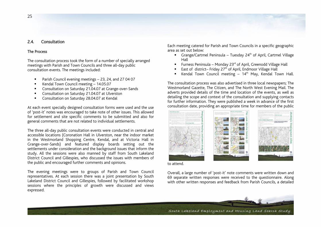
The three all-day public consultation events were conducted in central and accessible locations (Coronation Hall in Ulverston, near the indoor market in the Westmorland Shopping Centre, Kendal, and at Victoria Hall in Grange-over-Sands) and featured display boards setting out the settlements under consideration and the background issues that inform the study. All the sessions were also manned by staff from South Lakeland District Council and Gillespies, who discussed the issues with members of the public and encouraged further comments and opinions. The evening meetings were to groups of Parish and Town Council representatives. At each session there was a joint presentation by South Lakeland District Council and Gillespies, followed by facilitated workshop sessions where the principles of growth were discussed and views expressed.
Each meeting catered for Parish and Town Councils in a specific geographic area as set out below: Grange/Cartmel Peninsula – Tuesday 24th of April, Cartmel Village
Hall Furness Peninsula – Monday 23rd of April, Greenodd Village Hall East of district– Friday 27th of April, Endmoor Village Hall Kendal Town Council meeting – 14th May, Kendal Town Hall.
The consultation process was also advertised in three local newspapers; The Westmorland Gazette, The Citizen, and The North West Evening Mail. The adverts provided details of the time and location of the events, as well as detailing the scope and context of the consultation and supplying contacts for further information. They were published a week in advance of the first consultation date, providing an appropriate time for members of the public
Overall, a large number of ‘post-it’ note comments were written down and 69 separate written responses were received to the questionnaire. Along with other written responses and feedback from Parish Councils, a detailed

26
nd varied picture was built up of the issues affecting the area from the ttlements.
subject of fut r
g growth should be restricted to
that recurre
they
asurrounding se The Findings The complete set of results from all the consultation events is set out in Appendix 3 thof is report. Key findings from the questionnaire on the wider
u e housing and employment growth are set out below: 87% agreed that the type of housing on offer in the area
should be wider & more affordable 94% agreed that there is a need for more and better jobs in South Lakeland, and 83% agreed that development of a
local strategic employment site would benefit the South Lakeland economy & provide better local jobs
Only 39% of respondents agreed that preserving the countryside is more important than new housing/jobs
88% agreed that employment should be spread over key and local service centres 65% disagreed that housinthe five key service centres
From ‘post-i nt’ otes, written comments and responses, the gene
d were on the following issues: ral themes
Need for affordable housing Small scale residential development is desired Inadequate infrastructure – roads, public transport links,
sewers Adequacy of local amenities and shopping Appropriate small scale and low density of housing required
in small settlements Viability of communities is as important as ‘sustainability’ of
location Identity of existing communities must be retained and
must not be ‘absorbed’ into neighbouring areas
Preservation should be balanced against housing needs Many people commute – local jobs have declined, but local
housing has grown Kendal has office demand, but potential supply issues Good demand but lack of availability for employment sites
in Ulverston Economic diversification, telecoms and home working are
important areas of potential Character and heritage should be protected and enhanced
From the returned consultation forms and other detailed comments, settlement and site specific comments were also submitted. Examples of site and settlement-specific comments that came out of the consultation events inclu : de
Natland would have great difficulty coping with any more traffic. There is no easy parking, and can be hazardous for the pedestrian; more traffic would exacerbate the situation and Natland would lose its character and identity.
East of the village of Natland, access to potential development sites is very poor due to road layout
New housing in Holme has not helped local schools. Many go to Kendal
Parking after 5 pm is a problem in Greenodd and Penny Bridge and at times it would be difficult for emergency services to get through.
Existing industrial employment sites need protecting within Ulverston centre, not just creating a retail high street. A need for real craft and employment units. Restrict housing development on those areas.

South Lakeland Housing and Employment Land Search StudySouth Lakeland Housing and Employment Land Search Study
Site Identifi cation 03
27
ti Identification
e area of any settlement or any sites remote
ty, each otential site would need to be assessed on an individual basis.
ent Analysis
e analysis of the landscape and refers to he landscape type in general terms. The analysis required for this study is
overwhelm the character of the existing core unless the esign incorporates potential improvements of acceptable style and scale
Sec on 3 Site 3.1. Introduction The 21 settlements and 5 employment areas that form part of the South Lakeland Housing and Employment Land Search Study were each visited in order to understand the character of the existing settlements and surrounding areas. Following on from this analysis of the existing landscape and the communities, the peripheral areas of each community and employment sites were assessed in terms of their capacity to absorb change within the landscape, in the form of areas of built development. The study is concerned with the direct expansion of existing settlements within the South Lakeland LDF area; therefore it does not cover any sites within the existing developablfrom the existing built areas. The visits were undertaken over a number of days in May, June and July 2007 in generally good weather with clear visibility. Individual descriptions for each settlement are given in Appendix 5. The visits were undertaken by a consistent team of qualified landscape architects and findings were recorded without reference to the baseline material gathered and discussed in Section 2 of this report. The settlement analysis is a subjective judgement based on the quality of the existing landscape and its ability to absorb change through built development, and the impact that development might have on the surrounding landscape. The analysis suggests areas that might be best able to accommodate development, it does not however automatically preclude development in areas of higher sensitivity or allow development in areas of lower sensitivip
3.2. Settlem Character Areas Generally landscape within the study area is of high quality, as recognised by the high level of designation of landscapes of national, regional and local value as described in Section 2. The study area encompasses a variety of landscape character areas as described through the national study by the then Countryside Commission, Countryside Character Volume 2; North West and Technical Paper 5; Landscape Character supporting document to the Lake District and Cumbria Joint Structure Plan. The landscape character around each settlement and employment area is referred to in the description given. However this is for information only, as this is a descriptive rather than qualitativtundertaken at a more local level. Townscape Character and Context The existing townscape character of each settlement is described in Appendix 5. This assesses and describes the existing type and quality of the settlement and so understands the type and size of development that would fit with the existing settlement. Any new development should not overshadow or dto the existing. Additionally the character and type of building at the edges of the settlement is described and understood to analyse how any edge of settlement development would sit alongside the existing edges. Settlement edges which filter gently into the countryside and have little impact on the surrounding countryside should be preserved. However, sometimes later settlements, for example pre and post war housing estates can form harsh
28
ication for excluding sites from the final st of housing sites for appraisal.
to expansion as, for example, the
the l
opment on prominent ridgelines or in flat open
landscape.
and insensitive edges with the countryside. Sensitive expansion in these areas could improve the edge of the settlement and its relationship with the surrounding landscape. Appendix 5, in setting out the development otential also illustrates the justifp
li Landscape Character The understanding of the character of the landscape is fundamental in assessing the ability of the area to accommodate change. Some landscapes are more able to absorb change than others, these tend to be those which are well vegetated and can therefore compartmentalise and screen views. Natural barriers, such as hedgerows, vegetated watercourses and stone walls form natural breaks in the landscape and may allow development to sit within the existing framework. In other cases those natural barriers may form an obvious break between the natural and man made environment nd should serve as a permanent barrier a
woodland belt to the south east of Arnside. Effe s ct that a potential development may have on the landscape include
fol owing: Direct physical changes to the landscape throug h the loss of elements such as woodland, single trees and hedgerows The introduction of new man made elements such as the built forms and the associated developments
such as new roads and
services, visible in views across the landscape Changes to the pattern of the landscape that give it its distinctiveness, including field patterns, hedgerows and stone walls, open moorland or enclosed stream valleys. Changes in views across the landscape, particularly introducing new devel
The character of the existing surrounding landscape is outlined and understood for each settlement and employment area and recorded in Appendix 5.
opography and Views T The topography of the landscape is important in that it controls views to and from settlements and within the wider landscape. Rolling and undulating topography can break up and contain views, although locally these views may become dominant. High ground allows long and often panoramic views across the landscape and is of particular importance in much of the study area as, for example, the views from Arnside Knott give long and extensive views across the estuary to the north. Views across flat land may be extensive but more easily contained by planting and other eatures. f
Main views to and from the study settlements and across the wider landscape are indicated in the appendix for each site. These are diagrammatic and give an indication of the main views. In detail there will be subtleties to these views that can only be picked up on a site by site asis. b
Development Potential Taking all of the above characteristics into consideration the landscape potential of each settlement to incorporate development along its boundaries has been considered and outlined. The areas with development potential are described in Appendix 5 on a settlement by settlement basis nd the broad scope for each settlement is summarised in the table below; a

29
3.3 Site Identification Having assessed the settlements in the field and established basic areas for expansion, the settlements were further analysed as part of a desk based study to identify parcels of land that formed logical development sites. Aerial photographs, local information feeding through from the consultation process and map analysis supported the desk based analysis. It must be noted that this is not an exhaustive list of sites and further sites could emerge that could be appraised through the matrix in the future. Sites were reassessed in the field to check their development potential and understand local landscape characteristics. In addition, at this stage of the process, a view was taken on the best potential use for the site based on the immediate context and the wider settlement character. As a result of the site identification process a total of 64 housing sites were identified and taken forward for appraisal. These are shown on the plans at Appendix 6 and are set out in summary on the table overleaf. This table shows a potential 222.81 Hectares (Ha) of development land which would equate to 8,884 new homes based on an average density of 40 dwellings per Ha (gross). A number of the sites suggested were subject to constraints which has affected the developable area. Where this has been the case, the constraints have been highlighted in the Matrices at Appendix 7. Where it is possible to take the factors into account in the potential site areas, this has also been done. In terms of mixed use sites, 7 have been identified over 6 settlements, leading to 53.38 Ha of development land. The general assumption at this stage is for a land use split on mixed use sites of 50% housing and 50% employment uses. At an average density of 40 units per hectare (gross) this equates to 1067 new residential units alongside 26.69 Ha of land for employment uses. In terms of employment land, 8 sites equating to 66.14 Ha of development land were identified as potential extensions to 6 of the settlements, with
Settlement Small areas of land with development potential – but may effect character
Small areas of land with development potential
Significant areas of land with development potential
Milnthorpe North West
Arnside East
Sandside and Storth South
Holme North / West/ South
Burton–in–Kendal North East
Kirkby Lonsdale South / West
Levens North / East
Natland South
Oxenholme North South
Endmoor South North
Pennybridge/Greenodd
Kirkby in Furness East
Great Urswick South west
Swarthmoor North West East / South
Burneside East North east
Ulverston South west South / South east
Cartmel East
Cark South
Flookburgh East / South west
Grange over Sands North / South west
Kendal North east / South East / North west / South west
30
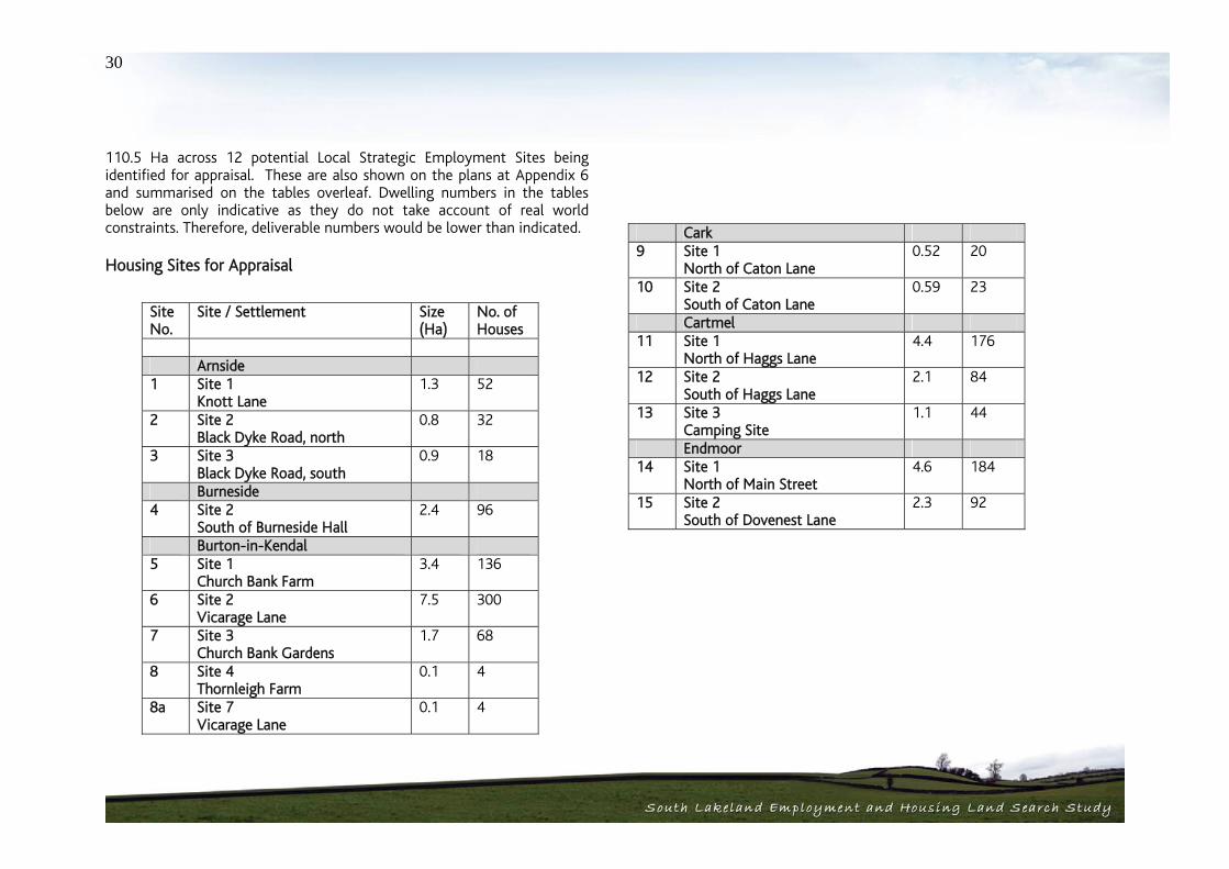
110.5 Ha across 12 potential Local Strategic Employment Sites being identified for appraisal. These are also shown on the plans at Appendix 6 and summarised on the tables overleaf. Dwelling numbers in the tables below are only indicative as they do not take account of real world constraints. Therefore, deliverable numbers would be lower than indicated.
Housing Sites for Appraisal
Site No.
Site / Settlement Size (Ha)
No. of Houses
Arnside 1 Site 1
Knott Lane 1.3 52
2 Site 2 Black Dyke Road, north
0.8 32
3 Site 3 Black Dyke Road, south
0.9 18
Burneside 4 Site 2
South of Burneside Hall 2.4 96
Burton-in-Kendal 5 Site 1
Church Bank Farm 3.4 136
6 Site 2 Vicarage Lane
7.5 300
7 Site 3 Church Bank Gardens
1.7 68
8 Site 4 Thornleigh Farm
0.1 4
8a Site 7 Vicarage Lane
0.1 4
Cark 9 Site 1
North of Caton Lane 0.52 20
10 Site 2 South of Caton Lane
0.59 23
Cartmel 11 Site 1
North of Haggs Lane 4.4 176
12 Site 2 South of Haggs Lane
2.1 84
13 Site 3 Camping Site
1.1 44
Endmoor 14 Site 1
North of Main Street 4.6 184
15 Site 2 South of Dovenest Lane
2.3 92
31
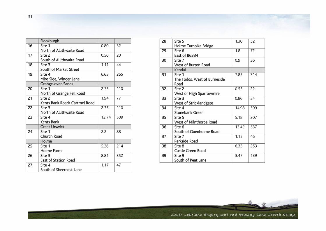
28 Site 5 Holme Turnpike Bridge
1.30 52
29 Site 6 East of B6384
1.8 72
30 Site 7 West of Burton Road
0.9 36
Kendal 31 Site 1
The Todds, West of Burneside Road
7.85 314
32 Site 2 West of High Sparrowmire
0.55 22
33 Site 3 West of Stricklandgate
0.86 34
34 Site 4 Stonebank Green
14.98 599
35 Site 5 West of Milnthorpe Road
5.18 207
36 Site 6 South of Oxenholme Road
13.42 537
37 Site 7 Parkside Road
1.15 46
38 Site 8 Castle Green Road
6.33 253
39 Site 9 South of Peat Lane
3.47 139
Flookburgh 16 Site 1
North of Allithwaite Road 0.80 32
17 Site 2 South of Allithwaite Road
0.50 20
18 Site 3 South of Market Street
1.11 44
19 Site 4 Mire Side, Winder Lane
6.63 265
Grange-over-Sands 20 Site 1
North of Grange Fell Road 2.75 110
21 Site 2 Kents Bank Road/ Cartmel Road
1.94 77
22 Site 3 North of Allithwaite Road
2.75 110
23 Site 4 Kents Bank
12.74 509
Great Urswick 24 Site 1
Church Road 2.2 88
Holme 25 Site 1
Holme Farm 5.36 214
26 Site 3 East of Station Road
8.81 352
27 Site 4 South of Sheernest Lane
1.17 47

32
Oxenholme 53 Site 1
Overdale 0.91 36
Sandside and Storth 54 Site 1
Yans Lane 5.22 208
55 Site 2 Four Lane Ends
1.58 63
Swarthmoor 56 Site 1
East of Park Road, north 0.63 25
57 Site 2 Rufus Lane
3.86 154
58 Site 3 West of Ulverston Road
0.64 26
59 Site 4 Cross Moor, South of Main Road
12.64 506
60 Site 5 East of Park Road, South
4.49 180
Ulverston 61 Site 1
Urswick Road 5.47 218
62 Site 2 Colt House Lane
0.61 24
63 Site 3 Mountbarrow Road
12.3 492
Kirkby-in-Furness 40 Site 1
Four Lane Ends 2.1 84
41 Site 2 Sand Side
0.94 37
Kirkby Lonsdale 42 Site 1
Harling Bank 2.67 106
43 Site 2 Bentinck Road
6.85 274
44 Site 3 Bridge Brow
0.77 30
Levens 45 Site 1
Brigsteer Road/Whitegate 4.4 176
46 Site 2 Land to the east of Levens Lane
7.5 300
Milnthorpe 47 Site 2
Hartland House 0.72 28
48 Site 3 North of Kirkgate Lane
4.6 184
Natland 49 Site 1
North of Hawes Lane 0.49 20
50 Site 2 South of Hawes Lane
0.64 25
51 Site 3 West of Robby Lea Drive
0.90 36
52 Site 4 Longmeadow Lane
3.52 140

33
Housing Sites for Appraisal – Settlement Totals
Site / Settlement Size (Ha) No. of Houses Arnside Settlement total 3.0 102 Burneside Settlement total 2.4 96 Burton-in-Kendal Settlement total 12.8 512 Cark Settlement total 1.11 43 Cartmel Settlement total 7.6 304 Endmoor Settlement total 6.9 276 Flookburgh Settlement total 9.04 361 Grange-over-Sands Settlement total 20.18 806 Great Urswick Settlement total 2.2 88 Holme Settlement total 19.34 773
Site / Settlement Size (Ha) No. of Houses Kendal Settlement total 53.79 2151 Kirkby-in-Furness Settlement total 3.04 121 Kirkby Lonsdale Settlement total 10.29 410 Levens Settlement total 11.9 476 Milnthorpe Settlement total 5.32 212 Natland Settlement total 5.55 221 Oxenholme Settlement total 0.91 36 Sandside and Storth Settlement total 6.8 271 Swarthmoor Settlement total 22.26 891 Ulverston Settlement total 18.38 734

34
Mixed Use Sites for Appraisal Site No.
Site / Location Size Ha
Number of Houses
Burneside 1 Site 1
Sharps Lane 1.6
Employment 0.8
Housing 0.8 32
Settlement total 1.6 32 Burton in Kendal 2 Site 5
Drovers Way 1.2
Employment 0.6
Housing 0.6 24
3 Site 6 Station Lane, north
1.5
Employment 0.75
Housing 0.75 30
Settlement total 2.7 54 Holme 4 Site 2
West of Station Road 8.56
Employment 4.28
Housing 4.28 171
Settlement total 8.56 171 Kendal 5 Site 10
Appleby Road (A685) 18.3
Employment 9.15
Housing 9.15 366
Settlement total 18.3 366 Milnthorpe 6 Site 1
Grisleymires Lane 14.6
Employment 7.3
Housing 7.3 292
Settlement total 14.6 292 Ulverston 7 Site 4
West End Farm 7.62
Employment 3.81
Housing 3.81 152
Settlement total 7.62 152
35
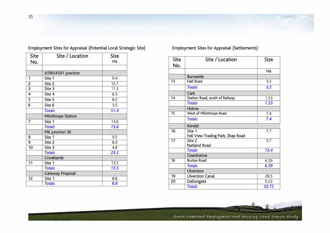
Employment Sites for Appraisal (Potential Local Strategic Site)
Employment Sites for Appraisal (Settlements)
Site No.
Site / Location Size Ha
A590/A591 Junction 1 Site 1 9.4 2 Site 2 12.7 3 Site 3 11.3 4 Site 4 6.3 5 Site 5 8.2 6 Site 6 3.5 Totals 51.4 Milnthorpe Station 7 Site 1 13.6 Totals 13.6 M6 Junction 36 8 Site 1 9.5 9 Site 2 8.9 10 Site 3 4.8 Totals 23.2 Crooklands 11 Site 1 13.5 Totals 13.5 Gateway Proposal 12 Site 1 8.8 Totals 8.8
Site No.
Site / Location Size
Ha Burneside 13 Hall Road 3.5 Totals 3.5
Cark 14 Station Road, south of Railway 1.53 Totals 1.53 Holme 15 West of Milnthorpe Road 7.4 Totals 7.4
Kendal 16 Site 1
Fell View Trading Park, Shap Road 7.7
17 Site 2 Natland Road
5.7
Totals 13.4 Oxenholme 18 Burton Road 6.59 Totals 6.59 Ulverston 19 Ulverston Canal 28.5 20 Daltongate 5.22 Totals 33.72

South Lakeland Housing and Employment Land Search StudySouth Lakeland Housing and Employment Land Search Study
Site Appraisals 04

36
Section 4 Site Appraisals 4.1. Introduction Having identified a number of potential development sites across the study area, the next stage of the process has been to appraise their sustainability and deliverability. In achieving this, a bespoke methodology was developed specifically for this process. Guidance does exist from the government in the form of Employment Land Reviews: Guidance Note (2004). This sets out a set of basic criteria and indicators that can be used for reviewing the quality and availability of employment sites. These indicators were used in the South Lakeland Employment Land and Premises Study and have directly informed the approach to compiling qualitative criteria for the assessment of sites for this piece of work. In terms of assessing housing sites, at the time that the methodology was being developed, the government had published draft guidance on this in the form of Housing Land Availability Assessments: Identifying Appropriate Land for Housing Development. The finalised Practice Guidance: Strategic Housing Land Availability Assessments was later published by the Government in July 2007. This highlights the issues that need to be considered rather than attempting to prescribe how assessments should be carried out. This guidance is also targeted at a more holistic scope of work where all sites both urban and non urban are being considered, whereas this study is looking to build on the Urban Capacity Study already carried out for South Lakeland and has been targeted specifically at identifying sites beyond the existing settlements boundaries. Inevitably therefore, this has necessitated a bespoke approach. Interestingly, this document also states that Housing Land Availability Studies should not take a view on sustainability or otherwise of sites, rather that this should come through
the sustainability appraisal process as part of the Local Development Framework. Notwithstanding this, the consultant team have set out an initial appraisal of this issue. 4.2. Site Appraisal Approach The study has deliberately identified sites across both urban and rural settlements in line with the guidance from PPS3. In identifying these sites no attempt was made to assess their broader suitability for development. Even if a site was of high landscape value, it was included in the site appraisal because the site could have other benefits in being brought forward with any necessary site mitigation. The strategic assessment of the area in identifying issues and constraints and the identification of sites as set out in Sections 2 and 3 of this report were carried out in parallel, but importantly, separately and are brought together in the site appraisal. Each of the identified sites has been appraised relative to two key criteria:
1. Sustainability; and 2. Deliverability.
Sustainability In considering the sustainable credentials of the sites, the following factors have been considered: 1. The Environmental Context This has included an appraisal of the development context, the wider landscape and environment and the potential visual impact. In addition, the traffic light analysis at Stage 1 is reflected here relative to each of the sites.

37
2. Accessibility The accessibility of the sites for all members of the community. This has included an appraisal of access to public transport in the form of bus routes / stops and train stations including walking distances. In addition, specific consideration has been given to the accessibility of the sites themselves and any traffic impact based on comments from the Local Highways Authority. 3. Facilities Proximity to and availability of community facilities has been included relative to each site. This has covered proximity to both primary, and secondary schools as well as shops and services and employment. Deliverability In line with PPS3, the consultant team have also appraised the identified sites in terms of their likely deliverability. This is directly in line with current national guidance in providing greater realism and certainty. This has included an assessment of the following factors. 1. Services The availability of services has been considered for each site based on consultations with key service providers including United Utilities, British Telecom and Transco.
2. Location Based on the baseline market analysis and the potential attractiveness of the location by reference to environmental quality, proximity to centres of employment, primary roads, schools, shops and services and other characteristics sought by developers.
3. Feasibility A consideration of potential development constraints and factors which could increase development costs including contamination, ownership, topography, presence of power lines and such like. 4. Viability An indicative assessment of the relationship between the likely values which can be achieved and the costs of development likely to be incurred. Comments In addition to the above appraisal a number of specific comments have been made based on the strategic analysis, consultations and discussions with stakeholders as to the sites suitability. This has included issues such as any specific relevant designations, planning history and local community views.

38
4.3. Settlement / Site Appraisal Results The full appraisals are set out in the Site Appraisal Matrix at Appendix 7 of this report. Set out below are the key findings in summary. The results are set out relative to each of the settlements as follows. Key Service Centres:
Kendal Ulverston Grange-over-Sands Milnthorpe Kirkby Lonsdale
Potential Local Service Centres:
Burneside Oxenholme Natland Levens Endmoor Burton in Kendal Holme Sandside / Storth Arnside Cartmel Cark Flookburgh Penny Bridge/Greenodd Kirkby - in – Furness Swarthmoor Great Urswick.
Appraisal of Employment Sites In addition to the appraisal of the settlements to accommodate new residential and mixed use development, the consultant team have also appraised a number of potential sites for new employment development as well as potential local strategic employment sites in the east of the district. This is in addition to those potential sites being considered by the NWDA for Regional Knowledge Based Employment Industries and is focussed on a strategic site to serve local growth and new businesses. Notwithstanding this, in considering potential sites, there has been some overlap with the NWDA work and the findings of that study have been taken into account. The appraisal has been carried out on a matrix based approach as for the housing, albeit in a slightly simplified form. The full results of the appraisal are set out in the Matrix at Appendix 7 and are summarised relative to each of the settlements and strategic locations below. Settlements
Kendal Ulverston Burneside Cark Holme Oxenholme
Local Strategic Site Locations
M6 Junction 36 Sedgwick Junction on the A590, Brettagh Holt Junction A590/A591 South of Milnthorpe Station

39
Gateway Proposal Site Crooklands Other appropriate locations in the east of the district
Based on the appraisals undertaken, the consultant team have categorised the potential sites in terms of their sustainability / deliverability as follows: Deliverability High – Highly attractive & deliverable with few constraints Medium – Possible with some investment / mitigation Low – Unlikely to be delivered due to constraints Sustainability High – Low environmental impact, good accessibility by non car modes and
close proximity to services / facilities Medium – Wider impacts, some accessibility, access to limited services Low – High environmental impact, poor accessibility, remote from services

40
Housing Sites
Site No.
Site / Settlement Size (Ha)
No. of Houses
Sustainability (H/M/L)
Delivery (H/M/L)
Arnside ( - Fig 1)
1 Site 1 Knott Lane
1.3 52 L Potential loss of trees Impact on AONB Public transport some distance Good access to facilities
L Significant environmental constraints - AONB Ancient Woodland, SBI
2 Site 2 Black Dyke Road, north
0.8 32 M Localised environmental impacts only
notwithstanding AONB Close to public transport, services and
employment
L Significant environmental constraints - AONB Potential flood risk
3 Site 3 Black Dyke Road, south
0.9 18 M Enhanced access to public transport required Good access to facilities, public transport and
employment
L Significant environmental constraints – AONB Potential flood risk
Settlement total 3.0 102 Burneside ( - Fig 2) 4 Site 2
South of Burneside Hall 2.4 96 H
Some landscape impact Good access to public transport, services and
employment
H Subject to sewer investments
Settlement total 2.4 96
Burton-in-Kendal ( - Fig 3) 5 Site 1
Church Bank Farm 3.4 136 L
Landscape impact including on listed church Pedestrian/ public transport links a bit distant Services relatively close by Capacity issues with local school
M Subject to careful design to reduce impact on LB Sewerage
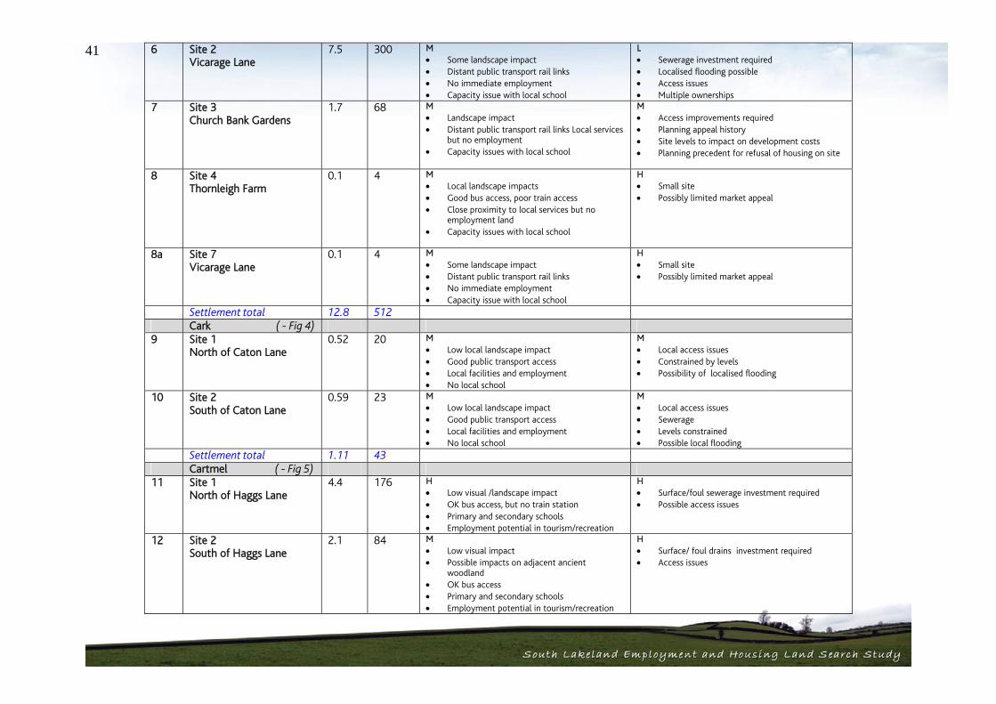
41 6 Site 2 Vicarage Lane
7.5 300 M Some landscape impact Distant public transport rail links No immediate employment Capacity issue with local school
L Sewerage investment required Localised flooding possible Access issues Multiple ownerships
7 Site 3 Church Bank Gardens
1.7 68 M Landscape impact Distant public transport rail links Local services
but no employment Capacity issues with local school
M Access improvements required Planning appeal history Site levels to impact on development costs Planning precedent for refusal of housing on site
8 Site 4 Thornleigh Farm
0.1 4 M Local landscape impacts Good bus access, poor train access Close proximity to local services but no
employment land Capacity issues with local school
H Small site Possibly limited market appeal
8a Site 7 Vicarage Lane
0.1 4 M Some landscape impact Distant public transport rail links No immediate employment Capacity issue with local school
H Small site Possibly limited market appeal
Settlement total 12.8 512
Cark ( - Fig 4) 9 Site 1
North of Caton Lane 0.52 20 M
Low local landscape impact Good public transport access Local facilities and employment No local school
M Local access issues Constrained by levels Possibility of localised flooding
10 Site 2 South of Caton Lane
0.59 23 M Low local landscape impact Good public transport access Local facilities and employment No local school
M Local access issues Sewerage Levels constrained Possible local flooding
Settlement total 1.11 43 Cartmel ( - Fig 5) 11 Site 1
North of Haggs Lane 4.4 176 H
Low visual /landscape impact OK bus access, but no train station Primary and secondary schools Employment potential in tourism/recreation
H Surface/foul sewerage investment required Possible access issues
12 Site 2 South of Haggs Lane
2.1 84 M Low visual impact Possible impacts on adjacent ancient
woodland OK bus access Primary and secondary schools Employment potential in tourism/recreation
H Surface/ foul drains investment required Access issues

42
13 Site 3 Camping Site
1.1 44 L Local visual impact OK bus access Primary and secondary school Employment potential in tourism/recreation
L Flood risk issues Impact of relocating current business Conservation area designation Potential archaeology interest
Settlement total 7.6 304 Endmoor ( - Fig 6) 14 Site 1
North of Main Street 4.6 184 M
Local visual impact Bus access good, distant train access Primary school Good local services and employment close by
H More than one land ownership Limited public transport investment required
15 Site 2 South of Dovenest Lane
2.3 92 M Local visual and landscape impact Bus access good, distant train access Primary school Good local services and employment
M No surface water to foul/combined sewer Access difficulties More than one land ownership Site levels
Settlement total 6.9 276 Flookburgh ( - Fig 4) 16 Site 1
North of Allithwaite Road 0.80 32 H
Good public transport – bus and rail Good services including school and
employment
H Surface/foul water sewerage Noise attenuation possibly required
17 Site 2 South of Allithwaite Road
0.50 20 H Visual impact from Allithwaite Road Good public transport – bus and rail Good services including school and
employment
H Surface/foul water sewerage Noise attenuation possibly required
18 Site 3 South of Market Street
1.11 44 H Good bus and train access Good services including school and
employment
H Surface/foul water sewerage Noise attenuation possibly required
19 Site 4 Mire Side, Winder Lane
6.63 265 M Visual impact to Ravenstown and Business
Park Good public transport access Good access to services Flood risk
L Access issues Flood risk on part of site – attenuation or
reduced capacity may be required Surface/foul water sewer issues
Settlement total 9.04 361
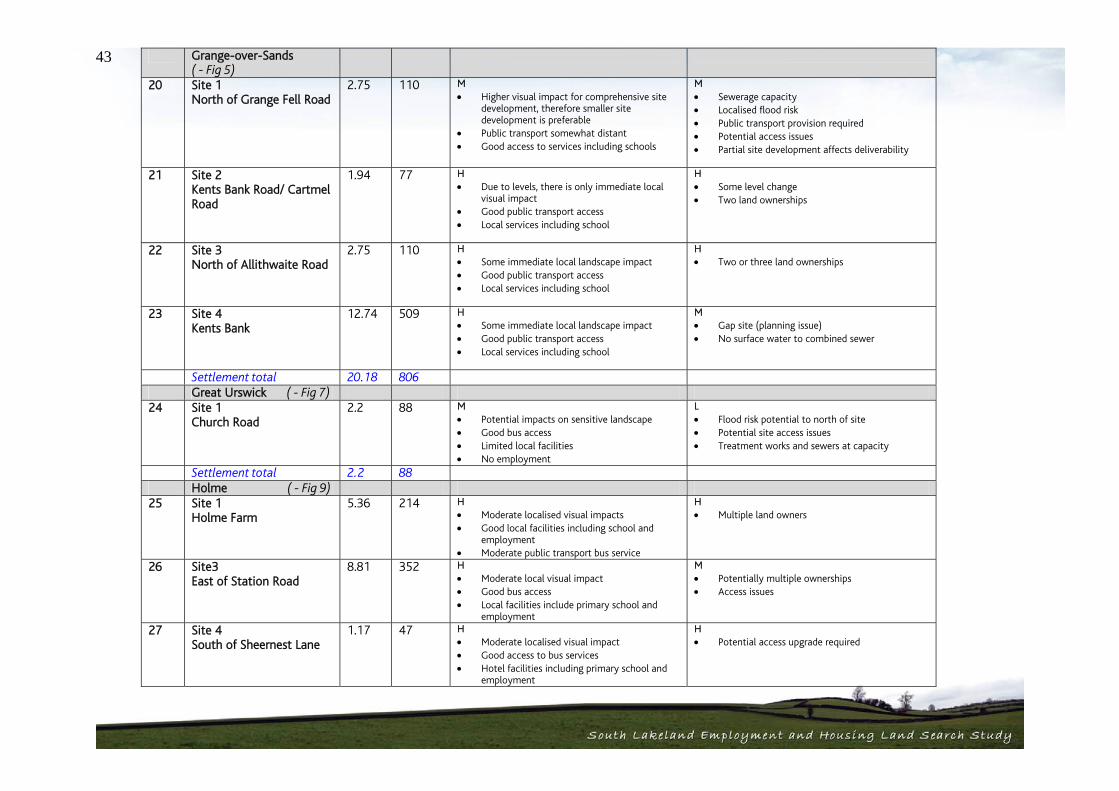
43 Grange-over-Sands ( - Fig 5)
20 Site 1 North of Grange Fell Road
2.75 110 M Higher visual impact for comprehensive site
development, therefore smaller site development is preferable
Public transport somewhat distant Good access to services including schools
M Sewerage capacity Localised flood risk Public transport provision required Potential access issues Partial site development affects deliverability
21 Site 2 Kents Bank Road/ Cartmel Road
1.94 77 H Due to levels, there is only immediate local
visual impact Good public transport access Local services including school
H Some level change Two land ownerships
22 Site 3 North of Allithwaite Road
2.75 110 H Some immediate local landscape impact Good public transport access Local services including school
H Two or three land ownerships
23 Site 4 Kents Bank
12.74 509 H Some immediate local landscape impact Good public transport access Local services including school
M Gap site (planning issue) No surface water to combined sewer
Settlement total 20.18 806 Great Urswick ( - Fig 7) 24 Site 1
Church Road 2.2 88 M
Potential impacts on sensitive landscape Good bus access Limited local facilities No employment
L Flood risk potential to north of site Potential site access issues Treatment works and sewers at capacity
Settlement total 2.2 88 Holme ( - Fig 9) 25 Site 1
Holme Farm 5.36 214 H
Moderate localised visual impacts Good local facilities including school and
employment Moderate public transport bus service
H Multiple land owners
26 Site3 East of Station Road
8.81 352 H Moderate local visual impact Good bus access Local facilities include primary school and
employment
M Potentially multiple ownerships Access issues
27 Site 4 South of Sheernest Lane
1.17 47 H Moderate localised visual impact Good access to bus services Hotel facilities including primary school and
employment
H Potential access upgrade required
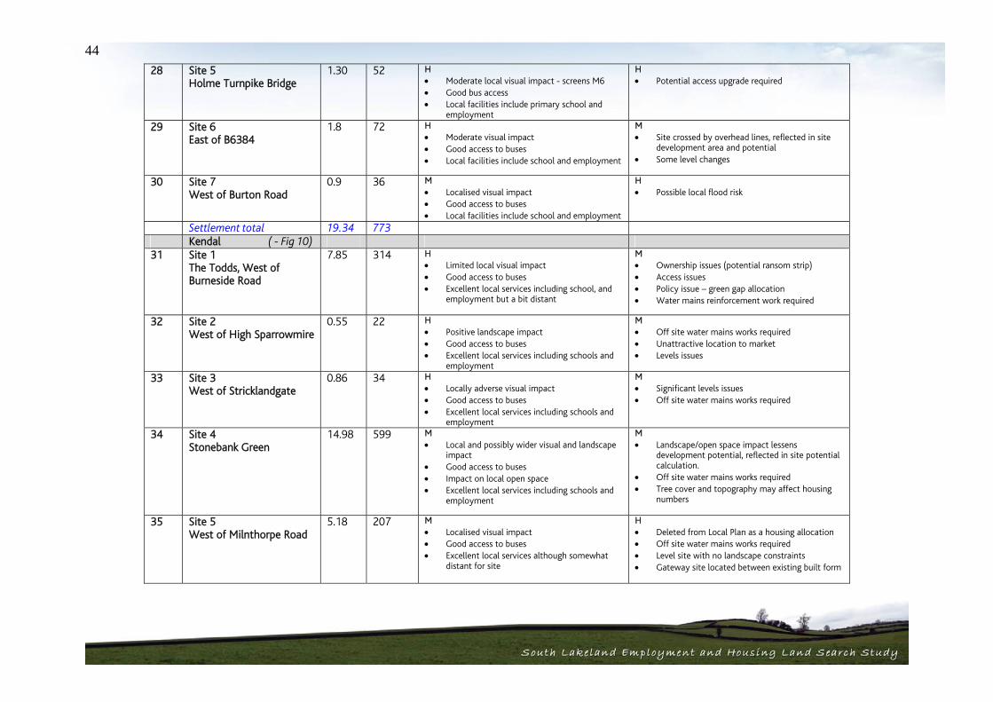
44 28 Site 5
Holme Turnpike Bridge 1.30 52 H
Moderate local visual impact - screens M6 Good bus access Local facilities include primary school and
employment
H Potential access upgrade required
29 Site 6 East of B6384
1.8 72 H Moderate visual impact Good access to buses Local facilities include school and employment
M Site crossed by overhead lines, reflected in site
development area and potential Some level changes
30 Site 7 West of Burton Road
0.9 36 M Localised visual impact Good access to buses Local facilities include school and employment
H Possible local flood risk
Settlement total 19.34 773 Kendal ( - Fig 10) 31 Site 1
The Todds, West of Burneside Road
7.85 314 H Limited local visual impact Good access to buses Excellent local services including school, and
employment but a bit distant
M Ownership issues (potential ransom strip) Access issues Policy issue – green gap allocation Water mains reinforcement work required
32 Site 2 West of High Sparrowmire
0.55 22 H Positive landscape impact Good access to buses Excellent local services including schools and
employment
M Off site water mains works required Unattractive location to market Levels issues
33 Site 3 West of Stricklandgate
0.86 34 H Locally adverse visual impact Good access to buses Excellent local services including schools and
employment
M Significant levels issues Off site water mains works required
34 Site 4 Stonebank Green
14.98 599 M Local and possibly wider visual and landscape
impact Good access to buses Impact on local open space Excellent local services including schools and
employment
M Landscape/open space impact lessens
development potential, reflected in site potential calculation.
Off site water mains works required Tree cover and topography may affect housing
numbers
35 Site 5 West of Milnthorpe Road
5.18 207 M Localised visual impact Good access to buses Excellent local services although somewhat
distant for site
H Deleted from Local Plan as a housing allocation Off site water mains works required Level site with no landscape constraints Gateway site located between existing built form

45
36 Site 6 South of Oxenholme Road
13.42 537 H Limited localised visual impact Excellent public transport access Local services including schools and
employment somewhat distant from site
M Green Gap Local Plan (planning) Off site water mains works required Public transport provision Potential relocation site for Kendal Rugby Club
37 Site 7 Parkside Road
1.15 46 M Limited localised visual impact Excellent public transport access Local services including schools and
employment somewhat distant from site
M Levels issues limits potential access Off site water mains works required
38 Site 8 Castle Green Road
6.33 253 H Localised visual impact Good access to buses Excellent local services although somewhat
distant for site
M Off site water mains works required Potential land assembly issues
39 Site 9 South of Peat Lane
3.47 139 H Local visual impact Good access to buses Good access to services including schools and
employment
M Off site water mains works required Land assembly issues Potential site drainage issues
Settlement total 53.79 2151 Kirkby-in-Furness
( - Fig 11)
40 Site 1 Four Lane Ends
2.1 84 H Localised visual impact Good access to public transport Local services including employment and
primary school
M Possible local flood risk Overhead pylons affect development potential of
site – reflected in site area and potential capacity Level change Improved public transport required
41 Site 2 Sand Side
0.94 37 H Impact on distant views for existing residents Good access to public transport Local services including employment and
primary school
M Single land ownership Surface water drainage required Possible local flooding Improved public transport provision required
Settlement total 3.04 121

46
Kirkby Lonsdale ( - Fig 12) 42 Site 1
Harling Bank 2.67 106 H
Minimal visual / landscape impact Good access to buses Good access to services including schools and
employment
M Sewerage treatment at capacity Access issues Bordered by floodplain No gas connection The Thirlmere Aquaduct passes outwith, but
immediately to the west of this site.
43 Site 2 Bentinck Road
6.85 274 H Local visual impact Good access to uses Excellent access to local services including
schools and jobs Site poorly served by public transport
M Issues of ownership Levels issues No surface water/combined sewer No gas connection The Thirlmere Aquaduct crosses the site QES Rugby Pitch on Western end of site
44 Site 3 Bridge Brow
0.77 30 H Potentially improves visual aspect Good access to buses Good local services including schools and
employment
M Mains water reinforcement required No gas connections
Settlement total 10.29 410 Levens ( - Fig 13) 45 Site 1
Brigsteer Road/Whitegate 4.4 176 H
Some specific local visual impact Good access to buses Some local services close by, including school,
no local employment
M Sewage treatment works investment required Possible localised flooding Additional bus services required
46 Site 2 Land to the east of Levens Lane
7.5 300 H Localised visual impacts, some wider views
affected Good access to buses Local facilities in proximity, including school
but no employment
M Possible multiple ownerships Possible localised flooding Additional bus services required
Settlement total 11.9 476 Milnthorpe ( - Fig 14) 47 Site 2
Hartland House 0.72 28 H
Low visual impact Good access to buses Excellent access to services including schools
and employment
M No surface water to foul sewer Possible local flood risk

47
48 Site 3 North of Kirkgate Lane
4.6 184 M Well integrated to settlement with visual
impact from the north Good access to buses Excellent access to services including schools
and employment
H Possible access issues
Settlement total 5.32 212 Natland ( - Fig 15) 49 Site 1
North of Hawes Lane 0.49 20 H
Moderate adverse visual impact Close proximity to bus stop but limited service
frequency Good local services and close to Kendal
H Possible site drainage issues Some public transport investment required
50 Site 2 South of Hawes Lane
0.64 25 H Potentially beneficial visual impact Close proximity to bus stop but limited service
frequency Good local services and close to Kendal
M Public transport required Surface to foul/combined sewer required Possible local flooding
51 Site 3 West of Robby Lea Drive
0.90 36 H Some limited local visual impact Good local services and close to Kendal Close proximity to bus stop but limited service
frequency
M Public transport investment required Localised drainage / geology issues Land ownership
52 Site 4 Longmeadow Lane
3.52 140 H Local and wider views affected Good local services and close to Kendal Close proximity to bus stop but limited service
frequency
M Potential multiple ownerships Possible local flood risk Public transport investment required
Settlement total 5.55 221 Oxenholme ( - Fig 15) 53 Site 1
Overdale 0.91 36 M
Moderate local visual impacts Good access to buses and mainline railway Some local facilities and close to Kendal
H Possibly two to three site owners
Settlement total 0.91 36

48
Sandside and Storth ( - Fig 16)
54 Site 1 Yans Lane
5.22 208 M Very low visual impact but sensitive natural
and landscape environs Good access to buses Local services include school and employment
M Designations - AONB, SBI No surface water to combined sewer Potential access issues County Employment Land Availability
55 Site 2 Four Lane Ends
1.58 63 L Low visual impact, but sensitive natural and
landscape environs Local services include school and employment Distant from public transport
M Designations - AONB, SBI
Settlement total 6.8 271
Swarthmoor ( - Fig 17) 56 Site 1
East of Park Road, north 0.63 25 H
Impacts of settlement extension – green gaps Good access to buses Local services including schools and close to
Ulverston
M Green Gap Local Plan Possible local flood risk Car parking congestion/access to A590
57 Site 2 Rufus Lane
3.86 154 H Low visual impact Good access to buses Local services including some distance to
schools but close to Ulverston
M Potential access issues onto trunk road No surface water to foul / combined sewer Possible local flood risk
58 Site 3 West of Ulverston Road
0.64 26 H Low visual impact Good access to buses Local services include schools, main
employment in Ulverston
M Possible access issues onto A590 (Planning) 50 m away from LP Mains
59 Site 4 Cross Moor, south of Main Road
12.64 506 H Low visual impact Good access to buses Local services include schools, main
employment in Ulverston
M Potential traffic issues Potential multiple ownerships Possible local flood risk
60 Site 5 East of Park Road, South
4.49 180 M Some local visual impact and green gap effects Good access to buses Local services are schools including schools
but some distance away, employment in Ulverston
M Green Gap Local Plan Potential site access issues
Settlement total 22.26 891

49
Mixed Use Sites
Site No.
Site / Settlement Size (Ha)
No. of Houses
Sustainability (H/M/L)
Delivery (H/M/L)
Burneside ( - Fig 2)
Site 1 Sharps Lane
1.6
Employment 0.8 Housing 0.8 32
1
Settlement total 1.6 32
H Low environmental / landscape impact Good access to public transport Some pedestrian improvement required Potential impacts on adjacent SAC
M Subject to swap in recreation space Subject to investment in sewers Proximity to SAC requires Habitat Regulations
Burton in Kendal ( - Fig 3)
Site 5 Drovers Way
1.2
Employment 0.6
2
Housing 0.6 24
H Local visual impact OK bus access, poor train access Close proximity to services Capacity issues with local school
H Relatively small site but easily developable Possible Local flood risk Improved pedestrian links to facilities required
Ulverston ( - Fig 17) 61 Site 1
Urswick Road 5.47 218 M
Visual impact on Green Gap Good access to buses Excellent access to services including schools
and employment
L Potential access issues Land ownership issues Green Gap Local PLan Possible local flood risk
62 Site 2 Colt House Lane
0.61 24 H Low visual and landscape impact Good bus access Local services include schools but a bit distant,
employment in Ulverston
H Possible local flood risk
63 Site 3 Mountbarrow Road
12.3 492 H Potential to form an improved settlement
edge Good access to buses Good local services and proximity to Ulverston
M Possible local flood risk LP Mains 100 m to north east Site currently in use
Settlement total 18.38 734

50
Site 6 Station Lane, north
1.5
Employment 0.75 Housing 0.75 30
3
Settlement total 2.7 54
H Some local visual impact OK bus access, poor train access Close proximity to services Capacity issues with local school
H Relatively small site but easily developable Improved pedestrian facilities required
Holme ( - Fig 9)
Site 2 West of Station Road
8.56
Employment 4.28 Housing 4.28 171
4
Settlement total 8.56 171
H Potential for landscape and visual
improvement Good access to buses Local facilities including school and
employment
M Potential contamination Potential localised flood risk Complex ownership No surface / foul combined sewer
Kendal ( - Fig 10)
Site 10 Appleby Road (A685)
18.3
Employment 9.15 Housing 9.15 366
5
Settlement total 18.3 366
M Some intermittent visual impacts Good access to buses Local schools a bit distant Good access to services and jobs
M Off site water mains Possible drainage issues Housing allocation Bus services provision required Leisure use on part of site Overhead power cables affect development
potential. This has been reflected in site development potential
Milnthorpe ( - Fig 14)
Site 1 Grisleymires Lane
14.6
Employment 7.3 Housing 7.3 292
6
Settlement total 14.6 292
H Limited visual impact Good access to buses Local services including schools and
employment
H Possible site ownership issues Possible localised flood risk
Ulverston ( - Fig 17)
Site 4 West End Farm
7.62
Employment 3.81 Housing 3.81 152
7
Settlement total 7.62 152
M Potential for wider visual impact Good bus access Good local services
M Sewer network issues No surface to foul / combined sewer Improved public transport required

51
Employment Sites (Local Strategic)
Site No.
Site / Settlement Size (Ha)
Sustainability (H/M/L)
Delivery (H/M/L)
A590/A591 Junction
( - Fig 13)
1 Site 1 9.4 L Some visual impact Limited accessibility to public transport and
non car modes Nearest facilities somewhat distant
M Flood risk area covers part of the site Concerns over accessibility
2 Site 2 12.7 L Local views impacted Limited accessibility for public transport
and non car modes Nearest services distant Some ecological issues
M Possible ecological issues Possible flood risk issues Concerns over accessibility
3 Site 3 11.3 L Local views impacted Limited accessibility for public transport
and non car modes Nearest services distant Some ecological issues
L Poor market profile Access issues MP Mains 900m from site
4 Site 4 6.3 L Limited visual impact Good access to buses Limited access to other non-car modes Facilities distant
L Major utilities infrastructure required Concerns over accessibility
5 Site 5 8.2 L Limited visual impact Good access to buses Limited access to other non-car modes Facilities distant
M Accessibility concerns Lower profile than other sites
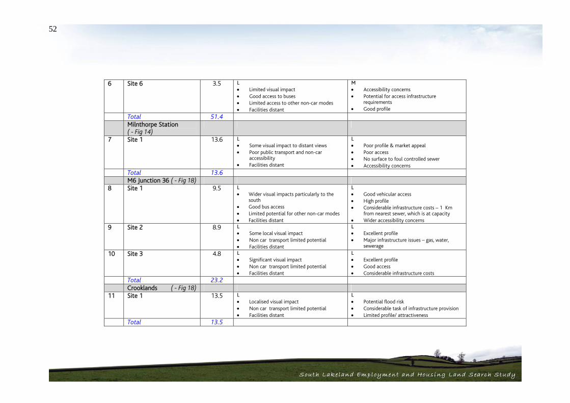
52
6 Site 6 3.5 L
Limited visual impact Good access to buses Limited access to other non-car modes Facilities distant
M Accessibility concerns Potential for access infrastructure
requirements Good profile
Total 51.4 Milnthorpe Station
( - Fig 14)
7 Site 1 13.6 L Some visual impact to distant views Poor public transport and non-car
accessibility Facilities distant
L Poor profile & market appeal Poor access No surface to foul controlled sewer Accessibility concerns
Total 13.6 M6 Junction 36 ( - Fig 18) 8 Site 1 9.5 L
Wider visual impacts particularly to the south
Good bus access Limited potential for other non-car modes Facilities distant
L Good vehicular access High profile Considerable infrastructure costs – 1 Km
from nearest sewer, which is at capacity Wider accessibility concerns
9 Site 2 8.9 L Some local visual impact Non car transport limited potential Facilities distant
L Excellent profile Major infrastructure issues – gas, water,
sewerage
10 Site 3 4.8 L Significant visual impact Non car transport limited potential Facilities distant
L Excellent profile Good access Considerable infrastructure costs
Total 23.2 Crooklands ( - Fig 18) 11 Site 1 13.5 L
Localised visual impact Non car transport limited potential Facilities distant
L Potential flood risk Considerable task of infrastructure provision Limited profile/ attractiveness
Total 13.5

53
Gateway Proposal
( - Fig 19)
12 Site 1 8.8 L Limited visual impact Poor accessibility to public transport and
non-car modes Nearest facilities distant
M Significant infrastructure costs Electricity pylons a major constraint Possible ecological constraints Access issues
Total 8.8
Employment Sites (Settlements)
Site No.
Site / Settlement Size (Ha)
Sustainability (H/M/L)
Delivery (H/M/L)
Burneside ( - Fig 2) 1 Hall Road 3.5 H
Locally screened views Good access to public transport Good local facilities
L Lack of utilities infrastructure Potential for impacts on adjacent SAC Potential impact of nearby landfill sites Access improvements required
Total 3.5 Cark ( - Fig 4) 2 Site 1
Station Road, south of Railway
1.53 H Some local visual impact Excellent public transport access Facilities in close proximity
H Possible local flood risk
Total 1.53 Holme ( - Fig 9) 3 West of Milnthorpe Road 7.4 M
Local visual impact on residents Good bus access Good local facilities in close proximity
M Issues with current planning consent Possible access issues Overhead pylons Possible local flood risk
Total 7.4

54
Kendal ( - Fig 10) 4 Site 1
Fell View Trading Park, Shap Road
7.7 M Forms part of the industrial backdrop Good bus access but possible town centre
impacts Good access to local facilities
M Possible market demand issues Possible local flood risk Positive planning designation Traffic impact on Kendal town centre
5 Site 2 Natland Road
5.7 L Limited local visual impact Public transport requires improvement Facilities somewhat distant Possible flood risk issues
M Potential flood risk issues Low market demand likely Access investment required
Total 13.4 Oxenholme ( - Fig 15) 6 Burton Road 6.59 M
Limited local visual impact Good bus as to services Impact on ‘green gap’
L No surface water to foul/ combined sewer Possible local flood risk Significant planning and public objection
issues Within Local Plan Green Gap
Total 6.59 Ulverston ( - Fig 17) 7 Site 1
Daltongate 5.22 M
Some local and wider visual impact Good access to buses and rail station Good local services in close proximity Impact on ‘green gaps’
M Within Local PLan Green Gap Possible local flooding Land ownership issues
8 Site 2 Ulverston Canal
28.5 M Highly visible from A590 Poor public transport and non-car access Close proximity to local services
L Flood risk issues Access issues County wildlife site No utilities Limited market demand
Totals 33.72

55
4.4. Site Categorisation When taken together the two scoring parameters of sustainability and deliverability allow for a categorisation of sites. Importantly, at this stage these two parameters have been treated with equal weight. This results in the following categorisation of sites:
Category Sustainability Deliverability
Category 1 High High High Medium Category 2 Medium High
Category 3 Medium Medium High Low Category 4 Low High Medium Low Category 5 Low Medium
Category 6 Low Low The following site categorization has been identified for housing, mixed use and employment sites across the study area. These are also shown on Figure 5 of page 62, following the tables. Housing Sites Category 1
Burneside Site 2 – South of Burneside Hall – 2.4
Cartmel Site 1 – North of Haggs Lane – 4.4 Flookburgh Site 1 – North of Allithwaite Road – 0.80 Flookburgh Site 2 –South of Allithwaite Road – 0.50 Flookburgh Site 3 – South of Market Street – 1.11 Grange-over-Sands Site 2 – Kents Bank Road/ Cartmel Road – 1.94 Grange-over-Sands Site 3 – North of Allithwaite Road – 2.75 Holme Site 1 – Holme Farm - 5.36 Holme Site 4 – South of Sheernest Lane – 1.17 Holme Site 5 – Holme Turnpike Bridge – 1.30 Natland Site 1 – North of Hawes Lane – 0.49 Ulverston Site 2 – Colt House Lane – 0.61
Totals: 12 Sites, 22.83 Ha, 912 homes Category 2
Burton-in-Kendal Site 4 –Thornleigh Farm – 0.1 Burton-in-Kendal Site 7 – Vicarage Lane – 0.1 Cartmel Site 2 – South of Haggs Lane – 2.1 Endmoor Site 1 - North of Main Street – 4.6 Grange-over-Sands Site 4 – Kents Bank– 12.74 Holme Site 3 – East of Station Road – 8.81 Holme Site 6 – East of B6384 – 1.8 Holme Site 7 – West of Burton Road – 0.9 Kendal Site 1 – The Todds, West of Burneside Road – 7.85 Kendal Site 2 – West of High Sparrowmire – 0.55 Kendal Site 3 – West of Stricklandgate – 0.86 Kendal Site 5 – West of Milnthorpe Road – 5.18 Kendal Site 6 – South of Oxenholme Road – 13.42 Kendal Site 8 – Castle Green Road – 6.33 Kendal Site 9 – South of Peat Lane – 3.47 Kirkby-in-Furness Site 1 – Four Lane Ends – 2.1 Kirkby-in-Furness Site 2 – Sand Side – 0.94

56
Kirkby Lonsdale Site 1 – Harling Bank – 2.67 Kirkby Lonsdale Site 2 – Bentinck Road – 6.85 Kirkby Lonsdale Site 3 – Bridge Brow – 0.77 Levens Site 1 – Brigsteer Road/Whitegate – 4.4 Levens Site 2 – Land to the east of Levens Lane – 7.5 Milnthorpe Site 2 – Hartland House – 0. 72 Milnthorpe Site 3 – North of Kirkgate Lane – 4.6 Natland Site 2 – South of Hawes Lane – 0.64 Natland Site 3 – West of Robby Lea Drive – 0.90 Natland Site 4 – Longmeadow Lane – 3.52 Oxenholme Site 1 – Overdale – 0.91 Swarthmoor Site 1 – East of Park Road, north – 0.63 Swarthmoor Site 2 – Rufus Lane – 3.86 Swarthmoor Site 3 – West of Ulverston Road – 0.64 Swarthmoor Site 4 – Cross Moor, South of Main Road – 12.64 Ulverston Site 3 – Mountbarrow Road – 12.3
Totals: 33 Sites, 135.40Ha, 5410 homes Category 3
Burton-in-Kendal Site 3 – Church Bank Gardens – 1.7 Cark Site 1 – North of Caton Lane – 0.52 Cark Site 2 – South of Caton Lane – 0.59 Endmoor Site 2 – South of Dovenest Lane – 2.3 Grange-over-Sands Site 1 – North of Grange Fell Road – 2.75 Kendal Site 4 – Stonebank Green – 14.98 Kendal Site 7 – Parkside Road – 1.15 Sandside and Storth Site 1 – Yans Lane – 5.22 Swarthmoor Site 5 – East of Park Road, South – 4.49
Totals: 9 Sites, 33.7 Ha, 1346 homes
Category 4 N/A Category 5
Arnside Site 2 – Black Dyke Road, north – 0.8 Arnside Site 3 – Black Dyke Road, south – 0.9 Burton-in-Kendal Site 1 – Church Bank Farm – 3.4 Burton-in-Kendal Site 2 – Vicarage Lane – 7.5 Flookburgh Site 4 – Mire Side, Winder Lane – 6.63 Great Urswick Site 1 – Church Road –2.2 Sandside and Storth Site 2 – Four Lane Ends – 1.58 Ulverston Site 1 – Urswick Road – 5.47
Totals: 8 Sites, 28.48 Ha, 1120 homes Category 6
Arnside Site 1 – Knott Lane - 1.3 Cartmel Site 3 – Camping Site – 1.1
Totals: 2 Sites, 2.4 Ha, 96 homes Mixed Use Sites Category 1
Burton in Kendal Site 5 – Sharps Lane – 1.2 Burton in Kendal Site 6 – Station Lane, north – 1.5 Milnthorpe Site 1 – Grisleymires Lane – 14.6

57
Totals: 3 Sites, 17.3Ha Category 2 Burneside Site 1 – Sharps Lane – 1.6 Holme Site 2 – West of Station Road – 8.56 Totals: 2 Sites, 10.16Ha Category 3 Kendal Site 10 – Appleby Road (A685) – 18.3 Ulverston Site 4 – West End Farm – 7.62 Totals: 2 Sites, 25.92 Ha Employment Sites Category 1
Cark – Site 1 Station Road, south of Railway 1.53 Ha Totals: 1 Site, 1.53 Ha Category 2 N/A Category 3
Holme – West of Milnthorpe Road 7.4 Ha Kendal – Site 1, Fell View Trading Estate 7.7 Ha Ulverston – Site 1, Daltongate 5.22 Ha
Totals: 3 sites, 20.32 Ha
Category 4
Burneside – Hall Road 3.5 Ha Totals: 1 Site, 3.5 Ha Category 5
A590/A591 Junction Site 1 – 9.4 A590/A591 Junction Site 2 – 12.7 A590/A591 Junction Site 5 – 8.2 A590/A591 Junction Site 6 – 3.5 Gateway Proposal – 8.8 Kendal Site 2 – 5.7 Oxenholme Burton Road Site – 6.59 Ulverston Site 2 – Ulverston Canal – 28.5
Totals: 8 Sites, 83.39 Ha Category 6
A590/A591 Junction Site 3 – 11.3 A590/A591 Junction Site 4 – 6.3 Milnthorpe Station – 13.6 M6 Junction 36 Site 1 – 9.5 M6 Junction 36 Site 2 – 8.9 M6 Junction 36 Site 3 – 4.8 Crooklands – 13.5
Totals: 7 Sites, 67.9 Ha

58
Figure 5 – Categorised Sites Plan

South Lakeland Housing and Employment Land Search StudySouth Lakeland Housing and Employment Land Search Study
Conclusions 05

59
Section 5 Conclusions 5.1. Development Potential for Employment / Housing As a result of the analysis undertaken in this study, a significant number of potential sites for development have been identified. Where physical constraints and other mitigating factors affect a site, these have been taken into account in the calculation of development potential where it is possible to do so. Any site specific impacts are detailed further in the matrices at Appendix 7:
64 housing sites with a potential for 222.81 Hectares (Ha) of development land which would equate to 8,884 new homes based on an average density of 40 dwellings per Ha (gross).
7 mixed use sites over 6 settlements, leading to 53.38 Ha of
development land. At an average density of 40 units per hectare (gross) this equates to 1067 new residential units alongside 26.69Ha of land for employment uses.
8 employment sites equating to 66.14 Ha of development land
were identified as potential extensions to 6 of the settlements, with 110.50 Ha across 12 potential Local Strategic Employment Sites also identified.
Importantly, however, this is an overly simplistic view and these sites have rightly been subject to further appraisal and categorisation relative to their sustainability and deliverability. This has resulted in the following broad potential being identified:
Housing Category 1 Sites - 12 Sites, 22.83 Ha, 912 homes Category 2 Sites - 33 Sites, 135.40Ha, 5410 homes Category 3 Sites - 9 Sites, 33.7 Ha, 1346 homes Category 4 Sites - N/A Category 5 Sites - 8 Sites, 28.48 Ha, 1120 homes Category 6 Sites - 2 Sites, 2.4 Ha, 96 homes Mixed Use Category 1 Sites - 3 Sites, 17.3Ha Category 2 Sites - 2 Sites, 10.16Ha Category 3 Sites - 2 Sites, 25.92 Ha Category 4 Sites - N/A Category 5 Sites - N/A Category 6 Sites - N/A Employment Sites Category 1 Sites - 1 Site, 1.53 Ha Category 2 Sites - N/A

60
Category 3 Sites - 3 sites, 20.32 Ha Category 4 Sites - 1 Site, 3.5 Ha Category 5 Sites - 8 Sites, 83.39 Ha Category 6 Sites - 7 Sites, 67.9 Ha In terms of housing potential, the picture is encouraging. It is clear that there are a lesser number of sites that are considered to be high in terms of both their sustainability and deliverability credentials (19%). Perhaps more encouraging is the fact that approximately 66% of the sites identified fall within category 2/3 and could be taken forward subject to some mitigative measures. In addition, all of the mixed use sites identified fall within categories 1, 2 and 3 and therefore have potential for development Where significant constraints and site issues are identified in the Appraisal Matrix (Appendix 7) that may affect the development potential of an individual site such as overhead electricity lines, this is reflected in the site potential as categorised in the above figures. Also, when constraints are identified that can be circumnavigated by partial site development; this is identified in the matrix and in the site delivery issues. The picture on employment is somewhat different. Few of the sites score highly in terms of sustainability and deliverability. Those that do are generally those that are in proximity to the existing centres. The local strategic employment sites generally score poorly, particularly in terms of sustainability due to their relative remoteness and poor access to services etc.
5.2. Implications for Strategy The outcomes as set out paint a positive picture for the future allocation of sites for employment and housing development in South Lakeland. Through a robust process of appraisal, a significant number of sites have been identified that have the potential to accommodate development (albeit to varying degrees). An analysis of the identified and categorised sites has a number of spatial implications for the future of the district as follows. 7. There is the potential to focus new development in the key service
centres of Kendal and Ulverston. This also provides for a potentially more sustainable form of development building on existing facilities and services. However, the other key service centres have proved difficult to put forward potential employment and mixed use sites.
8. Grange-over-Sands and Milnthorpe are both physically constrained and therefore, to identify potential new employment and mixed use sites would impact heavily on the environment. Kirkby Lonsdale is also physically constrained, with an exceptional quality of surrounding landscape.
9. There is a good spread of sites across the local service centres with the majority of centres having the potential to accommodate some level of growth.
10. Holme demonstrates considerable potential for growth in addition to Ulverston and Kendal. However it is unlikely that the current services and facilities in the village will be sufficient to accommodate the cumulative impacts of this level of growth. There is potential here to perhaps build on the Government’s current agenda by pushing for this

61
settlement to become an Eco Town providing a different housing offer for the district.
11. Swarthmoor also demonstrates considerable potential for expansion,
which itself raises issues of its role in relation to the key service centre of Ulverston in the long term.
12. The potential for a local strategic employment site is difficult. There
are sustainability issues with many of the sites in terms of their accessibility and proximity to services. The preferred sites in this sense are those that are more closely related to Kendal.
Given this spatial outcome of the study process, it is important to relate these findings back to the emerging options for the South Lakeland Local Development Framework Core Strategy. The 2005 SLDC Core Strategy Issues and Options Report set out three potential alternative Development Strategies as follows: 1. Development focussing on the five key service centres with small
scale development taking place in eight local service centres in accordance with the current joint structure plan.
2. A broader distribution of development expanding the list of local
service centres to include a total of 37 settlements. 3. A balanced approach between options 1 and 2 where the list of
Local Service centres includes 17 settlements, which have reasonably good level of services.
From the work carried out in this study and the outcomes in terms of the identification of sustainable and deliverable sites, Development Strategy 3 would seem to be most closely aligned. There is a focus of development
emerging for the Key Service Centres, however, in addition, there is potential for expansion in the majority of the identified Local Service Centres. Given the level of potential development land identified, there would not seem to be any justification for expanding the list of Local Service Centres further. However, this study has identified that there is considerable potential for growth in Holme and Swarthmoor in visual and landscape terms. These settlements offer spatial options for different scales of further development which could be considered by the Development Strategy.
5.3. Delivery Having identified suitable sites with potential to meet the future requirements for housing and employment development, it is necessary to ensure that development on chosen sites is brought forward. In order to achieve this, some level of intervention by the authority may be beneficial and/or essential. Set out below are a series key actions, applicable to all of the sites identified, that will aid the delivery of development. These actions include:
Proactive identification of site owners, utilising the Land Registry where necessary;
A programme of liaison with site owners to assess interest in taking development forward and to promote development;
Preparation of development briefs for the larger sites, identifying the scale and nature of development sought, in order to provide certainty to owners/developers;
Clearly the level of intervention should be matched to the quality and size of the site and its ability to address the key issues for the authority such as affordability of housing and employment growth. Where there are

62
additional specific delivery issues to be addressed for Category 1 and 2 sites, they are set out below:
Burneside Site 1 - Clarify ownership and broker any necessary land assembly. Development Brief may be required;
Burneside Site 2 – No specific delivery actions; Burton in Kendal Site 4 - No specific delivery actions; Burton in Kendal Site 5 - Development Brief may be required; Burton in Kendal Site 6 - Development Brief may be required; Burton in Kendal Site 7 – No specific delivery actions; Cartmel Site 1 – No specific delivery actions, although the scale of
the site may justify preparation of a Development Brief; Cartmel Site 2 – Clarify land ownership and access requirements; Flookburgh Site 1 – Need to clarify planning position in terms of
protection of allotment. Guidance on noise attenuation from the train line may also be required;
Flookburgh Site 2 - Guidance on noise attenuation from the train line may be required;
Flookburgh Site 3 - Guidance on noise attenuation from the train line may be required;
Endmoor Site 1 – Clarify ownership and broker any necessary land assembly
Grange over Sands Site 2 – Clarify ownership and broker any necessary land assembly
Grange over Sands Site 3 - Clarify ownership and broker any necessary land assembly
Grange over Sands Site 4 - Clarify ownership and broker any necessary land assembly
Holme Sites – Masterplan & Delivery Strategy likely to be required for the expansion of the settlement to include expansion of local shops and services provision and liaison with landowners;
Kendal Site 1 – Clarify ownership and broker any necessary land assembly. Development Brief may be required;
Kendal Site 2 – Most suited to RSL scheme, consult with RSLs to gage interest;
Kendal Site 3 – No specific delivery actions; Kendal Site 5 – No specific delivery actions; Kendal Site 6 – Clarify ownership, and alternative/additional use of
land by Rugby Club. Development Brief may be required; Kendal Site 8 – No specific delivery actions; Kendal Site 9 – Clarify ownership and broker any necessary land
assembly; Kirkby-in-Furness Site 1 – Clarify land ownership and ensure
consultation with National Grid over electricity pylons; Kirkby-in-Furness Site 2 – Clarify specific actions from planning
inquiry; Kirkby Lonsdale Site 1 – No specific delivery actions; Kirkby Lonsdale Site 2 – Clarify ownership and broker any
necessary land assembly; Kirkby Lonsdale Site 3 – No specific delivery actions; Levens Site 1 – Advise on site levels and access; Levens Site 2 – No specific delivery actions; Milnthorpe Site 1 – Clarify ownership and broker any necessary
land assembly. Development Brief may be required; Milnthorpe Site 2 – Advise on site access options; Milnthorpe Site 3 – Advise on site access options; Natland Site 1 – Advise on site drainage issues; Natland Site 2 – No specific delivery actions; Natland Site 3 – Advise on site drainage issues; Natland Site 4 – Advise on site design and noise mitigation issues; Oxenholme Site 1 – No specific delivery actions;
63
Swarthmoor Site 1 – Advise on site access; Swarthmoor Site 2 – Advise on site access; Swarthmoor Site 3 – Advise on site access; Swarthmoor Site 4 – Clarify on Green Gaps allocation; Ulverston Site 2 – No specific delivery actions; Ulverston Site 3 - No specific delivery actions;
5.4. Recommendations The findings from this work will obviously form part of a wider evidence base in developing the emerging core strategy and ultimately the Allocations of Land Development Plan Document. The identified sites need to be considered with the results of the South Lakeland Strategic Housing Land Availability Assessment soon to be commissioned to provide a robust evidence base for future housing policy in South Lakeland in line with the Government’s advice in PPS3. Once the Council have brought the two studies together, it is essential that further consultation is undertaken on these findings. The involvement of stakeholders and the public in the preparation of this work has now raised expectations and given the potential contentiousness of the issues involved further consultation through the LDF process is a key requirement.

64
Appendices 1. Strategic Mapping 2. Market Appraisal Report 3. Results of Public Consultations 4. Policy / Document Review 5. Settlement Landscape Assessments 6. Site Identification Maps 7. Detailed Site Appraisals 8. Suggested Sites


