81


Space-Based Disaster Management: The Need for International Cooperation
ii
Notice: The cosmic study or position paper that is the subject of this report was approvedby the Board of Trustees of the International Academy of Astronautics (IAA). Any opinions,findings, conclusions, or recommendations expressed in this report are those of theauthors and do not necessarily reflect the views of the sponsoring or funding organizations.For more information about the International Academy of Astronautics, visit the IAAhome page at www.iaaweb.org.
Copyright 2010 by the International Academy of Astronautics. All rights reserved.
The International Academy of Astronautics (IAA), an independent nongovernmentalorganization recognized by the United Nations, was founded in 1960. The purposes ofthe IAA are to foster the development of astronautics for peaceful purposes, to recognizeindividuals who have distinguished themselves in areas related to astronautics, and toprovide a program through which the membership can contribute to internationalendeavours and cooperation in the advancement of aerospace activities.
© International Academy of Astronautics (IAA) November 2010. This publication isprotected by copyright. The information it contains cannot be reproduced without writtenauthorization.
Study on SPACE-BASED DISASTER MANAGEMENT: THE NEED FOR INTERNATIONALCOOPERATION
Edited by Ranganath Navalgund, Valery Menshikov and Joseph Akinyede
Printing of this Study was sponsored by:Indian Space Research Organisation (ISRO)ISRO Headquarters, Antariksh Bhavan, New BEL RoadBangalore, India - 560 231 www.isro.org
International Academy of Astronautics6 rue Galilée, Po Box 1268-16,75766 Paris Cedex 16, Francewww.iaaweb.org
ISBN EAN 9782917761120
Cover Illustration: Disaster (source: Roscosmos, Maksimov Space Systems ResearchInstitute, ISRO)

Space-Based Disaster Management: The Need for International Cooperation
1
SPACE-BASED DISASTER MANAGEMENT:THE NEED FOR
INTERNATIONAL COOPERATION
Edited by:Ranganath NavalgundValery Menshikov and
Joseph Akinyede

Space-Based Disaster Management: The Need for International Cooperation
2
Blank

Space-Based Disaster Management: The Need for International Cooperation
3
TABLE OF CONTENTS
Page
Foreword
Gopalan Madhavan Nair, IAA President 5
Preface
Ranganath R. Navalgund, Chair, IAA WG-IV 7
Executive Summary 9
1. Scope 16
1.1 Type of disasters, their damage potential, time-scales 16
1.2 Role of space technology 23
1.3 Collaborative international efforts 33
1.4 Objectives of the study report 35
2. General Context and Status of Major Natural Disasters 37
3. Future Stakes, Issues and Potential Solutions 45
3.1 Overall short-comings in the present-day
space observation systems, in-situ observation
networks and modeling 45
3.2 Solutions through International efforts in place 48
3.2.1 GEOSS 48
3.2.2 UN-SPIDER 48
3.2.3 Sentinel-Asia 49
3.2.4 International Charter "Space and Major Disasters" 49
3.2.5 Disaster Monitoring Constellation (DMC) 50

Space-Based Disaster Management: The Need for International Cooperation
4
3.2.6 GMES- SAFER 51
3.2.7 United Nations Geographical Information
Working Group (UNGIWG) 52
3.2.8 ESCAP/WMO Typhoon Committee and
WMO/ESCAP Panel on Tropical Cyclone 52
3.2.9 IGMASS (International Global Monitoring
Aerospace System): Proposed 53
4. Future Perspectives for International Co-operation 54
Appendix 1 Contributors 68
Appendix 2 References and additional readings 69
Appendix 3 Heads of Space Agencies Summit 76
Appendix 4 IAA in Brief 78

Space-Based Disaster Management: The Need for International Cooperation
5
Foreword
I am pleased to welcome the present International Academy ofAstronautics (IAA) study that will support discussions during the historicHeads of Space Agencies Summit on November 17, 2010 in WashingtonDC, USA. Prepared during a record time of one year with anunprecedented support, this study constitutes one of the four pillars ofthe Summit dialogue.
In addition four successful IAA conferences contributed to the inputof the four studies, namely: the Academy Day in Bremen on planetaryrobotic exploration, the IAA conference in Riga on disaster management,IAA conference in Nagoya on climate change and the Academy Day inPrague on human spaceflight.
I would like to thank the Study group members who have preparedthis study and the Trustees of the Academy who have reviewed it.I would like to particularly thank the Summit Coordinator, Dr. Jean-Michel Contant, IAA Secretary General, who has coordinated these fourstudies and remarkably secured the 25 Heads of Space Agencies, as ofOctober 1st, 2010.
I would also like to extend my thanks to the Co-Chair of the SteeringCommittee and Summit Program Manager, Mrs. Corinne Jorgenson,President, Advancing Space and the Co-Chair of the Steering Committee,Mrs. Mary Snitch, Director, Lockheed Martin Corporation for their valuablecontributions to the studies and Summit preparation.
After 50 years of existence the International Academy of Astronauticsis recognized by space agencies as a unique elite body that can helpadvancing international cooperation. It has been observed that muchcurrent cooperation programs are aging such as the International SpaceStation (ISS) initiated with just a few countries. Many newcomers arejoining the club of emerging space countries and more than half of thecurrent space agencies did not exist at the beginning of ISS. The result

Space-Based Disaster Management: The Need for International Cooperation
6
is a need to enlarge significantly the circle of the current partners forinternational space cooperation.
The IAA with members from all over the world is engaged in extendingthe frontiers of knowledge in space exploration and also its applicationsto solve the day-to-day problems of humankind. Academicians haveworked in unison to achieve the set goals of the Academy and itis inspiring to note the many IAA emerging activities. In view of theSummit achieving successful concrete preliminary results, many spaceagencies have already welcomed the Academy serving as catalyst foryears to come with several subsequent implementation meetings andstudies.
Gopalan Madhavan NairPresidentInternational Academy of Astronautics

Space-Based Disaster Management: The Need for International Cooperation
7
Preface
Space-borne remote sensing has been playing an important role inidentifying disaster sites, assessing damage and risk, monitoring disastersituations and providing early warning. A large number of initiatives havebeen taken up by the international space agencies as well as manyother multilateral forums to establish mechanisms for making availablespace data and its products for the managers in different phases ofdisasters. However, it has not been possible to provide the right type ofdata at the right time in the right format to the end stakeholders inmitigating the disasters at all times. For some of the disasters, earlywarning methods have been inadequate. In this context, the InternationalAcademy of Astronautics (IAA) has commissioned a study, through theWorking Group on Disaster Management/Natural Hazards, to reach abroad consensus on international cooperation and coordination at thehighest level to consider new initiatives of cooperation, avoiding anyduplication of on-going efforts as well as foster closer internationalcoordination to strengthen the effectiveness and support of global spaceactivities.
The Working Group prepared an outline of the study report and alsocirculated a brief note listing a number of issues related to the theme,present state-of-the-art in various aspects of disasters, inadequacies inthe observation systems, kinds of satellite constellations required, etc.Based on the reports generated by various members of the workinggroup followed by discussions through teleconferences, a draft reportwas prepared and circulated within the group. The draft was alsodiscussed at the 2nd International Symposium on Space and GlobalSecurity of Humanity organised at Riga, Latvia during July 5-9, 2010. Inaddition, several rounds of discussion with IAA Steering Committeemembers took place. Based upon these discussions as well as thefeedback received from the Trustees of the IAA, this document has beengenerated. The document provides scope of the present study, generalcontext and status of space technology vis-à-vis major natural disasters,

Space-Based Disaster Management: The Need for International Cooperation
8
over all shortcomings in the space observations at present, in-situobservation networks, modeling, various international efforts in placeand suggests future course of action required for international cooperationto effectively use space technology in various phases of disastermanagement including better early warning methods.
As Chair of the Working Group, I would like to place on record myappreciation to the Co-Chair and members of the Working Group onDisaster Management/Natural Hazards, Dr. Jean-Michel Contant, IAASecretary General, Mrs. Corinne Jorgenson, President, Advancing Spaceand the Co-Chair of the Steering Committee, representatives of spaceagencies, my colleagues at the Space Applications Centre/ISRO, and allthose who provided necessary background material, in compiling thisdocument.
Ranganath NavalgundChair, IAA Working Group onDisaster Management/Natural Hazards

Space-Based Disaster Management: The Need for International Cooperation
9
Executive Summary
Natural disasters are events, which are caused by purely naturalphenomena and bring damage to human societies (such as geophysical– earthquake, volcano, landslides, land subsidence; hydrological – floods,avalanche, debris flow; meteorological – cyclone, snow storm, duststorms, tornado; climatological – extreme temperature, drought, wildfire; biological – epidemics, insect infestations and extra-terrestrial-meteorite/asteroid impacts). Human-induced disasters are naturaldisasters that are accelerated / aggravated by human influence. Naturalevents cannot be prevented, but potential disasters can be 'managed'to minimise loss of life and properties through disaster management.Space based Disaster Management System has the distinct advantageof being unaffected by disasters on the ground and provides unbiased,synoptic and timely information on different components of the disastermanagement cycle.
However, even with the availability of large spectrum of EarthObservation (EO) data, development of communication technologies,and building of international networks; availability of right information toright people at right time in right format is still a major challenge. In thiscontext, this IAA study report on Disaster Management/ Natural Hazardsoutlines the current status of the space-based disaster managementtechnology for different disasters, identifies the gap areas, and suggestspossible improvements for real-time integrated solutions. One of theimportant aspects, which the study attempts to highlight, is thedevelopment of early warning systems, where international collaborativeresearch effort would be necessary to develop forecasting models, inwhich EO data can be assimilated for more accurate warning system(s).
Present day earth observation satellites are designed to meetrequirements of wide-ranging applications and do not full-fill specificrequirements of disaster prediction, monitoring and mitigation. Spaceresources, both EO satellites as well as communication satellites, needto be pooled together for disaster management purposes. The existing

Space-Based Disaster Management: The Need for International Cooperation
10
network of ground stations receiving satellite data is inadequate forglobal coverage, therefore countries/space agencies need to establishas well strengthen existing ground infrastructure for receiving satellitedata. Current available expertise to process raw satellite data intomeaningful products for disaster management is limited to a few countries/few Institutes. Rigorous and time-tested early warning/ forecasting modelsneed to be developed. Robust decision support systems are necessary.Operational institutional arrangements among satellite operators, remotesensing service providers, disaster management authorities and responseaction headquarters require to be established with standardized valueadded products, services and delivery channels with specific disasterresponse plans during disaster emergency response. There is a gapbetween existing information products of space agencies or remotesensing centres and the information requirement of disaster managers.There is poor networking between data provider and user agencies,thus making the utility of spatial data limited. The public Internet serviceis observed to be inadequate in providing access to large volume ofspace based information data in many countries.
Disaster is a global phenomenon. Any disaster that strikes does notrestrict itself to administrative boundary. Even if its effect is limited to aparticular country, it becomes a global concern for response and relief.Hence, it is essential to have a network of various internationalorganizations working towards disaster management, more particularlyin the field of utilization of space technology for disaster management.
At present, there exist a number of international commitments ofspace agencies to share their space resources for disaster affectednations. Some of these initiatives are operational, some are semi-operational, while some are at initial stages of formulations. The GlobalEarth Observation System of Systems (GEOSS) provides platformto integrate Earth observations with other information to help plannersreduce vulnerability, strengthen preparedness and early-warningmeasures and, after disaster strikes, rebuild housing and infrastructure

Space-Based Disaster Management: The Need for International Cooperation
11
in ways that limit future risks. UN-SPIDER acts as an open network ofproviders of space-based solutions to support disaster managementactivities. This includes all types of information provided by earthobservation satellites, communication satellites and global navigationsatellite systems. Sentinel Asia is a "voluntary and best-efforts-basisinitiatives" led by the APRSAF (Asia-Pacific Regional Space AgencyForum) to share disaster information in the Asia-Pacific region on theDigital Asia (Web-GIS) platform and to make the best use of earthobservation satellites data for disaster management in the Asia-Pacificregion.
International Charter on Space and Major Disasters, initiated byESA and CNES following the Third United Nations Conference on theExploration and Peaceful Use of Outer Space (UNISPACE III) in 1999has currently, ten member space agencies. The Charter is an internationalagreement between space agencies (not between States), making theirresources available on a best effort basis to emergency operations atthe request of a world wide Authorized Users base. The Charter, fullyoperational since November 2000, is a successful case of internationalcooperation and has been activated more than 265 times in 90 countriesover all continents for a variety of disasters.
The Disaster Monitoring Constellation (DMC) consists of a group ofsatellites independently owned and controlled by a separate nation, butall satellites have been equally spaced around a sun-synchronous orbitto provide daily imaging capability. The countries involved are Algeria,China, Nigeria, Turkey, UK and Spain. The DMC has both multi-spectralsensors with 22-32 m resolution and panchromatic sensors with 4 mresolution. The DMC Consortium has agreed to consider participation inthe International Charter for Space and Major Disasters, contributingdaily imaging capability to fill the existing 3-5 day response gap. TheEuropean initiative GMES (Global Monitoring for Environment andSecurity) proposes to provide information useful in a range of issuesincluding climate change and citizen's security, land, risks, ocean and

Space-Based Disaster Management: The Need for International Cooperation
12
atmosphere. In the frame of the GMES initiative, SAFER (Services andApplications For Emergency Response) project aims at preparing theoperational implementation of the Emergency Response Service (ERS).SAFER provides civil protection authorities and humanitarian relieforganizations with a rapid mapping capacity when natural disasters occurand in the context of complex crises. United Nations GeographicalInformation Working Group (UNGIWG) is a network of professionalsworking in the fields of cartography and geographic information scienceto building the United Nations Spatial Data Infrastructure needed toachieve sustainable development and emergency responses. ESCAP/WMO Typhoon Committee and WMO/ESCAP Panel on Tropical Cycloneis an ESCAP-affiliated regional cooperation mechanism jointly workingwith the Tropical Cyclone Programme of the World MeteorologicalOrganization. The International Global Monitoring Aerospace System(IGMASS) is a study proposal to create a system to provide well-timedwarning to the international community about coming disasters andemergencies, natural and man-caused disasters through a globaland operational forecasting with the use of scientific and technicalpotential of earth-based, air and space monitoring all over the worldand the further development and gradual integration of navigation,telecommunication and information resources of the planet to solve thehumanitarian problems of Humanity.
An analysis of various space-based disaster management techniquesand the status of different international networks showed that, the currentcapability is mostly at the level of post-disaster monitoring and damageassessment. Early warning is still a research issue. Even most of theinternational networks are limited to providing near real-time EO data forpost-disaster activities. Though, it has been an important dimension, itdoes not suffice the complete space based disaster managementrequirement. Apart from this, the space technology development andapplications are at different levels in different countries. Especially indeveloping and under-developed nations, where impact of disaster isvery high, the space capability is either nil or very limited making them

Space-Based Disaster Management: The Need for International Cooperation
13
more susceptible. All these necessitate strong international cooperation.In order to achieve the goals of disaster risk reduction and management,it is essential to explore and establish information sharing and productservice modes and mechanisms among different countries, thereby tostrengthen the exchanges and cooperation on relevant experience andto narrow the gap between developed and developing countries.
Having considered the significant role played by space technologyin all phases of disaster management and the various initiativesundertaken by the national, regional and international organizations, aswell as gaps in the existing observational platforms and early warning/forecasting methods, the Study Group recommends following:
– Strengthen existing network of earth observation satellites (opticaland radar sensors) through virtual constellations, ensuring theircontinuity and establish a mechanism for proper orbit allocation,satellite tasking for emergencies and meeting rush access ofEO data. It is very important to not only acquire 'good' data butalso to be able to disseminate as quickly as possible usabledata to the end users. A possible satellite constellation of 20 EOsatellites shall provide temporal resolution of 3 hrs for globalcoverage.
– Strengthen existing mechanism of International Co-operation.Efforts should be made to strengthen the UN-SPIDER, GEOSSand ISPRS Disaster Management Program for more globalcoverage. Every country should be encouraged to participate insuch internationally recognized programs. There should becommitment from each country, to provide all possible support,in form of data sharing, capacity building, etc. to the affectednations.
– Strengthen collaborative efforts for developing early warningmodels. An international team should carry out research andmodeling activity for forecasting, which should be provided with

Space-Based Disaster Management: The Need for International Cooperation
14
all forms of data support from all space organizations. This shouldbe supported by the local governments for building technicalinfrastructure towards intensive field data collections. The earlywarning programs of GEOSS, UN-SPIDER, IGMASS and otherregional/international initiatives should be supported andstrengthened.
– Strengthen communications network by including low earth orbitcommunication satellites/Data Relay Satellite System (DRSS)and make available adequate band widths so that availability ofdata becomes easier. Attempts should be made to augmentamateur radio (Ham Radio) service, which are highly usefulduring post-disaster activity.
– Create a policy for data sharing and making available all EOdata in standard format, along a common framework with properlydefined meta-data and processed to useful derived productswith different thematic layers in the same format. The efforts ofCEOSS towards data standardization should be strengthened.Sharing of value added data products at nominal cost should bethrough a mechanism of coordination among existing internationalprograms/initiatives on space and disasters. It is noted thatpresently, all the acquired data, including VHR (Very HighResolution) data are available to all the actors in the frame ofthe International Charter on Space and Major Disasters.However, the users are waiting for products (maps) rather thanraw data, which are totally unusable for them.
– Improve efforts for capacity building. There is need to developnew regional and global institutes of disaster management andto strengthen existing ones in order to effectively conduct regularcourses/trainings especially for the representatives of lessdeveloped countries. IAA can play a great role by preparingbrochures and bulletins in easy and multiple languages, to explainthe scope of EO data for disasters management. IAA may

Space-Based Disaster Management: The Need for International Cooperation
15
facilitate preparation of a directory of relevant web sites on allphases of disaster management, which includes GEOSS, UN-SPIDER, and International Charter Web Portals.
– Strengthen regional/national level Networking of Stakeholders(Government and non-government). There is a need for regularinteractions/ meetings/ and workshop between all partners toavoid duplication of efforts. The framework of the activities needsto be defined and responsibilities of each stake-holder shouldbe clearly outlined. This also necessitates regular mock exercisesfor disasters scenarios.

Space-Based Disaster Management: The Need for International Cooperation
16
1. Scope
1.1 Type of disaster, their damage potential, time scales
Disasters are the deadly events causing miseries to mankind andthey are inevitable. A disaster is a serious disruption of the functioningof a community or a society causing widespread human, material,economic or environmental losses which exceed the ability of the affectedcommunity or society to cope using its own resources. A disaster is afunction of the risk process. It results from the combination of hazards,conditions of vulnerability and insufficient capacity or measures to reducethe potential negative consequences of risk. Centre for Research on theEpidemiology of Disasters (CRED) defines a disaster as a "situation orevent, which overwhelms local capacity, necessitating a request tonational or international level for external assistance (definition consideredin EM-DAT); an unforeseen and often sudden event that causes greatdamage, destruction and human suffering".
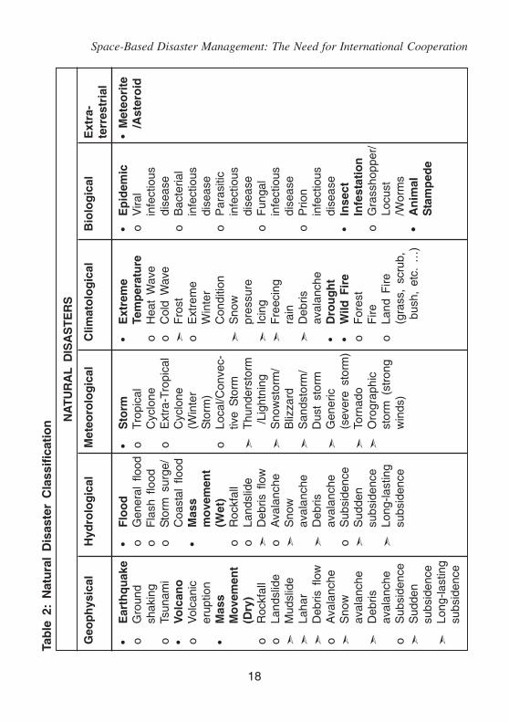
EMDAT (CRED) the international disaster database, distinguishestwo types of disasters, i.e. natural and technological. Natural disastersoccur naturally and are always triggered by natural hazards. EM-DAT(CRED) and NATcatService of Munich Reinsurance Company (MunichRE) databases on natural disasters have been utilized to establish acommon classification of natural disasters (Below et al., 2009) and issummarized in Table 1 and 2.
Table 1: Disaster sub-group definition and classification
Disaster Definition DisasterSubgroup Main Type
Geophysical Events originating from Earthquake,solid earth Volcano, Mass
Movement (dry)
Hydrological Events caused by deviations Flood, Massin the normal water cycle movement (wet)and/or overflow of bodies ofwater caused by wind set-up

Space-Based Disaster Management: The Need for International Cooperation
17
Meteorological Events caused by short-lived Storm/small to meso scaleatmospheric processes (in thespectrum minutes to days)
Climatological Events caused by long-lived/ Extrememeso to macro scale processes Temperature,(in the spectrum from intra- Drought,seasonal to multi-decadal Wild Fireclimate variability)
Biological Disaster caused by the exposure Epidemic,of living organisms to germs and Insect Infestation,toxic substances Animal Stampede
Extra-terrestrial Events caused by Extra –terrestrial sources Meteorite/Asteroid
The technological disasters comprise of three groups:
• Industrial accidents: such as chemical spills; collapses ofindustrial infrastructures; explosions; fires, gas leaks; poisoning;radiation;
• Transport accidents: by air, rail, road or water means of transport;
• Miscellaneous accidents: collapses of domestic/non-industrialstructures; explosions; fires.
Natural disasters are events, which are caused by purely naturalphenomena and bring damage to human societies (such as earthquakes,volcanic eruptions, cyclones). Human made disasters are events, whichare caused by human activities (such as atmospheric pollution, industrial,chemical accidents, major armed conflicts, nuclear accidents, oil spill).Human-induced disasters are natural disasters that are accelerated/aggravated by human influence. It may be noted EO satellites do notprovide information on all types of disasters.
Space-Based Disaster Management: The Need for International Cooperation
18
Tab
le 2
: N
atu
ral
Dis
aste
r C
lass
ific
atio
n NA
TU
RA
L D
ISA
ST
ER
S
Geo
ph
ysic
alH
ydro
log
ical
Met
eoro
log
ical
Clim
ato
log
ical
Bio
log
ical
Ext
ra-
terr
estr
ial
•E
arth
qu
ake
•F
loo
d•
Sto
rm•
Ext
rem
e•
Ep
idem
ic•
Met
eori
teo
Gro
und
oG
ener
al f
lood
oTr
opic
alTe
mp
erat
ure
oV
iral
/Ast
ero
idsh
akin
go
Fla
sh f
lood
Cyc
lone
oH
eat
Wav
ein
fect
ious
oTs
unam
io
Sto
rm s
urge
/o
Ext
ra-T
ropi
cal
oC
old
Wav
edi
seas
e•
Volc
ano
Coa
stal
flo
odC
yclo
ne
Fro
sto
Bac
teria
lo
Vol
cani
c•
Mas
s(W
inte
ro
Ext
rem
ein
fect
ious
erup
tion
mo
vem
ent
Sto
rm)
Win
ter
dise
ase
•M
ass
(Wet
)o
Loca
l/Con
vec-
Con
ditio
no
Par
asiti
cM
ove
men
to
Roc
kfal
ltiv
e S
torm
S
now
infe
ctio
us(D
ry)
oLa
ndsl
ide
T
hund
erst
orm
pres
sure
dise
ase
oR
ockf
all
D
ebris
flo
w /
Ligh
tnin
g
Icin
go
Fun
gal
oLa
ndsl
ide
oA
vala
nche
S
now
stor
m/
F
reec
ing
infe
ctio
us
Mud
slid
e
Sno
wB
lizza
rdra
indi
seas
e
Laha
rav
alan
che
S
ands
torm
/
Deb
riso
Prio
n
Deb
ris f
low
D
ebris
Dus
t st
orm
aval
anch
ein
fect
ious
oA
vala
nche
aval
anch
e
Gen
eric
•D
rou
gh
tdi
seas
e
Sno
wo
Sub
side
nce
(sev
ere
stor
m)
•W
ild F
ire
•In
sect
aval
anch
e
Sud
den
To
rnad
oo
For
est
Infe
stat
ion
D
ebris
subs
iden
ce
Oro
grap
hic
Fire
oG
rass
hopp
er/
aval
anch
e
Long
-last
ing
stor
m (
stro
ngo
Land
Fire
Locu
sto
Sub
side
nce
subs
iden
cew
inds
)(g
rass
, sc
rub,
/Wor
ms
S
udde
n b
ush,
etc
. …
)•
An
imal
subs
iden
ceS
tam
ped
e
Long
-last
ing
subs
iden
ce

Space-Based Disaster Management: The Need for International Cooperation
19
Table 3 & 4 (Westen and Soeters, 2000) provide classification ofdisasters on the basis of gradual scale from purely natural to purelyhuman made and on the basis of main controlling factors.
The world has seen many disasters over the years. In the lastthousand years, there were at least 43 disasters, which took more than100,000 lives each (Hall, 2005). The deadliest earthquake in history hitthe eastern Mediterranean in July 1201. Approximately 1.1 million peoplewere killed, mostly in Egypt and Syria. The worst flood disaster was inChina in 1887. The Yellow River overflowed, causing the death of about900,000 people (some reports say it was a million that perished). Thedeadliest drought in recorded history was in China between 1876 and1879. Rivers became dry, so most crops and livestock died. There wasno food production in a 1-million km2 area of 9 provinces and the droughtcaused the death of an estimated nine million people. In India, about tenmillion people lost their lives from a famine in Bengal, in 1769. In the lastten years (1994-2003), there have been at least 6145 disasters affectingthe world (Source: EM-DAT, 2005). In this period, among the naturaldisasters 75 per cent are hydro-meteorological, followed by 16 per centbiological and 9 per cent geological. If individual disasters are considered,the frequency of occurrence is highest for floods, followed by windstorms,drought & related, epidemic, earthquake & tsunamis and landslides(Figure 1).
Figure 1: Worldwide distribution of natural disaster from 1994-2003(Source: EM-DAT, 2005)

Space-Based Disaster Management: The Need for International Cooperation
20
Tab
le 3
: D
isas
ters
in
a g
rad
ual
sca
le b
etw
een
pu
rely
nat
ura
l an
d p
ure
ly h
um
an-m
ade
and
amen
able
to
sat
ellit
e b
ased
Ear
th O
bse
rvat
ion
s
Nat
ura
lS
om
e h
um
anM
ixed
nat
ura
l/S
om
e n
atu
ral
infl
uen
ceh
um
an i
nfl
uen
cein
flu
ence
Hu
man
Ear
thqu
ake
Flo
odLa
ndsl
ides
Cro
p di
seas
eO
il sp
ills
Tsun
ami
Dro
ught
Sub
side
nce
Inse
ct i
nfes
tatio
nW
ater
Vol
cani
c er
uptio
nD
eser
tific
atio
nF
ores
t fir
epo
llutio
nA
vala
nche
Coa
l fir
esM
angr
ove
decl
ine
Air
pollu
tion
Gla
cial
lak
e ou
tbur
stC
oast
al e
rosi
onC
oral
ree
f de
clin
eC
yclo
neS
ea L
evel
Ris
eA
ster
oid
Impa
ct
Tab
le 4
: M
ain
co
ntr
olli
ng
fac
tors
lea
din
g t
o a
dis
aste
r an
d a
men
able
to
sat
ellit
e b
ased
Ear
tho
bse
rvat
ion
s
Met
eoro
log
ical
Geo
mo
rph
olo
gic
al/
Eco
log
ical
Tech
no
log
ical
Glo
bal
Ext
raG
eolo
gic
alen
viro
nm
enta
lte
rres
tria
l
Dro
ught
Ear
thqu
ake
Cro
p di
seas
eO
il sp
ills
Sea
Lev
elA
ster
oid
Dus
t S
torm
Tsun
ami
Inse
ct i
nfes
tatio
nW
ater
/soi
l/R
ise
impa
ctF
lood
Vol
cani
c er
uptio
nF
ores
t fir
eai
r po
llutio
nE
l N
ino
Win
d st
orm
Land
slid
eG
laci
al l
ake
Pes
ticid
esC
yclo
neA
vala
nche
outb
urst
Man
grov
eS
ubsi
denc
eC
oral
ree
f de
clin
ede
clin
eC
oal
fires
Des
ertif
icat
ion
Coa
stal
ero
sion

Space-Based Disaster Management: The Need for International Cooperation
21
Since the turn of the century, the Emergency Events Database(EM-DAT) has recorded an average of 397 disasters each year. In theyear 2008, more than 235, 000 people were killed, 214 million peoplewere affected and economic costs were over 190 billion US$ by a totalnumber 354 of reported disasters (Rodriguez et al., 2009). The deathtoll was three times higher than the annual average of 66 813 for 2000-2007, mainly caused by two major events: Cyclone Nargis which killed138 366 people in Myanmar and the Sichuan earthquake in China whichcaused the death of 87 476 people. Disaster costs in 2008 were morethan twice the 82 billion US$ annual average for 2000-2007 and weremainly attributed to the Sichuan earthquake in China (85 billion US$)and hurricane Ike in the U.S. (30 billion US$). Asia remained the mostaffected continent. Nine of the top 10 countries with the highest numberof disaster-related deaths were in Asia. While China, the U.S., thePhilippines and Indonesia reported the largest number of natural disasters,Djibouti, Tajikistan, Somalia and Eritrea topped the list of number ofvictims per 100 000 inhabitants.
The deadliest disaster in 2010 was an earthquake that occurred onTuesday 12, January, in Haiti with a catastrophic magnitude 7.0 Mw andan epicentre near the town of Léogâne, approximately 25 km (16 miles)west of Port-au-Prince, Haiti's capital. The Haitian Government reportsthat between 217,000 and 230,000 people have died, an estimated300,000 injured, and an estimated 1,000,000 homeless. It was alsoestimated that 250,000 residences and 30,000 commercial buildingshad collapsed or were severely damaged.
Another major disaster in 2010 was the 2010 Chilean earthquakewhich occurred off the coast of the Maule Region of Chile on February27, 2010 rating a magnitude of 8.8 on the moment magnitude scale andit killed about 497 people.
Developing countries and least developed countries suffer more than92 per cent of all deaths caused by natural disasters (see Table 5). Theirhigh population densities and poor infrastructure, coupled with unstable

Space-Based Disaster Management: The Need for International Cooperation
22
landforms and exposure to severe weather events, makes themparticularly vulnerable.
Table 5: Number of people reported killed by type of disaster andlevel of development (1991 - 2005) source: EM-DAT
Flood Wind Drought Slide Earthquake Volcanic Epide- TotalStorm and eruption mic
tsunami
OECD 2150 5430 47516 426 5910 44 442 61918
CEE+CIS 2635 512 3109 1176 2412 0 568 10412
DevelopingCountries 97061 65258 12599 9369 397303 900 47616 630106
Leastdevelopedcountries 20127 149517 3320 1739 9247 201 70588 254739
Countriesnotclassified 99 767 57 23 2277 0 104 3327
Total 122072 221484 66601 12733 417149 1145 119318 960502
* Drought related disasters category includes extreme temperatures
Figure 2: Number of reported disasters and victims for the period 1989-2008(Rodriguez et al., 2009)

Space-Based Disaster Management: The Need for International Cooperation
23
Disasters belong to the multifarious temporal- and space scales.Some of them appear on the scale of a territory, a region, a country orthe planet, while the others may affect locally. Similarly the timerange of occurrence disasters also vary a lot starting from minutes(earthquake, landslides) to vary slow disasters taking months to develop(e.g. drought). Figure 3 shows the spatial and temporal scales of differentdisasters. The disaster management will vary greatly depending uponthe spatio-temporal scale of disasters.
Figure 3: Spatial and temporal scales of different disasters
1.2 Role of Space Technology
Natural events cannot be prevented, but potential disasters can be'managed' to minimise loss of life and properties through disaster

Space-Based Disaster Management: The Need for International Cooperation
24
management. Disaster management aims to reduce, or avoid the potentiallosses from hazards, assure prompt and appropriate assistanceto victims of disaster, and achieve rapid and effective recovery. TheDisaster management cycle illustrates the ongoing process by whichgovernments, businesses, and civil society plan for and reduce theimpact of disasters, react during and immediately following a disaster,and take steps to recover after a disaster has occurred. Appropriateactions at all points in the cycle lead to greater preparedness, betterwarnings, reduced vulnerability or the prevention of disasters during thenext iteration of the cycle (see Figure 4, Table 6).
The primary concern in disaster management is to prevent a hazard
take the form of a disaster. Pre-disaster planning consists of disaster
prevention, mitigation and preparedness. Disaster response can be
divided into warning phase and emergency relief phase. Recovery is
Figure 4: The disaster management cycle

Space-Based Disaster Management: The Need for International Cooperation
25
the period following relief stage, where ad-hoc measures should
be consciously eschewed and strict adherence enforced to follow
the recommended land use pattern and engineering design and
control.
The importance of disaster monitoring and mitigation has been
included in the UN Millennium Declaration of September, 2000, where
the heads of State and Government have resolved (among other things)
to intensify cooperation to reduce the number and effects of natural and
man-made disasters.
Space based Disaster Management System has the distinct
advantage of being unaffected by disasters on the ground and provides
unbiased, synoptic and timely information on different components of
the disaster management cycle. Space technology has demonstrated a
variety of critical and valuable supports to many disaster management
areas such as assessment, preparedness and mitigation planning, early
warning, impact assessment and emergency communications.
Certain aspects of space and related technologies such as
Geographical Information System (GIS), Global Positioning System
(GPS), remote sensing, and digital photogrammetry have proven to be
crucial for disaster management. The contribution of satellite remote
sensing to earth observation science since the launching of Landsat
in 1972, has made significant development in all dimensions ranging
from high-resolution topography (using Interferrometric SAR, LIDAR, and
digital photogrammetry) and geodesy to passive hyperspectral (such as
ASTER, MODIS and Hyperion) and active microwave imaging have
transformed the discipline (Tralli et al., 2005). Applications of different
spectral channels for disaster management is shown in Table 7 and a
list of current and future optical sensors is presented in Table 8 and
microwave sensors in Table 9.

Space-Based Disaster Management: The Need for International Cooperation
26
Tab
le 6
: A
pp
licat
ion
s o
f re
mo
te s
ensi
ng
in
dis
aste
r m
anag
emen
t
Dis
aste
r
Cyc
lone
Dro
ught
Mit
igat
ion
Ris
k m
odel
ling
Vul
nera
bilit
yan
alys
is
Ris
k m
odel
ling
Vul
nera
bilit
yan
alys
is
Land
and
wat
erm
anag
emen
tpl
anni
ng
Pre
pare
dn
ess
Ear
ly w
arni
ng(t
rack
and
inte
nsity
)
Sto
rm s
urge
pred
ictio
ns
Long
-ran
gecl
imat
e m
odel
ling
Wea
ther
fore
cast
ing
Veg
etat
ion
mon
itorin
g
Cro
p w
ater
requ
irem
ent
map
ping
Ear
ly w
arni
ng a
nddr
ough
t bu
lletin
s
Res
po
nse
Iden
tifyi
ng e
scap
ero
utes
Iden
tify
area
s fo
rpr
ovid
ing
relie
f/aid
Cris
is m
appi
ng
Impa
ct a
sses
smen
t
Cyc
lone
mon
itorin
g
Inun
datio
nm
onito
ring
Mon
itorin
gve
geta
tion
Dam
age
asse
ssm
ent
Rec
ove
ry
Dam
age
asse
ssm
ent
Spa
tial
plan
ning
Info
rmin
gdr
ough
tm
itiga
tion

Space-Based Disaster Management: The Need for International Cooperation
27
Dis
aste
r
Ear
thqu
ake
Fire
Flo
od
Mit
igat
ion
Bui
ldin
g st
ock
asse
ssm
ent
Haz
ard
map
ping
Mon
itorin
g fu
ello
ad
Ris
k m
odel
ling
Del
inea
ting
flood
-pla
ins
Land
use
map
ping
Pre
pare
dn
ess
Mea
surin
g st
rain
accu
mul
atio
n
Iden
tifyi
ngE
arth
quak
epr
ecur
sors
Mic
ro-s
eism
iczo
natio
n
Map
ping
fire
-pr
one
area
s
Fire
det
ectio
n
Pre
dict
ing
spre
ad/
dire
ctio
n of
fire
Ear
ly w
arni
ng
Map
ping
flo
od-
pron
e ar
eas
Flo
od d
etec
tion
Ear
ly w
arni
ng
Rai
nfal
l m
appi
ng
Res
po
nse
Pla
nnin
g ro
utes
for
sear
ch a
nd r
escu
e
Dam
age
asse
ssm
ent
Eva
cuat
ion
plan
ning
Def
orm
atio
n m
appi
ng
Coo
rdin
atin
g fir
e-fig
htin
g ef
fort
s
Flo
od m
appi
ng
Eva
cuat
ion
plan
ning
Dam
age
asse
ssm
ent
Iden
tify
area
s fo
rpr
ovid
ing
relie
f/aid
Rec
ove
ry
Dam
age
asse
ssm
ent
Iden
tifyi
ng s
ites
for
reha
bilit
atio
n
Dam
age
asse
ssm
ent
Dam
age
asse
ssm
ent
Spa
tial
plan
ning

Space-Based Disaster Management: The Need for International Cooperation
28
Dis
aste
r
Land
slid
e
Vol
cano
Mit
igat
ion
Land
slid
e ha
zard
zona
tion
Ris
k m
odel
ling
Ris
k m
odel
ling
Haz
ard
map
ping
Dig
ital
elev
atio
nm
odel
s
Pre
pare
dn
ess
Mon
itorin
g ra
infa
llan
d sl
ope
stab
ility
Ear
ly w
arni
ngm
odel
s
Dig
ital
elev
atio
nm
odel
s
Em
issi
ons
mon
itorin
g
The
rmal
ale
rts
Res
po
nse
Map
ping
affe
cted
area
s
Iden
tify
rout
es f
orpr
ovid
ing
relie
f/aid
Map
ping
lav
a flo
ws
Eva
cuat
ion
plan
ning
Rec
ove
ry
Dam
age
asse
ssm
ent
Spa
tial
plan
ning
Sug
gest
ing
man
agem
ent
prac
tices
Dam
age
asse
ssm
ent
Spa
tial
plan
ning

Space-Based Disaster Management: The Need for International Cooperation
29
Tab
le 7
: A
pp
licat
ion
s o
f d
iffe
ren
t w
aveb
and
s fo
r d
isas
ter
man
agem
ent
Wav
elen
gth
Wav
eban
dUs
eful
for
Exam
ple
sens
ors
Visi
ble
0.4-
0.7µ
mVe
geta
tion
map
ping
SPO
T; L
ands
at T
M,
IRS
- LI
SS, A
WiF
S
Build
ing
stoc
k as
sess
men
tAV
HR
R;
MO
DIS
; IK
ON
OS;
CAR
TOSA
T
Popu
latio
n de
nsity
IKO
NO
S; M
OD
IS
Dig
ital e
leva
tion
mod
elSR
TM,
CAR
TOSA
T,
ASTE
R;
PRIS
M
Nea
r in
frare
d0.
7-1.
0µm
Vege
tatio
n m
appi
ngSP
OT;
Lan
dsat
TM
; AVH
RR
; IR
S, M
OD
IS
IRS-
LISS
, AW
iFS
Floo
d m
appi
ngIR
S, M
OD
IS
Shor
twav
e in
frare
d0.
7-3.
0µm
Wat
er v
apor
AIR
S
Ther
mal
infra
red
3.0-
14µm
Activ
e fir
e de
tect
ion
MO
DIS
Burn
sca
r m
appi
ngM
OD
IS
Hot
spot
sM
OD
IS;
AVH
RR
Volc
anic
act
ivity
MO
DIS
; AV
HR
R
Mic
row
ave
(rada
r)0.
1-10
0cm
Earth
def
orm
atio
n an
d gr
ound
Rad
arsa
t SA
R;
PALS
ARm
ovem
ent
Rai
nfal
lM
eteo
sat;
Mic
row
ave
Imag
er (
aboa
rd T
RM
M)
Riv
er d
isch
arge
and
vol
ume
AMSR
-E
Floo
d m
appi
ng a
nd f
orec
astin
gAM
SR-E
Surfa
ce w
inds
Qui
kSca
t ra
dar,
Oce
ansa
t-2
3D s
torm
stru
ctur
ePr
ecip
itatio
n ra
dar
(abo
ard
TRM
M)
Acr
onym
s: S
atel
lite
Pou
r l'O
bser
vatio
n de
la
Terr
e (S
PO
T);
The
mat
ic M
appe
r (T
M);
Adv
ance
d V
ery
Hig
h R
esol
utio
n R
adio
met
er (
AV
HR
R);
Mod
erat
eR
esol
utio
n Im
agin
g S
pect
rora
diom
eter
(M
OD
IS);
Adv
ance
d S
pace
born
e T
herm
al E
mis
sion
and
Ref
lect
ion
Rad
iom
eter
(A
ST
ER
); P
anch
rom
atic
Rem
ote-
sens
ing
Inst
rum
ent
for
Ste
reo
Map
ping
(P
RIS
M);
Syn
thet
ic A
pert
ure
Rad
ar (
SA
R);
Pha
sed
Arr
ay t
ype
L-ba
nd S
AR
(P
ALS
AR
); T
ropi
cal
Rai
nfal
l M
easu
ring
Mis
sion
(T
RM
M);
Glo
bal
Pre
cipi
tatio
n M
easu
rem
ent
(GP
M);
Adv
ance
d M
icro
wav
e S
cann
ing
Rad
iom
eter
(A
MS
R-E
); A
tmos
pher
ic I
nfra
red
Sou
nder
(A
IRS
)

Space-Based Disaster Management: The Need for International Cooperation
30
Tab
le 8
: M
ain
par
amet
ers
of
curr
ent
and
fo
rth
com
ing
op
tica
l/IR
sat
ellit
e an
d m
icro
sat
ellit
esy
stem
s w
ith
med
ium
to
hig
h r
eso
luti
on
(S
ou
rce:
Met
tern
ich
t et
al.,
200
5)
Opt
ical
Sens
or
Spat
ial r
esol
utio
n (m
eter
s) a
nd (
# ba
nds)
Swat
hRe
peat
Year
Sate
llite
(km
)Cy
cle
laun
chPA
NVN
IRSW
IRM
WIR
TIR
Land
sat 5
MSS
80 (
4)12
0 (1
)18
516
1984
TM30
(4)
30 (
2)IR
S-IC
and
LISS
-III
23.5
(3)
70.5
(1)
142
2419
95IR
S-ID
PAN
5.8.
7024
WiF
S18
8 (2
)18
8 (1
)77
45
1997
IRS-
P2LI
SS-II
36.4
(4)
7422
1994
IRS-
P3W
iFS
188
(2)
188
(1)
774
519
96La
ndsa
t 7ET
M+
1530
(4)
30 (
2)60
(1)
185
1619
99SP
OT
4H
RVI
R10
20 (
3)20
(1)
60 (
80)
26 (
4)19
98Ve
geta
tion
1000
(3)
1000
(1)
CBE
RS
1 an
d 2
HR
CC
2020
(4)
113
2619
99IR
-MSS
8080
(2)
160
(1)
120
26W
FI26
0 (2
)89
03
to 5
Ikon
os 2
OSA
14
(4)
113
1999
Terra
ASTE
R15
(3)
30 (
6)90
(5)
6016
1999
KOM
PSAT
-1**
EOC
6.6
1726
1999
OSM
I10
00 (
6)ER
OS
A1**
PIC
1.9
142.
5 -
4.5
2000
MTI
MTI
5 (4
), 20
(3)
20 (
3)20
(2)
20 (
3)12
2000
SPO
T 5
HR
G2.
5-5
10 (
3)20
(1)
6026
(5)
2002
HR
S10
1230
26Ve
geta
tion
210
00 (
3)10
00 (
1)22
001
Qui
ckbi
rd 2
BGIS
200
00.
62.
5 (4
)16
320
01IR
S-P6
(Res
ourc
eSat
-1)
LISS
-46
6 (3
)23
.9 (
70)
520
03LI
SS-3
23.5
(3)
23.5
(1)
141
34AW
iFS
56 (
3)56
(1)
740

Space-Based Disaster Management: The Need for International Cooperation
31
DM
C2-
AlSA
T1a
ESIS
32 (
3)60
04
2003
DM
C2-
BILS
AT-1
aPa
nCam
1225
(30
0)4
2003
MSI
S26
(2)
55 (
300)
CO
BAN
120
(4)
DM
C2-
Nig
eria
SAT
1aES
IS32
(3)
600
420
03U
K-D
MC
aES
IS32
(3)
600
420
03R
OC
-Sat
-2/
Form
oSAt
-2b
RSI
28
(4)
2414
2004
Orb
View
-3b
OH
RIS
14
(4)
83
2003
KOM
PSAT
-2b
MSC
14
(4)
1528
2004
IRS-
P5(C
arto
Sat-1
)PA
N-F
/A2.
530
520
05AL
OS
PRIS
M,
2.5
35 (
70)
46 (
2)20
05AV
NIR
-210
(4)
70C
BER
S 3
and
4M
UX
20 (
4)12
026
PAN
560
1 -
26IS
R40
40 (
2)80
120
26W
FI73
(4)
866
5To
pSat
bR
ALC
am1
2.5
5 (3
)25
420
05Pl
eiad
esc-
1 an
d 2
HiR
L0.
72.
8 (4
)20
26 to
4R
apid
Eye
A-Ed
REI
S6.
56.
5 (5
)78
120
07ER
OS
B -
CPI
C0.
72.
811
2005
-20
08R
azak
Satc
MAC
2.5
5 (4
)20
13 -
15f
2005
Chi
na D
MC
+4(T
sing
hua-
1)M
S D
MC
432
(3)
600
2005
Res
urs
DK-
1gES
I1
3 (3
)28
.3N
/A20
05a
DM
C (
Dis
aste
r M
onito
ring
Con
stel
latio
n of
4 s
atel
lites
) of
sun
-syn
chro
nic
circ
ular
orb
it, d
aily
rev
isit
cycl
e.b
Circ
ular
, su
n-sy
nchr
onic
orb
it.c
Two-
spac
e-cr
aft
cons
tella
tion
of C
NE
S (
Spa
ce A
genc
y of
Fra
nce)
, w
ith p
rovi
sion
of
ster
eo i
mag
es.
d F
ive-
sate
llite
con
stel
latio
n.e
Nea
r eq
uato
rial
low
Ear
th o
rbit
(NE
O).
f P
asse
s/da
y.g
Nea
r-ci
rcul
ar n
on-s
un s
ynch
rono
us o
rbit.

Space-Based Disaster Management: The Need for International Cooperation
32
Tab
le 9
: M
ain
ch
arac
teri
stic
s o
f cu
rren
t an
d f
ort
hco
min
g m
icro
wav
e sa
telli
tes
(So
urc
e: M
ette
rnic
ht
et a
l., 2
005)
Sate
llite
ERS-
1ER
S-2
Rada
rsat
-1JE
RS-1
Envi
sat
Rada
rsat
-2Al
osTe
rraS
AR-X
Cosm
o/Sk
yMed
a
Sens
orAM
IAM
ISA
RSA
RAS
ARSA
RPA
LSAR
TSX-
1SA
R-2
000
Spac
e ag
ency
ESA
ESA
Rad
arsa
t In
tN
ASD
AES
AR
adar
sat
Int
NAS
DA
DLR
/Info
terra
ASI
Gm
bHO
pera
tiona
l sin
ce19
9119
9519
9519
9220
0220
052.
420
0620
05O
ut o
f se
rvic
e si
nce
2000
1198
Band
CC
CL
CC
LX
XW
avel
engt
h (c
m)
5.7
5.7
5.7
23.5
5.7
5.7
23.5
33
Pola
rizat
ion
VVVV
HH
HH
HH
/VV
QU
AD-P
olb
A11
A11
HH
/VV
Inci
denc
e an
gle
(°)
2323
20 -
50
3515
- 4
510
- 6
08
- 60
15 -
60
Varia
ble
Res
olut
ion
rang
e (m
)26
2610
- 1
0018
30 -
150
3 -
100
7 -
100
1 -
161
- 10
0R
esol
utio
n az
imut
h (m
)28
289
- 10
018
30 -
150
3 -
100
7 -
100
1 -
161
- 10
0Sc
ene
wid
th (
km)
100
100
45 -
500
7556
- 4
0050
- 5
0040
- 3
505
-100
10 -
200
(up
to 3
50)
(up
to 1
300)
Rep
eat
cycl
e35
35 (
3)24
4435
242
- 46
2 -
115
- 16
Orb
ital e
leva
tion
(km
)78
578
579
856
880
079
866
051
461
9
Sour
ce:
ITC
's da
taba
se o
f sa
tellit
es a
nd s
enso
rs
(Onl
ine:
http
://w
ww.
itc.n
l/res
earc
h/pr
oduc
ts/s
enso
rsdb
/A11
Sate
llites
.asp
x),
Con
nect
ing
Earth
Obs
erva
tion
Res
ourc
e:ht
tp://
dire
ctor
y.eo
porta
l.org
/res_
p1_E
arth
obse
rvat
ion.
htm
#not
e.a C
onst
ella
tion
of 4
sat
ellit
es.
b QU
AD-P
ol m
ode
(all
four
pol
ariz
atio
n: H
H,
HV,
VV,
VH
).

Space-Based Disaster Management: The Need for International Cooperation
33
With the advent of multi platform, multi sensor, multi spectral geodataand the organisation of spatial databases around a GeographicalInformation Systems (GIS), combined with the Global Positioning System(GPS) and photogrammetry, the process of systematic spatial informationacquisition has now become much easier (Nayak and Pathan, 2005).Large developments in analytical and predictive modelling through GISand Decision Support System (DSS) has occurred based on enhancementin computing methodologies through neural networks, fuzzy logic andhybrid soft computing techniques. There has been significant progressin managing topological change in geo-spatial databases. The web-mapping technology has matured and moved towards 3D webapplications, sensor web environments, web-based services, anddistributing (grid) geo-computing.
All these developments have revolutionized all aspects of the earthobservation studies, including disaster monitoring, mitigation andmanagement. While the remote sensing data has been utilized in disasteridentification, damage assessment, monitoring changes over time;integration of GIS and modelling has influenced disaster mitigation andmanagement through vulnerability zone identification, creation of spatialdatabases of emergency management resources, e.g. hospitals, reliefcenters, etc.
The first Disaster Monitoring Constellation (DMC-I), developed bySurrey Satellite Technology Limited, UK addresses the basic need forproviding timely data (da Silva Curiel et al., 2002). A constellation of5 satellites is designed to offer daily coverage of any point on the globe.
1.3 Collaborative International Efforts
Under the theme "Space benefits for humanity in the twenty-firstcentury", the Third United Nations Conference on the Exploration andPeaceful Uses of Outer Space (UNISPACE III) was held in Vienna
Space-Based Disaster Management: The Need for International Cooperation
34
from 19 to 30 July 1999. In its resolution 1, the Conference adopted.The Space Millennium: Vienna Declaration on Space and HumanDevelopment, that was subsequently endorsed by the General Assemblyin its resolution 54/68. The Vienna Declaration recommended 33specific actions that should be taken to enable space technologies tocontribute to the solution of global challenges of the new millennium.One of the recommendations put forward was the need "to implementan integrated, global system, especially through international cooperation,to manage natural disaster mitigation, relief and prevention efforts,especially of an international nature, through Earth observation,communications and other space-based services, making maximum useof existing capabilities and filling gaps in worldwide satellite coverage".The use of space-based solutions and information has increasedsignificantly since UNISPACE-III. The use of such technologies hasbeen proven useful in the risk assessment, mitigation and preparednessphases of disaster management. As the global community learnt fromthe tsunami event of December 2004, space technologies have a centralrole to play in providing early warning to communities that are at risk.But in order for developing countries to be able to incorporate the useof space technology-based solutions there is a need to increaseawareness, build national capacity and also develop solutions thatare customised and appropriate to the needs of the developingworld. This was the main goal of the space technology and disastermanagement programme carried out by the Office for Outer Space Affairs(UNOOSA), between 2000 – 2004 (http://www.eird.org/wikien/index.php/Space_technology_and_disaster _reduction).
During the current decade, both developed as well developingcountries have put concentrated efforts in utilizing and sharing spacebased technology like Earth Observation (EO) satellites, communicationsatellites, meteorological satellites and Global Navigation SatelliteSystems (GNSS) in disaster risk reduction and disaster management.

Space-Based Disaster Management: The Need for International Cooperation
35
Therefore, efforts to facilitate the access to space information productsand services to support disaster management decision making weremade among several space agencies and disaster management agencies.These efforts have resulted into several global and regional programsof International co-operation such as United Nations Platform forSpace-based Information for Disaster management and EmergencyResponse (UN-SPIDER), International Charter on Space and MajorDisasters, Group on Earth Observation (GEO) and Global EarthObservation System of Systems (GEOSS), Sentinel Asia, GlobalMonitoring for Environment and Security (GMES), UNOSAT, The AsiaPacific Space Cooperation Organization (APSCO) and many more.
1.4 Objectives of the Study Report
However, even with the availability of large spectrum of EarthObservation (EO) data, development of communication technologies,and building of international networks; availability of right informationto right people at right time in right format is still a major challenge.In this context, this IAA study report on Disaster Management/ NaturalHazards is very timely. The purpose of this study report is to:
i) outline the current status of the space-based disastermanagement technology for different disasters,
ii) identify the gap areas,
iii) suggest possible improvements for real-time integratedsolutions.
One of the important aspects, which the study attempts to highlight,is the development of early warning systems, where collaborativeresearch effort would be necessary to develop forecasting models,in which EO data can be assimilated for more accurate warningsystem(s).

Space-Based Disaster Management: The Need for International Cooperation
36
The report is further divided into three chapters, apart from thecurrent chapter which deals with the scope of the study. The secondchapter discusses the current status, and analyzes the role of EO datafor management of individual disasters. The third chapter is on Stakes,Issues and Potential Solutions. This chapter identifies the shortcomingsof the current technology and looks into the mode of activities of differentinternational networks. Based on the above analysis, the last chapterdeals with the recommendations for better space based disastermanagement, outlining the need for international cooperation.

Space-Based Disaster Management: The Need for International Cooperation
37
2. General Context and Status ofMajor Natural Disasters
Natural disasters are often frightening and difficult for us tounderstand, because we have no control over when and where theyhappen. What we can control is how prepared we are as communitiesand governments to deal with the dangers that natural disasters bring.Places that are more likely to have natural disasters, such as theearthquake-prone Pacific Ring of Fire, or coastal areas vulnerable tohurricanes, require accurate methods of predicting disasters and warningthe public quickly. A study made by Ugnar (1999) has shown that lossesdue to extreme events are increasing steeply specially in the last decadeof the twentieth century. However, these increased losses may be eitherdue to a real increase in the frequency of the extreme weather eventsor due to increased vulnerability of cities, towns and the associatedinfrastructure and installations, which have grown rapidly to meet theneeds of a growing population.
This chapter describes some of the most damaging disasters,their genesis, spatial and temporal scales, status of space technologyin mitigation, monitoring, damage assessment and early warning/forecasting and Gap areas. Earthquakes, tsunami, wind storm/cyclones,floods, drought and landslides are the most damaging natural disasters.
Earthquake
Earthquakes are short-lived, menacing and the most feared naturalhazards because of their sudden impact and devastation in a matter offew seconds inflicting immense losses of life and property. Currently,operational EO capabilities have shown use in the mitigation andresponse phases of earthquake risk management, but limited in thewarning phase.
Space-Based Disaster Management: The Need for International Cooperation
38
Mitigation includes creation of seismic zones, where variousearthquake damage reduction measures can be taken and also for basemapping for emergency relief logistics, and estimation of settlement andstructure vulnerability (e.g. building design) and exposure (e.g. proximityto active areas) (CEOS, 2003). Remote sensing and GIS provide adatabase from which the evidence left behind by disaster can be combinedwith other geological and topographical database to arrive at hazardmaps. Satellite remote sensing plays an important role in the mappingof active faults, lineament and density of lineaments as well as liquefactionsensitivity index.
New generations of high-resolution optical satellites (IKONOS, TES,EROS, Cartosat-2/2A/2B, etc), which provide imagery with 1-meterresolution in panchromatic mode, are very useful for damage mapping.The high level of details makes possible reliable damage detection tothe buildings or to other structures (Chiroiu et al., 2001). In recentearthquake at Uri town, Cartosat-1 data has been utilized for damagedetection and assessment. SAR interferometry such as (InSAR) alsoholds increasing utility for the mapping of seismic ground deformation.A number of countries such as the United States, France and Russiahad launched satellites that will help to better predict earthquakes fromspace. However, the move represents only one effort to tap the potentialto predict imminent earthquakes, other measures need to be combinedwith the space technology.
Tsunami
Tsunami is Japanese for "harbor wave". Tsunamis occur when largevolumes of water are forcefully displaced by crustal movement of theocean floor, usually due to an earthquake, (underwater) landslide or avolcanic eruption. Tsunamis have incredible energy because of the greatvolume of water affected. They bring waves of destruction capable ofkilling thousands of residents along the coast.

Space-Based Disaster Management: The Need for International Cooperation
39
Most tsunamis originate along the Ring of Fire. The Ring of Fireis an area of volcanoes and seismic activity 24,000 mi long. Associatedrisks include flooding, polluted water supplies, and damaged gaslines.
Although many countries have well developed tsunami warningsystems, there is need to strengthen the network of tsunami warningsystems in developing countries. Denser networking of seismic stations,tide gauges, data buoys with pressure sensors along with satelliteconnectivity, storm surge modeling using high resolution DEM, improvingforecasting time duration are some of the critical areas requiring effortsat regional and global level. In addition research related to early warningof earthquakes requires to be strengthened with newer techniques.
Cyclone/Storm Surges
Tropical cyclones are among the most devastating events in nature.Most of the damages are caused due to coastal inundation by tidalwaves, storm surges and torrential rains besides the effect of wind.However, as a result of improved computer models and remote sensingtechniques, the impact of cyclones on life loss has been graduallyreduced. Meteorological satellites have been highly useful for monitoringand forecasting of cyclones. INSAT-VHRR, NOAA-AVHRR andMETEOSAT have been used to identify cloud systems over the oceans,and also for cyclone tracking, intensity assessment and prediction ofstorm surges.
Though significant progress has been made in the track and intensityprediction of tropical cyclones, further improvements in these directionsare needed through different R&D efforts. Enhancement of observationalnetwork over data sparse region such as coastal Doppler Weather Radar(DWR), extensive use of satellites, buoys, aircrafts and UAV etc. in thereal time and the assimilation of these products is required in providingbetter initial conditions to the mesoscale models.

Space-Based Disaster Management: The Need for International Cooperation
40
Floods
Floods are among the most recurrent natural hazards in the world,claiming more lives and causing more property damage than any othernatural phenomena.
Near real time flood monitoring is only possible through satellitedata, Synthetic Aperture Radar (SAR) can achieve regular observationof the earth's surface, even in the presence of thick cloud cover. Floodinundation maps have been combined with many GIS layers, such asadministrative boundaries, road/rail network, settlement location, etc.,for real time flood impact assessment.
GIS is used in Flood risk zoning (FRZ) to demarcate areas likely tobe affected by floods of different magnitudes, probability levels, and riskassociated for life and economy (Chakraborti et al., 2003). The outputfrom hydrologic models can also be combined with the socio-economicdata in a GIS to forecast extent of damage under different floodingscenario.
Drought
Drought is a period or condition of unusually dry weather within ageographic area where rainfall is normally present. During a droughtthere is a lack of precipitation. Droughts occur in all climatic zones.However, its characteristics vary significantly from one region to another.Drought is a condition resulting from prolonged absence, deficiency, orpoor distribution of precipitation.
In the past, climate and meteorological data have been the primarysources for drought information used to support decision-making.However, more recently, satellite observations have proved to bea valuable source of timely, spatially continuous data with improveddetail for monitoring vegetation dynamics over large areas. Vegetation

Space-Based Disaster Management: The Need for International Cooperation
41
indices (VI), most commonly Normalized Difference Vegetation Index(NDVI), have been extensively used to monitor vegetation stress condition.
Landslides
Landslides pose serious threat to human settlements and structuresused for transportation, natural resources management and tourism. Itimparts significant damages to property, highways, railways, waterwaysand pipelines. The slide events were reported to have triggered mainlyby rainfall, earthquake and human activities. Landslide studies can beorganized into three phases (Brenan, 2005), which include detectionand classification of landslides, monitoring activity of existing landslides,and analysis and prediction of slope failures in space and time. Remotesensing techniques can be and are often used in all three stages of alandslide investigation. Metternicht et al., (2005) provides a review ofremote sensing for landslides.
Aerial photographs, stereo images, optical and microwave imagesare useful for the detection and classification of landslides. Remotesensing and GIS can also play a major role in the monitoring of landslidemovements, prediction of slope failures and generation of hazard zonationmaps.
Avalanche
An avalanche is a rapid flow of snow down a slope, from eithernatural triggers or human activity. In mountainous terrain avalanchesare among the most serious objective hazards to life and property, withtheir destructive capability resulting from their potential to carry anenormous mass of snow rapidly over large distances. One of the aimsof avalanche research is to develop and validate computer models thatcan describe the time evolution of snow packs and predict the shearyield stress. A complicating factor is the large spatial variability that istypical.

Space-Based Disaster Management: The Need for International Cooperation
42
Forest fire
Forest fires cause a wide range of global environmental impacts.The most obvious one being the destruction of forest vegetation andsubsequent release of substantial amount of trace gases and particulatesinto the atmosphere, causing various changes to the earth (Fraser et al.,2000). Satellite data and GIS have been found to be useful in forest firemanagement (Ajai et al., 2003a).
Active fires can be detected using mid infrared (3-5 µm) bandsavailable in NOAA-AVHRR, MODIS and ATSR (Ajai et al., 2003a).Detecting forest fires with the use of AVHRR images has been donewith the use of a fire detection algorithm developed by Li et al., (2000a&b).
Volcanic Eruptions
A Volcano is a vent in the earth through which hot gases and moltenrock rise to the surface. A Volcano consists of a fissure in the earth'scrust, above which a cone of volcanic material has accumulated.Volcanoes pose a serious threat to persons on the ground near eruptingvolcanoes (due to proximal hazards such as lava flows, mud flows,ash fall, etc). Ash clouds from major eruptions endanger aircraft andairport operations over distances of thousands of kilometers. Remotesensing and GIS has become an indispensable part of the global systemof detection and tracking of the airborne products of explosive volcaniceruptions. Francis (1989) has reported the results of the applications ofthe Landsat Thematic Mapper (TM) and other satellite systems to theidentification, spectral and thermal monitoring of mudflow of activevolcanoes. Recent research has also shown the potential of remotesensing and GIS for monitoring proximal hazards such as hot spots andlava flows using geostationary and polar InfraRed (IR) data (CEOS,2003; Bertrand et al., 2003). Also, Interferometric Synthetic ApertureRadar (InSAR) imagery has been used to document deformation andtopographic changes at volcanoes.

Space-Based Disaster Management: The Need for International Cooperation
43
Desertification
Desertification is the extreme deterioration of land in arid anddry sub-humid areas due to loss of vegetation and soil moisture;desertification results chiefly from man-made activities and influencedby climatic variations. Today about 33 per cent of the earth's land surfaceexhibits desert characteristics to some degree or other. It is principallycaused by overgrazing, overdrafting of groundwater and diversion ofwater from rivers for human consumption and industrial use, all of theseprocesses fundamentally driven by overpopulation. A major impact ofdesertification is biodiversity loss and loss of productive capacity, forexample, by transition from land dominated by shrublands to non-nativegrasslands.
Remote sensing data along with GIS has been useful for desertificationmonitoring and assessment. The indicators of desertification amenableto remote sensing include salinity, erosion, sand sheet etc. (Ajai, et al.,2003b).
Impact of Asteroids and Comets/Near Earth Objects (NEO)/Hazardous Space Objects (HSO)
Collision of asteroids and comets on the earth's surface has thepotential to cause large scale destruction and are classed as Extra-Terrestrial disasters. Asteroids and comets whose orbits bring themto the vicinity of Earth are called Near Earth Objects (NEOs). NEOsare comets and asteroids that have been nudged by the gravitationalattraction of nearby planets into orbits that allow them to enter theEarth's neighborhood. The Earth has been subjected to bombardmentby thousands of very large NEOs since its formation. While the greatmajority of NEOs are small and pose little or no danger the most damagingones are 6 km or more in diameter, and the effects of their impact onEarth would likely cause the extinction of most life on Earth. This hasoccurred several times, the most recent being the impact 65 million

Space-Based Disaster Management: The Need for International Cooperation
44
years ago which extinguished the dinosaurs and 60% of other species,but fortunately their average impact frequency is only every 100,000,000years. The impact of NEOs 1-6 km in diameter would result in catastrophicdamage regionally or globally.
As of April 25, 2010, 6995 Near-Earth objects have been discovered(NASA, 2010). Some 805 of these NEOs are asteroids with a diameterof approximately 1 kilometer or larger. Also, 1110 of these NEOs havebeen classified as Potentially Hazardous Asteroids (PHAs). PotentiallyHazardous Asteroids (PHAs) are currently defined based on parametersthat measure the asteroid's potential to make threatening as it closelyapproaches to the Earth. Hazardous Space Objects (HSO) includes alltypes of space debris having potential to cause impact disasters on theearth's surface. Efforts are required for the timely detection andperformance definition of the NEO/HSO, the timely and reliable deliveryto NEO/HSO of impact modules which provide a proper declination ofthe hazardous object from the dangerous trajectory or to destruct it intonon-hazardous fragments and development of suitable spacecraft andlaunch vehicles (Degtyar et al., 2010).

Space-Based Disaster Management: The Need for International Cooperation
45
3. Future Stakes, Issues and Potential solutions
3.1 Overall short-comings in the present-day space observationsystems, in-situ observation networks and modeling
Following are some of the short-comings and issues in the presentday space observation systems in the context of disaster management:
i) Inadequate existing network of EO Satellites: Present dayearth observation satellites are designed to meet requirementsof wide-ranging applications and do not full-fill specificrequirements of disaster prediction, monitoring and mitigation.Overwhelming majority of existent EO satellites is dedicatedto recovery efforts after natural and man-caused disasters.Information from EO satellites is not practically used for thepurpose of disaster prediction. It results from absence on theboard of satellites appropriate equipment from one side, andabsence of reliable methods, approaches and instruments topredict disasters from other side. It is necessary to identifyspecific sensors with appropriate spatial, spectral and temporalresolutions. Limited satellite availability, with large gap betweendates of pass is observed. The observational gaps need to beremoved by providing additional network of satellites inparticular radar satellites to complement the existing EOsatellites. Constraint in timeliness in getting data and providingproducts, especially for hydro-meteorological disasters, forwhich cloud free optical data is difficult to obtain, is observed.Since remote sensing satellites have definite orbit and onlylimited maneuvering is possible, there is a need of aconstellation of intelligent earth observation satellites, bothoptical and microwave, with daily revisit capability. Satellites/Missions specifically designed for planetary defense against

Space-Based Disaster Management: The Need for International Cooperation
46
Near Earth Objects/Hazardous Space Objects are required.Table - 7 summarizes the sensor specific wave length rangesof EO satellites for disaster management.
ii) Lack of mechanism to share space resources: Spaceresources, both EO satellites as well as communicationsatellites need to be pooled together for disaster managementpurposes. Although several International programs of globaland regional co-operation have been launched during currentdecade, there is overlap and duplications of efforts. In addition,many less developed countries still do not have access to thespace resources. Although regional co-operation programsfocus to full-fill regional needs, there should be tie-up of allsuch programs under one umbrella so that both spaceresources as well expertise for disaster management may beglobally shared.
iii) Inadequate ground stations: The existing network of groundstations receiving satellite data is inadequate for globalcoverage, therefore countries/space agencies need to establishas well strengthen existing ground infrastructure for receivingsatellite data.
iv) Inadequate value added services for disaster relatedsatellite data products: Current available expertise to processraw satellite data into meaningful products for disastermanagement is limited to a few countries/few Institutes. Itneeds to be strengthened by increasing the existing expertiseand infrastructure as well by developing new expertise andinfrastructure at several other countries/Institutes.
v) Requirement of improving the quality of value addedsatellite data products: Satellite data products are useful in

Space-Based Disaster Management: The Need for International Cooperation
47
all the phases of disaster management cycle. These valueadded satellite data products are: early warning /riskassessment products, disaster loss and damage assessmentproducts, decision making support products etc. In order togenerate such products appropriate satellite data processingtechniques/methods or models are needed. These methodsmay be further improved by collaborative efforts of local,regional or global nature. Rigorous and time-tested earlywarning/ forecasting models need to be developed. A robustdecision support system needs to be developed.
vi) Requirement of improving the disaster response plans:Operational institutional arrangements among satelliteoperators, remote sensing service providers, disastermanagement authorities and response action headquartersrequire to be established with standardized value addedproducts, services and delivery channels with specific disasterresponse plans during disaster emergency response. Thereis non-availability of spatial database of socio-economicaspects at various scales, causing damage assessment andrelief operations difficult.
vii) Lack of data sharing policy: Although some of the initiativessuch as International Charter on Space and Major Disastersdo provide access to satellite data to all member countries,requirements at grass-root level are not full-filled due tomoderate to coarse resolution of the data and it is difficult toimplement any action at grass-root level. There is gap betweenexisting information products of space agencies or remotesensing centres and the information requirement of disastermanagers. There is poor networking between data providerand user agencies, thus making the utility of spatial datalimited.
Space-Based Disaster Management: The Need for International Cooperation
48
viii) Inadequate Internet bandwidth for accessing spaceinformation services: The public Internet service is observedto be inadequate in providing access to large volume of spacebased information data in many countries.
3.2 Solutions through International efforts in place
Disaster is a global phenomenon. Any disaster that strikes does notrestrict itself to administrative boundary. Even if its effect is limited toa particular country, it becomes a global concern for response andrelief. Hence, it is essential to have a network of various internationalorganizations working towards disaster management, more particularlyin the field of utilization of space technology for disaster management.The activities of these international organisations are briefly describedbelow.
3.2.1 GEOSS/GEO
The Global Earth Observation System of Systems (GEOSS) triesto integrate Earth observations with other information to help plannersreduce vulnerability, strengthen preparedness and early-warningmeasures and, after disaster strikes, rebuild housing and infrastructurein ways that limit future risks. By making it possible to integrate differenttypes of disaster-related data and information from diverse sources,GEOSS aims to strengthen analysis and decision making for disasterresponse and risk reduction by providing a better understanding of therelationship between natural disasters and climate change.
3.2.2 UN-SPIDER
There have been a number of initiatives in recent years that havecontributed to making space technologies available for humanitarian aidand emergency response. UN-SPIDER is the first to focus on the needto ensure that all countries and international and regional organizations

Space-Based Disaster Management: The Need for International Cooperation
49
have access to and develop the capacity to use all types of space-based information to support the full disaster management cycle whichwill significantly contribute to a reduction in loss of lives and property.The UN-SPIDER programme is achieving this by focusing on being agateway to space information for disaster management support, by servingas a bridge to connect the disaster management and space communitiesand by being a facilitator of capacity-building and institutionalstrengthening, in particular for developing countries. UN-SPIDER is beingimplemented as an open network of providers of space-based solutionsto support disaster management activities. This includes all types ofinformation provided by earth observation satellites, communicationsatellites and global navigation satellite systems.
3.2.3 Sentinel-Asia
Sentinel Asia is a "voluntary and best-efforts-basis initiatives" led bythe APRSAF (Asia-Pacific Regional Space Agency Forum) to sharedisaster information in the Asia-Pacific region on the Digital Asia (Web-GIS) platform and to make the best use of earth observation satellitesdata for disaster management in the Asia-Pacific region. Sentinel Asiais planned to be an internet-based, node-distributed, informationdistribution backbone, triggering data acquisition and distributing relevantsatellite and in-situ spatial information on all hazards from all availablesatellites in the region to all participating countries through theirrepresentative space agencies during major disasters. Major Activities ofSentinel Asia include: Emergency observation by earth observationsatellites in case of major disasters: Acceptance of observation requests:Wildfire monitoring and Flood monitoring and Capacity building forutilization of satellite images for disaster management.
3.2.4 International Charter on "Space and Major Disasters”
International Charter on Space and Major Disasters was initiated byESA and CNES following the Third United Nations Conference on the

Space-Based Disaster Management: The Need for International Cooperation
50
Exploration and Peaceful Use of Outer Space (UNISPACE III) in 1999.The Charter now embraces ten member space agencies-CNES, ESA,the Canadian Space Agency (CSA), the US Geological Survey (USGS),the National Oceanic and Atmospheric Administration (NOAA), the IndianSpace Research Organisation (ISRO), Argentinian Comision Nacionalde Actvidades Espaciales (CONAE), the Japanese Aerospace ExplorationAgency (JAXA), the Disaster Monitoring Constellation (DMC) via theUnited Kingdom Space Center (UKSC) and the China National SpaceAdministration (CNSA). Moreover, Roscosmos (Russia), Kari (Korea),INPE (Brazil) and DLR (Germany) join the Charter in 2010 as fullmembers.
The Charter is an international agreement between space agencies(not between States), making their resources available on a best effortbasis to emergency operations at the request of a world wide AuthorizedUsers base. The Charter is a simple but global data exchange mechanismrelying on existing satellites resources with two fold missions: i) to tasksatellites in emergency situation (the Charter deals only with emergencyand does not concern the prevention/rehabilitation phases), ii) to supplyemergency organizations, essentially the national civil protection agencies,with a timely, free and co-ordinated access to satellites data in case ofmajor natural or man made disaster. Each member agency commitssatellite and operational resources to support the activities of the Charterand thus is helping to mitigate the effects of disasters on human life andproperty. The Charter, fully operational since November 2000, is asuccessful case of international cooperation. It has been activated morethan 265 times in 90 countries over all continents for a variety of disasters.The Charter has achieved a number of objectives as a globally integratedspace based EO system (Ito, 2005).
3.2.5 Disaster Monitoring Constellation (DMC)
The Disaster Monitoring Constellation (DMC) was designed as aproof of concept constellation, capable of multispectral imaging of any

Space-Based Disaster Management: The Need for International Cooperation
51
part of the world every day. It is unique in that each satellite isindependently owned and controlled by a separate nation, but all satelliteshave been equally spaced around a sun-synchronous orbit to providedaily imaging capability. The countries involved in DMC include: Algeria,China, Nigeria, Turkey, UK, Spain. The DMC has both multi-spectralsensors with 22-32 m resolution and panchromatic sensors with 4 mresolution.
Although its main function is to provide independent daily imagingcapability to the partner nations, all DMC members agree to provide 5%of capacity free for daily imaging of disaster areas, and this datais channelled to aid agencies. The DMC Consortium has agreed toconsider participation in the International Charter for Space and MajorDisasters, contributing daily imaging capability to fill the existing 3-5 dayresponse gap.
3.2.6 GMES- SAFER
The European initiative GMES (Global Monitoring for Environmentand Security) proposes to provide information useful in a range of issuesincluding climate change and citizen's security, land, risks, ocean andatmosphere.
In the frame of the GMES initiative, SAFER (Services and ApplicationsFor Emergency Response) project aims at preparing the operationalimplementation of the Emergency Response Service (ERS). SAFERprovides civil protection authorities and humanitarian relief organizationswith a rapid mapping capacity when natural disasters occur and in thecontext of complex crises. Future products will also address early warningand reconstruction.
SAFER will reinforce the European capacity to respond to emergencysituations: fires, floods, earthquakes, volcanic eruptions, landslides,humanitarian crisis. The main goal is the upgrade of the ERS serviceand the validation of its performance.

Space-Based Disaster Management: The Need for International Cooperation
52
3.2.7 United Nations Geographical Information Working Group(UNGIWG)
It is a network of professionals working in the fields of cartographyand geographic information science to building the United Nations SpatialData Infrastructure needed to achieve sustainable development andemergency responses. UNGIWG was formed in 2000 to address commongeospatial issues – maps, boundaries, data exchange, standards – thataffect the work of United Nations Organizations and Member States.UNGIWG also works directly with nongovernmental organizations,research institutions and industry to develop and maintain commongeographic databases and geospatial technologies to enhance normativeand operational capabilities. Specifically UNGIWG aims to improvethe efficient use of geographic information for better decision-making; topromote standards and norms for maps and other geospatial information;to develop core maps to avoid duplication; to build mechanisms forsharing, maintaining and assuring the quality of geographic information;and provide a forum for discussing common issues and emergingtechnological changes.
3.2.8 ESCAP/WMO Typhoon Committee and WMO/ESCAP Panel onTropical Cyclone
The Typhoon Committee is an ESCAP-affiliated regional cooperationmechanism jointly working with the Tropical Cyclone Programme of theWorld Meteorological Organization. It develops activities under threesubstantive components: meteorology, hydrology, and disaster preventionand preparedness, and supports training and research relevant to theseareas. The success of the Typhoon Committee, which focused on theWest Pacific Ocean region, then led to the establishment and operationof another regional cooperation mechanism of the WMO/ESCAP Panelon Tropical Cyclones for the area of the Bay of Bengal and Arabian Sea.The experience of the Typhoon Committee and the Panel on Tropical
Space-Based Disaster Management: The Need for International Cooperation
53
Cyclone highlights the fact that a framework at regional/sub-regionallevel brings in opportunities for greater integration of stakeholders in theoverall process of disaster reduction and leads to further institutionalnetworking.
3.2.9 IGMASS (International Global Monitoring Aerospace System):Proposed
The International Global Monitoring Aerospace System (IGMASS) isa study proposal to create a system to provide well-timed warning to theinternational community about coming disasters and emergencies, naturaland man-caused disasters through a global and operational forecastingwith the use of scientific and technical potential of earth-based, air andspace monitoring all over the world and the further development andgradual integration of navigation, telecommunication and informationresources of the planet to solve the humanitarian problems of Humanity.IGMASS is proposed to be a large organizational and technical systemand it is intended to integrate in its structure, along with specially created,its own specialized space segment together with appropriate groundinfrastructure of management and maintenance of spacecraft, receiving,processing and expansion of monitoring information.

Space-Based Disaster Management: The Need for International Cooperation
54
4. Future Perspectives for InternationalCooperation
An analysis of various space-based disaster management techniquesand the status of different international networks showed that, the currentcapability is mostly at the level of post-disaster monitoring and damageassessment. Early warning is still a research issue. Even most of theinternational networks are limited to providing near real-time EO data forpost-disaster activities. Though, it has been an important dimension, itdoes not suffice the complete space based disaster managementrequirement.
Apart from this, the space technology development and applicationsare at different levels in different countries. Especially in developing andunder-developed nations, where impact of disaster is very high, thespace capability is either nil or very limited making them more susceptible.All these necessitate strong international cooperation. In order to achievethe goals of disaster risk reduction and management, it is essential toexplore and establish information sharing and product service modesand mechanisms among different countries, thereby to strengthen theexchanges and cooperation on relevant experience and to narrow thegap between developed and developing countries.
Hence the major recommendations of this study group are asfollows:
4.1 Strengthening existing constellation of satellites
It has been observed that disaster monitoring requires constellationof satellites with different sensor capabilities. No single satellite cancope with all these needs. Although, efforts have been made throughseveral global and regional programs to make available data fromsatellites of different countries for disaster monitoring purposes, the

Space-Based Disaster Management: The Need for International Cooperation
55
existing constellations are not adequate. Rather, what disaster managersneed is a constellation of satellites carrying a range of sensors. Crucially,different situations need data collected in different wavebands. Forexample, optical and near infrared data can map land use or assessdroughts. But to track a cyclone's eye, or monitor flooded areas beneathcloud, microwave sensors are needed. Similarly spatial resolutionrequirement for different disasters will vary widely. No single country canafford to develop such complete satellite system. Hence, internationalcooperation is needed to develop complementary space based systemscovering all aspects of data requirement for disasters.
International effort is required not only to strengthen existingconstellation of EO satellites (optical and radar sensors) but also toguarantee a continuous operational availability of this virtual constellation,and also to develop a global mechanism with a twofold mission: taskingsatellites in emergency response situation and providing rush access toEO data to organizations dealing with major disaster management. It isvery important to not only acquire 'good' data but also to be able todisseminate as quickly as possible usable data to the end users.
Any proposed constellation should fulfill the following requirements:
i) The satellites should be sun-synchronous for identical solarimaging conditions.
ii) Retrograde polar orbits with inclination ~ 98° to satisfy globalcoverage and sun-synchronicity.
iii) Altitude of ~ 1000 km for avoiding effect of atmospheric dragwhich would shorten life of satellite and avoiding the VanAllen radiation belt.
iv) Spatial resolution of 20-30 m and swath of ~ 600 km toachieve acceptable pixel distortion at edge of swath.
Space-Based Disaster Management: The Need for International Cooperation
56
v) Temporal resolution of ~ 3 hrs, which is perhaps the mostimportant driver for disaster monitoring constellation.
vi) Multi-spectral sensors operating in green, red, NIR, SWIRand thermal regions of electro-magnetic spectrum.
vii) Microwave sensors should be a part of the proposedconstellation to ensure all weather imaging capability. Apossible specification for a microwave SAR sensor is to havea swath of ~ 500 km with HH polarization and 50 mediumresolution. The range of incidence angles could be ~ 20-30ºwith C band (5.3 Ghz, 5.7 cm).
A possible satellite constellation of 20 EO satellites providing temporalresolution of 3 hrs for global coverage has been worked out (details inSupplement).
4.2 Strengthening existing mechanism of international co-operation
Disaster does not recognize political/administrative boundaries. Itsshort and long-term impacts can affect many countries. Existingmechanism of International co-operation needs to be strengthened. Whilesome of the programs are well represented by several countries orspace agencies and have long term well defined programs such asGEOSS, others require more representation as well clearly defined andfocused programs for the future. In this connection, the role of internationalbodies such as UN-SPIDER and GEOSS/GEO is significant. Everycountry is encouraged to participate in such internationally recognizedprograms. There should be commitment from each country, to provideall possible support, in form of data sharing, capacity building, etc. to theaffected nations. Efforts should be made to strengthen the UN-SPIDER,GEOSS and ISPRS Disaster Management Program for more globalcoverage.

Space-Based Disaster Management: The Need for International Cooperation
57
4.3 Collaborative efforts for developing early warning models
So far most of the International programs for disaster monitoringrestrict to data sharing during disasters, however efforts towards earlywarning mechanisms are not well established. hough, there is reasonableamount of progress in forecasting of hydro-meteorological disasters(e.g. drought, flood, etc.), the research efforts are very limited in caseof geological disasters, like earthquake, landslides, tsunami etc. Aninternational team should carry out research and modeling activity forforecasting, which should be provided with all forms of data supportfrom all space organizations. This should be supported by the localgovernments for building technical infrastructure towards intensive fielddata collections. The early warning programs of GEOSS, UN-SPIDER,IGMASS and other regional/international initiatives should be supportedand strengthened.
4.4 Strengthen communications network
Only generating earth observation data for disaster affected area isnot enough. The information has to be communicated to the stakeholders.Hence, there is also need to strengthen communication networks byincluding low earth orbit communication satellites/Data Relay SatelliteSystem (DRSS) and make available adequate band widths so thatavailability of data becomes easier. Many ground based communicationnetworks (e.g. telephone connections) break during a disaster. Henceproviding emergency communication is of utmost importance. Attemptsshould be made to augment amateur radio (Ham Radio) service, whichare highly useful during post-disaster activity.
4.5 Creating a policy for data sharing
Real-time data sharing is a major issue for disaster management.Generally, disaster management data of high spatial resolution, i.e.better than 10 m are not usually available because of their highcosts, formats and other issues. There should be international policies

Space-Based Disaster Management: The Need for International Cooperation
58
to make this high resolution data available to the disaster affectedcountry. All EO data should be available in standard format, alonga common framework for data sharing with properly defined meta-data and processed to useful derived products with different thematiclayers in the same format. The efforts of CEOSS towards datastandardization should be strengthened. Sharing of value addeddata products at nominal cost should be through a mechanism ofcoordination among existing international programs/initiatives onspace and disasters.
It may be noted that presently, all the acquired data, including VHR(Very High Resolution) data are available to all the actors in the frameof the International Charter on Space and Major Disasters. However,the users are waiting for products (maps) rather than raw data, whichare totally unusable for them.
4.6 Improving efforts for capacity building
One of the major tasks could be towards capacity building. Thereare many stakeholders with different levels of knowledge capacity. Inorder to bring them to single platform for disaster management, thereshould be consistent efforts towards capacity building at all levels. Thiscan be achieved through regular workshops/trainings at all levels (i.e.for scientists, managers, planners, grass-root workers, media and generalpublic). IAA can play a great role by preparing brochures and bulletinsin easy and multiple languages, to explain the scope of EO data fordisasters management. Websites need to be developed to provideinformation on disaster management. IAA may facilitate preparation of adirectory of relevant web sites on all phases of disaster management,which includes GEOSS, UN-SPIDER, and International Charter WebPortals. There is need to develop new regional and global institutes ofdisaster management and to strengthen existing ones in order to
Space-Based Disaster Management: The Need for International Cooperation
59
effectively conduct regular courses/trainings especially for therepresentatives of less developed countries.
4.7 Strengthening regional/national level networking of stakeholders(Government and non-government)
Disaster management activity has large number of stake-holders,both government and non-government. Many times, the wholeprocess gets affected as different authorities try shifting theresponsibility from one to another. Also duplication of the activitiescause loss of valuable time. Space agencies should be encouragedto avoid this. There is a need for regular interactions/ meetings/ andworkshop between all partners. The framework of the activities needsto be defined and responsibilities of each stake-holder should beclearly outlined. This also necessitates regular mock exercises fordisasters scenarios.

Space-Based Disaster Management: The Need for International Cooperation
60
Supplement to 4.1
Design of Satellite Constellations for DisasterMonitoring
Introduction
Disasters are catastrophic, and in many cases, episodic events that
can occur anywhere on the earth's surface at any time. Examples are
floods, earthquakes, landslides, forest fires, hurricanes etc. Practically,
only space-borne remote sensing sensors operating in different regions
of the electro-magnetic spectrum provide global coverage and can
effectively monitor the occurrence and location of disasters, both spatially
and temporally. The satellite orbital characteristics (sun-synchronous
and geostationary) as well as sensor spatial, spectral and temporal
resolutions determine the extent and frequency of area coverage, of any
given location on the earth's surface. It is becoming increasingly clear
that existing satellite remote sensing systems are quite adequate for
environmental monitoring but not for disaster detection and monitoring
at any given location on the earth's surface (Igleseider et al., 1995;
Ward et al., 1999). This is primarily because many satellite missions
have high temporal resolution (~1 day) with coarse spatial resolution
(~tens of kilometers). On the other hand, sensors with relatively finer
spatial resolution (10m – 500m) have low temporal resolution (of the
order of days). Disaster monitoring requires primarily high temporal
resolution (~hours, days) and medium to high spatial resolution (30m –
500m). There is a growing consensus among the remote sensing
community that small satellite constellations are the only viable alternative
for global coverage with high temporal and spatial resolution, for disaster
monitoring at a global scale.

Space-Based Disaster Management: The Need for International Cooperation
61
Background
A simple argument (Lo, 1999) shows that a minimum of threesatellites are required for instantaneous global coverage. The area ofthe instantaneous nadir coverage circle A(h) of a satellite sensor (alsocalled the footprint) is given by
A(h) = 2*pi*R2 *h/(R+h) (1)
Where h is satellite altitude and R is radius of the earth (6378.14km). Since h/(R+h) is always < 1, A(h) is always smaller than the earth'shemispherical area, 2*pi*R2. A lower bound on the number of satellitesrequired to provide instantaneous global coverage is obtained by dividingthe total surface area of the earth (assumed to be a perfect sphere) byA(h), that is
N = 4*pi* R2/A(h) = 2 + 2*R/h (2)
Since h > 0 and finite, equation (2) shows that the required numberof satellites is > 2, hence a minimum of three satellites are required forinstantaneous global coverage. The per-cent coverage of the earth bysatellites at different altitudes, calculated using equation 1, is given inFig. 1.
Figure 1: Percent coverage of the earth by satellites at different altitudes

Space-Based Disaster Management: The Need for International Cooperation
62
From Fig. 1, it is seen that for typical low earth satellite altitudes(200 – 1000 km), the instantaneous coverage of the earth is about 4 – 6%,compared to about 42% for satellites at geosynchronous altitudes(~ 36, 000 km). This implies that, in principle, complete global coveragecan be ensured with three geostationary satellites in the equatorialplane. This was pointed out as early as 1945 by the eminent sciencewriter Arthur C. Clarke. For example, instantaneous global coverage ispossible with the three satellites placed at intervals of 0, 90 and 180degrees along the equatorial plane. In practice, due to the wide areacoverage of geostationary satellites (± 81 deg latitude), there aredistortions at edges of swath. For low earth orbits (LEO), the rotationof the earth beneath the satellite leads to global coverage with strips ofappropriate swath. So, there is a need of satellite constellations to achievecontinuous global coverage of the earth.
Satellites revolve round the earth in an orbital plane in either circularor elliptic orbits. A satellite in orbit in three-dimensional space has sixassociated elements, viz., three components of position and threecomponents of velocity, in a suitably defined earth-centred co-ordinateframe. Equivalently, the orbit is characterized by six classical Keplerianorbital elements, viz., inclination angle (i), right ascension of ascendingnode (RAAN) (Ω), argument of perigee (ω), eccentricity (e), semi-majoraxis (a) and true anomaly (θ). These six elements uniquely define thesatellite orbital plane. In absence of perturbations, the orbital plane isfixed with respect to the earth. In reality, a satellite revolving aroundthe earth in an orbital plane is subject three major perturbations,atmospheric drag, sun-moon gravitational force and the earth's equatorialbulge or the earth's oblateness. If satellite altitude h is high enough(~ 600 – 1000 km), atmospheric drag is minimized and sun-moongravitational force is not important if h < ~ 36, 000 km, which is a typicalaltitude for geosynchronous orbits. The perturbation effects of theequatorial bulge can be modeled through a spherical harmonics term,more precisely, the J2 term (the second spherical harmonic) – a

Space-Based Disaster Management: The Need for International Cooperation
63
consequent first effect is the precession of the satellite orbital plane andthe second effect is a shortening of the orbital period. These and otherbasic concepts related to satellite orbits are discussed in detail in Lo(1999) and Nelson (1995).
The next question is, what are the types of orbits, number of orbitsand optimum number of satellites in an orbit to ensure global coverage.Firstly, circular satellite orbits are preferred over elliptical orbits sincethey are symmetric and comparatively easy to analyze their orbital motion.In circular orbits, satellites move with uniform speed, though theircorresponding ground trace on the earth is not uniform. While all pointson Earth's surface rotate at the same angular velocity around theNorth Pole, the actual velocity (v) of any point on the surface is givenby v = r*ω, where r is the radius of latitude circle and ω is angularvelocity. It follows that points at different latitude circles have differentvelocities, due to the variable radii of different latitudes. For disastermonitoring, or for that matter general environmental monitoring, it wouldbe desirable to have sun-synchronous orbits, in which the satelliteimages the earth at approximately the same time of day at the samelatitude, thus ensuring identical illumination conditions at a given location.This can be done by setting the orbital precession rate equal to the rateat which the earth revolves around the sun (~ 1° per day). This can bearranged with polar satellite orbits with an inclination of ~ 98 – 99°,orbiting the earth. For circular orbits, the time period (T) to complete arevolution is given by (Joseph, 2003).
T = 10-2(R + h)3/2 (3)
R and h are expressed in km and T is in seconds.
To avoid atmospheric drag, LEO are generally placed at analtitude of 500 – 1000 km above the earth. The resulting time period is~ 94 – 104 minutes and the satellite orbits the earth 15 times per day.During this time period of a single orbit, a point on the equator moves
Space-Based Disaster Management: The Need for International Cooperation
64
about 2800 km, so the 15 orbits do not cover the earth completely. Ifthe sensor swath is ~ 2800 km, it follows that a single satellite canprovide daily global coverage. However, such a wide swath has extremedistortion at swath edge and hence is not suitable for global surfacemonitoring.
Having narrowed down the choice of a satellite constellation to circularorbits (so eccentricity is zero) and polar sun-synchronous low earthorbits (thus ensuring high spatial resolution and constant illuminationconditions), the question can be rephrased - what is the optimum numberof polar satellites required for global disaster monitoring, with a temporalresolutions of the order of hours with ~ 10 – 30 m spatial resolution?This question leads to the study of satellite constellations, where aconstellation is defined by the number of orbital planes p and numberof satellites per plane, s. The optimization problem is to choose p ands to minimize the total number of satellites N, for global coverage. TheWalker constellation (Walker 1970) is defined by three parameters,viz., T/P/F, where T is total number of satellites, P is number of orbitalplanes and F is the phasing parameter denoting the relative spacingbetween satellites in adjacent planes. The total number of satellites isequally divided among P planes with same inclination and the planesare equally spaced at 360/P degrees. Satellite constellations havebeen routinely employed for global communication (Brunt, 1996,GLOBALSTAR, 2007).
Igleseider (1995) studied the problem of small satellite constellationfor disaster monitoring and generated various scenarios linking satelliteelevation as function of revisit time or temporal resolution. It wasconcluded that a minimum of 32 satellites are necessary to coverthe globe with a revisit time of 30 minutes. Ward et al made adetailed study of the use of small satellites for disaster monitoring andconcluded that 7 satellites in a single orbit are required for daily globalcoverage.
Space-Based Disaster Management: The Need for International Cooperation
65
Proposed satellite constellation
A possible satellite constellation for continuous global coverage canbe designed based on foregoing considerations. The requirements areas follows:
I) The satellites should be sun-synchronous for identical solarimaging conditions.
II) Retrograde polar orbits with inclination ~ 98° to satisfy globalcoverage and sun-synchronicity.
III) Altitude of ~ 1000 km for avoiding effect of atmospheric dragwhich would shorten life of satellite and avoiding the Van Allenradiation belt.
IV) Spatial resolution of 20-30 m and swath of ~ 600 km to achieveacceptable pixel distortion at edge of swath.
V) Temporal resolution of ~ 3 hrs, which is the most important driverfor disaster monitoring constellation.
VI) Multi-spectral sensors operating in green, red, NIR, SWIR andthermal regions of electro-magnetic spectrum.
VII) Microwave sensors should be a part of the proposed constellationto ensure all weather imaging capability. A possible specificationfor a microwave SAR sensor is to have a swath of ~ 500 km withHH polarization and 50 medium resolution. The range of incidenceangles could be ~ 20-30° with C band (5.3 Ghz, 5.7 cm).
The width of the swath of a satellite (w) is given by
w = 2reβ (4)
Where, re is radius of earth and β is earth central angle given by
re
β = cos–1 –– cosθ – θ (5)rsat
( )

Space-Based Disaster Management: The Need for International Cooperation
66
with rsat = satellite height from centre of the earth and θ is satellite
elevation angle given by
rsat
θ = cos–1 ––– sinα (6)re
where α is the satellite nadir angle (i.e, half FOV). From the above
equations, it can be computed that for α = 20°, rsat = 1000 km and
θ = 67°, swath = ~ 594 km. From eqn (3), the orbital period for the
satellite is 103 minutes and it completes 14 orbits per day. The total
area covered by it in a day is ~ 8316 kms, with gaps due to rotation
of the earth. Since the earth's circumference is 40073 km, the minimum
number of satellites with identical swath required to for daily full
coverage of the earth is 5. This ensures full coverage at the equator
and greater overlapping coverage at higher latitudes, since the satellite
orbit converges at the poles. It follows that if the number of satellites
is doubled, i.e., 10 satellites in the same orbital plane, global coverage
is possible two times a day. The argument can be extended to show
that a minimum of 20 satellites are required for global coverage of the
earth for a temporal resolution of 3 hrs. A Walker constellation with
these specifications can be characterized as follows: T = total number
of satellites = 20, P = number of satellites per plane = 5 and F is the
inter-plane phase. The ascending nodes of the satellites are
uniformly distributed along the orbit at intervals of 72° (360/5).
The phase difference between the planes is given by F*2*pi/T, F=0, 1,
2, 3 which in the present case corresponds to 0, 18, 34 and 54
degrees respectively for planes 0,1,2 and 3 (Bruccoleri 2007). Table 1
summarises requirements of number of satellites vis-à-vis temporal
resolution.
( )

Space-Based Disaster Management: The Need for International Cooperation
67
Table 1: A possible satellite constellation for global coverage
Number No of Total no Global Phase Spacing ofof orbital satellites satellites coverage difference between ascendingplanes /plane corresponding node of
satellites in planes (deg)different planes (deg)
1 5 5 daily – –
2 5 10 12 hrs 0,72 180
3 5 15 6 hrs 0,48,96 120,240
4 5 20 3 hrs 0,18,34,54 120,240,360
Note
• Global coverage means a point on the earth's surface can beseen by at least one satellite at any given time and place.
• Satellite sensor height above earth surface assumed to be 900km, with inclination angle ~ 98 deg sun-synchronous orbits andswath of 600 km. Satellite elevation angle and satellite nadirangle are computed to be ~ 55 deg and ± 30 deg respectivelywith an equatorial crossing time of ~ 1030 am.
• Spatial resolution of 60 – 70 m is possible from this height.
• It is proposed to have two SAR and three optical payloads (withgreen, red, NIR, SWIR sensors) out of the five satellites in aplane. One possible SAR configuration could be a ScanSarmode with ~ 600 km swath, ~ 50 m spatial resolution, operatingin C band, HH polarization with 20 – 30 deg incidence angle.This ‘2 SAR – 3 optical satellite’ constellations in one plane canlead to 60% global coverage by optical payloads and 40%global coverage on a daily basis. By extension, repetition of thispattern in 4 planes can ensure the same coverage at a revisitperiod of ~ 3hrs. This can address the problem of non-availabilityof optical data due to cloud cover to a large extent.

Space-Based Disaster Management: The Need for International Cooperation
68
International Academy of Astronautics
Space-Based Disaster Management:The Need for International Cooperation
Appendix 1
Contributors
Chair : Ranganath Navalgund, INDIA
Co-Chair : Valery Menshikov, RUSSIA
Rapporteur : Akinyede Joseph, NIGERIA
Members : Ciro Arevalo Yepes, AUSTRIA
V. G. Degtyar, RUSSIA
V. S. Hegde, INDIA
Masanori Homma, JAPAN
Andre Husson, FRANCE
Igor Kabashkin, LATVIA
Sergey Lysyy, RUSSIA
Mikhail Novikov, RUSSIA
Sergey Pushkarsky, RUSSIA
Lydia Rykhova, RUSSIA
Jeannie Seelbach, USA
Amoldo Valenzuela, GERMANY
Additional
Contributors : Ajay Rajawat, INDIA
Shibendu Ray, INDIA
V. N. Sridhar, INDIA

Space-Based Disaster Management: The Need for International Cooperation
69
International Academy of Astronautics
Space-Based Disaster Management:The Need for International Cooperation
Appendix 2
References and Additional Readings
1. AIAA (2004). Protecting Earth from Asteroids and Comets. AnAIAA Position Paper, American Institute of Aeronautics andAstronautics.
2. ASE (2008). Asteroid Threats: A Call for Global Response.Association of Space Explorers International Panel on AsteroidThreat Mitigation. Jessica Tok (Editor), September, 2008. Reportsubmitted for consideration and subsequent action by the UnitedNations. 54p.
3. Ajai, Kimothi, M. M., Dutt, C. B. S. and Ranganath, B. K. (2003a).Forest Fire Management. NNRMS Bulletin 28, pp. 95-107.
4. Ajai, Arya, A. S. and Dhinwa, P. S. (2003b). Desertification: thecreeping disaster. NNRMS Bulletin 28, pp 52-64.
5. Anonymous (2005). National Database for EmergencyManagement (NDEM). Technical Document. NRSA/RS&GIS-AA/NDEM/R00/Sept05. NRSA, Hyderabad
6. Below, R., Wirtz, A. and Guha, D. (2009). Disaster CategoryClassification and Peril Terminology for Operational Purposes,Common accord Centre for Research on the Epidemiology ofDisasters (CRED) and Munich Reinsurance Company (MunichRE), Working Paper, 264. CRED/Munich RE.
7. Bertrand, C., Clerbaux, N, Ipe, A. and Gonzalez, L. (2003).Estimation of the 2002 Mount Etna eruption cloud radiative forcingfrom Meteosat-7 data. Rem. Sens. Environ. 87: 257-272

Space-Based Disaster Management: The Need for International Cooperation
70
8. Brennan, E. M. (2005). Remote Sensing Techniques Applied toLandslide Studies. http://geosun.sjsu.edu/paula/285/285/eb_sem.htm. (Accessed 17 December, 2005).
9. Bruccoleri (2007). Flower Optimisation and Implementation, Ph.Dthesis, Texas A & M University.
10. Brunt, P. (1996). IRIDIUM – Overview and Status, SpaceCommunications, 14, pp 61-68.
11. CEOS (2003). The Use of Earth Observing Satellites for HazardSupport: Assessments and Scenarios. Final Report of the CEOSDisaster Management Support Group (DMSG), November.
12. Cervone, G., Kafatos, M., Napoletani, D. and Singh, R. P. (2005).An early warning system for coastal earthquakes Adv.Space Res.(in press)
13. Chakraborti, A. K., Bhanumurthy, V. and Chandra Sekhar, G.(2003). Remote sensing towards filling the gaps in flood monitoring,impact assessment and forecast modelling. NNRMS Bulletin 28,pp. 44-51.
14. Chen, D. Huang, J. and Jackson, T. J. (2005). Vegetation watercontent estimation for corn and soybeans using spectral indicesderived from MODIS near- and short-wave infrared bands Rem.Sens. Environ. 98, ( 2-3): 225-236.
15. Chiroiu, L., André, G., and Bahoken, F. (2001). Earthquake lossestimation using high resolution satellite imagery., http://www.gisdevelopment.net/application/Natural_hazards/earthquakes/nheq0005.htm.
16. da Silva Curiel, A., Wicks, A., Meerman, M., Boland, L. and.Sweeting, M. (2002). Second Generation Disaster- MonitoringMicro-satellite Platform. Acta Astronautica. 51(1-9): 191-197.
17. Degtyar, V. G., Volkov, V. A. and Kalashnikov, S. T. (2010).Development of principles for adaptation of space and rocket

Space-Based Disaster Management: The Need for International Cooperation
71
complexes to be used for mitigation of asteroids and cometsthreat.
18. EM-DAT (2005). The OFDA/CRED International DisasterDatabase. http: //www.em-dat.net (Accessed 16-December-2005)
19. Francis, P. W. (1989). Remote sensing of volcanoes. Advances inSpace Research. 9(1):89-92.
20. Fraser, R. H., Z. Li, and R. Landry. (2000). SPOT VEGETATIONfor characterizing boreal forest fires Int. J. Rem.Sens., 21(18):3525-3532.
21. GLOBALSTAR Inc. (2007). www.globalstarusa.com/en/content.php.
22. Hall, D. B. (2005). 66 of the world's worst disasters. http://across.co.nz/. Available on 15 December, 2005.
23. IAA (2010). Concept of the International Global Monitoring Aero-space System (IGMASS). Draft, 2010, http://iaaweb.org/iaa/Scientific%20Activity /Study%20Groups/SG%20Commission%204/sg49/sg49draft.pdf
24. IAA (2009), Dealing with the Threat to Earth from Asteroids andComets, Ivan Bekey (Editor), Published by the InternationalAcademy of Astronautics.
25. Igleseder, H., Arens-Fischer, W., Wolfsberger, W. (1995). Smallsatellite constellations for disaster detection and monitoring,Advances in Space Research, 15, No. 11, pp 79-85.
26. Indian Institute of Remote Sensing (2000). Perspectives, 31-76.
27. Ito, A. (2005). Issues in the implementation of the InternationalCharter on Space and Major Disasters. Space Policy, 21: 141-149.
28. Jeyaseelan, A. T. and Venkaratnam, L. (2003). Remote sensingtowards agriculture drough monitoring – Retrospective andprospective. NNRMS Bulletin 28, pp. 30-43.

Space-Based Disaster Management: The Need for International Cooperation
72
29. Joseph, George (2003). Fundamentals of Remote Sensing,Universities Press of India Limited.
30. Kimothi M. M.and Jadhav R. N. (1998). Forest fire in the CentralHimalaya: an extent, direction and spread using IRS LISS-I data.Int. J. Rem. Sen., 19(12): 2261-2274.
31. Kishtawal, C. M. et al. (2005). Gephys. Res. Let. 32:11804.
32. Koutsias, N. and M. Karteris. (2000). Burned area mapping usinglogistic regression modeling of a single post-fire Landsat-5Thematic Mapper image. Int. J. Rem. Sens. 21(4):673-687.
33. Li, Z., S. Nadon and J. Cihlar. (2000a) Satellite-based detectionof Canadian boreal forest fires: development and application ofthe algorithm. Int. J. Rem. Sens., 21(16):3057-3069.
34. Li, Z., S. Nadon, J. Cihlar and B. Stocks. (2000b). Satellite-based mapping of Canadian boreal forest fires: evaluation andcomparison of algorithms. Int. J. Rem. Sens., 21(16):3071-3082.
35. Lo, M. W. (1999), Satellite Constellation Design, Computation inCommunication.
36. Majumdar, T. J., and Massonnet, D. (2002). D-InSAR applicationsfor monitoring of geologic hazards with special reference toLatur earthquake, 1993, Current Science, Vol. 83, No. 4,502-508.
37. Mansourian, A., Rajabifard, A., and Valadan Zoej, M. J. (2004)."SDI and Network-Based GIS for Disaster Management",Proceedings of 12th International Conference on Geoinformatics(GeoInformatics 2004), 7-9 June 2004, University of Gavle,Sweden.
38. Mansourian, A., Rajabifard, A., Valadan Zoej, M. J., and Williamson,I. (2005). Using SDI and web-based system to facilitate disastermanagement. Computers & Geosci. (In press).

Space-Based Disaster Management: The Need for International Cooperation
73
39. Menshikov Valery A., Perminov Anatoliy N., Urlichich Yuriy M.(2010). Global Aerospace Monitoring and Disaster Management– Springer, 570 p.
40. Metternicht, G., Hurni, L., Gogu, R. (2005). Remote sensing oflandslides: An analysis of the potential contribution to geo-spatialsystems for hazard assessment in mountainous environments.Rem. Sens. Environ., 98:284-303.
41. Nayak, S. and Pathan, S. K. (2005). Annual Report of ISPRS TCIV. www.commission4.isprs.org.
42. Nelson, R. A. (1995), Satellite Constellation Geometry, Via Satellite.
43. NRC (National Research Council), (2003). Living on an activeearth: perspectives on earthquake science. Committee on theScience of Earthquakes. National Academies Press, Washington,D.C. 432 pp.
44. Ouzounov, D. and F. Freund (2004). Mid-infrared emission priorto strong earthquakes analyzed by remote sensing data Advancesin Space Research 33:268-273.
45. Perminov Anatoliy N., Menshikov Valery A. (2009). Space andSecurity of Humanity – Moscow: Space Systems Research Institutenamed after A. A. Maksimov, 12 p.
46. Prabaharan D. J. and Kanniah, K. D. (2000). Volcano HazardManagement Using Digital Elevation Model. Presented in AsianConference in Remote Sensing, 2000.
47. Rajabifard, A., Mansourian, A., Valadan Zoej, M. J. and WilliamsonI. P. (2004). "Developing Spatial Data Infrastructure to FacilitateDisaster Management", Proceedings of Geomatics 83, NationalCartographic Center (NCC), Tehran, Iran.
48. Rodriguez, J., Vos, F., Below, R. and Guha-Sapir, D., (2009).Annual Disaster Statistical Review 2008, The numbers and trends,CRED, Belgium, 25 p.
Space-Based Disaster Management: The Need for International Cooperation
74
49. Sajanani, M. P. (2005). Disaster Managemnt Initiatives-Institutional,Legal and Coordinated Mechanism. In the Souvenir of NationalSymposium of Agrophysical Approaches in Disaster Mitigation,Resource Management and Environmental Protection. November17-19, 2005, IARI, New Delhi, pp. 11-24.
50. Sinha, Anil (2002). Hazard and Vulnerability – an overview.Presented in Disaster Preparedness & Mitigation Workshop inNortheast Region, December 6-7, 2002.
51. Suju, L. I., Kang, Byung-Sam and Guoxiang, W. U. (2003).Collaborative development of a regional disaster managementsupport platform on space-based information sharing and analysis,ESCAP Technical Paper, IDD/TP-09-03 (Version 1.0).
52. Tadesse, T., Hayes, M. J. and Brown, J. F. (2005). A new approachfor predicting drought related vegetation stress: integrating satellite,climate and biophysical data over the US central plains. ISPRSJ. Photogram. Rem. Sens., 59:244-253.
53. Tralli, D. M., Ronald, T., Blom, G., Zlotnicki, V., Donnellan, A.,Evans, D. L. (2005). Satellite remote sensing of earthquake,volcano, flood, landslide and coastal inundation hazards. ISPRSJ. Photogram. Rem. Sens., 59:185-198.
54. Ugnar, S. (1999). Is strange weather in the air? A study of U.S.national network news coverage of extreme weather events,Climate Change, 41,2,133-150.
55. Unganai, L. S. and Kogan, F. N. (1998). Southern Africa's recentdroughts from space Advances in Space Research. 21(3): 507-511.
56. Walker, J. G. (1970). Circular Orbit Patterns Providing WholeEarth Coverage, Technical Report 70211, Royal AircraftEstablishment.

Space-Based Disaster Management: The Need for International Cooperation
75
57. Ward, J., Jason, S., and Sweeting, M. Microsatellite (1999).Constellation for Disaster Monitoring. SSC – 99_V2,[email protected].
58. Westen, C. J. van and Soeters, R. (2000). Remote sensing andgeographic information systems for natural disaster management.In: Natural Disasters and their Mitigation, Remote Sensing andGeographic Information System.

Space-Based Disaster Management: The Need for International Cooperation
76
International Academy of Astronautics
Space-Based Disaster Management:The Need for International Cooperation
Appendix 3
Heads of Space Agencies Summit
November 17, 2010, Washington DC, USA
This year the International Academy of Astronautics (IAA) marks its 50th
Anniversary since its founding in Stockholm. In the past five decades,
the Academy has brought together the world's leading experts in
disciplines of astronautics on a regular basis to recognize the
accomplishments of their peers, to explore and debate cutting-edge
issues in space research and technology, and to provide direction and
guidance in the non-military uses of space and the ongoing exploration
of the solar system.
The 50th Anniversary of the IAA have been recognized and celebrated
throughout the second half of the year with a series of symposia around
the globe, and culminate with a Space Agencies Summit on November
17, 2010 at the Ronald Reagan Building and International Trade in
Washington DC.
After 50 years of existence the International Academy of Astronautics
(IAA) is recognized by the major space agencies as a unique elite body
that can help advancing international cooperation. It have been observed
that much current cooperation programs are aging such as the ISS,
initiated more than 20 years ago, with only 8 countries. The world is
flattening as many newcomers are joining the club of emerging space
countries, the major space countries face budgetary challenges and

Space-Based Disaster Management: The Need for International Cooperation
77
politicians and decision-makers face competing priorities. In addition,
the USA and Russia can no longer exclusively taxi the growing
international space community to low Earth orbit. The result is a need
to enlarge significantly the circle of the current partners for international
space cooperation.
A consensus widely recognized is that global challenges to come can
only be solved by international cooperation with all countries committed
to work together. However space agencies have to balance new
aspirations and eventual challenge solutions with constraints of existing
programs/budgets and national interests/needs. The large number of
new players brings the question on how to efficiently cooperate while
partners number will nearly triple? Confidence, trust, transparency,
best practice sharing will have to be the key points for reducing
impediments while promoting a safe and responsible use of space. It is
anticipated that the ISS experience will be used to leverage any new
cooperation.
To serve as the foundation for discussion among the Summiteers, four
IAA Study Groups composed of renowned international experts in Climate
Change/Green Systems; Disaster Management/Natural Hazards; Human
Space Flight and Planetary Robotic Exploration have been assembled
last year and have published those studies and recommendations for
deliberation by Agencies. This is a historic and unique event as not only
24 Heads of Space Agencies have confirmed their participation in the
Summit as of October 1st, 2010, but also the IAA has thorough studies
that support their discussions and provide background expert
documentation.

Space-Based Disaster Management: The Need for International Cooperation
78
International Academy of Astronautics
Space-Based Disaster Management:The Need for International Cooperation
Appendix 4
International Academy of Astronautics
November 2010
A Brief Description
Founded: 16 August 1960, Stockholm, Sweden by Theodore VonKarman. The IAA became an independent organization in 1983 and anongovernmental organization recognized by the United Nations in 1996.Current President, Dr. Madhavan Nair, India, Past President Prof. EdwardC. Stone, USA, Vice-Presidents: Mr. Yannick d'Escatha, France, Prof. H.Matsuo, Japan, Dr. Stanislav Konyukhov, Ukraine, Prof. Liu Jiyuan, China,Secretary General Dr. JM Contant, France.
Aims: Foster the development of Astronautics for peaceful purposes;recognize individuals who have distinguished themselves in a relatedbranch of science or technology; provide a program through whichmembers may contribute to international endeavours; cooperation in theadvancement of aerospace science.
Structure: Regular Meeting, Board of Trustees, Four Sections: BasicSciences, Engineering Sciences, Life Sciences and Social Sciences.
Activities: Encourage international scientific cooperation through scientificsymposia and meetings and the work of specialized Study Groups andProgram Committees coordinated by six commissions: on Space PhysicalSciences, D. Baker (USA), on Space Life Sciences, P. Graef (Germany),on Space Technology and System Development, J. Mankins (USA), on

Space-Based Disaster Management: The Need for International Cooperation
79
Space Systems, Operations and Utilization, A. Ginati (Germany), onSpace Policies, Law and Economics, S. Camacho (Mexico) and on Spaceand Society, Culture and Education, P. Swan (USA). A major initiative ofthe Academy is the development of a series of "Cosmic Studies" andPosition Papers dealing with the many aspects of international cooperation(see http://iaaweb.org/content/view/229/356/)
Events: Establishment of cooperation with national academies in UK(2008), Sweden (1985), Austria (1986, 1993), France (1988, 2001),Finland (1988), India (1990, 2007), Spain (1989), Germany (1990),Netherlands (1990, 1999), Canada (1991), U.SA (1992, 2002), the U.S.National Academy of Engineering (1992, 2002), Israel (1994), Norway(1995), China (1996), Italy (1997), Australia (1998), Brazil (2000), theU.S. National Institute of Medicine (2002), Czech Republic (2010).
Publications: Acta Astronautica (monthly) published in English; IAAe-Newsletter; Proceedings of Symposia, Yearbook, Dictionaries andCD-ROM in 24 languages.
Members: 1243 Members and Corresponding Members in four TrusteeSections and Honorary Members in 89 countries.
Mailing Address: IAA, PO Box 1268-16, F-75766 Paris Cedex 16,France
Secretariat: 6 rue Galilée, 75116 Paris, France, IAA Study Center inBeijing, China; IAA Secretariat Branch in Bangalore, India, 35 RegionalSecretaries in all continents (see http://iaaweb.org/content/view/139/238/)
Web Site: http://www.iaaweb.org
Phone: 33 1 47 23 82 15, Fax: 33 1 47 23 82 16
email: [email protected]


