39
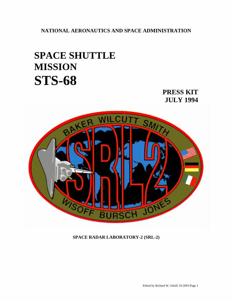
Edited by Richard W. Orloff, 01/2001/Page 1 NATIONAL AERONAUTICS AND SPACE ADMINISTRATION SPACE SHUTTLE MISSION STS-68 PRESS KIT JULY 1994 SPACE RADAR LABORATORY-2 (SRL-2)
Edited by Richard W. Orloff, 01/2001/Page 1
NATIONAL AERONAUTICS AND SPACE ADMINISTRATION
SPACE SHUTTLE MISSION STS-68
PRESS KIT JULY 1994
SPACE RADAR LABORATORY-2 (SRL-2)
Edited by Richard W. Orloff, 01/2001/Page 2
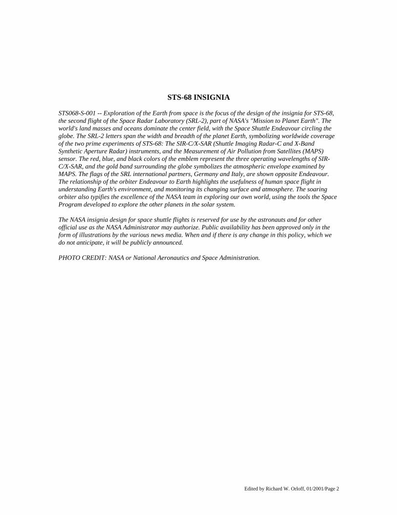
STS-68 INSIGNIA STS068-S-001 -- Exploration of the Earth from space is the focus of the design of the insignia for STS-68, the second flight of the Space Radar Laboratory (SRL-2), part of NASA's "Mission to Planet Earth". The world's land masses and oceans dominate the center field, with the Space Shuttle Endeavour circling the globe. The SRL-2 letters span the width and breadth of the planet Earth, symbolizing worldwide coverage of the two prime experiments of STS-68: The SIR-C/X-SAR (Shuttle Imaging Radar-C and X-Band Synthetic Aperture Radar) instruments, and the Measurement of Air Pollution from Satellites (MAPS) sensor. The red, blue, and black colors of the emblem represent the three operating wavelengths of SIR-C/X-SAR, and the gold band surrounding the globe symbolizes the atmospheric envelope examined by MAPS. The flags of the SRL international partners, Germany and Italy, are shown opposite Endeavour. The relationship of the orbiter Endeavour to Earth highlights the usefulness of human space flight in understanding Earth's environment, and monitoring its changing surface and atmosphere. The soaring orbiter also typifies the excellence of the NASA team in exploring our own world, using the tools the Space Program developed to explore the other planets in the solar system. The NASA insignia design for space shuttle flights is reserved for use by the astronauts and for other official use as the NASA Administrator may authorize. Public availability has been approved only in the form of illustrations by the various news media. When and if there is any change in this policy, which we do not anticipate, it will be publicly announced. PHOTO CREDIT: NASA or National Aeronautics and Space Administration.
Edited by Richard W. Orloff, 01/2001/Page 3
PUBLIC AFFAIRS CONTACTS
For Information on the Space Shuttle Ed Campion Policy/Management 202/358-1778 NASA Headquarters Washington, DC
James Hartsfield Johnson Space Center Houston, TX
Mission Operations Astronauts
713/483-5111
Bruce Buckingham Kennedy Space Center, FL
Launch Processing KSC Landing Information
407/867-2468
June Malone Marshall Space Flight Center Huntsville, AL
External Tank/SRBs/SSMEs 205/544-0034
Don Haley Dryden Flight Research Center Edwards, CA
DFRC Landing Information 805/258-3448
For Information on NASA-Sponsored STS-68 Experiments
Brian Dunbar SRL-2 202/358-1547 NASA Headquarters Washington, DC
202/358-1979 Mike Braukus NASA Headquarters Washington, DC
BRIC, CHROMEX
Deborah Rahn International Cooperation 202/358-1639 NASA Headquarters Washington, DC
Charles Redmond CPCG 202/358-1757 NASA Headquarters Washington, DC
Tammy Jones Goddard Space Flight Center, Greenbelt, MD
GAS Experiments 301/286-5566
For Information on DOD-sponsored STS-68 Experiments
Dave Hess Johnson Space Center Houston, TX
CREAM, MAST 713/483-3498
Edited by Richard W. Orloff, 01/2001/Page 4
CONTENTS
GENERAL BACKGROUND General Release 5 Media Services Information 7 Quick-Look Facts 8 Shuttle Abort Modes 10 Summary Timeline 11 Payload and Vehicle Weights 12 Orbital Events Summary 13 Crew Responsibilities 14 CARGO BAY PAYLOADS & ACTIVITIES Space Radar Laboratory-2 (SRL-2) 15 Measurement of Air Pollution from Satellites (MAPS) 22 Get Away Special (GAS) Experiments 25 IN-CABIN PAYLOADS Commercial Protein Crystal Growth (CPCG) 28 Biological Research in Canisters (BRIC) 29 Chromosomes and Plant Cell Division in Space Experiment 30 (CHROMEX) 31 Cosmic Radiation Effects and Activation Monitor (CREAM 32 Military Applications of Ship Tracks (MAST) STS-68 CREW BIOGRAPHIES 33 SPACE SHUTTLE PROGRAM INFORMATION BRIC-01 graphic 36 G-541 graphic 37 Ron McNair North Caroline A&T graphic 38
Edited by Richard W. Orloff, 01/2001/Page 5
RELEASE: 94-114
SPACE RADAR LABORATORY MAKES SECOND FLIGHT In August 1994, scientists around the world will again be provided a unique vantage point for studying how the Earth's global environment is changing when Endeavour begins the STS-68 Space Shuttle mission. During the 10 day mission, the Space Radar Laboratory (SRL) payload in Endeavour's cargo bay will make its second flight. The SRL payload, which first flew during STS- 59 in April 1994, will again give scientists highly detailed information that will help them distinguish between human-induced environmental changes and other natural forms of change. NASA will distribute the data to the international scientific community so that this essential research is available worldwide to assist people in making informed decisions about protecting the environment. Leading the STS-68 crew will be Mission Commander Michael A. Baker, who will be making his third flight. Pilot for the mission is Terrence W. Wilcutt, who is making his first flight. The four mission specialists aboard Endeavour are Thomas D. Jones, the Payload Commander, who will be making his second flight; Steven L. Smith who will be making his first flight; Daniel W. Bursch, who will be making his second flight; and Peter J. K. Wisoff, who will be making his second flight. Launch of Endeavour currently is scheduled for no earlier than August 18, 1994, at 6:54 a.m. EDT. The planned mission duration is 10 days, 4 hours, 40 minutes. With an on-time launch on August 18, Endeavour's landing would take place at 11:34 a.m. EDT on August 28 at the Kennedy Space Center's Shuttle Landing Facility. The SRL payload is comprised of the Spaceborne Imaging Radar- C/X-Band Synthetic Aperture Radar (SIR-C/X-SAR), and the Measurement of Air Pollution from Satellite (MAPS). The German Space Agency (DARA) and the Italian Space Agency (ASI) are providing the X-SAR instrument. The imaging radar of the SIR-C/X-SAR instruments has the ability to make measurements over virtually any region at any time, regardless of weather or sunlight conditions. The radar waves can penetrate clouds, and under certain conditions, also can "see" through vegetation, ice and extremely dry sand. In many cases, radar is the only way scientists can explore inaccessible regions of the Earth's surface. The SIR-C/X-SAR radar data provide information about how many of Earth's complex systems - those processes that control the movement of land, water, air and life - work together to make this a livable planet. The science team particularly wants to study the amount of vegetation coverage, the extent of snow packs, wetlands areas, geologic features such as rock types and their distribution, volcanic activity, ocean wave heights and wind speed. STS-68 will fly over the same sites that STS-59 observed so that scientists will be able to study seasonal changes that may have occurred in those areas between the missions. An international team of 49 science investigators and three associates will conduct the SIR-C/X-SAR experiments. Thirteen nations are represented: Australia, Austria, Brazil, Canada, China, the United Kingdom, France, Germany, Italy, Japan, Mexico, Saudi Arabia and the United States. The MAPS experiment will measure the global distribution of carbon monoxide in the troposphere, or lower atmosphere. Measurements of carbon monoxide, an important element in several chemical cycles, provide scientists with indications of how well the atmosphere can cleanse itself of "greenhouse gases," chemicals that can increase the atmosphere's temperature. STS-68 will see the continuation of NASA's Get Away Special (GAS) experiments program. The project gives a person or organization a chance to perform experiments in space on a Shuttle mission. Two universities, North Carolina A&T State University and University of Alabama in Huntsville, and the Swedish Space Corp., Soina, Sweden, will have small self- contained payloads flying during the STS-68 mission.
Edited by Richard W. Orloff, 01/2001/Page 6
Other GAS hardware in Endeavour's payload bay will carry 500,000 commemorative stamps for the U.S. Postal Service in recognition of the 25th anniversary of the Apollo 11 Moon landing. Other payloads aboard Endeavour include the Biological Research in Canister (BRIC) which will fly for the first time, and the Military Applications of Ship Tracks (MAST) which will be making its second flight. BRIC experiments, sponsored by NASA's Office of Life and Microgravity Sciences and Applications, are designed to examine the effects of microgravity on a wide range of physiological processes in higher order plants and arthropod animals (e.g., insects, spiders, centipedes, crustaceans). MAST is an experiment sponsored by the Office of Naval Research (ONR) and is part of a five-year research program developed by ONR to examine the effects of ships on the marine environment. The Commercial Protein Crystal Growth (CPCG) experiment, the Chromosome and Plant Cell Division in Space Experiment (CHROMEX) and the Cosmic Radiation Effects and Activation Monitor (CREAM) experiment also will be carried aboard Endeavour. Shuttle Mission STS-68 will be the 7th flight of Endeavour and the 64th flight of the Space Shuttle System.
(END OF GENERAL RELEASE; BACKGROUND INFORMATION FOLLOWS.)
Edited by Richard W. Orloff, 01/2001/Page 7
MEDIA SERVICES INFORMATION NASA Television Transmission NASA Television is available through Spacenet-2, Transponder 5, located at 69 degrees west longitude with horizontal polarization. Frequency is 3880.0 MHz, audio is 6.8 MHz. The schedule for television transmissions from the Shuttle and for mission briefings will be available during the mission at Kennedy Space Center, Fla.; Marshall Space Flight Center, Huntsville, Ala.; Dryden Flight Research Center, Edwards, Calif.; Johnson Space Center, Houston, and NASA Headquarters, Washington, D.C. The television schedule will be updated to reflect changes dictated by mission operations. Television schedules also may be obtained by calling COMSTOR 713/483-5817. COMSTOR is a computer data base service requiring the use of a telephone modem. A voice report of the television schedule is updated daily at noon Eastern time. Status Reports Status reports on countdown and mission progress, on-orbit activities and landing operations will be produced by the appropriate NASA newscenter. Briefings A mission briefing schedule will be issued prior to launch. During the mission, status briefings by a flight director or mission operations representative and when appropriate, representatives from the payload team, will occur at least once per day. The updated NASA Television schedule will indicate when mission briefings are planned.
(END OF GENERAL RELEASE; BACKGROUND INFORMATION FOLLOWS.)
Edited by Richard W. Orloff, 01/2001/Page 8
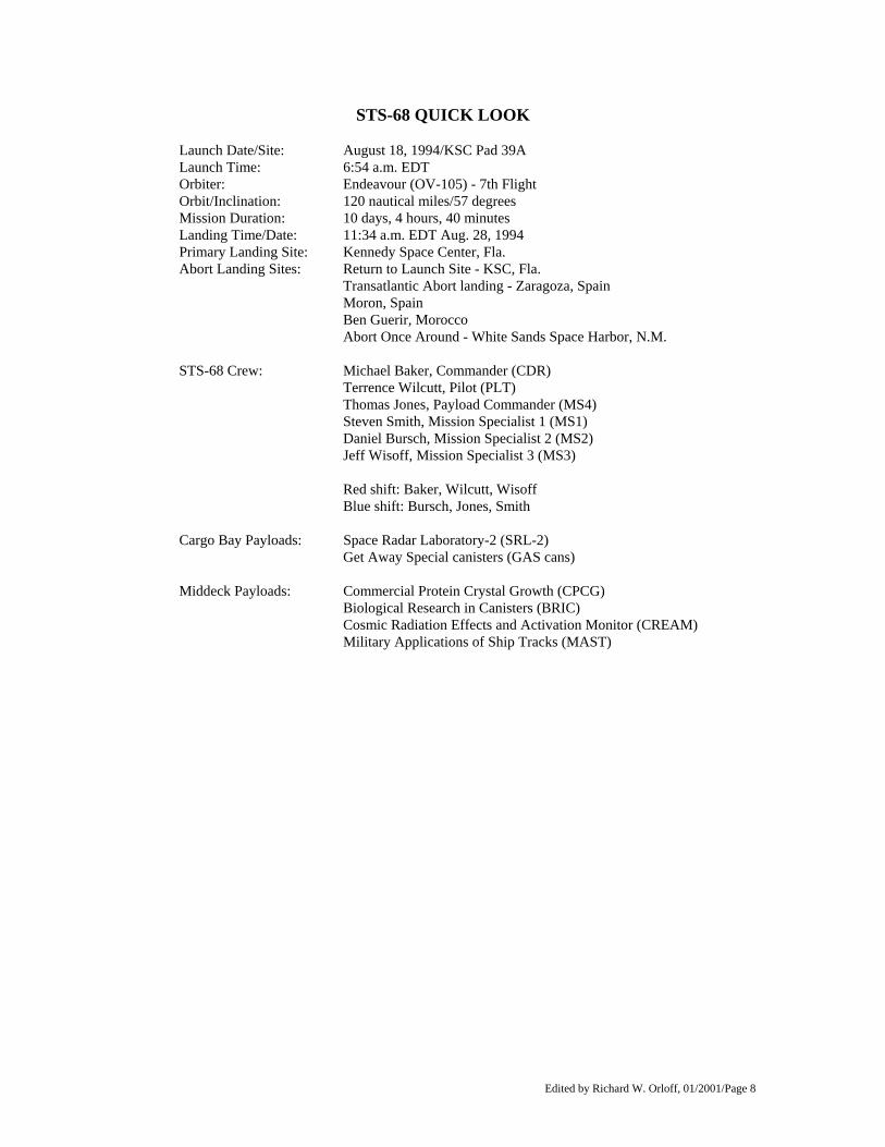
STS-68 QUICK LOOK
Launch Date/Site: August 18, 1994/KSC Pad 39A Launch Time: 6:54 a.m. EDT Orbiter: Endeavour (OV-105) - 7th Flight Orbit/Inclination: 120 nautical miles/57 degrees Mission Duration: 10 days, 4 hours, 40 minutes Landing Time/Date: 11:34 a.m. EDT Aug. 28, 1994 Primary Landing Site: Kennedy Space Center, Fla. Abort Landing Sites: Return to Launch Site - KSC, Fla. Transatlantic Abort landing - Zaragoza, Spain
Moron, Spain Ben Guerir, Morocco
Abort Once Around - White Sands Space Harbor, N.M. STS-68 Crew: Michael Baker, Commander (CDR) Terrence Wilcutt, Pilot (PLT) Thomas Jones, Payload Commander (MS4) Steven Smith, Mission Specialist 1 (MS1) Daniel Bursch, Mission Specialist 2 (MS2) Jeff Wisoff, Mission Specialist 3 (MS3) Red shift: Baker, Wilcutt, Wisoff Blue shift: Bursch, Jones, Smith Cargo Bay Payloads: Space Radar Laboratory-2 (SRL-2) Get Away Special canisters (GAS cans) Middeck Payloads: Commercial Protein Crystal Growth (CPCG) Biological Research in Canisters (BRIC) Cosmic Radiation Effects and Activation Monitor (CREAM) Military Applications of Ship Tracks (MAST)
Edited by Richard W. Orloff, 01/2001/Page 9
Detailed Test Objectives/Detailed Supplementary Objectives: DTO 251: Entry Aerodynamic Control Surfaces Test DTO 254: Subsonic Aerodynamics Verification Objectives DTO 301D: Ascent Structural Capability Evaluation DTO 305D: Ascent Compartment Venting Evaluation DTO 306D: Descent Compartment Venting Evaluation DTO 307D: Entry Structural Capability Evaluation DTO 312: External Tank Thermal Protection System Performance DTO 414: Auxiliary Power Unit Shutdown Test DTO 521: Orbiter Drag Chute System Test DTO 656: PGSC Single Event Upset Monitoring DTO 664: Cabin Temperature Survey DTO 700-8: Global Positioning System Flight Test DTO 805: Crosswind Landing Performance DSO 317: Shuttle Humidity Condensate Collection/Evaluation DSO 326: Window Impact Observations DSO 484: Assessment of Circadian Shifting in Astronauts by Bright Light DSO 487: Immunological Assessment of Crewmembers DSO 491: Characterization of Microbial Transfer Among Crewmembers During Spaceflight DSO 603B: Orthostatic Function During Entry, Landing and Egress DSO 604: Visual-Vestibular Integration as a Function of Adaptation DSO 605: Postural Equilibrium Control During Landing/Egress DSO 614: The Effect of Prolonged Spaceflight on Head and Gaze Stability During Locomotion DSO 621: In-Flight Use of Florinef to Improve Orthostatic Intolerance Postflight DSO 624: Pre and Postflight Measurement of Cardiorespiratory Responses to Submaximal Exercise DSO 626: Cardiovascular and Cerebrovascular Responses to Standing Before and After Spaceflight DSO 901: Documentary Television DSO 902: Documentary Motion Picture Photography DSO 903: Documentary Still Photography
Edited by Richard W. Orloff, 01/2001/Page 10
SPACE SHUTTLE ABORT MODES Space Shuttle launch abort philosophy aims toward safe and intact recovery of the flight crew, Orbiter and its payload. Abort modes include: • Abort-To-Orbit (ATO) -- Partial loss of main engine thrust late enough to permit reaching a minimal
105-nautical mile orbit with orbital maneuvering system engines. • Abort-Once-Around (AOA) -- Earlier main engine shutdown with the capability to allow one orbit
around before landing at White Sands Space Harbor, N.M. • Transatlantic Abort Landing (TAL) -- Loss of one or more main engines midway through powered
flight would force a landing at either Zaragoza, Spain; Moron, Spain; or Ben Guerir, Morocco. • Return-To-Launch-Site (RTLS) -- Early shutdown of one or more engines, and without enough energy
to reach Zaragoza, would result in a pitch around and thrust back toward KSC until within gliding distance of the Shuttle Landing Facility.
STS-68 contingency landing sites are the Kennedy Space Center, White Sands, Zaragoza, Moron and Ben Guerir.
Edited by Richard W. Orloff, 01/2001/Page 11
STS-68 SUMMARY TIMELINE Flight Day 1 Ascent OMS-2 burn (120 n.m. x 120 n.m.) SRL-2 activation/operations Blue Flight Days 2-7 SRL-2 operations - SIR-C/X-SAR Radar Imaging - MAPS Carbon Monoxide Survey Red Flight Days 2-7 SRL-2 operations - SIR-C/X-SAR Radar Imaging - MAPS Carbon Monoxide Survey Blue Flight Day 8 SRL-2 operations - SSIR-C/X-SAR Interferometry - MAPS Carbon Monoxide Survey Red Flight Day 8 SRL-2 operations - SIR-C/X-SAR Interferometry - MAPS Carbon Monoxide Survey Blue Flight Day 9 SRL-2 operations - SIR-C/X-SAR Interferometry - MAPS Carbon Monoxide Survey Red Flight Day 9 Flight Control Systems Checkout Reaction Control System Hot-Fire SRL-2 deactivation Cabin stow Blue/Red Flight Day 10 Deorbit Entry Landing
Edited by Richard W. Orloff, 01/2001/Page 12
STS-68 VEHICLE AND PAYLOAD WEIGHTS
Pounds Orbiter (Endeavour) empty and 3 SSMEs 173,669 Space Radar Lab-2 23,796 Get-Away Special Experiments 1,464 Biological Research in Canisters 20 Commercial Protein Crystal Growth 58 Chromosome and Plant Cell Division in Space 64 Cosmic Radiation Effects and Activation Monitor 39 Detailed Supplementary/Test Objectives 156 Total Vehicle at SRB Ignition 4,511,195 Orbiter Landing Weight 223,040
Edited by Richard W. Orloff, 01/2001/Page 13
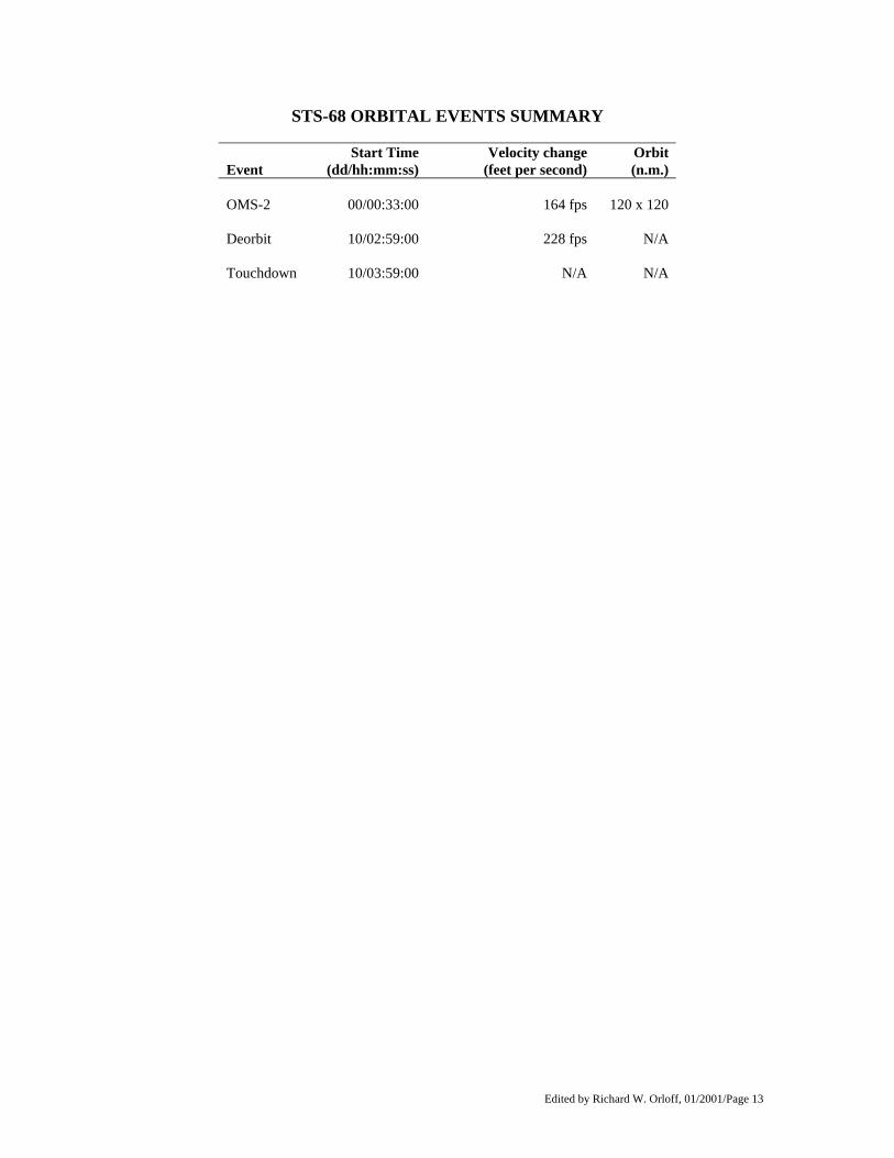
STS-68 ORBITAL EVENTS SUMMARY
Event
Start Time (dd/hh:mm:ss)
Velocity change(feet per second)
Orbit (n.m.)
OMS-2 00/00:33:00 164 fps 120 x 120 Deorbit 10/02:59:00 228 fps N/A Touchdown 10/03:59:00 N/A N/A
Edited by Richard W. Orloff, 01/2001/Page 14
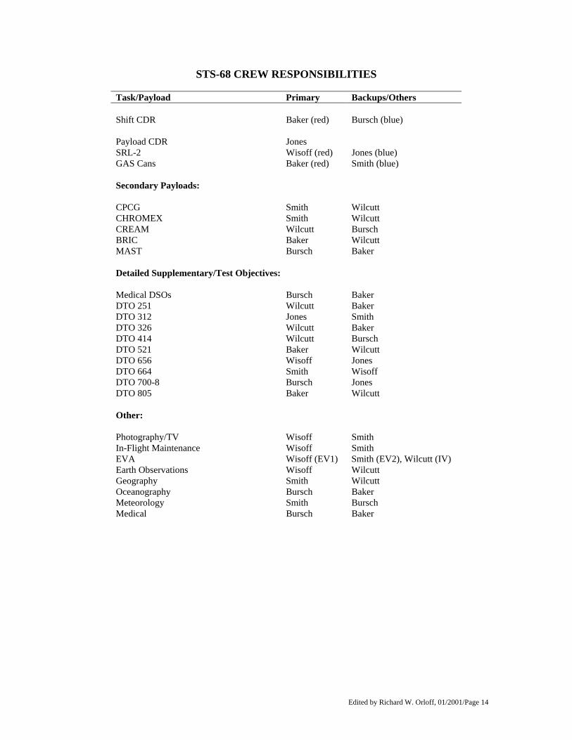
STS-68 CREW RESPONSIBILITIES
Task/Payload Primary Backups/Others Shift CDR Baker (red) Bursch (blue) Payload CDR Jones SRL-2 Wisoff (red) Jones (blue) GAS Cans Baker (red) Smith (blue) Secondary Payloads: CPCG Smith Wilcutt CHROMEX Smith Wilcutt CREAM Wilcutt Bursch BRIC Baker Wilcutt MAST Bursch Baker Detailed Supplementary/Test Objectives: Medical DSOs Bursch Baker DTO 251 Wilcutt Baker DTO 312 Jones Smith DTO 326 Wilcutt Baker DTO 414 Wilcutt Bursch DTO 521 Baker Wilcutt DTO 656 Wisoff Jones DTO 664 Smith Wisoff DTO 700-8 Bursch Jones DTO 805 Baker Wilcutt Other: Photography/TV Wisoff Smith In-Flight Maintenance Wisoff Smith EVA Wisoff (EV1) Smith (EV2), Wilcutt (IV) Earth Observations Wisoff Wilcutt Geography Smith Wilcutt Oceanography Bursch Baker Meteorology Smith Bursch Medical Bursch Baker
Edited by Richard W. Orloff, 01/2001/Page 15
SPACE RADAR LABORATORY-2 (SRL-2) SIR-C/X-SAR Mission Objectives As part of NASA's Mission to Planet Earth, SIR-C/X-SAR is studying how our global environment is changing. From the unique vantage point of space, the radar system will observe, monitor and assess large-scale environmental processes. The spaceborne data, complemented by aircraft and ground studies, will give scientists highly detailed information that will help them distinguish natural environmental changes from those that are the result of human activity. NASA will distribute the Mission to Planet Earth data to the international scientific community so that this essential research is available worldwide to people who are trying to make informed decisions about protecting the environment. SIR-C/X-SAR is also a part of the continuing efforts by DARA, the German Space Agency, and ASI, the Italian Space Agency, in the field of Earth observations. Why Radar? The unique feature of imaging radar is its ability to collect data over virtually any region at any time, regardless of weather or sunlight conditions. Some radar waves can penetrate clouds, and under certain conditions, can also see through vegetation, dry snow and extremely dry sand. In many cases, radar is the only way scientists can explore inaccessible regions of Earth's surface. Radar is a lowercase acronym for "radio detection and ranging." A synthetic aperture radar transmits pulses of microwave energy toward Earth and measures the strength and time- delay of the energy that is scattered back to the antenna. In the case of SIR-C/X-SAR, the motion of the Shuttle creates, or synthesizes, an antenna opening, or aperture, that is much longer than the actual antenna hardware. A longer antenna produces images of finer resolution. Conditions on the Earth's surface influence how much radar energy is reflected back to the antenna. An area with a variety of surface types, such as hills, trees and large rocks, will generally reflect more energy back to the radar than a less complex area such as a desert. The resulting radar image of the varied terrain will be brighter overall and have higher contrasts than the image of the simpler area. The three frequencies of SIR-C/X-SAR will enable scientists to view three different scales of features in the images. Results of STS-59 Flying aboard STS-59 in April 1994, SIR-C collected 65 hours of data during the 10-day mission, roughly corresponding to 26 million square miles (66 million square kilometers). All data were stored onboard the Shuttle using a new generation of high density, digital, rotary head tape recorders. The data filled 166 digital tape cartridges (similar to VCR tape cassettes). X- SAR data filled 25 of those tapes. The mission returned 47 terabits of data (47 x 1012 bits). Stated another way, each of the radars generates 45 million bits of data per second. When all the radars are operating, they produce 225 million bits of data per second, the equivalent of 45 simultaneously operating television stations. Using JPL's digital SAR processor and German-Italian X-SAR processors, the ground team processed the raw data into images. High-priority SIR-C data were downlinked, processed, and released to the science team via the Internet within 24 hours of collection. The payload operations team processed the SIR-C data in survey mode and displayed it during the mission on NASA Television.
Edited by Richard W. Orloff, 01/2001/Page 16
Science The STS-59 mission achieved 100 percent of the SIR-C/X-SAR science objectives. The SRL-1 team completed 850 data takes, 97% of those planned. The team acquired 99% of the "supersite" opportunities over highest priority targets. The 94 hours of radar imagery were obtained over 44 countries, covering 43.75 million square miles (70 million square kilometers). In addition to taking high-resolution data at all of the planned sites, the science team was able to adjust the mission timeline and observe events as they were happening on the ground. SIR-C/X-SAR took data of the severe flooding that inundated the mid-western United States and Thoringen, Germany, as well as three different views of tropical Cyclone Odille as it formed in the Pacific Ocean. Scientists also acquired a series of radar images over Canada documenting the annual spring thaw of snow, ice and soil. Scientists use SIR-C/X-SAR data to study how our global environment is changing. The SIR-C/X-SAR radar data provides information about how many of Earth's complex systems - those processes that control the movement of land, water, air and life - work together to make this a livable planet. The science team particularly wants to study the amount of vegetation coverage, the extent of snow packs, wetlands areas, geologic features such as rock types and their distribution, volcanic activity, ocean wave heights and wind speed. STS-68 will fly over the same sites that STS-59 observed so that scientists will be able to study seasonal changes that may have occurred in those areas between the missions. Data will be taken over more than 400 sites on Earth. Nineteen of the sites are "supersites," the highest priority targets and the focal point for many of the scientific investigators. There are 15 backup supersites. If problems should occur during the flight that would drastically reduce the team's ability to collect data, the supersite data will take precedence over other data acquisition. During STS-59 the scientists who were working in the Payload Operations Control Center in Houston were in daily communication with the researchers who were part of the "ground truth" teams. The ground teams at several of the supersites made simultaneous measurements of vegetation, soil moisture, sea state, snow and weather during the mission. Aircraft and ships also collected data to ensure an accurate interpretation of the radar data taken from space. In addition, the astronauts recorded their personal observations of weather and environmental conditions in coordination with SIR-C/X-SAR operations. Supersites The supersites represent different environments within each scientific discipline. They are areas where intensive field work will occur before, during and after the flight. Ecology Supersites: Manaus, Brazil; Raco, Mich.; Duke Forest, N.C. Ecologists study life on Earth and how different species of animals and plants interact with one another and their local environment. SIR-C/X-SAR ecology investigations focus on mapping wetlands, deforestation and flooding under forest canopies over the tropical forests of the Amazon basin in South America and over the temperate forests of North America and Central Europe. Scientists also are studying wetlands and are using the data to validate computer models to determine the type and density of vegetation and to study seasonal thaws. The science team will use the images to study land use, including the volume, types and extent of vegetation and the effects of fires, floods and clear- cutting. Using early-release data, science team members have already generated both tree classification and vegetation biomass maps of the Raco, Michigan site and a freeze/thaw map over the Prince Albert, Saskatchewan backup supersite. A map of flooding near Manaus, Brazil also has been produced as a step toward improving models and our understanding of flooding and wetlands under dense forest canopies.
Edited by Richard W. Orloff, 01/2001/Page 17
SIR-C/X-SAR's three radar frequencies interact with the vegetation in different ways, providing views of different parts of the forest. The shortest wavelength (X-band), reflects from the leaves of trees. C-band microwaves reflect from twigs and branches, and L-band wavelengths reflect from the trunks of trees. These data give scientists a clearer picture of the conditions on the ground. The science team will study seasonal changes in the forest by comparing data from the two SIR-C/X-SAR flights. For example, data from two previous imaging radar missions showed a decrease in forests along the Mississippi River between 1978 and 1981. Deforestation threatens both temperate and tropical forests around the world. SIR-C/X-SAR data and ground data will be used to understand the impact of the loss of forests on local populations of plants and animals. By studying the short-term and long-term changes in forests, scientists can determine what effects changing environmental conditions and land uses have on the forests and, in turn, on global climate change. Hydrology Supersites: Chickasha, Oklahoma; Otztal, Austria; Bebedouro, Brazil; Montespertoli, Italy SIR-C/X-SAR hydrology investigations are focused on Brazil, Austria, Italy and Oklahoma, where the radar data will be used to determine soil moisture patterns. These studies will help scientists develop ways to estimate soil moisture and evaporation rates over large areas, which could ultimately be incorporated into computer models to help predict a region's water cycle. Another significant part of hydrology centers on snow cover. Using data from STS-59, investigators generated a snow and ice classification map over the Oetztal, Austria, supersite and a snow-wetness map of the Mammoth Mountain, Calif., backup supersite. Spring snow melt often determines the annual runoff cycle and the resulting water supply, ground water and reservoir replenishment rates. For many areas, long-term or ground-based snow cover data do not exist, and radar data is the only efficient way to collect this information. SIR-C/X-SAR acquired snow cover data over Mammoth Lakes, Calif., the Austrian Alps and northwest China. The shorter wavelength X-band data are useful in determining snow type, while the longer wavelengths of L-band and C-band help estimate snow thickness. These data might help communities determine how much water will be available for human and agriculture use. In August, this investigation's emphasis will shift to the Patagonian district in southern Chile, which contains the largest glaciers and ice fields in South America. Oceanography Supersites: The Gulf Stream (mid-Atlantic region); eastern North Atlantic Ocean; Southern Ocean Oceanographers study how waves move through the ocean and how the air and sea interact. The ocean is a reservoir for heat and energy, and the air-sea interaction moves this heat and energy around the globe regulating the Earth's climate. The Gulf Stream off the eastern coast of North America is a major ocean current that transports heat from the equator toward the poles. The relatively low altitude of the Shuttle is particularly advantageous for oceanography investigations since the SIR-C/X- SAR radars are more sensitive to ocean features than satellites in higher orbits. Oceanographers are using data from SIR-C/X-SAR to study surface and internal waves and the interactions of waves and current. In addition, an associated experiment provided by the Applied Physics Laboratory of the Johns Hopkins University, Baltimore, Md., collected extensive information on wave energy over the Southern Ocean. These data will help scientists study how the ocean moderates Earth's climate.
Edited by Richard W. Orloff, 01/2001/Page 18
Geology Supersites: Galapagos Islands; Sahara Desert; Death Valley, Calif.; Andes Mountains, Chile Geologists study the present surface of the Earth. By observing older rocks they can determine how an area came to be and what it may have looked like in the past. Scientists are using SIR-C/X-SAR data to map geologic structures and variations in rock types over large areas, as well as areas of volcanic activity and erosion. The longer L-band radar wavelength is particularly useful for looking beneath surfaces. SIR-C/X-SAR obtained penetration data of the Sahara desert that show stream channels and a larger river valley beneath an extensive sand sheet. On the ground and in photographs, this big valley and the channels in it are entirely covered by windblown sand. SIR-A observed some of these channels in 1981. Scientists hypothesize that an ancient westward-flowing river carved the large valley, tens of millions of years before the Nile River existed. The Nile flows north about 200 miles (300 kilometers) east of the area observed by the radar. The existence of hidden river channels indicates that portions of the Sahara have undergone significant climate change and have evolved from an area of flowing streams to what is now an arid desert. SIR-C/X-SAR also is studying other geologic features that record past climate changes. In areas of Death Valley, Calif., western China and the Patagonia region of the southern Andes, the radar imaged alluvial fans. Alluvial fans are gravel deposits that erode and wash down from the mountains. They are found throughout the semi-arid deserts of the world in areas where there is a significant amount of tectonic activity and erosion. The gravel builds up at the base of the mountains during periods of overall wetter climate. The radar is sensitive to these rocky and rough surfaces, allowing scientists to study an area's climatic and geologic history and the relative age of surfaces. As an area ages, it is exposed to weathering. This changes its roughness characteristics. Studying past climate changes will give scientists a base from which to monitor and predict future climate changes. During STS-59, SIR-C/X-SAR acquired radar images of several volcanoes, including Mount Pinatubo in the Philippines and the volcanoes of the Galapagos Islands. These radar images are helping scientists identify the different types of lava flows and their ages and assess environmental risks posed by the volcanoes. A key objective of STS-68 will be to obtain a second image of Mount Pinatubo during the summer monsoon season, when new mudflows are likely to occur, and to evaluate whatever short-term changes may have taken place. Calibration Supersites: Flevoland, The Netherlands; Kerang, Australia; Oberpfaffenhofen, Germany; Western Pacific Ocean The ground teams placed calibration devices, called corner reflectors, and transponders in southern Germany, the Netherlands, Australia and Death Valley, Calif., to measure the amount of radar energy obtained on the ground during the flight. The teams are calibrating the radar data and applying what they learn to the image processing and scientific interpretation of the images. Rain Experiment Two SIR-C/X-SAR experiments imaged rain over the Western Pacific Ocean, an area scientists call the "rainiest place on Earth." Rain can change conditions on the surface and thus change the radar image. At the shorter wavelengths of X-band and C-band, rain may reduce the strength of the radar or scatter the signals significantly.
Edited by Richard W. Orloff, 01/2001/Page 19
The rain experiments offer a unique challenge to the operation of the radar during flight. All the other experiments can be reasonably tied to a specific area, while the rain experiments only require that a "deep" rainstorm be in progress. Weather targets are transitory in both space and time and cannot be scheduled, so finding a good target of opportunity is a gamble. Scientists chose the western Pacific because there is a high probability that it will be raining there when the Shuttle passes over it. Interferometry: A new SIR-C/X-SAR Experiment One of the bonuses of flying SIR-C/X-SAR for a second time is the opportunity to demonstrate a different data-gathering method from the Shuttle platform, called interferometry. Scientists will conduct the experiment during the last three days of the flight using repeated passes of SIR-C/X-SAR over the same areas on the Earth. By comparing data from two repeated passes, investigators hope to generate digital elevation models (topography) of the Earth's surface. Once topography is determined, a third interferometric pass can be used to determine what, if any, topographic change has occurred in the intervening time between radar passes. The focus of these experiments is to improve our understanding of natural hazards such as flooding, subsidence, mudflows, earthquakes and volcanic eruptions. For example, the topography of mountain glaciers is important because it directly reflects ice-flow dynamics and is closely linked to global climate and sea level change. Monitoring mountain glaciers on a global, long- term basis could give scientists important information on the rate of global warming. In addition, the use of topographic data may help reduce the risk of natural disasters by monitoring volcanoes, flooding and earthquake-prone faults.
Spaceborne Imaging Radar C/X-Band Synthetic Aperture Radar (SIR-C/X-SAR) SIR-C/X-SAR is a sophisticated set of radars that fills nearly all of Endeavour's cargo bay. SIR-C, built by the Jet Propulsion Laboratory (JPL) Pasadena, Calif., and the Ball Communications Systems Division, is a two-frequency radar including L-band (9- inch, or 23-cm, wavelength) and C-band (2.4-inch, or 6-cm wavelength). SIR-C is the first spaceborne radar with the ability to transmit and receive horizontally and vertically polarized waves at both frequencies. The multi-frequency, multi- polarization capability creates a new and more powerful tool for studying the world. A good way to understand this is to think of visual images: Just as color pictures have more information about a subject than black and white pictures, multi-frequency, multi-polarization radar images contain more information about the surface than single frequency, single polarization radar images. The SIR-C antenna is the most massive piece of flight hardware ever built at JPL. Its mass is 16,100 pounds (7,300 kg) and it measures 39.4 feet by 13.1 feet (12 meters by 4 meters). The instrument comprises several subsystems: the antenna array, the transmitter, the receivers, the data-handling subsystem and the ground processor. The antenna consists of three leaves, and each is divided into four subpanels. Hundreds of small transmitters embedded in the surface of the antenna form the radar beam. By adjusting the energy from these transmitters, the payload operations team can point the beam electronically, without moving the antenna. This feature, combined with the roll and yaw maneuvers of the Shuttle, will allow the team to acquire images from 15-to 55- degree angles of incidence. Advances in radar technology will allow SIR-C to acquire simultaneous images at L-band and C-band frequencies at multiple polarizations. Polarization describes how the radar wave travels in space. For example, for HH-polarized data, the antenna transmits energy in the horizontal plane and receives the backscattered radiation in the horizontal plane. For HV polarization, the wave is transmitted horizontally, but is received in the vertical plane. The interaction between the transmitted waves and the Earth's surface determines the polarization of the waves received by the antenna.
Edited by Richard W. Orloff, 01/2001/Page 20
Multi-polarization data contain more specific information about surface conditions than single polarization data. Multi- polarization data are particularly useful to scientists studying vegetation because the data allow them to see different types of crops and to measure the volume of trees contained under the canopy of a forest. SIR-C can acquire data with HH, VV, HV, and VH polarizations. X-SAR was built by the Dornier and Alenia Spazio companies for the German Space Agency, Deutsche Agentur fuer Raumfahrtangelegenheiten (DARA), and the Italian Space Agency, Agenzia Spaziale Italiana (ASI), with the Deutsche Forschungsanstalt for Luft und Raumfarht (DLR) as a major partner. It is a single-polarization radar operating at X-band (1-inch, or 3-centimeter wavelength). X-SAR uses a finely tuned slotted waveguide antenna to produce a pencil-thin beam of energy. The X-SAR antenna rests on a supporting structure that is tilted mechanically to align the X- band beam with the L-band and C-band beams. X-SAR will provide VV polarization images. The payload team can operate SIR-C and X-SAR independently or together. When combined into a three-frequency, multi- polarization instrument, SIR-C/X-SAR becomes the most powerful civilian radar ever flown in space. The width of the ground swath varies from 9 to 56 miles (15 to 90 kilometers), depending on the orientation of the antenna beams. The resolution of the radars varies from 33 to 656 feet (10 to 200 meters). Previous Radar Missions Since the late 1970s a variety of NASA satellite missions have used imaging radar to study Earth and our planetary neighbors. Perhaps the most familiar example of NASA's success using imaging radar is the Magellan mission to Venus. Magellan's radar pierced the dense clouds covering Venus to map the entire surface of the planet, revealing a world hidden to humans until the late 20th century. SIR-C is the latest in a series of Earth observing imaging radar missions that began in June 1978 with the launch of Seasat SAR and continued with SIR-A in November 1981 and with SIR-B in October 1984. Both the SIR-A and SIR-B sensors built upon the Seasat SAR, and all three could transmit and receive horizontally polarized radiation at L-band frequency. The major difference between the Seasat and SIR-A sensors was the orientation of the radar's antenna with respect to Earth's surface. Microwave radiation transmitted by Seasat struck the surface at a fixed angle of approximately 23 degrees from the local zenith direction. SIR-A viewed the surface at a fixed 40- degree angle. SIR-B improved upon both those missions because its antenna could be mechanically tilted. This allowed SIR-B to obtain multiple radar images of a given target at different angles during successive Shuttle orbits. The X-SAR antenna is a follow-on to Germany's Microwave Remote Sensing Experiment (MRSE), which flew aboard the first Shuttle Spacelab mission in 1983. These early missions had a tremendous impact on the international remote sensing community when SIR-A discovered ancient river beds hidden beneath the sands of the Sahara, and SIR-B data led explorers to the Lost City of Ubar in Oman. Data Acquisition Plans for STS-68 Portions of the SIR-C/X-SAR data will be downlinked to the ground in near-real time through NASA's Tracking and Data Relay Satellite System (TDRSS). However, only one channel of data can be downlinked or played back at a time. This is not a problem for X-SAR since it only has one channel of data. SIR-C has up to four channels of data, and each channel must be played back separately. The payload teams will
Edited by Richard W. Orloff, 01/2001/Page 21
process the data in images using digital SAR processors in Pasadena, Calif., Oberpfaffenhofen, Germany, and Matera, Italy. Historically, processing SAR data has required a great deal of computer time on special-purpose computer systems. SIR-C/X-SAR scientists will benefit, however, from rapid advances in computer technology that make it possible to process the images with a standard parallel supercomputer. Yet even with these advances, it will still take five months to produce survey images from the large volume of data acquired. Detailed processing will take another nine months. Italy, Germany and the United States will exchange data to meet the needs of the science investigators. NASA, DARA and ASI will attempt to release some radar images to the press during the Shuttle flight. JPL will process SIR-C images and send them over the Internet to the Johnson Space Center, where the image will be released on NASA Television. JPL also will release hard-copy prints simultaneously to the wire services. In Germany, DLR will process X-SAR imagery. In addition, X-SAR "quick look" data will be available for release over NASA Television. Science Team An international team of 49 science investigators and three associates will conduct the SIR-C/X-SAR experiments, representing 13 nations: Australia, Austria, Brazil, Canada, China, England, France, Germany, Italy, Japan, Mexico, Saudi Arabia and the United States. Dr. Diane Evans of JPL is the U.S. project scientist. Dr. Herwig Ottl of DLR is the German project scientist and Prof. Mario Calamia of the University of Florence is the Italian project scientist. Dr. Miriam Baltuck of NASA's Office of Mission to Planet Earth is the program scientist. Management JPL manages the SIR-C mission for NASA's Office of Mission to Planet Earth, Washington, D.C. Michael Sander is the JPL project manager. X-SAR is managed by the Joint Project Office (JPO) located near Bonn, Germany. Rolf Werninghaus of DARA is the project manager and Dr. Paolo Ammendola of ASI is the deputy project manager. James McGuire of the Office of Life and Microgravity Sciences and Applications, Washington, D.C., is the SRL program manager. Richard Monson of the Office of Mission to Planet Earth is the SIR-C program manager.
Edited by Richard W. Orloff, 01/2001/Page 22
MEASUREMENT OF AIR POLLUTION FROM SATELLITES (MAPS) The MAPS experiment measures the global distribution of carbon monoxide - an important indicator of the atmosphere's ability to cleanse itself of greenhouse gases and pollutants - in the lower atmosphere (2 to 10 miles above the surface). Covering the Earth between 57 degrees North latitude and 57 degrees South latitude, the MAPS measurements provide the only near-global database of lower-atmosphere carbon monoxide values available to scientists. Preliminary results from the April 1994 MAPS flight aboard STS-59 showed low carbon monoxide concentrations in the Southern Hemisphere (very clean air) with a gradual increase, moving northward, in carbon monoxide levels. The highest levels of carbon monoxide were present north of the 40 degree latitude band in the Northern Hemisphere. The MAPS measurements will be correlated with ground- and aircraft-based carbon monoxide measurements, astronaut observations and photography, and meteorological data analyses and satellite images. MAPS' unique measurements of carbon monoxide, a gas produced by the burning of gasoline and other carbon-based fuels, provide scientists with indications of how well the atmosphere can cleanse itself of these pollutants. How far pollutants such as carbon monoxide are transported from their source regions and the size of the source regions are two other invaluable pieces of information provided by the MAPS measurements. Because MAPS is being flown twice this year, scientists will be able to examine seasonal differences in the distribution of carbon monoxide. This will be especially valuable to scientists studying the transportation of industrial pollutants in the Northern Hemisphere and biomass burning in the tropics and Southern Hemisphere. The STS-68 flight will occur during the Southern Hemisphere's dry season (June-October), when the maximum amount of biomass burning, such as clearing forests for agriculture uses, occurs. The dry season carbon monoxide levels from this flight will be compared to data from the wet season (April 1994) flight. The MAPS measurements also will be compared to data from previous dry-season MAPS flights (November 1981 and October 1984). Why do we measure carbon monoxide? World-wide increases in human technological and agricultural activity are causing increasing amounts of carbon monoxide to be released into the atmosphere. Carbon monoxide, a colorless and odorless gas, is produced by the burning of carbon-based fuels and by the burning of forests and grasslands. Once released into the atmosphere, carbon monoxide can be transported over long distances, eventually converting to carbon dioxide by reacting with a chemical called the hydroxyl radical (chemical symbol: OH). The OH radical is a key participant in the destruction and removal of greenhouse gases such as methane. Methane also is important in the chemical cycle of stratospheric ozone. As the amount of carbon monoxide in the atmosphere increases, its reactions with the OH radical increase accordingly. These reactions may leave less OH available to break down and remove greenhouse gases, chemicals that can trap heat near the Earth's surface, increasing atmospheric temperatures. Therefore, increases in carbon monoxide levels may cause subsequent decreases in OH levels, which can have long-term consequences on stratospheric ozone and the levels of various greenhouse gases, potentially influencing the Earth's climate. Data Collection and Processing The primary goal of the MAPS experiment is to measure the distribution of carbon monoxide in the atmosphere between the altitudes of 2 to 10 miles (4 to 15 kilometers). The MAPS measurements will be
Edited by Richard W. Orloff, 01/2001/Page 23
stored on a tape recorder aboard the instrument and also will be transmitted to the ground in real- time through the Space Shuttle telemetry system. The real-time data transmissions will be processed at the Payload Operations Control Center to produce "quick look" maps of the measured carbon monoxide distribution. The "quick look" maps, along with real-time observations by the astronaut crew, will be used to determine areas of special interest, such as large areas of biomass burning. An infrared camera attached to the MAPS instrument will take pictures of each region of the Earth being measured during the first half of the flight. The astronaut crew also will keep watch for any signs of industrial pollution (smoke stacks, gas flares from oil fields, etc.) and for smoke and fires caused by biomass burning. Real-time observations by the astronaut crew and the analysis of astronaut and MAPS instrument photographs, will play a crucial role in understanding the measurements from the MAPS experiment. Following the flight, the data recorded aboard the instrument and the data transmitted to the ground in real-time will be merged, then processed using more sophisticated techniques than the preliminary ("quick look") MAPS data. In addition, the MAPS measurements will be correlated with a global network of intercalibrated ground- and aircraft-based measurements. To ensure the accuracy of the ground and aircraft measurements, all the ground sites will be using the same four gas cylinders to calibrate their instruments. This ensures that all the ground sites have the same calibration standard (that they are `intercalibrated’) and allows for the intercomparison of carbon monoxide data measured by dozens of different instruments around the world. The 25 ground sites include locations in the United States, South Africa, Russia, Germany, Bermuda, Ireland, Hong Kong, Australia, and New Zealand. The aircraft underflights of the MAPS instrument include the NASA DC-8, and aircraft from INPE, Brazil; CSIRO, Australia; the University of Maryland; and the National Oceanic and Atmospheric Administration in Boulder, Colo. Results From Previous Flights MAPS, the first Space Shuttle science payload, has flown three times: in November 1981 (STS-2), October 1984 (STS-41G) and April 1994 (STS-59). The 1981 flight proved surprising because the greatest concentrations of tropospheric carbon monoxide were found in the Earth's tropical regions rather than in the industrialized Northern Hemisphere as had been expected. The 1981 flight also showed that carbon monoxide concentrations vary greatly from region to region. The October 1984 flight confirmed the November 1981 finding that the burning of forests in South America and grasslands in Africa is a significant source of global tropospheric carbon monoxide during the Southern Hemisphere spring (dry season). Preliminary results from the April 1994 flight show low carbon monoxide concentrations in the Southern Hemisphere (very clean air) and a gradual increase in carbon monoxide levels from the Southern Hemisphere to the Northern Hemisphere. The highest levels of carbon monoxide measured by MAPS were present north of the 40 degree latitude band in the Northern Hemisphere. Because the second 1994 flight of MAPS occurs during the burning season in South America and Africa, scientists will be able to study the source regions of carbon monoxide as well as its transport from the source regions. Real-time data analysis by the MAPS operations team and observations by the astronaut crew will help the scientists on the ground evaluate the data and determine those regions where more detailed measurements should be made by the MAPS instrument. Because there will be two flights in the same year, scientists also will be able to study the changes in carbon monoxide distributions from the Southern Hemisphere wet season (April) to the dry season (August), when biomass burning is at a maximum.
Edited by Richard W. Orloff, 01/2001/Page 24
Scientists also will be able to examine the seasonal effects near and downwind from the industrial source regions of the Northern Hemisphere. This ability to study global seasonal differences in tropospheric carbon monoxide levels is available only through the unique measurements provided by the MAPS instrument. Mission Information Information on the MAPS experiment for both the SRL-1 and SRL- 2 flights is available through Internet 24 hours a day. The information is available via DOS, MAC, and UNIX platforms. This information will be updated weekly prior to the SRL-2 launch with updates during the mission as time allows. The information can be accessed through NCSA Mosaic (an Internet information browser and World Wide Web client). For information on obtaining Mosaic software or help using it please send electronic mail to:
[email protected] For those who already have Mosaic, to access the Mosaic MAPS home page directly, click on the File button in the header at the top of the Mosaic home page; click on Open; type in URL to open: http://stormy.larc.nasa.gov/press.html; click on Open. For more information on the MAPS home page please contact:
Scott Nolf: [email protected] The MAPS Instrument The MAPS flight hardware consists of an optical box, an electronics box, a tape recorder and a camera, all mounted to a single baseplate. This assembly is mounted to a Multi-Purpose Experiment Support Structure near the forward end of the cargo bay. The instrument is about 36 inches long, 30 inches wide, and 23 inches high. It weighs 203 pounds and consumes about 125 watts of electrical power. The Program Manager is Louis Caudill, and Dr. Robert J. McNeal is the Program Scientist, both at NASA Headquarters, Washington, D.C. The MAPS Principal Investigator is Dr. Henry G. Reichle Jr., and the Project Manager is John Fedors, both at NASA Langley Research Center in Hampton, Va.
Edited by Richard W. Orloff, 01/2001/Page 25
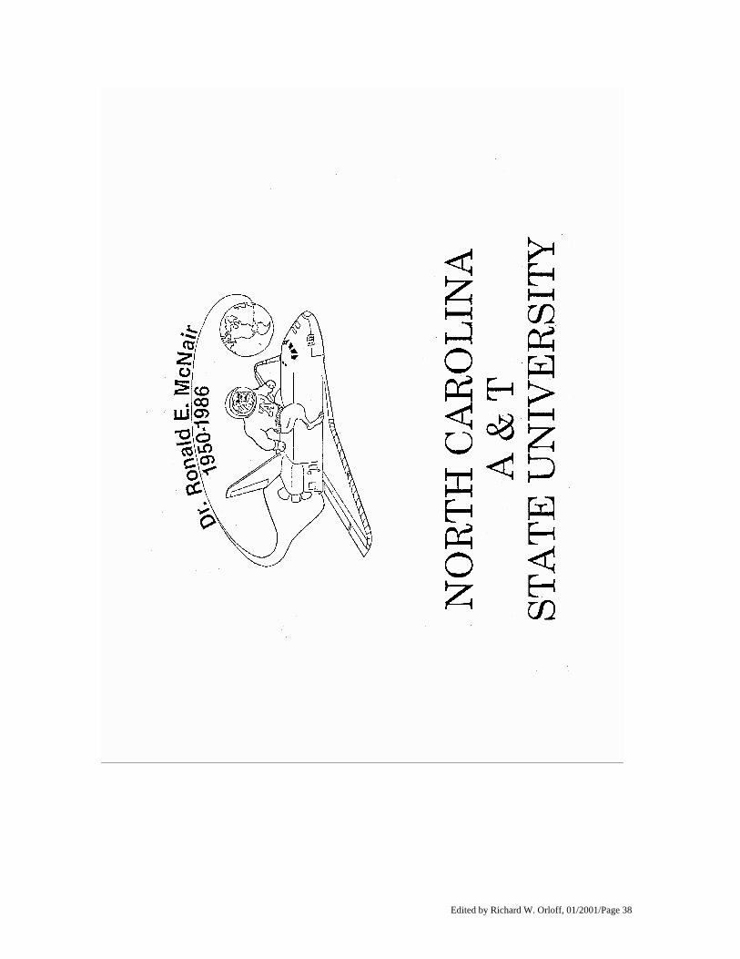
GET AWAY SPECIALS Two universities and a foreign country have small self- contained payloads flying on this mission. These customers are taking advantage of NASA's unique Get Away Special (GAS) program. GAS, managed by the Goddard Space Flight Center (GSFC), Greenbelt, Md., provides an opportunity for anyone in the world to access space. The GAS program presents an excellent educational tool for students. Individuals and organizations are able to send scientific research and development experiments into space aboard the Space Shuttle. So far, more than a hundred GAS payloads have flown on the Shuttle. Customers flying payloads on this mission include: G-316, North Carolina A&T University; G-503, University of Alabama in Huntsville; G-541, Swedish Space Corp. Following is a brief description of each. G-316 Customer: North Carolina A&T State University, Greensboro, NC Customer: Dr. Stuart Ahrens NASA Technical Manager: Charlie Knapp This payload contains two experiments designed to take advantage of the microgravity environment of the orbiting Shuttle. The first is a biology experiment that will study the effects of microgravity on the survival, mating and development of the milkweed bug. The second is a chemistry experiment that will use the microgravity environment to improve the growth quality and size of a crystal of rochelle salt. The entire payload weighs 100 pounds (45.36 kilograms) and fits in an airtight cylindrical canister which is mounted out in the payload bay of the orbiter. The payload is entirely self- contained and automated except for two relays that are controlled from the orbiter by the crew. Approximately half of the payload weight is due to batteries needed to control the experiments and keep the payload warm. The payload was conceived, designed and fabricated entirely by students in the university's Student Space Shuttle Program (SSSP). The SSSP owes its beginning to the late North Carolina A&T graduate and astronaut, Dr. Ronald E. McNair. More than 100 students representing 12 different majors have participated in the SSSP. The SSSP has received support in excess of $500,000 from more than 25 outside organizations, including Fortune 500 corporations. This support has been in the form of funds, consultation and payload parts. In addition to the primary goal of conceiving, designing and fabricating the payload, the SSSP has a number of secondary goals that are very important. These secondary goals are: to enhance the classroom experience by placing students in a real world project; to develop in students a strong sense of professionalism about their work; to have students interface with the high technology of the Space Shuttle; and to motivate students to pursue Dr. McNair's dream. When G-316 is launched aboard Endeavour in August, a number of tributes to Dr. McNair also will be on board. Attached to the outside of the payload's canister will be a large emblem in the university's colors. Included in the emblem will be the university's name and mascot and the inscription "Dr. Ron McNair, 1950-1986." Also in the orbiter's cabin will be two special 8x10 color photos, one of the Challenger crew and one of Dr. McNair.
Edited by Richard W. Orloff, 01/2001/Page 26
G-503 Customer: University of Alabama in Huntsville, Huntsville, Ala. Customer: Candance Townley NASA Technical Manager: Charlie Knapp This payload is sponsored by the Students for the Exploration and Development of Space at the University of Alabama in Huntsville to promote hands-on experience for its members. The primary objective of this payload is to successfully complete the following experiment: diatom (microscopic algae) growth and survivability in a cosmic radiation and microgravity environment; the mixing and curing of concrete; a study of microgravity influenced root growth; and a study of corrosive pitting in stainless steel. The secondary objective of these experiments is to provide students with a hands-on education of what is necessary to conduct scientific research in the space environment (funding, design, paperwork, manufacturing, testing, etc.). Experiment #1: The Microgravity and Cosmic Radiation Effects on Diatoms (MCRED) is the first test of a concept for a bioregenerative (ability for organisms to regenerate) life support system to be used on space station and Lunar/Mars expeditions. The experiment is designed to grow a series of diatom cultures in an ambient environment in low-Earth orbit. The microgravity and cosmic radiation effects will be evaluated based on recorded cell populations. The data will generate growth curves for study and interpretation. An additional study of physical changes in the cell wall structure (silicon dioxide) will be performed that will provide information about changes in cell metabolism. The results will be compared against ground experiments operating simultaneously to determine the cause of any observed changes. Experiment #2: The Concrete Curing In Microgravity (ConCIM) experiment is designed to give scientists and engineers valuable data about the feasibility of mixing and curing concrete in a microgravity environment. This data would be extremely valuable for future moon base applications. The concrete, cured for at least seven days in microgravity, will develop most of its ultimate chemical and physical properties. Once the experiment has been recovered, testing and material analysis will be performed to determine the chemical composition, the pore structure and strength of the space concrete. Test results will be compared to data obtained from a ground-based control sample of concrete, mixed and cured under similar conditions to determine the effect of the gravitational differences. Experiment #3: The Root Growth In Space (RGIS) experiment will study effects of microgravity on the early stages of germination of several seed types. The specific effects to be examined include production of gases during germination and the development and distribution of chemicals and hormones as they are affected by gravity. Experiment #4: The Microgravity Corrosion Experiment (COMET) is designed to examine the effects of microgravity on the mutation and growth of pitting in metals. Pitting is an extremely localized corrosion phenomenon which initiates on exposed surfaces and results in holes in the metal. It is one of the most destructive and insidious forms of corrosion and usually occurs in metal systems that exhibit a passive layer. Its effects are particularly vicious because it is a localized and intense form of corrosion, and failures often occur with extreme suddenness. Also, unlike many types of corrosion, pitting is difficult to predict. COMET will attempt to induce pitting in a stainless steel sample in order to study it in the absence of gravity and determine what forces drive this type of corrosion. This experiment has applications on Earth as well as in space for preventing pitting in corrosive material piping systems. The first three experiments are from students at the University of Alabama in Huntsville while the fourth experiment is from students at the University of Alabama in Birmingham.
Edited by Richard W. Orloff, 01/2001/Page 27
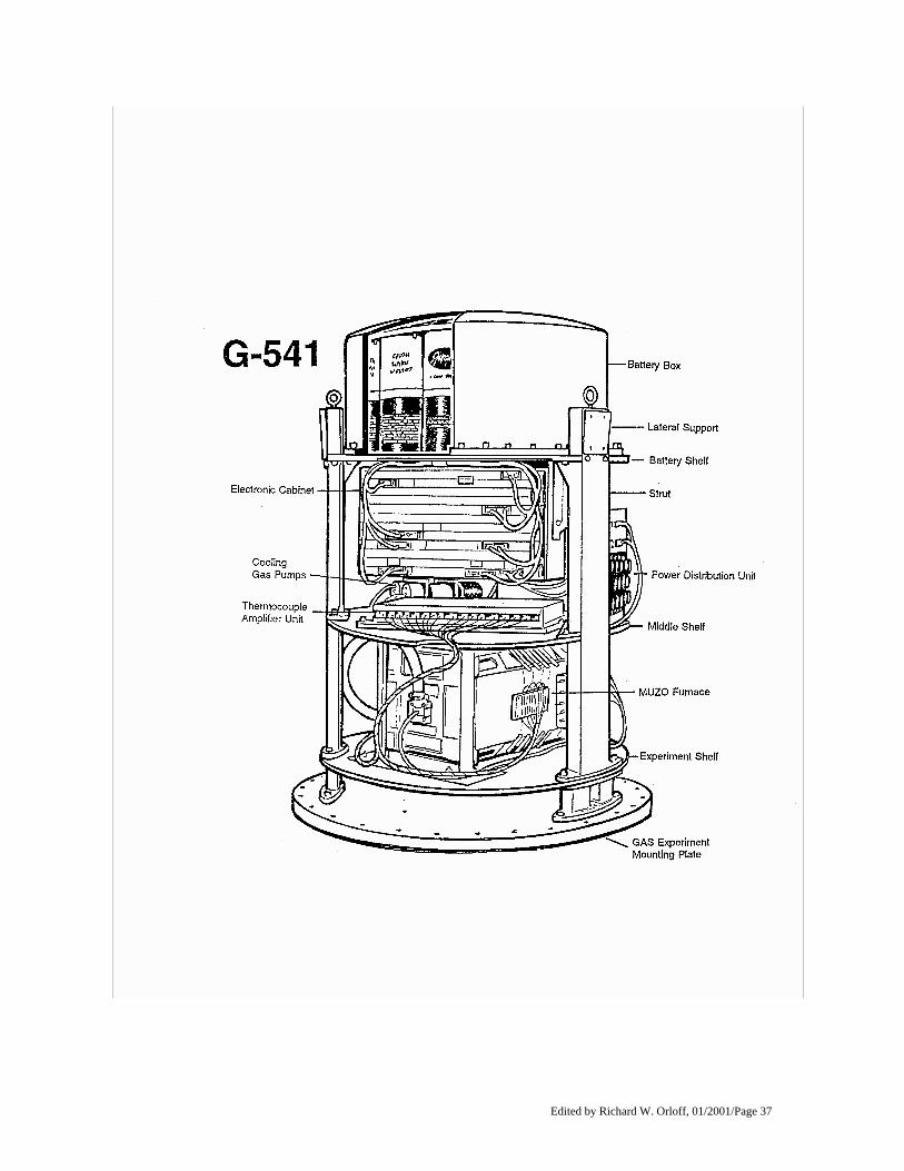
G-541 Customer: Swedish Space Corp., Solna, Sweden Customer: Kjell Anflo NASA Technical Manager: Barbara Milner The purpose of this experiment is to study the breakdown of a planar solid/liquid interface during crystal growth. A sample of Germanium treated with Gallium will be processed during the flight. The experiment is performed in a gradient furnace. In this furnace, which was developed for the previous G-330 flight, the growth rate can be controlled along the length of the crystal. The furnace is designed with electro-dynamic control of the temperature with a gradient moving along the sample. First the sample is heated up, melted and a controlled temperature gradient of 20 degrees Celsius is established. It is important to keep a short part of the sample solid because this part acts as a monocrystal seed. Subsequently the absolute temperature is decreased but the temperature gradient is maintained. The rate of the solidification front is kept constant at approximately 1 mm/sec. The dopant (an impurity added to a pure substance to produce a deliberate change) concentration along the sample is higher in the hot end. The interface will become unstable and will break down when the solidification front reaches the part of the sample where the dopant concentration increases. The interface demarcations are expected to reveal the development of the size of the disturbances and the wavelengths during interface breakdown. The thermo-couples and spreading resistance measurements will give accurate data of temperature gradients and dopant concentration, respectively. The payload consists of the following subsystems: * Multi Zone furnace, ceramic tube with five heating elements and a cooler * Sample cooling system, low pressure internal cooling system * Mechanical structure * Microprocessor-based system for control of the experiment, data handling and housekeeping * Accelerometers * Energy system, sealed lead batteries (1375 Wh) Other GAS hardware GAS hardware also is being used by the U.S. Postal Service to fly 500,000 commemorative stamps in recognition of the 25th anniversary of the Apollo 11 Moon Landing. The stamp that is being flown is a $9.95 Express Mail stamp. Artwork for the stamp was created by the father and son team of Paul and Chris Calle, experienced stamp designers and participants in the NASA Art Program. The new stamp shows two astronauts on the moon's surface with the Apollo landing module. The Express Mail stamp will be sold individually and in panes of 20 stamps.
Edited by Richard W. Orloff, 01/2001/Page 28
IN-CABIN PAYLOADS
COMMERCIAL PROTEIN CRYSTAL GROWTH (CPCG) The Commercial Protein Crystal Growth (CPCG) experiment has several objectives. One objective is to grow and retrieve highly structured protein crystals of sufficient size and quality to analyze the molecular structures of various proteins. Another objective is to obtain information on the dynamics of protein crystallization, allowing scientists to determine the parameters necessary to optimize scientific methods for producing large, high quality, well-ordered crystals. The CPCG experiment will be flown in what is known as a Block I configuration for STS-68. This configuration includes the utilization of one Commercial Refrigerator/Incubator Module (CRIM) to maintain a specific profile for three Vapor Diffusion Apparatus (VDA) trays. Each VDA tray contains 20 double-barrel syringes which empty into individually sealed sample chambers. Each syringe contains a protein solution in one barrel and a precipitant solution in the other barrel. The 20 syringes are ganged together on each of the VDA trays so that all the syringes on one VDA tray are deployed by one crew operation. The liquids in the syringes are deployed and retracted several times to adequately mix the protein and precipitant solutions. The final liquid deployment from the syringes leaves the fluid drop hanging on the end of the syringe tip. This configuration mimics a typical "hanging drop" configuration that is widely used for ground-based crystallization processes driven by vapor diffusion. The growth chamber surrounding the syringe tip contains a reservoir with a highly concentrated solution of precipitating agent. The crystallization process is driven by the difference in the vapor pressures of the hanging drop and the reservoir solution. Water vapor is transported from the hanging droplet of protein/precipitant solution to the reservoir solution of precipitating agent. Protein crystallization is initiated when the protein/precipitant concentrations within the hanging drop are altered by this vapor transport. When a unique protein/precipitant concentration for a particular sample is obtained in each of the growth chambers, crystallization occurs.
Edited by Richard W. Orloff, 01/2001/Page 29
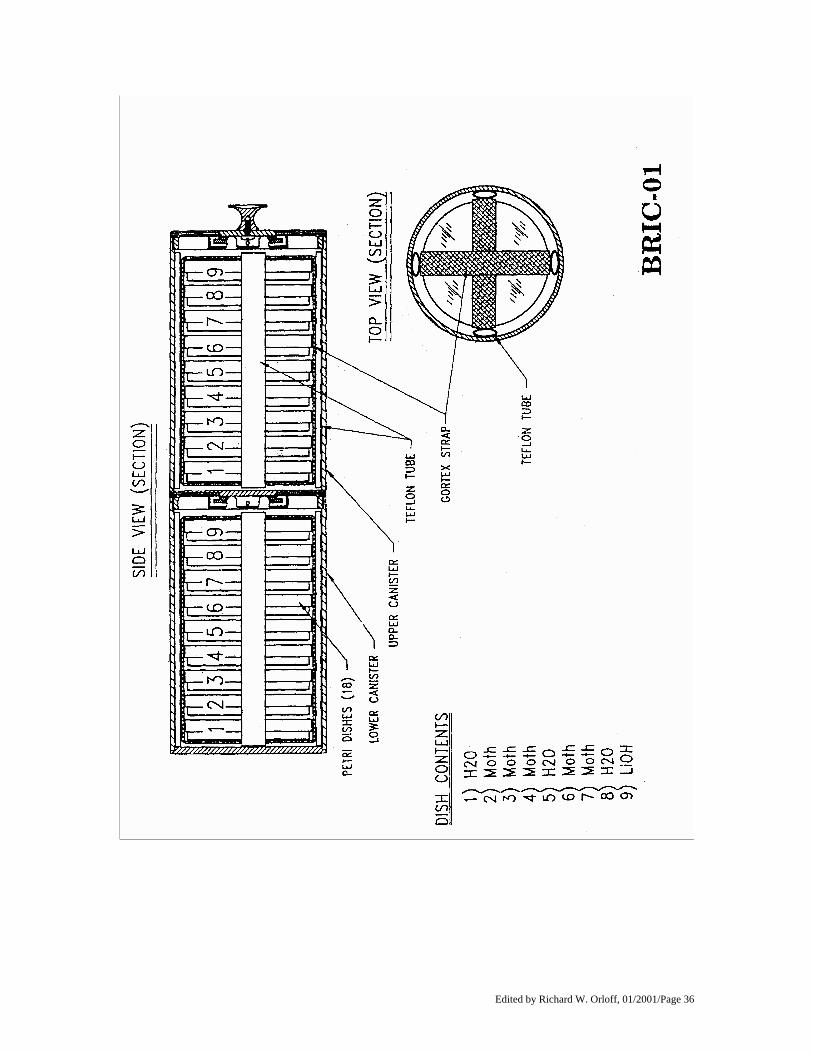
BIOLOGICAL RESEARCH IN CANISTERS - BRIC-01 STS-68 will fly the first in a new series of life sciences experiments titled, "Biological Research in Canisters (BRIC)." BRIC experiments, sponsored by NASA's Office of Life and Microgravity Sciences and Applications, are designed to examine the effects of microgravity on a wide range of physiological processes in higher order plants and arthropod animals (e.g., insects, spiders, centipedes, crustaceans). BRIC hardware consists of a small, self-contained, two-chambered aluminum container that requires no power. The first BRIC experiment (BRIC-01) will fly gypsy moth eggs to determine how microgravity affects the developing moth's diapause cycle. The diapause cycle is the period of time when the moth is in a dormant state and undergoing development. Previous spaceflights of gypsy moths have indicated that microgravity may shorten the diapause cycle which leads to the emergence of sterile gypsy moth larvae. Since the gypsy moth is among the most damaging insect pests of hardwood trees in the eastern United States, extensive ground- based research has been conducted to modify the gypsy moth's life cycle to create sterile moths. Results from NASA's BRIC-01 experiment could greatly enhance these research efforts. The investigator for this experiment, Dr. Dora K. Hayes, is a scientist with the U.S. Department of Agriculture in Beltsville, Md., in the Livestock Insects Laboratory.
Edited by Richard W. Orloff, 01/2001/Page 30
CHROMEX-05 STS-68 marks the fifth flight in the series of CHROMEX experiments designed to examine the effects of microgravity on a wide range of physiological processes in plants. CHROMEX experiments are flown in the Plant Growth Unit (PGU), an automated system that provides lighting, limited temperature control, and nutrients to support plant growth in the Shuttle middeck. Previous CHROMEX experiments (CHROMEX-03 and 04) indicate that plants grown in space may not produce seed embryos. The primary objective of CHROMEX-05 is to determine if plants grown in space are infertile due to microgravity or some other environmental factor. For this experiment, 13-day old Mouse-ear Cress (Arabidopsis thaliana) seedlings will be grown in space and will be compared to plants grown under similar conditions on the Earth. Results from this experiment will advance the field of space biology and will benefit the development of planned plant- based life support systems for future long duration space crews. Results may also benefit the nation's horticulture industry which produces plants under artificial conditions (e.g., aquaculture). The principal investigator for the primary experiment is Dr. Mary Musgrave, an associate professor in the department of Plant Pathology and Crop Physiology in the Louisiana Agricultural Experiments Station of the Louisiana State University Agricultural Center. The CHROMEX experiments are sponsored by NASA's Office of Life and Microgravity Sciences and Applications.
Edited by Richard W. Orloff, 01/2001/Page 31
COSMIC RADIATION EFFECTS AND ACTIVATION MONITOR (CREAM) The Cosmic Radiation Effects and Activation Monitor (CREAM) experiment on STS-68 is designed to collect data on cosmic ray energy loss spectra, neutron fluxes and induced radioactivity. The data will be collected by active and passive monitors placed at specific locations throughout the orbiter's cabin. The active monitor will obtain real-time spectral data while the passive monitors will obtain data during the entire mission to be analyzed after the flight. The flight hardware contains the active cosmic ray monitor, a passive sodium iodide detector and up to five passive detector packages. All hardware fits in one locker on Endeavour's middeck. Once in orbit, a crew member will be available at regular intervals to monitor the payload/experiment. CREAM is a Department of Defense payload and is flown under the direction of the DoD's Space Test Program.
Edited by Richard W. Orloff, 01/2001/Page 32
MILITARY APPLICATIONS OF SHIP TRACKS (MAST) The Office of Naval Research (ONR) is sponsoring the Military Applications of Ship Tracks (MAST) experiment on STS-68. MAST, which flew for the first time on STS-65 in July 1994, is part of a five-year research program developed by ONR to examine the effects of ships on the marine environment. The Naval Postgraduate School, Monterey, Calif., will conduct the experiment at the Johnson Space Center during the mission. The objective of MAST is to determine how pollutants generated by ships modify the reflective properties of clouds. Ship tracks are observed in satellite imagery as long, narrow, curvilinear cloud features that have greater brightness than the surrounding clouds. The STS-68 crew will photograph ship tracks using handheld cameras. These high-resolution photographs will provide insight into the processes of ship track production on a global scale. MAST will help in understanding the effects of man-made aerosols on clouds and the resulting impact on the climate system. MAST is a Department of Defense payload and is being flown under the direction of the DoD Space Test Program.
Edited by Richard W. Orloff, 01/2001/Page 33
STS-68 CREWMEMBERS
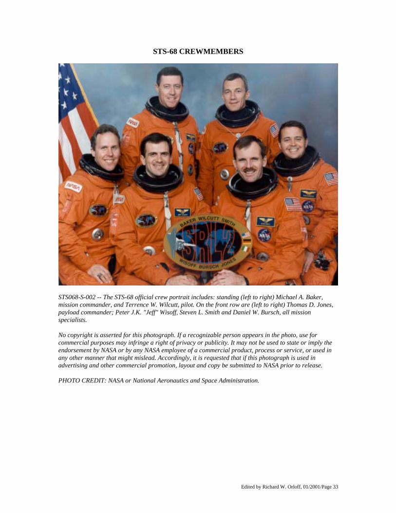
STS068-S-002 -- The STS-68 official crew portrait includes: standing (left to right) Michael A. Baker, mission commander, and Terrence W. Wilcutt, pilot. On the front row are (left to right) Thomas D. Jones, payload commander; Peter J.K. "Jeff" Wisoff, Steven L. Smith and Daniel W. Bursch, all mission specialists. No copyright is asserted for this photograph. If a recognizable person appears in the photo, use for commercial purposes may infringe a right of privacy or publicity. It may not be used to state or imply the endorsement by NASA or by any NASA employee of a commercial product, process or service, or used in any other manner that might mislead. Accordingly, it is requested that if this photograph is used in advertising and other commercial promotion, layout and copy be submitted to NASA prior to release. PHOTO CREDIT: NASA or National Aeronautics and Space Administration.
Edited by Richard W. Orloff, 01/2001/Page 34
BIOGRAPHICAL DATA MICHAEL (MIKE) A. BAKER, 40, Capt., USN, will be Commander (CDR) of STS-68. Selected as an astronaut in 1985, Baker considers Lemoore, Calif., his hometown and will be making his third Shuttle flight. Baker graduated from Lemoore Union High School in 1971 and received a bachelor's degree in aerospace engineering from the University of Texas in 1975. Baker's first Shuttle flight was as pilot aboard Atlantis' STS-43 mission in August 1991, a mission that deployed the fifth NASA Tracking and Data Relay Satellite. His second flight was as pilot of STS-52 in October 1992, a mission that deployed the Italian Laser Geodynamic Satellite and operated the first United States Microgravity Payload. Baker has logged more than 450 hours in space and more than 4,300 hours of flying time in 50 different types of aircraft. TERRENCE (TERRY) W. WILCUTT, 44, Major, USMC, will be Pilot (PLT) of STS-68. Selected as an astronaut in 1990, Wilcutt considers Russellville, Ky., his hometown and will be making his first Shuttle flight. Wilcutt graduated from Southern High School, Louisville, Ky., in 1967 and received a bachelor's degree in math from Western Kentucky University in 1974. After graduating from college, Wilcutt taught high school math for two years before joining the Marine Corps. Wilcutt earned his wings in 1978 and had initial training in the F-4 Phantom aircraft. He later attended the Naval Fighter Weapons School (Top Gun) and made two overseas deployments to Japan, Korea and the Philippines. In 1986 he attended the Naval Test Pilot School and graduated with distinction. He then served as a test pilot and project officer for the Strike Aircraft Test Directorate, Patuxent River, Md., until his selection by NASA. Wilcutt has over 3,000 flight hours in more than 30 different types of aircraft. THOMAS (TOM) D. JONES, 39, Ph.D., will be Payload Commander and Mission Specialist 4 (MS4) on STS-68. Selected as an astronaut in 1990, Jones was born in Baltimore, Md., and will be making his second space flight. Jones graduated from Kenwood Senior High School, Essex, Md., in 1973; received a bachelor's degree in basic sciences from the Air Force Academy in 1977; and received a doctorate in planetary science from the University of Arizona in Tucson in 1988. Jones served as an Air Force officer for six years, flying strategic bombers at Carswell AFB, Texas, and accumulating more than 2,000 hours of jet experience. He resigned his commission in 1983 and began work on his doctorate as a graduate research assistant. Following graduation in 1988, he served as a program management engineer in the CIA's Office of Development and Engineering. In 1990, he joined Science Applications International Corp., as a senior scientist, working on advanced program planning for the Solar System Exploration Division at NASA Headquarters, Washington, D.C. Jones' first flight was as a mission specialist on STS-59 in April 1994, the first flight of the Space Radar Lab. He has logged more than 269 hours in space.
Edited by Richard W. Orloff, 01/2001/Page 35
BIOGRAPHICAL DATA STEVEN (STEVE) L. SMITH, 35, will be Mission Specialist 1 (MS1). Selected as an astronaut in 1992, he considers San Jose, Calif., his hometown and will be making his first space flight. Smith graduated from Leland High School in San Jose in 1977; received a bachelor's degree in electrical engineering from Stanford University in 1981; received a master's degree in electrical engineering in 1982 from Stanford; and received a master's degree in business administration in 1987 from Stanford. Smith worked for IBM in the Large Scale Integration Technology Group in San Jose from 1982-1985, working on the development of electron beam chemical and lithographic processes for semiconductors. After a leave to pursue graduate studies, Smith returned to IBM's Hardware and Systems Management Group in Santa Clara, Calif., as a product manager for voice and telephony products. Smith joined NASA in 1989, serving in the Payload Operations Branch, Mission Operations Directorate, at the Johnson Space Center. He supported STS-37, STS-48, and STS-49 as a Payload Officer in Mission Control before his selection as an astronaut. DANIEL (DAN) W. BURSCH, 37, CDR., USN, will be Mission Specialist 2 (MS2). Selected as an astronaut in 1990, Bursch considers Vestal, N.Y., his hometown and will be making his second space flight. Bursch graduated from Vestal Senior High School in 1975; received a bachelor's degree in physics from the Naval Academy in 1979; and received a master's degree in engineering science from the Naval Postgraduate School in 1991. Bursch's first Shuttle flight was as a mission specialist on STS-51 in September 1993, a mission that deployed the Advanced Communications Technology Satellite and the Orbiting Retrievable Far and Extreme Ultraviolet Spectrometer/Shuttle Pallet Satellite. Bursch has logged more than 236 hours in space and more than 2,100 hours flying time in over 35 different aircraft. PETER (JEFF) J. K. WISOFF, 36, Ph.D., will be Mission Specialist 3 (MS3). Selected as an astronaut in 1990, Wisoff considers Norfolk, Va., his hometown and will be making his second space flight. Wisoff graduated from Norfolk Academy in 1976; received a bachelor's degree in physics from the University of Virginia in 1980; received a master's degree in applied physics from Stanford University in 1982; and received a doctorate in applied physics from Stanford in 1986. After completing his doctorate, Wisoff joined the Rice University faculty in the Electrical and Computer Engineering Department, researching the development of new vacuum ultraviolet and high intensity laser sources and the medical application of lasers to the reconstruction of damaged nerves. His recent work includes collaboration with researchers at Rice University on developing new techniques for growing and evaluating semiconductor materials using lasers. Wisoff's first flight was as a mission specialist on STS-57, a mission that retrieved the European Retrievable Carrier satellite and was the first flight of Spacehab. He has logged more than 239 hours in space.
Edited by Richard W. Orloff, 01/2001/Page 36
Edited by Richard W. Orloff, 01/2001/Page 37
Edited by Richard W. Orloff, 01/2001/Page 38
Edited by Richard W. Orloff, 01/2001/Page 39
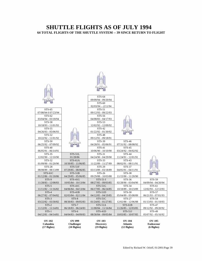
SHUTTLE FLIGHTS AS OF JULY 1994 64 TOTAL FLIGHTS OF THE SHUTTLE SYSTEM -- 39 SINCE RETURN TO FLIGHT
STS-64 09/09/94 - 09/20/94
STS-60 02/03/94 - -2/11/94
STS-65 07/08/94 0 07/23/94
STS-51 09/12/93 - 09/22/93
STS-62 03/04/94 - 03/18/94
STS-56 04/08/83 - 04/17/93
STS-58 10/18/93 - 11/01/93
STS-53 12/02/92 - 12/09/92
STS-55 04/26/93 - 05/06/93
STS-42 01/22/92 - 01/30/92
STS-52 10/22/92 - 11/01/92
STS-48 09/12/91 - 09/18/91
STS-50 06/25/92 - 07/09/92
STS-39 04/28/91 - 05/06/91
STS-46 07/31/92 - 08/08/92
STS-40 06/05/91 - 06/14/91
STS-41 10/06/90 - 10/10/90
STS-45 03/24/92 - 04/02/92
STS-35 12/02/90 - 12/10/90
STS-51L 01/28/86
STS-31 04/24/90 - 04/29/90
STS-44 11/24/91 - 12/01/91
STS-32 01/09/90 - 01/20/90
STS-61A 10/30/85 - 11/06/85
STS-33 11/22/89 - 11/27/89
STS-43 08/02/91 - 08/11/91
STS-28 08/08/89 - 08/13/89
STS-51F 07/29/85 - 08/06/85
STS-29 03/13/89 - 03/18/89
STS-37 04/05/91 - 04/11/91
STS-61C 01/12/86 - 01/18/86
STS-51B 04/29/85 - 05/06/85
STS-26 09/29/88 - 10/03/88
STS-38 11/15/90 - 11/20/90
STS-9 11/28/83 - 12/08/83
STS-41G 10/05/84 - 10/13/84
STS-51-I 08/27/85 - 09/03/85
STS-36 02/28/90 - 03/04/90
STS-59 04/09/94 - 04/20/94
STS-5 11/11/82 - 11/16/82
STS-41C 04/06/84 - 04/13/84
STS-51G 06/17/85 - 06/24/85
STS-34 10/18/89 - 10/23/89
STS-61 12/02/93 - 12/13/93
STS-4 06/27/82 - 07/04/82
STS-41B 02/03/84 - 02/11/84
STS-51D 04/12/85 - 04/19/85
STS-30 05/04/89 - 05/08/89
STS-57 06/21/93 - 07/01/93
STS-3 03/22/82 - 03/30/82
STS-8 08/30/83 - 09/05/83
STS-51C 01/24/85 - 01/27/85
STS-27 12/02/88 - 12/06/88
STS-54 01/13/93 - 01/19/93
STS-2 11/12/81 - 11/14/81
STS-7 06/18/83 - 06/24/83
STS-51A 11/08/84 - 11/16/84
STS-61B 11/26/85 - 12/03/85
STS-47 09/12/92 - 09/20/92
STS-1 04/12/81 - 04/14/81
STS-6 04/04/83 - 04/09/83
STS-41D 08/30/84 - 09/05/84
STS-51J 10/03/85 - 10/07/85
STS-49 05/07/92 - 05/16/92
OV-102
Columbia (17 flights)
OV-099 Challenger (10 flights)
OV-103 Discovery (19 flights)
OV-104 Atlantis
(12 flights)
OV-105 Endeavour (6 flights)


