99
Spatial Database Systems Tutorial Notes Ralf Hartmut Güting Fernuniversität Hagen Praktische Informatik IV D-58084 Hagen Germany [email protected]
Spatial Database Systems
Tutorial Notes
Ralf Hartmut Güting
Fernuniversität Hagen
Praktische Informatik IV
D-58084 Hagen
Germany

Ralf Hartmut Güting, Tutorial Spatial Database Systems
mall
an-
s
(or"
1 What is a Spatial Database System?
Requirement: Manage data related to some space.
Spaces:2D • geographic space (surface of the earth, at large or s
scales)
→ GIS, LIS, urban planning, ...
• the universe
→ astronomy
• a VLSI design
• a model of the brain (or someone's brain)
→ medicine
• a molecule structure
→ biological research
Characteristic for the supporting technology: capability of maging large collections of relatively simple geometric object
2.5D")
3D
2D
3D
3D

Ralf Hartmut Güting, Tutorial Spatial Database Systems
Terms:
pictorial database system
image
geometric
geographic
spatial
A database may contain
collections of
objects in some
space
raster images
of some space
clear identity, location,
extent
spatial database
system
image database
system
analysis,
feature extraction

Ralf Hartmut Güting, Tutorial Spatial Database Systems
ro-
-
s-
My personal definition of a spatial DBMS:
(1) A spatial database system is a database system
(2) It offers spatial data types in its data model and querylanguage
(3) It supports spatial data types in its implementation, pviding at least spatial indexing and efficient algorithmsfor spatial join.
Focus of this tutorial: describe fundamental problems and known solutions in a coherent manner.
2 Modeling
3 Querying
4 Tools for Implementation: Data Structures and Algorithms
5 System Architecture
Tutorial based on article:
R.H. Güting, An Introduction to Spatial Database Sytems. VLDB Journal 3 (4), 1994, pp. 357-399.
but revised and extended recently
Additional references there.
Ralf Hartmut Güting, Tutorial Spatial Database Systems
2 Modeling
2.1 What needs to be represented?
2.2 Discrete Geometric Bases
2.3 Spatial Data Types / Algebras
2.4 Spatial Relationships
2.5 Integrating Geometry into the DBMS Data Model

Ralf Hartmut Güting, Tutorial Spatial Database Systems
2.1 What needs to be represented?
Two views:
(i) objects in space
(ii) space itself
(i) Objects in space
city Berlin, …, population: 3 000 000,
city area:
river Rhine, …, route:
(ii) Space
Statement about every point in space (↔ raster images)
• land use maps (“thematic maps”)
• partitions into states, counties, municipalities, …

Ralf Hartmut Güting, Tutorial Spatial Database Systems
We consider:
1. modeling single objects
2. modeling spatially related collections of objects
1. Basic abstractions for modeling single objects:
• point
geometric aspect of an object, for which only its loca-tion in space, but not the extent, is relevant
• line (polyline)
moving through space, connections in space
• region
abstraction of an object with extent
city
rivercablehighway
forestlakecity

Ralf Hartmut Güting, Tutorial Spatial Database Systems
cts
2. Basic abstractions for spatially related collections of obje
• Partition
• Spatially embedded network (graph)
Others:
• nested partitions
• digital terrain models
• land use• districts• land ownership• “environments” of points Voronoi diagram
• highways, streets• railways, public transport• rivers• electricity, phone

Ralf Hartmut Güting, Tutorial Spatial Database Systems
2.2 Organizing the Underlying Space: Discrete Geomet-ric Bases
Is Euclidean geometry a suitable base for modeling?
Problem: space is continuous
computer numbers are discrete
p = (x, y) ∈ |R2
p = (x, y) ∈ real × real
• Is D on A?
• Is D properly contained in the area below
B
A
D’
D
A B?

Ralf Hartmut Güting, Tutorial Spatial Database Systems
in
Goal: Avoid computation of any new intersection points withgeometric operations
Two approaches:
• Simplicial complexes
Frank & Kuhn 86
Egenhofer, Frank & Jackson 89
• Realms
Güting & Schneider 93
Schneider 97
Definition of geometric types and operations
Treatment of numeric problems upon updates of the geometric basis
geometric basis

Ralf Hartmut Güting, Tutorial Spatial Database Systems
im-
Simplicial Complexes
(from combinatorial topology)
d-simplex: minimal object of dimension d
d-simplex consists of d+1 simplices of dimension d-1.
Components of a simplex are called faces. Simplicial complex: finite set of simplices such that the intersection of any two splices is a face.
0-simplex
1-simplex
2-simplex
3-simplex
etc.

Ralf Hartmut Güting, Tutorial Spatial Database Systems
ry
-
alm
ver-
Realms
Realm (intuitive notion): Complete description of the geomet(all points and lines) of an application.
Realm (formally): A finite set of points and line segments defined over a grid such that:
(i) each point or end point of a segment is a grid point
(ii) each end point of a segment is also a point of the re
(iii) no realm point lies within a segment
(iv) any two distinct segments do neither intersect nor olap
C
D
BA
Ralf Hartmut Güting, Tutorial Spatial Database Systems
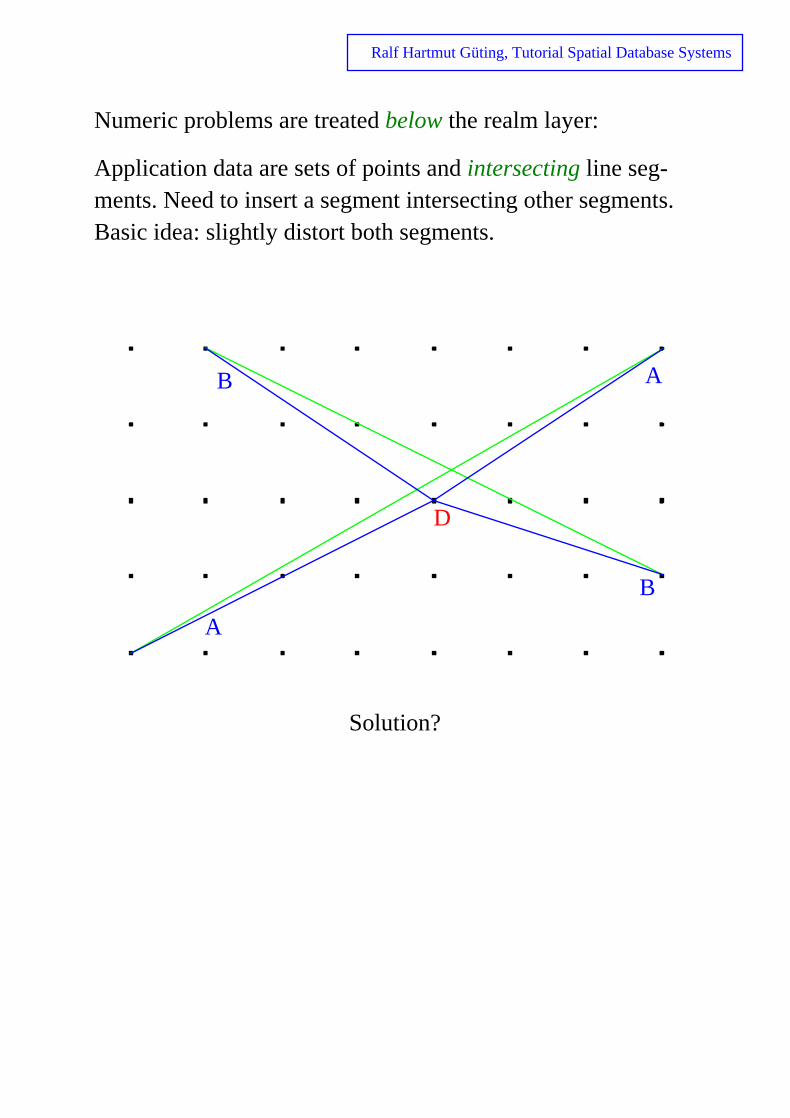
nts.
Numeric problems are treated below the realm layer:
Application data are sets of points and intersecting line seg-ments. Need to insert a segment intersecting other segmeBasic idea: slightly distort both segments.
Solution?
B
B
A
A
D

Ralf Hartmut Güting, Tutorial Spatial Database Systems
Segments can move! Point x is now on the wrong side of A!
B
B
A
A
C
A
B
B
A
C
A
A
C
x

Ralf Hartmut Güting, Tutorial Spatial Database Systems
ross
Concept of Greene & Yao (1986): Redraw segments within their envelope.
Segments are “captured” within their envelope; can never ca grid point.
P

Ralf Hartmut Güting, Tutorial Spatial Database Systems
-
s
d
op-
2.3 Spatial Data Types / Algebras
(spatial data type = SDT)
Requirements:
• “general structure” of values ↔ closed under set operations on the underlying point sets
• precise formal definition of SDT values and function
• definition in terms of finite precision arithmetics
• support for geometric consistency of spatially relateobjects
• independent of particular DBMS data model, but coerating with any

Ralf Hartmut Güting, Tutorial Spatial Database Systems
Geo-Relational Algebra (Güting 1988)
Relational algebra viewed as a many-sorted algebra (relations + atomic data types)
Sorts:
REL NUM POINT
STR LINE
BOOL REG PGON
AREA
cities cname center cpop
STR POINT NUM
PGONLINEPOINT AREA

Ralf Hartmut Güting, Tutorial Spatial Database Systems
Operations:
Geometric predicates
POINT × POINT → BOOL =, ≠
LINE × LINE → BOOL
REG × REG → BOOL
GEO × REG → BOOL inside
EXT × EXT → BOOL intersects
AREA × AREA → BOOL is_neighbour_of
GEO
EXT
REG
PGON AREALINEPOINT
intersects is_neighbour_of

Ralf Hartmut Güting, Tutorial Spatial Database Systems
Geometric relation operations
LINE* × LINE* → POINT* intersection
LINE* × REG* → LINE*
PGON* × REG* → PGON*
AREA* × AREA* → AREA* overlay
EXT* → POINT* vertices
POINT* × REG → AREA* voronoi
POINT* × POINT → REL closest
intersection
overlay
voronoi

Ralf Hartmut Güting, Tutorial Spatial Database Systems
Operations returning atomic geometric objects
POINT* → PGON convex_hull
POINT* → POINT center
EXT → POINT
convex_hull
center
Operations returning numbers
POINT × POINT → NUM dist
GEO × GEO → NUM mindist, maxdist
POINT* → NUM diameter
LINE → NUM length
REG → NUM perimeter, area

Ralf Hartmut Güting, Tutorial Spatial Database Systems
–
)
st
Compare to requirements:
• general structure, closed under point set ops
• formal definition +
• finite precision arithmetics –
• support for geometric consistency (–
• data model independent –
Problems:
• only simple polygons
• forming the intersection of two geometric objects mube embedded in a relation operation
• no difference of regions
• no numerically critical operations included
cannot be modeleddirectlyBremenNiedersachsen
- =

Ralf Hartmut Güting, Tutorial Spatial Database Systems
But also advantages:
• conceptually simple geometric objects
• simple formal definitions
• implementation: simple data structures + algorithms

Ralf Hartmut Güting, Tutorial Spatial Database Systems
w-
Scholl & Voisard 89
Algebra for manipulating “maps” = partitions
Goal: formal modeling of map operations, including the folloing:
Projection
Selection
corn district 1
corn district 2
wheat district 3
wheat district 4
district 1
district 2
district 3
district 4
corn district 1
corn district 2
wheat district 3
wheat district 4
wheat district 3
wheat district 4

Ralf Hartmut Güting, Tutorial Spatial Database Systems
Projection with merging (“fusion”)
“Windowing”
“Clipping”
corn district 1
corn district 2
wheat district 3
wheat district 4
corn
wheat
corn district 1
corn district 2
wheat district 3
wheat district 4
corn district 1
corn district 2
wheat district 4
corn
corn wheat
wheat
corn
corn
wheat
Ralf Hartmut Güting, Tutorial Spatial Database Systems
t of
r
Data type for regions:
Elementary region γ :
→ region of type γ
region of type {γ}
Embedded into a model for complex objects. A map is a setuples with a region attribute.
{[height: integer, land_use: string, area: γ ]
or area: {γ}]
Algebra for complex objects used (in particular, operator fonesting)
{[A: string, R: γ ]} →{[A: string, S: {R: γ }]}
+ some primitives on regions
+ some geometric set operations
or
NestA

Ralf Hartmut Güting, Tutorial Spatial Database Systems
Several other designs:
Gargano, Nardelli & Talamo 91
Larue, Pastre & Viemont 93
Svensson & Huang 91
Tomlin 90
Chan & Zhu 96

Ralf Hartmut Güting, Tutorial Spatial Database Systems
ROSE Algebra (Güting & Schneider 95)
ROSE = RObust Spatial Extension
A system of realm-based spatial data types → objects com-posed from realm elements
Types points, lines, regions
a points value a lines value
a regions value

Ralf Hartmut Güting, Tutorial Spatial Database Systems
ons
More complex structure of objects must be treated in definiti(and implementation).c2 is
• (area-) inside
• edge-inside
• vertex-inside
c1.
c1 and c2 are
• area-disjoint
• edge-disjoint
• (vertex-) disjoint
c2
c2
c2
(i)
(iii)
(ii)
(i, ii, iii)
(ii, iii)
(iii)
(iv, v, vi)
(v, vi)
(vi)
(iv)
(vi)
(v)

Ralf Hartmut Güting, Tutorial Spatial Database Systems
f
An R-face f is a pair (c, H), with c an R-cycle and H = {h1, …, hm} a set of R-cycles, such that:
(i) ∀ i ∈ {1, …, m}: hi edge-inside c
(ii) ∀ i, j ∈ {1, …, m}, i ≠ j: hi and hj are edge-disjoint
(iii) “no other cycle” can be formed from the segments of
Last condition enforces unique representations.

Ralf Hartmut Güting, Tutorial Spatial Database Systems
Let f = (f0, F) and g = (g0, G) be two R-faces.
f area-inside g
: ⇔ f0 area-inside g0
∧ ∀ g ∈ G:g area-disjoint f0
∨ ∃ f ∈ F: g area-inside f
A regions value F is a set of edge-disjoint R-faces.
Let F, G be two regions values.
F area-inside G
: ⇔ ∀ f ∈ F ∃ g ∈ G: f area-inside g
gg2g1
f
f2
f1

Ralf Hartmut Güting, Tutorial Spatial Database Systems
ipu-
ner-
.)
ROSE algebra offers precisely defined operations for manlating such values:
(GEO = {points, lines, regions}, EXT = { lines, regions})
∀ geo in GEO. ∀ ext in EXT.
geo × regions → bool inside
regions × regions → bool area-disjoint,
edge-disjoint,
edge-inside,
vertex-inside
Contains also (otherwise) numerically critical operations:
points × ext → bool on_border_of
ext × regions → bool border_in_common
Any intersection, union, difference can be formed due to geal structure of values:
points × points → points intersection
lines × lines → points intersection
regions × regions → regions intersection
regions × lines → lines intersection
geo × geo → geo plus, minus
(no embedding into e.g. relation operations needed
Ralf Hartmut Güting, Tutorial Spatial Database Systems
ob-
+
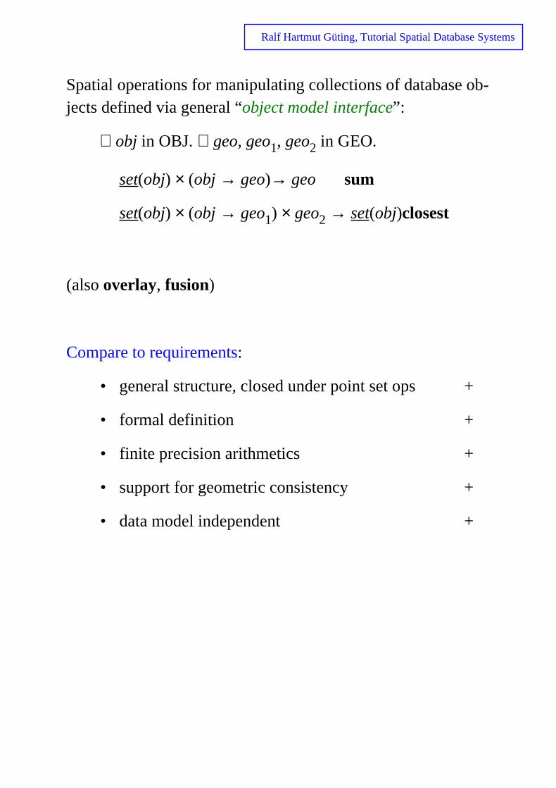
Spatial operations for manipulating collections of databasejects defined via general “object model interface”:
∀ obj in OBJ. ∀ geo, geo1, geo2 in GEO.
set(obj) × (obj → geo)→ geo sum
set(obj) × (obj → geo1) × geo2 → set(obj)closest
(also overlay, fusion)
Compare to requirements:
• general structure, closed under point set ops
• formal definition +
• finite precision arithmetics +
• support for geometric consistency +
• data model independent +

Ralf Hartmut Güting, Tutorial Spatial Database Systems
t dif-
But also disadvantages:
• No operations possible that create new geometries(leave the realm closure), e.g. voronoi, center, convex_hull
• Integrating realms into database systems somewhaficult. Updates of the realm must be propagated to realm-based attribute values in objects.
General issues concerning spatial data types / algebras:
• extensibility
• completeness
• one or more types (→ type “geometry”)?
• operations on sets of DB objects

Ralf Hartmut Güting, Tutorial Spatial Database Systems
E.g.
ple
2.4 Spatial Relationships
Most important operations of spatial algebras (predicates). find all objects in a given relationship to a query object.
• topological: inside, intersects, adjacent ... (invariant under translation, rotation, scaling)
• direction: above, below, north_of, ...
• metric: distance < 100
Topological relationships studied in some depth. Any com-pleteness criteria ?
Yes! Egenhofer 89 and subsequent work. Originally for simregions only (no holes, connected)
boundary
interior
A

Ralf Hartmut Güting, Tutorial Spatial Database Systems
4-intersection method (4 intersection sets for two objects)
42 = 16 combinations
∂A1 ∩ ∂A2 ∂A1 ∩ A2° A1° ∩ ∂A2 A1° ∩ A2° relationship name
∅ ∅ ∅ ∅ A1 disjoint A2
∅ ∅ ∅ ≠∅∅ ∅ ≠∅ ∅∅ ∅ ≠∅ ≠∅ A2 in A1∅ ≠∅ ∅ ∅∅ ≠∅ ∅ ≠∅ A1 in A2∅ ≠∅ ≠∅ ∅
∅ ≠∅ ≠∅ ≠∅≠∅ ∅ ∅ ∅ A1 touch A2≠∅ ∅ ∅ ≠∅ A1 equal A2≠∅ ∅ ≠∅ ∅≠∅ ∅ ≠∅ ≠∅ A1 cover A2≠∅ ≠∅ ∅ ∅
≠∅ ≠∅ ∅ ≠∅ A2 cover A1≠∅ ≠∅ ≠∅ ∅≠∅ ≠∅ ≠∅ ≠∅ A1 overlap A2

Ralf Hartmut Güting, Tutorial Spatial Database Systems
n
ish th-
Extensions:• include point and line features (Egenhofer & Herring
92, de Hoop & van Oosterom 92)
• consider also intersection of complements A-1 (Egen-hofer 91b).
Clementini et. al. 93: consider dimension of the intersectio
(empty, 0D, 1D, or 2D in 2-space) → 44 = 256 combinations, 52 are valid (dimension extended method).
Too many to be remembered !
Alternative: 5 basic relationships
• touch defined in terms of
• in dimension ext. method, e.g.
• cross <λ1 touch λ2> :⇔
• overlap (λ1° ∩ λ2°= ∅ ) ∧ (λ1 ∩ λ2 ≠ ∅)
• disjoint
+ 3 operators b, f, t to get boundaries.
One can prove:
• 5 relationships mutually exclusive
• 5 relationships + 3 boundary operators can distinguall 52 configurations of the dimension extended meod.

Ralf Hartmut Güting, Tutorial Spatial Database Systems
Further extensions:
• consider regions with holes (Egenhofer, Clementini &
Di Felice 94)
• consider composite regions (Clementini, Di Felice &
Califano 95) several disjoint components
Papadias et al. 95: What do relations between bounding boxes
tell us about the topological relations between their enclosed re-
gions?
13 possible relations on intervals in 1D space (Allen 1983)
→ 169 relations on rectangles in 2D space
etc.

Ralf Hartmut Güting, Tutorial Spatial Database Systems
2.5 Integrating Geometry into the DBMS Data Model
Basic idea: represent “spatial objects” by objects (of the DBMS data model) with at least one SDT attribute.
DBMS model must be open for user-defined types (→ abstract data type support, → extensibility).
E.g. for relational model:
relation states (sname: STRING; area: REGION;
spop: INTEGER)
relation cities (cname: STRING; center: POINT;
ext: REGION; cpop: INTEGER)
relation rivers (rname: STRING; route: LINE)
(representation of (sets of) single objects)
Ralf Hartmut Güting, Tutorial Spatial Database Systems
n
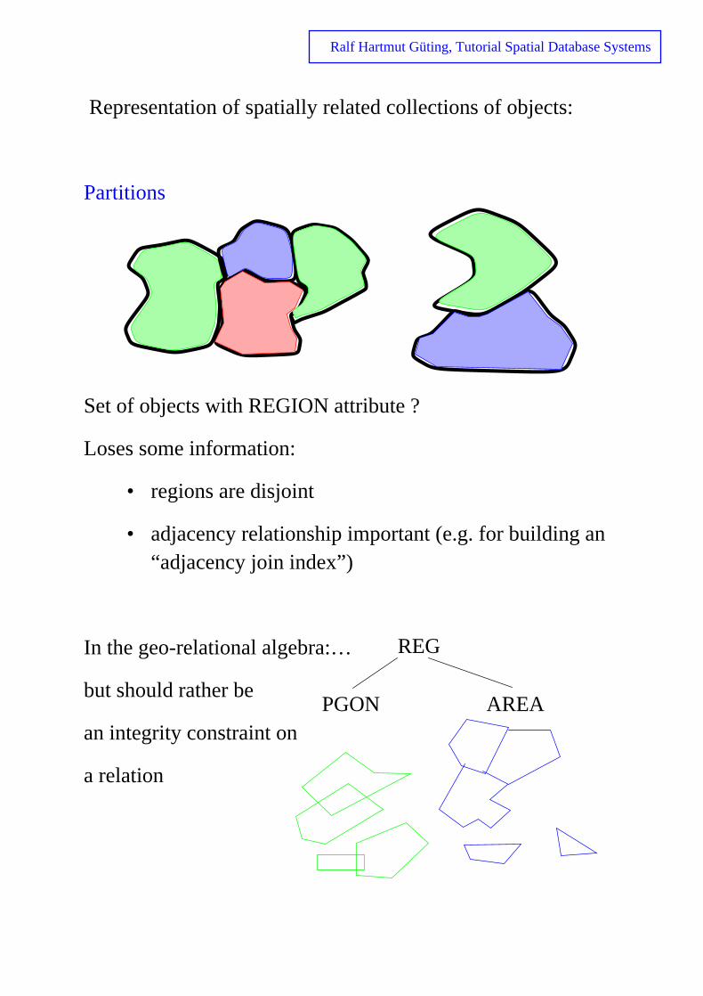
Representation of spatially related collections of objects:
Partitions
Set of objects with REGION attribute ?
Loses some information:
• regions are disjoint
• adjacency relationship important (e.g. for building a“adjacency join index”)
In the geo-relational algebra:…
but should rather be
an integrity constraint on
a relation
REG
PGON AREA

Ralf Hartmut Güting, Tutorial Spatial Database Systems
nted t
B el.
Networks
Not much research on spatially embedded networks (but a lot on graphs in databases in general). Usually graphs represeby given facilities of a data model. Disadvantage: Graph novisible to user; not very well supported by system. GraphD(Güting 94) has explicit graphs integrated into an OO mod
class vertex = pos: POINT;
vertex class junction = name: STRING;
vertex class exit = nr: INTEGER;
link class section = route: LINE, no_lanes: INTEGER,
top_speed: INTEGER from vertex to vertex;
path class highway = name: STRING as section+;

Ralf Hartmut Güting, Tutorial Spatial Database Systems
ets
3 Querying
Connect operations of a spatial algebra to the facilities of aDBMS query language.
Issues:• fundamental operations (algebra) for manipulating s
of database objects
• graphical input and output
• extending query languages
3.1 Fundamental Operations (Algebra)
• spatial selection
• spatial join
• spatial function application
• other set operations

Ralf Hartmut Güting, Tutorial Spatial Database Systems
l at-
“Spatial selection” ≡ selection based on a spatial predicate.
“Find all cities in Bavaria.”
cities select[center inside Bavaria]
“Find all rivers intersecting a query window.”
rivers select[route intersects Window]
“Find all big cities no more than 100 km from Hagen.”
cities select[dist(center,Hagen) ≤ 100 and
pop > 500 000]
“Spatial join” ≡ join based on a predicate comparing spatiatribute values.
“Combine cities with their states.”
cities states join[center inside area]
“For each river, find all cities within less than 50 kms.”
cities rivers join[dist(center, route) < 50]
a REGION value
a REGION value
a POINT value

Ralf Hartmut Güting, Tutorial Spatial Database Systems
new
ns
part
Spatial Function Application
How can we use operations of a spatial algebra computing SDT values? E.g.
regions × lines → lines intersection
• In selection conditions.
• Object algebra operators allow one to apply functioto each member of a set:
- filter operator (FAD)
- replace
- map
- extend / λ
“For each river going through Bavaria, return the name, the inside Bavaria and the length of that part.”
rivers select[route intersects Bavaria]
extend[intersection(route,Bavaria) {part}]
extend[length(part) {plength}]
project[rname, part, length]

Ralf Hartmut Güting, Tutorial Spatial Database Systems
nd le.
t.
Other Set Operations
Manipulate whole sets of spatial objects in a special way:
• operation is a conceptual unit
• separation between DBMS object set manipulation aspatial algebra SDT manipulation (often) not possib
For example:
• overlay
• fusion
• voronoi
Interfacing the spatial algebra with the DBMS more difficul
Section 2.3

Ralf Hartmut Güting, Tutorial Spatial Database Systems
lts
-
3.2 Graphical Input and Output
Needed:
• Graphical presentation of SDT values in query resu
• Entering SDT values (“constants” for queries)
• Overlay query results (build a taylored picture of thespace)
Requirements for spatial querying (Egenhofer 94)
1. Spatial data types
2. Graphical display of query results
3. Graphical combination (overlay) of several query results
4. Display of context
5. A facility for checking the content of a display
6. Extended dialog
7. Varying graphical representations
8. Legend
9. Label placement
10. Scale selection
11. Subarea for queries

Ralf Hartmut Güting, Tutorial Spatial Database Systems
Graphical user interface may have three (sub-)windows:
• text window for textual representation of a collection of objects
• graphics window for graphical representation of a col-lection of objects
• text window for entering queries and display of system messages
→ text-graphics interaction
Query may consist of three parts (Egenhofer 94):
• describe set of objects to be retrieved,
• partition this set by display queries into subsets,
• describe for each subset how to render its spatial at-tributes.
→ GPL (graphical presentation language) Egenhofer 91a
Tioga-2: Integrate the visual representation of a query with a vi-sualization of the result. Query represented as a dataflow graph (boxes and arrows). Query and visualization constructed incre-mentally. (Aiken et al. 96)

Ralf Hartmut Güting, Tutorial Spatial Database Systems
ns
use ion
3.3 Integrating Geometry into a Query Language
Three aspects:• denoting SDT values / graphical input
• expressing the four classes of fundamental operatio
• describing the presentation of results
Denoting SDT values. It is useful if the DBMS allows one to define named atomic data type values. For example:
DEFINE Bavaria
ELEMENT SELECT s.area
FROM s in states
WHERE s.sname = "Bavaria"
Allows one to decouple input via graphical input device and in query. Other proposal: keyword in query leads to interactfor input:
SELECT sname FROM cities WHERE center inside PICK

Ralf Hartmut Güting, Tutorial Spatial Database Systems
Expressing the four classes of fundamental operations:
• selection
• join
• function application
• other set operations
SELECT *
FROM rivers
WHERE route intersects Window
SELECT cname, sname
FROM cities, states
WHERE center inside area
SELECT rname, intersection(route, Bavaria),
length(intersection(route,Bavaria))
FROM rivers
WHERE route intersects Bavaria
do not fit with
also ok
SFW-construct
no problem

Ralf Hartmut Güting, Tutorial Spatial Database Systems
-
-ier
ed ulis
Describing presentation of results:
Could be
• part of query language
• separate language
• defined by GUI manipulation
Presentation language needs some querying capabilities.
Other directions:
• deductive database approach (e.g. Abdelmoty, Williams & Paton 93)
• visual querying – draw a sketch of spatial configurations of interest in a query (e.g. Maingenaud & Port90, Meyer 92)
• virtual reality exploration – fast navigation through large topographic scenes (Pajarola et al. 98)
• query by spatial structure: find all n-tuples of objects fulfilling a set of specified relationships. Can be viewas a generalization of spatial join. (Papadias, Mamo& Delis 98)
Ralf Hartmut Güting, Tutorial Spatial Database Systems
4 Tools for Spatial DBMS Implementation: Data Structures and Algorithms
Problem: Implementation of a spatial algebra in such a way that it can be integrated into a database system's query processing :
• representations for the types
• algorithms/procedures for the operations
Use of predicates in set-oriented query processing:
• spatial selection
• spatial join
• algorithms for set operations of a spatial algebra
4.1 Representing SDT Values and Implementing Atom-ic SDT Operations
4.2 Spatial Indexing - Supporting Spatial Selection
4.3 Supporting Spatial Join

Ralf Hartmut Güting, Tutorial Spatial Database Systems
-
pag-
nt-
ra-
,
4.1 Representing SDT Values and Implementing AtomicSDT Operations
Representation of an SDT value must be simultaneously compatible with two views:
DBMS view:
• like values of other types w.r.t. generic operations
• varying and possibly very large size
• resides permanently on disk in one page or a set of es
• can be loaded efficiently into memory (value of a poier variable there)
• offers type-specific implementations of generic opetions
Spatial algebra implementation view:
• value of a programming language data type
• is some arbitrary, possibly complex data structure
• supports computational geometry algorithms
• not designed to support just one particular algorithmbut balanced to support many well enough

Ralf Hartmut Güting, Tutorial Spatial Database Systems
Support DBMS view:
• paged data structure compatible with DBMS support for long fields or large attribute values
• info part and exact geometry part separately loadable
type polygon = pointer to
record area : real;
perimeter : real;
bbox : rectangle;
no_vertices : integer;
vertices : array[1..1000000]
of point
end
large
small
small, constantsize
possibly large, varying size
infopart
exactgeometrypart

Ralf Hartmut Güting, Tutorial Spatial Database Systems
e
Generic operations, for example:
Specifically for spatial data types
Support spatial algebra view:
• Representation contains plane sweep sequence
• Representation contains approximations
internal representation
ASCII
textual
graphical
bulk loadingdata exchange
internal representation approximation
pr
pl rl sl sr rrsr
rrql
prqr rl
ql
slpl
qr
userinterfac
interface with spatialaccess methods

Ralf Hartmut Güting, Tutorial Spatial Database Systems
tion
m-
• Representation contains stored unary function values
e.g. area, perimeter of region computed at construcof SDT value or delayed to first use.
Implementation of SDT operations:
• prechecking on approximations
• looking up stored function values
• use plane-sweep
Generally, use efficient algorithms from Computational Geoetry.
Güting, de Ridder & Schneider 95
Chan & Ng 97

Ralf Hartmut Güting, Tutorial Spatial Database Systems
n cts.
re
nt
ent
Special case of realm-based SDTs: Never any new intersectiopoints computed; all known in advance, occur in both obje
• often a parallel scan of two SDT values suffices wheotherwise a plane sweep is needed
lines × lines → points intersection
plane-sweep parallel scan of halfsegme
needed sequences suffices
(O(n log n + k), complex) (O(n+k), simple)
• plane sweep also simplified (only static sweep-evstructure needed)
(Güting, de Ridder & Schneider 95)
Ralf Hartmut Güting, Tutorial Spatial Database Systems
d in-
eral:
4.2 Spatial Indexing - Supporting Spatial Selection
Spatial indexing supports
• spatial selection
• spatial join
• other operations
Organizes space and the objects in it. Two strategies:
(i) dedicated external data structures
(ii) map spatial objects into 1D space and use a standardex structure (B-tree)
Fundamental idea for indexing and query processing in genuse of approximations (Frank 81, Orenstein 86, Orenstein & Manola 88)
• continuous approximation
• grid approximation

Ralf Hartmut Güting, Tutorial Spatial Database Systems
of
→ filter and refine strategy
Dedicated external data structures designed to store a setpoints or a set of rectangles.
Operations: insert, delete, member + query operations:
• range query
• nearest neighbour
• distance scan
• intersection query
• containment query

Ralf Hartmut Güting, Tutorial Spatial Database Systems
ions:
Space decomposed into buckets with associated bucket regClustering or secondary index.

Ralf Hartmut Güting, Tutorial Spatial Database Systems
to
he
4.2.1 One-Dimensional Embedding of Grid Approxima-
tions
Basic idea:
(i) find a linear order for the cells of the grid preservingproximity
(ii) define this order recursively for a grid correspondinga hierachical subdivision of space
z-order, Morton-order (Morton 66), bit interleaving. Generalbasis for query processing in PROBE (Orenstein 86).
Order imposed on all cells of a hierarchical subdivision is t lexicographical order of the bit strings.
01 11
00 10
1110
1
0
10

Ralf Hartmut Güting, Tutorial Spatial Database Systems
of
oid
Represent any shape by a set of bit strings, called z-elements.
Put z-elements as spatial keys into a B-tree B.
Containment query with rectangle r:
• determine z-elements for r
• for each z-element z scan a part of the leaf sequence B having z as a prefix
• check theses candidates for actual containment, avduplicate reports
10010 100110
1000

Ralf Hartmut Güting, Tutorial Spatial Database Systems
4.2.2 Spatial Index Structures for Points
Long tradition as structures for multi-attribute retrieval
Tuple t = (x1, …, xk) point in k dimensions
• grid file • EXCELL
• kd tree • buddy hash tree
• KDB tree • BANG file
• LSD tree • hB - tree
Grid file Nievergelt, Hinterberger & Sevcik 84
y1
y 2
y3
scales
directory
x x xx1 2 3
buckets
4

Ralf Hartmut Güting, Tutorial Spatial Database Systems
ary
bal-
kd-tree (Bentley 75) originally an internal structure:
KDB-tree (Robinson 81):introduce buckets, paginate the bintree, all leaves at the same level (like B-tree)
LSD-tree (Henrich, Six & Widmayer 89): abandon strict cy-cling through dimensions
• clever paging algorithm keeps external path length anced even for very unbalanced binary trees
→ important for transformation approach
B
A
C
D
G
F
3
5
A B
4
6E G
C D E F
2 2
x
y
x
y
0 1 3 4 5 62 7 8
876543210

Ralf Hartmut Güting, Tutorial Spatial Database Systems
le
e-
4.2.3 Spatial Index Structures for Rectangles
Rectangles more difficult than points, do not fall into a singcell of a bucket partition. Three strategies:
• transformation approach
• overlapping bucket regions
• clipping
Transformation approach: Hinrichs 85
Seeger & Kriegel 88
Rectangle (xl, xr, yb, yt) viewed as 4D point. Queries map to rgions of 4D space.
q
y=i2
i 2 qq1 21x=i
1
Ralf Hartmut Güting, Tutorial Spatial Database Systems
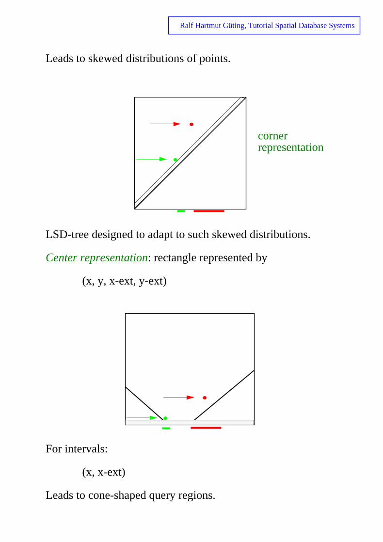
Leads to skewed distributions of points.
LSD-tree designed to adapt to such skewed distributions.
Center representation: rectangle represented by
(x, y, x-ext, y-ext)
For intervals:
(x, x-ext)
Leads to cone-shaped query regions.
cornerrepresentation

Ralf Hartmut Güting, Tutorial Spatial Database Systems
cket
Overlapping bucket regions:
Prime example: the R-tree Guttmann 84
Beckmann et al. 90 (R*-tree)
Advantage: Spatial object (or key) in a single bucket
Disadvantage: multiple search paths due to overlapping buregions
A D
E
F J
K
L
MC
I
H
G
B
A B C
D E F G H I J K L M

Ralf Hartmut Güting, Tutorial Spatial Database Systems
ver-
ot
Clipping:
R+
-tree: bucket regions disjoint; data rectangles cut into seal pieces, if necessary.
Sellis, Rossopoulos & Faloutsos 87
Faloutsos, Sellis & Rossopoulos 87
Advantage: less branching in search
Disadvantage: multiple entries for a single spatial object (ngood as a clustering index)
A D
E
F J
K
L
M
C
I
H
G
B
A CB
D E F J G H I M J K L

Ralf Hartmut Güting, Tutorial Spatial Database Systems
lied
e
Other directions in spatial indexing, for example
• quad tree variants (Samet 90)
• cell trees (Günther 88; ...)
Generalized Search Trees (GiST; Hellerstein, Naughton &
Pfeffer 95)
Generic, customizable tree structure. Key type (class) supp
by user with six required methods:
• consistent (p, q) p a key (predicate), q a predicat
• union ({p1, …, pn}) support for e.g. “bounding box”
• compress (p)
• decompress (π)
• penalty (p1, p2) support for insertion
• pickSplit (P) support for splitting
Can implement B-tree, R-tree, and many others.
p1 p2 pn pi key predicates,hold for all tuplesin subtree

Ralf Hartmut Güting, Tutorial Spatial Database Systems
ion
Further issues:
• provide concurrency control for the new structures
(necessary to make them really usable in a product
DBMS)
Kornacker & Banks 95 R-tree
Chakrabarti & Mehrotra 98 R-tree
Kornacker, Mohan & Hellerstein 97 GiST
• bulk loading techniques → better clustering, less time
for building the index
Van den Bercken, Seeger & Widmayer 97
Surveys on spatial indexing: Widmayer 91, Günther 98 (Sec-tion 3.3), Gaede & Günther 98.

Ralf Hartmut Güting, Tutorial Spatial Database Systems
ns re-
Index structures offering a few fundamental query operatiosupport selection with many different predicates (by filter +fine) E.g. intersection query
Find regions adjacent to A.
Find regions within distance d from B.
- d -

Ralf Hartmut Güting, Tutorial Spatial Database Systems
Extensions of the filter + refine strategy: Add a second filter step with better approximation than bounding box (Brinkhoff, Kriegel and Schneider 93), for example
• minimum bounding ellipse
• convex hull min. bounding 5-corner
Conservative approximation: encloses object
→ exclude false hits
Progressive approximation: contained in the object
→ identify hits
• e.g. maximum enclosed circle, rectangle
Goal: avoid loading the exact geometry for many objects (SDT values).
Using orthogonal polygons as bounding structures has also been investigated (Esperanca & Samet 97).
Ralf Hartmut Güting, Tutorial Spatial Database Systems
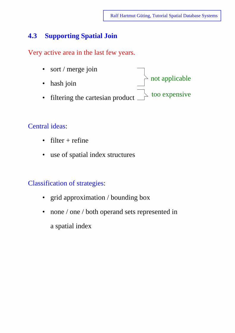
4.3 Supporting Spatial Join
Very active area in the last few years.
• sort / merge join
• hash join
• filtering the cartesian product
Central ideas:
• filter + refine
• use of spatial index structures
Classification of strategies:
• grid approximation / bounding box
• none / one / both operand sets represented in
a spatial index
not applicable
too expensive

Ralf Hartmut Güting, Tutorial Spatial Database Systems
s
The Filter Step
Grid approximations
E.g., overlap → parallel scan through the sets of z-element
0110, 10, 10010, 100110, 10110, ..
0111, 100, 1010, 1011, 1101→ (Α,Β), (Α,C) , ...A
B C
01
00 10
11
B
C
A

Ralf Hartmut Güting, Tutorial Spatial Database Systems
he
Bounding box approximations
(1) None of the operands represented in a spatial index
→ rectangle intersection problem
determine all pairs (p, q), p intersects q
→ bb-join operation, general basis for spatial join; plays trole of sort/merge join for standard data types.
Needed as a query processing method in any case:
cities select[pop > 500 000]
states select[language = "french"]
join[center inside area]
no indexany more

Ralf Hartmut Güting, Tutorial Spatial Database Systems
ct-
n
e
te
rit-
h
Proposed solutions:
• External, or “sweeping”, divide-and-conquer algo-
rithm (Güting & Schilling 87), adapted from internal
computational geometry algorithm. Finds all interse
ing pairs in one set of rectangles. Simple modificatio
to treat two sets implemented as bbjoin method in the
Gral system, Becker & Güting 92).
Divide plane into vertical stripes such that each strip
contains about c vertical edges of rectangles. Compu
intersections between rectangles represented in the
stripe by internal DAC algorithm. External: Merge ad-
jacent stripes bottom-up, as in external merge sort, w
ing intermediate structures into files again.
Sweeping: Keep the result of merging stripes 1 throug
j in memory. In each step, read stripe j+1 and merge
with it.

Ralf Hartmut Güting, Tutorial Spatial Database Systems
o
n-
t
h
;
ith
• “Spatial hash join” (Lo & Ravishankar 96, Patel &
De Witt 96). Assign the two sets of rectangles to tw
sets of buckets; process pairs of buckets internally.
Many design choices; nice analysis in Lo & Ravisha
kar 96. Concrete proposals and experiments:
Lo & Ravishankar 96: Overlapping bucket areas for se
B; each rectangle assigned to one bucket which grows
under insertion (initial bucket areas by sampling).
Bucket areas for A chosen equal to those of B; eac
rectangle in A goes into all buckets it overlaps.
Patel & De Witt 96: Decompose plane into regular grid
map grid cells into buckets by round-robin to deal w
skew in rectangle distribution.
0 1 2 0
1 2 0 1
2 0 1 2
Partitionnumber

Ralf Hartmut Güting, Tutorial Spatial Database Systems
at
m
ct-
ally
• “Size separation spatial join” (Koudas & Sevcik 97).
Distribute rectangles into two hierarchical grid parti-
tions. Each rectangle falls into lowest level grid cell th
wholly contains it.
Each bucket from set B is merged with all buckets fro
set A of the same or higher level. No replication of re
angles necessary, each page read exactly once.
• “Scalable sweeping-based spatial join” (Arge et al. 98).
Somewhat similar to Güting & Schilling 87. Divide
plane into vertical stripes. Process each stripe intern
by plane sweep.
Worst-case I/O analysis, theoretically optimal.
end piececenter piece
smallrectangle
end piece

Ralf Hartmut Güting, Tutorial Spatial Database Systems
set; the
t
r
(2) One of the operands represented in a spatial index
→ index join, repeated search join. Scan “outer” operand for each object perform a search with the bounding box onindex for the “inner” operand.
Or build an index on the fly, starting from the known bucke
boundaries of the existing index. (“Seeded trees”, Lo & Ravis-
hankar 94)
(3) Both operands are represented in a spatial index
Basic idea: Synchronized, parallel traversal of the two data structures
• grid files
(Rotem 91, Becker, Hinrichs & Finke 93)
• R-trees
(Brinkhoff, Kriegel & Seeger 93; refined version withbreadth-first traversal: Huang, Jing & Rundensteine97)
• generalization trees(Günther 93)
Further idea: Use of join indices (Rotem 91, Lu & Han 92)

Ralf Hartmut Güting, Tutorial Spatial Database Systems
ip
d-
st
Second Filter Step
Introduce a second filter step with better approximations
(Brinkhoff et al. 94), as before for spatial selection.
Huang, Jones & Rundensteiner 97: “Symbolic intersect detec-
tion.” Consider intersection area of two bounding boxes, cl
contained polygons by this; examine configuration of boun
aries in this area.
Some configurations of boundaries imply that polygons mu
intersect; no further plane-sweep needed.

Ralf Hartmut Güting, Tutorial Spatial Database Systems
n
nds
Zimbrao & Souza 98: For second filter step, represent polygo
as a four-colour bitmap.
Scale polygons for comparison. Compare cells: only weak-
weak and weak-strong are inconclusive.
Further work on:
• spatial join in distributed DBMSs (Abel et al. 95)
“spatial semi-join”
• parallel processing of spatial join (Brinkhoff, Kriegel &
Seeger 96, Zhou, Abel & Truffet 97)
• “ incremental distance join”: enumerate pairs by in-
creasing distance; possibly restrict by distance bou
or number of results. (Hjaltason & Samet 98)
empty
weak (≤ 50%)
strong (> 50%)
full
Ralf Hartmut Güting, Tutorial Spatial Database Systems
ure.
n
pe-
ion
5 System Architecture
5.1 Requirements
Integrate the tools from Section 4 into the system architectAccomodate the following extensions:
• representations for data types of a spatial algebra
• procedures for atomic operations
• spatial index structures
• access operations for spatial indices
• spatial join algorithms
• cost functions for all these operations
• statistics for estimating selectivity of spatial selectioand spatial join
• extensions of the optimizer to map queries into the scialized query processing methods
• spatial data types and operations within data definitand query language
• user interface extensions for graphical I/O
Clean solution: Integrated architecture using an extensibleDBMS.

Ralf Hartmut Güting, Tutorial Spatial Database Systems
5.2 GIS - Architectures — Using a Closed DBMS
First generation: built on top of file system
→ no high level data definition,
no flexible querying,
no transaction management,
...
Using a standard (mostly relational) DBMS:
• layered architecture
• dual architecture
Layered architecture
Spatial Tools
Standard DBMS

Ralf Hartmut Güting, Tutorial Spatial Database Systems
per
gs; only
dex
Representation of SDT values:
(1) Decompose SDT value into a set of tuples, one tuple point or line segment
states sid sname pop
s01 "Bavaria" 7 000 000
edges sid x1 y1 x2 y2
s01 134.78 92.514 137.13 93.84 1
s01 137.13 93.84 139.11 96.37 2
s02
...
Obviously terrible.
(2) Represent SDT values in “long fields” of DBMS
GEOVIEW Waugh & Healey 87
SIRO-DBMS Abel 89
DBMS handles geometries only as uninterpreted byte strinany predicate or other operation on the exact geometry canbe evaluated in the top layer.
Indexing: maintain sets of z-elements in special relations; inthese with a B-tree.
edge

Ralf Hartmut Güting, Tutorial Spatial Database Systems
s n
uence lds be
e.
l-
Some variant of these techniques currently used in Oracle8 Spatial Cartridge (Oracle 97). Spatial tools layer offers typepoint, line, polygon, and polygon with holes. A line or polygovalue is represented in a set of tuples. Each tuple has a seqnumber and fields to take 125 coordinate pairs. Unused fieare padded with zeroes. Hence small lines or polygons canrepresented in a single tuple.
Spatial indexing by sets of z-elements, as mentioned abov
Oracle intends to move to spatial data types as ADTs in coumns (Oracle 97).

Ralf Hartmut Güting, Tutorial Spatial Database Systems
go-
Dual architecture
Spatial object representation broken into two pieces:
Advantage: freedom to use efficient data structures and alrithms in the spatial subsystem.
Problems: Query must also be decomposed into two parts→ complex query processing.
Integration Layer
Standard DBMS Spatial Subsystem
Bavaria 7 000 000
Bavaria 7 000 000

Ralf Hartmut Güting, Tutorial Spatial Database Systems
for a sti-
e.g.
No global query optimization possible.
For example, either spatial or standard index can be used given query, but standard DBMS does not reveal its cost emate.
Used in most commercial GIS; some research prototypes,
ARC / INFO(Morehouse 89)
SICAD(Schilcher 85)
Ooi, Sacks-Davis & McDonell 89
Dual architecture also in
Aref & Samet 91a, 91b
but build a new system (not using a standard DBMS).

Ralf Hartmut Güting, Tutorial Spatial Database Systems
-
;
rd
the
5.3 Integrated Spatial DBMS Architecture — Using an Extensible DBMS
Research into extensible database systems tried to make extensions required above possible.
POSTGRES Starburst
Probe Gral
EXODUS Sabrina
GENESIS DASDBS
Predator
Leads to integrated architecture:
(1) No difference in principle between a “standard” datatype (STRING) and a spatial data type (REGIONS)same for operations.
(2) No difference in principle between index for standaattributes (B-tree) and for spatial attributes (R-tree).
(3) Sort/merge join and bounding-box join are basically same.
(4) Mechanisms for query optimization do not distiguishspatial or other operations.

Ralf Hartmut Güting, Tutorial Spatial Database Systems
Extensible architecture (in general)
Extensible DBMS
query processing methods
optimization rules
index structures data type representations

Ralf Hartmut Güting, Tutorial Spatial Database Systems
Extensible architecture (specifically for Gral)
Query Algebra ("Descriptive Algebra")
Query Processing Algebra ("Executable Algebra")
Parser & Optimizer
Parser & Query Processor
Operators
Relation Representation
Index
StructuresDataTypes
Storage and Buffer Management
Operator Implementations (+ cost functions)
Primitive Ops on Relations and Index Structures. Access to Componentsof Atomic Type Reps
rulerule
scan sort smjoin
exactmatch rect_searchpr_inside
BTREE LSDTREE BTREEINDEX
TIDREL LSDINDEX STRING PGON
≤+

Ralf Hartmut Güting, Tutorial Spatial Database Systems
ys-
s
in
ells of-
Some spatial DBMS prototypes built based on extensible stems:
PROBE Orenstein 86
Orenstein & Manola 88
• functional data model
• general POINT-SET data type, SDTs as refinement
• “approximate geometry” processing: SDT values assets of z-elements; spatial indexing and spatial jointhe system kernel (filter + refine strategy).
DASDBS Schek et al. 90
Wolf 89
• nested relational model
• EDT (“external data type”) concept
→ external “geometric computation service”
• spatial access methods partitioning data space into care assumed (e.g. grid file, R-tree); each EDT mustfer clip and compose functions.

Ralf Hartmut Güting, Tutorial Spatial Database Systems
ribe
tree)
ing
GRAL Güting 89
Becker & Güting 92
• relational model
• many-sorted algebra as a formal basis; used to descquery language and query processing system
• rule-based optimizer
• bounding box as interface to access methods (LSD
PARADISE DeWitt et al. 94
Patel et al. 97
• parallel spatial DBMS; emphasis on parallel process
techniques
• treatment of satellite images / large n-dimensional ar-
rays
• implemented on SHORE storage manager
• treatment of very large data sets (120 GB)

Ralf Hartmut Güting, Tutorial Spatial Database Systems
x-
MONET Boncz, Quak & Kersten 96
• parallel, main memory, spatial DBMS
• many-sorted algebra extensibility (as in Gral)
• “decomposed storage” model (binary relations)
Further prototypes:
Geo++ Oosterom & Vijlbrief 91
on POSTGRES Vijlbrief & Oosterom 92
GéoSabrina Larue, Pastre & Viémont 93
on Sabrina
Commercial extensible DBMS with spatial extensions, for e
ample:
• Informix Universal Server, with Geodetic DataBlade
(Informix 97)
• IBM DB2 Spatial Extender (Davis 98)

Ralf Hartmut Güting, Tutorial Spatial Database Systems
es
8,
-
Not covered in this tutorial:
• image database systems, raster data management
Lots of other interesting issues (only selected references):
• spatio-temporal databases, moving objects databas
Worboys 94, Sistla et al. 97, Güting et al. 98
• spatial objects with imprecise boundaries
Erwig & Schneider 97
• multi-scale modeling / cartographic generalization
Puppo & Dettori 95, Rigaux & Scholl 95
• data lineage
Woodruff & Stonebraker 97
• query processing for spatial networks
Shekhar & Liu 97, Huang, Jing & Rundensteiner 97
• nearest neighbor / similarity search
Rossopoulos, Kelley & Vincent 95, Berchtold et al. 9Hjaltason & Samet 95
• spatial constraint databases
Paredaens 95, Belussi, Bertino & Catania 97, Grumbach, Rigaux & Segoufin 98

Ralf Hartmut Güting, Tutorial Spatial Database Systems
r in-
d .
a--217.
po-
h Intl.
ed
nsible
es.
322-
es.
ch in
l ta-
rees.
References
Abdelmoty, A.I., M.H. Williams, and N.W. Paton, Deduction and Deductive Databases foGeographic Data Handling. Proc. 3rd Intl. Symposium on Large Spatial Databases, Sgapore, 1993, 443-464.
Abel, D.J., B.C. Ooi, K.L Tan, R. Power, and J.X. Yu, Spatial Join Strategies in DistributeSpatial DBMS. Proc. 4th Intl. Symposium on Large Spatial Databases, 1995, 348-367
Abel, D.J., SIRO-DBMS: A Database Tool Kit for Geographical Information Systems. Intl. J. of Geographical Information Systems 3 (1989), 103-116.
Aiken, A., J. Chen, M. Stonebraker, and A. Woodruff, Tioga-2: A Direct Manipulation Datbase Visualization Environment. Proc. 12th Intl. Conf. on Data Engineering, 1996, 208
Allen, J.F., Maintaining Knowledge about Temporal Intervals. Communications of the ACM 16(1983), 832-843.
Aref, W., and H. Samet, Extending a DBMS with Spatial Operations. Proc. 2nd Intl. Symsium on Large Spatial Databases, Zürich, 1991, 299-318.
Aref, W., and H. Samet, Optimization Strategies for Spatial Query Processing. Proc. 17tConf. on Very Large Data Bases, Barcelona, 1991, 81-90.
Arge, L., O. Procopiuc, S. Ramaswamy, T. Suel, and J.S. Vitter, Scalable Sweeping-BasSpatial Join. Proc. 24th Intl. Conf. on Very Large Data Bases, 1998, 570-581.
Becker, L., and R.H. Güting, Rule-Based Optimization and Query Processing in an ExteGeometric Database System. ACM Transactions on Database Systems 17 (1992), 247-303.
Becker, L., K. Hinrichs, and U. Finke, A New Algorithm for Computing Joins with Grid FilProc. 9th Intl. Conf. on Data Engineering, Vienna, 1993, 190-198.
Beckmann, N., H.P. Kriegel, R. Schneider, and B. Seeger, The R*-Tree: An Efficient andRobust Access Method for Points and Rectangles. Proc. ACM SIGMOD Conf. 1990, 331.
Belussi, A., E. Bertino, and B. Catania, Manipulating Spatial Data in Constraint DatabasProc. 5th Intl. Symposium on Large Spatial Databases, Berlin, 1997, 115-141.
Bentley, J.L., Multidimensional Binary Search Trees Used for Associative Searching. Commu-nications of the ACM 18 (1975), 509-517.
Berchtold, S., B. Ertl, D.A. Keim, H.P. Kriegel, and T. Seidl, Fast Nearest Neighbor SearHigh-Dimensional Space. Proc. 14th Intl. Conf. on Data Engineering, 1998, 209-218.
Boncz, P.A., W. Quak, and M.L. Kersten, Monet and its Geographic Extensions: A NoveApproach to High Performance GIS Processing. Proc. 5th Intl. Conf. on Extending Dabase Technology, 1996, 147-166.
Brinkhoff, T., H.P. Kriegel, and B. Seeger, Efficient Processing of Spatial Joins Using R-TProc. ACM SIGMOD Conf., Washington, 1993, 237-246.

Ralf Hartmut Güting, Tutorial Spatial Database Systems
rees.
s.
l
tec-
rators 69-93.
irst 286.
.
la-ial
Intl.
nf.
ses. 86.
ine,
m on
with
Brinkhoff, T., H.P. Kriegel, and B. Seeger, Parallel Processing of Spatial Joins Using R-tProc. 12th Intl. Conf. on Data Engineering, 1996, 258-265.
Brinkhoff, T., H.P. Kriegel, and R. Schneider, Comparison of Approximations of ComplexObjects Used for Approximation-Based Query Processing in Spatial Database SystemProc. 9th Intl. Conf. on Data Engineering, Vienna, 1993, 40-49.
Brinkhoff, T., H.P. Kriegel, R. Schneider, and B. Seeger, Multi-Step Processing of SpatiaJoins. Proc. ACM SIGMOD Conf., Minneapolis, 1994, 197-208.
Chakrabarti, K., and S. Mehrotra, Dynamic Granular Locking Approach to Phantom Protion in R-Trees. Proc. 14th Intl. Conf. on Data Engineering, 1998, 446-454.
Chan, E.P.F., and J. N.H. Ng, A General and Efficient Implementation of Geometric Opeand Predicates. Proc. 5th Intl. Symposium on Large Spatial Databases, Berlin, 1997,
Chan, E.P.F., and R. Zhu, QL/G – A Query Language for Geometric Data Bases. Proc. FIntl. Conf. on GIS in Urban and Environmental Planning, Samos, Greece, 1996, 271-
Clementini, E., P. Di Felice, and G. Califano, Composite Regions in Topological QueriesInformation Systems 20 (1995), 579-594.
Clementini, E., P. Di Felice, and P. van Oosterom, A Small Set of Formal Topological Retionships Suitable for End-User Interaction. Proc. 3rd Intl. Symposium on Large SpatDatabases, Singapore, 1993, 277-295.
Davis, J.R., IBM’s DB2 Spatial Extender: Managing Geo-Spatial Information Within the DBMS. Technical report, IBM Corp., May 1998.
DeWitt, D.J., N. Kabra, J. Luo, J.M. Patel, and J. Yu, Client-Server Paradise. Proc. 20th Conf. on Very Large Data Bases, Santiago, 1994, 558-569.
Egenhofer, M., A Formal Definition of Binary Topological Relationships. Proc. 3rd Intl. Coon Foundations of Data Organization and Algorithms, Paris, 1989, 457-472.
Egenhofer, M., A. Frank, and J.P. Jackson, A Topological Data Model for Spatial DatabaProc. First Intl. Symposium on Large Spatial Databases, Santa Barbara, 1989, 271-2
Egenhofer, M., and J. Herring, Categorizing Binary Topological Relationships between Regions, Lines, and Points in Geographic Databases. University of Maine, Orono, MaDept. of Surveying Engineering, Technical Report, 1992.
Egenhofer, M., Extending SQL for Cartographic Display. Cartography and Geographic Infor-mation Systems 18 (1991), 230-245.
Egenhofer, M., Reasoning about Binary Topological Relations. Proc. 2nd Intl. SymposiuLarge Spatial Databases, Zürich, 1991, 143-160.
Egenhofer, M., Spatial SQL: A Query and Presentation Language. IEEE Transactions on Knowledge and Data Engineering 6 (1994), 86-95.
Egenhofer, M.J., E. Clementini, and P. Di Felice, Topological Relations between RegionsHoles. Intl. Journal of Geographical Information Systems 8 (1994), 129-142.

Ralf Hartmut Güting, Tutorial Spatial Database Systems
al
fine Berlin,
etry.
ry
of
p. on
ue-
ring,
1988.
w
se 4-35.
gle
base
s.
roc.
Erwig, M., and M. Schneider, Vague Regions. Proc. 5th Intl. Symposium on Large SpatiDatabases, Berlin, 1997, 298-320.
Esperança, C., and H. Samet, Orthogonal Polygons as Bounding Structures in Filter-ReQuery Processing Strategies. Proc. 5th Intl. Symposium on Large Spatial Databases, 1997, 197-220.
Faloutsos, C., T. Sellis, and N. Rossopoulos, Analysis of Object-Oriented Spatial AccessMethods. Proc. ACM SIGMOD Conf., San Francisco, 1987, 426-439.
Frank, A., and W. Kuhn, Cell Graphs: A Provable Correct Method for the Storage of GeomProc. 2nd Intl. Symposium on Spatial Data Handling, Seattle, 1986, 411-436.
Frank, A., Application of DBMS to Land Information Systems. Proc. 7th Intl. Conf. on VeLarge Data Bases, Cannes, 1981, 448-453.
Gaede, V., and O. Günther, Multidimensional Access Methods. ACM Computing Surveys 30 (1998), 170-231.
Gargano, M., E. Nardelli, and M. Talamo, Abstract Data Types for the Logical Modeling Complex Data. Information Systems 16, 5 (1991).
Greene, D., and F. Yao, Finite-Resolution Computational Geometry. Proc. 27th IEEE SymFoundations of Computer Science, 1986, 143-152.
Grumbach, S., P. Rigaux, and L. Segoufin, The DEDALE System for Complex Spatial Qries. Proc. ACM SIGMOD Conf., 1998, 213-224.
Günther, O., Efficient Computation of Spatial Joins. Proc. 9th Intl. Conf. on Data EngineeVienna, 1993, 50-59.
Günther, O., Efficient Structures for Geometric Data Management. LNCS 337, Springer,
Günther, O., Environmental Information Systems. Springer-Verlag, Berlin-Heidelberg-NeYork, 1998.
Güting, R.H., An Introduction to Spatial Database Systems. VLDB Journal 3 (1994), 357-399.
Güting, R.H., and M. Schneider, Realm-Based Spatial Data Types: The ROSE Algebra. VLDB Journal 4 (1995), 100-143.
Güting, R.H., and M. Schneider, Realms: A Foundation for Spatial Data Types in DatabaSystems. Proc. 3rd Intl. Symposium on Large Spatial Databases, Singapore, 1993, 1
Güting, R.H., and W. Schilling, A Practical Divide-and-Conquer Algorithm for the RectanIntersection Problem. Information Sciences 42 (1987), 95-112.
Güting, R.H., Geo-Relational Algebra: A Model and Query Language for Geometric DataSystems. In: J.W. Schmidt, S. Ceri, M. Missikoff (eds.), Proc. EDBT 1988, 506-527.
Güting, R.H., Gral: An Extensible Relational Database System for Geometric ApplicationProc. 15th Intl. Conf. on Very Large Data Bases, Amsterdam, 1989, 33-44.
Güting, R.H., GraphDB: A Data Model and Query Language for Graphs in Databases. P20th Intl. Conf. on Very Large Data Bases, Santiago, 1994, 297-308.

Ralf Hartmut Güting, Tutorial Spatial Database Systems
. er-
cient Spa-
G-
Sys-
nal er-
oc-
n
ses.
roc. .
rst
sing Ber-
or Spa-
f. on
ed
997,
Güting, R.H., M.H. Böhlen, M. Erwig, C.S. Jensen, N.A. Lorentzos, M. Schneider, and MVazirgiannis, A Foundation for Representing and Querying Moving Objects. FernUnivsität Hagen, Informatik-Report 238, September 1998.
Güting, R.H., T. de Ridder, and M. Schneider, Implementation of the ROSE Algebra: EffiAlgorithms for Realm-Based Spatial Data Types. Proc. 4th Intl. Symposium on Largetial Databases, Portland, 1995.
Guttmann, R., R-Trees: A Dynamic Index Structure for Spatial Searching. Proc. ACM SIMOD Conf., 1984, 47-57.
Hellerstein, J.M., J.F. Naughton, and A. Pfeffer, Generalized Search Trees for Databasetems. Proc. 21st Intl. Conf. on Very Large Data Bases, 1995, 562-573.
Henrich, A., H.-W. Six, and P. Widmayer, The LSD-Tree: Spatial Access to MultidimensioPoint- and Non-Point-Objects. Proc. 15th Intl. Conf. on Very Large Data Bases, Amstdam, 1989, 45-53.
Hinrichs, K., The Grid File System: Implementation and Case Studies of Applications. Dtoral Thesis, ETH Zürich, 1985.
Hjaltason, G., and H. Samet, Ranking in Spatial Databases. Proc. 4th Intl. Symposium oLarge Spatial Databases, 1995, 83-95.
Hjaltason, G.R., and H. Samet, Incremental Distance Join Algorithms for Spatial DatabaProc. ACM SIGMOD Conf., 1998, 237-248.
Hoop, S. de, and P. van Oosterom, Storage and Manipulation of Topology in Postgres. P3rd European Conf. on Geographical Information Systems, Munich, 1992, 1324-1336
Huang, Y.-W., N. Jing, and E.A. Rundensteiner, Spatial Joins Using R-Trees: Breadth-FiTraversal with Global Optimizations. Proc. 23rd Intl. Conf. on Very Large Data Bases,1997, 396-405.
Huang, Y.W., M. C. Jones, and E. A. Rundensteiner, Improving Spatial Intersect Joins USymbolic Intersect Detection. Proc. 5th Intl. Symposium on Large Spatial Databases,lin, 1997, 165-177.
Huang, Y.W., N. Jing, and E.A. Rundensteiner, Integrated Query Processing Strategies ftial Path Queries. Proc. 13th Intl. Conf. on Data Engineering, 1997, 477-486.
Informix Geodetic DataBlade Module: User’s Guide. Informix Press, June 1997.
Kornacker, M., and D. Banks, High-Concurrency Locking in R-Trees. Proc. 21st Intl. ConVery Large Data Bases, 1995, 134-145.
Kornacker, M., C. Mohan, and J.M. Hellerstein, Concurrency and Recovery in GeneralizSearch Trees. Proc. ACM SIGMOD Conf., 1997, 62-72.
Koudas, N., and K.C. Sevcik, Size Separation Spatial Join. Proc. ACM SIGMOD Conf., 1324-335.

Ralf Hartmut Güting, Tutorial Spatial Database Systems
rs in a Sin-
47-
th Intl.
l 90,
ial 1992,
ca-
S. ls,
1997.
n
. ACM
: Vir-
roc.
orld
Larue, T., D. Pastre, and Y. Viémont, Strong Integration of Spatial Domains and OperatoRelational Database System. Proc. 3rd Intl. Symposium on Large Spatial Databases,gapore, 1993, 53-72.
Lo, M.L., and C.V. Ravishankar, Spatial Hash-Joins. Proc. ACM SIGMOD Conf., 1996, 2258.
Lo, M.L., and C.V. Ravishankar, Spatial Joins Using Seeded Trees. Proc. ACM SIGMODConf., Minneapolis, 1994, 209-220.
Lu, W., and J. Han, Distance-Associated Join Indices for Spatial Range Search. Proc. 9Conf. on Data Engineering, Vienna, 1992, 284-292.
Maingenaud, M., and M. Portier, Cigales: A Graphical Query Language for GeographicaInformation Systems. Proc. 4th Intl. Symposium on Spatial Data Handling, Zürich, 19393-404.
Meyer, B., Beyond Icons: Towards New Metaphors for Visual Query Languages for SpatInformation Systems. In: R. Cooper (ed.), Interfaces to Database Systems, Springer, 113-135.
Morehouse, S., The Architecture of ARC/INFO. Proc. Auto-Carto 9, Baltimore, 1989.
Morton, G.M., A Computer Oriented Geodetic Data Base and a New Technique in File Sequencing. IBM, Ottawa, Canada, 1966.
Nievergelt, J., H. Hinterberger, and K.C. Sevcik, The Grid File: An Adaptable, SymmetricMultikey File Structure. ACM Transactions on Database Systems 9 (1984), 38-71.
Ooi, B.C., R. Sacks-Davis, and K.J. McDonell, Extending a DBMS for Geographic Applitions. Proc. 5th Intl. Conf. on Data Engineering, Los Angeles, 1989, 590-597.
Oosterom, P. van, and T. Vijlbrief, Building a GIS on Top of the Open DBMS POSTGREProc. 2nd European Conf. on Geographical Informations Systems (EGIS 91), Brusse1991, 775-787.
Oracle8: Spatial Cartridge. An Oracle Technical White Paper. Oracle Corporation, June
Orenstein, J., and F. Manola, PROBE Spatial Data Modeling and Query Processing in aImage Database Application. IEEE Trans. on Software Engineering 14 (1988), 611-629.
Orenstein, J.A., Spatial Query Processing in an Object-Oriented Database System. ProcSIGMOD Conf. 1986, 326-336.
Pajarola, R., T. Ohler, P. Stucki, K. Szabo, and P. Widmayer, The Alps at Your Fingertipstual Reality and Geoinformation Systems. Proc. 14th Intl. Conf. on Data Engineering,1998, 550-557.
Papadias, D., N. Mamoulis, and V. Delis, Algorithms for Querying by Spatial Structure. P24th Intl. Conf. on Very Large Data Bases, 1998, 546-557.
Papadias, D., Y. Theodoridis, T. Sellis, and M. Egenhofer, Topological Relations in the Wof Minimum Bounding Rectangles: A Study with R-Trees. Proc. ACM SIGMOD Conf.,1995, 92-103.

Ralf Hartmut Güting, Tutorial Spatial Database Systems
Theory,
onf.,
able D
roc.
ta-
OD
1991,
r-
Ber-
tial
tial , 360-
518.
s
Paredaens, J., Spatial Databases, The Final Frontier. Proc. 5th Intl. Conf. on Database 1995, 14-32.
Patel, J.M., and D.J. DeWitt, Partition Based Spatial-Merge Join. Proc. ACM SIGMOD C1996, 259-270.
Patel, J.M., J.B. Yu, N. Kabra, K. Tufte, B. Nag, J. Burger, N.E. Hall, K. Ramasamy, R. Lueder, C. Ellman, J. Kupsch, S. Guo, D.J. DeWitt, and J. Naughton, Building a ScaleGeo-Spatial DBMS: Technology, Implementation, and Evaluation. Proc. ACM SIGMOConf., 1997, 336-347.
Puppo, E., and G. Dettori, Towards a Formal Model for Multi-Resolution Spatial Maps. P4th Intl. Symposium on Large Spatial Databases, 1995, 152-169.
Rigaux, P., and M. Scholl, Multi-Scale Partitions: Application to Spatial and Statistical Dabases. Proc. 4th Intl. Symposium on Large Spatial Databases, 1995, 170-183.
Robinson, J.T., The KDB-Tree: A Search Structure for Large Multidimensional Dynamic Indexes. Proc. ACM SIGMOD Conf., 1981, 10-18.
Rossopoulos, N., S. Kelley, and F. Vincent, Nearest Neighbor Queries. Proc. ACM SIGMConf., 1995, 71-79.
Rotem, D., Spatial Join Indices. Proc. 7th Intl. Conf. on Data Engineering, Kobe, Japan, 500-509.
Samet, H., The Design and Analysis of Spatial Data Structures. Addison-Wesley, 1990.
Schek, H.J., H.B. Paul, M.H. Scholl, and G. Weikum, The DASDBS Project: Objectives, Experiences, and Future Prospects. IEEE Transactions on Knowledge and Data Engineeing 2 (1990), 25-43.
Schilcher, M., Interactive Graphic Data Processing in Cartography. Computers & Graphics 9 (1985), 57-66.
Schneider, M., Spatial Data Types for Database Systems. LNCS 1288. Springer-Verlag,lin-Heidelberg-New York, 1997.
Scholl, M., and A. Voisard, Thematic Map Modeling. Proc. First Intl. Symp. on Large SpaDatabases, Santa Barbara, 1989, 167-190.
Seeger, B., and H.P. Kriegel, Techniques for Design and Implementation of Efficient SpaAccess Methods. Proc. 14th Intl. Conf on Very Larga Data Bases, Los Angeles, 1988371.
Sellis, T., N. Rossopoulos, and C. Faloutsos, The R+-Tree: A Dynamic Index for Multi-Dimen-sional Objects. Proc. 13th Intl. Conf. on Very Large Data Bases, Brighton, 1987, 507-
Shekhar, S., and D.R. Liu, CCAM: A Connectivity-Clustered Access Method for Networkand Network Computations. IEEE Transactions on Knowledge and Data Engineering 9 (1997), 102-119.

Ralf Hartmut Güting, Tutorial Spatial Database Systems
oc.
ll,
Multi- 406-
l.
h to )
ses).
. First
Visu-
.
Joins.
Sistla, A.P., O. Wolfson, S. Chamberlain, and S.D. Dao, Modeling and Querying MovingObjects. Proc. 13th Intl. Conf. on Data Engineering, 1997, 422-432.
Svensson, P., and Z. Huang, Geo-SAL: A Query Language for Spatial Data Analysis. Pr2nd Intl. Symposium on Large Spatial Databases, Zürich, 1991, 119-140.
Tomlin, C.D., Geographic Information Systems and Cartographic Modeling. Prentice-Ha1990.
Van den Bercken, J., B. Seeger, and P. Widmayer, A Generic Approach to Bulk Loading dimensional Index Structures. Proc. 23rd Intl. Conf. on Very Large Data Bases, 1997,415.
Vijlbrief, T., and P. van Oosterom, The GEO++ System: An Extensible GIS. Proc. 5th IntSymposium on Spatial Data Handling, Charleston, South Carolina, 1992, 40-50.
Waugh, T.C., and R.G. Healey. The GEOVIEW Design: A Relational Data Base ApproacGeographical Data Handling. Intl. Journal of Geographical Information Systems 1 (1987, 101-118.
Widmayer, P., Datenstrukturen für Geodatenbanken (Data Structures for Spatial DatabaIn: G. Vossen (ed.), Entwicklungstendenzen bei Datenbanksystemen. Oldenbourg, München, 1991, 317-361.
Wolf, A., The DASDBS GEO-Kernel: Concepts, Experiences, and the Second Step. ProcIntl. Symposium on Large Spatial Databases, Santa Barbara, 1989, 67-88.
Woodruff, A., and M. Stonebraker, Supporting Fine-grained Data Lineage in a Databasealization Environment. Proc. 13th Intl. Conf. on Data Engineering, 1997, 91-102.
Worboys, F., A Unified Model for Spatial and Temporal Information. The Computer Journal 37 (1994), 25-34.
Zhou, X., D. J. Abel, and D. Truffet Data Partitioning for Parallel Spatial Join ProcessingProc. 5th Intl. Symposium on Large Spatial Databases, Berlin, 1997, 178-196.
Zimbrao, G., and J. Moreira de Souza, A Raster Approximation for Processing of Spatial Proc. 24th Intl. Conf. on Very Large Data Bases, 1998, 558-569.


