Page 1
Periodicals of Engineering and Natural Sciences ISSN 2303-4521
Vol. 7, No. 4, December 2019, pp.2012-2021
2012
Spatial study of causes and effects of the sandstorms using
meteorological data and GIS: The case of Nasiriyah city, Iraq
Mohammad H. AL-Umar1, Murtadha S. Satchet
2, Basim M. Al-Zaidi
3, Alkhafaji R. Abood
4
1-4 Department of Civil Engineering, University of Thi Qar, Nasiriyah, Iraq
ABSTRACT
The reoccurrence of sandstorms in Nasiriyah city (Southern Iraq) throughout the Summer season is a very
important phenomenon and distinctive case that comes from the nearby regions. These storms restrict the
financial activities of the city with expanded municipal effort as well as other well-being and
environmental problems, and then bring a huge risk to the local residents. This paper uses Geographic
Information System (GIS) and Remote Sensing Imagery to dimensionally discover the reasons causing
sandstorms, understand the changes within certain periods of time, and then measure the sand-plume
coverage during storms. This work has also made an attempt to get the correlation between meteorological
records and spatial outputs to predict the direction and coverage range of the predicted future sandstorms
which could help to take protective and preventive measures for the sake of the human being. The periods
between 1972 and 2018 have been adopted to study the phenomena by using the information archive of the
Nasiriyah Meteorological Center together with NASA's open-source climate data and Landsat satellite
imagery.
Keywords: Sandstorms, Spatial study, GIS, Nasiriyah city, Meteorological
Corresponding Author:
Mohammad H. AL-Umar
Department of Civil Engineering, University of Thi Qar, Nasiriyah, Iraq
E-mail: [email protected]
1. Introduction
Sandstorms and duststorms are natural disaster phenomenon that occurs more frequently in dry and semi-dry
areas. The reason for this phenomenon is the contact of numerous dependent factors that expand through
several regional countries. The main causes of this storm are being longtime of inadequate and not effective
farming methods. Problems connected with managing water assets and environmental condition changes
especially the climatic changes still contribute to shriveled vegetation coverage, desertification, and drought,
which definitely influences the rise of the regional dust-storm problem [1].
The effect of mineral dust aerosols in the Earth's system depends primarily on particle characteristics like
size, mineralogy, and shape. But these characteristics can be changed in the course of dust transportation [2].
These characteristics are first recognized by the source regions they transport from. Thus, due to the high
spatial diversity of the dust plume characteristics along with its transportation, remote sensing could be an
associated methodology of finding and mapping of dust disasters [3, 4] and has recently been utilized to
verify the dust source zone with a distinct degree of success[5,7]. This phenomenon is a huge existing
problem in Iraq mainly during the last decades [8]. These natural disasters are reasons for many problems
Page 2
PEN Vol. 7, No. 4, December 2019, pp.2012- 2021
2013
because of their effects on human well-being, society and the environment as examples of the impacts of
these natural phenomena on numerous fields of life, problems in air and land proceed, soil erosion,
desertification, destruction of plants, agricultural infrastructure, etc. [9, 10].
Iraq is one of the countries geographically situated in a place that sand and sandstorms regularly hit and
expands for several days [11]. Sandstorms and dust are two of the most significant natural challenges
confrontation Iraqi areas which are placed in the dry and semi-dry areas. There is an important increase in the
depth and the frequency of these natural disasters in the previous many years [8]. The Ministry of
Environment in Iraq registered 283 dusty days and 122 dust storms, sources suggest that during the next
decade, Iraq may face 300 dusty days and dust storms each year [12]. Sandstorms and dust are a stable
problem in Iraq and different regions in the Middle East especially in the Spring and Summer months because
the strong northwesterly winds acknowledged “shamal winds” [13].
In the summer season, the northerly winds “shamal winds” are the dominant winds that prevail over most of
Iraq. The southern part of Iraq is more influenced by the southern and southern - easterly “Sharqi” winds, a
dry, dusty wind with blasts speed of mean annual around eighty kilometers an hour. It starts in the Spring
from April to early June and again occurs in Autumn from late September through November. This wind
carries with it extreme sandstorms that can rise to heights of several thousand meters. During summer from
the middle of June to the middle of September the Shamal wind blows from the north and northwest. The dry
air gives escalated sun warming which can be the reason for dry soil and desertification. It is particularly
these two winds, which produce extreme dry dust-storms in the region[11].
The wind has the ability to carry mineral aerosol (dust) and sand-grain material for long distances from the
source areas of these materials[13]. That is the reason faraway sensing and Geographical Information System
(GIS) technologies can find and mark on the map these events with the help of modern sensor skills and set
up methods for research and monitoring [7, 13].
Different satellite information can be used to tune dust and sand-storm pathways which include Total Ozone
Mapping Spectrometer (TOMS), Advanced Very-High-Resolution Radiometer (AVHRR), and of course
Moderate Resolution Imaging Spectroradiometer (MODIS).
Geographical Information System (GIS) has a perfect solution for managing big spatial climate datasets of a
numerous quantity of GIS applications. They become key management aspects in weather-processing
structures giving chance for interpolation, monitoring, and animation, etc. of climate statistics throughout any
degree of the atmosphere where GIS is used to make warnings to definite places using far off sensing skills
[14]. The GIS provides a detailed quantitative sense of detecting the environmental phenomena for many life
aspects where it can provide different types of outputs such as maps to analyze and describe the problems in
the environment [15]. GIS technique has the function to take huge spatial patterns; they can analyze both the
spatial and temporal fields’ structural phenomena.
The track manager gives different techniques that can be used in monitoring many natural disasters like
hurricanes, sand, and sandstorms, underground water studies, etc. [16]. In this study, our specific goal is to
understand the impact of metrological parameters on the density and regularity of the dust and sandstorm
disasters in Nasiriyah city and the impact of these storms on turning the areas into dry like desert and
decreasing runoff in the study area by finding out the statistical researches between them and metrological
parameters like temperature, rain, and runoff amount. Moreover, the feeding areas of these storms have been
identified and mapped to point out how they blow into the study area by studying and analyzing the pathway
of the winds in the region. A storm is a real of these phenomena using GIS particle tracking analysis where
the direction of the storm, its altering size and the period of the occurrence are identified.
Page 3
PEN Vol. 7, No. 4, December 2019, pp.2012- 2021
2014
1.1. Study area
The study area is Nasiriyah city, the center of Thi Qar Governorate, which is one of the largest cities in the
south of Iraq. The estimated population of the city in 2019 about 580000 capita. The study area is located on
the floodplain of Euphrates River, and it lies about 370 km southeast of Baghdad city. Figure 1 presents the
study area, where we reported the locations of the main borders with the surrounding cities. It shares interior
borders with Alshatrah district from the North and marshland area from the East and with the governorates of
Basrah in the South and Muthanna from the West. It is located at 31.06 latitudes and 46.26 longitudes, and it
is placed at an elevation 4-6 meters above sea level.
The climate of the Thi-Qar city is very dry which is normal for the region. The summer is always hot and dry;
the common high temperature goes up above 50°C while the winter is mild. Rains are restricted to the months
of November-April and average about 100 mm annually. Recently, climate changes affect badly on all parts
of the province with the developing problems of dust and sandstorms that sweep the province, making
economic, environmental and psychological damage. The motivation for choosing this city is the repetition of
sandstorms during the year.
The area which is the primary source of these storms placed in the western boundaries of Thi- Qar province
and reaches boundaries of Al Muthanna province in the West and Al-Qadisiyyah province in the North. It is
geographically extended restricted between longitudes 45o 10' E, 46o 00' E and latitudes 31
o 10' N, 32
o 00' N.
Figure 2 shows a sandstorm hitting Nasiriyah city that comes from the western bourders during August 2018.
This kind of sandstorm has led to being hazard driving along thousands of kilometers on the highway in the
study area due to invisible vision and dune layer over the road and then causing enormous traffic.
Figure 1. Map showing the location of the study area
Figure 2. A sandstorm hitting nasiriyah city in august 2018, showing how dunes creeping over the highway
western bourders of the study area (the image was taken by the author)
Page 4
PEN Vol. 7, No. 4, December 2019, pp.2012- 2021
2015
2. Dataset and methodology
Different information sources have been used to study the occurring and frequent sandstorms in the study
area, which can be classified as:
Data Collection
The current study includes a series of topographic maps for the Thi-Qar governorate and city map from
relevant researchers. The required satellite imagery for the study area for the years of 1972, 1983, 1990, 2001,
2009 and 2018 was downloaded from the USGS Earth Explorer Landsat-7, 8 as shown in Figure 3. Satellite
images of sandstorms each day from 2000 to 2017 were captured by Worldview satellites operated by the
National Aeronautics and Space Administration (NASA). The satellite images were intended for the months
particularly May, June, July, August, and September when the sandstorms were frequent and happened more
often during these months.
The daily meteorological information review since 1981 was gathered from the Power Information Access
Viewer operated by the National Aeronautics and Space Administration (NASA). The meteorological data
reports were used for the period between 1940 and 2019 of the Nasiriyah station (31°01'37"N, 46°14'35"E).
This data involves the annual amount of rainfall, temperature, wind speed, and storm frequency.
Figure 3. An archive of satellite images Landsat-7, 8 to study the changes in the land cover of the study area
during different years
Geodatabase and Classification
ArcGIS 10.5 was used to make a geographic information database for the study area and to collect a large
number of satellite images after the engineering corrections process. The classification of satellite images by
Landsat (using the Supervise Classification method) was carried out to studying the nature of the landcover of
the study area for various years over the study period of 46 yr. The impact of sandstorms and their frequency,
the coverage area and the cities that were ruined were studied with the help of the satellite images obtained by
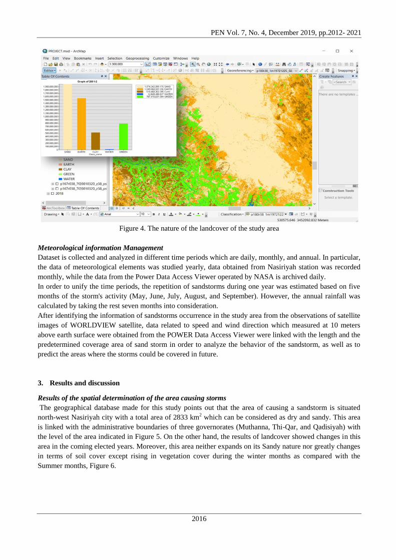
Worldview as shown in Figure 4.
Page 5
PEN Vol. 7, No. 4, December 2019, pp.2012- 2021
2016
Figure 4. The nature of the landcover of the study area
Meteorological information Management
Dataset is collected and analyzed in different time periods which are daily, monthly, and annual. In particular,
the data of meteorological elements was studied yearly, data obtained from Nasiriyah station was recorded
monthly, while the data from the Power Data Access Viewer operated by NASA is archived daily.
In order to unify the time periods, the repetition of sandstorms during one year was estimated based on five
months of the storm's activity (May, June, July, August, and September). However, the annual rainfall was
calculated by taking the rest seven months into consideration.
After identifying the information of sandstorms occurrence in the study area from the observations of satellite
images of WORLDVIEW satellite, data related to speed and wind direction which measured at 10 meters
above earth surface were obtained from the POWER Data Access Viewer were linked with the length and the
predetermined coverage area of sand storm in order to analyze the behavior of the sandstorm, as well as to
predict the areas where the storms could be covered in future.
3. Results and discussion
Results of the spatial determination of the area causing storms
The geographical database made for this study points out that the area of causing a sandstorm is situated
north-west Nasiriyah city with a total area of 2833 km2 which can be considered as dry and sandy. This area
is linked with the administrative boundaries of three governorates (Muthanna, Thi-Qar, and Qadisiyah) with
the level of the area indicated in Figure 5. On the other hand, the results of landcover showed changes in this
area in the coming elected years. Moreover, this area neither expands on its Sandy nature nor greatly changes
in terms of soil cover except rising in vegetation cover during the winter months as compared with the
Summer months, Figure 6.
Page 6
PEN Vol. 7, No. 4, December 2019, pp.2012- 2021
2017
Figure 5. The Spatial determination of the area causing storms
Figure 6. Variation in vegetation between the months of winter and summer
3.1. Determination of the coverage of sandstorms
By researching the extent and coverage of sandstorms taking into consideration the geographic database of
the research and by the satellite images of Worldview, we can come to the following conclusions:
1. The impact of sandstorms formed from the sandy area situated in the north-west of Nasiriyah city cover
hundreds of kilometers (100-400 km);
2. The lowest level of sandstorms estimated in the study area was ~130 km, and the maximum extent of the
storm was ~ 400 km;
3. The lowest point covered by sandstorms was ~3000 km2, and the largest coverage area was ~12000 km
2
when the extent of the storm exceeded ~350 km;
4. There is a direct connection between the depth and the coverage of the sandstorms as shown in Figure 7;
Page 7
PEN Vol. 7, No. 4, December 2019, pp.2012- 2021
2018
5. The two most important aspects influencing the coverage of the sandstorms to Nasiriyah city or the nearby
cities are the path of the storm and its distance extent; they depend on the speed and direction of the wind as
shown in Figure 8;
6. The cities that are often damaged by these storms are: Batha, Nasiriyah, Suq al-Shuyukh, Karma Bani
Saeed, and Al-Tar; and
7. At the maximum power of the storm (greater than 350 km), the effect reaches the capital of the Kuwait
State in the South of Iraq.
Figure 7. Relationship between the extent and coverage of the sandstorm
Figure 8. Effect of wind direction and velocity in the range and direction of the duststorms
Page 8
PEN Vol. 7, No. 4, December 2019, pp.2012- 2021
2019
3.2. The connection between the frequency of sandstorms and rainfall
Comparing the amount of annual rainfall of the Nasiriyah meteorological station and the frequency of
sandstorms according to the Worldview satellite facts, there was a clear relationship between the frequency of
sandstorms and the level of rainfall in the same year. The relation coefficient between them is – 0.511, as
explained in Figure 9.
Figure 9. The relationship between the frequency of sandstorms and the amount of rainfall
3.3. Connection the metrological data with the spatial output
By connecting the spatial consequences of the sandstorm (extend and coverage area) based on the above
results with the metrological information for the same storm day acquired from the POWER Data Access
Viewer, the following results can be received:
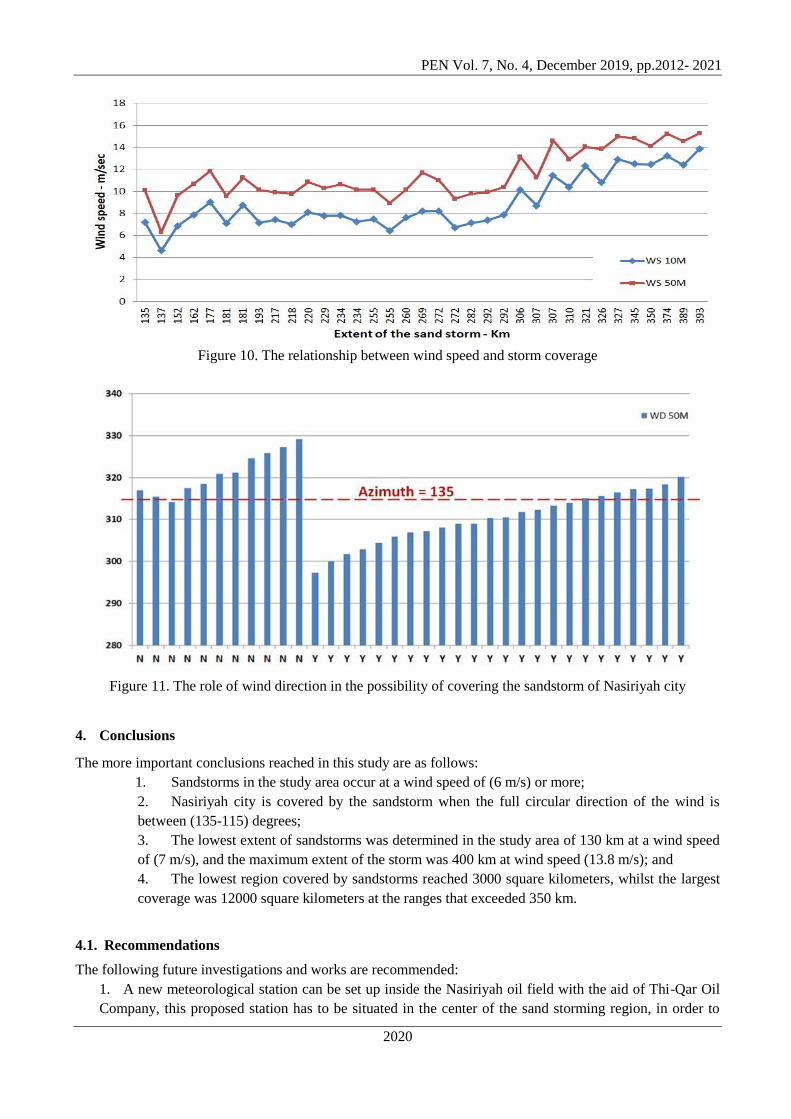
1) Sandstorms occurred in Worldview satellites when the wind speed was (6 m/s) or more;
2) There is a primary connection between wind speed and storm extent (Figure 10);
3) Wind direction is a necessary factor in the possibility of covering the sandstorm of Nasiriyah city or not;
4) Nasiriyah city lies within the sandstorm coverage if the full circular direction of the Azimuth winds
between (115 - 135) degrees (Figure 11).
Page 9
PEN Vol. 7, No. 4, December 2019, pp.2012- 2021
2020
Figure 10. The relationship between wind speed and storm coverage
Figure 11. The role of wind direction in the possibility of covering the sandstorm of Nasiriyah city
4. Conclusions
The more important conclusions reached in this study are as follows:
1. Sandstorms in the study area occur at a wind speed of (6 m/s) or more;
2. Nasiriyah city is covered by the sandstorm when the full circular direction of the wind is
between (135-115) degrees;
3. The lowest extent of sandstorms was determined in the study area of 130 km at a wind speed
of (7 m/s), and the maximum extent of the storm was 400 km at wind speed (13.8 m/s); and
4. The lowest region covered by sandstorms reached 3000 square kilometers, whilst the largest
coverage was 12000 square kilometers at the ranges that exceeded 350 km.
4.1. Recommendations
The following future investigations and works are recommended:
1. A new meteorological station can be set up inside the Nasiriyah oil field with the aid of Thi-Qar Oil
Company, this proposed station has to be situated in the center of the sand storming region, in order to
Page 10
PEN Vol. 7, No. 4, December 2019, pp.2012- 2021
2021
check the meteorological information in a more accurate way. The location of the Nasiriyah air station is
affected by the urban encroachment of Nasiriyah, and then to get on precise information; and
2. Working on the formation of joint task forces of the relevant governmental bodies (Thi-Qar
Agriculture Directorate, Thi-Qar Irrigation Directorate, Thi-Qar Environment Directorate, Thi-Qar Oil
Company, University of Thi-Qar, and others) in order to unite efforts and use modern methods and skills
in limiting the phenomenon of increasing sandstorms in the study area.
References
[1] UN. Sand and Dust Storms Fact Sheet produced by joint analysis and policy unit (JAPU). Available at
https://reliefwebint 2013.
[2] D. S. Mackie, P. W. Boyd, G. H. McTainsh, N. W. Tindale, T. K. Westberry, K. A. Hunter.
Biogeochemistry of iron in Australian dust: From eolian uplift to marine uptake. Geochemistry,
Geophysics, Geosystems; 9,2008.
[3] K. Badarinath, S. K. Kharol, V. Krishna Prasad, D. Kaskaoutis, H. Kambezidis. Variation in aerosol
properties over Hyderabad, India during intense cyclonic conditions. International Journal of Remote
Sensing; 29:4575, 2008.
[4] D. Kaskaoutis, H. Kambezidis, P. Nastos, P. Kosmopoulos. Study on an intense dust storm over Greece.
Atmospheric Environment; 42:6884, 2008.
[5] J. Bullard, M. Baddock, G. McTainsh, J. Leys. Sub‐basin scale dust source geomorphology detected using
MODIS. Geophysical Research Letters ;35, 2008.
[6] N. Karimi, A. Moridnejad, S. Golian, J. M. Vali Samani, D. Karimi, S. Javadi. Comparison of dust source
identification techniques over land in the Middle East region using MODIS data. Canadian Journal of
Remote Sensing; 38:586,2012.
[7] M. C. Baddock, J. E. Bullard, R. G. Bryant. Dust source identification using MODIS: a comparison of
techniques applied to the Lake Eyre Basin, Australia. Remote Sensing of Environment; 113:1511,2009.
[8] B. M. Yahya, D. Z. Seker. The Impact of Dust and Sandstorms in Increasing Drought Areas in Nineveh
Province, North-western Iraq. Journal of Asian and African Studies;0021909618812913, 2018.
[9] H. E. Redmond, K. D. Dial. Thompson JE. Light scattering and absorption by wind blown dust: Theory,
measurement, and recent data. Aeolian Research; 2:5, 2015.
[10] R. Washington, M. Todd, N. J. Middleton, A. S. Goudie. Dust-storm source areas determined by the
total ozone monitoring spectrometer and surface observations. Annals of the Association of American
Geographers; 93:297, 2003.
[11] V. Sissakian, N. Al-Ansari, S. Knutsson. Sand and dust storm events in Iraq. Journal of Natural Science;
5:1084,2013.
[12] M. Kobler. Dust storms of Iraq, UN Secretary General for Iraq, A ministerial meeting in Nairobi, Kenya.
2013.
[13] K. Badarinath, S. K. Kharol, D. Kaskaoutis, A. R. Sharma, V. Ramaswamy, H. Kambezidis. Long-range
transport of dust aerosols over the Arabian Sea and Indian region—A case study using satellite data and
ground-based measurements. Global and Planetary Change; 72:164,2010.
[14] H. Feidas, T. Kontos, N. Soulakellis, K. Lagouvardos. A GIS tool for the evaluation of the precipitation
forecasts of a numerical weather prediction model using satellite data. Computers & geosciences;
33:989,2007.
[15] K. Fedra. Urban environmental management: monitoring, GIS, and modeling. Computers, environment
and urban systems ;23:443, 1999.
[16] T. C. Vance, S. Mesick, S. Cross. Integrating particle tracking models into a GIS for analysis and display
of environmental phenomena. Proceedings of the 17th ACM SIGSPATIAL international conference on
advances in geographic information systems: ACM; p. 460, 2009.