139
Spectacular Voyage Following Lewis and Clark in Nebraska, Iowa and South Dakota Russell Gifford

Spectacular Voyage Following Lewis and Clark in Nebraska,
Iowa and South Dakota
Russell Gifford
Copyright © 2004 by Russell Gifford. Printed and bound in the United States. All rights reserved. No part of this book may be reproduced or transmitted in any form or by any means, electronic or mechanical, including photocopying, recording, or by an information storage and retrieval system - except by a reviewer who may quote brief passages in a review or to be printed in a magazine or newspaper - without permission in writing from the copyright holder. For information, contact Gifford & Associates, POB 411, South Sioux City, NE 68776. Parts of this book originally appeared in The Weekender magazine, July, August and September, 2002. First Printing, 2004 Gifford, Russell Spectacular Voyage: Following Lewis and Clark in Nebraska, Iowa and South Dakota / Russell Gifford p. cm. Includes bibliographical references and index. ISBN 1. Books--United States--History 2. Clark, William, 1770-1838. 3. Lewis, Meriwether, 1774-1809. 4. Lewis and Clark Expedition (1804-1806). 5. Jefferson, Thomas 1743-1826. 6. Explorers-United States-Biography. I. Title. Attention: EDUCATIONAL INSTITUTIONS, TOURISM ORGANIZATIONS: Quantity discounts are available on bulk purchases of this book for reselling or educational purposes. Special books or book excepts can also be created to fit specific needs. For information, please contact Gifford & Associates, POB 411, South Sioux City, NE 68776.

INTRODUCTION STEPPING INTO HISTORY WITH LEWIS AND CLARK ............................................................................. 1
PROLOGUE FROM ST. LOUIS TO THE EDGE OF NEBRASKA DAILY ROUTINE AND DUTIES........................... 4
CHAPTER 1 ENTERING NIBTHACKA..................................... 8
CHAPTER 2 FROM THE NEMAHA TO THE NEW WORLD .. 12
CHAPTER 3 CROSSING INTO A NEW WORLD ................... 18
CHAPTER 4 TO THE COUNCIL BLUFFS.............................. 23
CHAPTER 5 A LONG AND WINDING RIVER........................ 30
CHAPTER 6 DEATH IN THE WILDERNESS ......................... 37
CHAPTER 7 RIVER OF DREAMS.......................................... 46
CHAPTER 8 MEETINGS AND MEANINGS............................ 52
CHAPTER 9 DISCOVERIES................................................... 58
CHAPTER 10 TESTED AND TRIED....................................... 63
EPILOGUE LOOKING FORWARD, LOOKING BACK........... 70
ACKNOWLEDGEMENTS ....................................................... 73
GUIDE TO HISTORIC LEWIS AND CLARK LOCATIONS IN NEBRASKA, IOWA AND SOUTH DAKOTA.......................... 75
SOUTHEAST NEBRASKA, NORTHWEST MISSOURI.......... 76 Squaw Creek National Wildlife Refuge, Missouri ......................... 77 Rulo, Nebraska – Clark's View from July 12th .............................. 78 Indian Cave State Park.................................................................... 78 The Spirit of Brownville Riverboat ................................................ 78 Lewis and Clark Campsite: July 15th, 1804 ................................... 79 Historic Brownville, Nebraska........................................................ 79 Steamboat Trace Bicycle Hiking/Bike Trail................................... 79 Nebraska City, Nebraska ................................................................ 80 Waubonsie State Park, Iowa ........................................................... 81
FROM THE PLATTE RIVER TO OMAHA, NEBRASKA ........ 84 Plattsmouth, Nebr. .......................................................................... 84 The Schilling Wildlife Management Area in Nebraska.................. 85 Lake Manawa State Park, Iowa ...................................................... 86 Other Sites to visit In Council Bluffs.............................................. 86 Western Historic Trails Center in Iowa .......................................... 87 Heartland of America Park and George Leahy Mall ...................... 87 The Old Market............................................................................... 88 The Henry Doorly Zoo.................................................................... 88 Durham Western Heritage Museum ............................................... 88 Lewis and Clark Monument Park in Iowa ...................................... 88
FROM THE BLUFFS TO WILDERNESS TO BLUFFS........... 91 Fort Atkinson State Historical Park ................................................ 91 Boyer Chute National Wildlife Refuge........................................... 92 Blair, Nebraska ............................................................................... 92 DeSoto National Wildlife Refuge................................................... 93 Wilson Island Recreation Area ....................................................... 93 Missouri Valley, Iowa/Loess Hills ................................................. 94
THE VIEW BETWEEN THE HILLS......................................... 97 Remington Access .......................................................................... 98

Little Sioux Access ......................................................................... 98 Huff-Warner Access ....................................................................... 98 Lewis and Clark State Park............................................................. 98 Blackbird Scenic Overlook ............................................................. 99 Omaha and Winnebago Indian Reservations.................................. 99 Homer, Nebraska .......................................................................... 100 Tonwontonga ................................................................................ 100 Fish Camp ..................................................................................... 101 Dakota City, Nebraska .................................................................. 101 Sgt. Floyd Monument ................................................................... 101
EXPLORING SIOUXLAND ................................................... 104 Downtown Sioux City................................................................... 105 Dorothy Pecaut Nature Center ...................................................... 107 Stone State Park ............................................................................ 107 Lewis and Clark Interpretive Center............................................. 107 The Sgt. Floyd Riverboat Museum/ Welcome Center.................. 108 The Anderson Dance Pavilion ...................................................... 108 Sgt. Floyd Monument ................................................................... 108
ON TO SOUTH DAKOTA ..................................................... 111 Adams Homestead & Nature Preserve ......................................... 112 Elk Point, South Dakota................................................................ 112 Spirit Mound ................................................................................. 113 Vermillion, South Dakota ............................................................. 113 Crossing into Nebraska ................................................................. 114 Ionia Volcano................................................................................ 114 Ponca State Park ........................................................................... 114
YANKTON!............................................................................ 117 Ponca, Nebraska............................................................................ 117 Wiseman Monument..................................................................... 118 St. James, Nebraska ...................................................................... 118 Wynot, Nebraska........................................................................... 119 Corps of Discovery Welcome Center ........................................... 119 Yankton, South Dakota................................................................. 119 Gavins Point Dam......................................................................... 120

Lewis and Clark Visitor Center: ................................................... 121
FROM GAVINS POINT TO FORT RANDALL DAM ............. 123 Crofton, Nebraska ......................................................................... 123 Highway 12................................................................................... 124 Running Water Bridge .................................................................. 124 Niobrara, Nebraska ....................................................................... 124 Niobrara State Park ....................................................................... 125 The Dome: (Old Baldy) ................................................................ 125 To the Heavens ............................................................................. 126
BIBLIOGRAPHY ................................................................... 128
ABOUT THE AUTHOR ......................................................... 130
INDEX.................................................................................... 131
Introduction: Stepping into History
1
Introduction Stepping into History with Lewis and Clark
If you are in the region of Nebraska bordered by the Missouri River, awake early one morning, and drive to the edge of town. The sunrise, with the bright blues and golds painting the high clouds, can't help but evoke a feeling of wonder. The bluffs stand like resolute guardians for the tall grasses waving in the cool morning breeze. The Missouri River seems eternal, stretching to infinity in both directions. It flows from the point where it meets the arching sky on the distant horizon. That horizon beckons you, with all the promise of a new day. The sky, the hills, and the river: these are constants. If you are far enough away from the city, it is not too difficult to imagine the same scene greeting the men of the Lewis and Clark Expedition.
Introduction: Stepping into History
2
The difference, of course, is the promise of their day would not include air conditioners, cell phones or computers. Cars or planes. Microwave ovens or fast food places. Grocery stores or rest areas. Or roads. Only the sky, the hills, and the river. Their day would promise hard work and sweat, as they rowed, poled, or pulled the barge and two other boats up an unruly river. A river filled with muddy water, switchbacks, crumbling banks, submerged stumps, and numerous other hazards, all waiting to grasp the unwary. But the promise also included being part of an adventure that people would remember two centuries later, a trip that would fill blank spaces on maps and eventually fill pages of books, as they surveyed, studied and catalogued the wilderness in their search for the mythical "Northwest Passage," an all-water route to the far Pacific Ocean. They didn't find it. Not only did they not find the waterway to the Pacific, they proved it didn't exist. To some, this made the Voyage of Discovery a failure. How could it? Their very name speaks their purpose, and they were more successful than they could have imagined. The Expedition catalogued 178 plants and 122 animals that no one knew existed. They also returned with word of 24 Indian tribes previously unknown to the outside world. Too often, though, we see their trip only as history. For them, it was a trip into the future, and they were writing that future a day at a time with their actions. Isn't it time we filled in the outline of their visit to our region, to learn what they saw along the way? This book allows you to join the Lewis and Clark Expedition, and travel with the men of the Corps of Discovery from the time they enter

Introduction: Stepping into History
3
what is currently Nebraska until they leave the tri-state region in late September. Each chapter follows a week of the expedition, and we'll share their successes and discoveries as they explore not just the river, but the surrounding areas as well. We'll also share the near disasters, the two desertions, and the two dismissals, as well as the only death among their crew during the entire 28-month trek. We'll show you the world as they saw it. In the companion travel guide, we'll take you through the same region today, and show you the highways and the back roads that will take you to the places they described in their journals. We'll also point out what today's world has to offer the traveler, including shops, restaurants and historical displays, as you follow one of the most important treks in the history of America. In the two hundred years since their journey, their adventure has never been equaled. They lived an epic story worthy of the Greek classics, and in the process they founded the basis for an enduring piece of America culture. They are the cornerstone of the American dream, the belief that with enough effort and desire, resourceful and resolute men and women could persevere, prosper and achieve almost anything. As you stand at the edge of town, and look at the sunrise, with the vast sky of the Great Plains reaching out to the edge of the world, you'll know the excitement and the wonder that powered these adventurers. With this book, you'll also know a little more about your heritage. The Voyage starts here. Welcome aboard!
Prologue: Daily Routine and Duties
4
Prologue From St. Louis to the Edge of Nebraska
Daily Routine and Duties
"Your...mission is to explore the Missouri River.... Take observations.... Make yourself acquainted with the names of nations
and their numbers..... Worthy of notice will be the soil, the face of the country... its growth and vegetables... the animals... and the minerals."
Thomas Jefferson, in his orders to Capt. Meriweather Lewis, commissioning the Voyage of Discovery, 1803.
After spending the winter in camp near St. Louis, Missouri, the "Expedition for Northwestern Discovery" departed Camp Wood on May 14, 1804. After a shakedown cruise, they stopped at St. Charles for five days, where they added more supplies and hired a number of French traders they met on the river. These "engages" (hirelings) were
Prologue: Daily Routine and Duties
5
boatmen used to trading with the Indians past the mouth of the Platte. They would act as guides, interpreters, and extra hands on the river voyage. Two of these traders, Pierre Cruzatte and Francois Labiche, would actually enlist as members of the expedition. Starting again in earnest, the order of travel became set. The engages rode in one of the two pirogues, while Corporal Richard Warfington and six soldiers were in the other. The keelboat, containing most of the supplies, followed. Lewis and Clark called it the keelboat. The men doing the sweating called it a barge. Considering it was eight feet wide, over fifty feet long and could carry 12 tons of provisions and 28 men, barge is a fair name. History has decided on the more picturesque name of keelboat. The pirogues, smaller boats 35 to 40 feet long, were far lighter, and rode higher in the water. They could pass sandbars and tight spaces with less effort. Captain William Clark reported on the keelboat "the 20 poles and oars could with much difficulty stem the current" - if they weren't in the main channel of the river. There, he said, it was almost "impossible to resist its force by means of oars or poles." This forced them to travel in the eddies near the banks. Eventually the party found unless they could use the sails, the easiest way to move the boat was to drag it up the river, using a cable attached to the bow or the mast. The men trudged forward on the banks, or sometimes in the riverbed, pulling the boat upstream, past grasping sandbars and dangerous submerged trees. But the path near the edge was not always the easy one. The swirling river current often undermined the banks, "sometimes to the depth of forty or fifty paces, and several miles in length," wrote Clark. When no longer able to support the weight of the earth and trees
Prologue: Daily Routine and Duties
6
above, the banks would suddenly "tumble into the river with tremendous force, destroying everything within their reach." Obviously, the sight impressed Clark, and the continual nature of the collapses and the number of near misses led him a year later to note his surprise that they had not been engulfed by one of these incredible landslides. Hunting groups prowled the land on either side of the river in search of game, sometimes staying out more than a day. Captain Meriweather Lewis and a few others explored the land and streams, returning each night. Trained by President Jefferson on the scientific study of plants and animals, Lewis spent most days ashore, collecting and cataloguing everything he thought was new or different. He would list 38 plants between the Platte and the Mandan villages, 19 of which were previously unknown. Unfortunately, his daily journal, if he kept one, is lost, depriving us of his views of this new region. Clark, the better boatman of the two, spent more time aboard the boat, recording headings to detail the map of the river. When he got the chance though, Clark, too, explored the land. Always distinctive with his red hair, Clark must have been an interesting figure on the shore, since he used a "dainty" umbrella to protect himself from the scorching sun of the plains. As they progressed further up river, the crew's clothing changed as well. The heavy army shoes were discarded in favor of moccasins, and buckskins soon became the normal attire. Their daily schedule, depending on the weather, usually started at sunrise. They struck camp and traveled until 9 a.m. before stopping for breakfast. Back on the river, they'd plow forward until a good site
Prologue: Daily Routine and Duties
7
presented itself between noon and 2 p.m., when they took their dinner. The length of the break depended on their exertions, but then it was back to the river until sunset neared. The first month, while still near settlements, game was scarce. The noon meal was generally salt pork, cooked the night before, with or without a suet dumpling. (Flour, fat and water, boiled.) Supper depended on whatever the hunters had brought in, usually venison or more pork from their stores. Parched corn, (corn fried in grease until almost burned, and then dried over an open fire) was a favorite among the men, but they tried almost anything. The further they traveled, the more varied their diet became. After dark, if the camp was on an island, or at the mouth of a tributary, Clark and Lewis spent the evening making star sightings to fix the location for their maps. They frequently chose to camp on islands, for security reasons. Many nights, Lewis would call out the readings, Clark writing them down. Despite the day's labor, the nights often ended with fiddle playing and singing. Still, come the sunrise, they were ready to repeat their efforts yet another day. They would follow this schedule, with little variation, until they arrived in the Mandan Indian Village in late October. While they did not observe the Sabbath, they would, as necessary, rest along the way. July 12th was one of those days.

Chapter 1: Entering Nibthacka
8
Chapter 1 Entering Nibthacka
Sixty days following their departure from Camp Wood near St. Louis, Captain William Clark wrote in his journal, "the men are much fatigued." With good reason. Since their turn northward at the Kansas River a week before, the sun and heat exhaustion had taken their toll on the Corps of Discovery. And tired men make mistakes. July 5th, the day after the first celebration of their young nation's birthday west of the Mississippi, they briefly lost control of the keelboat. It "turned around three times," the last on some driftwood, which could have damaged the bottom. By luck, it did not. July 6th was a "very warm day," Clark tells us in his understated way. But he adds it is "worthy of remark that the water of this river or some other cause" forces the men to sweat more "than I could suppose could

Chapter 1: Entering Nibthacka
9
pass through a human body. Those men that do not work at all will wet a shirt in a few minutes and those that do work, the sweat will run off in streams." Little surprise then, that on the 7th, Clark mentions one man was down, "struck by the sun." On the 8th, he lists five as "sick with violent headaches," and "several with boils." A few days before, Joe Field was bitten by a snake, and his foot had swollen greatly. More than 10% of the crew are on the sick list. (There is no "disabled list" in the wilderness - you work.) Lewis treats them all. He bleeds the first man, and gives him "niter." The snakebite is treated with a poultice of bark. But tired men make mistakes. On the night of the 10th, the troops sent to retrieve their hunters believe they have stumbled on a campsite of a hostile party. They rush back to the main camp, and the men are roused to defensive positions. They will not realize until morning that it is a false alarm; it really was their hunters. Yet only one day later, they find Alexander Willard asleep at his guard post! It isn't hard to imagine different outcomes from these situations, and the catastrophic results for the Voyage. Had the ship been holed; had the crews fired on each other in the darkness; had a band of Sioux Indians actually found them, and attacked without warning in the night. Any of these results could have spelled disaster for the mission. With the river's turn northward, the settlements and trading posts were left far behind. The dangers are increasing, not lessening. So, on the morning of July 12th, on an island in the Missouri River, two months west of St. Louis, Captain Meriweather Lewis and Captain William Clark decided the Corp of Discovery would remained at

Chapter 1: Entering Nibthacka
10
camp, rest the injured and ill men, and await their hunting party's return. For Clark, though, this is a day of freedom and exploration. Shortly after breakfast, he and five other men board a pirogue and set out to explore "the Ne-Ma-haw River," which enters the Missouri to the west of their campsite. They ascend the river for two miles, mapping the twists and turns. At the mouth of a small creek, Clark exits the pirogue and climbs to the top of a nearby hill, where he finds numerous "artificial mounds" and small knolls. From the top of the largest of these, high on the bluffs overlooking the Big Nemaha River, the normally reticent Clark wrote, "I had an extensive view of the surrounding plains, which afforded me one of the most pleasing prospects I ever beheld. Under me, a beautiful River of clear water of about 80 yards wide meandered through a level and extensive meadow, as far as I could see…" The view was "much enlivened by the fine trees and shrubs … bordering the bank of the river, and the creeks and runs falling into it. The bottom land is covered with grass about four and a half feet high, and appears level as a smooth surface," and "the upper land "is also covered with grass and rich weeds and flowers, interspersed with corpses of Osage plumb. On the rising land, small groves of trees are seen, with a number of grapes, cherries," as well as berries, and chokecherries. William Clark, the rough-hewn Virginian, experienced traveler, and seasoned explorer, co-commander of the Corp of Discovery, and often-terse journal writer -- is clearly moved by the view. Later, the region would be recognized by the Omaha Indian name given the "flat river" that runs through the entire state. The French translated that river's name literally, as the Platte. The state would later take the original Omaha and Oto Indian names, slightly changed. Nebraska.

Chapter 1: Entering Nibthacka
11
Savoring the view, Clark remains a while. But he knows he must return. A Court-martial, with a life hanging in the balance, will be held at the camp tonight. The sentence could be a death penalty. And tired men make mistakes.

Chapter 2: From the Nemaha to the New World
12
Chapter 2 From the Nemaha to the New World
There had been other court-martials on the expedition, but on July 12th, the stakes were much higher. This time, the action was a capital crime, and under the articles of war, a guilty verdict could bring a penalty of death. On July 11, Sergeant John Ordway reported Alexander Willard lying down and sleeping while on guard duty. Underscoring the reality of the danger, only a day before the incident, the Corps spent the night at high alert, believing "a Sioux war party" might be camped nearby. The keelboat's main gun was fired to notify the hunting party of the danger. Since the turn north at the Kansas River, they had entered potentially hostile territory, and security demanded able and alert sentinels. The dereliction of one man could put the entire endeavor at risk.

Chapter 2: From the Nemaha to the New World
13
Thus, on an island near the Nemaha River, the Corps of Discovery, a military expedition, convened at 1 o'clock as a Court-martial to examine and determine the fate of Alexander Willard. Due to the weight of the potential penalty, Clark and Lewis sat as judges. As the men of the Expedition watched, Willard pled guilty of lying down, but not guilty of sleeping. After examining the evidence, the court ruled Willard guilty on all charges. Sweating in the heat of the July afternoon, the men waited, listening intently. Would the sentence be death? After deliberations with Clark, Captain Lewis handed down their judgment: the Court ordered that Willard would receive 100 lashes on his bare back, delivered in equal proportions each night at sundown for the next four nights. They would be administered by running the gauntlet of the crew. The people his actions had endangered would administer the punishment. The men seem satisfied, and the Captains' had made their point. At sunrise the following morning, the Corps of Discovery was once again on the move. The 13th took them past the Tarkio River, and near an "elegant prairie," whose hills were four to five miles distant. That night, though, the rapidly changing weather of the plains made its first entry into their lives. A violent storm lashed the camp for almost an hour before abating. In the morning, another storm delayed their departure as well. It was nearly 7 a.m. before they broke camp on July 14, and they were hardly underway when disaster struck at 7:30.

Chapter 2: From the Nemaha to the New World
14
As the keelboat passed between the point of a sand island and a caving shoreline, the sky darkened. The bank was filled with snags "as far as the eye could see," wrote Clark. Their options were few. Suddenly, strong winds hammered them, catching the keelboat broadside! The storm threw the ship toward the island, to be "dashed to pieces in an instant," said Clark. As the waves flowed over the gunwales, the men leapt out, grabbed the towline and the anchor, and struggled to hold the heavy ship away from the island. Battles between the strength of men and the forces of nature rarely end well for men. Inexorably, the wind edged the ship closer to the island, and the hull finally touched the sand. The men remained resolute, though, and held on. In this moment, the ship, caught between the two opposing forces, began to lean over! The bottom of the huge keelboat rose out of the water as she turned almost on her side on the island! The battle had lasted forty minutes "when the storm suddenly ceased, and the river suddenly became as smooth as glass," states Clark. They had won. Barely. Had the tarpaulin coverings of the lockers not held, the holds would have filled with water, and the boat would have sunk. In the end, the ship's leaning, as frightening as it was, may have saved them. The waves broke against the upturned hull, instead of dumping over the railing and into the boat. Clark lost his notes for the 13th. Luckily, that's all they lost. The pirogues, further upstream, were in a better position, and weathered the storm without damage.

Chapter 2: From the Nemaha to the New World
15
One cannot help but wonder exactly what Clark or Lewis would consider their options to be if they lost the keelboat at this early stage of the exploration. Could they have continued the expedition without the supplies on the keelboat? The question goes unanswered. While they had won this incredible battle, they sensed there would be more contests to come. It was not yet 8:30 a.m., and they had miles to go that day. They turned their backs to the scene of their temporary victory, and moved on. Weather continued to plague their journey. On the 15th a heavy fog along the river obscured their ability to see obstacles and sand bars, and delayed their departure until 9 a.m. Clark spent the day ashore, and explored the west side of the river. He crossed "three pretty streams," and noted the grass-covered prairie beyond the trees lining the edges of the river. It was a prairie that continued, "as far as the eye could see," he wrote, and the lack of trees was a sight worthy of note. The Lewis and Clark Expedition had arrived at the eastern border of the Great Plains. Consider how odd, how different, a flat and nearly treeless expanse of land would look to men of Virginia and Kentucky. Their home, their world, was filled with trees, shrubs and forests; hills and valleys. They were nearing the Platte, and sighting the new ecosystem of the Platte River valley. It was slow going, though. When the weather cooperated, the river did not. On the 16th, they ran upon a snag early, and after extricating themselves, they found a bank had lately collapsed, dumping 20 acres of hillside into the river. Thus, there was lots of timber to avoid, above and below the waterline. To the west, cliffs of sandstone now lined the bank. This was a new look to the river, and the large population of
Chapter 2: From the Nemaha to the New World
16
birds building their nests in the rocky cracks and crevices fascinated Clark. Their nests covered the bank for a distance of two miles. But these sights would fade in only moments. The wonders of nature were just beginning that day. As they rounded a bend, on the east side of the river they spied a range of steep-sided hills three to six miles away. They stretched northward beyond the range of vision – and they were bare! The sight mesmerized the explorers. None of them had seen anything like these geological formations. They called them the "bald pated prairie," and their journals reflect their fascination with these odd visions, rising from the flat lands to dominate the horizon as far as the eye could see. The lack of timber on these hills was a vivid reminder they were indeed strangers in a foreign land. They camped that night at a point of woods on the left side, opposite the southern end of these apparitions. Lewis decided they would stay an extra day at this camp. It was important to take readings, and fix the chronometer, which has again run down. But more importantly, he was determined to examine these odd formations. Early the next morning, Lewis followed the muddy Nishnabotna Creek to these bald prairie slopes. He found the clay soil and drought-tolerant ground cover on the slopes "very handsome," and spent the day in detailed examination of these unique hills. He was right -- they are unique. Today, we call them the loess hills, and we know they only exist in a few regions in the world. Thousands of centuries were required for nature to build this range, as the wind carried small grains of glacieral till soil across the plains, and deposited them here. Gradually they became these nearly monolithic

Chapter 2: From the Nemaha to the New World
17
formations of clay and sand, completely covering the rocky outcroppings on which they formed. Today many are covered with trees – a result of fire suppression techniques in the modern world. But some of these "bald" peaks are still visible in our time, and they remain as striking to us as to the members of the Lewis and Clark Expedition. From the rocky shale on the west side of the river, to the loess hills on to the east, the Voyage of Discovery found much to amaze them this week. Only a few miles further, the western bluffs come to the river's edge. One hill, Clark wrote, "has slipped into the river for about three quarters of a mile, and leaves a bluff of considerable height back of it." When the bank had caved into the river, it carried part of the bluff with it. Split open, the interior makeup of these western hills could be viewed. Envision the splash of colors, the browns, yellows and reds of those exposed interior rocks staining the hillside! Here, just below the mouth of the Platte, it is as if nature is providing a geological display case and opening her wonders to them. But the wonders truly start only a few miles ahead -- across the Platte.
Chapter 3: Crossing into a New World
18
Chapter 3 Crossing into a New World
In 1804, the Platte River formed a true "line in the sand" for the explorers. Crossing this line was the equivalent of stepping into a new world. The Platte River valley boasted plants and animals unknown to science, and the loess hills and the Great Plains were only two examples of the new terrain in this region. Clark, walking on the shore just below the Platte's mouth, tracked some elk into the hills. "After ascending and passing through a narrow strip of woodland, I came suddenly into an open and boundless prairie. I say boundless because I could not see the extent of it in any direction." Quite a concept for a Virginian, accustomed to trees and mountains. Of course, there was a new sight they had hoped to see, and had not: in the 68 days since they left Camp Wood, they had not met with any

Chapter 3: Crossing into a New World
19
native Indians. Moving north of the Platte was to move into true "Indian Country," another drastic change. Trade was well established with many of the river tribes of the Indian nations. On the day of the near-wreck of the keelboat, the crew had passed an abandoned trading post, "an old fort where Mr. Benoit of St. Louis wintered for two years, and traded with the Otos and the Pawnees," according to Clark's journal. These Indian tribes, located along the Platte, had in earlier years traded pelts with the French at these outposts. The engages hired by the Corps of Discovery were men experienced in Indian trade, and the two bowmen that had enlisted as full members, Private Cruzatte and Private Labiche, were half French and half Omaha. They brought to the expedition their knowledge of this area of the river, and the languages of the tribes. The Expedition took almost ten weeks to cover the more than 600 miles from Camp Wood to this point, and the Platte marked this distance for travelers as clearly as a milepost. It also marked the distance that many ships could travel before running short on stored goods. Almost in illustration, Clark named one island just below the mouth of the Platte "Butter Island, as at this place we made use of the last of our butter, as we approached this Great River Platte…." This was a small thing, perhaps, but yet another notice that they were departing from one world, and entering another. Whiskey and coffee, while still available, were two other non-essential items that could not be found in the wild, and would also be missed when their supplies were depleted. Thus, to cross beyond the Platte River was a noteworthy event, and the first landmark for the Corps of Discovery. It also took some doing to cross it with a 55-foot barge.

Chapter 3: Crossing into a New World
20
The Platte's current, more than twice the speed of the Missouri River above the Platte's mouth, pushed boats completely to the far bank when the two rivers met. The churning of the combined currents chewed these far banks, causing them to undermine and frequently collapse. This made the far edge unsafe, and far too shallow. This debris, combined with tremendous amount of sand brought down by the Platte from the Rockies, made sandbars more numerous. The rivers carved small and ever-changing channels between these bars, creating fast and unpredictable currents. The results could be treacherous. On July 21st, the Lewis and Clark Expedition ran this gauntlet. Clark, in his terse nature, wrote, "We found great difficulty in passing around the sand at the mouth of this river," but they made it. They had crossed the line into the new world. Once the keelboat was safely past, Clark and Lewis celebrated by taking a pirogue and six men a little distance up the Platte, to explore the differences in this unusual and wondrous river that rushed across the plains. The trip convinced Lewis the river would be difficult to travel by boat. According to information from either Cruzatte or Labiche, the river never got deeper than they were experiencing at the mouth, which was quite shallow. In fact, there were stories that the river stretched three miles wide in some places, filled with sandbars. Lewis, rightfully, believed these stories. He'd seen the "boiling motion" of the river, and noted "the irregular motion of the sand, of which its bed is almost entirely composed." Amazed by the enormous amount of sand carried by the current, he contrasted it with the far different water of the muddy Missouri they had been traveling for over two months. Returning to the Missouri, they proceeded on until they reached the Papillion (Butterfly) Creek, and camped nearby. They spent the night there, surrounded by wolves, but Lewis' eyes were on a campsite a

Chapter 3: Crossing into a New World
21
little further along. Captain Lewis had decided they would remain in this region for a few days, and he wanted a comfortable spot. They had much to do. Their goods in one of the pirogues needed dried. Oars and poles needed repaired or replaced. Achieving their first landmark by crossing the Platte, they needed to attend to their men's health. The next day, Sunday, the 22nd, they settled along the eastern bank, opposite the bluffs to the west. When Silas Goodrich caught a white catfish, they dubbed the place Camp White Catfish. In the two months since St. Charles, they had not stopped for longer than a day. Their mission, however, required them to spend some time here. When telling the Captains about the Platte, Cruzatte or Labiche also told the Captains that the Oto and Pawnee nations had villages only two to three days walk up the Platte. This, reasoned Lewis, was their chance to fulfill the President's order to meet with the natives of the region, and he grasped the chance. Monday morning's orders detailed the work of the Corps while at Camp White Catfish: a party of men searched for timber to repair of the oars; two separate hunting parties were dispatched to replenish their stored food supplies; and two men, Cruzatte and George Drouillard (often spelled as Drewyer in the journals), were sent in search of natives. They bore with them greetings, gifts and an invitation: the representatives of the new government in Washington would like to meet with the Chiefs of the local nations. When Drouillard and Cruzatte return on Wednesday, the 25th, they did not bring good news. The found the Oto villages, but they were empty and deserted. Still, Lewis persevered, and decided they would remain a few more days. In the week that followed, the crew gathered fish and berries, and explored the surrounding lands. Their travels took them as far west as

Chapter 3: Crossing into a New World
22
the Elkhorn River, and into the heavily timbered bluff nearby. The Captains spent their time working on reports they hoped to send back to Washington. Lewis detailed their findings thus far in the voyage, while Clark focused on updating his map of the river, utilizing Lewis' readings. But Clark's battles with the mosquitoes ("some as large as house flies") drove him back to exploration of the area. He and Rubin Field journeyed to the west of the river, and examined the mounds there. They would remain out until well after dark, fascinated by these remnants of past villages. By Friday, the poles and oars were finished. Clark and Lewis had treated the men for the aliments, mostly tumors, though Clark mentions that in health concerns, their expedition had faired far better than others before them. One member, though, would write in his journal at Camp White Catfish, "I am verry Sick and Has been for Somtime but have Recoverd my helth again...." His name was Sgt. Charles Floyd. But on July 28th, a dark, smoky morning with the promise of rain, all other thoughts are put aside. The shore party has returned, and brought with them an Indian from a nearby Oto hunting party. This contact will set in motion the first official Council between representatives of the United States, and Chiefs of the nations in the new region of the Louisiana Purchase. The Corps had crossed the line in the sand, and in the process, they would create a new world.
Chapter 4: To the Council Bluffs
23
Chapter 4 To the Council Bluffs
On July 28, 1804, George Drouillard, who signed on with the Corps as a hunter, finally had the opportunity to utilize his skills as an interpreter for the Lewis and Clark Expedition. While hunting on the plains that morning, Drouillard, the son of a Shawnee Indian and a French Canadian trapper, found three Indians and invited them back to meet with the Captains of the Corps of Discovery. At least one agreed. Clark's journal says the Indian "appeared sprightly," and he shared a great amount of information with the explorers. A Missourian Indian, he "is one of the few remaining of that nation, and lives with the Oto's." Though the "great gang" of his tribe was on the plains hunting buffalo, he told Drouillard their camp with roughly 20 lodges lay only four miles from the river. Another camp was only a few miles further, and was also home to a Frenchman who lived with the nation.
Chapter 4: To the Council Bluffs
24
Plans for a council were made immediately. One of Jefferson's prime interests, contact with the Indian nations of the region, was finally to became a reality. The French engage known as La Liberte was chosen to accompany the Indian back to the Oto camp to invite their leaders to meet with the explorers. Lewis set the rendezvous for a location further up the river, "at the next bend of the high land on the left side." It was a simple plan, but there would be many surprises before the meeting would come to pass. The next day was dark and cold following a morning of rain, but more ominous signs of nature's power lay ahead. Passing an area of "much fallen timber," the men marveled to see trees with trunks up to four feet in diameter "broken off near the ground." The force awed Clark, who concluded that a "dreadful hurricane" must have passed this way almost a year before. Today we can reasonably assume it was a tornado, and like Clark, be thankful that the Corps of Discovery did not learn of this force of nature first hand. Shortly after passing the Boyer River, the company camped for the night on the right hand side of the Missouri. Clark notes two men were ill after the 10 miles of effort on that cold and wet day, and as if to punctuate the conditions, the horse Clark found near the Kansas River on July 11 died during the night. July 29 was not a good day for Alexander Willard, either. Leaving camp that morning, Willard left his tomahawk behind. Walking back to retrieve it, he slipped while crossing a log over the Boyer River, and lost his gun in the water! Luckily, Rubin Field dived in and found it, but Clark's journal makes one assume a tongue-lashing added to Willard's dismal day.

Chapter 4: To the Council Bluffs
25
Spirits lifted, though, after an early start on July 30, when the Corps reached the rendezvous destination before the morning was gone. Here, where the Missouri River touched the foot of the high bluffs on the west, they raised the flag of the United States for the first time over this clear, open prairie, and named this campsite Council Bluff. Lewis and Clark ascended the 70 feet of bluff, and walked the high prairie together, enjoying the view, and the excitement. A mile further on, they climbed another rise of 80 or 90 feet. From this lofty point, the countryside is "of a continual plain as far as can be seen, with the most beautiful prospect of the river up and down, and the country opposite," declared Clark. "The river meandering the open and beautiful plains…" confined between "the two ranges of high lands parallel to each other four to ten miles distant…" clearly moved him. Not only is the region beautiful, it is also bountiful. Geese, turkeys, and beaver are found in abundance. The catfish are "caught in all parts of the river," says Clark, and are extremely fat. The elk amazes the hunters, finding over an inch of fat on the elks' ribs! They also find their first new animal, at least for the men of the Corps of Discovery. While hunting on the 30th, Joe Field killed an animal unknown to the Americans, but called a brarow by the engages. With short legs, snarling snout, teeth and claws designed to rip and tear, and sporting a distinctive white stripe from the nose to the tail, the men debate if it is part bear or part dog. Lewis, noting its peculiar qualities, promptly stuffs this animal to be sent to Jefferson at a later time. Today we know this animal as a badger. Returning the next morning, Joe and Rubin Field's hunting trip cannot be called a success. They bagged three deer, but they returned with nothing! The horses they took along to transport their kills have

Chapter 4: To the Council Bluffs
26
wandered off - or were they taken? The fear that the horses were stolen reflected the concerns of many of the men. Where are the Indians that were to meet them here? Some even speculated that La Liberte had been taken prisoner, or killed. Neither Clark, nor Lewis, shares these views, however, and the Corps will continue to wait at the Council Bluff. Clark dispatched Drouillard and Private John Colter to track the horses, and sent Private George Gibson to the previous campsite, looking for signs that the Otos or La Liberte might have returned there by mistake. While they awaited developments, Clark finished a "very flashy" Pipe of Peace for the expected council, and detailed the men of the expedition to hunting and trapping duties. Lewis, as always, was exploring the nature of their surroundings, and Clark joined him in these explorations. Descriptions of plants and flowers that are unknown to the men will fill the journal in the coming days. Lewis' natural history notes are now added directly into the log, joining Clark's daily observations. "What a field for a botanist and a naturalist," wrote Clark. August 1, a cool and pleasant day, was William Clark's birthday. At 34, he was one of the older men in the Corps of Discovery, whose age's range from Private George Shannon, 19, to Private John Shields, 35 years old. The average age appears to be a little over 28. Captain Lewis would turn 30 in a few weeks, Sgt. John Ordway was 29 this year, and Sgt. Nathaniel Pryor was 32. Sgt. Charles Floyd was a surprisingly young man for his post as Sergeant; he was only 22 in 1804, making him one of the younger members of party. His rank was earned by his skills, and Captain Lewis' comment that Floyd is "a young man of much merit," is reflected in the fact he continued to work hard, though his health still seemed to frequently trouble him.

Chapter 4: To the Council Bluffs
27
York, Clark's slave and companion since childhood, prepared a special meal for Clark's birthday: "A saddle of fat venison, an Elk fleece and a beavertail," along with a desert of cherries, plumbs, raspberries, currents and grapes "of a superior quality." While the dinner was excellent, and Clark enjoyed it greatly, his last line in the journal that night speaks volumes: "The Indians not arrived yet. We fear something amiss with our messenger, or them." August 2 would mark turnaround, though: Drouillard and Colter return with the horses and an elk. The horses were almost 12 miles to the southwest, and Drouillard informs Clark "the land continues as it is here." The other hunters also return, contributing three huge deer. These deer must have been large to impress Clark, an experienced outdoorsman! The hunters also brought Lewis something to ponder - a bird they had shot along the way. Lewis' notes provide a detailed analysis of the bird, and today we know it as a great egret. While Gibson reports back that there is no sign of anyone at the previous camp, the wait is over. At sunset, a party of 12 Indians arrive, and camp nearby. The explorers send the Indians roasted pork, flour and meal; the Indians send them watermelons in return. The council is set for the next day, and though some of the men are anxious about their presence, the night is peaceful. Thus, on Friday morning, August 3, 1804, a week after the meeting with the Indians on the plains, the first true council west of the Missouri is held between the representatives of the United States, and the representatives of the nations of the Otos and the Missourians. After breakfast, when the early morning fog has burned off, the two groups gather under an awning made from the sail of the keelboat. At 9 o'clock, in full dress uniform, the men of the Corps of Discovery

Chapter 4: To the Council Bluffs
28
parade for the visitors, performing military drill steps and march maneuvers. With the blue sky filled with clouds overhead, Lewis, complete with cocked hat, deliverers the message of peace from President Jefferson to the six principal chiefs of the two nations. The message is sincere. Jefferson's hopes, reflected throughout his presidency, are to establish trade and commerce with these nations, and to live together in peace. The speech mentions that coming together is not always easy, and there are many bad men on both sides. To counter this, Jefferson extends the offer that any of the Indian Chiefs that wish to visit him in Washington will be welcomed, so the Chiefs could learn the same things about the U.S. that the Corps of Discovery were attempting to learn about their world. Over the coming years, many Indian delegations would accept this offer, including We-ar-ruge-nor, the chief of this nation, currently on the plains with the buffalo hunt. The Indians, in return, delivered a speech of their own, approving what they heard, and indicating they were happy to find they now had a "great father" they could depend on. Lewis gives the chiefs small medals bearing Jefferson's profile on one side, and hands clasped in peace on the other. They also provide other small gifts for each of them. The chiefs ask for, and receive, further gifts: a little gunpowder, 50 balls of shot, and a bottle of whiskey. The men share the pipe, and the drink, and at 4 o'clock, following a demonstration of Lewis air gun, the Voyage of Discovery is once again heading up river. The principle gift the Indians provided to the Corps of Discovery is information. The Indians value trade with the whites, as it gives them goods like cloth and guns, that they would otherwise not have. The Corps, in return, learned much in this meeting about the languages of the various nations, and the disposition of the various tribes toward each other.

Chapter 4: To the Council Bluffs
29
This site, called Council Bluff by the explorers, "is well calculated for a trading establishment and houses to trade with the Indians," notes Clark. A fort established here, in the proximity to the various nations of the Oto, Pawnees, the Loups, Mahars and the "roving bands of Sioux," would curb the wars between these nations. The men, camping that night, celebrated their successful first meeting by contemplating what they have gathered this day. Clark and Lewis spent time talking with Drouillard, comparing and compiling a catalogue of the vocabularies of the different tribes. There is also much to be gleamed from the conversation with the Frenchman who lived with the Oto's, Mr. Faufong. His conversation told the travelers the Spanish city of Santa Fe was 25 days travel from Council Bluff, and located in the mountains. The Spaniards tightly controlled all information on this 200-year-old city of the southwest, so even a snippet like this one, concerning the distance, or the location, was of importance to the Americans. There is more news to be considered, though, and was not good news: La Liberte did not come back with the Indians, though he left their camp a full day before the Indians. Tomorrow, the search would begin in earnest, fearing that he is lost, or has tired his horse. Also tomorrow, they must face a river that is blocked by snags as far as they can see. Tonight, though, is a celebration -- except for Private Moses Reed. He asks permission to return to the Council Bluff to retrieve his knife. His request is granted, and he steps into the darkness beyond the camp.

Chapter 5: A Long and Winding River
30
Chapter 5 A Long and Winding River
On August 4th, 1804, the Corp of Discovery, fresh from their successful first council with the Oto Indians, set their goal as the Mahar (Omaha) Indian village of Tonwontonga in the north. The trip, roughly 75 miles overland, would be far longer following the twists and turns of the Missouri River in 1804. But the crew of the Corps bent their backs to the task at hand, and would take the measure of the river over the next few days. But some of the crew would not face this challenge. At least two members were missing, and were much on the mind of Captain William Clark, co-commander of the Lewis and Clark Expedition. Clark noted in his journal Private Moses Reed, who had asked permission to return to Camp Council Bluff to retrieve a knife, had not returned by nightfall. The distance was not far, due to the twisting
Chapter 5: A Long and Winding River
31
river, which made his absence this night suspicious. La Liberte, the French trader and engage, had not been seen since leaving the Oto Indian Camp five days before, after inviting the Otos to the council. The travels for August 4 had taken the expedition 15 miles upriver, past an old trading post, and several abandoned Indian villages. As these were on the river's edge, the men rowing the boats, like Private Joseph Whitehouse, could also see the sights. This would be the shortest distance rowed for more than a week. But though the current was slower than it had been below the Platte, the winding river would mean more miles to travel. The frequent changes in the course of the river left the entire bottomland "from one hill to the other ... mud or ooze," says Clark. The ground readily "melts and slips into the river" as soon as water touched it, and this mud and sand collected at the points, creating bars, snags and very narrow channels. The next few days would be far more difficult. August 5th started early, and began with a stormy look to it. In fact, this storm would cause them to lay by for almost two hours. The passage, filled with snags, was not easy, yet still they covered 20 ½ miles this day. Clark's notes show nine different course headings, attesting to numerous bends in the river. The cruel fact of this crooked path was found that evening when Clark, tracking a group of turkeys across the bottom, broke through the brush and struck the water's edge. He was at a spot twelve miles back by river; unfortunately, it was only 370 yards from their camp. Even the turkey Clark brought back didn't ease the truth that their day's labors netted them little more than a thousand feet in real distance. Captain Lewis' day was much more exciting. "Killed a serpent on the bank of the river," which looked similar to a rattlesnake, he said. Lewis meticulously describes this snake for posterity, including the length of "5 feet, 2 inches." He concluded it was not poisonous, and

Chapter 5: A Long and Winding River
32
believed it to be a "bull snake, from a bellowing noise which it is said sometimes to make…." Snakes, he would note, were not numerous in this area. A violent storm racked the camp that night, while Clark wrote, "The man who went back after his knife has not yet come up, we have some reason to believe he has deserted." These words caused Lewis and Clark to ponder the situation that night. If it was desertion, what would be the right response? On August 6, the Captains remained committed to the goal of reaching the Mahar nation as soon as possible. In his draft notes for the day, Clark stated his assumption that Reed had deserted, that La Liberte was lost on the prairie. He and Lewis worked out a plan to retrieve Reed, find La Liberte, and yet not delay the expedition. Clark's final draft, which was placed in the daily log, does not name Reed a deserter, but his grace period was clearly running out. Sgt. Floyd's journal recorded his feelings in a much more direct fashion. The examination of Reed's knapsack showed the man had taken his clothes, along with all his gunpowder and shot balls. The inference was clear to Floyd, and the Sergeant was clearly irate: Reed, Floyd says, used the knife as an excuse to "desert from us without any just case." Still, the 6th was another long day for the rowers, with another 20 1/2 miles covered and no fewer than 11 course headings. They passed the Soldier River, likely named by the French for members of Indian warriors. The Corps camped on the east side of the river, roughly halfway between the Soldier and Little Sioux rivers. Yet another storm pounded them this night, as well. August 7 started a bit later than usual, and though the wind was fair and the sights pleasant, Clark was greatly preoccupied with the orders he and Lewis were writing. While he noticed the 10 pelicans flying

Chapter 5: A Long and Winding River
33
past early this morning, he does little more than note them in his journal. All thoughts are on the missing men, and the orders they are writing for the search party – with good reason. At one o'clock, according to the journals, they "dispatched George Drouillard, Rubin Field, William Bratton and Francois Labiche back after the deserter Reed with order if he did not give up peaceably, to put him to death." The search party was given these orders in writing, a telling fact that demonstrates just how serious the Captains take this case of absence without leave. The die is cast. The Corps of Discovery was a military operation, and Reed was a deserter. He was to be found, and punished. The four searchers are to travel to the Oto camp, where the Captains expect to find Reed, and perhaps locate La Liberte as well. In addition, Lewis wants the men to persuade the Oto chiefs to come north with them, so that Lewis can conclude a peace agreement between the Oto and Mahar nations. The Corps will wait for them at Tonwontonga, the Mahar town. The possibility of finding two men on the endless plains seems remote. Yet Clark and Lewis do not speak of this prospect in the journals. The Captains have extreme faith in their searchers. As the four step off on this mission, nothing is said about the distance, the time, or the peril. The keelboat returned to the channel, and made yet another 11 miles that day, for a total of 18. August 8 started as a normal day, but the morning passage was difficult. The keelboat twice ran on snags as it tried to wind through the small channel, and concerns for the safety of the ship mounted as it turned several times today on sand bars. After passing the worst of these, Clark and Private John Collins go ashore to hunt elk, and Lewis joins the crew aboard the keelboat. The timing was perfect, for shortly after passing the mouth of the Little Sioux River, Lewis, the naturalist,
Chapter 5: A Long and Winding River
34
saw an amazing sight – the river ahead was covered in white! Reaching this phenomenon minutes later, he finds it is a blanket of feathers. "Those feathers had a very extraordinary appearance," wrote Lewis, "as they appeared in such quantities to pretty much cover sixty or seventy yards of the breadth of the river." The feathers continued for three miles while Lewis looked for the source. "At length, we were surprised by … a flock of Pelican at rest on a large sand bar attached to a small island." The number of birds astounded the men, "they appeared to cover several acres," wrote Lewis. Whitehouse, rowing in the keelboat, estimated there were 5,000 to 6,000 of the birds, all flying when the ship came within 300 yards of them. As the flock rose and flew ahead of the ship to another sandbar, they left behind several fish, some of them eight inches in length! After several approaches, Lewis shot into the flock and downed one of these birds, allowing him to examine it in detail. He and the crew are amazed by the pouch beneath the beak – it will hold up to five gallons of water! On shore, Clark and Collins fight their way through the mosquitoes and find the elk -- but Clark is unable to bring it down! He is using his long barreled "Kentucky" rifle, with small caliber shot balls not suited for large game. Collins does kill an elk, and together they bring it back to the river and rejoin the camp that night. Even with the difficulties and distractions, it was another 16-mile day for the Corps of Discovery. A foggy morning delayed the departure until 7 a.m. on August 9, but Clark chose to hunt again this day, this time with Floyd as a partner. They bag a turkey, but again that night, Clark found that the 17-½ miles traveled by the ship that day equaled less than three quarters of a mile by land. On August 10, though, with a fair wind from the

Chapter 5: A Long and Winding River
35
southwest, the keelboat sailed much of the day, and made 22 ½ miles! With twelve changes of direction, Clark spent a busy day on the boat, charting and mapping their course. At midday, the river finally returned to touch the foothills of the bluffs for the first time since the Council Bluff, and evening put them at camp, in sight of the high bluff where the late Mahar King Blackbird was buried. Following a hard rain on the morning of August 11th the boats move out, and after a few miles, Lewis, Clark and 10 others go ashore to climb this majestic hill. The bluff is a spectacular one, and Clark estimates it was 300 feet above the water. Stories are told that this was where Blackbird watched for the approach of the traders, and legend has it that he was buried atop his horse. The grave certainly appears large enough, and Captain Lewis hoisted a flag above the grave to honor the Indian Chief. Under Blackbird, the Mahar Nation had become the dominant tribe on the eastern plains, and they commanded much respect and fear among the others Indians. Four years before, though, a smallpox outbreak killed Blackbird, and over 400 of his tribe. After rejoining the boat, the expedition would travel 17 miles that day, and over 20 miles on August 12. Again, though, Lewis demonstrated the curve of the river when at noon he sent a man back to the previous noon's campsite. It was 974 paces away, or barely half a mile, compared to the 18-¾ miles they traveled by river. But after a week consistently traveling over 15 miles a day, the expedition is nearing its destination. The hills are again near the left side of the river, and are of yellow and brown clay. Some have soft sandstone near the top, and many are covered in red cedar and other timber. By 4 p.m. on the afternoon of August 13, the Corps of Discovery has camped on a sandbar where "the hills leave the river" on the left side.

Chapter 5: A Long and Winding River
36
Tonwontonga, the Mahar "Big Village," is only three miles away. Sgt. John Ordway, Privates Pierre Cruzatte, George Shannon, and E. Cann are sent to greet the villagers, and invite them to the camp to meet with the explorers. But by evening, the men have not returned. This night, between the desertions, the detachment of searchers, and these latest missing emissaries, this is the smallest number at camp in the three months since the departure from Camp Wood. In the shadow of what is reported to be the largest Indian village between Mandan and St. Louis, almost a quarter of the expedition's men are not present. By late morning of August 14, Clark writes: "The men sent to the Mahar Town last evening have not returned. We conclude to send a spy to know the cause of their delay."
Chapter 6: Death in the Wilderness
37
Chapter 6 Death in the Wilderness
After traversing almost 200 miles of river in 10 days, the men of the Lewis and Clark Expedition stood on the banks of the Missouri River on August 14 and wondered what the future held for them. Two men had disappeared since the third of August. Four more, sent after them, had not been seen or heard from since August 7, and four additional men, sent yesterday to the nearby Mahar Indian town of Tonwontonga, did not return to camp that evening. Almost 900 miles and 90 days from St. Louis, nearly a quarter of the men of the Corps of Discovery were absent! The situation was grim: what was detaining Sgt. Ordway and the men visiting the Indian village? Late in the morning, Captain William Clark wrote: "The men sent to the Mahar Town last evening have not returned. We conclude to send a spy to know the cause of their delay."

Chapter 6: Death in the Wilderness
38
Luckily, the action was not necessary. Near noon, Sgt. John Ordway and the men in his command returned to the expedition's campsite on the Missouri River. Had they been threatened, or detained by the Indians? No. In fact, the Mahar Village, one of the largest known Indian communities in the region, believed to be home to 1000 to 1500 people, was deserted! Ordway, originally from New Hampshire, was the only one of the initial three sergeants to come from the regular army. His methods were orderly, and he was thorough. Leaving the expedition camp early on August 13, Ordway led Shannon, Cruzatte and E. Cann across the plain of tall grass to the south. Their goal was the Mahar (Omaha) Creek, since the information from the Otos said the village lay along this waterway. How far inland was unclear, but it was assumed to be only a few miles. Following the creek back became difficult, though, when they found what appeared to be a series of forks in the stream. They chose to follow the southern "fork," and it became a "very fatiguing" march. The "grass, sunflowers and thistles … were above 10 feet high," said Ordway. Breaking the path was not easy, but the four men worked through the dense growth, "until we came to a village of about 300 cabins." They had found the Mahar town of Tonwontonga, and it was, indeed, a "big village." But the results were not what they expected. Much of the village was destroyed, and "we found none of the natives about the place," he continued. The town had been burned some time in the past, and their earthen lodges had collapsed when their wooden frames burned. There was no sign of current habitation. Searching through the village, the men ascended the hill above the town and found the many graves of former inhabitants of Tonwontonga. The assumption was clear: while it was known that small pox had ravaged

Chapter 6: Death in the Wilderness
39
this tribe in the winter of 1799, no one suspected these catastrophic results. High on the hills above the abandoned village, Ordway still had questions. Had the remaining residents simply burned the village and moved a little further up the creek? With this question unanswered, they could not return to the expedition. The men bedded down for the night, thirsty, since they found no water nearby. At first light on August 14, Sgt. Ordway led the men down the hills, past the graves for another look at the village, and the surrounding area. Determined to find anyone if they were around, the party struck out across the plain for the next hill below the creek, and climbed those hills as well. The paths here were well worn, but there was no fresh sign of usage. Ordway, in a last effort to find any natives, took his troops to the ridge of the hills, and viewed the region as they headed toward the river. "We expected to have found some corn or something growing somewhere in the bottom, but we could not see any appearance of anything being planted this year," said the diligent Sergeant. By noon, they were back in the camp, reporting to the Captains. Captain Lewis agreed that the small pox was the key to the downfall of this Indian community. More than half the village perished, and the rest, Clark concludes, "having no houses no corn or anything more than the graves of their ancestors to attach them to the old village, continue in pursuit of the buffalo longer than others who have greater attachments to their native village," returning only for the winter. The Omaha, once the strongest of the nations, were now subject to the insults and whims of the other tribes. Why return to this situation any sooner than necessary?
Chapter 6: Death in the Wilderness
40
With the safe return of these men, the spirits of the camp lifted. Now it was a matter of waiting for the search party to return with word of Private Reed and La Liberte. The Corps turned to the regular activities of an extended camp: repair work and hunting. While the region seemed thick with beaver, other game seemed scarce. Still, the situation offered other possibilities. On the 15th, Clark took a party of 10 men to the Omaha Creek for a very successful fishing expedition! Shortly after their departure, excitement gripped the remaining men. Smoke was spotted above the hills to the north! Fires on the plains were often a signal of a meeting, the prairie equivalent of an invitation. Captain Lewis sent three men, including Pierre Dorion, across the river to investigate. If natives were near, Dorion's skills as an interpreter would be sorely needed, since George Drouillard was leading the party searching for Reed. Dorion, a Frenchman in his early fifties, had lived with the Sioux from 1780 to perhaps 1800. When he met the expedition on the river a few weeks after their departure, Lewis and Clark persuaded him to join the trip at least as far as the Sioux empire. As a friend of the Sioux, they hoped Dorion could convince some of the leaders to return to Washington to visit with President Jefferson. There was no meeting with natives this day, however. The fire appeared to have been burning for some time, and only a change in the wind direction brought the smoke into their view. Still, the men of the camp are in good spirits today. Clark's fishing trip near the Beaver Dam hauled in over 300 fish, an incredible number - until Lewis topped it the following day, bringing in over 700!

Chapter 6: Death in the Wilderness
41
On the August 16, while Lewis led the fishing party, Clark supervised the repair of the mast, and mounted it in place. The next day continued the repairs to weapons, clothes and all other items, until at 6 o'clock, the night of the 17th, Private Francois Labiche entered the camp. The search party had returned! Drouillard, Reubin Field, William Bratton, and a number of chiefs from the Oto and Missouri nations were camped some six miles away. As the Otos and the Mahar were still officially at war, Labiche had been sent to prepare for the chiefs to enter the camp. The signal for the searchers was simple: fire the swivel gun if there are no Mahar in the camp. Labiche also told the Captains the searchers had captured both Reed and La Liberte – though La Liberte had later escaped. As La Liberte was an engage, a civilian hired to help the Corps reach the Mandan villages, the men did not pursue him. The booming of the swivel gun sent the news, and the next morning, Lewis dispatched Joseph Field to find the searchers and guide them in. While the camp awaited the searchers, the hunters, out for a few days, also return. By the afternoon of August 18, all the members of the Corps of Discovery are once again united! Following a short talk with the returning men, and a meeting with the Chiefs, the Captain's set the priorities. Private Moses Reed must stand trial for desertion immediately. The Court will convene this same evening. It was a very short trial. Reed confessed that he "deserted and stole a public rifle, shot pouch and balls." He requested that the Captains be as favorable with him as they could. No doubt the memory of Willard's possible execution was clearly on his mind.

Chapter 6: Death in the Wilderness
42
The Captains were certain of their judgment, and quick: Reed would run the gauntlet four times, with each man using 9 tree switches to flay Reed's bare back. But to Clark and Lewis, and the rest of the men, the actual punishment was Reed's expulsion from the Corps. Reed would no longer be considered a member of the party. He would be a member of the rowers, receive no pay for his time, and be returned to St. Louis when the keelboat was sent back. This was harsh, yet fitting punishment. The men of the Corps defined themselves by their devotion to honor and duty. Reed's actions dishonored him, and potentially endangered the Corps. There was no dissention in the ranks about Reed's sentence. Reed did have some defenders, though. The three principle chiefs of the Otos and Missouris petitioned for pardon for Reed's wrongs. Lewis and Clark were not dissuaded. Despite the trial, this night was clearly a special one. For the first time in weeks, the Corps of Discovery was whole again. Fiddles and dancing are the order, and the party on the sandbar lasted until 11 p.m. In celebration of Captain Lewis' 30th birthday this day, the men closed with an extra dram of whiskey, expressing their high hopes for the future. The mood would not last twelve hours. And within 36 hours, the Corps would never be complete again. August 19 was contentious from the beginning. Big Horse, the main chief of the Missouris, had been on the plains hunting buffalo when the Captains had held the meeting at Council Bluff. He is clearly unhappy, and to emphasize his viewpoint, he is naked when he joins the Captains for breakfast. As the council begins, Lewis reads the same speech from the Council Bluff. But the responses from the chiefs
Chapter 6: Death in the Wilderness
43
are much different this time. Big Horse states, "I came here naked, and must return home naked. If I have something to give the young men I can prevent them going to war…. I am a poor man, and can't quiet [them] without means." Clearly, the chiefs are less than happy with the gifts the expedition have supplied, and want more. Of great importance was the smaller medal sent to Big Horse. Since the Indians associated special spiritual powers with these medals, this was a significant issue. Lewis and Clark agree, and the medal was exchanged for one equal in stature to that of the second chief. All the other chiefs received some smaller articles, notably certificates of their good standing with the United States government. Though these certificates were standard items for lesser chiefs, Star gea Hun Ja pushed the certificate back to Clark. This action incensed Clark and Lewis. The chief, realizing there was nothing more to be gained, then requested the certificate be returned to him. Clark withheld it! The tension was palpable. When the chief again petitioned for the certificate, Clark lectured the natives "for having in object goods and not peace with their neighbors." Irritations grow on both sides. When all the chiefs requested the certificate be returned, Clark and Lewis gave the certificate to the great chief, and empowered him "to bestow it on the most worthy." The chief gave it to Star gea Hun Ja, and all were satisfied – to a degree. The Indians had wanted more, and Clark and Lewis were aware of their lack of materials to share with this group of natives. However, they had little choice. Larger tribes lay ahead of them, and despite the many gifts they purchased for the trip, there was little available.
Chapter 6: Death in the Wilderness
44
Clark's mood might also be explained by another event that had occurred that morning. As the chiefs gathered, Sergeant Charles Floyd, only 22, was suddenly seized with "a bellicose colic," said Clark, and he is "dangerously ill." Clark's efforts appeared to have no affect. He and many others would do all they could to help, yet later that day Clark would say simply, "nature appears exiting fast in him." The next morning, as the Indians head south, the expedition leaves the sandbar, and starts once again up river. Clark's entry is as close to defeat as we ever hear in the journals. "I am dull and heavy. Been up the greater part of last night with Sgt. Floyd, who is as bad as he can be and live." The Corps journeys on until after noon, making 8 miles, when Clark orders the boats to shore. The men hurry to create a warm bath "to brace" and comfort Floyd. But before the bath is ready, Floyd is dead. "Sgt. Floyd died with a great deal of composure, before his death he said to me, 'I am going away. I want you to write me a letter – '," wrote Clark. The men return once more to the river, traveling three and a half miles further. They stop as they reach the first hills on the north side, at a bluff a half a mile below a small stream. The men bear their fallen friend to the top of this round knob, and the first American military man to die in duty in the newly acquired lands of the Louisiana Purchase is buried with full military honors. He is "much lamented, " writes Clark, while he summarized the feelings of all the men in the Corps: "This man at all times gave us proofs of his firmness and determined resolution to do service to his country and honor to himself." Later that night, Clark wrote, "After paying all the honor to our deceased brother, we camped in the mouth of Floyd's River." It is, he adds, "a beautiful evening."

Chapter 6: Death in the Wilderness
45
Despite the beauty of the evening, the drastic changes in the last two days are sweeping. Two nights ago, they celebrated. Tonight, the camp is subdued by the first death in their midst. These are men who know death is a part of life. It is doubtful that any of them had not experienced it close at hand before this. But if Floyd, one of the "nine young men from Kentucky," youthful, strong, and dedicated, could be struck down, was anyone immune? Far from home, far from family, they left their fallen comrade high on a hill overlooking the river that had brought them to this place, a river that would continue to lead them into the unknown. As the sun settles over that river, turning the sky first gold, then red, then dark, would they not wonder if they, too, would face death in the wilderness?

Chapter 7: River of Dreams
46
Chapter 7 River of Dreams
August 21, the day after Sgt. Charles Floyd's death, marked the 100th day since the Corps of Discovery departed from Camp Wood. Ironically, the men seemed more intent on making miles this day than on discovery, and spent a hard day at the oars. The journey ahead, though, would reveal many new sights for the explorers, and some of these were the stuff of dreams: finding a volcano, or a mountain of evil spirits, and seeing their first buffalo. These were the experiences that drew them to exploration, and would draw them again to note their surroundings. However, both the beginning and the end of this week would remind them of the deadly realities of traveling in the wilderness on a river of dreams. Floyd's death on Aug. 20 was one of those realities, and it seemed to deeply affect Captain William Clark. Even in his most terse journal

Chapter 7: River of Dreams
47
entries, Clark had always displayed his interest, if not his excitement. But the entries following Floyd's death dealt factually with the information, and little else. Clark would write on Aug. 21 that "the country above the Platte has a great similarity," and there is no record that the Corps even explored the region around the river on this day. Coyotes watched the ships that morning as the men rowed past a "willow" creek, and a short distance further, Sgt. John Ordway notes "we passed the mouth of the Grand River de Sioux close above a high clay bluff." Clark records this, too, but no mention is made of sending pirogues to investigate either Perry Creek or the Big Sioux. Perhaps it was not necessary to investigate. The journals recount information about the Big Sioux's path given to the Captains by Pierre Dorion. "Our Sioux Interpreter," as Clark calls him, Dorion was a French Canadian from Quebec, and had lived with the Sioux for many years. Traveling down the river when he met the Corps heading north in June, he agreed to accompany the expedition and act as an intermediary with the Sioux. Dorion's knowledge of the area was steeped in equal parts fact and hearsay, but now, near his home, his stories enrich the journey. He tells tales of the Coteau de Prairies, a quarry somewhere north of the Big Sioux, where the red rocks used to make the finest Indian pipes are quarried. A short while later, passing a spot on the prairie some miles west of Fish Camp, they learn that here was the original village for the Mahar, before they founded Tonwontonga. If Clark was correct that the land was much the same, the river had certainly changed. By mid-morning, the waterway became very wide and extremely shallow, filled with sand bars, and raked by a hard wind. The boats traveled with difficulty, and at times the "the sand blew so thick from the sand bars we could not see the channel," notes Ordway. The white pirogue found the going very rough, and the ships
Chapter 7: River of Dreams
48
stopped to transfer kegs of pork to give the smaller ship additional ballast. While they could leave the place of Floyd's death, his absence required actions by the Captains. Clearly Lewis and Clark recognized a decision about Floyd's former command was required soon. Near the end of the day, Clark transferred Floyd's personal belongings to Sgt. Pryor, "except his shot pouch and tomahawk." Perhaps this transfer lightened a burden for Clark, as he added a brighter note in his journal later. Clark had discovered "an excellent fruit resembling the red currant," and he found it very tasty. Now called the buffaloberry, the plant was previously unknown to science. The Corps had traveled nearly 25 miles in this single day. But despite the distance, the memories lingered, and the next day, the 22nd, would bring another scare for Clark, as Lewis fell ill! With an early start on the 22nd, the men faced the boats into "a swift current" and hard winds. Reaching the point where the bluffs became continuous to their left, and very near the river, these highlands were strewn with colorful bands of minerals. Halting under the bluffs, Lewis collected numerous samples, and returned to the cabin of the keelboat to examine the substances. As the ships again plow up river, Clark writes that Lewis was poisoned, by accidentally inhaling the powders as he pulverized them, or perhaps by tasting small quantities of the materials to determine their components! But this illness would not stop Lewis. Lewis prescribed himself a "dose of salts to work off the effects of the arsenic," and camped that night under "a single tree in a beautiful large prairie," he orders a vote to replace Sgt. Floyd. The men choose Patrick Gass, a 33-year-old Pennsylvanian with an Army background and a skill in carpentry, to assume command of Floyd's troop. Gass, a private in the Floyd's

Chapter 7: River of Dreams
49
squad, received 19 votes, winning out over William Bratton and George Gibson. Humorously, though Gass was one of the few privates to keep a journal, he didn't mention his own promotion! By the 23rd, Clark began to shake off the effects of the loss of Floyd, and did so by stretching his legs hunting along the shore, where he "killed a fine buck." Deer and elk are plentiful in this area, but it was Joe Field that took the honors this day. Field returned to river and flagged down the boat with big news: he'd killed a buffalo! This was the first buffalo killed by the Corps, and Lewis took Ordway and ten others with him to retrieve the animal. The French engages would teach them how best to cook these animals, but the men spent the afternoon preparing and storing the excess meat. August 24 brought yet another startling view, and perhaps one of the most memorable of the lower river. The day started with rain, and found them traveling through an area of "ragged bluffs" and "smooth prairies back from the river," said Ordway. Clark noted the "blue clay bluff "on the left side, "some 180 or 190 feet high." These bluffs had lately been on fire, and still very hot, Clark reports. But Ordway, who appeared to have visited these bluffs, reported "it had a sulfurous smell" and "had a fire in it." Thought to be a volcano for most of the 19th century, scholars now believe the "Ionia volcano" was the result of chemical reactions between minerals and water in the rapidly eroding bluff. Still, this smoldering bluff must have inspired awe in the men in 1804. That night, Clark and Lewis took a long walk in the soaking rain, deep in private conversation, far from camp. While we don't know what else they discussed, the next day they announced their intention to visit "the Spirit Mound," a high hill situated on an immense plain and "conic in form." According to the Indians, is "suppose to be residence of devils." Clark recounts the local stories, likely given to them by

Chapter 7: River of Dreams
50
Dorion. These devils, only 18 inches tall, "are in human form with remarkably large heads…. They are very watchful, and are armed with sharp arrows with which they can kill at a great distance; they are said to kill all persons who are so hardy as to attempt to approach the hill…." According to the story, the Sioux, Mahar, Otos and other nations will not tread near the hill. The path to the hill was via the river Clark called the White Stone River. Now known as the Vermillion River, the names reflect it is source of the white and red earth paints the nearby Indians tribes used for their faces. On Aug. 25, taking a pirogue back to the Vermillion while the other boats went forward, Clark and Lewis and a team of men set out to "visit this mountain of evil spirits." While they obviously did not believe the tale of devils, it certainly appears they wanted to be ready for any possibility. The list of men on this trip includes most of the best men and best shots the Corps has: Drouillard, Ordway, Shields, Joe Field, Colter, Bratton, Cann, Labiche, Warfington, Frazer and York accompany the Captains, along with Seaman, Lewis's dog. It was a miserable day. Leaving the pirogue at the mouth of the river, they proceeded on. "At 7 miles the dog gave out, and we sent him back to the creek…" wrote Clark, but by noon, they were near the hill. When they climbed it, they found flying ants "which were in great numbers about the top of the hill…" These ants landed on their hats and other clothing, and several bit Clark "very sharp on the neck." From the top of the hill, they saw signs of coyote and badgers, and could see a distant view of "upward of 800" buffalo. But no devils, other than the ants. It would take these men until nightfall to return to the pirogue, and then they would spend the evening at the previous campsite. But by mid morning of August 26, the troops had reunited, and departed

Chapter 7: River of Dreams
51
together at 10 a.m., after leaving Drouillard and Shannon to find the missing horses. But again reality intervened: on August 27, Drouillard would return without the horses -- and without Shannon! Drouillard had walked all night, but Shannon was not to be found! Shields and Joe Field were sent after the missing man, the youngest member of the Corps, but the ships must continue on. A Sioux Indian had answered the signal fire the Corps left on the plains, and met the boat this morning. A council would be held soon, at the Calumet Bluff. The Corps would meet the searchers there, with Shannon, at the council. But it was not to be. Over two weeks would pass before the Corps learned the fate of Private George Shannon.

Chapter 8: Meetings and Meanings
52
Chapter 8 Meetings and Meanings
On August 27, as the men entered a region of the Missouri with high white banks to the south, they paused to set the prairie afire on one of the high bluffs. The signal would be clear to the natives of the region: we are here, come meet with us. As August drew to a close, the Corps of Discovery would meet with the Indians in this wilder region of the river. Beyond the meeting, though, their minds would remain on Private Shannon, their missing man, and the wonders that lay ahead. The signal fire worked. Midmorning, as the ships reached the mouth of the James River, a young Indian leapt into the water, and swam to the lead pirogue. When the boats landed, two more natives met them on the shore. The Sioux were camped nearby, they said, some miles up the James. Captain Lewis picked Sgt. Nathan Pryor to take Pierre Dorion, their Sioux interpreter, and follow these young men back to
Chapter 8: Meetings and Meanings
53
their camp. His orders were to invite their great chiefs to council with the Captains at the Calumet Bluff, a landmark hill overlooking the Missouri a few miles further on. The Corps continued on another mile and a half before pulling in on the north side, opposite the chalk-encrusted banks on the south side of the Missouri. The river was greatly different these days from the one they'd known below the mouth of the Big Sioux. Shallow and sandy, sandbars and snags created difficult situations, but one their 15 weeks of experience had taught them to handle. On August 28, though, the hazards grasped them in an unsuspecting moment near noon. A hard blow of wind struck, and shoved the pirogue commanded by the engages onto a snag. Holed, they begin taking on water, and the crew was forced to decide if they could continue, or should beach! They chose to beach, and with much bailing of water, got the ship safely aground. Captain Clark seemed testy in his notes as he recounted the transfer of good from the damaged pirogue to the one manned by Corp. Warfington and the soldiers. Was it the tension of the situation, or did he feel the accident was unnecessary? Too, the all-important questions of could the ship be repaired, and how badly were the stores damaged, were certain to cause him irritation. Eventually, ship could sail well enough without the load of stores, or so many passengers. Warfington and his men now take this ship, and the engages and the remaining supplies go to the other. Clark still says the pirogue was "unfit for service," but decided it would last until they can retire it and send it back with dispatches to President Jefferson. They cross to camp below the commanding presence of the Calumet Bluff, to await the Indians, and hopefully, the return of the searchers with the wayward Pvt. Shannon.

Chapter 8: Meetings and Meanings
54
Those searchers, Joe Field and Joe Shields do return, but Shannon is not with them. These men are trackers, and they can read the signs. Shannon clearly believes the ship has outpaced him, and was racing ahead to catch up with it. Afoot, this would not be a problem, but Shannon has the last two horses! Field and Shields could not catch him. Lewis and Clark are concerned. They know Shannon was not "a first rate hunter," and the results could be deadly for this young man, alone on the vast prairie. The next morning, Aug. 29, they send John Colter, an excellent hunter and tracker, in pursuit of George Shannon, with extra supplies. But in a foot race with horses, the situation was not promising. The morning was cloudy, and wet from the rain that fell through the night. Thunder echoed of the bluffs as they awaited their meeting with the Sioux. As always, hunters were out, but the catfish of the river were more than ample – many weighting in excess of 30 pounds! The remaining men were making a new towrope from Elk skins, but Clark spent his time writing his speech for the coming council. But at 4 o'clock, all work stopped. Sgt. Pryor and the party have returned to the far bank – and with them were the most Indians the Corps of Discovery had seen since starting this journey. A party of at least 60 Indians spread across the far bank of the river! Pryor and Dorion crossed the river, along with Dorion's son, who was trading with the Indians. Reporting in, Pryor describes the Indian camp, and the fascinating lodges. They were "a conic form, covered with buffalo robes painted different colors, and all compact and handsomely arranged." These are large, he says, with room for a fire in the center and 10 to fifteen people. They would learn the name for these lodges: tipi. His report also tells of the many honors extended to the men.

Chapter 8: Meetings and Meanings
55
The Indians, though, were most interested in meeting the captain's of the boat, and the council is set for the next morning, as Clark returns to preparations for the speech, and the various presents. The morning started foggy, and heavy with dew. At 9 o'clock, the Captains sent Dorion and a pirogue to invite the chiefs and a few warriors across. As the Indians entered the camp, four of them danced forward and backwards around the men, shaking a rattle of buffalo hide and singing. Painted, and dressed in their finest war garb, these singers and their performance enthralled the men. The Corps returned the honor and fired two rounds from the keelboat's swivel gun in salute. Following this opening ceremony and greeting, the council commenced high on the Calumet Bluff, under a spreading oak tree and the flag of the United States flapping gently in the breeze. With the plains stretching to the north and the river flowing below, Clark's speech told of the ascendance of a new "Great Father" and the intentions of the new country. The Indians listen with pleasure as the interpreter repeated the speech. Clearly, these men were very interested, and at 4 o'clock, following the speeches, the Captains delivered the great chief a red-laced coat, a fine cocked hat with a red feather, and a white shirt. The chiefs appreciate this finery, but there is more. An American flag, and a large medal were also given "Shake Hand," as Clark names him. Three other chiefs were honored as well, with a few articles, gifts and certificates. Clark and Lewis add their questions for the chiefs to consider before tomorrow's meeting. Following this, the chiefs withdrew for the day, and the captains retire to dinner. That night, during the singing and dancing at the Indian camp, Captain Lewis presented the Indians a grained deerskin to stretch over a half

Chapter 8: Meetings and Meanings
56
keg for a drum, and a party and celebration followed, with contests and dancing, and a mixing of the two cultures. The 60 or 70 members of this tribe of Sioux Indians fascinated the men of the Corps. They met members of the society of warriors marked for their bravery and refusal to give ground. All note, however, that only four of the original 22 still survived. Other journals mentioned the paints and makeup of the men, or the lack of women, since no women attended this party. Almost all of the journals mention the necklaces of claws that many of the men wore. Some of these claws were up to three inches in length. The Corps of Discovery would not meet the grizzly bear that sported claws like these for another forty days. These Indians wearing these necklaces would gain even more stature once they did. Perhaps the most startling discovery of the night came when the Captains, probing for the meanings of some unknown words, found "Sioux" was not the actual name of the tribe, but a nickname given them by the French! There were, they were told, perhaps 20 nations, and they called themselves Dak'ota, or Lak'ota, meaning "allies." This basic difference in the cultures would be a harbinger of misunderstandings to come in the relations over the years, but this night, the deeper meanings this lack of communication on both sides was not apparent. The speeches the next day followed this issue. These Indians did not see themselves as foes or enemies of whites. Exactly as the great father Jefferson wanted trade, so did the Indians. And they spent their speeches trying to entice the Captains to give them more goods, and more favor. Flanked by warriors dressed in their uniform of feathers and leggings, paint and war clubs, spears and shields, the grand Chief signaled his interest in trade – specifically, for clothes, for gunpowder, and lead shot for the guns. He also agreed that if the Captains would

Chapter 8: Meetings and Meanings
57
leave Mr. Dorion with them, they would accompany him to Washington when the ship returned to St. Louis in the spring. The other chiefs echoed the call. But they wanted trade goods, and the "spirits" of the "great Father" now, or as soon as possible. These were things the Captains, in charge of an exploring vessel, not a trade boat, could not provide. But both sides seemed happy with the understandings they had reached. The meeting done and the agreement set, the Chiefs welcome Dorion as the commissioned representative to arrange peace agreements with other tribes, and the passage of any that would like to visit the "Great Father" in Washington. The Corps of Discovery set sail the morning of September 1, into a different world from the one below this point. The bluffs at each side of the river are far closer here than anywhere along the journey, a mere two miles apart. The men note those bluffs on the north are of reddish soil and broken ground, while the bluffs to the south are smooth as the ones downriver, but their faces on the river were white. The game has begun to change as well. Over the next few days, a number of buffalo would increase greatly, as do the elk and deer. Goats, turkeys, mule deer and antelope are plentiful. Timber, always scarce, begins to be rare indeed, and on the 5th, they stop at an island to make a new mast from the trees located there. They were, however, racing time now. Shannon has still not been seen, though they can track his passage. Colter, still pursuing Shannon, knew he was not eating. Obviously, he expended either his gunpowder or the shot balls. In this land of plenty, if they did not hurry, their comrade would starve.

Chapter 9: Discoveries
58
Chapter 9 Discoveries
September 1804 was a month of many discoveries for the men of the Lewis and Clark Expedition. A week earlier, Captain Meriwether Lewis had first penned the phrase "Corps of Volunteers for North Western Discovery." Here, as the river spread wide and the days grew shorter, the men earned this name. This first week of September had turned cold and wet. Pressed for time by the coming change of seasons, their schedule was also compressed for another reason. Pvt. George Shannon, missing since Aug. 26, was still somewhere ahead of the boat. While the Captains had sent John Colter, an experienced hunter and tracker in pursuit, he had not been found. Shannon, the youngest member of the expedition, was not an experienced outdoorsman, and the Captains were justifiably worried about his ability to survive.

Chapter 9: Discoveries
59
Travel on this portion of the river was hard going, though. These weeks required the men to frequently tow the keelboat by hand through shallow channels and narrow passages. At least once they had to backtrack when the channel next to an island completely disappeared! The keelboat frequently grounded, and required hours of effort to free it. They spent at least one day working to free the keelboat from a sandbar, and made only four miles. By midmonth, they realized they had to lighten the load in the keelboat. They moved some of the stores back into the pirogues, but this decision meant the planned dispatch of Cpl. Warfington and soldiers in the red pirogue to St. Louis would be delayed yet again. Despite all these difficulties, the men catalogued an amazing list of animals and plants unknown to the world east of the Mississippi River. They recorded their first sightings of a new type of deer with a black tail and longer ears, which they called a mule deer. Captain Lewis described a "wild goat or antelope," which was really their first sighting of a pronghorn. Lewis spent much time and effort tracking them, but following a difficult day of hunting, he finally wrote, "I had this day an opportunity of witnessing the agility and superior fleetness of this animal…." Lewis, along with some of the best hunters, had found they could not get within 300 yards before these wary animals discovered their presence and sped far out of range of their rifles. Another animal that had eluded them was finally caught this month. Captain Clark, who was spending much more time ashore this month, wrote, "I killed a prairie wolf to day…." and received a surprising revelation: "the animal we have taken for a fox is this wolf…." Though they had seen them for almost a month, this was their first close look at the coyote, and the first time it had been described for science.
Chapter 9: Discoveries
60
Shields managed to bag a "hare of the prairie" after Lewis had chased one a few days before. This was another first sighting for science. These animals were larger than any rabbit the men had ever seen. With legs outstretched, this bunny was almost three feet long. It weighted over 6 pounds. Lewis stated, "I measured the leaps of one which I surprised … and found them 21 feet…." Their discoveries in botany kept pace, as well. Plums make an appearance for the first time since Clark's birthday. Clark, ecstatic, wrote he had found "great quantities of plums of a most delicious flavor, I have collected the seeds of three kinds to which I intend to send to my brother…." He also found "some grapes of a superior quality, large and well flavored." There are differences in the cottonwood trees they find. But trees, always scarce, are now rare. Their search for natives also continued. The early part of the month took them past the Bazile Creek, and shortly thereafter, the river the Omaha Indians call niubthatha, or "wide river." The Niobrara was indeed wide, over 150 yards at the mouth, and very shallow. Clark writes "the current is very rapid, not navigatable for even canoes without great difficulty owing to its sands." The similarity with the Platte was obvious, and Clark walked the banks of this river as far as a deserted Indian village where the Ponca tribe had lived. Returning, he "fell into a buffalo road," and rejoined "the boat late at night." These side trips gave Clark a view of a strange hill in the distance, and on Sept. 7, the Corps paused to investigate this odd formation on the southern side of the river. Lewis joined Clark, and they climbed this "dome," as Clark called it in his notes. Reaching about 70 feet higher than the highlands around it, with a base of about 300 feet, Sgt. John Ordway says the captains upon returning from their investigation told the crew "it was a curious place as if it had been made with the hands of men."

Chapter 9: Discoveries
61
But the trip back from the "dome" brought another curious discovery. The Captains had found an acre of ground, pocked with holes, teaming with small animals that looked like small squirrels with short tails. These animals stood on their back legs and "barked" or "whistled" when they saw the men, but scurried into their burrows when approached. Intrigued, the Captains were determined to capture one of these creatures! The men of the Corps gathered with shovels, and tried to dig the animals out. After moving six feet of earth, they found they were not half way to the bottom of the den! A new strategy was clearly required, and the Corps of Discovery shifted tactics. The men brought barrels of water from the river and attempted to flood the animals out! The battle continued, though, as the men found some burrows required more than five barrels of water to fill. Hours later, Ordway noted the Corps' success: the combined arms of the men of the expedition had managed to capture one "prairie dog." This "prisoner" would be held, and later sent to President Jefferson. More surprises awaited them. On Sept. 10, high on a ridge, the men found what might be the most unusual discovery of the expedition. "We saw the rack of bones of a very large fish," stated Ordway. Very large – Clark confirmed the size when he wrote, "we found the backbone of a fish, 45 feet long, tapering to a tail." Some teeth and ribs were also found, and the joints appear to have separated from the skeleton. The bones are "all petrified," said Clark. Their "fish" was actually the fossil of a plesiosaur, an aquatic dinosaur that roamed this region, whose vertebrae now reside in the Smithsonian. But this discovery pales in light of the one the next day. On the cold, cloudy morning of September 11, the river widened and stretched to touch the hills on both sides of the river. The men struggled with the

Chapter 9: Discoveries
62
boats as they ran aground many times. At one o'clock, the heavens opened, and drenched them in rain. But soon a call went up among the men: a man was approaching them on the river's edge. It was George Shannon. Sixteen days since his departure, Shannon had been found! Down to one horse, and no more strength to push ahead, "he had gave up the idea of finding our boat," wrote Ordway. Clark assessed the boy's condition, and wrote Shannon had "nearly starved to death, he had been 12 days without anything to eat but grapes…." His only meat had been a rabbit, which he killed "by shooting a piece of hard stick instead of a ball…." This was the discovery they had been seeking for more than two weeks, and the men were happy to be reunited. But not far ahead lay another first for the Corps: September would end with the discovery of their first hostile natives.
Chapter 10: Tested and Tried
63
Chapter 10 Tested and Tried
"It is impossible for us to foresee in what manner you will be received
... whether with hospitality or hostility.... Your numbers will be sufficient to secure you against unauthorized opposition of individuals
or small parties. But if a superior force… should be arrayed against your further passage… you must decline its further pursuit and
return." President Thomas Jefferson, in his initial orders to
Capt. Meriwether Lewis, 1803 At 1 o'clock on the morning of Sept. 21, Captain William Clark awoke to the sounds of the Sergeant of the Guard raising the alarm. "I got up and by the light of the moon observed that the land had given way both above and below our camp and was falling in fast." Clark ordered all hands to board the boats and shove off as quickly as possible. The men
Chapter 10: Tested and Tried
64
responded rapidly, and within minutes they were pulling away from the shore. Before they reached the other side, though, the bank under which moments before they and the boats had lain only moments before gave way! As Clark stated, it "would certainly have sunk both pirogues." It was a close call, but only the first of several sleepless nights awaiting the Corps in the coming week. As September, 1804 drew to an end, the Lewis and Clark Expedition faced their fiercest tests of the trip to date. The men were rounding the "grand detour" of the Missouri, a huge bend encompassing a large peninsula of land. They labored hard, and covered 36 miles in a single day, a record for them. This effort, though, was bittersweet: it was only a mile and a quarter across the land to again reach the river. This land, however, was not the flat vista of the lower river, nor was it as forgiving. Prickly pears covered the ground, piercing feet through their moccasins. In one place, the earth was so acidic it ate the leather soles from the shoes. The change in latitude and the change in season had also decreased the available game as well. The day after rounding the bend, on the fall equinox, Clark noted a great smoke signal to the southwest. The Indians had "discovered us," he said, and he was right. As they camped, three young Indians swam to greet the boat. They informed the Captains that a band of Indians "called the Tetons, of 80 lodges, were camped near the mouth of the next river, and 60 more [lodges] a short distance above them." Though the numbers were far greater than any they had met previously, the situation was similar to their other encounters, which lent assurance to the Captains. These Sioux were an important group to the Corps, a significant force on the river, and used to trading with the
Chapter 10: Tested and Tried
65
British, French and Spanish. But the Captains were also aware these Sioux were not the passive Indians they had met downriver, and Clark passed word to have "prepared all things for action in case that became a necessity." As they pushed forward on the September 24, Lewis and Clark prepared gifts of "some clothes and a few medals for the Chiefs of the Teton's band of Sioux." But the first contact with this nation would be unlike any others. At 1 o'clock, John Colter was spotted running along the shore, flagging down the keelboat. While he was preparing an elk he'd killed, a group of Indians had stolen the last remaining horse! Proceeding north, the Corps was now truly on alert. Talking with a small band of Indians a few miles on, the boat did not come to shore. Communicating with difficulty since the Frenchman onboard did not speak this dialect, Clark informed the Indians they were friends, but some Indians had stolen a horse sent as a gift to their Chief by the Great Father. The Corps would not speak with them until the horse was returned. It appeared the Indians agreed to search for the culprits, and directed the Corps to meet with their chief, Black Buffalo. The Corps camped a few miles further on at the mouth of a stream. Clark found one Frenchman who could speak a little Sioux, and he and Clark went ashore. "I smoked with the Chief who came here to see us … all well, we prepare to speak with the Indians tomorrow." Though the prospects seemed fine as Clark and Chief Buffalo Medicine shared tobacco, the boats remained offshore, with two thirds of the crew aboard. Only the guards and the cooks camped on the shore that night. Sept. 25th dawned with promise. On the sandbar at the mouth of the Teton River, this council began as the others had, with the hoisting of the flag and food prepared and shared in the shade of the awning made from the keelboat's sail. Difficulties arose quickly, though. Pierre

Chapter 10: Tested and Tried
66
Cruzatte could not speak the language, and thus the speeches by Clark and Lewis were cut short. The men paraded, and Lewis presented a medal to the grand chief, Black Buffalo, as well as second chief, Partisan, and third chief, Buffalo Medicine. The council was over. As the troops headed back to the keelboat, still anchored offshore, the Captains invited the Chiefs and one of their braves aboard the boat, and "showed them many curiosities." They also gave them each a wineglass of whiskey, which is when the true difficulties began. Wanting more, the Chiefs "became troublesome." Partisan, the second chief was exceedingly annoying to Clark, as the man feinted drunkenness and fell about the boat, demanding more drink and presents. Clark decided the visit was over, and persuaded the chiefs to join him in a pirogue for the journey back to the river's edge. "As soon as I landed, three of their young men seized the cable of the pirogue," while another hugged the mast. Partisan said Clark could not go, as they had not received sufficient presents. "The 2nd Chief was exceedingly insolent both in words and gestures to me," stated Clark, who attempted to pacify Partisan, but tensions quickly escalated. Partisan's insults became so personal, "and his intentions evident to do me injury, I drew my sword." Seeing this, Captain Lewis ordered all the men on the keelboat to arms, and the few men with Clark brought up their weapons as well. The Indians watching from the banks did the same, stringing their bows and notching their arrows. It was a moment of heated tempers, and one misstep could mean terrible disaster. The wisdom of age perhaps saw the way. Chief Black Buffalo grabbed the rope from the Indians holding it, and sent all the younger men off, including Partisan. Clark then spoke in "positive terms to them all, but principally" to Black Buffalo. The Chief tossed the rope

Chapter 10: Tested and Tried
67
aside, and returned to the gathering of perhaps 100 Indians waiting nearby. Clark offered him his hand, but the Chief refused it. With that, still under the drawn bows of the Indians, Clark ordered the men to cast off. Would the arrows fly? No. Instead, Black Buffalo and Buffalo Medicine waded into the river, and requested to ride along with Clark. He took them and two braves aboard, and the men rowed ahead a mile and camped, followed by the keelboat and the other pirogue. It was clearly the closest the men had come to an armed conflict, and perhaps, to the destruction of the entire Corps of Discovery. The Chiefs, who stayed the night with them, had prevented not only a battle at the moment of anger, but by riding along were perhaps insuring the safety of the men from hot-headed individuals on shore. As they proceeded forward the next day, the banks were lined with natives, and the chiefs asked the Captains to show them some kindness and allow their women and children see the boat. The captains reluctantly agreed, and anchored. They decided, however, that it would not be wise for both Captains to be absent, so Captain Lewis and five men accompanied the chiefs to their camp. All appeared friendly, and open. But after three hours and no sign of Lewis or the men, Clark became very uneasy. He sent Sgt. Pryor to find Lewis. After a tense wait, Pryor reported back that Lewis was fine. Shortly after, Lewis returned to the ship with the same message. Clark then went ashore. Greeted by six men, who gave him an elegant buffalo robe, he was carried on a buffalo blanket into the council. The chiefs requested Lewis' presence as well, and the tribe also honored him in the same manner.

Chapter 10: Tested and Tried
68
Goose or swan down covered the area, and the flags of Spain and the U.S. were displayed. In a huge ceremony, the chiefs spoke at length, and then took up the pipes of peace. Pointing first to the heavens, and then the four corners of the earth, they presented the Captains with the pipes. After the smoke and the grand meal, the area was cleared, and a large fire was prepared. The drums and tambourines began to beat in time with the shaking of long sticks tied with deer hooves to make a rattling sound. Women danced or jumped about, decorated with the trophy scalps their husbands or fathers had taken in battle. At midnight, the captains requested to retire, and four chiefs came with them, and stayed the night. The chiefs had requested the boat stay one more day so the greater part of their nation could arrive and meet them as well. Again, reluctantly, the captains agreed. Despite the party, the captains were highly worried. Mahar prisoners in the camp had told Cruzatte that the Sioux intended to prevent their passage. True or not, with distrust growing, an incident occurred that convinced the Captains of the hostile intentions of the Sioux. As the pirogue returning the captains had approached the keelboat, it came in too high and severed the anchor rope. As the keelboat caught the current and swung out of control, the guards called the alarm to bring the men to the ship's aid. With no anchor, there was no choice: the 55-foot ship had to come to shore. The noise and the actions alarmed the Chiefs, and 200 of the Indians rushed from their camp, prepared for battle. Clark and Lewis saw this as proof of the Sioux's hostile intentions. Though most of the Indians retired for the evening, 60 remained behind, on the bank above the keelboat. With no spare anchor, there was no choice but to stay ashore, easily within reach of the Indians.
Chapter 10: Tested and Tried
69
None of the men slept much that evening, and Clark did not sleep at all. On the 28th, the Captains were determined to leave. But departure was not to be an easy affair. With difficulty, they convinced the chiefs on board to leave. But before they could cast off, they found warriors again held the rope. Partisan had returned, and demanded a flag and tobacco before he would allow them to depart. Black Buffalo, who was still on board, told Lewis if he would give the men some tobacco, the braves would leave. Lewis was adamant that he would not be forced to give them anything. After some negotiation, "which had nearly reduced us to hostility" Clark threw a twisted carrot of tobacco to Black Buffalo, as a gift to him, and "spoke to touch his pride." More than that, Clark also grabbed the fire rod for the port gun. Much as it began, the meeting with the Teton Sioux was again at a standoff, and the potential for disaster. Again, Black Buffalo saw the wisdom of a peaceful ending. He gave the natives holding the rope the tobacco, and tossed the rope to the ship. The ships were free to leave, and they were again on their way upriver. Though Partisan would follow them for two days, the situation did not escalate again. The Corps of Discovery had passed beyond the "river pirates," as Clark called them. It would be over a year before the Corps again met with unfriendly natives. That encounter, sadly, would end in bloodshed.

Epilogue: Looking Forward, Looking Back
70
Epilogue Looking Forward, Looking Back
At mid-September, when the Missouri River turned northward again, and the Corps of Discovery found themselves moving into a changing landscape. The Expedition moved out of the tall grasslands of the prairie, and into a region a little more arid, with a soil not quite as rich. Much like crossing the Platte, passing the mouth of the Niobrara marked their move into another eco-system. They had spent 60 days crossing modern day Missouri, and another 60 adjacent to what is now Nebraska. They had experienced fierce storms, which nearly wrecked their plans, faced desertions, which could have broken their morale, and found death in the wilderness, which could have sapped their spirits.
Epilogue: Looking Forward, Looking Back
71
But, as Clark would write many times in the journals, "We continued on." The next six weeks would take them to the Mandan Villages in what is now North Dakota. Trials would face them before they rested for the winter at Mandan. As October came, they watched the geese flying south, and the game heading west. Morning air had the snap of coolness, and soon the bite of frost. The ground froze, as did the rain that fell. On October 21, this freezing drizzle turned to snow. They also faced the frosty situation of a mutinous member of the crew. And yet, they would weather all of these trials, and reach the Mandan villages before the end of October. Mandan was a village in name only: in 1804, Mandan's population was a quarter larger than St. Louis. It was here the men would build a fort for the winter, and the Captains would labor over their journals. Clark prepared his detailed map of the Missouri, and Lewis would write his compendium of the trip thus far. They would catalogue the vocabulary of the Indian tribes they met at Mandan, and the information they received from questioning all of them. "What tribe is near you? Who are they at war with? Who are their friends? Where does this river lead, and what is the land like that surround it?" By spring, they would be ready to move again. These journals, along with Lewis' collection of plants and animals, would be loaded onto the keelboat. The French engages, Cpl. Warfington and his soldiers, and the two men expelled from the crew, Reed and Newman, would take all these treasures, including the live magpies and the prairie dog, back to St. Louis. It was a special delivery for President Jefferson.

Epilogue: Looking Forward, Looking Back
72
The Corps of Discovery, strengthened by the addition of a French Interpreter Charbonneau, and much more importantly, by the Frenchman's Indian wife Sacagawea, would, indeed, "continue on."

Acknowledgements
73
Acknowledgements When I first became interested in the Lewis and Clark Expedition, some 12 years after the 150th anniversary, only the various "edited" editions of the Journals were available to non-scholars. While these edited journals were fascinating, most had only a handful of entries devoted to the time before the Mandan villages. Popular books on the great expedition were equally uninterested in the trip's events before the mountains. As a child, these books left me wondering for decades ‘what really happened in our region?' since I lived and played in the hills over looking the Missouri River in northeastern Nebraska. More than 30 years later, Stephen Ambrose's bestseller Undaunted Courage at least gave our region an incredible 25 pages (!) - but I still had questions. Luckily, others felt the same way. I used many sources
Acknowledgements
74
for this series, but the works of principle value were the 13 volumes of the definitive edition of the Journals of the Lewis and Clark Expedition, edited by Dr. Gary Moulton of the University of Nebraska at Lincoln. Special thanks should also be given to Anthony H. Kelly, who gave these books to the community as a gift to the Sioux City Public Library. As is often the case, it is impossible to foresee how the value of a gift multiplies beyond the initial offering. Mr. Kelly, if your desire was to spread the knowledge of the Lewis and Clark Expedition, I hope I have helped that cause. And I hope that perhaps some of those reading my words here will wish to know more than the outline of their adventures in our region, and will also choose to step into history with the Lewis and Clark Expedition. Special thanks to the Weekender magazine, and editor Thomas Ritchie, whose efforts always improved this work, and who had the desire to make a great story accessible to the people of Siouxland, before the rest of the world treks through our front yard in the next few years. Special thanks as well to KWIT-FM, the world's best NPR station, and their general manager Gretchen Gondek, who made time and facilities available for the audio essays of these tremendous adventurers.
75
Guide to Historic Lewis and Clark Locations in
Nebraska, Iowa and South Dakota

Southeast Nebraska, Northwest Missouri
76
Southeast Nebraska, Northwest Missouri
Tracing the steps of America's famous explorers is too tempting to pass up, and it is predicted in a few years, millions of people will be following the trail of Lewis and Clark. Here's a weekend getaway for people to follow the Lewis and Clark Expedition, highlighting the areas we talked about in Chapter 1's coverage of the trek. Since we are blessed with autos and the ability to cover a month's worth of the Expedition's progress in only a few hours, let's take advantage of that extra time. Get off the beaten path and see the area they walked. Better yet, we'll take you to the river to see it from their perspective! Stick with us, we'll show you the way!

Southeast Nebraska, Northwest Missouri
77
We'll also do some exploring of our own. Every chapter, we'll include the shops and stores to bring home the best of today's world as well. Ready? Turn off the cruise control – we're getting off the Interstate!
Squaw Creek National Wildlife Refuge, Missouri
On their trip, Lewis identified over 122 animals and 178 plants previously unknown to the outside world. In their trip though this region, the wildlife was plentiful. Today, we have to work a little harder to see it. Established in 1935, the Squaw Creek NWR attempts to preserve some of the last remnants of the native prairie. The Reserve provides a home to over 300 species of birds, 33 mammals, and 35 different reptiles and amphibians. But you have to be looking to see them. It is roughly a 13-mile loop around the refuge, and I have seen deer, geese, eagles, owls, turtles, raccoons, pelicans, herons and lord knows how many different types of ducks in this refuge. But I often suspect many people drive the entire circuit at 35 miles an hour and never see a single thing. Each visit will show you something different, depending on the time of year, and the weather. Morning and evening are great times, but every time of day seems to have its special residents. Slow down and enjoy the show! Directions: You'll reach Squaw Creek NWR by taking Exit 79 (Highway 159 West) off Interstate 29. Daylight hours only, and you need to be off the Refuge 15 minutes before sunset.

Southeast Nebraska, Northwest Missouri
78
Lodging: Mound City, Missouri offers a bed and breakfast.
Rulo, Nebraska – Clark's View from July 12th
Return to the entrance of the Wildlife Refuge, and turn right (west) onto Highway 159. As you follow the highway across the river bottom, look around at the hills. It can give you an appreciation of their efforts to realize the distances involved. Then consider the river twisted and turned in those days! When you reach Rulo, Clark's view of Nebraska is just south of town. While there are numerous "Lewis & Clark" signs posted for the trip through this region, at the corner just west of the bridge is an historic oddity - an older Lewis and Clark Trail marker from an earlier time, carved in a large stone.
Indian Cave State Park
When the boat almost swamped on July 14, the nearby woods in the journal is the area now occupied by Indian Cave State Park. The Park offers a view of the world that the expedition experienced and the site of the abandoned trading post mentioned in Clark's journal. There is also a sandstone overhang with Indian cravings, as well as an 1853 riverside village. Foxes, wild turkeys, and even flying squirrels reside in the park! Hiking, picnicking, biking and camping activities are available. The park is open from 8 am to 10 pm April 1 through October 31. Located off Highway S64. (402) 883-2575
The Spirit of Brownville Riverboat
This is an excellent way to get a look at the hills and the views from the water. They offer four-hour public cruises one way from the Indian Cave State Park to Brownville, June through August for $10. They also have round-trip packages in Brownville. Call (402) 825-6441.
Southeast Nebraska, Northwest Missouri
79
Lewis and Clark Campsite: July 15th, 1804
The actual campsite is about halfway from Indian Cave State Park to Brownville, Nebraska. This is Clark's view of a "continuous plain as far as the eye could see." Watch for signs, but the view is the same if you are at the "right spot" or just on the road, so look around. Consider the view from their point of view - and you'll remember to be happy about all the conveniences we have! (Ice. Ice and air conditioning. And cars. Cars are good.)
Historic Brownville, Nebraska
After you view the campsite area, travel on to Brownville for a look at one of Nebraska's oldest communities. The town, designated a National Historic District in 1970, offers an array of period buildings with wonderful shops, including; The Claybasket, offering quilts, candles and pottery, as well as folk dolls and other antique and collectible items; The Bazaar, featuring a hand made kitchen items, crocheted and quilted items, ceramics (and a large supply of old books!); The Brownville Mills, with ground organic grown grains and other specialty goods. Also, don't miss the Brownville House restaurant, with their homemade breads and pies! Brownville also offers a riverboat museum, and even a local community theatre. These things only scratch the surface. You can spend hours here.
Steamboat Trace Bicycle Hiking/Bike Trail
Access this newly created biking/hiking trail at Brownville, and Peru, as well as near Nebraska City. There are 21 miles of the old Burlington Northern railroad bed that have been converted to modern biking and hiking trails. The trail runs from Brownville to Peru to the Omaha Public Power District Station south of Nebraska City, and follows a true "nature trail" along the river bottom.

Southeast Nebraska, Northwest Missouri
80
The July 18th campsite is likely just south of Nebraska City. (There are other campsite markers near Peru as well).
Nebraska City, Nebraska
The Lewis and Clark Interpretive Trail & Visitor's Center is scheduled to open in 2004, with living samples of all the plants from the Lewis and Clark Expedition. These include items descended from the seeds that Lewis picked during the exhibition, which is an example of the interest these samples created when they reached Jefferson during the early years of the exploration. The facility will also feature the more than 400 scientific discoveries of flora and fauna (178 plants and 122 animals) found during the expedition. The Great Hall of this new center will present mounted displays of the large animals observed by Lewis and Clark in dramatic settings. A unique aspect of the center will be the use of a life size replica of the keelboat used by Lewis and Clark to transport the visitor through a highly interactive rediscovery of the explorers' remarkable journey on the great Missouri River. Located on 79 acres of wooded land owned by the US National Park Service in the bluffs overlooking the mighty Missouri River will offer a pure and unobstructed view down river, and a connection to the 21 mile Steamboat Trace Trail will allow visitors to "walk in the footsteps of Meriwether Lewis" as he left the boat to walk on the shore to collect scientific specimens. Address: 911 Central Avenue, Nebraska City I recommend you plan to spend some time in Nebraska City and see the sights. An historic Nebraska community in its own right, it also features Arbor Lodge, the 52-room mansion of J. Sterling Morton, the founder of Arbor Day. (Weekdays until 5 pm, Sundays until 4 pm.) The town also offers the unique Lied Center for lodging and conventions. Built in a modern prairie style, the hotel offers the finest

Southeast Nebraska, Northwest Missouri
81
in modern convenience. A walk connects the hotel to the Arbor Lodge Apple Farm, too. Don't overlook the downtown, with the vintage 1950's shopping district, as well! Near the downtown area are some reminders of the importance of Nebraska City in the early westward movement, including: the Farmers Bank & Trust Company building, formerly the Nebraska City Post Office. This huge Richardsonian-style structure was built in 1886 and completely renovated in the late 1980s; the G.A.R. Hall (Grand Army of the Republic), a museum was constructed in 1894 and used as a social gathering place. It is now home to Civil War memorabilia; Old Freighters Museum; and the Otoe County Courthouse, the oldest public building still in use in Nebraska. This building features a history exhibit. Directions: From Brownville, take Highway 136 west to Auburn, then Highway 75 north to Nebraska City. There are also three excellent bed and breakfast locations, and two other major hotels, as well as the Lied Center for overnight stays. For tourism details, call (800) 514-9113 or (402) 873-3000.
Waubonsie State Park, Iowa
This park encompasses much of the "bald-pated hills" remarked on by Clark and the men on July 16, 1804. Though most of the hills are now heavily wooded, there are 7 miles of foot trails and 8 miles of equestrian trails winding along windswept ridges down into gorges and valleys. Waubonsie is a hiker paradise. The trails scenery is incomparable, and the horseback rider will likewise enjoy the trails and the opportunity to use the equestrian campground. The Sunset Ridge Interpretive Trail provides visitors a chance to learn about many of the park's important plants and trees, as well as enjoy some tremendous views.

Southeast Nebraska, Northwest Missouri
82
Directions: Cross the Missouri River Bridge on Highway 2, and follow the State Park signs. OK -- you're back at the Interstate, and we've come full circle!

Southeast Nebraska, Northwest Missouri
83

From the Platte to Omaha, Nebraska
84
From the Platte River to Omaha, Nebraska Unlike any other part of the trip, following Lewis and Clark's trail this week offers a multitude of options in a metropolitan setting. But before we reach the cities, let's start with the smaller communities and the wilderness areas first.
Plattsmouth, Nebr.
Plattsmouth, the community, became a prominent stop on the Missouri River, and the town retains some of these early river port features. Plattsmouth today is an intriguing mix of the old and the new; in the older portion, antique shops are plentiful along the main road. The newer areas are a view of the height of the other port Plattsmouth became famous for: located near Offutt Air Force Base, home of the Strategic Air Command, Plattsmouth is heavily influenced by the modern world of air travel.
From the Platte to Omaha, Nebraska
85
Directions: Plattsmouth is located on Highway 34. Make the connection to Hwy 34 East from Hwy. 75. (If you continue north on Hwy. 75, you will pass near Offutt AFB, and see directions to the SAC Museum, as well as to connections at Interstate 80 to reach the Henry Doorly Zoo.) The Platte River became an important part of the westward expansion that created modern America, though never as a waterway. The river, too shallow for most boats, acted as a trail guide for the travelers of the Oregon Trail, the Mormon Trail, and the Pony Express, as well as many others. The flatlands along the river provided a natural path through the Great Plains. When the railroads decided the time was right to tie together the country via rail, they also followed the Platte River basin. The railroads started from Omaha, though, which made Omaha and Council Bluffs an important western town in the railroad era, and one of the major cities in the U.S. Much of the history of these towns revolves around their importance as a point of departure for cross-country travel.
The Schilling Wildlife Management Area in Nebraska
The best public place to see the Platte and the Missouri rivers join is at the Schilling Wildlife Management area. Watching the currents collide, consider what it meant in the time when men with oars and poles provided the only power to fight these two currents. Directions: From Main Street (Hwy 34) in Plattsmouth, proceed east. After crossing the railroad tracks, turn north on Schilling Road. For more information on Schilling, call (402) 296-0041.

From the Platte to Omaha, Nebraska
86
Lake Manawa State Park, Iowa
Returning to downtown Plattsmouth, take Hwy. 34 east. The drive out of town is rural, and you will cross one of the older bridges still over the Missouri River. Traffic on this bridge is generally low, and you can enjoy the view of this mighty river from a perspective usually only seen at high speed.
As you continue across the river bottom, realize that the Missouri, now channeled to provide a straight trip for barge traffic, frequently twisted left and right between the Nebraska bluffs and the distant Loess Hills. There were times when a 16- or 20-mile day of pulling the keelboat upriver would find the Expedition camped less than 1,000 steps from their previous day's campsite. When you reach Interstate 29, turn north, and stay on I-29 as it joins I-80 east, until you see the Lake Manawa exit. (I-80 Exit 3.) When the Corps of Discovery decided to pause on their journey upriver, they stopped at a shady spot on the eastern side of the river. They named their temporary home Camp White Catfish, and stayed for a week. Lake Manawa State Park is based around a lake created when a loop of the twisting river was cut off from the rest of the river when it shifted and dug a new, shorter course. Lake Manawa State Park has biking and nature trails, as well as camping and swimming. The bike trails also connect to The Western Historic Trails Center. Directions: Take I-80 to Exit 3, and follow Hwy. 275 south. Turn west to South 11th Street, and south again to Shore Drive.
Other Sites to visit In Council Bluffs
The railroad depot/visitors center, and Gage House offer a look at a period home of the day. These are both near Hwy. 275 North. Stay in

From the Platte to Omaha, Nebraska
87
the right-hand lane, and follow the signs into the visitor's center, located in the old depot. From there, follow the signs to the Gage House, a house preserving a view of life in a town near the frontier in the heyday of the railroads a century ago. Enjoy the view of the fountain as you pass the city square.
Western Historic Trails Center in Iowa
The Center features exhibits related to the travels of Lewis and Clark, as well as the history of people on the Oregon and Mormon Trail. This is also an Iowa Welcome Center, with a gift shop. Directions: This is the easiest location to reach, and only one turn off the Interstate. Take I-80 West to Exit 1B and turn south, and one block later turn west. The next stops on the trip require you to head back to Downtown Omaha. Return to Interstate 80, and stay in the right lane to follow I-29 North/I-480 to downtown Omaha. Take the Downtown Omaha/Eppley Airport exit. At the base of the exit, turn left – Away from Eppley – and then left again onto the riverfront.
Heartland of America Park and George Leahy Mall
The Omaha Riverfront is a revelation for those that remember it from a previous decade. Fountains and green space dominate the view today, and make a beautiful gateway into Omaha. This area also links from the river overlook to the waterway and park/mall that fronts on the City of Omaha. This park gives visitors a chance to wander green areas where Captain Clark and Reubin Field searched what they believed to be the remnants of an old Indian village. Their camp the night of the July 27 is at or north of the Douglas Street bridge, I-480, and the mounds are in what is today downtown Omaha. Almost 200
From the Platte to Omaha, Nebraska
88
years later, the differences are striking as you contemplate the skyline of today's Omaha.
The Old Market
Wander the streets of the Old Market, an eight square block area of Omaha near the river with numerous specialty shops, restaurants and art galleries. The flavor of the early years of Omaha is magnified by these lightly rejuvenated buildings, cobblestone streets and horse drawn carriages. Located north of South 10th Street, between Farnam and Jackson Streets.
The Henry Doorly Zoo
The premier zoo of the Midwest, the Henry Doorly Zoo features numerous animals and special habitats, including jungle, desert and night. Not to be missed! Directions: Off the South 13th Street Exit on I-80, or continue if leaving the Old Market, travel north to South 13th Street, and turn left.
Durham Western Heritage Museum
Only slightly east and south of the Old Market area is the old Union Pacific Railroad Depot, a huge building that accommodated 64 trains and 10,000 people a day. The building is now a great historical center and museum. Hours are Tuesday to Saturday, 10 a.m. to 5 p.m., Sundays 1 to 5 p.m. Call (402) 444-5071 for more info.
Lewis and Clark Monument Park in Iowa
Council Bluffs takes its name from its location near the first meeting west of the Mississippi that native Indian leaders sat in council with

From the Platte to Omaha, Nebraska
89
the representatives of the United States. We'll visit the actual location later, but this monument is a perfect place to contemplate the changes since the days of Lewis and Clark. Trails lead from the monument along the tops of the bluffs, overlooking a modern day view of Omaha and Council Bluffs. Directions: Returning to I-80 east, take I-29 north, leave I-29 at exit 55 to North 25th Street. Turn left at Nash Boulevard, to Big Lake Park. Follow the winding road under a low railroad bridge to a stop sign, then turn left on 8th Street, and left again at Monument Road. This article only scratches the surface of the many things Omaha and Council Bluffs have to offer. Take a little time to enjoy and explore the region.
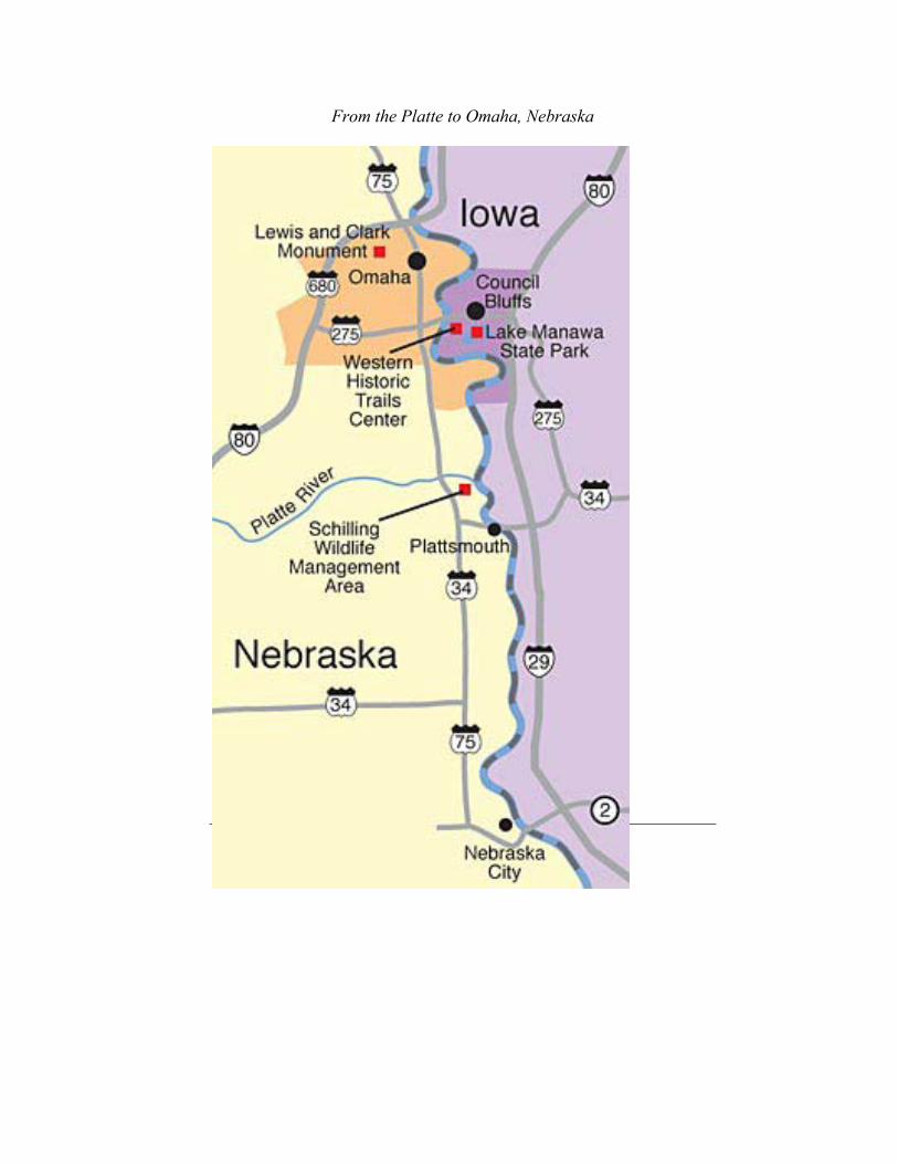
From the Platte to Omaha, Nebraska
90

Bluffs to Wilderness: From Council Bluff to Blair
91
From the Bluffs to Wilderness to Bluffs We left you looking over the region from the Iowa side of the river. Let's see what the original "Council Bluff" looked like!
Fort Atkinson State Historical Park
Less than twenty years after the first meeting with the Indians at Camp Council Bluff, Clark's expertise was proven correct when the U.S. Army built Fort Atkinson on the site. This would be the first military outpost west of the Missouri, and was in use from 1819 to 1827. While the river has relocated east since the time of the council, this area still reflects the views that moved Clark. (Council Bluffs, Iowa took its name from this historic site.) Directions: On I-29, take I-680 West to U.S. Highway 75, and north to Fort Calhoun, Nebraska. Turn east on Madison Street and follow the marked route. (402) 468-5611

Bluffs to Wilderness: From Council Bluff to Blair
92
(As you cross the Missouri, you are on the bridge dedicated to the Mormon Trail, part of the historic migration of the Mormons to the Great Salt Lake in Utah. Omaha has an historic site dedicated to the Mormon experience very near the bridge, well marked by signs, and well worth the side trip.)
Boyer Chute National Wildlife Refuge
This 2,000-acre refuge offers a view of grasslands, woodlands and wetlands that have been returned to the state of the region when Lewis and Clark traveled through in 1804. The Refuge offers visitors nature trails and fishing, and an excellent location for bird watching. Boyer Chute is three miles east of Fort Calhoun. (712) 642-4121.
Blair, Nebraska
On the night of August 3, following their first council with the Indians, the Lewis and Clark Expedition pulled to shore when they found numerous snags and sand bars blocking their passage. It was here the men celebrated their successes for the day, and here that Private Reed requested the chance to retrieve his missing knife. A historical marker off U.S. Highway 75 south of Blair marks the site of this encampment. Blair is an excellent example of town that has preserved her historic buildings and maintained them as part of a vital downtown. It is a beautiful place to visit. Buildings from the late 1800's and into the 1900's have been renovated and are in use on Main Street. Numerous stores, cafes and small coffee shops will entice you, so give in and see what Blair has to offer! This is a perfect place to lunch before you continue on your trip!
Bluffs to Wilderness: From Council Bluff to Blair
93
Directions: Returning to Highway 75 at Fort Calhoun, turn north and continue on to the trail marker. (Along the way, you'll also see the Fort Calhoun Nuclear Power Generator.) Once you reach Blair, you will intersect Highway 30. To see downtown, turn west (left). (If you decide to head directly to DeSoto, turn east.)
DeSoto National Wildlife Refuge
According to some, this is the area where Private Joseph Field killed the first badger seen by an American. DeSoto is another oxbow lake created when the river carved a new channel sometime in the past. DeSoto Refuge is home to eagles, turkeys, geese and deer, as well as small birds and mammals. The Refuge provides a seasonal stopover for the fall migration of snow geese, as well. But DeSoto has another function: the main building is also a time machine. Inside, you'll find an exhibit of artifacts recovered from a riverboat that sank here in 1865. The boat was headed for the gold miners in the Black Hills, and was filled with the goods and tools of the time. This is a fascinating trip into the past. Directions: If you are in Blair, return to Highway 30 and turn east. This will take you again across the Missouri River, and through the bottomlands to the entrance to DeSoto National Wildlife Refuge. (About 5 miles total.) The Refuge is open daylight hours, but the building is only open to 4 p.m.
Wilson Island Recreation Area
Camped here on the night of August 5, 1804, the Corps realized that although they'd covered over 20 miles on the river that day, they were only 370 yards from the campsite of August 4! Encompassing 577

Bluffs to Wilderness: From Council Bluff to Blair
94
acres, Wilson Island Recreation Area has boat ramps on the Missouri, campsites, public hunting and fishing. Directions: If you entered DeSoto National Wildlife Refuge, you can reach the Wilson Island Recreation area from the inside. (You can then exit the front gate to travel well marked gravel roads to I-29 exit 72, but for this tour, I'm going to suggest you return to DeSoto, so you can see the other portion of the refuge on your way out.)
Missouri Valley, Iowa/Loess Hills
Traveling to Missouri Valley Iowa from DeSoto will take you past some very popular antique shops, as well as franchise food outlets and motels and gas stations. Directions: Leaving DeSoto's main entrance, turn east (right) on U.S. Highway 30. You are roughly 6 miles from I-29. If you choose to leave the tour here, you can enter I-29 north or south to return home. However, traveling into Missouri Valley also allows you to find Highway 183, and travel a portion of the Loess Hills that is rarely seen by travelers today. Highway 183 south will bring you to Loveland or Honey Creek, where you can re-enter the Interstate system. On a clear day, you can also take I-680 East from I-29, and find an overlook which is very pretty. But they only offer daylight hours for viewing. But wherever you are on this tour, as sundown nears, pull off and enjoy the view. As you watch the gigantic red sun descend into the Great Plains, changing colors as it slips closer and closer to the horizon, consider the thoughts of the forty-some men of the Corps of Discovery. Almost all of them spent the day rowing up an implacable river, in search of the unknown. What would Private Shannon, only 19, be thinking as the sun slips away for another day? Private Whitehouse actually kept a journal. In this section of the river, his
Bluffs to Wilderness: From Council Bluff to Blair
95
thoughts are succinct: "Rowed 20 miles today." If you are Private John Shields, the old man of the party at 35, and one of the few married men on the trip, what are your thoughts tonight? Or consider that at this moment roughly 200 years ago, Meriwether Lewis would be watching this sunset, looking for the first star to appear, to gather his nightly readings.

Bluffs to Wilderness: From Council Bluff to Blair
96

The View Between the Hills: From Blair to Dakota City
97
The View Between the Hills The Lewis and Clark Expedition moved upriver at an astonishing rate this week. Overall, they traveled almost 190 miles in 10 days, managed to send hunters over the same landscape, and make a scenic stop along the way. Our trip offers you the same options! Last chapter, we included the first two stops along this week's trip, namely DeSoto National Wildlife Refuge, and Wilson Island State Park. Since the Missouri was channeled in the 1950's, the course is generally straight and rarely changes. But looking at a map of the river from Omaha to Sioux City, you'll see many examples of "oxbow lakes," loops of water that represent an old river course. Carter Lake, DeSoto, the lake at Lewis and Clark State Park, as well as Brown's Lake, are all examples of the many times the river chose a new direction, somewhere between the lines of bluffs that encompass the river bed. The river would seal the ends of these loops with silt, sand

The View Between the Hills: From Blair to Dakota City
98
and mud, creating a lasting lake in the old riverbed. This was common in the time of Lewis and Clark. On this leg of the trip, most of these lakes are on the Iowa side of the river, as well as access ways to the Missouri. If you'd like to visit the river, I'd suggest you stay with I-29 North. As these are generally fishing or boat launch areas, I'll simply provide directions here.
Remington Access
This is the region near the places sited on August 6th, 1804. Remington Access is about 5-1/2 miles west-southwest of I-29 at Exit 89 on marked gravel roads.
Little Sioux Access
This access is near the original Pelican Island, and the area where on August 8th Lewis saw the river blanketed with feathers. Little Sioux Access is on a paved road that leads west from I-29 at Exit 95, turning right, just before a trailer park, to follow the Little Sioux River for a short distance to the Missouri.
Huff-Warner Access
Huff-Warner access is 2-1/2 miles west-southwest of I-29 at Exit 105 Now, with the next two places are well worth your time to view.
Lewis and Clark State Park
On August 10, 1804, Clark noted an oxbow lake in this region. The Lewis and Clark State Park is built around such a lake, and also houses replicas of the keelboat and pirogues used by the Expedition during the Voyage of Discovery. Rides on these boats are often available, and a
The View Between the Hills: From Blair to Dakota City
99
yearly festival is held every June. Lewis and Clark State Park has trails and swimming, and campsites are available. The park is just west of I-29 at Exit 112 near Onawa. (712) 423-2829.
Blackbird Scenic Overlook
On August 11, 1804, Captains Clark and Lewis, along with 10 others, climbed the 300-foot bluff to view the burial site of Blackbird, a powerful Omaha chief who had died four years earlier. While the actual Blackbird Hill is not open to the public, the Blackbird Overlook is a great place to contemplate the magnitude of the undertaking of the Lewis and Clark Expedition. This site provides a tremendous perspective of the vast distance of land these hardy explorers were navigating. This site is great at all times of year, in all types of weather. To see the fog rising off the river in the early glow of morning is an exhilarating rush. Nearing sundown, with the light behind you, provides a viewing the feeling of desolation as the katydids begin to chirp. The small flowers and huge vista cannot help but make you think about what these men faced in this part of their journey. Directions: When leaving Lewis and Clark State Park, turn right, and cross the Missouri river at Decatur, Nebraska. Follow the signs to U.S. Highway 75 North, and proceed roughly 3 to 5 miles. The Blackbird overlook is on your right near the peak of the first hill, and is well marked, just inside the boundary of the Omaha Indian Reservation.
Omaha and Winnebago Indian Reservations
Two of the major reservations in Nebraska lay along U.S. 75. You entered the Omaha Reservation as you approached the Blackbird Overlook, and will remain on the reservation until you reach the Winnebago Reservation border some 20 miles north. Along the way,
The View Between the Hills: From Blair to Dakota City
100
you will pass by Macy, home of the Omaha Indian Reservation, and continuing north, 12 miles later you will pass through the community of Winnebago, on the Winnebago Indian Reservation. These two reservations are home to roughly 4,000 people, and some 250,000 acres of woodland and farms. (When 75 joins U.S. 77, turn north, which is to the right.) Watch the fields to the left of the road as you leave Winnebago. There are frequently buffalo grazing in this area.
Homer, Nebraska
Turning right at the Homer intersection will take you to a gravel road. Within 2 miles is Combs School, and O'Conner House. These late 19th Century buildings are open to the public on Sundays from June to August.
Tonwontonga
Returning to U.S. 75, and turning north, you have exited the bluffs and entered the river bottom. There is nothing left of the Omaha "Big Village," but one can get a sense of the region, with the hills behind and to the left, and as Clark says in his journal, the river running "55 degrees West as far as the can be seen." According to the experts, the Omaha village lay just north of the current town of Homer, Nebraska, near the bluffs and the creek. One senses from the journals the village may be located a little further west, but either way, the campsite was very near the community. It is estimated that after the small pox epidemic, this village of earthen huts may have held 1,500 people, a considerable number in that era. (In fact, it is still a considerable number in modern Nebraska, and larger than the current community of Homer!)

The View Between the Hills: From Blair to Dakota City
101
Fish Camp
Again, there is no sign of the campsite from August 13 to August 20, though it is thought to be about 3 miles further north on U.S. 77/75, and perhaps a mile east of the road. Today it is a cornfield, but in 1804 it was a sandy island in the riverbed. Note the proximity of the campsite, and the marker for the village. (Plans call for new signage for this area, so be alert to road markers.)
Dakota City, Nebraska
Another 5 miles north will bring you to the turnoff for Dakota City, Nebraska. Cottonwood Park in Dakota City offers an excellent view of the river, and some historical markers. During the right times of the year, eagles are often seen in this area. Directions: At the four way stop, turn right. Continue east until a stop sign. Turn right, two blocks and left. (If you are looking for food, Hungry's North offers incredible steaks grilled over an open flame. The prices are surprisingly affordable, and the rustic environment is a unique dining experience.)
Sgt. Floyd Monument
Return to the four way stop at Hwy 77/75, and turn north. When the road intersects with I-129/U.S. 20, turn right, and follow I-129 East. Just before the bridge, to your left, you will see a beautiful view of the Sgt. Floyd Monument rising out of the tree-lined bluffs. Take the I-29 South exit, and exit I-29 immediately. Turn left, until you reach 75, and then turn left after crossing the railroad tracks. Roughly 4 miles, and the turn to the marker is on your left.

The View Between the Hills: From Blair to Dakota City
102
Step out of your car, and you will be able to see a beautiful panorama of the entire region and three states. Your view extends to the horizon on the west, and past the trees across the river. Most evenings, this is a spectacular place to watch the sun slide below the horizon. Spend a little time and enjoy the beauty.
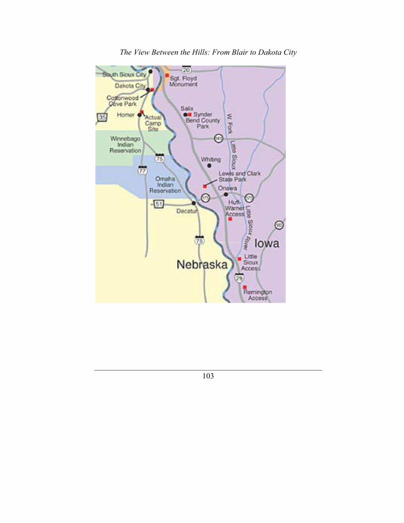
The View Between the Hills: From Blair to Dakota City
103

Exploring Siouxland
104
Exploring Siouxland Our explorations take us to the region where the Lewis and Clark Expedition suffered their greatest loss. For many of our readers, it also takes us home. Let's see if we can't provide a few surprises as we explore the Siouxland region! Sometimes, looking at the community you know best, it is difficult to see what it really looks like. Let's think of this trip as though we were seeing Siouxland for the first time. If we are entering Sioux City from the South on I-29, as we enter the region near the airport, we notice new houses to our right and some major work on the overpass ahead. Hmmm. A growing community, one suspects. As we proceed a little farther, we are also very near the area where the Lewis and Clark Expedition beached in an effort to revive Sgt. Charles Floyd with a warm bath, but instead heard him tell Captain Clark, "I am going away now." Within a few miles, we'll also see the Floyd Monument,

Exploring Siouxland
105
coming into view on the hillside to our right. That's ok – we'll come back to that. Let's hit the town first.
Downtown Sioux City
As we exit the Interstate at the Downtown exit, we see more new buildings going up, and after a quick left onto Gordon Drive, a block later, a quick right onto Nebraska Street. We are heading north, and for visitors that haven't seen the City in some years, they also see a surprise. The gateway to the community has changed radically. Gone are the agri-based farm stores and grain areas, or the even older shipping warehouses and block-long storage buildings. Instead we see examples of a downtown revitalized with new buildings and new ideas. Sioux City stretches out before the traveler, offering restaurants to the left and right, as well as the very classy looking Terra Centre, the glass building that acts as a centerpiece for today's downtown. Before we reach that, though, notice that on your left is a dazzling Sioux City Art Center, with world-class art displays and a dedication to excellence. As we pass under the skywalk, let's take a left on 4th street and grab a cup of coffee at the Daily Grind coffee shop and used bookstore. Enjoy this month's guest artist on display, and then hit the street – we have a lot of ground to cover! If you leave your car and travel east, you'll see the classic view of the Badgerow Building, one of the last of the art deco buildings in Siouxland, and for many years, the tallest building in town. Cross another two blocks, you'll find Historic Fourth Street, with numerous restaurants and specialty shops in remodeled buildings from the Riverboat days of the city at the turn of the 20th century. This is a perfect area for lunch, with many fine restaurants.
Exploring Siouxland
106
If instead you traveled north from the coffee shop, within two blocks is the incredible Orpheum Theatre, one of the grandest of the old movie and Vaudeville theatres. The building, only recently renovated, now hosts music and dance performances, as well as movies. If your trip allows, plan to catch a show at this tremendous theatre, and experience the grandeur of one of the premier renovated theatres in the country. One block further west, notice an item from the 19th Century: City Hall's Clock Tower dates back over 100 years, thought the City Hall has been renovated, it still sports the original facade. On the other half of the same block, to the north, is the Woodbury County Court House, a brilliant peace of timeless Prairie architecture from 1918. This fantastic building is well worth a look inside to view the interior rotunda and the incredible murals. But today, let's stick to the car. Driving west, cross Pierce Street, and turn right on Douglas, which will take us past City Hall and the Court House. Turning right on 7th, head two blocks east, and then left again on Nebraska. At the top of the bluff overlooking Sioux City, you'll doubtlessly notice the "Castle on the Hill." Originally a high school, this fascinating building was in service until 1971, and after years of disuse, has now become an historic apartment complex. Turn right on 14th street, and then left on Jackson. Proceeding north again, at 29th and Jackson is the Sioux City Public Museum. Originally a private home, the building is made of pink quartz found nearby. (Closed on Mondays.) Taking a left on 29th, go two blocks to Pierce, turn left again, and at the stop light for Stone Park Boulevard, take a right. This long diagonal street will lead you through a pleasant residential area, and to a major stop light at Hamilton Avenue. Turning left on Hamilton will take you past Siouxland's original shopping center, and a variety of strip malls, as well as back to the I-29 ramp in three miles.

Exploring Siouxland
107
Dorothy Pecaut Nature Center
Stone State Park
Turning right (north), take I-29 north for two miles, following the river and the bike trails. Just before Exit 151, you'll see the Big Sioux River join the Missouri. Exit at 151, and turn right. Follow Riverside Boulevard (Hwy 12) through town, and out to the edges of the Loess Hills. Here, roughly two miles on, you will find the Dorothy Pecaut Nature Center, and Stone State Park. Spend as much time as you'd like in these heavily timbered examples of the Loess Hills, and enjoy the wildlife.
Lewis and Clark Interpretive Center
Return to I-29, and turn south to follow it back to the Hamilton Exit. This time, however, at the bottom of the exit ramp, turn left, and let's look at the Siouxland riverfront. If you haven't been to Sioux City in some time, this may be your greatest surprise. As you travel this area of green space and bike trails, notice the Sgt. Floyd Riverboat Museum/ Welcome Center, and the Lewis and Clark Interpretive Center – and these are all before you pass under the bridge! The huge statue of Lewis, Clark and Seaman inviting kids to climb on the friendly larger than life sculpture sets the tone for the interior of the Interpretive Center. While it follows and open floor plan, the entire story of the trip through the region is told in a hands-on process that kids love. (The lifelike automatons of Clark and Lewis discussing the trip are certain to be a hit with the kids as well!)

Exploring Siouxland
108
The Sgt. Floyd Riverboat Museum/ Welcome Center
The main floor of this survey vessel, which plied the waters of the Missouri for most of its life, is given over to tradition welcome center activities. This boat could house the most overlooked treasure trove of Lewis and Clark materials on the entire trip. While the Sgt. Floyd River Boat Museum traces the history of riverboats on the Missouri, it offers some unique artifacts, such as an actual dugout canoe, Indian items, and maps of the era. Most notable, though, are the many stunning dioramas and models designed by the late Blair Chicoine. Not to be overlooked, though, is the forensic re-creation of Sgt. Floyd. The Sgt. Floyd Riverboat also offers pamphlets of other regional sights. If you don't stop here, you are missing a treasure!
The Anderson Dance Pavilion
The Anderson Dance Pavilion, with the beautiful white canvas top is the keystone of the area, and started the riverfront re-development. Further along the Iowa side, you'll pass the Belle of Sioux City Casino Riverboat, as well. Across the river, you'll notice Nebraska's Scenic Park Campground, and soccer fields. When you reach Floyd Avenue, follow it over the railroad, to 4th street. To your left is Historic Fourth Street, which we mentioned at the start of this tour. Let's take a right, though -- we have an important stop to make before sundown.
Sgt. Floyd Monument
After we cross the Floyd River, we will find our way to Hwy 75, also known as Lewis Boulevard. (Wonder how it got that name?) Take a right; you will drive almost 2 miles, topping a hill, and a second one,
Exploring Siouxland
109
before we see the exit for the Sgt. Floyd Monument on your right. Let's stop here for a closer look. Floyd's Bluff, as it was known to early travelers, was a landmark to all who passed through the region. The original cedar post that marked the grave was long gone by the time the 100th anniversary of the trip approached. In fact, the original grave had opened when the hillside eroded, and only fast action by locals prevented the loss of Floyd's remains. This marker was erected in 1902, to permanently mark the resting place of Sgt. Charles Floyd, who died near here on August 20, 1804. As the only member of the Lewis and Clark Expedition to die on the 28-month trip, it seems fitting that this marker is the largest Lewis and Clark related monument in the country, and that it became the first National Historic Landmark, registered in 1960. Walking to the marker, you will be able to see a beautiful panorama of the entire region. Below you is the railroad, and beyond that the Interstate highway. Beyond both is the river, the original highway that Lewis, Clark, Floyd and 40 other men traveled into the heart of America almost 200 years ago. The land across the river is Nebraska, and at sundown on most days, the view from here is spectacular. This is also a spectacular spot to consider the trip that the men of the Expedition made, and their struggles to reach this spot. Their view from this place could only focus their thoughts on hardships they had already faced, and the incredible distance they had in front of them. Yet, in their journals, they still consider the beauty of the sundown. As in many things on their trip, their actions should be a lesson to us all. Enjoy the beauty that surrounds you today.

Exploring Siouxland
110
On the Trail: From Sioux City to Ponca, Via South Dakota
111
On to South Dakota Following the Corps of Discovery this week will take us into new lands, as we tread into South Dakota for the first time! Much of our trip out will feature the flatlands of the river bottom, but our return will take us through the bluffs of Nebraska, on the scenic Hwy 12. In the process, we will cross a bridge that didn't exist two years ago, and see a portion of the Missouri that remains as free and wild as it did in the time of Lewis and Clark's travels. Let's get started! Starting on I-29 north, our path will take us across the Big Sioux River, and into South Dakota. The first two miles demonstrates the differences brought by crossing a state line: In this small area is the prairie-style corporate office of IBP, whose windows look out upon the beauty of the Loess Hills; the main factory for Gateway Computers, (yes, those spotted buildings are their factory); and the Dakota Dunes, featuring a world class golf course designed by Arnold Palmer overlooking the Missouri River. A half-mile to the right of the

On the Trail: From Sioux City to Ponca, Via South Dakota
112
Interstate is the North Sioux City Strip, featuring numerous casinos and restaurants for your pleasure. Our first stop, however, is only one mile further!
Adams Homestead & Nature Preserve
At this spot, you can view the river, and the prairie, in much of its natural nature. For hikers, there are more than seven miles of trails in the preserve, traveling through the prairie grasses, and offering a glimpse of many of the region's animals in their natural habitats. Directions: McCook Exit 4, and follow the signs.
Elk Point, South Dakota
Returning to the Interstate, our next stop is Elk Point. To your left are the Nebraska hills, and the region where Lewis gathered minerals. (We'll check those sights on the return trip.) Near here, the Corps of Discovery spotted two Elk crossing the Missouri, and their first buffalo. It was also here that the men elected Patrick Gass as Sergeant for Floyd's squad. This is thought to be the first election held by U.S. citizens west of the Mississippi, and a marker in downtown Elk Point relays the story. Another display in the town park commemorates the event, as well as an annual festival that attracts visitors and re-enactors each year. (And if you do stop, don't overlook Edgar's Old Fashioned Soda Fountain on the main strip through town, featuring a vintage soda fountain!) Directions: Take the "first" exit to Elk Point, turn right, and follow the road into town.
On the Trail: From Sioux City to Ponca, Via South Dakota
113
Spirit Mound
Continue on through Elk Point, but do not re-enter the Interstate. Let's stay close to the river bottom, and take the "old" highway into Vermillion. Hwy 10 will take us along the farms fronting the Missouri, and bring us to the south of Vermillion, South Dakota. Our first priority is to reach the "Spirit Mound," a tall conical hill the natives believed to be home to tiny devils with arrows. The crew walked over 11 miles to reach this hill on an incredibly hot day on August 25, 1804, and Clark noted the view of the river, and the herd of buffalo grazing in the distance. Directions: Continue through Vermillion, and at the Hwy 19 intersection, continue north. Spirit Mound stands about six miles north of Vermillion. The land has been restored to original grasses, with a trail to the top. The mound still affords an incredible view of the prairie.
Vermillion, South Dakota
When you leave Spirit Mound, retrace you trip back to Vermillion on Hwy 19. This town is home to the W.H. Over Museum of Natural History, which features a Lewis and Clark Learning Center, as well as native history and early settlers exhibits. The museum is located at 1110 Ratingen Avenue. This is a great museum, a worth the time to review for native and pre-history of the region. Not to be overlooked while in Vermillion is the Shrine to Music Museum, located on the campus of the University of South Dakota, on Clark Street. With the largest collection of musical instruments in the world, this is definitely an important stop. Another treat is the old downtown, which offers small stores, coffee shops, and a fine used bookstore bursting with hidden treasures, frequently including signed copies of rare books! Vermillion also offers a Winery/Bed and Breakfast, and guided kayak
On the Trail: From Sioux City to Ponca, Via South Dakota
114
trips on the Missouri! For more information, the best contact is the Vermillion Chamber of Commerce at 906 E. Cherry. (605) 624-5571.
Crossing into Nebraska
Ionia Volcano
The newest bridge across the Missouri is now open. Heading back out of town on East Main, follow down the hillside to Timber Road. Shortly thereafter, take a sharp U-turn onto Hwy 19 South. After a few miles, you will emerge from a tree-lined riverbed to a view of the wild, untamed Missouri. Traffic is generally light, so take a few moments to see the sand bars and shallow river that challenged the men of the Corps. There is also an overlook on the Nebraska hillside that gives you an incredibly beautiful view of the river and the region, which is more than worth the walk to the top of the bluff. Continuing into the Nebraska, you will pass over the high bluffs for roughly 10 miles before you reach Hwy. 12. Turn left, and the road winds through these less traveled roads. Near here, on the river, was the Ionia Volcano, a bluff of shale before it completely fell into the river.
Ponca State Park
You will pass through Newcastle, Nebraska, and in another ten miles you will reach Ponca on your left. At the 26E intersection take a left, and follow the road to Ponca State Park. Covering 1400 acres, this park in the Nebraska bluffs features trails, cabins, campsites and a pool. The new 17,000-square-foot Interpretive Center allows visitors to learn about the Missouri River, as well as the historic trip of Lewis and Clark. But don't forget to travel through the park for additional views of the river, both close at hand, and from high above. At the

On the Trail: From Sioux City to Ponca, Via South Dakota
115
lower side, the limestone cliffs tower over the river approach, giving us a view of these hills as they attracted Lewis to gather minerals. From above, at the overlook, we can see the river as it twists in the bottomlands, and look over the prairie for miles. On this, one of the last remaining sections of the river that is untamed, we can see the region as the explorers saw it. From this perspective, facing the river, there is little to remind you of today, save for the uniform checkerboard of fields across the river. It is easy to experience the wonder of the constants of the hills, the sky, and the river. For them, 200 years is but a wink of the eye.

On the Trail: From Sioux City to Ponca, Via South Dakota
116

On the Trail: From Ponca to Yankton
117
Yankton! Our trip will take us to a pioneer town on the river this week, as we head back to South Dakota for a look at some very special sites in the Lewis and Clark Expedition. On the way, though, let's make a few extra stops to share some of the history of rural Nebraska.
Ponca, Nebraska
We finished our tour in Ponca, Nebraska last time. Ponca is one of Nebraska's oldest communities, and some of the older buildings are reflections of an early river town. In the 1880's Ponca was a teaming center of activity and industry. Don't miss the local historical museum in the old blacksmith shop, a half block west of the Post Office. Three blocks further west, visit the Adams House for a look at an 1880's home, with additional displays of life in an early frontier town.

On the Trail: From Ponca to Yankton
118
Continue west, and you will again reach Hwy 12. Turn right for a beautiful trip along the bluffs on Nebraska's newest addition to the state's scenic byways road system. This road winds through the communities of Newcastle, Maskell and Obert, small towns that reflect the drastic out-migration of families as the rural farm economy dwindled in the 20th century.
Wiseman Monument
Shortly after Obert is a sign for the Wiseman Monument, commemorating the death of the Wiseman children during the later Indian uprisings in the region. Set in a shady area near the historic location of the family cabin, this is a look at Nebraska off the beaten path, and how historical monuments have changed in the last 100 years. Directions: Turn right at road marker. Follow gravel road to monument on left side.
St. James, Nebraska
From the Wiseman Monument is a sign directing you to St. James. This small community has created a farmer's market craft room and tearoom in an old school building, called St. James Marketplace. The hours are 10 to 5 on Saturdays thru the summer, but there is also a special event to end the season on the Sunday after Labor Day. The St. James Heritage Fest celebrates the rural life of early farm families, with "hands on" experiences of butter churning, wool spinning and weaving, as well as two-man cross cut saw contests, and many other displays. Directions: Follow marker from Wiseman Monument to St. James. (If still on Hwy 12, take right at St. James sign.)

On the Trail: From Ponca to Yankton
119
Wynot, Nebraska
Twelve communities have joined to create the "Shannon Trail," commemorating the wanderings of Pvt. George Shannon during the 16 days of his journey. Each town has a woodcut statue of Shannon in various poses, and a display talking about his trials. Directions: After returning to Hwy 12 (south from St. James Market on paved road) turn right onto Hwy 12. Wynot is to right of the road, and Shannon display is just past the Post Office.
Corps of Discovery Welcome Center
On the hillside overlooking the Missouri River valley, this center offers visitors a welcome rest, a beautiful view and lots of regional information. Free pamphlets, historical artifacts, and numerous gifts and books are available, along with a video display and lots of special events. The hours are 9-4 daily after Labor Day. Directions: At Hwy 12 and US 81 intersection, turn right. The entrance to the Welcome Center is 5 miles ahead, on the left.
Yankton, South Dakota
As you leave the Welcome Center, turn left on Hwy 81, and head north. Crossing the river this time is a special experience, as we will travel over the Meridian Bridge, a drawbridge with one lane of traffic on a high road, and the south bound traffic on the low road! After you cross, you may want to get a better view of this bridge. If so, there are riverfront parks to the west. But let's cruise through the downtown area first. Continuing north from the bridge, you will pass many older buildings dating from the late 1800's. Driving through this downtown,
On the Trail: From Ponca to Yankton
120
you will see this community has done a beautiful job of renovating and incorporating these buildings into today's world. The Riverfront Event Center is an example, but you can pick any nearby building in this area. Park and walk the community, and enjoy an hour strolling. It is a unique experience, with a wonderful atmosphere. Directions: North from the Welcome Center on Hwy 81. There are a number of items along the road as we head west from downtown. All of these are to the south of the road, and include the Gavins Point Dam Fish Hatchery and Aquarium, as well as the Lewis and Clark Recreation Area. Along the river are at least three camping areas, featuring sites for camper trailers and tents, and also cabins along the backwater by the river. Continuing on Hwy 52, you will see a sign for Gavins Point Dam. Turn left, and as you cross the dam, the Lewis and Clark Lake stretches to your right. During the season, sailboats slide across the shimmering waters of this recreation area, and bring color and activity to the water. Directly ahead, you'll see the white-faced bluffs, which so intrigued Lewis and the men of the Corps of Discovery. The bluff to the left of the dam, with the building overlooking the river, is Calumet Bluff, and the site of the council with the Lak'ota in 1804. More on the building in a moment!
Gavins Point Dam
As you reach the south end of the dam, you are traveling over the spillway, and then the power plant of the Gavins Point Dam, created in 1957 to control the flooding on the Missouri River and provide electrical power to the region. The plant produces enough electricity, with no pollution, for over 30,000 homes a day. (That's roughly a city the size of Sioux City!) During the planning of these flood-control dams, and near the time of the 150th anniversary of the Lewis and Clark Expedition, terrible floods ravaged the region, including Sioux

On the Trail: From Ponca to Yankton
121
City. The completion of these dams, and other flood control projects in Siouxland, has prevented the costly and painful re-occurrence of that event over the last 50 years.
Lewis and Clark Visitor Center:
Completed in 1976, the Visitor Center sits high atop the remaining portions of Calumet Bluff, and provides a view of the past and the present of this area. The building houses a Lewis and Clark Museum, with attention to providing insights into the experiences of the men of the Corps, as well as the natives in the region. The Council at Calumet Bluff was the first real mixing of the Corps and the natives. Spend some time here, and gain an appreciation of the challenges and the choices faced by everyone involved in the exploration of the Louisiana Purchase.

On the Trail: From Ponca to Yankton
122

From Gavins Point to Fort Randall Dam
123
From Gavins Point to Fort Randall Dam This week is the last of the Nebraska towns on our tour of the Lewis and Clark Trail. These are rural areas, with long vistas and the beginnings of a very different landscape as we move into South Dakota. Let's start our tour at Gavin's Point Dam, heading south in Nebraska on Highway 121.
Crofton, Nebraska
Located at the intersection of Hwy 121 and Hwy 12, this community offers a glimpse of the past at the Argo Hotel. The Argo has been beautifully restored, and functions now as a bed and breakfast for travelers, as well as a top restaurant. Directions: Located north of Hwy 12 and east of Hwy 121.
From Gavins Point to Fort Randall Dam
124
Highway 12
As we head west, on one of the first hills you will see a horizon almost 20 miles distant. From here to the Niobrara, the land remains grassland. As we approach the turnoff for Lindy, we will pass into the Santee Indian Reservation. A few miles beyond that, as you fall off the high country and into the bottomlands, slow down to see some very beautiful scenery. You will cross the Bazile creek, a wide, fast stream. To your left is the rock face of the low hill, and you are surrounded by trees. A few miles further, the land will suddenly open to an incredible view of a flooded wetland, with only the road above water. These wetlands are home to pelicans, and as the migration patterns dictate, ducks and geese of all kinds.
Running Water Bridge
Before Niobrara, you'll see a turn to the right for Running Water Bridge, and Tyndall, South Dakota. While we will continue on Hwy 12 for this tour, take a few minutes to cross over, and see the white chalk bluffs. There's an overlook just above the bridge. Stop and enjoy the view!
Niobrara, Nebraska
Re-crossing the bridge, turn right on Hwy 12, and you'll enter another long stretch of wetlands. This time, we are heading to the community on the bluff, which is the historic town of Niobrara, Neb. Originally on the lowlands, this community was re-located years ago due to the flooding of community. After leaving the bluff, you'll pass over the Niobrara River, and the new channel west of the river. Watch for herons and pelicans and other birds as you see the wide sandy river Clark described in his journals.

From Gavins Point to Fort Randall Dam
125
Niobrara State Park
Past the river, and on the right as we climb another bluff is Niobrara State Park. This park offer trails to the riverfront across an old railroad bridge, and the campsites and cabins at the top of these bluffs offer a truly spectacular view. Good news: this is one of the less densely populated state parks, and cabins are often available in the season. Check it out!
The Dome: (Old Baldy)
We will pass by Verdel, Minowi, Lynch and Bristow before Highway 12 joins Hwy 281. Continue west, climbing the bluff to reach Spencer. If you need gas, this is a good place. We are going to leave Hwy 12 here, though we will also leave Hwy 281 for a while. The "dome" near the prairie dog village that Lewis and Clark visited is nearby. Directions: Drive north of Spencer on Hwy 281 for 4.6 miles, and then turn east (right) between mileposts 219 and 220, on a country road for Gross. This country road will take you near the dome, now better known as "Old Baldy." This road connects Gross with Lynch and Bristow, as well. You are now at the region where the Lewis and Clark trail leaves Nebraska behind. Looking around, you'll notice the changes already from the land we've spent the last two months traveling through. This area is a high country plain. The grass is shorter, and except for the region around the river, it seems drier, as well. Out here, between the towns, is a perfect place to contemplate one last sight that has changed very little since the times of Lewis and Clark. If it is a dark, cloudless night, stop for a moment, and turn off the engine, and your car lights. Step out of your car, and listen to the sounds surrounding you. Perhaps

From Gavins Point to Fort Randall Dam
126
you'll hear a "prairie wolf," as Clark so frequently mentions in his journal.
To the Heavens
After your eyes have grown accustomed to the darkness, tilt you head back. Here, away from the city lights, take a moment to appreciate the richness of the cloud of stars making up the Milky Way, and the twinkling jewels that shine in the dark heavens above. Some people never notice the stars where they live, but when people visit from New York City, or even Omaha, I can hear the awe in their voice as they experience the Milky Way for the first time. Here, away from lighted signs and streets, see the sky as members of the Expedition experienced it. Drink in the luminosity and, yes, the color, of the night sky. With the insects chirping and the wind gently whispering as it passes, it is not hard to imagine William Clark taking a last look at this beautiful sky, before sleep, and another day on the Missouri River.

From Gavins Point to Fort Randall Dam
127
Bibliography
128
Bibliography Ambrose, Stephen Undaunted Courage, NY, Simon & Schuster, 1996 Hawke, David Freeman Those Tremendous Mountains, Norton, 1980 Jefferson, Thomas, Writings, NY, Library of American, 1984 Malone, Dumas Jefferson and His Times, Volume 1, Boston, Little, Brown, 1948 Malone, Dumas Jefferson and His Times, Volume 3, Boston, Little, Brown, 1962 Malone, Dumas Jefferson and His Times, Volume 4, Boston, Little, Brown, 1970

Bibliography
129
Malone, Dumas Jefferson and His Times, Volume 5, Boston, Little, Brown, 1974 Malone, Dumas Jefferson and His Times, Volume 6, Boston, Little, Brown, 1981 Merk, Frederick History of the Westward Movement, NY, Knopf, 1978 Moulton, Gary, Editor The Journals of the Lewis and Clark Expedition, Volume 1, Lincoln, University of Nebraska Press, Moulton, Gary, Editor The Journals of the Lewis and Clark Expedition, Volume 2, Lincoln, University of Nebraska Press, Moulton, Gary, Editor The Journals of the Lewis and Clark Expedition, Volume 3, Lincoln, University of Nebraska Press, 1987 Moulton, Gary, Editor The Journals of the Lewis and Clark Expedition, Volume 9, Lincoln, University of Nebraska Press, 1995 Moulton, Gary, Editor The Journals of the Lewis and Clark Expedition, Volume 10, Lincoln, University of Nebraska Press, 1996 Moulton, Gary, Editor The Journals of the Lewis and Clark Expedition, Volume 11, Lincoln, University of Nebraska Press, Moulton, Gary, Editor The Journals of the Lewis and Clark Expedition, Volume 12, Lincoln, University of Nebraska Press Rhonda, James P. Lewis and Clark Among the Indians, Lincoln, University of Nebraska Press, 1984

About the Author
About the Author
Russell Gifford is a life-long resident of northeastern Nebraska. He grew interested in the voyage of Lewis and Clark during his youth in Ponca, Nebraska, wondering, "What did they see? How did they feel about these views, these hills?"
Since that time, he's studied this monumental trek and American history. Over the years, as popular books ignored the region below Mandan, he continued his quest for the answers. "Spectacular Voyage" draws on the now available first-person accounts from the journals of the Expedition, coupled with Gifford's first-hand knowledge of the region.
After years of success in marketing and business management, Gifford now works as an instructional trainer and freelance writer in South Sioux City, Nebraska. He writes about history, technology and entertainment, and is currently working on his next book.
Further information is available at www.russgifford.com.130

Index
131
INDEX
B Bazile Creek ....................................... 60 Benoit................................................... 19 Big Horse ............................................ 42 Big Sioux ............................... 47, 53, 107 Black Buffalo ............................65-67, 69 Blackbird........................................ 35, 99 Boyer River ................................... 24, 92 Bratton, William ................... 33,41,49-50 Buffalo Medicine............................65-67 Butter Island........................................ 19
C Calumet Bluff .....55, 57, 58, 59, 126, 127 Camp White Catfish............... 23, 24, 92 Camp Wood .............. 4, 9, 20, 21, 40, 50 Cann, E. .................................. 40, 42, 54 Charbonneau ...................................... 78 Clark, William....5, 6, 7, 9, 10, 11, 12, 14,
15, 16, 17, 18, 20, 21, 22, 24, 26, 27, 28, 29, 30, 31, 32, 34, 35, 36, 37, 38, 39, 40, 41, 43, 44, 45, 46, 47, 48, 49, 50, 51, 52, 53, 54, 55, 57, 58, 59, 63, 64, 65, 66, 67, 68, 69, 70, 71, 72, 73, 74, 75, 77
Collins, John ................................ 38, 39 Colter, John..... 29, 30, 54, 58, 62, 63, 70 Coteau de Prairies ............................. 51 Council Bluff....28, 29, 31, 32, 33, 34, 39,
47, 91 Cruzatte, Pierre ... 21, 22, 23, 24, 40, 42,
71, 73
D Dorion, Pierre.. 44, 51, 54, 57, 58, 59, 61 Drouillard, George .... 23, 24, 26, 29, 30,
32, 37, 44, 45, 54, 55
E Elkhorn River ...................................... 24
F Faufong ............................................... 32 Field, Joseph ........ 10, 28, 53, 54, 55, 58 Field, Rubin ....................... 24, 28, 29, 37 Floyd, Charles 24, 30, 36, 39, 48, 49, 50,
52, 53, 107, 110, 114, 118 Frazer, Robert .................................... 54

Index
132
G Gass, Patrick .............................. 53, 118 Gibson,George ....................... 29, 30, 53 Goodrich, Silas ................................... 23
I Ionia volcano....................................... 53
J James River ........................................ 56 Jefferson, Thomas .. 4, 6, 27, 29, 31, 32,
44, 57, 61, 66, 68, 78, 86
K Kansas River ............................ 9, 13, 27 Keelboat ..5, 9, 13, 15, 16, 21, 22, 31, 37,
38, 39, 46, 52, 59, 64, 70, 71, 72, 74, 77, 86, 92, 104
L La Liberte .................... 27, 29, 33, 44, 45 Labiche, Francois..21, 22, 23, 37, 45, 54 Lewis, Meriweather4, 5, 6, 7, 10, 11, 14,
16, 17, 18, 22, 23, 24, 26, 27, 28, 29, 30, 31, 32, 34, 35, 36, 37, 38, 39, 40, 41, 43, 44, 45, 46, 47, 48, 52, 53, 54, 56, 58, 60, 63, 64, 65, 66, 68, 69, 70, 71, 72, 73, 74, 77, 83
Little Sioux..................................... 36, 38 Loess Hills................... 92, 100, 113, 117 Louisiana Purchase ............. 25, 49, 127 Loups ................................................... 31
M Mahars........................................... 31, 39 Mandan.................................. 6, 7, 45, 77
Missouri .4, 11, 22, 23, 26, 27, 28, 31, 34, 41, 42, 45, 56, 57, 69, 76, 77, 120
Missourian ........................................... 26
N Nemaha River............................... 11, 14 Newman, John.................................... 77 Niobrara ......................... 65, 76, 130, 131 Nishnabotna Creek ............................ 17
O Omaha Indian ......... 12, 41, 65, 105, 106 Ordway, John..13, 30, 40, 41, 42, 43, 51,
52, 53, 54, 66, 67 Otos.............21, 29, 31, 35, 42, 45, 46, 54
P Papillion ............................................... 23 Partisan ............................. 71, 72, 74, 75 Pawnees........................................ 21, 31 Perry Creek ......................................... 51 Platte River....5, 6, 12, 16, 18, 20, 21, 22,
23, 35, 51, 65, 76, 91 Pryor, Nathaniel.......... 30, 52, 57, 58, 73
R Reed, Moses...33, 34, 36, 37, 44, 45, 46,
77, 98
S Sacagawea ......................................... 78 Seaman ............................................... 54 Shannon, George 29, 40, 42, 55, 56, 58,
62, 63, 67, 100, 125 Shawnee ............................................. 26 Shields, John ...... 30, 54, 55, 58, 65, 101 Sioux ....10, 13, 32, 44, 51, 54, 55, 56, 58,
60, 70, 73, 74

Index
133
Soldier River ....................................... 36 Spirit Mound........................ 54, 118, 119 Star gea Hun Ja ........................... 47, 48
T Tarkio River......................................... 14 Tetons.................................................. 69 Tonwontonga .34, 40, 41, 42, 43, 51, 106
V Vermillion River .................................. 54
W Warfington, Richard ..... 5, 54, 57, 64, 77 White Stone River .............................. 54 Whitehouse, Joeseph .......... 35, 38, 101 Willard, Alexander ...... 10, 13, 14, 27, 46
Y York ........................................ 30, 54, 132


