Spore-Pollen Biostratigraphy and Paleoecology of Mesozoic and Lower Tertiary Samples from the Surghar and Salt Ranges, Northern Pakistan By N.O. Frederiksen, U.S. Geological Survey T.P. Sheehan, U.S. Geological Survey V.A.S. Andrle, U.S. Geological Survey Chapter D of Regional Studies of the Potwar Plateau Area, Northern Pakistan Edited by Peter D. Warwick and Bruce R. Wardlaw Prepared in cooperation with the Geological Survey of Pakistan, under the auspices of the U.S. Agency for International Development, U.S. Department of State, and the Government of Pakistan Bulletin 2078–D U.S. Department of the Interior U.S. Geological Survey
Transcript
Spore-Pollen Biostratigraphy and Paleoecology of Mesozoic and Lower Tertiary Samples from the Surghar and Salt Ranges, Northern Pakistan
By N.O. Frederiksen, U.S. Geological Survey T.P. Sheehan, U.S. Geological Survey V.A.S. Andrle, U.S. Geological Survey
Chapter D ofRegional Studies of the Potwar Plateau Area, Northern PakistanEdited by Peter D. Warwick and Bruce R. Wardlaw
Prepared in cooperation with the Geological Survey of Pakistan, under the auspices of the U.S. Agency for International Development, U.S. Department of State, and the Government of Pakistan
Bulletin 2078–D
U.S. Department of the InteriorU.S. Geological Survey
Acknowledgments ................................................................................................................................1Previously Reported Ages of Formations ..................................................................................................1Determination of Spore-Pollen Ages ..........................................................................................................3Palynological Methods .................................................................................................................................5Sample Analyses............................................................................................................................................5
Makarwal Coal Field .............................................................................................................................5Nammal Pass Section ..........................................................................................................................6Nammal Dam Section ..........................................................................................................................7Kuraddi Section .....................................................................................................................................7Samples from the Central and Eastern Salt Range .........................................................................8Arara Section.........................................................................................................................................9Nila Wahan Section ..............................................................................................................................9Drill Hole 9, Khairpur Area ...................................................................................................................9
Drill Hole 34, Basharat Area ..............................................................................................................10Discussion and Conclusions ......................................................................................................................11References Cited..........................................................................................................................................12Appendix D1. Alphabetical List of Species Mentioned in this Report ................................................14
Plates[Plates follow Appendix D1]
D1. Permian and Jurassic or Early Cretaceous spores and gymnosperm pollen from the Salt Range.
D2. Late Jurassic or Early Cretaceous, probably middle Cretaceous, and Paleocene spores and pollen from the Surghar and Salt Ranges.
D3. Spores and angiosperm pollen from the Patala Formation of the Salt Range. D4. Angiosperm pollen from the Patala and Nammal Formations of the Salt Range.
Figures D1. Map showing the Salt Range study area and selected regional features .......................D2 D2. Map of the Salt Range study area in northern Pakistan showing sample localities
discussed in this report ...............................................................................................................2
iv
D3. Range chart for 27 stratigraphically significant pollen species and species groups in a composite section for the upper Paleocene of the Lower Indus coal region, Sindh Province .................................................................................................................4
D4–D8. Diagrams showing analyses of spore-pollen assemblages from the— D4. Hangu and Patala Formations of Lumshiwal Nala in the Makarwal coal field .........6 D5. Hangu Formation of Nammal Pass and the Patala Formation of the Nammal
Dam, Arara, Kuraddi, and Nila Wahan sections .............................................................7 D6. Patala Formation of various sections in the central and eastern Salt Range ...........8 D7. Patala Formation of drill hole 9, Khairpur area ...............................................................9 D8. Patala and Nammal Formations of drill hole 34, Basharat area ................................10 D9. Diagram showing composite analyses of spore-pollen assemblages from the
Hangu, Patala, and Nammal Formations of the Surghar and Salt Ranges .......................11
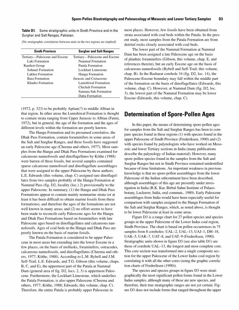
Table D1. Some stratigraphic units in Sindh Province and in the Surghar and Salt Ranges,
Spore-Pollen Biostratigraphy and Paleoecology of Mesozoic and Lower Tertiary Samples from the Surghar and Salt Ranges, Northern Pakistan
By N.O. Frederiksen, T.P. Sheehan, and V.A.S. Andrle
AbstractThe conglomerate at the base of the Basharat drill hole 34
(eastern Salt Range), thought to represent the Tobra Formation (Permian), contained Permian pollen grains and spores that may be indigenous or may be reworked; thus, the age of this conglomerate is uncertain.
Two samples from the lower part of Lumshiwal Nala (Makarwal coal field, Surghar Range), probably from the Lumshiwal Formation, were assigned Late Jurassic to Early Cretaceous and middle Cretaceous (approximately Aptian to Albian) ages, respectively.
Rocks from the shallow subsurface of the Kuraddi sec-tion in the western Salt Range, thought to be possibly from the Paleocene Hangu Formation, contained spores and pollen grains probably of Jurassic to Early Cretaceous age; therefore, these samples were probably from the Mesozoic Datta Formation.
Rocks mapped as the Hangu Formation at Lumshiwal Nala (Surghar Range) and Nammal Pass (western Salt Range) are Paleocene in age. All analyzed samples of the Patala Formation from the Salt Range appear to be late Paleocene in age and con-tain pollen assemblages similar to those of the Lakhra Formation of Sindh Province. The Patala assemblages are no older than those from the uppermost part of the Bara Formation of Sindh Prov-ince. Paleocene coal beds in the Hangu and Patala Formations were undoubtedly deposited in or near brackish water because dinoflagellate cysts and brackish-water palm pollen of the genus Spinizonocolpites were found in the associated detrital rocks.
Two samples from the Nammal Formation (lower Eocene(?)) of the Basharat drill hole 34 (eastern Salt Range) had low-diversity spore and pollen assemblages that did not include any species known to be restricted to the Eocene, although some new species were present that might be so restricted.
IntroductionLower and middle Eocene rocks of the Surghar and Salt
Ranges (figs. D1, D2) were deposited entirely in marine environ-
ments and can generally be given an age assignment using marine megafossils or microfossils. However, some of the Mesozoic and Paleocene formations of the region are predominantly nonmarine; although marine fossils have been found in these formations in certain areas, many outcrops lack such fossils. Spores and pollen are therefore most useful in providing ages and correlations of mainly nonmarine units. Previously published Tertiary spore and pollen work in the region includes a description of some late Paleocene or Eocene species from Dandot, in Jhelum District, Punjab, by Vimal (1952) and a description of many Paleocene spe-cies from northern and southern Pakistan by Frederiksen (1994).
In the present study of spores and pollen from the Surghar and Salt Ranges, 1 sample was analyzed from the Tobra Formation(?) (Permian(?)), 2 from the Lumshiwal For-mation (Mesozoic), 7 from rocks thought at least tentatively to represent the Hangu Formation (Paleocene), 26 from the Patala Formation (mainly or entirely Paleocene), and 2 from the Nammal Formation (Eocene(?)). Spore-pollen species mentioned in the text and figures are listed in appendix D1. Many taxa studied are shown in plates D1–D4.
Acknowledgments
This work was done as part of the Coal Resources Explo-ration and Assessment Program (COALREAP), a collaborative program between the U.S. Geological Survey and the Geologi-cal Survey of Pakistan. This cooperative program is under the auspices of the U.S. Agency for International Development and the Government of Pakistan. Most samples discussed in this paper were collected by Frederiksen; however, many of the Patala samples from the central and eastern Salt Range were collected by P.D. Warwick. We appreciate the helpful reviews of L.E. Edwards, J.E. Fassett, and B.R. Wardlaw.
Previously Reported Ages of FormationsThe Lumshiwal Formation of the Surghar Range (table
D1) contains very few marine fossils but was thought by Fatmi
D2 Regional Studies of the Potwar Plateau Area, Northern Pakistan
TajikistanTurkmenistan
CASPIAN L ines ofSEA contro l
Uzbekistan Himalaya C h i n a
A f g h a n i s t a n MouI r a n re
nt
vRi Study ainarea s
Quetta
s LahoreudnI Nepal
P a k i s t a n
KarachiI n d i a
Oman
ARABIAN SEAINDIAN OCEAN
Islamabad
Jammu andKashmir
60° 80°
30°
20°
1000 Km625 Mi
Figure D1. Location map showing the Salt Range study area (box) and selected regional features.
IslamabadAttock City re
Rawalpindi
v
Kohat
i R
Hangu
m ul ehJ
verSoan Ri
BannuMakarwal JhelumKhejiKurram
Riverv rRi e
reivR umel
Jh
sudIn
71° 72° 73°34°
33°
32°
x 151 14 x
2,3 13 x 16xx x
xx x11x x6x x x 7 12
4 x5
0 10 20 30 MILES
0 10 20 30 40 KILOMETERS
98
P o t w a rP l a t e a u
10
gean
R
rahgr u S
Sa l tRange
Figure D2. Map of the Salt Range study area in northern Pakistan showing sample localities discussed in this report. 1, Lumshiwal Nala; 2, Nammal Pass section; 3, Nammal Dam section; 4, Kuraddi section; 5, sample R4264; 6, sample R4262; 7, Arara section; 8, sample R4242M; 9, sample R4242K; 10, sample R4242J; 11, Nila Wahan section; 12, sample R4242L; 13, drill hole 9 in Khairpur area; 14, drill hole 34 in Basharat area; 15, sample R4242E; and 16, sample R4242D.
Spore-Pollen Biostratigraphy and Paleoecology of Mesozoic and Lower Tertiary Samples D�
(1972, p. 323) to be probably Aptian(?) to middle Albian in that region. In other areas the Lumshiwal Formation is thought to contain strata ranging from Upper Jurassic to Albian (Fatmi, 1972), but in general, the age of the formation and the ages of different levels within the formation are poorly known.
The Hangu Formation and its presumed correlative, the Dhak Pass Formation, contain foraminifers in some areas of the Salt and Surghar Ranges, and these fossils have suggested an early Paleocene age (Cheema and others, 1977). Most sam-ples from the Hangu and Dhak Pass Formations examined for calcareous nannofossils and dinoflagellates by Köthe (1988) were barren of these fossils, but several samples contained sparse calcareous nannofossil and dinoflagellate assemblages that were assigned to the upper Paleocene by these authors. L.E. Edwards (this volume, chap. C) assigned rare dinoflagel-lates from two samples probably of the Hangu Formation at Nammal Pass (fig. D2, locality (loc.) 2) provisionally to the upper Paleocene. In summary, (1) the Hangu and Dhak Pass Formations appear to contain mainly nonmarine strata (or at least it has been difficult to obtain marine fossils from these formations), and therefore the ages of the formations are not well known in many areas; and (2) no effort seems to have been made to reconcile early Paleocene ages for the Hangu and Dhak Pass Formations based on foraminifers with late Paleocene ages based on dinoflagellates and calcareous nan-nofossils. Ages of coal beds in the Hangu and Dhak Pass are poorly known on the basis of marine fossils.
The Patala Formation is considered to be upper Paleo-cene in most areas but extending into the lower Eocene in a few places, on the basis of mollusks, foraminifers, ostracodes, calcareous nannofossils, and dinoflagellates (Cheema and oth-ers, 1977; Köthe, 1988). According to L.M. Bybell and J.M. Self-Trail, L.E. Edwards, and T.G. Gibson (this volume, chaps. B, C, and E), the uppermost part of the Patala at Nammal Dam (general area of fig. D2, locs. 2, 3) is uppermost Paleo-cene. Furthermore, the Lockhart Limestone, which underlies the Patala Formation, is also upper Paleocene (Cheema and others, 1977; Köthe, 1988; Edwards, this volume, chap. C). Therefore, the entire Patala is probably upper Paleocene in
most places. However, few fossils have been obtained from strata associated with coal beds within the Patala. In the pres-ent study, most samples from the Patala Formation are from detrital rocks closely associated with coal beds.
The lower part of the Nammal Formation at Nammal Dam has been assigned a late Paleocene age on the basis of planktic foraminifers (Gibson, this volume, chap. E, and references therein), but an early Eocene age on the basis of calcareous nannofossils (Bybell and Self-Trail, this volume, chap. B). In the Basharat corehole 34 (fig. D2, loc. 14), the Paleocene-Eocene boundary may fall within the middle part of the formation on the basis of dinoflagellates (Edwards, this volume, chap. C). However, at Nammal Dam (fig. D2, loc. 3), the lowest part of the Nammal Formation may be lower Eocene (Edwards, this volume, chap. C).
Determination of Spore-Pollen Ages
In this paper, the means of determining spore-pollen ages for samples from the Salt and Surghar Ranges has been to com-pare species found in these regions (1) with species found in the upper Paleocene of Sindh Province (Frederiksen, 1990) and (2) with species found by palynologists who have worked on Meso-zoic and lower Tertiary sections in India (many publications describe the palynology of Indian material). However, many spore-pollen species found in the samples from the Salt and Surghar Ranges but not in Sindh Province remained unidentified because of time limitations. An important weakness in previous knowledge is that no spore-pollen assemblages from the lower Paleocene of the Indian subcontinent have been described, although assemblages of this age are presently under inves-tigation in India (R.K. Kar, Birbal Sahni Institute of Palaeo-botany, Lucknow, India, oral commun., 1989). Early Paleocene assemblages from India would have been especially useful for comparison with samples assigned to the Hangu Formation of the Salt and Surghar Ranges, which, as noted above, is thought to be lower Paleocene at least in some areas.
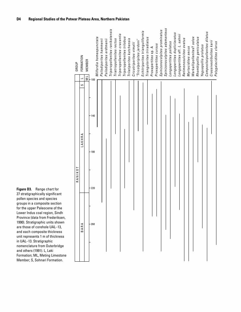
Figure D3 is a range chart for 27 pollen species and species groups in the upper Paleocene of the Lower Indus coal region, Sindh Province. The chart is based on pollen occurrences in 75 samples from 8 coreholes: UAL–2, UAL–13, UAJ–1, DH–18, UAK–5, UAK–7, UAT–8, and UAT–9 (Frederiksen, 1990). Stratigraphic units shown in figure D3 (see also table D1) are those of corehole UAL–13, the longest and most complete core. This core section was transformed into a single composite sec-tion for the upper Paleocene of the Lower Indus coal region by correlating it with all the other cores (using the graphic correla-tion charts of Frederiksen (1990)).
The species and species groups in figure D3 were strati-graphically the most significant pollen forms found in the Lower Indus samples, although many of these are new species, and therefore, their true stratigraphic ranges are not yet certain. Fig-ure D3 does not include forms that ranged throughout the upper
Table D1. Some stratigraphic units in Sindh Province and in the Surghar and Salt Ranges, Pakistan.
[No stratigraphic correlations between units in the two regions are implied]
Sindh Province Surghar and Salt Ranges
Tertiary—Paleocene and Eocene Tertiary—Paleocene and Eocene Laki Formation Nammal Formation Ranikot Group Patala Formation Sohnari Formation Lockhart Limestone Lakhra Formation Hangu Formation Bara Formation Jurassic and Cretaceous Khadro Formation Lumshiwal Formation
Chichali Formation Samana Suk Formation Datta Formation
D� Regional Studies of the Potwar Plateau Area, Northern Pakistan
Figure D�. Range chart for 27 stratigraphically significant pollen species and species groups in a composite section for the upper Paleocene of the Lower Indus coal region, Sindh Province (data from Frederiksen, 1990). Stratigraphic units shown are those of corehole UAL–13, and each composite thickness unit represents 1 m of thickness in UAL–13. Stratigraphic nomenclature from Outerbridge and others (1991). L, Laki Formation; ML, Meting Limestone Member; S, Sohnari Formation.
Milf
ordi
a ho
meo
punc
tata
Psi
lodi
pori
tes
ham
men
iiP
silo
dipo
rite
s er
dtm
anii
Trip
orop
olle
nite
s ra
niko
tens
isTr
iatr
iopo
lleni
tes
rect
usTr
ipor
opol
leni
tes
crac
enti
sTr
ipor
opol
leni
tes
trilo
bus
Trila
tipo
rite
s ku
tche
nsis
Cri
cotr
ipor
ites
vim
alii
"Tri
colp
orip
ites
jerd
oni"
Echi
trip
orit
es t
rian
gulif
orm
isTr
iang
ulor
ites
tri
radi
atus
Pro
xape
rtit
es s
p. A
Pro
xape
rtit
es c
ursu
sS
pini
zono
colp
ites
pro
min
atus
Spi
nizo
noco
lpit
es a
dam
ante
usLo
ngap
erti
tes
psila
tus
Long
aper
tite
s du
plic
lava
tus
Long
aper
tite
s af
f. L
. sah
nii
Ret
imon
osul
cite
s ov
atus
Myr
taci
dite
s se
cus
War
kalli
polle
nite
s? s
olox
Rho
mbi
polli
s ge
nicu
latu
sYe
guap
ollis
pro
latu
sC
ompo
sito
ipol
leni
tes
dila
tus
Cra
ssiv
esti
bulit
es k
arii
Pol
ygal
acid
ites
cla
rus
100
140
180
220
260
GRO
UP
FORM
ATIO
N
MEM
BER
SL M
LL
AK
HR
AR
AN
IKO
TB
AR
A
Spore-Pollen Biostratigraphy and Paleoecology of Mesozoic and Lower Tertiary Samples D�
Paleocene section in the Lower Indus region, nor does it include rare forms whose true range tops and bases are poorly known.
Besides the species known from the Lower Indus region, five additional early Tertiary taxa were tabulated for the samples from the Salt and Surghar Ranges. These species, and their ranges as known from India, are as follows.Dandotiaspora dilata—apparently confined to the Paleocene
(Ambwani and Kar, 1988)Dandotiaspora telonata (pl. D3, fig. 2)—mainly Paleocene,
but ranges up into the Eocene (Ambwani and Kar, 1988)Lakiapollis ovatus (see L. aff. L. ovatus in pl. D4, fig. 1)—
Paleocene to middle and upper(?) Eocene (Venkatachala and others, 1988)
Retitribrevicolporites matanomadhensis (pl. D4, fig. 4)—Paleocene to middle Eocene (Kar, 1985)
Acrostichum spp. (pl. D3, fig. 1)—This genus is interesting because (1) it is the only modern fern genus that can live consistently in brackish-water environments (it is pan-tropical), and (2) large abundances of Acrostichum spores are said to be characteristic of early Paleocene spore-pol-len assemblages of India (R.K. Kar, oral commun., 1989). Because of some evidence that the Hangu Formation is at least partly early Paleocene in age, it was of interest to see whether Acrostichum spores were abundant in Hangu samples. However, spores identified as belonging to this genus are very rare to absent in all Paleocene and Eocene samples examined for the present report. On the other hand, there is some question whether the characteristic verrucate to coarsely granulate ornamentation found in modern Acrostichum spores (Nayar and others, 1964; Kremp, 1967; Thanikaimoni, 1987) is preserved very well in the fossil state. For example, Anderson and Muller (1975, p. 295) reported that Acrostichum spores from the Miocene and Holocene of Borneo had, “in the fossil state, a smooth exine.” Thanikaimoni (1987, pl. 43, figs. 785–788) illustrated two fossil Acrostichum spores from Sri Lanka, one of which has a rough exine (ornamenta-tion or a result of corrosion?) and the second of which has a smooth exine except for fine pitting, which is probably due to corrosion. In summary, it appears that most fossil Acrostichum spores are not easy to identify with certainty unless they are associated with obvious mangrove pollen; therefore, the rarity of obvious Acrostichum spores in the Paleocene of Pakistan apparently does not necessarily mean that these spores are actually rare in the samples.
Palynological MethodsPalynological samples were prepared by means of
standard acid maceration. All samples underwent heavy liquid separation using ZnCl
2 having a specific gravity of
1.45. This unusually low specific gravity was necessary in order to remove the abundant dark woody particles from the residues and to increase the richness of the residues in
the spores and pollen. The float fraction was screened on a 10-micrometer (µm) nylon sieve and mounted in glycerine jelly. When spores and pollen were present in a sample, they were usually fairly to very well preserved. Slide designations in captions for plates D1–D4 show the sample number with the slide number in parentheses. The coordinates listed in the plate descriptions locate the specimens on Leitz microscope 871956 at the U.S. Geological Survey (USGS), Reston, Va. On this microscope, the coordinates for the center point of a standard 25.4 × 76.2 mm slide are 38.8 × 102.5 (horizontal × vertical axes); the horizontal coordinates increase toward the right edge of the stage, and the vertical coordinates increase toward the front of the stage. All slides are stored at the USGS in Reston, Va.
Sample Analyses
Makarwal Coal Field
The Makarwal coal field is in the Mianwali District, Surghar Range (fig. D2, loc. 1). Palynology samples examined from this area are from Lumshiwal Nala, lat 32°51.49′ N., long 71°08.83′ E., and include samples from the Lumshiwal, Hangu, and Patala Formations (table D1). In the Makarwal coal field, Danilchik and Shah (1987, p. 17) measured 285 feet (ft) of Lumshiwal Formation in its type section, where it underlies the Hangu Formation. This type section for the Lum-shiwal Formation is in Miranwal Nala, 1.7 kilometers (km) north of Lumshiwal Nala.
Palynology sample R4381A.—Field no. NF89P–1, carbo-naceous shale at base of stream channel, thought to be probably Mesozoic in age or possibly from the Paleocene Hangu Forma-tion. The stratum from which this sample was taken is probably from the Lumshiwal Formation, and apparently it lies below the measured section for the uppermost part of the Lumshiwal Formation and the Hangu Formation in Lumshiwal Nala that was described by Danilchik and Shah (1987, p. 19). The sample probably is from the same horizon as Warwick sample K–SH–1, examined by Khan (1990). Sample R4381A contains a rich spore-pollen assemblage, including Callialasporites dampieri (pl. D2, fig. 1), C. segmentatus, C. trilobatus, Corollina, Exesipollenites, Araucariacites, Contignisporites fornicatus, a large variety of Gleicheniidites types, and rare dinoflagellate cysts and Veryhachium acritarchs. Age is Late Jurassic or Early Cre-taceous, in agreement with Khan’s (1990) age determination for sample K–SH–1. As noted above, the Lumshiwal Formation in the Surghar Range was thought, on the evidence of very sparse marine fossils, to be Aptian(?) to Albian. In the Makarwal coal field, the Lumshiwal Formation is underlain by the Upper Juras-sic to Lower Cretaceous (Neocomian) Chichali Formation; how-ever, no Chichali was mapped in the area of Lumshiwal Nala (Danilchik and Shah, 1987). Therefore, in the area of Lumshi-wal Nala, the Lumshiwal Formation appears to include strata of Chichali (Late Jurassic to Early Cretaceous) age.
D� Regional Studies of the Potwar Plateau Area, Northern Pakistan
Palynology sample R4381B.—Field no. NF89P–2, under-clay below Hangu(?) coal. The sample contained only rare palynomorphs, and no age determination could be made.
Palynology sample R4381C.—Field no. NF89P–3, siltstone above the coal bed that is underlain by the clay of sample R4381B. Sample R4381C contained Klukisporites, Densoisporites (pl. D2, fig. 3), Contignisporites glebulentus (pl. D2, figs. 5, 6), Coptospora kutchensis (pl. D2, fig. 4), Matonisporites, and Callialasporites segmentatus (pl. D2, fig. 2). No dinoflagellate cysts were seen. Age is probably middle Cretaceous, approximately Aptian to Albian. There is confu-sion as to whether this sample comes from the same horizon asWarwick sample SH–MK–HT–1, examined by Khan (1990). Khan (1990) reported a possible Paleogene age for sample SH–MK–HT–1, which would be in conflict with the middle Cretaceous age determined for sample R4381C. However, it is possible that the coal bed near Khan’s sample is the Makarwal main coal bed of Danilchik and Shah (1987, p. 19), which was considered to be in the Hangu Formation. Sample R4381C may come from the Lumshiwal Formation, possibly from the upper part of the formation, near a coal bed that is about 25 ft below the Makarwal main coal bed (Danilchik and Shah, 1987, p. 17). The doubt about sample positions and ages needsto be resolved by future collecting in the section.
Palynology sample R4381D.—Field no. NF89P–4, HanguFormation higher in stream channel than sample R4381C. The sample contained only sparse pollen grains, few spores, and rare dinoflagellate cysts. Some variety of spore-pollen forms was present, but we are not familiar with most of them. Figure D4 lists the forms that also occur in the upper Paleocene of Sindh Province. These forms all have long ranges or are so rare that the ranges are poorly known. Age is Paleocene.
Palynology sample R4381E.—Field no. NF89P–5, carbonaceous shale associated with coal in the lower part of the Hangu Formation. The sample contained many species of angiosperm pollen, but we are not familiar with most of them.
Tria
trio
polle
nite
s du
bius
Cric
otrip
orite
s vi
mal
iiEc
hitr
ipor
ites
tria
ngul
iform
isTr
iang
ulor
ites
trira
diat
usPr
oxap
ertit
es s
p. A
Prox
aper
tites
ass
amic
usPr
oxap
ertit
es o
perc
ulat
usSp
iniz
onoc
olpi
tes
prom
inat
usSp
iniz
onoc
olpi
tes
adam
ante
usLo
ngap
ertit
es re
tipila
tus
Tric
olpi
tes
retic
ulat
usCu
pani
eidi
tes
gran
ulat
usPo
lyco
lpor
opol
leni
tes
calv
usRe
tiste
phan
ocol
pite
s sp
p.D
ando
tiasp
ora
dila
ta
? X X XX PX X XX X XX X X X
XXX X X
R4381GR4381ER4381D
Sample
X
Figure D�. Analyses of spore-pollen assemblages from the Hangu (samples R4381D, E) and Patala (sample R4381G) Formations of Lumshiwal Nala in the Makarwal coal field. X, present; P, probably present; ?, possibly present.
Spores are not abundant; rare dinoflagellate cysts are present. Figure D4 lists the pollen forms that also occur in the upper Paleocene of Sindh Province. These forms all have long ranges or are so rare that the ranges are poorly known, but they prob-ably all extend well down into the Bara Formation in Sindh Province. No Late Cretaceous species (listed, for example, by Venkatachala and Sharma (1974) and Baksi and Deb (1980)) have been seen in this sample or the next lower one (R4381D). Age is Paleocene.
Palynology sample R4381F.—Field no. NF89P–6, transi-tion zone between the Lockhart Limestone and the Patala For-mation. Nearly barren of spores and pollen; rare dinoflagellate cysts are present.
Palynology sample R4381G.—Field no. NF89P–6A, Patala Formation at 403 ft in the measured section of Ward-law and others (this volume, chap. F). Like the Paleocene Hangu samples, this sample contained many species that are unfamiliar to us. Figure D4 lists the pollen forms that also occur in the upper Paleocene of Sindh Province. These forms generally have long ranges or are so rare that the ranges are poorly known, but two species, Cricotriporites vimalii and Proxapertites sp. A, have known range bases in the upper part of the Bara Formation in Sindh Province. Furthermore, the two samples from the lower part of the Hangu Formation, R4381D and E, are more similar to each other than they are to the Patala sample R4381G. In short, the age of R4381G is presumably late Paleocene.
Palynology sample R4381H.—Field no. NF89P–7, lower part of Patala Formation at 275 ft in the measured section of Wardlaw and others (this volume, chap. F). This sample was nearly barren of palynomorphs.
Nammal Pass Section
Three samples thought to be from the Hangu Forma-tion were collected from a coal mine dump near the road over Nammal Pass in the western Salt Range (fig. D2, loc. 2). This locality is near the base of the Nammal Pass measured section of Wardlaw and others (this volume, chap. F), at lat 32°40.75′ N., long 71°47.19′ E. Two samples from this mine dump contained sparse dinoflagellates possibly of late Paleocene age (Edwards, this volume, chap. C).
Two of the three samples collected were analyzed for spores and pollen (fig. D5): R4383A, field no. NF89P–10, gray mudstone; and R4383B, field no. NF89P–11, coal. The samples had relatively few spores, but they did contain a con-siderable variety of angiosperm pollen; however, most of the pollen grains represented new species, different from the pol-len species known from the upper Paleocene (Ranikot Group) of Sindh Province and from the Patala Formation of the Salt Range. Age is Paleocene but older than typical Patala samples. Sample R4383A (roof mudstone) contained the pollen genus Spinizonocolpites, representing the brackish-water palm genus Nypa, as well as fragments of dinoflagellate cysts; sample R4383B (coal) contained Spinizonocolpites. Thus, the Hangu
Spore-Pollen Biostratigraphy and Paleoecology of Mesozoic and Lower Tertiary Samples D7
coal and its roof mudstone at this locality were deposited in brackish water.
Nammal Dam Section
The Nammal Dam section is located at lat 32°39.81′ N., long 71°48.05′ E. in the western Salt Range (fig. D2, loc. 3). Three samples were examined from the Patala Formation at this locality: R4384A, field no. NF89P–13, lowest dark beds of the Patala; R4384B, field no. NF89P–14, 91 ft above the base of the Patala; and R4384C, field no. NF89P–15, 10 ft higher than sample NF89P–14.
Each of these samples contained only sparse spores and pollen grains, and analyses of the three samples are combined in figure D5. Age is late Paleocene(?). All three samples contained dinoflagellate cysts; thus, the beds were deposited in brackish-water to marine environments.
Kuraddi Section
The Kuraddi section is located 0.5 km south of the village of Kuraddi in the western Salt Range; the base of the section is at lat 32°31.67′ N., long 72°03.43′ E. (fig. D2, loc. 4; section 31 of Warwick and Shakoor (1988); section 8 of Wardlaw and others (this volume, chap. F)). The following palynology samples were examined: from the Patala Formation, R4386E, field no. NF89P–26; and from the Hangu Formation(?),
R4386A, field no. NF89P–22; R4386B, field no. NF89P–23; and R4386C, field no. NF89P–24.
The three samples thought perhaps to be from the Hangu Formation were from blocks of mudstone on a pile of coal mine spoil. These samples all had the same palyno-morph assemblage, characterized by (1) a high dominance (>90 percent) of the gymnosperm pollen genus Corollina (pl. D1, figs. 10, 11) and (2) a low diversity of other constituents, which were mainly fern spores. No dinoflagel-late cysts were seen. The following spore-pollen species were identified: “Dictyophyllidites pectinataeformis” of Venkatachala (1969, pl. D1, fig. 12), Concavisporites cf. C. jurienensis, Matonisporites crassiangulatus (pl. D1, fig. 8), Microreticulatisporites cf. M. telatus, Cingulatisporites cf. C. foveolatus (pl. D1, fig. 7), C. pseudoalveolatus (pl. D1, fig. 9), Cingulatisporites spp. (pl. D1, figs. 3, 4), Clavifera? spp. (pl. D1, figs. 5, 6), Ischyosporites aff. I. crateris, Baculatisporites comaumensis, Lycopodiacidites aff. L. subtriangulus, Acanthotriletes cf. A. levidensis, and Inaperturopollenites turbatus (pl. D1, fig. 12). Age is Jurassic or Early Cretaceous, perhaps most likely Neocomian. It is apparent that these samples were from rocks mapped by Gee (1981) near Kuraddi as the Datta Formation; Gee considered the Datta to be Lower Jurassic.
Sample R4386E (Patala Formation) contained relatively few identified species (fig. D5). Age is presumably late Paleo-cene. The assemblage from this mudstone sample contained the brackish-water palm genus Spinizonocolpites.
Psilo
dipo
rites
ham
men
iiTr
iatr
iopo
lleni
tes
dubi
usCr
icot
ripor
ites
vim
alii
"Tric
olpo
ripite
s je
rdon
i"Ec
hitr
ipor
ites
tria
ngul
iform
isTr
iang
ulor
ites
trira
diat
usPr
oxap
ertit
es s
p. A
Prox
aper
tites
ass
amic
usPr
oxap
ertit
es o
perc
ulat
usPr
oxap
ertit
es e
men
datu
sSp
iniz
onoc
olpi
tes
prom
inat
usSp
iniz
onoc
olpi
tes
adam
ante
usLo
ngap
ertit
es p
sila
tus
Long
aper
tites
retip
ilatu
sLo
ngap
ertit
es d
isco
rdis
Long
aper
tites
sp.
FTr
icol
pite
s re
ticul
atus
Myr
taci
dite
s se
cus
War
kalli
polle
nite
s? m
ediu
sCa
lloph
yllu
mpo
lleni
tes
cf. C
. rot
undu
sCo
mpo
sito
ipol
leni
tes
dila
tus
Cupa
niei
dite
s fla
ccid
iform
isRe
tiste
phan
ocol
pite
s sp
p.A
cros
tichu
m s
p.D
ando
tiasp
ora
telo
nata
Retit
ribre
vico
lpor
ites
mat
anom
adhe
nsis
XX X X
X X X X X XX X X
XX X
R4384A–CR4385C–ER4386ER4387B, CR4383A, B
X XX P X X?
X X X XXX X XXX X X ?
?XX X
XX XXX X
X
X X X X X
Sample
Figure D�. Analyses of spore-pollen assemblages from the Hangu Formation of Nammal Pass (samples R4383A, B) and from the Patala Formation of the Nammal Dam (samples R4384A–C), Arara (samples R4385C–E), Kuraddi (sample R4386E), and Nila Wahan (samples R4387B, C) sections. X, present; P, probably present; ?, possibly present.
D� Regional Studies of the Potwar Plateau Area, Northern Pakistan
Samples from the Central and Eastern Salt Range
Samples from the Patala Formation of the central and eastern Salt Range that yielded useful palynological data are in figure D6 and below.
Palynology sample R4264.—Field no. SH–S30–2, central Salt Range coal field, lat 32°27.75′ N., long 72°11.58′ E., the Punjab, Khushab District (fig. D2, loc. 5). Material studied is a grab sample of shale of the Patala Formation. Age is late Paleocene, correlative with the Lakhra Formation and appar-ently with the middle part of the Lakhra Formation. The sample contained some dinoflagellate cysts.
Palynology sample R4262.—Field no. SH–ARR–HM–RT, central Salt Range coal field, lat 32°32.83′ N., long 72°20.92′ E., the Punjab, Khushab District, Hayak Ul Mir Coal Co. mine (fig. D2, loc. 6). Material studied is a grab sample of coal roof shale of the Patala Formation. Age is late Paleocene, correlative with the Lakhra or Sohnari Formation. No dinoflagellate cysts were seen, but the presence of Spinizonocolpites (brackish-water palm) pollen suggests brackish-water deposition.
Palynology sample R4242M.—Field no. SH–P–KB–6B, central Salt Range coal field, lat 32°36.67′ N., long 72°28.75′ E., the Punjab, Khushab District, Karam Buksh and Co. mine 6B (fig. D2, loc. 8). Material studied is a grab sample of coal roof shale of the Patala Formation. Age is late Paleocene, cor-relative with the Lakhra Formation. The sample contained rare dinoflagellate cysts.
Palynology sample R4242K.—Field no. SH–PJ–PCP–1, central Salt Range coal field, lat 32°37.75′ N., long 72°31.00′ E., the Punjab, Khushab District, Punjmin-PCP mine 1 (fig. D2, loc. 9). Material studied is a grab sample of coal roof shale of the Patala Formation. Age is late Paleocene, cor-relative with the Lakhra or Sohnari Formation. The sample contained rare dinoflagellate cysts.
Palynology sample R4242J.—Field no. SH–M–SAL–1, central Salt Range coal field, lat 32°39.42′ N., long 72°33.42′ E., the Punjab, Chakwal District, S.A. Latif and Co. mine (fig. D2, loc. 10). Material studied is a grab sample of coal roof shale of the Patala Formation. Age is late Paleocene, correla-tive with the Lakhra Formation. The sample contained some dinoflagellate cysts.
Palynology sample R4242L.—Field no. SH–P–KC–12, central Salt Range coal field, lat 32°35.50′ N., long 72°35.58′ E., the Punjab, Khushab District (fig. D2, loc. 12). Mate-rial studied is a grab sample of coal roof shale of the Patala Formation. Age is late Paleocene, correlative with the Lakhra Formation. The sample contained rare dinoflagellate cysts.
Palynology sample R4242E.—Field no. SH–CGAS–HCC–3, eastern Salt Range coal field, lat 32°48.83′ N., long 73°06.42′ E., the Punjab, Jhelum District, Hasnain Coal Co. mine (fig. D2, loc. 15). Material studied is a grab sample of coal roof shale of the Patala Formation. Age is late Paleocene, correlative with the Lakhra Formation or uppermost part of the Bara Formation. The sample contained sparse dinoflagellate cysts.
Psilo
dipo
rites
ham
men
iiTr
ipor
opol
leni
tes
trilo
bus
Tria
trio
polle
nite
s du
bius
Cric
otrip
orite
s vi
mal
ii"T
ricol
porip
ites
jerd
oni"
Echi
trip
orite
s tr
iang
ulifo
rmis
Prox
aper
tites
sp.
APr
oxap
ertit
es a
ssam
icus
Prox
aper
tites
ope
rcul
atus
Prox
aper
tites
em
enda
tus
Spin
izon
ocol
pite
s pr
omin
atus
Long
aper
tites
psi
latu
sLo
ngap
ertit
es p
unct
atus
Long
aper
tites
retip
ilatu
sLo
ngap
ertit
es d
isco
rdis
Long
aper
tites
aff.
L. s
ahni
iLo
ngap
ertit
es s
p. F
Retim
onos
ulci
tes
ovat
usM
atan
omad
hias
ulci
tes
max
imus
Bre
vitr
icol
pite
s va
dosu
sM
yrta
cidi
tes
secu
sPo
roco
lpop
olle
nite
s af
f. P.
olli
vier
aeCa
lloph
yllu
mpo
lleni
tes
aff.
C. ro
tund
usCo
mpo
sito
ipol
leni
tes
dila
tus
Cupa
niei
dite
s fla
ccid
iform
isCu
pani
eidi
tes
gran
ulat
usPo
lyga
laci
dite
s cl
arus
Retis
teph
anoc
olpi
tes
spp.
Acr
ostic
hum
sp.
Dan
dotia
spor
a di
lata
Dan
dotia
spor
a te
lona
taLa
kiap
ollis
ova
tus
Re
titrib
revi
colp
orite
s m
atan
omad
hens
is
X
X
X
X X
X
X
X
X X X
X ?
X
X X
X
X
X
X
X
X
X
X
X
X
X
X X
X
X
X
X
X
X
X
X
X
X
X
X
X
X
R4242DR4242ER4242JR4242KR4242LR4242MR4262R4264
X
X
X X X
X
X X
X
X XXP
X
X
X
X
X
X
X
X
X
X
?X
X X
X
X
XX XX
X
X
X
X
X
X
X
X
X
X X
X
X
X
X XXP X
X X
X
XX
X
X
X
?
X
X
X X
X
X
X
X
X
X
X
X
X
XX XXX
X
X
X
X
X
Sample
?
P
P
Figure D�. Analyses of spore-pollen assemblages from the Patala Formation of various sections in the central and eastern Salt Range. X, present; P, probably present; ?, possibly present.
Spore-Pollen Biostratigraphy and Paleoecology of Mesozoic and Lower Tertiary Samples D�
Palynology sample R4242D.—Field no. SH–ARA–MC5, eastern Salt Range coal field, lat 32°44.83′ N., long 73°08.25′ E., the Punjab, Jhelum District, Munawer Corp. mine 5 (fig. D2, loc. 16). Material studied is a grab sample of coal roof shale of the Patala Formation. Age is late Paleocene, correla-tive with the Lakhra Formation. The sample contained sparse dinoflagellate cysts.
Arara Section
The Arara section is located 3.2 km southeast of the vil-lage of Arara, its base at lat 32°32.16′ N., long 72°23.54′ E. (fig. D2, loc. 7; section 29 of Warwick and Shakoor (1988); section 10 of Wardlaw and others (this volume, chap. F)). Five siltstone, shale, and mudstone samples were collected from a pile of coal mine spoil in the Patala Formation at this locality. Combined analyses of three of these palynology samples are given in figure D5: R4385C, field no. NF89P–18; R4385D, field no. NF89P–19; and R4385E, field no. NF89P–20.
This set of samples was relatively rich in angiosperm pol-len species known from the upper Paleocene of Sindh Prov-ince. The samples contained pollen of the brackish-water palm genus Spinizonocolpites.
Nila Wahan Section
The Nila Wahan section is located at a north point divid-ing major drainages to Nila Wahan Gorge, 2 km southeast of the village of Bhal; the base of the Lockhart Limestone is at lat 32°38.67′ N., long 72°35.75′ E. (fig. D2, loc. 11; section 20 of Warwick and Shakoor (1988); section 13 of Wardlaw and others (this volume, chap. F)). Three mudstone samples were collected from a pile of coal mine spoil in the Patala Formation at this locality; combined analyses of two of these
palynology samples are given in figure D5: R4387B, field no. NF89P–28; and R4387C, field no. NF89P–29.
These samples contained a fair number of angiosperm pollen species known from the upper Paleocene of Sindh Province. No dinoflagellate cysts were found, but pollen of the brackish-water palm genus Spinizonocolpites was present.
Drill Hole �, Khairpur Area
Drill hole 9 in the Khairpur area is at lat 32°44.67′ N., long 72°47.00′ E. (fig. D2, loc. 13). Only samples processed for palynomorphs are listed below; samples marked with an asterisk were barren or contained only rare palynomorphs. Depths are in feet below ground surface. Analyses of three usable spore-pollen assemblages from the Patala Formation are given in figure D7.
Cric
otrip
orite
s vi
mal
ii"T
ricol
porip
ites
jerd
oni"
Prox
aper
tites
ass
amic
usPr
oxap
ertit
es o
perc
ulat
usPr
oxap
ertit
es e
men
datu
sSp
iniz
onoc
olpi
tes
prom
inat
usLo
ngap
ertit
es p
sila
tus
Long
aper
tites
pun
ctat
usLo
ngap
ertit
es re
tipila
tus
Long
aper
tites
dis
cord
isLo
ngap
ertit
es a
ff. L
. sah
nii
Long
aper
tites
sp.
FM
atan
omad
hias
ulci
tes
max
imus
Poro
colp
opol
leni
tes
aff.
P. o
llivi
erae
Cupa
niei
dite
s af
f. C.
flab
ellif
orm
isCu
pani
eidi
tes
flacc
idifo
rmis
Retis
teph
anoc
olpi
tes
spp.
Acr
ostic
hum
sp.
Dan
dotia
spor
a di
lata
Dan
dotia
spor
a te
lona
ta
Retit
ribre
vico
lpor
ites
mat
anom
adhe
nsis
R4372JR4372OR4372Q
Sample
XX
XX
PXXX
XXX X
XP X
XXX X
XX
X X
PP X XX
X XXXXX
X X
Figure D7. Analyses of spore-pollen assemblages from the Patala Formation of drill hole 9, Khairpur area. X, present; P, probably present.
Nammal Formation
Four palynology samples were processed from the Nammal Formation: R4372C*, 210.5–210.7 ft; R4372D*, 301.0–301.4 ft; R4372E*, 335.3–335.6 ft; and R4372F*, 405.7–406.0 ft.
Patala Formation
Palynology sample R4372J, 421.1–421.5 ft, is of late Paleocene age, correlative with the Lakhra Formation or the uppermost part of the Bara Formation. Palynology sample R4372N, 446.6–446.9 ft, contained only sparse spores and pollen grains but did contain dinoflagellate cysts. Palynology sample R4372O, 457.9–458.0 ft, is probably of late Paleocene age and contained rare dinoflagellate cysts. Palynology sample
D10 Regional Studies of the Potwar Plateau Area, Northern Pakistan
R4372Q, 465.3–465.7 ft, is of late Paleocene age. No dino-flagellate cysts were seen, but the presence of genus Spinizonocolpites (brackish-water palm) pollen suggests at least brackish-water deposition. Also processed were palynology samples R4372K*, 431.7–432.2 ft; R4372R*, 476.2–476.4 ft; and R4372S*, 479.4–479.5 ft.
Lockhart LimestoneFour palynology samples were processed from the
Lockhart Limestone: R4372T*, 483.3–483.4 ft; R4372V*, 488.8–489.3 ft; R4372W*, 500.0–500.3 ft; and R4372Y*, 512.7–513.3 ft.
Drill Hole ��, Basharat Area
Drill hole 34 in the Basharat area of the eastern Salt Range is at lat 32°46.87′ N., long 73°05.95′ E. (fig. D2, loc. 14). Only samples processed for palynomorphs are listed below; samples marked with an asterisk were barren or contained only rare palynomorphs. Depths are in feet below ground surface.
Palynology samples from the Nammal Formation are R4379A*, 86.0–86.2 ft; R4379B, 94.0–94.2 ft; R4379C*, 96.9–97.1 ft; R4379D, 106.0–106.2 ft; R4379K*, 141.5–141.8 ft; R4379O*, 171.1–171.4 ft; R4379P*, 181.7–181.9 ft; and R4379S*, 203.7–204.0 ft.
Palynology samples from the Patala Formation are R4379U*, 224.2–224.3 ft; R4379X, 245.6–245.9 ft; R4379Y, 257.0–257.3 ft; R4379Z, 266.9–267.1 ft; R4379AB*, 286.0–286.2 ft; and R4379AD*, 305.7–306.0 ft.
Palynology sample R4379AE, 326.8–327.0 ft, is from the Tobra(?) Formation.
Sample R4379AE, near the base of the drill hole, was a conglomerate thought by the well-site geologists to be from the Tobra Formation (Permian). This sample contained dark-brown, well-preserved Permian pollen grains and spores (pl. D1, figs. 1, 2) that could be either indigenous or reworked. There were also a few monosulcate gymnosperm grains of Ginkgo-cycad-cycadeoid type, which are probably Permian or Mesozoic. Light-brown palynomorphs were also present that seemed to be younger than Permian. Most of these were smooth inaperturate grains of unknown affinity (that is, it is unknown whether they represent gymnosperm pollen or marine palynomorphs), but no obvious dinoflagellate cysts were present. However, these smooth inaperturate grains might be contaminants in the coarse-grained rock. In short, the age of the sample could be Permian or younger.
Analyses of three usable spore-pollen assemblages from the Patala Formation and two from the Nammal Formation are given in figure D8. The three Patala samples from the Basharat drill hole contained the richest spore-pol-len flora of any Patala samples examined for this report, no doubt partly because the site of deposition was close to the land area that was the source of the spores and pollen grains, and partly because these were unweathered core samples in which the spores and pollen were unusually well preserved. These Patala samples correlate with the Lakhra Formation of Sindh Province, but they contain quite a few pollen species that do not range as high as the top of the Lakhra (Proxapertites sp. A; Longapertites psilatus, L. dupliclavatus; L. aff. L. sahnii; Myrtacidites secus; Rhombipollis geniculatus; Polygalacidites clarus). Sparse dinofla-gellate cysts were found in two of the Patala samples, and all three also contained brackish-water Spinizonocolpites pollen; thus, the samples appear to have been deposited in brackish water.
X
Psilo
dipo
rites
ham
men
ii
R4379BR4379DR4379XR4379YR4379Z
Sample
P
Trip
orop
olle
nite
s cr
acen
tis
X X
X
X
X
X X
Tria
triop
olle
nite
s du
bius
Cric
otrip
orite
s vi
mal
ii
P
Echi
tripo
rites
tria
ngul
iform
is
X
Prox
aper
tites
sp. A
X
X
X
X
X
Prox
aper
tites
ass
amic
us
X
X
X
X
X
Prox
aper
tites
ope
rcul
atus
X
Prox
aper
tites
cur
sus
X
X
X
Prox
aper
tites
em
enda
tus
X
X
X
Spin
izono
colp
ites
prom
inat
us
X
X
Clav
aina
pertu
rites
cf. C
. cla
vatu
s
X
X
X
Long
aper
tites
psi
latu
s
X
X
Long
aper
tites
retip
ilatu
s
X
Long
aper
tites
dis
cord
is
X
Long
aper
tites
dup
licla
vatu
s
X
Long
aper
tites
aff.
L. s
ahni
i
X
X
Long
aper
tites
sp. F
X
Mat
anom
adhi
asul
cite
s m
axim
us
X
Brev
itric
olpi
tes
vado
sus
X
Tric
olpi
tes
retic
ulat
us
X
Myr
taci
dite
s se
cus
X
X
X
War
kalli
polle
nite
s? m
ediu
s
X
Rhom
bipo
llis
geni
cula
tus
X
Poro
colp
opol
leni
tes
aff.
P. o
llivi
erae
X
Callo
phyl
lum
polle
nite
saf
f. C.
rotu
ndus
X
Cupa
niei
dite
saf
f. C.
flab
ellif
orm
is
X
X
X
Cupa
niei
dite
s fla
ccid
iform
is
X
X
Cupa
niei
dite
s gr
anul
atus
X
Poly
gala
cidi
tes
clar
us
X
X
X
X
X
Retis
teph
anoc
olpi
tes
spp.
X
Dand
otia
spor
a di
lata
X
Dand
otia
spor
a te
lona
ta
X
Laki
apol
lis o
vatu
s
X
Psilo
dipo
rites
ben
gale
nsis
X
X
X
Retit
ribre
vico
lpor
ites
mat
anom
adhe
nsis
Figure D�. Analyses of spore-pollen assemblages from the Patala Formation (samples R4379X, Y, Z) and Nammal Formation (samples R4379B, D) of drill hole 34, Basharat area. X, present; P, probably present.
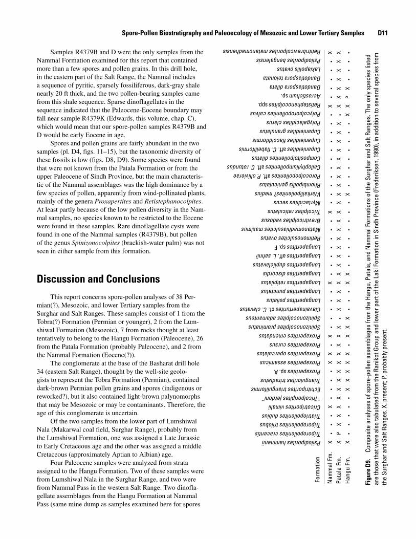
Spore-Pollen Biostratigraphy and Paleoecology of Mesozoic and Lower Tertiary Samples D11
Samples R4379B and D were the only samples from the Nammal Formation examined for this report that contained more than a few spores and pollen grains. In this drill hole, in the eastern part of the Salt Range, the Nammal includes a sequence of pyritic, sparsely fossiliferous, dark-gray shale nearly 20 ft thick, and the two pollen-bearing samples came from this shale sequence. Sparse dinoflagellates in the sequence indicated that the Paleocene-Eocene boundary may fall near sample R4379K (Edwards, this volume, chap. C), which would mean that our spore-pollen samples R4379B and D would be early Eocene in age.
Spores and pollen grains are fairly abundant in the two samples (pl. D4, figs. 11–15), but the taxonomic diversity of these fossils is low (figs. D8, D9). Some species were found that were not known from the Patala Formation or from the upper Paleocene of Sindh Province, but the main characteris-tic of the Nammal assemblages was the high dominance by a few species of pollen, apparently from wind-pollinated plants, mainly of the genera Proxapertites and Retistephanocolpites. At least partly because of the low pollen diversity in the Nam-mal samples, no species known to be restricted to the Eocene were found in these samples. Rare dinoflagellate cysts were found in one of the Nammal samples (R4379B), but pollen of the genus Spinizonocolpites (brackish-water palm) was not seen in either sample from this formation.
Spinizonocolpites prominatusSpinizonocolpites adamanteusClavainaperturitescf. C. clavatus
Proxapertites assamicusProxapertites operculatusProxapertites cursus
Proxapertitessp. A
Proxapertites emendatus
Myrtacidites secusWarkallipollenites? mediusRhombipollis geniculatusPorocolpopollenitesaff. P. ollivieraeCallophyllumpollenitesaff. C. rotundus
Cupanieiditesaff. C. flabelliformisCompositoipollenites dilatus
Cupanieidites flaccidiformis
Polycolporopollenites calvus
Cupanieidites granulatusPolygalacidites clarus
Retistephanocolpitesspp.
Dandotiaspora dilataAcrostichumsp.
Dandotiaspora telonataLakiapollis ovatus
Retitribrevicolporites matanomadhensis
Longapertites dupliclavatus
Psilodiporites bengalensis
X
X
X
XX
X XXX X
X X
X X
Nam
mal
Fm
.Pa
tala
Fm
.H
angu
Fm
.X
XX
XX
XX
X
X
X
P
XXX
XX
XX
XX
XX XX
XXX
XX
XX
XX
XX
XX
XXX
XXX P
X
XX
XX
XX
XX
X
Form
atio
n
Triporopollenites trilobus
Com
posi
te a
naly
ses
of s
pore
-pol
len
asse
mbl
ages
from
the
Hang
u, P
atal
a, a
nd N
amm
al F
orm
atio
ns o
f the
Sur
ghar
and
Sal
t Ran
ges.
The
onl
y sp
ecie
s lis
ted
en, 1
990)
, in
addi
tion
to s
ever
al s
peci
es fr
om
.Fi
gure
D�
are
thos
e th
at w
ere
also
tabu
late
d fro
m th
e Ra
niko
t Gro
up a
nd lo
wer
par
t of t
he L
aki F
orm
atio
n in
Sin
dh P
rovi
nce
(Fre
derik
s, p
roba
bly
pres
ent.
the
Surg
har a
nd S
alt R
ange
s. X
, pre
sent
; P
Discussion and ConclusionsThis report concerns spore-pollen analyses of 38 Per-
mian(?), Mesozoic, and lower Tertiary samples from the Surghar and Salt Ranges. These samples consist of 1 from the Tobra(?) Formation (Permian or younger), 2 from the Lum-shiwal Formation (Mesozoic), 7 from rocks thought at least tentatively to belong to the Hangu Formation (Paleocene), 26 from the Patala Formation (probably Paleocene), and 2 from the Nammal Formation (Eocene(?)).
The conglomerate at the base of the Basharat drill hole 34 (eastern Salt Range), thought by the well-site geolo-gists to represent the Tobra Formation (Permian), contained dark-brown Permian pollen grains and spores (indigenous or reworked?), but it also contained light-brown palynomorphs that may be Mesozoic or may be contaminants. Therefore, the age of this conglomerate is uncertain.
Of the two samples from the lower part of Lumshiwal Nala (Makarwal coal field, Surghar Range), probably from the Lumshiwal Formation, one was assigned a Late Jurassic to Early Cretaceous age and the other was assigned a middle Cretaceous (approximately Aptian to Albian) age.
Four Paleocene samples were analyzed from strata assigned to the Hangu Formation. Two of these samples were from Lumshiwal Nala in the Surghar Range, and two were from Nammal Pass in the western Salt Range. Two dinofla-gellate assemblages from the Hangu Formation at Nammal Pass (same mine dump as samples examined here for spores
D12 Regional Studies of the Potwar Plateau Area, Northern Pakistan
and pollen) were assigned a possible late Paleocene age by Edwards (this volume, chap. C). The spore-pollen samples contained a considerable variety of angiosperm pollen, but most of the pollen grains represented new species, different from species of the upper Paleocene of Sindh Province and at least to some degree different from species in the Patala Formation of the Salt Range. The disparity between the Hangu and Patala assemblages is shown in figure D9, where the Hangu assemblages appear to have a low diversity only because so many of the Hangu species are new. Some new species in the Hangu Formation might range up into the Patala Formation in this region, but the new species have not been studied to determine their stratigraphic ranges.
Paleocene coal beds in the Hangu Formation were undoubtedly deposited in or near brackish water because dinoflagellate cysts and pollen of the brackish-water palm genus Spinizonocolpites were found in the associated detri-tal rocks. Three samples tentatively attributed to the Hangu Formation were also examined from the shallow subsurface of the Kuraddi section in the western Salt Range. These samples were found to be Jurassic or Lower Cretaceous and therefore were probably from the Datta Formation (Mesozoic).
Twenty-six samples of the Patala Formation were studied from 15 localities, ranging geographically from the Surghar Range to the eastern Salt Range. The main coal bed in the Patala Formation is mostly in the lower or middle part of the formation (Warwick and Shakoor, 1988), which is upper Paleocene from evidence of marine fossils in underlying and overlying rocks. The uppermost part of the Patala is mostly upper Paleocene but has been assigned to the lower Eocene in a few places on the basis of marine fossils.
Spore-pollen assemblages from the Patala Formation were similar (in some cases, very similar) to assemblages from the upper Paleocene Lakhra Formation of Sindh Province. However, the spore-pollen assemblages could not be used to prove conclusively that all of the Patala samples studied for this report were late Paleocene in age. Practically no informa-tion is available from Sindh Province about changes in spore-pollen assemblages across the Paleocene-Eocene boundary, and as far as we know, no papers have been published on the palynology of this boundary in India.
Nearly all the Patala samples contained pollen of the brackish-water palm genus Spinizonocolpites and (or) dino-flagellate cysts. Thus, the Patala samples all or nearly all formed in brackish water, and the coal beds, with which most of the samples were associated, undoubtedly formed near the sea.
Only two samples from the Nammal Formation had usable spore-pollen assemblages; these samples were from drill hole 34 in the Basharat area of the eastern Salt Range. The samples may be lower Eocene on the basis of dinoflagel-late assemblages from this corehole (Edwards, this volume, chap. C). These spore-pollen assemblages were characterized by high dominance and low diversity and were not definitive as to a late Paleocene or early Eocene age.
References Cited
Ambwani, K., and Kar, R.K., 1988, Light microscopy and SEM studies of Dandotiaspora and Proxapertites from Palaeocene sediments of India: Pollen et Spores, v. 30, p. 223–230.
Anderson, J.A.R., and Muller, J., 1975, Palynological study of a Holocene peat and a Miocene coal deposit from NW Borneo: Review of Palaeobotany and Palynology, v. 19, p. 291–351.
Baksi, S.K., and Deb, U., 1980, Palynostratigraphic zonation of the Upper Cretaceous-Paleogene sequence of Bengal Basin: Geophytology, v. 10, p. 199–224.
Cheema, M.R., Raza, S.M., and Ahmad, H., 1977, Cainozoic, in Shah, S.M.I., ed., Stratigraphy of Pakistan: Geological Survey of Pakistan Memoirs, v. 12, p. 56–98.
Danilchik, Walter, and Shah, S.M.I., 1987, Stratigraphy and coal resources of the Makarwal area, Trans-Indus Moun-tains, Mianwali District, Pakistan: U.S. Geological Survey Professional Paper 1341, 38 p., 4 pls. in pocket.
Fatmi, A.N., 1972, Stratigraphy of the Jurassic and Lower Cretaceous rocks and Jurassic ammonites from northern areas of West Pakistan: British Museum (Natural History) Bulletin, Geology, v. 20, p. 300–381.
Frederiksen, N.O., 1990, Palynological contribution to geo-logic mapping of coal-bearing upper Paleocene rocks in the Lower Indus coal region, Pakistan: U.S. Geological Survey Open-File Report 90–243, and Project Report to the Geo-logical Survey of Pakistan (IR)PK–87, 40 p.
Frederiksen, N.O., 1994, Middle and late Paleocene pollen from Pakistan: Palynology, v. 18, p. 91–137.
Gee, E.R., 1981, Pakistan geological Salt Range series, sheet 3: Directorate of Overseas Surveys, United Kingdom, for the Government of Pakistan and Geological Survey of Paki-stan, scale 1:50,000.
Jain, K.P., Kar, R.K., and Sah, S.C.D., 1973, A palynological assemblage from Barmer, Rajasthan: Geophytology, v. 3, p. 150–165.
Kar, R.K., 1985, The fossil floras of Kachchh. IV, Tertiary palynostratigraphy: Palaeobotanist, v. 34, p. 1–279.
Khan, A.M., 1990, Palynostratigraphy of samples submitted by U.S. Geological Survey: Biostratigraphy Section, Hydro-carbon Development Institute of Pakistan.
Spore-Pollen Biostratigraphy and Paleoecology of Mesozoic and Lower Tertiary Samples D1�
Köthe, Angelika, 1988, Biostratigraphy of the Surghar Range, Salt Range, Sulaiman Range and the Kohat area, Pakistan, according to Jurassic through Paleogene calcareous nan-nofossils and Paleogene dinoflagellates: Geologisches Jahrbuch, pt. B, v. 71, p. 3–87.
Kremp, G.O.W., 1967, Tetrad markings of pteridophytic spores and their evolutionary significance: Review of Pal-aeobotany and Palynology, v. 3, p. 311–323.
Nayar, B.K., Lata, P., and Tiwari, L.P., 1964, Spore morphol-ogy of the ferns of west tropical Africa: Pollen et Spores, v. 6, p. 545–582.
Outerbridge, W.F., Frederiksen, N.O., Khan, M.R., Khan, R.A., Qureshi, M.J., Khan, M.Z., Niamatullah, and Khan, S.A., 1991, The Sohnari Formation in southern Pakistan, in Stratigraphic notes, 1989–90: U.S. Geological Survey Bul-letin 1935, p. 27–40.
Thanikaimoni, G., 1987, Mangrove palynology: Institut Fran-çais de Pondichéry, Travaux de la Section Scientifique et Technique, v. 24, 100 p.
Venkatachala, B.S., 1969, Palynology of the Mesozoic sedi-ments of Kutch. 4 Spores and pollen from the Bhuj expo-sures near Bhuj, Gujarat District: Palaeobotanist, v. 17, p. 208–219.
Venkatachala, B.S., Caratini, C., Tissot, C., and Kar, R.K., 1988, Palaeocene-Eocene marker pollen from India and tropical Africa: Palaeobotanist, v. 37, p. 1–25.
Venkatachala, B.S., and Sharma, K.D., 1974, Palynology of the Cretaceous sediments from the subsurface of Vridhacha-lam area, Cauvery Basin: Geophytology, v. 4, p. 153–183.
Vimal, K.P., 1952, Spores and pollen from Tertiary lignites from Dandot, West Punjab (Pakistan): Indian Academy of Science Proceedings, v. 36, p. 135–147.
Warwick, P.D., and Shakoor, Tariq, 1988, Preliminary report on coal characteristics in the Salt Range area of north-cen-tral Pakistan: U.S. Geological Survey Open-File Report 88–637, 333 p.
D1� Regional Studies of the Potwar Plateau Area, Northern Pakistan
Appendix D1. Alphabetical List of Species Mentioned in this Report
[An asterisk denotes an informal species name used by Frederiksen (1990). Plate and figure citations refer to illustrations in the present paper]
Acanthotriletes cf. A. levidensis Balme 1957Acrostichum sp.; pl. D3, fig. 1
Callialasporites dampieri (Balme 1957) Dev 1961; pl. D2, fig. 1
Callialasporites segmentatus (Balme 1957) Dev 1961; pl. D2, fig. 2
Callialasporites trilobatus (Balme 1957) Dev 1961Callophyllumpollenites aff. C. rotundus Sah & Kar 1974;
pl. D3, fig. 12Cingulatisporites cf. C. foveolatus Couper 1958; pl. D1, fig. 7Cingulatisporites pseudoalveolatus Couper 1958; pl. D1, fig. 9Cingulatisporites spp.; pl. D1, figs. 3, 4Clavainaperturites cf. C. clavatus van der Hammen &
Wymstra 1964Clavifera? spp.; pl. D1, figs. 5, 6Compositoipollenites dilatus Frederiksen 1994Concavisporites cf. C. jurienensis Balme 1957Contignisporites fornicatus Dettmann 1963Contignisporites glebulentus Dettmann 1963; pl. D2, figs. 5, 6Coptospora kutchensis Venkatachala 1969; pl. D2, fig. 4Cordaitina sp.; pl. D1, fig. 2Corollina spp.; pl. D1, figs. 10, 11Couperipollis sp.; pl. D2, fig. 8Crassivestibulites karii Frederiksen 1994Cricotriporites vimalii (Sah & Dutta 1966) Frederiksen 1994Cupanieidites aff. C. flabelliformis Venkatachala & Rawat
Retimonosulcites ovatus (Sah & Kar 1970) Kar 1985Retistephanocolpites spp.; pl. D3, fig. 10Retitrescolpites sp. B*Retitribrevicolporites matanomadhensis (Venkatachala & Kar
1969) Kar 1985; pl. D4, fig. 4Rhombipollis geniculatus Frederiksen 1994
Permian and Jurassic or Early Cretaceous Spores and Gymnosperm Pollen from the Salt Range
U.S. Geological Survey Bulletin 207�–D, Plate D1
Plate D2
[Magnification × 1,000; see scale]
Figures 1–6. Late Jurassic or Early Cretaceous (fig. 1) and probably middle Cretaceous, approximately Aptian to Albian (figs. 2–6) spores and gymnosperm pollen from Lumshiwal Nala, Makarwal coal field, Surghar Range.