PsychNology Journal, 2011 Volume 9, Number 2, 137 – 163
137
SQUARELAND: A Virtual Environment for Investigating Cognitive Processes
in Human Wayfinding
Kai Hamburger∗1 and Markus Knauff1
1Experimental Psychology and Cognitive Science; Justus Liebig University Giessen
(Germany)
ABSTRACT We introduce a new virtual environment (VE) called SQUARELAND, consisting of a 10×10 block maze, which allows for all kinds of investigations in human wayfinding. It enables researchers to quickly implement experiments on indoor- and outdoor wayfinding, including variations of route length, route complexity, availability of landmarks, etc. The basic setup was programmed with the freeware GoogleSketchUp®. We would like to invite the spatial cognition community to adopt this standardized and highly controllable research tool or at least parts of it, since this could improve comparability and reproducibility of different effects in wayfinding/navigation.
Keywords: wayfinding, virtual environment, landmarks, salience, spatial cognition, cognitive
maps, learning spatial information, psychology
Paper Received 20/08/2010; accepted 27/12/2010.
1. Introduction
Everyday we almost effortlessly make our way from home to our working place. We
exactly know how to get to our best friends’ places. No doubt, we also know or find the
way to the public swimming pool, to the movie theater, or to the shopping mall. Quite
often we have knowledge of different routes to the same places, also depending on the
means of locomotion: traveling by foot, with the bicycle, or by car.
These remarkable performances normally remain to be unconscious and we just take
them for granted. We only become aware of them when they fail: if we get lost.
Cite as: Hamburger, K., & Knauff, M. (2011). SQUARELAND: A virtual environment for investigating cognitive processes in human wayfinding. PsychNology Journal, 9(2), 137 – 163. Retrieved [month] [day], [year], from www.psychnology.org. ∗ *Corresponding Author Kai Hamburger Justus Liebig University Giessen, Otto-Behaghel-Str. 10F, 35394 Giessen, Germany [email protected]
K. Hamburger, M. Knauff
138
Our ability to find different routes again is mainly based on the ability of our brain to
encode, organize, store, revise, and to retrieve spatial information (for an overview see
Kitchin & Blades, 2002). Our memory system may process and store directional
information (Kitchin & Blades, 2002) and may store place locations in an egocentric
(related to the person) or allocentric (related to an external object) reference system
(e.g., Burgess, Spiers, & Paleologou, 2004; Coluccia, Mammarella, De Beni, Ittyerah,
& Cornoldi, 2007). It also builds so-called cognitive maps (Hermann, Schweizer,
Janzen, & Katz, 1998; Thorndyke & Hayes-Roth, 1982; Tolman, 1948) and possesses
many more cognitive skills (for overview, e.g., Montello, 2001). A special skill of the
memory system is that it may encode, store, and afterwards provide spatial information
about a certain route. This route knowledge
“describes the path that one must walk to reach the goal by telling the individual
what to do at the decision points on the route, e.g. turn right at the church, then the
second street to the left. It is one-dimensional or ‘string-like’ and it does not
necessarily involve the knowledge of the exact location of the goal.” (Meilinger &
Knauff, 2008, p14).
In the last decade, Spatial Cognition research has made much progress in
understanding the cognitive representations and processes that underlie human
wayfinding. One reason for the progress is the availability of new VE-software.
However, a disadvantage of current research is that most investigations use their
own VE-setups which sometimes differ quite tremendously. This is not only the case
for behavioural studies, but also for brain imaging (e.g., Ekstrom et al., 2003; Gillner &
Mallot, 1998; Hassabis et al., 2009; Janzen & Weststeijn, 2007; Newman et al., 2007;
Stankiewicz, Legge, Mansfield, & Schlicht, 2006; Wolbers, Weiller, & Büchel, 2004;
Wolbers, Hegarty, Büchel, & Loomis, 2008). Most of these experiments have to be
programmed in expensive and complex software or programming languages, or, are
sometimes realized in open or environmental codes within virtual reality computer
games. Thus, there is a need for “simple and economical but controlled” VE-setups
that can be used for behavioural as well as for brain imaging studies on human
navigation and wayfinding. Furthermore, it would be helpful to have a setup that can
also be used for comparative studies. Such a common VE-setup could serve for
different research questions on: landmarks, salience, route length and complexity,
neural correlates of wayfinding, etc.
SQUARELAND: Investigating Cognitive processes in wayfinding
139
2. Research questions
2.1 Landmarks
The SQUARELAND-environment provides an easy-to-use research environment to
study the role of landmarks in spatial cognition. Such landmarks are objects along the
route, which are said to be very salient (they “pop out” from the surround) and
therefore can serve as orientation points. It is undoubted that route knowledge cannot
be acquired without such landmarks (e.g., Daniel & Denis, 1998; Denis, 1997; Galea &
Kimura, 1993; Klein, 1982) independent of how they are communicated (visually or
verbally). It is also unquestioned that such information is required to find a certain way
again (e.g., Kitchin & Blades, 2002). But, it is still unknown what really makes an object
along a path to represent a “good” or “useful” landmark. Most authors claim that a
good landmark is characterized by “popping out” from the environment and therefore
signalizes a certain geographic place (Golledge, 1999). The literature about the
properties of a place or an object along the route that cause this pop-out effect is quite
ambiguous. Within this context the term “landmark salience” is often used (for an
overview see Caduff & Timpf, 2008). It defines how noticeable a landmark (object) is
within the surrounding context (Presson & Montello, 1988). In other words, what the
authors refer to is the contrast between object and surround. Taking this definition as a
basis for landmark salience, it becomes clear that the term salience is often used with
respect to visual features, which will be discussed in a later section (since landmark
salience contains more than just visual information). Empirically, this effect has rarely
been investigated. The current project, funded by a grant from the German Research
Foundation (DFG), which we refer to as SQUARELAND offers the possibilities to conduct
behavioral as well as neuroscientific experiments in order to close this gap. This virtual
environment may serve as a tool to develop a neuro-cognitive theory of landmark
salience in the domain of wayfinding. Furthermore, it could serve (with few variations)
for many kinds of research within spatial cognition as we will show in the following
sections.
Landmarks may be represented by natural, man-made, or culturally important
objects. In general, they are assigned certain characteristics. In the view of Presson
and Montello (1988) every object that sticks out from the environment can serve as a
landmark. Tom and Denis (2003) for example argue that landmarks are generally more
helpful in wayfinding than street signs. Presson and Montello (1988) point out that in
K. Hamburger, M. Knauff
140
certain contexts during wayfinding even street intersections may serve as landmarks.
There are many different views on the definition and functions of landmarks and most
authors focus on different aspects. We here just present a brief summary of some of
the most important approaches towards landmarks:
- Landmarks are learned, stored, and retrieved already very early in life (landmark
knowledge) (Siegel & White, 1975);
- Landmarks structure the knowledge of a certain surround/environment, for
example serving as anchors (Couclelis, Golledge, & Tobler, 1987);
- In route descriptions, landmarks are integrated differently, more often at starting
points, end points and decision points, compared to others (Michon & Denis,
2001; Tversky & Lee, 1999);
- Landmarks at street intersections (decision points) are more salient and are
better remembered if a change of direction/turn is required (Lee, Tappe, &
Klippel, 2002; Lee, Klippel, & Tappe, 2003);
- The usage of landmarks increases the subjective quality of a route description
(Denis, Pazzaglia, Cornoldi, & Bertolo, 1999).
To summarize, objects along a route enormously facilitate navigation (Blades &
Medlicott, 1992; Golledge, 1999; Janzen & van Turennout, 2004; Johnsrude, Owen,
Crane, Milner, & Evans, 1999). However, such objects or landmarks are not of the
same relevance for wayfinding and do also not have the same salience. For example,
it is important whether the objects are located at a decision point or not. If located at an
intersection, they directly contribute to successful wayfinding, while landmarks along a
route do not contribute much to wayfinding. They rather serve as a confirmation that
we are still on the right track (e.g., Hermann et al., 1998; Lovelace, Hegarty, &
Montello, 1999). Also their neural representation in the brain differs quite tremendously
(Janzen & van Turennout, 2004). On the other hand there are routes which include
direction changes that are better remembered than routes without any turns. In the
latter ones the landmarks are most often simply ignored or they will later be forgotten
(Denis, 1997; Klippel, Tappe, & Habel, 2003; Tversky & Lee, 1998).
2.2 Salience
The SQUARELAND environment also allows for studies on the “salience” of landmarks
in spatial cognition (which represents our main research focus). The term “salience” is
strongly related to the research areas of perception and to informatics of spatial
cognition. In both research fields the term is well-defined (at least better defined)
SQUARELAND: Investigating Cognitive processes in wayfinding
141
compared to psychological spatial cognition research. In perception, salience –also
called “pop-out” effect– is extensively investigated, but it is rather concerned with
simple tasks mainly on low-level processes in vision (e.g., Ullman, 1996). Of great
importance within this context are the works by Itti and Koch on the so-called “salience
maps” (Itti & Koch, 2000, 2001; Peters, Iyer, Itti, & Koch, 2005). Their approach is
concerned with the bottom-up processing of visual scenes. On the basis of
experimental results, this approach offers a differentiated algorithmic theory for the
focus of attention, which explains how the attention of a person can be controlled and
directed to a special area of a scene by simple visual features. These works are also
of relevance for the SQUARELAND project. But, they do not tell anything about
perceptual processing mechanisms during wayfinding and they also neglect
knowledge-based processing of attention. Furthermore, they explicitly study the visual
salience of objects in isolation (just within a natural scene) which is also a shortcoming
for this current project as we will see later. In informatics, different models are provided
that are capable of calculating pop-out of objects or landmark salience for navigation
(e.g., Klippel & Winter, 2005; for an overview of different models see Caduff & Timpf,
2008). Similar approaches or models also exist in areas such as town planning (Galler,
2002). In both fields salient features of a surround or an urban area are theoretically
and mathematically well-defined. However, until now the empirical bases for such
formalization seem to be missing.
Essential for the research project presented here is the –inter alia suggested by
Klippel and Winter (2005)– distinction between visual-, semantic- (see also Daniel &
Denis, 1998), and structural salience (Raubal & Winter, 2002; Sorrows & Hirtle, 1999).
This distinction may look as follows:
- Visual salience is referred to all visual features of an object such as size, shape,
color, texture, etc.
- Semantic salience is referred to all knowledge-related features such as
famousness of a building (e.g., Statue of Liberty) or its function (e.g., city hall,
church). Semantic salience is often related to how well a building can be named
(language component).
- Structural salience is referred to features that are primarily (directly) related to
navigation. For example, it contains the number of intersections that need to be
passed (surround context) and the exact location of a landmark along the route
(close to it or further away; decision point versus non-decision point). Such
K. Hamburger, M. Knauff
142
features are of great importance if there’s no possibility to revert to any visual or
semantic features for successful wayfinding.
With SQUARELAND we provide the scientific community a very easy to program and
cost-saving opportunity to empirically investigate these three different forms of
landmark salience, which will be described in part three (the virtual environment
SQUARELAND) and in part five (future work) in more detail.
2.3 Route length and complexity
The length of a route and its complexity (temporal and spatial) is also of fundamental
importance for human wafinding performance. The longer or more complex the route
is, the higher the cognitive load will be, which has for example been shown by
Meilinger and Knauff (2008). However, this result also depends on the aid from which
the navigational information is acquired. Hamburger, Dotzert, and Knauff (2010)
showed that with increasing route length, wayfinding performance decreases while
decision times increase if participants learned the route in an exploration sequence or
from a verbal description. If the route was previously learned from a map, performance
remained constant and decision times slightly improved. Thus, a standardized VE-
setup could help to shed more light on the significance of route length and complexity,
while controlling the information sources (see also Section 4. Current research).
2.4 Neural correlates of wayfinding
With SQUARELAND it is also possible to systematically investigate the neural basis of
human wayfinding. SQUARELAND can either be used with back projection systems in an
MR-scanner, but also with MRI-compatible fiber optic glasses. With the back projection
techniques a mirror is placed on the coil of the scanner so that the participants (lying
on the back) can see SQUARELAND on a projection screen mounted on the rear of the
scanner bore. With the fiber optic glasses technique the MR-inert glasses (e.g., by
Avotec Inc.) are supported over the participants’ eyes by a 3-axis mount attached to
the head coil. The mount provides independent adjustment of each eyepiece for easy
binocular fusion.
From a neuroscientific point of view there is great interest in wayfinding and
navigation in humans and other animals. For instance, it could be shown that some
bird species possess a special compass for navigation (Wiltschko, Traudt, Güntürkün,
Prior, & Wiltschko, 2002). Besides that, the remarkable orientation performances of
pigeons (e.g., Prior, Wiltschko, Stapput, Güntürkün, & Wiltschko, 2001; Prior,
SQUARELAND: Investigating Cognitive processes in wayfinding
143
Lingenauber, Nitschke, & Güntürkün, 2002) and honeybees (e.g., Menzel & Müller,
1996) have been investigated. Single-cell recordings in rats have shown that so-called
place cells in the hippocampus are engaged in navigation processes (Hölscher, Jacob,
& Mallot, 2003; O’Keefe & Dostrowsky, 1971; O’Keefe & Nadel, 1978). The here
introduced VE-setup is similar to many setups in rat studies and could be used in this
research area as well (please see Section 5. Proposals).
However, our current research project is mainly concerned with wayfinding in
humans. Here, the hippocampus and nearby areas also turned out to be of great
importance for wayfinding. These sub-cortical structures are especially involved in
establishing an allocentric spatial representation (Aguirre, Detre, Alsop, & D’Esposito,
1996; Burgess, Jeffrey, & O’Keefe, 1999; Burgess, Maguire, & O’Keefe, 2002; Dragoi,
Harris, & Buzsáki, 2003; Ekstrom et al., 2003; Grön, Wunderlich, Spitzer, Tomaczak, &
Riepe, 2000; Maguire et al., 1998; Maguire, Frith, Burgess, Donnett, & O’Keefe, 1998;
Wood, Dudchenko, Robitsek, & Eichenbaum, 2000), while egocentric representations
are rather connected to the parietal cortex. Additionally, the parahippocampal gyrus is
associated with the processing of places containing objects relevant for navigation as
well as the processing of visuo-spatial scenes (Bar & Aminoff, 2003; Epstein &
Kanwisher, 1998). Route knowledge has been found to activate the medial frontal
gyrus, the retrosplenial cortex, and the posterior inferior parietal cortex (Wolbers et al.,
2004). As mentioned above, Itti and Koch (2001) already developed a theory on
directing visual attention, in which additionally to the two visual cortices, parts of the
infero-temporal and posterior parietal cortex as well as prefrontal cortex and parts of
the superior colliculus are activated during the processing of salient features of a visual
scene.
For the current project mainly those studies are of relevance that were concerned
with neural correlates of landmarks and route knowledge. The mental representation of
objects during wayfinding results in higher activations in the parahippocampal gyrus
bilaterally, in the left inferior frontal gyrus and the left superior parietal lobe (Janzen &
van Turennout, 2004). Recollection for objects at decision and non-decision points was
similar, but the neural activation in the parahippocampal gyrus was higher for decision
points, independent of whether they were correctly remembered or not. The human
brain seems to automatically differentiate between relevant and irrelevant objects
during the acquisition of a route. Even without conscious recollection of the previously
learned material, different activations were obtained dependent on the objects’
K. Hamburger, M. Knauff
144
localization. But, why the brain favors some landmarks over others remains an open
issue.
A major disadvantage of these studies was that they did not (or could not) control for
landmark characteristics. Janzen and van Turennout (2004) for instance used toys or
music instruments. Such objects do not occur as landmarks during “normal” or
“everyday” navigation and thus we do not learn them as objects that are relevant for
wayfinding. Furthermore, these studies did not control for object differences such as
color, shape, famousness, etc. However, such differences are crucial for empirical
investigations of landmarks and landmark salience, since these objects alone (due to
their properties) could have caused the higher activations in certain brain regions.
Additionally, presentation at decision and non-decision points was systematically
varied but not the objects themselves. Taken together, these studies concentrated on
structural features rather than landmarks which are also of importance for successful
wayfinding. At this point the current project comes again into play. With SQUARELAND it
is possible to systematically investigate neglected or excluded issues of landmarks
amongst other things.
3. The virtual environment SQUARELAND
3.1 General
The basis for this project is our virtual environment (VE) navigation area which we
refer to as SQUARELAND1. It combines the possibility of precise variable control and
variation and benefits from comparatively realistic appearance. Its range goes from
simple hedge-maze structures –as mainly presented here– to complex urban areas.
Geometrically, it consists of a 10×10 raster (Figure 1 and 2), which can optionally be
changed in almost any way (blocking ways, inserting additional walls to elongate single
segments, etc). For 2D experiments (map) it may also be placed on one corner (Figure
3), so that the navigation possibilities become reduced from left, right, and straight to
1The name SQUARELAND has an intended association with the well-known science fiction novel “Flatland” by E. A. Abbott (1880).
SQUARELAND: Investigating Cognitive processes in wayfinding
145
Figure 1. Two dimensional map of the virtual environment SQUARELAND (bird-eye perspective). It consists of ten-by-ten cuboids.
Figure 2. Aerial view of SQUARELAND.
simply oblique left and oblique right turns. The paths between the 100 blocks serve as
routes in any possible variation. Since each segment has the same length, a full
control of path lengths, number of turns, etc is ensured. The intersections serve as
K. Hamburger, M. Knauff
146
decision points while objects along the path can be placed at non-decision points.
Visibility from an intersection in all other directions (streets) is identical. By
implementing an (optional) haze about 3-5 meters in front of the walker, participants
may not see the next intersection in order to get further navigationally relevant
information (creates path sequences). Such limiting of visual information has
successfully been used by Stankiewicz and colleagues before (Stankiewicz et al.,
2006). This additionally offers the opportunity to implement walls (dead ends; visible or
invisible) which allows for even more flexibility and gives excellent control of the
environment. What we described thus far provides some advantages compared to
unstructured environments which are used quite often in spatial cognition/navigation
research (e.g., Hochmair & Frank, 2000; Knauff, Schlieder, & Freksa, 2002).
SQUARELAND was inspired by the virtual environment HEXATOWN (Gillner & Mallot,
1998; Mallot & Gillner, 2000; Steck & Mallot, 2000). Here, in contrast to HEXATOWN, we
did not make use of quite unnatural hexahedrons with 120 deg turns but rather a
simple square-shaped structure. The advantage is that this comes a bit closer to
structures in the real world (e.g., compare with the layout of major northern American
cities) and is also closer to the layout of indoor environments such as buildings, since
we here have “real” intersections with turns to the left, to the right, and no turns where
you have to go straight (T-junctions or dead-ends can be implemented as described
above). As a side note, it has also been reported in the literature that orthogonal
turnoffs are better adapted than oblique turns (Montello, 1991; 2005).
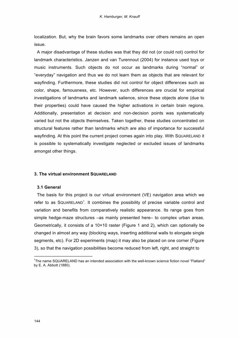
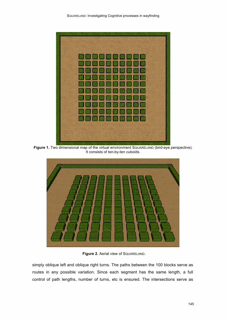
3.2 Core features and information for reproduction
For this project our virtual environment SQUARELAND was realized with the freeware
Google SketchUp 6.0® by Google® and can easily be controlled and manipulated. It is
available under www.uni-giessen.de/cms/cognition/squareland. In the default version,
SQUARELAND consists of ten-by-ten cuboids, 10 blocks in horizontal direction, and 10
blocks in vertical direction (Figure 1). Each block has a size of 5.5 x 5.5 x 2.75 meters
(LxWxH) in the virtual environment (or 11 x 11 x 2.75 meters), and each path between
the blocks has a width of 2.75 meters (Figure 4). The walls of the blocks consist of a
hedge structure so that they appear as natural hedges and not like an indoor building
structure, which could be misleading due to systematic structural information.
However, all these settings can be changed with very little effort. Particularity, Google
SketchUp 6.0® (or higher versions) offers many possibilities for material and texture.
Thus, it is also possible to present brick walls or even glass surfaces. Furthermore,
SQUARELAND: Investigating Cognitive processes in wayfinding
147
illumination, shading, time of the day, and season may be incorporated. This approach
is not the only one that uses Google
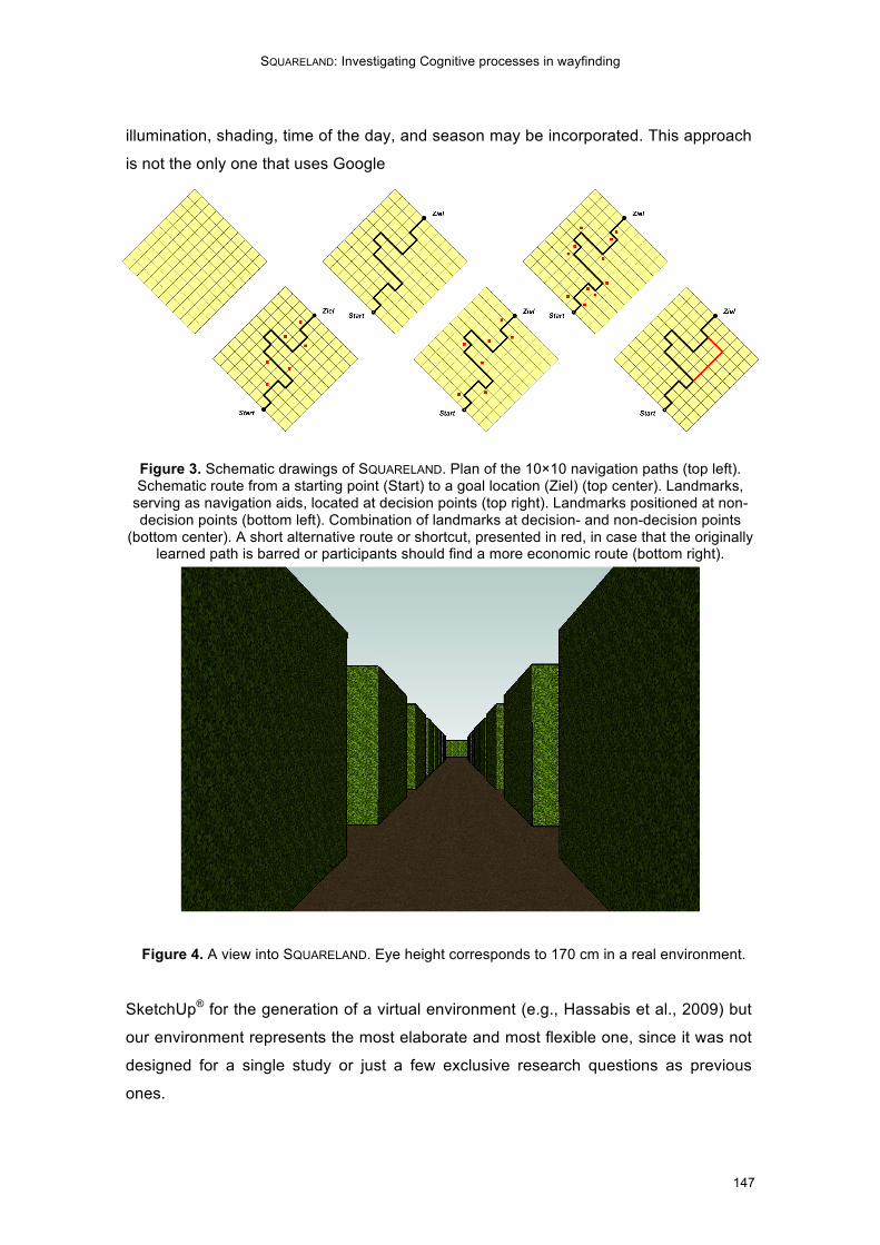
Figure 3. Schematic drawings of SQUARELAND. Plan of the 10×10 navigation paths (top left). Schematic route from a starting point (Start) to a goal location (Ziel) (top center). Landmarks,
serving as navigation aids, located at decision points (top right). Landmarks positioned at non-decision points (bottom left). Combination of landmarks at decision- and non-decision points
(bottom center). A short alternative route or shortcut, presented in red, in case that the originally learned path is barred or participants should find a more economic route (bottom right).
Figure 4. A view into SQUARELAND. Eye height corresponds to 170 cm in a real environment.
SketchUp® for the generation of a virtual environment (e.g., Hassabis et al., 2009) but
our environment represents the most elaborate and most flexible one, since it was not
designed for a single study or just a few exclusive research questions as previous
ones.
K. Hamburger, M. Knauff
148
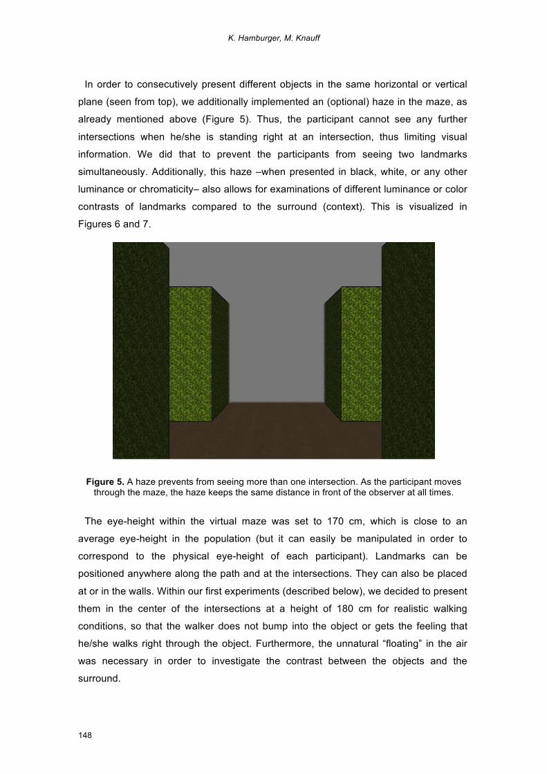
In order to consecutively present different objects in the same horizontal or vertical
plane (seen from top), we additionally implemented an (optional) haze in the maze, as
already mentioned above (Figure 5). Thus, the participant cannot see any further
intersections when he/she is standing right at an intersection, thus limiting visual
information. We did that to prevent the participants from seeing two landmarks
simultaneously. Additionally, this haze –when presented in black, white, or any other
luminance or chromaticity– also allows for examinations of different luminance or color
contrasts of landmarks compared to the surround (context). This is visualized in
Figures 6 and 7.
Figure 5. A haze prevents from seeing more than one intersection. As the participant moves
through the maze, the haze keeps the same distance in front of the observer at all times.
The eye-height within the virtual maze was set to 170 cm, which is close to an
average eye-height in the population (but it can easily be manipulated in order to
correspond to the physical eye-height of each participant). Landmarks can be
positioned anywhere along the path and at the intersections. They can also be placed
at or in the walls. Within our first experiments (described below), we decided to present
them in the center of the intersections at a height of 180 cm for realistic walking
conditions, so that the walker does not bump into the object or gets the feeling that
he/she walks right through the object. Furthermore, the unnatural “floating” in the air
was necessary in order to investigate the contrast between the objects and the
surround.
SQUARELAND: Investigating Cognitive processes in wayfinding
149
In case that anybody wants to rebuilt SQUARELAND for own research projects, we may
also provide additional information or help with setting up this environment (we may
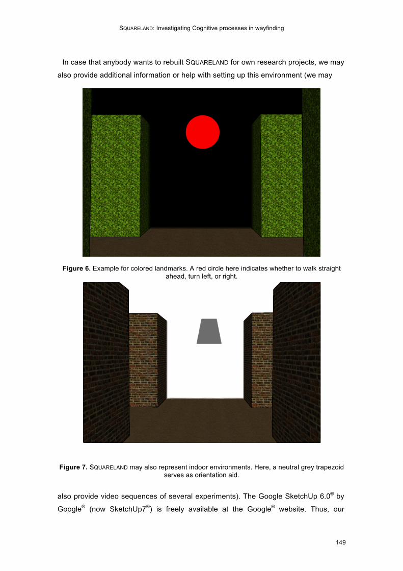
Figure 6. Example for colored landmarks. A red circle here indicates whether to walk straight
ahead, turn left, or right.
Figure 7. SQUARELAND may also represent indoor environments. Here, a neutral grey trapezoid serves as orientation aid.
also provide video sequences of several experiments). The Google SketchUp 6.0® by
Google® (now SketchUp7®) is freely available at the Google® website. Thus, our
K. Hamburger, M. Knauff
150
research tool is cost-saving, easy to handle (since the program is a 3D-drawing
program and no computer programming is required) for scientists as well as for
students. We already implemented it for our regular studies as well as experiments
within diploma and bachelor theses, since it is a hands-on setup and program that just
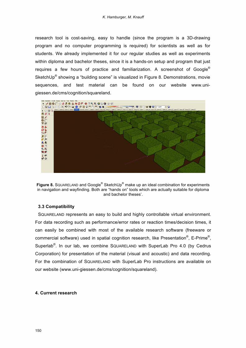
requires a few hours of practice and familiarization. A screenshot of Google®
SketchUp® showing a “building scene” is visualized in Figure 8. Demonstrations, movie
sequences, and test material can be found on our website www.uni-
giessen.de/cms/cognition/squareland.
Figure 8. SQUARELAND and Google® SketchUp® make up an ideal combination for experiments in navigation and wayfinding. Both are “hands on” tools which are actually suitable for diploma
and bachelor theses’.
3.3 Compatibility
SQUARELAND represents an easy to build and highly controllable virtual environment.
For data recording such as performance/error rates or reaction times/decision times, it
can easily be combined with most of the available research software (freeware or
commercial software) used in spatial cognition research, like Presentation®, E-Prime®,
Superlab®. In our lab, we combine SQUARELAND with SuperLab Pro 4.0 (by Cedrus
Corporation) for presentation of the material (visual and acoustic) and data recording.
For the combination of SQUARELAND with SuperLab Pro instructions are available on
our website (www.uni-giessen.de/cms/cognition/squareland).
4. Current research
SQUARELAND: Investigating Cognitive processes in wayfinding
151
To show the flexibility and value of SQUARELAND, we here provide a brief overview of
some of the studies already realized within this project. In a first (pre-)experiment
participants had to detect different shapes and colors within the virtual environment
(Figure 9). Concerning fast (low-level) detection we could not find any significant
differences between the different shapes or colors (however, achromatic patterns were
less accurately and more slowly recognized compared to chromatic patterns within the
two surrounds; in contrast to our knowledge from perceptual research). What we rather
found was a moderate to high negative correlation between the detection performance
(reaction time and errors) and spatial IQ, measured with the IST2000R (Amthauer,
Brocke, Liepmann, & Beauducel, 2001). In other words, the higher the spatial abilities
were, the lower were the reaction times and errors. This issue could be of high interest
in future studies on navigation.
Figure 9. The hedge structure may also be replaced by more realistic urban scenes. Here, simple row houses are shown. More complex scenes with green areas, etc can easily be
implemented in SQUARELAND.
In a follow-up experiment participants were initially led through the SQUARELAND
environment (passively), in order to learn certain landmarks/objects and the
corresponding route information. They were asked to encode the different shapes or
colors of the objects (Figure 6) at the intersections and should also remember the
directions of the route (left turn, right turn, straight on). In the first experiment of this
series the participants had to pass a recognition task subsequently to the training
phase (Wahl, Hamburger, & Knauff, 2008a and b), while in the second experiment the
K. Hamburger, M. Knauff
152
navigation sequence (video) was shown again and participants had to indicate the
directions at each intersection where the landmarks/objects were located. Both
experiments showed some shapes and colors to be better remembered than others,
even though the effects were quite small and unsystematic in nature. Additionally, no
evidence for the necessity of a high contrast to the background –as suggested in quite
many definitions (e.g., Presson & Montello, 1988)– could be found. Taken together,
these results provide a good basis for future empirical work on landmark salience.
Within these experiments we also investigated the influence of instruction (remember
objects, remember path, just watch the video sequence). Task instruction did not
provide any significant differences or advantages for certain groups, e.g., participants
with the task to remember the objects did not outperform the participants who were
just asked to watch the movie sequence in the following recognition or navigation task.
In a third experiment (Hamburger et al., 2010), we investigated which learning form
provides the best route knowledge. For this, we compared three different learning
strategies (map, verbal description, exploration in VE). Learning from a SQUARELAND
map was followed by best navigation performance in the virtual maze. Performance of
the verbal description group was better than that of the exploration group, but
insignificant. Finally, we also found the expected effects of route length (more errors
and higher decision times), except for the map condition. There, participants showed
the identical performance no matter whether eight or 16 landmarks had to be learned
and then navigated. At present another focus is on indoor navigation using different
kinds of landmarks such as visual versus acoustic landmarks or famous versus
unknown landmarks (for an example see Figure 10).
The results obtained so far clearly indicate that further research on landmarks is
required (e.g., our empirical findings do not support theoretical assumptions like “high
contrast”, “low performance with more complex routes”, etc).
5. Proposals for and application of future work
The major aim within this project is to develop a neuro-cognitive theory of landmark
salience in human wayfinding. In order to realize this, SQUARELAND offers the
opportunity to combine behavioral experiments in the virtual environment (VE) with
brain imaging techniques (fMRI). The goals of this project are therefore the following:
SQUARELAND: Investigating Cognitive processes in wayfinding
153
• What exactly determines the salience of a landmark in wayfinding? This question
can be tackled by systematic variations of visual, semantic, and structural
characteristics of different landmarks.
• How can salience be measured quantitatively and how can it be defined formally?
This may be done by developing a scaling-unit for salience with behavioral and
brain imaging experiments and formalization of such data.
• Which neural processes and representations are involved in landmark-based
wayfinding? This can be investigated by means of fMRI experiments in order to
find whether different types of landmarks are associated with the same underlying
brain structures or not (e.g., verbal vs. visual representation). Furthermore, this
could also provide valuable insights in how they are correlated with differences in
wayfinding performance.
Figure 10. An example for indoor navigation with famous landmarks (Sydney opera).
The first series of questions will be dealing with the previously mentioned distinction
between visual, semantic, and structural characteristics of landmarks. The visual
features that distinguish between important and unimportant landmarks will first be
investigated by systematically varying shape or/and color of the different relevant
objects. These experiments very likely focus on bottom-up processing mechanisms
which are closely related to perceptual mechanisms (e.g., Itti & Koch, 2000, 2001;
K. Hamburger, M. Knauff
154
Peters et al., 2005). Such bottom-up mechanisms are interconnected with top-down
mechanisms during wayfinding (goals, etc).
For investigating the issue of semantic contributions to landmark salience, features
such as famousness, familiarity, how well a landmark may be labeled verbally, and
perceptibility of its function will be systematically manipulated. With these semantic
landmark features we investigate the top-down processing of landmarks, e.g.,
attention, experience, knowledge. Most important here will be the influence of
knowledge and language on the usefulness of landmarks. Associated questions are: Is
the object to deal with familiar or unfamiliar? May the objects be named/labeled easily
or not? May these objects be assigned with a specific function? Furthermore, we hope
to find evidence whether landmarks are preferably represented in a visual or a
semantic form. Here comes the distinction between ‘visualizer’ and ‘verbalizer’ in
visual imagery into play (Richardson, 1977).
A third group of landmark features to be investigated are the structural
characteristics. These include features that are directly relevant for wayfinding, but
cannot simply be explained in perceptual or conceptual terms. The position of the
landmark close to the route or further away from it as well as its location at a decision
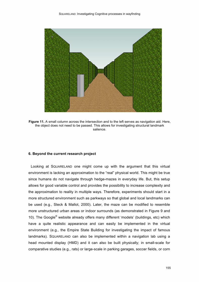
point or a non-decision point belongs to this structural category. An example of
structural features is shown in Figure 11 (position behind the intersection, which
therefore does not need to be passed).
All these features may be investigated systematically with the SQUARELAND setup.
Additionally, it is possible to compare these results with the already existing theoretical
models on landmark salience in order to find out whether they turn out to be
appropriate assumptions about how humans use landmark information. Maybe these
models get support from our empirical data or need to be revised. Finally, the neural
mechanisms involved in landmark-based wayfinding and landmark properties will be
addressed.
SQUARELAND: Investigating Cognitive processes in wayfinding
155
Figure 11. A small column across the intersection and to the left serves as navigation aid. Here,
the object does not need to be passed. This allows for investigating structural landmark salience.
6. Beyond the current research project
Looking at SQUARELAND one might come up with the argument that this virtual
environment is lacking an approximation to the “real” physical world. This might be true
since humans do not navigate through hedge-mazes in everyday life. But, this setup
allows for good variable control and provides the possibility to increase complexity and
the approximation to reality in multiple ways. Therefore, experiments should start in a
more structured environment such as parkways so that global and local landmarks can
be used (e.g., Steck & Mallot, 2000). Later, the maze can be modified to resemble
more unstructured urban areas or indoor surrounds (as demonstrated in Figure 9 and
10). The Google® website already offers many different ‘models’ (buildings, etc) which
have a quite realistic appearance and can easily be implemented in the virtual
environment (e.g., the Empire State Building for investigating the impact of famous
landmarks). SQUARELAND can also be implemented within a navigation lab using a
head mounted display (HMD) and it can also be built physically; in small-scale for
comparative studies (e.g., rats) or large-scale in parking garages, soccer fields, or corn
K. Hamburger, M. Knauff
156
fields to provide the possibility of physical navigation (including both wayfinding and
locomotion; Montello, 2005).
SQUARELAND, as we described it thus far, is not limited to the research questions that
we suggested. It represents much more than that and offers quite many possibilities to
study human spatial cognition. For example, while investigating issues on semantic
salience the influence of language components can systematically be integrated.
Words and names could be presented instead of landmark images (Pazzaglia &
Taylor, 2007). This could be realized in a congruent fashion of presentation and
retrieval (word/word; image/image) or in an incongruent way (word/image;
image/word). This is also interesting for questions on modality-specific processing
within the brain (Meilinger & Knauff, 2008). If the information were modality-specific
then we should obtain something like translation costs from one modality (e.g., vision)
to another (e.g., language).
So far everything was concerned with finding certain ways –which were previously
learned– again. However, it is also possible to have participants learn different routes
within the maze and let them then navigate on new and more economic routes through
the maze (Figure 3, bottom right). Or, it is also possible to block a path so that the
participants are required to find an appropriate detour. All this is related to survey-
knowledge. Within this context global landmarks become even more important (Elias,
Paelke, & Kuhnt, 2006), which may be used in SQUARELAND as well (by just lowering
the wall height).
SQUARELAND may also be implemented in comparative studies as briefly mentioned
above. Within the virtual setup as well as a physical setup of the maze it is possible to
realize similar experiments on the salience of landmarks with rats or other mammals
(e.g., Hölscher, Schnee, Dahmen, Setia, & Mallot, 2005). Such experiments could
provide valuable insights into similarities and dissimilarities of sensoric and cognitive
processes. Finally, SQUARELAND (real and virtual) allows for controlled studies with
blind participants. Within this context (also with unimpaired participants) the use of
auditory landmarks, instead of visually presented material, is of great relevance, e.g.,
to examine the role of semantics, modality-specific processing, translation costs, etc.
We could use certain sounds as landmarks at decision and non-decision points.
Besides blind participants, this project also allows for the inclusion of patients,
preferably with parietal lesions. This might also lead to valuable insights into
processing mechanisms of human navigation, since these patients show different
limitations in navigation performance and spatial abilities.
SQUARELAND: Investigating Cognitive processes in wayfinding
157
The superordinate aim of this project –including behavioral cognitive psychological
methods as well as neuroscientific experiments– is a neuro-cognitive theory of
salience and usefulness of landmarks in wayfinding. It is not just supposed to
supplement current models, but rather implemented to identify how the human brain
processes and makes use of landmark information. These findings could be seminal
for areas such as city planning, and navigation aids or navigation systems.
A major aim of this research amongst our empirical findings that we will obtain is to
provide the community with a new virtual environment research setup that is easy to
use and enables spatial cognition researchers to quickly implement experiments on
indoor- and outdoor wayfinding, including the variation of route length, route
complexity, availability of landmarks, etc. We hope that this also helps to standardize
the experiments that are done in different groups. This could lead to better comparable
findings and faster progress in understanding the fascinating ability of human (and
other animals) wayfinding in natural and virtual environments.
Therefore, we would like to encourage scientists from the spatial cognition
community and the many different research areas to adopt this simple, highly
controllable, cost-saving, hands-on research tool SQUARELAND and help us to improve
it to make it an excellent contribution for future empirical research.
7. Acknowledgement
The research project SQUARELAND is supported by the German Research Foundation
(DFG grant HA5954/1-1). We thank Nadja Stein and Johanna Weinberg for their help
setting up the experiments, and Florian Röser and Cate Trillmich for valuable
comments on the manuscript.
8. References
Abbott, E. A. (1880). Flatland: A Romance of Many Dimensions. Stilwell, KS:
Digireads.com Publishing.
Aguirre, G. K., Detre, J. A., Alsop, D. C., & D’Esposito, M. (1996). The
parahippocampus subserves topographical learning in man. Cerebral Cortex, 6,
823-829.
K. Hamburger, M. Knauff
158
Amthauer, R., Brocke, B., Liepmann, D., & Beauducel, A. (2001). Intelligenz-Struktur-
Test 2000 R (2., erweiterte und revidierte Auflage). Göttingen: Hogrefe.
Bar, M., & Aminoff, E. (2003). Cortical analysis of visual context. Neuron, 38, 347-358.
Blades, M., & Medlicott, L. (1992). Developmental differences in the ability to give route
directions from a map. Journal of Environmental Psychology, 12, 175-185.
Burgess, N., Jeffrey, K. J., & O’Keefe, J. (Eds.) (1999). The Hippocampal and Parietal
Foundations of Spatial Cognition. Oxford: University Press.
Burgess, N., Maguire, E. A., & O’Keefe, J. (2002). The human hippocampus and
spatial and episodic memory. Neuron, 35, 625-641.
Burgess, N., Spiers, H. J., & Paleologou, E. (2004). Orientational manoeuvres in the
dark: dissociating allocentric and egocentric influences on spatial memory.
Cognition, 94, 149-166.
Caduff, D., & Timpf, S. (2008). On the assessment of landmark salience for human
navigation. Cognitive Processing, 9, 249-267.
Coluccia, E., Mammarella, I. C., De Beni, R., Ittyerah, M., & Cornoldi, C. (2007).
Remembering object position in the absence of vision: egocentric, allocentric, and
egocentric decentred frames of reference. Perception, 36, 850-864.
Couclelis, H., Golledge, R. G., & Tobler, W. (1987). Exploring the anchorpoint
hypothesis of spatial cognition. Journal of Environmental Psychology, 7, 99-122.
Daniel, M. P., & Denis, M. (1998). Spatial descriptions as navigational aids: a cognitive
analysis of route directions. Kognitionswissenschaft, 7, 45-52.
Denis, M. (1997). The description of routes: A cognitive approach to the production of
spatial discourse. Current Psychology of Cognition, 16, 409-458.
Denis, M., Pazzaglia, F., Cornoldi, C., & Bertolo, L. (1999). Spatial discorse and
navigation: an analysis of route directions in the City of Venice. Applied Cognitive
Psychology, 13, 145-174.
Dragoi, G., Harris, K. D., & Buzsáki, G. (2003). Place representation within
hippocampal networks is modified by long-term potentiation. Neuron, 39, 843-853.
Ekstrom, A. D., Kahana, M. J., Caplan, J. B., Fields, T. A., Isham, E. A., Newman, E.
L., & Fried, I. (2003). Cellular networks underlying human spatial navigation.
Nature, 425, 184-187.
Elias, B., Paelke, V., & Kuhnt, S. (2006). Kartographische Visualisierung von
Landmarken. Deutsche Gesellschaft für Kartographie, Kartographische Schriften,
Band 10: Aktuelle Entwicklungen in Geoinformation und Visualisierung, Beiträge
des Seminars GEOVIS 2006, Potsdam, 73-81.
SQUARELAND: Investigating Cognitive processes in wayfinding
159
Epstein, R., & Kanwisher, N. (1998). Cortical representation of the local visual
environment. Nature, 392, 598-601.
Galea, L. A. M., & Kimura, D. (1993). Sex differences in route-learning. Personality and
Individual Differences, 14, 53-65.
Galler, I. (2002). Identifikation von Landmarks in 3D-Stadtmodellen. Unpublished
Diploma Thesis, Rheinische Friedrich-Wilhelms-Universität Bonn.
Gillner, S., & Mallot, H. A. (1998). Navigation and Acquisition of Spatial Knowledge in a
Virtual Maze. Journal of Cognitive Neuroscience, 10, 445-463.
Golledge, R. G. (1999). Human wayfinding and cognitive maps. In: R. G. Golledge
(Ed.), Wayfinding Behavior. Baltimore: Johns Hopkins University Press.
Grön, G., Wunderlich, A. P., Spitzer, M., Tomaczak, R., & Riepe, M. W. (2000). Brain
activation during human navigation: gender-different neural network as substrate of
performance. Nature Neuroscience, 3, 404-408.
Hamburger, K., Dotzert, B., Knauff, M. (2010). Lernen mit Karten,
Wegbeschreibungen oder virtuellen Umgebungen – was funktioniert am
besten? In: C. Frings, A. Mecklinger, D. Wentura & H. Zimmer (Hrsg.). Beiträge
zur 52. Tagung experimentell arbeitender Psychologen. Lengerich: Pabst.
(S.45)
Hassabis, D., Chu, C., Rees, G., Weiskopf, N., Molyneux, P. D., & Maguire, E. A.
(2009). Decoding neuronal ensembles in the human hippocampus. Current Biology,
19, 546-554.
Hermann, T., Schweizer, K., Janzen, G., & Katz, S. (1998). Routen- und
Überblickswissen – konzeptuelle Überlegungen. Kognitionswissenschaft, 7, 145-
159.
Hochmair, H., & Frank, A. U. (2000). Influence of estimation errors on wayfinding-
decisions in unknown street networks – analyzing the least-angle strategy. Spatial
Cognition and Computation, 2, 283-313.
Hölscher, C., Jacob, W., & Mallot, H. A. (2003). Reward modulates neural activity in the
hippocampus of the rat. Behavioral Brain Research, 142, 181-191.
Hölscher, C., Schnee, A., Dahmen, H., Setia, L., & Mallot, H. A. (2005). Rats are able
to navigate in virtual environments. Journal of Experimental Biology, 208, 561-569.
Itti, L., & Koch, C. (2000). A saliency-based search mechanism for overt and covert
shifts of visual attention. Vision Research, 40, 1489-1506.
Itti, L., & Koch, C. (2001). Computational modelling of visual attention. Nature Reviews
Neuroscience, 2, 194-203.
K. Hamburger, M. Knauff
160
Janzen, G., & van Turennout, M. (2004). Selective neural representation of objects
relevant for navigation. Nature Neuroscience, 7, 673-677.
Janzen, G., & Weststeijn, C. G. (2007). Neural representation of object location and
route direction: An event-related fMRI study. Brain Research, 1165, 116-125.
Johnsrude, I. S., Owen, A. M., Crane, J., Milner, B., & Evans, A. C. (1999). A cognitive
activation study of memory for spatial relationships. Neuropsychologia, 37, 829-
841.
Kitchin, R., & Blades, M. (2002). The Cognition of Geographic Space. London/New
York: I. B. Tauris Publishers.
Klein, W. (1982). Local deixis in route directions. In R. J. Jarvella & W. Klein (Eds.),
Speech, place, and action (pp. 161-182). Chichester: Wiley.
Klippel, A., & Winter, S. (2005). Structural salience of landmarks for route
discrimination. In A. G. Cohn & D. Mark (Eds.), Spatial Information Theory.
International Conference COSIT (pp. 347-362). Berlin: Springer.
Klippel, A., Tappe, H., & Habel, C. (2003). Pictorial representations of routes: Chunking
route segments during comprehension. In C. Freksa, W. Brauer, C. Habel, & K.
Wender (Eds.), Spatial Cognition III (pp. 11-33). Berlin: Springer.
Knauff, M., Schlieder, C., & Freksa, C. (2002). Spatial Cognition: From Rat-Research
to Multifunctional Spatial Assistance systems. Künstliche Intelligenz, Heft 4/02, 5-9.
Lee, P. U., Tappe, H., & Klippel, A. (2002). Acquisition of Landmark Knowledge from
Static and Dynamic Presentation of Route Maps. Künstliche Intelligenz, 4, 32-34.
Lee, P., Klippel, A., & Tappe, H. (2003). The effect of motion in graphical user
interfaces. In: A. Butz, A. Krüger & P. Oliver (Eds.), Smart Graphics (pp. 12-21).
Berlin: Springer.
Lovelace, K., Hegarty, M., & Montello, D. R. (1999). Elements of good route directions
in familiar and unfamiliar environments. In C. Freksa & D. Mark (Eds.), Spatial
Information Theory: Cognitive and Computational Foundations of Geographic
Information Science (pp. 65-82). Berlin: Springer.
Maguire, E. A., Burgess, N., Donnett, J. G., Frackowiak, R. S. J., Frith, C. D., &
O'Keefe, J. (1998). Knowing where and getting there: a human navigation network.
Science, 280, 921-924.
Maguire, E. A., Frith, C. D., Burgess, N., Donnett, J. G., & O’Keefe, J. (1998). Knowing
where things are: parahippocampal involvement in encoding object locations in
virtual large-scale space. Journal of Cognitive Neuroscience, 10, 61-76.
SQUARELAND: Investigating Cognitive processes in wayfinding
161
Mallot, H. A., & Gillner, S. (2000). Route navigation without place recognition: What is
recognised in recognition-triggered responses? Perception, 29, 43-55.
Meilinger, T., & Knauff, M. (2008). Ask for your way or use a map: A field experiment
on spatial orientation and wayfinding in an urban environment. Journal of Spatial
Science, 53, 13-24.
Menzel, R., & Müller, U. (1996). Learning and memory in honeybees: From behavior to
neural substrates. Annual Reviews Neuroscience, 19, 379-404.
Michon, P. E., & Denis, M. (2001). When and why are visual landmarks used in giving
directions? In: D. R. Montello (Ed.), Spatial Information Theory. Volume 2205 of
Lecture Notes in Computer Science (pp. 292-305). Berlin: Springer.
Montello, D. R. (1991). Spatial orientation and the angularity of urban routes: A field
study. Environment and Behavior, 23, 47-69.
Montello, D. R. (2001). Spatial Cognition. In N. J. Smelser & P. B. Baltes (Eds.),
International Encyclopedia of the Social & Behavioral Science (pp. 14771-14775).
Oxford: Pergamon Press.
Montello, D. R. (2005). Navigation. In P. Shah & A. Miyake (Eds.), The Cambridge
Handbook of visuospatial thinking. New York: Cambridge University Press. (pp.
257-294)
Newman, E. L., Caplan, J. B., Kirschen, M. P., Korolev, I. O., Sekuler, R., & Kahana,
M. J. (2007). Learning your way around town: How virtual taxicab drivers learn to
use layout and landmark information. Cognition, 104, 231-253.
O’Keefe, J., & Dostrowsky, J. (1971). The hippocampus as a spatial map. Preliminary
evidence from unit activity in the freely moving rat. Brain Research, 34, 171-175.
O’Keefe, J. & Nadel, L. (1978). The Hippocampus as a Cognitive Map. Oxford:
Clarendon.
Pazzaglia, F., & Taylor, H. A. (2007). Perspective, instruction, and cognitive style in
spatial representation of a virtual environment. Spatial Cognition and Computation,
7, 349-364.
Peters, R. J., Iyer, A., Itti, L., & Koch, C. (2005). Components of bottom-up gaze
allocation in natural images, Vision Research, 45, 2397-2416.
Presson, C. C., & Montello, D. R. (1988). Points of reference in spatial cognition:
Stalking the elusive landmark. British Journal of Developmental Psychology, 6, 378-
381.
K. Hamburger, M. Knauff
162
Prior, H., Wiltschko, R., Stapput, K., Güntürkün, O., & Wiltschko, W. (2001). Visual
lateralization and homing in pigeons. In: Orientation and Navigation- Birds, Humans
and other Animals (pp. 251-258). Royal Institute of Navigation, Oxford.
Prior, H., Lingenauber, F., Nitschke, J., & Güntürkün, O. (2002). Orientation and
lateralized cue use in pigeons navigating a large indoor environment. Journal of
Experimental Biology, 205, 1795-1805.
Raubal, M., & Winter, S. (2002). Enriching wayfinding instructions with local landmarks.
In: M. J. Egenhofer & D. M. Mark (Eds). Geographic information science (pp 243-
259). Berlin: Springer.
Richardson, A. (1977). Verbalizer-Visualizer: A cognitive style dimension. Journal of
Mental Imagery, 1, 109-126.
Siegel, A. W., & White, S. H. (1975). The development of spatial representations of
large-scale environments. In H. W. Reese (Ed.), Advances in child development
and behaviour (pp. 9-55). Volume 10. New York: Academic Press.
Sorrows, M. E., & Hirtle, S. C. (1999). The nature of landmarks for real and electronic
spaces. In: C. Freksa & D. M. Mark (Eds). Spatial Information Theory: Cognitive
and Computational Foundations of Geographic Information Science, International
Conference COSIT 1999 (pp. 37-50). Stade: Springer.
Stankiewicz, B. J., Legge, G. E., Mansfield, J. S., & Schlicht, E. J. (2006). Lost in virtual
space: Studies in Human and ideal spatial navigation. Journal of Experimental
Psychology: Human Perception and Performance, 32, 688-704.
Steck, S. D., & Mallot, H. A. (2000). The Role of Global and Local Landmarks in Virtual
Environment Navigation. Presence, 9, 69-83.
Thorndyke, P. W., & Hayes-Roth, B. (1982). Differences in spatial knowledge acquired
from maps and navigation. Cognitive Psychology, 14, 560-589.
Tolman, E.C. (1948). Cognitive maps in rats and men. Psychological Review, 55, 189-
208.
Tom, A., & Denis, M. (2003). Referring to landmark or street information in route
directions: What difference does it make? In W. Kuhn, M. Worboys & S. Timpf
(Eds.), Spatial Information Theory. Volume 2825 of Lecture Notes in Computer
Science (pp. 384-397). Berlin: Springer.
Tversky, B., & Lee, P. (1998). How space structures language. In C. Freksa, C. Habel
and K. F. Wender (Eds.), Spatial Cognition: An interdisciplinary approach to
representation and processing of spatial knowledge (pp. 157-175). Berlin: Springer.
SQUARELAND: Investigating Cognitive processes in wayfinding
163
Tversky, B. & Lee, P. (1999). Pictorial and verbal tools for conveying routes. In C.
Freksa & D. Mark (Eds.), Spatial Information Theory. Volume 1661 of Lecture
Notes in Computer Science (pp. 51-64). Berlin: Springer.
Ullman, S. (1996). High-level vision – object recognition and visual cognition.
Cambridge, MA: MIT Press.
Wahl, N., Hamburger, K., & Knauff, M. (September 2008a). Which properties define the
‘salience’ of landmarks for navigation? – An empirical investigation of shape, colour
and intention. Spatial Cognition Conference 2008, Freiburg, Germany.
Wahl, N., Hamburger, K., & Knauff, M. (September/October 2008b). Das
Navigationssystem in uns: Wie die Salienz von Landmarken die Leistung beim
Wegefinden beeinflusst. 9th Jahrestagung der Gesellschaft für
Kognitionswissenschaft, Dresden, Germany.
Wiltschko, W., Traudt, J., Güntürkün, O., Prior, H., & Wiltschko, R. (2002).
Lateralisation of magnetic compass orientation in a migratory bird. Nature, 419,
467-470.
Wolbers, T., Weiller, C., & Büchel, C. (2004). Neural foundations of emerging route
knowledge in complex spatial environments. Cognitive Brain Research, 21, 401-
411.
Wolbers, T., Hegarty, M., Büchel, C., & Loomis, J. M. (2008). Spatial updating: how the
brain keeps track of changing object locations during observer motion. Nature
Neuroscience, 11, 1223-1230.
Wood, E., Dudchenko, P. A., Robitsek, R. J., & Eichenbaum, H. (2000). Hippocampal
neurons encode information about different types of memory episodes occurring in
the same location. Neuron, 27, 623-633.