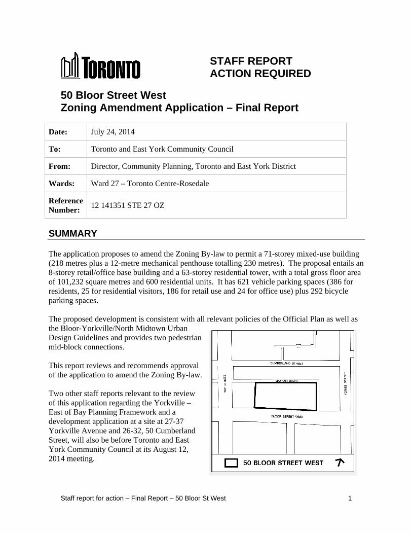
Staff report for action – Final Report – 50 Bloor St West 1 STAFF REPORT ACTION REQUIRED 50 Bloor Street West Zoning Amendment Application – Final Report Date: July 24, 2014 To: Toronto and East York Community Council From: Director, Community Planning, Toronto and East York District Wards: Ward 27 – Toronto Centre-Rosedale Reference Number: 12 141351 STE 27 OZ SUMMARY The application proposes to amend the Zoning By-law to permit a 71-storey mixed-use building (218 metres plus a 12-metre mechanical penthouse totalling 230 metres). The proposal entails an 8-storey retail/office base building and a 63-storey residential tower, with a total gross floor area of 101,232 square metres and 600 residential units. It has 621 vehicle parking spaces (386 for residents, 25 for residential visitors, 186 for retail use and 24 for office use) plus 292 bicycle parking spaces. The proposed development is consistent with all relevant policies of the Official Plan as well as the Bloor-Yorkville/North Midtown Urban Design Guidelines and provides two pedestrian mid-block connections. This report reviews and recommends approval of the application to amend the Zoning By-law. Two other staff reports relevant to the review of this application regarding the Yorkville – East of Bay Planning Framework and a development application at a site at 27-37 Yorkville Avenue and 26-32, 50 Cumberland Street, will also be before Toronto and East York Community Council at its August 12, 2014 meeting.
Transcript
Staff report for action – Final Report – 50 Bloor St West 1
STAFF REPORT ACTION REQUIRED
50 Bloor Street West Zoning Amendment Application – Final Report
Date: July 24, 2014
To: Toronto and East York Community Council
From: Director, Community Planning, Toronto and East York District
Wards: Ward 27 – Toronto Centre-Rosedale
Reference Number:
12 141351 STE 27 OZ
SUMMARY
The application proposes to amend the Zoning By-law to permit a 71-storey mixed-use building (218 metres plus a 12-metre mechanical penthouse totalling 230 metres). The proposal entails an 8-storey retail/office base building and a 63-storey residential tower, with a total gross floor area of 101,232 square metres and 600 residential units. It has 621 vehicle parking spaces (386 for residents, 25 for residential visitors, 186 for retail use and 24 for office use) plus 292 bicycle parking spaces.
The proposed development is consistent with all relevant policies of the Official Plan as well as the Bloor-Yorkville/North Midtown Urban Design Guidelines and provides two pedestrian mid-block connections.
This report reviews and recommends approval of the application to amend the Zoning By-law.
Two other staff reports relevant to the review of this application regarding the Yorkville – East of Bay Planning Framework and a development application at a site at 27-37 Yorkville Avenue and 26-32, 50 Cumberland Street, will also be before Toronto and East York Community Council at its August 12, 2014 meeting.
Staff report for action – Final Report – 50 Bloor St West 2
RECOMMENDATIONS
The City Planning Division recommends that:
1. City Council amend Zoning By-law 438-86, as amended, for the lands at 50 Bloor Street West substantially in accordance with the draft Zoning By-law Amendment attached as Attachment No. 8 to report dated July 24, 2014.
2. City Council authorize the City Solicitor to make such stylistic and technical changes to the draft Zoning By-law Amendment as may be required.
3. Before introducing the necessary Bills to City Council for enactment, require the Owner to enter into an Agreement pursuant to Section 37 of the Planning Act as follows:
a. The community benefits recommended to be secured in the Section 37 Agreement are as follows:
i. an indexed contribution of $6,000,000 to be paid or secured at the times noted in each of the sections below in the Section 37 Agreement. The total amounts are indexed upwardly in accordance with the Statistics Canada Non-Residential Construction Price Index for Toronto, calculated from the date of the Section 37 Agreement to the date of payment and is detailed as follows;
1. An indexed cash contribution of $800,000 towards Yorkville Avenue streetscape improvements, to be paid in accordance with the following schedule:
a. $262,500 to be paid the later of 30 days from the site specific zoning by-law coming into full force and effect, or January 15, 2015;
b. $262,500 to be paid the earlier of the third anniversary of the date on which the site specific zoning by-law comes into full force and effect, or immediately preceding the issuance of the first building permit; and
c. $275,000 to be paid prior to the issuance of the first building permit.
2. An indexed cash contribution of $525,000, to be paid prior to the issuance of the first building permit, towards capital improvements to Toronto Community Housing in Ward 27, in consultation with the Ward Councillor;
3. An indexed cash contribution of $3,925,000, to be paid prior to the issuance of the first building permit, towards streetscape and park
Staff report for action – Final Report – 50 Bloor St West 3
improvements in the local area, in consultation with the Ward Councillor and the Chief Planner and Executive Director, City Planning; and
4. $750,000 towards public art on site, in accordance with the City of Toronto Public Art Program.
5. In the event the cash contributions referred to above have not been used for the intended purpose within three (3) years of this By-law coming into full force and effect, the cash contribution may be redirected for another purpose, at the discretion of the Chief Planner and Executive Director of City Planning, in consultation with the local Councillor, provided that the purpose is identified in the Toronto Official Plan and will benefit the community in the vicinity of the lands.
ii. The conveyance of a community services and facilities space which may include a non-profit childcare at not less than 418 square metres of indoor space plus an additional 232.5 square metres of outdoor space or a community or cultural space at not less than 465 square metres on top of the base building. The community services and facilities space must be provided for substantially in accordance with the draft term sheets attached as Attachment Nos. 9 and 10 to report dated July 24, 2014. The conveyance is to occur within 30 days of the registration of any condominium on the site, or in the event that no condominium is registered on the site, before such time that any residential unit is occupied.
iii. A 3.90-metre wide pedestrian easement is to be provided for a publicly accessible north-south pedestrian mid-block connection adjacent to Mayfair Mews to be approved by the Chief Planner and Executive Director, City Planning. The granting of the easement is to occur before such time that any residential unit is occupied;
iv. The owner will use its reasonable commercial efforts to provide a north-south pedestrian connection from Bloor Street to the north boundary of the department store (currently tenanted by Holt Renfrew) to a well designed entrance/exit at Mayfair Mews during hours that are acceptable to the tenant and the Chief Planner and Executive Director, City Planning. The owner is required to provide the pedestrian connection within one year of a connecting north-south open space being provided by the owners to the north of Mayfair Mews; and,
v. An easement is to be provided for public use of the a 2,455 square metre publicly accessible open space on the roof the base building with public access from the ground floor and the concourse level, with appropriate signage in accordance with the Privately Owned Publicly-Accessible Space Guidelines. The granting of the easement is to occur before such time that any residential unit is occupied.
Staff report for action – Final Report – 50 Bloor St West 4
Financial Impact The recommendations in this report have no financial impact.
DECISION HISTORY A preliminary staff report dated August 10, 2012 was adopted at the September 11, 2012 Toronto and East York Community Council meeting. http://app.toronto.ca/tmmis/viewAgendaItemHistory.do?item=2012.TE18.49
On October 2, 3 and 4, 2012 City Council directed City Planning to review the existing and planned built form context, pedestrian linkages, as well as other policies and guidelines for the area bounded by: Bloor Street to the south; Davenport Road to the north; Yonge Street to the east; and Bay Street to the west ('Yorkville- East of Bay') to establish appropriate heights for the areas outside of the Height Peak, Height Ridges and Low-rise areas in Site and Area Specific Official Plan Policy 211, and to bring forward any required Official Plan Amendments to a statutory public meeting after holding a community meeting.
On June 18, 2013, Toronto and East York Community Council directed staff to initiate consultation with local stakeholders on the review of 'Yorkville- East of Bay' in consultation with the Ward Councillor and report back with a draft policy recommendation in a Preliminary Report. The Yorkville – East of Bay Planning Study Update report is available here: http://app.toronto.ca/tmmis/viewAgendaItemHistory.do?item=2013.TE25.65
A separate staff report dated July 24, 2014, to the August 12, 2014 meeting of the Toronto and East York Community Council on the draft Yorkville – East of Bay Planning Framework addresses both requests.
ISSUE BACKGROUND
Proposal The application proposes to amend the Zoning By-law to permit a 71-storey mixed-use building (218 metres plus 12 metre mechanical penthouse totalling 230 metres). The proposed residential tower sits above an 8-storey retail/office base building that covers most of the site. The total gross floor area is 101,232 square metres with a density of 17.1 times the area of the lot. For more detailed information see Attachment No. 1: Application Data Sheet.
The development proposal retains part of the existing 3-storey mixed-use building and grade-related retail on the site. The existing retail space in the east portion of the site will be replaced by the new base building, a vehicular motor court (‘Port Cochere’), a pedestrian walkway and the residential tower. The proposal retains the below-grade concourse with some realignment of the north connection to Cumberland Terrace.
The Bloor Street frontage will consist mainly of retail use, with two distinct mid-block pedestrian connections north to Cumberland Street. One north-south connection is located on the eastern portion of the site consisting of a pedestrian walkway (3.9 metres wide including tree planting) from Bloor Street along the widened Mayfair Mews, accessing the residential and office lobbies via the ‘Porte Cochere’, and a future connection to Cumberland Street to the north.
Staff report for action – Final Report – 50 Bloor St West 5
The second noth-south pedestrian connection will be accessed through the department store (currently Holt Renfrew) across Mayfair Mews to a future open space (in association with 2 Bloor Street West) on the south side of Cumberland Street.
The proposed 8-storey (36 metre) base building will contain existing and new retail and office space. A total of 31,630 square metres of retail space and 9,245 square metres of office space is proposed in the base building including the concourse. The office space is to be located from the fifth to eighth storeys on the eastern half of the base building. A community facility and a private owned publicly-accessible space (POPS) are proposed on the roof of base building.
At the ground floor, the front setback of the base building from Bloor Street ranges from 0 to 2.5 metres. From the second to sixth floors, the main front wall of the building extends to the street line, and at the second and third floors it has feature wall that projects partly over the sidewalk. At the seventh and eighth floors, the base building steps back approximately 2 metres.
The floor plate of the proposed tower flares toward the west at the top and bottom of the tower. Its average floor plate is 974 square metres, and is smallest at the 40th floor at 870 square metres.
The tower setbacks from the centreline of Mayfair Mews, a public lane abutting the site, vary from 15.6 to 16.3 metres on the east, and from 12.8 to 13 metres on the north.
The breakdown of the proposed 600 residential units is as follows:
Unit Type Number of Units 1-bedroom 360 2-bedroom 170 3-bedroom 70 Total 600
The total amount of proposed indoor and outdoor amenity space is 1,665 square metres and 1,330 square metres, respectively, for a total of 2,995 square metres. The amenity space will be provided at the 9th, 10th, 40th and 70th floors, and includes an indoor pool and fitness facilities on the 9th floor. The proposed amount of each type of amenity space exceeds the minimum requirement of 1,200 square metres in Zoning By-law 438-86.
The proposed 418 square metre community facility with an associated secure outdoor space of 240 square metres, and the 2,455 square metre POPS to be located on the roof of the base building (9th floor) will have public access via elevator from the ground floor (office lobby off Mayfair Mews) and the retail concourse level.
The concourse will contain retail uses and connect to the existing below grade pedestrian concourse system. Below the concourse level, 621 parking spaces are proposed on six levels of underground parking equipped with parking stackers. 386 of these spaces are planned for residents, 25 for residential visitors, 186 for retail use and 24 for office use.
Staff report for action – Final Report – 50 Bloor St West 6
The proposed parking facility will have valet service for all uses and be accessed by vehicles from Bay Street via the east-west leg of Mayfair Mews on the north side of the site. A valet staging area is to be provided in the ‘Porte Cochere’ by the residential and office lobbies. Vehicular access to and from Bloor Street via the north-south leg of Mayfair Mews is proposed as a right-in/right-out movement only.
A total of 292 bicycle parking spaces are provided (160 for residential use, 40 for residential visitors, 60 for retail use, and 32 spaces for office use). The residential and residential visitor bicycle parking is located on the second floor of the base building. Bicycle parking for the retail and office uses is located on the concourse level. The bicycle parking areas are accessed from a dedicated bicycle elevator.
Eight loading spaces are proposed, including one Type-G residential, one Type-B residential, two Type-B commercial and four Type-C commercial spaces. The loading spaces are located on the east-west leg of Mayfair Mews.
The current proposal incorporates numerous revisions to the original application as summarized below:
- gross floor area reduced 10% from 112,860 square metres to 101,232 square metres; - tower height reduced from 83 storeys to 71 storeys (from 277 metres to 230 metres); - tower floor plate reduced from average of 1,066 square metres to 973 square metres; - tower setbacks from the centerline of Mayfair Mews increased (now vary between 16.3
and 15.6 metres on the east and 13 metres and 12.8 metres on the north); - tower separation from existing office building at 2 Bloor Street West increased to 20
metres from 16.6 – 17.0 metres; - overall design and materiality of residential tower revised; - projecting balconies replaced with recessed balconies; - retail frontage along Bloor Street increased and is continuous; - width of the vehicular access from Bloor Street decreased from 9 to 7 metres; - future north-south interior at-grade pedestrian connection introduced; - community facility on 9th floor introduced; - indoor and outdoor amenity space decreased from 2,905 to 1,665 square metres, and 1,735
to 1,200 square metres respectively; - elevator access to 9th floor POPS now provided via the office elevators; - programming and layout of 9th floor POPS revised to accommodate outdoor area of the
community facility; - residential and office entrance as well as motor court relocated to northeast portion of
property which enables a 10.9 metre wide pedestrian/vehicular space; - vehicular access from Bloor Street reduced to a right-in/right-out for cars only (service
vehicle access from Bay Street via east/west leg of Mayfair Mews); - loading, garbage pick-up, and ramps to underground parking relocated (access from east-
west leg of Mayfair Mews); and - Tree removal on Bloor Street reduced from 2 trees to 1 tree.
Staff report for action – Final Report – 50 Bloor St West 7
Site and Surrounding Area The site is located on the north side of Bloor Street West, between Yonge Street and Bay Street. It is rectangular shaped and approximately 5,920 square metres in area. It has a frontage of 115 metres along Bloor Street and is 54.2 metres in depth. A public lane, Mayfair Mews, abuts the east and north property lines of the site.
The site consists of a 4, 3 and 2-storey building with retail uses at-, above-, and below-grade. The site is referred to as The Holt Renfrew Centre with the anchor tenant being the Holt Renfrew department store.
Uses and structures near the site include:
North and East: of the public lane, Mayfair Mews, is 'Cumberland Terrace' (2 Bloor Street West), on an L-shaped parcel extending north from the northwest corner of Yonge and Bloor and west along the south side of Cumberland Street to Bay Street. An existing 34-storey office tower is located at the northwest corner of Yonge and Bloor Streets. A low-rise concrete building that spans the south side of Cumberland from Bay to Yonge Street, contains an internalized retail mall and some office/commercial uses. A below-grade retail concourse connects the 2 Bloor Street West site to the Toronto Parking Authority (TPA) parking garage on the north side of Cumberland Street.
An OMB approved site specific zoning by-law (OMB File No. PL100851) for 2 Bloor Street West permits: a 102.9 metre tower including a 6.3 metre mechanical penthouse at Yonge Street; and, a mid-block Cumberland Street tower at 170 metres, including a 10 metre mechanical penthouse. The by-law also permits a 24.4 metre high base building including grade-related commercial space, four levels of above-grade parking and “rooftop villas” at the southeast corner of Bay and Cumberland Streets (stepped back atop the podium from Cumberland Street with an overall height of 30.6 metres). The owner presented a revised built form proposal for the site to the City's Design Review Panel on March 18, 2014, showing the proposed mid-block tower shifted further west and a reduced base building height, but has not submitted an application to date for the revised proposal.
South: of Bloor Street West is the 18-storey tower of the Manulife Centre, a mixed use building; Balmuto Street, a north/south local street; and, 2-storey retail uses.
West: of the site is 60 Bloor Street West, a 14-storey office building with retail on the ground floor. The retail uses include Josephson's Optical, the Gap and Holt Renfrew.
Provincial Policy Statement and Provincial Plans The Provincial Policy Statement (PPS) provides policy direction on matters of provincial interest related to land use planning and development. The PPS sets the policy foundation for regulating the development and use of land. The key objectives include: building strong communities; wise use and management of resources; and protecting public health and safety. City Council’s planning decisions are required to be consistent with the PPS.
Staff report for action – Final Report – 50 Bloor St West 8
The Growth Plan for the Greater Golden Horseshoe provides a framework for managing growth in the Greater Golden Horseshoe including: directions for where and how to grow; the provision of infrastructure to support growth; and protecting natural systems and cultivating a culture of conservation. City Council’s planning decisions are required to conform, or not conflict, with the Growth Plan for the Greater Golden Horseshoe.
Official Plan The City of Toronto Official Plan designates the subject site Mixed Use Areas and locates it within the Downtown and Central Waterfront shown on Map 2 of the Official Plan’s Urban Structure map. As part of the Official Plan’s growth strategy, the Downtown is identified as an area of intensification where growth in employment and residential uses is encouraged.
The Mixed Use Areas designation in the Official Plan provides for a broad range of commercial, residential and institutional uses, in single-use or mixed-use buildings, as well as parks and open spaces and utilities.
Development in Mixed Use Areas is subject to a number of development criteria: locate and mass new buildings to provide a transition between areas of different development intensity and scale; provide appropriate setbacks and/or stepping down of heights, particularly towards lower scale Neighbourhoods; locate and mass new buildings so as to adequately limit shadow impacts on adjacent Neighbourhoods particularly during the spring and fall equinoxes; provide good site access and circulation and an adequate supply of parking for residents and visitors; provide an attractive, comfortable and safe pedestrian environment; locate and screen service areas, ramps and garbage storage to minimize the impact on adjacent streets and residences; and provide indoor and outdoor recreation space for building residents in every significant multi-unit residential development.
Staff have reviewed this application for compliance with these criteria and all other relevant policies of the Official Plan. To review all sections of the Toronto Official Plan refer to the City’s Website at: www.toronto.ca/planning/official_plan/introduction.htm
Area Specific Policy 211 (Bloor Yorkville / North Midtown Area) Area Specific Policy 211 of the Official Plan recognizes that the Bloor-Yorkville/North Midtown Area comprises a broad mix of districts with differing intensities, scales and heights in a diversity of building forms. The area includes Neighbourhoods, Apartment Neighbourhoods, Mixed Use Areas, Areas of Special Identity and open space provided by parks and ravines. The Area forms the north edge of the Downtown and provides for transition in density and scale. The subject site is located within the Height Peak as illustrated in Policy 211, where the highest building heights are allowed.
Area Specific Policy 225 (Lands North and South of Bloor Street Between Park Road and Avenue Road) Area Specific Policy 225 of the Official Plan encourages pedestrian walkways, at or below grade, and new parks, illustrated on the map within the Policy. At this site, the map identifies the existing underground pedestrian mall system and its connections to the properties to the north, west and east.
Staff report for action – Final Report – 50 Bloor St West 9
Zoning The site is subject to Zoning By-law No. 438-86, as amended and By-law No. 499-77. In By-law No. 438-86, the property is zoned CR T7.8 C4.5 R.7.8 with a height limit of 61 metres and a maximum density of 7.8 times the area of the lot. The CR zoning category allows for a broad range of residential and commercial uses.
By-law No. 499-77 is a site-specific zoning by-law, which permits the existing building on the site (Holt Renfrew Centre).
Bloor –Yorkville/North Midtown Urban Design Guidelines The Bloor –Yorkville/North Midtown Urban Design Guidelines approved by Council in 2004 seek to improve the physical quality of the area and ensure that new development respects its special character.
The main planning objectives of these local Design Guidelines include:
- enhancement of Areas of Special Identity and historic buildings; - protection of residential areas from adverse impacts of commercial and/or higher density
development; - improvement of public realm and publicly accessible areas; and - excellence in urban design, architecture, and landscaping.
The Bloor-Yorkville/North Midtown area is comprised of a number of precincts and corridors, each defined by its attributes in terms of function, built form and character. The subject site is located within the Bloor Street Corridor. The centre of the Bloor Street Corridor, at the Yonge and Bloor intersection, is referred to as a ‘Height Peak’, where the tallest buildings in the area are concentrated. Projects proposed along Bloor Street should incorporate mid-block connections from Bloor to Cumberland Streets and where possible, should connect with the underground concourse/subway connections. As well, consideration should be given to the form of buildings along this portion of Bloor Street to ensure that the low-rise buildings in the Village of Yorkville and the Village of Yorkville Park are not shadowed adversely.
The Bloor-Yorkville/North Midtown Urban Design Guidelines are available on the City’s website at: http://www.toronto.ca/planning/urbdesign/blooryorkville.htm
Tall Building Design Guidelines In May 2013, Toronto City Council adopted the updated city-wide Tall Building Design Guidelines and directed City Planning staff to use these Guidelines in the evaluation of all new and current tall building development applications. The guidelines establish a unified set of performance measures for the evaluation of tall building proposals to ensure that they fit within their context and minimize their local impacts. The city-wide Guidelines are available at http://www.toronto.ca/planning/tallbuildingdesign.htm
The Official Plan (Section 5.3.2: Implementation Plans and Strategies for City-Building, Policy 1) states that Guidelines will be adopted to advance the vision, objectives, and policies of the
Staff report for action – Final Report – 50 Bloor St West 10
Plan. Urban Design Guidelines specifically are intended "to provide a more detailed framework for built form and public improvements in growth areas." The Tall Building Design Guidelines serve this policy intent, helping to implement Chapter 3.1 (The Built Environment) and other policies within the Plan related to the design and development of tall buildings in Toronto.
This project is located within an area that is also subject to the Downtown Tall Buildings: Vision and Supplementary Design Guidelines (adopted by City Council in July 2012 and consolidated with the city-wide Tall Building Design Guidelines May 2013). This document identifies specific Downtown streets that are most suitable for tall building development, establishes a height range along these streets and provides a set of supplementary Downtown specific design guidelines which address Downtown built form and context. The Downtown Vision and Supplementary Design Guidelines were used together with the city-wide Tall Building Design Guidelines in the evaluation of this proposal. The Downtown Guidelines are available at: http://www.toronto.ca/planning/tallbuildingstudy.htm#guidelines
The application is located on Bloor Street West, which is identified as a High Street on Map 1 of the Guidelines. This portion of Bloor Street West falls within the 77 metres to 137 metres height range on Map 2, is identified as a Canyon Form Typology on Map 3 and is identified as a Retail Street on Map 4.
Yorkville – East of Bay Planning Framework The Yorkville – East of Bay Planning Framework is addressed in a separate report (dated July 24, 2014) to the August 12, 2014 Toronto and East York Community Council.
The Planning Framework applies to the area of Yorkville located east of Bay Street and west of Yonge Street, between Bloor Street and Davenport Road. It represents a comprehensive review of aspects of existing policy to provide better guidance for future change. The Framework is founded on a vision and goals for the pedestrian environment and connectivity, and the location of tall buildings and their built form criteria.
The Planning Framework identifies two key mid-block pedestrian connections created by a series of parks, open spaces, linear parks and walkways. The two mid-block pedestrian systems are named by their defining features - Town Hall Walkway and Clock Tower Walkway. The Planning Framework also identifies the built form criteria for existing, approved, proposed and possible future tall building sites.
Site Plan Control The proposal is subject to Site Plan Control. An application for Site Plan Control has not been made to date. The applicant will be required to present their proposal at the Design Review Panel once the application is submitted.
Tree Preservation There are seven trees in the public sidewalk of Bloor Street West in front on the site. The proposal calls for the removal of one tree to provide for the widened vehicular access from Bloor Street West and the pedestrian walkway.
Staff report for action – Final Report – 50 Bloor St West 11
Reasons for the Application The application proposes a mixed-use building with a height of 230 metres (including mechanical penthouse) with a 36 metre tall base building. The overall proposed height exceeds the 61 metre height limit on the site. The proposed density is 17.1 times the area of the lot, whereas the maximum permitted density is 7.8. The proposal also exceeds the permissions set out in Zoning By-law No. 499-77. A Zoning By-law amendment is therefore required.
Community Consultation On October 29, 2012, a community meeting was held at the Stone Church at 45 Davenport Road. The original application was presented, along with another application for a site at 27-37 Yorkville Avenue and 26-32, 50 Cumberland Street. Approximately 90 members of the public attended the community consultation meeting.
The attendees asked questions and expressed a number of comments, issues and concerns, including: the height and density of the tower; the height and size of the base building; the above grade parking relating to the size and design of the base building; the size of the development relative to the width of the cross streets; the cumulative shadow impacts of the proposals; the number of vehicular access points to the property; the traffic generated as a result of the proposed development; the lack of open space; the interim lack of parking during the reconstruction of the TPA parking garage; and the collective impacts of all of the proposals in the Yorkville – East of Bay area.
On July 3, 2013, an urban design workshop was held with the architects and urban design consultants representing the applications in the Yorkville – East of Bay area. Several other City Divisions were represented at the workshop, including Transportation Services and Parks, Forestry and Recreation. Community associations at the design workshop included the ABC Residents Association, the Bloor-Yorkville BIA, and the Greater Yorkville Residents Association. The outcome of the visioning exercise was a Workshop Summary Document which identified a vision for the area including new open spaces, mid-block connections and vehicular access routes for the applications under review.
The summary document is available at: http://www1.toronto.ca/City%20Of%20Toronto/City%20Planning/Community%20Planning/Files/pdf/E/east_bay_summary_document.pdf
On October 30, 2013 Planning staff held a Community Consultation Meeting at the Stone Church to present the vision resulting from the July 3, 2013 urban design workshop and to provide an update on the applications in the study area, including this proposal.
The application was before the City’s Design Review Panel (DRP) on March 7, 2013 and March 18, 2014. At the second meeting, the Panel commented on the 4 proposals in Yorkville- East of Bay collectively: 50 Bloor Street West; 2 Bloor Street West; 27-37 Yorkville Avenue and 26-50 Cumberland Street; and, 836-850 Yonge Street and 1-9A Yorkville Avenue.
The Panel expressed overall support for the project as a “celebration of retail”, and especially its north-south pedestrian connectivity. The Panel had a number of concerns regarding the proposed
Staff report for action – Final Report – 50 Bloor St West 12
tower regarding the floor plate size, separation distances and the complex design. The applicant has worked with staff to reduce the tower floor plate, increase the tower separation distance to the east, simplify the tower design and increase the width of the pedestrian north-south walkway adjacent to Mayfair Mews.
The minutes of the DRP meeting are available at: http://www1.toronto.ca/City%20Of%20Toronto/City%20Planning/Urban%20Design/Files/pdf/DRP/DRP%20Minutes%20March%202014.pdf
On March 18, 2014, following the second DRP meeting, the local Councillor chaired a community stakeholder meeting where the ABC Residents Association, Asquith Collier Residents Association, Bloor-Yonge BIA and Greater Yorkville Residents Association provided feedback on the presentations from the DRP meeting.
On April 3, 2014 Planning staff met with representatives of the Asquith Collier community to discuss the emerging vision for Yorkville -East of Bay and each of the development applications.
On May 7, 2014 Planning staff met with community stakeholders from the ABC Residents Association, Asquith Collier Residents Association, Bloor-Yonge BIA and Greater Yorkville Residents Association to update them on the applications in the Yorkville - East of Bay area. The stakeholders provided comments to Staff on the latest proposals by the applicants.
On June 9, 2014 Planning staff presented the most current proposals by applicants in the Yorkville – East of Bay area to the Asquith Collier neighbourhood at the invitation of its Asquith Collier Residents Association.
Agency Circulation The application was circulated to all appropriate agencies and City divisions. Responses have been used to assist in evaluating the application and to formulate appropriate By-law standards.
COMMENTS Planning staff reviewed the application comprehensively and in the context of the Yorkville – East of Bay policy review. Planning staff reviewed this application comprehensively. Staff are recommending a Draft Site Specific Zoning By-law that represents good planning.
The applicant participated in the Yorkville – East of Bay design workshops and addressed concerns raised by the local community, Design Review Panel and Planning staff through the development review process, including but not limited to: reducing the height and floor plate of the proposed tower, introducing two north-south mid-block pedestrian connections, increasing the amount of retail frontage on Bloor Street West and provided a POPS and community facility on top of the base building. The revised proposal provides a significant contribution to creating a public space network east of Bay Street, a characteristic that has been key to Yorkville’s success west of Bay Street.
Staff report for action – Final Report – 50 Bloor St West 13
Provincial Policy Statement and Provincial Plans The proposal is consistent with the Provincial Policy Statement (PPS). It provides additional density within a settlement area through intensification and redevelopment to accommodate an appropriate range and mix of land uses (Policy 1.1.2). The intensification will meet appropriate development standards (Policy 1.1.3.4), discussed further in this report.
In regard to efficient use of infrastructure and transportation systems, the proposal, located at the intersection of the Bloor and Yonge subway lines, promotes a land use pattern, density and mix of uses that limit vehicle trips and support the use of transit and active transportation (Policy 1.6.7.4).
This proposal conforms and does not conflict with the Growth Plan for the Greater Golden Horseshoe. It represents new growth in a built-up area that will ensure and maximize the viability of existing and planned infrastructure (Policy 2.2.2).
Land Use Planning staff are satisfied that the proposed residential and non-residential uses, including retail and office uses are acceptable. These uses are permitted within the Mixed Use Areas of the Official Plan as well as the CR district in Zoning By-law 438-86, as amended. The Official Plan states that development in Mixed Use Areas will create a balance of high quality commercial, residential, institutional and open space uses that reduces automobile dependency and meets the needs of the local community. In addition, the Tall Buildings Guidelines identify Bloor Street as a priority retail street and the Urban Design Guidelines identify Bloor Street as a Highly Animated Street where the primary use is retail and commercial uses.
The Draft Site Specific Zoning By-law accommodates a mix of uses.
Site Organization / Yorkville – East of Bay area The site organization is acceptable. A single tower is proposed on the east half of the site above a base building with a POPS on its roof. The tower and underground parking is proposed on area ‘A’ with little disruption to the existing retail use in area ‘B’, as shown on Attachment No. 2: Site Plan. The site access is via an existing lane, to be widened to include a north-south pedestrian walkway.
The proposal meets the vision, goals and objectives of the Yorkville – East of Bay Planning Framework (see separate report to August 12, 2014 meeting of Toronto and East York Community Council). The site proposal provides for the two future mid-block pedestrian connections, the proposed Clock Tower Walkway and Town Hall Walkway.
While limited open space is provided at grade, a 2,455 square metre POPS is proposed on the roof of the 8-storey base building adjoining an indoor and outdoor community facility area. The outdoor space is accessible from the ground floor, as well as from the concourse level which connects underground to the subway system.
Staff report for action – Final Report – 50 Bloor St West 14
The proposed tower is designed with no projecting balconies and the tower separation is 20 metres from the existing office tower to the east (discussed later in this report).
The proposed tower is appropriately placed within the Yorkville – East of Bay area to fit within the urban structure for Yorkville, while minimizing potential impacts and improving pedestrian access and comfort.
Height and Density The Official Plan Area Specific Policy 211 and the Bloor-Yorkville/Midtown Urban Design Guidelines set out areas called the Height Peak, Height Ridges and Low-Rise Areas. The intent of these local policies and guidelines is to direct the tallest buildings around the Yonge and Bloor Streets intersection, known as the Height Peak. The Height Ridges provide a transition in scale from the Height Peak with lesser height and physical scale than the Height Peak, and in a form compatible with adjacent areas.
The subject site is located in the Height Peak as identified in Official Plan Policy 211 and the Urban Design Guidelines. The proposed tower is 230 metres tall to the top of the roof, including the mechanical penthouse. The overall height and density is acceptable as it fits with the existing and planned context while minimizing the impacts relating to the height, such as shadow impacts. The height of the tower is less than the zoned height (290 metres) and expected construction height (254 metres) at 1 Bloor Street East. The subject proposal falls below a plane drawn from either the approved or constructed heights at 1 Bloor Street East to the newly built Four Seasons hotel (204 metres) at Bay Street and Yorkville Avenue. The density of 17.1 is consistent with recently approved site specific zoning by-laws for 1 Bloor Street East (currently under construction) and 2 Bloor Street West (not built).
Planning staff find the overall height and density appropriate as it fits within the existing and planned character, contributes to the Yonge and Bloor skyline with limited impact and is supported by available infrastructure.
Massing Tall buildings should be designed to consist of three parts carefully integrated into a single whole, including a base building, middle and top. Tall buildings should address key urban design considerations in the Official Plan, including the built form policies, site design and general fit within the existing and planned context, while providing a usable publicly accessible open space.
Base Building The proposed base conforms to the Official Plan and responds to the direction in the Bloor-Yorkville/North Midtown Urban Design Guidelines. The proposed 8-storey (36 metres) base building is appropriately massed to fit within the existing and planned built form along Bloor Street West. Existing towers along this segment of Bloor Street are designed with no base building (i.e. canyon-typology).
Staff report for action – Final Report – 50 Bloor St West 15
The Official Plan states that base buildings shall be massed to support the appropriate scale of adjacent streets, parks and open spaces, and to minimize the impact of parking and servicing uses. The proposed loading and servicing facilities, utilities, and vehicle parking, are all located underground or within the building mass and are not visible from Bloor Street. The main building entrances will be clearly visible and directly accessible from the public sidewalk.
The ground floor uses of the base building include residential and office lobbies, and retail uses. These uses have views and access to adjacent streets and open spaces. The location of the proposed residential, retail and office lobby entrances is acceptable as they front on the public sidewalk and publicly accessible open spaces. The base is designed with active, grade-related uses along both the Bloor Street West frontage and the ‘Porte Cochere’ and pedestrian walkway along the north-south leg of Mayfair Mews.
A number of pedestrian entry points are proposed for Bloor Street. The upper floors of the base building will include active uses such as additional retail and office space overlooking the public realm. The base is generally built to the street line and extends the full width of the site along Bloor Street while providing a ground floor setback of 0 to 2.5 metres. Along the north-south section of Mayfair Mews a 3.9 metre at-grade pedestrian walkway plus the widened laneway is proposed, which forms part of the Yorkville – East of Bay Town Hall Walkway. As well, an indoor pedestrian connection is proposed from Bloor Street to Mayfair Mews through the existing retail department store, which forms part of the Yorkville – East of Bay Clock Tower Walkway.
The proposed Bloor Street sidewalk width varies with the ground floor setbacks, ranging from 5.5 to 8.0 metres. The greater widths are located at the new main entrances of the retail use directly north of the north end of Balmuto Street. The proposed sidewalk widths are largely consistent with the minimum sidewalk dimension of 6 metres in the Tall Building Guidelines.
Middle Portion of Tower Planning staff are satisfied with the shaft of the proposed tower. The Official Plan states that the design, floor plate size and shape of the middle component shall have appropriate dimensions for the site. Towers shall be located and oriented in relation to the base building and adjacent buildings to fit within the existing and planned context. The existing and planned context at 50 Bloor Street is informed by the sites within the Height Peak, as defined by Area Specific Policy 211 and more specifically the properties at the intersection of Yonge and Bloor Streets.
The Tall Buildings Design Guidelines state that the tower portion of a tall building, including balconies, will be set back from the podium a minimum of 3 metres for a minimum of two-thirds of the length of the tower facing the street. The Guidelines permit up to one-third of the tower to extend straight down to the ground at the front property line. The proposed tower is set back 3 metres from Bloor Street. There are no balconies projecting into the proposed setbacks.
The proposed tower floor plate increases towards the top and bottom halves of the tower. The average floor plate is 974 square metres, and is smallest at the 40th floor at 870 square metres. The tower is designed with a straight vertical east façade while the northwest and southwest quadrants of the tower are flared. The tower floor plate size is consistent with the tower
Staff report for action – Final Report – 50 Bloor St West 16
currently under construction at 1 Bloor Street East. The tower floor plate is acceptable given the overall size of the site.
Top of the Tower The top of the tower has been designed to provide a distinctive landmark associated with a very tall building. The 70th floor is at 215 metres and the 71st floor is at 218 metres. The 71st floor is the second level of a penthouse suite located on the 70th floor. The mechanical penthouse covers the remainder of the 71st floor, as well as additional partial mechanical level above, with an extended parapet as an architectural feature sculpting the top of the tower.
Tower Separation The tower is located approximately 16 metres from the centreline of Mayfair Mews to the east and 12.8 metres from Mayfair Mews to the north which is greater than the 12.5-metre minimum standard in the Tall Buildings Design Guidelines. The intent of the 12.5-metre setback standard is to preserve the opportunity to provide a 25-metre separation distance between towers. While the proposal exceeds the standard on its site, the proposed tower separation is 20 metres to the existing office building to the east at 2 Bloor Street West.
The Bloor-Yorkville/North Midtown Urban Design Guidelines state that where possible and appropriate, the placement of a point tower should be staggered from adjacent towers. The minimum separation between point towers should have a 1:1:1 relationship between floor plate width and distance between buildings. On dense urban sites, like those in the Height Peak at the Yonge Street and Bloor Street intersection, a minimum separation distance of 15 metres above the street wall must be achieved.
Planning staff are satisfied with the tower separation, which exceeds the 15 metres identified in the local Urban Design Guidelines. The proposed residential tower is located adjacent to an office building to the east and offset from the proposed residential tower to the north, thereby mitigating privacy impacts through design and land use.
Shadow The shadow impact resulting from the application is acceptable. The Downtown Tall Buildings Design Guidelines state that every effort will be made to design and orient tall buildings to minimize their shadow impact on all publicly accessible parks, open spaces, natural areas and other shadow sensitive areas.
The Tall Buildings Design Guidelines - Supplementary Design Guideline #2 states that new buildings should be located and designed not to cast any new net shadow on all other parks between 12:00 PM. and 2:00 PM on September 21st. It also states that new buildings should be designed and located to best mitigate all new net shadowing on Jesse Ketchum Park/Schoolyard and Ramsden Park in the Bloor-Yorkville/North Midtown Area.
The Bloor-Yorkville / North Midtown Urban Design Guidelines identify Shadow Sensitive Areas. The Neighbourhoods and Natural Areas to the east of Yonge Street, including the lands that are designated Neighbourhoods in the Asquith Collier Precinct, on Collier Street, Park Road and Asquith Avenue, Frank Stollery Parkette on Scollard Street, the Fire Hall clock tower,
Staff report for action – Final Report – 50 Bloor St West 17
Library and Town Hall Square Park on Yorkville Avenue, the Village of Yorkville Park, a portion of the Village of Yorkville, the Yorkville Triangle Precinct, and Jesse Ketchum Park are all identified as shadow sensitive areas.
The Official Plan states that development in Mixed Use Areas will locate and mass new buildings so as to adequately limit shadow impacts on adjacent Neighbourhoods, particularly during the spring and fall equinoxes.
Planning staff have assessed the proposed development in terms of the incremental impact resulting from the proposed 71-storey tower and are satisfied that it adequately limits shadow on the Neighbourhoods, shadow sensitive areas, parks, publicly accessible open spaces and natural areas.
The massing, placement and height of the proposed tower limits its shadow impacts. The tower height was reduced from the original application to minimize the impact on the Jesse Ketchum Schoolyard during the spring and fall equinoxes.
On September/March 21, at 9:18 AM a shadow is cast over the front and rear yards of a few buildings on Hazelton Avenue and one property on Scollard Street, but not on the Jesse Ketchum Schoolyard. By 10:18 AM, there is no incremental shadow impact on the southern edge of Jesse Ketchum Schoolyard and by 11:18 AM the shadow is on the east side of Bay Street.
On September/March 21, at 12:18 PM the incremental shadow is cast over the Mixed Use Areas to the north as well as the Yorkville library and a portion of the Town Hall Square. By 1:18 PM the incremental shadow of the proposal stretches to Yonge Street and is not over any park space.
On September/March 21, at 3:18 PM the shadow from the proposal is just west of the low-rise Asquith-Collier residential neighbourhood and by 4:18 PM there is an incremental shadow cast over a portion of the Milner Parkette and the rear yards of a few houses on Collier Street. By 5:18 p.m. the incremental shadow is off all of these areas.
On June 21, when the sun is at its highest point, there are no incremental shadows on Town Hall Square, Jesse Ketchum Park, Frank Stollery Parkette or the Asquith Collier neighbourhood at any point during the day.
Wind The applicant submitted a Pedestrian Wind Study, dated March 22, 2012 prepared by Theakston Environmental Control Specialists, based on the initial design for the application. The applicant also submitted an updated Pedestrian Wind Study, dated May 2014 prepared by its consultant, providing further analysis on the current proposal as well as an analysis of the current proposal in combination with the two applications at the 27-37 Yorkville Avenue/26-32, 50 Cumberland Street and 836-850 Yonge Street/1-9A Yorkville Avenue sites.
The study tested the pedestrian wind conditions at 42 locations on and adjacent to the site. The findings show that, generally, the wind conditions are comfortable for walking in the winter, and
Staff report for action – Final Report – 50 Bloor St West 18
at some locations, such as along Bloor Street, are expected to improve with the proposal. The intersection of Yonge and Bloor Streets may be perceived as uncomfortable to pedestrians during times of strong westerly winter winds. There are no unsafe or “severe” wind conditions identified in the wind study. Planning staff are satisfied with the wind condition resulting from the proposed development subject to further assessment during the Site Plan Control review. Planning staff will require further review of the wind conditions resulting from the final massing and design and will secure the wind mitigation strategies to improve pedestrian level conditions.
Roadways, Traffic Impact, Access, Parking
Roadways Abutting the site to the north and east is a public lane known as Mayfair Mews, with an approximate width of 5.5 metres. To satisfy the Official Plan requirement for a 6.0 metre width for this lane, the owner will be required to convey to the City, a 0.255-metre-wide strip of land for the full extent of the site abutting the east-west leg of the public lane and a strip of land about 0.33 metres in width for the full extent of the site abutting the north-south leg of the public lane. In addition, a 1.5 metre by 1.5 metre wide splay must be provided at the intersection of the north-south and east-west legs of the lane, as widened. The lane widening conveyances will be secured through the Site Plan Control process.
Existing Below Grade Pedestrian Concourse The current plans indicate a relocated below grade connection under Mayfair Mews to the Cumberland Terrace concourse under Mayfair Mews, but not any new tunnel connections to the existing Cumberland Terrace. The realignment of the pedestrian connection from the subject building to Cumberland Terrace will be addressed further during Site Plan Control. The relocation of the below grade pedestrian connection is not being approved at this time. The proposed relocation of the pedestrian connection is to accommodate the revised location for the below-grade garage ramp. The existing below grade pedestrian concourse network connecting the Bay subway station and the Yonge subway line remains unchanged.
Traffic Impact Assessment The applicant’s transportation consultant, LEA Consulting Ltd., prepared a Traffic Impact Study, revised as of May 2014. The consultant estimates that the proposed mixed-use development will generate approximately 145 and 306 two-way trips during the weekday AM and PM Peak Hours, respectively and 274 two-way trips during Saturday Peak Hour. Given this level of trip generation, the applicant’s consultant concludes that the projected site traffic will have minimal impacts on area intersections and therefore can be acceptably accommodated on the adjacent road network. Traffic Planning staff have reviewed the the updated report and conclude that no further information or analysis is required and the traffic impacts of the proposal will be acceptable provided that there will be restricted movements at the Bay Street / Mayfair Mews and Bloor Street West / Mayfair Mews intersections as described below.
The applicant’s transportation consultant has undertaken analysis of a potential extension of the north-south leg of Mayfair Mews northerly to Cumberland Street. This connection would be beneficial to both the subject site (50 Bloor Street West) and 2 Bloor Street West, as it would provide additional routing options. Assuming the extension of the two-way segment of
Staff report for action – Final Report – 50 Bloor St West 19
Cumberland Street easterly to the site access driveway, the consultant concludes that the Bay Street/Cumberland Street intersection would operate satisfactorily for a downtown intersection. The analysis is acceptable for the purpose of the subject rezoning application.
Bloor Street West/Mayfair Mews Intersection The result of the capacity analysis shows that the average delay for this intersection during the weekday PM Peak period exceeds acceptable limits. The consultant's report notes that under a worse-case scenario, vehicle queues of 2 to 3 vehicles in one minute, or 4 to 5 vehicles in two minutes, are projected at the Bloor Street access during the PM peak hour, when pedestrian volumes are high. The report also indicates that pedestrian activity is elevated during the entire afternoon and evening periods.
The consultant report notes that with the relocation of the underground garage ramp closer to Bay Street off Mayfair Mews, less reliance on Bloor Street is expected, and therefore the projected site vehicular traffic to Bloor Street will likely be lower. Nevertheless, the revised analysis still shows very high average delay for the intersection, which reflects limited availability of acceptable gaps in the pedestrian and vehicular stream along Bloor Street West, specifically for left-turns to/from Mayfair Mews. As result, Traffic Planning staff require Mayfair Mews at Bloor Street West to operate with right-in/right-out movements only.
Mayfair Mews/Bay Street Intersection The intersection of Mayfair Mews with Bay Street is very close to the Bay Street/Bloor Street and Bay Street/Cumberland Street intersections and the southbound and northbound queues at these intersections will potentially block left-turns to and from Mayfair Mews during peak periods. Accordingly, left-turns will have to be prohibited during the AM peak period from 7:00 to 10:00 AM and PM peak period from 3:30 to 6:30 PM. Enforcement of the above-noted left-turn prohibitions will require the enactment of appropriate by-laws.
Traffic Impacts at the Park Road/Rosedale Valley Intersection The consultant's report identifies traffic movements at the Park Road/Rosedale Valley Road intersection as requested by the local community. The intersection operates currently at capacity during the AM and PM peak hours and there is little residual capacity for additional traffic. The consultant concludes that it is unlikely that new traffic from the development site will choose this route to access destinations to and from the northeast. Accordingly, the consultant has not assigned trips to this route. Traffic Planning staff agree that this assumption seems logical. No comments or recommendations to resolve the current condition are being considered in conjunction with this review. A separate study outside of this review process would be required.
Encroachments The "glazed retail facades" on the second and third level on the Bloor Street West frontage have been set back to the property line so that only a canopy and an electronic illuminated feature wall would continue to encroach over the sidewalk. In addition, the planter wall on the southeast corner of the building has been set back so that a canopy fin remains. The proposed canopy encroachments and illuminated signage are acceptable in principle.
Staff report for action – Final Report – 50 Bloor St West 20
Parking A total of 621 parking spaces are proposed, consisting of 386 spaces for residents, 25 residential visitor spaces, 24 office parking spaces and 186 spaces for the retail component of the project. The parking spaces are located in a six-level underground parking garage with access off of the east-west leg of Mayfair Mews. All parking spaces, with the exception of three accessible and four single parking spaces, are provided in the form of two-car stackers, and will be accessed by valet arrangement only.
On the basis of the traffic consultant's study, the minimum parking required is 651 spaces. The total parking supply is deficient by approximately 30 to 41 parking spaces. The consultant recommends that the minor deficiency in the non-residential parking supply be accepted because of the unique characteristics of this location (at the intersection of two major subway lines). They also note that most retail stores in the area do not provide any retail parking. Traffic Planning staff find the deficiency acceptable.
The proposed parking strategy for the project entails all cars being parked by valets. The estimated time required to park and retrieve a vehicle by one valet from the ‘Port Cochere’ is 3 minutes, 45 seconds. Holding facilities are available for valet parking operations in the ‘Porte Cochere’ in front of the residential condominium off of Mayfair Mews (estimated at seven vehicles), in the staging area on the P1 level, (which can accommodate eight vehicles plus a 'car wash,') and in the existing lay-by on Bloor Street West, in front of Holt Renfrew. In the event that the capacity of the valet staging area is exceeded, valets could temporarily access vacant parking spaces in the parking garage for the purpose of staging vehicles. Traffic Planning staff estimate that up to four vehicles could be practically accommodated in the ‘Porte Cochere’ without the need to move another vehicle.
Based on the projected trip generation/valet turnaround time, the consultant estimated that a maximum of twelve valet drivers would be needed during peak periods to avoid retention of vehicles in any of the proposed holding areas. The consultant also suggested that a minimum of 3 and 8 valets would be required during off-peak hours.
While this level of analysis is acceptable for the purpose of the subject rezoning application, a more detailed analysis will be required in conjunction with the site plan application. The Site Plan Agreement will contain provisions that require that the valet operations be provided and maintained in accordance with the proposed valet parking management plan and in a manner that contains valet activity on the site.
Loading The application proposes one Type-G, three Type-B and four Type-C loading spaces. The loading facility is located off the east-west leg of Mayfair Mews and is not visible from either Bay Street or Bloor Street. This is acceptable to Staff.
Driveway Access and Site Circulation Access to the on-site parking and loading facilities will be provided off the widened Mayfair Lane. This "L"-shaped lane has access from both Bloor Street West and Bay Street.
Staff report for action – Final Report – 50 Bloor St West 21
Servicing Construction and Engineering Services have reviewed the Functional Servicing Report and Stormwater Management Report and are satisfied that there is capacity to accommodate the proposed development. Further detailed analysis will be conducted through the Site Plan Control process.
Open Space/Parkland The proposal is a 71-storey mixed-use building containing 600 residential units and an 8-storey base building containing commercial and office uses.
The Official Plan contains policies to ensure that Toronto's system of parks and open spaces are maintained, enhanced and expanded. Map 8B of the Toronto Official Plan shows local parkland provisions across the City. The lands subject to this application are in an area with 0.78 to 1.55 hectares of local parkland per 1,000 people. The site is in the middle quintile of current provision of parkland. The site is in a parkland priority area, as per the City Wide Parkland Dedication By-law 1020-2010.
For sites that are less than 1 hectare in size, a cap of 10% is applied to the residential use while the non-residential use is subject to a 2% parkland dedication. The actual amount of cash-in-lieu to be paid will be determined at the building permit issuance stage.
The applicant is required to satisfy the parkland dedication requirement through cash-in-lieu. This is appropriate as there is no location for an on-site parkland dedication.
Streetscape / Trees The proposed streetscape plan illustrates an upgraded pavement treatment for part of Mayfair Mews to match the existing streetscape of Bloor Street West. Through the Site Plan Control process, the proposed pavement treatment will be reviewed in more detail by Engineering and Construction Services staff to determine whether these materials can accommodate public lane traffic. If these non-standard pavement treatments are approved in principle by the Executive Director of Engineering and Construction Services, a mechanism would need to be implemented for future maintenance of the upgraded pavement treatment.
The lower storeys of the base are intended to be designed with stone cladding, as well as other upgraded materials. These upgraded finishes will be secured through the Section 37 Agreement, but details will be secured through the Site Plan Agreement.
The development proposes the removal of one public tree along the Bloor Street frontage to accommodate the widened lane. As new planting is proposed along the improved north-south laneway and walkway, the proposed landscape plan is acceptable.
Toronto Green Standard City Council has adopted the two-tiered Toronto Green Standard (TGS), a set of performance measures for green development. Tier 1 is required for new development. Tier 2 is a voluntary, higher level of performance with financial incentives.
Staff report for action – Final Report – 50 Bloor St West 22
Section 37 The Official Plan contains policies pertaining to the provision of community benefits for increases in height and/or density pursuant to Section 37 of the Planning Act. While the proposed development exceeds the height and density limits of the Zoning By-law, the application is consistent with the objectives and policies of the Official Plan, and thus constitutes good planning.
The community benefits recommended to be secured are found in Appendix 1 of the Draft By-law in Attachment No. 8 of this report.
ATTACHMENTS Attachment 1: Application Data Sheet Attachment 2: Site Plan Attachment 3: South Elevation Attachment 4: West Elevation Attachment 5: East Elevation Attachment 6: North Elevation Attachment 7: Zoning Map Attachment 8: Draft Zoning By-law Amendment Attachment 9: Draft Childcare Term Sheet Attachment 10: Draft Community Services and Facilities Term Sheet
Staff report for action – Final Report – 50 Bloor St West 23
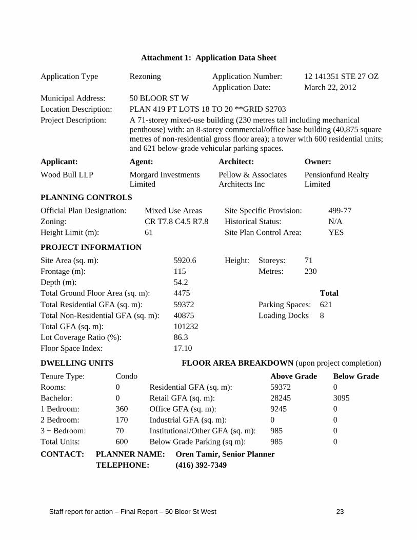
Attachment 1: Application Data Sheet
Application Type Rezoning Application Number: 12 141351 STE 27 OZ Application Date: March 22, 2012
Municipal Address: 50 BLOOR ST W Location Description: PLAN 419 PT LOTS 18 TO 20 **GRID S2703 Project Description: A 71-storey mixed-use building (230 metres tall including mechanical
penthouse) with: an 8-storey commercial/office base building (40,875 square metres of non-residential gross floor area); a tower with 600 residential units; and 621 below-grade vehicular parking spaces.
Applicant: Agent: Architect: Owner:
Wood Bull LLP Morgard Investments Limited
Pellow & Associates Architects Inc
Pensionfund Realty Limited
PLANNING CONTROLS
Official Plan Designation: Mixed Use Areas Site Specific Provision: 499-77 Zoning: CR T7.8 C4.5 R7.8 Historical Status: N/A Height Limit (m): 61 Site Plan Control Area: YES
PROJECT INFORMATION
Site Area (sq. m): 5920.6 Height: Storeys: 71 Frontage (m): 115 Metres: 230 Depth (m): 54.2 Total Ground Floor Area (sq. m): 4475 Total Total Residential GFA (sq. m): 59372 Parking Spaces: 621 Total Non-Residential GFA (sq. m): 40875 Loading Docks 8 Total GFA (sq. m): 101232 Lot Coverage Ratio (%): 86.3 Floor Space Index: 17.10
DWELLING UNITS FLOOR AREA BREAKDOWN (upon project completion)
Staff report for action – Final Report – 50 Bloor St West 24
Attachment 2: Site Plan
Staff report for action – Final Report – 50 Bloor St West 25
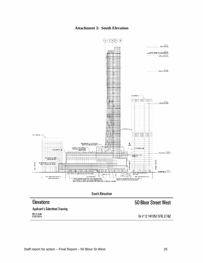
Attachment 3: South Elevation
Staff report for action – Final Report – 50 Bloor St West 26
Attachment 4: West Elevation
Staff report for action – Final Report – 50 Bloor St West 27
Attachment 5: East Elevation
Staff report for action – Final Report – 50 Bloor St West 28
Attachment 6: North Elevation
Staff report for action – Final Report – 50 Bloor St West 29
Attachment 7: Zoning Map
Staff report for action – Final Report – 50 Bloor St West 30
Attachment 8: Draft Zoning By-law Amendment
Authority: Toronto and East York Community Council Item ~ as adopted by City of Toronto Council on ~, 20~
Enacted by Council: ~, 20~ CITY OF TORONTO
Bill No. ~ BY-LAW No. ~-20~
To amend the General Zoning Bylaw No. 43886 and Site Specific By-law No. 499-77 of the former City of Toronto with respect to the lands
municipally known as 50 Bloor Street West
WHEREAS authority is given to Council of the City of Toronto (“Council”) by Section 34 of the Planning Act, R.S.O. 1990, c.P.13, as amended (the “Planning Act”), to pass this By law; and
WHEREAS Council has provided adequate information to the public and has held at least one public meeting in accordance with the Planning Act; and
WHEREAS pursuant to Section 37 of the Planning Act, the Council may, in a by law passed under Section 34 of the Planning Act, authorize increases in the height or density of development beyond that otherwise permitted by Zoning By law 438 36, as amended, and Zoning By-law 499-77 (together, defined herein as the “Zoning By laws”), in return for the provisions of such facilities, services or matters as are set out in the by law; and
WHEREAS Subsection 37(3) of the Planning Act provides that, where an owner of land elects to provide facilities, services or matters in return for any height or density of development, the Municipality may require the owner to enter into one or more agreements with the Municipality dealing with the facilities, services or matters; and
WHEREAS the owner of the aforesaid lands has elected to provide the facilities, services or matters as are hereinafter set forth; and
WHEREAS the increase in the height and density permitted hereunder, beyond those otherwise permitted on the lands by the Zoning By laws, are to be permitted subject to the provision of the facilities, services or matters set out in this By law and to be secured by one or more agreements between the owner of the lands and the City of Toronto (hereinafter referred to as the “City”); and
WHEREAS the Official Plan of the City contains provisions relating to the authorization of the height and density of development; and
WHEREAS Council has required the owner of the aforesaid lands to enter into one or more agreements to secure certain facilities, services, or matters in connection with the aforesaid
Staff report for action – Final Report – 50 Bloor St West 31
lands set forth in this By law in return for the increases in height and density set forth in this By law;
The Council of the City of Toronto HEREBY ENACTS as follows:
1. This By law applies to the lot outlined by heavy dashed lines on Map 1, attached to and forming part of this By law.
2. Pursuant to Section 37 of the Planning Act, the heights and density of development permitted in this By law are permitted subject to compliance with all of the conditions set out in this By
law including the provision by the owner of the lot of the facilities, services and matters set out in Appendix 1 hereof to the City at the owner’s sole expense and in accordance with and subject to the agreement referenced in Section 3 of this By law.
3. Upon execution and registration of an agreement or agreements with the owner of the lot pursuant to Section 37 of the Planning Act securing the provision of the facilities, services or matters set out in Appendix 1 hereof, the lot is subject to the provisions of this By law, provided that in the event the said agreement(s) requires the provision of a facility, service or matter as a precondition to the issuance of a building permit, the owner may not erect or use such building until the owner has satisfied the said requirements.
4. Except as otherwise provided herein, the provisions of the Zoning By laws shall continue to apply to the lot.
5. None of the provisions of Zoning By law 499 77 and none of the provisions of Section 2 of Zoning By law No. 438 86 of the former City of Toronto, being “A By
law to regulate the use of land and the erection, use, bulk, height, spacing of and other matters relating to buildings and structures and to prohibit certain uses of land and the erection and use of certain buildings and structures in various areas of the City of Toronto”, as amended, with respect to the definitions of grade, loading space - Type C, lot, ,common outdoor space and street related retail and service uses, and Sections 4(2)(a), 4(5)(b),(c), (d) and (h), 4(8), 4(13), 4(14)(a), 8(3) PART I 1, 2, and 3, 8(3) PART II 1, 8(3) PART III 1(a), 12(2)132, and 12(2)259 shall apply to prevent the erection and use of a mixeduse building containing dwelling units, uses permitted in Section 8(1)(f)(b) subsections (ii), (iv) and (vi) and a commercial parking garage, on the lands comprising the lot on Map 1, provided that:
(1) the aggregate amount of the residential gross floor area and the non-residential gross floor area erected and used on the lot does not exceed 101,232 square metres, of which no less than 3,725 square metres of the non-residential gross floor area is used only for streetrelated retail and service uses.
(2) a minimum of 10 percent of the total number of dwelling units constructed on the lot shall have a minimum area of 79.0 square metres and shall contain at least two bedrooms;
Staff report for action – Final Report – 50 Bloor St West 32
(3) no person shall erect or use a building or structure on the lot having a greater height than the height limits specified by the numbers in metres as shown on Map 2 with the exception of the following:
(a) stair towers, elevator shafts, chimney stacks, skylights, guardrails, railings, lighting fixtures, communication equipment, generators or other power, heating, cooling, or ventilating equipment or window washing equipment on the roof of any portion of the building or fences, walls or structures enclosing such elements, are permitted provided the maximum height of the top of such elements or enclosures is no higher than the sum of 4.5 metres and the height limit specified on Map 2.
(b) structures on the roof of any portion of the building which are used for outside or open air recreation, safety, or wind protection purposes, including landscape garden elements, including foliage and devices used to attach such foliage, and green roofs are permitted provided the maximum height of the top of such structure is no higher than the sum of 4.5 metres and the height limit specified on Map 2; and:
i. no part of such structure is less than 2 metres from an adjacent outside wall or a vertical projection of the wall; and
ii. such structure does not enclose space so as to constitute a form of penthouse or other room or rooms.
(4) no above grade portion of any building or structure shall be located other than wholly within the areas delineated by heavy lines as shown on the attached Map 2 with the exception of the following:
(a) canopies and awnings projecting not more than 2 metres;
(b) foliage and any devices used to attach such foliage to any living green wall, parapets, signage, railings, eaves, building cornices, ornamental or architectural elements, balustrades, mullions, and window sills projecting not more than 1.2 metres and which are no higher than that portion of the building to which they are attached;
(c) guardrails no higher than 3 metres above finished ground level and lighting fixtures projecting not more than 2 metres;
(d) stairs, stair enclosures, uncovered platforms and wheelchair ramps, provided the height of such structures does not exceed 2 metres above the finished ground level;
(e) public art features provided they are approved by the City; and
(f) a display space measuring a maximum of 61 metres in length and 13 metres in height, which does not contain residential gross floor area or non residential gross floor area, located along the Bloor Street frontage of the lot, at the
Staff report for action – Final Report – 50 Bloor St West 33
second and third storey of the building and projecting not more than 1.4 metres.
(5) the minimum number of parking spaces provided and maintained for the exclusive use of the residents shall be in accordance with the following:
(a) 0.30 spaces for each bachelor dwelling unit;
(b) 0.50 spaces for each one bedroom dwelling unit;
(c) 0.80 spaces for each two bedroom dwelling unit; and
(d) 1.0 spaces for each three or more bedroom dwelling unit.
(6) the minimum number of parking spaces provided and maintained for residential visitor use shall be provided in accordance with the following
(a) 0.04 spaces for each dwelling unit.
(7) the minimum number of parking spaces provided and maintained for retail uses shall be provided in accordance with the following:
(a) 0.90 spaces for each 100 square metres of gross floor area
(8) the minimum number of parking spaces provided and maintained for office uses shall be provided in accordance with the following:
(a) 0.26 spaces for each 100 square metres of gross floor area
(9) parking spaces provided pursuant to this By law shall comply with the parking space dimensional requirements noted in Section 4(17) of Zoning By law No. 438 86, as amended, with the exception that parking spaces provided in excess of the quantity required by this By-law, which may include tandem or small car spaces, will not be subject to Section 4(17);
(10) the minimum number of bicycle parking spaces provided and maintained on the lot shall be in accordance with the following:
(a) a minimum of 0.26 bicycle parking spaces – occupant for each dwelling unit;
(b) a minimum of 0.06 bicycle parking spaces – visitor for each dwelling unit; and
(c) a minimum of 0.30 bicycle parking spaces-visitor for each 100 square metres of non-residential gross floor area;
(11) no change rooms in connection with bicycle parking shall be required in any building or structure erected on the lot;
(12) loading spaces shall be provided and maintained in accordance with the following:
(a) 3 loading space – type B;
Staff report for action – Final Report – 50 Bloor St West 34
(b) 4 loading space – type C; and
(c) 1 loading space - type G;
(13) no parking spaces, bicycle parking spaces, or loading space of any type shall be required to be provided on the lot or off site for any existing buildings or any portion thereof remaining on the lot after the date of enactment of this By law or to service any of the non-residential uses occurring on the lot;
(14) a minimum of 325 square metres of common outdoor space shall be provided on the lot;
(15) the minimum building setback to the centre line of the east-west leg of Mayfair Mews shall be 2.80 metres; and
(16) the owner of the lot enters into and registers on title to the lot one or more agreements with the City pursuant to Section 37(3) of the Planning Act, to the City Solicitor’s satisfaction, to secure the facilities, services, and matters in Appendix 1.
6. None of the provisions of the Zoning By-laws shall apply to prevent a temporary sales office on the lot.
7. Definitions:
For the purposes of this By law, each word or expression that is italicized in this By law shall have the same meaning as each such word or expression as defined in Zoning By law No. 438 86, as amended, except for the following:
(1) “common outdoor space” means an unenclosed, paved, sodded or landscaped exterior area or areas on a lot which provides amenities for the benefit and enjoyment of pedestrians and which:
(a) contains, but is not limited to, at least two of the following elements: landscaping such as grass, shrubs, trees and flowers; refuse receptacles/recycling bins; outdoor seating;
(b) is located within 2 metres of grade and is accessible by a ramp not exceeding a gradient of 1 in 12, or by stairs and a ramp not exceeding a gradient of 1 in 12; and
(c) is not for the purposes of a driveway, vehicular ramp, loading or servicing area, outdoor storage, motor vehicle parking, restaurant patio, vent or stairs;
(2) “grade” means 115.7 metres Canadian Geodetic Datum;
(3) “lot” means the lands outlined by heavy dashed lines as shown on Map 1 attached to this By law;
(4) “loading space - Type C” - means a loading space with a length of at least 6.0 metres, a width of at least 3.5 metres and a vertical clearance of at least 3.0 metres, and
Staff report for action – Final Report – 50 Bloor St West 35
(a) is located at grade and situated so that it serves an entrance to the building erected or to be erected on the lot and is readily accessible via a driveway or laneway with a minimum vertical clearance of 3.0 metres connecting with a street abutting the lot on which the building or structure is located, or
(b) is located below grade and situated so that it serves an elevator or similar lifting device serving the building and is readily accessible via a ramp, driveway or laneway with a minimum vertical clearance of 3.0 metres connecting with a street abutting the lot on which the building or structure is located;
(5) “street-related retail and service uses" means one or more of the uses listed in sections 8(1)(f)(b)(i), (ii) and (iv) of Zoning By-law No. 438-86, as amended, other than a public park or a public playground, where:
(a) the principal public entrance to each shop or store is located in the exterior wall of the building which is directly accessible by pedestrians along a route not more than 5 metres from:
A. the frontage of the lot on which the shop or store is located; or
B. a building setback line on the lot on which the shop or store is located, provided the line is established by this By-law as amended;
(b) the exterior wall from which the principal public entrance is gained, is at an angle of divergence from the frontage of not more than 85 degrees; and
(c) the level of the floor of the principal public entrance is within 0.2 metres of the level of the public sidewalk opposite such entrance;
(6) “temporary sales office” means a building, structure, facility or trailer on the lot used for the purpose of the sale of dwelling units to be erected on the lot; and,
8. Despite any existing or future severance, partition, or division of the lot, the provisions of this By law shall continue to apply to the whole of the lot as if no severance, partition or division occurred.
9. Building permit issuance with respect to the lands to which this By law applies shall be dependent upon satisfaction of the provisions of this By law and in the Section 37 Agreement relating to building permit issuance, including the provision of monetary payments and the provision of financial securities.
ENACTED AND PASSED this day of , 2014.
Staff report for action – Final Report – 50 Bloor St West 36
Appendix 1: Community Benefits
1. an indexed contribution of $6,000,000, to be paid or secured at the times noted in each of the sections below in the Section 37 Agreement. The total amounts are indexed upwardly in accordance with the Statistics Canada Non-Residential Construction Price Index for Toronto, calculated from the date of the Section 37 Agreement to the date of payment and is detailed as follows;
a. An indexed cash contribution of $800,000 towards Yorkville Avenue streetscape improvements, to be paid in accordance with the following schedule:
i. $262,500 to be paid the later of 30 days from the site specific zoning by-law coming into full force and effect, or January 15, 2015;
ii. $262,500 to be paid the earlier of the third anniversary of the date on which the site specific zoning by-law comes into full force and effect, or immediately preceding the issuance of the first building permit; and
iii. $275,000 to be paid prior to the issuance of the first building permit.
b. An indexed cash contribution of $525,000, to be paid prior to the issuance of the first building permit, towards capital improvements to Toronto Community Housing in Ward 27, in consultation with the Ward Councillor;
c. An indexed cash contribution of $3,925,000, to be paid prior to the issuance of the first building permit, towards streetscape and park improvements in the local area, in consultation with the Ward Councillor and the Chief Planner and Executive Director, City Planning; and
d. $750,000 towards public art on site, in accordance with the City of Toronto Public Art Program.
e. In the event the cash contributions referred to above have not been used for the intended purpose within three (3) years of this By-law coming into full force and effect, the cash contribution may be redirected for another purpose, at the discretion of the Chief Planner and Executive Director of City Planning, in consultation with the local Councillor, provided that the purpose is identified in the Toronto Official Plan and will benefit the community in the vicinity of the lands.
2. The conveyance of a community services and facilities space which may include a non-profit childcare at not less than 418 square metres of indoor space plus an additional 232.5 square metres of outdoor space or a community or cultural space at not less than 465 square metres on top of the base building. The community services and facilities space must be provided for substantially in accordance with the draft term sheets attached as Attachment Nos. 9 and 10 to report dated July 24, 2014. The conveyance is to occur within 30 days of the registration of any condominium on the site, or in the event that no condominium is registered on the site, before such time that any residential unit is occupied.
Staff report for action – Final Report – 50 Bloor St West 37
3. A 3.90-metre wide pedestrian easement is to be provided for a publicly accessible north-south pedestrian mid-block connection adjacent to Mayfair Mews to be approved by the Chief Planner and Executive Director, City Planning. The granting of the easement is to occur before such time that any residential unit is occupied. ;
4. The owner will use its reasonable commercial efforts to provide a north-south pedestrian connection from Bloor Street to the north boundary of the department store (currently tenanted by Holt Renfrew) to a well designed entrance/exit at Mayfair Mews during hours that are acceptable to the tenant and the Chief Planner and Executive Director, City Planning. The owner is required to provide the pedestrian connection within one year of a connecting north-south open space being provided by the owners to the north of Mayfair Mews; and,
i. An easement is to be provided for public use of the a 2,455 square metre publicly accessible open space on the roof the base building with public access from the ground floor and the concourse level, with appropriate signage in accordance with the Privately Owned Publicly-Accessible Space Guidelines. The granting of the easement is to occur before such time that any residential unit is occupied.
Staff report for action – Final Report – 50 Bloor St West 38
Staff report for action – Final Report – 50 Bloor St West 39
Staff report for action – Final Report – 50 Bloor St West 40
Attachment 9: Draft Childcare Term Sheet
1. General Terms The owner shall construct, finish, furnish and equip a Child Care facility sufficient to accommodate XX children aged 0 to 6 years. The exact size of the child care will be determined by the City (City Planning and Service, Planning & Support Unit of the City of Toronto's Children's Services Division) once a specific site has been determined by the owner.
The interior space shall provide for 110 square feet per child, and the exterior space shall provide 60 square feet of usable playground space per child. Child Care space must meet criteria within the Day Nurseries Act; Planning & Design Guidelines for Child Care Centres from the Ministry of Child Services and Youth Services; the CAN/CSA-Z614-03 Children's Play Spaces and Equipment or equivalent; the Toronto Child Care Design & Technical Guideline (2013), the Toronto Accessibility Guidelines, the Toronto Green Development Standards; all provincial codes and municipal planning, zoning and by-law criteria and if the proposed operator will be servicing subsidized spaces the Operating Criteria for Child Care Providing Care in the City of Toronto must be followed.
The owner must either select an existing non-profit child care operator with a proven track record in providing licensed child care, or establish a new non-profit corporation with the majority of members being the parents of children enrolled in the program. The operator must be satisfactory to the City. The City shall participate in the selection of a suitable child care operator.
2. Facility Design At the time of site plan application, the approved plans must show:
- exterior fenced play space adjacent to interior space, suitably weather protected, equipped and landscaped to facilitate year-round use with a minimum 8' x 8' of vandal-proof storage adjacent to each playground;
- a location at grade is preferred, or partially on the second floor level if there is an opportunity for an adjacent play area on a podium. Infant and toddler playroom space must be located at grade;
- direct access to grade level and an elevator (if partially located on the second floor). The elevator must be large enough to handle a full length stretcher;
- acceptable safe access to the Child Care Centre for children, parents, custodians and staff, including pedestrian and vehicular drop-off and pick-up location of children;
- parking provision of a minimum 3 spaces to be located within a short walk to the Centre; - full functional kitchen based on the needs of the chosen operator; - acceptable wind, sun/shade, noise, air quality and soil quality conditions; - acceptable security provisions that allow the Centre to operate autonomously within a
multi-use facility; - provision and space for the ability to recycle all food, diaper, fluorescent tubing in order to
achieve 100% waste diversion by 2010 and the owner to provide funding to reach this goal; - compliance with the Day Nurseries Act; Planning & Design Guidelines for Child Care
Centres from the Ministry of Children & Youth Services; CAN/CSA-Z614-03 Children's
Staff report for action – Final Report – 50 Bloor St West 41
Play Spaces & Equipment; Toronto's Accessibility Guidelines and, - compliance with all physical criteria necessary to obtain a license required to operate a
child care facility.
Prior to issuance of a building permit, working drawings and specifications must be submitted to the Chief Planner, and the Province's Ministry of Child Services & Youth Services – Compliance Review Services for their review and approval.
3. Equipment and Start-up Costs The owner must provide funds required to equip the Child Care facility in accordance with provincial and municipal standards. Replacement of appliances and large pieces of equipment shall be the responsibility of the owner and shall be the subject of an equipment lease, including a detailed equipment list to be appended to the lease for the facility.
In addition, the owner must provide funds required for the defrayment of operational deficits incurred during the first year of operation. The amount will be dependent on the licensed capacity of the program, but shall be in the range of $100,000 to $150,000, adjusted for cost of living increases over time.
4. Lease The operator and the owner shall enter into a lease for 3-25 year terms, and one 24 year term. The lease shall ensure that the Child Care facility is free of all rent, the cost of all utilities and municipal services supplied to the facility, caretaking costs, repair and maintenance costs, property damage, liability insurance, realty taxes and local improvement charges.
In the event that an existing child care operator is chosen, the lease shall provide for the formation of a separate advisory committee to provide in-put into the operation of the facility and the program.
In the event that the facility is no longer required for licensed child care purposes, the lease shall acknowledge the City's right to establish another non-profit community service use in the premises.
5. Financial Security The owner shall provide financial security prior to the issuance of a building permit for the construction of the Child Care facility in order to guarantee the satisfactory performance and completion of work in respect of design, construction and provision to the City.
The Financial Security shall be in a form of a Letter of Credit (s) and the initial amount of the Letter of Credit shall be sufficient to guarantee 120% of the estimated cost of the design, construction and provision of the Child Care Facility.
The Financial Security shall be indexed to the Statistics Canada Non-Residential Construction Price Index for Toronto from the date the proposed Zoning By-law comes into force.
Staff report for action – Final Report – 50 Bloor St West 42
Attachment 10: Draft Community Services and Facilities Term Sheet
The Term Sheet is developed in consultation with City Planning, Social Development, Finance & Administration and Facilities Management. The Term Sheet is to guide City Planning in Section 37 matters that will result in the securing of community services and facilities space under the City's Community Space Tenancies Program.
Section 37 community benefit to involve provision of on-site fully finished, furnished and equipped community services and facilities space for a XX square metre Community Facility that meets the criteria noted below.
1. COMMUNITY FACILITY DESCRIPTION 1.1 Owner to design and construct entirely at his own costs, a complete XX square metre
Community Facility with all of the program elements included and functional for the intended purpose of providing community recreation/service programs (Attach Proposed Facility Program).
1.2 Owner is responsible for constructing, furnishing and finishing the Community Facility, including supplying all furniture fittings and equipment required for the operation of the community facility (See Attached Schedule A – Deliverables listing equipment and furnishings such as capital built-ins, security/signage systems, kitchen appliances, moveable office furniture, etc.).
1.3 The Community Facility space shall be made available for a minimum of 99 years at no cost to the City and/or its selected non-profit Operator (ie. no property taxes or utility costs, common area costs, operating or maintenance costs, or any other costs related to the facility and/or the occupation of the space).
2. OPERATOR 2.1 Community Facility will be operated by the City and/or non-profit service provider (the
“Operator”) selected or approved by the City with a proven track record of providing local community services.
3. SELECTION PROCESS 3.1 Where the City uses a non-profit service provider, the City will conduct a selection process
to identify non-profit service providers who will operate the Community Facility space. Priority will be to local service delivery with final selection informed by a City needs assessment process and/or input from the appropriate City operating division.
3.2. The space will be allocated through a Request for Expressions of Interest “REOI” process. The REOI process is not required for service providers that exist on the site and may be displaced or impacted as a result of the proposed development, or in the event that a service provider is identified as part of the development proposal prior to the negotiation of the Section 37 agreement.
3.3. In all circumstances the service provider(s) shall meet the Below-Market Rent criteria.
Staff report for action – Final Report – 50 Bloor St West 43
3.4. Directed by the Below-Market Rent Policy, the space will be allocated through a two-stage process- Eligibility Review Stage and an Assessment Stage. Prospective service provider(s) must meet all of the eligibility criteria before proceeding to the assessment stage of the below-market space allocation process.
Stage 1: Eligibility Review The organization must demonstrate: 1. That is has incorporated not-for-profit or holds charitable status; 2. That the activities of the organization serve City residents; 3. That the activities of the organization support City objectives; and 4. That the organization’s mandate is not the responsibility of senior levels of
government.
Stage 2: Assessment During this stage, the organization must demonstrate its fit with the City’s priorities, goals and objectives. The best fit is determined by: 1. The degree to which organizations are aligned with City and divisional goals and
objectives; and 2. The likelihood of organizations achieving their stated objectives. 3. Financial ability to meet tenant obligations.
3.5. The City will use a service agreement to monitor ongoing eligibility for below-market space. The Service agreement will be administered through the division responsible for the program area under which the service provider’s programs fall.
3.6. The City will conduct a full eligibility and assessment review at the end of each lease term. To ensure efficiency and transparency, the review process will commence in advance of the lease expiry date.
3.7. In circumstances, where the existing service provider is deemed ineligible for below-market space, ceases to exist, or terminates the service agreement, the City will conduct a selection process to identify service provider(s) who will operate the Community Facility space according to the process listed in section 3.2 above.
4. DESIGN INTENT 4.1 The Community Facility shall be designed to be:
- Inspiring, welcoming, and befitting its context and the surrounding urban form; - Address the street with an appropriate degree of interest and animation; - Developed with the most current technologies and design principles, including green
technologies and principles of sustainability and universal accessibility; - Self-contained unit within the building or stand alone, located at grade (unless
otherwise agreed to by the City) with direct entrance from the street; - Easily recognizable with appropriate signage and fully serviced; - Full accessibility for the disabled, in accordance with the City’s Accessibility
Guidelines; and
Staff report for action – Final Report – 50 Bloor St West 44
- Designed to maximize the programming potential and use of the space for the tenant(s) and their clients.
4.1.1 The City must approve of and fully participate in all phases of the design and construction process for the Community Facility.
4.1.2 Where possible, the City will engage the tenant organization(s) in the design process to ensure high quality and functioning programming space for the Community Facility.
5. COMPARABLE EXAMPLES 5.1 Develop a high quality Community Facility based on comparable examples of recently
constructed City facilities, including the Wellesley Community Centre and Warden Hilltop Community Centre in order to achieve the minimum level of design, materials, quality, fit and finish.
6. LOCATION AND PROGRAM 6.1 The location of the space, basic design considerations and facility program elements must
be referenced in the final term sheet, including but not limited to: - Program elements such as: multi-purpose program and meeting rooms, full kitchen,
office and administration space and all associated and supporting circulation space, washrooms and all mechanical, storage and servicing space;
- All vehicular access, vehicular parking, visitor pick-up/drop-off areas, service access and garbage pick-up required for the Community Facility in accordance with the most current by-laws, standards and codes;
- All related open space, landscaped outdoor areas and pedestrian connections required for the Community Facility;
- All associated mechanical, plumbing, security and electrical systems and devices; and,
- Ground floor space or ground floor access to the space, and street signage to facilitate resident access to the tenant organization(s) programs and services.
7. COSTS 7.1 All costs required to design and construct a complete, operational centre fully finished,
furnished and equipped are the sole responsibility of the developer to the standards of design and finish acceptable to the City.
7.2 Any increase in anticipated costs due to inflation or other factors are the sole responsibility of the developer.
7.3 The City shall not be responsible for any costs associated with the design and construction of the Community Facility.
7.4 The Owner will be obligated to pay all taxes and levies, unless otherwise exempt. 7.5 The Owner shall pay for all common space costs if the facility is located within another
building. 7.6 The Owner agrees to maintain and repair the space/facility at no cost to the City, as well as
provide a detailed itemized Program Schedule identifying maintenance, repair and replacement items indicating timelines by year for any future improvements and/or replacement of systems or components that may be required.
Staff report for action – Final Report – 50 Bloor St West 45
7.7 The Owner shall pay for all finishings, furnishings, equipment and supplies required by the Operator for the opening of the Community Facility to the satisfaction of the City.
8. FINISHING 8.1 Community Facility shall be finished with flooring, ceilings, partitions, cupboards, full
kitchen, fully functioning electrical, security, plumbing, heating and air conditioning systems, and fixtures.
8.2 All materials, products, finishes, devices, appliances and systems shall be designed and specified with regard for the demands of an intensively used public building. The Owner will provide sample boards or catalogue sheets of products, finishes, devices, appliances and systems that are proposed to fit out the facility. The City has the right to accept and or reject any or all as proposed by the Owner.
9. CONSTRUCTION 9.1 Community Facility shall be constructed in conjunction with construction of the building
in which it is located. 9.2 Community Facility operation shall commence in association with occupancy of the
building in which it is located. 9.3 Community Facility shall be constructed in compliance with all applicable provincial and
municipal legislation, by-laws, regulations, guidelines and standards applicable at the time of construction and with the plans, drawings, and specifications.
10. FINANCIAL SECURITY 10.1 Owner to provide financial security prior to the issuance of a building permit for the
construction of the Community Facility in order to guarantee the satisfactory performance and completion of all works in respect of the design, construction and provision to the City.
10.2 The Financial Security shall be in the form of a Letter of Credit(s) and the initial amount of the Letter of Credit shall be sufficient to guarantee 120% of the estimated cost of the design, construction and provision of the Community Facility to the City.
11. COMMUNITY FACILITY LEASE TERMS 11.1 Owner agrees to enter into a Lease with the City. The City will occupy or sub-lease the
space and/or facility to a non-profit operator. 11.2 On-going occupancy and maintenance costs shall be paid by the Owner for a term of 99
years. 11.3 Owner to be responsible for all costs related to the facility operations, repair and
maintenance of the Community Facility and associated heating, ventilating and air conditioning systems; the building structure; outdoor spaces associated with the Facility; the cost of all utilities and municipal services supplied to the Facility; realty taxes; local improvement charges; property damage and liability insurance and any other related costs.
11.4 Provision for staff/visitors parking, drop off and pick up, and service access and garbage pick-up area.
Staff report for action – Final Report – 50 Bloor St West 46
12. CODES AND GOVERNING BODIES 12.1 All components will be designed, constructed delivered and installed in accordance with all
relevant governing legislation, regulations, guidelines and standards applicable to the intended use for public buildings. The most current codes, standards and practices for good construction at the time of construction shall prevail.
SCHEDULE ‘A’
DELIVERABLES
Included in the scope of work by the Developer are the following: 1. Complete, operational Community Facility, fully equipped and functional for the intended
purpose to the specified standard. All systems tested and demonstrated to be operational and as accepted by the City
2. Complete exterior and interior structure, weather proof and secure. 3. All interior and exterior doors, windows and locks. 4. All interior and exterior space must meet City accessibility requirements. 5. All cladding, roofing, weather proofing, finishes and protective coatings. 6. All floor coverings, wall and ceiling finishes, paint, protective coatings, floor coverings
and treatments. 7. All trim, moldings, and detailing. 8. All insulation, fireproofing and sound proofing as required through OBC and design
process. 9. All interior structural, dividing or partition walls. 10. All utility and service connections sized and located as appropriate for the intended
function of the facility. 11. All fixtures, equipment, appurtenances, built-in furniture, counters, etc. 12. All window coverings, blinds, drapes etc. 13. All vehicular access, parking (including disabled requirements), service access and turn-
rounds for garbage, delivery, visitor drop-off, etc .including all ancillary or related work (ie excavation, granular, paving, etc)
14. All related open space, landscaped outdoor areas, walkways and pedestrian connections, stairs, ramps, lights etc.
15. All related and supporting mechanical and electrical systems including heating, air conditioning, lighting, intercom, public address, security, elevating devices, fire detection and suppression, automated door openers, computer cables, telephone, internet, and wiring.
16. International standardized signs for washrooms, elevators, exits and emergency exits, stairs, meeting rooms, etc.
17. Any and all demolition, stripping, clearing and grubbing, excavation, removal and disposal, clean-up and soil remediation as required in order to complete the project in accordance with all codes, standards and practices.