-1- STAFF REPORT C17 A 2 11/29/17 W 27113 S 2 M. Schroeder GENERAL LEASE – OTHER APPLICANT: The Wildlands Conservancy PROPOSED LEASE: AREA, LAND TYPE, AND LOCATION: Sovereign land in the Eel River Estuary Preserve, including Cutoff Slough, Centerville Slough and historic tidal sloughs within the approximate limits of distubance of the Eel River Estuary Preserve Ecosystem Enhancement Project, adjacent to Assessor's Parcel Numbers 100-121-01, 100-143-01, 100-142-01, 100-131-03 and -04; 100-121-04 and -05, near Ferndale, Humboldt County. AUTHORIZED USE: Construction, use, and maintenance of the Eel River Estuary Preserve Ecosystem Enhancement Project, a tide gate, two kayak launching areas, tidal wetlands, ponds and side channels, aquatic habitat cover, interpretive area, gated culverts, a vault toilet, improvements to access roads, repair or removal of culverts and culvert holes, enhancement of existing freshwater ponds, removal of non-native beach grass, establishment of dunes and sediment management areas, improvement of drainage on agricultural land; and temporary construction work areas including cofferdams, diversion pipelines, and fish screens. LEASE TERM: 25 years, beginning November 29, 2017. CONSIDERATION: Public use and benefit; with the State reserving the right at any time to set a monetary rent if the Commission finds such action to be in the State’s best interests. SPECIFIC LEASE PROVISIONS: Liability insurance in an amount no less than $2,000,000 per occurrence.
Transcript
-1-
STAFF REPORT C17
A 2 11/29/17 W 27113 S 2 M. Schroeder
GENERAL LEASE – OTHER APPLICANT:
The Wildlands Conservancy PROPOSED LEASE:
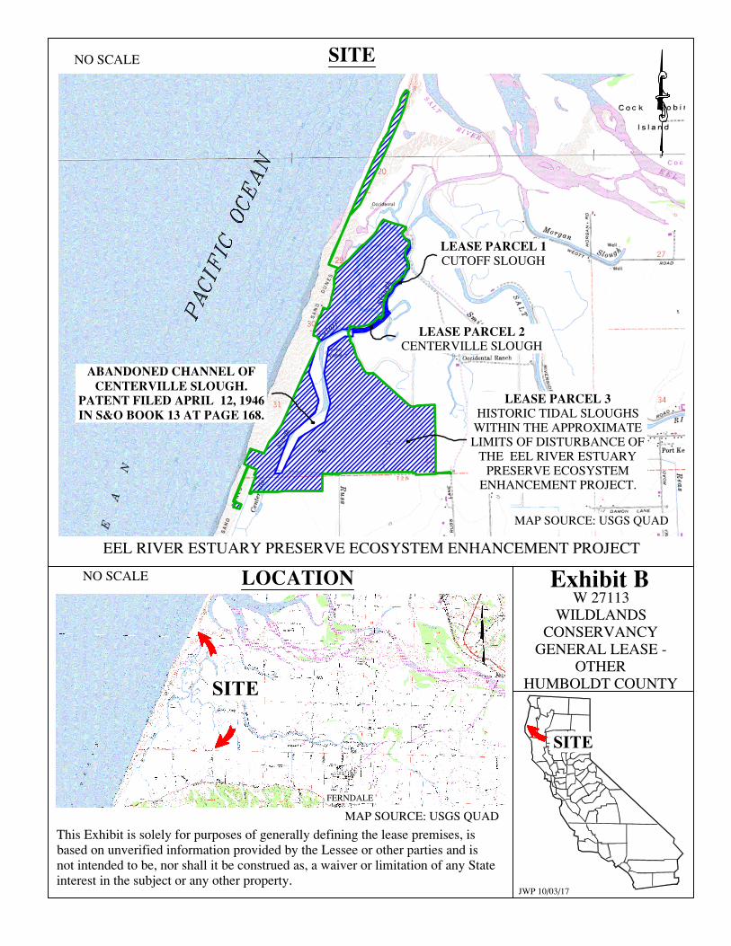
AREA, LAND TYPE, AND LOCATION: Sovereign land in the Eel River Estuary Preserve, including Cutoff Slough, Centerville Slough and historic tidal sloughs within the approximate limits of distubance of the Eel River Estuary Preserve Ecosystem Enhancement Project, adjacent to Assessor's Parcel Numbers 100-121-01, 100-143-01, 100-142-01, 100-131-03 and -04; 100-121-04 and -05, near Ferndale, Humboldt County.
AUTHORIZED USE:
Construction, use, and maintenance of the Eel River Estuary Preserve Ecosystem Enhancement Project, a tide gate, two kayak launching areas, tidal wetlands, ponds and side channels, aquatic habitat cover, interpretive area, gated culverts, a vault toilet, improvements to access roads, repair or removal of culverts and culvert holes, enhancement of existing freshwater ponds, removal of non-native beach grass, establishment of dunes and sediment management areas, improvement of drainage on agricultural land; and temporary construction work areas including cofferdams, diversion pipelines, and fish screens.
LEASE TERM:
25 years, beginning November 29, 2017.
CONSIDERATION: Public use and benefit; with the State reserving the right at any time to set a monetary rent if the Commission finds such action to be in the State’s best interests.
SPECIFIC LEASE PROVISIONS: Liability insurance in an amount no less than $2,000,000 per occurrence.
STAFF REPORT NO. C17 (CONT’D)
-2-
STAFF ANALYSIS AND RECOMMENDATION: Authority:
Public Resources Code sections 6005, 6216, 6301, 6501.1, and 6503; California Code of Regulations, title 2, sections 2000 and 2003.
Public Trust and State’s Best Interests Analysis:
The Wildlands Conservancy has applied for a General Lease – Other for the proposed Eel River Estuary Preserve Ecosystem Enhancement Project (project). The purpose of the project is to improve ecosystem functions that will enhance habitat for aquatic life, support waterfowl and wildlife, and benefit agricultural land management by more effectively managing onsite flooding and sedimentation.
The project area is approximately 1,200 acres and is a historic reclamation district with the purpose of managing tidal inundation, as well as the Eel River and Wildcat Hill stream floodwaters. Tidal salt marsh, brackish marsh, riparian scrub, sloughs and open water channels, freshwater ponds and ditches, and nearshore dune ridges and swales are located within the project area. Cutoff Slough, Centerville Slough and historic tidal sloughs are located on sovereign land in the project area and are subject to lease. The abandoned channel of Centerville Slough is also located within the project area. However, the channel was patented on April 12, 1946, and is no longer sovereign land; therefore, a lease for the project located within the channel is not required at this time. In addition, the existing bridges, proposed new bridge, enhancement and reestablishment of the Centerville Slough, and the existing Cutoff Slough tide gate are not located on sovereign land and a lease is not required at this time. The project area includes nine parcels. Seven of the nine parcels are owned by the Applicant, one parcel is owned by O’Rourke Foundation and one parcel is owned by Harville Ranch LLC. The Applicant is in the process of obtaining access agreements from the other owners. The Applicant has established the largest nonprofit nature preserve system in California. This project is a component of that nature preserve system. This system preserves and restores a variety of areas and makes them available to the public for educational and recreational purposes. A combination of grants from the California State Coastal Conservancy and the California Department of Fish and Wildlife were awarded to California Trout to design and implement the project within the Applicant’s preserve.
Implementation of the project will occur using a phased approach over multiple years and multiple construction seasons. Each season will last approximately 120 days (May through October). The initial phase is
STAFF REPORT NO. C17 (CONT’D)
-3-
proposed to commence in 2018 and will include site preparation and invasive species removal. Construction in 2019 is proposed to include the new tide gate construction and sand dune reconfiguration. Additionally, the side channel and pond complexes within the Inner Marsh will be constructed and connected to existing channels. The Inner Marsh is a 150-acre former salt marsh used for summer grazing and is hydraulically connected with culverts to Cutoff Slough and Centerville Slough. In 2020, the majority of the earthwork is proposed to be completed through the excavation of the Inner Marsh Slough and construction of a new sediment management area. The gates on the new tide gate structure will be opened and seasonal operations will commence.
Construction of a new tide gate structure will re-introduce tidal exchange into the Inner Marsh, enabling tidewaters to re-occupy historic tidal slough channels. As a result, enhancement of aquatic species passage through the Eel River Estuary, Centerville Slough, and Cutoff Slough will occur, while improving drainage efficiency. The new tide gates will be aluminum or stainless steel. The disconnected slough channels in the Inner Marsh will be reconnected through excavation of new connector channels which will further enhance re-introduction of the tidal exchange. Creation and enhancement of tidal pools in the Inner Marsh will occur with grading activities. Introduction of habitat cover for aquatic species will be implemented by anchoring approximately 20 in-channel woody structures within primary or secondary channel banks. Culverts connecting the Inner Marsh with Cutoff and Centerville Sloughs will either be removed and the dike repaired or retrofitted with flap gates. Material from excavated channels will be reused on site to construct refurbished berms or placed in the designated upland agricultural reuse area. Existing freshwater ponds managed for waterfowl will be deepened with controlled inlets and outlets to enhance their habitat value. This enhancement of habitat will protect Public Trust resources in the area. Natural sand dunes are generally self-maintaining; however, the form of the sand dunes can be altered by vegetation, sediment recruitment, storm/wave strength, and geologic changes. Non-native invasive vegetation alters dune mobility and shape. Dunes traditionally migrate, and possess various zones of recruitment. The dunes have been significantly disturbed with movement of sand further into the project area, which facilitates breach and wave over-wash events that have inundated hundreds of acres of pasture with salt water, impacting their agricultural utility and causing conversion to salt marsh. This trend threatens the safety and land use of the project area. The proposed dune work includes
STAFF REPORT NO. C17 (CONT’D)
-4-
trapping and retaining sand in a manner that rebuilds the dune in over-wash areas to former and surrounding heights. The Applicant intends to preserve agricultural land productivity through managed short-grass habitat for pasture. Existing access roads and berms within the project area will be improved by raising and resurfacing with gravel. Culverts will be replaced or installed along the road in areas of poor drainage. Excavation of channels will be through a variety of methods, including track-mounted excavators, scrapers, and large clam-shell type equipment. Clam shell buckets are generally attached to excavators, cranes, or dredges and can be used to excavate both saturated and unconsolidated material. Dredges are not anticipated to be used on this project due to size, weight, and access constraints. The multiple sediment reuse areas coupled with the extent of the project excavation is anticipated to necessitate multiple active staging and excavation sites within the project area. Each work site may include excavators, graders, scrapers, dozers, loaders, dump trucks, small tractors, compactors, and water trucks. Brief restrictions on access to portions of the project area, including Cutoff Slough, Centerville Slough, and historic tidal sloughs are expected during construction for purposes of public safety; however, it is expected that navigation in waterways in the project area will not be impeded. Primary construction access to the project area will be through Russ Lane from Centerville Road with connecting easements. Temporary construction easements will be used to stage equipment, store material, and transport material. Temporary construction areas will be predominantly contained within the same locations as permanent impacted areas such as excavation and fill placement areas (berms, channel corridor, agricultural reuse lands), and within areas where grading will occur such as lowered berms and channels. All areas disturbed by temporary staging and stockpiling will be de-compacted and naturalized as needed prior to project completion. Placement of temporary cofferdams will be used to divert and control water flows in the waterways during in-water work. The cofferdams will include a water bladder, geotextile wrapped fill, sheet piles, or a combination of these types. A combination of pumped or gravity diversion pipes will be used to route flow around the active work areas. If diversion pipes are used, temporary sheet piles will be advanced or pushed into the sediments using non-vibratory methods. Fish screens will be installed immediately upstream from the cofferdams to prevent aquatic life from
STAFF REPORT NO. C17 (CONT’D)
-5-
being transported into the bypass pipe. Turbidity curtains and silt fencing will be used to reduce transport of turbid water. In-water work on the tide gates will take place during low tides since it is not feasible to dewater the structures as the tide gates are located below mean sea level. Seepage water will be pumped to adjacent areas such as adjoining pastures or the back dune area. Ponds and connector channels will be constructed while maintaining an earthen plug at the connection to existing sloughs. Once the final grades are achieved in the newly created habitat, the earthen plugs will be excavated and the habitat allowed to fill in with water. Excavation of the Inner Marsh Slough will be phased and will also utilize earthen plugs to reduce inflow to the active excavation areas.
Public access to the site is from Russ Lane off Centerville Road. Title to the upland includes a right-of-way easement for road uses. The project area is managed for natural resources enhancement, agricultural production, outdoor recreation, and educational opportunities. Public access and recreational components of the project include continuation of access for a waterfowl hunting club, improvements to access roads, trails, an interpretive area, a vault toilet, construction of kayak launch facilities with foot-accessible ramps built of all-weather gravel surfaces to provide recreational amenities for visitors, and installation of interpretative signage at the kayak launch areas. In addition, improvements to the public access parking areas will be completed. The kayak launch ramps will also provide access to the Inner Marsh to facilitate post-project monitoring of the Inner Marsh aquatic educational programs. The addition of these improvements will facilitate the public’s ability to access and enjoy the unique coastal features and Public Trust resources at this location. The Applicant must carry a $2,000,000 per occurrence liability insurance policy to insulate the state from any incidents or damage that could occur in relation to the lease activities. The project will require ongoing maintenance and monitoring activities to ensure that the project meets its goals and objectives; thus, the lease term is for 25 years. Maintenance may require planting to revegetate in the project area, optimization of drainage inflows, integration of sediment and vegetation maintenance.
Climate Change Analysis: Climate change impacts, including sea-level rise, more frequent and intense storm events, and increased flooding and erosion, affect both open coastal areas and inland waterways in California. The project area is located adjacent to the Eel River, and is a tidally influenced site vulnerable to flooding at current sea levels that will be at higher risk of flood exposure given projected scenarios of sea-level rise. The project area ranges in
STAFF REPORT NO. C17 (CONT’D)
-6-
elevation from below sea level to an approximate elevation of 30 feet. Prominent water features within the lease area include the remnant Centerville Slough and Cutoff Slough, as well as smaller (seasonal) slough channels and drainage ditches.
The goal of the project is to improve geomorphic and ecosystem functions to enhance habitat for native fisheries and aquatic species, support waterfowl and wildlife species, and benefit agricultural land management by more effectively managing onsite flooding and sedimentation. This would include increasing resiliency to sea-level rise and reducing salt water influences to pastures, and improving drainage; enhancing tidal processes by restoring tidal prism and increasing reliability of tide gate infrastructure to provide adaptability for sea-level rise and varied land management; and augmenting dune formation to increase resiliency to sea-level rise. The project does not propose to place any habitable structures into the lease area; however, it would include the replacement of an existing culvert with a gated culvert at Centerville/Cutoff Slough and removal of an existing culvert and berm repair in Cutoff Slough.
The risk of flood exposure to portions of the project area under lease is likely to increase with time. The region could see up to 0.8 foot of sea-level rise (from year 2000 levels) by 2030, 1.6 feet by 2050, and approximately 4.7 feet by 2100 (National Research Council 2012). Rising sea levels can lead to more frequent flood inundation in low lying areas and larger tidal events. In addition, as stated in Safeguarding California (California Natural Resources Agency 2014), climate change is projected to increase the frequency and severity of natural disasters related to flooding, fire, drought, extreme heat, and storms (especially when coupled with sea-level rise). In rivers and tidally influenced waterways, more frequent and powerful storms can result in increased flooding conditions and damage from storm-created debris. Climate change and sea-level rise will further influence coastal and riverine areas by changing erosion and sedimentation rates. In rivers and tidally influenced waterways, flooding and storm flow will likely increase scour, decreasing bank stability and structure.
The proposed improvements within the lease area would result in increased resiliency from sea-level rise. Regular maintenance, as required by the lease, will reduce the likelihood of severe structural degradation or dislodgement. Pursuant to the proposed lease, the Applicant acknowledges that the lease premises are located in an area that may be subject to effects of climate change.
STAFF REPORT NO. C17 (CONT’D)
-7-
Conclusion: For all the reasons above, staff believes the proposed lease is consistent with the common law Public Trust Doctrine and is in the best interests of the State.
OTHER PERTINENT INFORMATION:
1. This action is consistent with Strategy 1.1 of the Commission’s Strategic Plan to deliver the highest levels of public health and safety in the protection, preservation and responsible economic use of the lands and resources under the Commission’s jurisdiction.
2. An Environmental Impact Report (EIR), State Clearinghouse No. 2014122040, was prepared for this project by the California State Coastal Conservancy and certified on February 2, 2017. Commission staff has reviewed the EIR and Mitigation Monitoring Program prepared pursuant to the provisions of the California Environmental Quality Act (CEQA) (Pub. Resources Code, § 21081.6) and adopted by the lead agency.
3. The EIR and related project approvals have been challenged in a lawsuit
under CEQA raising issues in various categories including Agricultural Resources, Cultural Resources, Greenhouse Gas Emissions, Hydrology, Recreation and others. (Jack Russ, et al. v. California State Coastal Conservancy, et al., Humboldt County Superior Court (Case No. CV170269).) No injunction or stay has been issued. When a lawsuit has been filed and no stay or injunction has been issued, responsible agencies must assume the EIR complies with the requirements of CEQA and proceed with consideration of the project. If the Commission approves the project, the approval constitutes permission to proceed with the project at the applicant’s risk pending final determination of the lawsuit. (Pub. Resources Code, § 21167.3 subdivision (b).)
4. A Mitigation Monitoring Program and Statement of Findings made in conformance with the State CEQA Guidelines (Cal. Code Regs., tit. 14, §§ 15091, 15096) are contained, respectively, in the attached Exhibits C and D.
5. This activity involves lands identified as possessing significant
environmental values pursuant to Public Resources Code section 6370 et seq., but such activity will not affect those significant lands. Based upon staff’s consultation with the persons nominating such lands and through the CEQA review process, it is staff’s opinion that the project, as proposed, is consistent with its use classification.
STAFF REPORT NO. C17 (CONT’D)
-8-
APPROVALS REQUIRED: U.S. Army Corps of Engineers North Coast Regional Water Quality Control Board California Department of Fish and Wildlife California Coastal Commission Humboldt County U.S. Fish and Wildlife Service National Oceanic and Atmospheric Administration
EXHIBITS: A. Land Description B. Site and Location Map C. Mitigation Monitoring Program D. CEQA Statement of Findings
RECOMMENDED ACTION: It is recommended that the Commission:
CEQA FINDING: Find that an EIR, State Clearinghouse No. 2014122040, was prepared for this Project by the California State Coastal Conservancy and certified on February 2, 2017, and that the Commission has reviewed and considered the information contained therein; that in the Commission’s independent judgement, the scope of activities to be carried out under the lease to be issued by this authorization have been adequately analyzed; that none of the events specified in Public Resources Code section 21166 or the State CEQA Guidelines section 15162 resulting in any new or substantially more severe significant impact has occurred; and, therefore no additional CEQA analysis is required.
Adopt the Mitigation Monitoring Program, as contained in Exhibit C, attached. Adopt the Statement of Findings, made pursuant to California Code of Regulations, title 14, sections 15091 and 15096, subdivision (h), as contained in Exhibit D, attached.
Determine that the project, as approved, will not have a significant effect on the environment.
STAFF REPORT NO. C17 (CONT’D)
-9-
PUBLIC TRUST AND STATE’S BEST INTERESTS: Find that the proposed lease will not substantially impair the public rights to navigation and fishing or substantially interfere with the Public Trust needs and values at this location, at this time, and for the foreseeable term of the lease; is consistent with the common law Public Trust Doctrine; and is in the best interests of the State.
SIGNIFICANT LANDS INVENTORY FINDING:
Find that this activity is consistent with the use classification designated by the Commission for the land pursuant to Public Resources Code section 6370 et seq.
AUTHORIZATION: Authorize issuance of a General Lease – Other to The Wildlands Conservancy, beginning November 29, 2017, for a term of 25 years, for the construction, use, and maintenance of the Eel River Estuary Preserve Ecosystem Enhancement Project, which includes a tide gate, two kayak launching areas, tidal wetlands, ponds and side channels, aquatic habitat cover, interpretive area, gated culverts, a vault toilet, improvements to access roads, repair or removal of culverts and culvert holes, enhancement of existing freshwater ponds, removal of non-native beach grass, establishment of dunes and sediment management areas, improvement of drainage on agricultural land; and temporary construction work areas including cofferdams, diversion pipelines, and fish screens, as described in Exhibit A and shown on Exhibit B (for reference purposes only), attached and by this reference made a part hereof; consideration being the public use and benefit, with the State reserving the right, at any time, to set a monetary rent as specified in the lease if the Commission finds such action to be in the State’s best interests; and liability insurance in an amount no less than $2,000,000 per occurrence.
W 27113WILDLANDS
CONSERVANCYGENERAL LEASE -
OTHERHUMBOLDT COUNTY
MAP SOURCE: USGS QUAD
EEL RIVER ESTUARY PRESERVE ECOSYSTEM ENHANCEMENT PROJECT
This Exhibit is solely for purposes of generally defining the lease premises, isbased on unverified information provided by the Lessee or other parties and isnot intended to be, nor shall it be construed as, a waiver or limitation of any Stateinterest in the subject or any other property.
JWP 10/03/17
NO SCALE
NO SCALE
FERNDALE
SITE
SITE
MAP SOURCE: USGS QUAD
CUTOFF SLOUGH
CENTERVILLE SLOUGH
HISTORIC TIDAL SLOUGHS
WITHIN THE APPROXIMATELIMITS OF DISTURBANCE OF
THE EEL RIVER ESTUARYPRESERVE ECOSYSTEM
ENHANCEMENT PROJECT.
AutoCAD SHX Text
.
AutoCAD SHX Text
PACIFIC OCEAN
November 2017 Page C-1 Eel River Estuary and Centerville SloughEnhancement Project
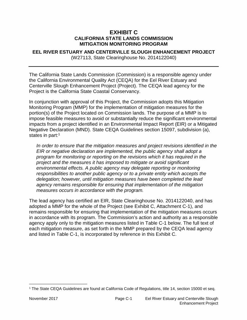
EXHIBIT CCALIFORNIA STATE LANDS COMMISSION
MITIGATION MONITORING PROGRAM
EEL RIVER ESTUARY AND CENTERVILLE SLOUGH ENHANCEMENT PROJECT(W27113, State Clearinghouse No. 2014122040)
The California State Lands Commission (Commission) is a responsible agency underthe California Environmental Quality Act (CEQA) for the Eel River Estuary andCenterville Slough Enhancement Project (Project). The CEQA lead agency for theProject is the California State Coastal Conservancy.
In conjunction with approval of this Project, the Commission adopts this MitigationMonitoring Program (MMP) for the implementation of mitigation measures for theportion(s) of the Project located on Commission lands. The purpose of a MMP is toimpose feasible measures to avoid or substantially reduce the significant environmentalimpacts from a project identified in an Environmental Impact Report (EIR) or a MitigatedNegative Declaration (MND). State CEQA Guidelines section 15097, subdivision (a),states in part:1
In order to ensure that the mitigation measures and project revisions identified in theEIR or negative declaration are implemented, the public agency shall adopt aprogram for monitoring or reporting on the revisions which it has required in theproject and the measures it has imposed to mitigate or avoid significantenvironmental effects. A public agency may delegate reporting or monitoringresponsibilities to another public agency or to a private entity which accepts thedelegation; however, until mitigation measures have been completed the leadagency remains responsible for ensuring that implementation of the mitigationmeasures occurs in accordance with the program.
The lead agency has certified an EIR, State Clearinghouse No. 2014122040, and hasadopted a MMP for the whole of the Project (see Exhibit C, Attachment C-1), andremains responsible for ensuring that implementation of the mitigation measures occursin accordance with its program. The Commission’s action and authority as a responsibleagency apply only to the mitigation measures listed in Table C-1 below. The full text ofeach mitigation measure, as set forth in the MMP prepared by the CEQA lead agencyand listed in Table C-1, is incorporated by reference in this Exhibit C.
1 The State CEQA Guidelines are found at California Code of Regulations, title 14, section 15000 et seq.
Exhibit C – CSLC Mitigation Monitoring Program
November 2017 Page C-2 Eel River Estuary and Centerville SloughEnhancement Project
Table C-1. Project Impacts and Applicable Mitigation Measures
Potential Impact Mitigation Measure (MM)2
Impact AQ-1: Violate Any Air Quality Standardor Result in Cumulatively Considerable NetIncrease of Any Criteria Pollutant for which theProject Region is in Non-attainment.
MM AQ-1: Dust Control Measures duringConstruction.
MM BIO-1a: Avoidance, Minimization, andMitigation for Tidewater Goby.MM BIO-1b: Conduct Pre-construction AvianSurveys for Nesting Passerine Birds and AvianSpecies of Special Concern.MM BIO-1c: Avoid, Minimize, and Mitigate forPotential Impacts to Western Snowy Plover.MM BIO-1d: Habitat Enhancement forNorthern Red-legged Frog.MM BIO-1e: Mitigate for Potential Impacts toSalmonid Species and Longfin Smelt.
MM BIO-3a: Mitigate Impacts to SensitiveListed Habitats through Avoidance and Re-establishment.MM BIO-3b: Mitigate Impacts to SensitiveListed Habitats Through Control of InvasiveSpecies.
Impact BIO-4: Substantial Adverse Effect onFederally and/or State Protected Wetlands.
MM BIO-4: Mitigate Temporary and Short-termImpacts to Sensitive Habitats IncludingWetlands through Construction Minimizationand Avoidance Measures.
Impact CR-1: The Project could cause asubstantial change in the significance of ahistorical or archaeological resource asdefined in Section 15064.5.
MM CR-1: Disturbance of UndiscoveredCultural Resources.
Impact CR-2: The Project could directly orindirectly destroy a unique paleontologicalresource or site or unique geologic feature.
MM CR-2: Potential Disturbance ofUndiscovered Paleontological Resources.
Impact CR-3: The Project could disturb anyhuman remains, including those interredoutside of formal cemeteries.
MM CR-3: Potential to Uncover HumanRemains.
Impact GEO-1: Expose People or Structuresto Potential Substantial Adverse EffectsInvolving Strong Seismic Ground Shaking orSeismic-related Ground Failure, includingLiquefaction.
MM GEO-1: Implement Recommendations inthe Geotechnical Report.
2 See Attachment C-1 for the full text of each MM taken from the MMP prepared by the CEQA lead agency.
Exhibit C – CSLC Mitigation Monitoring Program
November 2017 Page C-3 Eel River Estuary and Centerville SloughEnhancement Project
Potential Impact Mitigation Measure (MM)2
Impact GEO-2: Result in Substantial SoilErosion or Loss of Topsoil.
MM HWQ-1a: Manage Construction StormWater.MM HWQ-1b: Implement Contractor Trainingfor Protection of Water Quality.MM HWQ-1c: In‐Stream Erosion and WaterQuality Control Measures during ChannelExcavation and Operations.MM HWQ-3: Implement Erosion and WaterQuality Monitoring, Maintenance, and AdaptiveManagement Plan.MM GEO-1 (see above)
Impact GEO-3: Be Located on Geologic Unitor Soil that is Unstable, or would becomeUnstable as a Result of the Project, andPotentially Result in Liquefaction, LateralSpreading, Subsidence, or Collapse.
MM GEO-1 (see above)
Impact GEO-4: Be Located on Expansive Soil,as Defined in Table 18-1-B of Uniform BuildingCode (1994), Creating Substantial Risks toLife or Property.
MM GEO-1 (see above)
Impact HWQ-1: Violate any Water QualityStandards or Waste Discharge Requirements.
MM HWQ-1a (see above)
MM HWQ-1b (see above)MM HWQ-1c (see above)
Impact HWQ-3: Substantially Alter the ExistingDrainage Pattern of the Site or Area andIncreasing Erosion or Siltation.
MM HWQ-3 (see above)
Impact HWQ-5: Substantial AdditionalSources of Polluted Runoff or OtherwiseSubstantially Degrade Water Quality.
MM HWQ-1a (see above)MM HWQ-1b (see above)MM HWQ-1c (see above)MM HWQ-3 (see above)
ATTACHMENT C-1
Mitigation Monitoring Program Adopted by the
California State Coastal Conservancy
A-1 Eel River Estuary and Centerville Slough Enhancement Project October 2016 Mitigation Monitoring and Reporting Program
MITIGATION MONITORING AND REPORTING PROGRAM
EEL RIVER ESTUARY AND CENTERVILLE SLOUGH ENHANCEMENT PROJECT
In order to mitigate or avoid significant effects resulting from the proposed project, Public Resources Code Section 21081.6 requires that monitoring and reporting procedures take place through a Mitigation Monitoring and Reporting Program (MMRP). Table A-1 provides the MMRP for the proposed Project in accordance with those guidelines.
MITIGATION MONITORING AND REPORTING PROGRAM
TABLE A-1 MITIGATION MONITORING AND REPORTING PROGRAM
October 2016 A-2 Eel River Estuary and Centerville Slough Enhancement Project
Monitoring Measure
Individual Responsible
for Monitoring
and/or Reporting
Individual or Organization Responsible for Verifying Compliance
Timing of Initial Action
Frequency and/or
Duration of Monitoring
Performance Criteria
Proposed Funding
3.2 Agricultural Resources
AR-1 Pasture Monitoring Plan (not a Mitigation Measure). The Coastal Conservancy shall put in place a Pasture Monitoring Plan to monitor the increase in productivity resulting from the proposed Project for no fewer than five years. The Pasture Monitoring Plan will assess the Project’s ability to provide a more predictable management of flow and sediment in the avulsion areas, and will quantify pasture production for the five-year period. Additionally, the Coastal Conservancy shall place $90,000 into an escrow account, or otherwise cause such funds to be set aside, to be used only in the event that the Pasture Monitoring Plan shows that the projected productivity increases do not occur by the conclusion of the five-year monitoring period. The funds will be used to acquire or otherwise protect or improve agricultural land in or near the Project area for the benefit of the agricultural economy of Humboldt County. The fund amount is based on agricultural land in the Project area being worth an estimated $6,000/acre, and the potential conversion of prime agricultural land being 15 acres. If this outcome is triggered, the funds will be granted to a suitable non-profit or special district capable of and willing to administer the funds. Possible recipients include the Humboldt Resource Conservation District, the Salt River Watershed Council or the Northcoast Regional Land Trust.
Applicant Humboldt County Planning and Building Department
Project operation
Project operation
County/ State standards
Applicant/ Coastal Conservancy
Mitigation Measure
3.3 Air Quality
AQ-1 Dust Control Measures during Construction. The contractor shall implement the following Best Management Practices: 1. All exposed surfaces (e.g., parking areas, staging
areas, soil piles, active graded areas, and unpaved access roads) shall be watered two times per day.
2. All haul trucks transporting soil, sand, or other loose material off-site shall be covered.
Applicant’s Contractor
Humboldt County Planning and Building Department
Project construction
During construction
County/ standards
Applicant
October 2016 A-3 Eel River Estuary and Centerville Slough Enhancement Project
Monitoring Measure
Individual Responsible
for Monitoring
and/or Reporting
Individual or Organization Responsible for Verifying Compliance
Timing of Initial Action
Frequency and/or
Duration of Monitoring
Performance Criteria
Proposed Funding
3. All visible mud or dirt track-out onto adjacent public roads shall be removed using wet power vacuum street sweepers at least once per day. The use of dry power sweeping is prohibited.
4. All vehicle speeds on unpaved roads shall be limited to 15 mph, unless the unpaved road surface has been treated for dust suppression with water, rock, wood chip mulch, or other dust prevention measures.
3.4 Biological Resources
BIO-1a
Avoidance, Minimization, and Mitigation for Tidewater Goby. Because implementing the Project could directly or indirectly harm or kill Tidewater Gobies, the following avoidance and minimization measures will be incorporated into the Project: Construction activities will be phased and conducted
in a sequence that minimizes impacts to Tidewater Gobies. Construction also will be limited to dry-season work windows (June 15 through October 15) to reduce the amount of goby habitat affected and minimize the impact on water quality. Although dry-season work windows may coincide with spawning and larval development, the footprint of available goby habitat may be smaller because summer conditions typically are drier, reducing the area in which Tidewater Gobies may be present. In addition, conducting work during the dry season will minimize the impact on water quality from sediment generated by construction activities and from spills that could occur during construction and maintenance of the Project (e.g., oil, fuel, hydraulic fluid).
Phase Project construction so Tidewater Gobies can be relocated to sites in the Project area but away from areas targeted for restoration. During excavation, Tidewater Gobies may be crushed by equipment or debris or may be removed from
Applicant
USFWS First year of construction during the dry season and pre-operation
During construction and operation
State and Federal standards
Applicant
October 2016 A-4 Eel River Estuary and Centerville Slough Enhancement Project
Monitoring Measure
Individual Responsible
for Monitoring
and/or Reporting
Individual or Organization Responsible for Verifying Compliance
Timing of Initial Action
Frequency and/or
Duration of Monitoring
Performance Criteria
Proposed Funding
channels or marshes unintentionally by equipment. Mortality can be minimized by capturing and relocating Tidewater Gobies out of construction areas. Relocating Tidewater Gobies from areas targeted for restoration to habitat outside of the immediate restoration area before construction begins is intended to protect individual fish; however, improper capture and handling may result in injury or mortality. In addition, Tidewater Gobies that need to be relocated should be taken to areas that have suitable habitat (e.g., where Tidewater Gobies are known to thrive). Therefore, the capture and handling of Tidewater Gobies will be conducted by qualified biologists, and suitable habitats for relocation will be identified before construction begins. Tidewater gobies were successfully translocated as part of restoration activities at the nearby Riverside Ranch (Kramer 2016).
Where dewatering needs to occur, all pump intakes will be screened, and only qualified biologists will conduct goby rescue during dewatering. Dewatering to facilitate excavation and other construction activities may be harmful if Tidewater Gobies become entrained into dewatering pumps or if Tidewater Gobies become stranded.
To compensate for the increased potential for predation by non-native species on Tidewater Gobies, the quantity and quality of post-construction habitat for Tidewater Gobies will be increased in the Project area. Tidewater Goby populations are expected to expand into restored areas and be able to withstand any potential increase in predation by non-native species such as Sacramento Pikeminnow as a result of this increase in complex vegetated aquatic habitat.
Bio-1b Conduct pre-construction Avian Surveys for Nesting Passerine Birds and Avian Species of Special Concern.
Applicant
USFWS; CDFW
Pre-construction
Pre-construction
Federal and State standards
Applicant
October 2016 A-5 Eel River Estuary and Centerville Slough Enhancement Project
Monitoring Measure
Individual Responsible
for Monitoring
and/or Reporting
Individual or Organization Responsible for Verifying Compliance
Timing of Initial Action
Frequency and/or
Duration of Monitoring
Performance Criteria
Proposed Funding
Trees are not present; therefore, none would be removed. Clearing of shrubs or other vegetation, if necessary for construction or maintenance, shall be conducted during the fall and/or winter months from August 16 to February 29, outside of the active nesting season for migratory bird species (i.e., March 1 to August 15). If vegetation removal or ground disturbance cannot be confined to work during the non-breeding season, the applicant shall have a qualified biologist conduct preconstruction surveys within the impact area for ground disturbance, vegetation removal and/or maintenance activities, to check for nesting activity of migratory, raptors, and special-status bird species. The biologist shall conduct the preconstruction surveys within the 14-day period prior to vegetation removal and ground-disturbing activities (on a minimum of three separate days within that 14-day period). If ground disturbance and vegetation removal work lapses for 15 days or longer during the breeding season, a qualified biologist shall conduct a supplemental avian preconstruction survey before Project work may be reinitiated. If active nests are detected within the construction or maintenance (operation) footprint or within 500 feet of construction activities, the applicant shall have locations flagged that are supporting breeding, and will not begin ground disturbing work or vegetation removal inside the buffers until the nests have fledged. Construction activities shall avoid nest sites until the biologist determines that the young have fledged or nesting activity has ceased. If nests are documented outside of the construction (disturbance) footprint, but within 500 feet of the construction area, buffers will be implemented if deemed appropriate in coordination with CDFW. In general, the buffer for common species would be determined on a case-by-case basis with consultation with CDFW, the buffer for sensitive species would be 300 feet, and the buffer for raptors would be 500 feet.
BIO-1c Avoid, Minimize, and Mitigate for Potential Impacts to Applicant USFWS During During Federal Applicant
October 2016 A-6 Eel River Estuary and Centerville Slough Enhancement Project
Monitoring Measure
Individual Responsible
for Monitoring
and/or Reporting
Individual or Organization Responsible for Verifying Compliance
Timing of Initial Action
Frequency and/or
Duration of Monitoring
Performance Criteria
Proposed Funding
Western Snowy Plover. Construction and maintenance activities associated with dune re-establishment would be conducted between September 1 and March 1, outside of the plover nesting season. The area of impact, defined as permanent or semi-permanent change in elevation or conversion to > 30 percent vegetation cover, would be mitigated through enhancement of dunes elsewhere on the EREP site, in the northern half of the dune complex within the site (generally between the northern limit of the Inner marsh and the outlet of the Eel River). Enhancement would occur at a minimum ratio of 1.1:1, and would include removal of European beach grass through mechanical or other appropriate methods; and quarterly maintenance, through removal of re-sprouts, for a period of two years post-construction. The initial removal effort would occur concurrently with the impacts. This would result in no net loss nor temporal loss of suitable Western Snowy Plover breeding habitat.
construction construction, quarterly and for two years post-construction
standards
BIO-1d Habitat Enhancement for Northern Red-legged Frog. Although direct impacts to Northern Red-legged Frog breeding habitat is not anticipated because the duckponds will remain in freshwater conditions, measures for this species are included because individual frogs may disperse for considerable distances and could enter construction areas. Pre-construction surveys would occur prior to ground disturbance in any areas of potential frog habitat (not in saline or tidal areas). After consultation with CDFW, a qualified Project biologist will relocate Northern Red-legged Frog eggs if observed within the direct Project footprint in spring prior to construction or if observed during Project implementation.
Applicant CDFW
Pre-construction
During construction
State standards
Applicant
BIO-1e Mitigate for potential impacts to salmonid species and Longfin Smelt. The in-water construction and maintenance work window will be limited to June 15th through October 15th to avoid or minimize impacts to juvenile salmonids and Longfin
Applicant CDFW/ NOAA Fisheries
Pre-construction and pre-operation
During construction
Federal and State standards
Applicant
October 2016 A-7 Eel River Estuary and Centerville Slough Enhancement Project
Monitoring Measure
Individual Responsible
for Monitoring
and/or Reporting
Individual or Organization Responsible for Verifying Compliance
Timing of Initial Action
Frequency and/or
Duration of Monitoring
Performance Criteria
Proposed Funding
Smelt. Before potential de-watering activities begin in creeks or channels within the Project area, the qualified Biologist shall ensure that native aquatic vertebrates and larger invertebrates, if feasible, are relocated out of the construction footprint into a flowing channel segment by a qualified fisheries biologist. In deeper or larger areas, water levels shall first be lowered to manageable levels using methods to ensure no impacts to fisheries and other special status aquatic species. A qualified fisheries biologist or aquatic ecologist shall then perform appropriate seining or other trapping procedures to a point at which the biologist is assured that almost all individuals within the construction area have been caught. These individuals shall be kept in buckets with aerators to ensure survival. They shall then be relocated to an appropriate flowing channel segment or other appropriate habitat as identified by the qualified Biologist in consultation with NOAA Fisheries and CDFW. Federally threatened salmonid species that occur within the Project area either natal or non-natal Coho salmon, steelhead, and Chinook salmon.
BIO-2a Mitigate Impacts to Beach Layia. The following measures shall be implemented to mitigate impacts to the federally listed beach layia during construction and operation/ongoing maintenance of the Project, primarily associated with dune building on EREP and European beachgrass removal associated with Western Snowy Plover habitat enhancement required by Mitigation Measure BIO-1c. A pre-construction survey shall be conducted prior to the beginning of ground disturbing work and at the appropriate season to verify the extent of known beach layia occurrences and to identify new occurrences on or adjacent to dunes, if any. At the beginning of construction, flagging or exclusion fencing shall be installed around all known occurrences of beach layia within 10 feet of construction limits. Locations of fencing shall be identified and flagged by a qualified biologist and installed while the
Applicant USFWS Pre-construction and pre-operation
Annual monitoring post-construction for two years
No net loss in number of individual plants. If replanting is employed, a 2:1 planting ratio includes built in overplanting in order to meet success criteria and no net loss.
Applicant
October 2016 A-8 Eel River Estuary and Centerville Slough Enhancement Project
Monitoring Measure
Individual Responsible
for Monitoring
and/or Reporting
Individual or Organization Responsible for Verifying Compliance
Timing of Initial Action
Frequency and/or
Duration of Monitoring
Performance Criteria
Proposed Funding
biologist is present. The fencing shall be inspected weekly for the duration of construction to ensure that the fencing remains installed properly. Direct impacts to beach layia shall be avoided. If any new or existing occurrences of beach layia are in proximity to areas of Project-related ground disturbance and if Project activities could conceivably result in indirect impacts such as alteration of dune erosion or deposition patterns, then mitigation will be employed that includes one or more of the following mechanisms: protective wooden fencing to shelter the population from shifting sand, seed collection from the site and/or nearby known occurrences so that replacement plants can be grown out at a nursery and replaced at a stable portion of the site (2:1 planting ratio), seed collection for seed banking in the event indirect impacts occur as a result of the Project in a dynamic coastal environment, plant relocation, and/or preparation of a sensitive species management plan (SSMP) that provides further details about the above options in cooperation with USFWS as to which mechanism(s) are preferred option(s) at the time of impact. The triggering mechanism for seed banking would be if this plant species is identified within 100 feet in a downwind direction of dune establishment, and/or 50 feet in any other direction, or within the footprint of the proposed Western Snowy Plover mitigation area. If an SSMP is deemed appropriate by jurisdictional agencies, the report would lay out specific timing and details of seed collection, mitigation site identification (within EREP), substrate preparation, monitoring and maintenance. If plant replacement, or relocation is deemed necessary (whether through relocation and/or replanting) annual monitoring for two years shall be required, with no net loss of number of individual number of plants. If replanting is employed, a 2:1 planting ratio includes built in overplanting in order to meet success criteria and no net loss.
October 2016 A-9 Eel River Estuary and Centerville Slough Enhancement Project
Monitoring Measure
Individual Responsible
for Monitoring
and/or Reporting
Individual or Organization Responsible for Verifying Compliance
Timing of Initial Action
Frequency and/or
Duration of Monitoring
Performance Criteria
Proposed Funding
Mitigation for special status plant species other than beach layia is addressed collectively for all species, with modifications noted for individual species; this measure is patterned after and slightly modified from one used successfully on the adjacent Salt River (Grassetti et al. 2011). Significant impacts to special-status plant species present or likely to be present onsite shall be minimized, avoided, and (if necessary) compensated by complying with the following: • Pre-construction and maintenance surveys: Potential habitat for special-status plant species shall be surveyed in appropriate seasons for optimal species-specific detection prior to Project excavation/dredging, fill, drainage, or flooding activities associated with Project construction and maintenance. Survey methods shall comply with CNPS/CDFG rare plant survey protocols, and shall be performed by qualified field botanists. Surveys shall be modified to include detection of juvenile (pre-flowering) colonies of perennial species when necessary. Any populations of special-status plant species that are detected shall be mapped. Populations shall be flagged if avoidance is feasible and population is located adjacent to construction areas. Previous special-status plant surveys documented populations of Lyngbye’s sedge and Humboldt Bay owl’s clover as described above. • The locations of any special status plant populations to be avoided shall be clearly identified in the contract documents (plans and specifications). • If special-status plant populations are detected where construction or maintenance would have unavoidable impacts, a compensatory mitigation plan shall be prepared and implemented in coordination with CDFW. Such plans may include salvage, propagation, on-site reintroduction in restored habitats, and monitoring. Plans have been developed for Lyngbye’s sedge, Humboldt Bay owl’s
construction and pre-operation
construction through construction; and monitored for five years post-construction
criteria achieved
October 2016 A-10 Eel River Estuary and Centerville Slough Enhancement Project
Monitoring Measure
Individual Responsible
for Monitoring
and/or Reporting
Individual or Organization Responsible for Verifying Compliance
Timing of Initial Action
Frequency and/or
Duration of Monitoring
Performance Criteria
Proposed Funding
clover, and eelgrass, and will be further revised in consultation with regulatory agencies. Impacts to these species shall be avoided or minimized to the extent feasible. It should be noted that populations of owl’s clover can fluctuate dramatically between years (Pickart 2001), making the number of individuals impacted difficult to predict in advance. • Humboldt Bay owl’s clover: A qualified botanist shall collect and conserve seed from local (preferable on-site, or from the immediate region if on-site sources are insufficient) populations of Humboldt Bay owl’s clover. These seeds shall be used to replant a population of this species to mitigate for the population lost to construction impacts. The Project area shall be monitored for five years and compared with a reference population to determine whether replanting and natural recruitment have resulted in population numbers equal to or greater than those present before Project implementation. If the population does not appear to have reestablished during the five-year period, seed shall be collected from elsewhere and additional attempts shall be made to reestablish the population. • Lyngbye’s sedge: Seed shall be collected from Lyngbye’s sedge in the Project area to be used for replanting in the event that natural recruitment does not result in a post-Project population size equal to or greater than the pre-Project population size. Monitoring and adaptive management will be conducted for a ten year period to determine whether the area and approximate number of Lyngbye’s sedge in the Project area is similar to the area of sedge before the Project. Additional planting efforts (from seed or from rootstock of mature plants) shall be undertaken if the population size is declining below pre-Project size during the monitoring period. • Eelgrass: The extent and density of eelgrass cover within areas of Project impact shall be mapped prior to
October 2016 A-11 Eel River Estuary and Centerville Slough Enhancement Project
Monitoring Measure
Individual Responsible
for Monitoring
and/or Reporting
Individual or Organization Responsible for Verifying Compliance
Timing of Initial Action
Frequency and/or
Duration of Monitoring
Performance Criteria
Proposed Funding
construction. Natural recruitment shall be monitored for three years to determine whether eelgrass is naturally recruiting in newly created channels adequately to replace the area of eelgrass lost due to Project impacts. If eelgrass does not establish in an area equal to or greater than that lost due to Project impacts in the first three years, eelgrass shall be actively planted to offset any lack of natural recruitment, using the most current scientific methods and following NMFS guidance. If CDFW requires propagation or transplantation, scientifically sound genetic management guidelines and protocols for rare plants shall be applied.
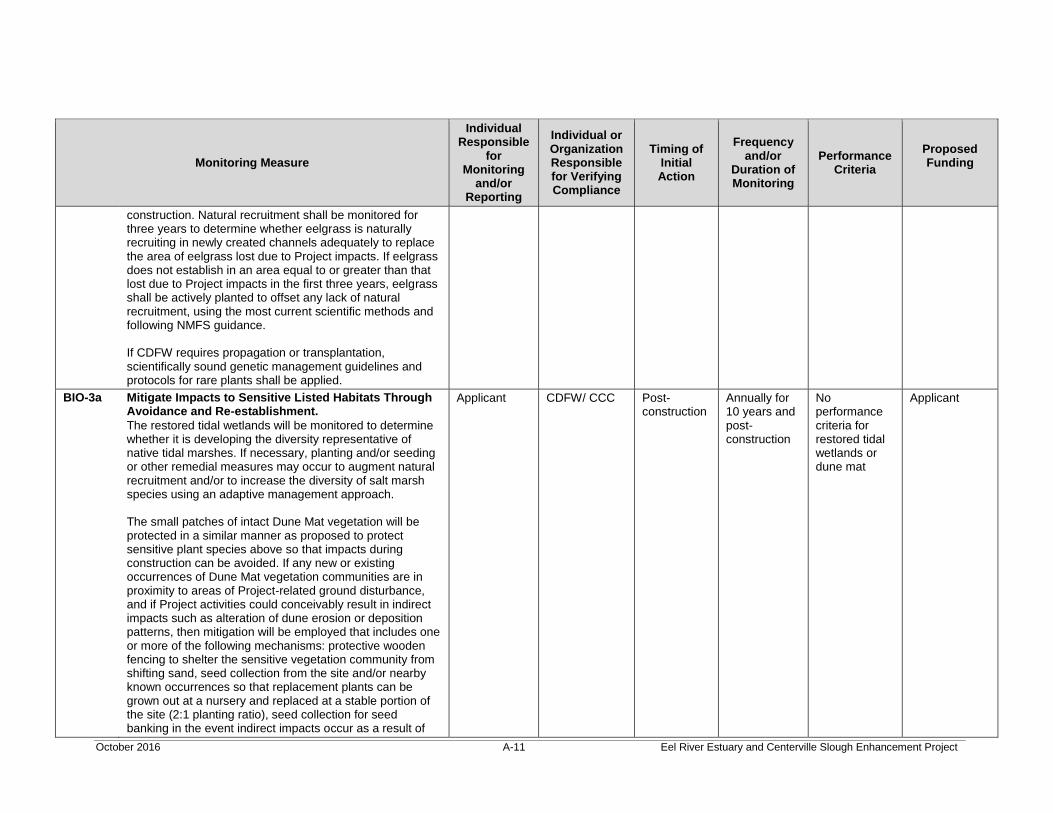
BIO-3a Mitigate Impacts to Sensitive Listed Habitats Through Avoidance and Re-establishment. The restored tidal wetlands will be monitored to determine whether it is developing the diversity representative of native tidal marshes. If necessary, planting and/or seeding or other remedial measures may occur to augment natural recruitment and/or to increase the diversity of salt marsh species using an adaptive management approach. The small patches of intact Dune Mat vegetation will be protected in a similar manner as proposed to protect sensitive plant species above so that impacts during construction can be avoided. If any new or existing occurrences of Dune Mat vegetation communities are in proximity to areas of Project-related ground disturbance, and if Project activities could conceivably result in indirect impacts such as alteration of dune erosion or deposition patterns, then mitigation will be employed that includes one or more of the following mechanisms: protective wooden fencing to shelter the sensitive vegetation community from shifting sand, seed collection from the site and/or nearby known occurrences so that replacement plants can be grown out at a nursery and replaced at a stable portion of the site (2:1 planting ratio), seed collection for seed banking in the event indirect impacts occur as a result of
Applicant CDFW/ CCC Post-construction
Annually for 10 years and post-construction
No performance criteria for restored tidal wetlands or dune mat
Applicant
October 2016 A-12 Eel River Estuary and Centerville Slough Enhancement Project
Monitoring Measure
Individual Responsible
for Monitoring
and/or Reporting
Individual or Organization Responsible for Verifying Compliance
Timing of Initial Action
Frequency and/or
Duration of Monitoring
Performance Criteria
Proposed Funding
the Project in a dynamic coastal environment. BIO-3b Mitigate Impacts to Sensitive Listed Habitats Through
Control of Invasive Species. In order to reduce the likelihood of dense-flowered cordgrass (Spartina) colonizing restored tidal marsh, existing populations in and adjacent to (north of the tidegates) the Project footprint shall be controlled prior to construction using manual, mechanical, and/or approved chemical methods, and in compliance with appropriate methods analyzed and disclosed in the Regional Invasive Spartina Management Plan and the associated EIR. During the operation period of the Project (10 year maintenance under the adaptive management plan), removal of cordgrass would be conducted under the authority of the Regional Invasive Spartina Management Plan and the associated EIR. Colonization of the Inner Marsh and other portions of the Project footprint by cordgrass will be controlled in collaboration with the region-wide eradication program. Invasive weed removal shall be conducted as part of Project maintenance. Weed removal techniques may include manual, mechanical, and/or approved chemical means (including mowing, cutting, pulling, grinding, and/or excavation and burial) as discussed in the adaptive management plan and as approved by jurisdictional agencies. Heavy equipment would be required to be cleaned and weed-free before entering the site.
Applicant CDFW/ CCC
Pre-construction and pre-operation
Pre-construction through construction; and 10 years operation post-construction
Success criteria achieved
Applicant
BIO-4 Mitigate Temporary and Short-term Impacts to Sensitive Habitats Including Wetlands Through Construction Minimization and Avoidance Measures. • The locations of sensitive habitats including wetlands to be avoided shall be clearly identified in the contract documents (plans and specifications).
Applicant USACE/ CCC
Pre-construction
Pre-construction through construction and post-construction for five years
Agency standards
Applicant
October 2016 A-13 Eel River Estuary and Centerville Slough Enhancement Project
Monitoring Measure
Individual Responsible
for Monitoring
and/or Reporting
Individual or Organization Responsible for Verifying Compliance
Timing of Initial Action
Frequency and/or
Duration of Monitoring
Performance Criteria
Proposed Funding
• Before clearing and grubbing commences, disturbance areas shall be flagged to clearly define the limits of the work area. These areas shall be clearly identified on the contract documents (plans and specifications). • Selected contractors shall sign a document stating that they have read, understand, and agree to the required resource avoidance measures, and shall have construction/maintenance crews participate in a training session on sensitive resources. • A qualified biologist shall be on-site to observe activities as appropriate when construction or maintenance in or adjacent to sensitive habitat including wetlands occurs. Site disturbance shall be minimized to the greatest extent feasible by using existing disturbed areas for access roads and staging areas, and concentrating the area of disturbance associated with restoration actions within the minimum space(s) necessary to complete the Project. Where feasible, temporary measures for access or construction, such as the use of temporary tracks or pads, shall be used to minimize impacts. Revegetation activities shall take place at seasonally appropriate times based on habitat types, and as soon as feasible following habitat disturbance, to restore disturbed areas to pre-Project conditions or better. • There would be no net loss of jurisdictional wetlands. Any permanent fill in wetlands would be compensated through in-kind re-establishment or enhancement of wetlands at a ratio determined by use of the USACE SPD Mitigation Ratio Checklist and the California Coastal Commission.
3.5 Cultural Resources
CR-1
Disturbance of Undiscovered Cultural Resources. During the course of ground-disturbing activities associated with Project implementation, if any cultural resources are discovered, work shall be halted immediately within 66 feet
Applicant
Humboldt County Planning and Building
During construction
Throughout construction
County standards
Applicant
October 2016 A-14 Eel River Estuary and Centerville Slough Enhancement Project
Monitoring Measure
Individual Responsible
for Monitoring
and/or Reporting
Individual or Organization Responsible for Verifying Compliance
Timing of Initial Action
Frequency and/or
Duration of Monitoring
Performance Criteria
Proposed Funding
of the discovery, and the Humboldt County Planning Department shall be immediately notified. At that time, the county will coordinate any necessary investigation and evaluation of the discovery with a qualified archaeologist. If the archaeological resources are Native American, representatives of the appropriate culturally affiliated tribe shall also be enlisted to help evaluate the find and suggest appropriate treatment. The county shall consult with the archaeologist and agree upon implementation of treatment of the resources that is deemed appropriate and feasible. Such treatment may include avoidance, curation, documentation, excavation, preservation in place, or other appropriate measures. The final disposition of archaeological, historical, and paleontological resources recovered on State lands under the jurisdiction of the Commission must be approved by the CSLC.
Department
CR-2 Potential Disturbance of Undiscovered Paleontological Resources. During the course of ground-disturbing activities associated with Project implementation, if any paleontological resources are discovered, work shall be halted immediately within 66 feet of the discovery, and the Humboldt County Planning Department shall be immediately notified. At that time, the county will coordinate any necessary investigation of the discovery with a qualified paleontologist. The county shall consider the mitigation recommendations of the qualified paleontologist for any unanticipated discoveries of paleontological resources. The county shall consult with the paleontologist and agree upon implementation of a measure(s) that are deemed appropriate and feasible. Such mitigation measures may include avoidance, curation, documentation, excavation, preservation in place, or other appropriate measures.
Applicant
Humboldt County Planning and Building Department
During construction
Throughout construction
County standards
Applicant
October 2016 A-15 Eel River Estuary and Centerville Slough Enhancement Project
Monitoring Measure
Individual Responsible
for Monitoring
and/or Reporting
Individual or Organization Responsible for Verifying Compliance
Timing of Initial Action
Frequency and/or
Duration of Monitoring
Performance Criteria
Proposed Funding
CR-3 Potential to Uncover Human Remains. If construction activities result in the discovery of human remains during ground disturbing activities, in accordance with California Health and Safety Code Section 7050.5, no further disturbance shall occur until the Coroner has made a determination of origin and disposition pursuant to PRC Section 5097.98. The Coroner shall be notified of the find immediately. If the human remains are determined to be prehistoric, the Coroner shall notify the NAHC, which shall determine and notify a Most Likely Descendant. The Most Likely Descendant shall complete the inspection of the site within 48 hours of notification and may recommend scientific removal and non-destructive analysis of human remains and items associated with Native American burials.
Applicant Humboldt County Coroner
During construction
Continuously during construction
State standards
Applicant
3.6 Geology and Soils
GEO-1 Implement Recommendations in the Geotechnical Report. The California State Coastal Conservancy shall ensure that the Project is designed to comply with the recommendations in the Project’s Geotechnical Report (LACO 2016) to ensure seismic stability and adherence to the CBC. The geotechnical recommendations are proposed to be incorporated in the final plans and specifications and implemented during construction. Professional inspection by a qualified engineer or geologist of foundation and excavation, earthwork and other geotechnical aspects of site development shall be performed during construction in accordance with the current version of the CBC.
Applicant Humboldt County Planning and Building Department
Pre-construction
During construction
County/ State standards
Applicant
3.9 Hydrology and Water Quality
HWQ-1a
Manage Construction Storm Water. The Project and operations shall obtain coverage under State Water Resources Control Board Order No. 2009-0009-DWQ, Waste Discharge Requirements for Discharges of Storm Water Runoff Associated with
Applicant
Humboldt County Planning and Building Department/
Pre-construction
Pre-construction through construction
County/ NCRWQCB standards
Applicant
October 2016 A-16 Eel River Estuary and Centerville Slough Enhancement Project
Monitoring Measure
Individual Responsible
for Monitoring
and/or Reporting
Individual or Organization Responsible for Verifying Compliance
Timing of Initial Action
Frequency and/or
Duration of Monitoring
Performance Criteria
Proposed Funding
Construction and Land Disturbance Activities, as amended by Order No. 2012-0006. In compliance with the NPDES requirements, a Notice of Intent (NOI) shall be prepared and submitted to the NCRWQCB, providing notification and intent to comply with the State of California General Permit. In addition, a Construction Storm Water Pollution Prevention Plan (SWPPP) would be prepared for pollution prevention and control prior to initiating site construction activities. The Construction SWPPP shall identify and specify the use of erosion sediment control BMPs for control of pollutants in stormwater runoff during construction related activities, and would be designed to address water erosion control, sediment control, off-site tracking control, wind erosion control, non-stormwater management control, and waste management and materials pollution control. A sampling and monitoring program shall be included in the Construction SWPPP that meets the requirements of the NCRWQCB to ensure the BMPs are effective. A Qualified Storm Water Pollution Prevention Plan Practitioner shall oversee implementation of the Plan, including visual inspections, sampling and analysis, and ensuring overall compliance. The operations associated with the adaptive management plan include but not limited to activities associated with sediment management and channel maintenance are not anticipated to require preparation and implementation of a SWPPP as per section I (C) of Order No. 2009-0009 DWQ which lists activities that are not covered under the general permit: (24) Routine maintenance to maintain the original line and grade, hydraulic capacity, or original purpose of the facility and (25) Disturbance to land surfaces solely related to agricultural operations such as disking, harrowing, terracing and levelling and soil preparation.
NCRWQCB
HWQ-1b Implement Contractor Training for Protection of Water Quality. All contractors that would be performing demolition,
Applicant
Humboldt County Planning and
Pre-construction
Pre-construction through
County standards
Applicant
October 2016 A-17 Eel River Estuary and Centerville Slough Enhancement Project
Monitoring Measure
Individual Responsible
for Monitoring
and/or Reporting
Individual or Organization Responsible for Verifying Compliance
Timing of Initial Action
Frequency and/or
Duration of Monitoring
Performance Criteria
Proposed Funding
construction, grading, operations or other work that could cause increased water pollution conditions at the site (e.g., dispersal of soils) shall receive training regarding the environmental sensitivity of the site and need to minimize impacts. Contractors also shall be trained in implementation of stormwater BMPs for protection of water quality.
Building Department
construction
HWQ-1c In‐Stream Erosion and Water Quality Control Measures during Channel Excavation and Operations. In instances where excavation occurs in an effort to widen/deepen Project channels and ditches, in-stream erosion and turbidity control measures shall be implemented. These measures include installation and maintenance of in-stream turbidity curtains, cofferdams and silt-fence along channel banks as specified in Project designs, specifications and erosion control plans.
Applicant
Humboldt County Planning and Building Department
During construction
Throughout construction
County standards
Applicant
HWQ-3 Implement Erosion and Water Quality Monitoring, Maintenance and Adaptive Management Plan. The long-term erosion monitoring of on-site channels would routinely screen the Project for areas experiencing excessive erosion leading to degraded water quality. Maintenance and adaptive management strategies are contained in the plan to stabilize areas experiencing excessive erosion.
Applicant
Humboldt County Planning and Building Department
Post-construction
Pre-construction per AMP
County standards
Applicant
November 2017 Page D-1 Eel River Estuary and Centerville Slough
Enhancement Project
EXHIBIT D – EEL RIVER ESTUARY AND CENTERVILLE SLOUGHENHANCEMENT PROJECT
CALIFORNIA STATE LANDS COMMISSIONSTATEMENT OF FINDINGS
1.0 INTRODUCTION
The California State Lands Commission (CSLC), acting as a responsible agency underthe California Environmental Quality Act (CEQA), makes these findings to comply withCEQA as part of its discretionary approval to authorize issuance of a General lease, tothe Wildlands Conservancy (Applicant), for use of sovereign land associated with theproposed Eel River Estuary and Centerville Slough Enhancement Project (Project).(See generally Pub. Resources Code, § 21069; State CEQA Guidelines, § 15381.)1 TheCSLC has jurisdiction and management authority over all ungranted tidelands,submerged lands, and the beds of navigable lakes and waterways. The CSLC also hascertain residual and review authority for tidelands and submerged lands legislativelygranted in trust to local jurisdictions. (Pub. Resources Code, §§ 6301, 6306, 6009,subd. (c).) All tidelands and submerged lands, granted or ungranted, as well asnavigable lakes and waterways, are subject to the protections of the common law PublicTrust.
The CSLC is a responsible agency under CEQA for the Project because the CSLC mustapprove a lease for the Project to go forward and because the California State CoastalConservancy (Coastal Conservancy), as the CEQA lead agency, has the principalresponsibility for approving the Project and has completed its environmental reviewunder CEQA. The Coastal Conservancy analyzed the environmental impactsassociated with the Project in a Final Environmental Impact Report (EIR) (StateClearinghouse [SCH] No. 2014122040) and, in February 2017, certified the EIR andadopted a Mitigation Monitoring and Reporting Program (MMRP) and Findings.
Per the EIR, the Project would improve geomorphic and ecosystem functions that wouldenhance habitat for native fisheries and aquatic species, support waterfowl and wildlifespecies, and benefit agricultural land management by more effectively managing onsiteflooding and sedimentation.
The Coastal Conservancy determined that the Project could have significantenvironmental effects on the following environmental resources:
• Air Quality• Biological Resources• Cultural Resources• Geology/Soils• Hydrology and Water Quality
1 CEQA is codified in Public Resources Code section 21000 et seq. The State CEQA Guidelines arefound in California Code of Regulations, title 14, section 15000 et seq.
Exhibit D – Findings
November 2017 Page D-2 Eel River Estuary and Centerville Slough
Enhancement Project
Of the five resources areas noted above, Project components within the CSLC’sjurisdiction (i.e., the replacement of an existing culvert with a gated culvert atCenterville/Cutoff Slough and removal of an existing culvert and berm repair in CutoffSlough) could have significant environmental effects on all of these resource areas.
In certifying the Final EIR and approving the Project, the Coastal Conservancy imposedvarious mitigation measures for Project-related significant effects on the environment asconditions of Project approval and concluded that Project-related impacts would besubstantially lessened with implementation of these mitigation measures such that theimpacts identified as potentially significant would be less than significant.
As a responsible agency, the CSLC complies with CEQA by considering the EIR andreaching its own conclusions on whether, how, and with what conditions to approve aproject. In doing so, the CSLC may require changes in a project to lessen or avoid theeffects, either direct or indirect, of that part of the project which the CSLC will be calledon to carry out or approve. In order to ensure the identified mitigation measures orProject revisions are implemented, the CSLC adopts the Mitigation Monitoring Program(MMP) as set forth in Exhibit C as part of its Project approval.
2.0 FINDINGS
The CSLC’s role as a responsible agency affects the scope of, but not the obligation toadopt, findings required by CEQA. Findings are required under CEQA by each “publicagency” that approves a project for which an EIR has been certified that identifies oneor more significant impacts on the environment (Pub. Resources Code, § 21081, subd.(a); State CEQA Guidelines, § 15091, subd. (a).) Because the EIR certified by theCoastal Conservancy for the Project identifies potentially significant impacts that fallwithin the scope of the CSLC’s approval, the CSLC makes the Findings set forth belowas a responsible agency under CEQA. (State CEQA Guidelines, § 15096, subd. (h);Riverwatch v. Olivenhain Mun. Water Dist. (2009) 170 Cal.App.4th 1186, 1202, 1207.
While the CSLC must consider the environmental impacts of the Project as set forth inthe EIR, the CSLC’s obligation to mitigate or avoid the direct or indirect environmentalimpacts of the Project is limited to those parts which it decides to carry out, finance, orapprove (Pub. Resources Code, § 21002.1, subd. (d); State CEQA Guidelines, §§15041, subd. (b), 15096, subds. (f)-(g).) Accordingly, because the CSLC’s exercise ofdiscretion involves issuing a General lease for this Project, the CSLC is responsible forconsidering only the environmental impacts related to lands or resources subject to theCSLC’s jurisdiction. With respect to all other impacts associated with implementation ofthe Project, the CSLC is bound by the legal presumption that the EIR fully complies withCEQA.
The CSLC has reviewed and considered the information contained in the Project EIR.All significant adverse impacts of the Project identified in the EIR relating to the CSLC’sapproval of a General Lease, which would allow the replacement of an existing culvertwith a gated culvert at Centerville/Cutoff Slough and removal of an existing culvert and
Exhibit D – Findings
November 2017 Page D-3 Eel River Estuary and Centerville Slough
Enhancement Project
berm repair in Cutoff Slough, are included herein and organized according to theresource affected.
These Findings, which reflect the independent judgment of the CSLC, are intended tocomply with CEQA’s mandate that no public agency shall approve or carry out a projectfor which an EIR has been certified that identifies one or more significant environmentaleffects unless the agency makes written findings for each of those significant effects.Possible findings on each significant effect are:
(1) Changes or alterations have been required in, or incorporated into, the Projectthat avoid or substantially lessen the significant environmental effect as identifiedin the Final EIR.
(2) Such changes or alterations are within the responsibility and jurisdiction ofanother public agency and not the CSLC. Such changes have been adopted bysuch other agency or can and should be adopted by such other agency.
(3) Specific economic, legal, social, technological or other considerations, includingprovision of employment opportunities for highly trained workers, make infeasiblethe mitigation measures or project alternatives identified in the Final EIR.2
A discussion of supporting facts follows each Finding.
• Whenever Finding (1) occurs, the mitigation measures that lessen the significantenvironmental impact are identified in the facts supporting the Finding.
• Whenever Finding (2) occurs, the agencies with jurisdiction are specified. Theseagencies, within their respective spheres of influence, have the responsibility toadopt, implement, and enforce the mitigation discussed.
Because all potentially significant impacts will be reduced to a less than signicant levelthrough mitigation, Finding 3 is not required.
These Findings are supported by substantial evidence contained in the EIR, the leadagency’s Findings (Attachment D-1), and other relevant information provided to theCSLC or existing in its files, all of which is contained in the administrative record. Themitigation measures are briefly described in these Findings; more detail on themitigation measures is included in the Final EIR.
The CSLC is the custodian of the record of proceedings upon which its decision isbased. The location of the CSLC’s record of proceedings is in the Sacramento office ofthe CSLC, 100 Howe Avenue, Suite 100-South, Sacramento, CA 95825.
2 See Public Resources Code section 21081, subdivision (a) and State CEQA Guidelines section 15091,subdivision (a).
Exhibit D – Findings
November 2017 Page D-4 Eel River Estuary and Centerville Slough
Enhancement Project
A. SUMMARY OF FINDINGS
Based on public scoping, the proposed Project will have No Impact on the followingenvironmental issue areas:
• Population and Housing
The EIR subsequently identified the following impacts as Less Than Significant:
• Aesthetics• Agricultural Resources• Greenhouse Gas Emissions• Hazards and Hazardous Materials• Land Use and Planning• Mineral and Energy Resources• Noise• Public Services and Utilities• Recreation• Transportation
For the remaining potentially significant effects, the Findings are organized bysignificant impacts within the EIR issue areas as presented below.
B. IMPACTS REDUCED TO LESS THAN SIGNIFICANT LEVELS WITHMITIGATION
The impacts identified below were determined in the Final EIR to be potentiallysignificant absent mitigation; after application of mitigation, however, the impacts weredetermined to be less than significant. For the full text of each mitigation measure (MM),please refer to Exhibit C, Attachment C-1.
Air Quality AQ-1Biological Resources BIO-1, BIO-2, BIO-3, BIO-4Cultural Resources CR-1, CR-2, CR-3Geology/Soils GEO-1, GEO-2, GEO-3, GEO-4Hydrology and Water Quality HWQ-1, HWQ-3, HWQ-5
Exhibit D – Findings
November 2017 Page D-5 Eel River Estuary and Centerville Slough
Enhancement Project
1. AIR QUALITY
CEQA FINDING NO. AQ-1
Impact: Impact AQ-1. Violate Any Air Quality Standard or Result inCumulatively Considerable Net Increase of Any Criteria Pollutant forwhich the Project Region is in Non-attainment. Unless controlled,fugitive dust emissions during construction of the proposed Project could bea significant impact.
Finding(s): (1) Changes or alterations have been required in, or incorporated into, theproject that mitigate or avoid the significant environmental effect asidentified in the EIR.
FACTS SUPPORTING THE FINDING(S)
Construction emissions would not exceed significance thresholds; however, earth-moving activities would generate fugitive dust (particulate matter 10 micrometers or lessin diameter [PM10]). The amount of fugitive dust generated would be highly variable andis dependent on the size of the area disturbed at any given time, amount of activity, soilconditions, and meteorological conditions. Implementation of MM AQ-1 has beenincorporated into the Project to reduce this impact to a less than significant level.
MM AQ-1: Dust Control Measures during Construction
LEVEL OF SIGNIFICANCE AFTER MITIGATION. With the mitigation described above,this impact is reduced to a less than significant level.
2. BIOLOGICAL RESOURCES
CEQA FINDING NO. BIO-1
Impact: Impact BIO-1. Substantial Adverse Effect on Special-Status WildlifeSpecies. Construction and operation of the proposed Project could directlyor indirectly impact populations of tidewater gobies, raptors, migratory birds,western snowy plover, northern red-legged frog, salmonids, and theirhabitats
Finding(s): (1) Changes or alterations have been required in, or incorporated into, theproject that mitigate or avoid the significant environmental effect asidentified in the EIR.
FACTS SUPPORTING THE FINDING(S)
The Project would require activities that could directly or indirectly affect special-statuswildlife species, including retrofit of the existing tide gates, the installation of new tidegates, improvements to Centerville Slough, the reconnection of Centerville Slough toRuss Creek and Shaw Creek, and the improvement of existing, and establishment ofnew, off-channel habitat in the Project area. Operational activities could also directly or
Exhibit D – Findings
November 2017 Page D-6 Eel River Estuary and Centerville Slough
Enhancement Project
indirectly affect some species. MMs BIO-1a through BIO-1e would be incorporated intothe Project to minimize the impacts on species to a less than significant level.
MM BIO-1a: Avoidance, Minimization, and Mitigation for Tidewater Goby
MM BIO-1b: Conduct pre-construction Avian Surveys for Nesting PasserineBirds and Avian Species of Special Concern
MM BIO-1c: Avoid, Minimize, and Mitigate for Potential Impacts to WesternSnowy Plover
MM BIO-1d: Habitat Enhancement for Northern Red-legged Frog
MM BIO-1e: Mitigate for Potential Impacts to Salmonid Species and LongfinSmelt
LEVEL OF SIGNIFICANCE AFTER MITIGATION. With the mitigation described above,this impact is reduced to a less than significant level.
CEQA FINDING NO. BIO-2
Impact: Impact BIO-2. Substantial Adverse Effect on Special-Status PlantSpecies. The proposed Project could directly or indirectly impactpopulations of one federally listed and several California Rare Plant Rank -listed plant species.
Finding(s): (1) Changes or alterations have been required in, or incorporated into, theproject that mitigate or avoid the significant environmental effect asidentified in the EIR.
FACTS SUPPORTING THE FINDING(S)
The Project footprint would avoid direct impacts to populations of sensitive listed plantspecies that have been mapped on the site except for Lyngbye’s sedge in areasadjacent to installation of the new tidegate. The proposed Project could also directly orindirectly impact populations of one federally listed plant species (Beach Layia), andseveral California Rare Plant Rank-listed plant species through changes in tidal prismand site hydrology, operation activities, post-construction (operational) changes in sandmovement associated with foredunes, if new plant populations are identified beyond thepreviously mapped extent, or if new species are identified at the site. Implementation ofMMs BIO-2a and BIO-2b has been incorporated into the Project to reduce this impactto a less than significant level.
MM BIO-2a: Mitigate Impacts to Beach Layia
MM BIO-2b: Mitigate Impacts to Sensitive-Listed Plant Species
Exhibit D – Findings
November 2017 Page D-7 Eel River Estuary and Centerville Slough
Enhancement Project
LEVEL OF SIGNIFICANCE AFTER MITIGATION. With the mitigation described above,this impact is reduced to a less than significant level.
CEQA FINDING NO. BIO-3
Impact: Impact BIO-3. Substantial Adverse Effect on Sensitive NaturalCommunity. Four sensitive natural vegetation communities identified withinthe Project area include dune mat, saltmarsh bulrush, coastal dune willowthickets, and pickleweed mats.
Finding(s): (1) Changes or alterations have been required in, or incorporated into, theproject that mitigate or avoid the significant environmental effect asidentified in the EIR.
FACTS SUPPORTING THE FINDING(S)
Temporary impacts to the 41.7 acres of combined saltmarsh habitats (saltmarsh bulrushand pickleweed) would be considered a significant impact. In addition, constructionactivities could import noxious weed propagules on construction machinery. Avoidanceand re-establishment of sensitive habitats and control of invasive species as stipulatedin MMs BIO-3a and BIO-3b would reduce this impact to a less than significant level.
MM BIO-3a: Mitigate Impacts to Sensitive Listed Habitats through Avoidanceand Re-establishment
MM BIO-3b: Mitigate Impacts to Sensitive Listed Habitats Through Control ofInvasive Species
LEVEL OF SIGNIFICANCE AFTER MITIGATION. With the mitigation described above,this impact is reduced to a less than significant level.
CEQA FINDING NO. BIO-4
Impact: Impact BIO-4. Substantial Adverse Effect on Federally and/or StateProtected Wetlands. The Project design includes both filling of two andthree parameter wetlands, as well as re-establishment of new wetlands.
Finding(s): (1) Changes or alterations have been required in, or incorporated into, theproject that mitigate or avoid the significant environmental effect asidentified in the EIR.
FACTS SUPPORTING THE FINDING(S)
Although no net loss overall to wetland acreage/quantity or quality is expected, theproposed Project could result in short-term temporary impacts to permanent, seasonal,and transitional wetland areas. Construction activities associated with restoration woulddisturb wetlands and waters through vegetation clearing activities, grading andinstallation of restoration features, dewatering activities, and construction and use ofaccess roads and staging areas for construction equipment, materials and stockpiles.
Exhibit D – Findings
November 2017 Page D-8 Eel River Estuary and Centerville Slough
Enhancement Project
Minimization and avoidance measures, as included in MM BIO-4, have beenincorporated into the Project to reduce this impact to a less than significant level.
MM BIO-4: Mitigate Temporary and Short-term Impacts to Sensitive HabitatsIncluding Wetlands through Construction Minimization and AvoidanceMeasures
LEVEL OF SIGNIFICANCE AFTER MITIGATION. With the mitigation described above,this impact is reduced to a less than significant level.
3. CULTURAL RESOURCES
CEQA FINDING NO. CR-1
Impact: Impact CR-1. The Project could cause a substantial change in thesignificance of a historical or archaeological resource as defined inSection 15064.5. Unanticipated buried archaeological materials may bepresent at the Project site.
Finding(s): (1) Changes or alterations have been required in, or incorporated into, theproject that mitigate or avoid the significant environmental effect asidentified in the EIR.
FACTS SUPPORTING THE FINDING(S)
Due to an extensive history of flooding and silt deposits in the area, significant historicalor unique archaeological resources, if buried on the Project site, could potentially gounobserved during field surveys. Implementation of MM CR-1 has been incorporatedinto the Project to reduce this impact to a less than significant level.
MM CR-1: Disturbance of Undiscovered Cultural Resources
LEVEL OF SIGNIFICANCE AFTER MITIGATION. With the mitigation described above,this impact is reduced to a less than significant level.
CEQA FINDING NO. CR-2
Impact: Impact CR-2. The Project could directly or indirectly destroy a uniquepaleontological resource or site or unique geologic feature.Unanticipated, buried paleontological resources may be present at theProject site.
Finding(s): (1) Changes or alterations have been required in, or incorporated into, theproject that mitigate or avoid the significant environmental effect asidentified in the EIR.
Exhibit D – Findings
November 2017 Page D-9 Eel River Estuary and Centerville Slough
Enhancement Project
FACTS SUPPORTING THE FINDING(S)
There are no known unique paleontological resources or geologic features on theProject site. Because the sand dunes are relatively new geologically, and river floodingover the decades has resulted in silt deposits, the likelihood of the proposed Projectaffecting paleontological resources is low. However, there is the possibility ofunanticipated discovery of paleontological resources during ground-disturbing activitiesassociated with construction of the Project. Implementation of MM CR-2 has beenincorporated into the Project to reduce this impact to a less than significant level.
MM CR-2: Potential Disturbance of Undiscovered Paleontological Resources
LEVEL OF SIGNIFICANCE AFTER MITIGATION. With the mitigation described above,this impact is reduced to a less than significant level.
CEQA FINDING NO. CR-3
Impact: Impact CR-3. The Project could disturb any human remains, includingthose interred outside of formal cemeteries. Disturbance of buriedhuman remains could result in a significant impact.
Finding(s): (1) Changes or alterations have been required in, or incorporated into, theproject that mitigate or avoid the significant environmental effect asidentified in the EIR.
FACTS SUPPORTING THE FINDING(S)
While no evidence exists for the presence of historic or prehistoric burials at the Projectsite, this does not preclude the existence of buried subsurface human remains. If anyhuman remains were unearthed during Project construction, particularly those that weredetermined to be Native American, a potentially significant disturbance of humanremains would occur. Implementation of MM CR-3 has been incorporated into theProject to reduce this impact to a less than significant level.
MM CR-3: Potential to Uncover Human Remains
LEVEL OF SIGNIFICANCE AFTER MITIGATION. With the mitigation described above,this impact is reduced to a less than significant level.
Exhibit D – Findings
November 2017 Page D-10 Eel River Estuary and Centerville Slough
Enhancement Project
4. GEOLOGY AND SOILS
CEQA FINDING NO. GEO-1
Impact: Impact GEO-1. Expose People or Structures to Potential SubstantialAdverse Effects Involving Strong Seismic Ground Shaking or Seismic-related Ground Failure, including Liquefaction. Past seismic historysuggests that the Project area is susceptible to moderate to strong seismicground shaking.
Finding(s): (1) Changes or alterations have been required in, or incorporated into, theproject that mitigate or avoid the significant environmental effect asidentified in the EIR.
FACTS SUPPORTING THE FINDING(S)
The Project includes reinforced structures that would be at risk of collapse fromgroundshaking, and road (haul roads and access roads) improvements that would besusceptible to damage during strong seismic ground shaking. The Project site is in anarea with a high liquefaction potential. Quantitative liquefaction analysis indicates thatthe unconsolidated alluvium underlying the Ferndale bottoms is susceptible toliquefaction. Implementation of MM GEO-1, which will ensure seismic stability andadherence to the California Building Code, has been incorporated into the Project toreduce this impact to a less than significant level.
MM GEO-1: Implement Recommendations in the Geotechnical Report
LEVEL OF SIGNIFICANCE AFTER MITIGATION. With the mitigation described above,this impact is reduced to a less than significant level.
CEQA FINDING NO. GEO-2
Impact: Impact GEO-2. Result in Substantial Soil Erosion or Loss of Topsoil.Grading, earthwork, and stockpiling during construction and maintenancecould result in increased potential for erosion or loss of topsoil.
Finding(s): (1) Changes or alterations have been required in, or incorporated into, theproject that mitigate or avoid the significant environmental effect asidentified in the EIR.
FACTS SUPPORTING THE FINDING(S)
The potential for increased soil erosion or loss of topsoil due to Project activities(grading, earthwork, stockpiling) would be reduced with the implementation of the MMsnoted below. Most Project actions are designed to reduce/control flooding hazards andsusceptibility of soil to erosion or loss of topsoil. All soil areas disturbed duringconstruction would be treated with adequate erosion control practices and revegetatedto further ensure long-term stabilization pursuant to the Stormwater Pollution PreventionPlan. Levees, berms, and access and haul roads would be constructed with additional
Exhibit D – Findings
November 2017 Page D-11 Eel River Estuary and Centerville Slough
Enhancement Project
best management practices to ensure immediate protection from erosion and wouldalso include design components (e.g., erosion-resistant vegetation, aggregate baserock for access and haul roads) as needed to ensure long-term stability. Implementationof the MMs noted below has been incorporated into the Project to reduce this impact toa less than significant level.
MM HWQ-1a: Manage Construction Storm Water
MM HWQ-1b: Implement Contractor Training for Protection of Water Quality
MM HWQ-1c: In‐Stream Erosion and Water Quality Control Measures duringChannel Excavation and Operations
MM HWQ-3: Implement Erosion and Water Quality Monitoring, Maintenanceand Adaptive Management Plan
MM GEO-1. Implement Recommendations in the Geotechnical Report
LEVEL OF SIGNIFICANCE AFTER MITIGATION. With the mitigation described above,this impact is reduced to a less than significant level.
CEQA FINDING NO. GEO-3
Impact: Impact GEO-3. Be Located on Geologic Unit or Soil that is Unstable, orwould become Unstable as a Result of the Project, and PotentiallyResult in Liquefaction, Lateral Spreading, Subsidence, or Collapse.Soils in the Project area are susceptible to liquefaction.
Finding(s): (1) Changes or alterations have been required in, or incorporated into, theproject that mitigate or avoid the significant environmental effect asidentified in the EIR.
FACTS SUPPORTING THE FINDING(S)
The Project site is potentially susceptible to lateral spreading from liquefaction.Subsidence from liquefaction could also occur. Tidegates, berms, access and haulroads, and bridges could be susceptible to damage or collapse. Implementation of MMGEO-1, which will require a site-specific geotechnical report, and design andconstruction in conformance with applicable design standards, has been incorporatedinto the Project to reduce this impact to a less than significant level.
MM GEO-1: Implement Recommendations in the Geotechnical Report
LEVEL OF SIGNIFICANCE AFTER MITIGATION. With the mitigation described above,this impact is reduced to a less than significant level.
Exhibit D – Findings
November 2017 Page D-12 Eel River Estuary and Centerville Slough
Enhancement Project
CEQA FINDING NO. GEO-4
Impact: Impact GEO-4: Be Located on Expansive Soil, as Defined in Table 18-1-B of Uniform Building Code (1994), Creating Substantial Risks toLife or Property. Expansive soils can damage structures and foundations.
Finding(s): (1) Changes or alterations have been required in, or incorporated into, theproject that mitigate or avoid the significant environmental effect asidentified in the EIR.
FACTS SUPPORTING THE FINDING(S)
The geotechnical report prepared for the Project identified moderate to highly plasticclays, which are potentially expansive, in borings excavated along Centerville Slough,the proposed Russ Creek Channel alignments, and in the Inner Marsh. A site-specificgeotechnical report and design and construction in conformance with applicable designstandards would reduce the risk to life or property due to expansive soils.Implementation of MM GEO-1, which will require a site-specific geotechnical report, anddesign and construction in conformance with applicable design standards, has beenincorporated into the Project to reduce this impact to a less than significant level.
MM GEO-1: Implement Recommendations in the Geotechnical Report
LEVEL OF SIGNIFICANCE AFTER MITIGATION. With the mitigation described above,this impact is reduced to a less than significant level.
5. HYDROLOGY AND WATER QUALITY
CEQA FINDING NO. HWQ-1
Impact: Impact HWQ-1. Violate any Water Quality Standards or WasteDischarge Requirements. Project impacts to water quality could resultfrom sediment mobilization during channel/wetland construction andoperations.
Finding(s): (1) Changes or alterations have been required in, or incorporated into, theproject that mitigate or avoid the significant environmental effect asidentified in the EIR.
FACTS SUPPORTING THE FINDING(S)
Construction and operation activities such as site clearing, grading, excavation, channelwidening/deepening, material stockpiling, tide gate removal and installation, demolition,and berm construction could leave soils exposed to rain or surface water runoff thatmay carry soil contaminants (e.g., nutrients or other pollutants) into waterways adjacentto the site, degrade water quality, and potentially violate water quality standards forspecific chemicals, dissolved oxygen, suspended sediment, or nutrients.Implementation of MMs HWQ-1a, -1b, and -1c, which will ensure that construction and
Exhibit D – Findings
November 2017 Page D-13 Eel River Estuary and Centerville Slough
Enhancement Project
operation activities associated with the Project are properly managed, has beenincorporated into the Project to reduce this impact to a less than significant level.
MM HWQ-1a: Manage Construction Storm Water
MM HWQ-1b: Implement Contractor Training for Protection of Water Quality
MM HWQ-1c: In‐Stream Erosion and Water Quality Control Measures duringChannel Excavation and Operations
LEVEL OF SIGNIFICANCE AFTER MITIGATION. With the mitigation described above,this impact is reduced to a less than significant level.
CEQA FINDING NO. HWQ-3
Impact: Impact HWQ-3. Substantially Alter the Existing Drainage Pattern of theSite or Area and Increasing Erosion or Siltation. The Project proposesthe beneficial reuse of excavation material to recontour the floodplain inspecific areas and for agronomic placement in upland areas located on thevalley floor.
Finding(s): (1) Changes or alterations have been required in, or incorporated into, theproject that mitigate or avoid the significant environmental effect asidentified in the EIR.
FACTS SUPPORTING THE FINDING(S)
All sediment reuse areas would be located within the Federal Emergency ManagementAgency (FEMA) flood zone and subject to potential localized remobilization during floodperiods. The Project and operations would alter drainage patterns of the site, althoughinternal slough channels would be located and sized to optimize internal marshcirculation and water quality. Through intensive hydraulic modeling and establishedhydraulic geometry relationships for local area reference sites, internal channeldimensions are designed to be in equilibrium with Project hydraulic conditions in orderto minimize erosion, down-cutting and bank failure. Bioengineering methods would beused, as necessary, to stabilize sites of potential bank and berm erosion. Hardstabilization measures (e.g., rock slope protection) may also be incorporated, ifnecessary, to prohibit excessive erosion at notable energy transition points such asculverts, bridges and gates. Measures to protect new setback berms and existinglevees from erosion would also be integrated into the stable Project design.Implementation of MM HWQ-3 has been incorporated into the Project to reduce thisimpact to a less than significant level.
MM HWQ-3: Implement Erosion and Water Quality Monitoring, Maintenanceand Adaptive Management Plan
LEVEL OF SIGNIFICANCE AFTER MITIGATION. With the mitigation described above,this impact is reduced to a less than significant level.
Exhibit D – Findings
November 2017 Page D-14 Eel River Estuary and Centerville Slough
Enhancement Project
CEQA FINDING NO. HWQ-5
Impact: Impact HWQ-5. Substantial Additional Sources of Polluted Runoff orOtherwise Substantially Degrade Water Quality. The development of theproposed Project and operations and intended land use would alter thetypes, quantities, and timing of stormwater contaminates relative to existingconditions.
Finding(s): (1) Changes or alterations have been required in, or incorporated into, theproject that mitigate or avoid the significant environmental effect asidentified in the EIR.
FACTS SUPPORTING THE FINDING(S)
If altered stormwater runoff is uncontrolled and not treated, the water quality of thedischarge could affect offsite drainage channels and downstream water bodies.Construction activities could result in substantial stormwater discharges of suspendedsolids and other pollutants into local drainage channels from the Project area.Construction and operational related chemicals (e.g., fuels, paints, adhesives, etc.)could be washed into surface waters by stormwater runoff. The deposition of pollutants(e.g., gas, oil, etc.) onto the ground surface by construction equipment could similarlyresult in the transport of pollutants to surface waters by stormwater runoff or in seepageof such pollutants into groundwater.
Implementation of MMs HWQ-1a, -1b, -1c, and HWQ-3, which will ensure that Projectconstruction and operation activities are properly managed, has been incorporated intothe Project to reduce this impact to a less than significant level.
MM HWQ-1a: Manage Construction Storm Water
MM HWQ-1b: Implement Contractor Training for Protection of Water Quality
MM HWQ-1c: In‐Stream Erosion and Water Quality Control Measures duringChannel Excavation and Operations
MM HWQ-3: Implement Erosion and Water Quality Monitoring, Maintenanceand Adaptive Management Plan
LEVEL OF SIGNIFICANCE AFTER MITIGATION. With the mitigation described above,this impact is reduced to a less tan significant level.
ATTACHMENT D-1
California State Coastal ConservancyResolution and Findings
Page 1 of 26
COASTAL CONSERVANCY
Staff Recommendation
February 2, 2017
EEL RIVER ESTUARY AND CENTERVILLE SLOUGH ENHANCEMENT PROJECT:
IMPLEMENTATION
Project No.: 12-018-03
Project Manager: Michael Bowen
RECOMMENDED ACTION: Consideration and certification of the Final Environmental
Impact Report (EIR) for the Eel River Estuary and Centerville Slough Enhancement Project;
approval of the version of the project identified as Alternative 4 in that report (“the Project”);
adoption of findings and Mitigation Monitoring and Reporting Program; and authorization to
disburse up to $950,000 of U.S. Fish and Wildlife Service funds to The Wildlands Conservancy
for implementation of the Project.”
LOCATION: Centerville Slough, tributary to the Salt River, near Ferndale, Humboldt County
(Exhibit 1)
PROGRAM CATEGORY: Coastal Resource Enhancement
EXHIBITS
Exhibit 1: Project Location Maps and Alternatives
Exhibit 2: Proposed Actions and Budget
Exhibit 3: Staff Recommendation April 18, 2013
Exhibit 4: Final EIR
Exhibit 5: Mitigation Monitoring and Reporting Program and Adaptive
Management Program.
Exhibit 6: Project Letters
RESOLUTION AND FINDINGS:
Staff recommends that the State Coastal Conservancy adopt the following resolution pursuant to
Sections 31251 – 31270 of the Public Resources Code:
“The State Coastal Conservancy hereby certifies the Final Environmental Impact Report, Eel
River Estuary and Centerville Slough Enhancement Project, January 2017 (Final EIR), approves
the version of the Eel River Estuary and Centerville Slough Enhancement Project identified as
Alternative 4 in the Final EIR (“the Project”) at Centerville Slough, near Ferndale (Exhibit 1),