STAFF REPORT FOR COASTAL DEVELOPMENT USE PERMIT #CDU 7-2009 (CSSC) July 2, 2009 Page PC-1 OWNERS: Caspar South Service Company PO Box 774 Mendocino, CA 95460 Marc Wasserman PO Box 1510 Mendocino, CA 95460 Charles A. Young PO Box 232 Mendocino, CA 95460 APPLICANT: Caspar South Service Company PO Box 774 Mendocino, CA 95460 AGENT: LACO Associates P.O. Box 1023 Eureka, CA 95502 REQUEST: Coastal bluff repair using a maximum of approximately 20 feet deep, 65 feet wide “Geoweb.” Accelerated bluff erosion needs to be corrected because it is encroaching on water and septic disposal lines. LOCATION: In the Coastal Zone, approximately ½ mile south of Caspar in the South Caspar Subdivision west of Highway One at 45520 and 45550 Otter Point Circle (CR 542) (APNs 118-360-26, -10, & -24). TOTAL ACREAGE: 2.2± acres GENERAL PLAN: RR-5 [RR-1] ZONING: RR: L-5 [RR: L-1] EXISTING USES: Residential; Utility Easement ADJACENT ZONING: RR: L-5 [RR: L-1] SURROUNDING LAND USES: Residential SUPERVISORY DISTRICT: 4 COASTAL RECORDS PROJECT: Image 200503349 OTHER RELATED APPLICATIONS ON SITE OR SURROUNDING AREA: CDP 65-97, residential additions on parcel 118-360-26
Transcript
STAFF REPORT FOR COASTAL DEVELOPMENT USE PERMIT #CDU 7-2009 (CSSC) July 2, 2009
Page PC-1 OWNERS: Caspar South Service Company PO Box 774 Mendocino, CA 95460 Marc Wasserman PO Box 1510 Mendocino, CA 95460 Charles A. Young PO Box 232 Mendocino, CA 95460 APPLICANT: Caspar South Service Company PO Box 774 Mendocino, CA 95460 AGENT: LACO Associates P.O. Box 1023 Eureka, CA 95502 REQUEST: Coastal bluff repair using a maximum of approximately 20 feet
deep, 65 feet wide “Geoweb.” Accelerated bluff erosion needs to be corrected because it is encroaching on water and septic disposal lines.
LOCATION: In the Coastal Zone, approximately ½ mile south of Caspar in the
South Caspar Subdivision west of Highway One at 45520 and 45550 Otter Point Circle (CR 542) (APNs 118-360-26, -10, & -24).
TOTAL ACREAGE: 2.2± acres GENERAL PLAN: RR-5 [RR-1] ZONING: RR: L-5 [RR: L-1] EXISTING USES: Residential; Utility Easement ADJACENT ZONING: RR: L-5 [RR: L-1] SURROUNDING LAND USES: Residential SUPERVISORY DISTRICT: 4 COASTAL RECORDS PROJECT: Image 200503349 OTHER RELATED APPLICATIONS ON SITE OR SURROUNDING AREA: CDP 65-97, residential additions on parcel 118-360-26
STAFF REPORT FOR COASTAL DEVELOPMENT USE PERMIT #CDU 7-2009 (CSSC) July 2, 2009
Page PC-2
EM 3-2006 approved a welded wire retaining wall to address bluff top erosion caused by a 2005 storm event culvert failure (same cul-de-sac as subject project, across the way) at 45533 Otter Point Circle (APN 118-360-08). Landslide occurred within 12 feet of the residence. EM 2-2007 approved replacement of the undersized culvert. CDP 43-2006, the follow-up to EM 3-2006 and EM 2-2007, was approved on August 28, 2008. PROJECT HISTORY: The Caspar South Subdivision is served by a water and sewer district, the Caspar South Service Company which provides domestic water service, and the Caspar South Water District provides septic disposal for residences within the subdivision. During a February 1998 El Nino storm event, the capacity of the cul-de-sac storm drainage system was exceeded. Surface flow flooded towards and over the bluff face, significantly eroding the bluff face at that time. According to the Wassermans, who own APN 118-360-26, they have been asking since this 1998 that CSSC, owners of the easement parcel at 118-360-24 where the bluff erosion is occurring, repair the eroded bluff. By 1999 a significant portion of a water line was exposed due to erosion at this location. In April of 2005, a new water line was routed, and the exposed line was left in place and abandoned. The new line was routed outside of the utility easement, on a privately owned residential parcel – APN 118-360-10 at 45550 Otter Point Circle1. David Berry, then President of the Caspar South Service Company (CSSC), indicated in a letter to the property owners dated August 13, 2008, that the CSSC has the right to locate easements on owner property to provide water service to the community, and that CSSC agrees to move the line if necessary for a future remodel of the residence (Berry 2008). Winzler & Kelly, Consulting Engineers, were hired by CSSC to assess a needed upgrade, per the North Coast Regional Water Quality Control Board, to the community septic system (Report of Findings: Landslide Evaluation & Repair Recommendations @ 45520 Otter Point Circle, Caspar, California by LACO and Associates, Consulting Engineers). Winzler and Kelly outline in their 2006 report (Final Wastewater Treatment & Disposal Facilities Plan for Caspar South Water District, PO Box 744, Mendocino, California, 95460, by Winzler & Kelly Consulting Engineers) that current problems include improper septic tank size, the location of pipe lines near the receding bluff, and a lack of leach bed monitoring. Winzler & Kelly project a cost of $420,000 for project components including installation of new septic tanks, installation of monitoring wells in the leach bed, and re-routing of two existing pipelines away from the receding bluff (Winzler & Kelly 2006). This project is unfunded and has not occurred. In their report, Winzler and Kelly show force main septic line running south along the westerly property lines of APNS 118-360-10 and 118-360-26, approximately six feet east of the eroding bluff (Figure 1). The Wassermans hired LACO, who first made recommendations for the subject repair in a December 2006 report. This report was based on recommendations made by Robert Ellis in a July 2006 report for
1 Concerns have been expressed that the water line abandonment and re-routing were done without benefit of a permit and without the property owner’s permission. Section II(B)(4) of the Repair, Maintenance and Utility Hook-Up Exclusions From Permit Requirements (Adopted by the California Coastal Commission on September 5, 1978) allows for repair and maintenance of existing public utility water lines without a Coastal Development Permit so long as service capacity is not altered and undergrounding is limited to public road/rail rights of way or public utility easements. The water company contends the relocation is within an easement area per the August 13, 2008 letter by David Berry, then President of the Caspar Service Water Company.
STAFF REPORT FOR COASTAL DEVELOPMENT USE PERMIT #CDU 7-2009 (CSSC) July 2, 2009
Page PC-3 the Wassermans (Geotechnical Investigation of Sloughing Bluff at 45520 Otter Point Circle in Mendocino, California by Robert Ellis, C.E., G.E. #2666 Consulting Engineer). The proposal was taken to CSSC, who refused to give the Wassermans permission to fix the bluff erosion on CSSC property. David Berry, who was then the President of CSSC, said that Winzler & Kelly recommended moving the sewer lines and abandoning the easement (Anderson 2009).
Figure 1. Sewage main line near eroding bluff (from 2006 Winzler & Kelly report). The Wassermans initiated a lawsuit against CSSC in 2007.
STAFF REPORT FOR COASTAL DEVELOPMENT USE PERMIT #CDU 7-2009 (CSSC) July 2, 2009
Page PC-4 In a report from R. Rexford Upp of Upp Technology dated June 10, 2008, entitled Preliminary Observations and Recommendations, Wasserman V. Caspar South, Bluff Erosion, Otter Point, Caspar, California, Mr. Upp recommends the proposed Geoweb wall. Mr. Upp indicates that the Geoweb will blend in with the existing terrace because it can be planted with native vegetation, and can be built entirely with hand labor, utilizing shovels, wheel barrels and small compactors. In October of 2008, the Wassermans won the lawsuit. As a result, insurance companies for CSSC are to pay for the proposed repair. A letter dated March 18, 2009 to the California Department of Public Health from Scott C. Navé of Lemieux & O’Neill, corporate counsel to the Caspar South Service Company, indicates that all four board members of CSSC have officially resigned, leaving the company without a board of directors. According to Mr. Navé, the former board members are still available to assist as needed, the company’s CPA is still handling day to day financial duties, and the water system is still managed by David Hautala, Water Master, and Donna Feiner, Water Quality Technician. Additionally, neighborhood volunteers help with meter reading and well production pumping and monitoring. PROJECT DESCRIPTION: The applicants propose to repair erosion caused by surface water flows by removing loose material, benching the subgrade, and installing a Geoweb cellular confinement system composite wall. The wall would have a maximum depth of 20 feet and a maximum length of 65 feet. Approximately 800 cubic yards of engineered, compacted fill and topsoil would be placed behind the wall as backfill. The face would be sloped at 0.5:1 (horizontal to vertical) grade to conform to natural bluff face contours, and backfilled Geoweb cells would be vegetated. An interceptor drain would be installed to capture groundwater and minimize potential for saturation of the buttress fill. A drainage swale would be constructed to capture and direct surface water runoff towards the center of the wall face. Three quarter inch crushed aggregate would be placed in a portion of outer cells of the Geoweb, creating a 12 foot wide swale to accommodate surface water runoff along the face. ENVIRONMENTAL REVIEW: In addition to protections afforded by the California Environmental Quality Act (CEQA), California’s coastal resources are protected by Coastal Act requirements. The County is responsible for assuring that developments are carried out in compliance with Coastal Act requirements through implementation of the policies found within the Local Coastal Plan (LCP). The following analysis addresses both CEQA and Coastal Act requirements. Earth (Item 1): Unstable earth conditions or changes in geologic substructures: The project is proposed to repair the eroding bluff face, which would repair instability of upper soils. The proposed repair is intended to prevent erosion from exposing the sewage main line, which could result in a raw sewage spill into the ocean. The proposed project is the only feasible alternative because there are no other funded options to address this situation. Loose soils would be removed to expose the top of the bedrock, and Geoweb would be founded on the top of the bedrock and benched soils. Hand labor and manually operated devices are recommended to minimize earth disruptions during installation activities. According to Christopher Watt, Engineering Geologist for LACO Associates:
Staging will take place in the Otter Point Circle cul-de-sac or on the lands of the Caspar South Service Company (CSSC) north of the Wasserman’s property. Equipment/materials will be moved along the utility easement between the Young (former Fugill) and Wasserman properties if feasible or lands of CSSC. No
STAFF REPORT FOR COASTAL DEVELOPMENT USE PERMIT #CDU 7-2009 (CSSC) July 2, 2009
Page PC-5
heavy equipment or materials is to be placed or stored along the bluff edge of the older westerly slide headscarp (Watt, page 2).
With the measures proposed, the project would not result in unstable earth conditions or detrimental impacts to geologic substructures. Disruptions, displacements, compaction, or over covering of the soil: The project would necessitate removal of loose soils and benching of soils. As the Geoweb system is installed, soil would be backfilled and compacted with a manually operated device. Approximately 800 cubic yards of soil would be placed, including topsoils within the upper 12 inches to allow for revegetation. Regarding the necessity for the extent of grading, Christopher Watt, Engineering Geologist for LACO Associates states:
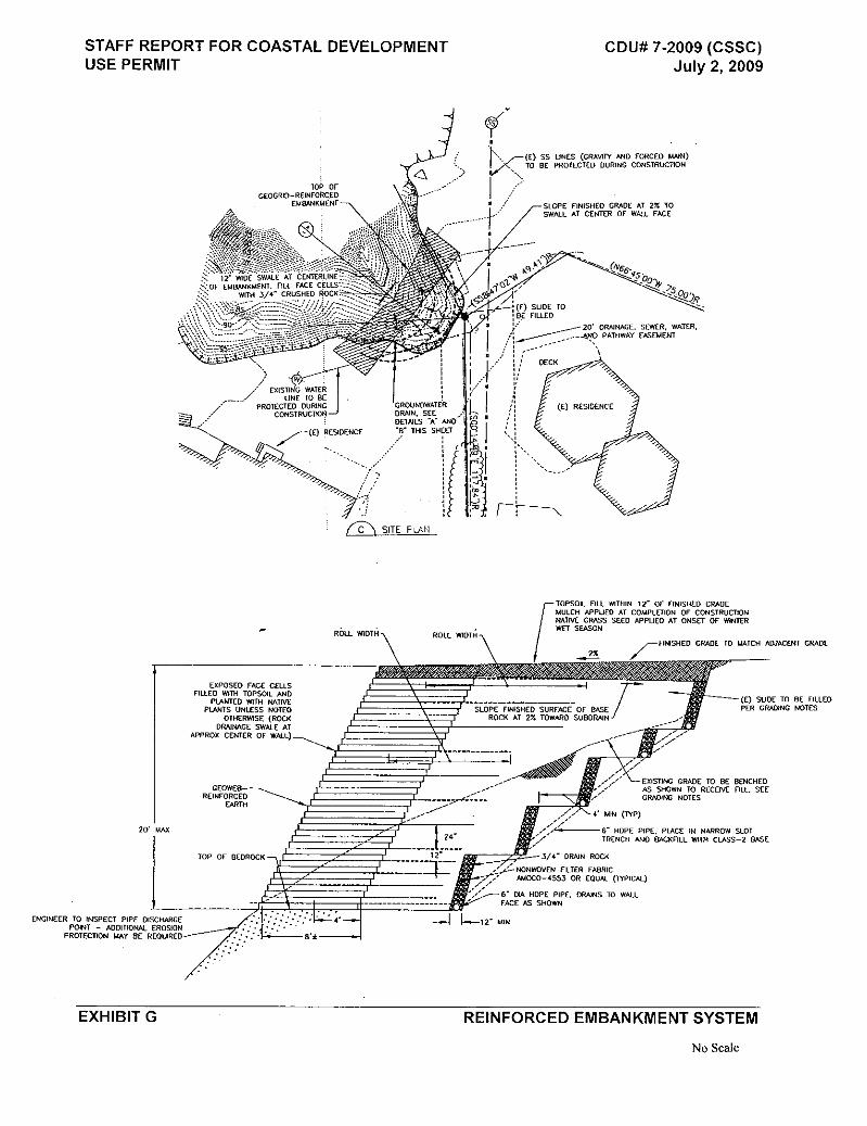
The proposed slope repair consists of a composite retaining wall utilizing a perforated Geoweb Cellular Confinement System and compacted engineered backfill. Geosynthetic (i.e. geotextile or geogrid) sheet reinforcements are used in conjunction with compacted engineered backfill i.e. reinforced soil. The outer edge of each layer of synthetic sheet reinforcement extends between selected Geoweb facia layers creating a frictional connection between the components. The soil mass and interlayered sheet reinforcements provide the necessary weight to maintain the structural integrity of the wall while buttressing the bluff face. Thus the engineered backfill is an integral part of this type of retaining structure. The volume of engineered backfill also restores the portion of bluff that failed during the 1998 storm event (Watt, page 1).
Staff is including Recommended Condition Number 1 to require the project be conducted to the extent possible by hand labor, utilizing shovels, wheel barrels, and small compactors. Impacts from soil disturbances and compaction would not be detrimental. Normally in association with approval of residential and other bluff adjacent development, it is the policy of the Coastal Commission and the County to require recordation of a deed restriction, requiring that permitted improvements be removed from the property if threatened by bluff retreat. The restriction also requires that the landowner be responsible for any clean up associated with portions of the development that might fall onto a beach. Because of special circumstances pertaining to the proposed development, staff is not recommending the deed restriction for this project. The owner of the subject property, the Caspar South Service Company, does not have an active board at this time. For this reason, recordation of a deed restriction may not be a reasonable option. Neighbors, including the Wassermans and Charles Young, are concerned about the bluff fix and have an interest in the proposed repair. The repair is also necessary to ensure protection of the sewage line. If the sewage line was to rupture due to erosion exposure, it could result in pollution of the ocean and an evacuation of South Caspar residences. Many of the occupants within the subdivision are seniors and evacuation would be a hardship. It is staff’s understanding that the board positions will be filled at some point in the near future, however the bluff fix must occur before winter rains in order to assure sewage line protection. Subsequently, staff recommends an alternative condition, listed as Recommended Condition Number 2, requiring that as a condition of approval, the Caspar South Services Company holds the County harmless, and is responsible for any removal should the bluff wall fail and fall in the ocean. Change in topography or ground surface relief features: The wall would have a maximum depth of 20 feet and a maximum length of 65 feet. The face would be sloped at 0.5:1 (horizontal to vertical) grade to conform to natural bluff face contours. Contours and backfill are proposed to repair contours to the previous natural appearance. Impacts would not be detrimental.
STAFF REPORT FOR COASTAL DEVELOPMENT USE PERMIT #CDU 7-2009 (CSSC) July 2, 2009
Page PC-6 Water (Item 3):
Changes in absorption rates, drainage patterns, or the rate and amount of surface runoff: According to Christopher Watt, Engineering Geologist for LACO Associates, absorption rates, drainage patterns, and rate/amount of surface runoff will not be impacted by the project:
The proposed slope repair design prepared by LACO Associates (LACO) does not alter the existing topography (i.e. ground surface) between the drainage network along Otter Point Circle and the bluff edge. The drainage pattern associated with overland flow and surface runoff will remain as is post-construction (Watt, page 2).
Alterations to the course of flow of floodwaters: As explained above, the project will not result in alterations to the course of flow of surface waters should the capacity of the road drainage system be exceeded in a storm event. The project is not located in any 100 year flood zones and would have no impact on the course of flow of 100 year floodwaters. Discharge into surface waters, or in any alteration of surface water quality, including but not limited to temperature, dissolved oxygen or turbidity: The project was referred to the County Water Agency. Dennis Slota responded that staff has reviewed the document and submits the following comments:
1. The grading plan needs to include site specific BMPs that are effective and properly installed to prevent erosion and sedimentation during construction.
2. The grading plan needs to include measures to prevent coastal winds from blowing stockpiled materials, trash, or miscellaneous materials away.
3. The applicants should submit photographic documentation that the BMP’s and wind control measures have been implemented.
Recommended Condition Number 3 is included to assure water quality is protected by Best Management Practices designed to prevent erosion and sedimentation during construction. As conditioned, the project would not result in significant impacts to water quality. Exposure of people or property to water related hazards such as flooding or tsunamis: As shown on the 100 Year Flood Zone and Coastal Flood Velocity (Wave Action) map, the project area is not subject to flooding, and is not located in a tsunami hazard zone. The project would not result in increased exposure to people or property to water related hazards such as flooding or tsunamis. Plant Life (Item 4): Change in the diversity of species, or number of any species of plants including trees, shrubs, grass, crops, and aquatic plants: The eroding bluff face has become vegetated by invasive plant species, predominantly ice plant. Surrounding vegetation is predominantly mowed lawns. The project would result in an overall reduction in non-native plants, and would not have detrimental impacts to the surrounding natural habitat area.
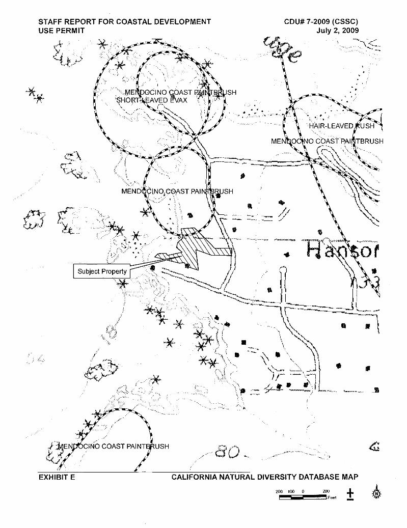
Reduction of the numbers of any unique, rare, or endangered species of plants: There are no rare plants, rare plant habitats, streams, wetlands, riparian areas or other natural resources of concern in the project area. The project area is vegetated by landscaped areas, lawns, and invasive plants. The project will not detrimentally impact plant resources.
STAFF REPORT FOR COASTAL DEVELOPMENT USE PERMIT #CDU 7-2009 (CSSC) July 2, 2009
Page PC-7 Animal Life (Item 5): Introduction of new species of animals into an area, or in a barrier to the migration or movement of animals: The project does not propose nor would it be conducive to the introduction of new animal species into an area. There are no known animal migratory routes in the area. The proposed Geoweb wall is not likely to significantly impact the movements of wildlife species.
Deterioration of existing fish or wildlife habitat: No natural habitat will be lost as a result of the proposed project. Areas to be developed are already highly disturbed, and do not provide unique or rare habitat for animals. Noise (Item 6): Increases in existing noise levels: The only noteworthy increase in noise generated by the project will be that of construction activity, which will be of limited duration. Noise impacts will not be significant. Land Use (Item 8): Substantial alteration of the present or planned use of a given area: The parcels are located in a largely built out subdivision classified on the Coastal Plan Map and zoned as Rural Residential 5 Acres Minimum with an alternate zoning of 1 Acre Minimum (RR-5 [RR-1]). Section 20.500.020(B)(4) of the Mendocino County Coastal Zoning Code states:
(4) No new development shall be allowed on the bluff face except such developments that would substantially further the public welfare including staircase accessways to beaches and pipelines to serve coastal-dependent industry. These developments shall only be allowed as conditional uses, following a full environmental, geologic and engineering review and upon a finding that no feasible, less environmentally damaging alternative is available. Mitigation measures shall be required to minimize all adverse environmental effects.
Since the proposed structure would be located on the bluff face, a conditional use permit is required for the proposed project. The project is in compliance with the requirement because protection of the public sewage system (exposure of the main sewage line is threatened by the erosion, which is approximately six feet away) is in the best interest of the public.
The use is compatible with the zoned residential use of the area. The project would not result in substantial alteration of present or planned use of the given area. Utilities (Item 15): Will the project result in a need for new systems or substantial alterations to the following:
Sewerage, Energy or information transformation lines: The wastewater system, constructed in 1966, is composed of two intermediate 3,000 gallon septic tanks, one main septic tank with two cells of 8,000 gallons each, and a pump station which pumps the effluent to a leachfield distribution box, which then sends effluent to the leachfield. As shown on the site plan, a sewage main line runs parallel to the bluff edge approximately six feet in from the eroding edge. The proposed repair is intended to prevent erosion from exposing the sewage main line, which could result in a raw sewage spill into the ocean. The proposed project is the only feasible alternative because there are no other funded options to address this situation.
STAFF REPORT FOR COASTAL DEVELOPMENT USE PERMIT #CDU 7-2009 (CSSC) July 2, 2009
Page PC-8 The project was referred to the Division of Environmental Health. The Division of Environmental Health responded that they could give clearance to this use permit application. Aesthetics (Item 17): Obstruction of any scenic vista or view open to the public, or create an aesthetically offensive site open to public view? The subject parcel is not located in a designated highly scenic area according to the Coastal Plan Map, and the proposed development would not be visible from any public view areas. However, analysis of aesthetic issues relating to appearance and views to and along the ocean are required for all development in the coastal zone. The importance of aesthetics is evidenced by policies in the County’s Coastal Element which apply to all areas in the coastal zone regardless of location in a designated highly scenic area. Coastal Plan Policy 3.5-1 of the Mendocino County Coastal Element states in pertinent part:
The scenic and visual qualities of Mendocino County coastal areas shall be considered and protected as a resource of public importance. Permitted development shall be sited and designed to protect views to and along the ocean and scenic coastal areas, to minimize the alteration of natural land forms, to be visually compatible with the character of surrounding areas and, where feasible, to restore and enhance visual quality in visually degraded areas.
The applicants would use beige colored cells to blend in with the sandy color of the bluff face. The cells are preliminarily proposed as the GW30V sized cell, which is approximately 8.4 inches wide, and would be about six inches deep (Rex Upp, personal communication). The Geoweb wall would be located below grade, and would be vegetated with native vegetation to blend in with the natural environment. Staff recommends Condition Number 4 to require a planting, irrigation, and maintenance plan prior to issuance of the Coastal Development Permit. As conditioned, visual impacts would be insignificant. Public Access & Recreation (Item 18): Impact upon the quality or quantity of existing recreational opportunities? The project site is located west of Highway 1 but is not designated as a potential public access trail location on the LUP maps. The steepness of the bluffs in this area prohibits safe access. The project would not have impacts to public access or recreation. Cultural Resources (Item 19): Alteration or destruction of a prehistoric or historic archaeological site? The project is located on the eroding bluff face and is not likely impact archaeological resources. Recommended Condition Number 13 is included in case any resources are encountered. ENVIRONMENTAL RECOMMENDATION: No significant environmental impacts are anticipated which cannot be adequately mitigated, therefore, a Mitigated Negative Declaration is recommended. GENERAL PLAN CONSISTENCY RECOMMENDATION: The proposed project is consistent with applicable goals and policies of the General Plan.
STAFF REPORT FOR COASTAL DEVELOPMENT USE PERMIT #CDU 7-2009 (CSSC) July 2, 2009
Page PC-9 RECOMMENDED MOTION:
General Plan Consistency Finding: As discussed under pertinent sections of this report, the proposed project is consistent with applicable goals and policies of the General Plan as subject to the conditions being recommended by staff.
Environmental Findings: The Planning Commission finds that no significant environmental impacts would result from the proposed project which can not be adequately mitigated through the conditions of approval, therefore, a Negative Declaration is adopted.
Coastal Development Use Permit Findings: The Planning Commission finds that the application and supporting documents and exhibits contain information and conditions sufficient to establish, as required by Section 20.532.095 of the Coastal Zoning Code, that: 1. The proposed development is in conformity with the certified local coastal program; and 2. The proposed development will be provided with adequate utilities, access roads,
drainage and other necessary facilities; and 3. The proposed development is consistent with the purpose and intent of the zoning
district applicable to the property, as well as the provisions of the Coastal Zoning Code, and preserves the integrity of the zoning district; and
4. The proposed development will not have any significant adverse impacts on the
environment within the meaning of the California Environmental Quality Act; and 5. The proposed development will not have any adverse impacts on any known
archaeological or paleontological resource; and 6. Other public services, including but not limited to, solid waste and public roadway
capacity have been considered and are adequate to serve the proposed development; and
7. The proposed development is in conformity with the public access and public recreation
policies of Chapter 3 of the California Coastal Act and Coastal Element of the General Plan; and
8. No feasible, less environmentally damaging alternative is available (required for
conditional use on a bluff face). RECOMMENDED ACTION FOR CDU 7-2009: Staff recommends that the Planning Commission approve the Coastal Development Use Permit CDU 7-2009, subject to the conditions of approval recommended by staff. RECOMMENDED CONDITIONS: ** 1. Construction activities shall be conducted to the extent possible by hand labor, utilizing
shovels, wheel barrels, and small compactors. The intent of this condition is to minimize soil disturbances and risk of rupturing the sewage line. A copy of this report shall be
STAFF REPORT FOR COASTAL DEVELOPMENT USE PERMIT #CDU 7-2009 (CSSC) July 2, 2009 Page PC-10
provided to all contractors and subcontractors for the project, and shall be in their possession at all times on site.
2. As a condition of approval, the landowner understands that the site may be subject to
extraordinary geologic and erosion hazards and the landowner assumes the risk from such hazards, and agrees to indemnify and hold harmless the County of Mendocino, it successors in interest, advisors, officers, agents and employees against any and all claims, demands, damages, costs, and expenses of liability (including without limitation attorneys’ fees and costs of the suit) arising out of the design, construction, operation, maintenance, existence or failure of the permitted project. Including, without limitation, all claims made by any individual or entity or arising out of any work performed in connection with the permitted project;
The landowner agrees that any adverse impacts to the property caused by the permitted project shall be fully the responsibility of the applicant. The landowner shall remove the retaining wall when bluff retreat reaches the point where the structure is threatened. In the event that portions of the retaining wall fall to the beach before they can be removed from the blufftop, the landowner shall remove all recoverable debris associated with these structures from the beach and ocean and lawfully dispose of the material in an approved disposal site. The landowners shall bear all costs associated with such removal.
** 3. The grading plan shall include site specific Best Management Practices that are effective
and properly installed to prevent erosion and sedimentation during construction. The grading plan shall also include measures to prevent coastal winds from blowing stockpiled materials, trash, or miscellaneous materials away. As soon as possible after installation, the applicants shall submit photographic documentation to Planning and Building Services that the Best Management Practices and wind control measures have been implemented.
** 4. Prior to issuance of the Coastal Development Permit, the applicant shall submit for approval by the Planning Division, a vegetation plan that outlines native, drought resistant plants to be used, planting schedule, watering and maintenance for the Geoweb wall and other areas of exposed soils. Prior to final clearance of the building (grading) permit, vegetation shall be sufficiently installed and thriving.
5. This permit is subject to the securing of all necessary permits for the proposed
development and eventual use from County, State and Federal agencies having jurisdiction. Any requirements imposed by an agency having jurisdiction shall be considered a condition of this permit.
6. This entitlement does not become effective or operative and no work shall be
commenced under this entitlement until the California Department of Fish and Game filing fees required or authorized by Section 711.4 of the Fish and Game Code are submitted to the Mendocino County Department of Planning and Building Services. Said fee of $1,926.75 shall be made payable to the Mendocino County Clerk and submitted to the Department of Planning and Building Services prior to July 16, 2009. If the project is appealed, the payment will be held by the Department of Planning and Building Services until the appeal is decided. Depending on the outcome of the appeal, the payment will either be filed with the County Clerk (if the project is approved) or returned to the payer
STAFF REPORT FOR COASTAL DEVELOPMENT USE PERMIT #CDU 7-2009 (CSSC) July 2, 2009 Page PC-11
(if the project is denied). Failure to pay this fee by the specified deadline shall result in the entitlement becoming null and void. The applicant has the sole responsibility of timely compliance with this condition.
7. This permit shall become effective after all applicable appeal periods have expired, or
appeal processes have been exhausted, and after any fees required or authorized by Section 711.4 of the Fish and Game Code are submitted to the Department of Planning and Building Services. Failure of the applicant to make use of this permit within 2 years or failure to comply with payment of any fees within specified time periods shall result in the automatic expiration of this permit.
To remain valid, progress towards completion of the project must be continuous. The applicant has sole responsibility for renewing this application before the expiration date. The County will not provide a notice prior to the expiration date.
8. The use and occupancy of the premises shall be established and maintained in
conformance with the provisions of Division II of Title 20 of the Mendocino County Code. 9. The application, along with supplemental exhibits and related material, shall be
considered elements of this permit, and that compliance therewith is mandatory, unless an amendment has been approved by the Planning Commission.
10. The applicant shall secure all required building permits for the proposed project as
required by the Building Inspection Division of the Department of Planning and Building Services.
11. This permit shall be subject to revocation or modification upon a finding of any one or
more of the following:
a. The permit was obtained or extended by fraud. b. One or more of the conditions upon which the permit was granted have been
violated. c. The use for which the permit was granted is conducted so as to be detrimental to
the public health, welfare or safety, or to be a nuisance. d. A final judgment of a court of competent jurisdiction has declared one or more
conditions to be void or ineffective, or has enjoined or otherwise prohibited the enforcement or operation of one or more such conditions.
Any revocation shall proceed as specified in Title 20 of the Mendocino County Code.
12. This permit is issued without a legal determination having been made upon the number,
size or shape of parcels encompassed within the permit described boundaries. Should, at any time, a legal determination be made that the number, size or shape of parcels within the permit described boundaries are different than that which is legally required by this permit, this permit shall become null and void.
STAFF REPORT FOR COASTAL DEVELOPMENT USE PERMIT #CDU 7-2009 (CSSC) July 2, 2009 Page PC-12
13. If any archaeological sites or artifacts are discovered during site excavation or construction activities, the applicant shall cease and desist from all further excavation and disturbances within one hundred feet of the discovery, and make notification of the discovery to the Director of the Department of Planning and Building Services. The Director will coordinate further actions for the protection of the archaeological resources in accordance with Section 22.12.090 of the Mendocino County Code.
Negative Declaration Appeal Period: Ten calendar days for the Mendocino County Board of Supervisors, followed by ten working days for the California Coastal Commission following the Commission’s receipt of the Notice of Final Action from the County. Appeal Fee: $945 (For an appeal to the Mendocino County Board of Supervisors.) ** Indicates conditions relating to Environmental Considerations - deletion of these conditions may
affect the issuance of a Negative Declaration. ATTACHMENTS:
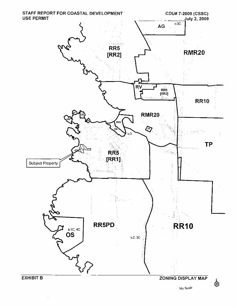
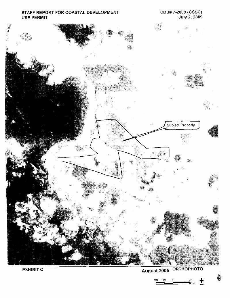
Exhibit A: Location Map Exhibit B: Zoning Display Map Exhibit C: Orthophoto Exhibit D: 100 Year Flood and Wave Action Map Exhibit E: California Natural Diversity Database Map Exhibit F: Site Plan Exhibit G: Reinforced Embankment Section SUMMARY OF COMMENTS: Planning – Ukiah No comment. Department of Transportation No comment. Environmental Health – Fort Bragg No response. Building Inspection – Fort Bragg No comment. Assessor No response. County Water Agency No response. Dept. of Fish and Game No response. Coastal Commission No response. RWQCB No response. US Fish and Wildlife No response. Dept. of Fish and Game No response. Army Corps of Engineers No response. Dept. of Parks and Recreation No response.
STAFF REPORT FOR COASTAL DEVELOPMENT USE PERMIT #CDU 7-2009 (CSSC) July 2, 2009 Page PC-13
Mendocino Fire District No response. Caspar South Svcs District No response.
References
Anderson, Terry M., P.E. Letter to Teresa Spade, May 12, 2009. Berry, David L., Ph.D. Letter to Mr. & Mrs. Richard Fugill, August 13, 2008. Caspar South Service
Company. County of Mendocino, 1991. Mendocino County Coastal Zoning Code. http://www.co.mendocino.ca.us/planning/CoastZO/ZOCoastIndex.htm December 2008. Watt, Christopher J. Certified Engineering Geologist. Letter to Teresa Spade, May 6, 2009. LACO
Associates Winzler & Kelly, 2006. Caspar South Water District, Mendocino County Final Wastewater Treatment &


![CSSC Program [2013]](https://static.documents.pub/doc/80x56/621cae364f48b20dd95f132a/cssc-program-2013.jpg)


![CSSC Program [2012]](https://static.documents.pub/doc/80x56/61b539d1ae3c301eed28566f/cssc-program-2012.jpg)


