214
Stanton Moor Conservation Plan 2007 Stella McGuire and Ken Smith with additional contributions from Ann Whitlock ©Copyright 2007. Peak District National Park Authority. Stella McGuire.

Stanton MoorConservation Plan 2007
Stella McGuire and Ken Smithwith additional contributions from Ann Whitlock
©Copyright 2007. Peak District National Park Authority. Stella McGuire.


Page 3
Stanton Moor Conservation Plan
AcknowledgementsMany thanks to all the people who have contributed to this Conservation Plan. They include the Plan consultees (see Appendix B) and all those who kindly provided comments on Plan drafts: Tim Allen; Adrian Baker; David Bent; James Cuthbert; Adrian Davie-Thornhill; Jill Gregory; Neil Hanshaw; Jane Harker; Jon Humble; Laura Hurford; Alan Martin; Michael Metcalfe; Martin Millmore; Paul Mortimer; Julie, Jules, Wookie, Ruth and Malcolm from the Nine Ladies Protest Camp; Frank Oulsnam; Rebecca Penny; Andrew Prince; Mr. and Mrs. Renwick; Jon Stewart; Rhodri Thomas; Andy Tickle; Tim Walker.
Many other Peak District National Park Authority staff in addition to those included in the list above gave support, information and advice. They include: Liz Ballard, John Barnatt, Gavin Bell, Bill Bevan, Daniel Boys, Lynn Burrow, Peter Bush, Philippa Davey, Andy Farmer, Angela Johnson, Rachael Kerr, Catherine Mate, Christina Porter, Mike Rhodes, John Sewell, Peter Smith, Sarah Whiteley.
Thanks to the following for information and advice on Museum holdings, databases and other Museum initiatives: Matt Edwards, Martha Jasko, Sue Palmer, Jonathan Wallis, Ros Westwood, Gill Woolrich.
Advice and guidance on Stanton Moor ceramics and their context was kindly provided by Pauline Beswick.
Many people provided information on education and learning initiatives and possibilities. They include: Wyn Austin, Melanie Barker, Daryl Baxter, Rachel Bellamy, Aimee Blease-Bourne, Matt Cooke, Lynn Crowe, Ann Hall, Ian Heath, Don Henson, Mrs. Howarth, Peter Jones, Colin Merrony, Catherine Nicklin, Frank Robinson, Phil Sidebottom.
The following provided information on a range of other topics included in the Plan: Jenny Blain, Barry Joyce, Pam McInally, Sarah Sims-Williams, Jan Stetka, Ian Thomas, Andrew Thompson, and members of Stanton-in-Peak Local History Society.
Thanks to Aimee Blease-Bourne and Rob Isherwood for permission to use information from their M.A. dissertations, and to Jamie Chapman for the use of data from his GCSE project on Stanton Moor.
Thanks to the following for their company, information and insight during trips to the Moor: Aimee Blease-Bourne, John Hughes, Willy Kitchen, Melissa Peet, Helen Ullathorne, and ‘Mr. Bateman’ – a descendant of the real thing, encountered one day by the Reform Tower.
Individual credits and copyright information are given in the illustration captions. Thanks to the following people for supplying plans, photographs and other images and/or giving permission to use them: Stewart Ainsworth, Trevor Ford, Jill Gibbon, Neil Hanshaw, Margaret O’Sullivan, Christina Porter, Jim Rieuwerts, Rhodri Thomas, Nick Tomlinson, Peter Ward, Mary Wilde.
The Plan was prepared for publication by Sarah Gillott, Peak District National Park Authority, Design Team.
Particular thanks to Philippa Davey at PDNPA for her support throughout the project, and to her and Angela Johnson at PDNPA for their work on the preparation of maps and plans.
Finally, many thanks to Jon Humble and English Heritage for commissioning and providing resources for this Conservation Plan, and for their support throughout the lengthy process of production.

Page 4
Stanton Moor Conservation Plan Summer 2007
Contents
Summary of Key Points 10
1 Introduction 15
2 Understanding the Moor 17
2.1 Chronology 17
2.2 Location and physical landscape 22
2.2.1 Introduction
2.2.2 Geology and soils
2.2.3 Topography
2.3 Land ownership and management 23
2.4 Cultural heritage 24
2.4.1 Mesolithic and Neolithic
2.4.2 Bronze Age
2.4.3 Iron Age
2.4.4 Romano-British
2.4.5 Early Medieval and Medieval
2.4.6 Post-Medieval to Early Modern
2.4.7 Industry
2.4.8 Modern artefacts
2.4.9 Structures
2.5 Excavation history, collections and archives 35
2.6 Natural heritage 42
2.7 Industry and agriculture 45 2.7.1 Quarrying within the scheduled area
2.7.2 Agriculture and shooting
2.8 Aesthetic appeal 47
2.9 Modern perceptions of the moor’s spiritual qualities 48
2.10 Interpretation and education 50

Page 5
Stanton Moor Conservation Plan
2.11 Access, visitor use and visitor impact 56
2.11.1 Access
2.11.2 Disability Access Audit for the Guardianship monument
2.11.3 Visitor use rates and patterns
2.11.4 Visitor impact
2.11.4.1 Footpaths
2.11.4.2 Gathering points
2.11.4.3 Nine Ladies stone circle and King Stone
2.11.4.4 Other monuments
2.11.4.5 Camp fi res
2.11.4.6 Fire risk
2.11.4.7 Parking and unauthorised vehicle access
2.12 Designations, responsibilities and strategies 62
2.12.1 Statutory designations
2.12.1.1 National Park
2.12.1.2 Scheduled Monument
2.12.1.3 Guardianship
2.12.1.4 Listed building
2.12.1.5 Wildlife and Countryside (Amendment) Act 1985
2.12.2 Non-statutory designations
2.12.2.1 Regionally Important Geological and Geomorphological Site
2.12.2.2 Biodiversity Action Plan / Priority Habitat
2.12.2.3 Natural Zone
2.12.3 Physical access and accessibility: designations, responsibilities and strategies
2.12.3.1 Strategic overview
2.12.3.2 Public Rights of Way (PROW)
2.12.3.3 Countryside and Rights of Way Act 2000 (CROW)
2.12.3.4 Legislation relevant to other forms of access
2.12.4 Strategies for information provision and interpretation
2.12.5 Management: designations, responsibilities and strategies
2.12.5.1 Farm Conservation Agreement (1993 – 2004)
2.12.5.2 Local Management Agreement
2.12.5.3 Multi-agency liaison group
2.12.6 National Trust landholding on Stanton Moor Edge
2.12.7 Peak District National Park Authority strategy and principles relating to quarrying
2.12.8 Government guidance and National Park planning policies on archaeology, the historic environment, biodiversity and geological conservation

Page 6
Stanton Moor Conservation Plan Summer 2007
3 The Moor in a wider frame: understanding the context of 71 Stanton Moor
3.1 Introduction 71
3.2 The character and extent of the Stanton Moor context area 71
3.2.1 Establishing the context area
3.2.2 Geology
3.2.3 Land ownership and management
3.2.4 Current land use and Historic Landscape Character
3.2.5 Recreational use
For issues related to access and parking on the periphery of the moor, see 2.11.
3.3 Quarrying on the moorland fringe 74
3.3.1 Introduction
3.3.2 Active and dormant quarries
3.3.2.1 New Pilhough and associated haul road
3.3.2.2 Dale View
3.3.2.3 Stanton Moor
3.3.2.4 Lees Cross and Endcliffe
3.3.2.5 Birchover / Stanton Park
3.3.3 Disused quarry workings
3.3.3.1 Dungeon / Barton Hill
3.3.3.2 New Park
3.3.3.3 Boden Stone (or ‘TV mast’) quarry
3.3.3.4 Disused quarries on Stanton Moor Edge
3.3.3.5 Disused quarries in Sheepwalk Wood
3.3.4 Summary
3.3.4.1 Impact on the scheduled monument of quarrying and proposed quarrying around the fringes of the moor
3.3.4.2 Archaeological, ecological and landscape value of the disused and dormant quarry workings fringing the moor
3.4 Cultural heritage: the wider context 83
3.4.1 Mesolithic
3.4.2 Neolithic
3.4.3 Bronze Age
3.4.4 Iron Age
3.4.5 Romano-British
3.4.6 Early Medieval and Medieval
3.4.7 Post-Medieval to Early Modern

Page 7
Stanton Moor Conservation Plan
3.4.8 Industrial context
3.4.8.1 Introduction
3.4.8.2 Lead smelting
3.4.8.3 Lead mining
3.4.8.4 Quarrying
3.4.8.5 Military timber supply
3.4.8.6 Overall impact of industry
3.5 Natural heritage: the wider ecological context 104
3.5.1 Heather moorland
3.5.2 Woodland
3.5.3 Stanton Moor Edge and Hill Wood: nature conservation evaluation
3.5.4 Quarries
3.6 Aesthetic landscape context: the moor in its setting 107
3.7 Modern spiritual context 108
3.8 Interpretation and education: the wider context 111
4 Summary of signifi cance 115
4.1 Introduction 115
4.2 Stanton Moor 115
4.2.1 Overview
4.2.2 Cultural heritage: the prehistoric resource
4.2.3 Cultural heritage: the medieval to modern resource
4.2.4 Natural heritage: ecology and geology
4.2.5 Recreation
4.2.6 Access
4.2.7 Aesthetic signifi cance
4.2.8 Landscape
4.2.9 Spiritual signifi cance
4.2.10 Interpretation and education
4.2.11 Agriculture and shooting
4.2.12 Quarrying
4.2.13 Group signifi cance
4.3 The context area: signifi cance of Stanton Moor’s setting 123
4.3.1 Overview
Page 8
Stanton Moor Conservation Plan Summer 2007
4.3.2 Cultural heritage in the context area
4.3.2.1 Prehistoric
4.3.2.2 Medieval to early modern
4.3.2.3 Industrial
4.3.3 Agriculture
4.3.4 Natural heritage in the context area
4.3.5 Recreation and access
4.3.6 Aesthetic and landscape signifi cance
4.3.7 Spiritual signifi cance
4.3.8 Education and interpretation
5 Factors affecting the signifi cance of the Moor 129
5.1 Introduction 129
5.2 Cultural heritage: impacts on the prehistoric resource 129
5.2.1 Effective conservation management is essential
5.2.2 Erosion and other damage caused by visitors and monument users
5.2.3 Damage by animals
5.2.4 Damage by vegetation
5.2.5 Current and potential impact of quarrying
5.2.6 Unrealised research potential
5.2.7 Potential for development of the Stanton Moor archive
5.2.8 Access to information on the prehistoric resource
5.2.9 Factors affecting group signifi cance
5.3 Cultural heritage: medieval to early modern 140
5.3.1 Impact of visitor use and weather damage
5.3.2 Impact of quarrying
5.3.3 Impact of vegetation and animals
5.3.4 Potential impact of development, including haul roads
5.3.5 Unrealised research potential
5.3.6 Access to information on the medieval to early modern resource
5.4 Natural heritage: factors affecting ecology 143
5.4.1 Effective conservation management is essential
5.4.2 Specifi c areas of vulnerability on Stanton Moor
5.4.3 Factors on moorland fringe
5.4.4 Unrealised research potential
5.4.5 Access to information

Page 9
Stanton Moor Conservation Plan
5.5 Impacts on recreational value 147
5.6 Factors affecting access 149
5.6.1 Access onto and across the moor
5.6.2 Access for those with different abilities
5.6.3 Quality of approach routes to moor
5.6.4 Access to Doll Tor
5.7 Factors affecting aesthetic signifi cance 153
5.8 Factors affecting landscape value 155
5.9 Factors affecting modern spiritual signifi cance 158
5.10 Factors affecting interpretation and education 159
5.11 Factors affecting economic signifi cance 161
5.11.1 The quarrying industry
5.11.2 Agriculture
5.11.3 Shooting
6 Conservation Policies 163
6.1 Introduction 163
6.2 Policy aims 163
6.3 Policies 165
7 Implementation, monitoring and review 187
7.1 Conservation through partnership 187
7.2 Implementation framework 187
7.3 Adoption, monitoring and review 188
Appendix A Bibliography 189
Appendix B List of consultees 201
Appendix C Maps and plans (bound as a separate document)
Glossary 203
Acronyms and abbreviations used in text 213

Page 10
Stanton Moor Conservation Plan Summer 2007
Summary of Key Points
Purpose, structure and implementation framework
The purpose of this Conservation Plan (more fully described in Chapter 1) is to provide a long-term framework for conservation management of the Stanton Moor Scheduled Monument and its setting. The Plan assesses not only the complex signifi cance of the moor but also the range of factors which impact upon it. It builds on this information to develop policies which will enable the signifi cance of the moor to be sustained or enhanced, and which will attract maximum support from those involved in transforming policy into practice.
Chapter 1 acts as an introduction. Chapters 2, 3 and 4 establish the overall signifi cance of the Scheduled Monument, including its important interrelationship with its setting or context area. Chapter 5 addresses the monument’s vulnerability – i.e. the issues which affect, or have the potential to affect, its signifi cance. Chapters 6 and 7 set out policies to address these areas of vulnerability, and a strategy for policy implementation.
It is intended that the conservation policies proposed in this Plan will be promoted by English Heritage and the Peak District National Park Authority, with the support and engagement, wherever appropriate, of the Trustees of the Thornhill Settlement, the National Trust, Natural England (formerly English Nature), the Haddon Estate, Stanton-in-Peak and Birchover Parish Councils, other appropriate Local Authorities, relevant quarry operators, local residents and visitors to the area.
It is proposed that, once the Plan has been accepted by sponsoring organisations, a Steering Group should be convened to take forward the policies recommended in Chapter 6. It is envisaged that this Group will be convened by English Heritage, who will consult on its membership (to be drawn from those responsible for the care and use of the Scheduled Monument and of the wider moor). The Steering Group will specify priorities for action, draw up an action plan or plans, and identify responsibilities, resources and timetables for implementation.
Cultural heritage of Stanton Moor
• Stanton Moor is of international signifi cance as a rare surviving example of a complex Bronze Age ceremonial, funerary and settlement landscape. Its monuments include a closely clustered group of ceremonial structures, many of them multi-phased, and an unusually extensive example of a mainly funerary cairnfi eld, containing around 30 known and 25 possible funerary cairns.
• A large area of the moor is a Scheduled Monument under the terms of the Ancient Monuments and Archaeological Areas Act 1979: the highest form of protection given to such sites under English law. The scheduling of a large area of the moor (rather than of individual monuments) recognises that the full signifi cance of this landscape derives from the rare survival of many prehistoric remains in close juxtaposition, and from the consequent interplay between its different components.
• Two monuments on the moor, the Nine Ladies embanked stone circle and the King Stone, have been in State Guardianship since 1882. The Nine Ladies is one of only a few such monuments in Britain which have survived relatively intact.
• The moor is the source of a major collection of Early Bronze Age material, mainly held in Weston Park Museum, Sheffi eld. The large collection of funerary urns is of particular importance.
• In addition to its highly signifi cant prehistoric remains, the moor provides a valuable example of a multi-period cultural landscape, retaining complex evidence for a succession of activities over time. These include medieval to early modern agriculture, early delves and later quarrying, 19th century ornamental landscape features (including the Reform Tower and embellished rock pillars), and forestry: most notably a light rail infrastructure for the removal of timber during World War 1.
Page 11
Stanton Moor Conservation Plan
• Extensive excavation in the early 20th century (carried out according to the standards of the time), detailed surveys in the 1980s and various forms of professional analysis and research have combined to provide relatively extensive information on the moor’s prehistoric and historic monuments. However, this is widely scattered in a range of disparate published and unpublished sources, and in various archives and collections. There is thus no common corpus of information about the moor and its multi-period monuments and other features which is readily accessible to researchers and to those professionally engaged in monument and landscape conservation.
• There is considerable scope for further research into the prehistoric monuments, their relationship with each other and with their immediate and wider landscape, and the ceramic and other artefacts which they contained. Very little research has been carried out into the historic-period archaeology of the moor and its periphery: particularly the old quarries, communications routes and 19th century rides and look-out points.
• Although the majority of monuments were clearly mapped in the 1980s, such mapping has not been made available in a form which is easily accessible or usable by archaeologists or conservation professionals. There has been no recent comprehensive survey of monument condition across the whole of the moor.
Ecology, landscape and the importance of appropriate conservation management
• The moor lies within a National Park – the UK’s top tier of landscape designation.
• As upland heather moor, Stanton Moor forms part of a scarce international ecological resource. The majority of the scheduled area is designated as National Priority Habitat, and is included within the Local Biodiversity Action Plan for the Peak District.
• The range of landscape resources on the moor and around its fringes – moorland, woodland, rocky edges and old quarries – constitute a mosaic of diverse habitats, contributing to local biodiversity. However, with the exception of the National Trust landholding on the eastern edge of the moor, there has been no detailed study of the overall ecological resource.
• A substantial area of the moor has been designated as a Regionally Important Geological and Geomorphological Site, because of the unusual characteristics of its sandstone.
• Although the moor itself has high aesthetic value as an open, ‘natural’, varied landscape, consultation has demonstrated that the long views which it provides over a range of diverse landscape types (gritstone, limestone, woodland, valley and moor) are fundamental to its aesthetic appeal. Consequently, actual and potential impacts on the quality of the moor’s setting (particularly from quarrying) are seen as posing a threat to the landscape value of the moor itself.
• The archaeology, ecology and landscape of the moor are at actual and potential risk from scrub encroachment, and, ultimately, from any future lack of appropriate controls over grazing. Although a planned reduction in grazing over the last decade or so has been successful in encouraging the healthy regrowth of heather, widespread birch regeneration is now a signifi cant and rapidly increasing problem. Bracken and rhododendron also present a threat.
• The overall ecological and landscape value of the moor could be enhanced by closer integration of conservation management between the main moor, the National Trust landholding on the eastern edge, and a range of other areas on the moor’s periphery.

Page 12
Stanton Moor Conservation Plan Summer 2007
Recreational and spiritual value
• Due to its varied cultural and natural attractions, its relative ease of access and its position close to fairly substantial communities, Stanton Moor forms a well-used and highly-valued local and regional recreational resource. Although relatively small in area, it provides a sense of wildness, isolation and tranquillity.
• The moor has a modern spiritual value, deriving from the spiritual signifi cance which many people accord to its ceremonial monuments, enhanced by their setting within a striking natural landscape. For several decades, the Nine Ladies stone circle has acted as a popular focus for various forms of observance and celebration.
• A long-running environmental protest camp sited on the fringe of the moor draws part of its impetus from the potential impact of quarrying on the setting and other signifi cant qualities of this circle, which has acquired an iconic value as a symbol of protest. For some audiences, the protest camp, the Nine Ladies stone circle and Stanton Moor have become synonymous.
Quarrying
• The Stanton Moor area is a source of high quality sandstone, which is particularly valued as a building material. In the last few decades, there has been an increase in the scope and extent of quarrying on the fringe of the moor.
• Effective steps have been taken to lessen the direct physical threat of mineral extraction to the moor’s prehistoric archaeology. However, the actual and potential impacts of quarrying and related activities on the landscape setting of the Scheduled Monument, and consequently on its archaeological, aesthetic, recreational and spiritual value, are highly signifi cant. In 2003, Stanton Moor was designated by English Heritage as a Scheduled Monument at High Risk, principally due to the threat posed by mineral extraction to the integrity and setting of the monument. Many of those consulted in the course of compiling this document judged the various impacts of quarrying to be the most signifi cant threat to the moor and its monuments, and to its ‘approach zone’ and general setting.
• Plan consultees judge that quarrying operations on the south-western edge of the moor pose the principal current visual (and noise-related) threat to the moor and its setting. However, a number of other actual and proposed quarrying operations and related activities are judged to pose a substantial future threat to the various signifi cant characteristics of the moor. There is an ongoing need to use the formal planning process to manage and mitigate the various actual and potential impacts of mineral extraction and associated activities on the moor’s signifi cant cultural and natural heritage, and to conserve its value as a nationally important archaeological landscape.
Visitor impact
• Stanton Moor is under signifi cant threat from visitor pressure, deriving from the relative accessibility of the moor, and its very popularity as a recreational and spiritual resource. Visitors are having an increasing impact on all the characteristics for which the moor is most valued: its major monuments, landscape and ecology, and its ‘unspoilt’, ‘natural’ atmosphere.
• The impact on the Nine Ladies stone circle and King Stone is particularly high. Despite conservation and reinforcement measures to address visitor-related erosion, English Heritage judges these monuments to be at ‘High Risk’ from visitor pressure.
• Unauthorised camping close to the Nine Ladies and (increasingly) across other areas of the moor has a range of signifi cant impacts on the moor’s ecological,

Page 13
Stanton Moor Conservation Plan
landscape and amenity value, particularly in the summer months. These impacts include the presence of tents and related infrastructure, campfi re sites, litter and the breaking of branches for fi rewood.
• Visitor impacts (e.g parking and camping) extend beyond the boundary of the Scheduled Monument to affect its periphery and ‘approach zone’.
Physical access and visitor profi le
• There has been no formal, large-scale assessment of the moor’s current visitor profi le (including the extent to which the moor attracts non-traditional audiences), nor of issues such as seasonal patterns of use, motives for visiting, and differential use of access points.
• Physical access is largely good, although capable of some improvement, particularly in relation to the differently-abled. Access routes at the northern edge of the moor lend themselves most easily to appropriate modifi cation.
• The signifi cant cultural and natural characteristics of the moor are all highly vulnerable to visitor impact. Therefore, in devising strategies to address the overall lack of interpretation (see below), and to extend access opportunities, extreme care will need to be taken to avoid an increase in visitor impact on the moor’s monuments, and on its ecological, landscape, aesthetic and spiritual value. Strategies should include an emphasis on ‘virtual’ access, guidance to visitors on both the value and the fragility of the moor’s resources, the careful vetting of the impact of any off-moor signage proposals, and the implementation of a range of measures to discourage parking on the immediate periphery of the moor.
Education, informal learning and interpretation
• There is no central pool of data enabling accurate assessment of the educational use made of the moor. However, research undertaken for this Conservation Plan shows that schools, colleges and universities (at both the local and regional level) make relatively extensive use of the archaeology, ecology and geology of the moor and its periphery.
• At primary level, the evidence suggests – perhaps surprisingly – that schools from outside the area make more regular use of the moor and its resources than do local schools. At secondary level, the limitations placed by the National Curriculum on the study of prehistoric archaeology diminish opportunities for pupils to engage with Stanton’s Bronze Age landscape. However, some schools use the moor as a striking example of confl ict over land use – a topic which fi ts within the current Citizenship curriculum. At tertiary level a number of colleges and universities (both local and regional) make regular use of the moor to teach archaeology and geology, and to illustrate confl icts over land use.
• The moor’s cultural and natural characteristics and qualities provide a signifi cant and varied potential resource not only for formal learning, but for a range of approaches to interpretation and informal learning. Some of these opportunities have been developed in imaginative ways: current initiatives have involved groups of children from urban and rural areas, members of ethnic minority groups from the wider region, and signed walks for the deaf. However, there is a broad consensus amongst Plan consultees that there is a real lack of interpretative material relating to the moor and its setting, and that the material which does exist is not well known and hard to access.

Page 14
Stanton Moor Conservation Plan Summer 2007
Interrelationship between the moor and its context area
• In terms of its archaeology, ecology, landscape, and its aesthetic, recreational and spiritual value, the moor is intrinsically related to – and cannot be considered separately from – its immediate and wider setting. The importance of this interrelationship should be a fundamental factor in future conservation management of the moor and its surroundings.
• There is extensive scope to build on this complex interrelationship between the moor and its setting in future research and interpretation.

Page 15
Stanton Moor Conservation Plan
Chapter 1 Introduction
1.1 Background to the Conservation Plan
Stanton Moor is one of Britain’s most important archaeological landscapes. A large area of the moor has been designated as a Scheduled Monument because of the archaeological signifi cance of its wealth of Bronze Age ceremonial, funerary, agricultural and other remains. It also retains archaeological evidence for a complex range of more recent uses, from the Roman period to the present day. The moor possesses other valued characteristics. As upland heath, it forms part of an internationally rare ecological and landscape resource; as accessible moorland within the Peak District National Park but close to centres of population, it is popular as a place to walk and to enjoy long views over the surrounding countryside. Many visitors also see the moor and its monuments – particularly the Nine Ladies stone circle – as a spiritual resource: a place for celebration or quiet contemplation.
The various characteristics for which Stanton Moor is valued do not always sit happily with each other. The moor and its fringes have traditionally been used as a source of high quality gritstone, and disused quarries lie around its edge. However, the modern scale of actual and potential quarrying here has generated a need to manage the impact of this use on other signifi cant characteristics of the moor, and specifi cally, to conserve its value as a nationally important archaeological landscape. There is also an ongoing need to manage agricultural use and to control the spread of vegetation, if over-grazing and scrub are to be prevented from damaging its archaeological, ecological, recreational and landscape value. The moor’s very popularity – deriving from its accessibility and from its modern status as a valued spiritual landscape – is itself a source of erosion and other forms of damage, and in 2003 Stanton Moor was designated by English Heritage as a Scheduled Monument at High Risk. Without a considered plan for its future management, it is inevitable that many of its valued characteristics will be damaged or lost.
The challenge facing those with responsibility for management of the Scheduled Monument is how best to protect and sustain what is most signifi cant about this landscape and its archaeological remains, while enabling enjoyment of its diverse qualities, and heightening awareness of its importance.
This Conservation Plan, commissioned by English Heritage and drawn up by the Peak District National Park Authority, is intended to provide a long-term framework for conservation management of the site and its setting. Its remit is to assess not only the complex signifi cance of Stanton Moor but also the range of factors which threaten it, and to develop policies which will enable the signifi cance of the moor to be sustained or heightened and will attract maximum support from those involved in transforming policy into practice.
The conservation philosophy which provides a framework for this task is best expressed by the concept of sustainability: a concept which recognises that the physical survivals from our past form an irreplaceable record which contributes to our understanding of both the past and the present, and which enables us to plan appropriately for the future. It also recognises that the scale of modern human activities, if not moderated, can have a major and irreversible impact on the historic environment. Although we cannot preserve this environment completely unchanged, it is a non-renewable resource and it is important to identify sustainable modes of change “which preserve the essential character of the past and allow future generations to reinterpret their history” (English Heritage 1996a:2.7).
The concept of inclusivity is also of fundamental importance. Cultural and natural environments are valued by different people in different ways. The Conservation Plan must identify ways to manage the moor which meet the needs of sustainable conservation, while enabling a diverse range of engagements with this landscape and its monuments. The Plan also recognises the existence of ‘absent’ audiences – those affected by the range of physical, fi nancial and cultural constraints which prevent some members of society from enjoying such landscapes. It aims to deal with complex questions of access and accessibility, and seeks to balance enjoyment of the moor by a wide range of audiences (including the non-traditional) against the need to maintain the natural character and archaeological signifi cance of the landscape.

Page 16
Stanton Moor Conservation Plan Summer 2007
1.2 Information sources and plan structure
The information on which the Conservation Plan is based has been drawn from the wide range of documentary and cartographic sources listed in the Bibliography (Appendix A), and through formal consultation with a range of organisations, agencies and individuals, identifi ed as representing different, but signifi cant, forms of engagement with the moor. A full list of these consultees is given at Appendix B. As indicated in the Acknowledgements, many other people have provided valuable information and expertise on a wide range of issues relevant to the moor.
The Plan is structured around three principal foci: the monument’s complex signifi cance, threats to this signifi cance, and policies which address these threats. Thus chapters 2, 3 and 4 establish the overall signifi cance of the Scheduled Monument, including its important interrelationship with its setting. Chapter 5 addresses the monument’s vulnerability – i.e. the issues which affect, or have the potential to affect, its signifi cance. Chapters 6 and 7 set out policies to address these areas of vulnerability, and a strategy for policy implementation.
The particular focus of each chapter is as follows. Chapter 2 focuses on the area of the moor which lies within the Scheduled Monument boundary: approximately one square mile of moorland and secondary woodland. It sets the moor in its physical context (its geology, topography and landscape) and outlines current land ownership, management and access arrangements, and their legal context, both statutory and non-statutory. It provides information essential to an understanding of the signifi cant characteristics of the scheduled area, and of its complex and diverse nature, addressing the moor’s cultural and natural heritage, its industry and agriculture, and the qualities which contribute to its aesthetic, spiritual, interpretive, educational and recreational value.
Chapter 3 examines the context of the moor – in both the geographical and the abstract sense. It sets the moor and its signifi cant attributes within a range of contexts, so that judgements can be made about contextual factors which have an impact on the conservation and management of the moor itself. A principal focus is the quarrying industry on the periphery of the moor – both its modern extent and its earlier history.
Chapter 4 draws on the information brought together in Chapters 2 and 3 in order to defi ne the complex and varied signifi cance of the scheduled area of the moor – a signifi cance which derives from a large number of often interrelated factors. It also identifi es those characteristics of the moor’s setting and general context which contribute most closely to this signifi cance.
Chapter 5 defi nes all those factors which have an adverse impact on the moor’s complex and varied signifi cance, or which have the potential to have such an impact in the future. In doing so, it emphasises that many of the activities and processes which damage the moor have multiple, interrelated impacts.
Chapter 6 provides the focal point of the Plan. Building on the information defi ned in Chapters 4 and 5, it sets out a range of conservation policies designed to enable the complex signifi cance of the site to be retained – or, where possible, enhanced. It also identifi es the principal agencies or organisations likely to be involved in addressing each policy.
Finally, Chapter 7 provides a framework for the implementation of the policies identifi ed in Chapter 6. It sets out the means by which the various stakeholders can work together to establish priorities for action, formulate action plans and agree on responsibilities, resources and timetables. It identifi es the process by which policy implementation will be monitored, and a timetable for review of the Conservation Plan itself.
For ease of reference, maps and plans referred to in the text have been bound separately as Appendix C.
Page 17
Stanton Moor Conservation Plan
2 Understanding the moor
The principal focus of Chapter 2 is that area of Stanton Moor which lies within the scheduled monument boundary (Figure C3). To provide chronological context, the chapter opens with a summary of factors which are known to have had an impact on the moor from the Mesolithic to the present day.
2.1 Chronology1
Mesolithic (c.8000 - c.4000 BC)
The valleys of the Wye and Derwent were densely wooded, with thinner tree cover on higher land. People may have used the Stanton area for hunting.
Neolithic (c.4000 - c.2200 BC)
The area now occupied by the moor was probably open woodland (mainly oak and birch) with areas of light, fertile soil, and could have been in use as upland grazing. It was possibly towards the end of this period that people marked the signifi cance of Harthill Moor, a short distance south-west of Stanton Moor, by erecting the Nine Stone Close stone circle.
Bronze Age (c.2200 - c.800 BC)
There were still light, sandy soils with a certain amount of tree cover on neighbouring high land (later the East Moors), and the lower ground surrounding Stanton Moor was probably extensively farmed. In the centuries around 2000 BC, people started to build a range of monuments on the Stanton Moor upland – small embanked stone circles and ring cairns – and to bury some of their dead here, particularly in stone cairns, but also in barrows and in at least one fl at cemetery. These traditions continued for at least 500 years. At some stage, part of the moor itself was almost certainly farmed and settled.
By the Later Bronze Age in the Peak District, barrows and stone circles were no longer being built, although people may still have farmed the land on and around the moor.
Iron Age (c.800 BC - 70s AD)
It is possible that people farmed and lived on the moor through at least part of the fi rst millennium BC – as they did at similar altitudes in other areas of the East Moors.
The Castle Ring hilltop enclosure, 2km to the west, may date to this period.
Romano-British period (c.70s AD - early 5th century AD)
Local communities may have used the moor as a source of stone for rotary querns. Clusters of Romano-British settlement and fi eld system remains on Harthill Moor, about 1.5km to the south-west, show that people were living close by.
Early Medieval and Medieval (6th century to c.1550 AD)
Nothing is known for certain about early medieval use of the moor. Before Domesday, there was a small settlement at Stanton, and cleared land (possibly a small settlement) at Birchover. By the 13th century, people were living at Stanton Lees and Stanton Woodhouse and sheep rearing was an important source of income. Small local farming communities probably used the moor for pasture, stone getting, wood, turves and other resources.
Early 1600s
Stanton Moor and Moor Common were used as an appropriate location for the expression of local rights: in 1607, lead miners from nearby villages, carrying weapons, marched to Stanton Moor to declare themselves a barmote (a legal unit governing local lead mining). Sir John Manners, Lord of Haddon estate, responded with prosecutions for riot.
1 For the places and features mentioned in 2.1, see, maps and plans bound separately at Appendix C.

Page 18
Stanton Moor Conservation Plan Summer 2007
1700s
It is possible that a number of paths or ‘rides’ across the moor and on its eastern slopes were created, although some of these features are likely to date from the early years of the following century.
1766 - 1787
Over 21 years, the 7.2km (4½ mile) Hillcar Sough was tunnelled beneath the northern section of the moor, to drain lead mines around Harthill and Alport.
1779
Church records show that Bette Gregory of Birchover (probably a suicide) was buried on Stanton Moor.
1780s - 90s
These decades saw the earliest recorded antiquarian interest in the monuments on the moor, although unrecorded ‘rummaging’ had occurred before this.
• In the early 1780s, Major Hayman Rooke surveyed and recorded some of the major monuments, and excavated a number of sites. He published much of this work in the journal Archaeologia.
• In 1799, White Watson of Bakewell employed Francis Walker to get ‘several urns’ from tumuli upon Stanton Moor.
• ‘Towards the beginning of the 19th century’, Rev. Bache Thornhill of Stanton opened several barrows on the moor.
1791
The Enclosure Commissioners came to the moor to mark it out for division, but were met by “a mob” and only allowed to depart “on a promise of not coming there again” (Wood 1999:319).
1799
According to a Haddon Estate map, Stanton Moor was still open land in 1799. At this time, the moor stretched north towards Rowsley, and south-west beyond Doll Tor stone circle, as far as Birchover and the Ivy Bar Brook.
1808 onwards
The moor was allotted under the Stanton Enclosure Act of 1809. Between 1808 and the early 1820s, its owners, the Thornhills of Stanton, improved these “wild wastes” with extensive plantations of fi r, larch, oak and Spanish chestnut (Rhodes 1824:237). By 1840, the whole area was mapped as woodland.
1832
The ‘Reform Tower’ was built on the moor’s north-eastern edge by William Pole Thornhill, to commemorate the passing of Earl Grey’s Reform Bill.
1820s - 50s
East-facing outcrops and pillars of stone, and the Reform Tower, were decorated with carefully carved coronets and initials or names, and a memorial was inscribed on the Andle Stone. The ‘rides’ (see above) may date from this period. By the 1840s, the moor was being promoted as a place for scenic excursions.
1830s - 50s
Some antiquarian work took place, but most archaeological discoveries were the by-product of ‘agricultural operations’, many of them probably associated with forestry:
• there were accidental fi nds of urns and other artefacts on the moor in the 1830s, 1840s and 1850s;
• in 1848, the Nine Ladies and King Stone were sketched for Thomas Bateman;
• in 1852, Bateman and friends came across the Doll Tor stone circle and immediately
Page 19
Stanton Moor Conservation Plan
“set to work with [their] pocket knives”, and then with a borrowed mattock and spade (Bateman 1861:84).
After 1840 and before 1877 / 78:
Industrial-scale quarrying began along the western and north-western edges of the moor.
After 1879
Large quarries expanded along and below the moor’s north-eastern escarpment.
The 1879 O.S. map showed the Nine Ladies stone circle and King Stone as separately enclosed – presumably with stone walls.
1882
The Nine Ladies stone circle and outlying King Stone were among the 28 archetypal monuments in England and Wales included in General Pitt-Rivers’ Schedule to the fi rst Ancient Monuments Protection Act, which became law in this year.
1883
Nine Ladies and King Stone taken into State Guardianship.
1890s
Several urns and ‘incense cups’ uncovered by quarrymen, probably on the south-west side of the moor.
Early 1900s
Strike by quarrymen at Birchover: they marched across the moor to bring out the men at Stanton Lees, Pilhough and Stanton-in-Peak.
c.1915 - 19
Large-scale clearance of woodland from the moor, probably to provide trench timber for use in World War 1. Construction of an animal-hauled light railway and a sawmill to deal with the timber.
1926
Hurried rescue excavation led by W. Storrs Fox, after quarrymen exposed more urns within New Park Quarry. This revealed what may be a fl at burial cemetery, or heavily reduced cairn. “Quarrymen declare that, in the ordinary course of work, numbers of fragments of pottery are carted away to the refuse tip” (Storrs Fox 1927:200).
Excavation of possible cist burial near Birchover Road by the Rev. Summerfi eld of Birchover.
1926 - 1928
Excavation of multi-phased barrow ‘T2’ by J.C. and J.P. Heathcote of Birchover: the earliest example of ‘modern’, systematic excavation known in the region.
1929
Scheduling of a ‘group of chambered tumuli’ on Stanton Moor. These were the embanked stone circle numbered by the Heathcotes as T43, the probable ring cairn T56, and the three large cairns T2, T55 and T57.
1926 to late 1930s (and onwards)
Extensive excavations and (in many cases) rather idiosyncratic reconstructions of about 60 monuments or possible monuments on Stanton Moor, undertaken by the Heathcotes. In 1930, they established a small private museum at Birchover to display their fi nds.
1934
11 hectares (27.5 acres) of land on the moor’s eastern escarpment, known as Stanton Moor Edge, acquired by the National Trust.
1940s on
By the mid-1940s, the majority of quarries along the western and north-eastern edges of

Page 20
Stanton Moor Conservation Plan Summer 2007
the moor were disused. There was a resurgence of activity in some areas from the 1950s. At least three of the Heathcote cairns at the south-west and north-west fringes of the moor were probably destroyed in the process.
1951 / 1952
Mineral permissions granted by the Minister of Housing and Local Government to a number of quarries on Stanton Moor. The permissions included no time or output limit, and few if any landscaping or restoration conditions.
1956
Designation of Doll Tor stone circle and cairn, adjacent to the moor, as a Scheduled Monument.
mid-1960s
Evidence for early fi elds on the moor recorded by L. H. Butcher.
1970s on
Increasing concern about level of erosion and damage suffered by Nine Ladies stone circle and King Stone.
1976
Exposure of fl at orthostat at Nine Ladies stone circle, after drought and consequent parchmarking revealed its position.
1979
Percy Heathcote arranged for much of the material from the Heathcote collection to be transferred to the then Sheffi eld City Museum. On his death in 1981, further material passed to the Museum.
1980
Major moorland fi re revealed archaeological features, but damaged heather cover. Following this, C. Hart undertook an archaeological survey of the moor for Sheffi eld City Museum.
mid-1980s
Removal of enclosure walls from around Nine Ladies stone circle and King Stone by English Heritage.
Field survey of Stanton Moor by J. Barnatt, as part of a wider survey of Bronze Age remains on the East Moors.
1986 / 1987
Full archaeological survey of Stanton Moor by the then Royal Commission on the Historical Monuments of England (RCHME) at a scale of 1:1000, with survey of selected monuments at 1:200. This allowed full appreciation for the fi rst time of the ways in which the Heathcotes’ excavation techniques had infl uenced the present structure of the monuments.
1988 - 97
Monitoring of erosion rates at Nine Ladies and King Stone demonstrated that visitor impact on the monument was extensive and increasing.
1990
King Stone broken by a vehicle: part of a pattern of damage to the circle and its immediate environs.
1991
Following storm damage and other problems, Reform Tower classifi ed as a Listed Building at Risk.
1993 - 2004
Ten (later eleven) year Farm Conservation Agreement between Stanton Moor’s owners – the Trustees of the Thornhill Settlement – and the Peak District National Park Authority
Page 21
Stanton Moor Conservation Plan
(PDNPA). Its remit included the control of grazing levels and of bracken, rhododendron and scrub, in order to encourage heather regeneration and protect archaeology.
1994
Upland heather moorland – of which Stanton Moor is an example – designated a National Priority Habitat, under the UK Biodiversity Action Plan.
Excavation and restoration of Doll Tor stone circle, adjacent to the moor, after serious damage caused by unauthorised ‘restoration’.
1995
Designation of around 1sq.km. of Stanton Moor as a Scheduled Monument.
Management of Nine Ladies and King Stone undertaken by PDNPA, on behalf of English Heritage, under a ten-year Local Management Agreement.
1998
Research design commissioned by English Heritage to investigate the archaeological potential of Nine Ladies and King Stone.
Geophysical survey of Nine Ladies and King Stone for English Heritage.
Archaeological appraisals of quarries on the south-western, western and north-eastern edges of the moor, as part of Environmental Impact Assessments needed to bring old minerals permissions up to the standard required by the Environment Act 1995.
1999
Proposals to re-open Lees Cross and Endcliffe Quarries prompted their long-term occupation by environmental protestors.
2000
Evaluation trenches excavated by Trent & Peak Archaeological Unit at Nine Ladies and King Stone for English Heritage.
Survey of part of the western edge of the moor by English Heritage, to identify and record archaeological features outside the area covered by the 1986 / 87 RCHME survey, and to clarify the western boundary of the scheduled area.
2003
Conservation work undertaken at Nine Ladies and King Stone, aimed at restoring and reinforcing ground levels around the monument.
Stanton Moor classifi ed as a Scheduled Monument at High Risk by English Heritage study: the major threats were judged to derive from mineral extraction and visitor-related erosion of the Nine Ladies stone circle and King Stone.
Nov. 2004
Ending of Stanton Moor Farm Conservation Agreement.
2005
Court of Appeal ruled that Lees Cross and Endcliffe Quarries should be classed as ‘dormant’, thus enabling modern environmental conditions to be imposed on any future quarrying operations.
Page 22
Stanton Moor Conservation Plan Summer 2007
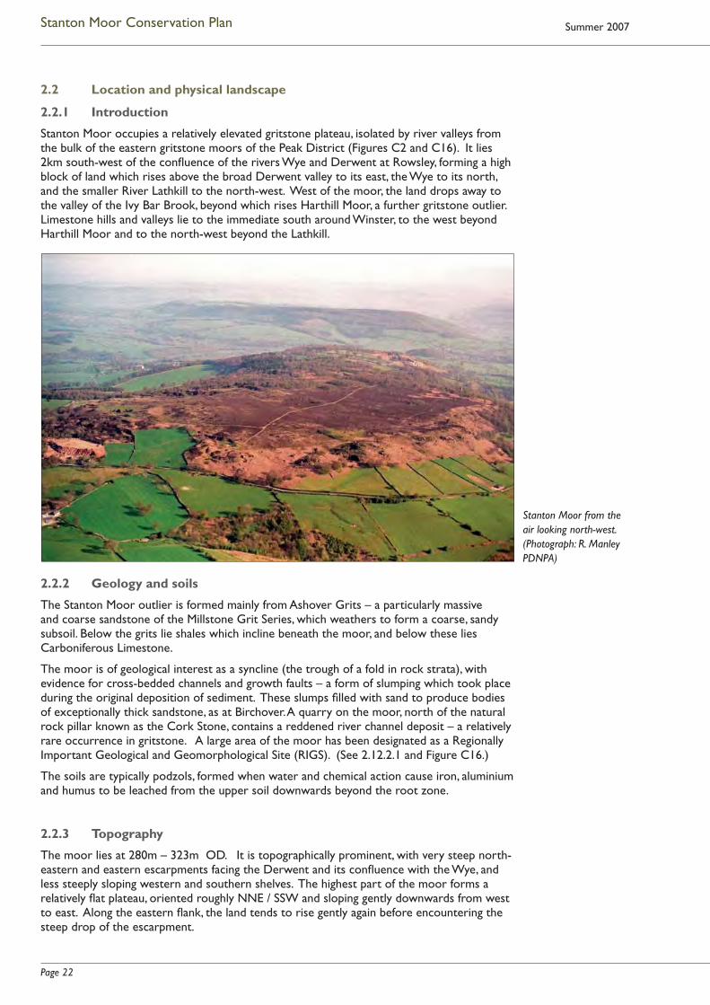
2.2 Location and physical landscape
2.2.1 Introduction
Stanton Moor occupies a relatively elevated gritstone plateau, isolated by river valleys from the bulk of the eastern gritstone moors of the Peak District (Figures C2 and C16). It lies 2km south-west of the confl uence of the rivers Wye and Derwent at Rowsley, forming a high block of land which rises above the broad Derwent valley to its east, the Wye to its north, and the smaller River Lathkill to the north-west. West of the moor, the land drops away to the valley of the Ivy Bar Brook, beyond which rises Harthill Moor, a further gritstone outlier. Limestone hills and valleys lie to the immediate south around Winster, to the west beyond Harthill Moor and to the north-west beyond the Lathkill.
2.2.2 Geology and soils
The Stanton Moor outlier is formed mainly from Ashover Grits – a particularly massive and coarse sandstone of the Millstone Grit Series, which weathers to form a coarse, sandy subsoil. Below the grits lie shales which incline beneath the moor, and below these lies Carboniferous Limestone.
The moor is of geological interest as a syncline (the trough of a fold in rock strata), with evidence for cross-bedded channels and growth faults – a form of slumping which took place during the original deposition of sediment. These slumps fi lled with sand to produce bodies of exceptionally thick sandstone, as at Birchover. A quarry on the moor, north of the natural rock pillar known as the Cork Stone, contains a reddened river channel deposit – a relatively rare occurrence in gritstone. A large area of the moor has been designated as a Regionally Important Geological and Geomorphological Site (RIGS). (See 2.12.2.1 and Figure C16.)
The soils are typically podzols, formed when water and chemical action cause iron, aluminium and humus to be leached from the upper soil downwards beyond the root zone.
2.2.3 Topography
The moor lies at 280m – 323m OD. It is topographically prominent, with very steep north-eastern and eastern escarpments facing the Derwent and its confl uence with the Wye, and less steeply sloping western and southern shelves. The highest part of the moor forms a relatively fl at plateau, oriented roughly NNE / SSW and sloping gently downwards from west to east. Along the eastern fl ank, the land tends to rise gently again before encountering the steep drop of the escarpment.
Stanton Moor from the air looking north-west. (Photograph: R. Manley PDNPA)

Page 23
Stanton Moor Conservation Plan
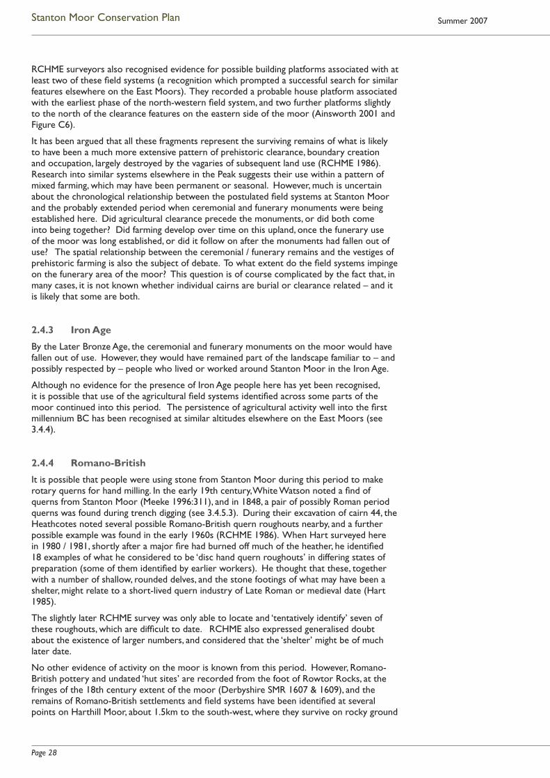
A number of prominent, isolated, wind-eroded outcrops and pillars of sandstone form a striking feature of the moor’s local topography. Several are on its eastern escarpment, and include the 9m high Heart Stone, now partly hidden in trees towards the southern end of Stanton Moor Edge, the 5m high pillar known as the Cat Stone to the north of the escarpment, and an outcrop known as the Duchess of Sutherland Stone about midway between them1 (Figure C5). To the south of the moor is another natural pillar, the Cork Stone, also about 5m high, while the outcrop known as the Andle Stone sits in what
is now enclosed farmland 250m west of the moor. Before its enclosure in the early 19th century, the moor extended to the edge of Birchover village, just west of which rises the strikingly eroded gritstone mass known as Rowtor Rocks, with Bradley Tor to its west.
All along the moor’s western fl ank, and over a large area of ground at its south-west, extensive quarrying for gritstone has in some cases entirely removed the earlier ground surface, and in others created extensive areas of pitting and scarring, thus radically altering the local topography (see 3.3). Parts of the eastern, and particularly the north-eastern, escarpment have also been quarried away.
2.3 Land ownership and management
2.3.1 19th and early 20th century
Throughout much of its medieval and late medieval history, the manor of Stanton was held ‘in moities’ or two main parts (Sinar n.d.). By the late 18th century the lords of these two halves of the manor were the Duke of Rutland and Bache Thornhill, who were also two of the larger Stanton landowners. At this point, despite earlier piecemeal enclosure of arable land and most of Stanton Common (Sinar n.d., Wood 1999:68), much of Stanton Moor was still unenclosed. A map of 1799 shows that it covered a much larger area than at present – particularly to the south-west, where it stretched down to Birchover, and across towards the Ivy Bar Brook (3.4.7.2).
In 1809, an Act was produced for the enclosure of the Stanton commons and remaining wastes, although the Enclosure Award was not issued until 1819 (Figure C9). Thornhill and the Duke of Rutland used this opportunity to exchange lands, and separate their manorial rights: Thornhill concentrated his land around Stanton village, while the Duke’s focus lay around Stanton Lees and Stanton Woodhouse. This exchange of land included the transfer of a large part of the moor from the Duke’s ownership to that of Bache Thornhill (DRO Q/RI 4/171).
From 1808, the Thornhills, as owners of the majority of the moor, began to ‘improve’ it with extensive plantations of trees (2.4.6 and 3.4.7.4). It is probable that they later became involved in the promotion of large-scale quarrying along its western fringes (2.4.7). Most of the moor remained in the possession of the Thornhill family and their descendants through the 19th and 20th centuries, as it does today.
The eastern fringe of the moor (i.e the land now occupied by Lees Cross Quarry and by the National Trust’s Stanton Moor Edge estate) was allotted to the Duke of Rutland in two or three different land parcels, with the western boundary of these ‘lots’ running along the line of what is now the ‘Duke’s Drive’. (The Enclosure Award does not refer to this ‘drive’ when it specifi es the allotments’ various boundaries, possibly suggesting that the route was a later creation along the new boundary line.) In 1920 the Duke of Rutland’s (Haddon) estate put the southern part of the escarpment up for sale, and in 1934 the same parcel of land was bought by the National Trust from William Twigg, an iron and steel merchant from Matlock.
1 The name ‘Gorse Stone’ may also have been applied to this stone and / or to the prominent rock pillar to its
south. 18th to 21st century accounts indicate uncertainty about the local names given to rock pillars around the moor, and
a certain amount of misnaming, and (possibly) name-sharing.
Cork Stone and eroded footpath, 2006.
(Photograph: S. McGuire)
Page 24
Stanton Moor Conservation Plan Summer 2007
Money for the purchase appears to have been donated by F.A. Holmes (a Derbyshire J.P., amateur archaeologist, member of the Council for the Protection of Rural England and supporter of the concept of National Parks, who was also involved in the acquisition of Ilam and parts of Dovedale for the Trust).
2.3.2 Current land ownership and management
The majority of Stanton Moor now forms part of the Stanton Estate, which is owned by the Trustees of the Thornhill Settlement. The Stanton Estate lets the moor to a tenant grazier. Shooting rights – particularly in the woodland to the west and north of the moor – are also let in the winter months. Between 1993 and November 2004, local management of much of the Estate land on the moor was carried out under the terms of a Farm Conservation Agreement (FCA), arranged between the Estate and the Peak District National Park Authority. The FCA area largely coincided with the scheduled area, but extended beyond it to the south and south-west (2.12.5.1 and Figure C14).
As indicated above, an area of some 11 hectares along the extreme eastern and south-eastern fringes of the moor, known as Stanton Moor Edge, is owned and managed by the National Trust. The FCA did not apply to the Trust land. Part of the northern sector of the Trust land is included within the scheduled area of the moor (Figure C11).
Since 1995, a large area of the moor has been included in the list of Scheduled Monuments, and thus falls within the responsibilities of English Heritage (2.12.1.2). To the north of the moor, the Nine Ladies stone circle and outlying King Stone are monuments in the Guardianship of English Heritage (2.12.1.3) and are managed on a day to day basis by the Peak District National Park Authority, under the terms of a Local Management Agreement, currently being renegotiated (2.12.5.2).
2.4 Cultural Heritage
2.4.1 Mesolithic and Neolithic
There is no direct evidence for Mesolithic use of Stanton Moor itself, although Late Mesolithic stone tools and production waste have been found on the neighbouring East Moors. Evidence that people used the moor during the Neolithic is relatively slight (see 3.4.2): it comprises a small number of polished stone axes from the moor itself, a fl int scatter incorporating some Neolithic material found on land to the west which formed part of the pre-19th century moor, and an artefact scatter a short distance to the north of the scheduled area, which included a leaf-shaped arrowhead and Beaker sherd. In Autumn 2006, a further leaf-shaped arrowhead was recovered from a footpath on Stanton Moor Edge. A macehead from the moor, and rock art at Rowtor Rocks (also on the edge of the earlier moor) may date from the Late Neolithic, and it is possible that a saddle quern found in mound material during the excavation of cairn T8 (see 3.4.3.8) indicates use of the moor during the Neolithic period – although it might equally add to evidence for settlement and agriculture here in the Bronze Age.
2.4.2 Bronze Age
2.4.2.1 Introduction
Although the scatter of artefacts described above suggests the presence of Neolithic people on and around the moor, we do not yet know whether there was any relationship between this earlier activity and the relatively intensive and possibly rather specialised use of this area in the Early Bronze Age. It was in this period that
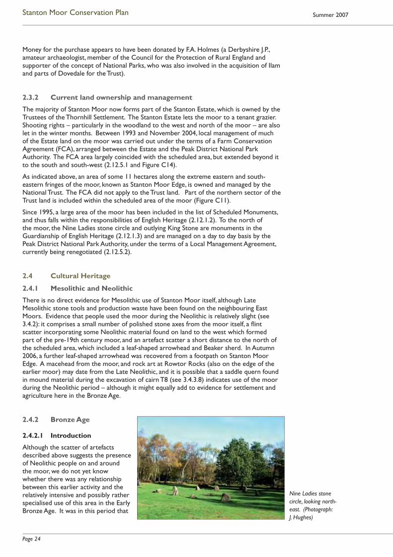
Nine Ladies stone circle, looking north-east. (Photograph: J. Hughes)

Page 25
Stanton Moor Conservation Plan
people – probably over several generations – chose to build a range of fairly closely spaced ceremonial and funerary monuments across what is now Stanton Moor (Figures C5 and C6).
It was once thought that the moor was reserved exclusively for such monuments. However, since the 1960s, evidence for Bronze Age agricultural clearance and probable settlement has been identifi ed, although it is not yet clear how far this spread across the moor, nor whether it was contemporary with the monuments. It may be that, for a time, the highest ground “was reserved for grazing, for the dead, and perhaps for certain moments when people gathered at their ceremonial circles” (Edmonds and Seaborne 2001:161). Many of the monuments appear to have been altered and developed, suggesting changes in tradition and use over a relatively long period.
Almost all excavation on the moor took place before the development of relatively accurate dating methods (2.5.1). This means that the age of the Stanton monuments has been assessed largely by analogy with examples elsewhere. Nor is much known about their relative chronological sequence, except in those few cases where monuments abut or are superimposed. Although many of the monuments have suffered some degree of early excavation, detailed survey has shown that unexcavated sections are likely to survive, even in many of the most disturbed structures. In addition, a number of largely undisturbed cairns have been recorded and these may retain valuable information (RCHME 1986).
The prehistoric monuments which survive on the moor include an unusually tight cluster of ceremonial sites comprising three embanked stone circles, a standing stone, and at least one (possibly two) ring cairns. A fourth circle, Doll Tor, lies to the west, just 250m outside the limit of the modern moorland. Close to these monuments lie more than 120 cairns, many of which appear to be primarily funerary (Figures C5 and C6). Again, the survival of a cairnfi eld with a very high proportion of funerary cairns is rare in the region, where only two or three other (much smaller) sites have been recognised (3.4.3.2). In addition, early 20th century excavation on the south-western fringe of the moor (2.5.1.4) revealed a large number of funerary urns and cremated remains in what may have been a fl at cemetery (Storrs Fox 1927).
In the modern landscape, the extensive cairnfi eld amongst which the ceremonial monuments and large funerary mounds are situated lies mainly on the crest and gentle east-facing slopes of the moor, with the greatest density of known funerary cairns towards the south. However, the area which Early Bronze Age people considered appropriate for funerary and ceremonial monuments appears to have extended west, south-west and possibly north beyond the modern moorland boundary. A possible cist burial was excavated near to the Birchover Road, just west of the moor (RCHME 1986). Close by lie the Doll Tor stone circle and an adjacent burial cairn. Accounts from the late 1800s and early 1900s (2.5.1) show that quarrymen regularly came across buried urns on the south-western edge of the moor (and also apparently to the south-east). Extensive quarrying at New Park in the 1920s and 30s is known to have destroyed the possible fl at cemetery, and probably destroyed at least two cairns here which had been examined by the early 20th century excavators, the Heathcotes (2.5.1.5). Potentially funerary objects recovered further west and south-west include a food vessel and bronze sword from Stanton Park (Vine 1982) and an urn and Bronze Age pottery from the foot of Rowtor Rocks (Derbyshire SMR 1605 & 1608). Recently, a possible cairn has been identifi ed north-east of stone circle T61, close to the eroded rock pillar known as the Duke of York stone, and thus outside the scheduled area (5.2.2.6). If confi rmed as funerary, this would be the northernmost such feature to be identifi ed on the moor. Even further to the north, sherds from a possible Collared Urn, found in subsoil on the line of the route of the New Pilhough Quarry short haul road north of the Lees Road, may indicate Early Bronze Age burial or settlement close by. However, these sherds may not be in situ (Beswick in O’Neill 2004).
2.4.2.2 Ceremonial and large-scale funerary monuments
The majority of the larger ceremonial and funerary monuments lie in a slightly uneven but potentially deliberate line which runs SSW / NNE across the moor, part way down the east-facing slope (Figures C5 and C6). They may have been sited to be intervisible: if this were so, it would imply substantial tree clearance on the moor by this time. Included in the ‘line’ are: the ring cairn named by the Heathcotes as T56; the embanked stone circles T43 and T61; the
Page 26
Stanton Moor Conservation Plan Summer 2007
Nine Ladies embanked stone circle and probable outlier, known as the King Stone, and two large, possibly multi-phased cairns, T2 and T55. (A possible further ring cairn north-west of the Reform Tower, identifi ed by RCHME in the late 1980s, sits outside the postulated line.) Conceivably, the line extends further south, to a cluster of cairns on the southern edge of the moor (English Heritage 1995). This cluster includes a row of three small cairns (T8, T29 and T30) which lie on a NNW / SSE alignment.
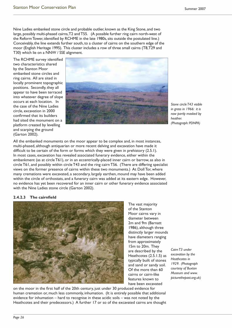
The RCHME survey identifi ed two characteristics shared by the Stanton Moor embanked stone circles and ring cairns. All are sited in locally prominent topographic positions. Secondly, they all appear to have been terraced into whatever degree of slope occurs at each location. In the case of the Nine Ladies circle, excavation in 2000 confi rmed that its builders had sited the monument on a platform created by levelling and scarping the ground (Garton 2002).
All the embanked monuments on the moor appear to be complex and, in most instances, multi-phased, although antiquarian or more recent delving and excavation have made it diffi cult to be certain of the form or forms which they were given in prehistory (2.5.1). In most cases, excavation has revealed associated funerary evidence, either within the embankment (as at circle T61), or in an eccentrically-placed inner cairn or barrow, as also in circle T61, and possibly within circle T43 and the ring cairn T56. (There are differing specialist views on the former presence of cairns within these two monuments.) At Doll Tor, where many cremations were excavated, a secondary, largely earthen, mound may have been added within the circle of orthostats, and a funerary cairn was added at its eastern edge. However, no evidence has yet been recovered for an inner cairn or other funerary evidence associated with the Nine Ladies stone circle (Garton 2002).
2.4.2.3 The cairnfi eld
The vast majority of the Stanton Moor cairns vary in diameter between 2m and 9m (Barnatt 1986), although three distinctly larger mounds have diameters ranging from approximately 15m to 20m. They are described by the Heathcotes (2.5.1.5) as typically built of stones and sand or sandy soil. Of the more than 60 cairns or cairn-like features known to have been excavated
on the moor in the fi rst half of the 20th century, just under 30 produced evidence for human cremation or, much less commonly, inhumation. (It is entirely possible that additional evidence for inhumation – hard to recognise in these acidic soils – was not noted by the Heathcotes and their predecessors.) A further 17 or so of the excavated cairns are thought
Cairn T3 under excavation by the Heathcotes in 1929. (Photograph courtesy of Buxton Museum and www.picturethepast.org.uk)
Stone circle T43 visible in grass in 1966: it is now partly masked by heather. (Photograph: PDNPA)

Page 27
Stanton Moor Conservation Plan
to be probably or possibly funerary, as may a number of undisturbed cairns – some of them identifi ed in the course of detailed archaeological survey in the 1980s (RCHME 1986). Although the cairns sometimes occur in clusters, John Barnatt (1999) has observed that, in general, they are more widely spaced than is the case in most other (primarily agricultural) cairnfi elds on the East Moors.
Many of the funerary (and potentially funerary) cairns show evidence of careful construction, and formal architectural characteristics such as kerbing. A number of cairns stand out. These include the three large mounds – the two (Heathcote T2 and T55) located in the potential ‘line’ of monuments across the moor, and one (T57) in a prominent position further to the east, overlooking the Derwent Valley. Despite damage done to these three substantial cairns, their shared characteristics – which include their prominent topographical positions, their size, and evidence for a large outer kerb or ring of stones – all suggest that they are complex, multi-phased burial monuments, which may have some structural, and perhaps chronological, relationship. (They are all currently scheduled as chambered tumuli.) Some of the smaller cairns also show evidence of structural complexity. Heathcote T13, to the west of the moor, which contained 13 recorded cremations, may have been two conjoined monuments. The largely undisturbed triple cairn to the south-east of the moor (T44 / 45 / 46) has also been interpreted as a deliberately linked burial complex (RCHME 1986).
Radiocarbon dates are not available for any of the excavated burials, but artefacts associated both with the cairns and with the majority of other monuments provide extensive evidence for an Early Bronze Age date. These include over 50 Collared Urns, approximately 14 Accessory Cups, and a smaller number of both Cordoned and Biconical Urns and Food Vessels (see 2.5.2, 3.4.3.5). With the exception of items found with the possible cist burial close to the Birchover Road, non-ceramic grave goods are limited in number and type: the Heathcotes and earlier excavators commonly noted the presence of a few burnt fl ints, quartz pebbles, and fragments of bronze, and occasional items such as a clay stud, jet ring, barbed and tanged arrowhead or faience bead. However, it is possible that, at the various periods when these monuments were excavated, urns and other grave contexts were not adequately searched (J.I. McKinley, cited in Beswick 1994:321).
Although the Stanton Moor cairns form a regionally and nationally unusual cluster of funerary monuments, many of them carefully structured, an earlier view that they had been constructed in a wide range of very unusual forms has now been disproved. Detailed survey in the 1980s made it clear that the morphology of many monuments had been substantially altered, principally through the particular mode of excavation and often extensive reconstruction adopted by the Heathcotes, and – perhaps less substantially – through the impact of various activities on the moor in the historic and modern periods (RCHME 1986, and see 2.4.6 & 2.4.7). The way in which the Heathcotes chose to excavate, and to reconstruct, is itself of some interest within the history of archaeological development.
2.4.2.4 Evidence for agriculture and settlement
Since the mid 1960s, evidence for prehistoric agricultural clearance and boundary creation, analogous to known Bronze Age fi eld systems elsewhere in the Peak District, has been identifi ed at various points across the moor (RCHME 1986; and Figures C5 and C6). The most widely accepted fi eld system remains – which consist of small cairns and linear stone clearance and reveal evidence for some chronological depth – lie to the north-west of the moor, close to the quarried western edge (beyond which they most probably extended). It has been argued that this fi eld system also extended eastwards across the centre of the moor, although only slight vestiges remain in this area. Close to the moor’s eastern edge, a second group of less structured fi eld system remains has been recognised. These comprise concentrations of small cairns and crudely formed rubble clearance banks. North-west of the Reform Tower lies a third area of possible small clearance cairns and linear clearance features. Even slighter remains have been tentatively identifi ed towards the southern edge of the moor, although specialists differ as to the strength of the evidence here.
Page 28
Stanton Moor Conservation Plan Summer 2007
RCHME surveyors also recognised evidence for possible building platforms associated with at least two of these fi eld systems (a recognition which prompted a successful search for similar features elsewhere on the East Moors). They recorded a probable house platform associated with the earliest phase of the north-western fi eld system, and two further platforms slightly to the north of the clearance features on the eastern side of the moor (Ainsworth 2001 and Figure C6).
It has been argued that all these fragments represent the surviving remains of what is likely to have been a much more extensive pattern of prehistoric clearance, boundary creation and occupation, largely destroyed by the vagaries of subsequent land use (RCHME 1986). Research into similar systems elsewhere in the Peak suggests their use within a pattern of mixed farming, which may have been permanent or seasonal. However, much is uncertain about the chronological relationship between the postulated fi eld systems at Stanton Moor and the probably extended period when ceremonial and funerary monuments were being established here. Did agricultural clearance precede the monuments, or did both come into being together? Did farming develop over time on this upland, once the funerary use of the moor was long established, or did it follow on after the monuments had fallen out of use? The spatial relationship between the ceremonial / funerary remains and the vestiges of prehistoric farming is also the subject of debate. To what extent do the fi eld systems impinge on the funerary area of the moor? This question is of course complicated by the fact that, in many cases, it is not known whether individual cairns are burial or clearance related – and it is likely that some are both.
2.4.3 Iron Age
By the Later Bronze Age, the ceremonial and funerary monuments on the moor would have fallen out of use. However, they would have remained part of the landscape familiar to – and possibly respected by – people who lived or worked around Stanton Moor in the Iron Age.
Although no evidence for the presence of Iron Age people here has yet been recognised, it is possible that use of the agricultural fi eld systems identifi ed across some parts of the moor continued into this period. The persistence of agricultural activity well into the fi rst millennium BC has been recognised at similar altitudes elsewhere on the East Moors (see 3.4.4).
2.4.4 Romano-British
It is possible that people were using stone from Stanton Moor during this period to make rotary querns for hand milling. In the early 19th century, White Watson noted a fi nd of querns from Stanton Moor (Meeke 1996:311), and in 1848, a pair of possibly Roman period querns was found during trench digging (see 3.4.5.3). During their excavation of cairn 44, the Heathcotes noted several possible Romano-British quern roughouts nearby, and a further possible example was found in the early 1960s (RCHME 1986). When Hart surveyed here in 1980 / 1981, shortly after a major fi re had burned off much of the heather, he identifi ed 18 examples of what he considered to be ‘disc hand quern roughouts’ in differing states of preparation (some of them identifi ed by earlier workers). He thought that these, together with a number of shallow, rounded delves, and the stone footings of what may have been a shelter, might relate to a short-lived quern industry of Late Roman or medieval date (Hart 1985).
The slightly later RCHME survey was only able to locate and ‘tentatively identify’ seven of these roughouts, which are diffi cult to date. RCHME also expressed generalised doubt about the existence of larger numbers, and considered that the ‘shelter’ might be of much later date.
No other evidence of activity on the moor is known from this period. However, Romano-British pottery and undated ‘hut sites’ are recorded from the foot of Rowtor Rocks, at the fringes of the 18th century extent of the moor (Derbyshire SMR 1607 & 1609), and the remains of Romano-British settlements and fi eld systems have been identifi ed at several points on Harthill Moor, about 1.5km to the south-west, where they survive on rocky ground

Page 29
Stanton Moor Conservation Plan
close to Robin Hood’s Stride, and within woodland just west of the Ivy Bar Brook (see 3.4.5 and Figure C21). It seems likely that people from these neighbouring communities would have made use of the resources of Stanton Moor in the early centuries AD.
2.4.5 Early Medieval and Medieval
Two glass beads, now thought to be Anglo-Saxon, were found on Stanton Moor in 1849 and 1850 (Derbyshire SMR 12968). Apart from these, no features or artefacts known from the moor can be confi dently ascribed to the early or later medieval period.
There are, however, traces of a number of activities which may date from this time. Early surface delves and quarries, small stone spoil heaps, and stone robbing from prehistoric cairns have been shown by RCHME to be widespread (RCHME 1986). Although such traces are largely undatable, stone getting on the moor is likely to have had a long history. It is possible that the small number of quern roughouts recorded on the moor may in fact be medieval, rather than Romano-British, as may potentially associated delves and stone litter.
There are complex remains of fi eld clearance and boundary creation to the north-west of the moor, which reveal evidence for at least three phases of activity (Figure C5). The earliest of these is considered to be prehistoric stone clearance. A second, later, phase, which consists of straighter, narrower, revetted boundaries, may relate to fi eld demarcation. Although RCHME judged these to be possibly also prehistoric, Barnatt (1986) considers them to be medieval in origin. At some points, lynchet formation suggests that they relate to areas which have been ploughed. These later boundaries are in places overlain by the ruined remains of post-medieval walls.
Towards the south of the moor, just west of the main north-south track, a group of seemingly linear rubble banks and walls forms what appears to be a large rectangular enclosure. Barnatt (1986) suggests that this could be a medieval or post-medieval sheep pound. An alternative interpretation is discussed at 2.4.6 below.
The moor is crossed by a number of hollow-ways, some of which may be medieval in origin.
2.4.6 Post-medieval to early modern
Much of the non-prehistoric evidence on Stanton Moor is likely to date from the 16th century onwards.
The moor is crossed by a number of hollow-ways and trackways (Figure C5). In the main, these run approximately north-south, and, as noted above, are likely to be medieval to post-medieval in origin. Some may be pre-turnpike packhorse routes, while others may relate to purely local access for quarrying and other activities. The remains of slab paving can be traced in at least three places: on a short stretch of the ‘Duke’s Drive’ (see below), on a section of track further south where a hollow-way climbs up onto the moor to the east of Stanton Park Quarry, and on the track which leads from the Birchover Road to a hollow-way which heads towards the Cork Stone.
Small-scale stone getting on Stanton Moor is documented from the late 16th century, and was probably an older right. There is much evidence – in the form of shallow surface pits and delves – for casual stone extraction, and a scatter of part-fi nished items such as lintels and gateposts can be seen across the moor (RCHME 1986). RCHME surveyors also recorded what they considered to be a broken millstone south of the Nine Ladies stone circle. (Large-scale stone extraction developed from the mid 19th century, and evidence for this within the scheduled area is described below at 2.4.7.)
There are a few examples of what is probably post-medieval enclosure. Footpath erosion has revealed stretches of wall footings on the public footpath which runs east from the Cork Stone and on the path which runs north of cairn T2 (Figure C5). To the north-west of the moor (within an area immediately east of recent stone extraction at Stanton Moor Quarry) are the collapsed and robbed remains of coursed drystone walling. These overlie earlier fi eld system boundaries, and are associated with small animal pens, a dew pond and narrow plough furrows (Figure C5). Some walls appear unfi nished. To their north-east lie the remains
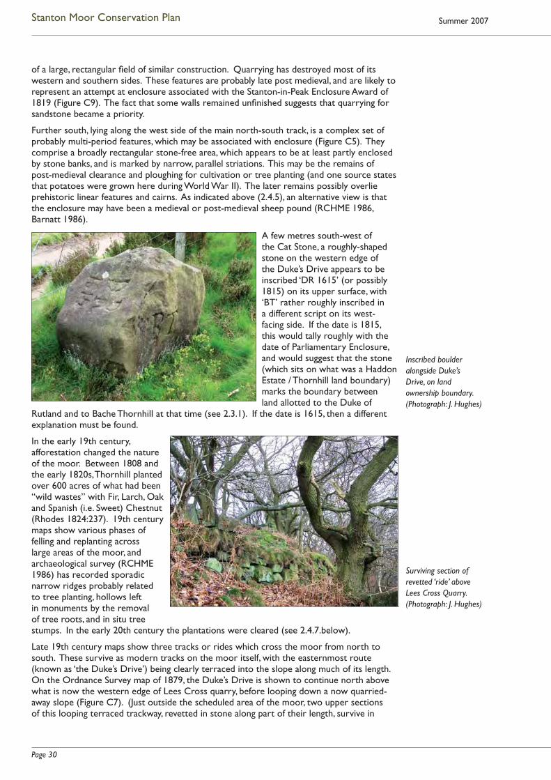
Page 30
Stanton Moor Conservation Plan Summer 2007
of a large, rectangular fi eld of similar construction. Quarrying has destroyed most of its western and southern sides. These features are probably late post medieval, and are likely to represent an attempt at enclosure associated with the Stanton-in-Peak Enclosure Award of 1819 (Figure C9). The fact that some walls remained unfi nished suggests that quarrying for sandstone became a priority.
Further south, lying along the west side of the main north-south track, is a complex set of probably multi-period features, which may be associated with enclosure (Figure C5). They comprise a broadly rectangular stone-free area, which appears to be at least partly enclosed by stone banks, and is marked by narrow, parallel striations. This may be the remains of post-medieval clearance and ploughing for cultivation or tree planting (and one source states that potatoes were grown here during World War II). The later remains possibly overlie prehistoric linear features and cairns. As indicated above (2.4.5), an alternative view is that the enclosure may have been a medieval or post-medieval sheep pound (RCHME 1986, Barnatt 1986).
A few metres south-west of the Cat Stone, a roughly-shaped stone on the western edge of the Duke’s Drive appears to be inscribed ‘DR 1615’ (or possibly 1815) on its upper surface, with ‘BT’ rather roughly inscribed in a different script on its west-facing side. If the date is 1815, this would tally roughly with the date of Parliamentary Enclosure, and would suggest that the stone (which sits on what was a Haddon Estate / Thornhill land boundary) marks the boundary between land allotted to the Duke of
Rutland and to Bache Thornhill at that time (see 2.3.1). If the date is 1615, then a different explanation must be found.
In the early 19th century, afforestation changed the nature of the moor. Between 1808 and the early 1820s, Thornhill planted over 600 acres of what had been “wild wastes” with Fir, Larch, Oak and Spanish (i.e. Sweet) Chestnut (Rhodes 1824:237). 19th century maps show various phases of felling and replanting across large areas of the moor, and archaeological survey (RCHME 1986) has recorded sporadic narrow ridges probably related to tree planting, hollows left in monuments by the removal of tree roots, and in situ tree stumps. In the early 20th century the plantations were cleared (see 2.4.7.below).
Late 19th century maps show three tracks or rides which cross the moor from north to south. These survive as modern tracks on the moor itself, with the easternmost route (known as ‘the Duke’s Drive’) being clearly terraced into the slope along much of its length. On the Ordnance Survey map of 1879, the Duke’s Drive is shown to continue north above what is now the western edge of Lees Cross quarry, before looping down a now quarried-away slope (Figure C7). (Just outside the scheduled area of the moor, two upper sections of this looping terraced trackway, revetted in stone along part of their length, survive in
Inscribed boulder alongside Duke’s Drive, on land ownership boundary. (Photograph: J. Hughes)
Surviving section of revetted ‘ride’ above Lees Cross Quarry. (Photograph: J. Hughes)

Page 31
Stanton Moor Conservation Plan
woodland above the quarry.) The date of origin of the rides and ‘drive’ is not certain. Although an 18th century date has been suggested (Bowmer 1998), it seems likely that there was some development of these routes in the early 19th century, in association with the planting up of the moor, and its transformation from the barren waste described by 18th century writers into a desirable place to visit. As indicated at 2.3.1, documents relating to Parliamentary Enclosure suggest that the Duke’s Drive postdates 1819. Certainly, by the mid 1840s, Adam’s guide to the area around Matlock Bath was promoting the beauty of Stanton Moor’s rides, pinewoods, lofty crags and scenic views, and his description (2.8) suggests that the rides on the moor itself formed the culmination of a scenic route up the north-eastern escarpment (Adam 1845).
Just on the boundary of the scheduled area, a number of carefully worked inscriptions and images carved on natural rock surfaces on the eastern periphery of the moor appear closely associated with the Duke’s Drive, its northern extension, and the rides or drives up the escarpment. Five smooth panels of stone have been created on rock pillars and outcrops on the edge of the eastern and north-eastern escarpment, and these bear carefully-incised initials usually accompanied by dates in the 1820s, 1830s and 1850s. In three cases the panels also display elaborate (probably ducal) coronets, created in bas relief (see illustrations here and at 3.4.7.6). Local names for two of the carvings – the ‘Duchess of Sutherland Stone’ and ‘Duke of York Stone’ – have been recorded (Heathcote 1947), and RCHME (1986:Part 4) has described three of them as “quarrymen’s graffi ti of an exceptionally high standard”. However, it seems more likely that, like the rides and Duke’s Drive, the earlier stones (if not the whole group) can be associated with early 19th century ornamentation of the natural landscape by those who owned it (see 3.4.7.5 / 6). The Duke of York Stone, dated 1826, and described in the 1840s as “overhanging the rides” (Adam 1845: 203), certainly appears designed to be admired from the northern extension of the Duke’s Drive, a truncated section of which still passes a few metres below it. The 1879 map shows that three of the inscribed stones could also be visited via short tracks which branched off the main Drive (although a route through to the Cat Stone had already been referred to, and recorded in a drawing, by Rooke in the1780s)1.
1 There are carefully-cut footholds and iron rings to act as handholds on one face of the Cat Stone, and very
similar sets of climbing aids exist on the Cork and Andle Stones. The date of these is not known, but the degree of
wear on the footholds suggests that they have been there for some time. The date ‘1758’ has been carved close to the
footholds on the Andle Stone, but there is nothing to prove that this inscription is contemporary with their creation.
Left: The ‘Duke of York Stone’ above
Lees Cross Quarry. (Photograph: J. Hughes)
Right: Inscribed block of stone on north-eastern edge of Stanton Moor.
(Photograph: J. Hughes)

Page 32
Stanton Moor Conservation Plan Summer 2007
The neighbouring Reform Tower (see 2.4.9 below) was originally ornamented with a stone panel carved with an earl’s coronet and the inscription ‘Earl Grey 1832’, which might suggest that this tower and the dated initials and coronets on neighbouring rock outcrops were conceived as part of the same landscape scheme. However, the Tower was built on Thornhill land, while the rock inscriptions were created on land which, at the time, was all in Rutland ownership. The possible implications of this are discussed at 3.4.7.6.
In the later 19th and early 20th centuries, some sections of revetted track on the north-eastern slopes appear to have been adapted to the needs of the growing quarrying industry (or simply quarried away), while the rides on the moor itself were partly incorporated into the infrastructure created to support tree felling (Ainsworth 1990).
2.4.7 Industry
There is sporadic evidence for small-scale industrial activity at various points across the moor, although the principal remains relate to extensive quarrying around its fringes, to 19th century afforestation, and to industrial-scale tree clearance and disposal in the early 20th century.
Bateman (1848:24) refers to “an ancient bole or smelting-place for lead” on the moor, still present in the fi rst half of the 19th century. As its position is no longer evident, it may have been destroyed by quarrying – perhaps on the western edge of the moor. In addition, the catalogue of the Heathcote Collection now at Weston Park Museum, Sheffi eld, includes a reference to ‘lumps of lead ore from outside cairn T57’ (SCM 1981.1441), which may point to the use of this large eastern cairn as a bole site.
At the moor’s extreme western edge, RCHME (1986) recorded traces of possible bell pits for coal extraction, although there is no mapped seam of coal here, and no exposures were seen.
To the north-east of the moor, there is evidence for small-scale sand quarrying, in the form of sand pits and spoil heaps (sometimes mistaken for rabbit warrens). There is a record of sand being dug on the moor in 1859 (Vine 1982:236).
As discussed above, there is widespread evidence for small-scale stone getting on the moor. Some of the hollow-ways and packhorse trails may have served this early industry.
In the 19th and 20th centuries, massive gritstone quarries spread along the north-west, west and south-west fringes of the moor, and adjacent to its north-eastern edge (see contemporary photograph at 3.4.8.4). In the main, this industrial-scale stone extraction appears to have got under way from the 1850s, with the most intensive period of work being the later 19th and early 20th centuries. On the moor itself, map evidence indicates that the area north of the Cork Stone was quarried at a date between 1879 and 1897 (see below). The western quarries were still expanding eastwards between 1897 and 1919, but by the mid 1940s the majority here were disused. There was some, more limited, resurgence of activity in the 1950s through to the 1980s. Currently, several substantial quarries close to the moor are now either active or projected (see 3.3).
The late 19th century quarry to the north of the Cork Stone and early to mid 20th century workings towards the mid-point of Stanton Moor Edge lie within the scheduled area (Figure C5). Although neither has been fully studied, informal inspection indicates that the Cork Stone quarry contains tooled blocks of varying sizes, a part-fi nished grindstone, fragments of at least one other, and, in the base of the quarry, a few courses of drystone masonry. The footings of small buildings lie against the south-eastern slope of the quarry side and on its northern edge (see 2.4.9 below). The scheduled 20th century workings on Stanton Moor Edge lie north of the Duchess of Sutherland Stone. Here, level with the moor, is an extensive area of ground revetted to create an artifi cial platform, coursed masonry, a gritstone crane base, and partially tooled gritstone blocks. Also scheduled are deep workings immediately to the east, now thickly overgrown with trees.
With the exception of these features, the larger quarries lie outside the scheduled area of the moor, although there is a small area of overlap to the west, whose extent and implications are discussed below at 2.7.1. Many of them still preserve a wealth of evidence

Page 33
Stanton Moor Conservation Plan
for historic working practices, including grindstone rough-outs and waste, other dressed artefacts, ruined buildings, machinery positions, revetted spoil heaps and trackways (see 3.3).
Cartographic and other documentary evidence indicates the afforestation of the moor from 1808 onwards, and management of this woodland via episodes of felling and replanting (see 2.4.6). Physical evidence of these activities includes narrow ridges, probably related to tree-planting, and an extensive scatter of tree stumps across the moor. The Heathcotes, for
example, recorded over 50 tree roots extracted from cairn T2 during excavation (Heathcote 1930:22).
During the First World War, the Stanton Moor plantations were largely clear-felled, most probably to provide trench timbers. The RCHME survey of 1986 recorded evidence for what appears to have been an animal-hauled light railway, which carried timber to a sawmill on the western edge of the moor (Figure C8). This interpretation is supported by the oral evidence of local residents, and some circumstantial evidence from contemporary archives. The remains of two lines and a short section of a third have been traced, although local people recall the existence of further lines. The tracks are recognisable as ballast banks made from earth and sand dug from pits alongside, and in some places the track has been terraced into the slope. The most clearly recognisable line runs from a point on the south-west edge of the moor, close to where the path to the Cork Stone leaves the Birchover Road. It runs north-east to a point close to the Reform Tower, and, where it crosses the centre of the moor, utilises the line of a pre-existing hollow-way. Close to its possible terminus by the Birchover Road lie the earthwork remains of a small rectangular building, which may have been the sawmill. Small projecting earthern platforms may be stances for saw machinery, and there are also traces of a possible unloading platform (RCHME 1986).
2.4.8 Modern artefacts
The temporary dwellings, aerial walkways and other infrastructure set up by environmental activists in Lees Cross and Endcliffe Quarries can be regarded as a signifi cant (albeit controversial) aspect of the moor’s contemporary cultural heritage. Because of the publicity generated by the quarrying protest, the protesters and the infrastructure which they have created have become, for some audiences, representative of Stanton Moor itself. While the main camp lies just outside the Scheduled Monument boundary, there are many occasions when supporters’ tents, banners (and other artefacts strung in the trees) can be seen on the moor itself (see 2.9, 3.3.2.4).
The contemporary popularity of the Nine Ladies stone circle as a spiritual focus has led to the (often transient)
Nine Ladies stone circle circa 1909: note
encircling wall and tree cover. (Photograph
courtesy of Derbyshire Local Studies and www.
picturethepast.org.uk)
Top right: protest camp tree house, Lees Cross.
(Photograph: J. Hughes)
Bottom right: Aerial walkway at
protest camp. (Jill Gibbon, 2003)
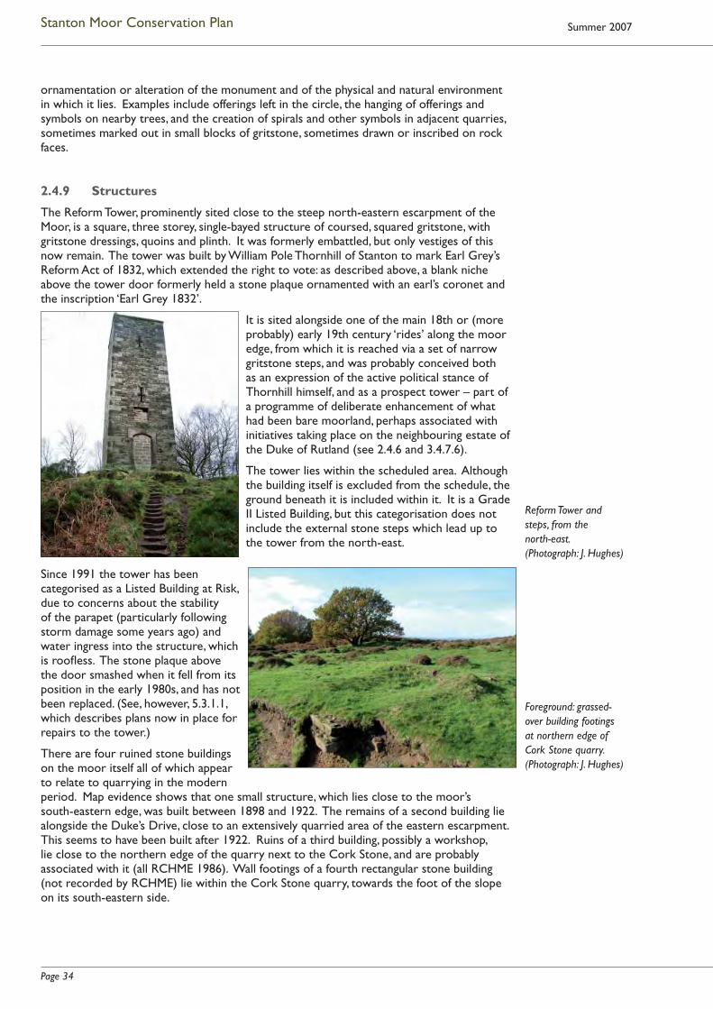
Page 34
Stanton Moor Conservation Plan Summer 2007
ornamentation or alteration of the monument and of the physical and natural environment in which it lies. Examples include offerings left in the circle, the hanging of offerings and symbols on nearby trees, and the creation of spirals and other symbols in adjacent quarries, sometimes marked out in small blocks of gritstone, sometimes drawn or inscribed on rock faces.
2.4.9 Structures
The Reform Tower, prominently sited close to the steep north-eastern escarpment of the Moor, is a square, three storey, single-bayed structure of coursed, squared gritstone, with gritstone dressings, quoins and plinth. It was formerly embattled, but only vestiges of this now remain. The tower was built by William Pole Thornhill of Stanton to mark Earl Grey’s Reform Act of 1832, which extended the right to vote: as described above, a blank niche above the tower door formerly held a stone plaque ornamented with an earl’s coronet and the inscription ‘Earl Grey 1832’.
It is sited alongside one of the main 18th or (more probably) early 19th century ‘rides’ along the moor edge, from which it is reached via a set of narrow gritstone steps, and was probably conceived both as an expression of the active political stance of Thornhill himself, and as a prospect tower – part of a programme of deliberate enhancement of what had been bare moorland, perhaps associated with initiatives taking place on the neighbouring estate of the Duke of Rutland (see 2.4.6 and 3.4.7.6).
The tower lies within the scheduled area. Although the building itself is excluded from the schedule, the ground beneath it is included within it. It is a Grade II Listed Building, but this categorisation does not include the external stone steps which lead up to the tower from the north-east.
Since 1991 the tower has been categorised as a Listed Building at Risk, due to concerns about the stability of the parapet (particularly following storm damage some years ago) and water ingress into the structure, which is roofl ess. The stone plaque above the door smashed when it fell from its position in the early 1980s, and has not been replaced. (See, however, 5.3.1.1, which describes plans now in place for repairs to the tower.)
There are four ruined stone buildings on the moor itself all of which appear to relate to quarrying in the modern period. Map evidence shows that one small structure, which lies close to the moor’s south-eastern edge, was built between 1898 and 1922. The remains of a second building lie alongside the Duke’s Drive, close to an extensively quarried area of the eastern escarpment. This seems to have been built after 1922. Ruins of a third building, possibly a workshop, lie close to the northern edge of the quarry next to the Cork Stone, and are probably associated with it (all RCHME 1986). Wall footings of a fourth rectangular stone building (not recorded by RCHME) lie within the Cork Stone quarry, towards the foot of the slope on its south-eastern side.
Reform Tower and steps, from the north-east.(Photograph: J. Hughes)
Foreground: grassed-over building footings at northern edge of Cork Stone quarry. (Photograph: J. Hughes)
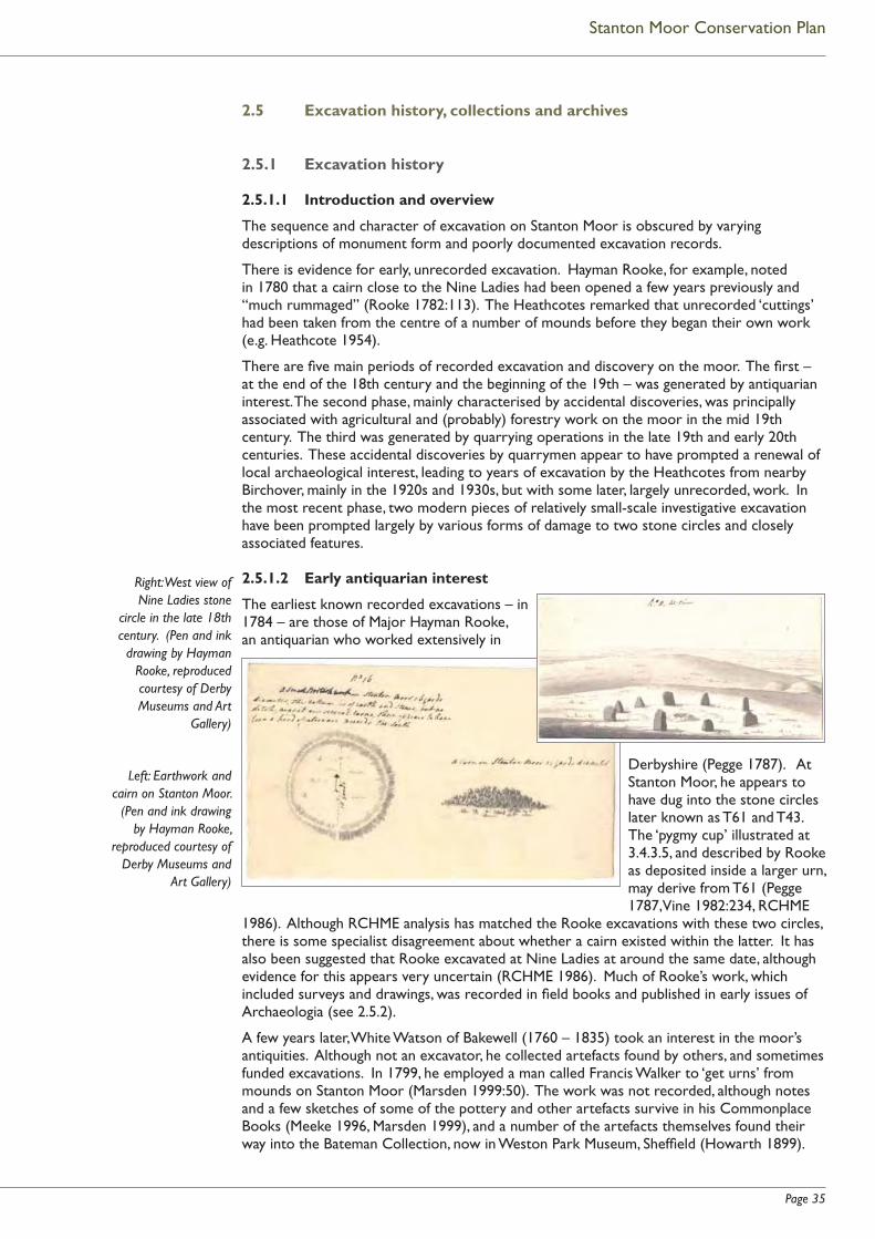
Page 35
Stanton Moor Conservation Plan
2.5 Excavation history, collections and archives
2.5.1 Excavation history
2.5.1.1 Introduction and overview
The sequence and character of excavation on Stanton Moor is obscured by varying descriptions of monument form and poorly documented excavation records.
There is evidence for early, unrecorded excavation. Hayman Rooke, for example, noted in 1780 that a cairn close to the Nine Ladies had been opened a few years previously and “much rummaged” (Rooke 1782:113). The Heathcotes remarked that unrecorded ‘cuttings’ had been taken from the centre of a number of mounds before they began their own work (e.g. Heathcote 1954).
There are fi ve main periods of recorded excavation and discovery on the moor. The fi rst – at the end of the 18th century and the beginning of the 19th – was generated by antiquarian interest. The second phase, mainly characterised by accidental discoveries, was principally associated with agricultural and (probably) forestry work on the moor in the mid 19th century. The third was generated by quarrying operations in the late 19th and early 20th centuries. These accidental discoveries by quarrymen appear to have prompted a renewal of local archaeological interest, leading to years of excavation by the Heathcotes from nearby Birchover, mainly in the 1920s and 1930s, but with some later, largely unrecorded, work. In the most recent phase, two modern pieces of relatively small-scale investigative excavation have been prompted largely by various forms of damage to two stone circles and closely associated features.
2.5.1.2 Early antiquarian interest
The earliest known recorded excavations – in 1784 – are those of Major Hayman Rooke, an antiquarian who worked extensively in
Derbyshire (Pegge 1787). At Stanton Moor, he appears to have dug into the stone circles later known as T61 and T43. The ‘pygmy cup’ illustrated at 3.4.3.5, and described by Rooke as deposited inside a larger urn, may derive from T61 (Pegge 1787,Vine 1982:234, RCHME
1986). Although RCHME analysis has matched the Rooke excavations with these two circles, there is some specialist disagreement about whether a cairn existed within the latter. It has also been suggested that Rooke excavated at Nine Ladies at around the same date, although evidence for this appears very uncertain (RCHME 1986). Much of Rooke’s work, which included surveys and drawings, was recorded in fi eld books and published in early issues of Archaeologia (see 2.5.2).
A few years later, White Watson of Bakewell (1760 – 1835) took an interest in the moor’s antiquities. Although not an excavator, he collected artefacts found by others, and sometimes funded excavations. In 1799, he employed a man called Francis Walker to ‘get urns’ from mounds on Stanton Moor (Marsden 1999:50). The work was not recorded, although notes and a few sketches of some of the pottery and other artefacts survive in his Commonplace Books (Meeke 1996, Marsden 1999), and a number of the artefacts themselves found their way into the Bateman Collection, now in Weston Park Museum, Sheffi eld (Howarth 1899).
Right: West view of Nine Ladies stone
circle in the late 18th century. (Pen and ink
drawing by Hayman Rooke, reproduced courtesy of Derby Museums and Art
Gallery)
Left: Earthwork and cairn on Stanton Moor.
(Pen and ink drawing by Hayman Rooke,
reproduced courtesy of Derby Museums and
Art Gallery)

Page 36
Stanton Moor Conservation Plan Summer 2007
Towards the beginning of the 19th century, the Rev. Bache Thornhill of Stanton – described by William Bateman as a “good neighbour and friend” (Ward 1908:165) – opened several barrows on the moor and dug out urns and cremations (Heathcote 1930). The date of this work is uncertain, but he died at the age of 42 in 1827, “accidentally shot by the discharge of the fowling piece of a friend” (Wright 1906:109), and twenty years later William Pole Thornhill presented some of the urns and associated artefacts to Thomas Bateman (Bateman 1848). There is a record from the early 1820s that a barrow “a little further on from the Cork Stone” had been recently opened, and an urn and human bones found (Rhodes 1824:237). The date suggests that this could have been one of Bache Thornhill’s excavations.
2.5.1.3 The mid 19th century
Little formal excavation is known from the mid 19th century and Storrs Fox (1927:199) comments that Thomas Bateman “did not invade Stanton Moor to any great extent”. He did, however, carry out an impromptu excavation at the Doll Tor stone circle in 1852 and found a grave with urns and ‘incense cups’, all of which had been emptied and broken by earlier diggers (Bateman 1861:84).
Otherwise, the record of fi nds from the moor in the mid-century is based on accidental discovery – apparently prompted by campaigns of digging and drainage, some of them probably associated with forestry operations. A large stone axe hammer was found on the moor in April 1833 (Vine 1982:235). In Spring 1847, Bateman records that, “a small tumulus was levelled by labourers cultivating waste land upon Stanton Moor”, and a small vase or urn found within a cist inside it (Bateman 1848:100). Later that same year, drain cutters came across three Collared Urns containing cremations (Bateman 1848: 24, Vine 1982: 234). In February 1848, a pair of querns, a small perforated sandstone disc, and an irregular ‘sandstone ball’ were unearthed during trenching operations (Howarth 1899), and a fl int axe and greywacke axe hammer were recovered in November and December of the same year (Derbyshire SMR 12972 & 1612). In January 1850, there was a fi nd of a bronze socketed axe, and in 1859 a polished stone macehead was “found in digging sand” on the moor (both Vine 1982: 236).
These scattered examples strongly suggest that there may have been other episodes of accidental discovery and destruction which went unrecorded.
2.5.1.4 The impact of quarrying
Quarrying prompted the next wave of fi nds, in the late 19th and early 20th centuries. In 1889, quarrymen working “on Stanton Moor” (the area is not specifi ed) discovered a large cinerary urn and ‘incense cup’ (Ward 1891:45). The fi nds were rescued and preserved by Joseph Heathcote of Barn Farm, Birchover (the father and grandfather of excavators Joseph and Percy Heathcote). A few weeks later, quarrymen found a second urn and cup close by (Ward 1891:47). In 1899, two more Collared Urns were found “about a yard apart” during quarrying operations “on the south-east margin of the moor”, and they too were retrieved by Joseph Heathcote (Ward 1900:27). By the mid 1920s, Storrs Fox could write that “quarrymen declare that, in the ordinary course of work, numbers of fragments of pottery are carted away to the refuse tip” (Storrs Fox 1927:200). He recorded a specifi c fi nd of three urns in 1925 during quarrying at New Park on the south-west edge of the moor, one of which was in a good enough state to be repaired (www.idigsheffi eld.org.uk has a good image of this). The exposure of yet more urns at the same quarry in 1926 led to a hurried rescue excavation (in advance of the proposed erection of a steam crane), which recovered what may have been the remains of a fl at cemetery. There was no time to plan the site, but 15 urns and ‘incense cups’ were excavated, with – in many cases – the apparent remains of cremations in and around them (Storrs Fox 1927). The quarry operator told a visiting journalist that 14 of the urns had been found “within the space of about 17ft.” (Sheffi eld Daily Telegraph 20.10.1926).
In November 1926, another amateur enthusiast, the Rev. C. W. Summerfi eld of Birchover, excavated what Heathcote describes as “an interment of a woman … on the roadside near the Andle Stone” (Heathcote 1947:6). The precise nature and location of this excavation are uncertain but it appears to have been close to the western edge of the Birchover Road. The

Page 37
Stanton Moor Conservation Plan
burial, which may have been within a cist, was associated with an urn or Enlarged Food Vessel and various artefacts including a bronze ‘knife-dagger’ (Vine 1982:236/7).
2.5.1.5 The work of the Heathcotes
By this time, Joseph Heathcote and his son Percy were already at work. As indicated above, Joseph was the son of Joseph Heathcote of Barn Farm (1834 – 1901), who had collected various local fi nds in the later 19th century. Percy taught history at Chesterfi eld, and both he and his father became closely associated with the Derbyshire Archaeological Society. In June 1926, they began their fi rst recorded excavation, that of a large cairn at the southern end of the moor, to which they
allocated the number T2. (This followed on from Storrs Fox’s excavation in New Park Quarry, which they called T1, and Summerfi eld’s work on the burial site known as T1A, close to the Birchover Road.)
They excavated (wholly or partially) well over 60 cairns or apparent cairns (see illustrations here and at 2.4.2.3), and also worked at the large cairns T55 and T57, although there is no written evidence for these latter excavations (RCHME 1986). In addition, they tackled some of the major ceremonial monuments, including the embanked stone circles T43 and T61, ring cairn T56, and – just off the modern moor – Doll Tor stone circle. It is not clear whether they undertook any work at Nine Ladies, although some small-scale excavation here is a possibility (RCHME 1986). From 1930 until 1979, fi nds from both moors were displayed in their private museum at Birchover, to which the Barn Farm collection of antiquities had also been transferred (see 2.5.2.2 below and illustration at 3.4.3.5).
Their published records appeared under Percy Heathcote’s name. All but one of these cover work in the years 1926 to 1938 (see Bibliography at Appendix A), with the exception of the report on cairn T36, whose excavation was supervised by Percy Heathcote in 1953 (Heathcote 1954). However, it seems highly likely that other work was being carried out in the years after 1938. The Heathcotes appear to have undertaken much unrecorded excavation, some of it identifi ed on the ground during the course of survey by RCHME in the late 1980s. With the assistance of local schoolboys, they (or perhaps principally Joseph Heathcote) also worked extensively on Harthill Moor – again, apparently without leaving many records (P. Beswick, pers. comm.). Unpublished Sheffi eld City (now Weston Park) Museum records indicate that, during the Second World War, Percy Heathcote was too busy to help his father with recording and drawing, and work thus remained unrecorded. Much information on excavations undertaken at this period, and known only to Joseph Heathcote, died with him in 1952.
Of the Stanton Moor cairns known to have been excavated by the Heathcotes, just under 30 have been shown to be funerary and a further 17 or so are probably or possibly funerary (RCHME 1986). Unfortunately, with the exception of cairn T2 and Doll Tor, they appear to have kept few if any records of their work on the three large cairns and major ceremonial monuments. Nevertheless, their work provided a substantial body of evidence for the funerary nature and approximate date of many monuments on the moor. A 1982 study by Vine shows that, of 57 Collared Urns recovered from the Millstone Grit area of the North Midlands at that time, 52 were from Stanton Moor. All 14 ‘Pygmy’ or Accessory
Cairn T2 under excavation by the
Heathcotes in the late 1920s. (Photograph courtesy of Buxton Museum and www.
picturethepast.org.uk)
Collared urn: probably one of the urns found
in New Park Quarry in 1925. (Photograph
courtesy of Buxton Museum and www.
picturethepast.org.uk)

Page 38
Stanton Moor Conservation Plan Summer 2007
Cups recorded from the gritstone were also from the moor. Some of these fi nds derive, of course, from 18th and 19th century work but a very large number are the product of the Heathcotes’ investigations. On a more negative note, the RCHME survey of the moor demonstrated that – whatever the benefi ts of the Heathcotes’ excavations – they not only failed to record a fairly large proportion of their work, but also substantially altered the appearance of the monuments themselves:
“It is clear … that the Heathcotes had a single model or idea about the constructional forms of the monuments on the moor. …The idea (probably the result of the fi rst and substantial excavation of T2) was essentially that all of the prehistoric features – primarily cairns but also ring banks and other linear features – were marked in construction by large stone kerbing, which defi ned the monument, and was later fi lled in with heaped loose stones. The [excavation] process therefore was to select a likely stone heap; to defi ne its presumptive kerb-like limit through a narrow trench … which wiggled in and out around every large stone that it encountered; to remove the heaped stones within the defi ned area (placing them in a ring just outside the defi ned limit), [and to search] the sandy subsoil … for burial deposits and fi nds. …The stones were then replaced to create a monument as it might or ought to have been. … [Their work] left a distinctive signature on the moor, characteristically comprising the narrow defi ning trench, rebuilt mound, and penumbra of scattered stones not fully re-used in the rebuilding. … The process was applied equally to the ring cairns: whole sections of T43 and T56, for example, were removed and reinstated, … while other sectors appear to have had their faces trimmed up or ‘uncovered’ ” (Everson 1989:20-21).
In a number of other cases, the RCHME survey was able to demonstrate that the Heathcotes’ reconstructions had “misleadingly created monuments which now form part of the prehistoric record” (Everson 1989:21). Notwithstanding these criticisms, the work of the Heathcotes should be judged within its contemporary context. The excavation and reconstruction methods which they adopted on Stanton Moor in the 1930s -1950s have a place in the history of the development of archaeological thinking and practice.
2.5.1.6 Later 20th and 21st century excavation
The earliest post-Heathcote work – by J. Radley – was small-scale. In the 1960s, he appears to have undertaken a very limited trial excavation on the south-east bank of ring cairn T56, sketchily recorded in his fi eld notes now in Weston Park Museum, Sheffi eld (RCHME 1986). In 1964, while taking a pollen sample from the bank of the north-western circle T61, he accidentally uncovered two urns placed mouth to mouth, with cremation material and burnt fl int (Radley 1967).
Doll Tor
In 1994, the fi rst substantial excavation and restoration work since the Heathcotes to be undertaken on (or, in this case, closely adjacent to) the moor, was led by John Barnatt at Doll Tor (Barnatt 1997). This was prompted by extensive damage to the circle and adjoining cairn in 1993, apparently as a form of preparation for celebration of the Spring Equinox. The damage included the addition of orthostats to the circle, the creation of a crude outer circle of stone, and the remodelling of the cairn. Barnatt dug two small excavation trenches prior to restoration of the site, with the aim of identifying the original stone holes of the two western orthostats. One product of this work was the identifi cation of the edge of a stony platform, possibly built to level the interior of the circle, and which may protect deposits undisturbed by Bateman, his anonymous predecessors, and the Heathcotes. Following this limited excavation, the circle and cairn were restored, using excavation data and the Heathcotes’ 1930s plan as a guide (see 3.4.3.3). Barnatt feels that the monument’s resulting arrangement is “closer to its prehistoric appearance than at any other period in historic times” (Barnatt 1997:84).
Page 39
Stanton Moor Conservation Plan
Nine Ladies and King Stone
In November 2000, the Trent & Peak Archaeological Unit (T&PAU), carried out limited excavation of the Nine Ladies stone circle and King Stone, considered to be a “high profi le monument at risk” (Smith 1999b:3). The excavation formed part of an ongoing process of evaluation and investigation, led by English Heritage as statutory guardian of the site, and prompted by the cumulative effect of deliberate and accidental damage and erosion (the latter largely the result of intense visitor interest). It followed a 1988 - 1997 programme of erosion monitoring (Guilbert and Malone 1999), and a 1998 geophysical survey, the results of which were inconclusive (Horsley 1998).
The excavation project was intended principally to guide conservation management decisions, rather than forming part of a strategic research programme (Smith 1999b:7). Consequently, it was decided to opt for excavation of a relatively small (10%) sample of the monument. The excavation objectives were: to establish the monument’s archaeological potential; to identify the extent to which this was vulnerable, and the nature of any threats; and to provide information to guide and underpin the future management of the Nine Ladies and King Stone (Smith 1998:5).
It was acknowledged before work began that trial trenching of this nature was not suffi cient to establish the full archaeological potential and vulnerability of the monument, and the excavator felt that the results of the excavation confi rmed these doubts (Garton 2002:9,38).
Two main trenches were sited to investigate areas of the stone circle itself, together with the King Stone and its immediate environs. The principal conclusions of this work are summarised below.
Nine Ladies stone circle
• remnants of stone paving survive within the circle;
• the gap between stones 5 and 6 of the circle (thought by some to be the site of a missing orthostat) appears to be genuine;
• the embankment on the downslope side of the circle appears to have been created by terracing the monument into the slope and scarping its inner edge: its potentially unusual morphology needs further study;
• there is no evidence for an external ditch surrounding the circle embankment.
King Stone
• the earthworks (a proposed ring cairn) recorded by the RCHME (1986) around the King Stone appear to be modern, and are probably not related to the monument;
• the extent of the foundation pit for the King Stone is uncertain.
Overall
• the excavation recovered no stratifi ed evidence (e.g. from buried soils) suitable for palaeo-environmental analysis or dating, although the report acknowledges that crucial evidence of this type may be recoverable from unexcavated areas of the monument.
The report concluded that there were only two viable options for the future: either complete excavation and reconstruction, or conservation in situ. In the event, the second course of action has been implemented. Conservation measures undertaken to date comprise restoration of the surface contours of the stone circle in line with those recorded in 1988 and the capping with turf of this area and an area round the King Stone. Zones of signifi cant linear erosion close to both monuments have been covered with soil, reinforced with plastic mesh, and returfed.
Page 40
Stanton Moor Conservation Plan Summer 2007
Evaluative excavation associated with mineral applications
Just outside the boundary of the scheduled area, a number of evaluative excavations have been conducted as part of the Planning Application process associated with proposed new or extended mineral workings and their infrastructure. The principal results of these small-scale excavations are summarised at 3.3.2.1, 3.3.2.2 and 3.3.2.4.
2.5.2 Collections and archives
2.5.2.1 Overview
The vast majority of archive material relating to Stanton Moor is contained within the Heathcote Collection, held by Weston Park Museum, Sheffi eld (formerly Sheffi eld City Museum). This comprises the bulk of artefacts retrieved from the Moor. The Museum also holds a number of Stanton Moor items within the Bateman Collection, and a small quantity of artefacts and images within other collections, including drawings by the 18th century antiquarian, Hayman Rooke (see 2.5.1.2).
Derby Museum holds a number of ceramic items excavated from the moor, together with a further group of Hayman Rooke prints and drawings showing Stanton Moor landscapes and selected monuments and artefacts. Derby Local Studies Library holds letters written by Hayman Rooke to his friend George Young (then Minister for War) some of which refer to Rooke’s work on Stanton Moor.
Very small quantities of ceramic or lithic material from the moor are held by Buxton Museum and Art Gallery (which also holds a limited number of early Heathcote excavation photographs), by the British Museum, and by the Ashmolean Museum, Oxford.
The archive from the November 2000 excavation of the Nine Ladies stone circle and King Stone is currently held by the Trent & Peak Archaeological Unit, but will eventually be deposited in Weston Park Museum, Sheffi eld.
The archive from the 1994 excavation and restoration of Doll Tor is currently held by the Peak District National Park Authority.
The archive from evaluation and excavation at Dale View Quarry (Adams et al 2006) is under temporary storage at the National Museums Liverpool Field Archaeology Unit, but is destined for the Buxton Museum and Art Gallery in the longer term.
2.5.2.2 Weston Park Museum, Sheffi eld (WPMS) holdings
The Stanton Moor artefacts from the Bateman Collection (of which there are less than 20) consist primarily of lithic objects for example a battle axe, axe hammer, macehead and querns – ‘found’ on the moor in the 19th century or earlier, mostly during drainage and other work, together with a small quantity of ceramic, bronze and glass items (2.5.1.3). Very few of these derive from deliberate excavation, apart from Bateman’s impromptu work at Doll Tor. One or two items derive from work initiated by White Watson and Bache Thornhill, whose collections passed (at least in part) into Bateman’s hands (2.5.1.2).
The Heathcote Collection, obtained by the Museum in 1979 and 1981, consists for the most part of artefacts and cremation material retrieved through excavation by Joseph and Percy Heathcote, mainly on Stanton and Harthill Moors, with other items inherited from the collection made by Joseph’s father (2.5.1.4, 2.5.1.5). Unfortunately, once an excavation was published (and many were not) the Heathcotes do not appear to have retained excavation records, and thus – apart from a number of labels – no paper archive accompanies the Collection.
Heathcote Collection artefacts specifi cally from Stanton Moor and Doll Tor include approximately 40 Collared Urns (or fragments of urns), one or two examples of Cordoned and Biconical Urns, 10 Accessory (or Miniature) Cups, and a small number of Food Vessels, or fragments of vessels (see 3.4.3.5). There are also approximately nine examples of Early Bronze Age metalwork, and smaller numbers of objects made from bone, faience, jet and clay, together with a battle axe and a range of fl int tools – including scrapers, plano-convex knives and barbed and tanged arrowheads. The Museum also holds cremation material found

Page 41
Stanton Moor Conservation Plan
in association with these artefacts. The majority of the items in the Collection derive from excavation in the 1920s to 1950s, although a small number are surface fi nds revealed by animal burrowing. As indicated above, a few items derive from a Heathcote family collection made in the late 19th century.
WPMS has two further urns and accompanying cremation material excavated by J. Radley in 1964, and his associated paper archive (2.5.1.6).
Sherds from a possible Collared Urn, found towards the northern end of the New Pilhough Quarry short haul road extension (2.4.2.1), will be deposited with WPMS following its reopening.
The Museum’s paper archive includes plans and notes made by L. Butcher during survey work on the moor in the mid 20th century. It also holds a number of antiquarian images of the moor and its monuments and artefacts. These comprise images within four Hayman Rooke sketch books; illustrations made by Bateman himself; and sketches from White Watson’s fi eld notebooks, which passed into the Bateman Collection. In addition to the Museum’s own Rooke sketch books, WPMS holds digitised and transcribed copies of other Hayman Rooke material, made available by Derby Museum (see 2.5.2.5 below).
2.5.2.3 Derby and Buxton holdings
Derby Museum holds ten Collared Urns and three Accessory Vessels, all found in the New Park Quarry area (then known as Twyford’s Quarry) in the late 1920s (2.5.1.4). The majority were the gift of the excavator, Storrs Fox. It also holds pen and ink drawings and engravings of Stanton Moor subjects by Hayman Rooke, which show artefacts, monuments and natural rock outcrops and pillars (see illustrations at 2.5.1.2, 3.4.3.4, 3.4.3.5 and 3.7).
Buxton Museum and Art Gallery’s Stanton Moor holdings comprise two large Collared Urns within the permanent collection (Longworth 1984). An urn sherd, said to be from Stanton Moor, is held in store, and there may be further pieces (S. Palmer, pers. comm.). In addition, the Museum holds 7 lantern slide images of the Heathcotes’ excavations of cairns T2 and T3 in 1926 -1929 (see illustrations at 2.4.2.3 and 2.5.1.5).
2.5.2.4 Other holdings
The British Museum holds an axe hammer and ‘battle axe’ from the moor. The Ashmolean Museum, Oxford, has an Accessory Vessel, attributed to an excavation carried out on the moor by Hayman Rooke (Vine 1982).
2.5.2.5 Accessing the collections
Weston Park Museum, Sheffi eld (WPMS)
Access to the Stanton Moor material at WPMS is achieved via various routes. The Museum’s Bateman Collection is detailed in an illustrated volume, published by Sheffi eld City Museum in 1899 (A Catalogue of the Bateman Collection of Antiquities, prepared by E. Howarth). The most complete record of the Heathcote Collection is currently in the form of a handwritten catalogue, made by the Museum when the material was accessioned, and not subsequently updated. At present, the Museum takes the view that their Stanton Moor paper archive (including illustrated material) is not always well recorded, which may impede easy access.
Images of some of the artefacts from Stanton Moor, backed up by written information, are currently available on the Museum’s ‘I Dig Sheffi eld’ website (www.idigsheffi eld.org.uk), an impressively illustrated resource aimed at the wider public. In the future, WPMS aims to develop this website further, gradually putting more material online, and thus enabling people to engage with the Museum’s collections without necessarily visiting the building.
Where specialist access is concerned, the long-term aim is to develop the Museum’s computerised record of its collections, including those which relate to Stanton Moor.
Derby Museum
The artefactual material from Stanton Moor is recorded on the Museum’s computerised database. The Museum has also digitised and transcribed both Derby’s own Hayman Rooke

Page 42
Stanton Moor Conservation Plan Summer 2007
material, and the four Hayman Rooke sketchbooks held by Weston Park Museum, Sheffi eld (see 2.5.1.2). A selection from this material has formed the subject of a recent public exhibition. (The digitised version of the Rooke material can be accessed not only at Derby Museum, but at WPMS and at Derby Local Studies Library.)
Derby Local Studies Library
The correspondence between Rooke and George Young (see 2.5.2.1) is available for public inspection. The Library also holds relevant volumes of Archaeologia, and the digitised and transcribed Hayman Rooke material referred to above.
Buxton Museum and Art Gallery
The limited amount of artefactual material from Stanton Moor held by the Museum is not as yet recorded on a computerised database, and Museum representatives suggest that the identifi cation and location of any items which may be in store would be a complex task. However, the Museum’s lantern slide images relating to the Heathcotes’ excavation of cairns T2 and T3 are all available on the Picture the Past website, composed of images drawn from museums and libraries in the East Midlands (www.picturethepast.org.uk and see illustrations at 2.4.2.3 and 2.5.1.5). (Also available on this website is a photograph showing two Collared Urns and an Accessory Cup from cairn T2, probably taken at the Heathcotes’ private museum at Birchover. The photograph (reproduced at 3.4.3.5) is held by the Derbyshire County Council Library Service.)
2.5.2.6 Published corpus of prehistoric artefacts from Stanton Moor
The Collared Urns from Stanton Moor are described and illustrated in ‘Collared Urns of the Bronze Age in Great Britain and Ireland’ (Longworth 1984). ‘The Neolithic and Bronze Age Cultures of the Middle and Upper Trent Basin’ (Vine 1982) includes a comprehensive gazetteer of prehistoric artefacts from the moor. Food Vessels from the moor are described and illustrated in ‘Food Vessels of the Peak District’ (Manby 1957, and see 3.4.3.5).
2.6 Natural heritage
2.6.1 Overview of habitat
Stanton Moor is principally upland heather moor, characterised by a mixture of heather (Ling) and Bilberry, with some Gorse, and areas of Bracken. There are copses and scatters of Silver Birch across the moor, particularly to the north. On sloping ground around the moorland edge, particularly to the north and east, there are areas of Oak / Birch woodland, with other tree species present in smaller numbers. The disused quarry areas provide a mixed habitat of heath, rock and bare soil. It is this mosaic of different habitats – upland moor, woodland and quarry – which characterises Stanton Moor, and increases its ecological value. However, with the exception of a Nature Conservation Evaluation of the National Trust’s Stanton Moor Edge Estate (Lister and Alexander 2001) there has been no recent detailed survey of the moor’s ecology.
Between 1993 and late 2004, the joint efforts of the Stanton Estate and Peak District National Park Authority conserved and enhanced its overall value as habitat (see 2.12.5.1). Following some ten years of overgrazing, in which the structure of the heather and bilberry had suffered, and areas of heath had converted to grass, the moor recovered well, and dwarf shrubs re-colonised grassy areas. Bracken and rhododendron control also benefi ted the site. However, one consequence of the reduction in grazing is that widespread birch regeneration now needs to be addressed. Bracken and rhododendron also need continued control.

Page 43
Stanton Moor Conservation Plan
2.6.2 Moorland
The upland heather moor is of a type designated as National Priority Habitat, and is included within the Local Biodiversity Action Plan for the Peak District (2.12.2.2). It is also mapped
under Section 3 of the Wildlife and Countryside (Amendment) Act 1985 as moorland which, in the opinion of the National Park Authority, it is particularly important to conserve (2.12.1.5). The plant mix on the moorland itself consists principally of heather (Ling), abundant Bilberry and scattered Western Gorse, a nationally
scarce species. Pill Sedge, which occurs only occasionally in the Peak District, is also found here. Silver Hair-grass, which is local in the Peak, occurs along the disturbed edges of paths.
The moorland is also an important site for lichens, and several rather local species are present. These include Parmelia incurva on rocks, and Cladonia pityrea and Cladonia conista under the heather.
The range of ground-nesting birds is poor compared to most moors in the Peak, due to its small size, isolation, and – probably – visitor pressure. But within the moorland / woodland fringe Tree Pipit and Woodcock are present.
To date, there has been little study of the invertebrates here. However, in some locations the sandy areas (for example, the edges of paths and sandy soil exposed above the Cork Stone quarry) provide important habitat for nesting solitary bees and wasps, and the moor may be the best site in the Peak for these scarce and declining species. The uncommon Globiceps juniperi Reuter – a bug which needs scrubby heath plants on which to lay its eggs – is present on the moor, and the Green Tiger Beetle is found beneath the heather canopy. Birch trees across the moor potentially offer a good habitat for other fauna.
2.6.3 Woodland
Copses and scatters of rather even-aged Silver Birch occur, principally to the north of the moor. On the northern edge of the moor and on slopes around its edges, particularly to the east, there are areas of Oak / Birch woodland, with a small number of other species, including Larch, Hawthorn, Rowan and Scots Pine. To the west, Birch has recolonised the old quarry workings, with occasional Oak, Ash and Scots Pine, and there is a cluster of Oak and Sweet Chestnut close to the junction of the Cork Stone path and Birchover Road. A few areas at the southern end of the moor retain scattered Oaks, with some Elder and Hawthorn, and Rowan is also present here. Overall, while not outstanding, the woodland and woodland / moorland edge provide valuable local habitat. Certain areas of Oak / Birch and other woodland on the fringes of the moor have been designated as Priority Habitat within the National Park and / or mapped under Section 3 of the Wildlife and Countryside (Amendment) Act 1985 (see 2.12.1.5, 2.12.2.2 and Figure C15).
Bilberry and heatheron Stanton Moor,
early autumn. (Photograph: S. McGuire)
Green Tiger Beetle. (Photograph: R. Thomas)
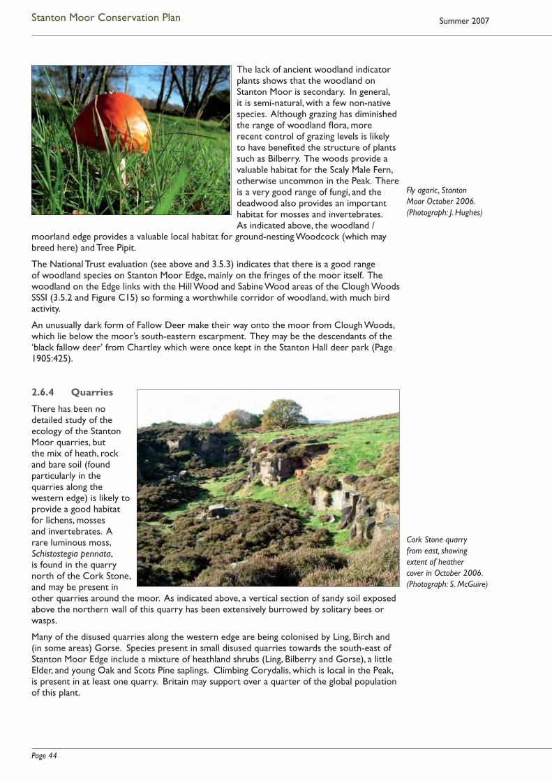
Page 44
Stanton Moor Conservation Plan Summer 2007
The lack of ancient woodland indicator plants shows that the woodland on Stanton Moor is secondary. In general, it is semi-natural, with a few non-native species. Although grazing has diminished the range of woodland fl ora, more recent control of grazing levels is likely to have benefi ted the structure of plants such as Bilberry. The woods provide a valuable habitat for the Scaly Male Fern, otherwise uncommon in the Peak. There is a very good range of fungi, and the deadwood also provides an important habitat for mosses and invertebrates. As indicated above, the woodland /
moorland edge provides a valuable local habitat for ground-nesting Woodcock (which may breed here) and Tree Pipit.
The National Trust evaluation (see above and 3.5.3) indicates that there is a good range of woodland species on Stanton Moor Edge, mainly on the fringes of the moor itself. The woodland on the Edge links with the Hill Wood and Sabine Wood areas of the Clough Woods SSSI (3.5.2 and Figure C15) so forming a worthwhile corridor of woodland, with much bird activity.
An unusually dark form of Fallow Deer make their way onto the moor from Clough Woods, which lie below the moor’s south-eastern escarpment. They may be the descendants of the ‘black fallow deer’ from Chartley which were once kept in the Stanton Hall deer park (Page 1905:425).
2.6.4 Quarries
There has been no detailed study of the ecology of the Stanton Moor quarries, but the mix of heath, rock and bare soil (found particularly in the quarries along the western edge) is likely to provide a good habitat for lichens, mosses and invertebrates. A rare luminous moss, Schistostegia pennata, is found in the quarry north of the Cork Stone, and may be present in other quarries around the moor. As indicated above, a vertical section of sandy soil exposed above the northern wall of this quarry has been extensively burrowed by solitary bees or wasps.
Many of the disused quarries along the western edge are being colonised by Ling, Birch and (in some areas) Gorse. Species present in small disused quarries towards the south-east of Stanton Moor Edge include a mixture of heathland shrubs (Ling, Bilberry and Gorse), a little Elder, and young Oak and Scots Pine saplings. Climbing Corydalis, which is local in the Peak, is present in at least one quarry. Britain may support over a quarter of the global population of this plant.
Fly agaric, Stanton Moor October 2006. (Photograph: J. Hughes)
Cork Stone quarry from east, showing extent of heather cover in October 2006. (Photograph: S. McGuire)
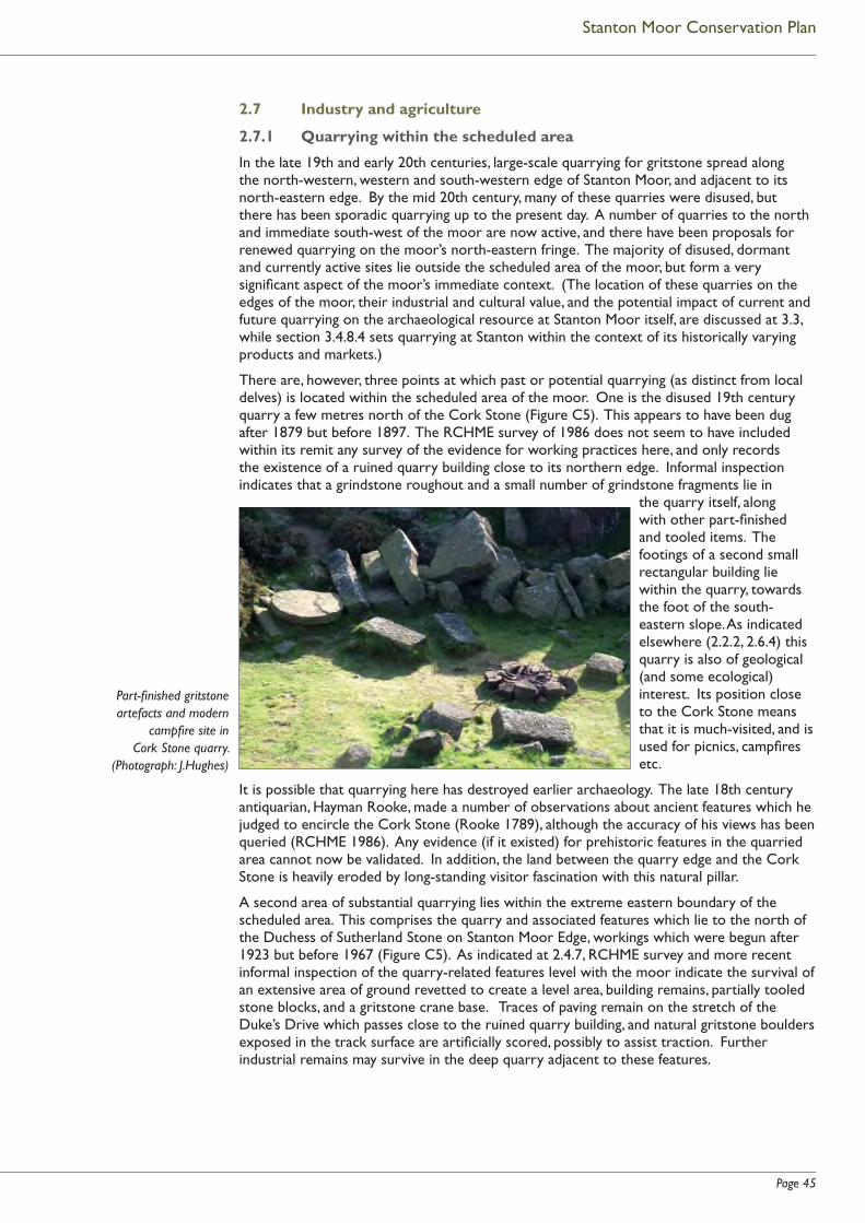
Page 45
Stanton Moor Conservation Plan
2.7 Industry and agriculture
2.7.1 Quarrying within the scheduled area
In the late 19th and early 20th centuries, large-scale quarrying for gritstone spread along the north-western, western and south-western edge of Stanton Moor, and adjacent to its north-eastern edge. By the mid 20th century, many of these quarries were disused, but there has been sporadic quarrying up to the present day. A number of quarries to the north and immediate south-west of the moor are now active, and there have been proposals for renewed quarrying on the moor’s north-eastern fringe. The majority of disused, dormant and currently active sites lie outside the scheduled area of the moor, but form a very signifi cant aspect of the moor’s immediate context. (The location of these quarries on the edges of the moor, their industrial and cultural value, and the potential impact of current and future quarrying on the archaeological resource at Stanton Moor itself, are discussed at 3.3, while section 3.4.8.4 sets quarrying at Stanton within the context of its historically varying products and markets.)
There are, however, three points at which past or potential quarrying (as distinct from local delves) is located within the scheduled area of the moor. One is the disused 19th century quarry a few metres north of the Cork Stone (Figure C5). This appears to have been dug after 1879 but before 1897. The RCHME survey of 1986 does not seem to have included within its remit any survey of the evidence for working practices here, and only records the existence of a ruined quarry building close to its northern edge. Informal inspection indicates that a grindstone roughout and a small number of grindstone fragments lie in
the quarry itself, along with other part-fi nished and tooled items. The footings of a second small rectangular building lie within the quarry, towards the foot of the south-eastern slope. As indicated elsewhere (2.2.2, 2.6.4) this quarry is also of geological (and some ecological) interest. Its position close to the Cork Stone means that it is much-visited, and is used for picnics, campfi res etc.
It is possible that quarrying here has destroyed earlier archaeology. The late 18th century antiquarian, Hayman Rooke, made a number of observations about ancient features which he judged to encircle the Cork Stone (Rooke 1789), although the accuracy of his views has been queried (RCHME 1986). Any evidence (if it existed) for prehistoric features in the quarried area cannot now be validated. In addition, the land between the quarry edge and the Cork Stone is heavily eroded by long-standing visitor fascination with this natural pillar.
A second area of substantial quarrying lies within the extreme eastern boundary of the scheduled area. This comprises the quarry and associated features which lie to the north of the Duchess of Sutherland Stone on Stanton Moor Edge, workings which were begun after 1923 but before 1967 (Figure C5). As indicated at 2.4.7, RCHME survey and more recent informal inspection of the quarry-related features level with the moor indicate the survival of an extensive area of ground revetted to create a level area, building remains, partially tooled stone blocks, and a gritstone crane base. Traces of paving remain on the stretch of the Duke’s Drive which passes close to the ruined quarry building, and natural gritstone boulders exposed in the track surface are artifi cially scored, possibly to assist traction. Further industrial remains may survive in the deep quarry adjacent to these features.
Part-fi nished gritstone artefacts and modern
campfi re site in Cork Stone quarry.
(Photograph: J.Hughes)

Page 46
Stanton Moor Conservation Plan Summer 2007
Part of the eastern edge of Stanton Moor Quarry1 also falls within the scheduled area. This quarry occupies an area of land on the western edge of the moor, leased by the Stanton Estate to Block Stone Ltd., and the operator benefi ts from a 1952 planning consent to extract stone at certain points within this leased area. Since scheduling in 1995, certain parts of the eastern extent of the leased area overlap with the Scheduled Monument. Until 2002, planning consent to extract or tip stone covered a stretch of land within the northern part of this ‘overlap area’ (thus lying within the scheduled monument), together with areas of land to the immediate north and west, which lie alongside the scheduled monument boundary (see 3.3.2.3 and Figure C19).
Surveys by RCHME in 1986/1987, by the then Trent & Peak Archaeological Trust in 1998, and by English Heritage in 2000, revealed that a small number of features of archaeological interest lay just within the overlap area which benefi ted from consent to quarry, and that complex remains lay along the boundary of this area and to its immediate east. These features include the linear remains of a multi-period fi eld system, the earliest stages of which appear to be Bronze Age, and potential burial or clearance cairns (see 3.3.2.3 and Figures C5 and C6). Ainsworth (2002:40,41) suggests that further archaeological surfaces and features related to prehistoric clearance may also survive below the ground surface in these areas.
In 2002, Block Stone Ltd. agreed to relinquish quarrying rights within part (but not the whole of) the overlap area (Figure C19). The company also agreed to forego working within the remainder of the permitted area of Stanton Moor Quarry until April 2007, while further negotiations take place.
2.7.2 Agriculture and shooting
The moor was in agricultural use as open pasture prior to 19th century enclosure and afforestation, and has reverted to this use since the plantations were cleared in the early 20th century. It is currently used as sheep pasture, and the grazing is let on an annual basis by the landowner, the Stanton Estate.
As indicated at 2.12.5.1, from 1993 until November 2004 the grazing regime was managed under the terms of a Farm Conservation Agreement (FCA) between the Estate and the Peak District National Park Authority. Prior to this, unregulated grazing had had an adverse effect on the vegetation of the heather moor, and on certain archaeological features. From 1993, all sheep were removed for a three year period: the heather recovered, but controlled grazing was then reintroduced to deal with a resurgence of birch saplings. Subsequently, stock numbers were managed to allow healthy regrowth of bilberry and heather, to control birch as necessary, and to minimise the effects of stock-related erosion on the archaeological resource. The grazing regime is now in need of reassessment: as indicated at 2.12.5.1 the Estate is keen to work with the National Park Authority for the future conservation of the moor, and at some time in the future, this may be formalised within an agri-environment agreement with the Authority or with the Department for Environment, Food and Rural Affairs (Defra).
Some of the woodland on the western and northern edges of the moor is used for shooting. Shooting rights are let by the Estate, and shooting takes place annually from October to January.
1 The name of this quarry can be confusing. 20th century map evidence suggests that the general name ‘Stanton Moor Quarry’ was given (at least by cartographers) to a larger area of land on the western and north-western fringes of the moor, which included what is now referred to as the Boden Stone (or ‘TV mast’) quarry, and land to its north-west. Much of this area was fairly heavily quarried in the 19th and 20th centuries, but – particularly to the north-west – is now disused, overgrown, and not covered by any extant permission to extract stone (3.3.3.3).
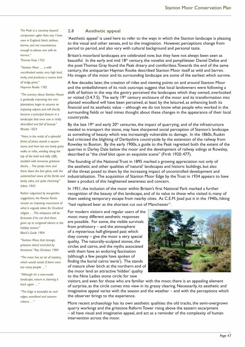
Page 47
Stanton Moor Conservation Plan
2.8 Aesthetic appeal
‘Aesthetic appeal’ is used here to refer to the ways in which the Stanton landscape is pleasing to the visual and other senses, and to the imagination. However, perceptions change from period to period, and also vary with cultural background and personal taste.
Britain’s moorland landscapes are celebrated now, but they have not always been seen as beautiful. In the early and mid 18th century, the novelist and pamphleteer Daniel Defoe and the poet Thomas Gray found the Peak dreary and comfortless. Towards the end of the same century, the antiquarian Hayman Rooke described Stanton Moor itself as wild and barren. His images of the moor and its surrounding landscape are some of the earliest which survive.
A few decades later, the creation of rides and viewing points on and around Stanton Moor and the embellishment of its rock outcrops suggest that local landowners were following a shift of fashion in the way the gentry perceived the landscapes which they owned, overlooked or visited (3.4.7.5). The early 19th century enclosure of the moor and its transformation into planted woodland will have been perceived, at least by the leisured, as enhancing both its fi nancial and its aesthetic value – although we do not know what people who worked in the surrounding fi elds or lead mines thought about these changes in the appearance of their local countryside.
By the late 19th and early 20th centuries, the impact of quarrying, and of the infrastructure needed to transport the stone, may have sharpened social perception of Stanton’s landscape as something of beauty which was increasingly vulnerable to damage. In the 1860s, Ruskin had criticised the blighting of Derbyshire countryside by the extension of the railway from Rowsley to Buxton. By the early 1900s, a guide to the Peak regretted both the extent of the quarries in Darley Dale below the moor and the development of railway sidings at Rowsley, described as “the chief blot upon an exquisite scene” (Firth 1920: 477).
The founding of the National Trust in 1895 marked a growing appreciation not only of the aesthetic and other qualities of ‘natural’ landscapes and historic buildings, but also of the threat posed to them by the increasing impact of uncontrolled development and industrialisation. The acquisition of Stanton Moor Edge by the Trust in 1934 appears to have been a product of this heightened awareness and concern.
In 1951, the inclusion of the moor within Britain’s fi rst National Park marked a further recognition of the beauty of this landscape, and of its value to those who visited it, many of them seeking temporary escape from nearby cities. As C.E.M. Joad put it in the 1940s, hiking “had replaced beer as the shortest cut out of Manchester”.
For modern visitors and regular users of the moor, many different aesthetic responses are possible. For some, the visible survivals from prehistory – and the atmosphere of a mysterious half-glimpsed past which they convey – give the moor a very special quality. The naturally-sculpted stones, the circles and cairns, and the myths associated with them have an enduring fascination (although a few people have spoken of fi nding the burial cairns ‘eerie’). The stands of mature silver birch at the northern end of the moor lend an attractive ‘hidden’ quality to the Nine Ladies stone circle: for new visitors, and even for those who are familiar with the moor, there is an appealing element of surprise, as the circle comes into view in its grassy clearing. Necessarily, its aesthetic and imaginative appeal varies with the season and the weather – and with the perceptions which the observer brings to the experience.
More recent archaeology has its own aesthetic qualities: the old tracks, the semi-overgrown quarry workings and the gritstone Reform Tower rising above the eastern escarpment – all have visual and imaginative appeal, and act as a reminder of the complexity of human intervention across the moor.
The Peak is a countrey beyond
comparison uglier than any I have
seen in England, black, tedious,
barren, and not mountainous
enough to please one with its
horrors.”
Thomas Gray 1762
“Stanton Moor … a wild
uncultivated waste, very high land,
rocky, and produces a coarse kind
of sedgy grass.”
Hayman Rooke 1782
“The scenery about Stanton House
is gradually improving: the new
plantations begin to assume an
imposing aspect; and will shortly
become a principal feature in a
landscape that even now is richly
diversifi ed and full of beauty.”
Rhodes 1824
“Here, in the midst of a splendid
forest of pines, stands a square
tower, and here too are lovely grass
walks or rides, winding along the
top of the bold and lofty cliffs,
studded with immense gritstone
blocks… The peeps here and
there down the fi ne glens, with the
outstretched views of the fertile and
lovely vales, are quite charming.”
Adam 1845
Rather vulgarised by tea-garden
suggestions, the Rowtor Rocks
remain an imposing monument of
what is vaguely taken for Druidical
religion … The antiquary will be
fortunate if he can fi nd them
given up to congenial silence in the
holiday season.”
Black’s Guide 1904
“Stanton Moor, that strange,
gritstone island encircled by
limestone.” Roy Christian 1984
“The moor has an air of mystery,
which would vanish if there were
too many people …”
“Although it’s a man-made
landscape, nature is claiming it
back again …”
“The Edge is beautiful, its rock
edges, woodland and autumn
colours …”

Page 48
Stanton Moor Conservation Plan Summer 2007
For some, however, the moor’s archaeology and history (if recognised at all) are a pleasant ‘added extra’. It is the natural landscape which they value most – the long views down the Derwent Valley, the rocky eastern edge with its oak trees and occasional pines, the copses of birch on the moor itself, the purple heather and whinberries in late summer, and the strangely eroded rock pillars.
This easily accessible moorland enables a wide range of people to gain a sense of open countryside. Although some consultees expressed concerns about the impact of unauthorised camping on the aesthetic and amenity value of the moor (see 2.11.3 and 5.5), for many of those interviewed the most valued characteristics of Stanton Moor were its ‘sense of openness’, its natural beauty and peacefulness, the distant views of surrounding valleys, woods and hills, and a certain ‘magical atmosphere’. For some, it has a ‘wilderness’ quality, an appealing remoteness. A frequent comment was that the moor seemed separate, ‘like an island’, a ‘lost world’, a place apart – close to but somehow high above and remote from civilization. For children, it is somewhere where they can enjoy the sense of being ‘lost’ for the day. Almost paradoxically, it seems that people enjoy being able to gaze out from the moor, while retaining a sense of being enclosed by it, as if in a separate world.
2.9 Modern perceptions of the Moor’s spiritual qualities
There is extensive and increasing research on the extent to which prehistoric people may have attributed spiritual qualities to their natural environment and expressed this sense of spiritual interaction between the human and natural world in, for example, the shaping and siting of ceremonial and funerary monuments1. As indicated at 3.4.3.9 and 4.2.2, Stanton Moor’s prehistoric remains and their distinctive topographical setting offer an opportunity to explore the potential for such relationships between monuments and their landscape.
Here, however, the focus is on modern perceptions of spiritual qualities inherent in the landscape and archaeological features of Stanton Moor, although such perceptions are essentially diverse and often very personal.
For some visitors to the moor the spiritual response to the landscape is an illustration of a particular faith; for others a walk here is a means of regaining peace of mind. For many the moor is a place to return to rather than to visit once and move on.
Local visitors, some with dogs, come for a quiet escape from daily life and for a sense of renewal derived from the tranquillity of the evening landscape. For these regular visitors the spiritual association may be unacknowledged, or perceived as a sense of well-being resulting from a walk among features which are familiar and well loved.
1 For a discussion of these ideas within a Peak District context, see for example Edmonds and Seaborne 2001.
Stanton Moor Edge: mist in Derwent Valley. (Photograph: S. McGuire)
“At Stanton you hear the cuckoo in
Spring, and you can see the deer
on the moor in the morning, when
no-one is about.”
“It’s almost a National Park in its
own right …”
(Voices from consultation interviews
2004)
“The moor offers peace and
solitude – in limited supply these
days … “
“Stanton Moor is an emotive and
signifi cant place …”
(Voices from consultation interviews
2004)
“We would often walk round
Stanton Moor and the Nine Ladies.
Tall pines surrounded the stone
circle, and when we went into the
wood there was always an uncanny
silence.” Drury 2001
“Lots of people come with pagan
beliefs; they feel the same as we do,
but they have rituals and practices
they need to perform. We just enjoy
the place.”
(Nine Ladies visitor, quoted in
Isherwood 2004)
Nine Ladies visitors with PDNPA Ranger. (Photograph: R. Manley PDNPA)

Page 49
Stanton Moor Conservation Plan
Visitors from cities and towns come less frequently, but many gain a sense of renewal and undefi ned peace of mind by simply sitting on the grass near the Nine Ladies stone circle, the most popular gathering place for those less familiar with other ancient sites on the moor. Although this is a crowded place, it is often one of silence – its visitors sit and stare as often as they discuss their reactions, contemplating the elusive history of the Nine Ladies.
For some of these visitors, this sense of well-being comes from an appreciation of the combined elements of the aesthetic and the spiritual landscape. For others, their response to the tranquil atmosphere may be the sense of being in a consecrated place, where faith can be restored and renewed – whether based on Christian teaching, or derived from the older religions which may have inspired the prehistoric settlers to build their monuments. For a few visitors, the Nine Ladies stone circle inspires refl ection on the ways in which these symbols of prehistoric ritual enhance their own beliefs about the sacred landscape.
Many pagan visitors make pilgrimages to Stanton Moor at times of calendrical signifi cance: the Summer and Winter solstices are most widely celebrated. Some visitors have a deep interest in the ancient ritual purpose of the stone circle, while many others come with a less defi ned set of beliefs, simply to honour the circle with tokens of fl owers, and with songs and poetry.
The members of the Nine Ladies Protest Camp regularly walk on the moor. They represent a wide range of spiritual and environmental backgrounds and beliefs. Few are members of organised pagan groups; most have individually expressed beliefs with a focus on honouring the land. Some of them have spoken of the moor as a place which has a ‘special feeling’, where they feel a sense of belonging, a place where it is possible to switch off from the modern world, with its noise and pollution, and to think clear, ‘grounded’ thoughts. They feel
that the moor provides a sharing environment: an atmosphere of openness, trust and equality. It feels accessible and open – although it also feels like a place apart. It has a timeless quality: a landscape which is old, yet also ageless.
It is not clear how many visitors to the Nine Ladies stone circle are aware of the full extent of the prehistoric features on the moor or how far their affection for the symbolism of the circle is matched by an understanding of its complex history. In a recent study of meanings and values associated primarily with the Nine Ladies and King Stone, Isherwood (2004) recorded the views of some of the moor’s ‘transient community’ – a group in which he includes pagans, ‘free festivallers’, travellers, protesters, eco-activists and regular campers by the stone circle. He found that members of this community commonly expressed a desire to maintain a connection or lineage with the ancient past, and that, for many, the meaning of the site appeared to be bound up with an idealised image of this past. He spent time with those celebrating the Solstice at the circle in 2004 and recorded the celebrants’ varying reasons for being present, fi nding that what bound them together was not a desire to participate in pagan rituals or ceremonies, but rather “a shared belief that the Nine Ladies represented a different set of cultural values to those typically associated with contemporary western society” (Isherwood 2004:32). Their understandings of the site were “very much a mix and match”, often strongly infl uenced by a common reference source, Julian Cope’s ‘The Modern Antiquarian’. Many were particularly taken with Cope’s view that “prehistoric monuments are points of contact with an ancient past…whose culture was morally, politically and spiritually superior to that of a corrupted modern day society” (Isherwood 2004:34).
Isherwood stresses the transient community’s belief that sites such as the Nine Ladies are both sacred and ‘active’, and should play a part within present day community and social life, rather than (as they interpret it) being mothballed by heritage managers, and protected like
“There’s something about the moor
– a special feeling – a feeling of
belonging – everyone is drawn to it.”
“It’s our heritage in the same way
that the pyramids are Egypt’s
heritage.”
(Voices from consultation interviews
2004/5.)
“Stanton Moor makes me
understand the defi nition of the
word ‘living’. I feel that my mind
and body sing when I am here …
I feel as if I had found the soul I
always thought I had.” Nine Ladies
visitor 2004
“It’s a special place … we belong
here.” Nine Ladies visitor
“Some come alone to hold
their own communion, others
to party; attitudes running from
political or religious conviction
through to romantic whimsy.”
Edmonds and Seaborne 2001
“Why have such a wonderful
monument if people aren’t allowed
to see, touch, feel however they
want to about it?” (Consultation
interview 2004)
A group at the protest camp. (Jill Gibbon, 2003)
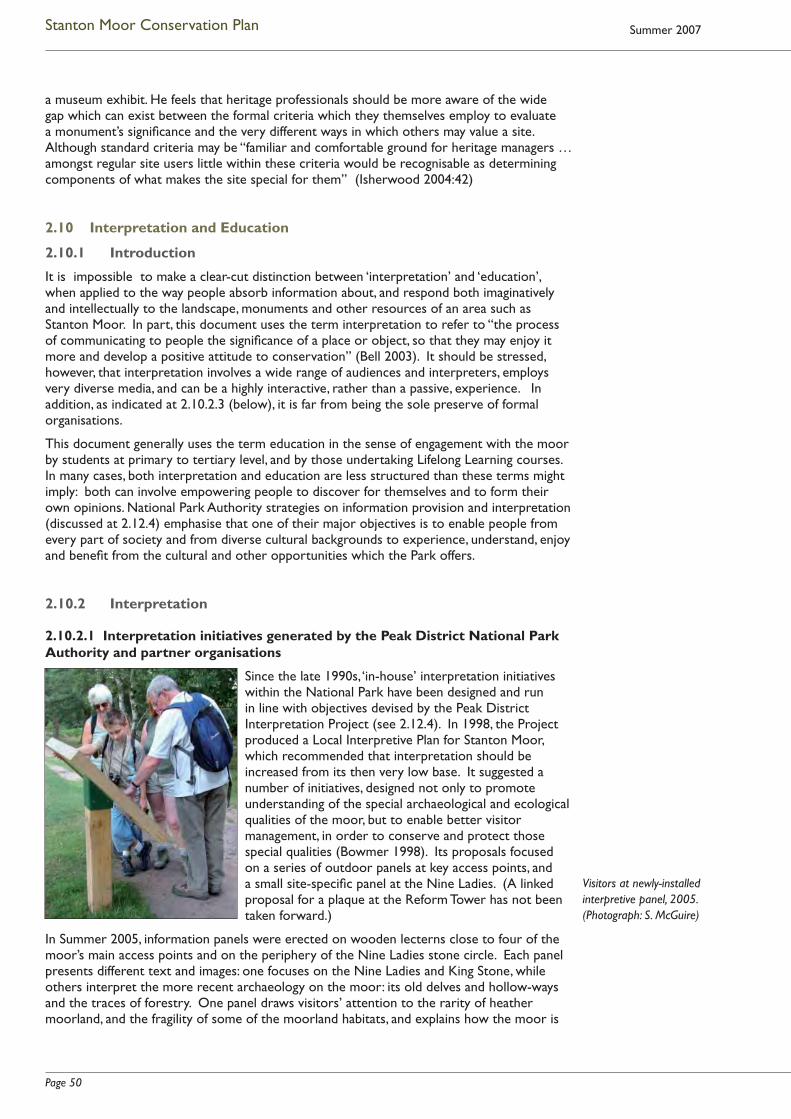
Page 50
Stanton Moor Conservation Plan Summer 2007
a museum exhibit. He feels that heritage professionals should be more aware of the wide gap which can exist between the formal criteria which they themselves employ to evaluate a monument’s signifi cance and the very different ways in which others may value a site. Although standard criteria may be “familiar and comfortable ground for heritage managers … amongst regular site users little within these criteria would be recognisable as determining components of what makes the site special for them” (Isherwood 2004:42)
2.10 Interpretation and Education
2.10.1 Introduction
It is impossible to make a clear-cut distinction between ‘interpretation’ and ‘education’, when applied to the way people absorb information about, and respond both imaginatively and intellectually to the landscape, monuments and other resources of an area such as Stanton Moor. In part, this document uses the term interpretation to refer to “the process of communicating to people the signifi cance of a place or object, so that they may enjoy it more and develop a positive attitude to conservation” (Bell 2003). It should be stressed, however, that interpretation involves a wide range of audiences and interpreters, employs very diverse media, and can be a highly interactive, rather than a passive, experience. In addition, as indicated at 2.10.2.3 (below), it is far from being the sole preserve of formal organisations.
This document generally uses the term education in the sense of engagement with the moor by students at primary to tertiary level, and by those undertaking Lifelong Learning courses. In many cases, both interpretation and education are less structured than these terms might imply: both can involve empowering people to discover for themselves and to form their own opinions. National Park Authority strategies on information provision and interpretation (discussed at 2.12.4) emphasise that one of their major objectives is to enable people from every part of society and from diverse cultural backgrounds to experience, understand, enjoy and benefi t from the cultural and other opportunities which the Park offers.
2.10.2 Interpretation
2.10.2.1 Interpretation initiatives generated by the Peak District National Park Authority and partner organisations
Since the late 1990s, ‘in-house’ interpretation initiatives within the National Park have been designed and run in line with objectives devised by the Peak District Interpretation Project (see 2.12.4). In 1998, the Project produced a Local Interpretive Plan for Stanton Moor, which recommended that interpretation should be increased from its then very low base. It suggested a number of initiatives, designed not only to promote understanding of the special archaeological and ecological qualities of the moor, but to enable better visitor management, in order to conserve and protect those special qualities (Bowmer 1998). Its proposals focused on a series of outdoor panels at key access points, and a small site-specifi c panel at the Nine Ladies. (A linked proposal for a plaque at the Reform Tower has not been taken forward.)
In Summer 2005, information panels were erected on wooden lecterns close to four of the moor’s main access points and on the periphery of the Nine Ladies stone circle. Each panel presents different text and images: one focuses on the Nine Ladies and King Stone, while others interpret the more recent archaeology on the moor: its old delves and hollow-ways and the traces of forestry. One panel draws visitors’ attention to the rarity of heather moorland, and the fragility of some of the moorland habitats, and explains how the moor is
Visitors at newly-installed interpretive panel, 2005. (Photograph: S. McGuire)

Page 51
Stanton Moor Conservation Plan
managed to achieve conservation aims. All fi ve panels stress the national importance of the scheduled monument, and ask visitors to help safeguard it.
In addition, an audio trail for Stanton Moor has been developed by Moors for the Future: a partnership project to restore and conserve Peak District moorlands, and encourage better appreciation and greater care of these landscapes. Users of the audio trail (currently one of four such trails in the National Park) can download a walking route and information about the moor’s landscape, archaeology and ecology onto a personal computer, and play the trail information through players such as Ipods, mobile phones and handheld computers. The audio trail is aimed at members of the public who already use the moor, those who are interested in technology as a means of introducing them to moorland heritage, and as a tool for those who do not yet use the moors because they lack the confi dence to do this without support.
There are well-supported guided walks across the moor, aimed at a variety of audiences, and designed to promote understanding of the landscape and awareness of its fragility. The Ranger Service leads a number of ‘animated walks’ across the moor. These are aimed at family groups with children and have also been run for the Peak Park ‘Leisure Walk’ Group – people who are advised to take part in health walks for a variety of social and physical and mental health reasons. The walkers meet a series of characters drawn from different periods in the moor’s past and a present-day Ranger who talks about how the moor is protected and managed. A recent initiative is the introduction of occasional signed walks on the moor, for the benefi t of the deaf.
Other interpretation initiatives are currently few in number. They have included an English Heritage leafl et produced in advance of the November 2000 excavation at Nine Ladies. This leafl et – which combined the functions of interpretation and information – was aimed at members of the public, including pagan groups, with a particular interest in the stone circle. It addressed the archaeology of the moor, the perceived need for partial excavation, and the nature of future management plans.
Although there are fairly brief references to the archaeology of the moor in general guides and walk books, there are few references to it in interpretive publications aimed at a general audience, and there is no specifi c guide to the moor.
Top right: Children from the Royal School for the Deaf,
Derby, with Ranger Service and school staff, Stanton
Moor, 2003. (Photograph by R. Manley, PDNPA, reproduced
by kind permission of the Royal School for the Deaf,
Derby.)
Left & bottom right: Participants in a Peak Park
‘Leisure Walk’ meet characters from Stanton Moor’s varied
past, April 2006. (Photograph: PDNPA)

Page 52
Stanton Moor Conservation Plan Summer 2007
2.10.2.2 Academic interpretation
The nature and signifi cance of the archaeological features on and around the moor have been addressed in a number of academic analyses and interpretations, and continue to be the subject of detailed study. Much of this body of work is referenced in the Bibliography at Appendix A. Studies such as these form the basis which underpins the majority of (generally brief) interpretive work for the public, and information from them fi nds its way in diluted form into general guide and walk books and other publications.
2.10.2.3 Independent interpretation
Interpretation of Stanton Moor is not the sole preserve of the Peak Park Interpretation Project, nor of archaeologists and other academics. Many individuals and groups produce and disseminate diverse interpretations of the meaning and signifi cance of its prehistoric archaeology and natural features. In many cases, these derive from a spiritual understanding of the monuments and their landscape, and at least one website (www.stantonmoor.co.uk) incorporates a range of detailed material on the overall history and archaeology of the moor. Websites now provide a cheap and popular means of publicising independent views, maintaining debate, and disseminating information. They constitute an active forum for the communication of differing viewpoints, which exists alongside, and in many ways separate from, the interpretive channels – both formal and informal – used by the Peak Park and its partner organisations.
2.10.2.4 Public interpretation / outreach initiatives by Derby Museum
Derby Museum is seeking to make its collections more accessible and relevant to Derby’s socially and ethnically diverse population. It feels that one way to do this is to focus on aspects of British prehistory which may resonate with people from a range of religious and ethnic backgrounds. One example would be the relationship between some stone circles and the phases of the sun and moon – a relationship paralleled in (for instance) certain South Indian monuments, such as the Sun Temple at Modhera (Jonathan Wallis, pers. comm.). The Museum is applying for funding to allow members of Derby’s ethnic minority communities to visit Stanton Moor to experience its monuments and landscape, and also to encourage their engagement with the Museum’s prehistoric collections including those from Stanton Moor (see 2.5.2.3). Community groups will be encouraged to develop a project resulting in an outcome that helps to interpret British prehistory and / or their feelings towards it. It is felt to be important that the project outcome is devised by the communities engaged in the project.
2.10.2.5 Perceived lack of interpretive material
Despite the various initiatives described above (some of them very recent) the overwhelming view of those consulted during research for this document was that, for the non-specialist, there was a distinct dearth of readily-accessible information on all aspects of the moor.
2.10.3 Education
2.10.3.1 Primary
Introduction
As discussed in more detail at 3.8.2.1, it is possible for primary teachers to use a landscape such as Stanton Moor as a resource for a range of topics, particularly as part of a local study at Key Stage 2. Given the curricular emphasis on the study of a ‘local’ site, together with the practical, budgetary and other constraints described during discussion with local teachers, the primary-level educational audience for Stanton Moor might be expected to lie within schools from the very local area. Surprisingly, however, as indicated below, it may be that primary schools from outside Derbyshire currently make more use of the moor than those within the county.

Page 53
Stanton Moor Conservation Plan
Use of the moor by local schools
In 2003, Stanton-in-Peak Primary School worked with English Heritage’s Regional Education Offi cer to develop a scheme of work which would link their local historic environment to the citizenship curriculum, by looking at some of the conservation issues surrounding Stanton Moor and the Nine Ladies stone circle. The stimulus for this was English Heritage conservation work carried out at the Nine Ladies in the spring of the same year. The scheme was linked to the teaching of a range of curriculum units, and tasks undertaken included measurement of the diameter of the circle and the volume of the stones, and designing and making models of Bronze Age roundhouses. Although the project has not yet been extended to other primary schools in towns and villages close to Stanton, it may be possible to do so in the future (R. Bellamy, pers. comm.). In addition to this project, Stanton-in-Peak Primary School makes fairly regular use of the moor and its environs. Activities have included the use of the stone circle and nearby woodland for drama and video recording, and work on environmental and conservation issues. The head teacher notes that, on a visit to Sheffi eld City (now Weston Park) Museum, Birchover children who attend the school were fascinated to see that many of the prehistoric artefacts which they saw there came from their home area.
Research to date suggests that Stanton-in-Peak is probably the only local primary school to make practical use of the moor. Recent contact with a number of other primary schools in the local area indicates that they do not use it – in some cases because it is not within walking distance. One local primary has, however, used the quarrying controversy as “a vibrant means of teaching citizenship issues” (head teacher cited in Isherwood 2004:41).
Use by primary schools from outside the area
Moving outside the Peak however, the Stanton area has been used as an educational resource by primary schools from much further afi eld. A 1994 schools’ television production (part of the ‘Zigzag’ series, entitled ‘Where You Live, Where I Live’) took the Stanton-in-Peak area and its primary school pupils as one of two main foci for a series of programmes which asked children to consider the differences between rural and urban environments. This series proved consistently popular across the UK; it generated a number of visits by other schools to the Stanton-in-Peak area, and is still in use.
In addition, there are regular visits to the moor by groups of primary school pupils from Cambridgeshire (and neighbouring counties). They are based at Cambridgeshire County Council’s ‘Great Adventures Campsite’ at Barn Farm, Birchover. (Until recently, this also offered activities to other age groups.) Teachers with primary groups from Cambridgeshire and Hertfordshire interviewed by Isherwood (2004) said that they currently used the moor as a resource within the Geography curriculum, but would be interested in extending and varying the ways in which pupils interacted with this landscape (R.Isherwood, pers. comm.) The operator of the Cambridgeshire facility has also expressed interest in extending ways in which the moor’s resources can be used within the primary curriculum (W.Austin, pers. comm.).
In March 2006, 60 Year 5 students from Boothroyd Junior School, Dewsbury, visited the moor. This initiative was developed in association with the Peak District National Park’s Moorland Discovery Learning Offi cer, working with the Moors for the Future partnership project (see 2.10.3.3 below), and enabled pupils to experience a very different locality, and to explore the moor and its resources in a range of interactive ways.
Other educational initiatives
One of the roles of the National Park Ranger Service is to work with primary schools across the Park, and from targeted areas outside its boundaries. The Service has a particular responsibility for developing a programme of environmental education, with a strong emphasis on the Biodiversity Action Plan (see 2.12.2.2). In the Stanton area, Rangers maintain contact with local primary schools, and past initiatives have included walks across the moor with pupils from Stanton-in-Peak school.

Page 54
Stanton Moor Conservation Plan Summer 2007
2.10.3.2 Secondary
Since 2004, it is no longer possible to study Archaeology as a separate subject at GCSE level. Research to date indicates that very few schools in the Peak District and neighbouring areas offer the subject at AS and A2 level (although there appears to be wider availability at Further Education and 6th form colleges.) However, there is potential for Stanton Moor to be used as a focus within Geography and Citizenship courses at secondary level, and within some aspects of the History curriculum (see 3.8.2.1). As with primary-level education, further research may clarify whether greater use is made of the moor by secondary schools outside the area than by those within it.
It has only been possible to trace a very few recent uses of Stanton Moor within secondary education, although others may exist, and contact with schools in the local region undertaken as part of the research for this plan indicates that there is scope for expansion.
One of the most substantial current uses forms part of a day-long teaching unit on issues surrounding mineral extraction, which is offered to GCSE and A-level students from throughout the UK by the National Park Education Service, based at Losehill Hall. As part of the programme, representatives of different interest groups are invited to present their point of view. Recent spokespeople have included a member of the Lees Cross / Endcliffe protest camp and the quarry manager from Blue Circle Cement (now Lafarge) at Hope.
In the past few years, students taking GCSE and A level Geography at a Bakewell secondary school have made use of the moor to examine issues relating to tourism and confl ict over land use. In 2004, for example, a student project involved interviews with a sample of visitors to the moor and with people in surrounding villages (see 2.11.3). The same school has also used contrasting views on the quarrying issue at Lees Cross / Endcliffe to generate discussion within an environment unit forming part of the Key Stage 3 Science curriculum.
Outside the county, a secondary school in the north-east has also used the Lees Cross / Endcliffe controversy as the subject for a web-based study, as part of the citizenship curriculum (A. Whitlock, pers. comm.). For this, students analysed arguments presented by the various parties concerned.
2.10.3.3 Potential for future work with schools
As indicated above, a number of teachers and others involved in educational provision have expressed interest in exploring the educational possibilities of Stanton Moor. In addition, Education Offi cers from the National Park Education Service and English Heritage’s East Midlands Region have expressed the view that the moor’s varied resources present an opportunity to develop key messages and themes to support future educational material (E. Ballard, R. Bellamy, pers. comm.). There is thus the potential to extend and vary engagement with the moor by pupils from the local area and further afi eld – not only through fi eld visits but possibly through ‘virtual’ contact, using web-based resources.
As part of the Moors for the Future partnership project, a new educational centre – the ‘Moorland Learning Base’ – is being developed at Longshaw, close to the eastern boundary of the National Park, and will open in 2006. The Learning Base is designed to act as a resource for moorland-based education, with a particular focus on children from inner-city schools. The education programmes will aim to offer young people the opportunity to experience moorlands such as Stanton, and consider their own role in looking after the environment now and for the future.
2.10.3.4 Tertiary / Continuing Education
Although relatively limited use appears to be made of the moor by schools in the region – particularly at secondary level – it is fairly regularly used as a resource by AS and A2 level students of various ages studying at Sixth Form colleges, by those pursuing Lifelong Learning courses, and by university students at undergraduate and postgraduate level. These students are drawn from colleges and universities in Derbyshire and surrounding counties, and their focus encompasses not only archaeology, but environmental and tourism issues, geology and geomorphology. Known examples of recent and current use are listed below, but it is entirely likely that other institutions also use the moor as an educational resource.

Page 55
Stanton Moor Conservation Plan
Cheadle and Marple Sixth Form College offers Archaeology at AS and A2 level, and its fi rst year students visit Stanton Moor as part of a fi eld study day on prehistory in the Peak District.
Buxton College offers both an ‘Introduction to Archaeology’ and AS / A2 level Archaeology, but the relevant tutor has commented that, while he would at some point take students to the moor, he currently feels that “the [moor] is in effect too popular and the erosion around the area needs controlling before it is beyond redemption” (I. Heath, pers.comm.).
Dearne Valley College offers Archaeology at AS and A2 level, and has used Stanton Moor as a fi eld trip venue in the past. However, specifi c health and safety qualifi cations are now needed by those of its tutors wishing to take student groups higher than 250m AOD.
Sheffi eld University’s Institute for Lifelong Learning (TILL) has brought students to the moor to study its prehistoric archaeology and to practice non-intrusive survey techniques. A fi eld trip to the moor is currently included in a TILL module entitled ‘The Archaeology of Death, Burial and Ritual’, offered to students enrolled at a range of levels.
The Centre for Continuing Education at the University of Nottingham uses Stanton Moor as a venue for archaeology fi eld trips at least 2 or 3 times a year. The focus of these visits is the moor’s Bronze Age archaeology, which is included within a module on the Neolithic and Early Bronze Age, and in a module based specifi cally on the archaeology of the Peak District. The same tutor also arranges occasional fi eld trips to the moor for continuing education students from the University of Keele and W.E.A students from Derby and Loughborough. He comments that Stanton Moor is “a wonderful site…a really useful resource” (D. Baxter, pers. comm.).
A number of recent undergraduate and postgraduate students from the Centre for Environment, Conservation and Outdoor Leisure at Sheffi eld Hallam University have used aspects of the moor as a basis for case studies. These have typically covered issues such as recreational use, the management of archaeology, landscape interpretation, and conservation issues including – yet again – the Lees Cross / Endcliffe quarrying debate. As part of such projects, students liaise with the Ranger Service and others. (However, a representative of the University notes that it is sometimes diffi cult for students to fi nd someone in a professional capacity willing to give up time to assist them with primary research.)
The Department of Archaeology and Prehistory at the University of Sheffi eld has used the moor for fi eld trips, primarily at MA but also at undergraduate level, and on occasion it has been a focus for practical exercises and project work. In addition, the Stanton Moor quarrying issue has formed the basis of a case study within a Heritage Management module offered to undergraduates. The view has been expressed that, in the past, practical use of the moor has been complicated by lack of certainty about access arrangements – an uncertainty which should now be remedied by the moor’s recently-acquired status as Access Land (2.12.3.3).
The University of Nottingham makes considerable use of the geological interest of the moor and its environs. The area of the moor which is designated as a Regionally Important Geological and Geomorphological Site (see 2.12.2.1) is used for fi eld work with fi rst year geology undergraduates, while second year students use the area between the moor and Gratton Dale for fi eld mapping. A third year module (‘Current Issues in Conservation’), available to students from a range of disciplines, highlights the moor as an example of confl ict between the needs of industry and preservation of the landscape. For this, students are asked to undertake their own assessment of an aspect of the moor (its archaeology, ecology, geomorphology etc.) and to act as expert witnesses in a simulated planning enquiry. The University also uses the processes involved in stabilising a signifi cant area of land slippage between the moor and Darley Bridge within its Applied Geology teaching, and notes that this is also of potential interest for Civil Engineering students. A University representative has commented that Stanton Moor has “tremendous educational potential”, which is probably not fully realised (P. Jones, pers. comm.).
Masters-level students from the University of Leicester visit the moor every year as part of a course in Landscape Archaeology. Their tuition while here is partly delivered by a member of staff from the National Park Authority’s Cultural Heritage Team.
Page 56
Stanton Moor Conservation Plan Summer 2007
Recent dissertations by MA students from the Universities of Sheffi eld and Manchester have focused on issues such as the management of the scheduled moorland, and relationships between the various formal and informal communities who engage with the Nine Ladies stone circle (see Alton 1996, Isherwood 2004). Another recent MA dissertation for the University of Staffordshire (Blease-Bourne 2004) used visitor responses to Stanton Moor – and particularly the Nine Ladies – to examine the role of the subjective observer in creating social and cultural space.
An ongoing research project Sacred Sites, Contested Rights / Rites, directed from Sheffi eld Hallam and Richmond Universities focuses on spiritual engagements with monuments and landscapes at Stanton Moor, Stonehenge and Avebury. Proposals include ethnographic fi eldwork to “develop narratives of residents, visitor, protestors…and other users of the landscape” (Blain and Wallis 2004c).
2.11 Access, visitor use and visitor impact
2.11.1 Access
2.11.1.1 Getting to the moor
Stanton Moor is among the most accessible heather moorlands of the Peak District (Figure C2). It lies about 30km (19 miles) from the city of Sheffi eld, within 8km (5 miles) of the towns of Matlock and Bakewell, and 2km (1.2 miles) from Darley Dale. The A6 runs through the river valleys to its immediate north and west.
Walking routes
For walkers, it is relatively easy to include this compact area of moorland within a longer walk. Public footpaths through open country lead up to the moor from Winster to the south, from the Limestone Way to the south-west, and from Rowsley to the north-east. Paths also provide easy access points for local users of the moor from the villages and hamlets on its lower slopes (Figure C12).
Public transport
Public transport links to Stanton Moor are currently poor. At the time of writing, although it is possible to use the Bakewell to Matlock service which calls at Stanton and Birchover at rather less than hourly intervals in the week, this service is more infrequent on Saturdays (particularly throughout the morning), and does not run on Sundays.
Cars and car parking
The Birchover Road runs along the western edge of the moor and the narrow, unclassifi ed Lees Road winds round its southern, western and northern perimeter. On these roads, there are relatively small amounts of space available for casual roadside parking at four of the public access points onto the moor, and a limited amount of space also exists close to a number of unoffi cial access points, both on the Birchover Road, and close to Lees Cross. In 2002, a public car park was established in part of the Dungeon Quarry site opposite Birchover Quarry. (Figure C12 shows current parking locations. For the impact of parking, see 2.11.4.7.)
2.11.1.2 Getting onto the moor
There are fi ve public access points onto the moor. With the exception of the route from the south up to Stanton Moor Edge, access from the roadside to public footpaths leading to or across the moor is via stone or wooden stiles. All public footpaths have stiles where they access the scheduled area of the moor, and the entry point from the north (close to the New Pilhough haul road) has a stile and fi eld gate (Figure C12).
There are also a number of unoffi cial access tracks, for example the ‘mast track’ from the north-west. Access is also gained from the west through disused quarries, although most of this (fairly light) use appears to be by local people. There are a number of unoffi cial tracks

Page 57
Stanton Moor Conservation Plan
up from the east and north-east, in some cases created or used by quarry-based protestors. However, one permissive path through Lees Cross Quarry has long been used by local people.
The public footpaths which lead up to the moor and to Stanton Moor Edge from the two southern access points are relatively steep and stony. Public footpath access from the north-east is also via a relatively steep slope. The public footpath from the west, via the Cork Stone, follows a fairly gentle gradient onto the moor, but in many places is worn away to uneven bedrock. In contrast, public access to the moor from the north, close to the point where the New Pilhough Quarry haul road crosses the Lees Road, is relatively fl at with a good surface.
Strategies and legislation relevant to public access are outlined at 2.12.3.
2.11.1.3 Crossing the moor
Four public footpaths cross the moor (Figure C12). In the main, these run broadly north / south along the contour, although the southern stretch of one path runs west / east from the Birchover Road past the Cork Stone. With the exception of the eastern path (the ‘Duke’s Drive’), all of these pass within a few metres of major prehistoric monuments.
A number of unoffi cial paths cross roughly east-west. Some of these ‘desire lines’ also lead to (and across) monuments, or to features such as the trig point. The width and surface quality of both public and unoffi cial footpaths vary with use rate and gradient.
As indicated below at 2.12.3.3, under the Countryside and Rights of Way Act 2000 (CROW), Stanton Moor has been designated as Access Land. However, it remains subject to powers included in the Act to minimise the impact of public access on wildlife and conservation interests, and to protect archaeological sites and features.
Prior to the advent of CROW, the National Trust operated a long-standing open access policy on the eastern escarpment, Stanton Moor Edge.
2.11.1.4 Signage / waymarking
Signage (i.e. waymarking of public rights of way from the metalled road) is the formal responsibility of Derbyshire County Council as the Highway Authority. In practice, the National Park Ranger Service places signs (usually fi ngerposts) on the basis of need, where paths / junctions / directions of path are not obvious. In the judgement of the Ranger Service, this is rarely the case on Stanton Moor – although consultation indicates that some visitors fi nd it hard to locate the Nine Ladies stone circle. Five information panels, erected in Summer 2005 close to four major access points, and at the Nine Ladies, incorporate a schematic footpath plan, and indicate the general location of the Nine Ladies stone circle and the Cork Stone. As required under CROW (see 2.12.3.3), there are now ‘Access Land’ signs where public footpaths access the moor. The placing of these is the responsibility of the National Park through its Ranger Service. (Interpretive – as opposed to directional – signage is discussed at 2.10.2.1.)
2.11.2 Disability access audit for the Guardianship monument
In 2003, a ‘Disability Access Audit’ was undertaken by English Heritage for the Nine Ladies stone circle and King Stone, as a monument in Guardianship (Walker 2003). This did not address access to the remainder of the scheduled monument by those with different abilities, other than in a very general way. The audit report noted that:
• the stone circle is at least 500m from the nearest public highway (although the English Heritage visitors’ handbook reads as if it is adjacent to the road);
• there is no dedicated parking associated with the monument, or with the wider moor;
• the Guardianship area is generally level, but several of the footpaths which approach it include steep slopes and surfaces which are in poor condition;
• the objective of any proposals should be to improve visitor experience rather than to increase visitor numbers.

Page 58
Stanton Moor Conservation Plan Summer 2007
Signage
The report made a number of recommendations in relation to improved signage on the moor itself, and an improved description in the English Heritage handbook. It also recommended that any new information panels should be sited “with disability access in mind”.
Access from road
It recommended that consideration should be given to upgrading the route from the Lees Road to the north of the monument, in order to improve access for less ambulant visitors “as a minimum requirement”.
Path maintenance
It recommended that footpaths should be regularly checked, repaired and kept clear of vegetation, and that circulation routes should be amended if they generate unacceptable levels of erosion. (As indicated at 5.6.1.1, the National Park Ranger Service already undertakes regular checking and maintenance of paths, gates and stiles.)
2.11.3 Visitor use rates and patterns
There are no defi nitive visitor surveys for Stanton Moor, although an estimated fi gure of 42,000 visitors per year has been suggested. However, this is based on generalised and now outdated fi gures extrapolated from a 1986 / 1987 survey of recreational visitors to the Peak District, combined with observation undertaken in 1998 on winter weekends only. Although these fi gures are broadly compatible with the number of casual visitors recorded during the November 2000 small-scale excavations at Nine Ladies, they cannot be taken as an accurate guide to current year-round use. In the view of the Ranger Service, visitor patterns have both increased and altered across the Park as a whole since these surveys were undertaken.
Since the 1970s, the prehistoric monuments on the moor – and particularly the Nine Ladies stone circle and King Stone – have formed an increasing focus of interest for those holding alternative beliefs, particularly (but far from exclusively) at solstices and equinoxes (see 2.9). The circle is also an occasional venue for more generalised parties and celebrations. Despite legal restrictions (see 2.12.3.4), camping appears to be becoming more common on the moor, particularly in the warmer months: some tents are pitched close to the circle, but others can be found in more distant stands of birch, and in woodland and quarries around the fringe of the moor.
In Autumn 1999, a protest camp was set up in Lees Cross / Endcliffe quarries, immediately below the moor’s north-east escarpment, as part of an ecologically-based protest against the renewal of quarrying close to this important cultural site. Members of the protest camp regularly visit the stone circle and moorland close by.
Observational evidence from the 1998 winter weekend Ranger survey suggested that there were a number of different types of user:
Gates and stile at northern (Lees Road) access point. (Photograph: S. McGuire)
Campers near the Nine Ladies stone circle, May 2005. (Photograph: J. Hughes)

Page 59
Stanton Moor Conservation Plan
• dog walkers and recreational walkers, including families with young children;
• ramblers from further afi eld;
• ‘alternative’ campers / solstice celebrants / anti-quarry protesters;
• stone circle enthusiasts;
• weekend party goers attending parties at the Nine Ladies;
• archaeologists;
• ecologists;
• school parties;
• students.
Recent observation combined with consultation and a small-scale student survey1 (Chapman 2004) suggest that the predominant year-round users of the moor are walkers, recreational ‘strollers’, dog walkers and family groups, while members of the protest camp and those specially attracted by the Nine Ladies stone circle make regular use of the north end of the moor. As noted above, some consultees have observed a relatively recent increase in unauthorised camping across the moor, possibly unassociated with the protest camp: they judge this to be especially common between April and October.
Small-scale survey results suggested that, on summer and autumn weekends in 2004 (and notwithstanding the presence of a number of visitors from quite distant parts of the UK and from abroad) a relatively high proportion of recreational users came from the local area – i.e. from within 10km (6 miles) of the moor – and that the majority had travelled no more than 40km (24 miles). Approximately two-thirds of those questioned had come to the moor to walk, and to admire the scenery (including the long views), with a smaller proportion (just over one third) citing the moorland archaeology as a reason for visiting. More extensive survey, also addressing visitor use at different points in the week, and at different times of year, would indicate whether these initial results represent a valid pattern.
Observation also suggests that ‘boulderers’ should be added to the list of frequent users of the moor: eroded pillars and outcrops of rock around the moor, such as the Cork, Cat and Andle Stones, appear to be the main attraction for this group, and the moor features on a local bouldering website. The popularity of this sport has increased signifi cantly within the last fi ve years. The moor is also used by orienteering groups, and in 2005 the landowner gave permission for its use for organised games of ‘frisbee golf ’, a group sport in which trees are used as frisbee targets. This use is being monitored by the Ranger Service. In late summer, the moor is valued for bilberry-picking.
The only horse riders permitted to use the moor are members of the landowner’s family, and there is no right of way for (and little use by) cyclists.
Sunday tends to be the busiest day, and mid-afternoon the busiest time. Rangers
1 The authors of this report are grateful to have been given access to data collected during a visitor survey
conducted on the moor in 2004 as part of a local school project (Chapman 2004). This was a small-scale survey, involving
interviews with over 150 visitors, mainly undertaken on summer and autumn weekends. It used questions largely based
on those employed in the National Park Authority’s formal consultation process. The data collected were subsequently
analysed by the authors of this report.
Boulderers at the Cork Stone, May 2005. (Photograph: J. Hughes)

Page 60
Stanton Moor Conservation Plan Summer 2007
suggest that there are very few times when there is nobody on the moor, and there are times (e.g. the summer solstice) when there are visitors for 24 hours a day.
Casual visitors tend to use some of the principal monuments close to the paths as rest and recreation stops. Most head ultimately for the Nine Ladies. The Cork Stone – and the challenge of climbing it – act as a draw for both adults and children. Other highly visible points, including the Reform Tower, the ‘trig point’ and the gritstone outcrops on the eastern escarpment, also shape the routes which visitors take around the moor.
2.11.4 Visitor impact
2.11.4.1 The major footpaths are completely devoid of vegetation, and carry little or no soil. On the steeper slopes, they are heavily gullied by rainwater run-off. The unoffi cial trans-moor paths are, however, less heavily eroded, and the vast majority of people keep to public footpaths. Few people attempt to walk through the heather – although the Ranger Service has recently noted that a few new ‘desire lines’ across the moor are becoming more regularly used. All the main paths and cross-moor routes appear to be increasing in width, and ‘corner-cutting’ at the major path junction close to cairn T2 is broadening the eroded area here (although see 2.6.2 on the ecological value of these bare sandy areas)
2.11.4.2 The ground around major gathering points, such as the Cork Stone and Reform Tower, is also almost devoid of vegetation. There is also evidence (in the form of chalk stains) that boulderers use the early 19th century inset panel on the Cat Stone as a handhold (see photograph at 5.3.1.2).
2.11.4.3 English Heritage has assessed the Nine Ladies stone circle and King Stone as being at ‘High Risk’, principally from the various impacts of visitor pressure (Fearn and Humble 2003:79).
Specifi c impacts on the area close to the monument include:
• trampling, ground disturbance, and erosion from devegetated areas;
• lighting of fi res within and around the circle;
• damage to orthostats from fi re, chipping, carving and use as seats;
• unauthorised vehicle access;
• damage to surrounding trees – especially the burning of live and dead wood;
• litter – particularly litter associated with camping and camp fi res;
• groups of loose dogs, which disturb sheep, and can also distress visitors to the moor.
For examples of these impacts, see illustrations here and at 2.9, 2.11.3 and 5.2.2.1.
As discussed at 2.12.5.2, the Ranger Service works with campers and other circle users to minimise damage. However, Ranger input has been somewhat reduced, owing to a number of pressures including reduced resources and changing priorities across the National Park.
Nine Ladies stones provide handy places to sit, May 2005. (Photograph: J. Hughes)
Offerings and erosion at centre of Nine Ladies stone circle, Summer 2005. (Photograph: S. McGuire)
Page 61
Stanton Moor Conservation Plan
The increasing rate of erosion at the site was monitored from 1988 to 1997, and, following evaluative excavation in 2000, conservation work was undertaken in Spring 2003 to restore and reinforce ground surfaces around the monument. The degree of resilience of the restored surfaces is being monitored: between Winter 2004 and Summer 2005 areas of erosion were becoming apparent close to several orthostats, in the centre of the circle, and along the approach path from the south. By Spring 2006, there were patches of bare ground – some of them substantial – around the majority of orthostats, in the centre of the circle, and on some parts of the (non-reinforced) approach path from the north.
2.11.4.4 A number of other monuments across the moor suffer from erosion, ground disturbance and stone displacement. These impacts can be attributed at least in part to visitor pressure, although grazing has played a role, particularly prior to the introduction of more formalised controls in 1993. Examples include the large cairn T2, which lies very close to the intersection of two major tracks (see photograph at 5.2.2.3). Vegetation here struggled to regenerate following scrub clearance, and the upper area of the cairn is suffering from erosion, although lower areas to the south appear to be regenerating fairly well. A second large cairn, T55, is also at some risk from erosion. This easily accessible cairn sits close to the eastern side of the central track across the moor. Two or three narrow paths have been worn from the track up onto the cairn, and stones on its upper surface have been displaced. Nevertheless, this cairn is considered to be revegetating fairly successfully in comparison with its condition 10 years ago (K. Smith, pers. comm.). There are also a number of areas of severe erosion on ring cairn T56, west of the central track. Here, an unoffi cial footpath which once led through an entrance gap in the bank has diverged to run up and over the bank.
In contrast, it is probable that many of the smaller monuments away from cross-moor routes are protected (from humans if not from animals) by their remoteness from paths, by high vegetation growth, and by their visual insignifi cance. However, there has been no formal survey of the levels of erosion or other disturbance affecting monuments (including smaller cairns) across the moor.
2.11.4.5 Camp fi res, although damaging, are generally confi ned to the area immediately adjacent to the Nine Ladies and King Stone, within the woodland edge, where there is little heather. However, there is evidence that they are also created in quarries and stands of trees at different points on and around the moor (e.g. close to ring cairn T56 and to the Stanton Moor Quarry boundary) and within T56 itself. To feed these fi res, branches are regularly broken from trees, and wooden fencing (and in one case a gate) has been removed. This fairly regular damage to supposedly stockproof boundaries poses problems for the grazier and landowner. (See photographs at 5.2.2.1)
2.11.4.6 From a fi re risk perspective, the siting of most camp fi res close to the Nine Ladies, where there is little heather, decreases the risk of accidental grass / heather fi res from such sources, and the risk is further decreased by the regular provision by the Ranger Service of corrugated steel sheets to act as fi re bases. In general, the majority of people understand and respect the need for these, although busy periods such as the Summer Solstice can present problems.
Elsewhere on the moor, the fi re risk is perceived by the Ranger Service to be similar to that for other areas of moorland with a high level of use. On Stanton Moor, the provision of fi re breaks through controlled heather burning helps to diminish the risk of a large-scale fi re.
2.11.4.7 Visitor parking around the moor can generate problems at any time of the year when the weather is good, and not only at signifi cant dates such as solstices. The most serious problem is to the north, where the public footpath joins the Lees Road, close to the New Pilhough Quarry haul road exit from Coast Wood (see photographs at 5.6.3.3). There is no formal lay-by here (although parking has created an informal one). The road is narrow, and vehicles / quarry lorries can fi nd it diffi cult to pass at times, churning up the verge in wet weather.
The busiest parking area is probably that to the west, on the Birchover Road, at the Cork Stone approach to the moor. This presents less of a problem, as the road here is wider, and there is a longer (if informal) lay-by available. In the view of the Ranger Service, small lay-bys close to other approach tracks do not cause problems. However, responses to the wider
Page 62
Stanton Moor Conservation Plan Summer 2007
consultation process (see Appendix B) indicated concern about the visual and physical impact of ad hoc parking.
There has been a history of unauthorised vehicle and motorcycle access onto the moor, via gated tracks, which in one case in 1990 led to severe damage to the King Stone. Until recently, measures to stop this – such as locking or blocking the main entry points – appeared reasonably effective. However, in 2005, there was a reported resurgence in access onto the moor by vehicles. It appears that a small number of drivers are using the Coast Wood haul road, and then gaining access to the moor itself, probably via an unlocked gate. Evidence suggests that casual (rather than regular) users of the moor are responsible for such access, and there are anecdotal accounts of aggressive behaviour by vehicle drivers.
2.12 Designations, responsibilities and strategies
2.12.1 Statutory designations
2.12.1.1 National Park
Stanton Moor lies within the Peak District National Park, established in 1951 under the National Parks and Access to the Countryside Act 1949. This is the UK’s top tier of landscape designation.
The statutory purposes and duties of a National Park Authority, as redefi ned by the Environment Act 1995, can be summarised as:
• to conserve and enhance the National Park’s special qualities;
• to provide opportunities for the enjoyment and understanding of these special qualities.
Where there is a confl ict between these two purposes, then the fi rst (‘to conserve and enhance…’) should prevail over the second (D.o.E. Circular 12 / 96). In pursuing these purposes, the National Park Authority also has a duty to foster the economic and social well-being of local communities.
Under Section 62 of the Environment Act 1995, wide-ranging duties are placed on a large number of public bodies to have regard to the purposes of National Parks in making decisions or carrying out activities relating to land within the Parks.
2.12.1.2 Scheduled Monument
In March 1995, the majority (approximately 1sq.km.) of Stanton Moor was included in the Schedule of Monuments, under the terms of the Ancient Monuments and Archaeological Areas Act 1979. The purpose of scheduling is to protect and conserve nationally important archaeological sites and monuments for the benefi t of current and future generations, and it is the highest form of protection afforded to such sites under English law. The scheduled area (whose boundaries are shown at Figure C3) has the general descriptive title ‘Bronze Age burial, ceremonial and settlement remains on Stanton Moor, and evidence for medieval, post-medieval and 19th to early 20th century activity’.
Stanton Moor Scheduled Monument is the management responsibility of English Heritage, and specifi cally, of the Inspector of Ancient Monuments based at the East Midlands Regional Offi ce at Northampton. In a recent study of monuments in the region (Fearn and Humble 2003) it was classifi ed by English Heritage as a Monument at High Risk (see 5.2.5).
In the late 19th and early 20th centuries, a number of individual monuments on the moor had been scheduled under earlier legislation (the Ancient Monuments Protection Act 1882). These were:
• 1882: The Nine Ladies stone circle (‘Derbyshire 4’).
(The monument so scheduled comprised both the Nine Ladies stone circle and King Stone. The schedule title was amended in August 1988 to refl ect this.)
• 1929: A group of ‘chambered tumuli’ on Stanton Moor (‘Derbyshire 42’).

Page 63
Stanton Moor Conservation Plan
This group (which would not now be categorised as chambered tumuli), comprised:
- the embanked stone circle T43
- the probable ring cairn T56
- the three large cairns numbered T2, T55 and T57.
The Doll Tor stone circle and adjacent cairn, which now lie in enclosed land just off the Moor, were jointly scheduled in 1956. They do not form part of the Stanton Moor scheduled monument.
2.12.1.3 Guardianship
The Nine Ladies stone circle and nearby King Stone were taken into State Guardianship in 1883, a procedure introduced by the Ancient Monuments Protection Act 1882. Under this and successor legislation (see above) it is the responsibility of the Guardian – in this case English Heritage, on behalf of the Secretary of State – to maintain the monument. The Guardian is given full powers of control and management, subject to any conditions specifi ed in the Deed of Guardianship. As outlined at 2.12.5.2, in 1995 English Heritage entered into a ten year Local Management Agreement with the Peak District National Park Authority (PDNPA) to undertake day to day management of some aspects of the site, and a decision on renewal of this Agreement is awaited. (The extent of the Guardianship area is shown at Figure C4.)
2.12.1.4 Listed Building
The gritstone structure known as the Reform Tower, on the north-east edge of the Moor, was listed Grade II in 1967. (The list of buildings of special architectural or historic interest is now compiled under Section 1 of the Planning [Listed Buildings and Conservation Areas] Act 1990.) Although the tower itself is excluded from the scheduled area of the moor, the ground beneath it is included within the scheduling. In 1991 it was categorised as a Listed Building at Risk and this is still the case, although repairs are pending (see 2.4.9 and 5.3.1.1).
2.12.1.5 Wildlife and Countryside (Amendment) Act 1985
Under Section 3 of the Wildlife and Countryside (Amendment) Act 1985, the Peak District National Park Authority has to prepare maps showing areas (for example mountain, moor, heath, down and woodland) whose natural beauty it is, in the opinion of the Authority, particularly important to conserve. The Authority has adopted a range of measures to protect designated areas – for example the inclusion of strict planning policies for such land in Structure and Local Plans, the use of ‘stop orders’ to control agricultural intensifi cation of moorland, and the encouragement of other bodies to recognise the importance of such land, and to adopt appropriate land management policies.
Much of the land on and around Stanton Moor has been included in maps prepared under Section 3 of the Act. Areas mapped comprise the moorland itself (including certain areas of the southern moor and the eastern moor edge which lie outside the Scheduled Monument zone) and fairly large areas of semi-natural woodland along its western, north-western and north-eastern fringes. (For the extent of this ‘Section 3’ moorland and woodland, see the plan at Figure C15.)
2.12.2 Non-statutory designations
2.12.2.1 Regionally Important Geological and Geomorphological Site (RIGS)
A large area of Stanton Moor has been designated as a Regionally Important Geological and Geomorphological Site. The RIGS concept was originally established in 1990 by the then Nature Conservancy Council, and is supported by its successor conservation agencies. It is a non-statutory designation, and supplements sites notifi ed as SSSIs. RIGS sites are selected on a local or regional basis, using the following nationally-agreed criteria:

Page 64
Stanton Moor Conservation Plan Summer 2007
• the value of the site for educational purposes in lifelong learning;
• the value of the site for study by both professional and amateur earth scientists;
• the historical value of the site in terms of important advances in earth science knowledge, events or human exploitation;
• the aesthetic value of a site in the landscape, particularly in relation to promoting public awareness and appreciation of earth sciences.
The designation covers a large part of the Stanton Moor scheduled monument area, but also takes in the quarries along the western and north-western fringes of the moor (Figure C17). The basis for the designation is summarised at 2.2.2. The Stanton Moor site is seen as of value for teaching, including tuition at A level and undergraduate level (see e.g. 2.10.3.4).
2.12.2.2 Biodiversity Action Plan / Priority Habitat
Two types of habitat on Stanton Moor – the upland heather moor itself and areas of upland oak / birch wood on and around the moor (see 3.5) – are considered to fall within the defi nition of National Priority Habitat, as specifi ed within the UK Biodiversity Action Plan 1994. This committed the British Government and its agencies to programmes to conserve species and habitats, develop public awareness and understanding, and contribute to biodiversity work in the European and global context. A series of action plans were drawn up for species and habitats of conservation concern by the UK Biodiversity Action Plan Steering Group in 1995 (revised in 1998). A Peak District Biodiversity Action Plan has also been produced to refl ect local interests and priorities: this is the primary nature conservation document for the Peak District and is shared with a wide range of partners. It includes a number of Habitat and Species Action Plans, and its aim is to set the agenda for Peak District wildlife conservation, both within and outside the National Park.
2.12.2.3 Natural Zone
Stanton Moor is designated in the Peak District National Park Authority’s Structure and Local Plans as ‘Natural Zone’: a designation applied to areas such as the Dark Peak moorland where there has been only minor modifi cation by human activities. (It is, however, recognised that such zones are not truly ‘natural’, since human infl uence – for example in the form of grazing – has had a considerable impact on the environment which we see today). Within the Natural Zone, there is a presumption against development, other than in exceptional circumstances.
2.12.3 Physical access and accessibility: designations, responsibilities and strategies
2.12.3.1 Strategic overview
The Peak District National Park Authority has a commitment to maintain and improve physical access, where appropriate. However, it recognises the need to take account of potential consequent impacts such as those on wildlife and the historic environment, land management interests and the sense of remoteness, and priority is given to conservation interests where necessary.
The Authority also recognises that accessibility is an important aspect of access, and that opportunities should be made available for those with different abilities to enjoy, understand and participate in the life of the Park. It recognises that, in some cases, increased accessibility to an area, site or building might be at odds with maintaining its special character, and that alternative solutions will have to be found (Peak District National Park Management Plan: Strategy 2000 - 2005).
2.12.3.2 Public Rights of Way (PROW)
As indicated above (2.11.2) and at Figure C12, fi ve public footpaths provide access to the moor. The paths themselves are the responsibility of the Highway Authority (Derbyshire County Council), while the landowner is responsible for associated ‘countryside furniture’

Page 65
Stanton Moor Conservation Plan
(stiles / gates / fi ngerposts). In practice, the National Park Authority, through its Ranger Service, has maintained stiles, gates etc. on behalf of the landowner, and assisted the Highway Authority with footpath maintenance.
The Highway Authority has no duty to provide access to public footpaths for people of different abilities, but there is a general presumption in favour of removing stiles and replacing them with gates. This is done through negotiation between the Highway Authority, the National Park Authority and the landowner.
2.12.3.3 Countryside and Rights of Way Act 2000 (CROW)
Under the terms of CROW, the Countryside Agency (now Natural England) has designated Stanton Moor as one of a number of areas of Open Countryside, to which extended public access rights are applicable. These rights became effective in the Peak District on 19 September 2004. The designated area (see Figure C13) extends beyond the Scheduled Monument boundary at a number of points, particularly to the north-west, west and south-west. It also takes in the National Trust land to the east, which already benefi ted from the Trust’s open access policy.
Although now classifi ed as open access land, Stanton Moor is still subject to National Park policies to minimise the impact of public access on landscape and wildlife conservation interests, and to protect archaeological sites and features.
Under CROW, the Highway Authority (Derbyshire County Council) has a duty to prepare Rights of Way Improvement Plans, which address action needed to manage and improve the rights of way network. The National Park, as the Access Authority, takes a strategic advisory role in relation to this process. The Act has also required the Park (as Access Authority) to produce new signage and access information, now in place at major access points around the moor.
2.12.3.4 Legislation relevant to other forms of access
There are no rights of way for vehicles on the moor. The Police are able to take action against unauthorised vehicle access under the terms of the Road Traffi c Act 1984.
The landowner’s permission is needed to camp on the moor (although unauthorised camping does take place). Planning permission would be required to camp there for more than 28 days per year.
2.12.4 Strategies for information provision and interpretation
As indicated at 2.10.2 and 2.12.3.1, one of the major objectives of the National Park Authority is to enable people from every part of society to experience, understand, enjoy and benefi t from the cultural and recreational opportunities which the Park offers – while also safeguarding sustainable management of the Park’s resources (Peak District National Park Management Plan: Strategy 2000 - 2005).
Participants in a Peak Park ‘Leisure Walk’ meet a character from the Bronze
Age at the Nine Ladies, April 2006. (Photograph: PDNPA)
Conquering the Cork Stone. (Photograph: PDNPA)

Page 66
Stanton Moor Conservation Plan Summer 2007
Information
The PDNPA thus works to ensure that information on the Park’s special qualities is available to as wide an audience as possible (including those who might not normally use the Park), and that information is as accessible as possible to people of different abilities (for example, through the use of large print, Braille, audio cassettes, jargon-free language, and the use of different languages).
Interpretation
One of the principal ways in which these goals are achieved is through the work of the Peak District Interpretive Project, created in 1997 and led by the Authority in liaison with a number of partner organisations. The Project recognises that the best interpretation relates to the experience of the people using it, and both provokes and challenges. Interpretation has to embrace principles of sustainability and to be accessible to all. Partner organisations involved in the project aim to achieve one or more of the following goals.
• Raise awareness and understanding of the Peak District; help people to develop a ‘sense of place’; highlight current issues and trends which might change or destroy elements of the Peak District.
• Support the local economy; sustain jobs which in turn will help to retain healthy communities.
• Protect the environment by better management of visitors.
• Increase people’s enjoyment of the Peak District.
• Help local people and others to develop a wider feeling of ‘ownership’ of aspects of their environment.
(Peak District Interpretation Strategy 2001).
2.12.5 Management: designations, responsibilities and strategies
2.12.5.1 Farm Conservation Agreement 1993 – 2004
The Trustees of the Thornhill Settlement, as owners of the Stanton Estate, let the moor to a farming tenant, who uses it solely for sheep grazing.
In 1993, the Peak District National Park Authority (PDNPA) entered into a 10 (subsequently 11) year Farm Conservation Agreement with the owners of the Stanton Estate, to enable enhanced conservation of the moor, for the benefi t of landscape, wildlife and the cultural heritage. The Agreement covered an area somewhat larger than that covered by scheduling, particularly to the west and south (Figure C14), and enabled the payment of particular grants to the Estate towards the cost of conservation and regeneration work.
The objectives of the Agreement were to:
• protect all archaeological features;
• restore and enhance the ecological habitats for fl ora and fauna;
• enhance the landscape interest of the moor;
• maintain agricultural use;
• manage recreation for the benefi t of these objectives, and provide information for users of the moor.
Strategies to achieve the regeneration of heather cover were in line with national and regional policies on the protection of heather moorland (see 3.5.1). They included the control of grazing, and the reduction of encroachment by silver birch, bracken and rhododendron. Small numbers of sheep were allowed onto the moor to combat grass and birch seedling growth. Associated works included the removal of rhododendron, spraying of bracken, and the burning of fi rebreaks across the heart of the moor in order to reduce the possibility of a catastrophic fi re. Other specifi c initiatives covered fencing and the

Page 67
Stanton Moor Conservation Plan
improvement of eroded footpaths, together with interpretation and visitor management. The retention of vegetation growth alongside pathways has encouraged visitors to keep to paths, thus reducing pressure on the moor’s archaeology and aspects of its ecology.
Silver birch reduction focused on small clumps and single trees (in addition to the thinning of trees around the Nine Ladies stone circle), and the control of regeneration. More recently, the reduction in grazing – successful in relation to heather regeneration – has resulted in the regeneration of birch across certain areas of the moor, a problem which now needs to be addressed. Objectives also included the retention of scattered oaks, and the safeguarding of oak regeneration, in line with national and regional policies on the conservation of oak / birch woodland as a priority habitat (see 3.5.2). An associated aim was to improve the quality of the valuable habitat at the moorland / woodland edge.
The Agreement concluded in 2004. However, the Estate is keen to work with the National Park Authority for the future conservation of the moor, and at some time in the future, this may be formalised with an agri-environment scheme with the Authority, or with the Department for Environment, Food and Rural Affairs.
2.12.5.2 Local Management Agreement (LMA)
On 25 February 1995, the Peak District National Park Authority (PDNPA) entered into a ten year Local Management Agreement with English Heritage for the Nine Ladies Stone Circle and King Stone, operational from 1 April 1995. Under the agreement, the PDNPA has worked to an annually agreed schedule and budget (funded by English Heritage). Its principal responsibilities have covered maintenance of the monument, litter collection, and the discouragement of camping on and adjacent to the monument. Camping and damage have been reported to English Heritage for assessment of any action required.
Under the Agreement, there has been an annual inspection of the monument by staff from the PDNPA and English Heritage, and it has been regularly monitored by the PDNPA Ranger Service. While not seeking to condone illegal camping, strategies devised to protect the monument have included:
• the thinning of silver birch to discourage camping and camp fi res too close to the circle and King Stone;
• information provision to monument users and visitors to encourage them to appreciate its value and to be aware of the types of activity which might cause damage;
• the provision of metal fi re bases to minimise campfi re damage in and around the monument, together with the active discouragement of the location of fi res within and close to the monument;
• action in liaison with Stanton Estate staff to prevent vehicle access onto the moor.
As at Autumn 2006, both English Heritage and the PDNPA were working to the 1995 – 2005 LMA, pending adoption of the text of a renewed Agreement.
2.12.5.3 Multi-agency liaison group
In the late 1990s, an informal liaison group, consisting of representatives from the PDNPA, English Heritage, the Stanton Estate and Derbyshire Constabulary, met twice a year to ensure an integrated response to the impact of Solstice celebrations on the moor. The group has not met for a number of years.
2.12.6 National Trust landholding on Stanton Moor Edge
As indicated at 2.3.2 and Figure C11, some 11 hectares of land along the eastern and south-eastern fringe of Stanton Moor (known as Stanton Moor Edge) are owned and managed by the National Trust. Part of the northern area of the National Trust estate lies within the scheduled area of the moor.

Page 68
Stanton Moor Conservation Plan Summer 2007
The National Trust’s core purposes include the responsibility to manage and maintain such estates as open spaces, and to promote the permanent preservation for the nation of their beauty, historic interest, natural features, animals and plant life.
2.12.7 Peak District National Park Authority strategy and principles relating to quarrying
A signifi cant number of active, or potentially active, sandstone quarries fringe or lie adjacent to the moor, but the majority of these lie outside the scheduled area. Their current status and management, and the consequent implications for the overall management of the moor, are considered at 3.3, and quarry locations are shown at Figure C18.
The Peak District National Park Authority (PDNPA), as the Mineral Planning Authority, determines mineral-related applications within the Park on the basis of policies contained in Local and Structure Plans. Following wide-ranging consultation with operators, landowners, statutory consultees and the public, a number of additional principles specifi c to existing mineral permissions and future mineral proposals in the Stanton Moor area have been established and agreed (see list below). Applicants are encouraged to consider these principles when proposing development in the Stanton Moor area, and the principles are a material consideration in the assessment of all such proposals related to quarrying.
• There is an acceptance that quarrying for building stone will continue in the area for the foreseeable future. The Authority encourages the use of natural stone for building, provided the scale and the environmental impact of extracting it can be adequately controlled or mitigated. A number of consents in the locality do not expire until 2042. Mineral working will therefore continue to have an impact on the local area, particularly in terms of traffi c generation. The emphasis must therefore be on controlling this impact rather than believing it can be eliminated.
• The Authority has a responsibility for conserving the landscape, wildlife and cultural heritage of the area. In particular, it would wish to see the cessation or very severe curtailment of working in the central section which includes Lees Cross / Endcliffe and Stanton Moor quarries. These sites adjoin or overlap the Scheduled Monument and any working would be likely to cause environmental damage and would spoil the special character of the area. There are however valid planning consents covering these areas and these are unlikely to be given up lightly by the owners and operators. As a general principle, the Authority would wish to see working concentrated in the northern and southern groups of quarries.
• Any proposals for variation or extension of existing workings must also put forward an acceptable means of minimising the impact of working and traffi c on local residents. This is likely to involve restrictions on lorry movements and/or new or improved lorry routes.
(Report to Planning Control Committee, PDNPA, 27.10.02)
2.12.8 Relevant Government guidance and National Park planning policies on archaeology, the historic environment, biodiversity and geological conservation
Archaeology and the historic environment
Planning and development decisions relating to or affecting the archaeology and historic environment of Stanton Moor and its setting take place within the context of local, regional and national policy. This includes two major pieces of national planning policy guidance. Planning Policy Guidance Note 16: Archaeology and Planning (Department of the Environment 1990) sets out policy (for the Department for Communities and Local Government and the Department for Culture, Media and Sport) on archaeological remains and how they should be recorded in both urban settings and the countryside. It explicitly places archaeology within the planning system, requiring that the potential impact on
Page 69
Stanton Moor Conservation Plan
archaeological remains must be determined prior to development, and advocates the presumption of physical preservation of important archaeological sites and their settings. Planning Policy Guidance Note 15: Planning and the Historic Environment (Department of the Environment 1994) emphasises the need for effective protection of historic buildings, conservation areas, and other elements of the historic environment, and requires local planning authorities to maintain a commitment to the stewardship of features of value.
Implementation of this policy guidance is refl ected in the Peak District National Park Structure Plan 1994, and particularly in Conservation Policy 8: Evaluating Sites and Features of Special Importance, and Conservation Policy 10: Sites of Historic, Archaeological or Cultural Importance, which relates not only to sites or features themselves, but also to their settings. The National Park Authority Local Plan adopted in 2001 also contains policies relevant to development control, which necessarily refl ect national policies and policy guidelines (including Mineral Planning Guidance and Mineral Planning Statements). Both the Local Plan and the Structure Plan are currently under review as part of the preparation of a Local Development Framework for the Peak District National Park.
The revised Structure Plan will conform with policies embodied in the Regional Spatial Strategy for the East Midlands (Government Offi ce for the East Midlands, March 2005). Relevant Regional policies include Policy 27 (Protecting and Enhancing the Region’s Cultural and Natural Assets), Policy 30 (Policies for the Management and Enhancement of the Region’s Landscape) and Policy 31 (Regional Priorities for the Historic Environment). Again, aspects of these policies are relevant to the setting of a site as well as to the site or feature itself.
Biodiversity and Geological Conservation
Planning and development decisions relevant to the moor and its setting also take place within the context of Planning Policy Statement 9 (ODPM 2005). This requires Local Planning Authorities (LPAs) to protect and positively enhance biodiversity (as defi ned in the UK Biodiversity Action Plan) and geological sites designated for their geology and / or geomorphological importance, and calls for LPAs to keep up to date information on the environmental characteristics of their area to inform planning decisions and the formulation of development plan policies.

Page 70
Stanton Moor Conservation Plan Summer 2007
View from Cratcliffe Rocks, west of Birchover. (Photograph: R. Manley. PDNPA)

Page 71
Stanton Moor Conservation Plan
3 The moor in a wider frame: understanding the context of Stanton Moor
3.1 Introduction
This section of the Conservation Plan deals with the context – or rather contexts – of Stanton Moor. It addresses context in both the physical sense (the moor’s setting and local environment) and in the more abstract sense (the archaeological, historical, ecological and other frameworks in which the moor and its resources can be understood). These more abstract contexts range from the local to the international, as appropriate. The chapter enables judgements to be made about contextual factors which may have an impact on the overall conservation and management of the moor itself.
Section 3.2 sets the moor within its local environment, and covers topics such as geology, land management and land use within the Stanton Moor ‘context area’, as defi ned in this Plan.
Section 3.3 addresses the nature and scope of the quarrying industry in the immediate environs of the moor. It indicates the quality and characteristics of the local stone as building material, but emphasises the actual and potential impact of modern quarrying on the moor and its setting. It also outlines the archaeological and historical signifi cance of the various quarry workings, including those which are now disused.
Section 3.4 assesses how the multi-period archaeology on Stanton Moor itself fi ts within wider archaeological frameworks, ranging from the local to the international. It also addresses the extent and nature of various forms of cultural heritage within the moor’s geographical context area.
Section 3.5 uses a similar framework to set the moor’s ecology within local to national frameworks.
Section 3.6 addresses the aesthetic appeal of the moor’s landscape setting, considered both as an intrinsic part of people’s experience of a visit to the moor, and as a complex, multi-textured landscape in its own right.
Section 3.7 sets the spiritual response to the moor and its monuments in its historic and modern context. As part of this, it draws on recent research on various strands of modern paganism, and specifi cally, on the diverse nature of pagan response to Stanton Moor.
Section 3.8 sets interpretive and educational initiatives in context. It emphasises the scope for future interpretive work focused on Stanton Moor itself, and the nature of existing interpretation of the moor’s environs. It also looks at ways in which the current national curriculum for schools presents opportunities (and constraints) in relation to the expansion of student involvement with the resources of the Moor.
3.2 The character and extent of the Stanton Moor ‘context area’
3.2.1 Establishing the context area
Section 3.2 introduces the Stanton Moor context area, defi ned for the purposes of this Plan as the area covered by the current civil parishes of Stanton-in-Peak and Birchover, together with that part of Rowsley parish which lies on the Stanton side of the rivers Wye and Derwent (Figure C2).
Stanton Moor – within its modern boundaries – sits towards the centre of this area, which is bounded to the west by the Ivy Bar Brook and River Lathkill, to the north by the Wye, and to the east by the Derwent. To the south it stretches as far as the southern boundary of Birchover parish, which (except in the far south-east) lies fairly close to the course of the geological boundary between the Stanton grits and shales, and the limestone country around Winster.

Page 72
Stanton Moor Conservation Plan Summer 2007
As indicated at 4.3.1, the physical context or ‘setting’ of a site or landscape can be understood as comprising a number of spatially incremental zones, which may include its immediate periphery, a wider setting whose scope and size will vary according to the nature of the site or landscape in question and of its environs, and a more distant ‘skyline zone’ (see e.g. Colcutt 1999). In the case of Stanton Moor, this ‘skyline zone’ or visual catchment is of course far wider than the immediate context area, taking in the view across the Derwent Valley to the East Moors, the long view down the same valley towards Matlock, and, to the south and west, the limestone hills above Winster and Youlgreave. The view to the north is partially limited by tree cover.
3.2.2 Geology
Stanton Moor itself comprises a small outlier of Ashover Grit, lying at the western edge of the East Moors, and separated from them by the alluvial valleys of the rivers Wye and Derwent (Figures C2 and C16). The sandstone horizons within the gritstone are much more resistant to erosion than the interleaved mudstones and shales, and form the edges and escarpments of the ‘Dark Peak’. Their resistant quality and coarse texture have made them ideal as building material, and as stone for grinding or milling (3.4.8.4). The interleaved layers of shale, mudstone and sandstone are prone to landslip, and this has occurred at several points to the immediate north-west, east and south-east of Stanton Moor.
Carboniferous Limestone lies below the moor, and is exposed to its immediate south, and to the west. Ores of lead with other minerals occur within it, although much of the accessible lead has been removed (3.4.8.3).
On the enclosed slopes to the west of the moor, there are substantial spreads of Head (a stony clay, probably caused by solifl uxion under sub-glacial conditions). A large area of Till, or Boulder Clay, occurs between Stanton-in-Peak village and the valleys of the River Lathkill and Ivy Bar Brook.
To the immediate south-west of the moor and on the far side of the valley of the Ivy Bar Brook, lies Harthill Moor, a second and somewhat lower outlier of Ashover Grit. Beyond this moor lies the Carboniferous Limestone of the White Peak.
3.2.3 Land ownership and management
Land ownership in the context area is shown at Figure C11. There are two principal landowners, one being the Trustees of the Thornhill Settlement, whose Stanton Estate takes in the majority of Stanton civil parish, including the major part of the Moor itself, and discrete areas within Birchover parish. The second is the Duke of Rutland, whose Haddon Estate includes land in the north and north-east of the area. The lands of both estates are principally let to tenant farmers and quarry operators, with areas of woodland also let to shooting tenants.
The National Trust owns two smaller parcels of land: Stanton Moor Edge along the eastern and south-eastern edge of the Moor, and part of Hill Wood, below the eastern escarpment (Figure C11). The remaining land is in the hands of a number of private owners.
The majority of the context area lies within, but at the extreme edge of, the Peak District National Park, and its eastern boundary is mainly coterminous with that of the Park (Figure
View south-east across Stanton Moor Edge and down the Derwent Valley. (Photograph: J. Hughes)

Page 73
Stanton Moor Conservation Plan
C2). A small area to the south-east, around Warrencarr and including part of Sabine Hey Wood, lies beyond the Park boundary.
At local authority level, the responsible bodies are the Peak District National Park Authority, Derbyshire County Council and Derbyshire Dales District Council. At civil parish level, the relevant Councils are those of Stanton, Birchover and Rowsley.
In total, about 750 people live within Stanton and Birchover parishes. The principal communities in the moor’s context area are Birchover and Stanton-in-Peak. There are smaller hamlets at Congreave, Pilhough and Stanton Lees (Figure C2) together with a number of outlying farms.
Monuments within the context area which are protected by scheduling under the terms of the Ancient Monuments and Archaeological Areas Act 1979 are: Doll Tor stone circle, in enclosed land to the west of the Moor; Stanton Moor itself; and Hillcarr Sough, in Hillcarr Wood to the east of the Moor (Figures C3 and C21).
To the south-east of the context area, there is an area of woodland notifi ed by English Nature as a Site of Special Scientifi c Interest (SSSI), under the terms of Section 28 of the Wildlife and Countryside Act 1981, as amended. The site, known as Clough Woods, comprises the combined woodlands of Clough Wood, Cambridge Wood, Cowley Knoll, Sabine Hey Wood, Hill Wood and Painters Way Wood (Figure C15). It is the role of English Nature (now Natural England) to ensure appropriate and effective management of SSSIs, if possible through voluntary agreement with landowners.
3.2.4 Current land use and Historic Landscape Character
Agriculture
Most agricultural land in the context area is enclosed pasture, with some areas of managed meadow, particularly to the north.
In the west, north and north-east of the area, the land forms part of the Stanton and Haddon Estates (Figure C11), and is let to tenant farmers, while to the south and south-east, the majority of farms are privately-owned. In recent years, a number of farmhouses, with small areas of adjacent land, have been sold for mainly non-agricultural use. Their remaining land has been absorbed into other farms.
Character of fi elds and boundaries
Many of the fi elds in the context area have irregular boundaries, and were enclosed at an unknown date, although there are also areas of more regular early modern enclosure, particularly south of Rowsley and around the fringes of Stanton Moor. To the south-east of the context area a small area of ancient enclosure indicates a fossilized strip system. Throughout the area, many fi elds are still bounded by drystone walls.
Woodland
Throughout most of the context zone, areas of (mainly managed) woodland are a prominent feature of the modern landscape. Both the Stanton and Haddon Estates actively manage their woods for shooting, and, over the last 50 years, much woodland has been planted largely for this purpose. South-east of the moor, large numbers of poplars have been planted on land belonging to the Warrencarr works (see below).
A number of areas of woodland on ancient woodland sites (defi ned as having been woodland since 1600) survive to the east and south-east of the moor. These include Hillcarr, Hill and Clough Woods and part of Sabine Hey Wood (see 3.5.2 and Figure C15). As indicated above, much of this woodland has been designated as a Site of Special Scientifi c Interest. Under the terms of Section 3 of the Wildlife and Countryside (Amendment) Act 1985, the Peak District National Park Authority has also designated certain areas as semi-natural woodland whose beauty it is particularly important to preserve. These comprise woodland within and on the fringes of the disused quarries along the western and north-western edges of the moor, and along its north-eastern escarpment – including Lees Cross Quarry (see 3.5.2 and Figure C15).

Page 74
Stanton Moor Conservation Plan Summer 2007
Parkland
A substantial area of private parkland lies immediately to the south of Stanton Hall. Its 19th century (and possibly earlier) history as a deer park is outlined at 3.4.7.5.
Settlement
As indicated above, settlement in the context area is characterized by small villages and scattered hamlets, with a number of outlying farms. Buildings are predominantly of local gritstone, and there are several fi ne examples of vernacular building dating from the 17th and 18th centuries.
Industry
Substantial areas on the periphery of the moor are taken up by disused or active sandstone quarries, some of which are now expanding. The nature and extent of past and present quarrying in this area are described at 3.3 and 3.4.8.4.
At Warrencarr, on the south-eastern fringes of the context area – but clearly visible from the moor – a lead reprocessing works now occupies the site of Millclose Mine, formerly one of the region’s most productive lead mines (see 3.4.8.3).
The industrial archaeology of the moor’s context area is outlined at 3.4.8.
3.2.5 Recreational use
The area attracts recreational use, principally by walkers. Stanton Moor is the main draw for recreational visits, but public footpath networks also focus on the village of Stanton-in-Peak, on Birchover village and Rowtor Rocks, and pass through Stanton Woodhouse. The middle-distance trail known as the Limestone Way passes to the immediate west of Birchover parish, crossing Harthill Moor with its cluster of striking geological and archaeological attractions. Walking guides indicate to visitors how best to combine the rocky tors, stone outcrops and prehistoric archaeology of Stanton and Harthill Moors and Rowtor Rocks within a relatively short walk.
The nature of access to the moor itself, including access for people with different abilities, is addressed at 2.11.1 and 2.11.2 above.
3.3 Quarrying on the moorland fringe
3.3.1 Introduction
Large-scale stone extraction – for both industrial and building purposes – spread around the fringes of Stanton Moor in the later 19th and early 20th centuries (see 2.7.1, 3.4.8.4). After a period of relative inactivity in the mid and later 20th century, the local industry has experienced a revival in the last twenty years. Stanton area ‘buff ’ sandstone is seen as a building stone of outstanding quality. After the 2nd World War it was used to repair damage to the Houses of Parliament; more recently, it has been used locally in projects such as the rebuilding of parts of Bakewell town centre, and in restoration work on the Chatsworth cascade and Haddon Hall chapel. Nationally, it has been used on prestigious projects such as the fl oor of the Burrell Collection building in Glasgow, and in the construction of Portcullis House (the new parliamentary building at Westminster) where, unusually, the stone provided both the structural strength and the aesthetic fi nish (A.Davie-Thornhill, pers.comm.). Stone from some of the quarries is also sold for walling, for ornamental and monumental use, and as ‘riprap’ for fl ood defence projects, and several quarries are now in operation (or projected) around the moor. However, it is not always easy to reconcile the interests of the quarrying industry, the interests of nearby residents, and the interests of conservation within a National Park (the UK’s top tier of landscape designation).
This section has two distinct aims. It summarises the current position in relation to active and proposed quarrying around the moor in order to inform assessment of its potential impact on the Scheduled Monument and its setting. (It is, however, evident that the situation is continually changing and developing, and will continue to do so once this Plan is in print.)
Page 75
Stanton Moor Conservation Plan
In addition, it summarises the archaeological value of the various part-used, dormant and disused quarries around the fringes of the moor, and, where appropriate, their ecological and landscape value. In a later section (3.4.8.4) quarrying at Stanton is set within the context of its historically varying products and markets.
Figure C18 shows the position of sites with dormant or active mineral permissions (and certain disused sites). There are three main groups of quarries around the moor which have had, or still have, the benefi t of planning permission. To the north lie New Pilhough and Dale View quarries. In the central group are Stanton Moor Quarry (on the western edge of the moor) and Lees Cross / Endcliffe (to the north-east). To the south-west are a group of quarries comprising Birchover / Stanton Park and Dungeon / Barton Hill. Disused quarries include Boden Stone (also known as the ‘TV mast quarry’) to the north-west of the moor, New Park (immediately south-west of the scheduled area), and old quarries to the east and south of the National Trust landholding on Stanton Moor Edge.
Following wide-ranging consultation with operators, landowners and the public, the Peak District National Park Authority, as the Mineral Planning Authority, has adopted a number of principles to guide its decisions on quarrying matters in this area. These are set out in full at 2.12.7, but can be summarised as follows.
• It is accepted that quarrying will continue in the locality for the foreseeable future (due to extant planning permissions).
• The Authority wishes to see a curtailment of working in the central section of the moor at Lees Cross / Endcliffe quarries and Stanton Moor Quarry, with working concentrated to the north (around Dale View and New Pilhough quarries) and to the south of the moor (Birchover).
• Any proposals for extensions or variations to existing mineral workings will have to identify an acceptable strategy for minimising the impact of working and traffi c on local residents.
3.3.2 Active and dormant quarries
3.3.2.1 New Pilhough Quarry and associated haul road
This quarry, which is operated by Block Stone Ltd, lies within enclosed land which forms part of the Stanton Estate. It is located 650m north of the scheduled area of Stanton Moor, and about 250m east of the Stanton-in-Peak Conservation Area. The disused Pilhough Quarry lies to its west.
New Pilhough Quarry, which fi rst appeared on O.S. maps in 1900, fell into disuse by the mid 20th century. Quarrying restarted in 1985, regularising consent was gained in 1989 (subject to planning gains in relation to the surrender of the Boden Stone or ‘TV mast’ quarry to the north-west of the moor, referred to at 3.3.3.3), and the quarry is now active. In 2002, an application for a western quarry extension was agreed, subject to planning gains in relation to the revocation and partial revocation, without compensation, of extant quarrying permissions at Dungeon and Stanton Moor quarries to the south, where the leasehold is held by the same company (see 3.3.2.3 and 3.3.3.1). The 2002 agreement also covered proposals for a new short haul road through Coast Wood (now in place) linking New Pilhough Quarry with the Birchover Road, and intended to reduce quarry traffi c through the village of Stanton-in-Peak. The legal agreement also committed the company to making an application for a long haul road before the second half of the extension was commenced.
Between 1999 and 2002, various forms of archaeological evaluation of the proposed quarry extension and Coast Wood haul road areas were carried out. These revealed a number of features probably associated with post-medieval stone-getting. In addition, sherds from what was probably an Early Bronze Age Collared Urn were recovered from subsoil on the line of the haul road to the north of the Lees Road, although these may not have been in situ (see 2.4.2.1).

Page 76
Stanton Moor Conservation Plan Summer 2007
In Spring 2006, the operator submitted planning applications and associated Environmental Statements to extend New Pilhough, and to create a long haul road, in association with an offer to relinquish the remainder of the Stanton Moor Quarry permission (see 3.3.2.3). At the time of writing, these proposals are being assessed by the National Park Authority as Mineral Planning Authority, in liaison with statutory consultees.
3.3.2.2 Dale View Quarry
This lies just south of New Pilhough, and less than 0.5km north-east of the scheduled area of Stanton Moor. The land lies within the Stanton Estate, and the quarry operator is Stancliffe Stone Co. Ltd. (now owned by Marshalls plc). The quarry benefi ts from a 1952 ministerial consent to extract stone, updated by a 1997 Scheme of Conditions under the Environment Act 1995. The site is active, and clearly visible from the far northern edge of the scheduled area. Extraction of stone is permitted until 2042. A proposal to extend this quarry towards the west was refused permission in 2000.
In June 2006, the operator submitted a consolidating planning application to extend the quarry: the application also included the revocation without compensation of Lees Cross and Endcliffe quarrying permissions (see 3.3.2.4 below).
Archaeological evaluation
In 2006, the National Museums (Liverpool) Field Archaeology Unit (NMLFAU) employed a range of techniques to evaluate the archaeological potential of land subject to the Dale View extension planning application (Adams et al 2006). The most signifi cant result of this work was the location (via test pitting) of a small scatter of prehistoric artefacts about 500m north of the scheduled monument boundary. The scatter included a leaf-shaped arrowhead and other fl int and chert tools and tool-making debris, some of which appeared to date to the Late Mesolithic / Early Neolithic, and a single sherd of pottery datable to the Late Neolithic. A number of cut features – ditches, a pit and a possible post-hole – were also investigated, but the date of these remains unclear.
3.3.2.3 Stanton Moor Quarry
Location
The name ‘Stanton Moor Quarry’ now applies to a specifi c area of land lying alongside the moor’s western fringe. However, earlier O.S. maps appear to apply the name ‘Stanton Moor Quarries’ fairly generally to a larger area of quarried land along the western and north-western edges of the moor.
Current position in relation to quarrying
Stanton Moor Quarry is leased to Block Stone Ltd., which benefi ts from a 1952 Ministerial Consent to extract stone within a total of 0.98 hectares. As discussed earlier (2.7.1), part of the eastern edge of the total leasehold area (incorporating part of the area with planning permission) overlaps with the scheduled area of the moor and contains, or lies immediately adjacent to, features of archaeological interest (Figures C5 and C19).
In 2002, the company relinquished permission to extract stone in part – but not the whole – of the overlap area. It also agreed a fi ve year moratorium on working within the whole of the planning permission area, to enable a solution to the problems associated with this and related sites to be developed.
Archaeological surveys undertaken
Three surveys are relevant to Stanton Moor Quarry and its eastern boundary with the moor. Prior to the 2002 moratorium, a 1998 planning application by the leaseholder generated an archaeological evaluation of the whole of the leased area by the then Trent & Peak Archaeological Trust (T&PAT), based on documentary and cartographic search and brief site inspection (Beswick and Garton 1998, Beswick and Guilbert 2001). Subsequently, English Heritage conducted a detailed survey of the eastern fringe of the leased area, where

Page 77
Stanton Moor Conservation Plan
it overlaps with the scheduled area (Ainsworth 2002)1. Prior to this work, the RCHME survey of 1986 had already recorded a number of archaeological features along the western boundary of the moor, close to the quarry edge.
The combined results of the three surveys indicate the survival of a small number of prehistoric (or possibly prehistoric) cairns and multi-period fi eld system remains within the overlap area itself (where the leasehold land lies within the Scheduled Monument), and the survival of complex prehistoric and later remains in land to the immediate east (see 2.7.1). This complex of remains includes cairns, fi eld boundaries, traces of fi eld clearance, and a potential prehistoric house platform (RCHME 1986).
In the southern part of the overlap area (and outside the zone accorded planning permission in 1952) RCHME recorded at least 3 prehistoric cairns and a short stretch of potentially prehistoric fi eld clearance remains lying within a few metres of quarry spoil and the old quarry edge. The 1998 survey reported that a further cairn recorded by RCHME (1986: SK26 SW234) was “actively eroding along the quarry edge” (Beswick and Garton 1998:13), and more recent inspection shows that its southern side is used as a sheep scrape. This cairn appears to lie a few metres outside the leasehold boundary, above a now-disused quarry face. The surveyors recommend that “it is deserving of preservation, if only by record” (Beswick and Guilbert 2001:203). In addition to the features identifi ed by RCHME, the T&PAT survey also identifi ed a possible additional cairn within the southern overlap area (at SK 24586325), partly masked by quarry spoil (Beswick and Guilbert 2001:203).
To the north of the overlap area, the remains of a large post-medieval enclosure lie close to the north-west boundary of the scheduled area, where it adjoins the disused quarry edge (RCHME 1986, Part 3). It can be assumed that quarrying at various periods has destroyed further prehistoric and later features close to and west of the western boundary of the scheduled area. These appear to include Heathcote cairn T60 (Beswick and Garton 1998, RCHME 1986).
The features identifi ed by the 1998 T&PAT walkover survey of the wider leased area of the quarry included stretches of hollow-way and revetted track, remains of probable quarry buildings and machinery stances, and a millstone (more probably a grindstone) fragment. The survey authors concluded that a range of evidence for historic working practices was likely to survive here. They recommended detailed archaeological recording of these old quarried areas to aid understanding and assessment of their historic character. They also recommended that a more detailed archaeological survey should be carried out of the area of the quarry with planning permission, and that a detailed set of proposals for the sensitive conservation management of the eastern fringe of Stanton Moor Quarry should be drawn up and implemented.
Ecological and landscape value
Under the terms of Section 3 of the Wildlife and Countryside (Amendment) Act 1985, much of Stanton Moor Quarry has been designated as semi-natural woodland whose beauty it is particularly important to conserve (see 2.12.1.5 and Figure C15). The woodland / moorland edge also provides valuable local habitat (2.6).
As discussed above (2.6.4), some areas of this quarry are being successfully recolonised by heath and other moorland shrubs. Here, the mix of heath, rock and bare soil is likely to provide good habitat for lichens, mosses and invertebrates.
3.3.2.4 Lees Cross and Endcliffe Quarries
Location and quarrying history
Lees Cross Quarry lies immediately below the steep, partly quarried, north-eastern escarpment of Stanton Moor, and part of its south-western boundary coincides with the boundary of the scheduled area. Endcliffe Quarry lies immediately to the east of Lees Cross,
1 As part of the English Heritage survey, eight other areas were examined. These lay along the boundary between
the moorland and the whole stretch of quarried land along the western and north-western fringe of the moor. They had
been incorporated within the scheduled area, but had not been surveyed by RCHME.

Page 78
Stanton Moor Conservation Plan Summer 2007
on the far side of Lees Road. These quarries were extensively worked towards the end of the 19th and into the early 20th centuries, with some resumption of working in the 1950s and 1960s. They appear to have been disused from the late 1960s until the present time.
Current legal situation
These quarries benefi t from 1952 Ministerial Consents to extract stone, valid until 2042. However, a legal judgement by the Court of Appeal in June 2005 confi rmed that both quarries are classed as dormant within the terms of the Environment Act 1995. The judgement means that no working may take place until modern conditions (as specifi ed under the Act) are in place. The operator has submitted a scheme of modern working conditions under the Environment Act 1995 (Provisions dealing with the Review of Old Minerals Permissions). The determination of modern working conditions is currently being held in abeyance (by agreement between the operator and the PDNPA) pending the outcome of the company’s application to extend Dale View Quarry, and voluntarily revoke Lees Cross and Endcliffe without compensation.
Results of archaeological appraisal
A number of archaeological appraisals of both quarries have been undertaken, as part of a 1999 application to bring planning consents up to date. The fi rst of these – a document search and brief walkover survey (ARCUS 1998) – enabled assessment of the potential archaeological value of both quarries, and evaluation of the impact of future quarrying not only on the identifi ed features within the quarries, but also on the setting and physical integrity of the two nearby Scheduled Monuments – Stanton Moor (immediately adjacent to Lees Cross Quarry) and Hillcarr Sough. The latter runs beneath the moor, and empties into the River Derwent some 300m east of Endcliffe Quarry (Figures C20 and 21, and see 3.4.8.3).
Almost all of the archaeological features identifi ed at Lees Cross Quarry relate to post-medieval quarrying. They include working areas, dumped waste material, buildings (including remnants of stone-working machinery), walls, trackways, drains, engravings and ‘millstones’ (more probably grindstones, as little or no evidence for the making of millstones is known from the moor). The survey also showed that areas of old ground surface survive. At Endcliffe, the survey did not identify any structural remains associated with the old working fl oor, but recorded a number of possible archaeological features of unknown date, and areas of undisturbed land.
Where their relative value could be assessed, all the features identifi ed at Lees Cross were considered to be of local archaeological value. The impact of potential quarrying on most of these was judged to be high. At Endcliffe, the features identifi ed were judged to be of either local or indeterminate archaeological value. Not all would be affected by the quarrying proposals, although the impact on some would be high.
The 1998 survey generated a number of mitigation proposals (ARCUS 1999), which have led to further archaeological investigation. This has enabled more detailed recording of many features of value to industrial archaeology, and drawn attention to the possible physical impact of quarrying on the section of Hillcarr Sough which lies beneath both quarries. However, with the exception of a possible fi repit, it has failed to identify evidence for prehistoric use of the two areas (Strange 2000, MAP 2003, MAP n.d.).
Ecological and landscape value
The woodland in Lees Cross Quarry and around its fringes is considered to have signifi cant landscape and ecological value. Under the terms of Section 3 of the Wildlife and Countryside (Amendment) Act 1985 it has been designated by the Peak District National Park Authority as an area of semi-natural woodland whose beauty it is particularly important to conserve (see 2.12.1.5 and Figure C15), and much of the woodland was made subject to Tree Preservation Orders in the mid 1990s. The moorland / woodland edge also provides valuable local habitat (2.6).
Impact of any future quarrying on the setting of the scheduled monument
In addition to the impact of quarrying on the archaeological and ecological value of
Page 79
Stanton Moor Conservation Plan
the quarries themselves, the proposal to re-open Lees Cross and Endcliffe quarries is judged by English Heritage and others to have substantial adverse implications for the adjacent scheduled area of Stanton Moor. English Heritage1 has emphasised the national archaeological importance of this ‘very special landscape’, whose setting, atmosphere and amenity value would be severely harmed by the creation of an extensive industrialised landscape on the north-eastern edge of the moor, and by associated noise levels and traffi c movements. It has emphasised that the proposed quarrying would have a signifi cant impact, not only on the Nine Ladies stone circle and King Stone, but on the scheduled monument as a whole, with its extensive multi-period archaeological remains. It has also drawn attention to the potential impact of quarrying on the scheduled Hillcarr Sough, noting that the structure of this historically important feature is unstable, and that potential damage from blasting would have implications not only for its archaeological value, but for the local hydrology and water table – a view contested by representatives of the quarry operator.
Public protest
Since 1999, the quarrying proposals at Lees Cross and Endcliffe have been the subject of ongoing local and wider protests. A protest camp, currently the longest-running such camp in the UK, was established in the quarries in the autumn of that year, and is still in being.
3.3.2.5 Birchover / Stanton Park Quarry
These adjoining permissions are worked as one site, and lie on the south-west fringe of the modern moor, north of the junction of Birchover Road and Lees Road. Part of their northern boundary is coincident with the southern boundary of the scheduled area of Stanton Moor. To their immediate north-west lies the disused New Park Quarry (see 3.3.3.2 below). Map evidence shows that large-scale stone extraction was already under way in this area prior to 1879.
The quarries benefi t from 1952 ministerial consents to extract stone, and are currently active, with working areas, extensive spoil heaps and quarry vehicles clearly visible from a substantial part of the scheduled area of the moor and from southern and south-eastern approach routes. Consultation evidence indicates that quarrying activities here became increasingly visually and aurally intrusive in 2003 / 2004. The Peak District National Park Authority, as the Mineral Planning Authority, is currently awaiting further environmental information from the operator, in order to enable it to determine modern working conditions at this site. At present, owing to a loophole in the current legislation, no mechanisms exist by which the Authority can force the provision of the requisite information necessary for a review of working conditions to take place, nor can working rights be suspended in the absence of such provision. The Department for Communities and Local Government (formerly the Offi ce of the Deputy Prime Minister) has indicated that it will consult on legislation to remove this loophole.
In 1998, an archaeological survey of the leased areas was commissioned from T&PAT by the then operator (Natural Stone Products). The survey revealed a range of features associated with historic working practices. These included evidence for surface working, old worked faces, overgrown spoil heaps, ruined buildings, a crane base, a small number of millstones (more probably grindstones), some of them chocked up, together with gate posts and building stones. It has recently been noted that machinery remains in Birchover Quarry include two large vertical lathes dating from the 19th century, which were once used in the manufacture of grindstones or pulping stones (M.Millmore, pers. comm.).
It is possible that these quarries also retain (or formerly retained) much older archaeological features, as the prehistoric cairnfi eld on Stanton Moor appears to have extended south into this area. At the boundary between Birchover Quarry and New Park Quarry lie the possible sites of two cairns excavated by the Heathcotes (T32 and T33). The RCHME survey of 1986 / 1987 failed to locate these, and it is possible that they have been destroyed during quarrying
1 Jon Humble (English Heritage Inspector of Ancient Monuments) to Head of Development Control, Peak District
National Park Authority, 11 03 04: Response to Consultation under Environment Act 1995 – Review of Old Mineral
Permissions, Application for Determination of New Planning Conditions, Lees Cross and Endcliffe Quarries, Stanton-in-
Peak.

Page 80
Stanton Moor Conservation Plan Summer 2007
activities, or that they survive, masked by clutter and vegetation (Beswick and Garton 1998: 8).
The Beswick and Garton survey recommended that more detailed archaeological recording of both quarries should be undertaken, together with documentary and cartographic searches, so that a strategy for their archaeology could be formulated.
3.3.3 Disused quarry workings
3.3.3.1 Dungeon / Barton Hill Quarries
These adjoining quarries lie south-west of the Birchover Road and its junction with Lees Road, 0.5km south-west of the scheduled area of Stanton Moor. In the main, large scale stone extraction here postdates 1879, although there had been some quarry working immediately north of Birchover village before this date. By 1923, both areas were extensively quarried.
The landowner at Dungeon Quarry is the Stanton Estate, and the operator is Block Stone Ltd. Barton Hill is owned by the Birchover Stone Company.
Both quarries were the subject of 1952 ministerial consents to extract stone, but have been dormant (although used for tipping quarry waste) until recently. Stone was extracted from Dungeon Quarry for a brief period in 2001, resulting in damage to regenerating birch/willow woodland. The operator has since given up its permission to quarry stone at Dungeon, in exchange for consent to extend its operation at New Pilhough Quarry, to the north of the moor (see 3.3.2.1 above). Barton Hill has been given up for quarrying purposes.
In 1998, an archaeological appraisal of the old quarried areas at Dungeon and Barton Hill was undertaken by the then Trent and Peak Archaeological Trust as part of an Environmental Assessment associated with what was then the operator’s intention to seek consent to recommence quarrying (Beswick and Garton 1998, Beswick and Guilbert 2001). The associated rapid walkover survey was undertaken in less than ideal conditions, and was in no way comprehensive. It nevertheless revealed a range of archaeological features associated with historic working practices, particularly in Dungeon Quarry. The summary report refers to “massive spoil heaps, some revetted …incorporating waste from the edge of circular millstones or grindstones… There are also ruined stone buildings and tanks; masonry bases for cranes and other machinery; trackways and holloways” (Beswick and Guilbert 2001:203).
The authors of the 1998 survey recommended that detailed archaeological recording of the old worked areas at both quarries should be carried out to aid understanding and assessment of their historic character, so that a management strategy for their archaeology could be formulated (Beswick and Garton 1998).
3.3.3.2 New Park Quarry
This disused quarry lies immediately east of the Birchover Road, at the point where the access track to the Cork Stone joins the road. Its northern boundary is coterminous with the scheduled area of the moor. The quarry was being actively worked in the 1920s when quarry workers unearthed prehistoric urns in 1925 and again in 1926. It appears that many similar fi nds, here or in adjacent quarries, went unrecorded. As indicated at 2.5.1.4, hurried excavation here by Storrs-Fox in 1926 revealed large numbers of urns and cremated remains within a possible fl at cemetery (Heathcote monument T1). In addition, as noted above (3.3.2.5), two cairns whose assumed positions lie just east of the Storrs Fox excavation (near the boundary between New Park and Birchover quarries) appear to have survived at least into the 1930s when they were excavated by the Heathcotes, who unfortunately left no written account of this work. These combined records indicate that the area of the moor once considered appropriate for funerary monuments extended south of the boundary of the scheduled area, when the moor here retained its unquarried surface.
By the late 1980s, RCHME recorded New Park Quarry as mostly backfi lled and its surveyors judged that the site of T1 had been destroyed – as may those of the two possible Heathcote cairns.

Page 81
Stanton Moor Conservation Plan
Although RCHME examined New Park for traces of prehistoric remains, the detailed recording of any surviving archaeology relating to historic quarry working does not appear to have been part of their remit. However, Beswick and Guilbert (2001) note the presence here of a stack of complete, chocked millstones / grindstones and a range of dressed stone artefacts. They also note that the rock chair, known to 18th century antiquaries, and called the ‘Chair Stone’ or ‘Thomas’s Chair’, still survives – perched on a high spot close to the northern boundary of the quarry.
3.3.3.3 The former Boden Stone (or ‘TV mast’) Quarry
This is situated to the north-west of the moor and its eastern and south-eastern sections (parts of which were once known as Lehane’s Quarry) lie within the scheduled area. It formerly benefi ted from long-term permission to extract stone, granted in 1951, with the consent allowing extraction from within 12m of the King Stone. However, in the late 1980s, the landowner (the Stanton Estate) relinquished this permission in exchange for regularisation of permissions relating to New Pilhough (see 3.3.2.1).
Much of this area was heavily quarried in the later 19th and early to mid-20th centuries, and is now overgrown, or in the process of revegetation. As with other formerly quarried areas around the fringes of the moor, it is of archaeological, ecological, and (possibly) geological interest, and must be considered as an important element in the moor’s immediate context. Although no formal archaeological assessment has yet been made of this extensive area of old quarry workings, informal inspection indicates that they contain substantial additional evidence for historic working practices. It is possible that prehistoric archaeology may also survive. That this was an area appropriate for burial is suggested by the probable former presence here of Heathcote cairn T60, which appears to have been destroyed by quarrying between 1938 and 1968 (RCHME 1986). In 1937, a Food Vessel was found “during quarrying near Nine Ladies stone circle and presented to the Heathcote family by Boden’s Quarry” (Vine 1982:234)1.
As with wooded areas in other quarries around the moorland edge, the woodland here is considered by the Peak District National Park Authority to have signifi cant landscape and ecological value. Under the terms of Section 3 of the Wildlife and Countryside (Amendment) Act 1985, it has been designated as an area of semi-natural woodland whose beauty it is particularly important to conserve (see 2.12.1.5 and Figure C15). The moorland / woodland fringe provides valuable local habitat (2.6).
3.3.3.4 Disused quarries on Stanton Moor Edge
No detailed archaeological survey has been made of the disused quarries on Stanton Moor Edge, although RCHME (1986) recorded their extent, and the survival of ruined buildings at two locations. Informal inspection indicates that disused workings towards the south of the National Trust landholding also contain revetted spoil heaps, partly worked stone, working faces and other evidence for historic working practices. They are also of potential ecological interest (see 2.6.4). As discussed at 2.7.1, working areas alongside the deep quarry north of the Duchess of Sutherland Stone also retain building remains, revetted ground surfaces, partly worked stone, and other features.
3.3.3.5 Disused quarries in Sheepwalk Wood
There are extensive remains of former quarrying and quarry infrastructure within this wood, which lies close to Pilhough Quarry, a short distance north-west of the moor. These remains have not been surveyed, but informal inspection indicates the presence of extensive spoil heaps, quarry-related trackways, at least one ruined building and overgrown working faces. These lie within attractive secondary woodland, in an area of land shown as open moor on the Stanton-in-Peak Enclosure Award map of 1819.
1 The RCHME 1986 survey report suggests that this too may have been associated with T60 rather than with the
more distant T66 to which Vine attributes it.

Page 82
Stanton Moor Conservation Plan Summer 2007
3.3.4 Summary
3.3.4.1 Impact on the scheduled monument of quarrying and proposed quarrying around the fringes of the moor
Current and potential impacts include:
• the substantial visual and aural impact of current quarrying and associated activities close to the south-western boundary of the moor, which detract from the setting of the scheduled monument, diminish opportunities for its quiet enjoyment, and detract from the rural character of approach routes to the moor;
• the signifi cant adverse impact which proposed renewal of quarrying and associated activities at Lees Cross and Endcliffe would have on the setting, atmosphere and amenity value of the very special landscape of the scheduled monument;
• the impacts of potential renewal of quarrying at Stanton Moor Quarry on the setting, atmosphere and amenity value of the scheduled monument;
• any physical threat posed by potential renewal of quarrying at Stanton Moor Quarry to archaeological remains within and on the boundary of the ‘overlap’ area at the east of the quarry, and any environmental threat posed to the immediate setting of further remains adjacent to the eastern perimeter of this overlap area;
• the potential future impact of any substantial expansion of mineral extraction operations to the north of the moor;
• the visual and aural impact of quarry vehicles on the immediate setting of the moor, and on the rural atmosphere of the moor’s approach zone.
In 2003, Stanton Moor was classifi ed by English Heritage (East Midlands Region) as a Scheduled Monument at High Risk, principally because of the serious threat posed by mineral extraction to the integrity, setting and amenity value of the monument (Fearn and Humble 2003).
3.3.4.2 Archaeological, ecological and landscape value of disused and dormant quarry workings fringing the moor
Rapid survey and other work undertaken in the numerous old quarries around the fringe of Stanton Moor indicate that:
• most of the quarries in the context area retain a wealth and range of features which provide evidence for historic working practices, but many are still unsurveyed and unrecorded even at a basic level; with the partial exception of workings at Lees Cross and Endcliffe, none have been the subject of detailed recording and analysis – although the work done demonstrates the desirability
Left: Probable crane base in quarries at northern end of Stanton Moor. (Photograph: J. Hughes)
Right: Grindstones in Lees Cross Quarry. (Photograph: S. McGuire)
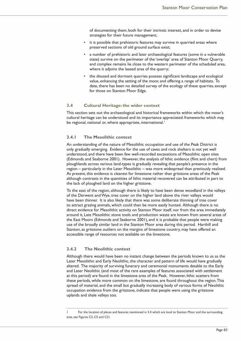
Page 83
Stanton Moor Conservation Plan
of documenting them, both for their intrinsic interest, and in order to devise strategies for their future management;
• it is possible that prehistoric features may survive in quarried areas where preserved sections of old ground surface exist;
• a number of prehistoric and later archaeological features (some in a vulnerable state) survive on the perimeter of the ‘overlap’ area of Stanton Moor Quarry, and complex remains lie close to the western perimeter of the scheduled area, where it adjoins the leased area of the quarry;
• the disused and dormant quarries possess signifi cant landscape and ecological value, enhancing the setting of the moor, and offering a range of habitats. To date, there has been no detailed survey of the ecology of these quarries, except for those on Stanton Moor Edge.
3.4 Cultural Heritage: the wider context
This section sets out the archaeological and historical frameworks within which the moor’s cultural heritage can be understood and its importance appreciated: frameworks which may be regional, national or, where appropriate, international.1
3.4.1 The Mesolithic context
An understanding of the nature of Mesolithic occupation and use of the Peak District is only gradually emerging. Evidence for the use of caves and rock shelters is not yet well understood, and there have been few well-recorded excavations of Mesolithic open sites (Edmonds and Seaborne 2001). However, the analysis of lithic evidence (fl int and chert) from ploughlands across various land-types is gradually revealing that people’s presence in the region – particularly in the Later Mesolithic – was more widespread than previously realised. At present, this evidence is clearest for limestone rather than gritstone areas of the Peak although contrasts in the quantities of lithic material recovered can be attributed in part to the lack of ploughed land on the higher gritstone.
To the east of the region, although there is likely to have been dense woodland in the valleys of the Derwent and Wye, tree cover on the higher land above the river valleys would have been thinner. It is also likely that there was some deliberate thinning of tree cover to attract grazing animals, which could then be more easily hunted. Although there is no direct evidence for Mesolithic activity on Stanton Moor itself, nor from the area immediately around it, Late Mesolithic stone tools and production waste are known from several areas of the East Moors (Edmonds and Seaborne 2001), and it is probable that people were making use of the broadly similar land in the Stanton Moor area during this period. Harthill and Stanton, as gritstone outliers on the margins of limestone country, may have offered an accessible range of resources not available on the limestone.
3.4.2 The Neolithic context
Although there would have been no instant change between the periods known to us as the Later Mesolithic and Early Neolithic, the character and pattern of life would have gradually altered. The majority of surviving funerary and ceremonial monuments datable to the Early and Later Neolithic (and most of the rare examples of features associated with settlement at this period) are found in the limestone area of the Peak. However, lithic scatters from these periods, while more common on the limestone, are found throughout the region. This spread of material, and the small but gradually increasing body of various forms of Neolithic occupation evidence from the gritstone, indicate that people were using the gritstone uplands and shale valleys too.
1 For the location of places and features mentioned in 3.4 which are local to Stanton Moor and the surrounding
area, see Figures C2, C5 and C21.
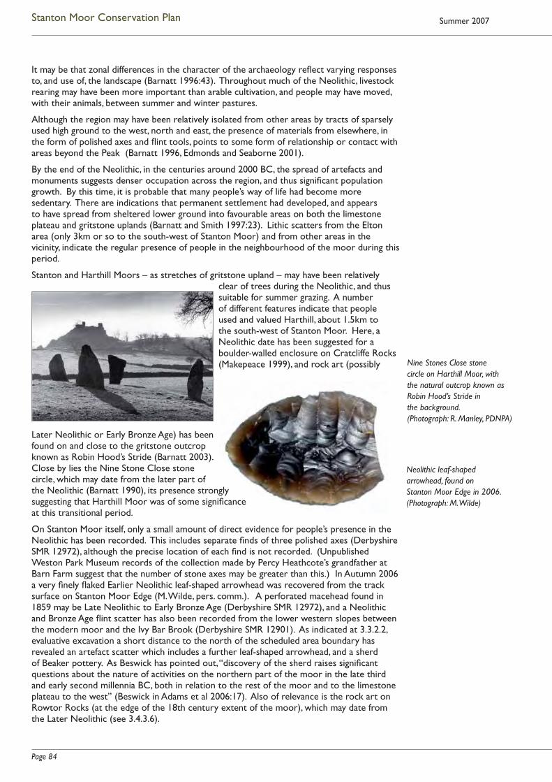
Page 84
Stanton Moor Conservation Plan Summer 2007
It may be that zonal differences in the character of the archaeology refl ect varying responses to, and use of, the landscape (Barnatt 1996:43). Throughout much of the Neolithic, livestock rearing may have been more important than arable cultivation, and people may have moved, with their animals, between summer and winter pastures.
Although the region may have been relatively isolated from other areas by tracts of sparsely used high ground to the west, north and east, the presence of materials from elsewhere, in the form of polished axes and fl int tools, points to some form of relationship or contact with areas beyond the Peak (Barnatt 1996, Edmonds and Seaborne 2001).
By the end of the Neolithic, in the centuries around 2000 BC, the spread of artefacts and monuments suggests denser occupation across the region, and thus signifi cant population growth. By this time, it is probable that many people’s way of life had become more sedentary. There are indications that permanent settlement had developed, and appears to have spread from sheltered lower ground into favourable areas on both the limestone plateau and gritstone uplands (Barnatt and Smith 1997:23). Lithic scatters from the Elton area (only 3km or so to the south-west of Stanton Moor) and from other areas in the vicinity, indicate the regular presence of people in the neighbourhood of the moor during this period.
Stanton and Harthill Moors – as stretches of gritstone upland – may have been relatively clear of trees during the Neolithic, and thus suitable for summer grazing. A number of different features indicate that people used and valued Harthill, about 1.5km to the south-west of Stanton Moor. Here, a Neolithic date has been suggested for a boulder-walled enclosure on Cratcliffe Rocks (Makepeace 1999), and rock art (possibly
Later Neolithic or Early Bronze Age) has been found on and close to the gritstone outcrop known as Robin Hood’s Stride (Barnatt 2003). Close by lies the Nine Stone Close stone circle, which may date from the later part of the Neolithic (Barnatt 1990), its presence strongly suggesting that Harthill Moor was of some signifi cance at this transitional period.
On Stanton Moor itself, only a small amount of direct evidence for people’s presence in the Neolithic has been recorded. This includes separate fi nds of three polished axes (Derbyshire SMR 12972), although the precise location of each fi nd is not recorded. (Unpublished Weston Park Museum records of the collection made by Percy Heathcote’s grandfather at Barn Farm suggest that the number of stone axes may be greater than this.) In Autumn 2006 a very fi nely fl aked Earlier Neolithic leaf-shaped arrowhead was recovered from the track surface on Stanton Moor Edge (M. Wilde, pers. comm.). A perforated macehead found in 1859 may be Late Neolithic to Early Bronze Age (Derbyshire SMR 12972), and a Neolithic and Bronze Age fl int scatter has also been recorded from the lower western slopes between the modern moor and the Ivy Bar Brook (Derbyshire SMR 12901). As indicated at 3.3.2.2, evaluative excavation a short distance to the north of the scheduled area boundary has revealed an artefact scatter which includes a further leaf-shaped arrowhead, and a sherd of Beaker pottery. As Beswick has pointed out, “discovery of the sherd raises signifi cant questions about the nature of activities on the northern part of the moor in the late third and early second millennia BC, both in relation to the rest of the moor and to the limestone plateau to the west” (Beswick in Adams et al 2006:17). Also of relevance is the rock art on Rowtor Rocks (at the edge of the 18th century extent of the moor), which may date from the Later Neolithic (see 3.4.3.6).
Nine Stones Close stone circle on Harthill Moor, with the natural outcrop known as Robin Hood’s Stride in the background. (Photograph: R. Manley, PDNPA)
Neolithic leaf-shaped arrowhead, found on Stanton Moor Edge in 2006. (Photograph: M. Wilde)

Page 85
Stanton Moor Conservation Plan
The Collared Urns and other vessels found in Stanton Moor’s many cairns and monuments (see 3.4.3.5) suggest that the moor became an important locus for burial and other ceremonial ritual in the Early Bronze Age. However, the boundary between the Late Neolithic and Early Bronze Age is fl uid, in terms of both chronology and practice, and it is possible that the moor was already seen as culturally signifi cant in the later 3rd millennium BC.
3.4.3 Stanton’s Bronze Age archaeology in context
3.4.3.1 Regional summary
As indicated above, the archaeological record shows extensive occupation of both limestone and gritstone areas of the Peak by the Later Neolithic / Early Bronze Age, although artefact densities appear greatest on the limestone. Large numbers of more or less circular burial barrows or cairns survive, dating to between 2500 and 1500 BC, with the majority, but by no means all, again found on the limestone. At around the same time, some communities in the Peak were building small stone circles and ring cairns: about 40 of these have been identifi ed here, with the vast majority on the gritstone East Moors. Later in the Bronze Age, by about 1500 BC, these traditions died out, and circles, ring cairns and barrows were no longer being built in the region.
It is likely that very few members of a community were given barrow burials, but it is not known why certain people were singled out for this special treatment. Excavation in the region shows that, before such mounds were built, at least some of their sites may have been open ritual areas, defi ned by kerbs or fences, and in many cases, mounds were not raised until several burials had been deposited (Barnatt and Smith 2004). Objects were sometimes placed with the burials, but, rather than displays of wealth, these items may have represented something about the individual in life, and “passed on the correct message from the living to the spirit world” (Barnatt and Smith 2004:36). Like many of the burial mounds, the small circles and ring cairns refl ect the importance to their builders of circular architecture: it has been speculated that societies used these circles to symbolise their community identity, and some may also have had a calendrical function, with stones aligned to mark lunar and solar events. Excavation shows that many provided a focus for burials and rituals accompanying interment of the dead. Their scale, and their apparent links with small-scale farming communities (see below) suggest that they may have been ‘local’ rather than regional monuments – although some may still have had links with seasonal cycles of movement (Edmonds and Seaborne 2001).
In addition to the small circular monuments, extensive remains of agricultural clearance and settlement from the 2nd millennium BC survive on the gritstone – particularly on the East Moors. Following intensive survey and analysis, it has been argued that the ceremonial and settlement remains here are likely to be broadly contemporary, with each small farming community (perhaps an extended family or kin group) having their own ‘family monument’ (Barnatt 2000).
The absence from the limestone of Bronze Age clearance and settlement remains, and of small circles and ring cairns, may well be due to the intensity of later agricultural activity here (Barnatt 2000). However, it is also possible that these contrasts between the archaeology of the White and the Dark Peak refl ect important differences of identity and tradition within the region (Edmonds and Seaborne 2001:169).
Within this context, Stanton Moor’s Early Bronze Age archaeology stands out, in terms of its range, diversity and possibly anomalous nature. This section summarises the way in which each of its complex components fi ts within not only regional but national, and sometimes international, contexts. However, a large part of the moor’s archaeological and landscape value derives from the interplay between the range of features which survive here, and from their survival as a group. Thus section 3.4.3.9 puts the pieces of the jigsaw back together, and emphasises Stanton Moor’s status as a complex and unusual archaeological landscape.

Page 86
Stanton Moor Conservation Plan Summer 2007
3.4.3.2 The funerary cairnfi eld
At both regional and national level, the spread of stone mounds across the moor constitutes a rare surviving example of a prehistoric cairnfi eld whose purpose was primarily funerary (see 2.4.2 and Figures C5 and C6).
Within the region, Stanton Moor is distinctly unusual, when compared with the vast majority of known prehistoric cairnfi elds here. It is atypical both in nature (as a cairnfi eld whose function appears to have been largely funerary, rather than related to agricultural clearance) and in size, being far larger than the handful of possible examples of such cairnfi elds known in the Peak.
Although there are substantial remains of cairnfi elds on the East Moors of the Peak (see 3.4.3.7 below) they are thought to be primarily the result of clearance for agriculture (although a small proportion of cairns at many sites may contain cremation burials, or other structured deposits and some isolated small cairns may also be funerary).
In contrast, excavation and survey evidence from Stanton Moor suggests that, despite the presence of a number of cairns which appear to derive from agricultural clearance, the majority of those in the southern and eastern areas of the cairnfi eld are funerary (2.4.2.3). There are other distinguishing features: a high proportion of the mounds display deliberate architectural characteristics such as rectangular form or kerbing, and in some cases cairns have been constructed to abut each other, forming complex monuments. There are also far fewer cairns per hectare than is usual in the predominantly agricultural cairnfi elds on the East Moors (Barnatt 1986).
At a national level, no clearly comparable example of a large primarily funerary cairnfi eld has yet been recognised.
3.4.3.3 Embanked stone circles and ring cairn(s)
Embanked stone circles:
As described at 3.4.3.1, small stone circles (including the embanked examples which are typical of the Peak) and the ring cairns which are often associated with them, may have been built by local communities as places of ritual and seasonal celebration (Barnatt and Smith 1997).
Many are known to have been destroyed in the historic period, but, of the 19 or so examples which survive in the region, a rather high proportion are associated with Stanton Moor. Here, three embanked circles were placed close to each other, forming elements within the distinctly linear arrangement of major monuments which crosses the east-sloping fl ank of the moor (2.4.2.2 and Figure C6). A fourth circle, Doll Tor, was built on the moor’s west-facing slope, within land which is now enclosed. (Whether this multi-phased site is best
Cairns T20 and T21, as planned during Heathcote excavations in the early 1930s. (Reproduced by courtesy of the Derbyshire Archaeological Society, from DAJ vol. 60, 1939)
The restored stone circle at Doll Tor, 1994. (Photograph: PDNPA)

Page 87
Stanton Moor Conservation Plan
characterised as an embanked stone circle, or as a kerb cairn, is a matter of debate [RCHME 1986, Barnatt 1997], as is the case with a number of similar monuments.)
Recent survey and evaluative excavation (2.5.1.6) have shown that the Nine Ladies embanked circle shares many characteristics with similar monuments in Britain, but is one of the few which, from antiquarian descriptions, can be shown to have survived relatively intact. Its construction – based on large-scale earth removal rather then deposition – appears unusual in a national context. Overall, it is a rare national example of an embanked stone circle surviving within a local landscape which incorporates such a range and quantity of Bronze Age features (Garton 2002).
Outside the Peak District, embanked stone circles are relatively uncommon (Barnatt 1990). In upland areas of northern, western and south-western England, perhaps 100 or so small stone circles (of which embanked circles are one type) are known to survive, with further possible examples in Scotland, Ireland and Wales (English Heritage 19901).
Ring cairns:
In the Peak District, there is a notable affi nity between embanked stone circles and ring cairns, which are quite commonly found close together (Barnatt 1990). Across Britain, they are often located in pairs, or small groups of up to four sites. Occasionally, as at Stanton Moor, they lie within barrow cemeteries (English Heritage 1990).
Precise numbers of surviving ring cairns are diffi cult to gauge, because of the diffi culty of distinguishing them from other forms of small circular monument. Fewer than 20 such structures are now recorded in the region (Barnatt 1990), although (as with small stone circles) others will have been destroyed by a range of land uses in the historic period. On Stanton Moor, there may be only one ring cairn – monument T56 – built as part of the line of major monuments across the centre of the moor (although it has also been argued that T56 is in fact a damaged embanked stone circle). A further ring cairn has been tentatively identifi ed on the moor’s north-eastern edge, although here again, the possibility that this is a stone circle has not been ruled out (RCHME 1986).
Across Britain, ring cairns are a relatively common form of monument, particularly in northern England, and equally so in Wales and most of southern Scotland. (Again, their known distribution is partly a refl ection of survival and survey.)
Linear grouping of small ceremonial features:
The close grouping of a relatively high number of small ceremonial monuments on Stanton Moor, and the striking linear pattern in which several of them are arranged, are unique within the context of surviving sites on the Peak gritstone, where (as noted above) particular circles and ring cairns seem to be closely physically associated with the fi elds and grazing land of individual farming communities. One possible explanation for the presence of a cluster of monuments here (although not for their linear arrangement) is that several such communities in the area surrounding the moor may have agreed to ‘share’ this upland island as a place to site their monuments, perhaps for practical reasons to do with the constraints on farming and settlement imposed by local topography (Barnatt 2000). However, other explanations are possible.
It is diffi cult to compare monument patterns on Stanton Moor with examples elsewhere in Britain. It is probable that regional differences in the way that ceremonial features were used mean that attempts to draw conclusions from superfi cial similarities in patterning are rather meaningless (J. Barnatt, pers. comm.).
1 Here, and elsewhere in Section 3.4.3, national fi gures for particular types of monument are derived from
Monument Class Descriptions prepared as part of English Heritage’s Monuments Protection Programme.
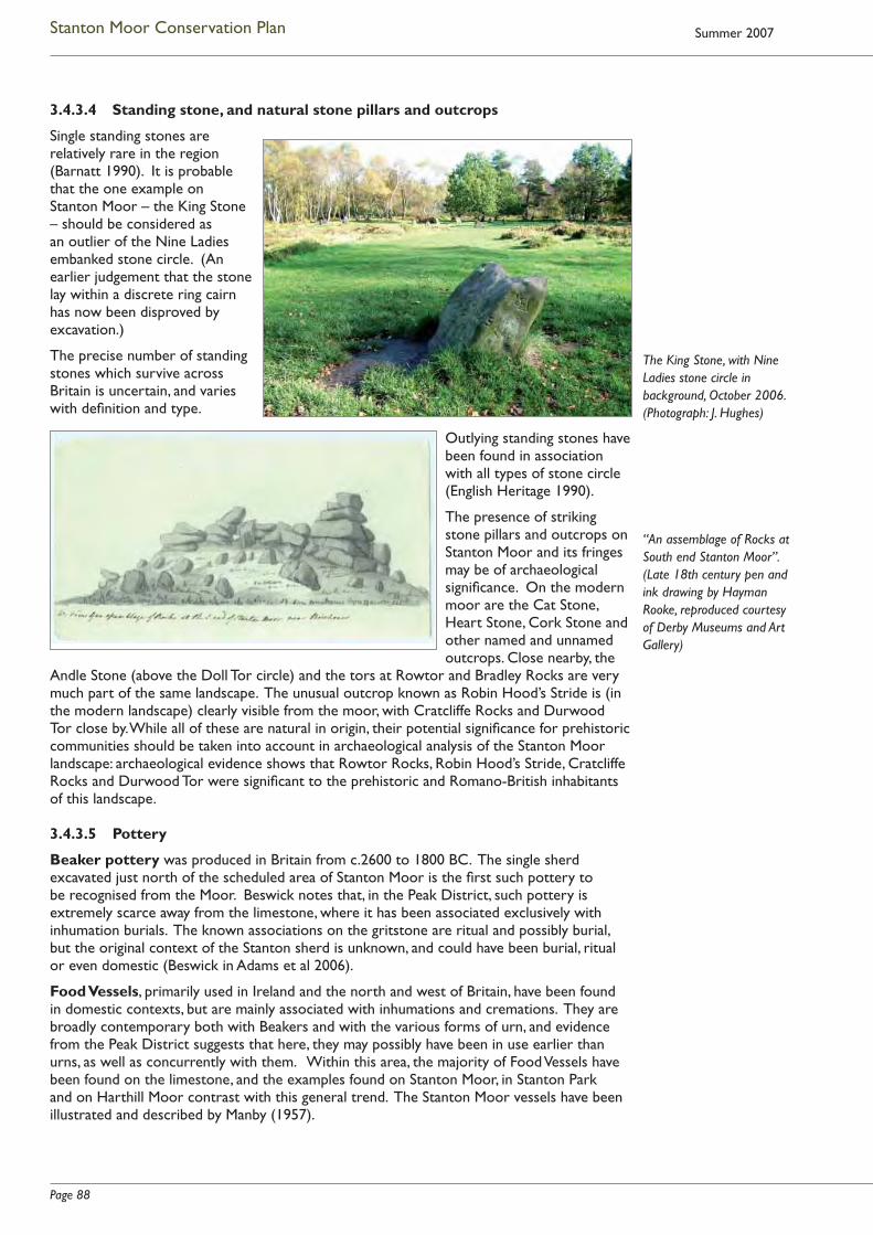
Page 88
Stanton Moor Conservation Plan Summer 2007
3.4.3.4 Standing stone, and natural stone pillars and outcrops
Single standing stones are relatively rare in the region (Barnatt 1990). It is probable that the one example on Stanton Moor – the King Stone – should be considered as an outlier of the Nine Ladies embanked stone circle. (An earlier judgement that the stone lay within a discrete ring cairn has now been disproved by excavation.)
The precise number of standing stones which survive across Britain is uncertain, and varies with defi nition and type.
Outlying standing stones have been found in association with all types of stone circle (English Heritage 1990).
The presence of striking stone pillars and outcrops on Stanton Moor and its fringes may be of archaeological signifi cance. On the modern moor are the Cat Stone, Heart Stone, Cork Stone and other named and unnamed outcrops. Close nearby, the
Andle Stone (above the Doll Tor circle) and the tors at Rowtor and Bradley Rocks are very much part of the same landscape. The unusual outcrop known as Robin Hood’s Stride is (in the modern landscape) clearly visible from the moor, with Cratcliffe Rocks and Durwood Tor close by. While all of these are natural in origin, their potential signifi cance for prehistoric communities should be taken into account in archaeological analysis of the Stanton Moor landscape: archaeological evidence shows that Rowtor Rocks, Robin Hood’s Stride, Cratcliffe Rocks and Durwood Tor were signifi cant to the prehistoric and Romano-British inhabitants of this landscape.
3.4.3.5 Pottery
Beaker pottery was produced in Britain from c.2600 to 1800 BC. The single sherd excavated just north of the scheduled area of Stanton Moor is the fi rst such pottery to be recognised from the Moor. Beswick notes that, in the Peak District, such pottery is extremely scarce away from the limestone, where it has been associated exclusively with inhumation burials. The known associations on the gritstone are ritual and possibly burial, but the original context of the Stanton sherd is unknown, and could have been burial, ritual or even domestic (Beswick in Adams et al 2006).
Food Vessels, primarily used in Ireland and the north and west of Britain, have been found in domestic contexts, but are mainly associated with inhumations and cremations. They are broadly contemporary both with Beakers and with the various forms of urn, and evidence from the Peak District suggests that here, they may possibly have been in use earlier than urns, as well as concurrently with them. Within this area, the majority of Food Vessels have been found on the limestone, and the examples found on Stanton Moor, in Stanton Park and on Harthill Moor contrast with this general trend. The Stanton Moor vessels have been illustrated and described by Manby (1957).
The King Stone, with Nine Ladies stone circle in background, October 2006. (Photograph: J. Hughes)
“An assemblage of Rocks at South end Stanton Moor”. (Late 18th century pen and ink drawing by Hayman Rooke, reproduced courtesy of Derby Museums and Art Gallery)
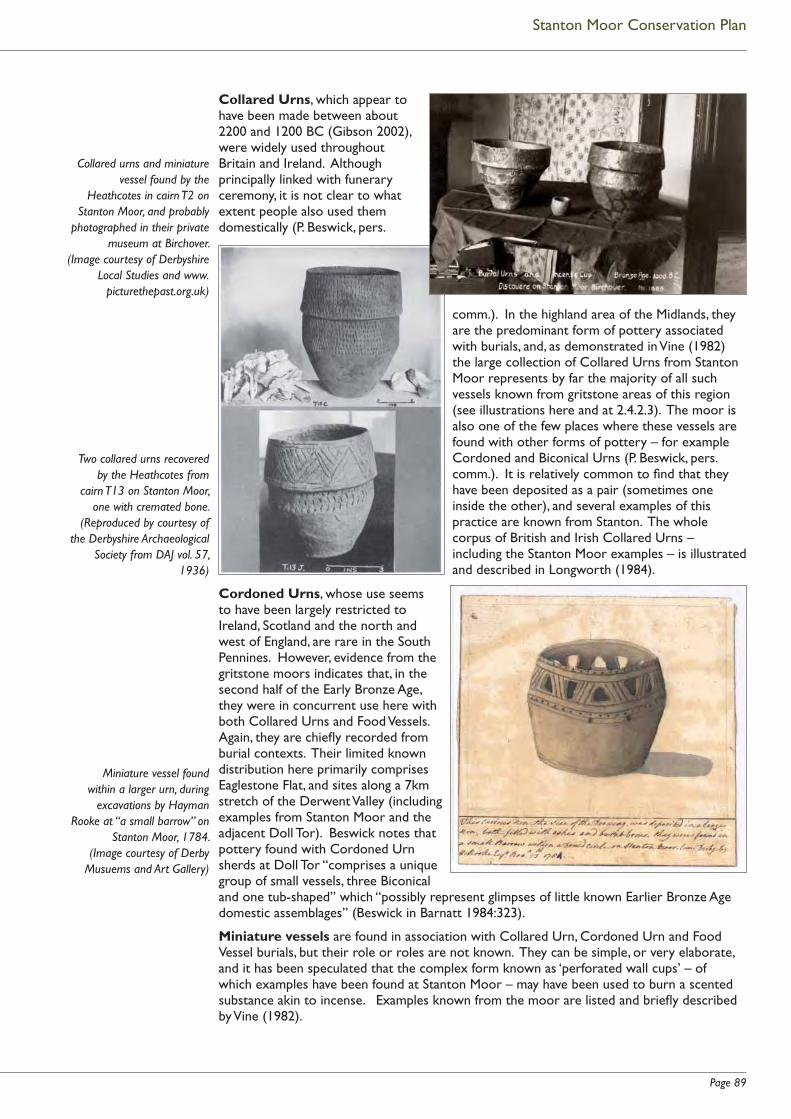
Page 89
Stanton Moor Conservation Plan
Collared Urns, which appear to have been made between about 2200 and 1200 BC (Gibson 2002), were widely used throughout Britain and Ireland. Although principally linked with funerary ceremony, it is not clear to what extent people also used them domestically (P. Beswick, pers.
comm.). In the highland area of the Midlands, they are the predominant form of pottery associated with burials, and, as demonstrated in Vine (1982) the large collection of Collared Urns from Stanton Moor represents by far the majority of all such vessels known from gritstone areas of this region (see illustrations here and at 2.4.2.3). The moor is also one of the few places where these vessels are found with other forms of pottery – for example Cordoned and Biconical Urns (P. Beswick, pers.comm.). It is relatively common to fi nd that they have been deposited as a pair (sometimes one inside the other), and several examples of this practice are known from Stanton. The whole corpus of British and Irish Collared Urns – including the Stanton Moor examples – is illustrated and described in Longworth (1984).
Cordoned Urns, whose use seems to have been largely restricted to Ireland, Scotland and the north and west of England, are rare in the South Pennines. However, evidence from the gritstone moors indicates that, in the second half of the Early Bronze Age, they were in concurrent use here with both Collared Urns and Food Vessels. Again, they are chiefl y recorded from burial contexts. Their limited known distribution here primarily comprises Eaglestone Flat, and sites along a 7km stretch of the Derwent Valley (including examples from Stanton Moor and the adjacent Doll Tor). Beswick notes that pottery found with Cordoned Urn sherds at Doll Tor “comprises a unique group of small vessels, three Biconical and one tub-shaped” which “possibly represent glimpses of little known Earlier Bronze Age domestic assemblages” (Beswick in Barnatt 1984:323).
Miniature vessels are found in association with Collared Urn, Cordoned Urn and Food Vessel burials, but their role or roles are not known. They can be simple, or very elaborate, and it has been speculated that the complex form known as ‘perforated wall cups’ – of which examples have been found at Stanton Moor – may have been used to burn a scented substance akin to incense. Examples known from the moor are listed and briefl y described by Vine (1982).
Collared urns and miniature vessel found by the
Heathcotes in cairn T2 on Stanton Moor, and probably
photographed in their private museum at Birchover.
(Image courtesy of Derbyshire Local Studies and www.
picturethepast.org.uk)
Two collared urns recovered by the Heathcotes from
cairn T13 on Stanton Moor, one with cremated bone.
(Reproduced by courtesy of the Derbyshire Archaeological
Society from DAJ vol. 57, 1936)
Miniature vessel found within a larger urn, during
excavations by Hayman Rooke at “a small barrow” on
Stanton Moor, 1784. (Image courtesy of Derby
Musuems and Art Gallery)
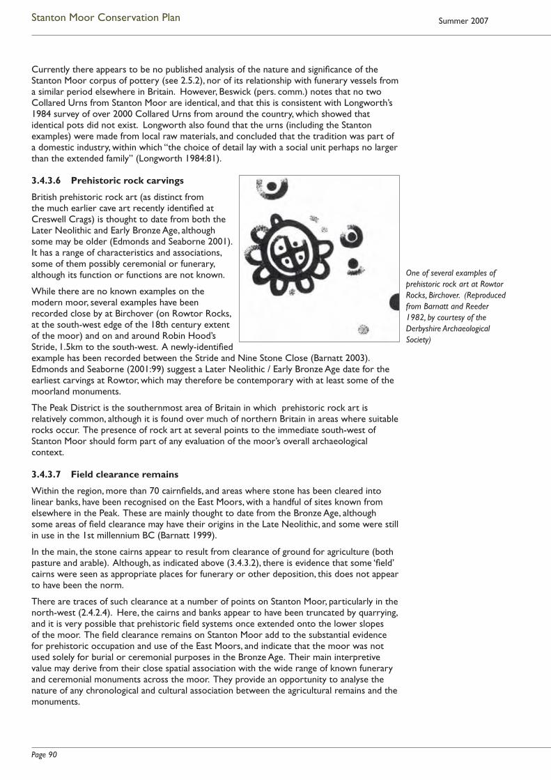
Page 90
Stanton Moor Conservation Plan Summer 2007
Currently there appears to be no published analysis of the nature and signifi cance of the Stanton Moor corpus of pottery (see 2.5.2), nor of its relationship with funerary vessels from a similar period elsewhere in Britain. However, Beswick (pers. comm.) notes that no two Collared Urns from Stanton Moor are identical, and that this is consistent with Longworth’s 1984 survey of over 2000 Collared Urns from around the country, which showed that identical pots did not exist. Longworth also found that the urns (including the Stanton examples) were made from local raw materials, and concluded that the tradition was part of a domestic industry, within which “the choice of detail lay with a social unit perhaps no larger than the extended family” (Longworth 1984:81).
3.4.3.6 Prehistoric rock carvings
British prehistoric rock art (as distinct from the much earlier cave art recently identifi ed at Creswell Crags) is thought to date from both the Later Neolithic and Early Bronze Age, although some may be older (Edmonds and Seaborne 2001). It has a range of characteristics and associations, some of them possibly ceremonial or funerary, although its function or functions are not known.
While there are no known examples on the modern moor, several examples have been recorded close by at Birchover (on Rowtor Rocks, at the south-west edge of the 18th century extent of the moor) and on and around Robin Hood’s Stride, 1.5km to the south-west. A newly-identifi ed example has been recorded between the Stride and Nine Stone Close (Barnatt 2003). Edmonds and Seaborne (2001:99) suggest a Later Neolithic / Early Bronze Age date for the earliest carvings at Rowtor, which may therefore be contemporary with at least some of the moorland monuments.
The Peak District is the southernmost area of Britain in which prehistoric rock art is relatively common, although it is found over much of northern Britain in areas where suitable rocks occur. The presence of rock art at several points to the immediate south-west of Stanton Moor should form part of any evaluation of the moor’s overall archaeological context.
3.4.3.7 Field clearance remains
Within the region, more than 70 cairnfi elds, and areas where stone has been cleared into linear banks, have been recognised on the East Moors, with a handful of sites known from elsewhere in the Peak. These are mainly thought to date from the Bronze Age, although some areas of fi eld clearance may have their origins in the Late Neolithic, and some were still in use in the 1st millennium BC (Barnatt 1999).
In the main, the stone cairns appear to result from clearance of ground for agriculture (both pasture and arable). Although, as indicated above (3.4.3.2), there is evidence that some ‘fi eld’ cairns were seen as appropriate places for funerary or other deposition, this does not appear to have been the norm.
There are traces of such clearance at a number of points on Stanton Moor, particularly in the north-west (2.4.2.4). Here, the cairns and banks appear to have been truncated by quarrying, and it is very possible that prehistoric fi eld systems once extended onto the lower slopes of the moor. The fi eld clearance remains on Stanton Moor add to the substantial evidence for prehistoric occupation and use of the East Moors, and indicate that the moor was not used solely for burial or ceremonial purposes in the Bronze Age. Their main interpretive value may derive from their close spatial association with the wide range of known funerary and ceremonial monuments across the moor. They provide an opportunity to analyse the nature of any chronological and cultural association between the agricultural remains and the monuments.
One of several examples of prehistoric rock art at Rowtor Rocks, Birchover. (Reproduced from Barnatt and Reeder 1982, by courtesy of the Derbyshire Archaeological Society)

Page 91
Stanton Moor Conservation Plan
At a national level, the incomplete state of survey does not yet allow a good overall picture of the number and extent of surviving prehistoric cairnfi elds and areas of linear clearance, although well over 250 cairnfi eld groups have been recognised in England (English Heritage 1990).
Within this national context, the East Moors of the Peak District stand out as an area with some of the largest and best-preserved fi eld systems in the north of England, which have also been the subject of intensive survey and recording (English Heritage 1995).
3.4.3.8 Unenclosed settlement associated with fi eld systems
In the 1980s, small yards and sections of curved fi eld bank were recognised within the East Moors fi eld systems, and interpreted as indicators of settlement. Detailed survey of Stanton Moor in 1986/7 identifi ed three platforms, surviving close to or within the newly-recognised fi eld systems on the moor (2.4.2.4) – platforms which could be interpreted as bases for circular timber houses (RCHME 1986). (The presence of a saddle quern, found in mound material during the excavation of T8 – one of a cluster of mounds at the southern end of the moor – may reinforce the argument for prehistoric settlement here [SCM 1979:1098].) The discovery of building platforms provided the impetus for the subsequent identifi cation of broadly similar settlement remains elsewhere across the East Moors, and it is now accepted that circular terraced platforms are associated with the majority of fi eld layouts in the region (Ainsworth 2001).
At national level, the existence of unenclosed Bronze Age settlements in association with fi eld systems is well attested in a number of upland zones, and particularly the Cheviots, Bodmin Moor and the Scottish Borders. The Peak District examples appear to relate most closely to those in the Cheviots, both morphologically, and in relation to their context within the fi eld systems (Ainsworth 2001).
To the immediate south-west of Stanton Moor, an undated earthwork enclosure on Harthill Moor has been tentatively dated to the Late Bronze Age or Early Iron Age (Bevan 1995), and may be evidence for different settlement practice at a later period, in the vicinity of the moor.
3.4.3.9 A complex and unusual Bronze Age landscape
A number of interlinked factors contribute to the unusual nature of Stanton Moor’s Bronze Age archaeology, and to its value as a composite landscape. Firstly, there is the survival here of a relatively high number and wide range of Early Bronze Age ceremonial and burial monuments, mingled (in some areas of the moor) with relict elements of fi eld systems and possible dwellings, which may also be Bronze Age, but may not be contemporary.
Secondly, the way in which the ceremonial and funerary monuments are ranged across the landscape is itself highly unusual. A concentration of small ritual monuments (small circles and probable ring cairns) survive here, some arranged in an apparently deliberate pattern recognised nowhere else in the region, and with no meaningful national parallels. The burial cairns are equally unusual, comprising by far the largest funerary cairnfi eld known in the Peak, and possibly in Britain.
It is not only the monuments themselves which are distinctive. The funerary urns excavated from them are both fascinating survivors in themselves, and provide a rare opportunity to study a large sample of vessels derived from a small and unifi ed area of landscape. Although much contextual information is missing, these pots retain information about the people who built the monuments, and about those who were buried in them. They may be able to tell us about local differences in the structuring of funerary ritual, and the related but individually distinct ways in which many different (perhaps neighbouring) communities or family groups chose to honour their dead.
Finally, the distinctive topographical setting of this small stretch of upland, and its unusual natural rock formations, form a striking setting for the Bronze Age archaeology which survives here. It is possible to speculate that this setting may have infl uenced the use which prehistoric communities made of the natural landscape.

Page 92
Stanton Moor Conservation Plan Summer 2007
3.4.4 Iron Age context
It used to be thought that climatic deterioration around 1000 BC resulted in the collapse and retreat of prehistoric societies in upland areas such as the Pennines (e.g. Hodges 1991). More recently, this perception has been challenged (e.g. Bevan 2000a), and work in the Peak District has demonstrated other possibilities. Analysis of environmental material from two East Moors sites, at similar altitudes to Stanton Moor, has shown that settlements here had Iron Age as well as Bronze Age histories. At Stoke Flat, above Froggatt, there are indications of agricultural activity, and the persistence of open (possibly managed) woodland throughout the 1st millennium BC, and similarly long-lived exploitation is thought to be probable at other fi eld systems in relatively favourable areas of the East Moors (Long et al 1998). Excavation at nearby Gardom’s Edge has revealed fi eld systems whose variability in form appears to represent a complex and lengthy history during both the Bronze and Iron Ages (Bevan 2000a:148). Artefactual evidence and radiocarbon dates from excavated structures indicate that this area was in use in the Late Bronze Age, and Early and Late Iron Age (Barnatt et al 2000; Bevan, pers. comm.). However, as discussed below (3.4.5.1), by the end of the Iron Age / Early Roman period, environmental degradation may have led to local abandonment of these moors – at least for settlement and arable agriculture (Bevan 2000b:10).
On Stanton Moor itself, as noted above (3.4.3.7, 3.4.3.8), there are traces of agricultural clearance and occupation which probably date to the Bronze Age, and it thus seems likely that the lower and more favourable slopes which surround the moor would also have been cultivated and occupied at this time, but that evidence for this has not survived later use. If this was the case, it is also possible that such use may have continued well into the 1st millennium BC, as demonstrated at Stoke Flat and Gardom’s Edge.
In addition, there is possible evidence for use of the area very close to the moor in the Iron Age. About 1.5km to the south-west, an undated earthwork enclosure close to Robin Hood’s Stride has been tentatively attributed to the Later Bronze Age or Early Iron Age, and may be an example of enclosed settlement at this period (Bevan 1995). Close by, the large circular enclosure known as Castle Rings, to the north of Harthill Moor, has also been attributed to the Iron Age, although this has not been demonstrated by excavation (Figure C21).
3.4.5 Romano-British context
3.4.5.1 Distribution of Roman period settlement in the Peak
The majority of Roman period sites in the Peak District survive on land which was marginal to historic cultivation, suggesting that such settlement was once much more extensive, but that archaeological evidence for this on lower, agriculturally more favourable ground has since been destroyed. Recent study indicates an apparent preference for the limestone, with just over 80% of surviving sites located in the White Peak, and the remainder on gritstone (Bevan 2000b).
The greater majority (89 %) of defi nite or probable Romano-British sites in the region lie between 201 and 350m AOD, indicating that this may be the upper limit at which cultivation was sustainable at this period (Bevan 2000b:10). However, on the East Moors, where both the altitude range and the history of earlier (Bronze and Iron Age) settlement and agricultural use would suggest that Romano-British remains might also be found, only one (uncertain) site has been identifi ed. Bevan suggests that this may be because the earlier agricultural use had led to environmental degradation, and, perhaps, local abandonment of these moors – as an area for settlement and cultivation – during the Later Iron Age or early Roman period.
3.4.5.2 Roman period settlement in the vicinity of Stanton Moor
About 1.5km south-west of the moor, a notable cluster of small Romano-British sites survives on the neighbouring gritstone outlier, Harthill Moor (Figure C21). This lies at about 235m AOD, with discrete areas of higher land, and is thus somewhat lower than Stanton. Today, it comprises enclosed pasture and woodland, with some substantial gritstone outcrops to its south. Antiquarian work in the 18th and 19th centuries revealed extensive evidence for Romano-British settlement and agricultural use of this moor, alongside the remains of earlier

Page 93
Stanton Moor Conservation Plan
periods (Bateman 1848:126-128). In the mid-20th century, the Heathcotes of Birchover excavated here, although they left few, if any, written records (P.Beswick, pers.comm.). Other small-scale excavations took place in the 1980s (Makepeace 1998). Today, the composite record for surviving Romano-British archaeology on the moor includes revetted platforms and rock shelters / caves on the southern and south-eastern slopes of Robin Hood’s Stride, where occupation may date from the Late Iron Age through to the Roman period. A 2nd to 4th century date has been suggested for a further settlement and fi eld system at Watscliff just to its south-west (Makepeace 1998). Traces of possible settlement and agriculture survive at Thieves’ Den (in woodland east of Nine Stone Close) and – more defi nitely – at Carr’s Wood, on wooded slopes west of the Ivy Bar Brook, and thus immediately adjacent to the now-enclosed lower slopes below Stanton Moor (Bevan 2000b). It is possible that, east of the Ivy Bar Brook, these lower west-facing slopes of Stanton Moor (with their more favourable aspect) were also in use at this period, but that later agricultural exploitation has destroyed the evidence for this.
3.4.5.3 Evidence from Stanton Moor in context
On Stanton Moor itself, the unenclosed moorland, while higher than Harthill, is (at 280 – 323m) within the altitude range which Bevan has identifi ed as the locus for the vast majority of surviving Romano-British sites in the Peak. However, although the vestiges of what is thought to be Bronze Age agricultural use and (possibly) settlement survive in certain areas of the moor (see above), no similar remains have been identifi ed from the early centuries AD – in strong contrast therefore to neighbouring Harthill.
There are various possible explanations for this lack. Bevan’s work indicates avoidance of the main block of the East Moors during this period, and a general preference for the limestone. It may be that Stanton Moor refl ects these trends more closely than its lower neighbour to the south-west, which is also more closely surrounded by limestone territory. Alternatively (or, perhaps, additionally) the absence of agriculture and settlement might indicate deliberate avoidance of a site occupied by so many funerary cairns.
There is, however, apparent evidence for the small-scale production of rotary querns on the moor (see 2.4.4), which may be Romano-British (or possibly medieval). In addition to the part-fi nished items and possible delves identifi ed in the 20th century, “a pair of gritstone querns, 16 ¾ inches in diameter and 2 ¾ inches thick” were dug up on the moor during trenching in 1848 (Howarth 1899:27). It is possible that the presence of some of the putative quern roughouts on or near cairns T44 and T45 (RCHME 1986) indicates that some funerary monuments may have been used as a source of stone, and were thus not consistently seen as features to be avoided or respected.
The evidence suggests that a community or communities nearby – possibly from Harthill Moor, or from the wider limestone area, where gritstone was not available to hand – may have made use of Stanton Moor as a source for querns. (Large numbers of querns and quern fragments have indeed been found in association with the settlement and agricultural evidence on Harthill, although the stone source for these may, of course, have been Harthill Moor itself.) It is also possible that these communities exploited Stanton Moor in other ways – as pasture, for instance – but that these have left no surviving archaeological trace.
3.4.6 Medieval context
3.4.6.1 Introduction: the wider framework
Very little is known of the immediate post-Roman history of the Peak District, and no documentary or datable archaeological evidence is known to survive which might indicate how the Stanton area was occupied or used in the post-Roman and very early medieval period.
The presence of many Anglian barrows (and burials inserted into prehistoric barrows) suggests that Anglian settlement in the Peak was well-established by the second half of the 7th century, apparently centred on the limestone area (Barnatt and Collis 1996). In addition, place name evidence and short stretches of linear earthwork such as the post-Roman ‘Grey
Page 94
Stanton Moor Conservation Plan Summer 2007
Ditch’ at Bradwell, at the northern limit of the limestone, may suggest a division between Anglian communities on the limestone and British territories on the shale and gritstone to the north (Barnatt and Smith 1997). Closer to Stanton Moor, it has also been suggested that a stretch of linear earthwork on Peak Tor, close to Rowsley, may date from a similar period (Hart 1981), although other origins have been suggested, and its function and date remain unknown.
A surviving tribute list, ascribed to various dates between the later 7th century and the early 9th century, indicates the existence of a group or tribe known as the Pecsaetna (the dwellers in the Peak), whose territory may have been focused on the limestone plateau, and the valleys around Bakewell, Matlock, Wirksworth and Ashbourne (Stafford 1985, Barnatt and Smith 1997). If this was the case, the uplands around Stanton may have been within the eastern margin of Pecsaetna land. By the end of the 8th century, their territory had been absorbed into the kingdom of Mercia, but, lying as it did at the southern boundary of Northumbria, it seems to have been subject to both Mercian and Northumbrian infl uence over a long period.
3.4.6.2 The Stanton neighbourhood in the 9th - 11th centuries
By the later 9th century, when the Danes had established political control over much of the north and east of England, Stanton lay at the western fringes of the Danelaw. (A fragment of a pre-Conquest cross, variously dated to the 9th or 11th century, has been found in the Wye close to Rowsley [Derbyshire SMR 12201], although this does not in itself provide suffi cient evidence for the presence of an early ecclesiastical site to the north of Stanton at this period.)
In the early 10th century, the West Saxon kingdom (following its annexation of Mercia) gradually gained control of the north Derbyshire area from the Danes, establishing a stronghold close to Bakewell, a few kilometres north-west of Stanton, in 920 (Stetka 2001). In 927, their defeat of the Danes of Northumbria led to the establishment of the English kingdom.
(It has been suggested that two land charters from this period relate to Stanton in Peak. One, probably of 900 AD, refers to the sale of property at ‘Stantune’ by Aethelfl eda, wife of the Mercian Governor; the other, from 968AD, provides a record of estate boundaries at ‘Stantune’ [Hart C. 1975, Hart C.R. 1981]. However, the attribution to Stanton in Peak is far from certain in both cases, and Sawyer [1979] argues that the most likely location is Stanton by Newhall in south Derbyshire.)
The early medieval structure of settlement at Stanton in Peak and Birchover may have been infl uenced by the widespread reorganisation of the agrarian system (associated with the development of open-fi eld agriculture) which appears to have taken place in England between 800 and 1200 AD, and which was accompanied in some areas by the creation of nucleated villages. However, a landscape of scattered hamlets and farms endured in some uplands and heavily wooded areas, and it is possible that this was the case in Stanton and its environs. Many small settlements would nevertheless have had their own fi elds, and access to meadow, pasture and waste.
Stanton and Birchover existed as two separate estates prior to the Conquest. By 1086, they both formed part of the extensive barony of Henry de Ferrers. Of the two estates, Stanton, although poor, was rather better resourced. Four villagers and six smallholders are recorded, with land for 3 ploughs, 24 acres of meadow and an expanse of woodland. Birchover, described as ‘waste’ at Domesday, seems to have been an outlying farm, with less arable, meadow and woodland (Morgan 1978, Sinar n.d.). There is evidence that the focus of medieval settlement here may have been at Uppertown, on the rising ground south of the present village (Heathcote 1947, Hart 1981). Both also cite possible evidence for the subsequent existence of a Norman church or chapel here.
Page 95
Stanton Moor Conservation Plan
3.4.6.3 The local medieval infrastructure: settlements and agriculture
Stanton itself must have continued to grow, with new settlements planted at Stanton Lees and Stanton Woodhouse, whose names suggest that they were both created within cleared woodland belonging to Stanton. A charter of the 1200s indicates the existence of a house, land, meadow and woods between Pilhough and Cold Brook in Stanton Lees (Carrington 1893), and a further 13th century document indicates the importance of sheep and pasture in the Stanton Lees and Woodhouse area at this time (Sinar n.d.). From the mid 12th century (or possibly earlier), Stanton was one of several chapelries attached to Youlgreave church, although the location of the chapel building is not known (Cox 1877). By the early 14th century, a mill and its ponds had been built here – similarly at an unknown location (Sinar n.d.), and Birchover also had a mill by the mid 1300s (Heathcote 1947). In sum, Stanton appears to have been “the small central village of a hill manor, not rich enough to support more than a chapel of ease, but with enough arable to warrant building a mill” (Sinar n.d:4).
The archaeological record indicates that traces of medieval settlement and agriculture survive in Stanton parish. At Stanton Woodhouse, aerial photographs taken in the 1970s and 1980s show traces of ridge and furrow, hollow-ways, and probable sites of buildings which very probably relate to the medieval settlement of Stanton Woodhouse (Badcock 1998). They lie adjacent to the manor house, a mainly 17th century building, which may have earlier origins. The aerial photographic record also shows areas of ridge and furrow – indicating medieval fi elds and their successors – close to Stanton Lees and Stanton-in-Peak (Badcock 1998), and survey has led to the recognition of potentially medieval ridge and furrow in fi elds east of Pilhough (Sidebottom 1996).
A 1799 map of the Haddon Estate shows an extensive area of moor and moor common stretching beyond the boundaries of the current Stanton Moor (see 3.4.7.2). It also shows ‘Stoneyley Common’ on broadly the same site as the present Stoney Ley Wood, on the eastern fl ank of the valley of the Ivy Bar Brook (Figure C21). Although no archaeological features on the modern moor are precisely dateable to the medieval period, the people of Stanton, Birchover and the small communities around the moor are likely to have enjoyed common rights to pasture stock in these areas. (It may be that, rather than sharing rights to the moor, Birchover people may have had access to specifi c parts of it. The draft O.S. map of 1840 (Figure C10) shows a small area named ‘Birchover Moor’ east of the Andle Stone, while, as indicated at 3.4.7.2, the 1879 map indicates many detached areas of Birchover parish to the north-west, north and north-east of Stanton Moor.) In addition to pasture, local people probably had access to moorland resources such as stone, sand, turves, gorse and wood (Hey 1996). Even in the early 20th century, villagers were using the moor and its fringes as a source of wild foods such as bilberries, blackberries, edible fungi and hazelnuts (Drury 2001).
At some point in the medieval period, a few fi elds and a sheep pound may have been created on the common land (see 2.4.5), although the archaeological evidence for this is open to different interpretations (Barnatt 1986, RCHME 1986).
3.4.6.4 Communications
As indicated at 2.4.5, a number of the hollow-ways now traceable on the moor may have had their origins in the medieval period (Figure C5). The broadly north-west / south-east alignment of some of these suggests movement across the moor from the Winster and Birchover direction towards Stanton Woodhouse and down to the crossing of the Wye at Rowsley. One would also expect to see well-used routes up to the moor from Stanton village itself. In the north-western area of the moor, surviving stretches of hollow-way aligned north-west / south-east may be the remnants of these, but it is probable that intermediate stretches between the moor and the village have been destroyed by quarrying. There has been no survey of the land to the west of the modern moor, between Birchover and Stanton, which might locate the course of early routes between these two communities. To the south of the moor, an old route runs west / east through Upper Town (Birchover) and Clough Wood, to link with the crossing of the Derwent at Darley Bridge, and routes east towards Chesterfi eld (Cooper 1991).
Page 96
Stanton Moor Conservation Plan Summer 2007
3.4.6.5 Population at the end of the period
The 1563 census shows that, by the end of the medieval period, upland parishes like these were still sparsely populated, with the Peak District’s population mainly concentrated in the valleys of the lead ore fi eld, and around the larger market towns such as Bakewell (Wood 1999).
3.4.7 Post-medieval to early modern context
3.4.7.1 The manorial context
By the very early 1600s, the Manors of Stanton and Rowsley (but not that of Birchover) formed part of Sir John Manners’ Lordship of Haddon. At this time, much of the centre and south of the Peak was held in very large estates, with the majority of these being owned by the Crown, through the Duchy of Lancaster, while the Lordships of Ashford and Haddon held a swathe of manors to the centre and east of the limestone plateau (Wood 1999). Within the overall lordship of the Haddon Estate, the manor of Stanton itself (characteristically held in moieties, or two separate parts) seems to have undergone frequent changes of ownership from the 13th to the early 19th centuries (see 2.3.1).
3.4.7.2 Enclosure of moor and common
From the later medieval period onwards, enclosure of land in the Peak had a long and diverse history. On the ground, its physical character varies throughout the region, ranging from complex networks of walls which suggest the earlier pattern of the medieval open fi elds, to the (generally) larger and more symmetrical layouts of later enclosure. From the mid 18th to the mid 19th century, about half the parishes in the Peak were the subject of a Parliamentary Enclosure Award, and these later awards often dealt with large areas of upland common, the lower land having already been enclosed (Barnatt and Smith 1997). This seems to have been the case at Stanton, where the arable appears to have been enclosed piecemeal privately (Sinar n.d.). Records show that most of the common here had also been enclosed by 1622 (Wood 1999:68).
However, in 1799 there were still large areas of unenclosed moor and moor common, which stretched well beyond the boundaries of the modern moor, almost to Pilhough in the north, close to Stanton-in-Peak in the north-west, and across towards Stanton Woodhouse and Hillcarr Wood to the north-east. To the south-west, the land around the Andle Stone and Doll Tor, as far as Eagle Tor and Birchover village, was open moorland. To the east and south-east, Stanton Moor Edge was described as Moor Common. The moor’s southern and south-western boundaries appear to have been relatively similar to those of today, apart from the areas now occupied by Stanton Park, Birchover and New Park Quarries, which then formed part of the Moor.
Although the Enclosure Commissioners had already been at work on plans to divide up the moor in 1791 (see 3.4.7.3 below), the Enclosure Award was not issued until 1819. The Plan and accompanying Award indicate the intention to enclose the whole of the remaining moor and moor common and to create land parcels of very varying sizes (Figure C9). Much of what had been open moor south-west of the Birchover Road, around Doll Tor, became parkland (see below). The majority of the modern moor appears on the Plan as a single enclosed tract of land, with one or two subdivisions to the north and west. Stanton Moor Edge, and the areas now occupied by Lees Cross and Endcliffe Quarries, were allocated as large separate lots – although all to the same landowner, the Duke of Rutland – broadly along their modern boundaries. Small enclosed lots were allocated either side of the Birchover Road, south-east of Stanton village (some of whose boundaries are visible today). In 1879, a considerable scatter of pieces of former moorland within the boundaries of Stanton Parish – some of them relatively large – formed detached portions of Birchover Parish. These are visible as distinct areas on the pre-Enclosure map of 1799, and thus may have belonged to Birchover for some while (see 3.4.6.3). They appear to have been allocated as discrete lots during the early 19th century Enclosure process.
Page 97
Stanton Moor Conservation Plan
3.4.7.3 Disputed local rights
In the 16th to 18th centuries, the Peak orefi eld was the locus of many disputes over local leadmining rights and – in common with many other areas of the country – over enclosure of common land. Stanton Moor and the neighbouring parish of Rowsley seem to have been one of several foci for such protests. The revival in the fortunes of the Derbyshire lead mining industry in the later 16th century had encouraged landowners to take a close interest in their mineral rights, leading – amongst other things – to confl ict between traditional ‘free miners’ (accustomed since the medieval period to certain rights within Crown-owned lands) and the lords of private estates such as that of Haddon, into which Stanton and Rowsley fell (Kiernan 1989). In one instance, in 1607, free miners from villages around Youlgreave, carrying weapons, marched to Stanton Moor to declare that the custom of free mining applied within the Manor, and were prosecuted for riot (Wood 1999). At the same time, confl icts over customary mining rights were linked with the marginalisation of use rights over common land, and at nearby Rowsley in 1616 / 1617, violent objections to enclosure included riots and direct threats to the life of Sir George Manners, the Master of Haddon (Wood 1999). Nearly 200 years later, in 1791, a local account describes how the Enclosure Commissioners, attempting to mark out Stanton Moor for division, “had a narrow escape with their lives” when they were met by “a mob”, which had assembled in the neighbourhood to prevent them from carrying out their task (Wood 1999:319). In the early 1900s, striking quarrymen from Birchover marched across the moor to bring out the men at Stanton Lees, Pilhough and Stanton-in-Peak (Drury 2001).
3.4.7.4 From common resource to commercial operation
The change from very long-standing common rights of access and customary use of Stanton Moor, to enclosure and private use in the early 19th century, refl ects a pattern common throughout much of England. Through the post-medieval period, it is probable that the small communities at Stanton and Birchover would have continued – as in earlier centuries – to make use of the large expanse of moor and moor common as pasture, and as a source of stone, wood, turf, wild foods and other resources. (In the early 20th century, for example, Birchover farmers were still using the tough grass from the moor (known as ‘windles’) to thatch their haystacks (Drury 2001), and forestry records from the 2nd World War indicate that local people were taking dead and live wood (illegally) from woodlands around the foot of the moor.) Some of the surviving hollow-ways probably mark the continuing use of medieval access routes from nearby settlement, while others may be cross-moor trails leading to nodal points such as the river crossing at Rowsley. However, the enclosure of this land in 1819 marked the extinction of small-scale and diverse local exploitation, in favour of large-scale ‘improvement’ and exploitation on what was presumably a commercial basis – but also with an eye to the scenic qualities of the landscape. (A physical manifestation of such a change can be seen to the north-east of the moor, where a deep hollow-way which climbs up to the moor from the Lees Road is cut by a revetted terraced trackway (3.4.7.5), probably of early 19th century date.)
Across the highest part of the moor, Bache Thornhill – like many other Derbyshire landowners at this time (Page 1905) – set about improving his newly-enclosed land by establishing plantations (see 2.4.6 and Figure C7). The decision may represent an early symptom of Victorian confi dence in the growing of trees as a viable commercial operation (Rackham 1996), and in 1815 he was awarded a Society of Arts Gold Medal for planting ‘Forest Trees’ (Thornhill 1862, VI: 278). We know that he was planting oak, for which there was a very good market in the fi rst half of the 19th century. Larch, another of his chosen species, also enjoyed a vogue as a plantation tree for part of this period, as did a range of fi rs. His planting plans may have gradually become more extensive, or changed their nature, as the pattern of intended new enclosures in the 1819 Award Plan, and surviving stretches of a large, straight-walled enclosure at the north-western edge of the moor, suggest an intention at one point to divide part of the moor into enclosures of various sizes. (The presence of post-medieval features such as a dew pond and animal enclosures to the north-west of the moor suggests that, in this area at least, there was a phase of agricultural use, although this may have predated enclosure [RCHME 1986].) Examination of surviving records might fl esh out the economic background to the century or so of planting, felling and replanting across the moor. By the late 1870s, quarrying may have been seen as more profi table than forestry,

Page 98
Stanton Moor Conservation Plan Summer 2007
as large quarries were already biting into the plantations at the north-west end of the moor, and forestry ceased when the trees were largely removed in the early 20th century (2.4.7, 3.4.8.5). (On the Duke of Rutland’s eastern escarpment, though, planting continued: when it was offered for sale in 1920, it was described as woodland, chiefl y of larch and scotch pine, “about 35 years planted” [DRO D504/113/1-3].)
3.4.7.5 Ornamentation of the landscape
In 1800, Bache Thornhill created a deer park – apparently a successor to an older park – to the immediate west of the moor, south of Stanton Hall (Page 1905:425). This probably covered the area shown on the draft Ordnance Survey map of 1840 as ‘Stanton Park’, with ‘The Far Park’ to its south (see Figure C10). The Far Park, which lay around Doll Tor and the Andle Stone, and stretched down to Birchover, must have been a very recent enclosure, as it was still moorland in 1799. (By 1879, this area had changed once more, and consisted of enclosed fi elds and discrete plantation blocks. It is not clear whether parkland ever extended east of here, across the far side of the Birchover Road, where two quarries have borne the names ‘New Park’ and ‘Stanton Park’.) A string of fi sh ponds and (undated) icehouses along the southern boundary of Stanton Park itself (see Figure C9) are likely to be associated with the creation of parkland and the improvement and ornamentation of the estate.
The appreciation of changing conceptions of ‘naturalness’ and ‘wilderness’, and the desire of landowners to enhance and display such features of their estates – and of the surrounding landscape – are documented through the 18th and early 19th centuries (Lasdun 1991). As described above (2.4.6), in the fi rst decades of the 19th century, rock outcrops on the eastern edge of the moor, overlooking the Derwent Valley, were ornamented with carved panels bearing initials, dates and coronets. The provision of what appears to
be a rustic seat, cut into the stone beside one of these features, the ‘Duke of York’s stone’, suggests that they were designed both to be viewed, and to act as viewing points. William Pole Thornhill built his Reform Tower (2.4.9) at a point where it both overlooks and is clearly visible from the Derwent Valley, and from the adjoining Estate. Prospect towers such as this (whose visitors could climb the stone stairs inside – now no longer accessible – to admire the long views from the top) had become increasingly popular towards the end of the 18th century.
These ornamented rocks and artifi cial viewpoints seem to be associated with a network of routes designed to allow appreciation of the estate(s) and their wider landscape (see 2.4.6). Later 19th century maps (Figure C7) show what appear to be rides which traverse the main plateau of the moor and join with others which loop up the north-eastern escarpment (now largely quarried away). They also show possibly similar rides within Hillcarr Wood, on the Duke of Rutland’s land to the east.
While the features at Stanton seem to fi t well into this picture of national fashions in taste, the shaping and inscription of gritstone – in situ and quarried – for a variety of personal purposes, and to display a range of messages, also seems to have been a very strong (and long-lived) local tradition, not always limited to the gentry. Above Baslow, and on Birchen Edge nearby, 19th century memorials and inscriptions on boulders commemorate Wellington and Nelson, and Wellington is again commemorated – with Lt.Col. William Thornhill – in an inscription on the western face of the Andle Stone. At Birchover in the late 1600s and early 1700s, the Reverend Eyre was busy remodelling Rowtor Rocks into a range of fanciful forms. Heathcote records the ornamentation of houses in the same village with rather sentimental mottoes carved above their doors – at least one with an 18th century date (Heathcote 1947). Slightly to the north, Hayman Rooke (1782) appears to have been the fi rst to record
The Reform Tower standing out clearly above the Derwent Valley in the mid 1950s. (Photograph reproduced by courtesy of Peter Ward.)

Page 99
Stanton Moor Conservation Plan
a lengthy Latin inscription (known as the ‘Res Rustica’) on a group of rocks in Stoneyley Wood, which he thought had been carved in the mid 1600s. As translated by Heathcote (1947), it affi rms that ‘rural affairs are akin to wisdom’.
3.4.7.6 Political context of the Reform Tower and other ornamental features
The Reform Tower – and several of the inscribed rocks – should also be seen in their contemporary political context. The building of the Tower provided a clear demonstration of support by William Pole Thornhill (later MP for North Derbyshire) for one of the contentious issues of the day – the extension of suffrage (albeit to a fairly limited sector of the population). More detailed research may clarify whether the ‘Duchess of Sutherland’ apparently commemorated by the 1830 inscription on the eastern edge of the moor was Harriet Sutherland (Duchess of Stafford in 1830), later the patroness of Harriet Beecher Stowe, and well-known for her anti-slavery stance – but strongly criticised by Karl Marx in 1853 for her association with the Highland Clearances. The 1826 ‘Duke of York’ inscription may pay tribute to Frederick (d.1827), whose military career is (perhaps unfairly) commemorated in the nursery rhyme in which he marches his men up – and then down – the hill (Opie 1992).
The presence of coronets and dates on both the Tower and nearby rocks, and the fact that they lie on either side of the Thornhill / Rutland estate boundary, prompts speculation about whether they were the product of friendly co-operation, emulation, or perhaps rivalry, between neighbours. While Thornhill’s tower clearly announces his support for Reform, his neighbour at the time, the 5th Duke of Rutland, seems to have felt very differently. He was a regular seasonal visitor to his shooting box at Stanton Woodhouse (from which he may have had a clear view of his neighbour’s Tower) but resided at Belvoir Castle, Leicestershire. Here, alarmed by social ferment at the time of the Reform Bill, he “armed his servants and labourers, acquired ammunition for his cannon, normally used for fi ring salutes, and installed an artillery sergeant” (Foss 1986:83).
3.4.7.7 The impact of the railway
Shortly after the time Adam was drafting his description of the ‘fertile and lovely vales’ around the Derwent which the visitor could glimpse from Stanton Moor, the setting of the moor will have been changed by the construction through the valley of the Manchester, Buxton, Matlock and Midland Junction Railway, which reached Rowsley in 1849 (Cooper 1991). (A year later, Joseph Paxton was embarking from Rowsley Station, with his draft plans for Crystal Palace.) The railway opened up the possibility of extensive new markets for the moor’s gritstone, and encouraged a further transformation of the landscape (3.4.8.4).
Right: Coronet and initials on the ‘Duchess of Sutherland Stone’, Stanton Moor Edge.
(Photograph: J. Hughes)
Left: Inscribed gritstone blocks above Lees Cross Quarry.
(Photograph: J. Hughes)
Page 100
Stanton Moor Conservation Plan Summer 2007
3.4.8 The industrial context
3.4.8.1 Introduction
It is the geology (and, in some cases, the resulting ecology) of the parishes around Stanton Moor which have, in the main, dictated the nature of their industrial use. Developments – and failures in – technology, the accessibility of wider markets, the changing fortunes of these markets, and economic change associated with the increasing availability of capital, have shaped the pace and scale at which local industries have developed and declined. This section summarises the background to and scope of industry in the area – chiefl y lead mining, lead smelting and stone quarrying, but also forestry. In the case of quarrying, the scale and general nature of the physical remains of previous industrial-scale extraction, and the scope and impact of current and potential quarrying, have already been outlined at 3.3. Here, the history of local stone extraction is placed in the context of its local, regional and wider markets.
3.4.8.2 Lead smelting
Lead mining in the Peak has a very long history, with its origins perhaps in the Bronze / Iron Ages. There is substantial evidence for the mining of lead here in the Roman, early medieval and medieval periods onwards, with a peak in the 17th and 18th centuries. With the major exception of Millclose Mine, close to Stanton Moor, the industry was in decline from the mid 19th century.
While the mining of lead in Stanton itself seems to have had to await the 17th and 18th century development of improved technology to remove water from lower levels (see 3.4.8.3), lead smelting appears to have been carried out here at a much earlier date. Farey (1811) includes Stanton-in-Peak as the site of an ancient bole or lead hearth, and, as indicated at 2.4.7, there is documentary and some slight physical evidence for bole smelting having taken place on the moor itself. Records also show that the area’s woods and watercourses attracted smelting sites from the earliest years of the industry’s expansion. In 1579, an itinerant smelter (probably using a simple structure known as a footblast, which could be erected at different sites) was smelting lead in Sabine Hey Wood, Birchover, below the south-eastern slopes of Stanton Moor, and was “cuttinge and dryinge…Wood to make lead” here (Kiernan 1989:188). In ‘Southwood’ (also apparently in Birchover), there was a water-powered smelting mill in the 1580s, possibly on the site of a later corn mill close to Eagle Tor (Crossley and Kiernan 1992). The Manners of Haddon – who were extensively involved in the smelting and trading of lead at this time – had smelting mills at both Great and Little Rowsley from the late 16th century, the mill at Great Rowsley perhaps surviving into the 18th century. (Whether the north-south routes across the moor were amongst those used by packhorse trains for transporting lead ore to these Rowsley sites is not known. Packhorses heading east towards Chesterfi eld would probably have used the west-east route south of the moor, through Uppertown at Birchover and Clough Wood, to Darley Bridge over the Derwent.) In Stanton parish itself, ‘Stanton Old Mill’ in Stoney Lee Wood, once believed to be an 18th century lead smelting site, is no longer thought to be so (L.Willies, D. Crossley, pers. comm.).
3.4.8.3 Lead mining
Rich orefi elds lie in the limestone country immediately south and south-west of Birchover, around Winster and Elton. A number of these veins, including those of the Yatestoop Mine, were exploited within Birchover Parish itself. To the east of both Birchover and Stanton, lead ore was dug from a network of veins between Stanton Moor and the Derwent. West of Stanton lay the rich Alport orefi eld, which extended below the shales into the western side of Stanton parish.
Lead mining around Alport expanded rapidly in the fi rst half of the 17th century, and several soughs were driven into this rich complex of veins in the late 17th and early 18th centuries (Ford and Rieuwerts 1983). However, once the natural water table had been reached, there were problems accessing the ore below this level. In 1766, work began on Hillcarr Sough (Figure C20) – an ambitious project designed to de-water the Alport and west Stanton area veins by a low level sough draining into the River Derwent on the far side of Stanton Moor.

Page 101
Stanton Moor Conservation Plan
It was driven deep under the moor from the Derwent side, mainly through shale, and took 21 years of hard, dangerous, and unhealthy work to complete. When it was fi nished, it was, at 7.2km (4½ miles), the longest sough in Derbyshire.
Within Stanton Parish, Brown Bank and Stanton Moor Shafts were sunk east of the Ivy Bar Brook in the late 1770s to ventilate the sough. In 1791, the Alport Mining Company reached agreement with Bache Thornhill of Stanton to drive Thornhill Sough, a branch level which ran north-west out of Hillcarr Sough. It passed under Thornhill land to the immediate west of Stanton Moor, to reach Amos Cross Vein, on the Stanton side of the Ivy Bar Brook. In the late 1840s, a hydraulic engine was installed in Kirkmeadow Shaft, west of Stanton village, to assist in de-watering this mine, but water problems caused it to close in the early 1850s.
This was typical of other mines in the Alport network. Although Hillcarr Sough had originally given them a new lease of life, by the beginning of the 19th century the veins had rapidly become exhausted down to sough level. New branches and extensions were added, and by the 1840s, four hydraulic engines had been installed to drain mineworkings deeper than the sough itself. By the mid century, however, the problems caused by the immense quantities of underground water led to the winding up of the Alport Mining Company (Ford and Rieuwerts 1983).
On the western edge of the parish are vestiges of this once-profi table enterprise (Figure C20), including waste hillocks close to Bowers Hall to the north-west, and, on the lower slopes west of Stanton village, a shaft on Amos Cross Vein and the well-preserved Kirkmeadow Shaft. Further south, close to the modern Birchover Road, is the site of the Stoneylee Mines, and, south again, the (now sealed) Brown Bank Shaft, with Stanton Moor Shaft about 400m to its east, near Cowclose. A long stretch of Hillcarr Sough lies deep under the moor itself, and passes under Lees Cross and Endcliffe quarries. It emerges to their east, in Hillcarr Wood, where the above-ground remains, now a Scheduled Monument (National Monument No. 27222) include not only the sough tail, which runs down to the Derwent, but an associated limekiln and spoil tip, and a paved trackway extending between three shafts sunk down to the sough.
To the south-east of Stanton Moor, at Warrencarr (now occupied by a lead reprocessing works) is the above-ground site of Millclose lead mine, which operated – though not continuously – from the 17th century until 1939, when it was fi nally overwhelmed by water. In its 300 or so years of existence, it provided perhaps a quarter of all the lead ore ever mined in Derbyshire, with its peak years in the 1850s to 1930s (Willies et al 1989). Its honeycomb of underground workings gradually spread north from their early origins close to Wensley (south-east of the moor) and continued under Warrencarr, then north-west towards Stanton Lees, under the sites of Lees Cross and Endcliffe quarries, to the area north of Stanton Woodhouse, with a branch north-west to Congreave. In the 1680s, it was said to employ “many hundred peoples” (Willies et al 1989:9), and at its peak in the 1930s
it employed 800: a local commemorative booklet describes men from Elton and Birchover walking through Sabine Hey Wood, below the moor’s eastern escarpment, to work in the mine.
3.4.8.4 Quarrying
Although the history and archaeology of quarrying in the Stanton Moor area have yet to be the subject of detailed investigation (I. Thomas, pers. comm.), the Stanton and Birchover gritstone will long have been used to meet the needs of a local market. At an early date, it appears to have been used for querns, and, later, for walling, building, dressed items such as gateposts, troughs and lintels, and (as detailed below) for gravestones and bakestones. The many undated delves across the moor, and others such as those close to
Gritstone slab wall on eastern edge of Sheepwalk Wood. (Photograph: S. McGuire)
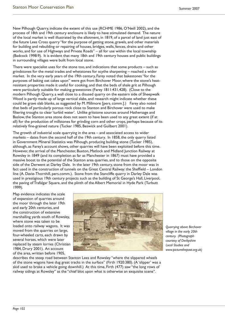
Page 102
Stanton Moor Conservation Plan Summer 2007
New Pilhough Quarry, indicate the extent of this use (RCHME 1986, O’Neill 2002), and the process of 18th and 19th century enclosure is likely to have stimulated demand. The nature of the local market is well illustrated by the allotment, in 1819, of a parcel of land just east of the future Lees Cross quarry “for the purpose of getting stone, gravels, and other materials for building and rebuilding or repairing of houses, bridges, walls, fences, drains and other works, and for use of Highways and Private Roads” – all for use within the local township (Badcock 1998:9). It is evident that many 18th and 19th century houses and public buildings in surrounding villages were built from local stone.
There were specialist uses for the stone too, and indications that some products – such as grindstones for the metal trades and whetstones for scythe sharpening – reached a wider market. In the very early years of the 19th century, Farey noted that bakestones “for the purposes of baking oat cakes upon” were got from Birchover Moor, where the stone’s heat-resistant properties made it useful for cooking, and that the beds of shale grit at Pilhough were particularly suitable for making gravestones (Farey 1811:431,428). (Close to the modern Pilhough Quarry, a wall close to a disused quarry on the eastern side of Sheepwalk Wood is partly made up of large vertical slabs, and research might indicate whether these could be grave slab blanks, as suggested by M. Millmore [pers. comm.].) Farey also noted that beds of particularly porous rock close to Stanton and Birchover were used to make fi ltering troughs to clear ‘turbid water’. Unlike gritstone sources around Hathersage and Baslow, the Stanton area stone does not seem to have been used to any great extent (if at all) for the production of millstones for grinding corn and other crops, perhaps because of its relatively fi ne-grained nature (Tucker 1985, Beswick and Guilbert 2001).
The growth of industrial scale quarrying in the area – and associated access to wider markets – dates from the second half of the 19th century. In 1858, the only quarry listed in Government Mineral Statistics was Pilhough, producing building stone (Tucker 1985), although, as Farey’s account shows, other quarries will have been exploited before this time. However, the arrival of the Manchester, Buxton, Matlock and Midland Junction Railway at Rowsley in 1849 (and its completion as far as Manchester in 1867) must have provided a massive boost to the potential of the Stanton area quarries, and to those on the opposite side of the Derwent at Darley Dale. In the later 19th century, stone from the moor was in fact used in the construction of tunnels on the Great Central Railway: the Sheffi eld – London line (A. Davie-Thornhill, pers.comm.). Stone from the Stancliffe quarry in Darley Dale was used in prestigious 19th century projects such as the building of St George’s Hall, Liverpool, the paving of Trafalgar Square, and the plinth of the Albert Memorial in Hyde Park (Turbutt 1999).
Map evidence indicates the scale of expansion of quarries around the moor through the later 19th and early 20th centuries, and the construction of extensive marshalling yards south of Rowsley, where stone was taken to be loaded onto railway wagons. It was moved from the quarries on large, four-wheeled carts, each drawn by several horses, which were later replaced by steam lorries (Christian 1984, Drury 2001). An account of the area, written before 1905, describes the steep road between Stanton Lees and Rowsley “where the slippered wheels of the stone wagons have dug great tracks in the surface” (Firth 1920:380). (A ‘slipper’ was a skid used to brake a vehicle going downhill.) At this time, Firth (477) saw “the long rows of railway sidings at Rowsley” as the “chief blot upon what is otherwise an exquisite scene”.
Quarrying above Birchover village in the early 20th century. (Photograph courtesy of Derbyshire Local Studies and www.picturethepast.org.uk)
Page 103
Stanton Moor Conservation Plan
At this period, the local stone was being extensively quarried both for building stone and for industrial grindstones and pulping stones. In the 1920s and 30s, quarries on the south-west fringes of the moor were producing stones for the Sheffi eld fi le and tool grinding industries and the Birmingham area metal trades. Pulping stones for the wood pulp industry (with a market which included Scandinavia and the United States) were produced here and at New Pilhough (Sheffi eld Daily Telegraph for 1926 and 1934, Tucker 1985). In some cases, stones were being produced for very specialist uses, such as glass bevelling, or sharpening knives for cutting sugar cane (Harris 1992).
As in other areas of the Peak, quarry workers (and lead miners) often combined industrial employment with small-scale farming, especially prior to World War I. In the 1920s and 30s work at the Stanton and Birchover quarries “swung between boom and gloom” (Drury 2001:40). In the winter, quarrying work depended on the weather, as stone could not be worked when it was frozen.
By the mid 20th century, the major market for grindstones had collapsed, with the introduction of synthetic stones, and of legislation to prevent silicosis, derived from dust generated by grindstones (Barnatt and Smith 1997). This, combined with high labour input, and the existence of mass-marketed alternatives to gritstone for building, saw the closure of many quarries in the years after World War 2 (Willies et al 1989) – although, in the early 1950s, Birchover and Stanton Moor Quarries were still producing “blockstone for building and engineering purposes, grindstones and pulpstones for the paper, glass and steel trades…and kerbstones” (Minister’s decision letter in relation to Planning Permission, Feb. 1952). The station and marshalling yards at Rowsley closed in the late 1960s. In 1984, T.W. Ward’s quarry was described as “the last Birchover survivor” (Christian 1984:34). However, as described at 3.3.1, in the last twenty years, demand for Stanton area gritstone has risen again, particularly in the form of dimensional stone, which attracts both a domestic and an export market.
3.4.8.5 Military timber supply
Planting and management of woodland across much of Stanton Moor took place from the early 19th century (see 2.4.6 and 3.4.7.4). As described at 2.4.7, the Stanton Moor Plantation was clear-felled in the course of World War 1, and slight traces of the infrastructure used to achieve this survive on the moor. Research by Ainsworth (1990) indicates that this mass clearance of trees was generated by the demand for timber for military uses, both at home and abroad, during the course of the war. Ainsworth notes that these demands – and particularly the need for trench timbers – had led to the establishment in 1915 of the ‘Home Grown Timber Committee’ (and subsequent bodies) which oversaw the felling of an estimated 450,000 acres of woodland in Britain. The clearance of Stanton Moor was probably carried out under the direction of a Canadian Army Unit, based at Rowsley Station, and employing (mostly female) local labour. It may have been the same unit which constructed an encampment, sidings, saw mill, light railway and bridge over the Derwent at Rowsley, while engaged in felling timber on the estates of the Dukes of Devonshire and Rutland in the last months of 1918.
Ainsworth suggests that the layout of the railway on Stanton Moor (Figure C8) was probably similar to those used by Canadian forestry units in France at the same period, and local recollections suggest that the rail-mounted trolleys which carried the timber were hauled by ponies and mules. The Canadian unit at Rowsley was disbanded in 1919, and little is known about what became of the railway on Stanton Moor after World War 1, although it may have continued in use to support quarrying or tree felling until 1920.
3.4.8.6 Overall impact of industry
The history of industrial use of the area shows that, far from relying solely on agriculture, the lead and gritstone industries have been a source of work (and of varying scales of income and profi t for local people, landowners and investors) from the 17th century through to the modern period. Lead mining survived far longer here than elsewhere in the Peak, and there have been various phases of expansion and decline in stone quarrying. At different times, both industries will have had a range of physical and social impacts on the Stanton, Birchover and Rowsley areas – through major episodes of construction of soughs and shafts, the cutting

Page 104
Stanton Moor Conservation Plan Summer 2007
away of extensive quarry faces, the transport on local routes of heavy loads of lead ore, stone and machinery, and the sight and sound of quarry working, of the huge above-ground pumping engines at Warrencarr, and the cranes, wagons and locomotives at Rowsley’s sidings.
3.5 Natural Heritage: the wider ecological context
Here, the three main types of habitat on Stanton Moor – upland heath, woodland, and disused quarries – are set within international (where appropriate), national and regional frameworks. However, as with the moor’s other attributes, it is the totality of the Stanton Moor landscape which is signifi cant: a large part of the moor’s ecological value derives from the fact that it hosts a mosaic of different habitats, which co-exist and complement each other. It also exists within a wider landscape, some of whose most important ecological characteristics are described below.
3.5.1 Heather Moorland
Britain
Britain supports a large proportion of the total global resource of heather moorland, which forms a habitat of international importance, home to a diverse range of fl ora, fauna and invertebrates.
Within Britain, over 27% of English and Welsh heather moorland is estimated to have been lost between 1947 and 1980, although the position has since improved. Upland heathland in Britain has now been designated a National Priority Habitat, under the terms of the UK Biodiversity Action Plan 1994. Such habitats are selected because they are internationally important, rapidly declining, or rare, and action plans for their rescue and conservation have been devised at UK and local levels (see 2.12.2.2).
Peak District
At regional level, moorlands form one of the most distinctive landscapes of the Peak District, and provide a variety of different habitats. Situated at the south-eastern limit of this form of habitat, they are especially vulnerable to the smallest changes in pollution, use and damage. Although an estimated 6500ha of Peak District upland heath was lost between 1913 and 1979, much of the surviving moorland is now protected within four Sites of Special Scientifi c Interest (SSSI). The extent now appears stable overall, and moorland condition is improving, despite areas of local decline. However, the Peak District moors are the most visited moorlands in the world.
Stanton Moor
Stanton Moor itself does not lie within a designated SSSI, but, as upland heath, is defi ned as National Priority Habitat (see above). The specifi c heathland community on Stanton Moor – a mix of Ling and Western Gorse, with a sub-community of Bilberry – is of an unusual type, with a mainly western distribution within Britain. It provides valuable moorland habitat, and supports a number of grasses, lichens, mosses and invertebrates which are locally or nationally rare (see 2.6.2).
Under the terms of Section 3 of the Wildlife and Countryside (Amendment) Act 1985, the majority of Stanton Moor has been included within maps prepared by the Peak District National Park Authority (PDNPA) to show areas of moorland whose natural beauty it is particularly important to conserve, and which are critical to the quality of the National Park (see 2.12.1.5). The area of the moor designated in this way is shown at Figure C15.
As indicated at 2.12.5.1, from 1993 until November 2004 moorland conservation was carried out under the terms of a Farm Conservation Agreement (FCA) negotiated between the National Park Authority and the landowner. Over the 11 years of the Agreement’s operation the moor recovered well, but birch regeneration is now causing increasing concern.
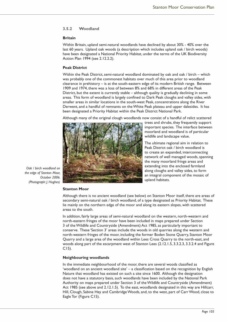
Page 105
Stanton Moor Conservation Plan
3.5.2 Woodland
Britain
Within Britain, upland semi-natural woodlands have declined by about 30% - 40% over the last 60 years. Upland oak woods (a description which includes upland oak / birch woods) have been designated a National Priority Habitat, under the terms of the UK Biodiversity Action Plan 1994 (see 2.12.2.2).
Peak District
Within the Peak District, semi-natural woodland dominated by oak and oak / birch – which was probably one of the commonest habitats over much of this area prior to woodland clearance in prehistory – is at the south-eastern edge of its modern British range. Between 1909 and 1974, there was a loss of between 8% and 68% in different areas of the Peak District, but the extent is currently stable – although quality is gradually declining in some areas. This form of woodland is largely confi ned to Dark Peak cloughs and valley sides, with smaller areas in similar locations in the south-west Peak, concentrations along the River Derwent, and a handful of remnants on the White Peak plateau and upper dalesides. It has been designated a Priority Habitat within the Peak District National Park.
Although many of the original clough woodlands now consist of a handful of relict scattered trees and shrubs, they frequently support important species. The interface between moorland and woodland is of particular wildlife and landscape value.
The ultimate regional aim in relation to Peak District oak / birch woodland is to create an expanded, interconnecting network of well managed woods, spanning the many moorland fringe areas and extending into the enclosed farmland along cloughs and valley sides, to form an integral component of the mosaic of upland habitats.
Stanton Moor
Although there is no ancient woodland (see below) on Stanton Moor itself, there are areas of secondary semi-natural oak / birch woodland, of a type designated as Priority Habitat. These lie mainly on the northern edge of the moor and along its eastern slopes, with scattered areas to the south.
In addition, fairly large areas of semi-natural woodland on the western, north-western and north-eastern fringes of the moor have been included in maps prepared under Section 3 of the Wildlife and Countryside (Amendment) Act 1985, as particularly important to conserve. These ‘Section 3’ areas include the woods in old quarries along the western and north-western fringes of the moor, including the former Boden Stone Quarry, Stanton Moor Quarry and a large area of the woodland within Lees Cross Quarry to the north-east, and woods along part of the escarpment west of Stanton Lees (2.12.1.5, 3.3.2.3, 3.3.2.4 and Figure C15).
Neighbouring woodlands
In the immediate neighbourhood of the moor, there are several woods classifi ed as ‘woodland on an ancient woodland site’ – a classifi cation based on the recognition by English Nature that woodland has existed on such a site since 1600. Although the designation does not have a statutory basis, such woodlands have been included by the National Park Authority on maps prepared under Section 3 of the Wildlife and Countryside (Amendment) Act 1985 (see above and 2.12.1.5). To the east, woodlands designated in this way are Hillcarr, Hill, Clough, Sabine Hey and Cambridge Woods, and, to the west, part of Carr Wood, close to Eagle Tor (Figure C15).
Oak / birch woodland on the edge of Stanton Moor,
October 2006. (Photograph: J. Hughes)

Page 106
Stanton Moor Conservation Plan Summer 2007
The area known as ‘Clough Woods’ (comprising the combined woodlands of Clough Wood, Cambridge Wood, Cowley Knoll, Sabine Hey Wood, Painters Way Wood and the majority of Hill Wood) has been designated a Site of Special Scientifi c Interest under the terms of the Wildlife and Countryside Act 1981. The greater part of the site supports ancient, predominantly semi-natural woodland of a type now unusual in the county, with the principle species being Pedunculate Oak, Ash and Hazel. The woodland fungus fl ora is of considerable interest, with some 75 species recorded, many of them associated with oak. The vegetation supports one of the richest invertebrate faunas in the county, with several nationally uncommon species. Of special interest are areas of old lead mine spoil which support a distinctive fl ora, some of it specifi c to the area, and some of it nationally uncommon. Great crested newts are present in one pond, and the woods also support a large herd of unusually dark-coloured fallow deer (see 2.6.3). These deer make their way out of the woods into the surrounding area, and are seen for example around Warrencarr, near New Pilhough quarry, and on the moor itself.
3.5.3 Stanton Moor Edge and Hill Wood: implications of nature conservation evaluation
The National Trust’s Stanton Moor Edge landholding lies at the extreme eastern edge of the moor, with its north-western sector forming part of the Stanton Moor scheduled area. The Trust also owns the north-western end of Hill Wood, which lies at the foot of the Stanton Moor escarpment (Figures C11 and C15). The results of a recent ecological survey of both properties (Lister and Alexander 2001) are summarised below.
Stanton Moor Edge
• The Edge is notable for the presence of relict heath, included as a priority in the UK Biodiversity Action Plan (see above). This is rather even-aged.
• The heath has a good range of characteristic heathland invertebrate species.
• While invasive bracken on the Edge slopes is in need of control, it provides habitat for specialist songbirds such as Yellowhammer.
• Woodland on the Edge provides a valuable corridor of woodland linking the moor and the Clough Woods SSSI below the escarpment. It provides valuable habitat for a range of woodland bird species.
• The woodland has a notably varied ground fl ora (considering its acidic soils and relatively recent origin), which includes Bluebell, listed as a species of conservation concern.
• Woodland invertebrates include the uncommon Soldier Beetle, and uncommon species of Bank Fly.
Hill Wood
• The National Trust-owned section of this wood has value as part of an extensive area of mainly semi-natural woodland extending to the Clough Woods SSSI.
• The majority of ground vegetation is species poor. The greatest conservation interest lies in land-slipped and fl ushed terrain at the northern end, where Intermediate Enchanter’s Nightshade (rare in Derbyshire) is present. Here, there is a greater diversity of woodland plant species, and the nationally scarce Fire-Winged Beetle has been found.
Bracken and scrub covered slopes on Stanton Moor Edge (top of picture) (Photograph: J. Hughes)
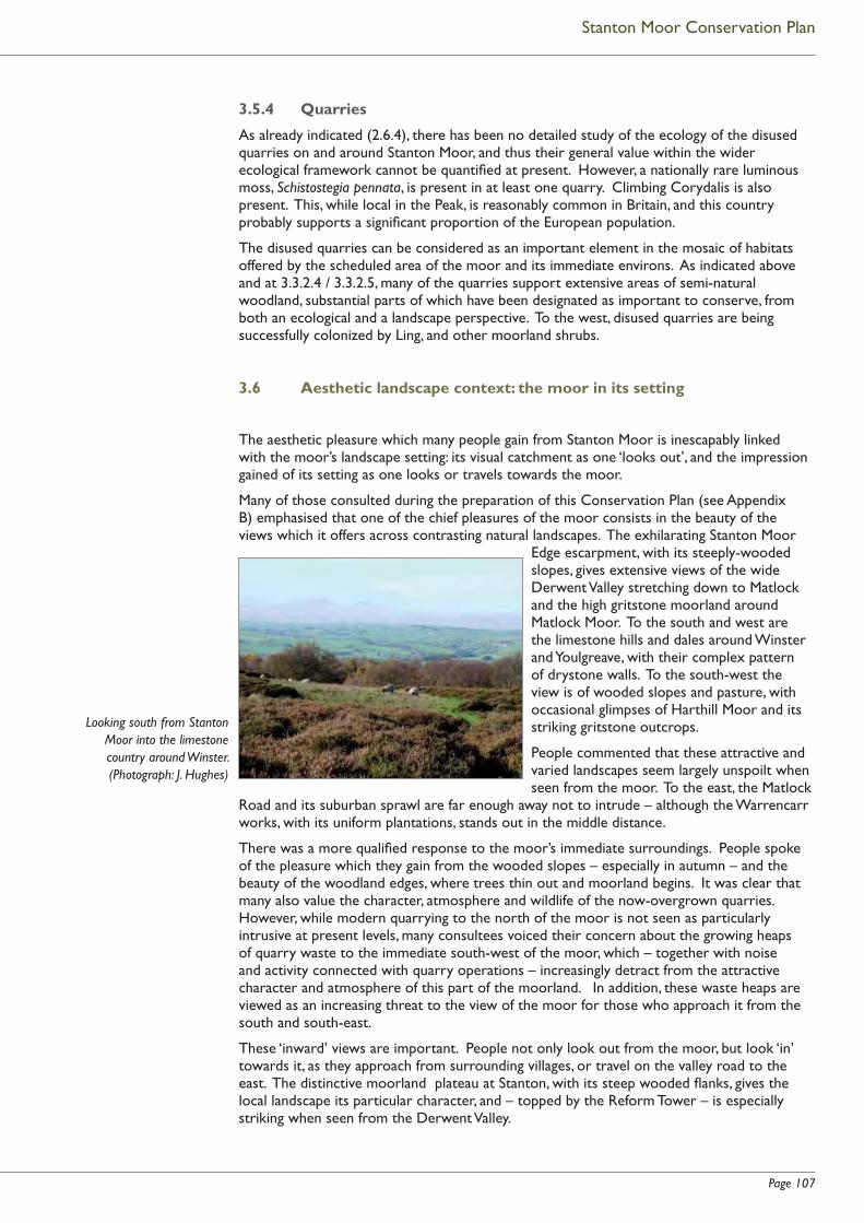
Page 107
Stanton Moor Conservation Plan
3.5.4 Quarries
As already indicated (2.6.4), there has been no detailed study of the ecology of the disused quarries on and around Stanton Moor, and thus their general value within the wider ecological framework cannot be quantifi ed at present. However, a nationally rare luminous moss, Schistostegia pennata, is present in at least one quarry. Climbing Corydalis is also present. This, while local in the Peak, is reasonably common in Britain, and this country probably supports a signifi cant proportion of the European population.
The disused quarries can be considered as an important element in the mosaic of habitats offered by the scheduled area of the moor and its immediate environs. As indicated above and at 3.3.2.4 / 3.3.2.5, many of the quarries support extensive areas of semi-natural woodland, substantial parts of which have been designated as important to conserve, from both an ecological and a landscape perspective. To the west, disused quarries are being successfully colonized by Ling, and other moorland shrubs.
3.6 Aesthetic landscape context: the moor in its setting
The aesthetic pleasure which many people gain from Stanton Moor is inescapably linked with the moor’s landscape setting: its visual catchment as one ‘looks out’, and the impression gained of its setting as one looks or travels towards the moor.
Many of those consulted during the preparation of this Conservation Plan (see Appendix B) emphasised that one of the chief pleasures of the moor consists in the beauty of the views which it offers across contrasting natural landscapes. The exhilarating Stanton Moor
Edge escarpment, with its steeply-wooded slopes, gives extensive views of the wide Derwent Valley stretching down to Matlock and the high gritstone moorland around Matlock Moor. To the south and west are the limestone hills and dales around Winster and Youlgreave, with their complex pattern of drystone walls. To the south-west the view is of wooded slopes and pasture, with occasional glimpses of Harthill Moor and its striking gritstone outcrops.
People commented that these attractive and varied landscapes seem largely unspoilt when seen from the moor. To the east, the Matlock
Road and its suburban sprawl are far enough away not to intrude – although the Warrencarr works, with its uniform plantations, stands out in the middle distance.
There was a more qualifi ed response to the moor’s immediate surroundings. People spoke of the pleasure which they gain from the wooded slopes – especially in autumn – and the beauty of the woodland edges, where trees thin out and moorland begins. It was clear that many also value the character, atmosphere and wildlife of the now-overgrown quarries. However, while modern quarrying to the north of the moor is not seen as particularly intrusive at present levels, many consultees voiced their concern about the growing heaps of quarry waste to the immediate south-west of the moor, which – together with noise and activity connected with quarry operations – increasingly detract from the attractive character and atmosphere of this part of the moorland. In addition, these waste heaps are viewed as an increasing threat to the view of the moor for those who approach it from the south and south-east.
These ‘inward’ views are important. People not only look out from the moor, but look ‘in’ towards it, as they approach from surrounding villages, or travel on the valley road to the east. The distinctive moorland plateau at Stanton, with its steep wooded fl anks, gives the local landscape its particular character, and – topped by the Reform Tower – is especially striking when seen from the Derwent Valley.
Looking south from Stanton Moor into the limestone country around Winster. (Photograph: J. Hughes)

Page 108
Stanton Moor Conservation Plan Summer 2007
Within the context area itself, the aesthetic value of the landscape, and of its villages and monuments, is very high. This is a complex, multi-textured landscape, with two major river valleys, gritstone moorland, both planted and ancient woodland, densely-wooded streamsides, and limestone cliffs along the River Lathkill, all in a relatively compact area. The very varied pattern of enclosure, visible both in the context area itself (see 3.2.4) and in surrounding valleys and hills, adds to the visual interest and historic character of this landscape.
Several consultees emphasised the attractive character of the villages and hamlets in these parishes, and the way that, built of local stone, they seem to grow naturally from their surroundings. Of the many attractive walking routes through this landscape, several lead up to the moor, and the character of these approach routes forms an important part of people’s aesthetic experience of a visit to the moor itself. Perhaps the most striking are the old route up from Rowsley, which passes the magnifi cent 17th century farm at Stanton Woodhouse (but is marred for some by protest camp infrastructure in the neighbourhood of Stanton Lees) and the old paths, defi ned by worn stone slabs, which mark traditional routes up from Winster.
The ‘ancient’ character of the moor itself is complemented and enhanced by a range of striking features in its immediate neighbourhood, both natural and man-made. These include a cluster of fantastically-shaped gritstone tors close to Birchover: Bradley Rocks, Eagle Tor and Rowtor Rocks: the latter, almost hidden among trees, are made more fantastical by Thomas Eyre’s idiosyncratic rock-cut rooms and steps, created in the early 1700s. On nearby Harthill Moor, a complex of ancient structures, including the imposing orthostats of the Nine Stone Close stone circle, the possibly Iron Age enclosure called Castle Ring, and a much later ‘hermit’s cave’, cluster close to the visually striking natural rock towers known as Robin Hood’s Stride or Mock Beggar Hall. To the west of the moor, the attractive small stone circle and cairn at Doll Tor are hidden within a copse of pines: although a relatively recent addition to the landscape, the trees provide a special ‘secret’ atmosphere for the monument – an atmosphere which changes with the weather and the seasons. Close by rises the isolated weathered mass of the Andle Stone.
For some, the remains of this area’s early industrial history – such as the massive gritstone Watts Engine House which stands in Clough Wood near Warrencarr – are equally impressive. They form an evocative and striking contrast with the rural landscape which now surrounds them.
3.7 The modern spiritual context
“It is impossible not to be magnetised by these [ancient sites] even as we are baffl ed by them. Because their functions are forgotten or only partially known, they have entered a new kind of existence and found a new kind of purpose: they commemorate the mystery of existence itself.” 1
The account (at 2.9) of the range of ways in which people appreciate the ‘spiritual’ qualities of the moor and its monuments emphasises that the nature of these responses is very fl uid: it encompasses a wide range of feelings and reactions, and need not be associated with formal or informal religious belief.
In common with many similar sites across Britain, the Nine Ladies stone circle and King Stone have long been associated with folk tales about how the stones came to be there, and about their ‘magic’ or spiritual properties – tales which may have very distant origins. In
1 Andrew Motion, reviewing ‘The Past from Above’, Guardian 04 04 06.
North-west view of Robin Hood’s Stride, as drawn by Hayman Rooke in the late 18th century. He considered the ‘rock basins’ here to be the work of Druids. (Image courtesy of Derby Museums and Art Gallery)

Page 109
Stanton Moor Conservation Plan
Stanton’s case, the most persistent story concerns nine maidens, frozen in stone for dancing on the Sabbath Day – along with the King Stone, their fi ddler. There are other traditional stories about the Doll Tor circle, and about Nine Stone Close on neighbouring Harthill Moor, whose stones, once known as ‘The Grey Ladies’, traditionally danced at midnight.
18th and 19th century accounts of the strangely-shaped rock tors and ancient sites at Birchover, Stanton and Harthill characteristically interpreted them as important foci for Druid ceremonies:
“This massive ridge would afford great facilities to the Druids for practising their deceptions upon the people, there being natural passages and cavernous hollows in various parts of the rocks, some large masses of which would require but little art and labour to convert them into moving, or rocking-stones; in fact oracles delivered from this ridge of rocks would be as much calculated to inspire awe in the breasts of the superstitious Britons, as those delivered from the Temple of Apollo at Delphos to the more polished but equally credulous Greeks and Romans.”1
Although such things were dismissed as ‘old beliefs’ by antiquaries, these strangely weathered rocks and clearly ancient circles and mounds will always have held real fascination for local people and visitors – as they do today.
The rather more focused modern belief that similar circles and standing stones continue to possess sacred or magic properties runs back through the 20th and into the 19th century – a belief refl ected, for example, in the continuing interest expressed in the writings of Alfred Watkins on ley lines and associated phenomena (see for example Watkins 1925)2. In the case of Stanton, if we are to believe Percy Heathcote (who had been closely familiar with the moor since his childhood in the early 1900s, and whose family had lived close to the moor from well before that time) the overt modern expression of this form of belief in the specifi c spiritual power of the Stanton circle and its wider landscape appears to be relatively recent. He dated the beginnings of what he (colourfully but inaccurately) called “witchcraft and associated drinking ceremonies” there to around 1970 (Heathcote 1980:16).
While bearing in mind that specifi cally pagan beliefs form only one strand of spiritual engagement with the moor, the following edited abstract provides an overview of the nature of modern pagan engagement with this landscape.
“The spiritual dimensions of the Peak Park – the importance of this area, centrally located in England, for people in the surrounding cities – must not be undervalued. It is hard to quantify the meanings of land and landscape to those individuals and groups who fi nd re-enchantment, restoration or re-creation of self and spirit through direct engagement with the land. While this text is principally concerned with paganisms, the landscape of Stanton Moor has spiritual meaning for many of those who visit.
Pagans and Archaeological Sites
Arguably, pagans’ engagements with archaeological monuments are both embedded in and constitutive of a ‘new folklore’: such places are consistently perceived as ‘sacred’, as places which are ‘alive’ today, where connections can be made with ‘ancestors’, where the Earth Goddess/God can be contacted, where the spirit/energy of the land can be felt most strongly. Specifi c narratives are forming around individual sites, or around more general pagan relationships with landscape: there are narratives of description or explanation, stories of events occurring to tellers or stones, ranging from appearances
1 Bateman 1848:117, describing Rowtor Rocks.
2 See also Anthony Powell’s ‘A Dance to the Music of Time’, which provides a fi ctional refl ection of the persistence
of similar ways of thinking from well before the 1st World War (Powell 1951 - 1975).
Rowtor Rocks from the east, with rocking stone, as drawn
by Hayman Rooke. The pillar on the left supported a
‘weather cock’. (Image courtesy of Derby
Museums and Art Gallery)

Page 110
Stanton Moor Conservation Plan Summer 2007
of supernatural beings to accounts of non-functioning electronic equipment. Sites of interest are chiefl y Neolithic and Bronze Age constructions, but also Iron Age, Romano-British and Saxon remains. There is no single pagan relationship with such places. Positions range from adopting the offi cial ‘preservation’ ethic promulgated by English Heritage, the National Trust and other organisations, to claiming individual divine inspiration for whatever practices seem appropriate at the time.
At some sites, pagans have come forward as ‘guardians’: increasingly this seems to be happening at Stanton Moor. Pagan understandings of and engagements with these ancient places, and often with associated landscapes including natural features and wildlife, are diverse and complex. They may include elements of (often older) academic interpretations of site and symbol, literature and history, together with folkloric understandings of spirits and local deities, sometimes drawing on narratives from elsewhere, re-enchanting these in line with how their paganisms understand people, deities and places. Some pagan discourses may focus on sites as places where deities can be approached, or that in some sense symbolise or embody deity. Other pagan discourses of sacredness instead relate to use of a site by not only human-people, but other beings, possibly as a location where human and other people enter into negotiations and relationships. Animist views hold that rocks, trees, rivers and so forth all have spirit and may all create or inscribe meaning in place. Unlike ‘rational’ understandings, of archaeologists in particular, in which meaning‚ scientifi c, spiritual or otherwise‚ is seen solely as a process of human inscription on to sites, pagans who make offerings often see ‘spirits’ of place (such as wights, land sprites and goddesses) as present a priori, as, for want of a better phrase, actually there.
Pagans and Stanton Moor
The Nine Ladies Stone circle is well known to many British pagans. Some of those extend their interest to the entire landscape of Stanton Moor, considering the cairns, circles and bronze-age burials as part of a sacred landscape in which spirits of nature, deities and/or ancestors can be honoured. Pagans are therefore concerned about the potential destruction of parts of this landscape, and the disruption to the remainder occasioned by the sounds of quarrying, the removal of material and destruction of wildlife habitat. The protesters in the proposed quarrying area near the Nine Ladies are not ‘typical’ of pagans more generally, but many pagans are expressing support for the protesters and for local action group opposition to the quarry.
The protest website uses the image of an apple ‘core’ remaining of the moor, holding the Nine Ladies and a single birch tree ‘stalk’, but with little else remaining, the quarries having taken their ‘bites’. In this ‘alternative’ representation of Stanton Moor, the circle becomes a metaphor for the moor, and pagans and others identify with the circle. However, this living landscape means different things to different groups of pagans: many treat the circle as a ritual focus, a place to meet spirits, deities or ancestors of the moor: others engage with spirit-lines or tracks, or leylines. Some perform ritual at the circle to give energy to stones and land.
Some ritual activity leaves traces - offerings, candles and so forth, but much leaves no traces other than those of steady erosion through site use by all ‘visitors’, pagan or otherwise. The protest camp people have been attempting to discourage other pagans from leaving visible offerings, while organisations such as ASLaN (Ancient Sacred Landscape Network) are attempting to provide education for pagan site users, urging that the best offering may be picking up others’ litter, but that a song or a libation are offerings that do not disrupt others’ enjoyment of the landscape.
In short, pagans across Britain are concerned about Stanton Moor and the situation of the Nine Ladies. When parts of the circle and its environs were excavated during 2000-1, local archaeologists took pains to explain the purposes of the excavation to protestors and visitors – some of whom then decorated the site with a pentacle, perhaps to protect the land or bless the excavation. Similarly, during the recent restorative work there were attempts to communicate between heritage management and pagan communities – communication which is, in our view, essential.” (Blain and Wallis 2004a).
Page 111
Stanton Moor Conservation Plan
3.8 Interpretation and education: the wider context
3.8.1 Interpretation
3.8.1.1 Stanton Moor interpretation in context
Interpretation of an area such as the Peak District can take many forms: besides the more traditional means such as visitor centres, interpretation panels, leafl ets, self-guided trails and guided walks, there are alternative media – for example sculpture, two-dimensional art, performance and music; in addition, technology now allows ‘virtual’ interpretation, giving people access to otherwise inaccessible or highly sensitive environments (Bell 2003). In some areas of the Peak, local communities are increasingly involved in telling the stories of their own towns, villages and landscapes. Other initiatives such as the PDNPA / English Nature ‘Vision for Wildlife Project’ ensure direct community participation in the study, evaluation and conservation of important local habitats.
In the case of Stanton Moor, however, as indicated at 2.10.2.5, consultation and small-scale survey have revealed a general perception that the various resources offered by the moor are markedly under-interpreted. (It is worth noting, however, that many of those who expressed a wish that there should be more information, revealed that they had not in fact tried to fi nd any.) Although it is hoped that the newly-installed information panels will go some way towards remedying this situation, there appears to be considerable scope for further work, including the investigation of a range of interpretive strategies, using diverse media.
It should be borne in mind that (following interviews with an admittedly rather small sample of people living in villages near the moor), Isherwood (2004) noted a perception amongst older residents that the transfer of the Heathcote collection to Sheffi eld at the end of the 1970s had broken a link between local people and the archaeology of the moor. Whether or not this is the case, the potential for greater community involvement in the interpretation of the ‘local’ landscape is well worth exploring.
3.8.1.2 Interpretation of the moor’s setting
General interpretive material on villages and landscape features within the moor’s context area can be found in a range of popular publications and websites – including the PDNPA’s own site and that of Birchover village – a website “created and operated by the local community”. Local people are also engaged in researching the long history of their communities and parish through the recently formed Stanton-in-Peak local history society.
The nature and signifi cance of prehistoric structures and landscape features in the area – for example the cluster of features on and around Harthill Moor, and the rock art on Rowtor Rocks – have been commented on and analysed fairly extensively in both academic and more popular studies (e.g. Bevan 1995, 2000b; Barnatt and Smith 2004) and feature regularly on informal websites devoted to interpretation of rock art and ‘megalithic’ archaeology.
At present, information on the lead-related industrial history of Stanton Moor and its environs has to be searched out in publications with a wider geographical focus. The history and archaeology of lead mining and smelting in the Peak continue to be recorded and researched in some detail, principally through the work of the Peak District Mines Historical Society. Although publications are often designed for a specialist audience, more accessible material does exist (for example Ford and Rieuwerts 2000), and the Peak District Mining Museum at Matlock Bath offers a range of ways in which adults and children can engage with the history of mining and its various impacts – both physical and social.
Information on the history and archaeology of the Stanton Moor quarrying industry is much harder to fi nd. Although there is specialist research material on the history of quarrying elsewhere in the Peak (and a small number of more general publications), there is no interpretive material which deals with the many quarries around the perimeter of Stanton Moor. Even at specialist level, this is an under-researched area (I. Thomas, pers. comm.).
Page 112
Stanton Moor Conservation Plan Summer 2007
3.8.2 Education
In what follows, the specifi c focus is on the current context of primary and secondary education within schools, in so far as this relates to the range of resources offered by a landscape such as Stanton Moor. The fl uidity of – and essential overlap between – broad concepts such as learning, interpretation and education has been discussed above at 2.10, and particularly at 2.10.1.
3.8.2.1 Primary and secondary education
The National Curriculum
The demands of the National Curriculum are subject to change. Currently, however, there are various ways in which an area such as Stanton Moor can be studied within the existing curricular structure, particularly within Geography, Citizenship and History, but also as part of other curriculum areas – for example primary level Science, Technology, Maths, Art and English.
The Geography curriculum allows a focus on practical skills – for example the use of maps and plans and the interpretation of photographic evidence – which form part of the study of any landscape. Throughout the curriculum, there is an emphasis on issues such as landscape change and sustainability (for example the diverse impacts of natural and human factors on a given area) which are of central relevance to Stanton Moor. Schemes of work also focus on the investigation of contrasts between a school’s home area and a very different environment: it is this emphasis which allows schools from outside the Peak to compare their own town, city or landscape with an area such as Stanton (see 2.10.3.1 and 2.10.3.2).
The Citizenship curriculum is viewed by both English Heritage and the Council for British Archaeology as a good medium for working with heritage issues, but one which could benefi t from further developmental work with teachers. The Citizenship framework encourages pupils to recognise different points of view, and to realise that, as citizens, they can make a difference: it thus enables a focus on environmental questions such as sustainability and conservation.
Although the History curriculum does not easily lend itself to the study of prehistory, there are opportunities at primary level to use a range of information sources (for example artefacts) to fi nd out about the past. The Stanton urns and grave goods strikingly photographed on Weston Park Museum’s I Dig Sheffi eld website (see 2.5.2.5) are a good example of the kind of material which is already available to support local study. Primary pupils can also investigate how a local area has changed over a long period – a topic which enables investigation of the prehistory and history of a local landscape, and allows links with Citizenship issues such as conservation and planning for change.
The nature of the national curriculum at primary level makes it possible to use a landscape such as Stanton Moor as a resource for a range of topics, particularly as part of a local study at Key Stage 2 (see 2.10.3.1). The local history study unit within the primary History programme includes ‘prehistoric settlers’ as a subject option, thus providing the potential for pupils to look at monuments in the landscape, and to investigate a local site. Amongst various resources available to primary teachers, the English Heritage 2001 publication, ‘Using Prehistory as a Local Study’ shows how History, English, Science, Mathematics, Geography and Design and Technology can all form part of such an enquiry.
Regrettably, the secondary History curriculum currently provides very limited opportunities to look at British prehistory, and so does not easily lend itself to the study of Stanton Moor’s Bronze Age archaeology – although it does offer the chance to study its early modern industrial history. However, the existence of many different professional and ‘alternative’ interpretations of the monuments on the moor provides an opportunity for pupils to engage with the concept of different historical interpretations – the idea that people can construct different pasts from the same evidence (Copeland 2004).
A number of organisations undertake research on the ways in which archaeological and environmental resources can be most rewardingly exploited within primary and secondary education, and develop resource materials to assist teachers. People working in this way include government agencies such as English Heritage and Natural England (formerly English
Page 113
Stanton Moor Conservation Plan
Nature), independent bodies such as the Council for British Archaeology, the Historical Association and the Geographical Association, and a range of educational researchers and publishers. The Qualifi cations and Curriculum Authority, based within the Department for Education and Skills, provides detailed schemes of work to guide practitioners.
The National Park Education Service
Within the National Park itself, the PDNPA’s Education Service produces a range of study units aimed at increasing young people’s awareness of their environment – particularly their natural environment. Currently, the Service does not offer material relevant to Stanton Moor’s history and archaeology, although units based on two rural villages show that there is the potential to develop such material. Within a scheme of work focusing on Hartington, Key Stage 2 pupils explore village characteristics and think about the implications of visitor pressure in the National Park. The Castleton programme (at Key Stages 2 and 3) offers children the opportunity to explore the changes which have occurred there as a result of the relationship between people and geology: as part of this work, pupils consider human impacts on the area, and the need to manage and sustain Peak landscapes.
(For information on the Moorland Learning Base, part of the Moors for the Future partnership project, which has a particular focus on offering moorland-based learning experiences to inner-city children, see 2.10.3.3.)
Derbyshire primary schools: involvement in local archaeological projects
The Nine Ladies project, developed by Stanton-in-Peak Primary School in partnership with English Heritage, has been described at 2.10.3.1. Two other notable examples of the way in which archaeology can be used as the focus for work with schools are summarised below.
The 1995-1999 Gardoms’ Edge Project, which aimed to interpret a complex landscape on the Peak Park’s eastern moors, was a collaborative venture between the University of Sheffi eld and the Peak District National Park Authority. An extensive schools programme formed an intrinsic part of the project, and included a module in environmental studies, developed in partnership with Derbyshire Educational Authority’s Urban Studies Centre (Bevan et al 2004). Each season, a number of primary schools from both rural and urban areas were invited to visit the excavations, and to engage in some very interactive activities. Pupils learned about environmental change over long periods of time, the impact of different intensities and types of land use, the varied ways in which people perceive different landscapes, and the skills of landscape investigation (ibid:202). (While the focus of this summary is on involvement with schools, the Gardom’s interpretive project was much wider, aiming to interest and stimulate both adults and children and to enable them to develop their own interpretations of the archaeology: as just one example of what went on, Bill Bevan’s 2004 article ‘Drama on Gardom’s Edge’ describes the important role played by the State of Flux theatre company in working with adult visitors and with schools.)
At Ashover Primary School, two pieces of Bronze Age rock art, discovered in the school grounds in 2000, provided the basis for an exciting school and community based project, which still continues. Pupils have investigated the rock art, built a ‘Bronze Age’ roundhouse, and been encouraged to think about the landscape of Bronze Age Ashover. The project has involved primary pupils of all ages, together with parents and other members of the village community, and has prompted work in a wide range of curriculum areas – not only Geography and History, but Design and Technology, Maths, English and Drama. Even the roundhouse’s destruction by fi re in 2003 was put to educational use as a stimulus for original writing (F. Robinson, pers. comm.). Casts of the rock art and information on the project have formed the basis of a travelling museum exhibition, which has taken interpretation to a wider public.
Page 114
Stanton Moor Conservation Plan Summer 2007
Approaching Nine Ladies stone circle from the north. (Photograph: J. Hughes)

Page 115
Stanton Moor Conservation Plan
4 Summary of signifi cance
4.1 Introduction
This chapter provides a summary of the diverse signifi cance of Stanton Moor. Although the statutory and non-statutory designations outlined at 2.12 provide the framework for a formal assessment of signifi cance, they do not refl ect views of the signifi cance of a landscape or monument when judged from other, perhaps very different perspectives. Nor do they necessarily refl ect the current state of academic or other professional knowledge about an area such as Stanton Moor. In order to redress this imbalance, the assessment in this chapter draws on the wide range of information set out in Chapters 2 and 3, and is substantially informed by the results of consultation with the organisations, agencies and individuals listed at Appendix B.
This chapter begins by drawing together and evaluating the various features, qualities and characteristics which contribute to the multi-textured signifi cance of Stanton Moor (4.2); it then assesses those aspects of the wider setting or context area (4.3) which contribute most closely to the moor’s signifi cance. Its aim is to emphasise what is valuable about the moor and its setting, and, by juxtaposing different perspectives, to highlight those areas or issues where, in the future management of this landscape, a choice may need to be made, or compromise achieved, between confl icting goals and between varying perceptions of value. Such choices must, however, refl ect both the general statutory framework and the statutory purposes of the National Park.
4.2 Stanton Moor
4.2.1 Overview
Stanton Moor’s signifi cance derives from a complex range of factors. Although these can be separated out (see below), the listing of such factors should not be taken to imply that each can be considered as a separate entity: many are intrinsically related, and a large part of the moor’s signifi cance derives from the interplay between a whole range of complementary qualities. (It should also be borne in mind that the list does not necessarily imply a descending order of importance.)
The moor is signifi cant:
• as a complex relict Bronze Age landscape of national / international value, important for the wealth and diversity of its surviving prehistoric remains, and for their contribution towards understanding of the prehistoric period at a national level;
• for its historic-period archaeology: the remains of stone delves and quarries on the moor and around its periphery, together with a range of other features dating from the medieval period to the early 20th century;
• cumulatively, as a multi-period landscape exhibiting good evidence for changes in land use over time;
• as heather moorland – a scarce international resource;
• as a landscape offering a mosaic of diverse habitats which contribute to local biodiversity;
• as accessible moorland, which, though close to fairly substantial communities, provides a sense of wildness, isolation and tranquillity;
• as a familiar and much-valued local recreational resource;

Page 116
Stanton Moor Conservation Plan Summer 2007
• for its aesthetic qualities: its natural beauty, open quality, long views, and the appeal – to the visual sense and to the imagination – of its archaeological monuments and their landscape setting;
• for its spiritual value, deriving from its peacefulness and ‘special’ atmosphere, and from the sacred qualities which a number of visitors accord to its prehistoric remains and to their setting;
• for its value as a complex educational and interpretive resource for formal and informal learning;
• for its value as moorland grazing;
• for the high quality of its sandstone.
4.2.2 Cultural heritage: signifi cance of the prehistoric resource
• Stanton Moor is of international signifi cance as a rare example of a Bronze Age ceremonial, funerary and settlement landscape. Some individual features display unusual characteristics, and many occur in combinations which are themselves nationally unusual or rare.
• The wealth and diversity of visible remains demonstrates that the archaeological evidence survives well, and generally in good condition.
• Recognition of the overall signifi cance of this relict prehistoric landscape has been marked by the scheduling of a large area of the moor, rather than that of individual monuments as separate entities. This form of scheduling recognises that the full signifi cance of this landscape derives from the rare survival of many prehistoric remains in close juxtaposition, and from the interplay between its different components.
• The scheduled area includes an unusually closely clustered group of Bronze Age ceremonial sites, many of them complex and multi-phased: three embanked stone circles (with a fourth, separately scheduled, within 250m); a standing stone, and one (possibly two) ring cairns, all spatially associated with a large cairnfi eld which appears to be primarily funerary.
• The arrangement of ceremonial monuments and major cairns in an irregular line across the moor is – if deliberate – regionally unique amongst surviving sites, and nationally unusual.
• The Nine Ladies embanked stone circle is one of only a few in Britain which can be shown to have survived relatively intact. It is also a rare national example of a circle surviving in a landscape which incorporates such a range and quantity of Bronze Age features.
• The Stanton Moor funerary cairnfi eld, with around 30 known funerary cairns, more than 25 other probable or possible examples, and multiple cremations within what may have been an associated fl at grave, is atypical within the context of the Peak District, and comprises by far the largest example known to survive in the region. Proven funerary cairnfi elds of this size are also nationally rare.
• The presence in certain areas of the moor of Bronze Age agricultural and settlement remains adds to the cultural complexity of the prehistoric archaeology here, and provides an opportunity to examine the relationship between the ceremonial / funerary landscape and the agricultural and settlement landscape.
• Detailed modern surveys of Stanton Moor provide a comprehensive basis for current and future study of :

Page 117
Stanton Moor Conservation Plan
~ the chronological and cultural interrelationships between the prehistoric features on the moor;
~ the way in which those who built and used the monuments may have perceived and been infl uenced by the moor’s immediate landscape context;
~ comparisons between the features on the moor, and well-studied and extensive archaeology from a similar period on the neighbouring East Moors and elsewhere in the region;
~ the place of the Stanton Moor archaeology within inter-regional and national contexts, which are at present little understood.
• Late 18th to mid 20th century excavations, together with accidental fi nds, form the source of a major collection of Early Bronze Age material in Weston Park Museum, Sheffi eld, and smaller collections at Derby and Buxton. The monuments on Stanton Moor have yielded a very large proportion of the Collared Urns and Accessory Vessels known from the Millstone Grit area of the North Midlands. They make a signifi cant contribution towards the comparative study of Early Bronze Age vessels at national level, and offer a rare opportunity to study a large sample of vessels from a compact, unifi ed area of landscape.
• Recent evaluative excavation of the Nine Ladies stone circle and King Stone has enabled a more detailed understanding of some of the structural elements of the stone circle, and the methods used to build it. It has provided information on the monument’s future archaeological potential, highlighting the possibility that unexcavated areas may retain evidence for its structural history and for its date, role and relationship to neighbouring monuments and other regional and national types. The excavation also provided detailed evidence on the vulnerability of the monument as an archaeological resource.
• A number of prehistoric features elsewhere on the moor are judged to survive relatively intact and may thus preserve signifi cant archaeological evidence. They have the potential to add to our understanding of the archaeology on the moor itself, and its place within local to international frameworks.
4.2.3 Cultural heritage: signifi cance of the medieval to modern resource
Stone-getting and quarrying
• The moor provides complex layers of evidence for different scales and types of quarrying over a long period – possibly from the Romano-British period onwards. The delves, artefacts and structures on the moor itself, the disused quarries on the moor and around its fringes, and the possibly-related packhorse trails, should provide good evidence for the techniques and scale of working adopted at different periods by this important industry.
• The signifi cant stone-getting and quarrying remains offer the opportunity to produce for the fi rst time a detailed record of historic working practices and products here, to complement and inform local, regional and national analyses.
Communications
• The multiple tracks and hollow-ways recorded across the moor, and which are evident (though largely unrecorded) in its immediate environs, offer the opportunity to study the relationship between these routes, and patterns of settlement, trade and communications at local and regional levels during the historic period.
Page 118
Stanton Moor Conservation Plan Summer 2007
Gentry landscapes
• The moor retains signifi cant evidence for the inscription within the landscape of the social, cultural and economic values of its late 18th / 19th century owners. Research into the physical means by which these values were expressed – whether through the enhancement and alteration of natural features, the building of artifi cial structures, the creation and design of access routes, or the alteration and management of vegetation – has the potential to enrich understanding of aspects of the early modern period in the region.
Wartime supply
• The complex remains of an early 20th century tree-felling and logging operation provide archaeological evidence for aspects of national preparation and supply for World War 1. These remains, together with documentary and oral evidence, bear witness to aspects of the impact of this international crisis on the local landscape, and on local communities.
Stratifi ed evidence for land use
• The moor preserves valuable evidence for a succession of types of land use – evidence recorded in detail by large-scale survey in the modern period. Elsewhere, information of this type has usually been masked or destroyed by land improvement. The Stanton Moor evidence enhances understanding of the particular ways in which successive forms of activity can alter or mask the physical remains left by previous uses of the land. This knowledge aids understanding of the sequence of activities on the moor itself, and throws light on the history of complex relict features elsewhere in the region, and further afi eld.
• The moor gains signifi cant value, in interpretive and educational terms, from this ‘palimpsest’ quality. The cumulative remains of successive waves of activity and use provide insight into the changing nature of cultural and social conditions in the moor’s environs, and form a valuable basis for education and interpretation at a local and regional level.
Eco-protest and artefacts associated with the Nine Ladies stone circle as a modern spiritual icon
• The long-running anti-quarrying protest camp on the edge of the moor, and the largely transient art and artefacts associated with the role of the Nine Ladies stone circle as a modern spiritual icon, form a signifi cant (and often controversial) aspect of the moor’s contemporary cultural heritage – both for visitors and for those who gain their information about the moor from the media and from websites.
4.2.4 Natural heritage
4.2.4.1 Signifi cance of the ecological resource
Overview
The moorland is of signifi cance as by far the largest of several isolated outlier moorlands and gritstone outcrops to the west of the Derwent Valley, which are divided by this valley from the main block of extensive moorland extending down its eastern side.
Stanton Moor’s ecological signifi cance has been enhanced over the past decade through active conservation management on the part of the landowner and National Park Authority. The principal areas of signifi cance are as follows.
• Upland heather moorlands such as Stanton Moor are of international signifi cance, and form priority habitat at both national and regional levels.

Page 119
Stanton Moor Conservation Plan
• Inextensive but valued stretches of Oak / Birch woodland on Stanton Moor and its fringes provide signifi cant local habitat. Much of this woodland is of a type judged to be critical to the quality of the National Park.
• The interface between moorland and woodland contributes signifi cantly to the overall ecological value of the moor and its immediate environs.
• The ecological signifi cance of the moor gains from the mosaic of different habitats – moorland, open sandy paths, moorland / woodland fringe, semi-natural woodland, scrub and disused quarries – which, co-existing in a relatively small area, encourage biodiversity.
• The moorland provides a locally important island of diverse habitats surrounded by enclosed pasture and in some areas by active quarrying and stone tipping.
• The woodland on Stanton Moor Edge provides a valuable corridor of woodland linking with SSSI woodlands to the immediate south-east.
Flora
• The heather moorland here is of an unusual type, mainly found further west in Britain.
• The moor supports a scarce species of Gorse, locally uncommon species of Sedge and Hair-Grass (the latter along disturbed path edges), and is locally important for lichens.
• A nationally rare moss is present in at least one disused quarry on the moor.
• The woodland is locally important for fungi and mosses, and supports a locally uncommon species of fern.
Fauna
• The woodland / moorland edge provides valuable local habitat for Woodcock and Tree Pipit, a declining species. Individual birch trees on the moor also provide song / display posts for Tree Pipit.
• An unusually dark breed of fallow deer make their way onto the moor from the neighbouring Clough Woods SSSI.
Invertebrates
• The moor supports the rare bug Globiceps juniperi Reuter. The edges of the sandy paths and exposed sandy soil in disused quarries provide what may be the best habitat in the Peak for solitary bees and wasps, a scarce and declining group of species. The woodland too provides good habitat for invertebrates.
4.2.4.2 Signifi cance of the geological resource
A substantial area of the moor has been designated as a Regionally Important Geological and Geomorphological Site, because of the unusual characteristics of its sandstone geology. It forms a valuable educational resource.
4.2.5 Recreational signifi cance
Consultation, other research, observation and survey have identifi ed a number of factors which contribute to the recreational signifi cance of the moor.
• Consultee responses indicate that the moor is seen as a highly-valued ‘local’ recreational resource. For some respondents, the area within which the moor is seen as an intrinsic component of the local landscape extends beyond the villages and hamlets on its fl anks to include larger population centres around Matlock and Bakewell. Within this area, there has been continuity of recreational use through recent generations: adults who played on the moor as children now take their own children or grandchildren there.
Page 120
Stanton Moor Conservation Plan Summer 2007
• Visitor survey, albeit limited, suggests that the majority of visitors to the moor may be relatively local, although it also attracts people from much further afi eld.
• The recreational value of the moor is diverse. Observation, consultation and survey indicate that it is used for family outings, short walks (including dog walking), and as one element within longer rambles in the area. There is increasing use by boulderers. It is visited for its long views and the quality of its landscape, for its archaeology and wildlife, for its peacefulness, ‘naturalness’, ‘special’ atmosphere, and for the perceived sacred quality of its landscape and monuments.
• The results of small-scale survey suggest that substantially more people visit the moor to walk and to admire the scenery and long views, than visit it for its archaeology. More extensive survey should reveal whether this pattern is real.
• The moor’s ease of access (see 4.2.6 below) contributes to its recreational value.
4.2.6 The signifi cance of access
• In comparison with the majority of other areas of moorland in the National Park, access to Stanton Moor is rapid, and paths are generally good. It thus enables easier than usual access to the experience of a relatively ‘natural’ moorland landscape, and to a group of nationally signifi cant prehistoric monuments within this landscape.
• National Trust ownership of the Stanton Moor Edge escarpment allows public access to highly-valued long views across and down the Derwent Valley.
• Recent extension of access rights under the Countryside and Rights of Way Act 2000 enables public access to a much-extended area of the moor, within constraints identifi ed in the legislation and in relevant National Park Authority policies.
• The moor is easily reached from a number of large centres of population, and is also within easy walking distance for local people.
• The relative ease of access to the moor may encourage visits from those who would not normally choose to (or would not normally be able to) visit this type of landscape (although see 5.6.2 on access for people with different abilities). However, no research has yet been undertaken which might show whether this is in fact the case.
4.2.7 Aesthetic signifi cance
For many visitors and local people, the signifi cance of Stanton Moor derives from the aesthetic qualities of the moor and its setting. The response to consultation and survey (see Appendix B and 2.11.3) indicates that its most-valued aesthetic characteristics are:
• the long and varied views, not only from Stanton Moor Edge, but to the west and south;
• the natural beauty of the moor itself, and the ‘open quality’ of the moorland landscape, together with the appeal of its autumn colours;
• the overall variety of the landscape: the contrast between open moorland (with copses and stands of trees) and semi-natural woodland on the moor’s fringes; the extensive overgrown quarries, rock edges and natural outcrops and pillars of stone;

Page 121
Stanton Moor Conservation Plan
• a ‘wilderness quality’, a sense of remoteness and of emptiness: one common response is to see the moor as a natural oasis, raised above and somehow separate from the surrounding landscape - a place with a special quality, a ‘lost world’;
• the moor’s naturalness and lack of commercialisation;
• its peacefulness, and the opportunity which it offers for quiet enjoyment of the landscape;
• the presence of the Nine Ladies stone circle and the other circles and cairns on the moor which, set in this natural landscape, add signifi cantly to its atmosphere and aesthetic appeal;
• the overgrown quarries, and the ruinous, moss-covered structures within them;
• the varied and subtle ways in which the idea of time-depth within this landscape appeals to the imagination.
Looking beyond the consultation process, it is clear that, for some audiences, the image of the Nine Ladies stone circle has become an aesthetic artefact. Expressed through a range of media, it has become an iconic symbol of Stanton Moor.
4.2.8 Landscape signifi cance
The moor’s landscape signifi cance derives from many of the qualities listed above and particularly:
• the open moorland landscape itself;
• the variation between closed and open environments across the wider moor, and the interest given by the combination of wooded areas and open moorland;
• the overall variety of landscape elements across the wider moor – including the disused quarries on its fringes and the dramatic eastern escarpment;
• the perceived ‘naturalness’ and ‘wilderness quality’ of this landscape;
• the availability of distant, varied views;
• the contrast offered by the moor’s gritstone geology and ecology with the limestone landscape and habitats to its south and west, and the broad river valley to the east and south-east;
• the impression of separateness from the surrounding landscape, probably deriving from the height of the moor, the high escarpment to the east, the disused quarry edges on its fringes and the woodland which surrounds it;
• the presence of its prehistoric archaeology, which gives it a particular atmosphere and character – variously perceived as beautiful, mysterious, sacred or eerie;
• the conservation within this landscape of the physical evidence of several thousand years of varied and changing human use;
• the recent history of successful conservation management of this landscape, which has protected and enhanced its particular and valued qualities.
4.2.9 Spiritual signifi cance
The moor’s spiritual signifi cance can take many forms, and varies with individual perspective and belief. There are, however, a number of common themes.
• The Nine Ladies stone circle acts as a focus for large numbers of visitors who fi nd contemporary spiritual signifi cance in prehistoric ceremonial monuments and in the particular atmosphere of the moor.

Page 122
Stanton Moor Conservation Plan Summer 2007
• For many, the natural environment in which the Nine Ladies is set, and the presence nearby of other ceremonial and funerary monuments, enhance the impression that this was and still is a sacred place. However, it is the Nine Ladies (and, to a lesser extent Doll Tor) which form the principal spiritual focus.
• The fact that the moor is felt to be set apart from the surrounding landscape adds to the sense of detachment from the outside world.
• The tranquillity and natural beauty of the moor and its setting are highly valued both from an individual perspective, and because this landscape is felt to enable and encourage peaceful, open human interaction.
• Stanton Moor (and particularly the Nine Ladies) has become a ‘special place’ for people who express various forms of spiritual, environmental and cultural engagement with this specifi c place and landscape. It has an important meaning in their lives, and acts as a signifi cant space to meet and interact with others who have a similarly strong sense of engagement.
4.2.10 Interpretive and educational signifi cance
The moor’s principal interpretive and educational value derives from:
• the regional and national importance of its Early Bronze Age prehistoric remains;
• the unusually close grouping of these remains, their association with prehistoric ceremony, with burial, and with persistent legends, and their setting within an apparently ‘unspoilt’ landscape – all factors which have great imaginative appeal.
• the palimpsest quality of this multi-period cultural landscape, which provides insight into the changing relationship between people and their environment, and their changing impact on this environment;
• the imaginative and visual appeal of the moor’s striking topography (both natural and artifi cial): its natural rock pillars, steep escarpment and overgrown quarry workings;
• the moor’s ecological interest and its status as a regionally important geological site;
• the combination of all these qualities with the natural beauty of the moor and its setting;
• the relative ease of access of the moor and its monuments, which makes it suitable for a range of visitor groups, and for younger children;
• the relevance of its prehistoric and historic remains, and other characteristics, to a range of topics within the educational curriculum;
• its status as a contested landscape with diverse users and interest groups – the focus of the sometimes competing interests of landowners, local residents, mineral companies, conservation bodies, eco-activists, tourists, archaeologists and people drawn to the moor through their interest in the Nine Ladies stone circle;
• its ‘localness’ to a number of surrounding communities, some of whose members feel a strong sense of engagement with the moor, and who may wish to be more fully involved in its investigation and interpretation;
• its potential as a resource for addressing social and cultural exclusion in relation to the prehistoric / historic environment (see e.g. recent initiatives by the PDNPA Ranger Service and Derby Museum, described at 2.10.2.1 and 2.10.2.4);
• the status of Stanton Moor Edge as the only gritstone habitat within the National Trust’s South Peak Estate, thus providing an opportunity to add a contrasting element within the Trust’s interpretation / education initiatives.

Page 123
Stanton Moor Conservation Plan
4.2.11 Agriculture and shooting
As moorland grazing, Stanton Moor plays a part within the local agricultural economy. In turn, the grazing helps to keep the moorland in good heart, and to control the growth of scrub.
Woodland on the western and northern fringes of the moor provides valued pheasant shooting.
4.2.12 The modern quarrying industry
As a high quality product of quarries on the moorland fringe (see 3.3.1), Stanton Moor sandstone is primarily of benefi t in the locations in which it is employed for building purposes, rather than adding to the cultural or natural heritage or amenity value of the moor itself, or that of its immediate surroundings.
4.2.13 Group signifi cance
The close association of a large number of prehistoric monuments on Stanton Moor means that the group value of the scheduled prehistoric resource is very high. Any adverse impact on the integrity of any single part of the monument would have adverse impacts on the coherence and integrity of the monument as a whole. However, as indicated in detail at 4.2.1 and throughout section 4.2, the moor draws additional signifi cance from a wide range of other important characteristics, and a large part of its value thus derives from the interplay between a range of complementary qualities.
4.3 The context area: signifi cance of Stanton Moor’s setting
4.3.1 Overview
The signifi cance of Stanton Moor itself is inextricably interwoven with the characteristics and the quality of its setting. This was made very clear during research and consultation for this plan, as the following points demonstrate.
• The overwhelming majority of consultation responses indicate that appreciation of Stanton Moor – its monuments, its landscape, its ecology, its value as recreational land – is inextricably bound up with the particular qualities of its setting within the wider landscape. The valued characteristics of the moor derive a large part of their signifi cance from the nature of this landscape context.
• The ‘setting’ of the moor comprises a number of different, but interlinked, zones. These include the immediate periphery of the moor, the wider context area, and what can be termed the ‘skyline zone’ – the wider visual catchment which includes views across to the East Moors, down the Derwent Valley and into the White Peak. (For a discussion of the varying meanings of ‘setting’, and the concept of ‘setting’ as a material consideration in planning policy, see Colcutt 1999.)
• The visual relationship between the moor and its landscape context is not confi ned to what a viewer sees when ‘looking out’ from the moor: equally central is the impression gained from ‘inward views’ as people look at or travel towards the moor from the surrounding area.
• The view ‘from the outside’ changes with distance and with mode of travel. The impression gained by a walker approaching the moor via tracks which come in from the surrounding area will be different from that gained by the motorist driving towards the moor and parking close by. In both cases, these differing ‘approach zones’ should be seen as signifi cant components of the moor’s landscape context.
• Consultation shows that, while the geographical limits of the scheduled area of the moor are fi xed, the extent of the area which people think of as ‘Stanton Moor’ is conceptual rather than geographical, and shrinks or expands according to personal perception. For some, ‘the moor’ equates to the heather moorland proper; for others, it takes in some of the wooded edges and disused quarries; for yet others, it

Page 124
Stanton Moor Conservation Plan Summer 2007
stretches downslope to the minor roads which encircle it – and even beyond these towards the A6. Conceptually therefore, areas which one observer would perceive as the moor’s setting, another would see as part and parcel of the moor itself.
4.3.2 Signifi cance of cultural heritage in the context area
4.3.2.1 The prehistoric resource
Within the moor’s context area and adjacent parishes, subsequent activities appear to have masked or destroyed most traces of prehistoric land use. However, signifi cant features survive here, including:
• Neolithic, Bronze Age and Romano-British remains on Harthill Moor;
• Later Neolithic, Bronze Age and Romano-British features associated with Rowtor Rocks;
• the Bronze Age Doll Tor stone circle and cairn, just beyond the moor’s western boundary.
These provide valuable insights into the use of the area closely adjacent to the moor at certain points during these periods, and constitute a highly signifi cant local context for the prehistoric archaeology on Stanton Moor itself.
Given the probability that there was relatively intensive use of this area of the Peak District in prehistory, particularly from the Late Neolithic / Early Bronze Age onwards, it is likely that further signifi cant evidence still survives within the moor’s immediate context area and in adjacent parishes – either as slight landscape features or (more probably) as buried features or artefacts. Recent excavation of a prehistoric fl int and chert scatter and Late Neolithic and Early Bronze Age pottery sherds from an area to the immediate north of the moor (O’Neill 2004, Adams et al 2006) strengthen this argument.
4.3.2.2 Medieval to early modern
Signifi cant indicators of the close interrelationship between Stanton Moor and surrounding communities in the medieval to early modern periods survive within the landscape which surrounds the moor, and can be seen in the physical structure of nearby villages and hamlets.
For much of the period, the moor (in a much-extended form) will have acted as an integral and signifi cant part of the economic and social structure of the manorial landscape. Hollow-ways leading to and from the moor reveal the routes which linked surrounding communities with the resources offered by moor and common. They provide evidence of the long-standing relationship between the moor, local communities, and the wider region.
In the 18th and 19th centuries, comprehensive enclosure, changes in the pattern of local land ownership, the development of commercial forestry, and the eventual expansion of industry (particularly quarrying) altered the economic and social interrelationship between the moor and its surrounding communities. Signifi cant physical evidence for the changing nature of this relationship is visible within the surrounding parishes – for example in the chronology and pattern of development of nearby villages, and at points where revetted quarry access routes cut earlier hollow-ways on the fringes of the moor.
The fact that, for several centuries, many of the houses, churches, mills and fi eld walls in the local area have been built from Stanton and Birchover stone, serves as a strong visual reminder of the historical links between surrounding communities and the moor.
Page 125
Stanton Moor Conservation Plan
4.3.2.3 Industrial
The extensive remains of two major mineral extraction industries survive in the parishes which surround the moor, and act as a reminder that this landscape has seen long-term industrial as well as agricultural use:
• Important remains of the area’s 17th to 20th century lead mining industry exist within the moor’s context area, and – in the case of Hillcarr Sough – pass below the moor itself. These features have a signifi cance which ranges from the local to the national.
• Substantial evidence of the (primarily) 19th to early 20th quarry industry – and some indications of earlier extraction – also survive here, principally around the perimeter of the moor. These quarries retain substantial and signifi cant evidence for historic working practices.
• The fact that several generations of local people gained a living from these quarries, either as owners or as employees, means that the quarries themselves (and their largely unstudied documentary history) form an integral and signifi cant part of the community history of this area.
4.3.3 Signifi cance of agriculture
Pasture fi elds and meadow in the area immediately surrounding the moor, and the spread of fi elds visible from the moorland plateau, make a signifi cant contribution to the aesthetic, recreational and landscape qualities of the moor’s environs.
4.3.4 Signifi cance of natural heritage
From an ecological perspective, the most signifi cant features within the context area are its woodlands. Many of these contribute, or have the potential to contribute, to the aim (expressed within the Local Biodiversity Action Plan) of enriching the mosaic of upland habitats in this area by ensuring that there is an inter-connected network of well-managed oak / birch woodland extending from the moorland fringes along clough and valley sides to link with enclosed farmland.
Signifi cant elements of woodland include:
• areas of secondary semi-natural oak / birch woodland, designated as priority habitat, and lying on the northern periphery of the moor, along its eastern slopes, and in scattered areas to the south;
• fairly large areas of semi-natural woodland on the western, north-western and north-eastern fringes of the moor;
• areas of woodland on ancient woodland sites to the south-east and west of the moor;
and perhaps most signifi cantly:
• the Clough Woods SSSI, south-east of the moor, but linked to it via a corridor of woodland comprising woods on Stanton Moor Edge and Hill Wood below the moor’s south-eastern escarpment.
In addition, the varied ecology of the disused quarries on the moorland periphery – while not yet fully studied – makes a valuable contribution to the local diversity of habitat in the moor’s immediate context area.

Page 126
Stanton Moor Conservation Plan Summer 2007
4.3.5 Recreational / access signifi cance
The network of footpaths within the context area (many of them following traditional routes) allows access to an attractive landscape of river and stream valleys, woods, farms and stone-built villages, together with unusual and striking landscape features such as Rowtor and Cratcliffe Rocks, and Robin Hood’s Stride. To the south-west, these paths include the popular middle-distance route known as the Limestone Way.
As indicated at 4.3.1, the nature and quality of approaches to the moor have an impact on both walkers and motorists, and may signifi cantly affect their impression of the moor itself. For walkers, both the quality of footpaths themselves, and the visual (and other) qualities of the landscape seen from these routes, will be important. Those travelling by car will also gain a (rather more fl eeting) impression of the quality of the landscape associated with approach routes, and they will be affected by the character of the roads which lead to the moor. Both walkers and motorists use many of the same access points onto the moor itself, and both groups will be affected by the character of parking areas, and the use made of them.
4.3.6 Aesthetic and landscape signifi cance
Historic Landscape Character
The context area is characterised by large areas of irregular fi elds, enclosed at an unknown date, and rather less extensive areas of more regular post-1650 enclosure. Many fi elds are bounded by traditional drystone walls. In addition to these (mainly pasture) fi elds, there are extensive spreads of managed woodland, some of it on ancient woodland sites. Settlement principally comprises small villages and scattered hamlets, built predominantly from local gritstone. There are many fi ne examples of vernacular buildings, principally from the 18th and 19th centuries.
Other valued characteristics of the context area.
For those living in, or travelling / walking through the parishes around the moor, their appeal consists in the attractive and varied qualities of this predominantly rural landscape – its pasture land, streams, river valleys and extensive woodlands, and its stone-built farms, hamlets and villages. From many parts of the context area (and beyond), the wooded slopes which rise up to the Stanton Moor plateau form a striking and attractive landscape feature – particularly when viewed from the east.
The views from the moor
Consultation clearly indicates that many visitors and local people derive particular pleasure from the long views which Stanton Moor offers over the surrounding landscape, and the impression of naturalness and tranquillity gained from this setting. There is thus a signifi cant interrelationship between the natural beauty and perceived peacefulness of the surrounding landscape and enjoyment of the moor itself.
Interrelationship between monuments and setting
The beauty and peace of their wider setting also have a signifi cant impact on visual, sensory and – to an extent – intellectual appreciation of the prehistoric monuments on the moor. The nature of their setting encourages and enables contemplation of their purpose, and invites the viewer to consider what may have been the original interrelationship between the monuments and their contemporary landscape, in the perception of those who founded them.
Page 127
Stanton Moor Conservation Plan
4.3.7 Spiritual signifi cance
For those users of the moor who fi nd spiritual signifi cance in its prehistoric monuments and its landscape, the presence of stone circles and prehistoric rock art close by adds to the special quality and importance of this area. Features which are particularly valued include the stone circles at Doll Tor and Nine Stone Close, and Later Neolithic / Bronze Age carvings at Rowtor Rocks and Robin Hood’s Stride. Some users of the moor are also deeply interested in the wider context, and undertake research into the meaning and function of prehistoric monuments throughout the Peak District, in other areas of the UK, and more widely.
The attractive, ‘natural’ setting of the moor within the wider landscape is felt to enhance its spiritual signifi cance. The fact that it is raised above and separate from the surrounding fi elds and valleys, and (perhaps) the visual contrast between moorland and more ‘domestic’ pasture fi elds with hamlets and villages, reinforce the sense of Stanton Moor as a separate and ‘special’ place.
4.3.8 Educational and interpretive signifi cance
Many aspects of the context area have intrinsic educational and interpretive value – for example its varied landscape, geology, wildlife and social and industrial history.
In terms of its educational / interpretive relationship with the moor, the main signifi cance of the context area lies in the way in which knowledge of the complex character and history of the moor’s environs can add to the richness of the experience of a visit to the moor itself. Seen in this light, the moor’s surroundings are not merely a ‘view’ (however beautiful), but can be appreciated as a landscape with a close interrelationship – social, historical, economic, ecological, geological – with the moor.
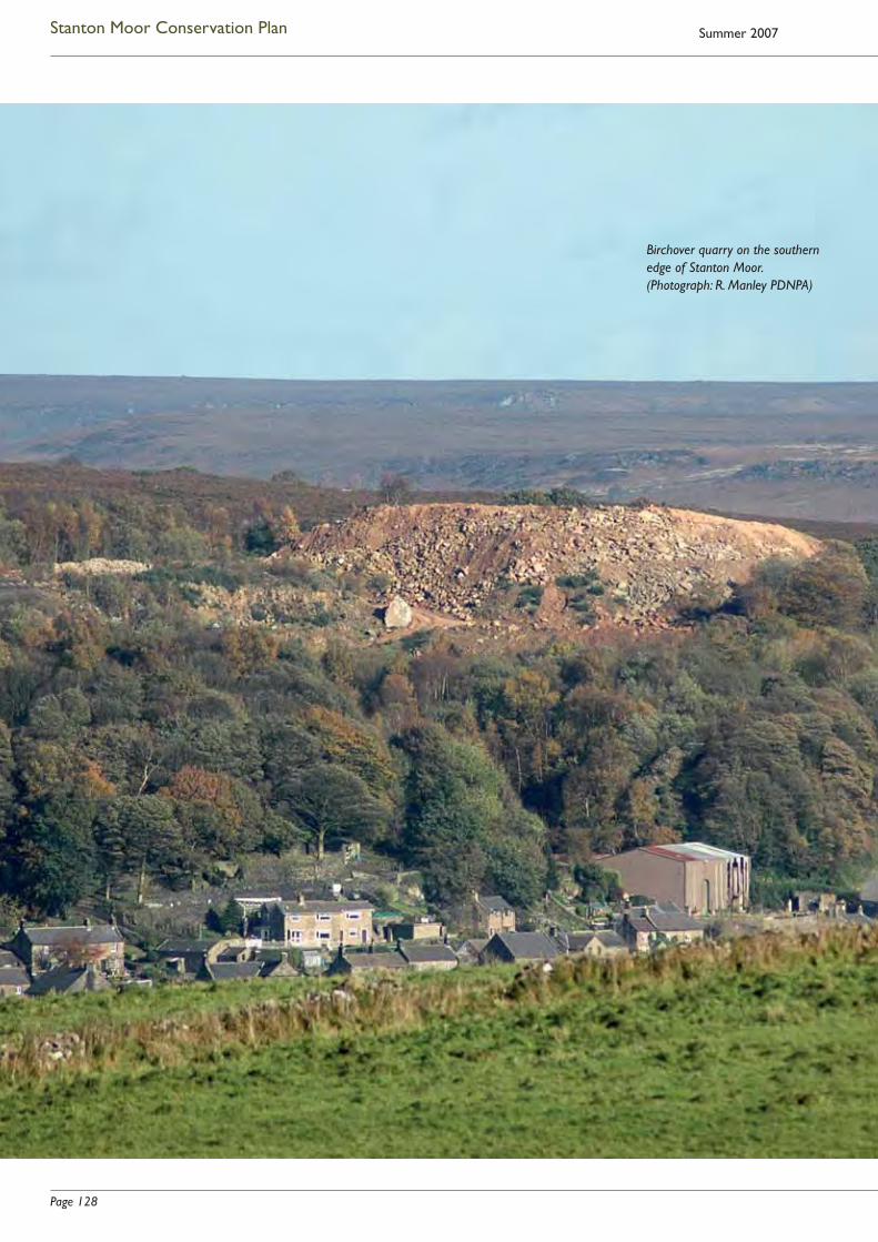
Page 128
Stanton Moor Conservation Plan Summer 2007
Birchover quarry on the southern edge of Stanton Moor. (Photograph: R. Manley PDNPA)

Page 129
Stanton Moor Conservation Plan
5 Factors affecting the signifi cance of Stanton Moor
5.1 Introduction
This chapter asks: what makes the moor vulnerable? What are the factors which detract from its complex signifi cance, or have the potential to do so? It sets out these threats in detail in order to provide a fi rm basis for identifying the policies which are needed to tackle them.
Inevitably, analysis of the various threats to the moor’s valued characteristics is a complex process. The previous chapter has demonstrated that the moor is signifi cant in many different – and often interlinked – ways. Equally, this chapter will show that many of the activities, processes or situations which damage the moor and its attributes have complex and multiple impacts. Each one may diminish the signifi cance of the moor in a number of different, often interactive, ways.
Although the complex signifi cance of the moor is affected principally by physical factors (human activity or lack of action, the effects of vegetation and grazing, and the impact of weather), there are more abstract factors such as lack of knowledge, or the absence of research, which also have an impact. This chapter addresses:
• factors known to have an adverse impact on the signifi cant characteristics of Stanton Moor and its setting, or which have the potential to have such an impact;
• areas where further research can add to our understanding of the signifi cance of the moor;
• areas where there is the potential to improve access to information about the signifi cant characteristics of the moor.
In those instances where there are measures already in place which attempt to address these factors (at least in part), these ‘mitigatory measures’ are noted in italics.
This analysis draws on the research outlined in Chapters 2 and 3 and incorporates the results of the consultation process described in Chapter 1. It provides the basis for the policies proposed in Chapter 6.
In order to make it easier to identify the policies which address specifi c impacts, reference numbers appended to each of the issues listed below indicate the principal relevant policy or policies given in Chapter 6. Total cross-correlation has not been attempted.
5.2 Cultural heritage: impacts on the prehistoric resource
The text below:
• emphasises the overriding importance of an effective conservation management structure (5.2.1);
• specifi es the features most at risk from erosion or other forms of damage, the nature of the various perceived threats, and (italicised) any mitigatory action taken to date (5.2.2 – 5.2.4);
• outlines the various impacts of the modern quarrying industry on the scheduled monument and its setting (5.2.5);
• outlines ways in which the nature and signifi cance of the moor’s prehistoric archaeology could be better established (5.2.6, 5.2.7)
• indicates the need for more readily available information on the nature and signifi cance of this archaeology (5.2.8).
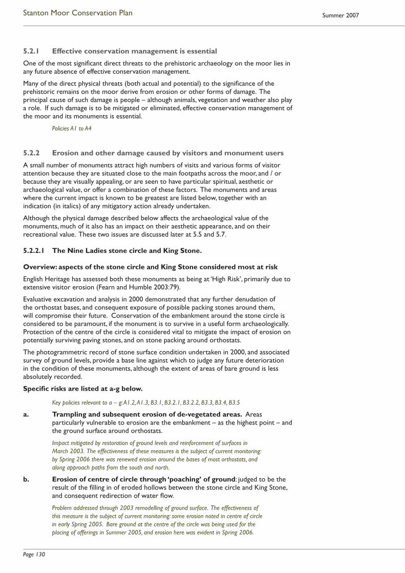
Page 130
Stanton Moor Conservation Plan Summer 2007
5.2.1 Effective conservation management is essential
One of the most signifi cant direct threats to the prehistoric archaeology on the moor lies in any future absence of effective conservation management.
Many of the direct physical threats (both actual and potential) to the signifi cance of the prehistoric remains on the moor derive from erosion or other forms of damage. The principal cause of such damage is people – although animals, vegetation and weather also play a role. If such damage is to be mitigated or eliminated, effective conservation management of the moor and its monuments is essential.
Policies A1 to A4
5.2.2 Erosion and other damage caused by visitors and monument users
A small number of monuments attract high numbers of visits and various forms of visitor attention because they are situated close to the main footpaths across the moor, and / or because they are visually appealing, or are seen to have particular spiritual, aesthetic or archaeological value, or offer a combination of these factors. The monuments and areas where the current impact is known to be greatest are listed below, together with an indication (in italics) of any mitigatory action already undertaken.
Although the physical damage described below affects the archaeological value of the monuments, much of it also has an impact on their aesthetic appearance, and on their recreational value. These two issues are discussed later at 5.5 and 5.7.
5.2.2.1 The Nine Ladies stone circle and King Stone.
Overview: aspects of the stone circle and King Stone considered most at risk
English Heritage has assessed both these monuments as being at ‘High Risk’, primarily due to extensive visitor erosion (Fearn and Humble 2003:79).
Evaluative excavation and analysis in 2000 demonstrated that any further denudation of the orthostat bases, and consequent exposure of possible packing stones around them, will compromise their future. Conservation of the embankment around the stone circle is considered to be paramount, if the monument is to survive in a useful form archaeologically. Protection of the centre of the circle is considered vital to mitigate the impact of erosion on potentially surviving paving stones, and on stone packing around orthostats.
The photogrammetric record of stone surface condition undertaken in 2000, and associated survey of ground levels, provide a base line against which to judge any future deterioration in the condition of these monuments, although the extent of areas of bare ground is less absolutely recorded.
Specifi c risks are listed at a-g below.
Key policies relevant to a – g: A1.2, A1.3, B3.1, B3.2.1, B3.2.2, B3.3, B3.4, B3.5
a. Trampling and subsequent erosion of de-vegetated areas. Areas particularly vulnerable to erosion are the embankment – as the highest point – and the ground surface around orthostats.
Impact mitigated by restoration of ground levels and reinforcement of surfaces in March 2003. The effectiveness of these measures is the subject of current monitoring: by Spring 2006 there was renewed erosion around the bases of most orthostats, and along approach paths from the south and north.
b. Erosion of centre of circle through ‘poaching’ of ground: judged to be the result of the fi lling in of eroded hollows between the stone circle and King Stone, and consequent redirection of water fl ow.
Problem addressed through 2003 remodelling of ground surface. The effectiveness of this measure is the subject of current monitoring: some erosion noted in centre of circle in early Spring 2005. Bare ground at the centre of the circle was being used for the placing of offerings in Summer 2005, and erosion here was evident in Spring 2006.

Page 131
Stanton Moor Conservation Plan
c. Ground disturbance through burial of objects in and around the circle.
Limited improvement may have been achieved through information to circle users on implications of such ground disturbance, but this continues to be a problem.
Information panels installed in 2005 indicate that it is an offence to dig holes, light fi res, remove stonework or fell trees within the scheduled monument, and that these activities could harm buried or upstanding archaeology.
d. Impact of camp fi res on ground surface in and around the circle, generating erosion.
Removal of trees from close to the monuments has extended the clearing and encouraged people to camp and light fi res at a greater distance. The impact of fi res has been mitigated to some extent by regular Ranger Service liaison with campers, and provision of fi re bases. However, the lighting of fi res without fi re bases in the area around the monuments, combined with the use of birch branches as fuel, remains a continuing problem.
See ‘c’ above for warnings included on information panels.
e. General damage to orthostats: from fi re, from chipping, carving and scratching, from use as seats and leaning posts, and (potentially) from attempts to ‘improve’ the monument via stone and earth moving.
Ranger Service advice and intervention is perceived to have some mitigatory effect, although the monument suffers regular and very heavy use, and the orthostats are frequently employed as seats and back rests. It is hoped that guidance included on information panels (see ‘c’ above) will lead to wider visitor awareness of the value and vulnerability of the monuments.
f. Increase in monument accessibility. This derives in part from management initiatives such as the cutting back of birch (intended to lessen camping within and immediately adjacent to the Guardianship monument) which may have made the monument more visible, resulting in increased visitor attention and the perpetuation of established routes into the clearing.
Repairs to and reinforcement of access routes into the clearing took place in March 2003. The effectiveness of these measures is the subject of current monitoring.
g. Unauthorised vehicle / motorcycle access – reported to be increasing in 2005.
For several years, the locking of gates and blocking of some access points was largely successful in reducing such access. It appears that this is no longer the case.
There is informal monitoring, by the PDNPA Ranger Service, of unauthorised access via the haul road through Coast Wood, and via other routes.
Chopping wood for a campfi re close to
Nine Ladies, October 2006. (Photograph: J. Hughes)
At Nine Ladies, May 2005. (Photograph: J. Hughes)

Page 132
Stanton Moor Conservation Plan Summer 2007
5.2.2.2 Ring cairn T56
Parts of the monument are suffering from erosion, particularly at two points where informal footpaths cross the bank. Erosion also results from its popularity as a picnic / stopping / viewing point close to a major path. Although T56 is not easily visible from the main path, an increasingly well-trodden informal route guides people to this monument.
No mitigation undertaken.
Policies B2.1, B3.1. B3.2.4
5.2.2.3 Large cairn T2
Upper areas of the cairn have failed to revegetate after the removal of scrub some years ago, although lower areas to the south appear to be regenerating fairly well. Severe erosion on this cairn probably results from its visibility and its very accessible position at the junction of major cross-moor routes. Sheep scrapes add to the problem.
No mitigatory action currently undertaken. (It is instructive to compare the condition of this monument with that of circle T43 a short distance to the north, which also lies alongside a major cross-moor route, but is relatively invisible due to its low height and heather cover. In the case of T43, the ditch which separates it from the track may also act as a deterrent to casual access.)
Policies B2.1, B3.1, B3.2.3
5.2.2.4 Large cairn T55
This cairn lies alongside the central track, and casual access is easy. Several narrow paths have been worn up its western fl ank, and there are areas of erosion and displaced stones on the ‘summit’. Cans and litter indicate its use as a stopping point. However, the cairn is considered to be revegetating fairly successfully compared with its condition 10 years ago.
No mitigatory action currently undertaken.
Policies B2.1, B3.1, B3.2.5
5.2.2.5 Possible ring cairn 60m north-west of Reform Tower
This has been partly destroyed by the terraced path cut through its north-eastern sector, which is still in use as a public footpath.
The south-western sector of the monument is protected by its position on the far side of a fence. The extent of damage caused to what may remain of the rest of the monument by continuing use of the path has not been assessed.
Policies B2.1, B3.1, B3.2.6
Erosion on cairn T2 (looking south-east), October 2006. (Photograph: J. Hughes)

Page 133
Stanton Moor Conservation Plan
5.2.2.6 Possible prehistoric cairn north of scheduled area boundary
This recently-identifi ed possible cairn lies at SK 25026370, approximately 30m NNW of the Duke of York stone and just outside the scheduled area. A public footpath to Lees Road passes over it, causing substantial continuing erosion.
No mitigation undertaken.
Policies B2.1, B3.1, B3.2.7, M2
5.2.2.7 Doll Tor stone circle and cairn
These structures lie just outside the scheduled area of the moor, but are considered here, as the factors which make them vulnerable are closely similar to those which affect the prehistoric monuments on the moor itself.
Extensive damage to these monuments in 1993 included large-scale rearrangement of orthostats, kerb and cairn stones, and the introduction of ‘new’ orthostats. Although the monuments have since been restored, this action indicates the vulnerability of isolated ‘ceremonial’ monuments to major damage, either misguided or malicious. In Spring 2005, one of the orthostats was discovered to have been dislodged, and was leaning into the circle.
Mitigatory action includes the restoration of the site in 1994, and the placing of an information panel which describes its age and the signifi cance and value of its prehistoric form.
Policies B2.2, B3.1, M3
5.2.2.8 Fire risk
The fi re risk to the whole of the scheduled area is broadly similar to that for other areas of well-visited moorland in the Peak, although the relatively high number of campers on Stanton Moor is likely to increase the level of risk here. Moorland fi res create bare ground, which increases the erosion risk to the monuments. Conversely, bare ground decreases fi re risk.
The burning of fi re breaks was undertaken from 1993 until November 2004 under the terms of the Farm Conservation Agreement (FCA) between the landowner and the National Park Authority. Following the cessation of the FCA, some planned burning has continued through informal agreement with the landowner. (For the impact of fi res on moorland habitat see 5.4.2.4.)
Policies A1.1 to A1.3, A2, B3.1, D9
5.2.2.9 Lack of assessment of visitor impact on the majority of monuments
The impact of visitor attention on the Nine Ladies and King Stone is well studied, and there is a degree of familiarity (mainly through the Ranger Service) with the impact of visitor use on some other major monuments on the moor. However, the extent to which the majority of monuments are adversely affected – and, conversely, the degree to which they appear to be protected by factors such as their visual insignifi cance, distance from footpaths, coverage by moorland shrubs, or a combination of these factors – has not been the subject of formal assessment or detailed recording.
Policy B2
Footpath crossing possible prehistoric cairn near Duke
of York Stone, May 2005. (Photograph: J. Hughes)

Page 134
Stanton Moor Conservation Plan Summer 2007
5.2.3 Damage by animals
5.2.3.1 Introduction
Grazed and wild animals can cause damage to monuments, for example through erosion or burrowing. Factors such as stock numbers and type affect the degree and nature of grazing-related damage. Clustering of stock close to inappropriately positioned water troughs or supplementary feeders can create areas of severe erosion.
Between 1993 and November 2004, action taken under the terms of the Stanton Moor Farm Conservation Agreement (FCA) addressed many such actual and potential problems. The short-, medium- and long-term impacts of initiatives were monitored and adjusted as appropriate. This Agreement has now lapsed (but see fi nal paragraph at 2.12.5.1).
Policies A1.1, A1.2, A2, B2, B4
5.2.3.2 Current impacts and mitigatory measures
a. The monitored grazing regime in place between 1996 and 2004 appears to have been successful in protecting the majority of prehistoric monuments from damage by grazing sheep. However, erosion associated with sheep scrapes occurs in a number of areas, and may have contributed to the failure of cairn T2 to regenerate. The quarry-edge cairn referred to at 5.2.5.9 is also used as a sheep scrape.
Policies B3.2.3, B3.2.8, B4
b. The regular presence of people and dogs at the Nine Ladies stone circle and King Stone (while itself generating erosion) keeps sheep away from these monuments, and thus protects them from the effects of grazing and of use as rubbing stones.
c. In some cases, use of sheep tracks by human visitors leads to gradual widening of such tracks and consequent erosion of monuments across which they run.
Policies B3.1, D7
d. The impact of grazing or burrowing on the less well known monuments has not been assessed, although rabbit burrows have had a signifi cant impact on cairn T2.
Policies B2, B4.4
5.2.4 Damage by vegetation
5.2.4.1 Introduction
The spread of birch and rhododendron will, if uncontrolled, have an impact on prehistoric features on the moor, through tree root damage and (in the case of rhododendron) the generation of areas of bare ground which become prone to erosion. Conversely, the removal of scrub from a monument can lead to erosion by animals and people.
Extensive spreads of bracken can also be harmful. Where bracken is allowed to predominate, large areas of bare ground left after it has died down are prone to erosion by wind and water in winter and early spring. The spread of bracken rhizomes underground can also damage monuments.
Policies A1.1, A2, B4Rhododendrons on eastern side of Stanton Moor, October 2006. (Photograph: J. Hughes)
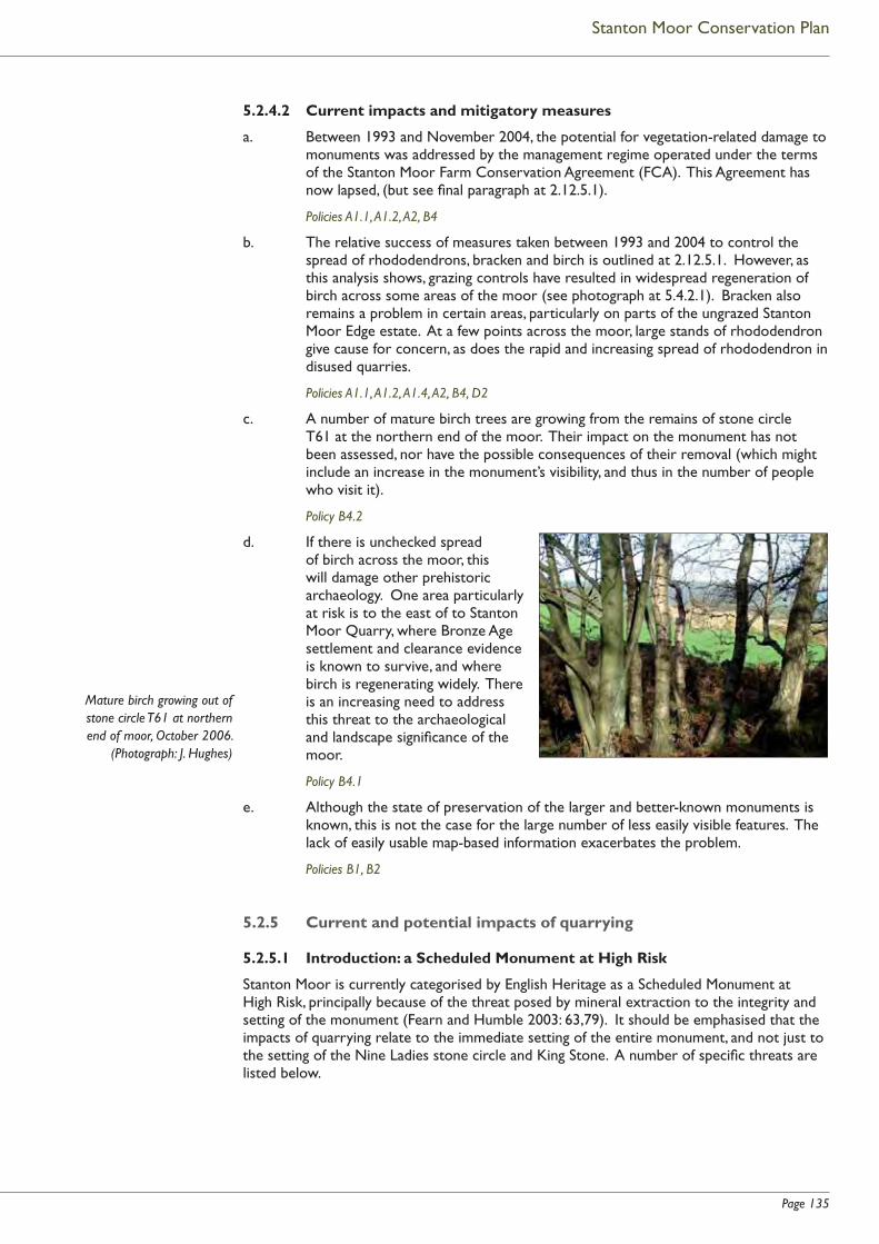
Page 135
Stanton Moor Conservation Plan
5.2.4.2 Current impacts and mitigatory measures
a. Between 1993 and November 2004, the potential for vegetation-related damage to monuments was addressed by the management regime operated under the terms of the Stanton Moor Farm Conservation Agreement (FCA). This Agreement has now lapsed, (but see fi nal paragraph at 2.12.5.1).
Policies A1.1, A1.2, A2, B4
b. The relative success of measures taken between 1993 and 2004 to control the spread of rhododendrons, bracken and birch is outlined at 2.12.5.1. However, as this analysis shows, grazing controls have resulted in widespread regeneration of birch across some areas of the moor (see photograph at 5.4.2.1). Bracken also remains a problem in certain areas, particularly on parts of the ungrazed Stanton Moor Edge estate. At a few points across the moor, large stands of rhododendron give cause for concern, as does the rapid and increasing spread of rhododendron in disused quarries.
Policies A1.1, A1.2, A1.4, A2, B4, D2
c. A number of mature birch trees are growing from the remains of stone circle T61 at the northern end of the moor. Their impact on the monument has not been assessed, nor have the possible consequences of their removal (which might include an increase in the monument’s visibility, and thus in the number of people who visit it).
Policy B4.2
d. If there is unchecked spread of birch across the moor, this will damage other prehistoric archaeology. One area particularly at risk is to the east of to Stanton Moor Quarry, where Bronze Age settlement and clearance evidence is known to survive, and where birch is regenerating widely. There is an increasing need to address this threat to the archaeological and landscape signifi cance of the moor.
Policy B4.1
e. Although the state of preservation of the larger and better-known monuments is known, this is not the case for the large number of less easily visible features. The lack of easily usable map-based information exacerbates the problem.
Policies B1, B2
5.2.5 Current and potential impacts of quarrying
5.2.5.1 Introduction: a Scheduled Monument at High Risk
Stanton Moor is currently categorised by English Heritage as a Scheduled Monument at High Risk, principally because of the threat posed by mineral extraction to the integrity and setting of the monument (Fearn and Humble 2003: 63,79). It should be emphasised that the impacts of quarrying relate to the immediate setting of the entire monument, and not just to the setting of the Nine Ladies stone circle and King Stone. A number of specifi c threats are listed below.
Mature birch growing out of stone circle T61 at northern end of moor, October 2006.
(Photograph: J. Hughes)

Page 136
Stanton Moor Conservation Plan Summer 2007
5.2.5.2 Birchover / Stanton Park Quarry
Extensive quarrying and associated operations at Birchover / Stanton Park Quarry, just outside the scheduled area but clearly visible from it and from a number of popular approach routes, are judged by many plan consultees to have a strongly adverse visual and noise-related impact on the setting of monuments at the southern end of the moor. This impact is judged to have increased signifi cantly from 2004 onwards, and the quarry spoil heap (with associated noise and vehicle movements) is now seen as dominating the south of the moor.
See 2.12.7 for the guiding principles which form a framework for decision making on mineral extraction in the Stanton Moor area.
The Department for Communities and Local Government (formerly the Offi ce of the Deputy Prime Minister) indicated that it would consult in 2006 on legislation to remove the legislative loophole from which the operators of Birchover / Stanton Park Quarry have been benefi ting.
Policies C1.1, L1, M2
5.2.5.3 Stanton Moor Quarry
If work were to be restarted in this quarry, which lies along the western boundary of the scheduled monument, this would impact on the setting of a number of major archaeological monuments along the spine of the moor and on complex groups of multi-period features in the north-western part of the scheduled area.
See 2.12.7 for the guiding principles which form a framework for decision making on mineral extraction in the Stanton Moor area. The various impacts of any future working at Stanton Moor Quarry would need to be assessed by the PDNPA as Mineral Planning Authority in liaison with statutory consultees.
As indicated at 3.3.2.3, in 2002, the operator agreed to relinquish permission to quarry within part of the leased area which overlaps with the Scheduled Monument. The company agreed to forego working within Stanton Moor Quarry until April 2007, while further negotiations take place. (See also 5.2.5.6 below re potential planning gain in relation to New Pilhough Quarry.).
Policies C1.2, L1, M2
5.2.5.4 Lees Cross and Endcliffe Quarries
Despite the positive conclusions of the consultants employed by the quarry operator in preparing the Review of Old Minerals Permissions application (see 3.3.2.4), many of the consultees interviewed as part of the research for this Conservation Plan judged that proposed large-scale mineral extraction and tipping at Lees Cross and Endcliffe Quarries below the moor’s north-eastern escarpment would have a highly detrimental impact (not only visually, but in relation to noise and heavy goods vehicle traffi c) on the immediate setting of the scheduled moorland and its monuments, and would thus detract signifi cantly from opportunities for their quiet enjoyment. In addition, as noted at 3.3.2.4, such quarrying would pose a potential threat to the physical integrity of the Hillcarr Sough scheduled monument.
In June 2005, a judgement by the Court of Appeal confi rmed that both quarries are classed as dormant under the terms of the Environment Act 1995. This means that no working can take place until modern conditions (as specifi ed under the Act) are in place. (See also 5.2.5.5 below.)
Policies C1.1, L1, M2
Page 137
Stanton Moor Conservation Plan
5.2.5.5 Dale View Quarry
Current quarrying operations at Dale View Quarry, less than 0.5km north-east of the scheduled area of the moor, have visual and noise-related impact on the setting of the scheduled area of the moor, and particularly affect the setting of the stone circle T61. The operator is currently exploring the possibility of seeking planning permission to extend its operation at Dale View, in association with the possible revocation of permission to work Lees Cross and Endcliffe quarries.
The various impacts of any such proposal will be assessed by the PDNPA as Mineral Planning Authority, in liaison with statutory consultees.
Policies C1.3, L1, M2
5.2.5.6 Extension of New Pilhough Quarry / extension of haul road
In Spring 2006, Block Stone Ltd. submitted planning applications and accompanying environmental statements for two extensions to New Pilhough Quarry and a dedicated haul road, whose proposed route would pass through Sheepwalk Wood and to the north of Stanton-in-Peak village. These applications are associated with the possible revocation of permission to work Stanton Moor Quarry.
The various impacts of these applications are being assessed by the PDNPA as Mineral Planning Authority, in liaison with statutory consultees.
Policies C1.3, C1.4, L1, M2
5.2.5.7 Impact of destruction of land surfaces
Destruction of land surfaces on the fringes of the scheduled area has had a direct impact on our ability to understand the nature and earlier extent of the prehistoric archaeology on and around Stanton Moor (see, for example 2.4.2.1, 2.4.2.4, 2.4.6 and 2.5 on the impact of quarrying and agricultural activity on prehistoric features to the west and south-west of the scheduled area). Modern Government guidance (see 2.12.8) provides advice on how to prevent similar destruction of evidence. Although archaeological survey of some of the disused and dormant quarries on the fringes of the moor has been rapid, and not undertaken in ideal conditions, the apparent survival of old ground surfaces has been recorded at Lees Cross and Endcliffe quarries, and it is possible that prehistoric features and old land surfaces survive – as yet undetected – in and close to other quarries on the periphery of the moor, and on land in the general environs of the moor. In 2004 and 2006, archaeological evaluation to the north of the moor located prehistoric urn sherds and fl int, indicating possible Late Mesolithic, Neolithic and Early Bronze Age activity in this area (see 2.4.2.1 and 3.3.2.2).
See 2.12.8 on the role and signifi cance of Planning Policy Guidance Note 16.
Policies C1.1 to C1.4, L1, M2
5.2.5.8 Impact on landscape context
Any large-scale increase in quarrying on the fringes of the moor will also affect our ability to interpret the landscape context of monuments. It has the potential to prevent understanding of the physical and conceptual relationship between the moor and associated sites, landscapes and landforms.
Policies C1.1 to C1.3, L1, M2
5.2.5.9 Impact of earlier quarrying:
Quarrying in the later 19th and early to mid 20th centuries is known to have destroyed archaeological evidence to the west and south-west of the moor, and possibly in other areas (for example, north of the Cork Stone and close to the eastern escarpment).
As indicated at 3.3.2.3, a possibly prehistoric cairn (at SK 24586325) on the edge of an old quarried face just outside the leasehold area of Stanton Moor Quarry was reported in 1998 as eroding into the quarry, and is now also used as a sheep scrape. A further possible cairn nearby is partly masked by quarry spoil.
Policies B2.1, B3.2.8, M2
Page 138
Stanton Moor Conservation Plan Summer 2007
5.2.6 Unrealised research potential of the prehistoric resource
5.2.6.1 The need to identify research priorities
In order that knowledge of Stanton Moor’s prehistoric archaeology does not remain static, future research priorities should be identifi ed. It should be borne in mind that:
• there is a danger of too great a focus on the Nine Ladies stone circle;
• our understanding of the prehistoric features on the moor may benefi t from more explicit consideration of:
~ their potential interrelationship with monuments and other prehistoric features outside the boundary of the scheduled monument, but within the moor’s context area;
~ the topographic and landscape context of the moorland monuments.
Future research agendas for the moor should be developed in line with national and regional agendas, bearing in mind the issues listed below.
• The relationship between Late Neolithic practice and the apparently Early Bronze Age archaeology of the moor.
• Overall chronologies: for example, the chronological relationship between the ceremonial monuments and the wider funerary cairnfi eld, and that between ceremonial and funerary features and agriculture / settlement on the moor.
• Issues deriving from the exploratory excavation of the Nine Ladies stone circle and King Stone in 2000 (see 5.2.6.2 below).
• The ceramic resource, and the opportunities this offers for:
~ more detailed formal analysis;
~ consideration of the social / cultural roles played by these vessels in relation to practice on Stanton Moor itself, and in regional and wider contexts.
• The resource offered by the extensive archive of antiquarian images and texts, and the (as yet only partly realised) opportunities these offer for detailed analysis – not only for the information they hold on the early modern history and condition of the monuments, but also as a record of changes of fashion in cultural analysis.
• Was Stanton Moor ‘special’, or are its apparently unusual characteristics a function of survival? For example:
~ how far outside the current boundaries of the scheduled monument might associated features once have extended?
~ what roles may the Stanton Moor monuments / funerary cairns have played in relation to the communities which built them?
~ what may have been the relationship (if any) between the selection of Stanton Moor as an appropriate place for these features and its local landscape characteristics and wider setting?
Policies A1.6, J1, K5, M1

Page 139
Stanton Moor Conservation Plan
5.2.6.2 Nine Ladies and King Stone
Evaluation work here in 2000 resulted in the posing of a number of research questions, many of which could potentially be answered by larger-scale excavation (Garton 2002: 48, 62). Subsequently however, it was decided that conservation of the monument could be most appropriately addressed by the more limited conservation measures outlined at 2.5.1.6.
Any future identifi cation of research goals should take into account the issues raised by the work in 2000, and consider the possibility that a number of the questions raised in relation to the Nine Ladies stone circle and King Stone may be capable of being addressed by work elsewhere on the moor.
Policy J1
5.2.7 Potential for development of the Stanton Moor archive
5.2.7.1 There is potential for specialist access to the total Stanton Moor collection at Weston Park Museum, Sheffi eld to be improved via expansion of the Museum’s computerised database to incorporate the whole of the artefactual and paper archive relating to the moor, including illustrated material.
Policies E7, K1
5.2.7.2 Longer-term enhancement of the ‘I Dig Sheffi eld’ website at Weston Park Museum, Sheffi eld (see 2.5.2.5) will allow the public to have wider online access to items and information from the Stanton Moor collections.
Policies E7, K1
5.2.7.3 Specialist access to the small number of items from Stanton Moor at Buxton Museum and Art Gallery could also be improved via the creation of a computerised database of Museum holdings.
Policies E7, K2
5.2.7.4 Although there is good digital access to Derby Museum’s collection of Stanton Moor artefacts and antiquarian images, the Museum feels that there is scope for expansion of the its website to improve virtual access to a number of sites, including Stanton Moor.
Policies E7, K3
5.2.7.5 Derby Museum is exploring ways to improve access to Hayman Rooke material relevant to Stanton Moor and other sites, through the publication in book form of as much of the Rooke archive as is feasible.
Policies E7, K3
5.2.8 The need to improve access to information on the archaeological signifi cance of the moor
5.2.8.1 Consultation has demonstrated the lack of information available to the public on all aspects of Stanton Moor’s cultural and other heritage. The majority of consultees commented on the dearth of easily accessible information – both for the general public and for those seeking something more detailed. Approximately half of those who contributed to the small-scale visitor survey (2.11.3) suggested that more information should be available.
Panels installed in Summer 2005 at fi ve points around the moor (see 2.10.2.1) provide information, via text and images, on the archaeological (and other) signifi cance of the scheduled monument. (But see 5.9d.)
Policies B3.1, E1 - 8, K1 - 5

Page 140
Stanton Moor Conservation Plan Summer 2007
5.2.8.2 Consultees with a professional interest in landscape and ecological conservation of the moor also commented that, while adequate, the level and nature of information made available to them on the archaeological signifi cance of the moor could be improved. They identifi ed a need for good, accessible, map-based information to enhance their ability to plan for the appropriate management of the moor.
Policies B1.1, B1.3
5.2.8.3 Consultees also identifi ed a two-way information gap in relation to student (and other) research needs and feedback from researchers. Information exists, but only in a form which makes it hard to fi nd and time-consuming to pass on. Conversely, researchers frequently fail to make the results of their work available to the National Park Authority and to other conservation bodies.
Policy K5
5.2.8.4 Within the available information, one consultee noted a tendency to focus on the Nine Ladies stone circle and King Stone, at the expense of other monuments.
Policies E2, E4, J1
5.2.9 Factors affecting group signifi cance
Given that the group value of the scheduled prehistoric resource is very high, any adverse impact on the integrity of any single part of the monument would have an adverse impact on the coherence and integrity of the monument as a whole. In addition, given that the moor draws added signifi cance from the interplay between a range of complementary characteristics and qualities, the majority of the impacts detailed throughout Chapter 5 also threaten the overall signifi cance of the monument.
See majority of policies listed under A, B, C, D, J, L, M
See also 5.10 (below) for factors affecting the interpretive and educational signifi cance of the moor.
5.3 Cultural heritage: the medieval to early modern resource
5.3.1 Impact of visitor use and weather damage
5.3.1.1 While not itself scheduled, the Reform Tower is a listed building lying within the scheduled area. As indicated at 2.4.9, it has been classifi ed as a Listed Building at Risk for many years, and there has been increasing concern about the stability of the parapet and the impact of ingress of water. An inscribed stone panel which stood above the door fell and shattered in the 1980s. The tower acts as a focus for visitors, leading to erosion of vegetation in its immediate surroundings. The steps leading up to it from the north-east, which are not included within the Listing, are in a somewhat dilapidated condition (see photograph at 2.4.9).
In 2005, the landowner and the Peak District National Park Authority developed plans to repair the Tower, using the process as a training exercise for the Ranger Service in methods of stonework repair and lime pointing. A date for this work has not yet been fi xed. The PDNPA has also requested the landowner to provide proposals for the replacement of the stone panel, although the necessary resources for its reinstatement have not been identifi ed.
Policies B3.1, B3.2.9

Page 141
Stanton Moor Conservation Plan
5.3.1.2 The increase in the popularity of bouldering has led to the regular scaling of rock pillars on the moor by this method. This is likely to have an impact on the 19th century inscribed panel on the Cat Stone (now used as a handhold) and will contribute to continuing erosion of the land surface around inscribed and un-inscribed rocks and pillars.
Policies B3.1, B3.3(e)
5.3.1.3 The Cork Stone quarry is easily accessible from a major footpath, and close to the best known of the moor’s rock pillars, which acts as a magnet for most visitors. The quarry bears signs of regular use in the form of tracks, eroded areas, camp fi res and displacement of quarried artefacts (see photograph at 2.7). The extent to which such use has an impact on the value of the quarry’s historic period archaeology (or, as discussed later, its ecological and geological value) has not been assessed.
Similarly, there has been no assessment of the impact of protest camp infrastructure and activities on the industrial archaeology of disused quarries on the moorland fringe.
Policies B3.1, B3.2.10, M6
5.3.1.4 The gradual erosion and widening of footpaths across the moor have led to the increased exposure of (possibly 19th century) wall footings and tree stumps at certain points, and will lead to the probable displacement of the short stretches of slab paving which survive along at least two of the main paths.
Policies B3.1, B3.3, B3.4
5.3.2 Impact of quarrying
5.3.2.1 Proposed quarrying on the north-eastern edge of the moor presents a serious threat to the immediate setting of all surviving early 19th century landscape features (the Reform Tower itself, inscribed stones and eastern rides). It also presents a possible physical threat to early modern trackways created as part of this 19th century embellishment of the landscape, some of which later served as quarry access routes.
For mitigation, see 5.2.5.4.
Policies C1.1, L1, L7
5.3.2.2 If undertaken, resumption of work at Stanton Moor Quarry would have an impact on the setting of medieval to early modern boundaries and other features immediately to its east.
For potential mitigation, see 5.2.5.3.
Policy C1.2
Boulderers’ chalk stains on Cat Stone inscription,
May 2005. (Photograph: J. Hughes)
Graffi ti in quarry near Cork Stone. (Photograph: PDNPA)

Page 142
Stanton Moor Conservation Plan Summer 2007
5.3.3 Impact of vegetation and animals
5.3.3.1 The area immediately to the east of Stanton Moor Quarry is currently affected by the regeneration of birch, which will have an impact on the condition of the multi-period fi eld system here, including the footings of early modern and (possibly) medieval fi eld walls.
Policies B4.1, D2
5.3.3.2 Natural revegetation of disused quarries, while of ecological interest in certain circumstances, can have a detrimental impact on the ability to record, understand and interpret the evidence for historic working practices here.
Policies B4.5, D2
5.3.3.3 Sheep scrapes (which develop when animals seek shelter) have an unassessed impact on the Cork Stone quarry and disused quarries on the periphery of the moor.
Policy B4.4
5.3.4 Potential impact of development, including haul roads
Various land uses – including agricultural practice and the expansion of quarry-associated infrastructure such as haul roads – have the potential to damage features (for example old boundaries, traditional routes and the remains of former industries) relevant to the history of surrounding communities’ historic links with the moor.
Policies C1.4, D1, L1, L7, M4 – M7
5.3.5 Unrealised research potential of the medieval to early modern resource
5.3.5.1 Stone getting and quarrying
As noted above and described in detail at 2.4.7 and 3.3, extensive remains of stone getting and quarrying on the moor and around its periphery retain potentially important evidence for historic working practices here. At present, the majority of these sites are insuffi ciently recorded and unresearched.
(And see 5.3.5.2 below on the need for work on communications routes and trackways.)
Policies J2, M6
5.3.5.2 Hollow-ways and other trackways
The 1986 RCHME survey of the moor incorporated a detailed survey of the hollow-ways and a range of other tracks on the moor. However, with the exception of work on the early 20th century light railway, the relative chronology and potential functions of these tracks have not been investigated. Work is also needed on the relationship between traditional routes within the context area and activities on the moor, and their signifi cance within the history of communications within the wider region.
There is also a need for research into the products which were moved along these routes and the nature and extent of their markets.
Policies J2, M5
5.3.5.3 Evidence for late 18th / 19th century enhancement of estate landscapes
With the exception of brief information available at www.stantonmoor.co.uk, there has been no known study of the surviving remains of 18th / 19th century landscape features on the moor – for example, the Reform Tower itself, the various inscribed rocks, and 18th / 19th century rides and other trackways. These, together with associated cartographic and other documentary evidence, provide an opportunity to analyse the social and cultural factors which infl uenced their creation, and to locate these within national contexts.
Policies J2, M4

Page 143
Stanton Moor Conservation Plan
5.3.6 The need to improve access to information on the medieval to early modern resource
The factors listed at 5.2.8.1 - 5.2.8.3 in relation to public and professional access to information on the prehistoric resource apply equally to the medieval to early modern archaeology of the moor and its periphery.
Four of the information panels installed on the moor in Summer 2005 provide information to the public, via text and images, on various aspects of the moor’s historic-period archaeology, including forestry, quarrying and trackways.
Policies E1 – E8, F1, F2, K4, K5
5.4 Natural heritage: factors affecting ecological signifi cance
5.4.1 Effective conservation management is essential
The ecological signifi cance of the moor depends on a number of often interrelated factors. Principal among these is the need for active management of the moor in a way designed to achieve and then maintain the desired ecological balance, i.e. healthy heather moorland combined with a mosaic of diverse habitats on and around the fringes of the moor. The principal current threat to its ecological signifi cance therefore lies in any lack of such management in the future.
Policies A1 – A4, D2, L1 – L3, L7
5.4.2 Principal areas of vulnerability on Stanton Moor
5.4.2.1 Grazing balance
It is diffi cult to achieve a balanced grazing regime which allows the healthy growth of heather, while controlling the spread of birch and other scrub. Many often inter-related factors must be taken into account, such as numbers and type of stock (and whether or not they are hefted), timing, the sequence of planned burning, the infl uence of people and dogs on sheep distribution across the moor, and the effects of vandalism on stock-proof fencing.
Currently, heather has regenerated well, but the spread of birch saplings is rapidly becoming a signifi cant problem. Rhododendron spread also represents a threat to the heather moorland, although it currently has less impact than birch regeneration. Bracken does not present a particular problem on the moor itself, but is invasive in certain peripheral areas. Some areas of the moor have gone over to grass and should be encouraged to return towards heather.
Mitigation measures in place under the former FCA included the regular adjustment of stock levels and the control of scrub via other means.
Policies D2, D13
Birch regeneration (visible across centre of photograph)
north of ring cairn T56, October 2006.
(Photograph: J. Hughes)
Page 144
Stanton Moor Conservation Plan Summer 2007
5.4.2.2 Differences in conservation regimes between the Stanton Moor and Stanton Moor Edge landholdings.
A number of consultees commented that conservation of the moorland, and its consequent ecological balance, would benefi t if conservation management of the National Trust’s Stanton Moor Edge landholding was planned in conjunction with that of the Stanton Moor Estate. At present, lack of grazing on the National Trust landholding contributes to the spread of scrub and bracken, and will have an impact on the diversity of habitat here. Bracken in particular is having an impact on the southern area of the Edge. The presence of the boundary fence, and the change in vegetation either side of this fence can also be considered detrimental in landscape terms.
Policies A1.4, D13, L4, L7
5.4.2.3 Other compartmentalisation of landscape areas
Areas of landscape outside the scheduled monument boundary, for example the southern tip of the moor and the disused quarries around its fringe, are integral to its ecological balance (and to its landscape value). Any compartmentalisation of management threatens this integrity. (And see 5.4.3.2 below.)
Policies D1, D13, L2, L3, L7
5.4.2.4 People management issues
a. Fire sites near Nine Ladies stone circle (and elsewhere in stands of trees and quarries across the moor), and the associated cutting of live wood, have a detrimental impact on moorland ecology in these areas. To some extent the collection of dead wood for campfi res also decreases valuable habitat for mosses, lichens, fungi and invertebrates – particularly in the northern part of the moor.
Policies A1.2, A1.3, D10, D14, E1, H1
b. In dry weather, campfi res – for which favourite sites appear to be the neighbourhood of the Nine Ladies stone circle, stands of mature birch elsewhere on the moor, and some of the western quarries – could generate wider fi res, destructive of both vegetation and wildlife. Fires are particularly damaging to moorland habitat when they burn into roots and peat in the summer.
Ranger Service advice, the provision of metal fi re bases, and self-policing and monitoring by some members of the moor’s transient community are considered to have lessened (but not eradicated) problems associated with camp fi res.
The fi re risk to the moor is considered by the National Park Authority to be no greater than for other moorland within the Park. The burning of fi re breaks was undertaken by the Ranger Service from 1993 until November 2004 under the terms of the Farm Conservation Agreement (FCA) between the landowner and the National Park Authority, and, following the cessation of the FCA, some planned burning has continued through informal agreement with the landowner. No fi refi ghting equipment is held on the moor itself, but the Ranger Service has a range of such equipment at its disposal.
Five information panels installed in Summer 2005 close to a number of access points to the moor and on the periphery of the Nine Ladies stone circle (see 2.10.2.1) state that it is an offence to light fi res and fell trees within the scheduled monument (although the panels only refer to the impact of such actions on the archaeology, rather than the ecology, of the monument).
Policies A1.2, A1.3, D9, D14, E1, H1
c. While the majority of visitors keep to the paths, existing paths are becoming wider through use (see photographs at 2.2.3 and 5.7.3) and a number of new ‘desire lines’ are being created. While this diminishes the total area of heathland vegetation (and has an impact on the landscape and aesthetic qualities of the moor), it extends the pathside habitat available for species such as Silver Hair-grass and solitary bees and wasps (see 2.6). Under the Countryside and Rights of Way Act 2000 (CROW) (2.12.3.3), it is now legal to walk over any part of the moor designated as Access Land.

Page 145
Stanton Moor Conservation Plan
One of the information panels described above provides a limited amount of information on the importance and fragility of the moorland habitat. All panels request visitors to keep to Public Rights of Way. Any ecological impact of the CROW Act 2000 is yet to be assessed.
Policies D7, D8, D14, E1
d. Some forms of current organised recreational use of the moor (for example orienteering and ‘frisbee golf ’) may pose a threat to aspects of moorland ecology and archaeology.
Policies A1.2, D7
e. Loose dogs (owned by day visitors and by campers) and relatively high visitor numbers present a threat to ground-nesting birds, which might otherwise be more plentiful within the moorland / woodland fringe.
The information panels referred to above ask visitors to keep dogs on a lead.
Policy D14
5.4.3 Factors on the moorland fringe which affect the signifi cance of the ecological resource
5.4.3.1 It is not possible to differentiate very meaningfully between the ecological value of the scheduled area of the moor and that of its immediate environs, given that much of the moor’s ecological value derives from its mosaic of habitats – a mosaic which does not recognise scheduled area or estate boundaries, but incorporates the heather moorland itself, the moorland / woodland edge, the various areas of woodland on the fringes of the moor and on its eastern escarpment, and the varied habitat within the many disused quarries.
5.4.3.2 The disused quarries around the moor should be treated as integral to the ecological (and landscape / land management) structure of the moor. In some quarries, for example, scrub encroachment threatens to diminish the diversity of the habitat which they currently offer. In others, it would be benefi cial to encourage the spread of semi-natural woodland and to limit that of conifers. (But see 5.3.3.2 above on the impact of vegetation on the visibility of quarry archaeology.)
Policies D13, L2 – L4, L7
5.4.3.3 The proposal to renew mineral extraction and tipping within Lees Cross and Endcliffe Quarries threatens the destruction of semi-natural woodland here. This woodland is currently mapped under Section 3 of the Wildlife and Countryside (Amendment) Act 1985 as an area whose natural beauty it is particularly important to conserve (2.12.1.5).
For mitigation, see 5.2.5.4.
Policies C1.1, L2, L3
5.4.3.4 The 2001 ecological survey of the National Trust’s Stanton Moor Edge and Hill Wood landholdings (3.5.3) demonstrates the need to preserve the relict heath on the Edge; to control invasive bracken (while taking account of its value as habitat for certain species); to maintain the ‘woodland corridor’ value of woodland on the Edge, and to maintain the conservation interest of the northern end of Hill Wood.
Policies A1.4, D1, D13, L4

Page 146
Stanton Moor Conservation Plan Summer 2007
5.4.4 Unrealised research potential of the ecology of the moor and moorland fringe
5.4.4.1 Certain aspects of the ecology of the moor are little studied, for example the invertebrates. Greater familiarity with the moor’s ecology would enable a more precise appreciation of the status of the resource, and more accurate targeting of conservation measures. In addition, with the exception of the National Trust’s Stanton Moor Edge landholding, there has been no recent detailed survey of the ecology of the moorland fringe and its woodland, quarries and rock edges. The ecological signifi cance of these areas and of their interrelationship with the moor is therefore not fully understood.
Policy D12
5.4.4.2 One consultee commented on the need for a species survey of the moor, combined with a check of species records. It was suggested that such a survey should also identify species absent from the moor, but which might be expected to be present.
Policy D12
5.4.5 Potential to improve access to information on the ecological signifi cance of the moor
5.4.5.1 Consultation has demonstrated the lack of information available to the public on all aspects of Stanton Moor, including its ecology.
As indicated above (5.4.2.4c), one of the information panels installed on the moor in 2005 includes a relatively limited amount of information on moorland ecology.
Policies D14, E2
5.4.5.2 Consultation has also revealed that the ecological information which does exist is in a form which makes it hard to fi nd and time-consuming to pass on – for example to students and other researchers.
Policy D15

Page 147
Stanton Moor Conservation Plan
5.5 Impacts on recreational value
Formal consultation as described in Chapter 1, the small-scale visitor survey outlined at 2.11.3, and other research, have led to the identifi cation of a number of factors which have an adverse impact (actual or potential) on recreational use of the moor.
5.5.1 Current impacts
5.5.1.1 Factors which have an adverse impact on the moor’s natural beauty and ‘remote’ atmosphere, or which are detrimental to its quiet enjoyment
a. The principal current problem identifi ed by several consultees is the very large spoil heap at Birchover / Stanton Park quarry, which some now perceive as dominating the southern end of the moor and approach routes to it. Noise from quarrying activities here is also perceived as having an increasing impact.
For mitigation, see 5.2.5.2
Policy C1.1
b. Various impacts of visitor use (e.g. erosion and litter) detract from the appeal of the moor and of its monuments.
Policies A1.2, D11
c. Some consultees and visitors felt that camping on the moor was unsightly, and some were strongly critical of the detritus left by casual campers, whom they saw as increasing in number, and using a much larger area of the moor than was formerly the case. They specifi ed camp fi re sites and associated litter such as drink cans, toilet paper and human faeces as particular problems. They also criticised campers for breaking off tree branches for fi rewood.
For mitigation, see 5.2.2 and 5.4.2.4
Policies A1.2, D11
d. Some also saw the neighbouring protest camp as an eyesore, while others were careful to make a distinction between occasional campers around the Nine Ladies (whom they saw as responsible for mess and vandalism), and the protest campers, whom they viewed as more thoughtful and environmentally aware.
Policies A1.2, D11, H1
e. Some consultees felt that the presence of some (though not all) campers could be intimidatory to other visitors and local people and particularly to those walking on their own.
Policies A1.2, D11
Litter sacks at Lees Road access point, Summer 2006. (Photograph: Stanton-in-Peak
Parish Council)
Litter near Nine Ladies stone circle, Summer 2006.
(Photograph: Stanton-in-Peak Parish Council)

Page 148
Stanton Moor Conservation Plan Summer 2007
f. Some consultees viewed the impact of tree growth on views from the eastern edge (and on views of the rocky edges themselves) as detracting from the amenity value of the eastern moor.
Within the next 5 years the National Trust plans to address the closure of views from this Edge, through woodland management, including selective planned felling. The programme is scheduled to begin in Winter 2006 /7.
Policy D5
5.5.1.2 Lack of information
Approximately 50% of those interviewed during the small-scale visitor survey (2.11.3) said that more information should be available about the moor (although it was not always possible to tell whether signage or factual information was meant). Specifi cally, visitors mentioned the need for information on the moor’s prehistoric archaeology, the Reform Tower, and wildlife.
The information panels installed in 2005 (see 2.10.2.1) go some way towards addressing this problem, although they do not include information on the Reform Tower.
Policies E1 – E8, G1
5.5.1.3 Deep quarries
A small number of consultees expressed concern about the danger posed by disused quarries (especially to children).
The National Trust is considering whether to fell trees in the quarry north of the Duchess of Sutherland stone, in order to make its depth more obvious. A sign is in place which warns of the steep drop.
Policy G8
For factors affecting visitor access, see 5.6 below.
5.2 Potential threats to recreational value
5.5.2.1 Any substantial increase in quarrying on the fringe of the moor
A majority of consultees view this as a threat to the moor’s natural beauty, peacefulness and ‘special atmosphere’, and as a threat to the beauty, peacefulness and historic landscape character of its setting. Comments include:
“Quarrying is the most apparent and potentially most destructive threat to the moor’s setting and to its tranquillity.”
“Quarrying will have a signifi cant impact on the pleasure which people gain from the moor.”
Policies C1.1 – C1.4
5.5.2.2 Potential increase in visitor numbers.
Many consultees expressed the view that a marked increase in the number of visitors will have an adverse physical impact on the moor’s monuments, ecology and overall landscape, and will detract from its ‘natural’ quality, its peacefulness and sense of remoteness and wildness. In turn, this will damage the quality of visitors’ experience of the moor. One commented that:
“The greatest potential threat is from a dramatic increase in access, resulting from more intensive promotion of its monuments.”
Many consultees also feared that improved parking, increased information, and additional signage would also contribute to an unsustainable increase in visitor numbers. The private promotion of the moor as a venue for activities such as ‘frisbee golf ’ could also add to visitor numbers, and have an adverse effect on the tranquillity and special atmosphere of the moorland landscape.
Page 149
Stanton Moor Conservation Plan
There are no proposals for extensive promotion of Stanton Moor by English Heritage or the PDNPA.
Policy A1.2, E1, G7
5.5.2.3 Perceived threat of permanent settlement
Two consultees expressed the fear that the regular presence of campers on the moor and its periphery could result in permanent settlement which had legal status.
Policy D11
5.6 Factors affecting access
This section considers impacts on access from a number of different perspectives. Firstly, it looks at general access issues relevant to the moor itself. Secondly, it addresses the specifi c question of access for those with different abilities. Finally, it looks at factors relevant to the moor’s ‘approach zone’ – the wider area through which walkers, motorists and other travellers approach the moor.
5.6.1 Access onto and across the moor
Although access was generally considered to be good, consultees and those who took part in the small-scale visitor survey (2.11.3) made a number of points about ways in which it could be improved.
5.6.1.1 Paths
a. The majority of consultees appreciated the natural quality of the sandy paths across the moor, which they felt to be appropriate to this moorland landscape. They expressed concern that efforts to ‘improve’ the paths might create an inappropriately ‘suburban’ or ‘country park’ effect.
Policies D6, G6.1, G6.2
b. Some commented that erosion on certain paths (e.g. at the southern end of the moor) made walking diffi cult here. Just under 10% of those who contributed to the small-scale visitor survey said that they had experienced problems with footpaths.
Every 3 years, the Ranger Service conducts a survey of the whole area, principally to check on the condition of stiles and gates, but also to note the surface condition of paths. Interim surveys are also carried out as part of regular Ranger visits.
In late 2004 the Ranger Service repaired the southern access point onto the Stanton Moor Estate.
Policies G6.1 – G6.3
c. A number of footpaths on the National Trust’s Stanton Moor Edge landholding need attention.
In late 2004 the National Trust and the National Park Authority Ranger Service carried out repairs to the southern end of the Duke’s Drive. Vegetation was cleared from the south-eastern perimeter path below Stanton Moor Edge in August / September 2005. Current National Trust work plans include the possible boarding-over of boggy areas at the northern end of this path, and further repairs to the Duke’s Drive footpath. The Trust’s long-term plan is to make improvements to footpath surfaces (e.g through clearance of bordering vegetation and erosion repair) while taking account of the need to maintain the ‘natural’ appearance of the landholding.
Policies G6.1 – G6.3

Page 150
Stanton Moor Conservation Plan Summer 2007
5.6.1.2 Signage
About one third of those who contributed to the small-scale visitor survey identifi ed signage as a problem, although it was not always clear whether lack of directional signs or of information signs was meant.
A number of consultees commented that some visitors have diffi culty locating the Nine Ladies stone circle. However, other consultees expressed wariness about additional signage on the moor, commenting that it would detract from the naturalness and ‘wildness’ of the landscape.
Some felt that a small number of additional signs in the immediate approach zone would help visitors to fi nd public footpath access points (and thus reduce the number who climb over walls and fences to reach the moor).
Information panels installed at access and other points in 2005 (see 2.10.2.1) incorporate a schematic plan showing public footpaths and the general position of the Nine Ladies stone circle.
Policies G6.5, G6.6
5.6.1.3 Potential for quarry companies to assist with access improvements
Two consultees commented on the potential for quarry companies to assist with access-related infrastructure such as paths, stiles and parking facilities. (But see 5.5.2.2.)
There is potential for this to be facilitated through the planning process in some cases.
Policies A4, G9
5.6.2 Access for those with different abilities
The majority of consultees acknowledged that access onto or across the moor presents a problem for the less able, and particularly for wheelchair users. Although only 7% of those who contributes to the small-scale visitor survey referred to stiles as a problem, it is likely that these cause diffi culties for a number of visitors, including the very young, and those with a range of health problems. The only public footpath identifi ed as lending itself (with improvement) to wheelchair access was that which runs from the Lees Road, north-west of the moor, close to the point where the quarry haul road emerges from Coast Wood. Currently, there are two squeezer stiles with gates and a wooden stile with a fi eld gate on this route, which leads to the heavily-visited area around the Nine Ladies.
It was noted that access onto the moor was not the only issue. If a decision was made to enable wheelchair users (for example) to gain full access to the moor itself, paths across the moor would need to be appropriately levelled and surfaced.
Gate and stile on path from Lees Road access point. (Photograph: J. Hughes)

Page 151
Stanton Moor Conservation Plan
A number of consultees also commented that small-scale dedicated parking at the north-western Lees Road access point would make it easier for those with different abilities to gain access to the northern end of the moor.
Although Derbyshire County Council (as Highways Authority) does not have a duty to provide access for people with disabilities, there is a general presumption in favour of replacing worn-out stiles with stockproof gates. PDNPA strategies on access also recognise the importance of enabling access for those with different abilities (see 2.12.3).
The Disability Access Audit undertaken by English Heritage in 2003 in relation to the Nine Ladies stone circle and King Stone (2.11.2) recommended that consideration should be given to upgrading the route to the Guardianship monument from the Lees Road to its north, in order to enable access for the less ambulant (as a “minimum requirement”), and that consideration should be given to appropriate parking arrangements close to the access point. It recommended that this access route and footpaths around the Guardianship monument should be regularly checked, repaired and kept clear of vegetation and that any new information panels should be sited with disabled access in mind. It also made a number of recommendations in relation to improved signage on the moor itself, in relation to the Nine Ladies and King Stone.
Policies G1 – G9
For factors affecting opportunities for access to information about the moor, see 5.10.
5.6.3 Factors affecting the quality of approach routes to the moor
A number of consultees stressed the important interrelationship between the quality of the moor’s ‘approach zone’ and visitors’ impression of the moor itself. There are a number of factors which have a current or potential adverse impact on the nature of visitors’ and local people’s experience of the approaches to the moor.
Factors affecting approach routes used by walkers
5.6.3.1 While the character and quality of some approach routes are good, the approach to the moor from the south is currently marred by growing spoil heaps at Birchover / Stanton Park quarry, and associated noise. In the future, extensive quarrying at Lees Cross and Endcliffe (if it took place) would also detract signifi cantly from the rural character of approach routes from the north-east, and the Historic Landscape Character of this environment. The environmental implications of proposals (submitted in Spring 2006) to extend New Pilhough Quarry, and any future application to extend Dale View Quarry will be assessed as part of the formal application process.
For mitigation see 5.2.5
Policies C1.1 – C1.4, L7
5.6.3.2 On weekdays, quarry traffi c on narrow roads close to the moor and through nearby villages can detract from the rural quality and safety of approach routes to the moor used by walkers.
The existing haul road through Coast Wood is judged to have had some success in diminishing the impact of HGVs on the north-western stretch of the Lees Road and on Stanton-in-Peak.
The various potential impacts of a proposed extension of this haul road (see 5.2.5.6) will be assessed as part of the formal Planning Application process.
Policies C1.4, L6, L7
Parked cars and damaged verges at northern (Lees
Road) access point to moor, October 2006.
(Photograph: J. Hughes)

Page 152
Stanton Moor Conservation Plan Summer 2007
5.6.3.3 Grass verges damaged by parked cars and passing vehicles, and (at busy periods) a general scatter of parked cars close to access points to the moor, can give the moor’s roadside environs an appearance described by one consultee as ‘slightly scruffy’ (and see 5.6.3.7 and 5.6.3.9 below).
Policies C1.4, F3, G4, G5, L5
5.6.3.4 Since 1999, the visual appearance of routes from the north-east has been affected by parked vehicles and other informal infrastructure associated with the Lees Cross protest camp, which is seen by a number of consultees and visitors as messy and unsightly (although the camp is viewed by others as a reason to visit the moor). The camp has also generated a number of additional informal paths (with handholds created from lengths of rope, plastic tape etc.) which traverse the north-eastern slope above Lees Cross Quarry.
Policy D11, H1
5.6.3.5 Concern has been expressed about the impact of future quarrying on the status of an existing permissive access route through Lees Cross Quarry.
Policy C1.1
5.6.3.6 The limited bus service in this area (combined with the common preference for the use of private cars) means that, with the exception of local people who walk up to the moor, the overwhelming majority of ‘walkers’ are most likely to have travelled by car to the point at which they began their walk to the moor.
Policies F3, G5, L5
Factors affecting approach routes used by drivers
5.6.3.7 Many consultees commented on parking issues. Cars park on verges at a number of points around the perimeter of the moor, and parking can be a problem at popular times such as solstices. However, the majority of consultees were wary of creating formal parking areas, which were thought likely to increase visitor levels (and thus parking and other problems). Many also felt that they would detract from the essentially rural character of the moor’s environs.
Policies G4, G5, G7, L5
5.6.3.8 Several consultees commented that some (relatively minor) formalisation of parking would improve the appearance of verges close to major access points.
Policy G4
5.6.3.9 On weekdays, quarry traffi c on narrow roads close to the moor and through nearby villages can detract from the rural quality and safety of approach roads to the moor.
See mitigatory point at 5.6.3.2.
Policies C1.4, L6
5.6.3.10 Some consultees commented that distant signage (e.g. on the A6 and Winster road) would make it easier for motorists to fi nd the moor. However, there was corresponding concern that such signs would draw in additional visitors, and contribute to what might be increasingly unsustainable visitor impact on the moor and its environs
Policies G1, G7, L7
For consultees’ views on the potential impact on Stanton Moor of an increase in visitor numbers, see 5.5.2.2.
5.6.4 Access to Doll Tor
There is no public access to Doll Tor (although there is a degree of informal access). If access were enabled, this could improve visitors’ understanding and appreciation of the extent and nature of the ceremonial monuments on the moor, and the fact that the area considered appropriate for funerary and other monuments may once have extended much more widely across the landscape.

Page 153
Stanton Moor Conservation Plan
Increased access – if negotiated – is likely to increase visitor impact on the monument itself. It could however be argued that it is its very isolation which enabled substantial damage to be done here in 1993 (see 2.5.1.6).
Policy G10
5.7 Factors affecting aesthetic signifi cance
5.7.1 Introduction
Many of the perceived threats to the aesthetic signifi cance of the moor relate closely to factors already identifi ed as having an impact on its recreational signifi cance. This is unsurprising, given that evidence so far indicates that a majority of the moor’s users come here because of the visual appeal of the moor, its particular ‘atmosphere’, and the beauty of its natural setting.
Consultation undertaken as part of the research for this Conservation Plan indicates that the major factors affecting the aesthetic signifi cance of the moor and its setting are seen as principally related (directly or indirectly) to quarrying (including protest about quarrying), and also to visitor impact both on the moor itself and on the approach zone around the moor.
5.7.2 Quarry-related impacts
a. The majority of consultees stated that the principal future threat to the moor’s aesthetic appeal came from current quarrying operations at Birchover / Stanton Park, the potential re-opening of quarries at Lees Cross and Endcliffe, and the possible resumption of quarrying at Stanton Moor Quarry
For mitigation, see 5.2.5.
Policies C1.1, C1.2
b. The large (and increasing) spoil heap at Birchover / Stanton Park quarry was singled out by some consultees. This is seen as dominating the southern end of the moor, and detracting from its natural, ‘unspoilt’ character – as does vehicle and other quarry-related noise from the same quarry.
For mitigation, see 5.2.5.2.
Policy C1.1
c. Consultees pointed out that proposed large-scale quarrying at Lees Cross and Endcliffe, if undertaken, would not only have an impact on views from the moor, but would also affect the Stanton Moor escarpment and north-eastern slopes, when viewed from the surrounding area – e.g. from the Derwent Valley and Darley Dale.
For mitigation, see 5.2.5.4.
Policy C1.1
d. The aesthetic impact (on views both ‘from’ and ‘towards’ Stanton Moor) of any proposed extension to Dale View Quarry and of the extensions proposed to New Pilhough Quarry will be assessed as part of the formal Planning Application process (see 5.2.5.5 and 5.2.5.6).
Policy C1.3
e. As part of the formal Planning Application process, there will be assessment of the aesthetic impact of a proposed extended haul road associated with New Pilhough Quarry (see 5.2.5.6) on views both ‘from’ and ‘towards’ the moor. This road (if built) will be in place for around 40 years.
Policy C1.4

Page 154
Stanton Moor Conservation Plan Summer 2007
f. Dwellings and vehicles associated with the Lees Cross protest camp are seen by a number of consultees, visitors and local people as an eyesore which detracts from the attractive character of the woodland on the north-eastern escarpment, and the area close to the hamlet of Stanton Lees. Two consultees expressed the fear that uncontrolled illegal camping on the north-eastern fringes of the moor might result in permanent settlement here, thus having a long-standing detrimental impact on the aesthetic and other value of the moor’s environs and on the character of approach routes from the north-east.
Policies C1, D11, H1
5.7.3 Impact of visitor use
The principal impacts identifi ed are listed below.
a. The visual impact of erosion, damage, camping, campfi re sites and litter on the aesthetic value of the most popular monuments (particularly the Nine Ladies stone circle and King Stone) and on the aesthetic value of their setting.
Action to combat erosion around the Nine Ladies stone circle and King Stone was taken in March 2003 (see 2.5.1.6). Under the Local Management Agreement with English Heritage, the Ranger Service has monitored visitor activity and taken action to mitigate practices which detract from the aesthetic, landscape and other values of the Guardianship site (see 2.12.5.2).
Some regular users of the Nine Ladies, and protest camp members, also take personal responsibility for asking others to behave responsibly, and for clearing away litter. The Ranger Service has noted, however, that the litter problem worsened in 2005.
Policies A1.2, A1.3, B3, D11, H1
b. The impact of camping and associated activities across wider areas of the moorland: e.g campfi re sites, litter, broken tree branches, and the presence of tents themselves (see photographs at 2.11.3, 2.11.4.3 and 5.2.2.2).
Policies A1.2, B3.1, D11, H1
c. Erosion associated with other ‘honeypot’ areas of the moor, e.g. the Reform Tower and natural features such as the Cork Stone (see photographs at 2.2.3 and 2.11.3) and Cat Stone.
Policies B3.1, B3.2.9, B3.2.10
d. Other impacts of visitor use on the moorland, including erosion and gradual widening of public footpaths, and the creation and gradual widening of ‘desire line’ footpaths (e.g. to the trig point).
Away from the Nine Ladies stone circle, no mitigatory action is currently in place to address the continued erosion and widening of footpaths on the main moor.
The extent and condition of new informal routes (‘desire lines’) across the moor is monitored by the Ranger Service.
Previous practice was to retain longer heather as a buffer between broad linear burns and the edges of public footpaths, in order to deter the creation of desire lines across the open moor. Narrower burns are now created in a zigzag pattern, and it is hoped that this will have a similar deterrent effect. Information panels installed in 2005 ask visitors to keep to Public Rights of Way.
Policy D7
Extensive and increasing erosion at footpath crossroads close to cairn T2, October 2006. (Photograph: J. Hughes)

Page 155
Stanton Moor Conservation Plan
e. As indicated above (5.6.3.3), in areas close to access points, the attractiveness of the area immediately surrounding the moor is marred at some periods by randomly parked cars, and by damaged verges.
Policies G4, G5
f. The lack of information and guidance for users of the moor: some consultees commented that interpretive and advisory information would help to improve visitor behaviour (through greater understanding of the value of the moor and its monuments), and thus lessen some visitors’ detrimental impact on the moor.
See 2.10.2.1 for summary of advisory information included on information panels installed at fi ve points on the moor in 2005.
Policies E1 – E6
g. Many consultees identifi ed an increase in visitor numbers as a major threat to the aesthetic appeal of the moor. They felt that a signifi cant increase would have a detrimental impact on its visual appearance (through erosion, litter etc.), and would detract from its peaceful, ‘natural’, ‘remote’ atmosphere.
There are no proposals for extensive promotion of the moor by English Heritage or PDNPA.
Policies E1, G7
5.7.4 Visual and other impact of new information panels
Some consultees felt that the location and design of the new information panels was inappropriate, seeing them as an unattractively alien element in a natural landscape.
Policy H2
5.7.5 Condition of fencing
A small number of consultees commented on the unattractive appearance of some ageing boundary fences, and the apparently random discarding of old fencing.
The landowner is in the process of renewing boundary fences around the moor.
5.8 Factors affecting landscape value
Consultees identifi ed the following principal factors.
5.8.1 Actual and potential impact of quarrying and related infrastructure
(For mitigation relevant to 5.8.1(a -e), see 5.2.5.)
a. The visual impact of quarrying operations at Stanton Park / Birchover quarries on the landscape quality of the southern and south-eastern areas of the moor is currently very high.
Policy C1.1
b. Renewed quarrying at Stanton Moor quarry was judged likely to have a signifi cant impact on the landscape quality of the western area of the moor.
Policy C1.2
c. Quarrying at Lees Cross / Endcliffe would have a signifi cant impact on the landscape and landscape setting of the northern and north-eastern areas of the moor.
Policy C1.1

Page 156
Stanton Moor Conservation Plan Summer 2007
d. Any extensions to quarries, or associated infrastructure, to the north of the moor have the potential to have substantial landscape impact.
Policies C1.3, C1.4
e. The landscape impact of quarrying (both actual and potential) on views of the moor from the surrounding area needs to be taken into account, in addition to its impact on ‘outward’ views.
Policies C1.1 – C1.4
5.8.2 Impact of boundary fence between estates
The boundary fence separating the Stanton Moor and Stanton Moor Edge estates detracts from the overall appearance and impact of the moorland landscape. The vegetational change either side of this fence is visually intrusive, and the National Trust land, cut off from the moor by the fence, does not have a landscape identity of its own.
Policies A1.1, A1.4, D1
5.8.3 The need for holistic landscape management of the moor
The particular landscape values of areas on the immediate periphery of the scheduled area of the moor – to its north, south, west and east – are integral to the overall balance and character of this landscape. If possible, a means to achieve unifi ed landscape management of moorland and peripheral areas should be identifi ed.
Policies A1.1, A1.4, D1, L1, L7
5.8.4 Lack of understorey in stands of trees towards north of moor
The stands of trees to the north of the moor, and particularly around the Nine Ladies stone circle, are considered to be worth retaining from a landscape perspective, but lack structure and are not sustainable. They will be lost in a few decades’ time.
No mitigation to date. The exclusion of sheep would require the use of fences, which are perceived to create artifi cial barriers within the landscape, and are vulnerable to use as fi rewood.
Policy D4
5.8.5 Need for ongoing management of vegetation
To retain the moor’s current landscape quality, continuing effective management of scrub, bracken and rhododendron on the moor is essential, in order to prevent:
• loss of heather moorland
• loss of the ‘open’ quality of the moorland, and of the balance currently achieved between moorland and woodland
• closure of views.
Policies A1.1, D2, D3

Page 157
Stanton Moor Conservation Plan
5.8.6 Loss of views from Stanton Moor Edge
The gradual loss of views from the escarpment edge (and of views of the rock outcrops along this edge) due to the growth of birch, and eventually to that of oak.
The National Trust intends to address the birch problem through woodland management, including selective planned felling, within the next fi ve years. Selective tree felling to improve views from the north eastern area of the Trust’s Stanton Moor Edge landholding is scheduled to begin Winter 2006 / 7.
Policy D5
5.8.7 Impact of Warrencarr works
Some consultees commented on the intrusive appearance of the Warrencarr reprocessing works in a largely rural landscape, on associated smells and ‘pollution’, and on inappropriate tree planting (poplars) around the works.
Policies L1, L7
5.8.8 Potential threat from over-use
A marked increase in visitor numbers and any lack of appropriate visitor management present a threat to the moor’s landscape value in the form of increasing erosion of paths and ‘honeypot’ sites, the creation of new paths, camping and campfi re sites, litter, cairn building and damage to trees and to monuments – together with the general visual impact of large numbers of people.
Policies E1, E6, G7
5.8.9 Potential impact of excessive infrastructure ‘improvement’
Some signifi cant natural landscape qualities could be at risk from the introduction of inappropriate visitor-related infrastructure on the moor itself and on its periphery. For example:
• proliferation of signage and / or over-prominent signage
• artifi cial path surfaces
• proliferation of litter bins
• formalised car parks.
Policies D6, G7
5.8.10 Reversion of in-bye land to moorland
Two consultees commented that it would be good to see some reversion to moorland of areas to the west of the moor (e.g. the farmland / in-bye land east of the Birchover Road).
Policies D1, L1

Page 158
Stanton Moor Conservation Plan Summer 2007
5.9 Factors affecting the moor’s modern spiritual signifi cance
There are a range of views on the contemporary spiritual signifi cance of the moor, and the factors which detract from appreciation of this signifi cance are correspondingly varied. Issues highlighted during consultation and research are listed below.
a. The potential visual and aural impact of large-scale quarrying at Lees Cross / Endcliffe on the setting and special atmosphere of the moorland monuments, and the more intangible impact on the spiritual quality of this landscape.
For mitigation, see 5.2.5.4.
Policy C1.1
b. The visual and aural impact of other existing and potential quarrying activity on the periphery of the moor – for example at Birchover Quarry and Dale View.
For mitigation, see 5.2.5.
Policies C1.1, C1.2, C1.3
c. The apparent lack of realisation by heritage managers that the moor’s transient community see the Nine Ladies stone circle as a ‘living’ site, with an important role in their cultural and social life.
Policies H1, H2
d. The installation in 2005 of an information panel close to the Nine Ladies stone circle: some consultees see this as extremely intrusive in this special place. They also object very strongly to the content of the information, seeing it as ‘insulting’ and ‘speculative’.
Policies H1, H2
e. The removal of mature birch trees, often seen as an important element in the spiritual quality of the moorland landscape.
Policy H1
f. The differing approaches to the leaving of visible offerings on and close to the stone circle. For some, this is an important rite; for others, it detracts from the spiritual quality of the monument.
Some members of the protest camp, and other regular visitors to the Nine Ladies stone circle, attempt to discourage users of the monuments from leaving offerings. Members of ASLaN (the ‘Ancient Sacred Landscape Network’) encourage people present at the stones to celebrate in a way which does not detract from others’ enjoyment of the moorland archaeology and landscape.
Policy H1
g. The frequent presence of tents, people and dogs around the Nine Ladies stone circle, particularly at periods of major celebration. For some, this is an important part of the spiritual life of the moor; for others, it detracts from its peaceful, unspoilt character.
Policies A1.2, A1.3, H1
h. An increase in unauthorised vehicle access onto the moor by casual visitors. These vehicles, and the aggressive attitude of some of their occupants, make the moor feel less safe for regular users, including members of the protest camp.
Policy B3.5
Page 159
Stanton Moor Conservation Plan
5.10 Factors affecting interpretive and educational signifi cance
5.10.1 Interpretation
5.10.1.1 Lack of information to underpin interpretation
a. The overwhelming majority of consultees commented that there was a dearth of easily available, good quality information about the moor (both for the general public, and for those seeking more detailed knowledge). One commented that the moor is “markedly under-interpreted”; another that “visitors aren’t really aware that the monuments are there, or where they are”; another that “there is a dearth of written information, even for those trying to seek it out”.
See 2.10.2.1 on the installation in Summer 2005 of information panels at fi ve points across the moor (and qualifying point at 5.10.1.2.)
Policies E1 – E8, F1, F2
b. Some of those professionally involved in the conservation of the moor also commented on the lack of good, accessible, map-based information (principally in relation to the moor’s archaeological signifi cance).
Policies B1.1 – B1.3
c. Several consultees noted the need for information on / interpretation of the old quarries on the fringes of the moor.
Policy F1
d. Interpretation of the complex character and history of other aspects of the moor’s environs could add to the richness of the experience of a (real or virtual) visit to the moor.
Policies F2, L7
e. The lack of a good, accessible, reliable information base has an inevitable impact on the way that the moor can be interpreted to a range of audiences.
Policies B1.1 – B1.3, K5
5.10.1.2 Scope for expansion of interpretive strategies and interpretive media
a. Interpretive strategies could be extended to explore alternative ways of interpreting the scheduled monument using media such as sculpture, music and dance.
Policies E2, E7
b. Some consultees feel that information on the panels installed in 2005 is poorly conceived, providing people with ready-made explanations instead of encouraging them to look and think for themselves.
Policy E2
c. There is scope for more involvement by local communities in the investigation and interpretation of their ‘local’ moor.
Policies A1.5, E3
d. Opportunities to offer web-based ‘off-site education’ and ‘virtual visits’ should be explored.
Policies E(1,2,5,6,7), K1 – K5
e. One consultee stressed the need for an interpretation centre – either on the moor itself (e.g. within the Reform Tower) or in one of the existing quarry buildings at Lees Cross quarry, which (the consultee stated) could perhaps be made available once (proposed) future quarrying here had exhausted stone reserves.
Policy E1
Page 160
Stanton Moor Conservation Plan Summer 2007
f. Many consultees commented on the potential link between an increase in available information / interpretation and an increase in visitor numbers – a consequence seen by most consultees as undesirable.
Policy E1
5.10.2 Education
a. Research has demonstrated the apparent lack of awareness amongst some teachers / lecturers of the signifi cance and variety of the cultural and natural resources on Stanton Moor and in its context area, and thus of the breadth of its educational potential.
Policies E1 – E8, F1&2, K1 – K5
b. This lack of awareness is closely linked with the points made above on the lack of good, easily-accessible information available about the moor and its context area. The non-specialist paper-based information is fairly thin, and, with the exception of one or two websites, there is a general lack of well founded web-based information on the archaeological and other resources of the moor.
Policies E1 – E8, F1&2, K1 – K5
c. Prior to the 2004 designation of the moor as Access Land, there was a lack of knowledge about the nature (and possible cost) of permission needed for groups to visit the major monuments on the moor. This uncertainty may still persist.
Policy E5
d. The moor’s scheduled status puts certain limits on the nature of activities which may be undertaken: permission needs to be sought from English Heritage for any form of survey involving ground disturbance.
Policy E5
e. The structure of the current school curriculum (especially at secondary level) means that some ingenuity is required to build archaeological and certain historical issues relevant to the moor into work programmes.
Policies E5 – E7
f. There is a lack of educational material specifi cally relevant to Stanton Moor and its context area (with the exception of English Heritage and National Park Authority initiatives described at 2.10.3).
Policies E5 – E7
g. There are a range of fi nancial and other constraints on the ability of schools to arrange educational visits to locations outside their immediate area.
Policies E5 – E7
h. There are fi nancial and timetabling constraints on the ability of further education colleges and universities to arrange fi eld trips, and (in at least one case) there are health and safety constraints on taking students to upland areas.
Policies E5 – E7
Page 161
Stanton Moor Conservation Plan
5.11 Factors affecting economic signifi cance
5.11.1 The quarrying industry
Factors identifi ed by consultees were as follows.
a. Lack of resolution of statutory planning issues relating to Stanton Moor Quarry.
For mitigation, see 5.2.5.3.
Policies C1.2, N1, N2
b. Lack of resolution of statutory planning issues relating to Lees Cross and Endcliffe quarries.
For mitigation, see 5.2.5.4.
Policies C1.1, N1, N2
c. The nature of the highway structure around Stanton Moor which is not ideal for quarry traffi c.
Policies C1.4, L6, N1, N2
5.11.2 Agriculture
5.11.2.1 The impact of vandalism
The principal factor affecting agriculture on the moor was identifi ed as vandalism and thoughtless behaviour, attributed principally to some of those who camp around the monuments, rather than to the protest campers on the fringes of the moor. This was associated with an unwillingness to amend behaviour when its consequences were pointed out. Activities which have a specifi c impact on stock were identifi ed as:
• damage to boundary fences through the removal of stakes (and on one occasion a large gate) for fi rewood, thus allowing stock to escape;
• the cutting of boundary fence wires to enable access;
• failure to reconnect water supply to sheep troughs, after taking water from the supply;
• harassment of sheep and lambs by loose dogs, resulting in certain cases in the death of lambs.
Regular visits to the moor by the Ranger Service go some way towards mitigating the impact of the small minority of visitors whose behaviour causes problems. The tenant grazier also attempts to reason with people, and to explain the impact of their actions on livestock.
Policies A1.2, D10, E2, P2
5.11.2.2 Other boundary fence issues
These were identifi ed as:
• the need for boundary fence renewal;
• damage caused to boundary fences / walls on the Birchover Road by day visitors who climb these to gain access to the moor, rather than walking to footpath access points.
It was noted that, if sheep are not held securely on the moor, they will go to where the grass is greener, and will not graze the young birch – with consequent implications for the ecology and landscape of the moor.
The landowner is currently renewing boundary fences.
Policies A1.2, E2, P2

Page 162
Stanton Moor Conservation Plan Summer 2007
5.11.2.3 Wider threats to agriculture
a. If trees are allowed to spread across the moor, this will lead to a loss of grazing.
Policies A2, P1
b. More generally, a future threat to agriculture on the moor was identifi ed as a decline in farming incomes, potentially leading to de-stocking of the uplands.
Policy L1
5.11.3 Shooting
One respondent identifi ed the detrimental impact of the removal of rhododendrons in areas where shooting takes place (mainly on the moorland fringe, to the west and north of the moor). The existing rhododendrons provide cover for pheasants.
Policy P3

Page 163
Stanton Moor Conservation Plan
6 Conservation Policies
6.1 Introduction
The policy aims and related policies outlined in this chapter have been developed to guide future management of Stanton Moor in a way which retains, protects and enhances the signifi cance of this landscape. They spring from detailed understanding – developed through the Conservation Plan process – of the complex signifi cance of the moor for a range of audiences, the ways in which that signifi cance is vulnerable, and the important interrelationship between the moor and its setting.
As emphasised in the Introduction, the Plan process is underpinned and informed by the concepts of sustainability and inclusivity, and by the need to achieve an appropriate balance between these.
The overall policy aims, and the policies themselves, are structured by the statutory and non-statutory designations, responsibilities and strategies outlined at 2.12, and particularly those of English Heritage, the Peak District National Park Authority, the Trustees of the Thornhill Settlement, and the National Trust.
The policies set out below provide the basis for the next stage of the process (see Chapter 7) in which a steering group will be convened, priorities identifi ed, an action plan drawn up, responsibilities and initial timetables agreed, and resources identifi ed.
The list of policy proposals is indicative, not absolute. A developmental process is envisaged in which, as policies are implemented, and solutions to certain diffi culties are achieved, further courses of action will be identifi ed.
6.2 Policy aims
Conservation management structure
A To achieve sustainable conservation management of the scheduled monument, and where appropriate, agreed areas on its immediate periphery, through a robust conservation management structure capable of delivering policy aims B to P.
Protection of the archaeological resource
B To safeguard the physical fabric of the scheduled archaeological resource.
Impact of mineral extraction and associated activities
C To reduce and control the adverse impacts which mineral extraction and associated activities have on opportunities for the quiet enjoyment and intellectual, spiritual and aesthetic appreciation of the scheduled monument within its setting.
Landscape and ecology
D To safeguard and enhance the landscape value and ecological signifi cance of the scheduled monument, taking into account the important interrelationship with land on its immediate boundaries and within its wider context area.

Page 164
Stanton Moor Conservation Plan Summer 2007
Interpretation and education
E To promote understanding of, and intellectual access to, the Stanton Moor scheduled monument by as wide a range of audiences as possible, to an extent consistent with protection of its valued characteristics.
F To increase public awareness and understanding of the cultural and natural heritage of the Stanton Moor context area, and particularly those aspects which interrelate most closely with the heritage of the moor itself.
Physical access
G To maintain and where possible enhance the accessibility of the scheduled monument for a range of audiences, while safeguarding the valued characteristics of the moor.
Spiritual signifi cance
H To work with those for whom the moor and its monuments are spiritually signifi cant to achieve mutually agreed ways of maintaining and enhancing the archaeological, environmental and other valued characteristics of the scheduled monument.
Research, archives and collections
J To promote identifi cation and implementation of appropriate research agendas for Stanton Moor.
K To improve access to archives and collections associated with the scheduled monument.
Setting and approach zone
L To safeguard and enhance the setting of the scheduled monument and to enhance the quality and character of its immediate ‘approach zone’.
M To promote identifi cation and implementation of survey and research agendas for those elements of the multi-period archaeological resource on the periphery of Stanton Moor, and elsewhere within its context area, which make a signifi cant contribution to understanding and appreciation of the scheduled monument; and to promote measures which safeguard such elements.
N To support measures which recognise the economic value of land on the periphery of the scheduled monument, but are consistent with preservation and enhancement of the archaeological, ecological, landscape and spiritual signifi cance, and amenity value, of the monument.
Agricultural and sporting signifi cance
P To ensure that, where appropriate, conservation management takes account of the agricultural and sporting signifi cance of Stanton Moor and land on its periphery.

Page 165
Stanton Moor Conservation Plan
6.3 Policies deriving from aims A - P
Section 6.3 sets out policies which derive from each of the policy aims identifi ed above. Where appropriate, each policy is followed by a reference to the key impact(s) identifi ed in Chapter 5 which the policy is designed to address. The principal organisations likely to be involved in taking policies forward are listed in italics, in abbreviated form (see key below1). Please note that these lists are indicative rather than comprehensive.
Policy Aim A
To achieve sustainable conservation management of the scheduled monument and, where appropriate, agreed areas on its periphery, through a robust conservation management structure capable of delivering policy aims B to P.
A1 Review conservation management of the Stanton Moor scheduled area, and land on its immediate periphery, with a particular focus on Policies A1.1 to A1.6 below.
A 1.1 Investigate ways in which the scheduled monument (and land on its immediate periphery) could be safeguarded through different tenurial regimes, e.g. a grazing licence or tenancy, medium or long-term lease, or acquisition by a conservation organisation.
EH, PDNPA, TTS, NT.
(Addresses impacts 5.2.1- 5.2.4, 5.2.9, 5.3.1, 5.3.3, 5.4.1-3, 5.4.2.4, 5.6.1, 5.7.3, 5.8.2 - 6, 5.9, 5.11.2.)
A 1.2 Establish a conservation management steering group, drawn from those responsible for care and use of the scheduled monument and of the wider moor.
PDNPA, EH, TTS, PCs, NT, DC.
(Addresses impacts 5.2.8, 5.5.1, 5.5.2.2(b-e), 5.11.2.1, 5.11.2.2 and all impacts listed above in relation to Policy A1.1.)
A 1.3 Finalise renewal of Local Management Agreement between English Heritage and the PDNPA, covering the Nine Ladies stone circle and King Stone Guardianship monument.
EH, PDNPA.
(Addresses impacts 5.2.1, 5.2.2.1, 5.2.9, 5.4.2.4, 5.7.3(a), 5.9(g).)
A 1.4 Identify ways to integrate sustainable conservation management of the National Trust’s Stanton Moor Edge landholding with that of the remainder of the moor.
NT, TTS, EH, PDNPA, tenant grazier.
(Addresses impacts 5.2.1, 5.2.4.2(b), 5.2.9, 5.4.1, 5.4.2.2, 5.4.3.4, 5.4.9, 5.8.2.&3.)
A 1.5 Seek to enhance the extent and nature of local community engagement with and support for sustainable management of the scheduled monument, for example through voluntary involvement in conservation and other schemes.
PDNPA, EH, PCs, TTS, NE, NT.
(Addresses impacts 5.2.1, 5.10.1.2(c).)
1 DAAC: Derbyshire Archaeological Advisory Committee; DC: Derbyshire Constabulary; DCC: Derbyshire County
Council; DCC (HER): Derbyshire County Council Historic Environment Record; EH: English Heritage; NE: Natural
England; HE: Haddon Estate; NT: National Trust; PCs: Parish Councils; PDNPA: Peak District National Park Authority; TTS:
Trustees of the Thornhill Settlement.
Page 166
Stanton Moor Conservation Plan Summer 2007
A 1.6 Consider periodic review of the scheduled monument boundary in the light of enhanced knowledge and understanding.
EH, PDNPA.
(Addresses impacts 5.2.6.1,5.2.9.)
A2 Promote the use of a range of conservation tools, such as agri-environment and other conservation initiatives and the development control process, to achieve conservation management of the overall resource.
EH, PDNPA, TTS, NT, NE.
(Addresses impacts 5.2.1, 5.2.2.8, 5.2.3, 5.2.4, 5.2.9, 5.4.1, 5.11.2.3(a).)
A3 Pursue the preparation of an Environmental Impact Assessment (EIA) as part of any development proposals affecting Stanton Moor, its setting and local landscape. The EIA should consider the impact of such proposals and demonstrate how this impact will be avoided, reduced or remedied.
PDNPA
(Addresses impacts 5.2.1, 5.4.1, 5.2.9.)
A4 Wherever appropriate, seek grant aid and / or sponsorship to assist with the cost of conservation management initiatives.
EH, PDNPA, NT, NE, TTS and others where appropriate.
(Addresses impacts 5.2.1, 5.4.1, 5.6.1.3.)
Policy Aim B
To safeguard the physical fabric of the scheduled archaeological resource.
The following policies are designed to support existing or amended management structures (see Policy Aim A above). They relate to the physical impact of human beings, animals, vegetation and weather on the scheduled monument.
B1 Improve professional information base
B 1.1 Produce practical, accessible but comprehensive map-based information on the location of all archaeological features within the scheduled monument, for use by agencies, organisations and individuals with responsibility for conservation management of the moor and its monuments.
EH, PDNPA.
(Addresses impacts 5.2.4.2(e), 5.2.8.2, 5.10.1.1(b,e).)
B 1.2 Within such information, highlight those prehistoric features (or parts of features) which previous surveys have indicated may survive relatively undisturbed, and which thus have the potential to retain signifi cant archaeological evidence.
EH, PDNPA.
(Addresses impact 5.2.8.2, 5.10.1.1(b,e).)
B 1.3 In association with the map-based information described at B 1.1, produce clear, accessible information on the nature and signifi cance of the Stanton Moor archaeological resource for use by all agencies, organisations and individuals with responsibility for conservation management of the moor and its monuments.
PDNPA, EH.
(Addresses impacts 5.2.8.2, 5.10.1.1(b,e).)

Page 167
Stanton Moor Conservation Plan
B2 Undertake comprehensive monument condition survey
B 2.1 Undertake a comprehensive condition survey of the scheduled monument, to include monuments of all periods, paying particular attention to features identifi ed through Policy B 1.2, in order to inform future management measures.
EH, PDNPA.
(Addresses impacts 5.2.2 (n.b. 5.2.2.9), 5.2.3, 5.2.4, 5.2.5.9.)
B 2.2 Incorporate the Doll Tor scheduled monument within this survey.
PDNPA, EH, TTS.
(Addresses impact 5.2.2.7.)
B3 Mitigate the physical impact of people and weather on the scheduled monument
B 3.1 Increase visitor awareness of the signifi cance and vulnerability of the scheduled monument, through the policies outlined at E1 to E5 and other appropriate measures.
EH, PDNPA, NT.
(Addresses impacts 5.2.2, 5.2.2.7, 5.2.3.2(c), 5.2.8.1, 5.3.1, 5.7.3.)
B 3.2 Identify and implement appropriate conservation programmes for monuments which, prior to the monument condition survey recommended at B2, are already known to be affected by erosion or other forms of human or weather-related damage. For example:
Nine Ladies stone circle and King Stone
B 3.2.1 Continue to monitor and mitigate erosion levels at vulnerable points, particularly where archaeological information may be most at risk (i.e. the embankment, the centre of the circle, and areas around orthostats). Assess the overall effectiveness of restoration work, and implement repairs and other conservation measures as necessary.
PDNPA, EH, TTS.
(Addresses impact 5.2.2.1.)
B 3.2.2 Continue with, and adjust as appropriate, other programmes of action instituted under the Local Management Agreement (see 5.2.2.1), to minimise damage to upstanding features and to adjacent ground surfaces.
PDNPA, EH, TTS.
(Addresses impact 5.2.2.1.)
Large cairn T2
B 3.2.3 Identify and implement environmentally appropriate measures for the conservation and management of this vulnerable monument, including interpretation.
PDNPA, EH, TTS.
(Addresses impact 5.2.2.3, 5.2.3.2(a).)
Ring cairn T56
B 3.2.4 Devise and implement environmentally appropriate measures to divert the existing informal footpath to its former route through the monument ‘entrance’, and monitor the success of this action.
PDNPA, EH, TTS.
(Addresses impact 5.2.2.2.)

Page 168
Stanton Moor Conservation Plan Summer 2007
Large cairn T55
B 3.2.5 Maintain close monitoring of this cairn (identifi ed as at risk from visitor use) and institute conservation measures as appropriate.
PDNPA, EH, TTS.
(Addresses impact 5.2.2.4.)
Possible ring cairn 60m NW of the Reform Tower
B 3.2.6 Assess how much of this monument survives, as a basis for the identifi cation and implementation of conservation measures, and for future monitoring.
PDNPA, EH.
(Addresses impact 5.2.2.5.)
Possible cairn at SK 25026370, approx. 30m NNW of the Duke of York stone
B 3.2.7 Assess the possible date and character of this feature, and, if appropriate, identify measures for its conservation.
PDNPA, EH.
(Addresses impact 5.2.2.6.)
Eroding cairn at SK 24586325
B 3.2.8 Assess the current condition of this cairn, and (if appropriate) the feasibility of preservation, at least by record.
PDNPA, EH, TTS.
(Addresses impacts 5.2.3.2(a), 5.2.5.9.)
Reform Tower
B 3.2.9 In liaison with interested parties, support the early implementation of measures to:
a. restore and maintain the integrity of the fabric of this Listed Building at Risk;
b. install a gritstone replica of the inscribed plaque which formerly stood above the Tower doorway;
c. ensure the integrity of the external steps which lead up to the Tower from the north-east (which are not incorporated within the Listing);
d. reduce erosion of the ground surface around the Tower base.
PDNPA, TTS
(Addresses impacts 5.3.1.1, 5.7.3(c).)
Cork Stone quarry
B 3.2.10 Assess the impact of visitor use on the archaeological value of this quarry, and identify and implement appropriate conservation measures. (For the impact of visitor use on its ecological and landscape value, see Policies D7 and D10.)
PDNPA, EH, TTS.
(Addresses impacts 5.3.1.3, 5.7.3(c).)
Page 169
Stanton Moor Conservation Plan
B 3.3
Continue to monitor monument condition across the whole of the scheduled monument, using baseline information derived from the condition survey proposed at B2, and paying particular attention to the following factors:
a. The impact of camping and associated activities, gatherings and various forms of sacred observance on the physical fabric of the whole scheduled monument (including the impact of camp fi res and vehicles, damage to stones and ground surfaces, and removal of or damage to monument fabric).
b. The general impact of visitor use throughout the whole of the scheduled monument, and particularly on those structures and features listed at B 3.2 above.
c. Any specifi c threats to the fabric of those prehistoric features which the 1986 RCHME and other surveys have shown may survive partly or wholly intact (see B1.2).
d. The impact of the Countryside and Rights of Way Act 2000 (CROW) on individual monuments and features. (For the impact of CROW on other aspects of the moor and its environs see Policies D7 and D8.)
e. The impact of bouldering and other visitor use on the integrity and landscape context of early 19th century rock inscriptions and carvings on the moor’s eastern escarpment.
EH, PDNPA, TTS, NT.
(Policies a. to e. above address impacts 5.2.2, 5.2.9, 5.3.1.)
B 3.4
Identify and implement conservation programmes for any monuments or features which the Condition Survey (Policy B2) and the continuing monitoring programme (Policy B3.3) identify as affected by visitor impact, with a particular focus on those monuments and features which are of greatest known or potential archaeological priority.
PDNPA, EH, TTS, NT.
(Addresses impacts 5.2.2, 5.2.9, 5.3.1.)
B 3.5
Strengthen measures to prevent unauthorised vehicle access onto the moor. (This policy is also relevant to the moor’s ecological, landscape, recreational and spiritual value.)
PDNPA, TTS.
(Addresses impacts 5.2.2.1(g), 5.9(h).)
B4 Mitigate the impact of animals and vegetation on the physical fabric of the scheduled monument
PDNPA, EH, TTS, tenant grazier, NT.
(Addresses impacts 5.2.3, 5.2.4.)
Note: as background to Policy B4, please refer to Policy D2 which aims to ensure the maintenance of appropriate grazing programmes and other management of vegetation.
Page 170
Stanton Moor Conservation Plan Summer 2007
B 4.1 Identify and address the specifi c conservation needs of the area affected by birch regeneration to the east of Stanton Moor Quarry where complex multi-period archaeological remains are known to survive.
PDNPA, EH, TTS, tenant grazier.
(Addresses impacts 5.2.4.2(d), 5.3.3.1.)
B 4.2 Identify and implement appropriate measures to address the impact of birch scrub on stone circle T61 (while taking into account the way in which tree clearance in this area may increase visitor numbers at this monument, and the importance of using tree cover to mask adjacent quarrying)
PDNPA, EH, TTS, tenant grazier.
(Addresses impact 5.2.4.2(c).)
B 4.3 In cooperation with interested parties, continue to take account of the potential impact on archaeology (and ecology) when siting water troughs, supplementary feeders etc.
Tenant grazier, PDNPA, TTS, EH.
(Addresses impact 5.2.3.1.)
B 4.4 Identify and implement measures to reduce the impact of sheep scrapes on cairn T2, and on any other archaeological features (e.g. quarries) where such damage has been identifi ed by the monument condition survey recommended at B2, and consider the introduction of rabbit control across the moor.
Tenant grazier, PDNPA, TTS, EH, NT.
(Addresses impacts 5.2.3.2, 5.2.3.3.)
B 4.5 Using information derived from the existing monitoring regime and from the implementation of policies B1 and B2, identify appropriate conservation management programmes for any other areas of the moor which contain features identifi ed as particularly sensitive and / or particularly vulnerable to animal or vegetation related damage.
PDNPA, EH, TTS, NT, tenant grazier.
(Addresses impacts 5.2.3, 5.2.4, 5.3.3.2.)
For mitigation of the physical impact of quarrying on the scheduled monument, please refer to Policy C1.2 on action in relation to Stanton Moor Quarry.

Page 171
Stanton Moor Conservation Plan
Policy Aim C
To reduce and control the adverse impacts which mineral extraction and related activities have on opportunities for the quiet enjoyment and intellectual, spiritual and aesthetic appreciation of the scheduled monument within its setting.
Impact of quarrying
C1
Seek resolution of statutory planning issues relating to mineral extraction on the periphery of Stanton Moor, with a particular focus on the policies detailed at C 1.1 to C 1.4 below.
C 1.1 Seek to minimise the visual and noise-related impact on the Stanton Moor scheduled monument, and on its setting, of mineral extraction and related activities at Birchover / Stanton Park Quarries, and (if undertaken) at Lees Cross and Endcliffe Quarries; and also seek to minimise the physical impact of these activities on people’s ability to understand the relationship between the archaeology on the moor and associated sites and landforms.
PDNPA, EH, mineral operators, landowners, NE.
(Addresses impacts 5.2.5, 5.2.9, 5.3.2.1, 5.4.3.3, 5.5.1.1(a), 5.5.2.1, 5.6.3.1, 5.7.2, 5.8.1(a, c and e), 5.9 (a & b), 5.11.1(b).)
C 1.2 Seek resolution of statutory planning issues relating to mineral extraction and tipping at Stanton Moor Quarry. If work were to resume here, identify and implement detailed measures for sensitive conservation management of:
a) any part of Stanton Moor Quarry where the area leased by the mineral operator overlaps with the scheduled area;
b) the area immediately east of the boundary of the leased area where complex multi-period archaeological remains are known to survive.
PDNPA, EH, mineral operator, TTS, NE.
(Addresses impacts 5.2.5, 5.2.9, 5.3.2.2, 5.5.2.1, 5.7.2, 5.8.1(b and e), 5.9 (b), 5.11.1(a).)
C 1.3 Identify and implement measures necessary to address the current and future environmental impact on the scheduled area, and on local approach routes to the moor, of mineral extraction and tipping associated with Dale View and New Pilhough quarries, or any extensions to these quarries.
PDNPA, EH, TTS, HE, mineral operators, NE.
(Addresses impacts 5.2.5, 5.2.9, 5.5.2.1, 5.6.3.1, 5.7.2, 5.8.1(d and e), 5.9 (b).)
C 1.4 Identify and implement any measures necessary to address the potential impacts of current or future quarry haul routes on the archaeological and environmental value of the setting of the scheduled area and on the quality and character of local approach routes to the moor.
PDNPA, EH, TTS, HE, mineral operators, DCC. NE.
(Addresses impacts 5.2.5, 5.3.4, 5.5.2.1, 5.6.3.1 - 5.6.3.3, 5.6.3.9, 5.7.2, 5.8.1(d and e), 5.11.1(c).)

Page 172
Stanton Moor Conservation Plan Summer 2007
Policy Aim D
To safeguard and enhance the landscape value and ecological signifi cance of the scheduled monument, taking into account the important interrelationship with land on its immediate boundaries and within its context area.
Overall conservation management
Please refer to Policies A 1.1 and A 1.4 which address overall conservation management of the wider moor, and possible integration of the conservation management of the Stanton Moor Edge landholding with that of the remainder of the moor.
D1
In addition to, or as part of, policies A1.1 and A1.4 achieve closer integration of conservation management of the scheduled area with that of land on its periphery (and specifi cally the disused quarries and wooded areas along the western, north-western and north-eastern fringes of the moor, land on its southern tip, and farmland / in-bye land east of the Birchover Road).
PDNPA, TTS, HE, NT, NE.
(Addresses impacts 5.2.9, 5.3.4, 5.4.2.3, 5.4.3.4, 5.8.2, 5.8.3, 5.8.10.)
Landscape value and ecological signifi cance
D2 In partnership with others, re-establish and maintain appropriate annual and / or rolling programmes of balanced grazing and control of scrub, bracken and rhododendron, in order to maintain and extend healthy heather moorland and to enhance the ecological habitats for fl ora and fauna (and also to mitigate the impact of animals and vegetation on the physical fabric of the scheduled monument, as indicated in Policies listed at B4).
PDNPA, TTS, EH, tenant grazier, NT.
(Addresses impacts 5.2.4.2, 5.3.3.1&2, 5.4.1, 5.4.2.1, 5.8.5.)
D3 Maintain an agreed and appropriate balance between open moorland, scattered mature trees and woodland, to complement both the landscape value and the habitat range of the moor, in a manner consistent with the protection of its archaeology.
PDNPA, TTS, tenant grazier, NT, NE.
(Addresses impact 5.8.5.)
D4 Identify ways to ensure regeneration of existing birch woodland to the north of the moor, particularly to maintain the ‘glade’ effect around the Nine Ladies stone circle.
PDNPA, TTS, tenant grazier.
(Addresses impact 5.8.4.)
D5 Prevent closure of views from moor, particularly to the east, through a programme of woodland management, including selective felling.
NT, PDNPA, TTS.
(Addresses impacts 5.5.1.1(f), 5.8.6.)

Page 173
Stanton Moor Conservation Plan
D6 Where conservation, repair or the introduction of visitor-related infrastructure such as signage are necessary, employ measures which maintain as far as possible the valued ‘natural’ appearance of the landscape.
PDNPA, TTS.
(Addresses impact 5.6.1.1(a), 5.8.9.)
D7 While acknowledging the access status of the moor, under the CROW ACT (see D8) minimise erosion and damage to moorland vegetation by encouraging users of the moor to keep to public footpaths, for example by means of information programmes (see policies listed at E) and through the avoidance of wide linear burns close to footpaths.
PDNPA, TTS, NT.
(Addresses impacts 5.2.3.2(c), 5.4.2.4 (c&d), 5.7.3.)
D8 Monitor the impact of the Countryside and Rights of Way Act 2000 on the landscape and ecological value of the moor.
PDNPA.
(Addresses impact 5.4.2.4(c).)
D9 In partnership with others, continue with regular burning of fi re breaks, and in addition investigate whether it would be feasible to cut rather than burn heather, in order to minimise risks to ecology.
PDNPA, TTS.
(Addresses impacts 5.2.2.8, 5.4.2.4(b).)
D10 Seek to prevent damage to the landscape value (and ecological and agricultural signifi cance) of the moor caused by the cutting down of trees, taking of branches, fencing and dead wood, and the lighting of camp fi res.
PDNPA, TTS.
(Addresses impacts 5.4.2.4, 5.11.2.1.)
D11 Assess and address the range of impacts of unauthorised camping on the landscape and amenity value of the moor. (For the impact of camping and associated activities on the physical fabric of the monument, see B3.3 and 3.4.)
PDNPA, TTS, EH, PCs.
(Addresses impacts 5.5.1.1(b-e), 5.5.2.3, 5.6.3.4, 5.7.2(f), 5.7.3(a&b).)
D12 Carry out or support the implementation of a comprehensive ecological survey of the moor and its periphery (including disused quarries and woodland). This should include:
• a check on species previously known to be present;
• an assessment of ‘missing’ species: i.e. those which might be expected to be present in the range of habitats offered by the moor, but are currently absent;
• a survey of species present under bracken, particularly in those areas where bracken clearance is proposed;
• an assessment of paths important for solitary bees / wasps so that path works can avoid damage to these areas.
PDNPA, TTS, NT, NE.
(Addresses impact 5.4.4.)

Page 174
Stanton Moor Conservation Plan Summer 2007
D13 Seek to preserve, and where possible expand, the moor’s biodiversity by maintaining and where possible enhancing:
• the priority habitat value of the heather moor;
• the habitat mosaic across the moor and its periphery;
• the valuable habitat offered by the moorland / woodland interface;
• the priority habitat represented by oak / birch woodland at various points on the periphery of the moor;
• the important woodland corridor linking the moor with the Clough Woods SSSI;
• the diverse habitats present within the disused quarries on the fringes of the moor.
PDNPA, TTS, NT, HE, NE.
(Addresses impacts 5.4.2.1-3, 5.4.2.3, 5.4.3.2, 5.4.3.4.)
D14 Provide visitors and other users of the moor with information on the signifi cance and vulnerability of its ecology (including the various impacts of accidental fi res, and the impact of loose dogs on ground-nesting birds). As part of this information, provide advice on ways to protect the moor’s ecological value (see policies listed at E).
PDNPA, NT, TTS.
(Addresses impacts 5.4.2.4, 5.4.5.)
D15 Identify and implement ways to consolidate ecological information on the moor and its periphery, so that users (including researchers and students) can access such information more easily.
PDNPA, NT, NE.
(Addresses impact 5.4.5.2.)
And see:
Policies C1 (C1.1 – C1.4) which address the various impacts of mineral extraction and associated activities.
Policies A1.2, A1.3, B3 and H1 which include measures designed to minimise the detrimental impacts of camping and associated activities.
Policies L1 – L4 and L7 which identify measures to protect and sustain the landscape and ecological value of land within the moor’s ‘approach zone’ and its wider setting.
Page 175
Stanton Moor Conservation Plan
Policy Aim E
To promote understanding of, and intellectual access to, the Stanton Moor scheduled monument by as wide a range of audiences as possible, to an extent consistent with protection of its valued characteristics.
E1
In identifying ways to promote understanding of the scheduled monument, avoid measures likely to increase visitor numbers beyond an environmentally sustainable level.
EH, PDNPA, NT, NE.
(Addresses impacts 5.2.2, 5.3.1, 5.4.2.4, 5.5.2.2, 5.7.3(g), 5.8.8, 5.10.1.2(d, f).)
E2
Revise and implement the Local Interpretation Plan for Stanton Moor produced by the Peak District Interpretation Project. The revised plan should:
• reinforce messages on the importance and fragility of the archaeology and ecology of the moor, and the ways to avoid damage to the landscape and to livestock;
• identify opportunities to expand virtual access to the moor and to its archaeological archive;
• ensure that information and interpretation are accessible to a wide range of people, including those with different abilities, and those drawn from non- traditional audiences;
• explore the use of a range of media (including where appropriate theatre, dance and other art forms);
• explore ways to highlight, where appropriate, the modern spiritual value of the moor;
• develop interpretation of the moor’s setting (see e.g Policy F1);
PDNPA, EH, NT, NE.
(Addresses impacts 5.2.8.1, 5.2.8.4, 5.3.6, 5.4.5.1, 5.5.1.2, 5.10.1.1 5.10.1.2, 5.11.2. See also impacts addressed by Policy E1.)
E3
Identify ways to involve local communities in researching and interpreting the valued characteristics of the moor.
PDNPA, EH, NT, NE, PCs.
(Addresses impacts 5.2.8.1, 5.10.1.2(c).)
E4
Support the production of a popular guide to the moor, which will contribute to sustainable conservation by making people aware of its valuable cultural and natural heritage.
PDNPA, EH, NT, NE, TTS.
(Addresses impacts 5.2.8.1, 5.2.8.4, 5.3.6, 5.4.5.1, 5.10.1.1(a).)

Page 176
Stanton Moor Conservation Plan Summer 2007
E5
Work with appropriate providers to realise the moor’s educational and learning potential, while protecting its valued characteristics.
PDNPA, EH, NT, NE.
(Addresses impacts 5.2.8.1, 5.3.6, 5.7.3(f), 5.10.1.1, 5.10.1.2, 5.10.2.)
E6
Encourage ‘virtual’ access by students and others, for example by expanding appropriate web-based information on the resources offered by the moor.
PDNPA, EH, NT, NE.
(Addresses impacts 5.10.1.2(d), 5.10.2(a, b, e-h). And see impacts addressed by Policy E1.)
E7
Work with museum services (individually and collectively) in and beyond the local region, to expand opportunities for people to engage with the moor’s resources.
EH, PDNPA, NT, relevant museum services.
(Addresses impacts 5.2.7, 5.10.1.2(a, d), 5.10.2(a, b, e-h).)
E8
Continue with, and develop as appropriate, the current programme of PDNPA Ranger-led walks across the moor.
PDNPA.
(See impacts listed at E2.)
See also:
Policies K1 to K5, which seek to improve the accessibility of existing research archives and collections.
Policy H2 which recommends inclusion of the spiritual value of the moor in appropriate interpretive and educational material.
Policy D13 which recommends provision of information on the signifi cance and vulnerability of the moor’s ecology.
Policies F1 - F3 which seek to expand interpretation of the cultural and natural heritage of the moor’s context area, and to link such interpretation with measures to promote the main footpath routes to the moor.
For measures to improve physical access to the moor, please refer to Policies listed under G.
Page 177
Stanton Moor Conservation Plan
Policy Aim F
To increase public awareness and understanding of the cultural and natural heritage of the Stanton Moor context area, and particularly those aspects which interrelate most closely with the heritage of the moor itself.
F1
Develop interpretation of the industrial history of the moor’s context area and its relationship to industrial exploitation of the moor itself.
PDNPA, EH.
(Addresses impacts 5.3.6, 5.10.1.1(a, c), 5.10.2(a, b).)
F2
Extend and develop interpretation of other aspects of the cultural and natural heritage of the moor’s context area, and link these, where appropriate, with interpretation of the moor.
PDNPA, EH.
(Addresses impacts 5.3.6, 5.10.1.1(a, d), 5.10.2(a, b).)
F3
Combine the initiatives at F1 and F2 with the promotion of walking routes which link the moor with its context area (see Policy L5).
PDNPA, EH.
(Addresses impacts 5.6.3.3, 5.6.3.6.)
And see policies listed under M which recommend survey and recording of various archaeological resources within the moor’s context area.
Policy Aim G
To maintain and where possible enhance the physical accessibility of the scheduled monument for a range of audiences, while safeguarding the valued characteristics of the moor.
G1
Undertake a visitor survey of the scheduled area of the moor in order to obtain up to date information on issues such as:
• motives for visiting
• patterns of visitor use
• travel distance
• differential use of access points
• other access and signage issues.
PDNPA, EH, NT.
(Addresses impacts 5.5.1.2, 5.6 (n.b: 5.6.2).)

Page 178
Stanton Moor Conservation Plan Summer 2007
G2
Review the existing English Heritage Disability Access Audit for the Nine Ladies stone circle and King Stone, extend the audit to the entire scheduled monument, and identify issues for action, to be implemented in environmentally sensitive ways consistent with Policy G7.
EH, PDNPA, TTS.
(Addresses impact 5.6.2)
G3
Identify those sections of the community who do not currently access the scheduled monument, and develop measures to enable access by these non-traditional audiences. (For measures to extend intellectual access, see policies listed under E.)
PDNPA, EH, NT.
(Addresses impact 5.6.2.)
G4
Liaise with appropriate interested parties to identify and implement discreet measures to improve informal parking areas, particularly at the north-western and south-western access points, in ways which maintain the rural character of the access zone, and do not encourage an increase in visitor numbers.
PDNPA, DCC, TTS, mineral operators.
(Addresses impacts 5.6.2, 5.6.3.3, 5.6.3.7, 5.6.3.8 5.7.3(e).)
G5
Liaise with providers of public transport to seek improvement to public transport access to Stanton Moor, and to walking route ‘start points’ in its vicinity (see Policy L5).
PDNPA, DCC, transport operators.
(Addresses impacts 5.6.3.3, 5.6.3.6, 5.6.3.7, 5.7.3(e).)
G6
Maintain and improve the overall physical access to the scheduled monument, in a way consistent with conservation interests, and with Policies D6 and G7. In doing this, include the measures listed below:
G6.1 Continue to carry out regular condition surveys of public rights of way leading onto and across the moor.
PDNPA, NT.
(Addresses impacts 5.6.1.1, 5.6.2.)
G6.2 Where appropriate, implement measures to combat footpath erosion in a manner consistent with the ‘natural’ quality of the landscape. (But see D11 on the need to protect the habitat of solitary bees / wasps.)
PDNPA, NT, TTS.
(Addresses impacts 5.6.1.1, 5.6.2.)
G6.3 Support further measures to improve the access path around the lower perimeter of the Stanton Moor Edge landholding.
NT, PDNPA.
(Addresses impacts 5.6.1.1(c), 5.6.2.)
Page 179
Stanton Moor Conservation Plan
G6.4 Where appropriate, replace stiles with stockproof (and motorcycle-proof) gates, to a schedule consistent with PDNPA and Highway Authority policies on the improvement of access.
PDNPA, NT, TTS, DCC.
(Addresses impact 5.6.2)
G6.5 Consider the introduction of discreet local signage to assist visitors to locate the main access points to the moor.
PDNPA, NT, TTS, EH, PCs.
(Addresses impacts 5.6.1.2, 5.6.2.)
G6.6 Monitor the extent to which the schematic footpath plan included on information panels installed in 2005 improves visitors’ ability to locate the major monuments on the moor.
PDNPA, EH.
(Addresses impact 5.6.1.2)
G7
In identifying ways to address the accessibility of the moor, avoid measures likely to increase visitor numbers above environmentally sustainable levels.
PDNPA, EH, NT.
(Addresses impacts 5.5.2.2, 5.6.2, 5.6.3.7, 5.6.3.10, 5.7.3(g), 5.8.8, 5.8.9.)
G8
Ensure that any access improvements conform with appropriate Health and Safety requirements.
PDNPA, EH, NT, TTS
(Addresses impacts 5.5.1.3, 5.6.2.)
G9
Seek sponsorship and / or grant aid from relevant local / regional / national / international companies and organisations towards the cost of appropriate access improvements.
PDNPA, EH, NT, TTS, mineral operators
(Addresses impacts 5.6.1.3, 5.6.2.)
See also Policies L5 to L7 on measures to improve the immediate ‘access zone’ around the moor.
Access to Doll Tor
G10
Investigate opportunities to enable public access to Doll Tor stone circle, if necessary on a provisional basis.
(PDNPA, EH, TTS).
(Addresses impact 5.6.4.)

Page 180
Stanton Moor Conservation Plan Summer 2007
Policy Aim H
To work with those for whom the moor and its monuments are spiritually signifi cant, to achieve mutually agreed ways of maintaining and enhancing the archaeological, environmental and other valued characteristics of the scheduled monument.
H1
Review ways of communicating and working with those for whom the moor is spiritually signifi cant, taking into account that these are necessarily diverse groups, with a range of differing perspectives.
EH, PDNPA, TTS.
(Addresses impacts 5.4.2.4, 5.5.1.1(d), 5.6.3.4, 5.7.2(f), 5.7.3 (a&b), 5.9 (c-g).)
H2
Ensure that, where appropriate, the spiritual value of the moor is highlighted in interpretive and educational material, and that appropriate consultation takes place on the possible adverse impact on the spiritual qualities of the moor of information panels or other visitor-related signage.
EH, PDNPA.
(Addresses impacts 5.7.4, 5.9(d).)
See also Policies A1.2 and A1.3 on the establishment of a steering group to address conservation issues relevant to the wider moor, and the renewal of the Local Management Agreement covering the Guardianship monument.
Policy Aim J
To promote identifi cation and implementation of appropriate research agendas for Stanton Moor.
J1
Support the identifi cation and implementation of research agendas relevant to the prehistoric (and Romano-British) archaeology of Stanton Moor. Account should be taken of existing national and regional agendas, and of the potential topics and strategies indicated at 5.2.6.
EH, PDNPA, DAAC, Universities.
(Addresses impacts 5.2.6.1&2, 5.2.8.4, 5.2.9.)
See also Policy M1 which recommends archaeological survey of landscape features adjacent to the moor.
J2
Support the identifi cation and implementation of research agendas relevant to the historic period archaeology of Stanton Moor. Account should be taken of existing national and regional agendas, and of the potential research topics and strategies indicated at 5.3.5.
EH, PDNPA, DAAC, Universities.
(Addresses impacts 5.2.9, 5.3.5.)
Page 181
Stanton Moor Conservation Plan
See also Policies M4 - M6 which recommend the survey, recording and protection of monuments and features on the periphery of the moor.
Policy Aim K
To improve access to archives and collections associated with the scheduled monument.
K1
In partnership with other appropriate organisations or individuals, promote improved access to artefactual and other archive material relevant to Stanton Moor held at Weston Park Museum, Sheffi eld, possibly through the development of the Museum’s existing collections database.
Weston Park Museum, EH, PDNPA. (Addresses impacts 5.2.7.1, 5.2.7.2, 5.2.8.1, 5.10.1.2(d), 5.10.2(a, b).)
K2
In partnership with other appropriate organisations / individuals, promote improved access to information on artefacts and any other Stanton Moor material held at Buxton Museum and Art Gallery.
Buxton Museum and Art Gallery, EH, PDNPA.
(Addresses impacts 5.2.7.3, 5.2.8.1, 5.10.1.2(d), 5.10.2(a, b).)
K3
In partnership with other appropriate organisations / individuals, support and promote initiatives by Derby Museum to widen access to and understanding of Stanton Moor and the Stanton Moor archive, including measures aimed at non-traditional audiences.
Derby Museum, EH, PDNPA.
(Addresses impacts 5.2.7.4, 5.2.8.1, 5.10.1.2(d), 5.10.2(a, b).)
K4
Where possible, encourage access to other archives and collections relevant to Stanton Moor, whether held in the public domain or not (e.g. County Sites and Monuments Record / Historic Environment Record).
PDNPA, EH, DCC (HER), DAAC, Museums.
(Addresses impacts 5.2.8.1, 5.3.6, 5.10.1.2(d), 5.10.2(a, b).)
K5
Unify (where feasible and appropriate) and make more easily accessible the currently disparate corpus of information and analysis deriving from excavation, research, survey and other work on Stanton Moor.
PDNPA, EH, DCC (HER), DAAC, Museums.
(Addresses impacts 5.2.6.1, 5.2.8.3, 5.2.9, 5.10.1.1(e), 5.10.2(a, b).)
See also Policy B 1.3 which recommends production of clear, accessible information on the nature and signifi cance of the Stanton Moor archaeological resource for use by agencies and individuals with responsibility for conservation of Stanton Moor and its monuments.

Page 182
Stanton Moor Conservation Plan Summer 2007
Policy Aim L
To safeguard and enhance the setting of the scheduled monument and to enhance the quality and character of its immediate ‘approach zone’.
Landscape, ecological and aesthetic value
Please refer to the following policies:
Policy A 1.1 which recommends the investigation of different tenurial regimes to safeguard the scheduled monument and land on its periphery.
Policy A 1.4 which recommends the integration of sustainable conservation management of the National Trust’s Stanton Moor Edge landholding with that of the remainder of the moor.
Policies C1 (C 1.1 – 1.4) which recommend the resolution of statutory planning issues relevant to mineral extraction on the periphery of the moor.
L1
Identify and support measures to preserve and sustain the Historic Landscape Character of the moor’s context area.
EH, PDNPA, NE, landowners, PCs.
(Addresses impacts 5.2.5 (1-7), 5.3.2.1, 5.3.4, 5.4.1, 5.8.3, 5.8.7, 5.8.10, 5.11.2.3(b).)
L2
Identify and support measures to protect the landscape and ecological value of those areas of semi-natural woodland on the periphery of the moor which have been designated under Section 3 of the Wildlife and Countryside (Amendment) Act 1985, including woodland in Stanton Moor Quarry and Lees Cross Quarry.
PDNPA, NE, TTS, HE, NT.
(Addresses impacts 5.2.9, 5.4.1, 5.4.2.3, 5.4.3.)
L3
Identify and support measures to sustain and improve those areas of secondary semi-natural oak / birch woodland on the periphery of the moor which have been categorised as Priority Habitat.
PDNPA, NE, NT, TTS, HE.
(Addresses impacts 5.2.9, 5.4.1, 5.4.2.3, 5.4.3.)
L4
Support measures to reduce the spread of scrub and bracken in certain areas of the National Trust’s Stanton Moor Edge landholding.
NT, PDNPA.
(Addresses impacts 5.4.2.2, 5.4.3.2, 5.4.3.4.)
See also Policies D11 and D12 which include recommendations to identify, maintain and enhance the diverse habitats present in disused quarries on the periphery of the moor.
Page 183
Stanton Moor Conservation Plan
Mitigation of various human impacts on the moorland fringe
L5
Seek to reduce the impact of parking around the periphery of the moor by low-key promotion of the public car park on the old Dungeon Quarry site, and by encouraging visitors to walk from a range of points within the context area. (For policies on interpretation of the cultural and natural heritage associated with such routes, see F1 – F3.)
PDNPA, DCC, NE, PCs.
(Addresses impacts 5.6.3.3, 5.6.3.6, 5.6.3.7.)
L6
Seek environmentally appropriate measures to lessen the impact of quarry traffi c on routes within the moor’s approach zone.
PDNPA, DCC, mineral operators.
(Addresses impacts 5.6.3.2, 5.6.3.9, 5.11.1(c).)
See also:
Policy G4 on improvement of informal parking areas, and Policy G5 on improving public transport links with the moor.
Policy G6.1 on the need for continued regular condition survey of public rights of way which lead up to as well as across the moor.
Policy G6.5 on the need to consider the introduction of discreet local signage.
Policy D11 on assessing and addressing impacts of unauthorised camping, and Policy H1 on working with those for whom the moor is spiritually signifi cant.
Further research into conservation management of monument settings
L7
Assess lessons learned from management of the setting of the Derwent Valley World Heritage Site, and the setting of other relevant sites and landscapes, and apply these where appropriate.
EH, PDNPA.
(Addresses impacts 5.3.4, 5.4.2.3, 5.4.3, 5.6.3, 5.8.3, 5.8.7, 5.10.1.1(d).)

Page 184
Stanton Moor Conservation Plan Summer 2007
Policy Aim M
To promote identifi cation and implementation of a survey and research agenda for those elements of the multi-period archaeological resource on the periphery of Stanton Moor and within its context area which contribute to understanding and appreciation of the scheduled monument; and to promote measures which safeguard such elements.
The prehistoric resource
M1
Seek agreement with appropriate interested parties to enable archaeological survey and recording of Rowtor Rocks, their immediate environs, and neighbouring rock outcrops such as Bradley Tor and Eagle Tor.
EH, PDNPA, landowner(s), tenant(s).
(Addresses impacts 5.2.6.1, 5.2.9.)
M2
Monitor and, where appropriate, try to mitigate the impact of any construction, development or other works on archaeological evidence which may survive in the moor’s environs, bearing in mind the unknown original extent of the complex of prehistoric monuments on Stanton Moor, and (in particular) the evidence that apparently related monuments formerly extended west, south-west and possibly north of the modern extent of the moor.
EH, PDNPA, TTS, NT, Haddon Estate, other landowners, leaseholders or tenants as appropriate.
(Addresses impacts 5.2.2.6, 5.2.5(1-9), 5.2.9.)
See also Policy A3 on the preparation of an Environmental Impact Assessment as part of any development proposals affecting Stanton Moor and its setting.
M3
Continue to monitor and safeguard the Doll Tor scheduled monument.
EH, PDNPA, TTS.
(Addresses impacts 5.2.2.7, 5.2.9.)
See also Policy B 2.2 on the inclusion of the Doll Tor scheduled monument within a comprehensive monument condition survey of Stanton Moor.
Medieval to early modern
M4
Seek agreement with appropriate interested parties to record and to protect, where possible, surviving elements of 18th / early 19th century ornamental landscape features on the fringes of the moor, and specifi cally the inscribed rocks and vestiges of associated trackways and rides on and below the eastern and north-eastern escarpment.
PDNPA, EH, NT, TTS, HE, leaseholders and tenants as appropriate.
(Addresses impacts 5.2.9, 5.3.4, 5.3.5.3.)

Page 185
Stanton Moor Conservation Plan
M5
Seek agreement with appropriate interested parties to record and to protect, where possible, the surviving remains of other former communications routes between the moor and its surrounding area.
PDNPA, landowners, leaseholders, tenants as appropriate.
(Addresses impacts 5.2.9, 5.3.4, 5.3.5.2.)
See also Policy B 3.2.8 on maintenance of the Reform Tower.
Industrial
M6
Seek agreement with appropriate interested parties to record and protect those features and artefacts surviving in and adjacent to former stone quarries on the periphery of Stanton Moor which provide evidence for historic working practices and products, and for associated transport and access routes.
EH?, PDNPA, NT, TTS, HE, leaseholders and tenants as appropriate.
(Addresses impacts 5.2.9, 5.3.1.3, 5.3.4, 5.3.5.1.)
M7
Seek to minimise or eliminate the impact of any future mineral extraction or related activities (if undertaken) at Lees Cross and Endcliffe Quarries on the physical integrity of Hillcarr Sough.
EH, PDNPA, HE, mineral operator.
(Addresses impacts 5.2.5.4, 5.2.9, 5.3.4.)
Policy Aim N
To support measures which recognise the economic value of land on the periphery of the scheduled monument, but are consistent with preservation and enhancement of the archaeological, landscape and spiritual signifi cance, and amenity value, of the monument.
N1
Continue to promote and abide by the principles relating to quarrying in the Stanton Moor area which were agreed in 2002 following Peak District National Park Authority consultation with quarry operators, landowners and the public, and which are listed at 2.12.7 in this Plan.
PDNPA, TTS, HE, mineral operators, PCs etc.
(Addresses impact 5.11.1(a-e).)
N2
Continue to promote the use of natural stone for building providing that the scale and environmental impact of quarrying can be adequately controlled or mitigated, and that the stone is used locally.
EH, PDNPA, TTS, HE, mineral operators
(Addresses impact 5.11.1(a-c).)

Page 186
Stanton Moor Conservation Plan Summer 2007
See also Policy C1 (C1.1 – C1.4) which addresses the resolution of statutory planning issues relating to mineral extraction on the periphery of Stanton Moor.
Policy Aim P
To ensure that, where appropriate, conservation management takes account of the agricultural and sporting signifi cance of Stanton Moor and land on its periphery.
P1
In liaison with interested parties, implement agreed measures to ensure continued viability of the moor as grazing land.
PDNPA, TTS, tenant grazier.
(Addresses impacts 5.11.2.3(a).)
P2
Identify ways to reduce the impact on livestock of vandalism (for example damaged boundary fences and interference with water supply to troughs) and loose dogs.
PDNPA, TTS, tenant grazier.
(Addresses impacts 5.11.2.1&2.)
P3
In liaison with interested parties, seek to maintain an appropriate level of rhododendron cover for game birds, whilst controlling its spread in inappropriate areas.
PDNPA, TTS, tenant grazier.
(Addresses impact 5.11.3)

Page 187
Stanton Moor Conservation Plan
7 Implementation, monitoring and review
7.1 Conservation through partnership
The successful long-term management and conservation of the Stanton Moor scheduled area, and the conservation and sustainable management of relevant aspects of its setting, will be dependent on partnerships between the various people and organisations who have contributed to the drafting and development of this Conservation Plan.
It is proposed that the conservation policies proposed in this Plan will be promoted by English Heritage and the Peak District National Park Authority, with the support and engagement, wherever appropriate, of the Trustees of the Thornhill Settlement, the National Trust, Natural England (formerly English Nature), the Haddon Estate, Stanton-in-Peak and Birchover Parish Councils, other appropriate Local Authorities, relevant quarry operators, local residents and visitors to the area.
The policies set out in Chapter 6 have been developed as part of the Conservation Plan process. Any specifi c proposals will be subject to the normal statutory controls and to available government guidance.
7.2 Implementation framework
It has been proposed (Policy A1.2) that, once this Conservation Plan has been accepted by sponsoring organisations, a Steering Group should be convened to take forward the policies recommended in the Plan. It is envisaged that this Group will be convened by English Heritage, who will consult on its membership (to be drawn from those responsible for the care and use of the scheduled monument – including the Guardianship monument – and of the wider moor). The Steering Group will specify priorities for action, draw up an action plan or plans, and identify responsibilities, resources and timetables. The Group may fi nd it necessary to set up sub-groups to take forward particular issues.
Some of the actions which the Steering Group will need to address will be covered by policy or statute, while others will be voluntary, and their success will depend on co-operation and good will. The extent to which many policies can be implemented will be affected by the availability of resources, and the commitment of the various partners.
The implementation of the conservation policies identifi ed in this plan will be a complex and dynamic process. There is no fi xed base point or status quo from which the process of policy implementation starts. Many important factors (for example legislation, mineral extraction issues, land ownership and ecological balance) can be subject to incremental or sudden change.
The implementation of specifi c policies will necessarily take place within a wide range of time-frames, depending on factors such as their complexity, the number of agencies involved, and the resources available. It is inevitable that policies which depend on the agreement of a wide range of parties, and on complicated land ownership and land management situations, will take time to carry forward.
The implementation process will generate its own internal dynamic, and will call for a fl exible approach. As one problem is tackled, the way in which it is solved may in turn have an impact on other issues, and may change the way in which these have to be addressed.

Page 188
Stanton Moor Conservation Plan Summer 2007
7.3 Adoption, monitoring and review
The Conservation Plan will be presented to stakeholders / consultees for endorsement.
It is proposed that the Steering Group described at 7.2 should be responsible for annual monitoring, assessment and minor amendment of strategy, as actions are completed and objectives achieved. The Group will also be responsible for fi ve-yearly review of the Conservation Plan, in consultation with the partner organisations and individuals involved in the promotion and implementation of the policies listed in Chapter 6.

Page 189
Stanton Moor Conservation Plan
Appendix A
Bibliography
Adam, W. 1845
The Gem of the Peak; or Matlock Bath and its Vicinity (4th edition), London: Longman and Co.
Adams, M. 1999
An archaeological desk-based assessment of land at Pilhough Quarry, Stanton-in-Peak, Derbyshire. Unpublished report for Liverpool Museum Field Archaeology Unit. Liverpool: Liverpool Museum.
Adams, M. 2006
An Archaeological Excavation Evaluation at Dale View Quarry, Stanton-in-Peak, Matlock, Derbyshire: Assessment Report. Unpublished report for Liverpool Museum Field Archaeology Unit. Liverpool: National Museums Liverpool.
Ainsworth, S. 1990
‘A light railway on Stanton Moor, Derbyshire’, Industrial Railway Record, 122 (Sept. 1990): 149-154.
Ainsworth, S. 2001
‘Prehistoric settlement remains on the Derbyshire gritstone moors’, Derbyshire Archaeological Journal,121: 19-69.
Ainsworth, S. 2002
Stanton Moor, Derbyshire. (Archaeological Investigation Report Series A1 / 6 / 2002). Unpublished report for English Heritage.
Allen, J. Romilly 1900
‘Cinerary Urns recently discovered on Stanton Moor, Derbyshire’, The Reliquary and Illustrated Archaeologist New Series VI: 25 – 31.
Alton, P. 1996
Nine Ladies Stone Circle: an archaeological management perspective. Unpublished MA dissertation for Department of Archaeology and Prehistory, University of Sheffi eld.
Anon. 1926
‘Link with Old Britons: more important archaeological fi nds near Matlock’, Sheffi eld Daily Telegraph 8th Sept. 1926.
Anon. 1927
‘Bronze Age urns in Derbyshire’, Antiquaries Journal, VII: 67-69.
Anon. 1934
‘Stanton Moor Edge for Nation’, Sheffi eld Star 10th Oct. 1934.
ARCUS 1998
Archaeological Desk-based Assessment and Walk-over Survey of Endcliffe and Lees Cross Quarries, Stanton Lees, Derbyshire. Unpublished report by ARCUS (Archaeological Research and Consultancy, University of Sheffi eld) for Glentoal Associates Ltd.
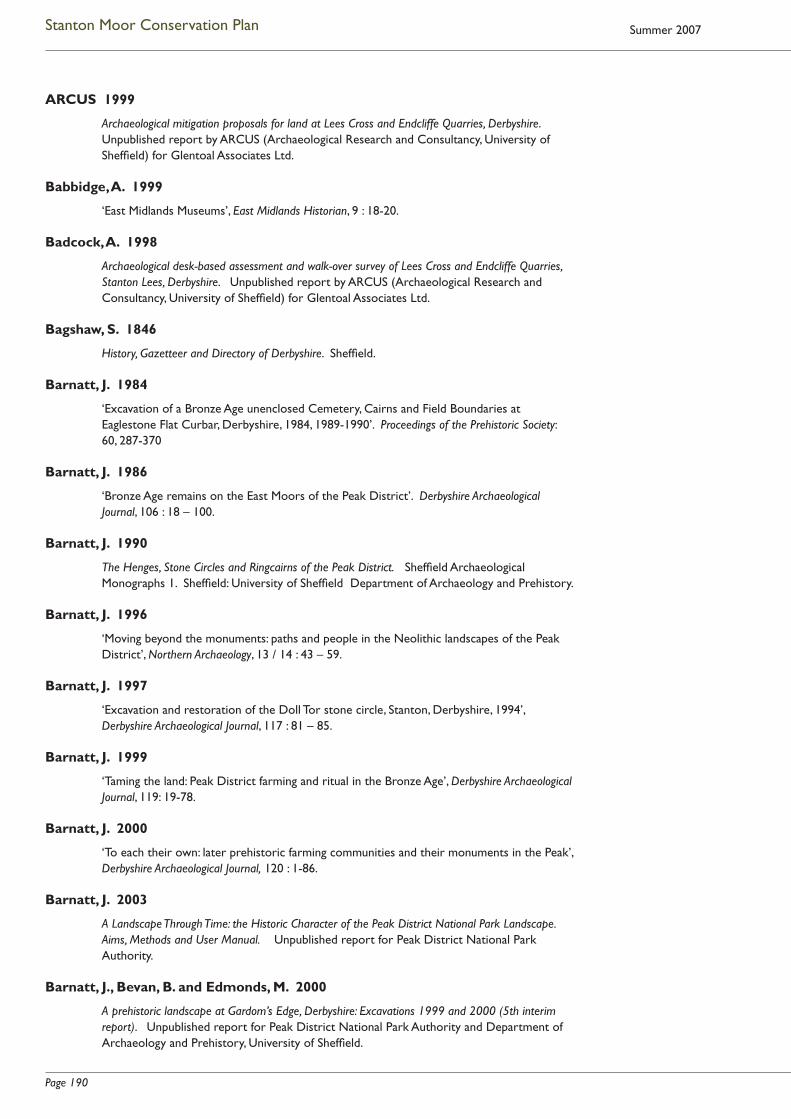
Page 190
Stanton Moor Conservation Plan Summer 2007
ARCUS 1999
Archaeological mitigation proposals for land at Lees Cross and Endcliffe Quarries, Derbyshire. Unpublished report by ARCUS (Archaeological Research and Consultancy, University of Sheffi eld) for Glentoal Associates Ltd.
Babbidge, A. 1999
‘East Midlands Museums’, East Midlands Historian, 9 : 18-20.
Badcock, A. 1998
Archaeological desk-based assessment and walk-over survey of Lees Cross and Endcliffe Quarries, Stanton Lees, Derbyshire. Unpublished report by ARCUS (Archaeological Research and Consultancy, University of Sheffi eld) for Glentoal Associates Ltd.
Bagshaw, S. 1846
History, Gazetteer and Directory of Derbyshire. Sheffi eld.
Barnatt, J. 1984
‘Excavation of a Bronze Age unenclosed Cemetery, Cairns and Field Boundaries at Eaglestone Flat Curbar, Derbyshire, 1984, 1989-1990’. Proceedings of the Prehistoric Society: 60, 287-370
Barnatt, J. 1986
‘Bronze Age remains on the East Moors of the Peak District’. Derbyshire Archaeological Journal, 106 : 18 – 100.
Barnatt, J. 1990
The Henges, Stone Circles and Ringcairns of the Peak District. Sheffi eld Archaeological Monographs 1. Sheffi eld: University of Sheffi eld Department of Archaeology and Prehistory.
Barnatt, J. 1996
‘Moving beyond the monuments: paths and people in the Neolithic landscapes of the Peak District’, Northern Archaeology, 13 / 14 : 43 – 59.
Barnatt, J. 1997
‘Excavation and restoration of the Doll Tor stone circle, Stanton, Derbyshire, 1994’, Derbyshire Archaeological Journal, 117 : 81 – 85.
Barnatt, J. 1999
‘Taming the land: Peak District farming and ritual in the Bronze Age’, Derbyshire Archaeological Journal, 119: 19-78.
Barnatt, J. 2000
‘To each their own: later prehistoric farming communities and their monuments in the Peak’, Derbyshire Archaeological Journal, 120 : 1-86.
Barnatt, J. 2003
A Landscape Through Time: the Historic Character of the Peak District National Park Landscape. Aims, Methods and User Manual. Unpublished report for Peak District National Park Authority.
Barnatt, J., Bevan, B. and Edmonds, M. 2000
A prehistoric landscape at Gardom’s Edge, Derbyshire: Excavations 1999 and 2000 (5th interim report). Unpublished report for Peak District National Park Authority and Department of Archaeology and Prehistory, University of Sheffi eld.
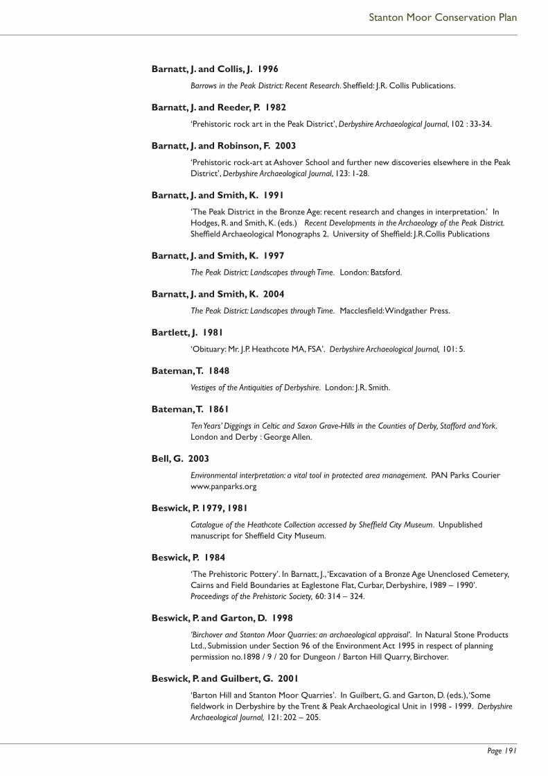
Page 191
Stanton Moor Conservation Plan
Barnatt, J. and Collis, J. 1996
Barrows in the Peak District: Recent Research. Sheffi eld: J.R. Collis Publications.
Barnatt, J. and Reeder, P. 1982
‘Prehistoric rock art in the Peak District’, Derbyshire Archaeological Journal, 102 : 33-34.
Barnatt, J. and Robinson, F. 2003
‘Prehistoric rock-art at Ashover School and further new discoveries elsewhere in the Peak District’, Derbyshire Archaeological Journal, 123: 1-28.
Barnatt, J. and Smith, K. 1991
‘The Peak District in the Bronze Age: recent research and changes in interpretation.’ In Hodges, R. and Smith, K. (eds.) Recent Developments in the Archaeology of the Peak District. Sheffi eld Archaeological Monographs 2. University of Sheffi eld: J.R.Collis Publications
Barnatt, J. and Smith, K. 1997
The Peak District: Landscapes through Time. London: Batsford.
Barnatt, J. and Smith, K. 2004
The Peak District: Landscapes through Time. Macclesfi eld: Windgather Press.
Bartlett, J. 1981
‘Obituary: Mr. J.P. Heathcote MA, FSA’. Derbyshire Archaeological Journal, 101: 5.
Bateman, T. 1848
Vestiges of the Antiquities of Derbyshire. London: J.R. Smith.
Bateman, T. 1861
Ten Years’ Diggings in Celtic and Saxon Grave-Hills in the Counties of Derby, Stafford and York. London and Derby : George Allen.
Bell, G. 2003
Environmental interpretation: a vital tool in protected area management. PAN Parks Courier www.panparks.org
Beswick, P. 1979, 1981
Catalogue of the Heathcote Collection accessed by Sheffi eld City Museum. Unpublished manuscript for Sheffi eld City Museum.
Beswick, P. 1984
‘The Prehistoric Pottery’. In Barnatt, J., ‘Excavation of a Bronze Age Unenclosed Cemetery, Cairns and Field Boundaries at Eaglestone Flat, Curbar, Derbyshire, 1989 – 1990’. Proceedings of the Prehistoric Society, 60: 314 – 324.
Beswick, P. and Garton, D. 1998
‘Birchover and Stanton Moor Quarries: an archaeological appraisal’. In Natural Stone Products Ltd., Submission under Section 96 of the Environment Act 1995 in respect of planning permission no.1898 / 9 / 20 for Dungeon / Barton Hill Quarry, Birchover.
Beswick, P. and Guilbert, G. 2001
‘Barton Hill and Stanton Moor Quarries’. In Guilbert, G. and Garton, D. (eds.), ‘Some fi eldwork in Derbyshire by the Trent & Peak Archaeological Unit in 1998 - 1999. Derbyshire Archaeological Journal, 121: 202 – 205.
Page 192
Stanton Moor Conservation Plan Summer 2007
Bevan, B. 1995
Robin Hood’s Stride, Harthill and Elton, Derbyshire: archaeological survey. Unpublished survey for Peak District National Park Authority.
Bevan, B. 2000 (a)
‘Peak Practice: whatever happened to the iron age in the southern Pennines?’ In Harding, J. and Johnston, R. (eds.), Northern Pasts: interpretations of the later prehistory of northern England and southern Scotland. British Archaeological Reports, British Series 302. Oxford: Archaeopress.
Bevan, B. 2000 (b)
Peak District Romano-British Rural Upland Settlement Survey 1998 - 2000. Unpublished survey for Peak District National Park Authority.
Bevan, B. 2004
‘Drama on Gardom’s Edge. The use of theatre groups in public interpretation of prehistory’. In Frodsham, P. (ed.), Interpreting the Ambiguous: archaeology and interpretation in early 21st century Britain. British Archaeological Reports, British Series 362. Oxford.
Bevan, B., Barnatt, J., Dymond, M., Edmonds, M. and McElearney,G. 2004
‘Public prehistories: engaging archaeology on Gardom’s Edge, Derbyshire’. In Henson, D., Stone, P. and Corbishley, M. (eds.), Education and the Historic Environment. London: Routledge.
Bicknell, P. 1981
Beauty, Horror and Immensity: Picturesque Landscape in Britain, 1750 – 1850. Cambridge: Fitzwilliam Museum.
Blain, J. and Wallis, R.J. 2002
Contemporary Paganism and Archaeology: Irreconcilable? Text of presentation to conference, ‘Archaeology in the Public Domain’, held at the University of Sheffi eld, 9 March 2002.
Blain, J. and Wallis, R.J. 2004a
Comments on Stanton Moor with respect to Lees Cross and Endcliffe quarrying proposals: landscape, spiritual meanings and pagan objections to proposals.
Unpublished comments submitted to Peak District National Park Authority, 4 March 2004.
Blain, J. and Wallis, R.J. 2004b
‘Sacred Sites, Contested Rites / Rights: contemporary pagan engagements with the past’. Journal of Material Culture, 9 (3): 237 – 261.
Blain, J. and Wallis, R.J. 2004c
Draft outline proposal for ethnographic work within the Peak District National Park: spiritual dimensions of the Park and implications for recognising and developing spiritual tourism. Unpublished draft proposal for submission to PDNPA.
Blease-Bourne, A. 2004
Imagining Places: Memory, Discourse and Identity. Unpublished MA dissertation for the University of Staffordshire.
Bowmer, C. 1998
Stanton Moor Local Interpretive Plan. Unpublished report commissioned for English Heritage by the Peak District National Park Authority.

Page 193
Stanton Moor Conservation Plan
Brindley, F.H. 1926
‘Peak Discovery: Site of Ancient Burial Ground. Urns unearthed’, Sheffi eld Daily Telegraph 20th Oct. 1926.
Carrington, W.A. 1893
‘Illustrations of Ancient Place-Names in Bakewell and the Vicinity, from original Archives preserved at Haddon Hall, and from other sources’. Journal of the Derbyshire Archaeological and Natural History Society,15: 31-64.
Chapman, J. 2004
Stanton Moor Tourism Project. Submitted as part of assessed work for GCSE in Geography, 2004.
Christian, R. 1984
‘The village of Birchover’, Derbyshire Life and Countryside, 49 (7): 34-36.
Colcutt, S. 1999
‘The Setting of Cultural Heritage Features’, Journal of Planning and Environment Law, JUN: 498 - 513.
Cooper, B. 1991
Transformation of a Valley: the Derbyshire Derwent. Cromford: Scarthin Books.
Copeland, T. 2004
‘Interpretations of history: constructing pasts’. In Henson, D., Stone, P and Corbishley, M. (eds.), Education and the Historic Environment London: Routledge.
Cox, J.C. 1877
Notes on the Churches of Derbyshire, volume II. London: Bemrose and Sons.
Crossley, D. 1994
Post-Medieval Archaeology in Britain. Leicester: Leicester University Press.
Crossley, D. & Kiernan, D. 1992
‘The Lead-Smelting Mills of Derbyshire’. Derbyshire Archaeological Journal, 112 : 6-47.
Croston, J. 1868
On Foot through the Peak. Manchester.
Denton, N., Bate, R., Reeves, R. and Tickle, A. 2004
Old Mineral Permissions and National Parks. Report on behalf of the Council for National Parks and the Friends of the Peak District.
Drury, J. 2001
Memories of Birchover. Birchover Reading Room.
Dymond, M. 1998
‘Not just a day out! Archaeology and Education on the Gardom’s Edge Project.’ Assemblage 4 University of Sheffi eld: www.shef.ac.uk/assem/4
Edmonds, M. and Seaborne, T. 2001
Prehistory in the Peak. Stroud: Tempus

Page 194
Stanton Moor Conservation Plan Summer 2007
English Heritage 1990
Monument Class Descriptions prepared under the Monuments Protection Programme. www.eng-h.gov.uk/mpp/mcd
English Heritage 1995
Bronze Age burial, ceremonial and settlement remains on Stanton Moor, and evidence for medieval, post-medieval and 19th to early 20th century activity. (National Monument No. 23315). Entry in the Schedule of Monuments compiled under Section 1 of the Ancient Monuments and Archaeological Areas Act of 1979, as amended.
English Heritage 1996a
Sustainability and the Historic Environment. Report prepared for English Heritage by Land Use Consultants and C.A.G. Consultants.
English Heritage 1996b
Hillcarr Sough and associated lime kiln and paved track. (National Monument No. 27222). Entry in the Schedule of Monuments compiled under Section 1 of the Ancient Monuments and Archaeological Areas Act of 1979, as amended.
English Heritage 2001
Using Prehistory as a Local Study: Information for Teachers. London: English Heritage Education.
English Heritage 2004
Citizenship: Using the evidence of the historic environment. A Teacher’s Guide. London: English Heritage Education.
Everson, P. 1989
‘Field survey by RCHME on the gritstone moorlands of the Derbyshire Peak District: Stanton Moor’. In Gibson, A. (ed.), Midlands Prehistory: some recent and current researches into the prehistory of central England. British Archaeological Reports, British Series 204. Oxford.
Farey, J. 1811
General View of the Agriculture and Minerals of Derbyshire, Vol. 1. Reprinted by Peak District Mines Historical Society, 1989.
Fearn, K. and Humble, J. 2003
Scheduled Monuments at Risk: a pilot study in the East Midlands. English Heritage
Firth, J.B. 1920
Highways and Byways in Derbyshire. London: MacMillan (reprint of 1905 edition).
Ford, T.D. and Rieuwerts, J.H. 1983
Lead Mining in the Peak District. (3rd edition) Bakewell: Peak Park Joint Planning Board
Ford, T.D. and Rieuwerts, J.H. 2000
Lead Mining in the Peak District. (4th edition) Matlock Bath and Ashbourne: Peak District Mines Historical Society and Landmark Publishing
Foss, A. 1986
The Dukes of Britain. London: Herbert Press

Page 195
Stanton Moor Conservation Plan
Garton, D. 2002
Nine Ladies, Stanton Moor: Evaluation of the Embanked Stone Circle and Outlier, November 2000. Unpublished report prepared for English Heritage by the Trent & Peak Archaeological Unit.
Gibson, A. 2002
Prehistoric Pottery in Britain & Ireland. Stroud : Tempus
Guilbert, G. and Malone, S. 1997
Nine Ladies, Stanton Moor, Derbyshire. Survey, November 1997. Unpublished report by Trent & Peak Archaeological Trust for English Heritage and Peak District National Park Authority.
Guilbert, G. and Malone, S. 1999
‘Nine Ladies, Stanton Moor’. In Guilbert, G. (ed.) ‘Fieldwork by Trent & Peak Archaeological Trust in Derbyshire 1997’. Derbyshire Archaeological Journal, 119: 288 - 290.
Harris, H. 1992
Industrial Archaeology of the Peak District. Ashbourne: Ashbourne Editions. (Reprint of David and Charles 1971 edition.)
Hart, Clive R. 1981
The North Derbyshire Archaeological Survey to A.D. 1500. Chesterfi eld: North Derbyshire Archaeological Trust.
Hart, Clive R. 1985
‘Stanton Moor, Derbyshire: Burial and Ceremonial Monuments’. In Spratt, D. and Burgess, C. (eds.), Upland Settlement in Britain: the 2nd Millennium BC and after. British Archaeological Reports, British Series 143. Oxford.
Hart, Cyril H. 1975
Early Charters of Northern England and the North Midlands. Leicester: Leicester University Press.
Heathcote, J.P.1930
‘Excavations at Barrows on Stanton Moor’, Derbyshire Archaeological Journal, 51 (New Series Vol. 4): 1 - 44.
Heathcote, J. P. 1936
‘Further excavations on Stanton Moor’, Derbyshire Archaeological Journal, 57 (New Series Vol.10): 21 - 42
Heathcote, J. P. 1938
‘Stanton Moor’, Derbyshire Archaeological Journal, 59 (New Series 12 for 1938, published 1939): 83.
Heathcote, J. P. 1939a
‘Excavations on Stanton Moor’. Derbyshire Archaeological Journal, 60 (New Series 13): 105 – 115.
Heathcote, J. P. 1939b
‘Excavations at Doll Tor Stone Circle, Stanton Moor’, Derbyshire Archaeological Journal, 60 (New Series 13): 116 – 125.

Page 196
Stanton Moor Conservation Plan Summer 2007
Heathcote, J.P. 1947
Birchover: Its Prehistoric and Druidical Remains. Private publication.
Heathcote, J.P. 1954
‘Excavations on Stanton Moor’, Derbyshire Archaeological Journal, 74 : 128 -132.
Heathcote, J.P. 1980
‘The Nine Ladies Stone Circle’, Derbyshire Archaeological Journal, 100 : 15 – 16.
Hey, D. 1996
The Oxford Companion to Local and Family History. Oxford: Oxford University Press.
Hodges, R. 1991
Wall-to-Wall History: the story of Roystone Grange. London: Duckworth.
Horsley, T.J. 1998
Nine Ladies stone circle, Stanton Moor, Derbyshire: Report on geophysical survey, 1998. Ancient Monuments Laboratory Report, 68 / 98.
Howarth, E. 1899
Catalogue of the Bateman Collection of Antiquities in the Sheffi eld Public Museum. London.
Isherwood, R. 2004
Meanings and Values within a Contested Landscape: the case of the Nine Ladies Stone Circle, Stanton Moor, Derbyshire. Unpublished MA dissertation for Department of Art History and Archaeology, University of Manchester.
Johnston, R. 2001
‘Breaking new ground: land tenure and fi eldstone clearance during the Bronze Age’. In Bruck, J.A. (ed.) Bronze Age Landscapes: Tradition and Transformation. Oxford: Oxbow.
Kiernan, D. 1989
The Derbyshire Lead Industry in the Sixteenth Century. Chesterfi eld: Derbyshire Record Society.
Kirkham, N. 1968 / 1969
‘Early Lead Smelting in Derbyshire’, Transactions of the Newcomen Society, 61 : 119-138.
Lasdun, S. 1991
The English Park: Royal, Private and Public. London: André Deutsch.
Lister, J.A. and Alexander, K.N.A. 2002
Stanton Moor Edge, Derbyshire (South Peak Estate): Nature Conservation Evaluation. National Trust Conservation Directorate.
Long, D.J., Chambers, F.M. and Barnatt, J. 1998
‘The palaeoenvironment and the vegetation history of a later prehistoric fi eld system at Stoke Flat on the gritstone uplands of the Peak District’, Journal of Archaeological Science, 25: 505 - 519.

Page 197
Stanton Moor Conservation Plan
Longworth, I.H. 1984
Collared Urns of the Bronze Age in Great Britain and Ireland. Cambridge: Cambridge University Press.
Makepeace G.A. 1998
‘Romano-British rural settlements in the Peak District and North-East Staffordshire’, Derbyshire Archaeological Journal, 118: 95 - 138.
Makepeace G.A. 1999
‘Cratcliff Rocks: a forgotten hillfort on Harthill Moor, near Bakewell, Derbyshire’. Derbyshire Archaeological Journal, 119: 12 - 18.
Manby, T.R. 1957
‘Food Vessels of the Peak District’, Derbyshire Archaeological Journal, 77 : 1 - 29.
M.A.P. 2003
Lees Cross and Endcliffe Quarries, Stanton-in-Peak, Derbyshire: desk-based assessment and walkover. Unpublished report by M.A.P. Archaeological Consultancy Ltd. for Stancliffe Stone Co. Ltd.
M.A.P. n.d.
Endcliffe and Lees Cross Quarries, Stanton in the Peak, Derbyshire: photographic survey and archaeological evaluation. Unpublished report by M.A.P. Archaeological Consultancy Ltd. for Stancliffe Stone Co. Ltd.
Marsden, B.M. 1977
The Burial Mounds of Derbyshire. Private publication.
Marsden, B.M. 1999
The Early Barrow Diggers. Stroud: Tempus
Meeke, E.R. 1996
White Watson: Bakewell’s Only Famous Man. Private publication.
Morgan, P. (ed.) 1978
Domesday Book: Derbyshire. Chichester: Phillimore.
Mount, D. (ed.) 2001
Peak District Interpretation Strategy: guidance for organisations and individuals who interpret the Peak District for visitors and local people. Unpublished guidance prepared for the Peak District Interpretation Project.
O’Neill, R. 2002
Archaeological survey and trial trench at New Pilhough Quarry, Stanton-in-Peak, Derbyshire (Project report 680.1). Unpublished report for ARCUS (Archaeological Research and Consultancy at the University of Sheffi eld).
O’Neill, R. 2004
Archaeological Watching Brief (Haul Road) at New Pilhough Quarry, Stanton-in-Peak, Derbyshire. Unpublished report prepared for Mineral Planning Group by ARCUS (Archaeological Research and Consultancy at the University of Sheffi eld).
Page 198
Stanton Moor Conservation Plan Summer 2007
Opie , I. and Opie, P. (eds.) 1992
The Oxford Dictionary of Nursery Rhymes. Oxford: Oxford University Press.
Page, W. (ed.) 1905 (reprinted 1970)
Victoria County History of Derbyshire, Volume 1. London: Dawson’s. (Reprint of London: Constable edition.)
PDNPA n.d.
Peak District National Park Management Plan, 2000 – 2005. Bakewell: Peak District National Park Authority.
PDNPA 2001
Peak District Bio-Diversity Action Plan. Bakewell: Peak District National Park Authority.
PDNPA 2004
PDNPA Access and Recreation Service: Action Plan 2004–2005. Unpublished report for Peak District National Park Authority.
Pegge, Rev. 1787
‘Observations by the Rev. Mr. Pegge on the Stanton Moor Urns and Druidical Temple in a letter to Mr. Rooke. Read Nov. 2nd 1785. ‘ Archaeologia, 8: 58-61.
Powell, A. 1951-1975
A Dance to the Music of Time. London: Heinemann.
Rackham, O. 1996
Trees and Woodland in the British Landscape. London: Phoenix
Radley, J. 1967
‘A Bronze Age Ring-Work on Totley Moor and other Bronze Age Ring-Works in the Pennines’, Archaeological Journal, 123 (for 1966): 1-26.
RCHME 1986
Stanton Moor, Derbyshire. A Catalogue of Archaeological Monuments. Unpublished report. National Monuments Record, NMR no. SK26SW12.
Rhodes, E. 1824
Peak Scenery or The Derbyshire Tourist. London: Longman et al.
Rodgers, F. 1992
Curiosities of the Peak. Derby: Derbyshire Countryside Ltd.
Rooke, H. 1782
‘An account of some Druidical Remains on Stanton and Hartle Moor in the Peak, Derbyshire. Read 6th April 1780’. Archaeologia, 6: 110 - 115.
Rooke, H. 1789
‘Description of some Druidical Remains on Harborough Rocks etc. in Derbyshire. Read November 6th 1788’. Archaeologia, 9: 206-210.
Sawyer, P. (ed.) 1979
Charters of Burton Abbey. Oxford: Oxford University Press.

Page 199
Stanton Moor Conservation Plan
Sidebottom, P. 1996
Archaeological survey of Home Farm, Rowsley. Unpublished survey for Peak District National Park Authority.
Sinar, J.C. n.d.
Stanton-in-the-Peak. Unpublished research by the County Archivist, Derbyshire County Council, for Peak District National Park Authority.
Smith, K. 1998
The Nine Ladies Stone Circle and King Stone, Stanton Moor, Derbyshire, in the Peak District National Park: A Research Design. (March 1998). Unpublished report commissioned from Peak District National Park Authority by English Heritage.
Smith, K. 1999a
The Nine Ladies Stone Circle and King Stone, Stanton Moor, Derbyshire, in the Peak District National Park: Phase 1 Report (June 1999). Unpublished report commissioned from Peak District National Park Authority by English Heritage.
Smith, K. 1999b
The Nine Ladies Stone Circle and King Stone, Stanton Moor, Derbyshire, in the Peak District National Park: Phase 1 Report: Options Supplement (September 1999). Unpublished report commissioned from Peak District National Park Authority by English Heritage.
Stafford, P. 1985
The East Midlands in the Early Middle Ages. Leicester: Leicester University Press.
Stetka, J. 2001
The shaping of the landscape of Bakewell in the 10th century. Private publication.
Storrs Fox, W. 1927
‘Bronze Age Pottery from Stanton Moor’, Journal of the Derbyshire Archaeological and Natural History Society, 49 : 199-209.
Strange, P. 2000
A Geophysical Survey at Endcliffe Quarry, Stanton Lees, Derbyshire. Unpublished report for Glentoal Associates.
Thornhill, I. 1862
A History of Derbyshire, illustrated by Isabella Thornhill.
Derbyshire Record Offi ce: DRO D258 / 54 / 1 – 6.
Tilbury,L. and Bowden, M. 2001
Using Prehistory as a Local Study. London: English Heritage.
Tucker, D.G. 1985
‘Millstone making in the Peak District of Derbyshire: the quarries and the technology’, Industrial Archaeology Review, 8 (1): 42-58.
Turbutt, G.H. 1999
A History of Derbyshire. Cardiff: Merton Priory Press.
Page 200
Stanton Moor Conservation Plan Summer 2007
Vine, P.M. 1982
The Neolithic and Bronze Age cultures of the Middle and Upper Trent Basin. British Archaeological Reports, British Series 105, Oxford.
Walker, T. 2003
Disability Access Audit: Nine Ladies Stone Circle, Derbyshire. Unpublished report for English Heritage.
Ward, J. 1891
‘Cinerary Urns and Incense Cups, Stanton Moor, Derbyshire’. Journal of the Derbyshire Archaeological and Natural History Society, 13 : 45-51.
Ward, J. 1900
‘Cinerary Urns recently discovered on Stanton Moor, Derbyshire’. The Reliquary and Illustrated Archaeologist, 6 : 25-31.
Ward, J. 1908
‘Notes on some Derbyshire Antiquities from Samuel Mitchell’s Memoranda’. Journal of the Derbyshire Archaeological and Natural History Society, 30 : 155-172.
Watkins, A. 1925
The Old Straight Track. London: Methuen.
Watson, J.R. 1970
Picturesque Landscape and English Romantic Poetry. London: Hutchinson Education.
Willies, L., Gregory, K. and Parker, H. 1989
Millclose: the Mine that Drowned. Cromford: Scarthin Books.
Wood, A. 1999
The Politics of Social Confl ict: The Peak Country 1520 – 1770. Cambridge: Cambridge University Press.
Wright, G.T. 1906
Longstone Records. Private publication.
Archive Sources
Derbyshire Record Offi ce (DRO)
Specifi c records cited in text:
DRO Q / RI 4 / 171: Stanton-in-Peak Enclosure Award
DRO D 504 / 113 / 1-3: Sale of the Duke of Rutland’s Estate 1920
Derbyshire Sites and Monuments Record (SMR)
SMR reference numbers given in text (e.g. ‘Derbyshire SMR 1605’) refer to the County Sites and Monuments Record (now the Historic Environment Record) held by Derbyshire County Council and by the Peak District National Park Authority.
Sheffi eld City Museum (SCM)
SCM reference numbers given in text (e.g. ‘SCM 1979: 1098’) refer to the collections reference system used by the former Sheffi eld City Museum (now Weston Park Museum Sheffi eld).

Page 201
Stanton Moor Conservation Plan
Appendix B
Stanton Moor Conservation Plan Consultees
The following took part in formal consultation interviews to assist the development of this Conservation Plan, and / or provided comments on the Plan draft.
Mr. D. Bent
Minerals Team Manager, Peak District National Park Authority
Mr. J. Cuthbert
Glentoal Associates Ltd., representing Birchover Stone Ltd, and local resident.
Mr. A. Davie-Thornhill
Representative of the Trustees of the Thornhill Settlement; land agent / manager of the Stanton Estate; landowner and local resident
Ms. J. Gregory
Director, Block Stone Ltd., and local resident.
Mr. N. Hanshaw
Area Ranger, Peak District National Park Authority
Miss J. Harker
Senior Minerals Planner, Peak District National Park Authority
Mr. J. Humble
Inspector of Ancient Monuments, English Heritage
Cllr. Mrs L. Hurford
Stanton-in-Peak Parish Council; local resident
Julie, Jules, Wookie, Malcolm and Ruth:
Members of the Stanton Moor / Nine Ladies protest camp.
Cllr. A. Martin
Chairman, Stanton-in-Peak Parish Council.
Mr. M. Metcalfe
Head of Minerals and Waste Management, Carter Jonas, representing Stancliffe Stone Co. Ltd.
Mr. M. Millmore
Director, Mineral Planning Group; consultant to Stancliffe Stone, Block Stone Ltd. and Birchover Stone
Mr. P. Mortimer
Countryside Manager, National Trust South Peak Estate
Mrs. R. Penny
Countryside & Economy Adviser, Peak District National Park Authority

Page 202
Stanton Moor Conservation Plan Summer 2007
Mr. and Mrs. Renwick
Tenant graziers, Stanton Moor
Mr. J. Stewart
Deputy Area Manager, English Nature (now Team Leader, Peak to Trent Area Team, Natural England)
Mr. R. Thomas
Manager, Ecology Team, Peak District National Park Authority
Dr. A. Tickle
Head of Conservation and Planning, Friends of the Peak District
In addition to the above, Birchover Parish Council made an initial contribution to the consultation process.
The Haddon Estate indicated that it did not wish to take up an invitation to take part in consultation.
Page 203
Stanton Moor Conservation Plan
Glossary
Ancient Woodland
Defi ned by English Nature (now Natural England) as areas of woodland that are known to have had continuous tree cover since at least AD 1600 or have been managed as woodlands throughout that period, where they have not been clear-felled and cultivated. The fl oral diversity of such woodland is indicative of its ancient origin, with often rare herbs surviving in the ground fl ora. In the Peak District, where historic map or documentary evidence is unavailable, the species indicators alone have been used by English Nature to categorise specifi c woods as of this type.
Anglian/ Anglo-Saxon
The period of English history dominated by the settlement of Northern Europeans in the eastern counties of England. It dates from the collapse of the Roman economy during the early fi fth century AD, to the Norman Conquest of 1066. In the Midlands settlement was dominated by the Angles, hence the term Anglian. It also includes infl uences from occupying Scandinavians during the 200 years before the Normans arrived. The early part of the Saxon period is sometimes known as the Dark Ages because of the lack of historical documentation for this period. In the Peak District, there is little evidence for extensive intrusion of Anglo-Saxon people or cultural ideas until the seventh century.
Assemblage
1. All of the artefacts found at an archaeological site.
2. An associated set of contemporary artefacts that can be considered as a single unit for archaeological record and analysis.
Axe hammer
A large and usually heavy type of perforated stone axe with a broad, fl at butt and a tapered blade. Stone examples found in NEOLITHIC and early BRONZE AGE contexts in Northern Europe may be copies of copper and bronze examples current at the time in Central Europe. Their purpose is unknown.
Barbed and tanged arrowhead
Triangular-shaped fl int arrowhead of the later NEOLITHIC and early BRONZE AGE in Europe. Distinctive in having a short rectangular tang on the base opposite the point, with a barb set symmetrically on either side of it. The tang was used to secure the arrow tip to its shaft and usually projects slightly below the ends of the barbs.
Barrow
A burial site covered by a mound of earth or stone. The mounds are usually round and date from the later NEOLITHIC to early BRONZE AGE, from about 2500 to 1500 BC. They often contain several burials, some accompanied by simple funerary or grave goods: gold and silver objects are not found in prehistoric round barrows in the Peak District. A few small barrows were also built by the Anglian inhabitants of the region around 600 to 700 AD.
Battle axe
Type of perforated stone implement dating to the later NEOLITHIC and early BRONZE AGE in southern, eastern and northern Europe, with a solid body, centrally-placed shaft hole and slightly concave outline when viewed in profi le. There is a great variety in form.
Beaker
A type of late NEOLITHIC and early BRONZE AGE ceramic vessel, distinctive in its type and range of shapes and style of decoration.

Page 204
Stanton Moor Conservation Plan Summer 2007
Bell pit
A bell-shaped pit used in early coal mining. Where coal lay near the surface, a narrow, vertical shaft was sunk into the seam, and then opened out to form a small chamber at the level of the seam.
Biconical Urn
Style of early BRONZE AGE pot with a deep, largely plain, outwardly-fl ared body above which is sharp carination (inward change of direction), usually decorated, and an inwardly angled neck. The neck is usually decorated with impressed cord designs, and the rim is typically bevelled and lightly ornamented.
Bole
A primitive furnace for smelting lead, used between the 12th and late 16th centuries. Boles were often located on the tops of west-facing hills or scarps, to take advantage of the prevailing wind.
Bouldering
Basic or intermediate climbing carried out on small rocks that can be traversed without great risk of bodily harm in the case of a fall. It focuses on individual moves rather than endurance. Climbers rarely go higher than a few metres, and may also put a crash pad / bouldering mat on the ground to break their fall.
Bronze Age
In Britain, the prehistoric period which comes between the NEOLITHIC and the IRON AGE, dating roughly from 2000 to 800 BC. The period saw the introduction of metals, and farmers began to use fi elds in a sustained way. In the fi rst half of the BRONZE AGE people continued to use ritual sites such as barrows and stone circles, but few if any of these monuments were built after about 1500 BC.
Bronze socketed axe
(See SOCKETED AXE)
Building platform
When buildings are constructed, the ground is sometimes levelled by cutting into a slope, and/or by building up one side to create a level terrace. Often the sites of demolished timber or stone buildings can still be identifi ed by a surviving building platform. Prehistoric examples are commonly circular, while from the ROMAN period onwards they tend to be rectangular.
Buried soil
An ancient soil profi le that has become sealed beneath younger material, or beneath some kind of structure, so that there is marked vertical separation between the older soil profi le and the more recent ground surface. Buried soils represent important sources of information for understanding the former environment and land use in an area.
Cairns: clearance and funerary
A clearance cairn is a pile of stones, often relatively small, which has been gathered into a heap in preparation of the adjacent ground for cultivation. In the Peak District the majority are of prehistoric date. However, later examples are known, including some made in the twentieth century.
A funerary cairn is a deliberately constructed pile of stones or stone rubble, forming a burial mound, or small BARROW.
Funerary and other deposits found in some prehistoric clearance cairns indicate that they sometimes had a dual function.

Page 205
Stanton Moor Conservation Plan
Chapel of ease
A building used for religious worship that was created for the ease of the inhabitants of an outlying part of a parish.
Cinerary Urn
A ceramic vessel used to contain the cremated remains of one or more individuals for burial. Such urns were not always specifi cally made for the purpose.
Cist
Stone-lined burial pit, sometimes sealed within or below a BARROW mound or funerary cairn, within which cremation or inhumation burials were placed. The stone walls sometimes supported a fl at cover-slab.
Collared Urn
A type of early and middle BRONZE AGE CINERARY URN found extremely widely in Britain. Although there are a range of forms, the basic characteristics include a small, fl at base, a conical body, and a heavy overhanging rim or collar which is usually ornamented with incised or impressed decoration.
Commons
A term used from the MEDIEVAL period onwards for the extensive parts of a parish/township that were not divided into fi elds and were used communally for grazing of stock and for acquiring resources such as fi rewood and peat. The term largely went out of use in the 18th/19th centuries when the commons were enclosed.
Cordoned Urn
A type of middle BRONZE AGE pottery found mainly in the northern part of Britain. They are generally tall, straight-sided vessels with a fl at base, slightly fl aring body and a simple rim. The outer face is decorated with applied cordons which often defi ne regions of the surface which are ornamented with incised decoration.
Dew Pond
An artifi cially-constructed pond used to collect rainwater for cattle.
Dimensional stone
Building stone
Early Medieval
A term often used for the ANGLO-SAXON period, i.e. from the collapse of the Roman occupation during the 5th century AD until the Norman Conquest in 1066 AD. However, only the later Anglo-Saxon period can be strictly called “Medieval”, a period distinguished by the development of towns, nucleated settlements and an organised agrarian landscape.
Earlier Prehistoric
A term used here to denote the time when humans subsisted by hunting and gathering, before the advent of farming around 6000 years ago.
Embanked stone circle
A type of stone circle in which the pillars of the main ring are set within or on top of a low stone or earth bank. They are relatively common in the Peak District, where they are often associated with the early BRONZE AGE. They are less common elsewhere, although there are examples in Yorkshire and Wales. They may have been built by local communities as places of ritual and seasonal celebration, and, in the Peak District, are often associated with RING CAIRNS.
Page 206
Stanton Moor Conservation Plan Summer 2007
Enclosure Act; Enclosure Award
Between the mid eighteenth and mid nineteenth centuries a large amount of waste and common land was enclosed in the Peak District and other parts of England and Wales. This drive towards enclosure was motivated by landowners’ belief in the need for agricultural improvement. To enclose land, the distribution of the newly enclosed fi elds to farmers and other landowners had to be approved: such approval could be via an Act of Parliament or by private agreement between local landowners and others with traditional land rights. In all legally ratifi ed cases, and some privately agreed examples, an enclosure award (which set down the agreed extent and layout of the enclosure in writing) and a corresponding plan were drawn up. The level of accuracy and detail that allotment boundaries were planned to is usually good, but in many cases the subdivisions into individual fi elds were not shown. In the case of Parliamentary Awards these were often done on a parish by parish basis.
Faience
Blue-coloured artifi cial glass-like material made from baked sand and clay and used for the manufacture of a variety of ornaments and pieces of jewellery in prehistoric times.
Field system
Groups of fi elds can sometimes be recognised which were created as planned units or ‘fi eld systems’. In the Peak District no prehistoric examples are known, as all identifi ed fi elds of this date appear to be created in gradual aggregated fashion rather than being systematically planned. Planned fi eld systems may start in the ROMANO-BRITISH period, while much of the present farmed landscape comprises MEDIEVAL or POST-MEDIEVAL fi eld systems.
Flat cemetery
An area of burials not marked by a mound or any kind of upstanding earthwork.
Food Vessel
A type of early BRONZE AGE pot found in northern Britain and Ireland. The name derives from an antiquarian suggestion about the vessels’ possible use. Heavily decorated, they are usually either biconical or bowl-shaped, usually in fi ne fabrics. They are mainly associated with cremation burials.
Fossilised cultivation strips
From at least as early as 1350 AD the open cultivation strips within the medieval STRIP FIELDS of the Peak District began to be enclosed. In some cases, the narrow, elongated form of the cultivation strips (often with distinctive curved sides forming a ‘reversed-S’ shape) has been preserved (‘fossilised’) by the enclosing walls. Taken together, these enclosures often allow the extent and character of the medieval strip fi eld to be recognised. Enclosure of the strip fi elds usually happened piecemeal, with small parcels created which vary in date from the fourteenth century to the eighteenth century.
Greywacke
Any coarse-grained, usually dark, sandstone containing angular mineral and rock fragments in a fi ne-grained clayey matrix or body.
Gritstone
A coarse-grained and rough-weathering sandstone.
Guardianship monument
The legislative procedure for introducing monuments into State Guardianship was introduced in 1882, under the Ancient Monuments Protection Act of that year. Under this and successor legislation, it is the responsibility of the Secretary of State (or another body acting on his / her behalf) to maintain the monument. The Guardian is given full powers of control and management, subject to any conditions specifi ed in the Deed of Guardianship.

Page 207
Stanton Moor Conservation Plan
Heft / hefted
‘Hefted’ is a local term applied to sheep which instinctively know their territory, and do not need fences. They are typically found in upland areas of Britain such as the Lake District. Such sheep are familiar with their own part of the mountain, and will return to it instinctively, passing on this knowledge to their offspring.
Hollow-way
The line of a routeway, usually disused, eroded into a gully during its use in the past. Some major routes may be extensive networks of braided tracks running parallel to and crossing over each other. They often pre-date 18th / 19th century turnpike roads and were commonly used by packhorse and foot traffi c, and in some cases by wagons.
Inbye-land
Normally defi ned as the farmland included within the ring-fence of a farmstead, including both improved and unimproved land. However, it is used here as a term of convenience for the enclosed fi elds and does not include the moorland, which is managed differently.
Incense cup
General term for miniature cups or accessory vessels found in early BRONZE AGE graves. The actual function of the cups is not known.
Iron Age
The prehistoric period which comes between the BRONZE AGE and the coming of the ROMANS. In the Peak District, this dates from approximately 800 BC to the 70s AD, and was a time of settled farming communities who lived in scattered farms and hamlets, some overlooked by hillforts. It is currently diffi cult to identify direct evidence for Iron Age occupation in the Region, although some has recently been positively identifi ed on the East Moors.
Later Prehistoric
A term used here to denote the last 4000 years of prehistory, covering the NEOLITHIC to the IRON AGE.
Kerb cairn
A cairn with a ring of stone slabs or boulders which defi nes or REVETS its edge.
Lithics
A general term applied to all collections of stone tools, stone working debris and raw materials recovered from an archaeological site.
Lynchet
An artifi cial bank formed by accumulation and / or loss of soil against a fi eld boundary, or deliberately produced to form the downslope edge of a cultivation terrace on sloping ground. Lynchets form upslope of a boundary when soil is moved downhill by ploughing, and becomes trapped against a boundary hedge, fence or wall, thus forming a bank. They also form downslope of a boundary where ploughing cuts into the slope. Where a boundary has subsequently been removed, a lynchet is often the main surviving evidence that a wall, fence or hedge once existed here.
Macehead
A stone artefact mainly associated with the later NEOLITHIC, and also with the early BRONZE AGE. They are often spherical or oval in shape, and pierced by a cylindrical hole. Their surfaces are polished or ground smooth, and they were often made from distinctive raw materials. Their function is not known, although many of them appear to have been prestige objects, rather than functional tools.

Page 208
Stanton Moor Conservation Plan Summer 2007
Medieval
Used here for the period that dates from the Norman Conquest of 1066 AD to approximately 1500 AD. Also known as the Middle Ages.
Mesolithic
In Britain, the prehistoric period which dates from the end of the last Ice Age, roughly 10,000 years ago, to the gradual adoption of agriculture in about 4000 BC (see NEOLITHIC). In the Mesolithic, people would have moved seasonally through the different landscapes of the Peak District, exploiting wild resources and eating food such as game, roots, and berries. Some management of game is likely to have been practised, particularly in the later stages of the period.
Miniature Vessel
See INCENSE CUP.
Neolithic
In Britain, the prehistoric period which comes between the MESOLITHIC and the BRONZE AGE (approximately 4000 to 2000 BC). This was the time of the gradual adoption of the fi rst agricultural practices: the rearing of domesticated animals, including herds of cattle and fl ocks of sheep, and also the cultivation of cereals. In the beginning, farmers probably moved around the landscape with their herds, much as they had in the Mesolithic, except that they took animals with them rather than following wild game. It was only after 1000 - 1500 years that they started to settle in more sustained farms, surrounded by hedged fi elds. They built impressive ritual monuments: it appears that by burying the bones of their ancestors to overlook their pastures, they sought to demonstrate rights to the use of land.
Open fi eld agriculture
See STRIP FIELDS
Orthostats
Large upright stones. A minority of these are standing stones, normally found on the moorlands, erected in prehistory as ritual monuments. Others may be prehistoric or later guidestones or boundary stones. Further large upright stones are found incorporated into dry stone walls, either naturally placed or erected: these tend to occur in walls bounding the edges of moorland, or in walls which have not been fully rebuilt in the recent past. However, their presence refl ects initial agricultural clearance of boulder-strewn areas and is not in itself an indicator of the age of a wall.
Palaeoenvironment
An ancient or past environment
Parish
The smallest unit of local government today is the civil parish. In some areas this covers the same area as an ecclesiastical parish, which is the area of jurisdiction covered by the parish church. Ecclesiastical parishes, which are sometimes much larger than civil parishes, almost always cover the same ground as MEDIEVAL manors, especially in rural areas; many have remained unaltered in their boundaries since the medieval period. In the Peak District many civil parishes have boundaries that follow those of traditional townships rather than those of the (often larger) ecclesiastical parishes.
Perforated macehead
See Macehead

Page 209
Stanton Moor Conservation Plan
Photogrammetry
The creation of scaled maps or plans based on features visible on one or more photographs of known scale. In some cases the photographs have to be adjusted to take account of distortions.
Plano-convex knife
A type of later NEOLITHIC and early BRONZE AGE fl int tool found in Britain. Such tools (not necessarily used as knives) have a leaf-shaped outline and slightly elongated form, worked on large, thick fl akes of fl int. Some have ‘retouch’ (deliberate fl aking) all over the convex surface, with a plain, untouched concave surface.
Poached ground
Land whose surface has become broken, sodden and muddy, e.g. through being trampled by cattle.
Polished axe
Used here to mean a stone axe manufactured from fi ne-grained rock during the NEOLITHIC period, and then polished by rubbing against coarser stone.
Post-medieval
The period after the MEDIEVAL, beginning at approximately 1500 AD. This period is distinct from the MEDIEVAL because of the change from a feudal to capitalist society and the eventual rapid development of industrialisation from the 18th century onwards.
Prehistory
The period dating from the fi rst human presence in the region, many thousand years ago, to the arrival in Britain of the ROMANS (and the fi rst written documents) just under two thousand years ago.
Pygmy cup
Archaic term for INCENSE CUP.
Quernstones
Two coarse stones, set one above the other and rubbed together to grind corn into fl our (or to grind other materials such as roots). The lower stone is usually fi xed and stationary, while the upper stone is moved either in a rotary motion (a rotary quern) or by a push-pull motion (a saddle quern).
Quoins
An architectural term for stones used to form the corners of the walls of buildings. They take the form of squared masonry, often used where the walling itself is constructed from much smaller stones.
Radiocarbon dating
A technique for determining the absolute date of organic matter, based on the fact that all living organisms contain a small but constant proportion of the radioactive isotope of carbon. When the organism dies, this is no longer replenished from the environment and the amount present at the time of death decays at a constant rate. By measuring the radioactivity of the carbon remaining in a specimen, its age can be calculated.
Revet / (revetted)
To face with hard and solid material in order to retain and support softer material: for example to build a stone wall along the face of an earth bank.
Page 210
Stanton Moor Conservation Plan Summer 2007
Ridge and furrow
In certain fi elds that have not been ploughed in recent years, the land is corrugated by many parallel low ridges, known as ridge and furrow. Older examples tend to be wider and more massive and have origins as MEDIEVAL cultivation strips (see STRIP FIELDS). In some instances they continued to be used and modifi ed until as late as the eighteenth or early nineteenth centuries. Narrow ridge and furrow tends to be nineteenth century in date (or from 1939-45 using old ploughs), and results from the use of a fi xed mould-board plough. There are rare exceptions to these trends, including pre-medieval ridge and furrow of various forms, wide but straight examples of relatively modern date and hand-dug examples of various dates. All types of ridge and furrow tend to occur on heavier, thicker soils, but are rare on the thin soils of the Peak District limestone plateau.
Ring cairn
A prehistoric ritual monument dating to the late NEOLITHIC and early BRONZE AGE. Ring cairns consist of a circular bank of earth or stones up to about 20m in diameter, surrounding a hollow central area. The bank may be kerbed on the inside, and sometimes on the outside too, with small uprights or laid boulders. Within the central area, there may be hearths, burials and pits with ash-rich fi lls, or sometimes small, low cairns. Ring cairns with stone banks are mainly found in western and upland areas of Britain. In the Peak District they are often associated with EMBANKED STONE CIRCLES.
Ritual monument
In prehistory, in the NEOLITHIC and earlier BRONZE AGE (from about 3500 to 1500 BC), people in the Peak District built many monuments used for pre-Christian rituals and ceremonies. The most common are round BARROWS and stone circles, but there are also single STANDING STONES and other stone settings, some within atypical mounded structures. In the limestone parts of the Peak there are also some mounds that are long rather than round (long cairns) and others with large stone chambers (chambered tombs).
Rock art
Used here in the sense of symbols carved on outcropping rock surfaces, boulders, small movable stones and stones in burials, in the late NEOLITHIC and early BRONZE AGE in Britain. The most common type of northern British rock carving is called ‘cup and ring’. A cup is a depression made in the rock, formed by picking with a hard rock tool. A ring is carved in the same way, and commonly surrounds a cup, either by itself or with others arranged concentrically. Derbyshire marks the southern limit of this form of carving in Britain.
Roman
The period covering the occupation of the British Isles by the Roman Empire. In the Peak District, this period begins in the 70s AD and ends during the early fi fth century AD.
Romano-British
A term used to refer to native activity and settlement during the Roman occupation. Although the local farming people present when the Romans arrived adopted some Roman products, such as superior pottery, for many their way of life continued – at least initially – much as it had done in the IRON AGE.
Rotary Quern; Saddle Quern
See QUERNSTONES.
Page 211
Stanton Moor Conservation Plan
Scheduled Monument; Scheduled Monument Consent
In Britain, the legal protection of archaeological sites involves the selection of nationally important examples which are then added to an offi cial list or Schedule, under the Ancient Monuments and Archaeological Areas Act 1979. The scheduling process defi nes an area of land known as the Scheduled Area: before any works are carried out within such an area Scheduled Monument Consent is required from the Secretary of State for Culture, Media and Sport.
Scraper
Used here to mean a distinctive kind of prehistoric tool, usually of fl int. Scrapers often comprise a roughly round or horseshoe-shaped fl ake which has been deliberately shaped to produce an extreme oblique angle round part or all of the circumference. Analysis suggests that scrapers had a range of uses connected with e.g. working with wood, bone or skins.
Semi-natural woodland
Woodland sites which have retained native tree and shrub cover that has not been planted, although it may have been managed by coppicing or felling and allowed to regenerate naturally.
Site of Special Scientifi c Interest (SSSI)
The best examples of the UK’s wildlife habitats, geological features and landforms. An SSSI is an area which (in England) has been designated by Natural England and its predecessor bodies as being of special interest under the Wildlife and Countryside Act 1981, strengthened by provisions under the Countryside and Rights of Way Act 2000, and other legislation.
Socketed axe
A type of tool typical of the later stage of the European BRONZE AGE. The body of the tool is hollow, to allow the end of the haft to be fi tted into the axe head.
Solifl uxion
This occurs in areas affected by glaciers or ice sheets. When the upper level of a soil profi le thaws, the water cannot drain away and the soil becomes waterlogged. The liquid soil then fl ows down to the lowest point available.
Sough
A near-horizontal tunnel driven to drain mine workings, to allow deeper mineral extraction.
Standing stone
A block or slab of stone perhaps selected for its shape or mass that was set upright as a marker of some kind. In Britain and neighbouring areas of north-west Europe, the majority of standing stones date to the NEOLITHIC and BRONZE AGE. As free-standing structures they seem to mark sacred places, alignments and sometimes burial grounds. Many are connected with broadly contemporary monuments such as stone circles.
Strip Fields
In the MEDIEVAL period, from at least as early as 1100 AD, Peak District villages were surrounded by large strip fi elds. (These are often referred to as ‘open fi elds’, but in upland areas it is debatable whether some parts of them remained open for long and thus the term strip fi eld is often preferred.) They were often bounded by banks and ditches, and were divided internally into a large number of unfenced cultivation strips, allowing a fair distribution of different grades of land. This agricultural system was designed to favour the needs of arable cultivation, and seems to have been introduced into the area from the lowlands of the Midlands. In the Peak District however, pastoral farming was of equal or greater importance, and some individual strips or parcels of strips were enclosed from an
Page 212
Stanton Moor Conservation Plan Summer 2007
early date. Others, in less favourable locations in what are known as ‘outfi elds’, may have only been used in an intermittent way from the outset.
Structured deposit
The term refers to a patterning in the way that artefacts are found when uncovered through excavation: patterning which suggests that they owe their position to (usually deliberate) human action. Examples include the placement of ceramic vessels in the terminals of boundary ditches.
The defi nitions used above are taken from, or adapted from, the following sources:
Barnatt, J. n.d.
Glossary of Archaeological and Architectural terms used in Farm Survey Reports. Cultural Heritage Team, Peak District National Park Authority
Beckensall, S. 1986
Rock Carvings of Northern Britain. Aylesbury: Shire
Darvill, T. 2002
Concise Oxford Dictionary of Archaeology. Oxford: Oxford University Press
Edmonds, M.E. 1995
Stone Tools and Society. London: Batsford
Fortey, R. 1993
The Hidden Landscape. London: Jonathan Cape
Hey, D. 1996
The Oxford Companion to Local and Family History. Oxford: Oxford University Press
New Shorter Oxford English Dictionary 1993
Oxford: Oxford University Press
Rieuwerts, J.H. 1998
Glossary of Derbyshire Lead Mining Terms. Peak District Mines Historical Society Ltd.
www.english-nature.org.uk

Page 213
Stanton Moor Conservation Plan
Acronyms and other abbreviations used in text
ARCUS Archaeological Research and Consultancy at the University of Sheffi eld
CROW Countryside and Rights of Way Act 2000
DAAC Derbyshire Archaeological Advisory Committee
DAJ Derbyshire Archaeological Journal
DC Derbyshire Constabulary
DCC Derbyshire County Council
DCC (HER) Derbyshire County Council Historic Environment Record (see also SMR)
DCLG Department of Communities and Local Government
Defra Department for Environment Food and Rural Affairs
DoE Department of the Environment (now part of the Department for Environment Food and Rural Affairs or Defra)
DRO Derbyshire Record Offi ce
EH English Heritage
EIA Environmental Impact Assessment
FCA Farm Conservation Agreement
HE Haddon Estate
LMA Local Management Agreement
LPA Local Planning Authority
n.d. no date (of publication)
NE Natural England (formerly English Nature)
NT National Trust
ODPM Offi ce of the Deputy Prime Minister (now the Department for Communities and Local Government)
OS Ordnance Survey
PCs Parish Councils
PDNPA Peak District National Park Authority
pers. comm. personal communication
PROW Public Rights of Way
RCHME Royal Commission on the Historical Monuments of England
RIGS Regionally Important Geological and Geomorphological Site
SCM Sheffi eld City Museum (now Weston Park Museum Sheffi eld)
SMR Sites and Monuments Record (now the Historic Environment Record)
SSSI Site of Special Scientifi c Interest
T1, T2 etc. The sequence of numbers (Tumulus 1, Tumulus 2 etc.) allocated by J. and P. Heathcote to the monuments which they excavated on Stanton Moor.
T&PAT Trent & Peak Archaeological Trust (now T&PAU)
T&PAU Trent & Peak Archaeological Unit
TILL The Institute for Lifelong Learning, University of Sheffi eld
TTS Trustees of the Thornhill Settlement
WEA Workers’ Educational Association
WPMS Weston Park Museum Sheffi eld (formerly Sheffi eld City Museum)

Page 214
Stanton Moor Conservation Plan Summer 2007


