State Government GIS Stakeholder Workshop Summary Page 1 August, 2008 Final State Government GIS Stakeholder Workshop Summary For: Minnesota Drive To Excellence GIS Functional Transformation Project ________________________________________________________________________ The State Government GIS Stakeholder Workshop was conducted on August 19, 2008 in St. Paul, Minnesota. The goal of this workshop was to brief State government GIS stakeholders on the initial recommendations for a “transformed” state government GIS for Minnesota and to solicit this community’s direct feedback and input into the planning process. Specifically, the intent was to better understand this community’s assessment of the validity, completeness, and feasibility of both the general direction and specific recommendations 1 , and their suggestions for implementing the recommendations as smoothly and effectively as possible. The core of the recommendations is embodied in the eight program elements illustrated in the figure below. 1 The recommendations were distributed to all invitees in draft form (version 5) of a document titled “Enterprise GIS Opportunity Assessment” in advance of the workshop, and the recommendations were reiterated in a formal presentation to the group at the outset of the workshop. The document is at: http://www.gis.state.mn.us/committee/MSDI/dte/D2E_preliminary_opportunity_assessment_08Aug14.pdf
Transcript
State Government GIS Stakeholder Workshop Summary Page 1 August, 2008 Final
The State Government GIS Stakeholder Workshop was conducted on August 19, 2008 in St. Paul, Minnesota. The goal of this workshop was to brief State government GIS stakeholders on the initial recommendations for a “transformed” state government GIS for Minnesota and to solicit this community’s direct feedback and input into the planning process. Specifically, the intent was to better understand this community’s assessment of the validity, completeness, and feasibility of both the general direction and specific recommendations1, and their suggestions for implementing the recommendations as smoothly and effectively as possible. The core of the recommendations is embodied in the eight program elements illustrated in the figure below. 1 The recommendations were distributed to all invitees in draft form (version 5) of a document titled
“Enterprise GIS Opportunity Assessment” in advance of the workshop, and the recommendations were reiterated in a formal presentation to the group at the outset of the workshop. The document is at: http://www.gis.state.mn.us/committee/MSDI/dte/D2E_preliminary_opportunity_assessment_08Aug14.pdf
State Government GIS Stakeholder Workshop Summary Page 2 August, 2008 Final
These eight program elements were derived from observations and findings emanating from several information gathering activities that are part of the GIS Functional Transformation project including: 20 agency interviews, an on-line survey, a workshop for non-state government GIS stakeholders and a review of existing documents. In addition to the eight program elements, the recommendations envision the formation of a Minnesota Geographic Information Office (MGIO) that will be charged with implementing these program elements. Thus, the “coordination entity” will be the MGIO and there are ongoing discussions about the governance model that will oversee the MGIO and the process for creating this office. The workshop was attended by 65 State government GIS practitioners and stakeholders representing 18 executive branch agencies and one legislative commission. The following agencies were represented: The first hour of the workshop consisted of a formal presentation that provided the project context and a detailed review of the proposed recommendations.2 During the remaining two hours the attendees were divided into four “breakout session” groupings that participated in focused, facilitated discussions on key issues emanating from the recommendations. Those discussions centered on the eight program elements (illustrated above) that form the organizing framework for a coordinated, enterprise GIS for Minnesota. The highlights and take home messages from those discussions are summarized below. These observations will help further influence the shape of the program elements as they are refined and further details are added.
Administration Legislative Coordinating Commission Agriculture Metropolitan Council Animal Health (Board) Natural Resources Commerce Office of Enterprise Technology Education Pollution Control Employment and Economic Development Public Safety Health Revenue Human Services Water and Soil Resources (Board) Labor and Industry Transportation Land Management Information Center
State Government GIS Stakeholder Workshop Summary Page 3 August, 2008 Final
This document does not attempt to track the input of individual breakout sessions. Rather, since some program elements were discussed by multiple breakout groups, this summary is organized by the same “major activity” and “program element” organization found in the Enterprise GIS Opportunity Assessment document. As each program element is presented below, the workshop slides that were used to introduce the program element and a series of open questions are shown. This summary does not attempt to comprehensively document every comment that was made, but rather attempts to extract themes and observations that seemed to resonate among the participants. After the eight program elements are enumerated, one additional section contains “general comments and observations” on the GIS Functional Transformation effort and there is a final section that provides an overall summary of the most important findings.
State Government GIS Stakeholder Workshop Summary Page 4 August, 2008 Final
Program Element #1: Coordination, Outreach & Communication
• In a tight fiscal environment there is an increased focus on “agency mandates” and there is limited opportunity to pursue “extras” such as coordination. Agencies are being managed to be increasingly focused on their own mandates and to explicitly “not mess” with other agencies’ mandates. There is currently no formal mandate for coordination.
• Good coordination takes resources and it is difficult to find resources at present. Some agencies, however, do coordinate. One example is the Pollution Control Agency which is pursuing intra-departmental GIS coordination by allocating resources to fund a “GIS coordinator” job description that is providing departmental benefits.
• Coordination is a two-way street. One agency cannot mandate that other agencies coordinate with it unless they are willing partners. It is difficult for one or a few agencies to coordinate unless all others are also committed to coordination. Thus, if the MGIO serves as a geospatial coordinating entity across the state, there needs to be appropriate contacts at the agency level to “coordinate with”. Agency participants acknowledged that internal departmental GIS coordination is important (e.g., PCA’s own efforts) and that statewide coordination leadership could be an asset in catalyzing further agency-level geospatial coordination.
• With the MGIO providing a “coordination framework”, coordination should not necessarily be limited to geospatial matters. GIS crosses over into many other technical areas such as non-spatial data, web, database and other technical standards. One of the harder parts of coordinating is “staying in touch” with the community. If that is done effectively for geospatial activities, over time there will be opportunities to broaden the conversation to other areas.
State Government GIS Stakeholder Workshop Summary Page 5 August, 2008 Final
• Data standardization becomes increasingly important in an environment with enterprise-wide data sharing. Standards – regarding data content, quality, structure and format – ensure that data users have access to information that describes the data characteristics and informs decisions about appropriate uses of the data. At an absolute minimum, strong metadata standards (i.e. documentation) are required.
• Having standards is not enough as people don’t always use them. Along with standards creation there needs to be a mechanism to encourage their use, and, as appropriate, the authority to ensure that they are used. Incentives (i.e., carrots) should be considered as such a mechanism. If incentives do not work, the state needs to consider alternative approaches potentially including sanctions (i.e., sticks).
• Under some circumstances there can be a business requirement to meet standards. For example, some Federal funding for data automation might require that FGDC metadata standards be followed. Such approaches could be mimicked for state efforts as they can provide powerful incentives (e.g. if state funding is used for data automation, then that automation must adhere to standards).
• Adhering to standards can cost data custodians money and this can serve as a disincentive to utilizing standards. Under the worst circumstances, agencies may have to face the possibility of (and costs associated with) reformatting or otherwise modifying data to meet new standards and ultimately to accommodate the larger community of non-agency users. To address this barrier to standards adoption, the proposed MGIO should provide technical assistance to help agencies implement standards, including converting and reformatting existing data to be standards compliant.
• National and international standards bodies are creating standards, and they can be very complex and time-consuming to understand, adapt and adopt. Whenever possible Minnesota standard setting should reference and, to the extent practical, match existing standards. However, when existing standards do not meet the needs of the Minnesota GIS
State Government GIS Stakeholder Workshop Summary Page 6 August, 2008 Final
community, or are too expensive to implement, the state should be prepared to develop simpler standards aimed at the state’s specific needs.
• In spite of these barriers and challenges there was an overall understanding of the importance of data standards and an overall willingness among agencies to support standards-setting and standards implementation efforts.
• In addition to “data standards” there are opportunities to adopt and implement other technical standards (e.g., database standards, web standards, etc.) that are germane to the geospatial environment. For instance, one participant expressed a preference that the state use REST as a web standard programming interface rather than SOAP (this comment is included in this document only as an observation and any standard setting of this nature would need to go through a formal definition and promulgation process).
On data custodianship:
• There was overall agreement that explicitly identifying data custodial roles as well as specific data custodians for key data sets made sense.
• Nevertheless, there was broad recognition that performing data custodial activities comes at a cost and the funding of these activities will potentially become an issue (i.e., data custodianship could become an “unfunded mandate” in some cases). As with “coordination”, in spite of the merits of this kind of activity agencies are being told to focus on their core mandates. How does data custodianship become a funded, agency mandate? Conversely, can any incentives be offered so that agencies willingly take on formal data custodial responsibilities, even for data sets they are maintaining informally at present?
• Custodianship of the hydrography layer provides a powerful example of some of the data custodial challenges. Historically, DNR has maintained a hydrography data layer. The state has now become involved with the USGS’s “national hydrography dataset” (NHD) program which involves a rich and complex data structure. In short, being the custodian for “NHD hydrography” is more complex and expensive than DNR’s historic hydrography. Further, the DNR believes that their business requirements don’t need everything that NHD provides or requires. Should DNR be asked to incur the added costs of this custodianship for the benefit of other NHD users?
• Data custodianship should result in data that are sharable; however, the data custodian should not be responsible for “reformatting” data to meet other users’ unique needs. Data custodianship might “end” with making the data available; other entities (e.g. the MGIO) might be responsible for publishing them in the most flexible manner.
• Examples of some data sets that would benefit from an identified custodian include:
o Municipal and other administrative boundaries o Parcel (addresses and ownership) o Elevation/topography o Transportation o Geo-coding substrate (e.g. address points and/or geocodable street centerlines)
State Government GIS Stakeholder Workshop Summary Page 7 August, 2008 Final
o Land cover/land use
Note that these examples represent baseline data that are of interest to most agencies but that there is not always an obvious “agency owner” of any of these data.
• Early formalization of data custodial responsibilities might start with data sets for which there is an obvious agency custodian. For example, state roads by Mn/DOT, state parks by DNR, hospitals by Health, etc.
• Ultimately, control and trust are key issues. Data custodians need to know that they are responsible for and control the data management and maintenance of “their layers”. Data users need to be able to trust that data custodians are fulfilling a defined set of responsibilities for maintaining high quality data. There may be a need for some quality assurance function.
On data sharing:
• Data security was observed to be an important barrier to some cross-agency data sharing. To manage legitimate data privacy and public safety security concerns there need to be robust identity management and data security mechanisms in place to facilitate data sharing. At the same time, several participants observed that “security concerns” have apparently been used as an “excuse” to not share data and it is unclear which data are legitimately excluded or limited from being shared.
• Similarly, participants observed that local and county government cost recovery efforts are a barrier to broader data sharing. Several participants wondered how relatively high local fees for data were allowed under Minnesota’s strong public records laws. Other participants observed that the Metropolitan Council model, which has successfully assembled 7-county regional data, provides a good example of how to overcome this barrier. Under this model, counties are compensated for their enhancements of shared datasets and gain access to the regional data.
State Government GIS Stakeholder Workshop Summary Page 8 August, 2008 Final
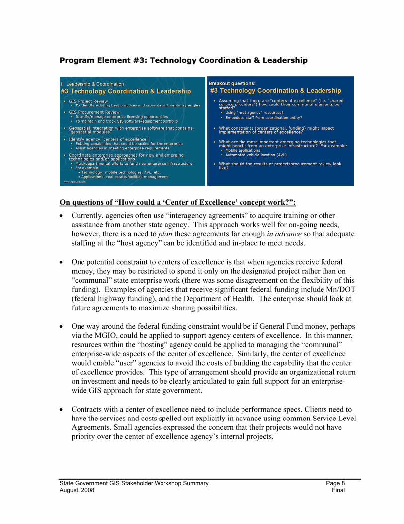
On questions of “How could a ‘Center of Excellence’ concept work?”:
• Currently, agencies often use “interagency agreements” to acquire training or other assistance from another state agency. This approach works well for on-going needs, however, there is a need to plan these agreements far enough in advance so that adequate staffing at the “host agency” can be identified and in-place to meet needs.
• One potential constraint to centers of excellence is that when agencies receive federal
money, they may be restricted to spend it only on the designated project rather than on “communal” state enterprise work (there was some disagreement on the flexibility of this funding). Examples of agencies that receive significant federal funding include Mn/DOT (federal highway funding), and the Department of Health. The enterprise should look at future agreements to maximize sharing possibilities.
• One way around the federal funding constraint would be if General Fund money, perhaps
via the MGIO, could be applied to support agency centers of excellence. In this manner, resources within the “hosting” agency could be applied to managing the “communal” enterprise-wide aspects of the center of excellence. Similarly, the center of excellence would enable “user” agencies to avoid the costs of building the capability that the center of excellence provides. This type of arrangement should provide an organizational return on investment and needs to be clearly articulated to gain full support for an enterprise-wide GIS approach for state government.
• Contracts with a center of excellence need to include performance specs. Clients need to have the services and costs spelled out explicitly in advance using common Service Level Agreements. Small agencies expressed the concern that their projects would not have priority over the center of excellence agency’s internal projects.
State Government GIS Stakeholder Workshop Summary Page 9 August, 2008 Final
On “project review” (to identify best practices and cross-departmental synergies): • The term “project review” does not reflect state agency expectations on the benefits of this
activity. Agency expectations are not that an MGIO would “approve” or “judge” projects. Rather this activity would provide a mechanism to collect and disseminate information on projects. The terms “project view”, “project inventory”, “project registry” or “project portfolio” better reflect agency expectations.
• There is a sincere interest and perceived benefit in knowing and understanding what peers in other agencies/organizations are doing with geospatial technology. If such a project inventory is created it will need to be well-advertised so people know to use it and also how to contribute information to it.
• For the project inventory to be effective it must contain quality information. Thus, if key projects are missed, or the information is not detailed, the usefulness will be reduced. In addition, the inventory needs to be well-organized and readily searchable so people can find what they’re looking for easily. To help ensure that the inventory contains good information it should be actively managed and moderated so that agencies are encouraged to keep it current and so that it doesn’t become a dumping ground for unorganized material. Finally, to be most effective the inventory needs to include information on agency points of contact for gaining further information about projects.
• To gain traction, the benefits of providing information to the inventory need to be described to the agencies that are expected to contribute information. Examples of potential benefits include:
o Contributing agencies may use the registry to identify similar activities being performed at other agencies. Participants may have a common interest in a shared resource.
o Agencies that are seeking partnerships could use the inventory to identify agencies with similar interests to seek joint funding opportunities.
• At the appropriate time, consideration should be given to expanding access to the inventory to agencies outside of state government.
• Possible technical options for implementing a project inventory and facilitating overall coordination include Web 2.0 technologies such as: Wikis, discussion boards, and/or blogs.
State Government GIS Stakeholder Workshop Summary Page 10 August, 2008 Final
On central repository vs. federated database vs. data warehouse
• There was broad agreement that there is a need for a central index of state data that includes information on how to obtain the data. It appears clear that many people were not aware of current state metadata efforts, or felt that they were insufficient. That being said, a statewide data index cannot impose undue or time consuming burdens on individual agencies that are registering their data.
• Workshop participants did not support the idea of a central repository, and in fact there were questions about the need for any type of statewide data library system. As one
State Government GIS Stakeholder Workshop Summary Page 11 August, 2008 Final
participant put it: “why do we need to discuss this at all? Can’t web services provide the data from wherever it is currently located?” Some participants felt that the current system of agency-provided services and the ability to ask for data as needed would be sufficient if they just knew what data were available and who to contact to ask for it.
• Some participants felt that the current federated structure for obtaining data from agencies such as DNR and Mn/DOT works well, is currently in place and thus they questioned “Why put money into changing the current architecture?” On the other hand, other participants felt that currently there were too many places to look for data and register datasets. While existing architectures may be able to deliver data, some participants observed that it can be difficult for people to find the data they want and need. A centralized broker as described in the MN State GIS Enterprise Conceptual Architecture Design (2005)3 could facilitate data finding.
• Health, DEED and other participants noted that not all data are deemed to be appropriate for public distribution due to privacy or sensitivity issues or because they are just not fully assembled. Any centralized data library system would need to implement appropriate security and role-based access systems.
• Some smaller agencies have no existing capabilities to provide data but maintain data that may be of interest beyond the agency. For these types of smaller agencies, assembling a data distribution capability could require significant resources for hardware, software and personnel that are not currently budgeted. Each agency’s primary responsibility is to perform their business requirements and making data available outside of the agency is a secondary concern. Under this scenario, having a centralized data distribution capability would provide benefits to agencies that do not currently have, or want to maintain, this capacity.
• There was not consensus among workshop participants about the importance of providing data distribution capabilities to the public or other agencies. Some participants questioned the need for, or effectiveness of, making their data available to the broader public and asked for proof that distributed data was actually used. Other participants believed that there is a broader user base beyond their agency for their data, both public and private.
Proper Role for Data Custodians in Maintaining the Data Library
• Participants indicated that data custodians should have more management control than the central repository model would likely provide. Equally, a data warehouse model would require additional enterprise investments in hardware, software and personnel that are seen as unnecessary since agencies are already managing their own data. As such, participants envisioned a potential hybrid approach that might involve:
o Federated approach to utilize existing data servers at major agencies with significant GIS capacity such as DNR and Mn/DOT
State Government GIS Stakeholder Workshop Summary Page 12 August, 2008 Final
Data from agencies with no current data sharing mechanism who have smaller amounts of data to share
Static data that do not change frequently and are used by a large number of agencies (e.g., county boundaries, census boundaries and attributes)
Data collected from local government once and made available to all users. (Currently, for example, several agencies collect and maintain county parcel data.)
• Data access and delivery mechanisms must include options that go beyond robust and reliable web services. There will remain existing needs to support the download of actual data sets (e.g., shapefiles).
• Many data sets are still “orphan” and do not have a formal data custodian (e.g. municipal boundaries, local roads, etc.). The MGIO could provide a centralized way of collectively identifying these needs for stewardship and communicating these requirements to decision makers and funders.
State Government GIS Stakeholder Workshop Summary Page 13 August, 2008 Final
• The web services question was discussed in each of the four breakout sessions. There was
extremely broad interest in this topic and a belief that web services are an important part of Minnesota state government’s GIS future.
• With overall governmental resources being extremely tight, there was broad agreement that agencies need to find a way to share tools and investments and web services provide a huge opportunity for achieving this. Paraphrasing one participant: “to do more, or even to just keep up, we need to share services.”
• While services represent a huge opportunity for large numbers of agencies to share a common resource for common data access and functionality requirements there are extremely important issues of trust and reliability of services that need to be addressed. It is not enough to have access to a service; the service must be high quality, stable and highly reliable. In addition, users must be able to trust that the web services utilize the best available data and that those data sets are kept current. If a service does not have these characteristics, it will not be used. Mechanisms such as service level agreements (SLA) that define performance and reliability metrics may be necessary before there is a larger move to shared services.
• Several agencies including DNR, Metropolitan Council and LMIC have made initial forays into providing shared web services. Additional agencies currently have services that they may be willing and able to share, however, there remain legitimate concerns about their capacity to provide support to a broader group of users.
• Several breakout groups identified the types of services that would be of greatest interest to them:
1. Aerial imagery, base map (including administrative boundaries), and parcel map services
2. Geocoding/geolocation for both addresses and PLSS 3. Reverse geocoding (i.e., submit a location’s coordinates and have an address
returned) 4. Address verification (i.e., determine if an address actually exists)
State Government GIS Stakeholder Workshop Summary Page 14 August, 2008 Final
5. Mailing label creation (e.g., prepare labels for a group of selected parcels) 6. Vehicle routing/scheduling 7. Point-in-polygon (e.g., to determine the parcel within which a point falls within)
• Data issues are key to successful implementation of some web services. For instance, a geocoding web service can be easily created, however, appropriate street centerline or address point data sets that support geocoding can be difficult to create and maintain and/or expensive to acquire4. Given the large interest in addresses and geocoding across most breakout groups, as well as the fact that address data is required for at least five of the seven desired web services listed above (i.e., numbers 2-6), there appears to be a need for a concerted effort to assemble reliable, high quality statewide addressing information.
• Major infrastructure improvements may be necessary to support the kind of reliable, high-performance web services that are desired. As the use of web services increases, Minnesota can expect that the hardware, software and personnel necessary to manage the services infrastructure will increase accordingly. Whether the MGIO creates and manages the web services, or whether existing agency web services are scaled to better serve the entire enterprise as center of excellence, some level of funding support will be necessary. Potential funding models that were discussed include:
o Line item funding, perhaps through the MGIO, to expressly support the services
o Building a business case by identifying the potential cost savings (e.g., less software maintenance and acquisition; less administration of agency web resources) that a robust services infrastructure could realize
o Cost recovery: through agency assessments
o Cost recovery: through utilization fees (e.g., pay-per-use), potentially by both internal state government users and outside users
• Absent the funded creation of a robust services infrastructure, there remains an immediate need to catalog and broker the availability of existing web services. Such a broker resource may also catalyze additional entities, whether state governmental or external, to make their web services available. Ideally, the broker would provide:
o Index of available services and instructions for accessing them
o Easy process for registering a new web service
o Information on SLAs for available services
o Testing to ensure that SLAs are being met
o Access to existing applications/web-sites that utilize the service to better illustrate the capabilities and make the web service “more real” to prospective users
• Some participants were aware of a Minnesota Governor’s Council on Geographic Information report5 outlining the concept of an enterprise broker and of a current effort by
4 Commercial data sets may also have license limitations on their ability to be used in a web services
setting. 5 The report was titled The Case for a Minnesota State Enterprise GIS and can be found at:
In-house training capacity vs. outsourced • It is a challenge to teach GIS technology to people who will only occasionally use the
software. It can also be a challenge to understand the potential for GIS to be inserted into existing business processes. For example, Health spoke of the challenges in teaching epidemiologists the benefits of using GIS as well as the separate challenge of teaching them specifically how to apply GIS tools to their analyses. In this context, there will always be a need for some level of agency-specific training.
• Understanding requirements for training is neither straightforward nor simplistic. For example, if a data analyst has only an occasional need to use GIS to produce a map, should that person be trained to how to use GIS to produce the map? Or should alternatives such as passing that task on to other already trained users or the development of a web application that simplifies the map making process be pursued?
• The decision on using in-house or outsourced training resources may vary depending on type of user:
o End users who need to use GIS as part of meeting business needs (e.g. epidemiologist) may be best served getting in-house, context-specific training from people who understand the data and workflows.
o GIS super users who create data, perform analyses (e.g., spatial statistics) and use advanced GIS tools may be best served getting more generic, but more advanced, software training that can be readily outsourced.
o GIS developers are likely best served by getting more advanced training, often in related topics such as programming, from non-state outsource providers.
State Government GIS Stakeholder Workshop Summary Page 17 August, 2008 Final
• Training on data is integral to using GIS successfully and appropriately, and these requirements may be best served through in-house training. Users need to:
o Become aware of available data
o Understand the limitations of data (due to scale, accuracy, currency, etc.)
o Have the data people will use on-the-job available in the classroom. Paraphrasing what one participant said: “it would be nice to use MN data in training as opposed to Redlands, California data” (which is typically used in ESRI-provided training classes)
• While it may not be appropriate for the MGIO to actually supply training, it is imperative that MGIO supply training coordination to:
o Determine needs for group classes and assemble multi-departmental groupings
o Assist in obtaining discounted training rates
o Advertise training opportunities
• Training opportunities cannot be limited to the Metro region and mechanisms for distributing training to out-state areas must be addressed, perhaps by:
o Offering training at regional sites
o Using video conferencing technology
o Creating web-based, virtual classroom materials
State Government GIS Stakeholder Workshop Summary Page 18 August, 2008 Final
• There was wide agreement that technical guidance in the form of user groups and peer-to-
peer knowledge exchange can be extremely beneficial and important. Participants identified a wide array of questions that could be addressed through these mechanisms as well as ideas for organizing technical guidance capabilities:
o Questions about identifying the best and most appropriate data sources come up often. There is a need to tap into others’ knowledge of which data sources are best and most current.
o Questions about which tools are in most common use come up often. Organizations that are making decisions about which tools to use would benefit from knowing which tools are most commonly implemented by state government already.
o User Groups should be organized around primary enterprise technologies. The user group model is attractive as it can be easier to justify investments of time to participate than it can be to justify the expenses of training. Participants also felt that the interactive “face time” with other GIS colleagues provided additional benefits.
o Some agencies have organized their own GIS steering group to facilitate intra-departmental coordination among both business and technical representatives
o Use of listservers can be valuable for providing support and guidance
• Technical support for the most commonly deployed tools is a requirement. Coordinating and advertising the mechanisms for gaining support could be a role of the MGIO. Participants identified several issues and ideas that should be explored for building the appropriate support mechanisms.
o If the state consummates an enterprise licensing agreement (ELA) for GIS software with ESRI6 there will be a formal requirement that there be a “first line”
6 The state is currently involved in discussions/negotiations with ESRI on moving to an ELA.
State Government GIS Stakeholder Workshop Summary Page 19 August, 2008 Final
of support that is provided by the State. Under an ELA, users are instructed to seek initial support from a State resource before accessing ESRI’s technical support.
o There was interest in the development of a “support hotline”. Such a hotline would need to be prepared to accommodate a wide variety of questions across a wide spectrum of user expertise and technical difficulty. If such a hotline were created there are open questions on how it would be funded and staffed. These requirements are even being considered at the departmental level and DNR is considering the development of an agency “support line”.
o While there is great potential for existing users helping other users (even users outside of their own agency), there is concern about how to get management support for these activities. How can managers understand and support the benefits of cross-departmental support and mentoring?
o If/when agencies deploy shared resources (e.g. web services, center of excellence activities) they will need to anticipate requirements for support. How can that additional support load be planned for and resourced?
o While many agreed there was potential for Web 2.0 tools (e.g., blogs, Wikis, forums) to assist in providing support, people had mixed experiences in using these tools to date. At best, they are one of a variety of tools for providing support and they do not fully replace other tools.
State Government GIS Stakeholder Workshop Summary Page 20 August, 2008 Final
• There are a wide variety of types of consulting and project support that agencies require
and there is not a “one size fits all” solution. Even with an internal “service bureau” there would remain needs for outside consulting. Participants were comfortable using internal, private and academic partners as funding allowed.
• PCA reported that its most frequent needs for project support involved less technical, one-time tasks such as data development.
• It was noted that a “service bureau” doing work on a “fee for service” basis could be viewed as at odds with the notion of a center of excellence model. Under a center of excellence model, agency activities are leveraged into enterprise resources that may be freely available. If other service bureau activities are available on a fee for service basis, wouldn’t centers of excellence consider charging for their services? It was then suggested that perhaps a service bureau, potentially located in the MGIO, could be considered a center of excellence and that its services would be offered to outside agencies without fees. Under this type of model the scope of the services that were offered might be smaller and more focused on “project support” as opposed to larger scale, project production activities. Participants suggested that access to the following types of upfront project support assistance would be beneficial:
o Project design
o Database/schema design
o Application design
o RFP development
These types of activities require smaller time investment and that would allow a small project support staff to assist multiple agencies.
• There was broad agreement that RFP execution and contracting for outside consulting support can be bureaucratically cumbersome and time consuming. There was broad interest in developing appropriate “blanket contracting” vehicles for GIS support that
State Government GIS Stakeholder Workshop Summary Page 21 August, 2008 Final
would allow expedited, cross-agency work to be performed on a task order basis7. Human Services described the development of these types of contracts for non-geospatial activities and encouraged working with the Department of Administration on an appropriate model for geospatial.
7 There is an existing GIS Master Contract; however, it acts more as a preferred vendor list and direct task
order based work is not currently possible.
State Government GIS Stakeholder Workshop Summary Page 22 August, 2008 Final
• All people at the top need to be involved and committed. Whatever is created needs to include the whole cabinet and span the governor’s and commissioner’s terms. Whatever is created has to be of real value; anything static will become obsolete.
• Any arguments put forward to decision makers for why an MGIO is needed must emphasize efficiency.
• There should be a balance between standardization and innovation. Don’t let standardization prevent innovation; at least provide a forum to discuss new ideas.
• Start with where we are (data and services), document limitations, and improve as we go along. Use rapid prototyping, and don’t try to solve everybody’s problems at once. Don’t wait for the perfect solution.
• On-going proactive communication is needed in most program elements for enterprise GIS to be successful.
WWoorrkksshhoopp SSuummmmaarryy
In general, the workshop’s overall input can be summarized by:
• Coordination is a two-way street. If the MGIO serves as a geospatial coordinating entity across the state, there need to be appropriate contacts at the agency level to “coordinate with”.
• There is an overall willingness among agencies to support standards-setting and standards implementation efforts. Along with standards creation there needs to be a mechanism to encourage their use.
• Explicitly identified data custodial roles and specific data custodians for key data sets make sense. Performing data custodial activities comes at a cost and the funding of these activities will potentially become an issue. In some cases (e.g., parcel data), custodial roles will best be performed by local governments and will need to be coordinated by an identified state entity.
• Sharing information about GIS project activities and efforts from all agencies can be facilitated by the MGIO. Project information, available geospatial services and other geospatial resources should be collected, moderated, organized and advertised via accessible and easily used formats. Introductions should be made between potentially helpful points-of-contact across state agencies.
• Build confidence in service/data quality and accessibility by defining a framework of service level agreements and by implementing both human and automated service brokers.
State Government GIS Stakeholder Workshop Summary Page 23 August, 2008 Final
• Various perspectives exist regarding the utility of a statewide data library system. Existing methods of accessing data from agencies such as DNR and Mn/DOT work well. However, no single resource is comprehensive and data can be difficult to find and metadata indexing efforts are not well known. Web services are seen as the future and are viewed as a potential method to access the best available data.
• There is an enormous interest in addresses and geocoding across state government and address data is required for the most desired web services. There appears to be a need for a concerted effort to assemble reliable, high quality statewide addressing information. The development and maintenance of such information will require partnerships with local government units throughout the state.
• Training is not straight forward. The MGIO needs to provide training coordination across agencies and user levels.
• There was wide agreement that technical guidance in the form of user groups and peer-to-peer knowledge exchange can be extremely beneficial and important. Technical support for the most commonly deployed tools is a requirement.
• There are a wide variety of consulting and project support activities that agencies require and there is not a “one size fits all” solution. A “service bureau” doing work on a “fee for service” basis could be viewed as at odds with the notion of a center of excellence model.
• Rather than a long analysis cycle to determine requirements and a development plan, web services (data and geocoding) should be quickly prototyped, made accessible to users for feedback. Further iterations can then expand the capabilities. Any delay in moving forward will just make it harder to accomplish any standardization.
• State web services can be mashed up with commercial tools like Google, Virtual Earth and Yahoo!. These tools are functional and have more access to peer help. It may be worth considering enterprise licensing for other products such as Google Maps.
• There should not be a focus on enterprise licensing of desktop software. It may well be desirable to have such an ELA for ESRI due to the existing uses of that technology, but that should not be a driver for DTE.
• The peer consultation tools (Wikis, blogs, boards, etc.) should take very little time to implement, and would seem to be a good candidate for an early “win”. It would seem like delivering high-quality products addressing at most 2 or 3 of the priority needs would give the process credibility and make it easier to do more.