STATE-LED ALTERNATIVE MECHANISMS TO ACQUIRE, PLAN AND SERVICE LAND FOR URBANISATION IN INDIA The working paper focuses on how land for public purposes such as roads, parks, affordable housing, education and health facilities could be provided for in urban areas. REJEET MATHEWS, MADHAV PAI, TINTU SEBASTIAN, SOUHARDHYA CHAKRABORTY A visual executive summary
Transcript
STATE-LED ALTERNATIVE MECHANISMS TO ACQUIRE, PLAN AND SERVICE LAND FOR URBANISATION IN INDIA
The working paper focuses on how land for public purposes such as roads, parks, affordable housing, education and health facilities could be provided for in urban areas.
Analysing Six State-Led Mechanisms for Planning and Servicing Urban Land ................................................
Key Findings ....................................
Recommendations ...........................
List of Abbreviation ..........................
Bibliography ....................................
HighlightsRapidly urbanising Indian cities need mechanisms to ensure that land is acquired, planned, and serviced with adequate infrastructure and social amenities, to prevent the occurrence of haphazard urban expansion and under provisioned inner-city areas.Such mechanisms should help government agencies recover their costs through land value capture, a method by which agencies recover part of the increase in the value of private property after it is serviced by new public infrastructure.Looking beyond the conventional practice of compulsory land acquisition, this document describes six state-led mechanisms to acquire, plan and service land along with land value capture techniques. The unique background of each case is described, along with it’s characteristics, process, strengths and challenges and the impact of each.It also evaluates the legal frameworks of these mechanisms according to nine parameters of equity and efficiency derived from a literature review. The mechanisms were found to have the potential to acquire, plan, and service land in infill contexts and urban extensions; better implement city master plans; share financial risks with land owners and private developers; and provide models for other states.Although no one mechanism can be used universally, these mechanisms can be adapted across different contexts with modifications.
Recommendations are made to strengthen the equity and efficiency of the mechanisms and they range from measures to prevent disconnected developments, recommendations to adopt standards for planning and urban design and reforms to facilitate better delivery of planned and serviced land that are beneficial to all the stakeholders.
This document aggregates key takeaways from the full working paper on ‘State-Led Alternative Mechanisms to Acquire, Plan and Service Land for Urbanisation in India’.
2
4
4
16
17
18
19
BOX 1 | KEY TERMS
Additional development rights: This permits an individual to build more floor area than typically allowed on a certain land parcel. These are often used as non-monetary compensation in exchange for land surrendered to government for public uses in several States.
Land value capture: Methods by which a government recovers all or part of the increase in property value resulting from government improvements to public infrastructure and services near the land. The unearned increase in property value that accrues to private properties is captured through increased taxes or fees based on the increased value of the land.
Betterment levy: A fee that is levied on individuals benefiting from infrastructure services and social amenities provided by government authorities to o�set the cost of providing the same.
Greenfields: Unbuilt land outside the city limits usually agricultural or fallow lands.
Infills: Small parcels of urban land that are vacant or contain derelict structures that can be consolidated and redeveloped within a city.
Infrastructure services: This includes roads, water supply, drainage, sewerage networks and such other utilities. Trunk infrastructure denotes the main arterial roads, or the primary pipelines, and power lines, which are provided by the government typically outside a private development. Collector roads, water supply, power supply and sewer lines to the individual properties, are usually developed within a subdivision by a private developer or individual property owner.
Landless project a�ected people: People who live on or derive an income from the land to be developed but do not own the legal rights to the property.
Master plan: Also called development plan or land-use plan, is a city- or region-wide plan that reserves land for roads, utilities, water, as well as schools, hospitals, parks, and other social amenities and designates where residential, commercial, and industrial activities can be located.
Public purpose reservations: This constitutes land reserved in a master plan for the larger common good rather than for an individual. This includes physical infrastructure and social amenities such as road networks, utilities, open spaces, educational institutions, medical and public health institutions, markets, social welfare and cultural institutions.
Planned land: Land on which irregular land parcels have been reshaped into more regular or rectangular shapes for urban use typically accompanied by a change in its designated use from agriculture to urban use following a master plan. Regularly shaped parcels and straighter roads can be more easily serviced by water supply, sewerage, electricity and drainage infrastructure.
Serviced land: Serviced land indicates the availability of physical infrastructure for urban services.
Social amenities: Social amenities include health, education, community facilities, open spaces, parks, and playgrounds that meet the larger needs of a community.
Urban extensions: Areas beyond the city limits that typically experience urbanisation pressures
State-Led Alternative Mechanisms To Acquire, Plan And Service Land For Urbanisation In India 1
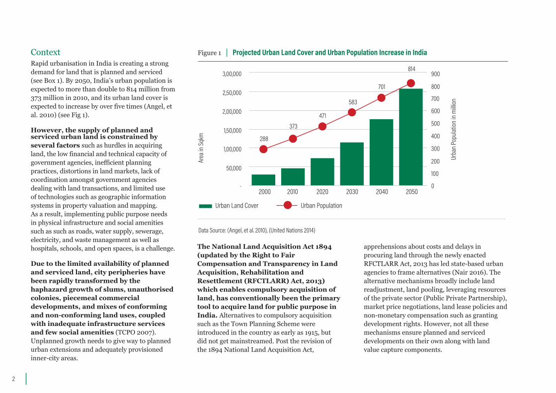
ContextRapid urbanisation in India is creating a strong demand for land that is planned and serviced (see Box 1). By 2050, India’s urban population is expected to more than double to 814 million from 373 million in 2010, and its urban land cover is expected to increase by over five times (Angel, et al. 2010) (see Fig 1).
However, the supply of planned and serviced urban land is constrained by several factors such as hurdles in acquiring land, the low financial and technical capacity of government agencies, inefficient planningpractices, distortions in land markets, lack of coordination amongst government agencies dealing with land transactions, and limited use of technologies such as geographic information systems in property valuation and mapping. As a result, implementing public purpose needs in physical infrastructure and social amenities such as such as roads, water supply, sewerage, electricity, and waste management as well as hospitals, schools, and open spaces, is a challenge.
Due to the limited availability of planned and serviced land, city peripheries have been rapidly transformed by the haphazard growth of slums, unauthorised colonies, piecemeal commercial developments, and mixes of conforming and non-conforming land uses, coupled with inadequate infrastructure services and few social amenities (TCPO 2007). Unplanned growth needs to give way to planned urban extensions and adequately provisioned inner-city areas.
Figure 1 | Projected Urban Land Cover and Urban Population Increase in India
2
Data Source: (Angel, et al. 2010), (United Nations 2014)
The National Land Acquisition Act 1894 (updated by the Right to Fair Compensation and Transparency in Land Acquisition, Rehabilitation and Resettlement (RFCTLARR) Act, 2013) which enables compulsory acquisition of land, has conventionally been the primary tool to acquire land for public purpose in India. Alternatives to compulsory acquisition such as the Town Planning Scheme were introduced in the country as early as 1915, but did not get mainstreamed. Post the revision of the 1894 National Land Acquisition Act,
apprehensions about costs and delays in procuring land through the newly enacted RFCTLARR Act, 2013 has led state-based urban agencies to frame alternatives (Nair 2016). The alternative mechanisms broadly include land readjustment, land pooling, leveraging resources of the private sector (Public Private Partnership), market price negotiations, land lease policies and non-monetary compensation such as granting development rights. However, not all these mechanisms ensure planned and serviced developments on their own along with land value capture components.
2000
Urban Land Cover Urban Population
2010 2020 2030 2040 20500-
50,000
1,00,000
1,50,000
2,00,000
2,50,000
3,00,000
100
288
373471
583
701
814
200
300
400
500
600
700
800
900
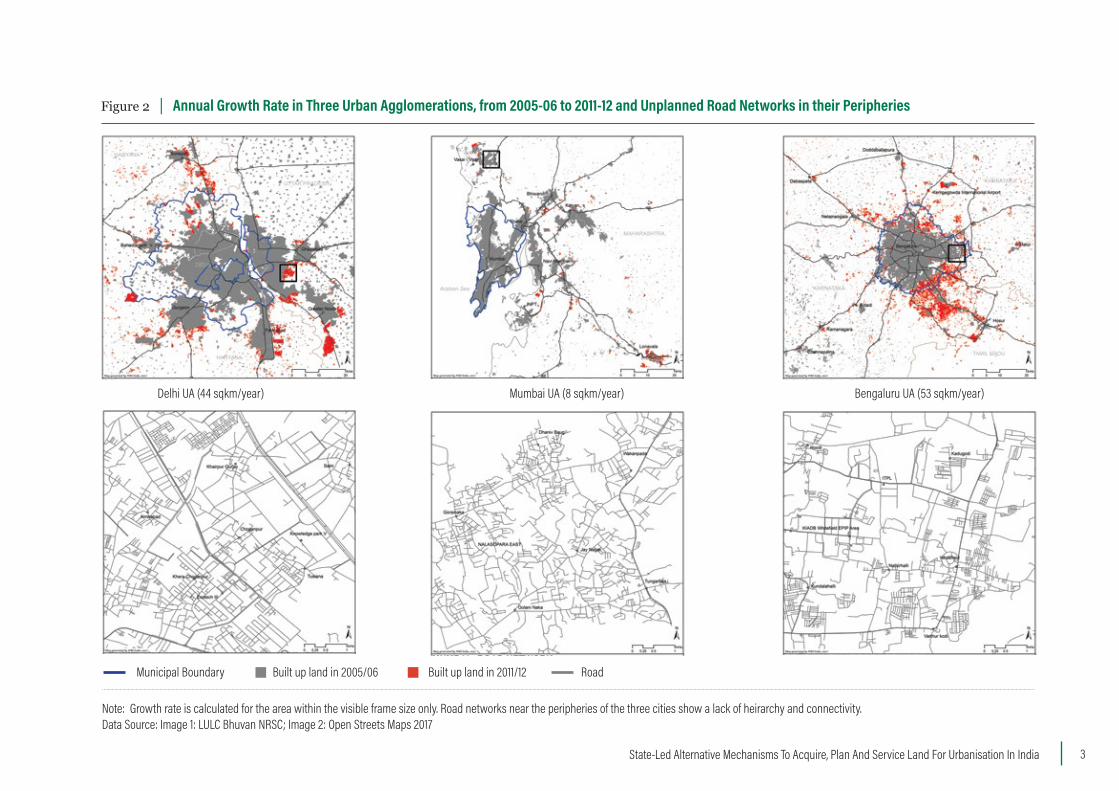
Figure 2 | Annual Growth Rate in Three Urban Agglomerations, from 2005-06 to 2011-12 and Unplanned Road Networks in their Peripheries
Note: Growth rate is calculated for the area within the visible frame size only. Road networks near the peripheries of the three cities show a lack of heirarchy and connectivity. Data Source: Image 1: LULC Bhuvan NRSC; Image 2: Open Streets Maps 2017
Delhi UA (44 sqkm/year) Mumbai UA (8 sqkm/year) Bengaluru UA (53 sqkm/year)
Municipal Boundary Built up land in 2005/06 Built up land in 2011/12 Road
State-Led Alternative Mechanisms To Acquire, Plan And Service Land For Urbanisation In India 3
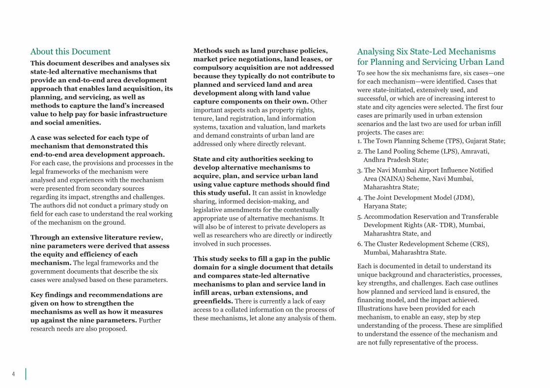
About this Document This document describes and analyses six state-led alternative mechanisms that provide an end-to-end area development approach that enables land acquisition, its planning, and servicing, as well as methods to capture the land’s increased value to help pay for basic infrastructure and social amenities.
A case was selected for each type of mechanism that demonstrated this end-to-end area development approach. For each case, the provisions and processes in the legal frameworks of the mechanism were analysed and experiences with the mechanism were presented from secondary sources regarding its impact, strengths and challenges. The authors did not conduct a primary study on field for each case to understand the real working of the mechanism on the ground.
Through an extensive literature review, nine parameters were derived that assess the equity and efficiency of each mechanism. The legal frameworks and the government documents that describe the six cases were analysed based on these parameters. Key findings and recommendations are given on how to strengthen the mechanisms as well as how it measures up against the nine parameters. Further research needs are also proposed.
Methods such as land purchase policies, market price negotiations, land leases, or compulsory acquisition are not addressed because they typically do not contribute to planned and serviced land and area development along with land value capture components on their own. Other important aspects such as property rights, tenure, land registration, land information systems, taxation and valuation, land markets and demand constraints of urban land are addressed only where directly relevant.
State and city authorities seeking to develop alternative mechanisms to acquire, plan, and service urban land using value capture methods should find this study useful. It can assist in knowledge sharing, informed decision-making, and legislative amendments for the contextually appropriate use of alternative mechanisms. It will also be of interest to private developers as well as researchers who are directly or indirectly involved in such processes.
This study seeks to fill a gap in the public domain for a single document that details and compares state-led alternative mechanisms to plan and service land in infill areas, urban extensions, and greenfields. There is currently a lack of easy access to a collated information on the process of these mechanisms, let alone any analysis of them.
Analysing Six State-Led Mechanisms for Planning and Servicing Urban Land To see how the six mechanisms fare, six cases—one for each mechanism—were identified. Cases that were state-initiated, extensively used, and successful, or which are of increasing interest to state and city agencies were selected. The first four cases are primarily used in urban extension scenarios and the last two are used for urban infill projects. The cases are:1. The Town Planning Scheme (TPS), Gujarat State;2. The Land Pooling Scheme (LPS), Amravati, Andhra Pradesh State;3. The Navi Mumbai Airport Influence Notified Area (NAINA) Scheme, Navi Mumbai, Maharashtra State;4. The Joint Development Model (JDM), Haryana State;5. Accommodation Reservation and Transferable Development Rights (AR- TDR), Mumbai, Maharashtra State, and 6. The Cluster Redevelopment Scheme (CRS), Mumbai, Maharashtra State.
Each is documented in detail to understand its unique background and characteristics, processes, key strengths, and challenges. Each case outlines how planned and serviced land is ensured, the financing model, and the impact achieved. Illustrations have been provided for each mechanism, to enable an easy, step by step understanding of the process. These are simplified to understand the essence of the mechanism and are not fully representative of the process.
4
State-Led Alternative Mechanisms To Acquire, Plan And Service Land For Urbanisation In India 5
Figure 3 | Planned and Serviced Land Through an Area Development Approach
BEFORE: Proposed road alignment to be acquired (Public purpose need)
AFTER: Option 1: Public purpose road implemented as a strip without the surrounding area being developed
AFTER: Option 2: Public purpose road implemented along with an area development approach
Option 1: This figure illustrates how acquiring land merely for an arterial road (conventionally done through compulsory land acquisition in India) leaves land owners unequally advantaged or disadvantaged. The parcels that do not adjoin the arterial road do not have any improved access despite the large costs incurred in laying this infrastructure. Several plots of owners become unfeasible for development and the area could potentially develop without adequate road networks, open spaces and amenities which is the case of several of our city peripheries today resulting in an unsustainable and inefficient lock-in, which is difficult and expensive to subsequently retrofit.
Option 2: This figure illustrates the use of an area development approach such as land readjustment and land pooling where not only arterials but also other hierarchies of road networks are planned along with reshaping irregular land parcels to more regular or rectangular parcels for urban use. The benefits of access to the main arterial road is thereby shared by all plot owners. Land owners benefit from increased land values though the size of their plots may decrease and now have access to physical infrastructure and social amenities such as parks and open spaces. Opportunities to capture the increased value of the land also becomes more feasible.
6
Figure 4 | Illustration of Town Planning Scheme (TPS) Process
1. Authority makes public declaration of intention to prepare TPS and undertakes survey of the area identified for TPS.
2. Authority prepares draft scheme and then calls for meeting of landowners to seek opinion and suggestions on the tentative proposals of the draft scheme.
3. Authority modifies tentative proposals and publishes draft scheme seeking objections and suggestions from landowners.
4. State government sanctions draft scheme after making necessary enquiries and authority takes possession of land needed for construction of roads soon after the sanction. Draft scheme then becomes the preliminary scheme.
5. Town planning o�icer modifies preliminary scheme after conducting hearings from landowners and then publishes it for inspection. Reshaped serviced land parcels of lesser area is o�ered back to landowners.
6. Authority constructs basic infrastructure facilities after preliminary scheme is published. Government approves final TPS after all appeals on financial matters are resolved. The landowner pays betterment levy to the authority for improved infrastructure facilities and increased land value if applicable.
Data Source: Gujarat Town Planning and Urban Development (GTPUD) Act, 1976 and GTPUD 1979 Rules
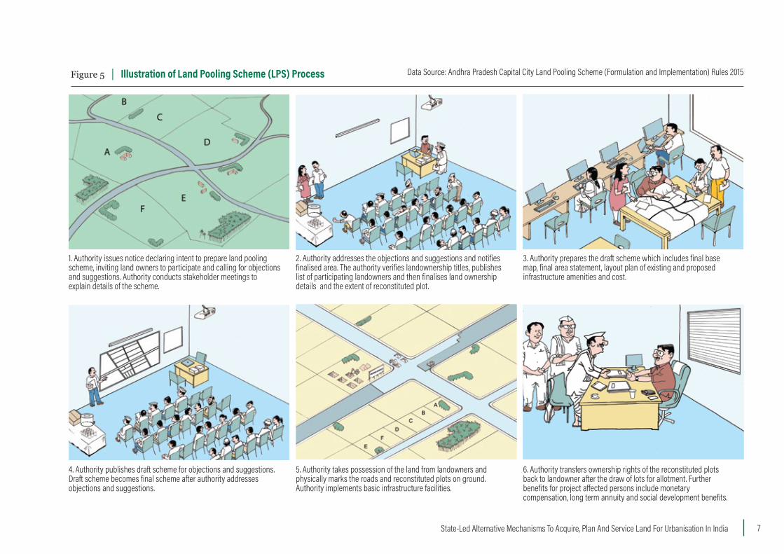
Figure 5 | Illustration of Land Pooling Scheme (LPS) Process Data Source: Andhra Pradesh Capital City Land Pooling Scheme (Formulation and Implementation) Rules 2015
1. Authority issues notice declaring intent to prepare land pooling scheme, inviting land owners to participate and calling for objections and suggestions. Authority conducts stakeholder meetings to explain details of the scheme.
2. Authority addresses the objections and suggestions and notifies finalised area. The authority verifies landownership titles, publishes list of participating landowners and then finalises land ownership details and the extent of reconstituted plot.
3. Authority prepares the draft scheme which includes final base map, final area statement, layout plan of existing and proposed infrastructure amenities and cost.
4. Authority publishes draft scheme for objections and suggestions. Draft scheme becomes final scheme after authority addresses objections and suggestions.
5. Authority takes possession of the land from landowners and physically marks the roads and reconstituted plots on ground. Authority implements basic infrastructure facilities.
6. Authority transfers ownership rights of the reconstituted plots back to landowner after the draw of lots for allotment. Further benefits for project a�ected persons include monetary compensation, long term annuity and social development benefits.
State-Led Alternative Mechanisms To Acquire, Plan And Service Land For Urbanisation In India 7
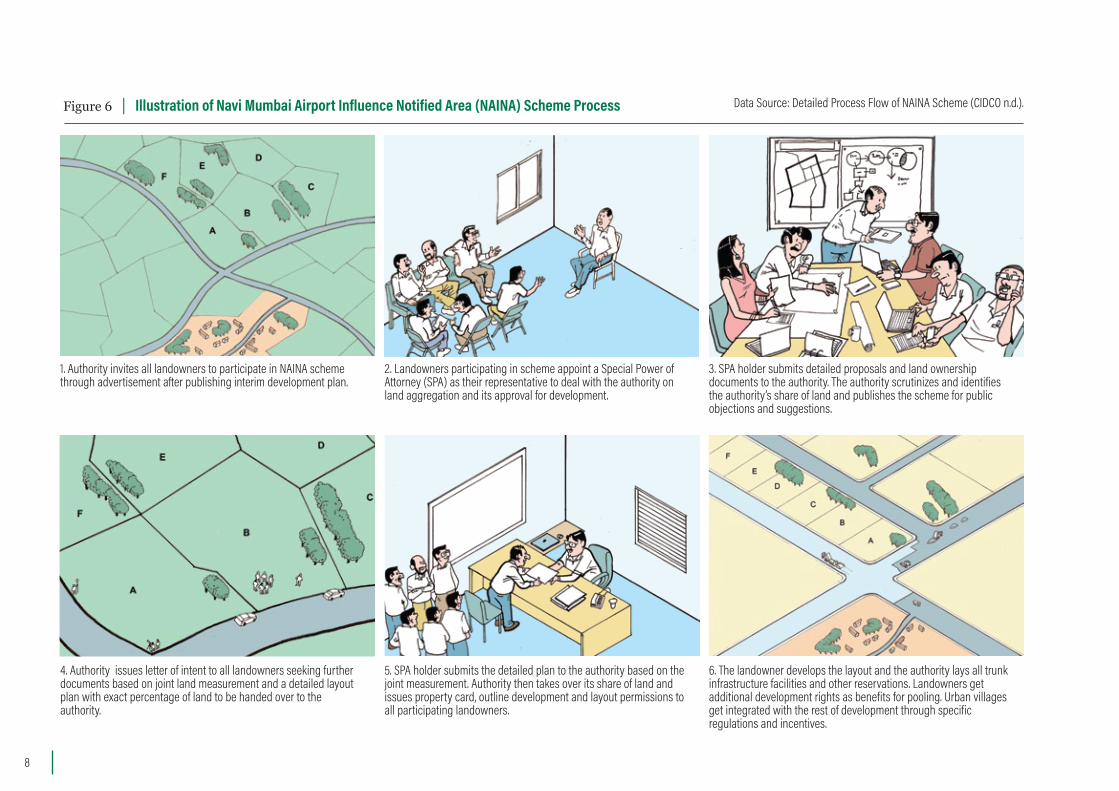
Figure 6 | Illustration of Navi Mumbai Airport Influence Notified Area (NAINA) Scheme Process Data Source: Detailed Process Flow of NAINA Scheme (CIDCO n.d.).
1. Authority invites all landowners to participate in NAINA scheme through advertisement after publishing interim development plan.
2. Landowners participating in scheme appoint a Special Power of Attorney (SPA) as their representative to deal with the authority on land aggregation and its approval for development.
3. SPA holder submits detailed proposals and land ownership documents to the authority. The authority scrutinizes and identifies the authority’s share of land and publishes the scheme for public objections and suggestions.
4. Authority issues letter of intent to all landowners seeking further documents based on joint land measurement and a detailed layout plan with exact percentage of land to be handed over to the authority.
5. SPA holder submits the detailed plan to the authority based on the joint measurement. Authority then takes over its share of land and issues property card, outline development and layout permissions to all participating landowners.
6. The landowner develops the layout and the authority lays all trunk infrastructure facilities and other reservations. Landowners get additional development rights as benefits for pooling. Urban villages get integrated with the rest of development through specific regulations and incentives.
8
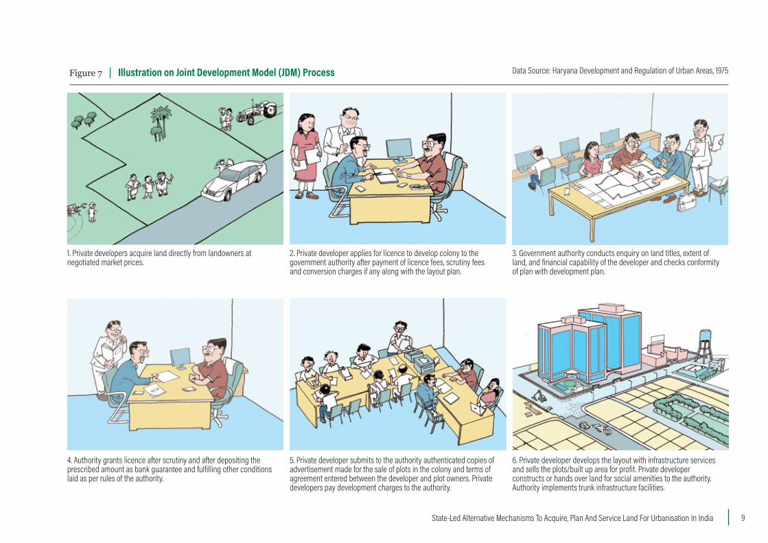
Figure 7 | Illustration on Joint Development Model (JDM) Process Data Source: Haryana Development and Regulation of Urban Areas, 1975
1. Private developers acquire land directly from landowners at negotiated market prices.
2. Private developer applies for licence to develop colony to the government authority after payment of licence fees, scrutiny fees and conversion charges if any along with the layout plan.
3. Government authority conducts enquiry on land titles, extent of land, and financial capability of the developer and checks conformity of plan with development plan.
4. Authority grants licence after scrutiny and after depositing the prescribed amount as bank guarantee and fulfilling other conditions laid as per rules of the authority.
5. Private developer submits to the authority authenticated copies of advertisement made for the sale of plots in the colony and terms of agreement entered between the developer and plot owners. Private developers pay development charges to the authority.
6. Private developer develops the layout with infrastructure services and sells the plots/built up area for profit. Private developer constructs or hands over land for social amenities to the authority. Authority implements trunk infrastructure facilities.
State-Led Alternative Mechanisms To Acquire, Plan And Service Land For Urbanisation In India 9
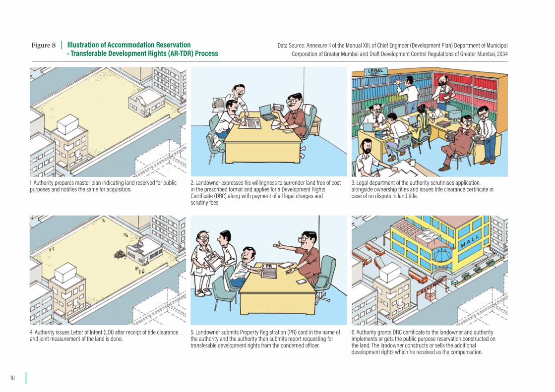
Figure 8 | Illustration of Accommodation Reservation - Transferable Development Rights (AR-TDR) Process
Data Source: Annexure II of the Manual XIII, of Chief Engineer (Development Plan) Department of Municipal Corporation of Greater Mumbai and Draft Development Control Regulations of Greater Mumbai, 2034
1. Authority prepares master plan indicating land reserved for public purposes and notifies the same for acquisition.
2. Landowner expresses his willingness to surrender land free of cost in the prescribed format and applies for a Development Rights Certificate (DRC) along with payment of all legal charges and scrutiny fees.
3. Legal department of the authority scrutinises application, alongside ownership titles and issues title clearance certificate in case of no dispute in land title.
4. Authority issues Letter of Intent (LOI) after receipt of title clearance and joint measurement of the land is done.
5. Landowner submits Property Registration (PR) card in the name of the authority and the authority then submits report requesting for transferable development rights from the concerned o�icer.
6. Authority grants DRC certificate to the landowner and authority implements or gets the public purpose reservation constructed on the land. The landowner constructs or sells the additional development rights which he received as the compensation.
10
Figure 9 | Illustration of Cluster Redevelopment Scheme (CRS) Process
1. Promoter identifies old and dilapidated buildings in clusters through an impact assessment study for redevelopment as per development plan or urban renewal plan. Promoter choses cluster after receiving approval from commissioner.
2. Government identifies eligible tenants and buildings as per the criteria and promoter seeks consent of 70% of the eligible tenants.
3. Promoter may assemble land through various options such as purchase, exchange, development rights procurement, transfer or acquisition provided he purchases rights over atleast 70% of the land in the cluster.
4. Promoter provides accommodation in transit camps or rental accommodations to the eligible tenants during the construction phase of CRS.
5. Promoter must provide each eligible tenant with a carpet area equivalent to the area occupied previously. Unused development rights are shared between the promoter and the government towards building a�ordable housing.
6. Promoter sells the built up area beyond the rehabilitation component for profit in the open market and provides maintenance through a corpus fund for 10 years.
Data Source: Draft Development Control Regulations of Greater Mumbai, 2034
State-Led Alternative Mechanisms To Acquire, Plan And Service Land For Urbanisation In India 11
Case 1: The Town Planning Scheme, Gujarat State How land gets planned and serviced: The Town Planning Scheme (TPS) of Gujarat employs a land readjustment mechanism that brings together a group of land owners who pool their land parcels for development. After deducting area for infrastructure and social amenities, including affordable housing, the remaining land is reconstituted into regularly shaped plots by the government and distributed back to the original owners. Infrastructure is provided by the local government agencies and the landowners benefit from improved services and thereby an increased land value of their share of land. In the land readjustment and pooling technique used in Gujarat, land is only notionally consolidated and often, the serviced land returned is a portion of the same land originally handed over by the landowners to the agency. An elaborate cost tabulation is involved in the process. For over a century, TPSs were routinely used to readjust land at scales of up to 200 hectares, but they are now used to readjust land up to 10,000 hectares (Panchal, et al. 2016).
How land value increments are captured: The cost of land development is partially financed through a betterment levy which is calculated based on the estimated increase of the land’s value as well as by the sale of a share of land that is retained by the government authority. Landowners were reportedly happy to pay the betterment levies, because they benefited from the increase in the value of their land (UN-HSP 2013).
Impacts: Over 665 TPSs have been prepared in the State of Gujarat (UN-HSP 2013). 38 percent
of them for Ahmedabad alone (UN-HP 2013). The Ahmedabad Urban Development Authority (AUDA) reported that Ahmedabad is the first city in India to have over 90 percent of its city development plan implemented through the TPSs. The state’s long history of TPS implementation makes the process acceptable to the people (Ballaney 2008). TPSs were also used in infill scenarios such as creation of a 50-hectare central garden in Ahmedabad city (Sharma 2015).
Strength and challenges: The TPS has a robust process with built in mechanisms for tabulation of plot details and costing of the scheme (UN-HSP 2013). It has a single legislation which is amended in a timely manner to improve the implementation of the process on ground. Challenges include the lack of provisions to compensate landless project-affected people who are dependent on the land for their livelihoods, or to upgrade the village settlements within the TPS.
Case 2: The Land Pooling Scheme, Amravati, Andhra Pradesh StateHow land gets planned and serviced: The Land Pooling Scheme (LPS) adopted by Andhra State government intended to plan, coordinate, execute, finance, fund, promote and secure planned development of 706,800 hectares for a new capital city of the state (Municipal Administration & UDD, Govt of Andhra Pradesh 2015). In the Land Pooling Scheme of Amravati, privately owned land parcels are legally consolidated by transfer of ownership rights to a government authority for public purpose reservations as designated in the master plan. Participation in the scheme is
voluntary, however land reserved for capital city area development could be taken compulsorily, if negotiations fail. The authority assembles land for infrastructure and social amenities, including affordable housing for the poor, and later transfers ownership of a percentage share of the land pooled back to the original owners. The landowners are compensated by serviced land as well as monetary support. A fund is created to provide a pension of Rs. 2,500 per month for 10 years to all landless families. The scheme also offers skill development programs and monetary benefits such as agriculture loan waivers and interest-free loans to the project-affected families.
How land value increments are captured: The cost of developing basic infrastructure and social amenities is expected to be recovered by the government through fees charged on the landowners of the serviced land and sale or lease of the share of land that the authority retains.
Impacts: It is reported that over 13,000 hectares were pooled in less than two months (MHUPA 2016), a record pace, making it the largest experiment of land pooling in the country (Chari 2015). However, critics protested against developing fertile agricultural land, and the government reportedly relied heavily on law enforcement to prevent resistance from farmers in the riverbank villages (Ramachandraiah 2016). LPS is a recent scheme and its implementation on ground is not yet complete, hence its impact and effectiveness are yet to be fully ascertained.
Strengths and challenges: The strength of the scheme is that it upholds the rights of the landless project-affected persons to receive compensation
12
as well as social development benefits. It is well supported politically with the chief minister of the state making a personal appeal to land owners to participate in the scheme. However, provisions to address grievances are weak and the vast differences in property prices across the capital city area have not been considered for valuation of the land.
Case 3: The NAINA Scheme, Navi Mumbai, Maharashtra StateHow land gets planned and serviced: The NAINA scheme, conceptualized in 2013, is similar to TPS and LPS but differs in its operational framework, process, and compensation packages. Navi Mumbai Airport Influence Notified Area (NAINA) Scheme was developed to support planned development in the influence area of the proposed greenfield airport in Navi Mumbai, Maharashtra. The NAINA Scheme allows landowners to aggregate contiguous land parcels of a minimum prescribed area and then surrender 40 to 50 percent of it to the government authority for implementing the public purpose reservation made in the master plan. Participating landowners retain 50 to 60 percent of their land and are offered additional development rights that are not offered to non-participating landowners. Development must be carried out under the regulations of the City and Industrial Development Corporation of Maharashtra Ltd (CIDCO), which is the “special planning authority” for the scheme.
How land value increments are captured: Cost-recovery components include development
charges, charges from leasing land in growth centers, sale or lease of plots for schools and community centers to other government bodies, and floor space linked premiums imposed on the nonparticipating landowners.
Impacts: By January 2018, CIDCO had received 341 building permission files, which are at various stages in the permission process (CIDCO 2018). Several developers expect NAINA Township to be one of the biggest suppliers of affordable housing in Navi Mumbai (Srivastava 2014).
Strengths and challenges: NAINA scheme has an integrated approach to development because it includes the village settlement sites present on the land and their expansion through separate regulations and norms. However, the framework for the scheme lacks clarity about how long it will take to deliver the trunk infrastructure facilities, which is the responsibility of the government authority. Further, it has no rehabilitation strategies for the landless families who depended on the land for their livelihood nor does it have conflict resolution mechanisms.
Case 4: The Joint Development Model, Haryana State How land gets planned and serviced: The Joint Development Model (JDM) of Haryana is a public private partnership model which allows private developers to assemble land through market price negotiations and apply for a licence to develop it into a residential, commercial, or industrial area in accordance with a master plan. As per the Haryana Development and Regulation
of Urban Areas Act, the private developers may develop a “colony” which is an area of land divided or proposed to be divided into plots or flats for residential, commercial, industrial, cyber city or cyber park purposes or for construction of flats in the form of group housing or for the construction of integrated commercial complexes or for division into plots for low-density eco-friendly colony. The infrastructure and social amenities within the colonies are built by the developer, who makes a profit through the sale of plots and built up space. The external trunk infrastructure, such as major roads and power lines to the colonies are usually provided by the government.
How land value increments are captured: The developer partially pays the government for the external trunk infrastructure through development charges. Developers also deposit 30 percent of the amount collected from plot sales in a separate account which will be released only after internal infrastructure and amenities are completed to the satisfaction of the state authority. Any profits above 15 percent that accrues to the developer following the completion of the project period, must be deposited to the State government or spent for providing further facilities in the colony. Developers may also pay infrastructure augmentation charges before taking a completion certificate from the authority and get exempted from paying the net profit above 15 percent.
Impacts: Through JDM, from 1981 until January 2018, a total of 1,702 licenses were issued to private developers in Haryana for residential, commercial, institutional, and industrial development (DTCP Haryana n.d.).
State-Led Alternative Mechanisms To Acquire, Plan And Service Land For Urbanisation In India 13
Ninety three percent of the licenses issued were developed for residential purposes including affordable housing projects on about 12,893 hectares (DTCP Haryana n.d.). The private developer captures the post development benefits of the mechanism, though they also contribute to a share of the external infrastructure costs. JDM has been used extensively in the development of the Gurgaon–Manesar urban complex.
Strengths and challenges: JDM enables the transfer of the financial burden of developing the physical infrastructure and social amenities as per master plan from the government authority to private players. It mandates the provision of housing for those designated as “economically weaker sections” along with the residential developments that are undertaken by the private developers. A significant challenge is the lack of accountability thrust on the government authority, which has no stipulated deadline for completion of trunk infrastructure facilities. Further, most of the residential group housing colonies already built in Gurgaon are gated communities having large block sizes that prevent thoroughfares and restrict the number of options that a pedestrian or motorist has, to go from one point to another.
Case 5: Accommodation Reservation and Transferable Development Rights, Mumbai, Maharashtra State How land gets planned and serviced: In Greater Mumbai, a landowner whose land is reserved for a public purpose in the master plan hands over a portion of their land to the authority to
accommodate the public purpose (like a park). In return the owner will be entitled to additional Development Rights (DR) irrespective of the development potential of the land so surrendered to the authority. The additional development rights can be used on the remainder of the owner’s land or converted into transferable development rights (TDR), which can be sold or used at another location. In accommodation reservation, the land owner could also construct the amenity (such as a dispensary), as per the stipulations of the public authority at no cost to the authority. Development rights are given in increments of floor space index (FSI), which is the ratio of the combined gross floor area of all floors to the total area of the plot. For a typical development, Development Control Regulations of Greater Mumbai permits an FSI of 1.33 to 3 in the Island city, varying based on the available road width. It allows FSI of 1 to 2.5 in the suburbs and extended suburbs of Mumbai for residential and commercial developments, but restrict FSI to 0.5 and 0.75 in certain areas of suburbs and extended suburbs (Municipal Corporation of Greater Mumbai 2018). Through Transferrable Development Rights, the landowner can use his or her development rights at the rate of 2.5 times the area of surrendered land if the area under reservation is in Mumbai city area (or the Island city), and 2 times the area of surrendered land, if the area surrendered is in Mumbai suburbs or extended suburbs.
How land value increments are captured: The government agency receives the land or built-up area for a public purpose amenity free of cost.
The authority also receives infrastructure improvement charges which are imposed on the person utilising the TDR as well as development charges when the person utilises the TDR to undertake construction.
Impacts: Through the TDR program, the Municipal Corporation of Greater Mumbai (MCGM) acquired 306 hectares for various public purposes and 109 hectares for road widening (MCGM n.d.). Over a 10-year period, 150,000 units of slum replacement housing were constructed using AR-TDR (Chandy 2007).
Strengths and challenges: TDR enables acquisition of land for public purpose in a built-up inner city context and allows maximising the development of sites with high development potential. However, there is no mechanism to ascertain the absorptive capacity of the areas receiving the additional built-up area through TDR. In addition there is no provision to closely monitor the actual quality of amenities that are handed over the authority through AR.
Case 6: The Cluster Redevelopment Scheme, Mumbai, Maharashtra State How land gets planned and serviced: The Cluster Redevelopment Scheme (CRS) also referred as cluster development scheme designates a group of buildings, (extending over a minimum area of 0.4 hectare in Mumbai city and 1 hectare in Mumbai suburbs and extended suburbs), which are in a derelict state, for redevelopment by a government
14
agency or a private developer called a promoter. In return, the promoter gets additional development rights (an increased floor space allowance) that can be used at the same site or transferred to other sites. The promoter chooses a cluster of buildings as identified in the development plan or cluster development plan. The land is assembled by the promoter through i) purchase of land ii) exchange with suitable land of equivalent value iii) procurement of development rights over land iv) transfer of all land to a legal entity or v) through acquisition provided he purchases rights over at least 70% of the land in the cluster. The eligible tenants receive “carpet area” equivalent to the area occupied by them previously in the old building. The scheme facilitates construction of improved housing as well as public amenities.
How land value increments are captured: Developers bear the cost of assembling the land and of construction. In return they receive additional development rights to build market-rate apartments that can be sold for profit. Thus, CRS leverages the benefits of redevelopment to ensure affordable housing without the government having to pay for land or construction. Government agencies also collect fees called development cess and development charges from the promoter.
Impacts: One Avighna Park in Parel, Mumbai is the first approved cluster redevelopment project (on about 3 hectares) (Balakrishnan 2013) and another three projects received approval till 2014. The CRS has been extended to Navi Mumbai and Thane as well.
Strengths and challenges: The strength of the scheme is that it enables creation of in-situ upgradation of housing facilities and development of public amenities such as open spaces and road networks, which otherwise remain inaccessible for public purposes. The impact assessment study mandated before taking up CRS helps to better plan infrastructure services. The main challenges are that the tenants are not allowed to participate in planning and implementation and there is no clear conflict resolution process in the scheme. The requirement of a minimum size of 0.4 hectare in the city and one hectare in the suburbs may not address the redevelopment needs of smaller clusters of dilapidated buildings in a dense city like Mumbai.
Nine parameters for equitable and e�icient land acquisition methods: Guidelines for reviewing the legal framework of the six casesThrough an extensive literature review, the authors identified nine parameters that were used to assess the equity and efficiency of each of the six state schemes. Each case’s legal framework was analysed based on these parameters and the results are discussed in the key findings and recommendations sections. The nine parameters are briefly described here: Recognition of public purpose: To assess if there is a clear listing or stated process for identification of public purposes provided. Public purpose land secured: To assess if there is a clear quantum of land in percentage that gets reserved for public purposes and considerations for Economically Weaker Sections (EWS).
Operational process: To evaluate the efficiency of each case in terms of the method of land acquisition involved, its timelines and identification of who takes responsibility for internal and external infrastructure provision and social amenities.Enabling framework: To check if the cases are enabled through a legislative framework; or by a government order, or a legally mandated master plan and related development control regulations. Compensation, resettlement, and rehabilitation: To assess the range of compensation offered to project affected persons and if it is equitable in terms of providing financial or social benefits including to the landless or occupiers of the land.Recognition of rights: To assess the equity of each case by checking what ownership types on the land is recognised and process of beneficiary identification. Participation mandates: To check if there are provisions for public participation in the scheme at various stages and to what extent it is inclusive of all affected persons in the process.Cost Recovery and Post-Development Benefits: To assess the financial viability of the mechanism by checking if there are cost recovery components embedded in each case and what benefits accrue to various stakeholders in each case.Grievance Redressal and Jurisdiction of Courts: To check if there are provisions included to address the conflicts arising in the process and if it is addressed in a transparent manner and if the individuals can approach the court in case of any grievances that need intervention.
State-Led Alternative Mechanisms To Acquire, Plan And Service Land For Urbanisation In India 15
Table 1 | KEY FINDINGS
1. Recognition of public purpose
- Clear and unambiguous listing of public purposes is present for all mechanisms because there is a mandate to follow the city master plan which designates the land reservations for public purposes. - However, none of the cases has a legal procedure or recourse to be taken if land is diverted for other purposes.
2. Public purpose land secured
- Percentage of land to be secured for roads, social amenities, open spaces and economically weaker sections (EWS) is explicitly mentioned in TPS and LPS, but only broadly for JDM and NAINA. - There is no clarity on whether the tenants or occupiers of land which was acquired are eligible for the affordable housing component that is set aside for TPS, LPS, NAINA and JDM.
3. Operational process
- TPS and LPS have well-defined steps, process and timelines. NAINA scheme has a clear process but does not specify timelines. - JDM, TDR-AR and CRS lack clarity in the process, as there is no step-by-step description in the legislation or regulations.
4. Enabling framework
- All cases operate at the micro level to implement reservations as per a master plan, which is prepared at the macro level (citywide). - The law that mandates preparation of master plan is a significant component that ensures planned and serviced land.
5. Compensation, resettlement and rehabilitation
- Compensation offered to landowners is in the form of serviced land for TPS and LPS. LPS also offers monetary benefits. NAINA scheme and AR-TDR offers additional development rights to landowners.- JDM offers negotiated market price to the landowners. Compensation offered to landowners is not explicit for CRS. Only LPS offers Resettlement and Rehabilitation for the landless project affected families.
6. Recognition of rights
- Only individuals with legal rights over property are recognized as landowners in all cases. For rehabilitation provisions, only CRS and LPS recognize rights of the tenants and landless project-affected persons.
7. Participation mandates
- Participation in the physical and financial aspects of TPS is largly confined to land owners. LPS has provisions for participation at all the stages of the process. NAINA scheme invites public objections and suggestions to the layout plan submitted by landowners. Prior consent of landowners and tenants for land assembling is sought only in LPS and CRS. - JDM and AR-TDR have not elaborated on any provision for participation in their enabling frameworks.
8. Cost recovery mechanisms and post-development benefits
- All mechanisms have cost recovery provisions; however, the viability of projects depend on the market demand for serviced land. - Post development benefits accrue to both landowners and government except for JDM and AR-TDR (if landowners surrenders entire land parcel to authority).
9. Grievance redressal and jurisdiction of courts
- Only TPS has an independent grievance redressal mechanism, while others do not have either an independent system or have no provisions for redressal. - LPS and TPS provide some clarity on jurisdiction of courts, while others do not provide clarity on access to courts.
16
No single mechanism can be applied uniformly or could be accepted by stakeholders across varied contexts. The use and interest in alternative mechanisms is relatively new and is currently only regionally applied. This will continue to be the case given regional specificities, legislative legacies, political realities, and constitutional mandates. The success of each mechanism is influenced by the political economy, historic evolution and socio-cultural context in which the mechanism is applied. Contextual adaptation and regular updating to the changing and dynamic needs of a city/state is critical.
The overall advantages of using alternative mechanisms are that they:Strengthen the ability of city agencies through land value capture to provide basic infrastructure and social amenities in urban developments.Serve as a bridge between macro-scaled city master plans and implementation at the micro scale.Ensure accessibility to planned and serviced land for all income groups. Share the financial risks of urban government agencies in land procurement and development, through partnerships with land owners and developers.Enable acquisition of land for infill development, urban extensions, and greenfields.Can be replicated in other states through contextually suitable legislative amendments.
Some areas that need strengthening include:Improving master planning processes and phasing, so that land parcels are not developed as isolated developments;
Improving accountability mechanisms would ensure that land is used for the designated public purposes, as in certain cases, land assigned for affordable housing were diverted to other uses.Improving accounting practices so that the land value capture of each mechanism is recorded systematically and its use is better managed to implement basic infrastructure amenities and social amenities.Introducing public participation mandates to include all stakeholders including landless project-affected people. Most mechanisms currently limit participation to landowners who possess a legal title. Including benefits for landless project-affected people who are displaced through the land acquisition process.
Recommendations Recommendations to improve the use of alternative mechanisms include the following. Delineate urban extensions in master plans to prevent distant, disconnected and dispersed development: Urban extensions should be identified in master plans taking into account growth dynamics, availability of infrastructure facilities, natural resource constraints and environmental features. Development must be contiguous with existing built-up areas, avoiding fertile multi cropped agriculture land where possible. Further, a city assessment must be done during the master planning process to ascertain whether areas receiving additional density have adequate infrastructure facilities, and are not located in a distant periphery.
Introduce planning and urban design standards to ensure connectivity and walkability: Many global cities specify acceptable block sizes and adopt street standards to encourage connectivity in the street network. This aspect is missing within the documented alternative mechanisms and hence must be introduced.
Institute and implement reforms critical to facilitating the delivery of developed land: Critical reforms include granting functional autonomy to city agencies to manage land development, improve accountability of implementing agencies and other directly related reforms such as land record updating and digitisation. Appropriate checks and balances should ensure that land is used for the intended purpose and compensation and rehabilitation schemes reach the intended beneficiaries.
Ensure participation of all affected stakeholders: Some of the bigger successes such as the Ring Road for Ahmedabad using the TPS were attributed to building consensus on the project (UN-HSP 2013). Government agencies need to be capacitated and sensitized to work closely with project affected people, explaining the projects benefits, convincing people and winning their confidence and trust to be able to implement developmental projects. It is also important to conduct an equity impact analysis of each project implemented on ground using alternative mechanisms, so as to bring about improvements in the subsequent schemes planned for the adjoining areas.
State-Led Alternative Mechanisms To Acquire, Plan And Service Land For Urbanisation In India 17
Include equitable and fair compensation frameworks: Compensation determination and the land valuation done in the alternative mechanisms should take into account the principles of proportionality, equity and fairness. Rehabilitation provisions from the National Land Acquisition Act, which includes subsistence allowance, employment opportunities, skill development and such other benefits for the landless tenants or occupiers could be adapted and integrated in the state-led alternative mechanisms, with checks and balances to ensure its implementation.
Build the capacity of government staff and establish efficient monitoring frameworks to implement alternatives: The number of cities and states implementing alternatives is limited and hence any attempts at scaling will require the capacities and capabilities of staff to be increased and upgraded. Use of modern technologies such as the use of geographic information system in data recording, tabulation and physical mapping surveys could significantly save the time involved in the process. All mechanisms should have an efficient monitoring framework with systematic recording of each scheme implemented on ground and tracking of corresponding land value gains along with its proper management of funds to finance the subsequent schemes.
Further research and analysis could include: Analysis of the extent to which legal framework provisions such as participation mandates, compensation disbursement, and conflict resolution mechanisms were followed in practice. Assessment of the percentage of affordable housing stock and other public purpose reservations were truly generated through on ground case studies. This information would help to quantify the mechanism’s success or failure as a contributor to planned and serviced development in urban areas. A comparative cost-benefit analysis of the six mechanisms. This will help in evaluating the implemented case studies with respect to the quantum of investments made by public and private agencies and the returns on such investments accruing to each stakeholder, and more specifically to the original land owner and other project affected persons.Assess other critical factors that affect the enforcement of the mechanisms such as institutional arrangements, transparency, monitoring frameworks, and other factors such as property titling, landownership issues and property rights.Search for any state-led led mechanisms not documented in this paper that have resulted in planned and serviced developments.Analysis to ascertain whether the land value capture method used in each case example has set in motion a virtuous cycle of reinvestment to acquire and service additional land.
18
LIST OF ABBREVIATIONSAR Accommodation ReservationCIDCO City and Industrial Development Corporation of Maharashtra LtdCRS Cluster Redevelopment SchemeDR Development Rights DTCP Department of Town and Country Planning EWS Economically Weaker SectionFSI Floor Space IndexGIS Geographic Information SystemsGTPUD Gujarat Town Planning and Urban DevelopmentHDRUA Haryana Development and Regulations of Urban AreasJDM Joint Development ModelLPS Land Pooling SchemeMCGM Municipal Corporation of Greater MumbaiMHADA Maharashtra Housing and Area Development Authority MHUPA Ministry of Housing and Urban Poverty AlleviationNAINA Navi Mumbai Airport Influence Notified AreaRFCTLARR Right to Fair Compensation and Transparency in Land Acquisition, Rehabilitation and ResettlementRs RupeesSPA Special Power of AttorneySq.km Square kilometerSqm Square meterTCPO Town and Country Planning OrganisationTDR Transferable Development RightTPO Town Planning O�icerTPS Town Planning SchemeUA Urban Agglomeration UN-HSP United Nations Human Settlement Programme
BIBLIOGRAPHYAngel, Shlomo, Jason Parent, Daniel L. Civco, and Alejandro M. Blei. 2010. The Atlas of Urban Expansion. Lincoln Institute of Land Policy.Anvekar, Ankoor. 2014. "Villagers Shun CIDCO's Rehabilitation Hearings." Mid-day.com, November 29. Accessed March 1, 2018. https://www.mid-day.com/articles/villagers-shun-cidco-s-rehabilitation-hearings/15801167.Balakrishnan, S. 2013. "Cluster development key to Mumbai's growth: Nishant Agarwal." Mumbai: DNA, November 4. Accessed February 16, 2016. http://www.dnaindia.com/mumbai/interview-cluster-development-key-to-mumbai-s-growth-nishant-agarwal-1913453.Ballaney, Shirley. 2008. The Town Planning Mechanism in Gujarat. India. Washington D.C: The International Bank for Reconstruction and Development/The World Bank.Chandy, Mathew. 2007. "The Use of ADRs & TDRs in Slum Upgrading." World Bank Fourth Urban Research Forum, May. Accessed January 30, 2018. http://siteresources.worldbank.org/INTURBANDEVELOPMENT/Resources/336387-1269364687916/6892589-1269394486592/chandy.pdf.Chari, Mridula. 2015. "Land pooling strategy for the new Andhra capital could become a model for India's Smart Cities." 12: Scroll.in, August. Accessed August 2, 2017. https://scroll.in/article/746040/land-pooling-strategy-for-the-new-andhra-capital-could-become-a-model-for-indias-smart-cities.CIDCO. 2018. "Status of Building Permission Proposals received in NAINA o�ice as on 16/1/2018." CIDCO. Accessed January 26, 2018. http://www.cidco.maharashtra.gov.in/pdf/Final_sheet_for_BP_12_12_2017.pdf.DTCP Haryana. n.d. "Licences as per Circle, District and Purpose." Department of Town and Country Planning, Haryana. Accessed January 27, 2018. https://tcpharyana.gov.in/WebAdmin/License/LicenseDetails.MCGM. n.d. "MANUAL-XVII Section 4(1)(b)(xvii) OTHER USEFUL INFORMATION." Mumbai: MCGM. Accessed January 30, 2018. http://www.mcgm.gov.in/irj/go/km/docs/documents/MCGM%20Department%20List/Chief%20Engineer%20(Development%20Plan)/RTI%20Manuals/Chief_Engineer_Development_Plan_RTI_E18.pdf.MHUPA. 2016. India Habitat III National Report 2016. New Delhi: Ministry of Housing and Urban Poverty Alleviation.Municipal Administration & UDD, Govt of Andhra Pradesh. 2015. "The Andhra Pradesh Capital City Land Pooling Scheme (Formulation and Implementation) Rules,2015." January 1.Municipal Corporation of Greater Mumbai. 2018. "Draft Development Control Regulations, Draft Development Plan -2034, Greater Mumbai." Mumbai: MCGM,Government of Maharashtra, May.Nair, Reshmy. 2016. "RFCTLARR Act, 2013: Overview of Recent Developments." ASCI Journal of Management, March: 1-10.Panchal, Kaushik, Jagdish Salgaonkar, Divya Prakash Vyas, and Rejeet Mathews. 2016. "Scaling up Land Readjustment for Urban and Industrial Development through the Town Planning Scheme in Dholera, Gujarat, India." Washington DC: World Bank.Ramachandraiah, C. 2016. "Making of Amaravati A Landscape of Speculation and Intimidation." Vol. vol LI no 17 . Economic & Political Weekly. 68-75.Sharma, P.L. 2015. "Presentation of Town Planning-Gujarat , Tool for Planned , Fair and Equitable Urban Development." Delhi: Connect Karo 2015, April.Srivastava, Amit. 2014. "NAINA – the only hope for a�ordable homes in Navi Mumbai." Mumbai: DNA India, December 10. Accessed March 1, 2018. http://www.dnaindia.com/mumbai/report-naina-the-only-hope-for-a�ordable-homes-in-navi-mumbai-2042550.Suzuki, Hiroaki, Arish Dastar, Sebastian Mo�att, Nanae Yabuki, and Hinako Maruyama. 2010. Eco2 Cities Ecological Cities as Economic Cities . The World Bank.TCPO. 2007. Model Guidelines for Urban Land Policy (Draft). Policy Guidelines, Town and Country Planning Organisation, Ministry of Urban Development,Government of India.UN-HSP. 2013. Supply of land for urban development: Land Readjustment Experience in Gujarat, India. Nairobi: UN-Habitat - United Nations Human Settlement Programme.
State-Led Alternative Mechanisms To Acquire, Plan And Service Land For Urbanisation In India 19
ACKNOWLEDGEMENTSWe thank our colleagues from The World Resources Institute (WRI) who provided insight and expertise that greatly assisted the research. In particular we would like to thank Robin King, Anjali Mahendra, Peter Veit, Bharath Jairaj, Daryl Ditz, Jessica Seddon, OP Aggarwal, Jaya Dhindaw and Srinivasan Sunderasan.
We are grateful to the following external experts who provided valuable comments: Sirish B Patel (Civil Engineer and Urbanist, SPACPL), Reshmy Nair (Professor, ASCI), Darshini Mahadevia (Professor, CEPT University), E F N Ribeiro (Former Chief Town Planner, TCPO), Patrick Lamson Hall (Project Coordinator, NYU-MIUM), V. Ravichandar (Civic Evangelist) and Mona Qureshi, for their review, comments and feedback. While our reviewers were very generous with their time and input, this working paper reflects the views of the authors alone and any shortcomings are our own.
We would like to thank Emily Matthews, Maria Hart, Garima Jain, Dnyanada Deshpande and Mary Paden for providing administrative, editing and design support. We would like to thank our colleagues Surya Prakash and Raj Bhagat for the maps on urban agglomeration growth. We would also like to thank Anil Achar for the hand drawn illustrations provided in this document.
ABOUT THE AUTHORSRejeet Mathews is Head, Urban Development, WRI IndiaMadhav Pai is India Director for WRI Ross Center for Sustainable CitiesTintu Sebastian is a research consultant with the Urban Development team at WRI IndiaSouhardhya Chakraborty contributed to this research as part of the Early Professional Program at WRI India
ABOUT WRI World Resources Institute is a global research organization that turns big ideas into action at the nexus of environment, economic opportunity and human well-being.
Our ChallengeNatural resources are at the foundation of economic opportunity and human well-being. But today, we are depleting Earth’s resources at rates that are not sustainable, endangering economies and people’s lives. People depend on clean water, fertile land, healthy forests, and a stable climate. Livable cities and clean energy are essential for a sustainable planet. We must address these urgent, global challenges this decade.
Our VisionWe envision an equitable and prosperous planet driven by the wise management of natural resources. We aspire to create a world where the actions of government, business, and communities combine to eliminate poverty and sustain the natural environment for all people.
20
PHOTO CREDITCover/World Bank - Curt Carnemark/flickr
This document aggregates key takeaways from the full working paper on ‘State-Led Alternative Mechanisms to Acquire, Plan and Service Land for Urbanisation in India’. For more detail, see the full paper which will shortly be uploaded at http://wrirosscities.org/our-work/research
Maps included in this document are for illustrative purposes and do not imply the expression of any opinion on the part of WRI, concerning the legal status of any country or territory or concerning the delimitation of frontiers or boundaries.
This product is for general information only and does not constitute a legal advice.