ENVIRONMENTAL ASSESSMENT AND FINDING OF NO SIGNIFICANT IMPACT STEUBEN LAKES REGIONAL WASTE DISTRICT Northeast District Phase 1 Wastewater Collection System Improvements Project SRF PROJECT WW 18 27 76 01 DATE: October 25, 2018 TARGET PROJECT APPROVAL DATE: November 26, 2018 I. INTRODUCTION The above entity has applied to the Wastewater State Revolving Fund (SRF) Loan Program for a loan to finance all or part of the wastewater project described in the accompanying Environmental Assessment (EA). As part of facilities planning requirements, an environmental review has been completed which addresses the project's impacts on the natural and human environment. This review is summarized in the attached EA, which can also be viewed in color at http://www.in.gov/ifa/srf/. II. PRELIMINARY FINDING OF NO SIGNIFICANT IMPACT (FNSI) The SRF Wastewater Program has evaluated all pertinent environmental information regarding the proposed project and determined that an Environmental Impact Statement is not necessary. Subject to responses received during the 30-day public comment period, and pursuant to Indiana Code 5-1.2-3, it is our preliminary finding that the construction and operation of the proposed facilities will result in no significant adverse environmental impact. In the absence of significant comments, the attached EA shall serve as the final environmental document. III. COMMENTS All interested parties may comment upon the EA/FNSI. Comments must be received at the address below by the target approval date above. Significant comments may prompt a reevaluation of the preliminary FNSI; if appropriate, a new FNSI will be issued for another 30-day public comment period. A final decision to proceed, or not to proceed, with the proposed project shall be effected by finalizing, or not finalizing, the FNSI as appropriate. Comments regarding this document should be sent within 30 days to: April Douglas Senior Environmental Manager State Revolving Fund 100 N. Senate Ave. IGCN 1275 Indianapolis, IN 46204 317-234-7294 [email protected]State Revolving Fund Loan Programs Drinking Water, Wastewater, Nonpoint Source
Transcript
ENVIRONMENTAL ASSESSMENT AND
FINDING OF NO SIGNIFICANT IMPACT
STEUBEN LAKES REGIONAL WASTE DISTRICT Northeast District Phase 1
Wastewater Collection System Improvements Project
SRF PROJECT WW 18 27 76 01
DATE: October 25, 2018
TARGET PROJECT APPROVAL DATE: November 26, 2018
I. INTRODUCTION
The above entity has applied to the Wastewater State Revolving Fund (SRF) Loan Program for a loan to
finance all or part of the wastewater project described in the accompanying Environmental Assessment
(EA). As part of facilities planning requirements, an environmental review has been completed which
addresses the project's impacts on the natural and human environment. This review is summarized in the
attached EA, which can also be viewed in color at http://www.in.gov/ifa/srf/.
II. PRELIMINARY FINDING OF NO SIGNIFICANT IMPACT (FNSI)
The SRF Wastewater Program has evaluated all pertinent environmental information regarding the
proposed project and determined that an Environmental Impact Statement is not necessary. Subject to
responses received during the 30-day public comment period, and pursuant to Indiana Code 5-1.2-3, it is
our preliminary finding that the construction and operation of the proposed facilities will result in no
significant adverse environmental impact. In the absence of significant comments, the attached EA shall
serve as the final environmental document.
III. COMMENTS
All interested parties may comment upon the EA/FNSI. Comments must be received at the address below
by the target approval date above. Significant comments may prompt a reevaluation of the preliminary
FNSI; if appropriate, a new FNSI will be issued for another 30-day public comment period. A final
decision to proceed, or not to proceed, with the proposed project shall be effected by finalizing, or not
finalizing, the FNSI as appropriate. Comments regarding this document should be sent within 30 days to:
State Revolving Fund Loan Programs Drinking Water, Wastewater, Nonpoint Source
SRF Clean Water Program Page 2 of 52
Steuben Lakes Regional Waste District Environmental Assessment: Northeast District Phase 1 - Wastewater Collection System Improvements Project Distributed October 25, 2018 to the public for a 30-day comment period.
I. PROJECT IDENTIFICATION
Project Name and Address: Northeast District Phase 1
Wastewater Collection System Improvements Project
Steuben Lakes Regional Waste District
8119 West 150 North
Angola, IN 46703
SRF Project Number: WW 18 27 76 01
Authorized Representative: Mr. Bryan Klein, Superintendent
II. PROJECT LOCATION
The proposed project is located in Steuben County, Angola East and West 24K USGS Quadrangles,
township 38N, range 13E, sections 26, 27, 33, 34 and 35 in Jamestown civil township; and in
township 37N, range 13E, sections 2, 3, 10 and 11 in Pleasant civil township. See Figures 1 through
11.
III. PROJECT NEED AND PURPOSE
Steuben Lakes Regional Waste District (the District) currently provides wastewater collection and
treatment services for the majority of the developed properties within its jurisdictional boundary.
Wastewater is collected primarily through a low-pressure type system and conveyed via pump
stations to the District’s centralized wastewater treatment plant (WWTP).
The main area not currently served by the District’s collection and treatment facilities is collectively
and locally known as the Northeast District (NED) and is loosely bounded to the west by James and
Snow Lakes, to the north by State Road 120, to the east by I-69, and to the south by W 275 N. There
are three subareas within the NED service area that are served by aging cluster absorption fields that
are owned, operated and maintained by the District. Additionally, there are a handful of properties
connected to a small private WWTP owned by the owner of the Ramada Inn and operated by a
private contract wastewater operator. Finished effluent from this wastewater treatment facility is
currently land applied under a permit issued by the IDEM Office of Land Quality.
IV. PROJECT DESCRIPTION
The proposed project will consist of an expansion of the District’s existing pressure sewer system. It
will include a total of three (3) new wastewater pump stations and approximately 300 new grinder
pump stations, each serving one or two properties. The project will result in the District being able
to abandon its existing cluster absorption field, situated within the boundary of Pokagon State Park,
which serves the majority of the residents of Lone Tree Point. It will also allow the existing
privately owned and operated wastewater treatment plant to be decommissioned.
No upgrades to the District’s existing WWTP are needed in conjunction with this collection system
expansion project.
ENVIRONMENTAL
ASSESSMENT
SRF Clean Water Program Page 3 of 52
Steuben Lakes Regional Waste District Environmental Assessment: Northeast District Phase 1 - Wastewater Collection System Improvements Project Distributed October 25, 2018 to the public for a 30-day comment period.
V. ESTIMATED PROJECT COSTS, AFFORDABILITY AND FUNDING
A. Selected Plan Estimated Cost Summary
Construction Costs
Collection/transport system cost $ 8,889,800 Contingency 889,000
Construction Sub-Total $ 9,778,800
Non-Construction Costs $ 1,998,560*
Project Total Estimated Project Cost $11,777,360
Cash on Hand $ 9,291,600
SRF Loan Amount $ 2,485,760
* $50,000 for easement payments is ineligible for SRF funding
B. Steuben Lakes Regional Waste District will finance the project with a loan from the State
Revolving Fund Loan Program for a term and annual fixed interest rate to be determined at loan
closing. The actual loan amount will depend on the bids received. Monthly user rates and charges
may need to be analyzed to determine if adjustments are required for loan repayment.
VI. DESCRIPTION OF EVALUATED ALTERNATIVES
The “No Action” alternative is not practical, environmentally sound nor economical. The result of
this option for properties either on individual private septic systems or on clustered STEP systems
would be the continued infiltration of untreated absorption field effluent into the ground, and
potentially surrounding water bodies.
Several options for treatment at nearby wastewater treatment plants were evaluated. These treatment
plants include the Town of Fremont, the City of Angola and the Steuben Lakes Regional Waste
District. The options considered transporting the wastewater from different areas around the proposed
Northeast District to one or more of the nearby treatment plants. Also considered was serving a
reduced service area at the District’s WWTP.
The recommended alternative provides for consistent and reliable service to a significant number of
unserved customers and improves the ability of the District to accomplish its core goals within its
current jurisdictional boundaries. The alternative provides that the portion of the service area
potentially served by the Town of Fremont would be addressed under a separate project. However, a
new collection system will be installed in the Cranston’s Reef area to provide collection and treatment
of the sewage. The homes in this area currently provided treatment by Fremont will have the option of
disconnecting from the existing private collection system and connecting to the District. It should be
noted that Pokagon State Park will not be a part of the project and will continue to operate its own
collection and treatment system.
SRF Clean Water Program Page 4 of 52
Steuben Lakes Regional Waste District Environmental Assessment: Northeast District Phase 1 - Wastewater Collection System Improvements Project Distributed October 25, 2018 to the public for a 30-day comment period.
VII. ENVIRONMENTAL IMPACTS OF THE FEASIBLE ALTERNATIVES
A. Direct Impacts of Construction and Operation
The Area of Potential Effect for this project includes the area where the new pressure sewer
system and three (3) wastewater pump stations will be installed, and upgrades to an existing
wastewater pump station. The project will be designed to keep as much of the pipeline as
possible within the pavement limits, or within previously disturbed roadway rights-of-way.
Some yards and possibly street-side yard plantings may be affected by construction of the
project. The contractor will be required to promptly restore disturbed yards and street-side
plantings as portions of the project are completed.
The three (3) proposed wastewater pump station sites will be on tracts on land approximately
50’x50’ and adjacent to existing roadways. It is anticipated that most all of the pump station
sites will be disturbed with significant excavation occurring for the wet well and valve vault
installations. Wet wells are anticipated to be approximately 20’ to 25’ deep, while the valve
vaults are typically 6’ to 8’ deep.
The force mains will be required to be installed using horizontal directional drilling, or other
appropriate trenchless methods, in order to minimize land disturbance and corresponding
restoration costs. Small excavations will be necessary for several situations. The approximate
disturbance area for each excavation is:
• Connection of successive sections of force main, approximately 15’x8’x6’ depth;
• Service lateral connection points, approximately 5’x5’x6’ depth; and
• Installation of flushing and/or air release manhole locations, approximately 8’x8’x6’.
Additionally, some surface disturbance should be anticipated with the excavators and directional
drilling machines and support vehicles used for a project of this nature. The approximate
footprint of a typical directional drilling machine and resulting disturbed area would be about
8’x20’.
Disturbed/Undisturbed Land: The project will be designed to keep as much of the pipeline as
possible within the pavement limits, or within previously disturbed roadway rights-of-way.
Archaeological surveys were completed for the locations of the new pump stations that are in
new locations which found no archaeological sites with characteristics that qualify for inclusion
in or eligibility for the National Register of Historic Places.
Work related to the installation of storm and sanitary sewers will occur in disturbed rights-of-
way, adjacent to and within roadways, alleys and existing utility trenches. All areas have been
previously disturbed by previous construction activity.
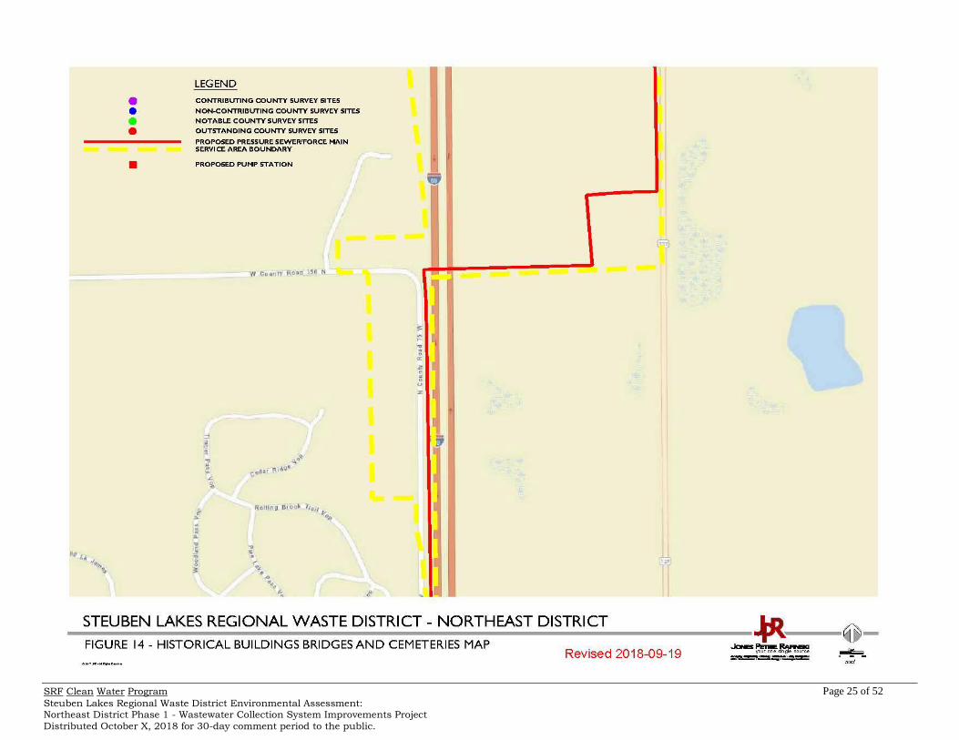
Structural Resources (Figures 12-21): Construction and operation of the project will not alter,
demolish or remove historic properties. If any visual or audible impacts to historic properties
occur, they will be temporary and will not alter the characteristics that qualify such properties for
inclusion in or eligibility for the National Register of Historic Places. The SRF’s finding
pursuant to Section 106 of the National Historic Preservation Act is: “no historic properties
affected.”
SRF Clean Water Program Page 5 of 52
Steuben Lakes Regional Waste District Environmental Assessment: Northeast District Phase 1 - Wastewater Collection System Improvements Project Distributed October 25, 2018 to the public for a 30-day comment period.
Surface Waters: Several stream crossings are required as a part of the project. The crossing
will be accomplished via directional drilling and all construction activities will be outside of the
floodplains or floodways.
The project will not adversely affect outstanding state resource waters listed in 327 IAC 2-1.3-
3(d), exceptional use streams listed in 327 IAC 2-1-11(b), Natural, Scenic and Recreational
Rivers and Streams listed in 312 IAC 7-(2), or Salmonid Streams listed in (327 IAC 2-1.5-
5(a)(3)) or streams on the Outstanding River List for Indiana.
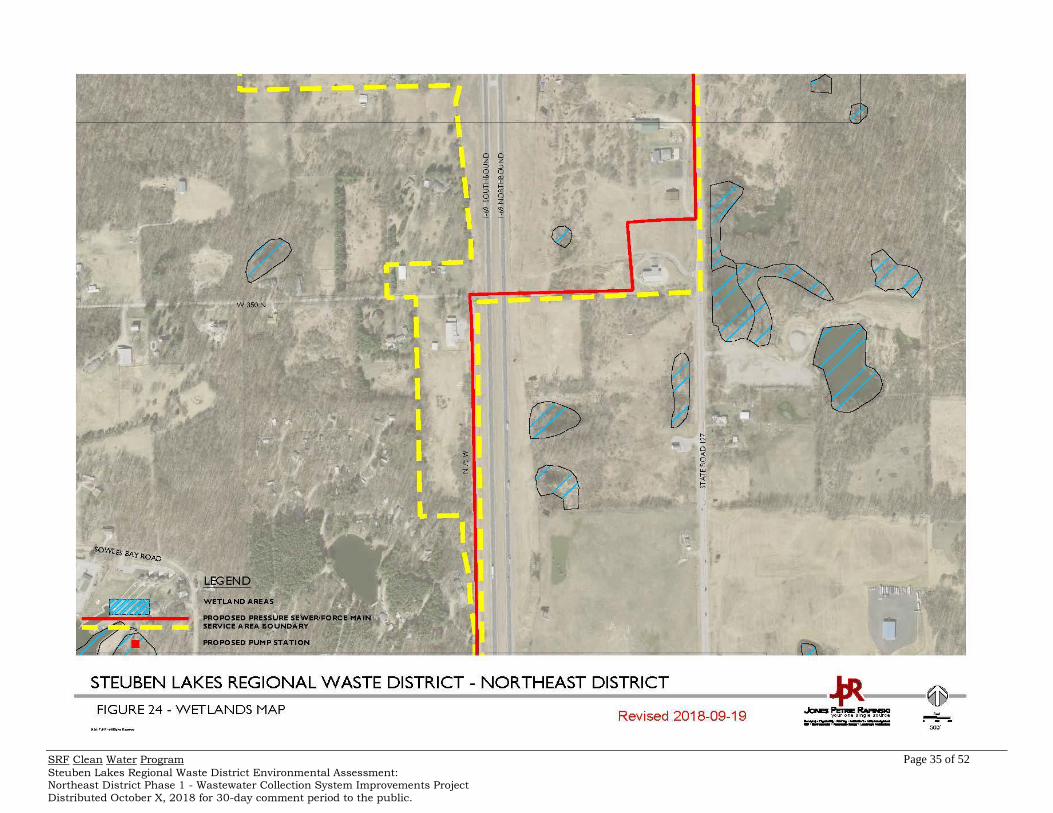
One would expect to find wetlands throughout the project area due to its unique nature, and one
would be correct. In most situations the wetlands exist away from the existing rights-of-way and
proposed construction corridors. There is, however, one area within the project area that this is
not the case, that being the combined corridor of State Road 727 and Lane 100 Lake James,
which leads to the Pokagon State Park Entrance and the Lone Tree Point development along the
eastern bank of Lake James. These roads were each constructed across separate wetlands
areas. The construction activities in these locations will be limited to the installation of force
main to convey wastewater from the properties within Lone Tree Point to the remainder of the
proposed collection system outside of the Pokagon State Park. It is recommended that in these
locations the proposed force main be constructed beneath the existing roadways in order to
avoid disturbance of the adjacent wetlands, and that the sections crossing the wetlands will be
installed in single, complete pulls avoiding the necessity to excavate within the wetlands limits to
make connections between force main segments.
Any disturbance to the wetland area will be restored with native plantings appropriate for the
wetland area. For the remainder of the project, construction activity in or near wetlands will be
avoided. Some wetlands do not exist adjacent to the proposed pressure sewer and force main.
The use of horizontal directional drill method of installation will greatly reduce the disturbed
areas in general and allow the pressure sewer to be installed adjacent to the wetlands without
disturbing the wetlands. During the early design phase of the project, the Engineer will
coordinate with the appropriate agencies to identify areas of concern. Once identified, specific
area near or adjacent to wetlands will be identified on the design drawings as no work or no
staging zones.
Floodplain (Figures 32-35): Several stream crossings are required as a part of the project. The
crossing will be accomplished via directional drilling and all construction activities will be
outside of the floodplains or floodways.
Groundwater: Dewatering may be needed for construction of the pump station wet wells. For
the package grinder pump stations and pressure sewer structures, it is anticipated that only minor
dewatering of short duration (2 hours or less) may be required.
If dewatering is necessary, the Contractor will be required to discharge to a suitable location and
provide a settling basin or filtering bag to capture solids prior to the discharge.
No adverse impacts are expected to local water wells and groundwater table.
Plants and Animals: The majority of the project will be installed within existing pavement and
roadway rights-of-way. The project is expected to have minimal to no impact to plants and
animals during construction and no impacts afterwards.
SRF Clean Water Program Page 6 of 52
Steuben Lakes Regional Waste District Environmental Assessment: Northeast District Phase 1 - Wastewater Collection System Improvements Project Distributed October 25, 2018 to the public for a 30-day comment period.
Prime Farmland: The project will not convert prime farmland.
Air Quality: Construction activities may generate some noise, fumes and dust, but should not
significantly affect air quality.
Open Space and Recreational Opportunities: Construction and operation of the
recommended project will neither create nor destroy open space or recreational opportunities.
Lake Michigan Coastal Program: The project will not affect the Lake Michigan Coastal Zone.
National Natural Landmarks: Construction and operation of the proposed project will not
The District, to the extent possible through its limited authority, will strive to ensure that future
development, as well as future collection system or treatment works projects connecting to the
State Revolving Funds (SRF) funded facilities will not adversely impact
archaeological/historical/structural resources, wetlands, wooded areas, or other sensitive
environmental resources. The District will, to the extent possible under its limited authority,
strive to require that new development and treatment works projects be constructed within the
guidelines of the U.S. Fish and Wildlife Service, IDNR, IDEM, and other environmental review
authorities.
C. Comments from Environmental Review Authorities
In correspondence dated October 17, 2018, the Indiana Department of Natural Resources
Division of Historic Preservation and Archaeology stated:
Pursuant to IC 13-18-21 and 327 IAC 14 and Section 106 of the National Historic
Preservation Act (54 U.S.C. § 306108) and 36 C.F.R. Part 800, the Indiana State Historic
Preservation Officer ("Indiana SHPO") is conducting an analysis of the materials dated and
received by the Indiana SHPO on September 20, 2018, for the above indicated project in
Pleasant Township, Steuben County, Indiana.
Based on our analysis, it has been determined that no historic properties will be altered,
demolished or removed by the proposed project provided that the proposed project activities
remain within areas disturbed by previous construction or subjected to archaeological
investigations. It is our understanding that an archaeological reconnaissance is being
conducted and will be submitted to our office for review.
If any prehistoric or historic archaeological artifacts or human remains are uncovered during
construction, demolition, or earthmoving activities, state law (Indiana Code 14-21-1-27 & 29)
requires that the discovery must be reported to the Department of Natural Resources within
two (2) business days. In that event, please call (317) 232-1646. Be advised that adherence to
Indiana Code 14-21-1-27 & 29 does not obviate the need to adhere to applicable federal
statutes and regulations, including but not limited to 36 C.F.R 800.
An archaeological reconnaissance was completed for the Feather Valley Road Pump Station 30
site which found no archaeological sites with characteristics that qualify for inclusion in or
eligibility for the National Register of Historic Places and submitted to Indiana SHPO on
October 24, 2018.
SRF Clean Water Program Page 7 of 52
Steuben Lakes Regional Waste District Environmental Assessment: Northeast District Phase 1 - Wastewater Collection System Improvements Project Distributed October 25, 2018 to the public for a 30-day comment period.
In correspondence dated October 25, 2018, the Indiana Department of Natural Resources
Division of Historic Preservation and Archaeology stated:
Pursuant to IC 13-18-21 and 327 IAC 14 and Section 106 of the National Historic
Preservation Act (54 U.S.C. § 306108) and 36 C.F.R. Part 800, the Indiana State Historic
Preservation Officer ("Indiana SHPO") is conducting an analysis of the materials dated and
received by the Indiana SHPO on October 24, 2018, for the above indicated project in
Pleasant Township, Steuben County, Indiana.
Based on our analysis, it has been determined that no historic properties will be altered,
demolished or removed by the proposed project provided that the proposed project activities
remain within areas disturbed by previous construction or subjected to archaeological
investigations. Thank you for the archaeological report. We concur that no further
archaeological investigations are necessary.
If any prehistoric or historic archaeological artifacts or human remains are uncovered during
construction, demolition, or earthmoving activities, state law (Indiana Code 14-21-1-27 & 29)
requires that the discovery must be reported to the Department of Natural Resources within
two (2) business days. In that event, please call (317) 232-1646. Be advised that adherence to
Indiana Code 14-21-1-27 & 29 does not obviate the need to adhere to applicable federal
statutes and regulations, including but not limited to 36 C.F.R 800.
In correspondence dated October 11, 2018, the United States Fish and Wildlife Service stated:
This responds to your letter dated September 20, 2018, requesting our comments on the
aforementioned project. We previously reviewed iterations of this project in 2012 and 2014, at
which time it was being considered for funding by the U.S. Department of Agriculture’s Rural
Utilities Program. Both the 2012 and 2014 proposals included crossings of Lake James at
different locations; these crossings have been removed from the current plan. Various sewers
were also proposed within Pokagon State Park, but those activities have also been modified
under the current project.
These comments have been prepared under the authority of the Fish and Wildlife Coordination
Act (16 U.S.C. 661 et. seq.) and are consistent with the intent of the National Environmental
Policy Act of 1969, the Endangered Species Act of 1973, and the U.S. Fish and Wildlife
Service's Mitigation Policy.
The current project extends from County Road West 275 North on the south to big Otter Lake
Lane 110 on the north, with force mains of various sizes along both SR 127 and CR N 75 W
west of I-69 and SR 127 and CR N 50 W east of I-69. Residential areas at Lakes Charles East
and West will be serviced, as will those along portions of Big and Little Otter Lakes. A new
force main will extend into and through Pokagon State Park along SR 727 and Lake James
Lane 100; this line will service residences along Lane 105 on the east side of Lake James and
the west side of Pokagon. The absorption field located with the state park will be abandoned.
In addition, a motel along SR 127 will be served and its current package treatment plant will
be decommissioned; 1 of the 3 new pump stations will be constructed at the motel property.
Approximately 290 new grinder pump stations will be constructed along the new sewers, with
each serving 1 or 2 properties.
There are numerous wetlands and lakes through the general project area, including several
dedicated State Nature Preserves. Potawatomi Nature Preserve is located within Pokagon
State Park, and a portion of it is along both sides of SR 727 (fact sheet enclosed on page 47).
Beechwood, Foster and Majneri Nature Preserves, owned by ACRES Land Trust, are located
along Little Otter Lake Lane 150 (fact sheet enclosed on page 48). The project proposes to
SRF Clean Water Program Page 8 of 52
Steuben Lakes Regional Waste District Environmental Assessment: Northeast District Phase 1 - Wastewater Collection System Improvements Project Distributed October 25, 2018 to the public for a 30-day comment period.
install force mains along SR 727 and Little Otter Lake Lane 150, so it is imperative that the
exceptional resources protected within these nature preserves not be adversely impacted
during construction.
The information provided with your letter indicates that the “project will be designed to keep
as much of the pipeline as possible within the pavement limits, or within previously disturbed
roadway rights-of-way”. Also, in the discussion on wetlands, it is acknowledged that
important wetlands are present along SR 727 and Lake James Lane 100 through Pokagon
State Park: “It is recommended that in these locations the proposed force main be constructed
beneath the existing roadways in order to avoid disturbance of the adjacent wetlands, and that
the sections crossing wetlands will be installed in single, complete pulls avoiding the necessity
to excavate within the wetlands limits to make connections between force main segments”. We
are pleased to see this recognition and avoidance plans for this area, but the Beechwood,
Foster, and Majneri Nature Preserves area along Little Otter Lake Lane 150 must also be
recognized and protected.
It will be necessary to locate equipment staging areas and bore work areas well away from
wetlands, especially those within the state park and nature preserves. It will also be necessary
to store fuel, lubricants, and any other potential contaminants within protective enclosures
(e.g. sandbagged upland location) 150 feet or more from the nearest wetland or lake, and
whenever possible, refueling of equipment must not be conducted close to any wetland,
waterway, or lake. Spill prevention information and spill containment equipment (i.e.
absorbent pads and/or booms) need to be available at all times close to work areas near
wetlands, waterways, and lakes.
ENDANGERED SPECIES
The proposed project is within the range of the Federally endangered Indiana bat (Myotis
sodalis), clubshell mussel (Pleurobema clava), and ray bean mussel (Villosa fabalis), and the
threatened northern long-eared bat (Myotis septentrionalis), northern copperbelly water snake
(Nerodia erythrogaster neglecta), and eastern massasauga rattlesnake (Sistrurus catenatus).
The eastern massasauga is known to be present at Pokagon State Park and is likely present at
Beechwood Nature Preserve, and the 2 bat species may be present because suitable habitat is
available; both species have been found elsewhere in Steuben County. The 2 mussel species
and the northern copperbelly are not known within the project area. The surface disturbances
in and around Pokagon State Park will be within existing developed areas, so the bats and the
eastern massasauga are not likely to be present at these sites. However, the Park Naturalist at
Pokagon needs to be consulted during project construction to ensure that no eastern
massasauga, or other Indiana listed reptiles or amphibians, are inadvertently present;
protective fencing to keep these species away from work areas may be necessary. With these
protections in place, the U.S. Fish and Wildlife Service concurs that the project as proposed is
not likely to affect these endangered and threatened species.
This precludes the need for further consultation on this project as required under Section 7 of
the Endangered Species Act of 1973, as amended. However, should new information arise
pertaining to project plans or a revised species list be published, it will be necessary for the
Federal agency to reinitiate consultation.
In correspondence dated October 22, 2018, the Department of Natural Resources Environmental
Unit stated in reference to ER-20869:
The Indiana Department of Natural Resources has reviewed the above referenced project per
your request. Our agency offers the following comments for your information and in
accordance with the National Environmental Policy Act of 1969.
SRF Clean Water Program Page 9 of 52
Steuben Lakes Regional Waste District Environmental Assessment: Northeast District Phase 1 - Wastewater Collection System Improvements Project Distributed October 25, 2018 to the public for a 30-day comment period.
If our agency has regulatory jurisdiction over the project, the recommendations contained in
this letter may become requirements of any permit issued. If we do not have permitting
authority, all recommendations are voluntary.
Regulatory Assessment: This proposal may require the formal approval of our agency
pursuant to the Flood Control Act, IC 14-28-1 for construction of a stream or other flowing
waterbody which has a drainage area greater than one square mile, unless it qualifies for a
general license under Administrative Rule 312 IAC 10-5 that applies to utility line crossing
(see enclosure on pages 49 and 50). Please include a copy of this letter with the permit
application if the project does not meet the general license criteria.
Natural Heritage Database: The Natural Heritage Program's data have been checked.
A list of managed lands, high quality natural communities, and species that have been
documented within ½ mile of the project area is attached (see pages 51 and 52). The Division
of Nature Preserves recommends that the project limits be confined as much as possible to
avoid potential negative impacts to the nature preserves, high quality natural communities and
plant species.
Fish & Wildlife Comments: We do not foresee any impacts to Cicso as a result of this project.
Avoid and minimize impacts to fish, wildlife, and botanical resources to the greatest extent
possible, and compensate for impacts. The following are recommendations that address
potential impacts identified in the proposed project area:
1) Animal Species:
a. Birds: We recommend that the rights-of-ways be mowed frequently to maintain
short grass and vegetation during construction to prevent any bird species that are
state listed or protected by the Migratory Bird Treaty Act from nesting in the
rights-of-ways. Construction activities should also remain within the right-of-way,
and trees and bushes should not be removed during the breeding season, which is
May through August. If these criteria are followed, we do not foresee significant
negative impacts on any listed or migratory bird species as a result of this project.
b. Reptiles & Amphibian: To minimize impacts to the reptiles and amphibians near
the project area, we recommend installing an entrenched silt fence around the
entire work area where pump station #30 is proposed prior to construction. The
silt fence should be inspected regularly, repaired when necessary, and remain in
place until the project is completed.
2) Directional Boring: We recommend that a trenchless method of installation be used for
all utility lines crossing streams, forested areas, or wetland habitat. The length of the bore
should include any forested riparian areas along the stream or wetland habitat to
minimize impacts to forested habitat. Install erosion control measures such as silt fencing
or other appropriate devices around directional drilling pits in order to prevent drilling
mud from leaving the immediate area of the pit or entering the stream.
If open-trench method is necessary and the only feasible option at any of the planned
stream crossings due to the site conditions, then the following measures should be
implemented:
a. Any open-trench stream crossing should be timed to coincide with the low-water
time of year (typically mid- to late-summer).
SRF Clean Water Program Page 10 of 52
Steuben Lakes Regional Waste District Environmental Assessment: Northeast District Phase 1 - Wastewater Collection System Improvements Project Distributed October 25, 2018 to the public for a 30-day comment period.
b. Restore disturbed streambanks using bioengineering bank stabilization methods
and revegetate disturbed banks with native trees, shrubs and herbaceous plants.
Stream bank slopes after project completion should be restored to stable-slope
steepness (not steeper than 2:1).
c. The cleared width through any forested area should be the minimum needed to
install the line and no more than 20 feet wide through the forested area to allow
the canopy to close over the line.
d. Use graded stone or riprap to protect the section of trench below the normal water
level from scour or erosion (any stone or riprap fill in the streambed must not be
placed above the existing streambed elevation to avoid creating a fish passage
obstruction).
3) Riparian Habitat: We recommend a mitigation plan be developed (and submitted with the
permit application, if required) for any unavoidable habitat impacts that will occur. The
DNR's Floodway Habitat Mitigation guidelines (and plant lists) can be found online at:
Steuben Lakes Regional Waste District Environmental Assessment: Northeast District Phase 1 - Wastewater Collection System Improvements Project Distributed October 25, 2018 to the public for a 30-day comment period.
4. Do not cut any trees suitable for Indiana bat or Northern Long-eared bat roosting
(greater than 3 inches dbh, living or dead, with loose hanging bark, or with cracks,
crevices, or cavities) from April 1 through September 30.
5. All excavated material must be properly spread or completely removed from the project
site such that erosion and off-site sedimentation of the material is prevented.
6. Appropriately designed measures for controlling erosion and sediment must be
implemented to prevent sediment from entering the stream or leaving the construction
site; maintain these measures until construction is complete and all disturbed areas are
stabilized.
7. Seed and protect all disturbed streambanks and slopes not protected by other methods
that are 3:1 or steeper with erosion control blankets that are heavy-duty, biodegradable,
and net free or that use loose-woven / Leno-woven netting to minimize the entrapment
and snaring of small-bodied wildlife such as snakes and turtles (follow manufacturer's
recommendations for selection and installation); seed and apply mulch on all other
disturbed areas.
8. Do not excavate or place fill in any riparian wetland.
In correspondence dated August 9, 2018, the Natural Resources Conservation Service stated:
The proposed project to make sanitary sewer improvements in Steuben Lakes regional waste
district, Steuben County, Indiana, as referred to in your letter received August 2, 2018, will not
cause a conversion of prime farmland.
VIII. MITIGATION MEASURES
Steuben Lakes Regional Waste District’s PER states:
The project will be subject to the conditions set forth in the approved erosion control plan, which
will be incorporated as part of the construction documents. The Contractor(s) will be required to
comply with the terms and conditions of the permit(s).
The Contractor(s) will be required to utilize trenchless pipe installation techniques for most of the
project with limited ability and/or locations to utilize conventional open-excavation methods. This
will significantly reduce the amount and extent of land-disturbing activities.
IX. PUBLIC PARTICIPATION
A properly noticed public hearing was held on July 9, 2018, at 5:00 pm in the board room of the
Steuben Lakes Regional Waste District offices at 8119 W 150 N, Angola IN to discuss the PER. No
written comments were received during the 5-day comment period following the hearing.
SRF Clean Water Program Page 12 of 52 Steuben Lakes Regional Waste District Environmental Assessment: Northeast District Phase 1 - Wastewater Collection System Improvements Project
Distributed October X, 2018 for 30-day comment period to the public.
SRF Clean Water Program Page 13 of 52 Steuben Lakes Regional Waste District Environmental Assessment: Northeast District Phase 1 - Wastewater Collection System Improvements Project
Distributed October X, 2018 for 30-day comment period to the public.
SRF Clean Water Program Page 14 of 52 Steuben Lakes Regional Waste District Environmental Assessment: Northeast District Phase 1 - Wastewater Collection System Improvements Project
Distributed October X, 2018 for 30-day comment period to the public.
SRF Clean Water Program Page 15 of 52 Steuben Lakes Regional Waste District Environmental Assessment: Northeast District Phase 1 - Wastewater Collection System Improvements Project
Distributed October X, 2018 for 30-day comment period to the public.
SRF Clean Water Program Page 16 of 52 Steuben Lakes Regional Waste District Environmental Assessment: Northeast District Phase 1 - Wastewater Collection System Improvements Project
Distributed October X, 2018 for 30-day comment period to the public.
SRF Clean Water Program Page 17 of 52 Steuben Lakes Regional Waste District Environmental Assessment: Northeast District Phase 1 - Wastewater Collection System Improvements Project
Distributed October X, 2018 for 30-day comment period to the public.
SRF Clean Water Program Page 18 of 52 Steuben Lakes Regional Waste District Environmental Assessment: Northeast District Phase 1 - Wastewater Collection System Improvements Project
Distributed October X, 2018 for 30-day comment period to the public.
SRF Clean Water Program Page 19 of 52 Steuben Lakes Regional Waste District Environmental Assessment: Northeast District Phase 1 - Wastewater Collection System Improvements Project
Distributed October X, 2018 for 30-day comment period to the public.
SRF Clean Water Program Page 20 of 52 Steuben Lakes Regional Waste District Environmental Assessment: Northeast District Phase 1 - Wastewater Collection System Improvements Project
Distributed October X, 2018 for 30-day comment period to the public.
SRF Clean Water Program Page 21 of 52 Steuben Lakes Regional Waste District Environmental Assessment: Northeast District Phase 1 - Wastewater Collection System Improvements Project
Distributed October X, 2018 for 30-day comment period to the public.
SRF Clean Water Program Page 22 of 52 Steuben Lakes Regional Waste District Environmental Assessment: Northeast District Phase 1 - Wastewater Collection System Improvements Project
Distributed October X, 2018 for 30-day comment period to the public.
SRF Clean Water Program Page 23 of 52 Steuben Lakes Regional Waste District Environmental Assessment: Northeast District Phase 1 - Wastewater Collection System Improvements Project
Distributed October X, 2018 for 30-day comment period to the public.
SRF Clean Water Program Page 24 of 52 Steuben Lakes Regional Waste District Environmental Assessment: Northeast District Phase 1 - Wastewater Collection System Improvements Project
Distributed October X, 2018 for 30-day comment period to the public.
SRF Clean Water Program Page 25 of 52 Steuben Lakes Regional Waste District Environmental Assessment: Northeast District Phase 1 - Wastewater Collection System Improvements Project
Distributed October X, 2018 for 30-day comment period to the public.
SRF Clean Water Program Page 26 of 52 Steuben Lakes Regional Waste District Environmental Assessment: Northeast District Phase 1 - Wastewater Collection System Improvements Project
Distributed October X, 2018 for 30-day comment period to the public.
SRF Clean Water Program Page 27 of 52 Steuben Lakes Regional Waste District Environmental Assessment: Northeast District Phase 1 - Wastewater Collection System Improvements Project
Distributed October X, 2018 for 30-day comment period to the public.
SRF Clean Water Program Page 28 of 52 Steuben Lakes Regional Waste District Environmental Assessment: Northeast District Phase 1 - Wastewater Collection System Improvements Project
Distributed October X, 2018 for 30-day comment period to the public.
SRF Clean Water Program Page 29 of 52 Steuben Lakes Regional Waste District Environmental Assessment: Northeast District Phase 1 - Wastewater Collection System Improvements Project
Distributed October X, 2018 for 30-day comment period to the public.
SRF Clean Water Program Page 30 of 52 Steuben Lakes Regional Waste District Environmental Assessment: Northeast District Phase 1 - Wastewater Collection System Improvements Project
Distributed October X, 2018 for 30-day comment period to the public.
SRF Clean Water Program Page 31 of 52 Steuben Lakes Regional Waste District Environmental Assessment: Northeast District Phase 1 - Wastewater Collection System Improvements Project
Distributed October X, 2018 for 30-day comment period to the public.
SRF Clean Water Program Page 32 of 52 Steuben Lakes Regional Waste District Environmental Assessment: Northeast District Phase 1 - Wastewater Collection System Improvements Project
Distributed October X, 2018 for 30-day comment period to the public.
SRF Clean Water Program Page 33 of 52 Steuben Lakes Regional Waste District Environmental Assessment: Northeast District Phase 1 - Wastewater Collection System Improvements Project
Distributed October X, 2018 for 30-day comment period to the public.
SRF Clean Water Program Page 34 of 52 Steuben Lakes Regional Waste District Environmental Assessment: Northeast District Phase 1 - Wastewater Collection System Improvements Project
Distributed October X, 2018 for 30-day comment period to the public.
SRF Clean Water Program Page 35 of 52 Steuben Lakes Regional Waste District Environmental Assessment: Northeast District Phase 1 - Wastewater Collection System Improvements Project
Distributed October X, 2018 for 30-day comment period to the public.
SRF Clean Water Program Page 36 of 52 Steuben Lakes Regional Waste District Environmental Assessment: Northeast District Phase 1 - Wastewater Collection System Improvements Project
Distributed October X, 2018 for 30-day comment period to the public.
SRF Clean Water Program Page 37 of 52 Steuben Lakes Regional Waste District Environmental Assessment: Northeast District Phase 1 - Wastewater Collection System Improvements Project
Distributed October X, 2018 for 30-day comment period to the public.
SRF Clean Water Program Page 38 of 52 Steuben Lakes Regional Waste District Environmental Assessment: Northeast District Phase 1 - Wastewater Collection System Improvements Project
Distributed October X, 2018 for 30-day comment period to the public.
SRF Clean Water Program Page 39 of 52 Steuben Lakes Regional Waste District Environmental Assessment: Northeast District Phase 1 - Wastewater Collection System Improvements Project
Distributed October X, 2018 for 30-day comment period to the public.
SRF Clean Water Program Page 40 of 52 Steuben Lakes Regional Waste District Environmental Assessment: Northeast District Phase 1 - Wastewater Collection System Improvements Project
Distributed October X, 2018 for 30-day comment period to the public.
SRF Clean Water Program Page 41 of 52 Steuben Lakes Regional Waste District Environmental Assessment: Northeast District Phase 1 - Wastewater Collection System Improvements Project
Distributed October X, 2018 for 30-day comment period to the public.
SRF Clean Water Program Page 42 of 52 Steuben Lakes Regional Waste District Environmental Assessment: Northeast District Phase 1 - Wastewater Collection System Improvements Project
Distributed October X, 2018 for 30-day comment period to the public.
SRF Clean Water Program Page 43 of 52 Steuben Lakes Regional Waste District Environmental Assessment: Northeast District Phase 1 - Wastewater Collection System Improvements Project
Distributed October X, 2018 for 30-day comment period to the public.
SRF Clean Water Program Page 44 of 52 Steuben Lakes Regional Waste District Environmental Assessment: Northeast District Phase 1 - Wastewater Collection System Improvements Project
Distributed October X, 2018 for 30-day comment period to the public.
SRF Clean Water Program Page 45 of 52 Steuben Lakes Regional Waste District Environmental Assessment: Northeast District Phase 1 - Wastewater Collection System Improvements Project
Distributed October X, 2018 for 30-day comment period to the public.
SRF Clean Water Program Page 46 of 52 Steuben Lakes Regional Waste District Environmental Assessment: Northeast District Phase 1 - Wastewater Collection System Improvements Project
Distributed October X, 2018 for 30-day comment period to the public.
SRF Clean Water Program Page 47 of 52 Steuben Lakes Regional Waste District Environmental Assessment: Northeast District Phase 1 - Wastewater Collection System Improvements Project
Distributed October X, 2018 for 30-day comment period to the public.
Potawatomi Nature Preserve fact sheet referred to in USFW response letter.
SRF Clean Water Program Page 48 of 52 Steuben Lakes Regional Waste District Environmental Assessment:
Northeast District Phase 1 - Wastewater Collection System Improvements Project Distributed October X, 2018 for 30-day comment period to the public.
Beechwood, Foster and Majneri Nature Preserves, owned by ACRES Land Trust fact sheet referred to in
USFW response letter.
SRF Clean Water Program Page 49 of 52
Steuben Lakes Regional Waste District Environmental Assessment: Northeast District Phase 1 - Wastewater Collection System Improvements Project Distributed October X, 2018 for 30-day comment period to the public.
Administrative Rule 312 IAC 10-5 that applies to utility line crossing referred to in DNR response letter.
ARTICLE 10. FLOOD PLAIN MANAGEMENT
(1) 312 IAC 10-2-42 “Utility line crossing” defined
Authority: IC 14-28-1-5; IC 14-28-3-2
Affected: IC 14-27-7; IC 14-28-1; IC 14-28-3
Sec. 42. “Utility line crossing” means the utility crosses the waterway in a straight line at an angle of between forty-five (45) degrees
and one hundred thirty-five (135) degrees from the streambank and does not parallel the waterway for more than fifty (50) feet in the floodway
before crossing unless the parallel portion of the line is contained within existing road right-of-way. (Natural Resources Commission; 312 IAC
10-2-42; filed Jul 5, 2001, 9:12 a.m.: 24 IR 3389, eff Jan 1, 2002)
(2) Rule 5. General Licenses and Specific Exemptions from Floodway Licensing
312 IAC 10-5-0.3 Determining project eligibility for a general license; general criteria
Authority: IC 14-10-2-4; IC 14-28-1-5
Affected: IC 14-28-1; IC 14-29-1
Sec. 0.3. (a) Except as provided in subsections (b) and (c), a project for a utility line crossing, the removal of logjams and obstructions,
or the placement of outfall projects within a floodway is eligible for a general license if the project satisfies the requirements of this rule. For
the removal of logjams and obstructions, these requirements include the procedures established by section 0.6 of this rule.
(b) Subsection (a) does not authorize a project in any of the following circumstances:
(1) Within a river or stream listed in the Indiana Register at 16 IR 1677 in the Outstanding Rivers List for Indiana unless prior
written approval from the division of water’s environmental unit has been obtained.
(2) Within a salmonid stream designated under 327 IAC 2-1.5-5(a)(3).
(3) Within a natural, scenic, or recreational river or stream designated under 312 IAC 7-2. (4) For a utility line crossing, below the ordinary high watermark of a navigable waterway listed in the Indiana Register at 20 IR
2920 in the Roster of Indiana Waterways Declared Navigable or Nonnavigable unless the utility line is placed beneath the bed of the
waterway under section 4(b) of this rule.
(5) Where the project requires an individual permit from the United States Army Corps of Engineers under Section 404 of the
Clean Water Act or Section 10 of the Rivers and Harbors Act.
(c) Subsection (a) does not authorize the removal of logjams or obstructions within one-half (½) mile of any of the following: (1) A species listed in the Indiana Register at 15 IR 1312 in the Roster of Indiana Animals and Plants Which Are Extirpated,
Endangered, Threatened, or Rare.
(2) A known mussel resource.
(3) An outstanding natural area, as contained on the registry of natural areas maintained in the natural heritage data center of the
department.
(d) The limitations contained in subsection (b) and subsection (c) [subsections (b) and (c)] do not apply to section 7 of this rule. (Natural Resources Commission; 312 IAC 10-5-0.3; filed Aug 2, 2004, 3:18 p.m.: 27 IR 3875)
(3) 312 IAC 10-5-2 General licensing for utility line crossings
Authority: IC 14-10-2-4; IC 14-28-1-5
Affected: IC 14-27-7; IC 14-28-1; IC 14-29-1
Sec. 2. Except as provided in sections 3 and 4 of this rule, a license is required under IC 14-28-1, IC 14-29-1, and 312 IAC 10-4 to
place a utility line in or on a floodway where:
(1) the drainage area of a river or stream is at least one (1) square mile at the downstream end of the line’s floodway segment; or (2) a dam or levee regulated under IC 14-27-7 is affected.
(Natural Resources Commission; 312 IAC 10-5-2; filed Jul 5, 2001, 9:12 a.m.: 24 IR 3394, eff Jan 1, 2002)
(4) 312 IAC 10-5-3 Aerial electric, telephone, or cable television lines; general license
Authority: IC 14-10-2-4; IC 14-28-1-5
Affected: IC 14-28-1; IC 14-29-1; IC 14-29-6
Sec. 3. The placement of an aerial electric, telephone, or cable television line is authorized without a written license issued by the
department under IC 14-28-1, IC 14-29-1, and 312 IAC 10-4 if:
(5) the activity does not disturb the bed of the waterway beneath the line; (6) the activity conforms with the minimum clearance requirements of section 4(b)(9) of this rule;
(7) the support mechanisms are located at least seventy-five (75) feet from the top of the bank; and
(8) the utility line crossing is not within the floodway of a natural river, scenic river, or recreational river designated under 312 IAC
7-2.
(Natural Resources Commission; 312 IAC 10-5-3; filed Jul 5, 2001, 9:12 a.m.: 24 IR 3394, eff Jan 1, 2002; filed Aug 2, 2004, 3:18 p.m.: 27
IR 3876)
SRF Clean Water Program Page 50 of 52 Steuben Lakes Regional Waste District Environmental Assessment: Northeast District Phase 1 - Wastewater Collection System Improvements Project
Distributed October X, 2018 for 30-day comment period to the public.
(9) 312 IAC 10-5-4 Qualified utility line crossings; general license
Authority: IC 14-10-2-4
Affected: IC 13-11-2-260; IC 14-27-7; IC 14-28-1-29; IC 14-33; IC 36-9-27
Sec. 4. (a) This section establishes a general license for the placement of a qualified utility line crossing in a floodway. (b) A person who wishes to implement a project for the placement of a qualified utility line crossing on a river or stream, other than on a
river or stream identified in section 0.3(b) or 0.3(c) of this rule, may do so without notice to the department if the project conforms to the
following conditions:
(1) Tree removal and brush clearing shall be contained and minimized within the utility line crossing area. No more than one (1) acre of
trees shall be removed within the floodway.
(2) Construction activities within the waterway from April 1 through June 30 shall not exceed a total of two (2) calendar days.
(3) Best management practices shall be used during and after construction to minimize erosion and sedimentation. (4) Following the completion of construction, disturbed areas shall be reclaimed and revegetated. Disturbed areas shall be mulched with
straw, wood fiber, biodegradable erosion blanket, or other suitable material. To prevent erosion until revegetated species are established,
loose mulch shall be anchored by crimping, tackifiers, or netting. To the extent practicable, revegetation must restore species native to the
site. If revegetation with native species is not practicable, revegetation shall be performed by the planting of a mixture of red clover,
orchard grass, timothy, perennial rye grass, or another species that is approved by the department as being suitable to site and climate
conditions. In no case shall tall fescue be used to revegetate disturbed areas.
(5) Disturbed areas with slopes of three to one (3:1) or steeper, or areas where run-off is conveyed through a channel or swale, shall be
stabilized with erosion control blankets or suitable structural armament.
(6) No pesticide will be used on the banks.
(7) If a utility line transports a substance that may cause water pollution as defined in IC 13-11-2-260, the utility line will be equipped
with an emergency closure system.
(8) If a utility line is placed beneath the bed of a river or stream, the following conditions are met: (A) Cover of at least three (3) feet measured perpendicularly to the utility line is provided between the utility line and the banks.
(B) If the placement of a utility line is not subject to regulation under IC 14-28-1-29, IC 14-33, or IC 36-9-27, cover is provided
as follows:
(i) At least three (3) feet, measured perpendicularly to the utility line, between the lowest point of the bed and the top
of the utility line or its encasement, whichever is higher, if the bed is composed of unconsolidated materials.
(ii) At least one (1) foot, measured perpendicularly to the line, between the lowest point of the bed and the top of the
utility line or its encasement, whichever is higher, if the bed is composed of consolidated materials.
(C) If the placement of the utility line is subject to regulation under IC 14-28-1-29, IC 14-33, or IC 36-9-27, cover is provided
as follows:
(i) At least three (3) feet, measured perpendicularly to the utility line, between the design bed and the top of the line
or its encasement, whichever is higher, if the bed is composed of unconsolidated materials.
(ii) At least one (1) foot, measured perpendicularly to the line, between the design bed and the top of the line or its
encasement, whichever is higher, if the bed is composed of consolidated materials.
(D) Negative buoyancy compensation is provided where the utility line has a nominal diameter of at least eight (8) inches and
transports a substance having a specific gravity of less than one (1).
(9) If a utility line is placed above the bed of a river or stream, the following conditions are met: (A) Except as provided in clauses (B) and (C), minimum clearance is provided from the lowest point of the utility line
(determined at the temperature, load, wind, length of span, and type of supports that produce the greatest sag) calculated as the
higher of the following:
(i) Twelve and one-half (12½) feet above the ordinary high watermark. (ii) Three (3) feet above the regulatory flood elevation.
(B) If the river or stream is a navigable waterway that is subject to IC 14-28-1, the utility line that crosses over the waterway
must be placed to provide the greater of the following:
(i) The minimum clearance required under clause (A). (ii) The minimum clearance required for the largest watercraft that is capable of using the waterway. The utility must
consult in advance with the department to determine the minimum clearance for watercraft at the crossing.
(C) If a utility line is attached to or contained in the embankment of an existing bridge or culvert, no portion of the utility line
or its support mechanism may project below the low structure elevation or otherwise reduce the effective waterway area.
(10) A utility line placed in a dam or levee regulated under IC 14-27-7 does not qualify for a general license under this subsection. (c) A person who elects to act under this section must comply with the general conditions under subsection (b). Failure to comply with
these terms and conditions may result in the revocation of the general license, a civil penalty, a commission charge, and any other sanction
provided by law for the violation of a license issued under IC 14-28-1 and, if the waterway is navigable, the violation of a license issued
under IC 14-29-1. (Natural Resources Commission; 312 IAC 10-5-4; filed Jul 5, 2001, 9:12 a.m.: 24 IR 3394, eff Jan 1, 2002; filed Dec
26, 2001, 2:42 p.m.: 25 IR 1545; errata filed Mar 13, 2002, 11:51 a.m.: 25 IR 2521; filed Aug 2, 2004, 3:18 p.m.: 27 IR 3876)
SRF Clean Water Program Page 51 of 52
Steuben Lakes Regional Waste District Environmental Assessment: Northeast District Phase 1 - Wastewater Collection System Improvements Project Distributed October X, 2018 for 30-day comment period to the public.
Referred to in Natural Heritage Database section of the DNR response letter.
ER-20869: Managed lands, high quality natural communities, and species documented within 1/2 mile of the project area.
All were documented in T38N, R13E, except the Spotted Turtle record.
A) DNR MANAGED LANDS:
1. Big Otter Lake Wetland Conservation Area, section 27
2. Big Otter Lake Public Access Site, section 26
3. Marsh Lake Wetland Conservation Area, sections 25 & 26
b. Fries' Pondweed (Potamogeton friesii), section 35 & 36
c. Great St. John's-wort (Hypericum pyramidatum), section 34
d. Leafy Northern Green Orchis (Platanthera hyperborea), section 34
e. Red Baneberry (Actaea rubra), section 34
2. State Rare:
a. Green-keeled Cotton-grass (Eriophorum viridicarinatum), section 35
b. Grove Meadow Grass (Poa alsodes), section 34
c. Horned Pondweed (Zannichellia palustris), section 25
d. Longstalk Sedge (Carex pedunculata), section 34
e. Purple Bladderwort (Utricularia purpurea), section 36
f. Rushlike Aster (Symphyotrichum boreale), section 35
g. Small Yellow Lady's-slipper (Cypripedium calceolus var. parviflorum), section 34
h. Water Bulrush (Scirpus subterminalis), section 26
i. Whorled Water-milfoil (Myriophyllum verticillatum), section 35
3. State Watch List:
a. Alderleaf Buckthorn (Rhamnus alnifolia), section 35
b. Bog Bluegrass (Poa paludigena), section 34
c. Bristly-stalk Sedge (Carex leptalea), section 35
d. Cuckoo Flower (Cardamine pratensis var. palustris), section 35
e. Downy Yellow Violet (Viola pubescens), section 35
f. Flatleaf Bladderwort (Utricularia intermedia), section 35
g. Loesel's Twayblade (Liparis loeselii), section 35
h. Roundleaf Sundew (Drosera rotundifolia), section 35
i. Showy Lady's-slipper (Cypripedium reginae), section 35
j. Small Green Woodland Orchis (Platanthera clavellata), section 35
k. Small White Lady's-slipper (Cypripedium candidum), section 34
l. Smooth Gooseberry (Ribes hirtellum), section 35
SRF Clean Water Program Page 52 of 52
Steuben Lakes Regional Waste District Environmental Assessment: Northeast District Phase 1 - Wastewater Collection System Improvements Project Distributed October X, 2018 for 30-day comment period to the public.
INSECTS:
1. State Endangered: Brown Spiketail (Cordulegaster bilineata), section 34
2. State Threatened:
a. Curved Halter Moth (Capis curvata), section 34
b. Many-lined Cordgrass Moth (Photedes enervata), section 34
c. Spatterdock Darner (Rhionaeschna mutata), section 34
d. Tufted Sedge Moth (Hypocoena inquinata), section 34
3. State Rare:
a. Band-winged Meadowhawk (Sympetrum semicinctum), section 34
b. Cinnamon Tussock Moth (Dasychira cinnamomea), section 34 c. Dorcas Copper (Lycaena dorcas dorcas),
section 25
c. Huckleberry Eye-spot Moth (Melanomma auricinctaria), section 34
d. Many-lined Wainscot (Leucania multilinea), section 34
e. Slant-lined Owlet (Macrochilo absorptalis), section 34
f. Twin-dotted Macrochilo (Macrochilo hypocritalis), section 34
g. White-eyed Borer Moth (Iodopepla u-album), section 34
E) FISH: Cisco (Coregonus artedi), state special concern, sections 26, 34 & 35
F) AMPHIBIAN: Four-toed Salamander (Hemidactylium scutatum), state special concern