74
STATE SALES FILE PRACTICE MANUAL Exhibit 107 2012 Equalization Proceedings Before the Tax Equalization and Review Commission APRIL 2012 Exhibit 107 - Page 1

STATE SALES FILE
PRACTICE MANUAL
Exhibit 107
2012 Equalization Proceedings
Before the
Tax Equalization and Review Commission
APRIL 2012
Exhibit 107 - Page 1

TABLE OF CONTENTS
Preface………………………………………..………………………………………………A.1-1 Real Estate Transfer Statement Form 521
Purpose………………………………………………………………………………B.1-1 Original Copy………………………………………………………………………..B.2-1 Field Explanations and Definitions…………….……………………………………B.3-1
Property Characteristic Information Field Explanations……………………………………….………………..…………C.1-1
Sales Review and Verification
Purpose……….…….………………..…….….….…….……………………………D.1-1 Sample Verification Letter…………..…………….…..…………..…………………D.2-1
Sample Verification Document……..…..…………...………………………………D.3-1 Practical Application Definitions Arm’s Length Transactions…………….……………….……………………………E.1-1 Non-Arm’s Length Transactions……………….….…………………………………E.2-1 Statistical Definitions………………….…………………..…………………………E.3-1
Commercial Occupancy Codes Purpose……………………………….………….……………………………………F.1-1 List-Alphabetically Ordered………….………….……………………………………F.2-1
List-Numerically Ordered…………..…..….………………………………………….F.3-1 List Special Occupancy Codes………..…….……...…………………………………F.4-1 Abstract of Assessment Form 45 Filing Requirements..……………….………………………………………G.1-1 Form 45 Information and Definitions……….…….…………………………………G.2-1 Form 45 Abstract Paper Form……………….…….…………………………………G.3-1 Assessed Value Update Filing Requirements..…….…………………………………G.4-1 School District Coding
Purpose and Information……………………………………………………………H.1-1
Exhibit 107 - Page 2
Section A.1 Page 1
PREFACE
The Sales File Practice Manual is published by the Nebraska Department of Revenue, Property Assessment Division (Division) to provide county assessors and staff with the information necessary to properly submit sale information and develop the qualified base for future statistical analysis.
The Division is required by Neb. Rev. Stat. §77-1327 to develop and maintain a state-wide sales file of all arm’s length transactions. From this sales file the Division prepares an assessment sales ratio study in compliance with acceptable mass appraisal standards. The assessment sales ratio study is the primary mass appraisal performance evaluation tool. From the sales file, the Division prepares statistical analysis from a non-randomly selected set of observations; known as sales, from which inferences about the population, known as a class or subclass of real property, may be drawn.
Neb. Rev. Stat. Section §77-1327(1) provides that "[I]t is the intent of the Legislature that accurate and comprehensive information be made accessible to the taxpayer in order to ensure the quality and uniformity of assessment practices on both intercounty and intracounty valuations."
Subsection (3) specifically allows the Property Tax Administrator to "require assessors and other local officers to report to him or her data on taxable valuations and other features of the property tax for such periods and in such form and content as the Property Tax Administrator (PTA) shall require."
Pursuant to Section §77-1377, the Property Tax Administrator shall create a statewide file on real estate sales to compile data and information regarding hard-to-assess property, including situations in which a local property may have few available comparable sales.
The Property Tax Administrator makes the Sales File available to county assessors and county clerks performing the duties of county assessors.
The sales file maintained by the Property Assessment Division is used for several purposes, such as:
♦ Determination of the level of value and quality of assessment of real property in Nebraska.
♦ Generation of statistical and narrative reports to aid the Tax Equalization and Review Commission for Statewide Equalization proceedings.
♦ Determination of adjusted valuation for certification to the Department of Education for state aid to education.
♦ Development of assessment strategies by County Assessors. ♦ Use by appraisers and taxpayers to identify comparable properties.
Exhibit 107 - Page 3
Section A.1 Page 2
The Sales File Practice Manual is intended to be a resource to those responsible for processing sale information for assessment purposes and to those utilizing the data for establishing assessment strategies and actions. This manual is intended to be updated as statutes and policies hange. If any portion of this manual is found to be in conflict with Statute, Regulation irective or Policy, those laws shall govern.
cD
Exhibit 107 - Page 4

Section B.1 Page 1
REAL ESTATE TRANSFER STATEMENT PURPOSE
The Real Estate Transfer Statement, Form 521(Form 521), is used for the purpose of recording transfers of interest in real property. Every deed, memorandum of contract, land contract, or any other instrument affecting title to real property is required to be recorded with the register of deeds. It is the responsibility of the register of deeds to ensure the Form 521 accompanies the recorded instrument and that the Form 521 is completed in compliance with the statutory requirements found in §76-214. If the Form 521 does not accompany the instrument to be recorded or is not completed properly the register of deeds shall not record the deed, memorandum of contract, or land contract. The Form 521 is used by the county register of deeds to determine whether transactions affecting the title to real property are subject to, or exempt from, documentary stamp tax. The documentary stamp tax is taxed to the grantor executing the real property transfer at the rate of two dollars and twenty-five cents for each one thousand dollars value or fraction thereof. See Neb. Rev. Stat. §76-901. This tax is collected at the time the deed, memorandum of contract, or land contract is presented to the county register of deeds for recording. The information contained on the Form 521 provides the basis for equitable treatment of all taxpayers by the county assessor, county board of equalization, and the Tax Equalization and Review Commission. The Division also uses this information to develop and maintain a state-wide sales file of all arm’s length transactions to aid in the determination of class and subclass levels of value. See §77-1327. The following are questions to guide the decision process to determine if the Form 521 represents a sale of real property or only the transfer of an interest in the real property. 1. Is the transfer for the sale of a parcel of real property?
a. Were all interests to the real property sold or was only a partial interest of the real
property sold? b. Were non-real property interests included in the sale and reported on line 24 of the 521
(i.e. personal property, motor vehicle, blue sky, franchise or inventory)? c. Does the stated selling price report the value paid for the real property?
Exhibit 107 - Page 5
Section B.1 Page 2
2. Is the transfer for a name change or splitting interest to the parcel?
a. Does the 521 represent a transfer of convenience (i.e. correcting defects in a title)?
b. Was the 521 transfer completed for an estate transfer (distribution of property to heirs? Estate transfers represent a transfer of ownership or control, but not a sale of real property.)
c. Was the 521 transfer completed for divorce proceedings? (i.e. Represents a settlement of ownership but not a sale of real property, and is often noted as a quit claim deed.)
d. Does the transfer represent a change to the parcel to a joint tenancy or common tenancy? (i.e. Represents a change in the form of ownership, but not a sale of real property)
e. Does the transfer represent a corporate restructure and not the actual sale or change of ownership of property?
3. What type of deed is it? (Deed – a document or written legal instrument which, when
executed and delivered, conveys an interest in or legal title to a property.) §76-203. Deed, defined. The term deed, as used in sections §76-201 to §76-281, shall mean every instrument in writing by which any real estate or interest therein is created, aliened, mortgaged or assigned, or by which the title to any real estate may be affected in law or equity, except last wills and leases for one year or for a less time.
a. Warranty deed – Warrants good and clear title – A deed containing a covenant (a
promise written into a legal agreement that binds the parties to abide by or refrain from certain acts) of warranty whereby the grantor of an estate of freehold guarantees that the title that he or she undertakes to transfer is free from defects and that the property is unencumbered except as stated, and whereby the grantor, for him or herself and his or her heirs, undertakes to defend and protect the grantee against any loss that may be suffered by reason of the existence of any other title or interest in the property existing at the time the deed was executed and not excepted therein.
b. Quitclaim deed – Does not profess the title is valid – A deed in which the grantor conveys or relinquishes all interests that he or she may have in a property, without warrant as to the extent or validity of such interest.
c. Corrective deed – replaces a deed that contains an error which has already been recorded.
d. Sheriff’s deed- A document giving ownership rights in property to a buyer at a sheriff’s sale (i.e. a sale held by a sheriff to pay a court judgment against the owner of the property). Deed given at sheriff’s sale in foreclosure of a mortgage.
e. Conservator deed – A deed which is issued by a Committee, Personal Representative or Guardian appointed by the Court to administer the property of a person who is not capable of managing his own affairs.
f. Land Contract. A land contract is a contract between the buyer and a private seller of a property, wherein the seller holds the title or deed to the property until all agreed upon
Exhibit 107 - Page 6

Section B.1 Page 3
payments have been made in full. The seller provides financing to buy the property and the buyer repays the loan in installments.
g. Executor deed – A deed which is issued by a person appointed by a testator (one who has made a will) to carry out the provisions of his will; the executor is that person who carries out the provisions of the will.
h. Partition deed – A deed issued pursuant to a court ordered division of property owned by two or more owners, may take form of a physical division of the property or a forced sale and division of the proceeds.
i. Personal Representative’s deed – a personal representative deed is used by a personal representative to transfer the real property from an estate to the beneficiaries or purchasers.
j. Mineral deed – An instrument which transfers to the purchaser only an interest in the subsurface portion of the property, while retaining to the vendor the surface or air rights.
k. Trust deed – A sealed instrument in writing, duly executed and delivered, conveying or transferring property to a trustee, usually but not necessarily covering real property. A written contract that sets forth the understanding between the trustor and trustee. It generally contains a set of instructions to describe the manner in which the trust property is to be held and invested, the purposes for which its benefits (income or principal) are to be used, and the duration of the agreement.
l. Cemetery deed – A deed for a cemetery lot. m. Deed of trust – An instrument taking the place and serving the uses of a mortgage, by
which the legal title to real property is placed in one or more trustees, to secure the repayment of a sum of money or the performance of other conditions.
Exhibit 107 - Page 7

(1) Single Family (4) Industrial (7) Mineral Interests-Nonproducing (9) State Assessed
(2) Multi-Family (5) Agricultural (8) Mineral Interests-Producing 10) Exempt
(3) Commercial (6) Recreational
Mo. Day Yr.
13 Was the transfer between relatives, or if to a trustee, are the trustor and beneficiary relatives? (If Yes, check the appropriate box.)
YES NO Spouse Parents and Child Family Corporation, Partnership or LLC
Grandparents and Grandchild Brothers and Sisters Aunt or Uncle to Niece or Nephew Other ________________
14 What is the current market value of the real property? 15 Was the mortgage assumed? (If Yes, state the amount and interest rate.)
YES NO $ %
16 Does this conveyance divide a current parcel of land? 17 Was transfer through a real estate agent? (If Yes, include the name of the agent.)
YES NO YES NO __________________________________________________
18 Address of Property 19 Name and Address of Person to Whom Tax Statement Should be Sent
20 Legal Description
21 If agricultural, list total number of acres ___________________ .
1 County Name 2 County Number 3 Date of Sale 4 Date of Deed
11 Was ownership transferred in full? (If No, explain the division.) 12 Was real estate purchased for same use? (If No, state the intended use.)
YES NO ____________________________________________________________ YES NO ________________________________________
10 Type of Transfer Sale Gift Foreclosure Revocable Trust Court Decree Satisfaction of Contract
Auction Exchange Life Estate Irrevocable Trust Partition Other (Explain.) _________________
8 Type of Deed Corrective Land Contract Personal Rep. Bill of Sale
Warranty Sheriff Executor Mineral Cemetery
Quit Claim Conservator Partition Trust Other__________
22 Total purchase price, including any liabilities assumed . . . . . . . . . . . . . . . . . . . . . . . . . . . . . . . . . . . . . . . . . . . . . . 22
23 Was nonreal property included in the purchase? YES NO (If Yes, enter amount and attach itemized list.) . . 23
24 Adjusted purchase price paid for real estate (line 22 minus line 23) . . . . . . . . . . . . . . . . . . . . . . . . . . . . . . . . . . . . . . . . 24
25 If this transfer is exempt from the documentary stamp tax, list the exemption number ___________________ .
FORM
521THE DEED WILL NOT BE RECORDED UNLESS THIS STATEMENT IS SIGNED AND ITEMS 1-25 ARE ACCURATELY COMPLETED
Mo. Day Yr. Mo. Day Yr.
Nebraska Department of Revenue Authorized by Neb. Rev. Stat. §§ 76-214, 77-1327Form No. 96-269-2008 Rev. 8-2011 Supersedes 96-269-2008
GRANTEE — Please retain a copy of this document for your records.
27 Value of Stamp or Exempt Number
$ 26 Date Deed Recorded
Grantor’s Name, Address, and Telephone (Please Print) Grantee’s Name, Address, and Telephone (Please Print) Grantor’s Name (Seller) Grantee’s Name (Buyer)
Street or Other Mailing Address Street or Other Mailing Address
City State Zip Code City State Zip Code
Telephone Number Telephone Number
( ) ( )
5 6
Real Estate Transfer Statement •TobefiledwiththeRegisterofDeeds. •Readinstructionsonreverseside.
Print or Type Name of Grantee or Authorized Representative Telephone Number
Signature of Grantee or Authorized Representative Title Date
Underpenaltiesoflaw,I declare that I have examined this statement and that it is, to the best of my knowledge and belief, true, complete, and correct, and that I am duly authorized to sign this statement.
REGISTEROFDEEDS’USEONLY FORDEPT.USEONLY 28 Deed Book 29 Deed Page 30
(A)Status (B)PropertyType (C) (1) Improved
(2) Unimproved
(3) IOLL
PROPERTYCLASSIFICATIONNUMBER.CheckoneboxincategoriesAandB.CheckCifpropertyisalsoamobilehome.
9 IRC § 1031 Exchange? Yes No (Was the transfer an IRS like-kind exchange?)
(1) Mobile Home
signhere
7
$
$
$
Exhibit 107 - Page 8
INSTRUCTIONSThe Register of Deeds will not accept a deed for recording unless items 1 through 25 are properly completed and this Real Estate Transfer Statement, Form 521 is signed.WHO MUST FILE. Any grantee, or grantee’s authorized representative, who wishes to record a deed to real property must file this Form 521. A land contract or memorandum of contract requires a completed Form 521, which is not subject to the documentary stamp tax until the deed is presented for recording.
WHEN AND WHERE TO FILE. This Form 521 must be filed with the Register of Deeds when the deed or land contract or memorandum of contract is presented for recording.
SPECIFIC INSTRUCTIONSGRANTEE (BUYER)
ITEM 1. Indicate the county where the property is located. If it is located in more than one county, indicate the county where the transfer is being filed.
ITEM 4. The date of the deed is the date on which it was signed by the grantor, unless otherwise specified in the deed.
ITEMS 5 AND 6. Enter the complete name, address, and telephone number of the grantor and grantee. Business addresses should be used for business organizations such as corporations, trusts, and partnerships.ITEM 7. Indicate the type of property being transferred. Check C only if the property being transferred is a mobile home. “IOLL” means improvement on leased land. Check only one box in categories A and B.
ITEM 8. Indicate the type of deed being filed. Check only one box.
ITEM 9. Indicate whether the real estate transfer is a like-kind exchange under Internal Revenue Code § 1031.
ITEM 11. Indicate what property interests were transferred. If full ownership was not transferred, check “NO” and explain.ITEM 12. A “purchase for the same use” means a purchase with the same intended use of the property. Change in use include, for example, a vacant lot becoming a cemetery or an agricultural lot becoming a subdivision.ITEM 13. Check the appropriate box to indicate if the transfer was between relatives. “Relative” means a seller is related to the buyer by blood or marriage.ITEM 14. Indicate the current market value of the real property. Current market value may be the purchase price paid for the real property, if the sale is between a willing buyer and a willing seller in the ordinary course of business.ITEM 15. Indicate whether the buyer assumed a mortgage as part of the purchase price. If a mortgage was assumed, check “YES” and indicate the amount and interest rate. If no mortgage was assumed, check “NO.”ITEM 16. If this transfer divides the property into two or more parcels, check “YES.” If this transfer does not divide or split the property, check “NO.”ITEM 20. The legal description can be found in the deed or abstract of the real property.ITEM 21. Indicate the total number of acres included if the transfer was of agricultural or horticultural land. Indicate the total number of acres included in the sale.ITEM 22. Enter the total purchase price or consideration paid or to be paid, including cash, mortgages, property traded, assumed liabilities, leases, easements, and personal property purchased.ITEM 23. Enter the total dollar value of items which are included in the total purchase price but are not considered a part of the real property. If there are none, check “NO” and enter zero.ITEM 25. The list of exemptions is available from the Register of Deeds or at www.revenue.ne.gov/PAD under “Featured Information.” Click on “Documentary Stamp Tax” then click on “Documentary Stamp Tax Exemptions Chart.”AUTHORIZED SIGNATURE. This Form 521 must be signed and dated by the grantee or the grantee’s authorized representative.
REGISTER OF DEEDSThe Register of Deeds will not record the deed if items 1 through 25 on this Form 521 have not been completed or the Form 521 has not been signed by the grantee or authorized representative.The Register of Deeds will complete items 26 through 29 at the time the deed is recorded.The Register of Deeds will forward this Form 521 to the county assessor when items 1 through 29 are complete.
Please retain a copy of this statement for your records.
Exhibit 107 - Page 9

Section B.3 Page 1
FORM 521 FIELD EXPLANATIONS
Item #1 County Name – Indicates the county where the property is located. If located in more than one county, indicates the county where the real property transfer is being filed.
*** Item #2 County Number – Indicates the one (1) or two (2) digit number identifying the alphabetical order by name of the county, not the license number historically assigned for motor vehicles.
*** Item #3 Date of Sale – Indicates the actual sale date of the transfer of the real property. This information is in a MM/DD/YY format, i.e. 08/20/09. This field is used by the county assessors and the Property Assessment Division to determine as of what date the sale price represented market value.
Item #4 Date of Deed – Indicates the date the instrument was recorded. Uses a MM/DD/YY format.
*** Item #5 Grantor’s Name, Address and Telephone Number – Indicates the name of the person(s) selling the real property. This information is required for verification in the sales analysis, county reappraisal, questionable items for documentary stamp tax, and income tax purposes.
*** Item #6 Grantee’s Name, Address and Telephone Number – Indicates the name of the person(s) purchasing the real property. This information is required for verification in the sales analysis, county reappraisal, questionable items for documentary stamp tax, and income tax purposes.
Item #7 Property Classification Number – Represents the property type of the real property being transferred.
Part (A) Status:
1 Improved – means land upon which buildings are located.
2 Unimproved – means land without buildings or structures.
3 IOLL (Improvements on Leased Land) – means any item of real property which is located on land owned by a person other than the owner of the item.
Part (B) Property Type – Means the primary use of the parcel of real property at the time of the sale, regardless of the parcel’s legal use or zoning.
Exhibit 107 - Page 10

Section B.3 Page 2
1. Single family means all parcels of real property predominantly used or intended to be used as a dwelling place or abode whether occupied by the owner, tenant or lessee, and where occupancy is for a period of time usually year-round as opposed to a transitory occupancy by a single family or two families.
2. Multi-family – means all dwellings predominantly used for occupancy by more than two families.
3. Commercial – means all parcels of real property predominantly used or intended to be used for commerce, trade, or business.
4. Industrial – means all parcels of real property predominantly used or intended to be used for the process or manufacture of goods or materials.
5. Agricultural – means all parcels of land, excluding any building or enclosed structure and the land associated with such building or enclosed structure located on the parcel, which are primarily used for agricultural or horticultural purposes, including wasteland lying in or adjacent to and in common ownership or management with other agricultural land or horticultural land.
6. Recreational – means all parcels of real property predominantly used or intended to be used for diversion, entertainment, and relaxation on an occasional basis.
7 & 8. Mineral Interests—Producing or Non producing– means the ownership of any mines, minerals, quarries, mineral springs and wells, oil and gas wells, overriding royalty interest, and production payments with respect to oil and gas leases.
9. State Assessed – means all centrally assessed operating real property valued by the Property Tax Administrator.
10. Exempt – means all parcels of real property that receive a property tax exemption.
Part (C) – Regards mobile homes, irrespective of use.
Item #8 Type of Deed – Indicates the type of deed involved in the transaction. If “Other” is checked, an explanation is required.
Item #9 1031 Exchange – Indicates whether the transfer is a like-kind exchange under Internal Revenue Code Section 1031. Section 1031 allows sellers to purchase a replacement property of like-kind and defer the recognition of capital gains and the taxes due. This field is used by the county assessors and Division to determine if a premium was paid in order to qualify for a 1031 Exchange. This
Exhibit 107 - Page 11

Section B.3 Page 3
information is also used by the Internal Revenue Service as verification for amounts reported for income tax purposes.
Item #10 Type of Transfer – Indicates the type of transfer. If “Other” is checked, an explanation is required. This field is used by the county assessors and the Division for sales file and analysis purposes. This file may also be used by the register of deeds as an aid for documentary stamp tax purposes.
Item #11 Ownership Transferred in Full – Indicates whether ownership was transferred in full. If “No” is checked, an explanation is required. This field is used by the county assessors and the Division to identify if the sale amount represents full market value or a portion thereof. . This file may also be used by the register of deeds as an aid for documentary stamp tax purposes.
Item #12 Was real estate purchased for same use? - Indicates whether the real property was purchased for the same use. If “No” is checked, an explanation is required. This field is used by the county assessors and the Division to determine use changes and possible assessment valuation changes.
Item #13 Was transfer between relatives, or if a trustee, are the trustor and beneficiary relatives? - Indicates whether the transfer was between relatives. If “No” is checked, an explanation is required. This field is used by the county assessors and the Division to determine whether the sale price represents an arm’s length transaction. Sales involving relatives often involve a ‘gift’ element. This file can also be used by the register of deeds as an aid for documentary stamp tax purposes.
Item #14 What is the current market value of the real property? – This field is used by the register of deeds and the Department of Revenue in calculating documentary stamp tax when real property is transferred for less than actual value. The current market value should be indicated even if the transfer is exempt from real property taxation, and whenever the amount reflected on Item #24 is nominal.
Item #15 Was mortgage assumed? - This field is used by the register of deeds to determine taxable value when Item #24 shows only the cash portion of the transaction, which if completed in this manner is incorrect as the purchase price should reflect the any and all mortgages. This field is used by the county assessors and the Division for determination of the price paid for the real property only.
Item #16 Does this conveyance divide a current parcel of land? – Indicates whether the transaction divides the real property parcel. This field is used by the county assessors to determine if a split or new parcel was created as a result of the ownership transfer.
Exhibit 107 - Page 12

Section B.3 Page 4
Item #17 Was sale through a real estate agent? – Indicates whether a real estate agent was involved in the transaction. If “Yes” is checked, indicate the name of the real estate agent. If a real estate agent was involved in the transaction, the agent may be contacted concerning the transfer as they may have information regarding the conditions involved in the transfer. The real estate agent’s telephone number and company affiliation is also helpful. This field is used by the county assessors and the Division as an aid in determining whether the sale was arm’s length and offered on the open market.
*** Item #18 Address of Property – Indicates the address of the situs of the real property. Location is helpful if the address if unclear; e.g. “East of northeast corner of section 12,” etc. This field is used by the county assessors, the Division, and other sections of the Department of Revenue for locating and verifying the legal description of the real property.
Item #19 Name and Address of Person to Whom Tax Statement Should be sent – Indicates to whom and where the annual tax statements should be sent. This is used by the assessor in the administration of tax statements.
*** Item #20 Legal Description – Indicates the actual legal description of record for the real property being transferred. This field is used by the county assessors, the Division, and other sections of the Department of Revenue, and the register of deeds as the primary source of identification of the real property being transferred.
Item #21 If Agricultural, List total number of acres – Indicates the number of acres involved in the transaction, if the transaction involves agricultural land. This field should be completed for agricultural home sites, as well as farms and ranches.
*** Item #22 Total Purchase Price, including any liabilities assumed – Indicate the total purchase price in terms of money, including the real property, the value of personal property, assumed mortgages, other liabilities, or other property traded in the transfer.
*** Item #23 Non-real Property – Indicates the value of all personal property involved in the transfer. A list itemizing the personal property must be included with the Form 521. If no list is included, the deed or instrument can be recorded, but the documentary stamp tax will be computed on the total purchase price, not the adjusted purchase price. (See Regulation Chapter 12). This field is used by the county assessors, the Division, the Department of Revenue, and the register of deeds to determine the actual value applied to the real property.
Check the list of personal property included in the transfer to verify that items such as houses, cabins, agricultural storage bins, wells, etc. are not included as
Exhibit 107 - Page 13
Section B.3 Page 5
personal property. These items are real property and should not be deducted from the purchase price. See, 77-103 for the definition of real property.
*** Item #24 Adjusted purchase price paid for real estate – Indicates the actual value applied to the real property. This amount should be used by the register of deeds for calculation and collection of documentary stamp tax, unless nominal (See Reg.
Item #25 Exemption number—If exempt from Documentary Stamp Tax, the number to reference the type of exemption. The list of exemptions is available from the Register of Deeds or at www.revenue.ne.gov/PAD under “Featured Information.” Click on “Documentary Stamp Tax” then click on “Documentary Stamp Tax Exemptions Chart.”
52-002.08B). This field is used by the county assessors, and the Division to determine sale amount of the real property.
Name of grantee or authorized representative – Name and telephone number of grantee or authorized representative.
Signature –The Form 521 must be signed before it is considered statutorily complete. See §76-214.
*** Item #26 Date Deed Recorded. This is the date that the deed is recorded in the Register of Deed’s office. MM/DD/YYYY format.
*** Item #27 Value of Stamp or Exempt number. The documentary stamp tax is taxed to the grantor executing the real property transfer at the rate of two dollars and twenty‐five cents for each one thousand dollars value or fraction thereof. See Neb. Rev. Stat. §76‐901. This tax is collected at the time the deed, memorandum of contract, or land contract is presented to the county register of deeds for recording.
*** Item #28 Book: This is defined by the office of the Register of Deeds. Used by the assessor and Division along with page number as the identification number of the transfer for sales file purposes.
*** Item #29 Page: This is defined by the office of the Register of Deeds, and notes the number of the page on which the first page of the deed is found. Used by the assessor and Division along with book number as the identification number of the transfer for sales file purposes.
*** Identifies fields captured for the state sales file.
Exhibit 107 - Page 14

Section C.1 Page 1
PROPERTY CHARACTERISTIC DATA EXPLANATIONS
The property characteristic information accompanies the Form 521 information as necessary data used for the creation of the state sales file. Property characteristic information provides the specific detail of the sold property and allows the assessor and Division to analyze and group similar sales. Three additional data fields exist as part of the characteristic information, which allow the assessor to designate a usability code to describe the validity of the transfer as an indicator of market value, assessor adjustment to the sale price, and comments describing specific details of the sale transfer and describing. The County Assessor is required to provide the property characteristic information as part of the sales transfer process. County Assessors are required to transfer characteristic information electronically to the Division on or before the 15th of the 2nd month following the date the deed was recorded with the Register of Deeds.
The following information is referred to as the property characteristic data required for transfer: Location ID: Unique identification number or account number used to identify a parcel within a county. This is a nine digit field. Sale Number: County sale number assigned and used by the County. This is a four digit field. Qualification Code/Usability: A numeric identifier indicating the assessor’s determination of the use of the sale for the sales file. This is a one digit field. If the usability is left blank or zero, the sale will be used in the ratio study.
Usability Code (1) is used for sales between two or more parties, both of whom sought to maximize their position from the sale. Sales of this nature are arm’s length transactions. These sales are qu t
alified for use in he ratio study.
Examples include: Property sold after receiving competing offers in an open market environment; Private sales in which both the buyer and seller were knowledgeable about the conditions of the sales and acting in their own best interest.
Usability Code (2) is used for arm’s length transactions in which adjustments are necessary to the sale price to reflect the actual value paid for the real property. The reason for the adjustment shall be noted in the assessor comments section of the sales file. These sales, as adjusted, are qualified for use in the ratio study. Caution should be exercised to ensure the amount adjusted for personal property reflects its value contribution to the sale.
Examples include: Transactions in which the price paid for personal property was reflected in the price paid for the real property on line 24 of the Form 521
Exhibit 107 - Page 15

Section C.1 Page 2
Usability Code (3) is used for arm’s length transactions of parcels that have changed physically, legally, or economically after the sale. This change substantially affects the market value of the parcel, so the parcel as assessed no longer represents the characteristics of the parcel when it sold. A description of the change to the parcel must be noted in the assessor comments section of the state sales file. Substantially changed sales will not be used in the ratio study unless an insufficient sample exists and a value can be developed from the valuation model to represent the parcel as it existed when sold.
Examples include: Sales of property in which the improvement on the parcel at the time of sale is removed and a new improvement is built in its place; Sales of property in which the improvements have been remodeled after the sale adding significant market value to the parcel; Sales of agricultural land in which trees are removed from the grass land, a pivot is installed, and the land becomes irrigated.
Usability Code (4) is used for non‐arm’s length transactions. The reason for the sale being non‐arm’s length and excluded from the ratio study must be noted in the assessor comments section of the state sales file. These sales are non‐qualified and will not be used in the ratio study.
Examples include: Distressed sales, transactions involving partial interests, sales between family members, sales to religious or charitable organizations in which an element of philanthropy is involved, etc.
Usability Code (5) is used for arm’s length transactions that are not reliable for use as a comparison to similarly classified parcels. A description of the parcel sufficient to identify the reason for the coding shall be noted in the assessor comments section of the state sales file. These sales are non‐qualified and will not be used in the ratio study.
Examples include: Sales of agricultural or horticultural land receiving special value; Sales of unique property that do not have a constituency in the population of parcels; Sales of real property in which the value attributable to the going business or personal property is an excessive portion of the total sale price or cannot be reliably determined through verification.
Code # accompanying the usability: The county assigned code number that represents the assessor’s determination of the comparability of the sale for use in the assessment process. This is a two digit number. This code number is a county assessor defined code and is not supplied by the Division. If the county assessor has a set of codes that are used when determining if a sale is nonqualified, the applicable code may be entered here for reference. However, county assessors are required to include a narrative reason when sale prices are adjusted or sales are determined to be non-qualified. Land: The assessed value of the land at the time of sale, not including the value of improvements. Improvements: The assessed value of all structural improvements which are real property at the time of sale.
Exhibit 107 - Page 16

Section C.1 Page 3
Total: The total sum of both land (20) and improvements (21) at the time of sale. Assessor Location (Res. & Com.): Assessor location is an alpha numeric field limited to twenty spaces. It is defined and used by the assessor to group similar type property. It may be a city, village, or other area description. Irrigation Type (Ag): The kind of irrigation and water source as indicated by the assessor. A two digit code as indicated. 10: gravity / well 11: gravity / canal 12: gravity / stream or river 13: gravity / water from off site source, not on parcel 20: pivot / well 21: pivot / canal 22: pivot / stream or river 23: pivot / water from off site source, not on parcel 30: towline / well 31: towline / canal 32: towline / stream or river
33: towline / water from off site source, not on parcel 40: volume gun / well 41: volume gun / canal 42: volume gun / stream or river 43: volume gun / water from off site source, not on parcel 50: side roller / well 51: side roller / canal 52: side roller / stream or river 53: side roller / water from off site source, not on parcel 60: Other
School District Code: The school district code found on the school district reference list provided by the Division for each county. Refer to the School District Code Section in this manual. Base: A hyphenated six-digit code that indicates the base school district in which the sold real property is located. The format is 00-0000 with the first two digits indicating the county where the school district is headquartered, followed by a four-digit number assigned to the school district by the Department of Education. Affiliated. This field is not being currently used. Unified: The six-digit code used to indicate if the base school is either in a unified or in a learning community with another school district. GeoCode: The governmental township area to be described by a four-digit sequential number starting in the upper right corner of the state going west and back east numbering without regard to county lines. Geo Code Maps are available from the Division. Twn: The two-digit township number assigned in the rectangular survey method starting at the Nebraska/Kansas border with 01 and sequentially going north to South Dakota.
Exhibit 107 - Page 17

Section C.1 Page 4
Rng: The three-digit number assigned in the rectangular survey method starting at the sixth principal meridian going both east and west to the Nebraska borders. Allows for the designation of E or W in the range. Sect: The two-digit number identifying the section in each township numbered from east to west and back again starting with 01 in the northeast corner and ending with 36 in the southeast corner of the township. Qrt: The quarter identifier starting in the northeast quarter with 1, then going to the northwest quarter with 2, then to the southwest quarter with 3, and finishing in the southeast quarter with 4. Subdiv: The County assigned subdivision identifier. The subdivision field has five digits. The first two digits may be used to identify a town or city. The last three digits may be used for the assigned codes of the subdivisions within a city or village. The subdivision code for a parcel in a rural area may be used to describe location of the parcel. Area: A county assigned code that represents either geographic or non-geographic market areas in the county. The code can be used to describe similar properties grouped together for the purpose of analysis, adjustments, updates or revaluation. This is a five-digit field. Blk: The block number assigned to the property. This is a three-digit field. Parcel: The county assigned four-digit identifier assigned to the individual piece of property within a block. Property Classification Number: Status: The type of real property. A one digit number from 1 to 3. 1. Improved. Land with buildings. 2. Unimproved. Land without buildings or structures. 3. IOLL (Improvements on Leased Land). Any item of real property that is located on land owned by a person other than the building owner. Property Type: The use of real property parcels at the present time, regardless of legal use or zoning. A two digit number from 01 through 12.
01 Single Family. Real property parcels predominantly used or intended to be used as a dwelling place or abode whether occupied by the owner, tenant or lessee, and where the occupancy is for a period of time usually year-around as opposed to a transitory occupancy by a single family or two families.
02 Multi-family. Dwellings predominantly used for occupancy by more than two
families.
Exhibit 107 - Page 18

Section C.1 Page 5
03 Commercial. Parcels of real property predominantly used or intended to be used for commerce, trade, or business.
04 Industrial. Parcels of real property predominantly used or intended to be used for the
process or manufacture of goods or materials. 05 Agricultural. Parcels of real property which are primarily used for the production of
agricultural or horticultural products. 06 Recreational. Parcels of real property predominately used or intended to be used for
diversion and relaxation on an occasional basis. Some of the uses would include fishing, hunting, camping, boating, hiking, picnicking, and the access or view that allows relaxation, diversion and entertainment.
07 Mobile Home. Portable or relocatable device of any description without motive
power, which is used, or designed to be used for residential, office, commercial, agricultural, or other similar purposes.
08 Minerals-Nonproducing. Parcels of real property in which there is no known activity
related to the recovery of a mineral. 09 Minerals-Producing. Parcels of real property which have come into production to
recover a mineral(s) and for which production payments are being made or received. 10 State Centrally Assessed. Parcel of operating real property valued by the Property
Tax Administrator. Types of property include: railroad operating property and public service entity operating property.
11 Exempt. Parcels that receive a property tax exemption. 12 Game & Parks In Lieu. Parcels of real property acquired by the Game & Parks Commission for wildlife management purposes.
Mobile Home: If this is marked, it identifies that the improvement is a mobile home. Zoning: The public regulation and enforcement of the use of real property by a county or incorporated city. An incorporated city is granted legal zoning jurisdiction for a specific area outside of the city limits based on the class of city. A one digit number from 1 through 7 with 0 indicating there is no zoning.
1. Single Family: Real property predominantly zoned as a dwelling place or abode whether occupied by the owner, tenant or lessee, and where the occupancy is for a period of time usually year-round as opposed to a transitory occupancy by a single family or two families.
Exhibit 107 - Page 19
Section C.1 Page 6
2. Multi-family. Real property predominantly zoned for occupancy by more than two families. 3. Commercial. Parcels of real property predominantly zoned for commerce, trade, or business. 4. Industrial. Parcels of real property predominantly zoned for the process or manufacture of goods or materials. 5. Agricultural. Parcels of real property predominantly zoned for the commercial production of agricultural or horticultural products. 6. Recreational. Parcels of real property predominately zoned to be used for diversion and relaxation on an occasional basis. 7. Mobile Home. Portable or relocatable device of any description without motive power, which is used, or designed and may be zoned to be used for residential, commercial, agricultural, recreational or other similar purposes. 0. Not Applicable.
Location: The physical location of the property. A one digit number from 1 through 3.
1. Urban. Located within the limits of an incorporated city or village. 2. Suburban. Located outside the limits of an incorporated city or village, but within the legal jurisdiction of an incorporated city or village. 3. Rural. Located outside of an urban or suburban area. Unincorporated villages and subdivisions outside the legal jurisdiction of incorporated city or village shall be classified as rural.
City Size: The population of the city in which the property is located, or which has jurisdiction thereof. A one digit number from 1 through 9, with 9 indicating the parcel is not located in a city.
1. +300,000 2. 100,001-299,999 3. 12,001-100,000 4. 5,001-12,000 5. 2,501-5000
6. 800-2,500 7. 101-799 8. 1-100 9. Unincorporated village or N/A
Parcel Size: The size of a parcel of land in square feet or acres. A two digit number from 1 through 10.
1. <10,000 sq. ft. 2. 10,001 – 20,000 sq. ft.
Exhibit 107 - Page 20

Section C.1 Page 7
3. 20,001 sq. ft. – 1.00 ac. 4. 1.01 – 2.00 ac. 5. 2.01 – 5.00 ac. 6. 5.01 – 10.00 ac. 7. 10.01 – 20.00 ac. 8. 20.01 – 40.00 ac. 9. 40.01 – 160.00 ac. 10. >160.00 ac
Exhibit 107 - Page 21
Section C.1 Page 8
Residential & Commercial Definitions:
Multiple Improvements: The number of improvements on the parcel. If more than one, the number of the improvements shall be entered. Construction Date: The year of original construction of the primary structure. Floor: The total surface area (sq. ft.) calculated using perimeter measurements of the primary structure. Building Cost New: The replacement cost at the time of construction of the primary structure. Style: (Single Family or Townhouse, Duplex) Is a three-digit number describing the primary structure type. Condition: The condition of the improvements at time of sale. Quality: The description of the cost based on the type and quality of materials used and the workmanship applied. Commercial Occupancy Code: A three-digit number indicating a description of the predominate type of improvement. Space has been provided to record the occupancy code for up to three improvements on the same commercial parcel. See the Occupancy Code List in this manual.
a: Primary b: Other1 c: Other2
Class: Is a one-digit number describing the construction type of the primary structure. Cost Rank: The quality of the construction based on the type and quality of materials and the workmanship applied. Condition: The condition of the improvement at time of sale. Assessor Adjustment: The assessor is to make an adjustment to the sale price here. Assessor Comments and Reasons for Adjustment: The amount needs to be explained.
Exhibit 107 - Page 22

Section C.1 Page 9
Agricultural Definitions:
LCG (Land Capability Groups): A grouping of soils that have similar capabilities and characteristics by land use. Land Capability Groups are determined by the Division and provided to the counties as Soil Conversions to Land Capability Groups. Acres The number of acres in each LCG. This is a required field on agricultural land parcels. Value: Assessed value of the total acres in the LCG. This is an optional field for the individual groupings. Shelterbelt/Timber: Number of acres and the assessed value of the total acres classified as Shelterbelt/Timber. Shelterbelt/Timber is defined as natural and planted strands of trees and/or shrubs where livestock grazing is not practiced or possible. Accretion: Number of acres and the assessed value of the total acres classified as Accretion. Accretion is defined as land that has been formed by alluvial deposits associated with a body or stream of water. These land areas may vary in size by the raising and lowering of the associated water or as the stream or river changes it channel. Waste: Number of acres and the assessed value of the total acres classified as Waste. Waste is defined as land that is lying in or adjacent to and in common ownership or management with land used for the production of agricultural products, cannot be used economically, and is not suitable for recreational or agricultural use or production. Other: Number of acres and the assessed value of the total acres classified as Other. Other is defined as land that does not apply to any other classification, such as intensive use areas including but not limited to, nurseries, feedlots, vineyards, sod farms, and orchards. Agland Total: The total acres at seventy five percent value Neb. Rev. Stat. §77-201(2) of all agricultural land. Both of these fields are required on agricultural land parcels. Roads: Report the number of acres of public roads and adjoining ditch areas on land privately owned. There is no assessable value. Farm Sites: Farm site shall mean land containing improvements that are agricultural or horticultural in nature, including an uninhabitable or unimproved farm home site, all of which is contiguous to agricultural or horticultural land. This land shall not be classified or assessed as agricultural or horticultural land and not include a home site. REG 10-001.03 Home Sites: Farm home site shall mean one acre or less of land that is contiguous to a farm site and upon which is located a residence and necessary improvements needed for residential purposes. This land shall not be classified or assessed as agricultural or horticultural land. REG 10-001.02A
Exhibit 107 - Page 23

Section C.1 Page 10
Recreation: Recreational shall mean all parcels of real property predominately used or intended to be used for diversion, entertainment, and relaxation on an occasional basis. Some of the uses would include fishing, hunting, camping, boating, hiking, picnicking, and the access or view that simply allows relaxation, diversion and entertainment. REG 10-001.05E Other: The total acres and one-hundred percent value of all land that is part of an agricultural record but not being used for agricultural purposes which is not classified in any other category, i.e. intermittent small drainage ways, stream channels, private lakes and ponds. Non-Ag Total: The total acres and one-hundred percent value of all nonagricultural land. If there are non-agland acres, both the acres and value are required fields. Dwellings: One-hundred percent of the assessed value of all residential improvements (house and garage) for the current assessment year. This is a required field if it is an improved parcel. Outbuildings: One-hundred percent of the assessed value of all other improvements and outbuildings for the current assessment year. This is a required field if it is an improved parcel. Total Market Value (Agricultural Land only): One-hundred percent of the actual market value of all parcels receiving special valuation.
Exhibit 107 - Page 24

Section D.1 Page 1
SALES REVIEW AND VERIFICATION PURPOSE
The reliability of the sales file and any valuation model developed by the county depends on the quality of the information contained in the file. Verification of the conditions associated with a sale is necessary to determine the validity of the sale as a usable comparison to estimate market value for similar properties. Sales information confirmed by utilizing a sales verification questionnaire mailed to the buyer, seller or both parties will generally yield the most accurate information when making sales qualification determinations. This should be a professional document on official stationery clearly stating the purpose of the sales verification. To increase the likelihood that the questionnaire is returned, a postage-paid return envelope included may prove beneficial. Telephone interviews or personal interviews are also considered viable means to gather sale information. Regardless of the method used to verify sales, it will be very important that the staff be trained to ask the necessary questions to obtain useful information regarding the individual sale. When developing a verification process, the following are necessary to efficiently collect information for each sale:
o Parcel identification number; o Contact information – name of person interviewed and their role in the sale
transaction, (i.e. Buyer, Seller); o Comments –specifics related to the interview outside the original set of questions
asked; o Name of Person conducting the interview; o Date the Form is completed.
The information in this section provides a sample of questions and considerations that may be used when verifying a sale. Each county may want to expand the examples to suit the individual needs of their county. A sample cover letter is also included. The Standard on Verification and Adjustment of Sales published by the International Association of Assessing Officers is a professional standard that may additionally act as a resource in conducting sales verifications.
Exhibit 107 - Page 25

Section D.2 Page 1
County Letterhead
Dear Recipient:
Based on a recent filing of a 521 Transfer Statement, we have been informed that you have recently sold or purchased property in this county. The Nebraska Department of Revenue, Property Assessment Division and the County are required to follow the Nebraska Statute 77-1327, which requires the County Assessor to furnish sales and assessment information to the Property Assessment Division. The Property Tax Administrator is responsible for providing a sales file to assist in the determination of level of value for the individual counties.
Based on the Nebraska Statute, all sales are arm’s length transactions unless determined to be otherwise under professionally accepted mass appraisal techniques. The enclosed questionnaire is being sent to you to verify the sale transaction that occurred and assist in determining the usability of the transaction for further studies. Each question is designed to assist the County in seeking information that would be useful in understanding the motivating influences between the buyer and seller. The verification will assist the county and assure that there were not any unusual circumstances in the transaction that would make the transaction a questionable sale. It will also assist the county in determining that the sale price was the truest reflection of the market value of the real estate.
Nebraska law states that real property is assessed as of January 1st of the current year. Please consider each question and answer each of them. If you have any questions, please contact the office and we will answer them for you.
Enclosed is a self addressed stamped envelope for you to return the verification as soon as possible so that we can move forward with the analysis of the sale transaction. Thank you in advance for completing the verification form.
Sincerely,
County Assessor
Exhibit 107 - Page 26
Section D.3 Page 1
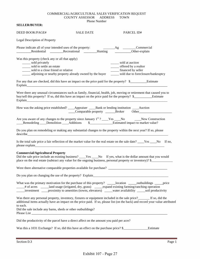
COMMERCIAL/AGRICULTURAL SALES VERIFICATION REQUEST COUNTY ASSESSOR ADDRESS TOWN
Phone Number SELLER/BUYER: DEED BOOK/PAGE# SALE DATE PARCEL ID# Legal Description of Property Please indicate all of your intended uses of the property: _______Ag ________Commercial _________Residential ________Recreational ________Hunting __________Other-explain Was this property (check any or all that apply) _____ sold privately _____ sold at auction _____ sold to settle an estate _____ offered by a realtor _____ sold to a close friend or relative _____ financed by seller _____ adjoining or nearby property already owned by the buyer _____ sold due to foreclosure/bankruptcy
For any that are checked, did this have an impact on the price paid for the property? $__________Estimate Explain______________________________________________________________________________________ Were there any unusual circumstances such as family, financial, health, job, moving or retirement that caused you to buy/sell this property? If so, did this have an impact on the price paid for the property? $___________Estimate Explain______________________________________________________________________________________ How was the asking price established? ____Appraiser ____Bank or lending institution ____Auction ____Comparable property ______Broker Other____________________ Are you aware of any changes to the property since January 1st ? ____Yes ____No ____New Construction ____Remodeling ____Demolition ____Additions $______________Estimated impact to market value? Do you plan on remodeling or making any substantial changes to the property within the next year? If so, please describe______________________________________________________________________________________ Is the total sale price a fair reflection of the market value for the real estate on the sale date? ____Yes ____No If no, please explain_______________________________________________________________________________ Commercial/Agricultural Property Did the sale price include an existing business? ____Yes ____No If yes, what is the dollar amount that you would place on the real estate (subtract any value for the ongoing business, personal property or inventory)? $_____________ Were there alternative comparable properties available for purchase? ____________________________________ Do you plan on changing the use of the property? Explain______________________________________________ What was the primary motivation for the purchase of this property? _____location _____outbuildings _____price _____# of acres _____land usage (irrigated, dry, grass) _____expand existing farming/ranching operation _____investment ____proximity to amenities (towns, elevators) _____water availability _____soil productivity Was there any personal property, inventory, fixtures or equipment included in the sale price?_______ If so, did the additional items actually have an impact on the price paid. If so, please list (on the back) and record your value attributed to each. Did the sale include any barns, sheds or other outbuildings? Please List ___________________________________________________________________________________ Did the productivity of the parcel have a direct affect on the amount you paid per acre? Was this a 1031 Exchange? If so, did this have an effect on the purchase price? $_______________Estimate
Exhibit 107 - Page 27
Section D.3 Page 2
Is the property currently signed up for any government programs such as WRP, CREP, CRP, or EQIP? ________ If so, please list (on the back) which program, # of acres and contract expiration Is there any additional information about this sale that would help us in our analysis?
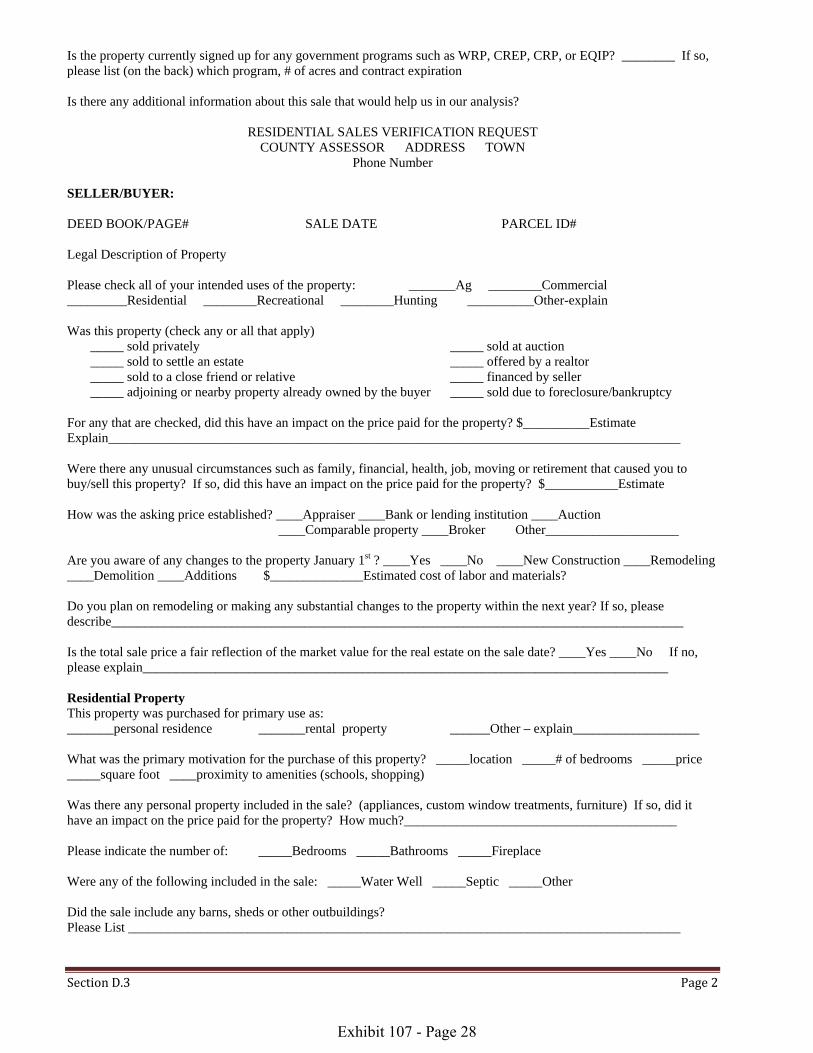
RESIDENTIAL SALES VERIFICATION REQUEST COUNTY ASSESSOR ADDRESS TOWN
Phone Number SELLER/BUYER: DEED BOOK/PAGE# SALE DATE PARCEL ID# Legal Description of Property Please check all of your intended uses of the property: _______Ag ________Commercial _________Residential ________Recreational ________Hunting __________Other-explain Was this property (check any or all that apply) _____ sold privately _____ sold at auction _____ sold to settle an estate _____ offered by a realtor _____ sold to a close friend or relative _____ financed by seller _____ adjoining or nearby property already owned by the buyer _____ sold due to foreclosure/bankruptcy
For any that are checked, did this have an impact on the price paid for the property? $__________Estimate Explain______________________________________________________________________________________ Were there any unusual circumstances such as family, financial, health, job, moving or retirement that caused you to buy/sell this property? If so, did this have an impact on the price paid for the property? $___________Estimate How was the asking price established? ____Appraiser ____Bank or lending institution ____Auction ____Comparable property ____Broker Other____________________ Are you aware of any changes to the property January 1st ? ____Yes ____No ____New Construction ____Remodeling ____Demolition ____Additions $______________Estimated cost of labor and materials? Do you plan on remodeling or making any substantial changes to the property within the next year? If so, please describe______________________________________________________________________________________ Is the total sale price a fair reflection of the market value for the real estate on the sale date? ____Yes ____No If no, please explain_______________________________________________________________________________ Residential Property This property was purchased for primary use as: _______personal residence _______rental property ______Other – explain___________________ What was the primary motivation for the purchase of this property? _____location _____# of bedrooms _____price _____square foot ____proximity to amenities (schools, shopping) Was there any personal property included in the sale? (appliances, custom window treatments, furniture) If so, did it have an impact on the price paid for the property? How much?_________________________________________ Please indicate the number of: _____Bedrooms _____Bathrooms _____Fireplace Were any of the following included in the sale: _____Water Well _____Septic _____Other Did the sale include any barns, sheds or other outbuildings? Please List ___________________________________________________________________________________
Exhibit 107 - Page 28
Section E.1 Page 1
PRACTICAL APPLICATION
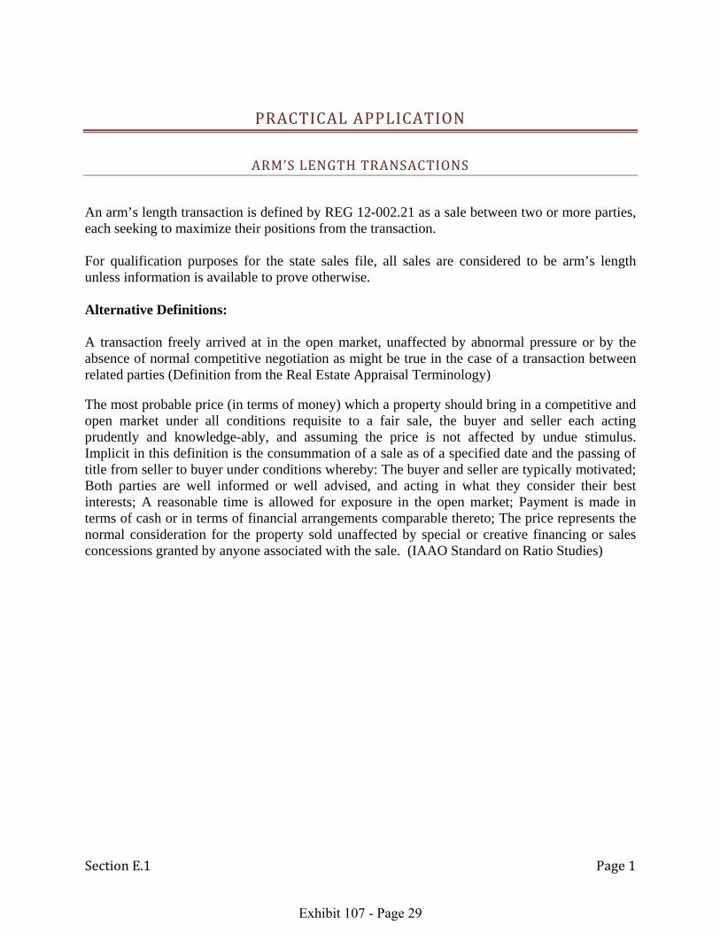
ARM’S LENGTH TRANSACTIONS
An arm’s length transaction is defined by REG 12-002.21 as a sale between two or more parties, each seeking to maximize their positions from the transaction. For qualification purposes for the state sales file, all sales are considered to be arm’s length unless information is available to prove otherwise. Alternative Definitions: A transaction freely arrived at in the open market, unaffected by abnormal pressure or by the absence of normal competitive negotiation as might be true in the case of a transaction between related parties (Definition from the Real Estate Appraisal Terminology) The most probable price (in terms of money) which a property should bring in a competitive and open market under all conditions requisite to a fair sale, the buyer and seller each acting prudently and knowledge-ably, and assuming the price is not affected by undue stimulus. Implicit in this definition is the consummation of a sale as of a specified date and the passing of title from seller to buyer under conditions whereby: The buyer and seller are typically motivated; Both parties are well informed or well advised, and acting in what they consider their best interests; A reasonable time is allowed for exposure in the open market; Payment is made in terms of cash or in terms of financial arrangements comparable thereto; The price represents the normal consideration for the property sold unaffected by special or creative financing or sales concessions granted by anyone associated with the sale. (IAAO Standard on Ratio Studies)
Exhibit 107 - Page 29

Section E.2 Page 1
NON ARM’S LENGTH TRANSACTIONS
Pursuant to professionally accepted mass appraisal techniques and thorough review, sufficient documentation and compelling information regarding the sale is necessary to determine if a sale is a non-arm’s length transaction. Complete verification of the transaction is necessary to determine that a sale is not arm’s length. The following conditions are indicators of potential non-arm’s length transactions, but are not to be automatically considered as such: Sale between immediate family members
Specify the relationship – spouse, grandparents and grandchild, parents and child, brothers and sisters, family corporation or partnerships, aunt or uncle to niece or nephew
Sales between immediate family members (immediate family members to include grandparents, parents, children, aunts, uncles) serve only as a flag and may not necessarily invalidate the sale. Sales between relatives are usually non-open-market transactions and tend to occur at prices lower than would otherwise be expected. Family transactions may be considered arm’s length if all the following conditions apply:
The property was exposed on the open market Listed with a realtor or some other form of public notice at the
time of sale (for sale sign, newspaper, word-of-mouth, etc) The selling price is within an acceptable range that any party
purchasing the property would be expected to pay. The selling price was established by independent appraisals The sale meets other criteria of being an open-market arm’s length
transaction Sale involving corporate affiliates belonging to the same parent company
These transactions should be considered a non-arm’s length transaction. Corporate sales often require considerable research to determine legal relationships. Sales between corporate affiliates may be made only to obtain financing or to adjust corporate accounts. Knowledge of corporate relationships is usually required to identify corporate affiliates, although a buyer and seller at the same address may indicate an affiliation.
Exhibit 107 - Page 30
Section E.2 Page 2
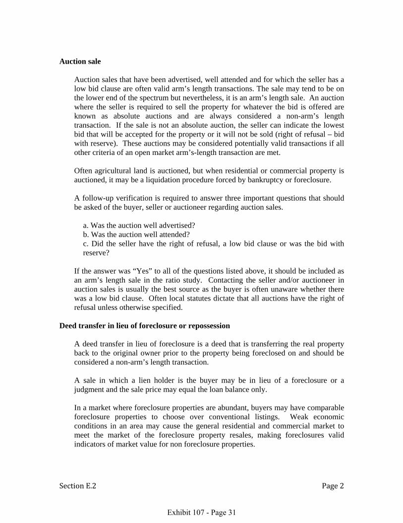
Auction sale
Auction sales that have been advertised, well attended and for which the seller has a low bid clause are often valid arm’s length transactions. The sale may tend to be on the lower end of the spectrum but nevertheless, it is an arm’s length sale. An auction where the seller is required to sell the property for whatever the bid is offered are known as absolute auctions and are always considered a non-arm’s length transaction. If the sale is not an absolute auction, the seller can indicate the lowest bid that will be accepted for the property or it will not be sold (right of refusal – bid with reserve). These auctions may be considered potentially valid transactions if all other criteria of an open market arm’s-length transaction are met. Often agricultural land is auctioned, but when residential or commercial property is auctioned, it may be a liquidation procedure forced by bankruptcy or foreclosure. A follow-up verification is required to answer three important questions that should be asked of the buyer, seller or auctioneer regarding auction sales.
a. Was the auction well advertised? b. Was the auction well attended? c. Did the seller have the right of refusal, a low bid clause or was the bid with reserve?
If the answer was “Yes” to all of the questions listed above, it should be included as an arm’s length sale in the ratio study. Contacting the seller and/or auctioneer in auction sales is usually the best source as the buyer is often unaware whether there was a low bid clause. Often local statutes dictate that all auctions have the right of refusal unless otherwise specified.
Deed transfer in lieu of foreclosure or repossession
A deed transfer in lieu of foreclosure is a deed that is transferring the real property back to the original owner prior to the property being foreclosed on and should be considered a non-arm’s length transaction. A sale in which a lien holder is the buyer may be in lieu of a foreclosure or a judgment and the sale price may equal the loan balance only. In a market where foreclosure properties are abundant, buyers may have comparable foreclosure properties to choose over conventional listings. Weak economic conditions in an area may cause the general residential and commercial market to meet the market of the foreclosure property resales, making foreclosures valid indicators of market value for non foreclosure properties.
Exhibit 107 - Page 31

Section E.2 Page 3
Sale by judicial order (by a guardian, executor, conservator, administrator, or trustee of an estate)
Sales should be verified to confirm they meet the criteria for an open market transaction. A follow-up verification should be made prior to including the sale in the ratio study.
a. A conveyance by an executor or trustee under power granted in a will may not
represent market value especially if the sale takes place soon after the will is filed and admitted to probate in order to satisfy the decedent’s debts or the wishes of an heir.
b. Estate sales where the seller is the estate may be an arm’s length transaction, if the sale is not forced and meets the other conditions of market value.
c. Sales where the buyer is an executor or trustee of an estate are usually non-market at nominal consideration.
Sales involving charitable, religious, or educational institutions
Typically should be considered a non-arm’s length sale because they are usually the result of full or partial gifts making them a non-arm’s length sale.
Sales involving government agencies or public utilities
Such sales may involve an element of compulsion and often occur at prices higher than would otherwise be expected. On the other hand, sales by governmental agencies of surplus property or of redevelopment sites tend to be favorable prices and with further review may be considered an arm’s length sale.
Buyer (new owner) is a financial institution, insurance company, pension fund, or mortgage corporation
This transaction could possibly be a repossession, in which case, the sale should not be included as an arm’s length transaction in the ratio study.
Sales from banks should not be automatically considered a non-arm’s length transaction especially if you do not have an abundant supply of sales. Typically, values will be on the low end of the value range, but they may be considered arm’s length transactions and included in the ratio study if all other criteria for being an open market arm’s-length transaction are met.
Exhibit 107 - Page 32

Section E.2 Page 4
Sale of only a partial interest in the real estate
These transactions should be considered as non-arm’s length sales unless all the interests in the real property have sold. If all the interests have sold, a follow-up verification is necessary to confirm whether or not the sale price is the total sale price or whether it is only the price paid for an interest in the property. When all the interests are known, only one of transfers should be adjusted for the total sale price and validated, if the transaction meets all the other requirements to be considered an arm’s length sale. The remaining interest sales should be invalidated and not included in the statistical analysis.
Sale involved a trade or exchange of properties
Generally, sales involving a trade should be excluded from sales analysis. In situations where the trade is a pure trade (there is no cash or financing involved) the sale should be excluded from the study. If the sale involves both money and traded property, it may be possible to include the sale as a potentially valid sale if the value of the traded property is stipulated, an accurate estimate can be made or the value is small in comparison to the total sale price. 1031 Exchanges –Under section 1031 of the Internal Revenue Code, a real property owner can sell his property and then reinvest the proceeds in ownership of like-kind property and defer the capital gains taxes. To qualify as a 1031 like-kind exchange, property exchanges must be done in accordance with the rules set forth in the tax code and in the treasury regulations. 1031 exchange services can offer significant tax advantages to real estate buyers.
Transfer of convenience
Such transfers are intended to correct defects in a title, create a joint or common tenancy, or serve some similar purpose. In such situations, the sale price is usually nominal. Sales of convenience can be identified by deed type.
Exhibit 107 - Page 33

Section E.3 Page 1
STATISTICAL DEFINITIONS
Median Ratio: shall mean the middle ratio of the sorted or arrayed assessment/sales ratios. If there is an even number of ratios, the median shall be the average of the two middle ratios. The median divides the ratios into two equal groups and is therefore little affected by outliers. Of the three measures of central tendency, the median is generally preferred for the development of market adjustment factors, since it is less influenced by extreme ratios. The median is the generally preferred measure of central tendency for direct equalization, monitoring appraisal performance, determining reappraisal priorities, or evaluating the need for a reappraisal. Mean Ratio: shall mean the arithmetic mean ratio or the total of all assessment/sales ratios divided by the number of ratios. The mean ratio is the average ratio. The mean accurately reflects the full magnitude of every ratio, which is desirable only if outliers are based on valid data and occur with the same frequency in both the sample and the population. Outliers particularly affect the mean in small samples.
Computing the Median and Mean
Example A Example B Example C Sale Number Ratio Sale Number Ratio Sale Number Ratio 1 80.00 1 80.00 1 80.00 2 85.00 2 85.00 2 85.00 3 90.00 3 90.00 3 90.00 4 95.00 4 95.00 4 95.00 5 100.00 5 100.00 5 100.00 6 105.00 6 200.00
450.00 555.00 650.00 Median Position 0.5(5) + 0.5 = 3.0 0.5(6) + 0.5 = 3.5 0.5(6) + 0.5 = 3.5 Median Ratio = 90.00 (90.00+95.00)/2 = 92.50 (90.00+95.00)/2 = 92.50 Mean Ratio 450.00/5 = 90.00 555.00/6 = 92.50 650/6 = 108.30 Definitions pertaining to Sales File
Exhibit 107 - Page 34

Section E.3 Page 2
Aggregate Ratio or Weighted Mean Ratio: The weighted mean weights each ratio in proportion to its sale price. The weighted mean is an appropriate measure for estimating the total dollar value of a population of parcels. It gives each dollar of valuation equal weight. Because of its dollar weighting feature, the weighted mean is most appropriately used in indirect equalization, where one seeks to estimate the total dollar value of the jurisdiction.
Calculating the Weighted Mean
Example A
Example B
Sale Number
Assessed Value
Sale Price
Ratio (A/S)
Sale Number
Assessed Value
Sale Price
Ratio (A/S)
1 $ 20,000 $ 25,000 80.00 1 $ 10,000 $ 25,000 40.00 2 20,000 25,000 80.00 2 20,000 25,000 80.00 3 20,000 25,000 80.00 3 20,000 25,000 80.00 4 20,000 25,000 80.00 4 20,000 25,000 80.00 5 40,000 100,000 40.00 5 80,000 100,000 80.00
$120,000 $200,000 360.00 $150,000 $200,000 360.00 Mean Ratio Mean Ratio 360.00/5 = 72.00 360.00/5 = 72.00 Weighted Mean Ratio Weighted Mean Ratio $120,000 / $200,000 = 60.00 $150,000 / $200,000 = 75.00
Exhibit 107 - Page 35

Section E.3 Page 3
Coefficient of Dispersion (COD): Measures the average absolute (sign-ignored) difference of the ratios from the median expressed as a percentage. It thus provides a measure of assessment uniformity that is independent of the level of assessment and permits direct comparisons between property groups. The lower the level of assessment (median A/S ratio), the greater will be the COD relative to the average deviation. Low CODs (15.00 or less) tend to be associated with good assessment uniformity.
Calculation the Coefficient of Dispersion
Sale Number
Assessed Value
Sale Price
Ratio (A/S)
Absolute difference From median
1 $ 8,500 $ 25,000 34.00 16.00 2 19,000 50,000 38.00 12.00 3 13,000 30,000 43.30 06.70 4 30,000 60,000 50.00 00.00 5 17,000 30,000 56.70 06.70 6 31,000 50,000 62.00 12.00 7 16,500 25,000 66.00 16.00
69.40
Median Ratio = 50.00 Average Absolute Deviation = (69.40 / 7) = 9.90 COD = (9.90 / 50.00) * 100 = 19.80 Residential Low CODs (15.00 or less) tend to be associated with good appraisal uniformity. Commercial and Agricultural CODs (less than 20) tend to be associated with good appraisal uniformity.
Exhibit 107 - Page 36
Section E.3 Page 4
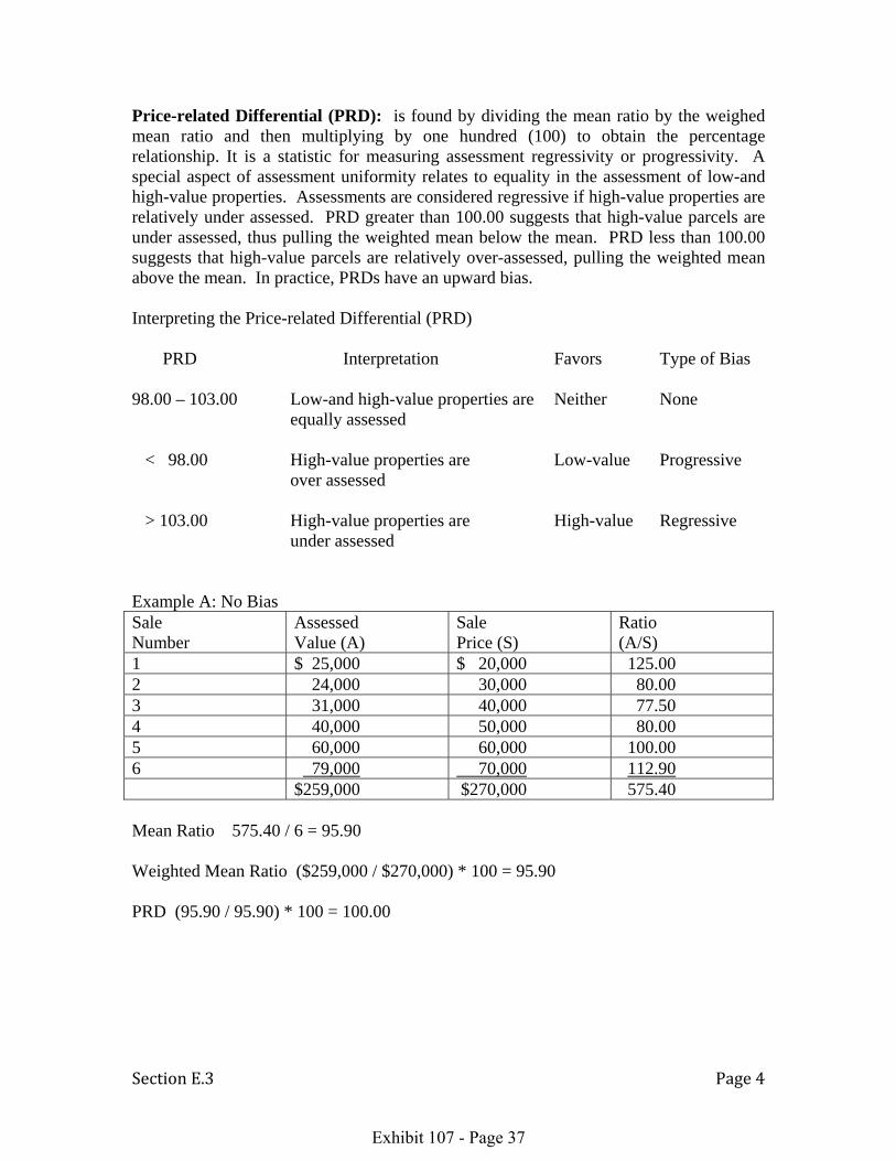
Price-related Differential (PRD): is found by dividing the mean ratio by the weighed mean ratio and then multiplying by one hundred (100) to obtain the percentage relationship. It is a statistic for measuring assessment regressivity or progressivity. A special aspect of assessment uniformity relates to equality in the assessment of low-and high-value properties. Assessments are considered regressive if high-value properties are relatively under assessed. PRD greater than 100.00 suggests that high-value parcels are under assessed, thus pulling the weighted mean below the mean. PRD less than 100.00 suggests that high-value parcels are relatively over-assessed, pulling the weighted mean above the mean. In practice, PRDs have an upward bias. Interpreting the Price-related Differential (PRD) PRD Interpretation Favors Type of Bias 98.00 – 103.00 Low-and high-value properties are Neither None equally assessed < 98.00 High-value properties are Low-value Progressive over assessed > 103.00 High-value properties are High-value Regressive under assessed Example A: No Bias Sale Number
Assessed Value (A)
Sale Price (S)
Ratio (A/S)
1 $ 25,000 $ 20,000 125.00 2 24,000 30,000 80.00 3 31,000 40,000 77.50 4 40,000 50,000 80.00 5 60,000 60,000 100.00 6 79,000 70,000 112.90
$259,000 $270,000 575.40 Mean Ratio 575.40 / 6 = 95.90 Weighted Mean Ratio ($259,000 / $270,000) * 100 = 95.90 PRD (95.90 / 95.90) * 100 = 100.00
Exhibit 107 - Page 37

Section E.3 Page 5
Example B: Regressivity (High valued properties are under assessed) Sale Number
Appraised Value (A)
Sale Price (S)
Ratio (A/S)
1 $ 30,000 $ 20,000 150.00 2 40,000 30,000 133.30 3 45,000 40,000 112.50 4 50,000 50,000 100.00 5 40,000 60,000 66.70 6 45,000 70,000 64.30
$250,000 $270,000 626.80 Mean Ratio 626.80 / 6 = 104.50 Weighted Mean Ratio ($250,000 / $270,000) * 100 = 92.60 PRD (104.50 / 92.60) * 100 = 112.85 Example C: Progressivity (High value properties are over assessed) Sale Number
Appraised Value (A)
Sale Price (S)
Ratio (A/S)
1 $ 6,000 $ 20,000 30.00 2 12,000 30,000 40.00 3 30,000 40,000 75.00 4 60,000 50,000 120.00 5 75,000 60,000 125.00 6 90,000 70,000 128.60
$273,000 $270,000 518.60 Mean Ratio 518.60 / 6 = 86.40 Weighted Mean Ratio ($273,000 / $270,000) * 100 = 101.10 PRD (86.40 / 101.10) *100 = 85.00
Exhibit 107 - Page 38

Section E.3 Page 6
Central tendency: A single point in a range of observations, around which the observations tend to cluster. The three most commonly used measures of central tendency calculated by the Division are the median ratio, weighted mean ratio and the mean ratio. Direct Equalization: The process of adjusting the assessed values of parcels of real property, usually by class or subclass, using adjustment factors or percentages, to achieve proportionate valuations among the classes or subclasses. Involves converting ratio study results into adjustment factors (trends) and ordering locally determined appraised or assessed values to be changed to more nearly reflect market value or the statutorily required level of assessment. Advantage: it can be applied to specified strata, such as property classes, geographic area, and political subdivisions, that fail to meet appraisal level performance standards. Also produces results that are more visible to the taxpayer and will more clearly reduce perceived inequities between classes. Indirect Equalization: Involves computing hypothetical values that represent the oversight agency’s best estimate of taxable value, given the statutorily required level of assessment or market value. The most common use of indirect equalization is to ensure proper funding distribution, particularly for school districts. For example, if the assessed value of property in a jurisdiction is $750 million, but a ratio study shows an assessment level of 75 percent, while the legally required level of assessment is 100 percent, an equalized value of $1,000 million could be computed ($750 million/.075). Indirect equalization results in fairer funding apportionment because the overall appraisal levels of the taxing jurisdictions tend to vary. If there were no equalization, the extent that a jurisdiction under-or overestimated its total tax base would result in over-or under apportionment of funds. Indirect equalization does not correct for under-or over appraisal between classes of property and is less visible to taxpayers. Indirect equalization tends to encourage taxing jurisdictions to keep their overall tax bases close to the required level.
Exhibit 107 - Page 39

Section F.1 Page 1
PURPOSE OF COMMERCIAL OCCUPANCY CODES
Occupancy code is the descriptor of a building or a portion of a building’s use and is used to categorize similar properties for appraisal. Each improved commercial sale included in the sales file is required to have an occupancy code to identify the property. The importance of properly assigned occupancy codes cannot be over emphasized, as these codes allow proper identification for comparable sales searches across the state. A multi-use building will have more than one occupancy code because the square footage is split between uses. An example would include a retail store with offices on the second level. When assigning the primary occupancy code it may be helpful to note occupancy percentage in the comments section of the sales file. Occupancy percentage is the percentage of a structure’s total square footage dedicated to a specific occupancy or use. The commercial codes provided in this manual are listed alphabetically, numerically, and includes a list developed by the Department of Revenue for special use properties.
Exhibit 107 - Page 40
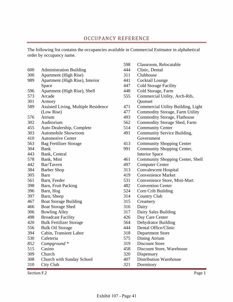
Section F.2 Page 1
OCCUPANCY REFERENCE
The following list contains the occupancies available in Commercial Estimator in alphabetical order by occupancy name.
600 Administration Building 300 Apartment (High Rise) 989 Apartment (High Rise), Interior
Space 596 Apartment (High Rise), Shell 573 Arcade 301 Armory 589 Assisted Living, Multiple Residence
(Low Rise) 576 Atrium 302 Auditorium 455 Auto Dealership, Complete 303 Automobile Showroom 410 Automotive Center 563 Bag Fertilizer Storage 304 Bank 443 Bank, Central 578 Bank, Mini 442 Bar/Tavern 384 Barber Shop 305 Barn 561 Barn, Feeder 398 Barn, Fruit Packing 396 Barn, Hog 397 Barn, Sheep 467 Boat Storage Building 466 Boat Storage Shed 306 Bowling Alley 498 Broadcast Facility 420 Bulk Fertilizer Storage 556 Bulk Oil Storage 394 Cabin, Transient Labor 530 Cafeteria 852 Campground * 515 Casino 309 Church 308 Church with Sunday School 310 City Club
598 Classroom, Relocatable 444 Clinic, Dental 311 Clubhouse 441 Cocktail Lounge 447 Cold Storage Facility 448 Cold Storage, Farm 555 Commercial Utility, Arch-Rib,
Quonset 471 Commercial Utility Building, Light 477 Commodity Storage, Farm Utility 493 Commodity Storage, Flathouse 562 Commodity Storage Shed, Farm 514 Community Center 491 Community Service Building,
Government 413 Community Shopping Center 991 Community Shopping Center,
Interior Space 461 Community Shopping Center, Shell 497 Computer Center 313 Convalescent Hospital 419 Convenience Market 531 Convenience Store, Mini-Mart 482 Convention Center 524 Corn Crib Building 314 Country Club 315 Creamery 316 Dairy 317 Dairy Sales Building 426 Day Care Center 564 Dehydrator Building 444 Dental Office/Clinic 318 Department Store 575 Dining Atrium 319 Discount Store 458 Discount Store, Warehouse 320 Dispensary 407 Distribution Warehouse 321 Dormitory
Exhibit 107 - Page 41

Section F.2 Page 2
393 Dormitory, Labor 499 Dry Cleaners/Laundry 480 Environmental Vegetable Building 472 Equipment Shed 470 Equipment (Shop) Building 588 Extended Stay Motel 448 Farm Cold Storage 562 Farm Commodity Storage Shed 558 Farm Implement Arch-Rib, Quonset 476 Farm Implement Building 478 Farm Implement Shed 566 Farm Sun Shade Shelter 557 Farm Utility Arch-Rib, Quonset 477 Farm Utility Building 565 Farm Utility Shelter 479 Farm Utility Storage Shed 349 Fast Food Restaurant 899 Feeder Barn * 561 Feeder Barn 516 Fellowship Hall 563 Fertilizer Storage, Bag 420 Fertilizer Storage, Bulk 486 Field Houses 322 Fire Station (Staffed) 427 Fire Station (Volunteer) 483 Fitness Center 493 Flathouse 532 Florist Shop 533 Food Store, Warehouse 517 Foyer/Narthex 323 Fraternal Building 324 Fraternity House 469 Freestall Barn 398 Fruit Packing Barn 594 Full Service Hotel 423 Garage, Mini-Lube 527 Garage, Municipal Service 528 Garage, Service Repair 526 Garage, Service Shed 326 Garage, Storage 523 Golf Cart Storage Building 100 Golf Course (complete) 491 Government Community Service
Building 327 Governmental Building
841 Grain Elevator * 493 Grain Storage, Flathouse 421 Grain Storage, Utility 521 Greenhouse, Hoop, Arch-rib 518 Greenhouse Lath Shade House 520 Greenhouse, Modified Hoop 519 Greenhouse Shade Shelter 522 Greenhouse, Straight Wall 424 Group Care Home 417 Handball-Racquetball Club 329 Hangar, Maintenance and Office 328 Hangar, Storage 409 Hangar, T 418 Health Club 525 High Rise Mini Warehouse 396 Hog Barn 430 Hog Shed 429 Hog Shed, Modified 330 Home For The Elderly 521 Hoop Greenhouse, Arch-rib 520 Hoop Greenhouse, Modified 428 Horse Arena 331 Hospital 381 Hospital, Veterinary 313 Hospital, Convalescent 594 Hotel, Full Service 595 Hotel, Limited Service 416 Indoor Tennis Club 994 Industrial Building, Interior Space 454 Industrial Building, Shell 392 Industrial Engineering Building 453 Industrial Flex Building 495 Industrial Heavy Manufacturing 494 Industrial Light Manufacturing 989 Interior Space, Apartment (High
Rise) 991 Interior Space, Community Shopping
Center 994 Interior Space, Industrial Building 987 Interior Space, Multiple Residence
(Low Rise) 990 Interior Space, Neighborhood
Shopping Center 993 Interior Space, Office Building
Exhibit 107 - Page 42

Section F.2 Page 3
992 Interior Space, Regional Shopping Center
335 Jail, Correctional Facility 489 Jail, Police Station 490 Kennel 496 Laboratory 393 Labor Dormitory 518 Lath Shade House (Greenhouse) 336 Laundromat 499 Laundry/Dry Cleaners 560 Lean-To 337 Library, Public 555 Light Commercial Arch-Rib,
Quonset 471 Light Commercial Utility Building 537 Lodge 338 Loft 390 Lumber Storage Building, Vertical 339 Lumber Storage Shed, Horizontal 583 Mail Processing Facility 581 Main Post Office 340 Market 419 Market, Convenience 533 Market, Food Warehouse 586 Market, Roadside 446 Market, Super 473 Material Shelter 391 Material Storage Building 468 Material Storage Shed 585 Mechanical Penthouse 341 Medical Office 584 Mega Warehouse 440 Milkhouse 578 Mini Bank 423 Mini-Lube Garage 531 Mini-Mart Convenience Store 386 Mini Warehouse 525 Mini Warehouse, High Rise 597 Mixed Retail with Office Units 459 Mixed Retail with Residential Units 851 Mobile Home Park * 429 Modified Hog Shed 520 Modified Hoop Greenhouse 342 Mortuary 343 Motel
588 Motel, Extended Stay 544 Motel, Office-Apartment 542 Motel Room, 1 Story, Double Row 543 Motel Room, 1 Story, Single Row 540 Motel Room, 2 Story, Double Row 541 Motel Room, 2 Story, Single Row 352 Multiple Residence (Low Rise) 987 Multiple Residence (Low Rise),
Interior Space 587 Multiple Residence (Low Rise),
Shell 589 Multiple Residence, Assisted Living
(Low Rise) 451 Multiple Residence, Senior Citizen
(Low Rise) 459 Multiple Residential Units Mixed
with Retail 527 Municipal Service Garage 481 Museum 517 Narthex/Foyer 485 Natatorium 412 Neighborhood Shopping Center 990 Neighborhood Shopping Center,
Interior Space 460 Neighborhood Shopping Center,
Shell 544 Office-Apartment (Motel) 344 Office Building 993 Office Building, Interior Space 492 Office Building, Shell 444 Office, Dental 341 Office, Medical 599 Office, Relocatable 554 Office Shed 597 Office Units Mixed with Retail 556 Oil Storage, Bulk 431 Outpatient (Surgical) Center 577 Parking Levels 345 Parking Structure 388 Parking Structure, Underground 571 Passenger Terminal 585 Penthouse, Mechanical 346 Post Office 581 Post Office, Main 582 Post Office, Branch
Exhibit 107 - Page 43

Section F.2 Page 4
395 Potato Storage 570 Poultry House - Cage, One Story,
Elevated 474 Poultry House - Cage Operation,
One Story 569 Poultry House - Cage, Three Story 567 Poultry House - Cage, Two Story 568 Poultry House - Cage, Two Story,
Elevated 475 Poultry House - Floor Operation 583 Processing Facility, Mail 834 Quarry * 558 Quonset, Farm Implement Arch-Rib 557 Quonset, Farm Utility Arch-Rib 555 Quonset, Light Commercial Arch-
Rib 417 Racquetball-Handball Club 552 Recreational Enclosure 348 Rectory 414 Regional Shopping Center 992 Regional Shopping Center, Interior
Space 462 Regional Shopping Center, Shell 598 Relocatable Classroom 599 Relocatable Office 530 Restaurant, Cafeteria 349 Restaurant, Fast Food 529 Restaurant, Snack Bar 350 Restaurant, Table Service 432 Restroom Building 353 Retail Store 597 Retail Mixed with Office Units 586 Roadside Market 551 Rooming House 526 Service Garage Shed 528 Service Repair Garage 408 Service Station 466 Shed, Boat Storage 472 Shed, Equipment 562 Shed, Farm Commodity Storage 478 Shed, Farm Implement 479 Shed, Farm Utility Storage 561 Shed, Feeder Barn 430 Shed, Hog 339 Shed, Lumber Storage, Horizontal
468 Shed, Material Storage 429 Shed, Modified Hog 526 Shed, Service Garage 554 Shed Office Structure 596 Shell, Apartment (High Rise) 461 Shell, Community Shopping Center 454 Shell, Industrial Building 587 Shell, Multiple Residence (Low
Rise) 460 Shell, Neighborhood Shopping
Center 492 Shell, Office Building 462 Shell, Regional Shopping Center 397 Sheep Barn 565 Shelters, Farm Utility 473 Shelters, Material 566 Shelters, Sun Shade 413 Shopping Center, Community 991 Shopping Center, Community,
Interior Space 461 Shopping Center, Community, Shell 459 Shopping Center, Mixed with
Residential Units 412 Shopping Center, Neighborhood 990 Shopping Center, Neighborhood,
Interior Space 460 Shopping Center, Neighborhood, Shell 414 Shopping Center, Regional 992 Shopping Center, Regional, Interior
Space 462 Shopping Center, Regional, Shell 403 Shower Building 303 Showroom, Automobile 534 Showroom Store, Warehouse 405 Skating Rink 529 Snack Bar 378 Stable 559 Stables, High-Value 563 Storage, Bag Fertilizer 420 Storage, Bulk Fertilizer 556 Storage, Bulk Oil 470 Storage, Equipment Shop 447 Storage Facility, Cold 476 Storage, Farm Implement
Exhibit 107 - Page 44

Section F.2 Page 5
477 Storage, Farm Utility 493 Storage, Flathouse 326 Storage Garage 421 Storage, Grain 523 Storage, Golf Cart 328 Storage Hangar 390 Storage, Lumber Building, Vertical 339 Storage, Lumber Shed, Horizontal 391 Storage, Material 395 Storage, Potato 406 Storage Warehouse 318 Store, Department 319 Store, Discount 458 Store, Discount Warehouse 533 Store, Food Warehouse 353 Store, Retail 534 Store, Warehouse Showroom 522 Straight Wall Greenhouse 446 Supermarket 409 T-Hangar 442 Tavern/Bar 416 Tennis Club, Indoor 380 Theater, Cinema 379 Theater, Live Stage 456 Tool Shed 394 Transient Labor Cabin 387 Transit Warehouse 825 Transmission Facilities * 580 Truck Stop 388 Underground Parking Structure 477 Utility Building, Farm 471 Utility Building, Light Commercial 480 Vegetable Building, Environmental 381 Veterinary Hospital 574 Visitor Center 458 Warehouse Discount Store 407 Warehouse, Distribution 533 Warehouse Food Store 525 Warehouse, High Rise Mini 584 Warehouse, Mega 386 Warehouse, Mini 534 Warehouse Showroom Store 406 Warehouse, Storage 387 Warehouse, Transit
Exhibit 107 - Page 45

S e c t i o n F . 3 P a g e 1
NUMERICAL OCCUPANCY LIST
The following list contains the occupancies available in Commercial Estimator in numerical order by occupancy number.
100 Golf Course (complete) 300 Apartment (High Rise) 301 Armory 302 Auditorium 303 Automobile Showroom 304 Bank 305 Barn 306 Bowling Alley 308 Church with Sunday School 309 Church 310 City Club 311 Clubhouse 313 Convalescent Hospital 314 Country Club 315 Creamery 316 Dairy 317 Dairy Sales Building 318 Department Store 319 Discount Store 320 Dispensary 321 Dormitory 322 Fire Station (Staffed) 323 Fraternal Building 324 Fraternity House 326 Storage Garage 327 Governmental Building 328 Storage Hangar 329 Hangar, Maintenance and Office 330 Home for the Elderly 331 Hospital 335 Jail (Correctional Facility) 336 Laundromat 337 Library, Public 338 Loft 339 Lumber Storage Shed, Horizontal 340 Market 341 Medical Office 342 Mortuary 343 Motel 344 Office Building 345 Parking Structure
346 Post Office 348 Rectory 349 Fast Food Restaurant 350 Restaurant 352 Multiple Residence (Low Rise) 353 Retail Store 378 Stable 379 Theater, Live Stage 380 Theater, Cinema 381 Veterinary Hospital 384 Barber Shop 386 Mini Warehouse 387 Transit Warehouse 388 Underground Parking Structure 390 Lumber Storage Building, Vertical 391 Material Storage Building 392 Industrial Engineering Building 393 Labor Dormitory 394 Transient Labor Cabin 395 Potato Storage 396 Hog Barn 397 Sheep Barn 398 Fruit Packing Barn 403 Shower Building 405 Skating Rink 406 Storage Warehouse 407 Distribution Warehouse 408 Service Station 409 T-Hangar 410 Automotive Center 412 Neighborhood Shopping Center 413 Community Shopping Center * O c c u p a n c y C o d e s i n i t a l i c s r e p r e s e n t t h o s e d e f i n e d b y t h e D i v i s i o n .
Exhibit 107 - Page 46
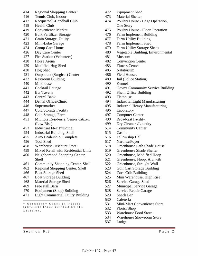
S e c t i o n F . 3 P a g e 2
471 Light Commercial Util
414 Regional Shopping Center1 416 Tennis Club, Indoor 417 Racquetball-Handball Club 418 Health Club 419 Convenience Market 420 Bulk Fertilizer Storage 421 Grain Storage, Utility 423 Mini-Lube Garage 424 Group Care Home 426 Day Care Center 427 Fire Station (Volunteer) 428 Horse Arena 429 Modified Hog Shed 430 Hog Shed 431 Outpatient (Surgical) Center 432 Restroom Building 440 Milkhouse 441 Cocktail Lounge 442 Bar/Tavern 443 Central Bank 444 Dental Office/Clinic 446 Supermarket 447 Cold Storage Facility 448 Cold Storage, Farm 451 Multiple Residence, Senior Citizen
(Low Rise) 453 Industrial Flex Building 454 Industrial Building, Shell 455 Auto Dealership, Complete 456 Tool Shed 458 Warehouse Discount Store 459 Mixed Retail with Residential Units 460 Neighborhood Shopping Center,
Shell 461 Community Shopping Center, Shell 462 Regional Shopping Center, Shell 466 Boat Storage Shed 467 Boat Storage Building 468 Material Storage Shed 469 Free stall Barn 470 Equipment (Shop) Building
ity Building
* O c c u p a n c y C o d e s i n i t a l i c s r e p r e s e n t t h o s e d e f i n e d b y t h e D i v i s i o n .
472 Equipment Shed 473 Material Shelter 474 Poultry House - Cage Operation,
One Story 475 Poultry House - Floor Operation 476 Farm Implement Building 477 Farm Utility Building 478 Farm Implement Shed 479 Farm Utility Storage Sheds 480 Vegetable Building, Environmental 481 Museum 482 Convention Center 483 Fitness Center 485 Natatorium 486 Field Houses 489 Jail (Police Station) 490 Kennel 491 Govmt Community Service Building 492 Shell, Office Building 493 Flathouse 494 Industrial Light Manufacturing 495 Industrial Heavy Manufacturing 496 Laboratory 497 Computer Center 498 Broadcast Facility 499 Dry Cleaners/Laundry 514 Community Center 515 Casino 516 Fellowship Hall 517 Narthex/Foyer 518 Greenhouse Lath Shade House 519 Greenhouse Shade Shelter 520 Greenhouse, Modified Hoop 521 Greenhouse, Hoop, Arch-rib 522 Greenhouse, Straight Wall 523 Golf Cart Storage Building 524 Corn Crib Building 525 Mini Warehouse, High Rise 526 Service Garage Shed 527 Municipal Service Garage 528 Service Repair Garage 529 Snack Bar 530 Cafeteria 531 Mini-Mart Convenience Store 532 Florist Shop 533 Warehouse Food Store 534 Warehouse Showroom Store 537 Lodge
Exhibit 107 - Page 47

S e c t i o n F . 3 P a g e 3
540 Motel Room, 2 Story, Double Row 541 Motel Room, 2 Story, Single Row 542 Motel Room, 1 Story, Double Row 543 Motel Room, 1 Story, Single Row 544 Office-Apartment (Motel) 551 Rooming House 552 Recreational Enclosure 554 Shed Office Structure 555 Light Commercial Arch-Rib,
Quonset 556 Bulk Oil Storage 557 Farm Utility Arch-Rib, Quonset 558 Farm Implement Arch-Rib, Quonset 559 Stables, High Value 560 Lean-To 561 Feeder Barn 562 Commodity Storage Shed, Farm 563 Bag Fertilizer Storage 564 Dehydrator Building 565 Farm Utility Shelter 566 Farm Sun Shade Shelter 567 Poultry House - Cage, Two Story 568 Poultry House - Cage, Elevated Two
Story 569 Poultry House - Cage, Three Story 570 Poultry House - Cage, Elevated One
Story 571 Passenger Terminal 573 Arcade 574 Visitor Center 575 Dining Atrium 576 Atrium 577 Parking Levels 578 Mini Bank 580 Truck Stop 581 Post Office, Main 582 Post Office, Branch
583 Mail Processing Facility 584 Mega Warehouse 585 Mechanical Penthouse 586 Roadside Market 587 Multiple Residence (Low Rise),
Shell 588 Motel, Extended Stay 589 Multiple Residence, Assisted Living
(Low Rise) 594 Hotel, Full Service 595 Hotel, Limited Service 596 Apartment (High Rise), Shell 597 Mixes Retail with Office Units 598 Relocatable Classroom 599 Relocatable Office 600 Administration Building 825 Transmission Facilities 841 Grain Elevator 851 Mobile Home Park 852 Campground 899 Feed Lot (Cattle) 987 Multiple Residence (Low Rise),
Interior Space 989 Apartment (High Rise), Interior
Space 990 Neighborhood Shopping Center,
Interior Space 991 Community Shopping Center,
Interior Space 992 Regional Shopping Center, Interior
Space 993 Interior Space, Office Building 994 Interior Space, Industrial Building * O c c u p a n c y C o d e s i n i t a l i c s r e p r e s e n t t h o s e d e f i n e d b y t h e D i v i s i o n .
Exhibit 107 - Page 48

S e c t i o n F . 3 P a g e 4
SPECIAL OCCUPANCY GROUP LISTS
Farm Occupancies, Light Commercial Sheds and Outbuildings 563 Bag Fertilizer Storage 305 Barn 561 Barn, Feeder 398 Barn, Fruit Packing 396 Barn, Hog 397 Barn, Sheep 383 Barn, Tobacco 420 Bulk Fertilizer Storage 394 Cabin, Transient Labor 448 Cold Storage, Farm 477 Commodity Storage, Farm Utility 493 Commodity Storage, Flathouse 562 Commodity Storage Shed, Farm 524 Corn Crib Building 450 Cotton Gin 315 Creamery 316 Dairy 564 Dehydrator Building 393 Dormitory, Labor 562 Farm Commodity Storage Shed 558 Farm Implement Arch-Rib,
Quonset 476 Farm Implement Building 478 Farm Implement Shed 566 Farm Sun Shade Shelter 557 Farm Utility Arch-Rib, Quonset 477 Farm Utility Building 565 Farm Utility Shelter 479 Farm Utility Storage Shed 561 Feeder Barn 563 Fertilizer Storage, Bag 420 Fertilizer Storage, Bulk 469 Free stall Barn 398 Fruit Packing Barn 493 Grain Storage, Flathouse 421 Grain Storage, Utility 396 Hog Barn 430 Hog Shed 429 Hog Shed, Modified 428 Horse Arena
393 Labor Dormitory 560 Lean-To 390 Lumber Storage Building, Vertical 339 Lumber Storage Shed, Horizontal 391 Material Storage Building 468 Material Storage Shed 440 Milkhouse 429 Modified Hog Shed 395 Potato Storage 570 Poultry House - Cage, One Story,
Elevated 474 Poultry House - Cage Operation,
One Story 569 Poultry House - Cage, Three Story 567 Poultry House - Cage, Two Story 568 Poultry House - Cage, Two Story,
Elevated 475 Poultry House - Floor Operation 558 Quonset, Farm Implement Arch-Rib 557 Quonset, Farm Utility Arch-Rib 472 Shed, Equipment 562 Shed, Farm Commodity Storage 478 Shed, Farm Implement 479 Shed, Farm Utility Storage 561 Shed, Feeder Barn 430 Shed, Hog 468 Shed, Material Storage 429 Shed, Modified Hog 526 Shed, Service Garage1 397 Sheep Barn 565 Shelter, Farm Utility 566 Shelter, Sun Shade 378 Stable 559 Stables, High-Value 563 Storage, Bag Fertilizer * O c c u p a n c y C o d e s i n i t a l i c s r e p r e s e n t t h o s e d e f i n e d b y t h e D i v i s i o n .
Exhibit 107 - Page 49

S e c t i o n F . 3 P a g e 5
420 Storage, Bulk Fertilizer 476 Storage, Farm Implement 477 Storage, Farm Utility 421 Storage, Grain 391 Storage, Material 395 Storage, Potato 383 Tobacco Barn 456 Tool Shed 394 Transient Labor Cabin 477 Utility, Farm
Exhibit 107 - Page 50
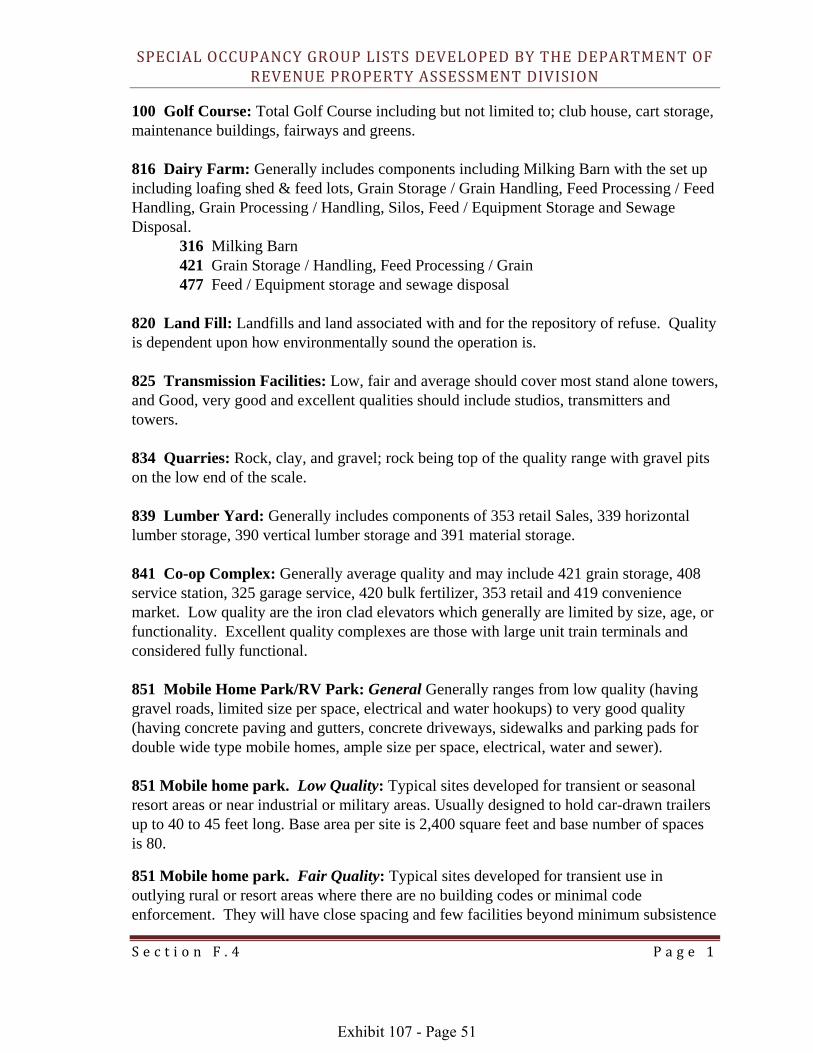
S e c t i o n F . 4 P a g e 1
SPECIAL OCCUPANCY GROUP LISTS DEVELOPED BY THE DEPARTMENT OF REVENUE PROPERTY ASSESSMENT DIVISION
100 Golf Course: Total Golf Course including but not limited to; club house, cart storage, maintenance buildings, fairways and greens. 816 Dairy Farm: Generally includes components including Milking Barn with the set up including loafing shed & feed lots, Grain Storage / Grain Handling, Feed Processing / Feed Handling, Grain Processing / Handling, Silos, Feed / Equipment Storage and Sewage Disposal.
316 Milking Barn 421 Grain Storage / Handling, Feed Processing / Grain 477 Feed / Equipment storage and sewage disposal
820 Land Fill: Landfills and land associated with and for the repository of refuse. Quality is dependent upon how environmentally sound the operation is. 825 Transmission Facilities: Low, fair and average should cover most stand alone towers, and Good, very good and excellent qualities should include studios, transmitters and towers. 834 Quarries: Rock, clay, and gravel; rock being top of the quality range with gravel pits on the low end of the scale. 839 Lumber Yard: Generally includes components of 353 retail Sales, 339 horizontal lumber storage, 390 vertical lumber storage and 391 material storage. 841 Co-op Complex: Generally average quality and may include 421 grain storage, 408 service station, 325 garage service, 420 bulk fertilizer, 353 retail and 419 convenience market. Low quality are the iron clad elevators which generally are limited by size, age, or functionality. Excellent quality complexes are those with large unit train terminals and considered fully functional. 851 Mobile Home Park/RV Park: General Generally ranges from low quality (having gravel roads, limited size per space, electrical and water hookups) to very good quality (having concrete paving and gutters, concrete driveways, sidewalks and parking pads for double wide type mobile homes, ample size per space, electrical, water and sewer). 851 Mobile home park. Low Quality: Typical sites developed for transient or seasonal resort areas or near industrial or military areas. Usually designed to hold car-drawn trailers up to 40 to 45 feet long. Base area per site is 2,400 square feet and base number of spaces is 80.
851 Mobile home park. Fair Quality: Typical sites developed for transient use in outlying rural or resort areas where there are no building codes or minimal code enforcement. They will have close spacing and few facilities beyond minimum subsistence
Exhibit 107 - Page 51

S e c t i o n F . 4 P a g e 2
level, and are designed for smaller trailers and recreational vehicles. Base area per trailer space is 1,600 square feet and base number of spaces is 50.
851 Mobile home park. Average Quality: These are average costs of parks built more or less for permanent occupancy and represent the low and midpoint for permanent parks. They will have spaces to accommodate the manufactured house up to 55 to 60 feet long as well as large transient trailers. They will have utility buildings, office, recreation buildings, and other recreation facilities. Base area per site is 3,200 square feet and base number of spaces is 100.
851 Mobile home park. Good Quality: The typical good park is a manufactured housing park catering to the larger manufactured homes and represents the median for permanent parks. It will accommodate large manufactured homes with private patios and gardens, and complete recreational facilities. Base area per site is 4,400 square feet and base number of spaces is 175.
851 Mobile home park. Excellent Quality: The excellent manufactured housing park provides deluxe accommodations for the largest site-erected manufactured home units and represents the high end midpoint for permanent parks. It will have complete and varied recreational facilities of tip quality. Base area per site is 5,600 square feet and base number of spaces is 200.
883 Sale Barn: Generally includes a show ring for sales, office, roof structure over livestock pens, open air livestock pens, area for veterinary work, possibly includes café facilities. 896 Hog Confinement: generally includes 396 hog barn, 429 modified hog shed and 430 hog shed and sewage disposal. 899 Cattle Feed Lots: Generally includes components of feed processing, grain storage, grain processing/handling 404 feed/equipment storage and office/scale 381 veterinary facilities and sewage disposal. 851 Mobile home park. Low Quality: Typical sites developed for transient or seasonal resort areas or near industrial or military areas. Usually designed to hold car-drawn trailers up to 40 to 45 feet long. Base area per site is 2,400 square feet and base number of spaces is 80.
851 Mobile home park. Fair Quality: Typical sites developed for transient use in outlying rural or resort areas where there are no building codes or minimal code enforcement. They will have close spacing and few facilities beyond minimum subsistence level, and are designed for smaller trailers and recreational vehicles. Base area per trailer space is 1,600 square feet and base number of spaces is 50.
851 Mobile home park. Average Quality: These are average costs of parks built more or less for permanent occupancy and represent the low and midpoint for permanent parks. They will have spaces to accommodate the manufactured house up to 55 to 60 feet long as well as large transient trailers. They will have utility buildings, office, recreation buildings,
Exhibit 107 - Page 52
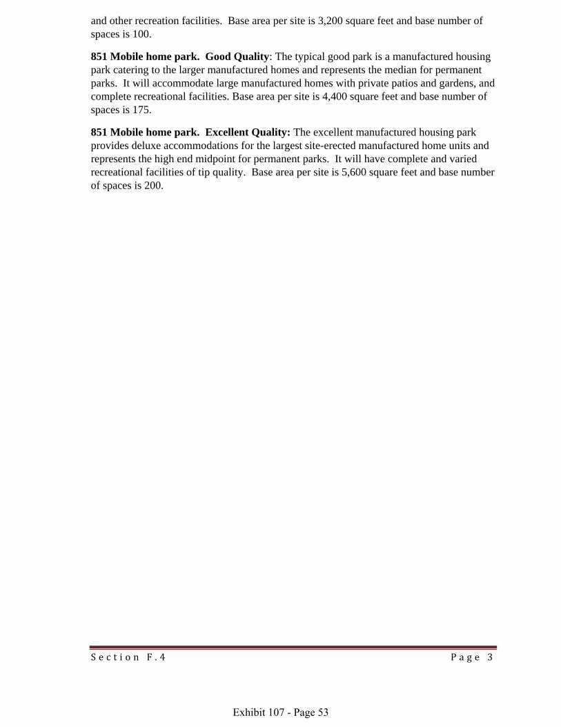
S e c t i o n F . 4 P a g e 3
and other recreation facilities. Base area per site is 3,200 square feet and base number of spaces is 100.
851 Mobile home park. Good Quality: The typical good park is a manufactured housing park catering to the larger manufactured homes and represents the median for permanent parks. It will accommodate large manufactured homes with private patios and gardens, and complete recreational facilities. Base area per site is 4,400 square feet and base number of spaces is 175.
851 Mobile home park. Excellent Quality: The excellent manufactured housing park provides deluxe accommodations for the largest site-erected manufactured home units and represents the high end midpoint for permanent parks. It will have complete and varied recreational facilities of tip quality. Base area per site is 5,600 square feet and base number f spaces is 200. o
Exhibit 107 - Page 53

Section G.1 Page 1
CO T UNTY ABSTRACT OF ASSESSMENFOR REAL PROPERTY, FORM 45
Purpose. The Abstract of Assessment for Real Property, Form 45 is integral in determining the level and quality of assessment by Property Tax Administrator for the purpose of statewide equalization. The abstract is also used in developing the state’s equalization ratio for the real property of centrally assessed railroads and public service entities. The county assessor is responsible to prepare the Form 45 based on the property assessment rolls of locally assessed property in his or her county on forms prescribed by the Property Tax Administrator. The Form 45 is electronically filed by the county assessor and shows the taxable value of real or personal property in the county as established by the county assessor.
Who Must File. Neb. Rev. Stat. §77‐1514 requires the county assessor to prepare an abstract or summary of the assessment rolls of his or her county, on forms prescribed by the Property Tax Administrator. The abstract must show the taxable property in the county as required by the Property Tax Administrator.
When and Where to File. The County Abstract of Assessment for Real Property must be completed and submitted on or before March 19. Upload the export from the county CAMA system to the state sales file or mail a paper copy to the Department of Revenue, Property Assessment Division, 301 Centennial Mall South, P.O. Box 98919, Lincoln, NE 68509‐8919.
Extensions. The Property Tax Administrator, upon written request from the county assessor, may for good cause shown extend the final filing due date for the real property abstract and the statutory deadlines provided in section 77‐5027. The Property Tax Administrator may extend the statutory deadline in section 77‐5028 for a county if the deadline is extended for that county.
Recertified Abstract. In any county where the Tax Equalization and Review Commission orders valuation changes, the county assessor shall recertify the County Abstract of Assessment for Real Property on or before June 5 to reflect such changes pursuant to Neb. Rev. Stat. §77‐5029.
Amended Abstract. Amended abstracts, other than recertified abstracts, may be filed to correct clerical errors, which include transposition of numbers, typographical errors, allocation of value or tax to the wrong taxing subdivision, mathematical errors, and omission of required information. Each time an Amended Abstract is filed, the county assessor shall file a written statement explaining the reasons for the amended filing. (Title 350 Nebraska Administrative Code, REG 60003.08).
Exhibit 107 - Page 54

Section G.2 Page 1
ABSTRACT OF ASSESSMENT FORM 45
INFORMATION AND DEFINITIONS General Information applicable to Form 45:
• Report all record counts as whole numbers.
• ght of the decimal. Report all acre counts rounded to two places to the ri
• Report all valuations as whole dollars, with no cents.
• Report all market areas numbers as greater than zero. Market areas must be numeric.
Definitions:
Record the appropriate columns. s. Report the taxable record count, for the class of real property in
Urban. Real property located within an incorporated city or village limit.
SubUrban. Real property located outside of an incorporated city or village limit, but within the legal jurisdiction (e.g. zoning) of an incorporated city.
Rural. Real property located outside of an urban or suburban area. Unincorporated villages and subdivisions not within legal jurisdiction of an incorporated city or village shall be classified as ural. r
SCHEDULE Ia & Ib: NONAGRICULTURAL RECORDS
Residential/Single Family. Report the number of records and value for real property classified as single family residential. Single family residential shall mean all real property predominantly used or intended to be used as a dwelling place or abode whether occupied by the owner, tenant or lessee, and where occupancy is for a period of time usually year‐a‐round as opposed to a transitory occupancy by a single family or two families. For purposes of the abstract, report real property with dwellings originally designed for occupancy by one family, or duplexes originally designed for occupancy by two families.
Commercial. Report the number of records and value for real property classified as commercial. Commercial shall mean all real property predominantly used or intended to be used for commerce, trade or business. For purposes of the abstract, report multifamily, dwelling originally designed for occupancy by more than two families, along with other commercial property.
Exhibit 107 - Page 55
Section G.2 Page 2
Industrial. Report the number of records and value for real property classified as industrial. Industrial means all real property predominantly used or intended to be used for the process or manufacture of goods or materials.
Recreational. Report the number of records and value for real property classified as recreational. Recreational means all real property that is predominantly used or intended to be used for diversion, entertainment, and relaxation on an occasional basis. Some of the uses would include fishing, hunting, camping, boating, hiking, picnicking and the access or view that simply allows relaxation, diversion and entertainment
Unimproved. Land without buildings or structures. Report the number of records and land value for the class or subclass of real property.
Improved. Land upon which buildings or structures are located. Report the number of records and land value for the class or subclass of real property (do not include the value of improvements).
Improvements. Improvements mean any addition made to real property, amounting to more than mere repairs, such as sidewalks, streets, sewers, or utilities. Improvements include buildings or structures designed for habitation, shelter, storage, trade, manufacture, religion, or business, education and the like. A structure or edifice enclosing a space within its walls, and usually, but not necessarily, covered with a roof. Report the number of records and value of all improvements, including mobile homes and improvements on leased land, for the class of subclass of real property.
Growth. Report the total value attributable to growth for each class or subclass of real property. Growth value includes physical additions or improvements to real property which increase the value of such property. Growth value does not include a change in valuation of a class or subclass of real property, revaluation of individual properties, valuation changes resulting from a change in use of the property, or taxable value added because of a property has changed from exempt to taxable.
SCHEDULE II – TAX INCREMENT FINANCING (TIF) RECORDS
Tax Increment Financing (TIF). Blighted real property that is currently part of an approved community redevelopment project as defined in Neb. Rev. Stat. §18‐2103. The community redevelopment laws allow for the increased property taxes generated by the improvement of the blighted property to be used to pay for the financing of the redevelopment.
Redevelopment project valuation, also known as the base value, means the assessed valuation on the taxable real property in a redevelopment project last certified to the political subdivisions in the year prior to the effective date of the provision for authorizing the dividing of ad valorem tax pursuant to Neb. Rev. Stat. §18‐2147.
Redevelopment project excess valuation means the total assessed valuation on the real property in a redevelopment project for the current year less the project base valuation.
Value Base. Report the number of records and base value by the appropriate class or subclass of property, for records currently in a TIF project. Only the TIF property’s base value shall be included
Exhibit 107 - Page 56

Section G.2 Page 3
in the respective property classes on the abstract, lines 1 through 16, as the TIF base value is assessable value to a political subdivision.
Value Excess. Report the number of records and excess value by the appropriate class or subclass of property, for records currently in a TIF project. The excess value shall not be included in respective property classes on abstract lines 1 through 16, as the TIF excess value is not assessable to a political subdivision.
TIF Residential/Single Family. Real property in a TIF project classified as residential. For purposes of the abstract, report real property with dwellings originally designed for occupancy by one family, or duplexes originally designed for occupancy by two families.
TIF Commercial. Real property in a TIF project, classified as commercial. For purposes of the abstract, report multifamily, dwelling originally designed for occupancy by more than two families, along with other commercial property.
TIF Industrial. T s Real property in a IF project, classified a industrial.
TIF Other. Real property in a TIF project that is not currently classified as residential, commercial, or industrial.
*TIF – Growth. TIF projects do not have any growth. When a TIF project is paid off, this is a change in taxable value and the excess value should not be considered growth.
SCHEDULE III – MINERAL INTEREST RECORDS
Minerals. A mineral is an inorganic substance found naturally in the earth including but not limited to ore, gravel, oil, or natural gas.
Producing. Report the number of records and value for mineral interests that are currently in active production and for which production payments are being made or received.
NonProducing. Report the number of records and value for mineral interest that are currently non‐prod mucing, i.e. for which there is no known activity related to the recovery of the ineral.
Growth. Report the total value attributable to growth for each class or subclass of real property. Growth value includes physical additions or improvements to real property which increase the value of such property. Growth value does not include a change in valuation of a class or subclass of real property, revaluation of individual properties, valuation changes resulting from a change in use of the property, or taxable value added because of a property has changed from exempt to taxable.
SCHEDU LE IV: EXEMPT RECORDS NON AGRICULTURAL
Exempt. Report the total number of records of non‐agricultural real property that receive a property tax exemption pursuant to Neb. Rev. Stat §77‐202 (1) (a) (b) (c) (d) i.e. governmental and permissive exemptions. This data is required and shall not be left blank. There is no taxable value.
SCHEDULE V: AGRICULTURAL RECORDS
Exhibit 107 - Page 57

Section G.2 Page 4
Agricultural and horticultural land; terms, defined. The Legislature finds and declares that agricultural land and horticultural land shall be a separate and distinct class of real property for purposes of assessment. The assessed value of agricultural land and horticultural land shall not be uniform and proportionate with all other real property, but the assessed value shall be uniform and
nd and horticultural land. proportionate within the class of agricultural la
For purposes of sections 77‐1359 to 77‐1363:
(1) Agricultural land and horticultural land means a parcel of land, excluding any building or enclosed structure and the land associated with such building or enclosed structure located on the parcel, which is primarily used for agricultural or horticultural purposes, including wasteland lying in or adjacent to and in common ownership or management with other agricultural land and horticultural land;
(2) Agricultural or horticultural purposes means used for the commercial production of any plant or animal product in a raw or unprocessed state that is derived from the science and art of agriculture, aquaculture, or horticulture. Agricultural or horticultural purposes includes the following uses of land:
(a) Land retained or protected for future agricultural or horticultural purposes under a conservation easement as provided in the Conservation and Preservation Easements Act except when the parcel or a portion thereof is being used for purposes other than agricultural or horticultural purposes; and
(b) Land enrolled in a federal or state program in which payments are received for removing such land from agricult ural or horticultural production. “Neb. Rev. Stat. §77‐1359.”
AgVacant Land. Report the number of records and total land value, for real property records classified as unimproved agricultural records.
AgImproved Land. Report the number of records and total land value for real property classified as improved agricultural.
AgImprovements. Report the number of records and value of all improvements for real property classified as agricultural.
AgTotal Taxable. Report the total number of records and value. Please note that records should e the sum of Line 27 and 29. Value should equal Lines 27 thru 29. b
SCHEDULE VIa: AGRICULTURAL RECORDS: NONAGRICULTURAL FARM HOME SITE DETAIL
Abstract Schedule VIa Farm Home Site Detail is supplemental information. The number of records and value will be included in Abstract Schedule V Agricultural, lines 27 through 30.
Farm home site. Farm home site shall mean one acre or less of land that is contiguous to a farm site and upon which is located a residence and necessary improvements needed for residential purposes. This land shall not be classified or assessed as agricultural or horticultural land.
Exhibit 107 - Page 58

Section G.2 Page 5
Farm home site land unimproved. Report the number of records, acres, and value for land that is part of an agricultural record, classified as farm home site land, and is vacant.
Farm home site land improved. Report the number of records, acres and value for land that is part of an agricultural record, class iif ed as farm home site land, and contains improvements.
Farm home site improvements. Report the number of records and value for improvements located upon land that is part of an agricultural record, classified as farm home site. Improvements shall include value of the residence and the necessary improvements needed for residential purposes, e.g. dwelling and garage.
Growth. Report the total value attributable to growth for each class or subclass of real property. Growth value shall include physical additions or improvements to real property which increase the value of such property. Growth value does not include a change in valuation of a class or subclass of real property, revaluation of individual properties, valuation changes resulting from a change in use of the property, or taxable value added because of a property has changed from xempt to taxable. e
SCHEDULE VIb: AGRICULTURAL RECORDS: NONAGRICULTURAL FARM SITE DETAIL
Abstract Schedule VIb Farm Site Detail is supplemental information. The number of records and value will be included in Abstract Schedule V Agricultural, lines 27 through 30.
Farm site shall mean land containing improvements that are agricultural or horticultural in nature, including an uninhabitable or unimproved farm home site, all of which is contiguous to agricultural or horticultural land. This land shall not be classified as agricultural or horticultural land.
Farm site unimproved land. Report the number of records, acres, and value for land that is part of an agricultural record, classified as farm site, and is vacant.
Farm site land improved. Report the number of records, acres, and value for land that is part of an agricultural record, classified as farm site, and has improvements situated upon it.
Farm site improvements. Report the number of records and value for improvements located upon land that is part of an agricultural record, classified as farm site. Improvements shall include value of the buildings or structures that are agricultural or horticultural in nature, e.g. ag‐outbuildings.
Public Roads & Ditches. Report the number of acres of public roads and adjoining ditch areas on land privately owned, pursuant to Title 350 Nebraska Administrative Code, Chapter 14, REG 14‐005.01C. Roads and ditches are to be counted and inventoried when the county has established and is maintaining a public road on land privately owned. Acres of public roads and adjoining ditch acres will carry no assessable value to the land owner. Generally public roads and ditches will not exceed 4 acres per mile or 16 acres per section.
Other – NonAg Use. Report the number of acres and value for land that is part of an agricultural record but is not being used for agricultural purposes, i.e. intermittent small drainage ways, stream
Exhibit 107 - Page 59
Section G.2 Page 6
channels, large lakes, private lakes and ponds. Do not report any “aguse other” value in this section. Do not report “nonag use” value on line 73 of Schedule IX & X.
Growth. Report the total value attributable to growth for each class or subclass of real property. Growth value shall include physical additions or improvements to real property which increase the value of such property. Growth value does not include a change in valuation of a class or subclass of real property, revaluation of individual properties, valuation changes resulting from a change in use of the property, or taxable value added because of a property has changed from exempt to taxable.
SCHEDULE VII: AGRICULTURAL RECORDS: GAME & PARKS
Game and Parks Wildlife Management Land. Report the number of records, acres, and land value of real property records owned by the Game and Parks Commission and designated for wildlife management purposes, pursuant to Neb. Rev. Stat. §37‐335. This land value is subject to equalization with other agricultural land. The amount of value on line 42 should not be included in abstract lines 27 through 30.
SCHEDULE VIII: AGRICULTURAL RECORDS: SPECIAL VALUE
Special Value. Report the number of records, acres, and special valuation assessment for agricultural or horticultural land receiving special valuation pursuant to Neb. Rev. Stat. § 77‐1343 through 77‐1348. Line 43 and 44 is aresupplemental information, indicating the amount of land value receiving special valuation assessment, included in agricultural land abstract lines 27 through 30. For tax year 2009 and forward recapture value is no longer required therefore, Line 44 has been left blank in the Form 45. The Division has chosen to simply write ‘not applicable 44’ versus renumbering the remaining lines to reduce a significant change for the vendors,.
SCHEDULE IX & X A L: GRICULTURA RECORDS: AGLAND MARKET AREA & COUNTY DETAIL.
For Schedule IX: If your county has multiple market areas, then you will need to complete a schedule for each market area in your county.
For Schedule X: Report County Totals on one sheet. This is a summation of all Schedule IX you have within your County. If you have no market areas you may return only Schedule X.
Irrigated Cropland. Report the number of acres and value for land classified as irrigated land, i.e., land that receives artificial application of water for the full crop production. This would include irrigated grassland.
Dry Cropland. Report the number of acres and value for land classified as dry cropland, i.e. land that is primarily used for crop production without irrigation.
Grassland. Report the number of acres and value for land classified as grassland, i.e. land that is not presently being cultivated. The state and condition of the range based on what is naturally capable of producing. Includes all types of grasses, permanent bromegrass, other introduced grasses, and native grasses used for grazing or mowed for hay. Alfalfa and grass mixture can be classified as cropland. Wooded grazing land is classified as grassland not timberland or wasteland. Timbered grassland where grazing occurs shall be included with grassland.
Exhibit 107 - Page 60

Section G.2 Page 7
Waste. Report the number of acres and value for land classified as wasteland, i.e. land that is lying in or adjacent to and in common ownership or management with land used for the production of agricultural products. Wasteland includes those land types that cannot be used economically, and are not suitable for recreational or agricultural use or production. Examples of wasteland: blowouts, riverwash, marshes, badlands, large deep gullies, bluffs, rockland, gravel areas, and salt flats. Other land types which may be classified as wasteland are the permanent easement acres associated with the Bureau of Reclamation or irrigation districts ‐ these areas are defined as open canals or ditches, laterals, drains, and service roads for the canal system.
Other – Ag Use. Report the number of acres and value for agricultural or horticultural land that is “ag‐use” but is not classified as irrigated, dry, grassland, or waste. This category shall include agricultural or horticultural land which has been designed for intensive uses, i.e. feedlots, nurseries, vineyards, sod farms, orchards, forestland and shelterbelt areas. The “Other‐Ag Use” category shall not included timber grassland where grazing occurs and shall not include accretion land. Pursuant to Title 350 Nebraska Administrative Code, Chapter 14, REG 14‐004.05B, accretion land can be classified into any agricultural use category, i.e. irrigated, dry, grass, or waste land.
AgExempt. Report the total number of acres of agricultural real property that receive a property tax exemption pursuant to Neb. Rev. Stat. §77‐202 (1) (a) (b) (c) (d), i.e. governmental and ermissive exemptions. There is no taxable value. p
Exhibit 107 - Page 61

County Abstract of Assessment for Real Property, Form 45 Please refer to Form 45 Instructions from your vendor.
County Name: County ID: Due on or before March 19
Total Records Total Value Total Growth Total Real Property Value ( Recs & Value sum lines 17, 25 & 30)
(Growth sum lines 17+25+41) Schedule Ia: Non-Agricultural Records Urban SubUrban Rural Total Growth 1. Res Unimp Land Records
V alue 2. Res Improv Land Records
V alue 3. Res Improvements Records
V alue 4. Res Total (Recs sum lines 1 & 3; Value sum lines 1 thru 3)
Records V alue
5. Comm Unimp Land Records V alue
6. Comm Improv Land Records V alue
7. Comm Improvments Records Value
8. Comm Total (Recs sum lines 5 & 7; Value sum lines 5 thru 7)
Records Value
Exhibit 107 - Page 62
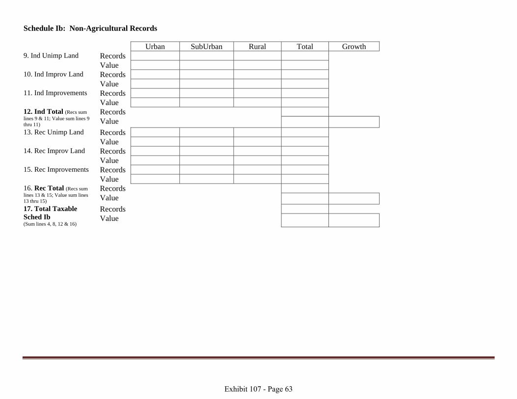
Schedule Ib: Non-Agricultural Records Urban SubUrban Rural Total Growth 9. Ind Unimp Land Records
Value 10. Ind Improv Land Records
Value 11. Ind Improvements Records
Value 12. Ind Total (Recs sum lines 9 & 11; Value sum lines 9 thru 11)
Records Value
13. Rec Unimp Land Records Value
14. Rec Improv Land Records Value
15. Rec Improvements Records Value
16. Rec Total (Recs sum lines 13 & 15; Value sum lines 13 thru 15)
Records Value
17. Total Taxable Sched Ib (Sum lines 4, 8, 12 & 16)
Records Value
Exhibit 107 - Page 63

Schedule II: Tax Increment Financing (TIF) Urban SubUrban Rural Total 18. TIF Residential Records
Value ase B Value Excess
19. TIF Commercial Records Value ase B Value Excess
20. TIF Industrial Records Value ase B Value Excess
21. TIF Other Records Value ase B Value Excess
22. Total TIF Sched II (Sum lines 18 thru 21)
Records Value ase B Value Excess
Exhibit 107 - Page 64

Schedule III: Mineral Interest Records Urban SubUrban Rural Total Growth 23. Mineral Interest Producing Records
V alue 24. Mineral Interest Non- Producing
Records V alue
25. Total Minerals Sched III (Sum lines 23 & 24)
Records Value
Schedule IV: Exempt Records: Non-Agricultural Urban SubUrban Rural Total 26. Exempt Records Schedule V: Agricultural Records Urban SubUrban Rural Total 27. Ag-Vacant Land Records
Va lue 28. Ag-Improved Land Records
Va lue 29. Ag-Improvements Records Va lue 30. Ag- Total Taxable (Recs sum lines 27 & 29; Value sum lines 27 thru 29)
Records Value
Please note that Total Value from Lines 41 + 82 of this document should equal Total Value on Line 30 above. Please note that Value from Lines 33 + Line 37 of this document should equal Value on Line 29 above.
Exhibit 107 - Page 65
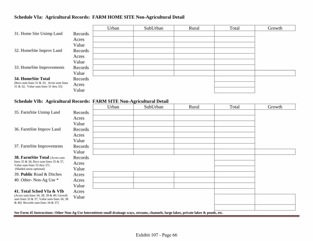
Schedule VIa: Agricultural Records: FARM HOME SITE Non-Agricultural Detail Urban SubUrban Rural Total Growth 31. Home Site Unimp Land Records
A cres V alue
32. HomeSite Improv Land Records A cres V alue
33. HomeSite Improvements Records V alue
34. HomeSite Total (Recs sum lines 31 & 33; Acres sum lines 31 & 32; Value sum lines 31 thru 33)
Records Acres Value
Schedule VIb: Agricultural Records: FARM SITE Non-Agricultural Detail Urban SubUrban Rural Total Growth 35. FarmSite Unimp Land Records
A cres V alue
36. FarmSite Improv Land Records A cres Value
37. FarmSite Improvements Records Value 38. FarmSite Total (Acres sum lines 35 & 36; Recs sum lines 35 & 37, Value sum lines 35 thru 37) (Shaded areas optional)
Records Acres Value
39. Public Road & Ditches A cres 40. Other- Non-Ag Use * A cres
V alue 41. Total Sched VIa & VIb (Acres sum lines 34, 38, 39 & 40; Growth sum lines 33 & 37; Value sum lines 34, 38 & 40) Records sum lines 34 & 37)
Acres Value
See Form 45 Instructions: Other Non-Ag Use Intermittent small drainage ways, streams, channels, large lakes, private lakes & ponds, etc.
Exhibit 107 - Page 66

Section G.3 Page 6
Schedule VII: Agricultural Records: Ag Land Detail – Game & Parks Urban SubUrban Rural Total 42. Game & Parks G&P wildlife management only, pursuant to section 37-335
Records Ac res Va lue
Schedule VIII: Agricultural Records: Special Value Urban SubUrban Rural Total 43. SV – Special Value
Records Acres
Value 44. SV – Market Value Value N/A N/A N/A N/A
Exhibit 107 - Page 67
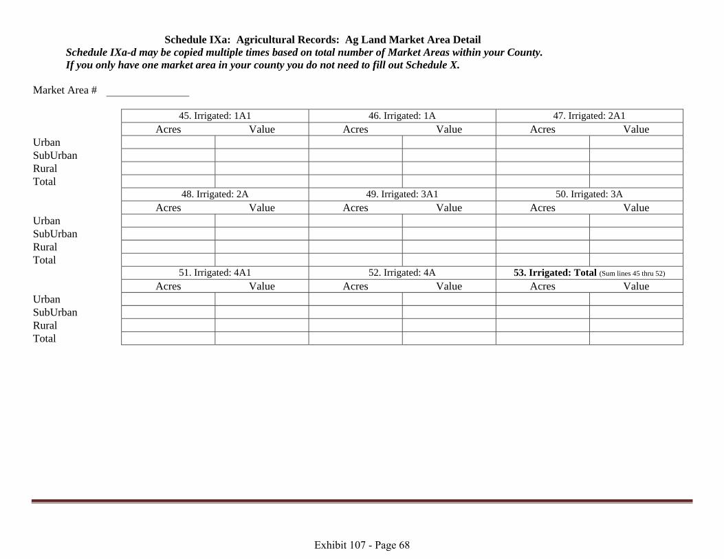
Schedule IXa: Agricultural Records: Ag Land Market Area Detail Schedule IXa-d may be copied multiple times based on total number of Market Areas within your County. If you only have one market area in your county you do not need to fill out Schedule X. Market Area # 45. Irrigated: 1A1 46. Irrigated: 1A 47. Irrigated: 2A1 Acres Value Acres Value Acres Value Urban S ubUrban Rural Total 48. Irrigated: 2A 49. Irrigated: 3A1 50. Irrigated: 3A Acres Value Acres Value Acres Value Urban S ubUrban Rural Total 51. Irrigated: 4A1 52. Irrigated: 4A 53. Irrigated: Total (Sum lines 45 thru 52) Acres Value Acres Value Acres Value Urban S ubUrban Rural Total
Exhibit 107 - Page 68

Schedule IXb: Agricultural Records: Ag Land Market Area Detail Market Area # 54. Dry: 1D1 55. Dry: 1D 56. Dry: 2D1 Acres Value Acres Value Acres Value Urban S ubUrban Rural Total 57. Dry: 2D 58. Dry: 3D1 59.Dry: 3D Acres Value Acres Value Acres Value Urban S ubUrban Rural Total 60. Dry: 4D1 61. Dry: 4D 62. Dry: Total (Sum lines 54 thru 61) Acres Value Acres Value Acres Value Urban S ubUrban Rural Total
Exhibit 107 - Page 69

Schedule IXc: Agricultural Records: Ag Land Market Area Detail Market Area # 63. Grass: 1G1 64. Grass: 1G 65. Grass: 2G1 Acres Value Acres Value Acres Value Urban S ubUrban Rural Total 66. Grass: 2G 67. Grass: 3G1 68. Grass: 3G Acres Value Acres Value Acres Value Urban S ubUrban Rural Total 69. Grass: 4G1 70. Grass: 4G 71. Grass: Total (Sum lines 63 thru 70) Acres Value Acres Value Acres Value Urban S ubUrban Rural Total
Exhibit 107 - Page 70
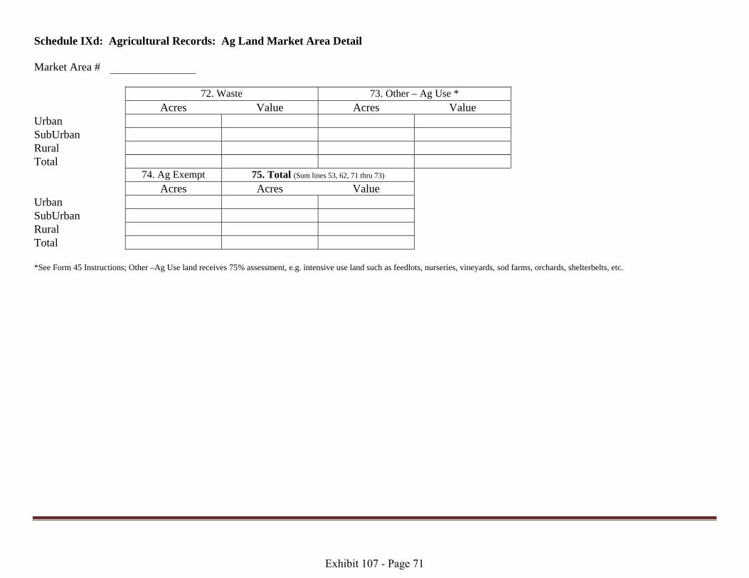
Schedule IXd: Agricultural Records: Ag Land Market Area Detail Market Area # 72. Waste 73. Other – Ag Use *
Acres Value Acres Value Urban SubUrban Rural Total 74. Ag Exempt 75. Total (Sum lines 53, 62, 71 thru 73) Acres Acres Value Urban SubUrban Rural Total *See Form 45 Instructions; Other –Ag Use land receives 75% assessment, e.g. intensive use land such as feedlots, nurseries, vineyards, sod farms, orchards, shelterbelts, etc.
Exhibit 107 - Page 71

Section G.3 Page 11
Schedule X: Agricultural Records: Ag Land Market Area Totals Schedule X should be a summation of all Schedule IXa-d that you have. County ID 76. Irrigated Land 77. Dry Land 78. Grass Land Acres Value Acres Value Acres Value Urban SubUrban Rural Total 79. Waste Land 80. Other Ag Land * 81. Ag Exempt Acres Value Acres Value Acres Urban SubUrban Rural Total 82. Total (Sum lines 76 thru 80)
Acres Value Urban SubUrban Rural Total *See Form 45 Instructions; Other –Ag Use land receives 75% assessment, e.g. intensive use land such as feedlots, nurseries, vineyards, sod farms, orchards, shelterbelts, etc.
Exhibit 107 - Page 72
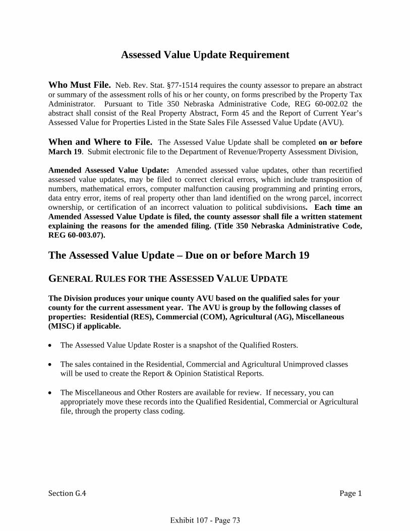
Section G.4 Page 1
Assessed Value Update Requirement Who Must File. Neb. Rev. Stat. §77-1514 requires the county assessor to prepare an abstract or summary of the assessment rolls of his or her county, on forms prescribed by the Property Tax Administrator. Pursuant to Title 350 Nebraska Administrative Code, REG 60-002.02 the abstract shall consist of the Real Property Abstract, Form 45 and the Report of Current Year’s Assessed Value for Properties Listed in the State Sales File Assessed Value Update (AVU). When and Where to File. The Assessed Value Update shall be completed on or before March 19. Submit electronic file to the Department of Revenue/Property Assessment Division, Amended Assessed Value Update: Amended assessed value updates, other than recertified assessed value updates, may be filed to correct clerical errors, which include transposition of numbers, mathematical errors, computer malfunction causing programming and printing errors, data entry error, items of real property other than land identified on the wrong parcel, incorrect ownership, or certification of an incorrect valuation to political subdivisions. Each time an Amended Assessed Value Update is filed, the county assessor shall file a written statement explaining the reasons for the amended filing. (Title 350 Nebraska Administrative Code, REG 60-003.07). The Assessed Value Update – Due on or before March 19 GENERAL RULES FOR THE ASSESSED VALUE UPDATE The Division produces your unique county AVU based on the qualified sales for your county for the current assessment year. The AVU is group by the following classes of properties: Residential (RES), Commercial (COM), Agricultural (AG), Miscellaneous (MISC) if applicable. • The Assessed Value Update Roster is a snapshot of the Qualified Rosters. • The sales contained in the Residential, Commercial and Agricultural Unimproved classes
will be used to create the Report & Opinion Statistical Reports. • The Miscellaneous and Other Rosters are available for review. If necessary, you can
appropriately move these records into the Qualified Residential, Commercial or Agricultural file, through the property class coding.
Exhibit 107 - Page 73

Section H.1 Page 1
SCHOOL CODE INFORMATION
Each June, the Division issues the School District Reference List, which indicates the prescribed school district name, class, and school codes for each county. The Division provides each county assessor a list of school district dissolutions/mergers/ reorganizations and the corresponding receiving school district, if applicable for the county. Additionally, the documents are available on the Property Assessment Division’s website under the Property Assessment Calendar of Bulletins/Procedures for County Assessors: http://www.revenue.ne.gov/PAD/calendars.html
The assessor is required to update their tax entity/fund file, tax district file, tax codes on all real property, personal property and centrally assessed records, prior to the certification of value for levy setting on August 20th. In addition, the assessor is required to update any school district codes for sales within the state sales file and any sales in the county's in-house sales file, if applicable.
The Division will coordinate with the county assessor to implement school district changes for the state's sales file. For those sales file records that can readily be changed in mass, e.g. one school code moves to another school code, the division will process these changes. For those sales where the school district did not move into one specific school, it will require the field liaison to ascertain specific legal descriptions (sale records) from the assessor and determine which school district is applicable, based upon the school district petition document (available at he county clerk's office). t
Exhibit 107 - Page 74


