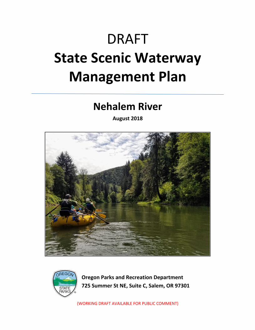
(WORKING DRAFT AVAILABLE FOR PUBLIC COMMENT) DRAFT State Scenic Waterway Management Plan Nehalem River August 2018 Oregon Parks and Recreation Department 725 Summer St NE, Suite C, Salem, OR 97301
Transcript
(WORKING DRAFT AVAILABLE FOR PUBLIC COMMENT)
DRAFT State Scenic Waterway
Management Plan
Nehalem River August 2018
Oregon Parks and Recreation Department 725 Summer St NE, Suite C, Salem, OR 97301
(WORKING DRAFT AVAILABLE FOR PUBLIC COMMENT)
Executive Summary
Background The Oregon Parks and Recreation Department (OPRD) is responsible for administering the State Scenic Waterway program, which is designed to protect the existing scenic, natural, and recreation values of the 22 designated waterways throughout the state. OPRD is directed by statute (ORS 390.855) to periodically study new waterways for potential inclusion in the program.
This Oregon Scenic Waterway study, conducted by OPRD, serves as the statutorily required first step in the process to possibly designate a new Oregon Scenic Waterway. That process, established by ORS 390.855, allows for the governor to designate new state scenic waterways following a study and a positive recommendation of the Oregon Parks and Recreation Commission and the Oregon Water Resources Commission. This study, covering approximately 17.5 miles of the Nehalem River, was done to accomplish three objectives:
1. Determine if the river segment meets the qualification criteria for designation as an Oregon Scenic Waterway (ORS 390.855);
2. If the qualification criteria are met, outline in general what type of management designation would be appropriate for the waterway; and
3. Summarize the public comments received.
Waterway Qualification Criteria Findings In May of 2017, OPRD evaluated 17.5 miles of the Nehalem River during a field visit using qualification criteria established by State Statute (ORS 390.855). Representatives from OPRD, Oregon’s Department of Forestry, and Water Resources Department were in attendance. Based on the field visit and public input, the entire study area met the criteria qualifications for an Oregon Scenic Waterway.
• The study area is completely free-flowing as determined by the Water Resources Department.
• The scenic quality of the study area meets or exceeds the standard of “pleasing” with areas where the scenery is outstanding in nature. The study area is a rural landscape with a variety of geologic, plant, and wildlife features visible from the river. There are cultural modifications such as a few homes, a road, two bridges, a small rail line, and evidence of logging. The cultural modifications are localized and do not detract noticeably from the pleasing scenic views of the area. Most of the visual signs of logging are beyond the ¼ mile study corridor.
• It appears that current recreation use is such that the river and its setting are able to maintain existing natural and recreational values without undue impairment and sustain substantial recreation use.
(WORKING DRAFT AVAILABLE FOR PUBLIC REVIEW)
Public Input Findings The public was notified of the study and the opportunity to comment in a variety of ways. Letters were sent to all landowners listed on tax lot data. Emails were sent to a list of approximately 160 interested parties and a media release announcing the study and the September 2017 public meeting were picked up by several local newspapers, including The Daily Astorian, the Tillamook County Pioneer, and the Cannon Beach Gazette, which all published the release in its entirety. Approximately 40 people attended the September 12th public meeting in Nehalem. And lastly, the OPRD Scenic Waterway webpage was updated to provide information on the study and to solicit feedback from the public.
The following findings summarize public input received thus far in the process:
• Public comment received at the public meeting and through written comments indicates there is strong support for designating the study area.
• The Clatsop County Board of Commissioners supports a designation, while the Tillamook County Commissioners oppose the designation.
• A total of 1,409 comments were received. Ten were in opposition and 1,327 form emails indicated support of the designation.
• Some comments indicated that the program did not offer enough protection.
• Three commenters indicated that they are landowners within the study area; two are opposed and one is in support. The stated opposition was over concern for more government regulation and that designation would prevent property owners from making improvements to their property.
• There was general agreement that the study area meets the criteria (i.e., free-flowing, scenic views from the river, outstanding recreational and natural values). Most also indicated that the study area could sustain substantial recreation use without undue impairment, though a few commenters stated the study area could not sustain more recreation use. A few commenters indicated that the scene was not primitive or rural pastoral due to timber harvests.
• There seemed to be confusion about what the program does and does not do. There is also confusion between the waterway program and adjudicated navigable rivers, promotional “water trail” programs, and federally designated wild and scenic rivers. Some of the comments seemed to indicate that the program would address water quality issues. Other comments indicated an assumption that the designation would either stop timber harvest or greatly curtail it and would not allow any future development.
Waterway Study Conclusions The Nehalem River study area is a strong candidate for the State Scenic Waterway program. The vast majority of comments received support the designation, including support from the Clatsop County Commission. There is some opposition from landowners and others, notably the Tillamook County Commission.
(WORKING DRAFT AVAILABLE FOR PUBLIC REVIEW)
Management Planning
The goal of the scenic waterway management planning process is to develop a comprehensive and workable management plan which will protect or enhance the special attributes of the designated river corridor. Primary emphasis is on the protection of scenic, fish and wildlife, and recreational features. The intent is to maintain the existing scenic condition of the area, without “turning back the clock” on existing land uses.
OPRD held two Advisory Group meetings (May 28th and July 18th, 2018) open to the public and one public workshop (September 6th, 2018) designed to obtain public feedback on the draft plans for the waterway. The Advisory Group consists of local landowners, recreational users, local business owners, and local government members. Input provided in these meetings provided the foundation for the final recommendations contained in the draft management plans.
In order to define and achieve management goals, if designated, the river is classified into one or more of six possible classifications according to the present level of land development, committed land uses, or landscape alterations (Fig. 4). Once the classifications are set, appropriate guidelines for new development or landscape alterations are established as rules. The major aim of the program is to maintain the existing scenic condition of the river. As proposed, the river would be managed (if designated and not altered during public rule-making) as a Scenic River Area.
All new structures, improvements and development should be in compliance with the Public Use of Scenic Waterways Rules (OAR 736-040-0025) and Land Management Rules (OAR 736-40-030 and 0035) and be consistent with applicable Federal, State, and County (Tillamook or Clatsop) land use and development regulations, along with proposed regulations specific to each management category. Additionally, a set of proposed management recommendations were developed from input provided by the advisory committee and the public including recommendations to encourage collaborations between stakeholders to improve riparian habitat and water quality and to provide opportunities for outreach and education for visitors to the Nehalem River.
Concurrently, the Oregon Water Resources Department (OWRD) staff began preparing a scenic flow recommendation to assist the Water Resources Commission in their consideration of designation of the proposed scenic waterways. Following designation (if that occurs), the Water Resources Commission will request that the Water Resources Department (WRD) identify flow quantities necessary for recreation, fish, and wildlife uses before issuing new water rights within or above designated scenic waterway (ORS 390.835(1)).
Administration of the Oregon Scenic Waterway Program ......................................................................... 4
Impact of Setting Scenic Waterway Flows .................................................................................................. 4
Designation Process for New Scenic Waterways ........................................................................................ 4
Nehalem River Study ...................................................................................................................................... 6
Eligibility Study Purpose ................................................................................................................................. 6
Study Location and Area ............................................................................................................................. 6
Field Rating Conclusions ............................................................................................................................. 7
Program Goals ............................................................................................................................................ 8
Administration of the Oregon Scenic Waterways Program ....................................................................... 8
MANAGEMENT OF SCENIC WATERWAYS ....................................................................................................... 9
The Management Planning Process ........................................................................................................... 9
Advisory Group and Draft Management Plan ............................................................................................ 9
Scenic Waterway Land Management Program ........................................................................................ 12
Scenic River Area ...................................................................................................................................... 12
Potential Land Management Rules ......................................................................................................... 15
For all Scenic Waterway areas .................................................................................................................. 15
Nehalem Scenic River Area ....................................................................................................................... 15
Works Cited .................................................................................................................................................. 17
Figure 1. Oregon's Designated State Scenic Waterway .................................................................................. 3 Figure 2. State Scenic Waterway Designation Process ................................................................................... 5 Figure 3. Location of Study Area in Clatsop and Tillamook Counties in Northwest Oregon .......................... 7 Figure 4. Diagram showing the six types of potential river classifications ................................................... 11 Figure 5. Nehalem Scenic Waterway Study Segment Map .......................................................................... 14
Maggie Peyton, Nehalem Upper Watershed Council Executive Director
Nicole Sprecher, OPRD, Grants and Community Programs Support
Pam Zweifel, Treasurer of Farm Bureau
Richard Gitschlag, Scenic Railroad President
Ryan Anderson, Oregon Water Resources Department, Hydrologist
Tara Brown, Wild Salmon Center
Teri Wing, OPRD, North Coast District Manager
Tracy Louden, OPRD, Administrator, Business and Technology Solutions
Trevor Taylor, OPRD, Stewardship Section Manager
Page 3 of 17 (WORKING DRAFT AVAILABLE FOR PUBLIC REVIEW)
BACKGROUND The Oregon Scenic Waterway program is administered under the authority of the State Parks Commission through the State Parks and Recreation Department (ORS 390.805 to ORS 390.925). The statute also directs the Water Resources Commission to consider the quantities of water necessary for recreation, fish, and wildlife uses within or above a designated State Scenic Waterway before granting new water rights (ORS 390.835).The Scenic Waterway program seeks to balance protection of scenic values possessed by each individual scenic waterway and future development. The Scenic Waterway program was created in in 1970 by a vote of the public which passed by a two to one margin. The original ballot initiative designated 496 miles of the Deschutes, Illinois, John Day, Owhyee, Rogue and Minam rivers. Between 1972 and 1987 additional river segments were added to the program, some by the Oregon legislature. The Sandy River was designated by the governor as a result of a study conducted when Oregon Parks and Recreation Department (OPRD) was a division under the Oregon Department of Transportation (ODOT). In 1988 another ballot initiative was passed doubling the size of the program. The state program currently includes approximately 1,200 miles on 22 waterways (Figure 1).
Figure 1. Oregon's Designated State Scenic Waterways
Page 4 of 17 (WORKING DRAFT AVAILABLE FOR PUBLIC REVIEW)
There have been several studies conducted since the establishment of the program leading to designation by the governor. Some OPRD-led studies were at the direction of the legislature and the legislature decided on the designation, such as in the case of the Upper Deschutes River. Studies such as the 1987 study of Opal Creek and Opal Lake found they did not meet the criteria because of a lack of recreation opportunities and outstanding scenic attraction as other rivers in the area do, such as the Little North Santiam, offer equal or greater recreation and scenic opportunities. In 2014, OPRD-led studies of the Molalla and Chetco Rivers. The studies found the segments met the criteria; they were designated by the governor in 2016. A study of the upper Grande Ronde River during the same time period found the study segment did not meet the criteria due to lack of recreation opportunities.
Administration of the Oregon Scenic Waterway Program The Oregon Administrative Rules (OAR) outlines the manner in which the statute is to be carried out. The OAR generally requires that any proposed changes of land use within ¼ mile of both river banks be evaluated for potential to impair the scenic views. Property owners must notify OPRD for certain types of proposed new development including houses, roads, timber harvest, or similar activities up to one year in advance. The Department negotiates with the landowner to find ways to complete the landowner’s changes without impairing the scenic views. OPRD relies on its rules for each designated scenic waterway to make the determination.
Impact of Setting Scenic Waterway Flows To protect the existing scenic nature of a waterbody, scenic waterway flows are established by the State Water Resources Department for each new scenic waterway. It is important to note that new state scenic waterway designations have no impact on existing water rights within, above, or below the designated reach. Similarly, future uses of surface water downstream will not be limited because of the upstream scenic waterway flows. However, the availability of water for future surface water uses within or above a designated scenic waterway will be subject to scenic waterway flow levels adopted by the Water Resources Commission. In addition, these flows may be used as a permit condition attached to new water rights granted within or above the designated State Scenic Waterway.
Designation Process for New Scenic Waterways Oregon Revised Statute (ORS 390.855 to 390.865) establishes procedures by which new scenic waterways may be designated (Figure 2). The Department is directed by the statute to periodically study rivers or segments of rivers, and their related adjacent land, to evaluate if they meet the scenic waterway criteria. Concurrence of the State Water Resources Commission is required before bringing a recommendation to the governor for designation. The governor may designate any river or segment of river if it meets the statutorily defined criteria. The legislature can, by joint resolution, disapprove of the entirety or part of the designation, in which case the designation would not become effective. Initial high-level screening of Oregon’s waterways indicated that this section of the Nehalem River may meet the criteria necessary to be considered as a state scenic waterway. The Nehalem River has been listed by the National Park Service in the National River Inventory, a “listing of free-flowing river segments…that are believed to possess one or more outstandingly remarkable natural or cultural values judged to be of more than local or regional significance” since 1982 (National Park Service, 2012 & 2014). The entire river is listed as having
Page 5 of 17 (WORKING DRAFT AVAILABLE FOR PUBLIC REVIEW)
outstanding recreation and fish resources (National Park Service, 2017). The outstandingly remarkable values identified by the National Park Service are consistent with the qualities of Oregon’s State Scenic Waterway system. The river was also listed in a 1987 study of recreational use of Oregon Waterways (Oregon Department of Transportation, 1987) in which it was found to have “outstanding recreational resources” and has been on various lists, including those developed as part of Statewide Comprehensive Outdoor Recreation Planning (SCORP) as a potential study waterway (Oregon Department of Transportation, 1975; Oregon Department of Transportation, 1988). OPRD considered rivers rated to be most free flowing by the Oregon Water Resources Department (WRD) and also considered rivers recommended in the State Trails Plan surveys and others suggested by the public. OPRD held meetings in November 2016 and January 2017 in order to announce the beginning of another scenic waterway study and to gather input on which river segment(s) to study in this biennium. Five river segments were identified as top candidates, including the 17.5 mile segment of the Nehalem River. There were a number of considerations in the final selection of the Nehalem River including the location of the river, adding to the geographic diversity of the program and the potential for support from adjacent land owners, nearby communities, and water enthusiasts.
Figure 2. Oregon’s State Scenic Waterway designation options
Ballot Initiative Legislative Bill OPRD Study
OPRD & WRD Commissions
Governor
Not Designated Designates Legislature may
override
Draft Management
Plan with Proponent Group
Public Meetings and
Comment Period
Page 6 of 17 (WORKING DRAFT AVAILABLE FOR PUBLIC REVIEW)
Nehalem River Study
Eligibility Study Purpose An Oregon Scenic Waterway study, initiated by OPRD in 2017, serves as the statutorily required first step in the process to possibly designate a new Oregon Scenic Waterway. That process, established by ORS 390.855, allows for the governor to designate new scenic waterways following study and approval of the Oregon State Parks and Recreation Commission and the Oregon Water Resources Commission. The study, covering approximately 17.5 miles on the Nehalem River, constitutes the first step—a report to the OPRD Commission. The study was done to accomplish two objectives:
1. Determine if the river segments meet the qualifications for designation as an Oregon Scenic Waterway (ORS 390.855); and
2. If the qualifications are met, outline, in general, what type of management designation would be appropriate for the waterway, if it is found to be eligible, suitable, and ultimately designated.
Study Location and Area
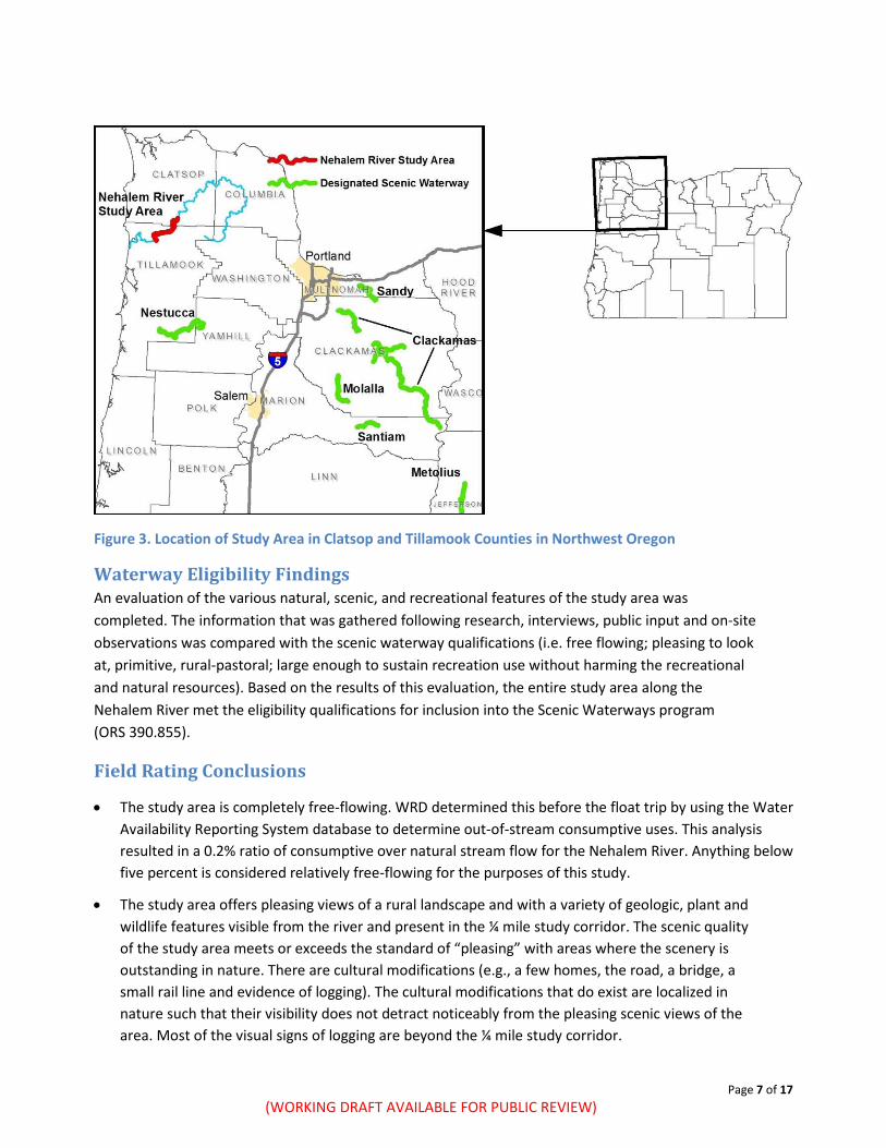
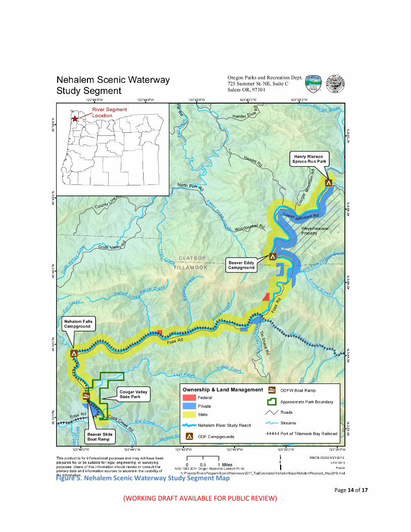
The Nehalem River has its headwaters on the east side of the northern Oregon Coast Range, in the Tillamook State Forest, and flows through Washington, Columbia, Clatsop, and Tillamook Counties before draining first into Nehalem Bay and then the Pacific Ocean. The total length of the river is approximately 119 miles. OPRD studied the approximately 17.5 mile section beginning at the Oregon Department of Forestry (ODF) owned and managed Henry Rierson Spruce Run Campground and ending at the confluence of Cook Creek and the Nehalem River, near Cougar Valley State Park. The elevation at water level at the top of the study area is 315 feet. The elevation at the downstream end of the study area is 40 feet. Other major rivers in the vicinity are the Miami and Wilson rivers. The closest State Scenic Waterway is the Nestucca River, approximately 30 miles to the south. The Nehalem River Study Area referred to in this report is defined as follows: The Nehalem River and all lands within ¼ mile of each bank, beginning at Henry Rierson Spruce Run Campground downstream approximately 17.5 miles to the confluence with Cook Creek, near Cougar Valley State Park (Figure 3). In May of 2017, the 17.5 mile segment of the Nehalem River was evaluated during a field visit using qualification criteria established by State Statute (ORS 390.855). Staff from the Oregon Department of Forestry (ODF) and the Oregon Water Resources Department (WRD) were in attendance on the first day for a float trip, which started at the day use area adjacent to the Henry Rierson Spruce Run Campground and floated to just above Nehalem Falls Campground. The group chose five locations to rate using criteria developed to help document the scenic quality of the river. The methodology is based on those used by federal land management agencies (e.g., Bureau of Land Management, Forest Service) to conduct scenic resource inventories and includes a description of various landscape elements including landform, vegetation, water, color, adjacent scenery, scarcity, and cultural modifications. The region of comparison for determining scarcity is the state of Oregon. Due to safety reasons, Nehalem Falls was not rafted. The falls and the remaining study area ending at the confluence of Cook Creek were rated on the second day by OPRD and WRD staff by accessing the river by foot. Two more ratings were performed, for a total of seven locations, each picked as a representative sample of the river.
Page 7 of 17 (WORKING DRAFT AVAILABLE FOR PUBLIC REVIEW)
Figure 3. Location of Study Area in Clatsop and Tillamook Counties in Northwest Oregon
Waterway Eligibility Findings An evaluation of the various natural, scenic, and recreational features of the study area was completed. The information that was gathered following research, interviews, public input and on-site observations was compared with the scenic waterway qualifications (i.e. free flowing; pleasing to look at, primitive, rural-pastoral; large enough to sustain recreation use without harming the recreational and natural resources). Based on the results of this evaluation, the entire study area along the Nehalem River met the eligibility qualifications for inclusion into the Scenic Waterways program (ORS 390.855).
Field Rating Conclusions
• The study area is completely free-flowing. WRD determined this before the float trip by using the Water Availability Reporting System database to determine out-of-stream consumptive uses. This analysis resulted in a 0.2% ratio of consumptive over natural stream flow for the Nehalem River. Anything below five percent is considered relatively free-flowing for the purposes of this study.
• The study area offers pleasing views of a rural landscape and with a variety of geologic, plant and wildlife features visible from the river and present in the ¼ mile study corridor. The scenic quality of the study area meets or exceeds the standard of “pleasing” with areas where the scenery is outstanding in nature. There are cultural modifications (e.g., a few homes, the road, a bridge, a small rail line and evidence of logging). The cultural modifications that do exist are localized in nature such that their visibility does not detract noticeably from the pleasing scenic views of the area. Most of the visual signs of logging are beyond the ¼ mile study corridor.
Page 8 of 17 (WORKING DRAFT AVAILABLE FOR PUBLIC REVIEW)
• The study area offers several ODF-managed camping and day-use areas, views of the waterfall and other river viewing opportunities and a small hiking trail by the falls. Cougar Valley State Park, an undeveloped park with walk in access, is at the southern end of the study area. Recreational fishing can be found along most of the study area. Paddling opportunities exist for boaters of a variety of skill levels depending on flow, with the most likely floatable time periods and flow levels occurring in the spring and late fall (flows in summer months are typically very low).
• It appears that current recreation use is such that the river and its setting are able to maintain existing natural and recreational values. Recreation use numbers are available from the ODF- managed campgrounds and are described in the study report.
Program Goals The scenic waterway program promotes cooperative protection and wise use of rivers in the system by all agencies (federal, state and local), individual property owners and recreation users. Five general program goals include:
1. To protect the free-flowing character of designated rivers for fish, wildlife, and recreation. No dams, reservoirs, impoundments and some forms of placer mining activities are currently allowed on scenic waterways.
2. To protect and enhance scenic, natural, recreation, scientific, fish and wildlife values along scenic waterways. New development or changes of existing uses proposed within a scenic waterway are reviewed before they may take place.
3. To protect private property rights, the program discourages unsightly structures or inappropriate development that could be a nuisance to neighboring landowners and/or even depreciate property values. It prohibits pollution and the disturbance of adjacent surface lands by dredging. It also prohibits public use of private property without explicit consent of the landowner.
4. To promote expansion of the State Scenic Waterway system. The program provides a process for adding new rivers to the system and establishes criteria for candidate rivers.
5. To encourage other local, state and federal agencies to act consistently with the goals of the program, the Oregon Parks and Recreation Department reviews plans and decisions made by other agencies to ensure consistency with the State Scenic Waterways program.
Administration of the Oregon Scenic Waterways Program Scenic waterways are administered under the authority of the Oregon State Parks and Recreation Commission (ORS 390.805 to ORS 390.925). Administrative rules (OAR 736-40-005 to 736-40-040) have been adopted to govern the program. In addition to the general rules governing the program, specific rules are generated for management of each river segment in the system. These rules are created through the management planning process, and tailored to the actions necessary to maintain the existing character of the designated river corridor. Oregon statute and the Commission’s rules require the evaluation of proposed land use changes within one-quarter mile from the ordinary high water line, on each side of the river, for their potential impacts on the existing special attributes of the river. Property owners wanting to build roads or houses; extract minerals and aggregate, harvest timber, or other similar projects, may need to provide written
Page 9 of 17 (WORKING DRAFT AVAILABLE FOR PUBLIC REVIEW)
notification to the Oregon Parks and Recreation Department (OPRD). OPRD’s evaluation of the project will be coordinated with other natural resource agencies (federal and state) having regulatory responsibility and with the local jurisdiction. OPRD relies on its river classification and administrative rules for each segment of the scenic waterway to determine whether the proposed project is inconsistent with the designated classification. OPRD works with the landowner to reach a resolution of conflicts. Where such resolution cannot be reached the Commission must decide within one year of the original notification whether to pay the property owner for the land or the development rights. If the Commission does not decide within one year to acquire the land or development rights, then the landowner may proceed in accordance with the original development proposal. OPRD coordinates the program with local, state, and federal agencies to assure their actions are compatible with Scenic Waterway Act, administrative rules and resource management plans.
MANAGEMENT OF SCENIC WATERWAYS The Management Planning Process The goal of the scenic waterway management planning process is to develop a comprehensive and workable management plan which will protect or enhance the special attributes of the designated river corridor. Primary emphasis is on the protection of scenic, fish and wildlife, and recreational features. The intent is to maintain the existing scenic condition of the area, without “turning back the clock” on existing land uses.
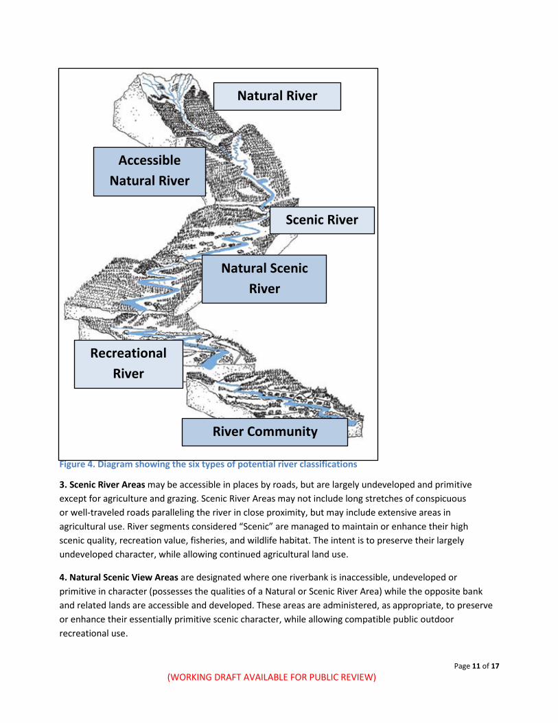
Advisory Group and Draft Management Plan OPRD held two Advisory Group meetings (May 24th and July 18th) and one public workshop (September 6th, 2018) for the Nehalem Waterway. The Advisory Groups consist of local landowners, recreational users, local business owners, and local government members. These meetings provided the foundation for the recommendations contained in the draft management plan. The mechanisms for protection and enhancement to be included in this draft management plan are: Scenic Waterway Classification - Within the management plan, scenic waterways are classified into one or more of six possible classifications, according to the character of the landscape and the amount and type of existing development. Administrative Rules – If scenic waterway designation occurs, classifications are set in a management plan and specific guidelines for new development are established as state administrative rules through a public rule-making process. Other Management Recommendations - Suggestions for actions to protect or enhance corridor values are also included in the management plan. Implementation could be through the OPRD, other state agencies, federal agencies or local agencies, organizations or persons. This includes input to OWRD’s recommendation of scenic flows to the Water Resources Commission. Concurrently, the Oregon Water Resources Department (OWRD) staff began preparing a scenic flow
Page 10 of 17 (WORKING DRAFT AVAILABLE FOR PUBLIC REVIEW)
recommendation to assist the Water Resources Commission in their consideration of designation of the proposed scenic waterways. Following designation (if that occurs), the Water Resources Commission will request that the Water Resources Department (WRD) identify flow quantities necessary for recreation, fish and wildlife uses before issuing water rights within or above designated scenic waterways (ORS390.835(1). WRD recommends scenic waterway flows to the Water Resources Commission through a formal staff report. The Commission then amends and/or approves the staff report and flow protections are implemented through the water right process for new water rights within and above the scenic waterway. Input from the OPRD Advisory Committee and Public Comment regarding the recreational flow needs of the scenic waterway informs the recommendation that WRD puts forward to the Commission.
Scenic Waterway Classification Under Oregon law (ORS 390.345), the Scenic Waterways program is administered by the Oregon State Parks and Recreation Commission, and staffed by Oregon Parks and Recreation Department. OPRD works to protect scenic values, recreation and fish and wildlife, based on special attributes of each river. OPRD strives to protect special attributes of the river while recognizing existing land uses and management practices on adjacent lands. In order to define and achieve management goals, the river is classified into one or more of six possible classifications according to the present level of land development, committed land uses, or landscape alterations (Fig. 3). Once the classifications are set, appropriate guidelines for new development or landscape alterations are established as rules. The major aim of the program is to maintain the existing scenic condition of the river. The following are existing land use and land alteration conditions usually associated with each of the six river classifications; and how each kind of classification should be administered (managed) in the Scenic Waterways program: 1. Natural River Areas are generally inaccessible except by trail or river, with related adjacent lands and shorelines essentially primitive. These areas may include an occasional lightly traveled road, airstrip, habitation or other kind of improvement already established, provided the effects are limited to the immediate vicinity. These areas will be administered to preserve their natural, wild and primitive condition while allowing compatible recreational and other uses. Preservation and enhancement of the primitive character of these areas is the goal of this and the next two classifications. 2. Accessible Natural River Areas are relatively primitive, undeveloped areas with access by railroad or lightly traveled road but otherwise possess the qualities of a Natural or Scenic River Area. These areas are administered to protect or enhance their scenic character, while allowing compatible outdoor recreational use.
Page 11 of 17 (WORKING DRAFT AVAILABLE FOR PUBLIC REVIEW)
Figure 4. Diagram showing the six types of potential river classifications 3. Scenic River Areas may be accessible in places by roads, but are largely undeveloped and primitive except for agriculture and grazing. Scenic River Areas may not include long stretches of conspicuous or well-traveled roads paralleling the river in close proximity, but may include extensive areas in agricultural use. River segments considered “Scenic” are managed to maintain or enhance their high scenic quality, recreation value, fisheries, and wildlife habitat. The intent is to preserve their largely undeveloped character, while allowing continued agricultural land use. 4. Natural Scenic View Areas are designated where one riverbank is inaccessible, undeveloped or primitive in character (possesses the qualities of a Natural or Scenic River Area) while the opposite bank and related lands are accessible and developed. These areas are administered, as appropriate, to preserve or enhance their essentially primitive scenic character, while allowing compatible public outdoor recreational use.
River Community
Recreational River
Scenic River
Natural Scenic River
Natural River
Accessible Natural River
Page 12 of 17 (WORKING DRAFT AVAILABLE FOR PUBLIC REVIEW)
5. Recreational River Areas are readily accessible by road or railroad, with some agricultural, commercial and/or residential development along the banks; the river may have undergone some impoundment or diversion in the past. River segments considered “Recreation” are managed to allow continuance of a wide range of compatible river-oriented public outdoor recreation opportunities, to the extent that these do not substantially impair the natural beauty of the scenic waterway or diminish its aesthetic, fish and wildlife, scientific and recreational values. 6. River Community Areas are river segments where the density (residential tract or platted subdivision) of existing structures or other developments precludes application of a more restrictive classification. River segments considered “Community Areas” are managed to allow development that is compatible with county zoning and blends into the natural character of the surrounding landscape. This also means protecting riparian vegetation, and encouraging activities that enhance the landscape. Due to the individual character of each scenic waterway, administrative criteria within each of the six classifications may vary from one scenic waterway to another. Examples can be found in the administrative rules for existing state scenic waterways. The rules established for each river classification generally allow some new construction and continued use of existing structures and improvements. Though some improvements require notification and approval, many others do not. For example, notification and approval is not generally needed for construction of new fences; maintenance of farm buildings, fences or outbuildings; laying of irrigation lines; crop rotation; removal of danger trees; construction of grain storage facilities under certain conditions; maintenance of existing residences and outbuildings; minor residential remodeling; construction of garage adjacent to existing homes; certain changes in landscaping; maintenance of roads and bridges; and firewood cutting for personal use. Mining, road building, construction and placement of some new structures, land clearing, and timber harvest are examples of activities typically requiring approval. River classifications and the associated rules or guidelines determine how the natural and scenic beauty of the river will be maintained.
Scenic Waterway Land Management Program Scenic River Area
The Oregon Parks and Recreation Department, based on discussions that occurred with the Advisory Committee, proposes to apply one scenic waterway classification, Scenic River Area, to the entire 17.5-mile stretch of the proposed Nehalem Scenic Waterway.
Under the Scenic River Area classification, the river is largely undeveloped except for agriculture and grazing. The Nehalem River has extensive private and public logging operations which fit within the definition of agricultural operations.
The river is completely free-flowing within its natural banks, with the exception of minor cultural modifications made for the bridges, the railroad and road, and a few homes. The few developments that do exist are quite localized, so their visibility does not detract noticeably from the general natural setting of the area.
Page 13 of 17 (WORKING DRAFT AVAILABLE FOR PUBLIC REVIEW)
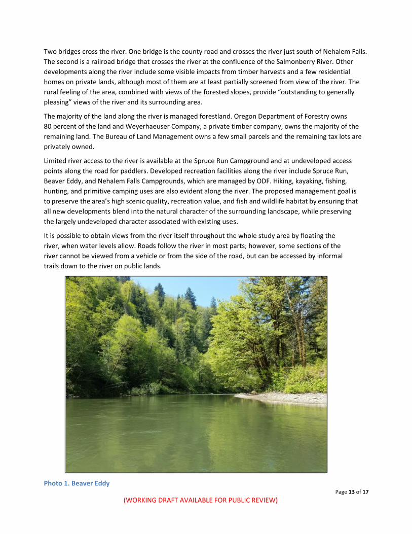
Two bridges cross the river. One bridge is the county road and crosses the river just south of Nehalem Falls. The second is a railroad bridge that crosses the river at the confluence of the Salmonberry River. Other developments along the river include some visible impacts from timber harvests and a few residential homes on private lands, although most of them are at least partially screened from view of the river. The rural feeling of the area, combined with views of the forested slopes, provide “outstanding to generally pleasing” views of the river and its surrounding area.
The majority of the land along the river is managed forestland. Oregon Department of Forestry owns 80 percent of the land and Weyerhaeuser Company, a private timber company, owns the majority of the remaining land. The Bureau of Land Management owns a few small parcels and the remaining tax lots are privately owned.
Limited river access to the river is available at the Spruce Run Campground and at undeveloped access points along the road for paddlers. Developed recreation facilities along the river include Spruce Run, Beaver Eddy, and Nehalem Falls Campgrounds, which are managed by ODF. Hiking, kayaking, fishing, hunting, and primitive camping uses are also evident along the river. The proposed management goal is to preserve the area’s high scenic quality, recreation value, and fish and wildlife habitat by ensuring that all new developments blend into the natural character of the surrounding landscape, while preserving the largely undeveloped character associated with existing uses.
It is possible to obtain views from the river itself throughout the whole study area by floating the river, when water levels allow. Roads follow the river in most parts; however, some sections of the river cannot be viewed from a vehicle or from the side of the road, but can be accessed by informal trails down to the river on public lands.
Photo 1. Beaver Eddy
Page 14 of 17 (WORKING DRAFT AVAILABLE FOR PUBLIC REVIEW)
Figure 5. Nehalem Scenic Waterway Study Segment Map
Page 15 of 17 (WORKING DRAFT AVAILABLE FOR PUBLIC REVIEW)
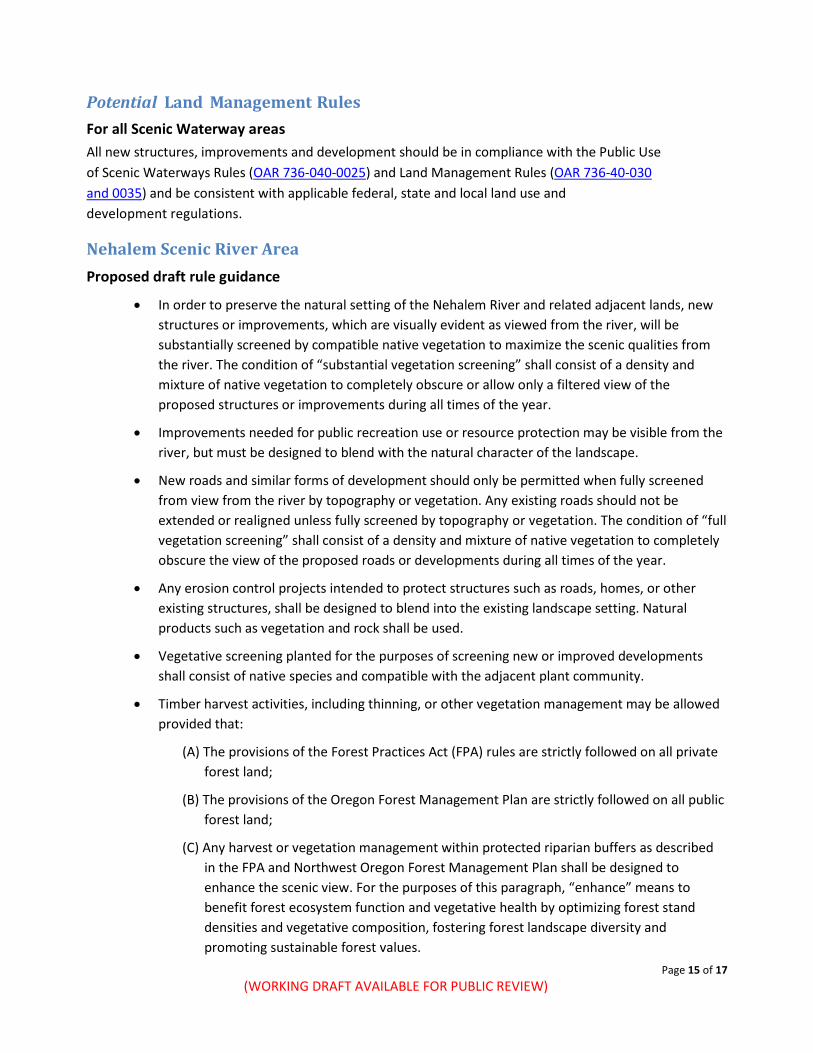
Potential Land Management Rules For all Scenic Waterway areas All new structures, improvements and development should be in compliance with the Public Use of Scenic Waterways Rules (OAR 736-040-0025) and Land Management Rules (OAR 736-40-030 and 0035) and be consistent with applicable federal, state and local land use and development regulations.
Nehalem Scenic River Area Proposed draft rule guidance
• In order to preserve the natural setting of the Nehalem River and related adjacent lands, new structures or improvements, which are visually evident as viewed from the river, will be substantially screened by compatible native vegetation to maximize the scenic qualities from the river. The condition of “substantial vegetation screening” shall consist of a density and mixture of native vegetation to completely obscure or allow only a filtered view of the proposed structures or improvements during all times of the year.
• Improvements needed for public recreation use or resource protection may be visible from the river, but must be designed to blend with the natural character of the landscape.
• New roads and similar forms of development should only be permitted when fully screened from view from the river by topography or vegetation. Any existing roads should not be extended or realigned unless fully screened by topography or vegetation. The condition of “full vegetation screening” shall consist of a density and mixture of native vegetation to completely obscure the view of the proposed roads or developments during all times of the year.
• Any erosion control projects intended to protect structures such as roads, homes, or other existing structures, shall be designed to blend into the existing landscape setting. Natural products such as vegetation and rock shall be used.
• Vegetative screening planted for the purposes of screening new or improved developments shall consist of native species and compatible with the adjacent plant community.
• Timber harvest activities, including thinning, or other vegetation management may be allowed provided that:
(A) The provisions of the Forest Practices Act (FPA) rules are strictly followed on all private forest land;
(B) The provisions of the Oregon Forest Management Plan are strictly followed on all public forest land;
(C) Any harvest or vegetation management within protected riparian buffers as described in the FPA and Northwest Oregon Forest Management Plan shall be designed to enhance the scenic view. For the purposes of this paragraph, “enhance” means to benefit forest ecosystem function and vegetative health by optimizing forest stand densities and vegetative composition, fostering forest landscape diversity and promoting sustainable forest values.
Page 16 of 17 (WORKING DRAFT AVAILABLE FOR PUBLIC REVIEW)
Potential Management Recommendations Advisory Committee and public input on priorities for management that could enhance the recreational experience and protect fish and wildlife on the Nehalem River are summarized here. Ideas expressed pertain to actions that could be carried out by state and federal agencies, landowners, and partners in collaboration with land managers or other agencies, or by other groups or agencies independently.
1) Harvest and management methods with low visual impact are preferentially applied including: A. Leaving well-designed clumps of trees in sufficient densities to break up an opening, reduce
its apparent size, and avoid blowdown; B. Feathering or meandering the clear-cut and opening edges to reduce the sharp contrasting line
between the opening boundary and forest edge; C. Avoiding the retainment of individual trees standing on ridge lines where trees can be viewed
against the sky (“flag” trees); D. Preserving a 100-foot forested riparian buffer that maximizes the number of trees left intact
to retain the scenic viewshed of the Nehalem River; E. Keeping stumps low, cleaning slash promptly, and protecting the remaining trees and brush
from damage during harvest operations.
2) Riverside revegetation shall prioritize the use of conifers with the intention of shading out invasive plant species (e.g., knotweed, policeman’s helmet, reed canarygrass).
3) Encourage landowners to treat invasive species such as knotweed and English ivy when constructing improvements or new projects on their property.
4) Collaborate with local partners and public agencies to develop and install small interpretive signs with messages about the river corridor in key areas. Potential topics include: river stewardship, leave no trace, recreation, cultural resources, fisheries, wildlife, geology, water quality, hydrology, respecting private property.
5) Develop organized regular river clean-up activities (e.g., trash and other debris), particularly at river access points.
6) Explore opportunities to form partnerships to identify and implement actions that will improve water quality and riparian health, facilitate the planting of native species, and implement invasive species management and/or monitoring efforts or otherwise to help protect and enhance the outstanding values of the river.
7) OPRD and ODF shall enter into an Intergovernmental Agreement requiring ODF to consult with OPRD throughout the forest management process including allowing OPRD to comment and make recommendations regarding protection of values for the scenic waterway. This process shall be used in lieu of the standard Notice of Intent process.
Page 17 of 17 (WORKING DRAFT AVAILABLE FOR PUBLIC REVIEW)
Works Cited National Park Service. (2012, December 4). Inventory of Oregon Segments in the National River Inventory.
Retrieved August 2014, from National Center for Recreation and Conservation: http://www.nps.gov/ncrc/programs/rtca/nri/states/or.html
National Park Service. (2014). Nationwide Rivers Inventory. Retrieved July 2014, from National Center for Recreation and Conservation: http://www.nps.gov/ncrc/programs/rtca/nri/index.html
Oregon Department of Transportation. (1988). Statewide Comprehensive Outdoor Recreation Plan. Salem: Oregon State Parks and Recreation Division.
Oregon Department of Transportation. (1975, November). Oregon State Parks System Plan 1975-1981. Salem: Parks and Recreation Branch, Department of Transportation.
Oregon Department of Transportation. (1987). Recreational Values on Oregon Rivers. Salem, Oregon: Oregon State Parks and Recreation Division.