2 SITE ................................................................................................................................................................................... 4
2.1 SITE LOCATION AND CONTEXT ................................................................................................................................... 4 2.2 HISTORY OF THE SITE ................................................................................................................................................ 7 2.3 ZONING .................................................................................................................................................................... 7 2.4 ZONE OBJECTIVES ..................................................................................................................................................... 9 2.5 TERRESTRIAL BIODIVERSITY ................................................................................................................................... 11 2.6 LANDSCAPE ............................................................................................................................................................ 19 2.7 CROWN LANDS ACT ................................................................................................................................................ 20 2.8 NEIGHBOURING RESIDENCES ................................................................................................................................. 23
3 PROPOSED DEVELOPMENT ............................................................................................................................................. 25
3.1 PROJECT DETAILS .................................................................................................................................................... 25 3.2 COST OF DEVELOPMENT ........................................................................................................................................ 28 3.3 OPERATING HOURS AND FREQUENCY ..................................................................................................................... 28
APPENDIX 1 – CERTIFICATES OF TITLE .................................................................................................................................. 54
APPENDIX 2 – AF RESTRICTIONS .......................................................................................................................................... 57
This Statement of Environmental Effects (SEE) supports a development application (DA) to Queanbeyan Palerang Regional Council (QPRC) for a Recreational Facility (Outdoor) – Rifle Range to be established on Lots 114 and 200 DP 750008, and Lot 149 DP 750013, 2155 Collector Road, Currawang (the ‘site’). The owners of Lots 114 and 200 DP75008, and Lot 149 750013, 2155 Collector Road, Currawang (the proponent) are seeking approval for the site to be used as a rifle range. The site is zoned RU1. Under the QPRC Local Environmental Plan, a “Recreational Facility (Outdoor)” is permitted with Council consent in the RU1 zone. A “Recreational Facility (Outdoor)” means a building or place (other than a recreation area) used predominantly for outdoor recreation, whether or not operated for the purposes of gain, including a golf course, golf driving range, mini-golf centre, tennis court, paint-ball centre, lawn bowling green, outdoor swimming pool, equestrian centre, skate board ramp, go-kart track, rifle range, water-ski centre or any other building or place of a like character used for outdoor recreation (including any ancillary buildings), but does not include an entertainment facility or a recreation facility (major). The site will be, in accordance with the above definition, used predominantly for a ‘rifle range’ and in accordance with the provisions allowable under the NSW Firearms Act 1996 and Firearms Regulation 2017.
NSW Firearms Registry has been consulted as part of the range approval process, in accordance with the NSW Range User Guide. The initial site inspection conducted by NSW Firearms Registry has deemed the site is suitable for the intended use based on their requirements for the conduct and regulation requirements pertaining to the operation and construction of a live firing range.
4
2 SITE
2.1 SITE LOCATION and CONTEXT The site comprises Lots 114 (689.92ha) and 200 DP 750008 (422.85ha) and Lot 149 DP 750013 (819.34ha). The total site area is 1,932.1ha and measures approximately 7km North to South and 3.6km East to West. It is located on the north-eastern side of Lake George as indicated on the aerial photograph and topographic map at Figures 1 and 2.
Access to the South of the site is either via the Federal Highway onto Collector Road or via the Collector / Currawang Road onto Collector Road and then onto Lake George Road and Point Ondyong Road (crown road) to Lot 149 DP 750013 (the site). See Figure 3. Access to the north of the site is either via the Federal Highway onto Collector Road or via the Collector / Currawang Road onto Collector Road to RA 2155 – see Figure 3. Access from the Collector Road is then via a right-of-carriageway over Lot 2 DP 1072611 and Lot 49 DP 750013 (part of the subject land) and a crown road to Lot 114 DP 750008 being approx. 5m wide.
The land is vacant and is not serviced with reticulated water and sewerage but has telephone services and electricity available.
The area surrounding the site is rural in nature.
There have been general improvements on the site not related to the DA and not requiring approval. These improvements include upkeep of access and internal roads, erection of a small 63m2 hut, backfilling of a dam due to leakage, levelling and grassing of land previously used for grazing purposes and erosion management of an existing quarry.
5
Figure 1: Site Map - Aerial (Map Source: Six Maps)
Property Boundary
Lot 114 DP 750008
Lot 200 DP 750008
Lot 149 DP 750013
N
Scale: 1:35,376 (approx.)
6
Figure 2: Site Map - Topographic
(Map Source: Six Maps)
Property Boundary
Lot 114 DP 750008
Lot 200 DP 750008
Lot 149 DP 750013
N
Scale: 1:35,376 (approx.)
7
Figure 3: Road Map (Map Source: Whereis)
2.2 HISTORY OF THE SITE
The land is substantially native vegetation and has been used for limited grazing in the past and has been vacant for many years. In recent years, the site has frequently been made available to visiting shooters and hunters. Anecdotally, some locals have had concerns about the potentially unsafe and illegal nature of these activities. The current owners are ensuring controlled access and legal hunting in accordance with NSW Office of Environment and Heritage requirements. Kangaroo culling occurs routinely in the area; hence the sound of rifle fire is a feature of life in the local area on any given day.
2.3 ZONING The site is within the RU1 Primary Production Zone under the Palerang Local Environmental Plan 2014 as detailed below. The proposed development (Rifle Range) is permissible in this zone. The zone land use table (see page 14) does permit a Recreation Facility (Outdoor) in which a Rifle Range is permissible. Under Palerang Local Environmental Plan 2014 a Recreation Facility (Outdoor) is defined as: recreation facility (outdoor) means a building or place (other than a recreation area) used predominantly for outdoor recreation, whether or not operated for the purposes of gain, including a golf course, golf driving range, mini-golf centre, tennis court, paint-ball centre, lawn bowling green, outdoor swimming pool, equestrian centre, skate board ramp, go-kart track, rifle range, water-ski centre or any other building or place of a like character used for outdoor recreation (including any ancillary buildings), but does not include an entertainment facility or a recreation facility (major).
N
8
Under the Palerang Local Environmental Plan 2014 the land is also identified as: 1. Having a minimum lot size for subdivision purposes of 80 hectares. 2. Having a height of building limitation of 10m. 3. Having no floor space ratio limitation. 4. Not affected by minerals or extractive resources. 5. Not subject to any land acquisition proposal. 6. Not containing a heritage item. 7. Is not within a heritage conservation area. 8. Not flood affected. 9. Is within an area of terrestrial biodiversity. 10. Is not within an area of riparian lands and watercourses. 11. Not within an urban release area. 12. Is bushfire prone. 13. In terms of clause 3.3 the land is-
a. not within the coastal waters; b. not a coastal lake; c. not included in SEPP 14 or SEPP 26; d. not an aquatic reserve; e. not within a wetland of international significance or a world heritage area; f. not within 100m of either item (c), (d) or (e) above; g. not identified as being of high Aboriginal cultural significance or high
biodiversity; h. not reserved as a state conservation area; i. not dedicated for the preservation of flora, fauna, geological formations or for
other environmental protection purposes; j. not within critical habitat.
The various Local Environmental Plan maps of the land follow:
The RU1 Primary Production Zone includes the following land use table:
9
Objectives of zone 1. • To encourage sustainable primary industry production by maintaining and enhancing the
natural resource base. • To encourage diversity in primary industry enterprises and systems appropriate for the
area. • To minimise the fragmentation and alienation of resource lands. • To minimise conflict between land uses within this zone and land uses within adjoining
zones. • To minimise the impact of any development on the natural environment. • To ensure that development does not unreasonably increase the demand for public
services or facilities.
2 Permitted without consent Extensive agriculture; Home businesses; Home occupations
3 Permitted with consent
Airstrips; Animal boarding or training establishments; Aquaculture; Backpackers’ accommodation; Bed and breakfast accommodation; Biosolids treatment facilities; Building identification signs; Business identification signs; Caravan parks; Cellar door premises; Cemeteries; Community facilities; Crematoria; Depots; Dual occupancies; Dwelling houses; Eco-tourist facilities; Environmental facilities; Environmental protection works; Extractive industries; Farm buildings; Farm stay accommodation; Flood mitigation works; Forestry; Function centres; Garden centres; Helipads; Home-based child care; Home industries; Hotel or motel accommodation; Industrial training facilities; Information and education facilities; Intensive livestock agriculture; Intensive plant agriculture; Neighbourhood shops, Open cut mining; Places of public worship; Plant nurseries; Recreation areas; Recreation facilities (outdoor); Restaurants or cafes; Roads; Roadside stalls; Rural industries; Rural workers’ dwellings; Secondary dwellings; Service stations; Sewage treatment plants; Truck depots; Veterinary hospitals; Water recycling facilities; Water supply systems.
4 Prohibited
Any development not specified in item 2 or 3
2.4 ZONE OBJECTIVES Compliance with RU1 Primary Production Zone objectives is detailed below:
• To encourage sustainable primary industry production by maintaining and enhancing the natural resource base. Comment:
The site has not been used for primary industry production for many years; however, the conduct of grazing activities on the site may be considered at a later date due to the complementary nature of land use.
• To encourage diversity in primary industry enterprises and systems appropriate for the area.
10
Comment: The proposed development is not associated with a primary industry enterprise at this time.
• To minimise the fragmentation and alienation of resource lands.
Comment: The proposed development will have no impact.
• To minimise conflict between land uses within this zone and land uses within adjoining zones.
Comment: The land surrounding the site is also zoned RU1 and is used largely for primary production purposes (grazing and cropping) and rural residential purposes. The impact of noise is addressed at Section 4.14.
• To minimise the impact of any development on the natural environment.
Comment: Development on the site is restricted by existing covenants that prevent the clearing of certain areas of native vegetation.
The proponent’s proposed development has taken into consideration the Principles of Ecologically Sustainable development as described in the Palerang Development Control Plan (DCP) specifically through project site selection, layout of the proposed recreational facility and design of the ancillary infrastructure. The proposed development has also been guided by a Flora and Fauna Assessment prepared by Umwelt (attached separately). The report supports that the development has been designed to blend with and preserve the natural environment, with previously disturbed land being utilised to achieve development outcomes that minimise the impact on the environment.
• To ensure that development does not unreasonably increase the demand for public
services or facilities. Comment: The proposed development will not increase the demand on public services or facilities. The proposed development includes the use of solar power, water collection and waste removal.
11
2.5 TERRESTRIAL BIODIVERSITY The site is marginally identified on the Terrestrial Biodiversity Map at Figure 7. A Flora and Fauna assessment has been undertaken by Umwelt and a copy is separately attached.
Clause 6.3 of the Palerang Local Environmental Plan 2014 states:
6.3 Terrestrial biodiversity (1) The objective of this clause is to maintain terrestrial biodiversity by:
(a) protecting native fauna and flora, and (b) protecting the ecological processes necessary for their continued existence, and (c) encouraging the conservation and recovery of native fauna and flora and their
habitats. (2) This clause applies to land identified as “Biodiversity” on the Terrestrial Biodiversity
Map. (3) In deciding whether to grant development consent for development on land to which
this clause applies, the consent authority must consider: (a) whether the development is likely to have:
(i) any adverse impact on the condition, ecological value and significance of the fauna and flora on the land, and
(ii) any adverse impact on the importance of the vegetation on the land to the habitat and survival of native fauna, and
(iii) any potential to fragment, disturb or diminish the biodiversity structure, function and composition of the land, and
(iv) any adverse impact on the habitat elements providing connectivity on the land, and
(b) any appropriate measures proposed to avoid, minimise or mitigate the impacts of the development.
(4) Development consent must not be granted to development on land to which this clause applies unless the consent authority is satisfied that: (a) the development is designed, sited and will be managed to avoid any significant
adverse environmental impact, or (b) if that impact cannot be reasonably avoided by adopting feasible alternatives—
the development is designed, sited and will be managed to minimise that impact, or
(c) if that impact cannot be minimised—the development will be managed to mitigate that impact.
12
The Flora and Fauna assessment indicates that:
“The proposed development does not exceed the Biodiversity Offset Scheme Threshold. Further, the proposed development is not likely to have a significant adverse impact on either BC Act or EPBC Act protected biodiversity values as assessed under the relevant test of significance. The proposed works therefore do not trigger a Biodiversity Assessment Methodology (BAM) under the BC Act and a referral to the Commonwealth Department of the Environment and Energy, under the EPBC Act is not considered to be warranted.”
Figure 4: Zoning Plan (Map Source: NSW Legislation Website)
2.6 LANDSCAPE The site is identified on the Landscape Map at Figure 10. Clause 6.7 and Clause 6.7A of the Palerang Local Environmental Plan 2014 states:
6.7 Highly erodible soils
(1) The objective of this clause is to provide for the appropriate management of land that has highly erodible soils or has the potential to be affected by the process of soil erosion.
(2) This clause applies to land identified as “Erodible Lands” on the Landscape Map.
(3) Before determining a development application for development on land to which this clause applies, the consent authority must consider the following:
(a) whether the development is likely to have an impact on soil erosion processes,
(b) whether soil erosion processes are likely to have an impact on the development,
(c) any appropriate measures proposed to avoid, minimise or mitigate the impacts of the development.
(4) Development consent must not be granted to development on land to which this clause applies unless the consent authority is satisfied that:
(a) the development is designed, sited and will be managed to avoid any significant adverse environmental impact, or
(b) if that impact cannot be avoided—the development is designed, sited and will be managed to minimise that impact, or
(c) if that impact cannot be minimised—the development will be managed to mitigate that impact.
6.7A Slopes over 18 degrees
(1) The objective of this clause is to provide for the appropriate management of land that has a slope of over 18 degrees.
(2) This clause applies to land identified as “Slopes over 18 degrees” on the Landscape Map.
(3) Development consent must not be granted to development on land to which this clause applies unless the consent authority has considered:
(a) whether the development is likely to have an impact on surrounding vegetation, the movement of water and soil erosion, and
(b) any appropriate measures proposed to avoid, minimise or mitigate the impacts of the development.
20
(4) Development consent must not be granted to development on land to which this clause applies unless the consent authority is satisfied that:
(a) the development is designed, sited and will be managed to avoid any significant adverse environmental impact, or
(b) if that impact cannot be avoided—the development is designed, sited and will be managed to minimise that impact, or
(c) if that impact cannot be minimised—the development will be managed to mitigate that impact.
In respect to the proposed development, there will be no clearing of trees and the proposed project site has been designed and sited to avoid any significant adverse environmental impact.
2.7 CROWN LANDS ACT It is noted that the three (3) parcels of land are subject to a Restriction on Use (Prevention of Subdivision) pursuant to Section 77B of the Crown Lands Act 1989 and a Restriction on the Use of the Land pursuant to Section 77A of the Crown Lands Act 1989. Copies of the land titles are at Appendix 1 (ownership is now in the name of Burns Property Company).
Section 77A of the Crown Lands Act 1989 states:
77A Restrictions and covenants relating to protection of the environment and other significant values
(1) The Minister may, in connection with the sale of Crown land under Part 4 or the grant of an application to purchase land that is the subject of a holding within the meaning of the Crown Lands (Continued Tenures) Act 1989, impose on the land, on behalf of the Crown, such restrictions on use or public positive covenants as the Minister considers appropriate for any one or more of the following purposes:
(a) protecting the environment,
(b) protecting or managing natural resources,
(c) protecting cultural, heritage or other significant values of the land or any item or work on the land.
(2) Any such restriction or public positive covenant is to be imposed in accordance with section 88D or 88E of the Conveyancing Act 1919 (as appropriate), and that Act applies in respect of the restriction or public positive covenant.
21
Note. See also section 183A which applies in relation to a restriction on use or public positive covenant imposed as referred to in this section.
(3) Without limiting subsection (1), any such restriction or public positive covenant extends to:
(a) any separate lots created by a subsequent subdivision of the land to which the restriction or covenant relates, and
(b) any separate titles created as a result of a separate dealing (as referred to in section 77B) in relation to the land.
(4) In relation to a restriction or covenant imposed as referred to in this section, the Minister may, on behalf of the Crown, exercise the functions of a prescribed authority under sections 88D and 88E of the Conveyancing Act 1919.
(5) Section 88D (9) of the Conveyancing Act 1919 does not apply in respect of any interest in the land acquired by the purchaser of the land before the restriction or public positive covenant takes effect and, accordingly, does not prevent the enforcement of the restriction or covenant. A reference in this subsection to a purchaser includes a reference to a mortgagee (or a person claiming through a mortgagee) or any other person claiming through the purchaser.
(6) This section does not limit the Minister’s power under Division 2 of Part 4 to include conditions in a contract of sale of Crown land.
Section 77B of the Crown Lands Act 1989 states:
77B Imposition of covenants relating to subdivision or separate dealings
(1) The Minister may, in connection with the sale of Crown land under Part 4 or the grant of an application to purchase land that is the subject of a holding under the Crown Lands (Continued Tenures) Act 1989, impose on the land, on behalf of the Crown, such covenants as the Minister considers appropriate for the purpose of preventing or restricting:
(a) the subdivision of the land, or
(b) any dealing in relation to the land (referred to in this section as a separate dealing) that would result in the separate ownership of multiple lots previously contained in a single holding or of any subsequent grouping of those lots.
(2) Any such covenant is to be imposed as a restriction on the use of the land in accordance with section 88D or 88E of the Conveyancing Act 1919 (as appropriate), and that Act applies in relation to the covenant. For that purpose, a subdivision or separate dealing is taken to be a use of the land.
22
Note. See also section 183A which applies in relation to a covenant imposed as referred to in this section.
(3) Without limiting the operation of subsection (1), a covenant imposed as referred to in this section extends to any subsequent dealings in relation to the land (including any subsequent separate dealings of the land or any subsequent subdivision of the separate lots created by a subdivision approved by the Minister).
(4) The Registrar-General must not, except with the consent of the Minister, register:
(a) a plan of subdivision that is the subject of a covenant (imposed as referred to in this section) for the purpose of preventing or restricting the subdivision, or
(b) a separate dealing in relation to land that is the subject of a covenant (imposed as referred to in this section) for the purpose of preventing or restricting the separate dealing.
(5) A consent authority (within the meaning of the Environmental Planning and Assessment Act 1979) must not grant consent under Part 4 of that Act to the subdivision of land that is the subject of a covenant (imposed as referred to in this section) preventing or restricting subdivision except with the consent of the Minister.
(6) The Minister may, in relation to land that is the subject of a covenant imposed as referred to in this section:
(a) consent to the subdivision of, or separate dealing in relation to, the land, and
(b) consent to the registration of a plan of subdivision or separate dealing in relation to the land.
Note. See clauses 9 (2) and 10 (2) of Schedule 7A to the Crown Lands (Continued Tenures) Act 1989 which require the Minister to obtain the concurrence of relevant Ministers in certain circumstances.
(7) If any such consent is given, the covenant concerned is to be varied accordingly.
(8) In relation to a covenant imposed as referred to in this section, the Minister may, on behalf of the Crown, exercise the functions of a prescribed authority under sections 88D and 88E of the Conveyancing Act 1919.
(9) Section 88D (9) of the Conveyancing Act 1919 does not apply in respect of any interest in the land acquired by the purchaser of the land before the covenant takes effect and, accordingly, does not prevent the enforcement of the covenant. A reference in this subsection to a purchaser includes a reference to a mortgagee (or a person claiming through a mortgagee) or any other person claiming through the purchaser.
(10) This section does not limit the Minister’s power under Division 2 of Part 4 to include conditions in a contract of sale of Crown land.
In respect to the Restriction on the Use of Land affecting Lot 114 and Lot 200 DP 750008 and Lot 149 DP 750013, copies of AF138471, AF138458 and AF 138476 are included at Appendix 2 The proposed development does not breach these restrictions.
23
2.8 NEIGHBOURING RESIDENCES There are currently five (5) approved dwellings located on adjacent properties as indicated on the aerial photograph at Figure 11. The approximate direct distances from these dwellings to the proposed ‘firing lines and target areas’ are as follows:
Dwelling 1 - 2.2km to the Southwest, Dwelling 2 - 2.2km to the Southeast,
Dwelling 3 - 2.8km to the Northeast, Dwelling 4 - 5.7km to the North, and Dwelling 5 - 6.9km to the North. The nearest township is Collector at approximately 12km.
Noise testing was conducted as part of a previous DA with receptors placed at Dwellings 4 and 5. Receptors were placed on the boundary closest to Dwellings 1 and 3. An addendum to this Noise Impact Assessment Report has been included as part of this DA and addresses the proposed development specifically.
It has been assessed that noise presents as both a direct and indirect social impact on
neighbouring residences. A noise assessment has been conducted and is separately attached, the report notes:
By shooting in the southern shot location, the impact of noise at the residential receptors is mitigated not just by distance but also by topography. All residential receptors are located over 2km away from the southern shot location. Additionally, the southern shot location is situated in a gully with no direct line of sight to residential receptors. It can be seen from Table 3 that the new proposal to predominantly utilise the southern shot location will significantly reduce the level of noise emission from the proposed rifle range at all receptor locations, whilst also allowing for greater use of the Site. Noise impacts have been addressed in Section 4.14
24
Dwelling 4
Dwelling 5
To Dwelling 1
Dwelling 3
6.9km
2.8km
2.2km
5.7km
Figure 11: Neighbouring Residences – Aerial (Map Source: Six Maps)
To Dwelling 2 2.2km
25
3 PROPOSED DEVELOPMENT
3.1 PROJECT DETAILS The DA is seeking consent for the land consisting of Lots 114 and 200 DP 750008, and Lot 149 DP 750013, 2155 Collector Road, Currawang to be used as a ‘rifle range’ (the site). The site is zoned RU1. Under the QPRC Local Environmental Plan, a “Recreational Facility (Outdoor)” is permitted with Council consent in the RU1 zone. A “Recreational Facility (Outdoor)” means a building or place (other than a recreation area) used predominantly for outdoor recreation, whether or not operated for the purposes of gain, including a golf course, golf driving range, mini-golf centre, tennis court, paint-ball centre, lawn bowling green, outdoor swimming pool, equestrian centre, skate board ramp, go-kart track, rifle range, water-ski centre or any other building or place of a like character used for outdoor recreation (including any ancillary buildings), but does not include an entertainment facility or a recreation facility (major). The site will be, in accordance with the above definition, being used predominantly for the purposes of recreational shooting, and in accordance with the provisions allowable under the NSW Firearms Act 1996 and Firearms Regulation 2017. The proponents are recreational and competition shooters (national and international). While an approved range is not required for the purposes of hunting, it is required for the purpose of shooting at targets, which is classed as recreational shooting. The proposed ancillary construction associated with this DA is located at the southern end of the site (Figure 12). It comprises the construction (and associated earthworks) of a shed and firing lines with target areas. Firing lines and target areas will be confirmed by NSW Firearms Registry range safety template requirements, prescribed to ensure public safety. An indicative range safety template for firing lines and target areas in the south is at Figure 13. It also shows the significant additional buffer between the edge of template and the site boundary. The proposed firing lines and target areas will require some minor earthworks. It is proposed that an existing gravel pit will be remediated with earthworks to enable the establishment of the proposed firing lines and target areas, enabling natural terrain features to be merged seamlessly.
26
Figure 12: Southern End of Site (looking North)
Figure 13: Indicative Range Safety Template
27
The physical structure being proposed is a 78m long x 25m wide x 8m high shed (hangar). The proposed site requires some levelling and will have a profile that merges into the natural slope. The hangar will be clad with colour bond iron comprising predominately woodland grey with matt black colour highlights. Rainwater will be harvested from the hangar roof and stored in two 203,000 litre modular woodland grey colour bond water tanks with a 10m diameter and 2.3m height, positioned next to the hangar. The hangar will comprise the following: - Equipment and machinery storage, - A covered outdoor area, - Rainwater tanks, - Solar Panels, - Vehicle parking space, - Toilet and shower, and - Kitchenette. The hangar has been designed with three distinct ‘sections’ all under a single roofline: - Section 1 vehicle parking area. - Section 2 is main storage with wet area. - Section 3 is the covered outdoor area.
Figure 14: Indicative Profile of Hangar
Site plans including proposed locations of the firing lines, target areas, hangar and internal layout of the hangar are attached separately. The construction will be carried out over the following phases:
• Phase 1 includes the earthworks for all firing lines and target areas. • Phase 2 includes the earthworks for the hangar and access upgrades. • Phase 3 includes the erection of Section 2 of the hangar. • Phase 4 includes the erection of Section 3 of the hangar. • Phase 5 includes the erection of Section 1 of the hangar.
28
The DA also includes the siting and use of a NSW Firearms Registry approved mobile range, the Live Fire Range in a Box (LFRiB) at the Recreational Facility (Outdoor) – Rifle Range. The LFRiB is a commercially available, noise restricted, fully contained, ballistically protected live fire range in a shipping container that can be mounted on a trailer. The LFRiB will be stored and used at the Recreational Facility (Outdoor) – Rifle Range but is not a permanent structure. While the LFRiB is an approved range, it requires local consent authority approval for it to be used on a particular site. Consent is sought for it to be used on the site. The LFRiB can only be transported by a prime mover and will predominantly be located on Lot 114 but could be positioned on Lots 149 and 200 as required.
3.2 COST OF DEVELOPMENT
The total cost of the development associated with this DA is approximately $600,000.00. These costs include:
- Construction of the shed. - Installation of proposed waste water system. - Earthworks. - NSW Firearms Registry compliance requirements.
3.3 OPERATING HOURS and FREQUENCY
The Recreational Facility (Outdoor) - Rifle Range will be used on weekdays and on weekends in accordance with Chapter 164 of the NSW EPA’s Environmental Noise Control Manual 1994 and the supporting Application Note 2015 that dictates the allowable operations of a rifle range. Under the EPA, daytime operation is considered as being from 10am to 5pm. Night operations normally extend from 5pm to 10pm.
The proposal is for a ‘rifle range’ where use is intermittent by nature and based on user availability. Therefore, it is proposed that firing at the ‘rifle range’ will be able to occur in a controlled manner as follows:
- 7 days week. - 3 nights week. - Extended daytime hours as discussed at section 4.14.
29
4 KEY CONSIDERATIONS
4.1 LEGISLATIVE AND POLICY COMPLIANCE
PROVISION REQUIREMENT COMMENT COMPLIES PALERANG LEP 2014 (Amendment 4) Clause 1.2 Aims of Plan
(1) This Plan aims to make local environmental planning provisions for land in that part of Queanbeyan-Palerang Regional local government area to which this Plan applies (in this Plan referred to as Palerang) in accordance with the relevant standard environmental planning instrument under section 33A of the Act. (2) The particular aims of this Plan are as follows: (a) to protect and improve the economic, environmental, social and cultural resources and prospects of the Palerang community, (b) to encourage development that supports the long-term economic sustainability of the local community, by ensuring that development does not unreasonably increase the demand for public services or public facilities, (c) to retain, protect and encourage sustainable primary industry and commerce, (d) to ensure the orderly, innovative and appropriate use of resources in Palerang through the effective application of the principles of ecologically sustainable development, (e) to retain and protect wetlands, watercourses and water quality and enhance biodiversity and habitat corridors by encouraging the linking of fragmented core habitat areas within Palerang,
The proposed development supports the aims of the LEP by: (a) Improving and protecting
the economic and environmental resources and prospects of the Palerang community;
(b) Will support the long-term economic sustainability of the local community and will not increase the demand for public services and facilities;
(c) Protecting primary industry and commerce;
(d) Will effectively apply the principals of ESD; and
(e) Retain and protect watercourses and not impact on biodiversity and habitat corridors within the site.
Yes
30
(f) to identify, protect and provide areas used for community health and recreational activities, (g) to ensure that innovative environmental design is encouraged in residential development.
Clause 2.3 Zone objectives and land use table. (2) The consent authority must have regard to the objectives for development in a zone when determining a development application in respect of land in that zone.
Compliance with objectives of the zone is detailed below and see Section 2.3.
Land Use Table Zone RU1 Primary Production
1 Objectives of zone • To encourage sustainable primary industry production by maintaining and enhancing the natural resource base. • To encourage diversity in primary industry enterprises and systems appropriate for the area. • To minimise the fragmentation and alienation of resource lands. • To minimise conflict between land uses within this zone and land uses within adjoining zones. • To minimise the impact of any development on the natural environment. • To ensure that development does not unreasonably increase the demand for public services or facilities.
Compliance with RU1 Primary Production Zone objectives is detailed below: • The land has not been used for primary industry production for many years and will not be carried out in association with the proposed development; • The proposed development is not associated with a primary industry enterprise; • The proposed development will have no impact; • The surrounding land is also zoned RU1 and is largely used for primary production purposes (grazing and cropping) and rural residential purposes; • The proposed use does not require the removal of any areas of native vegetation and will not pose an impact on the natural environment; • The proposed development will not increase the demand on public services or facilities. See Section 2.4
Yes
2. Permitted without consent Extensive agriculture; Home businesses; Home occupations
N.A
3. Permitted with consent Airstrips; Animal boarding or training establishments;
The proposed development is permissible with Council consent
Yes
31
Aquaculture; Backpackers’ accommodation; Bed and breakfast accommodation; Biosolids treatment facilities; Building identification signs; Business identification signs; Caravan parks; Cellar door premises; Cemeteries; Community facilities; Crematoria; Depots; Dual occupancies; Dwelling houses; Eco-tourist facilities; Environmental facilities; Environmental protection works; Extractive industries; Farm buildings; Farm stay accommodation; Flood mitigation works; Forestry; Function centres; Garden centres; Helipads; Home-based child care; Home industries; Hotel or motel accommodation; Industrial training facilities; Information and education facilities; Intensive livestock agriculture; Intensive plant agriculture; Neighbourhood shops, Open cut mining; Places of public worship; Plant nurseries; Recreation areas; Recreation facilities (outdoor); Restaurants or cafes; Roads; Roadside stalls; Rural industries; Rural workers’ dwellings; Secondary dwellings; Service stations; Sewage treatment plants; Truck depots; Veterinary hospitals; Water recycling facilities; Water supply systems
4. Prohibited Any development not specified in item 2 or 3
The proposed development is permissible with Council consent
N.A
Cl. 4.3 Height of buildings (1) The objectives of this clause are as follows: (a) to enhance the natural character and landscape of Palerang, (b) to protect residential amenity and solar access,
The proposed building does not exceed the maximum height allowable. The proposed shed is 8m high. The proposed building will not be seen from the road and is obscured by the natural
Yes
32
(c) to manage the visual impact of development, (d) to reflect the predominantly low-rise character of development in Palerang. (2) The height of a building on any land is not to exceed the maximum height shown for the land on the Height of Buildings Map.
vegetation.
Cl. 5.9 Preservation of trees or vegetation (1) The objective of this clause is to preserve the amenity of the area, including biodiversity values, through the preservation of trees and other vegetation. (2) This clause applies to species or kinds of trees or other vegetation that are prescribed for the purposes of this clause by a development control plan made by the Council. Note. A development control plan may prescribe the trees or other vegetation to which this clause applies by reference to species, size, location or other manner. (3) A person must not ringbark, cut down, top, lop, remove, injure or wilfully destroy any tree or other vegetation to which any such development control plan applies without the authority conferred by: (a) development consent, or (b) a permit granted by the Council.
The proposed development will not impact on trees or vegetation.
Yes
Cl. 5.9AA Trees or vegetation not prescribed by development control plan (1) This clause applies to any tree or other vegetation that is not of a species or kind prescribed for the purposes of clause 5.9 by a development
The proposed development will not impact on trees or vegetation.
Yes
33
control plan made by the Council. (2) The ringbarking, cutting down, topping, lopping, removal, injuring or destruction of any tree or other vegetation to which this clause applies is permitted without development consent.
Cl. 5.10 Heritage Conservation. The land is not affected. See map at Figure 5.
N.A
Cl. 6.3 Terrestrial Biodiversity The land is identified on the Terrestrial Biodiversity map. See Figure 7 and Section 2.5.
Yes
Cl. 6.5 Riparian Land and watercourses
The land is not affected. See Figure 8.
N.A
Cl. 6.7 Highly erodible soils The land is identified on the Landscape map. See Figure 10 and Section 2.6.
Yes
Cl. 6.7A Slopes over 18 degrees The land is identified on the Landscape map. See Figure 10 and Section 2.6.
Yes
PALERANG DCP 2015 Part B General Provisions B1 Site Analysis The site attributes and
constraints have been carefully considered in the site planning and assessment process.
Yes
B2 Accessible Design The site is not available for public use.
N.A
B3 Flora, fauna, soil and watercourses
There will be no tree or vegetation clearing and it has been designed, sited and will be managed to avoid any significant adverse environmental impact. A report has been prepared by Umwelt and is separately attached. See Section 4.11.
Yes
B4 Bush fire prone land The land is identified as bushfire prone. See Section 4.16. A separate bushfire report has been prepared and no issues identified.
Yes
B5 Crime prevention through environmental design
Under the requirements of the NSW Firearms Registry range approval process all aspects of public safety must be addressed. By addressing public safety requirements, by default crime prevention is addressed. The site will be controlled by restricted
Yes
34
access as well as security surveillance measures. The site has clear signage advising of range operations and illegal trespassing. Range management procedures detail how to respond to illegal access to the site.
B6 Development on ridges and prominent hills and within 200 metres of a classified road
No development will occur on ridges and prominent hills and within 200 metres of a classified road.
Yes
B7 Engineering Requirements Access and parking areas used for the movement of vehicles is efficient, safe and convenient, and integrated into the design of the development to minimise the visual impact.
Yes
B8 Erosion and Sediment Control The proposed development will not cause soil erosion. Where necessary straw bale filters and Sediment fencing would be installed prior to construction in accordance with Standard Drawings SD 6-7 and SD 6-8.
Yes
B9 Flood planning The land is not affected. N.A B10 Heritage – European (non-
Indigenous), Aboriginal (Indigenous) and Natural
The land is not affected. See Figure 5 and Section 4.10.
Yes
B11 Social and economic impact assessment
Noise has been identified as both a direct and indirect negative impact. The report makes recommendations to mitigate and minimize the negative impacts. The proponents have accepted the recommendations and have sited the rifle range and planned the operations of the rifle range accordingly.
Yes
B12 Landscaping The site is not visible from any public space and landscaping is not required.
Yes
B13 On-site System of Sewage Management (OSSM)
See Section 4.12. Yes
B14 Potentially contaminated land See Section 4.17. Yes B15 Waste Management See Section 4.12. Yes B16 Greywater reuse N/A N.A B17 Rainwater Tanks Two 203,000 litre, 11m diameter
and 2.3m high rainwater tanks will be installed. See section 4.5
Yes
35
Figure 29. Part E Notification of Development Applications E1 Notification of a Development
Application As required by Council.
Palerang s94 Development Contributions Plan Clause 2.4 Objectives of this Plan
The primary purposes of the contributions plan are: • to authorise the imposition of a condition on certain development consents and complying development certificates requiring the payment of a contribution pursuant to section 94A of the Environmental Planning and Assessment Act1979. • to assist the council to provide the appropriate public facilities which are required to maintain and enhance amenity and service delivery within the area • to publicly identify the purposes for which the levies are required.
To be advised by QPRC.
Yes
4.2 SECTION 4.15 EVALUATION
The following is a summary assessment of the proposed development under the heads of consideration contained in Section 79C (1) of the Environmental Planning and Assessment Act.
Section 4.15(1)(a)(i) - The provisions of any environmental planning instrument: The proposal is permissible with consent and the proposed development falls into a land use included in the Palerang LEP. Section 4.15(1)(a)(ii) - The provisions of any draft environmental planning instrument: The proposed development is not inconsistent with Palerang LEP 2014 (Amendment 4).
Section 4.15(1)(a)(iii) - The provisions of any development control plans: The proposal conforms to the requirements of the applicable DCP. Section 4.15(1)(a)(iiia) – Any Planning Agreement There are no planning agreements applicable to this application. Section 4.15(1)(a)(iv) - Matters prescribed by the Regulations: There are no relevant matters prescribed by the Regulations applicable to this development. Section 4.15(1)(b) - Likely impacts of the development: The proposal will have no adverse or identifiable impact in terms of:
36
context and setting; access, transport and traffic; the public domain; utilities; heritage; other land resources; water; soils; air and microclimate; flora and fauna; waste; energy; noise and vibration; natural hazards; technological hazards; safety, security and crime prevention; social impact; economic impact; site design and internal design; construction; or cumulative impacts.
Section 4.15(1)(c) - Suitability of the site for the development: The proposal is suitable for the site. Section 4.15(1)(d) – Submissions: Not available at this stage. Section 4.15(1)(e) - Public interest: There is no issue of public interest that should preclude the approval of this proposal.
4.3 TRAFFIC and ACCESS Access to the South of the site is either via the Federal Highway onto Collector Road or via the Collector / Currawang Road onto Collector Road and then onto Lake George Road and Point Ondyong Road (crown road) to Lot 149 DP 750013. See Figures 15 and 16. Access to the north of the site is either via the Federal Highway onto Collector Road or via the Collector / Currawang Road onto Collector Road to RA 2155 – see Figures 16 and 17. Access from the Collector Road is then via a right-of-carriageway over Lot 2 DP 1072611 and Lot 49 DP 750013 (part of the subject land) and a crown road to Lot 114 DP 750008 being approx. 5m wide.
The sight distance available at the access points to the site at RA 2155 is at least 220m in either direction and complies with a design speed between 90kph and 100kph in accordance with Austroads 2009 Guide To Road Design Part 4a: Unsignalised And Signalised Intersections Table 3.2: Safe intersection sight distance (SISD) and corresponding minimum crest vertical curve size for sealed roads.
37
The right-of-carriageway over Lot 2 DP 1072611 and Lot 49 DP 750013 via DP 1189100 is detailed in Appendix 3. Access to the site will primarily be by sedan or 4x4 vehicles. There is sufficient area for parking on the site. A 19m semi-trailer will deliver and retrieve the Live Fire Range in a Box (LFRiB) occasionally from all three Lots, but predominately Lot 114. Photographs are included at Figures 19 to 28.
Figure 15: Southern Access to Subject Land
(Map Source: Six Maps)
Samuel’s Run
Lake George Road
Point Ondyong Road
38
Figure 16: Southern Access to Subject Land
(Map Source: Six Maps)
Figure 17: Northern Access to Subject Land (Map Source: Six Maps)
Right-of-Carriageway Crown Road
Samuel’s Run
Samuel’s Run
Point Ondyong Road
Lake George Road
39
Figure 18: Northern Access to Subject Land
(Map Source: Six Maps)
Figure 19: Collector Road / Federal Highway Intersection Figure 20: Collector Road from Federal Highway
Right-of-Carriageway Crown Road
Sam
uel’s
Run
40
Figure 21: Gateway Entrance at RA 2155 Figure 22: Sight Distance West
Figure 23: Sight Distance East Figure 24: Right-of-Carriageway
Figure 25: Crown Reserve Road Figure 26: Entrance to North of Samuel’s Run
41
Figure 27: Lake George Road Figure 28: Point Ondyong Road 4.4 LIVE FIRE RANGE IN A BOX (LFRiB)
As indicated in Section 3.1 the use and storage of the LFRiB has been included as part of the DA. The LFRiB has been approved as a range by the NSW Firearms Registry. The use and storage of the LFRiB at the site will be ancillary to the approval of the land for use as a rifle range.
4.5 SERVICES and UTILITIES Services and utilities are not currently provided to the site. Power. Solar will be the primary form of power across all three Lots, with a diesel generator being used as a backup power source if required. Electrical services may be connected in the future. Water. Water will be captured from the shed and stored on site in two 203,000 litre, 11m diameter and 2.3m high, modular galvanised rain water tanks, positioned alongside the shed. The colour of the water tanks will be woodland grey.
Figure 29: Indicative images of two modular galvanised water tanks
4.6 STORMWATER
The development will have no impact on stormwater impacting the site. 4.7 FLOODING
The site is not affected by flooding.
42
4.8 HEIGHT OF BUILDINGS
The site is identified as having a height of building limitation of 10m. The proposed hangar is to be 8m high.
4.9 ECOLOGICAL SUSTAINABLE DEVELOPMENT
As discussed below, the development meets the justification measures of Ecological Sustainment Development (ESD) and satisfies object (a) (vii) of section 5 of the Environmental Planning and Assessment Act 1979. ESD is defined under the Protection of the Environment Administration Act 1991 to “require the effective integration of economic and environmental considerations in decision-making processes. Ecologically sustainable development can be achieved through the implementation of the following principles and programs:
(a) The precautionary principle – namely, that if there are threats or serious or irreversible environmental damage, lack of full scientific certainty should not be used as a reason for postponing measures to prevent environmental degradation. In the application of the precautionary principle, public and private decisions should be guided by careful evaluation to avoid, wherever practicable, serious or irreversible damage to the environment, and an assessment of the risk-weighted consequences of various options,
(b) Inter-generational equity – namely, that the present generation should ensure that the health, diversity and productivity of the environment are maintained or enhanced for the benefit of future generations,
(c) Conservation of biological diversity and ecological integrity – namely, that conservation of biological diversity and ecological integrity should be a fundamental consideration,
(d) Improved valuation, pricing and incentive mechanisms – namely, that environmental factors should be included in the valuation of assets and services, such as: (i) Polluter pays – that is, those who generate pollution and waste should bear the
cost of containment, avoidance or abatement, (ii) The users of goods and services should pay prices based on the full life cycle of
costs of providing goods and services, including the use of natural resources and assets and the ultimate disposal of any waste,
(iii) Environmental goals, having been established, should be pursued in the most cost effective way, by establishing incentive structure, including market mechanisms that enable those best placed to maximize benefits or minimise costs to develop their own solutions and responses to environmental problems.
In relation to the above definition:
(a) The precautionary principle: The development will utilise land that will not result in the loss of threatened species or communities.
43
(b) Inter-generational equity The management of the development as referred to in item (a) above indicates the ability for the development to maintain environmental health, diversity and productivity.
(c) Conservation of biological diversity and ecological integrity
The development will provide for the conservation of biological diversity and ecological integrity as much as is practicable, and the development will not adversely impact the ecological community on the land.
(d) Improved valuation, pricing and incentive mechanisms
The proponent will be responsible for the operation of the proposed development and will take in to consideration any requirements for a user pays approach, including the consideration of the full lifecycle costs of the proposed development.
4.10 INDIGENOUS and EUROPEAN HERITAGE Searches (Basic and Extensive) of the NSW Office of Environment and Heritage AHIMS register have been undertaken and are included at Appendix 4. An Aboriginal Due Diligence Assessment Report has been prepared by Past Traces Heritage Consultants and a copy is separately attached. The report summary states: The Due Diligence Assessment has shown that no Aboriginal heritage sites or areas of Potential Archaeological Deposit (PAD) were identified within the project area based on a review of previous reports and field survey of the project area. As a result of the field survey and background research completed for the project, the following recommendations have been developed: Recommendation 1: Works to proceed without further heritage assessment in areas without heritage constraints. The proposed works can proceed without further assessment within the areas where no Aboriginal objects or places have been identified as occurring. The potential of impacting unrecorded sites within these areas during the proposed works is assessed as extremely low, based on landform analysis and prior levels of disturbance.
44
4.11 FLORA and FAUNA A report has been prepared by Umwelt and is separately attached.
The Umwelt report includes the following conclusion: The historic and current uses of the Study Area have entailed some limited clearing and modification of the small areas of native vegetation within the Study Area. Extensive areas of remnant native vegetation are present within the study area. The Project Area supports a mosaic of native vegetation and cleared and pasture improved land supporting predominantly exotic pasture. The proposed works have been located in cleared areas supporting predominantly exotic pastures to avoid and minimise impacts on native vegetation, however up to 660 square metres of native vegetation would be removed as a result of establishing the site hanger and ranges. No threatened flora species were detected in the Study Area or during targeted surveys in the Project Area. Due to the negligible extent of native vegetation clearance, and the restriction of native vegetation clearance to previously disturbed areas, the proposed development is not likely to significantly impact any threatened flora species. A range of threatened fauna may utilise the habitats present in the Study Area. While no significant threatened fauna habitat will be directly impacted by the proposed development, indirect impacts associated with the noise of firearms is expected to impact fauna species in proximity to the fire ranges. Native fauna are expected in the first instance to disperse in response to loud noises however they are expected to become acclimatised to the use of the fire ranges over time. This behaviour has been observed in a number of threatened species living within fissures of bridges or within other structures in urban areas. The proposed development would not have a significant adverse impact on threatened fauna species potentially occurring in the Study Area. The Project Area supports vegetation meeting criteria for the BC Act listed White Box Yellow Box Blakely’s Red Gum Grassy Woodland endangered ecological community and likely to meet criteria for the EPBC Act listed White Box – Yellow Box – Blakely’s Red Gum Grassy Woodland and Derived Native Grassland critically endangered ecological community. While siting of the shed and ranges have minimised native vegetation clearance, up to 660 square metres of vegetation meeting criteria for these communities would be removed, although this may be further reduced by micrositing. Due to the small extent of impacts, and the restriction of impacts to previously disturbed edges, the proposed works are not likely to have significant adverse impacts on either the BC Act listed endangered ecological community or the EBPC Act listed critically endangered ecological community. Indirect impacts associated with increased visitation, noise, changed bushfire management requirements, and the potential ingress of weeds may be associated with the proposed works. The impacts on the vegetation communities, and the habitats present in the Study Area from these indirect impacts are not expected to be significant, particularly if recommended mitigation measures are implemented. The implementation of bushfire management, weed
45
management and feral animal control throughout the Study Area may have beneficial outcomes on threatened fauna habitats within the Study Area. The proposed development does not exceed the Biodiversity Offset Scheme Threshold. Further, the proposed development is not likely to have a significant adverse impact on either BC Act or EPBC Act protected biodiversity values as assessed under the relevant test of significance. The proposed works therefore do not trigger a Biodiversity Assessment Methodology (BAM) under the BC Act and a referral to the Commonwealth Department of the Environment and Energy, under the EPBC Act is not considered to be warranted.
4.12 WASTE
(i) Rubbish Waste of a domestic nature as a result of food and drink will be generated and is estimated at an average of approx. 20L each week. This waste will be collected in wheelie bins and transported to an approved waste management facility on a regular basis.
(ii) Toilets and Waste Water Strategic Environmental and Engineering Consulting (SEEC) were commissioned to provide a wastewater site assessment – copy separately attached. This assessment includes the following conclusion and recommendations: The proponent proposes to build a hanger with wet areas and an additional toilet facility (if required) located elsewhere onsite. These facilities will be used by visitors utilising the recreational facility. The proposed wastewater systems for the proposed hanger and additional toilet facility are designed to accommodate a maximum of 35 people (surge load). However, SEEC have been informed that only 3 to 10 people will be using the facility most of the time.
It is proposed to install an approved AWTS to secondary-treat all wastewater generated by the proposed hanger. Secondary-treated effluent would then be disposed in 30.1 m2 of absorption bed. This would be provided as a single 1.55 m x 20 m bed. There is ample room for a reserve area if it is ever required. Wastewater from the proposed additional toilet facility would be primary-treated in a 3,000 L septic tank with an outlet filter. Primary-treated effluent would then be disposed in 7 m2 of absorption trench. This would be provided as a single 0.6 m x 12 m trench. There is ample room for a reserve area if it is ever required.
46
4.13 AIR and MICROCLIMATE The proposed development will not produce any emissions or air pollution that could affect surrounding properties, and there are no known developments in the vicinity of the development site that may adversely impact on the proposed operations. There are no anticipated issues in relation to air and microclimate.
4.14 NOISE
A Noise Impact Assessment Report was previously prepared by Harwood Acoustics. This noise assessment was conducted in accordance with Chapter 164 of the Environmental Noise Control Manual (EPA 94/31) and the NSW EPA’s Target Shooting Ranges: Application Note for Assessing Noise Compliance 2015, which acceptable noise limits and noise compliance measurement methodology are derived from.
An addendum (attached separately) to the Noise Impact Assessment Report by Harwood Acoustics was prepared to support the DA for a Recreation Facility (outdoor) – Rifle Range, and states:
Measured and Predicted Noise Levels and Allowable Usage
Table 3 below shows the average noise levels at the closest receptors to each respective shot location along with the maximum allowable usage derived from the EPA’s Table A1 (see Table 2 above).
Table 3 Average Gunshot Noise Levels & Allowable Usage
Description
Average Noise Level
LZ, peak
Allowable Usage
New Range
Day Night
Northern Shot Location at closest receptor (R1)
9 mm ammunition 67 5 1
5.56 mm ammunition 74 4 -
7.62 mm ammunition 83 2 -
Central Location at closest receptor (R3)
All ammunition <60 7 3
Southern Location at closest receptor (R4)
All ammunition <60 7 3
ASSESSMENT AND RECOMMENDATIONS
47
Shooting Area Locations
While this addendum’s primary purpose is to assesses the impact of noise on residential receptors from shooting being conducted at the southern shot location, it also provides an assessment of the noise impact at the central and northern shot locations as well.
By shooting in the southern shot location, the impact of noise at the residential receptors is mitigated not just by distance but also by topography. All residential receptors are located over 2km away from the southern shot location. Additionally, the southern shot location is situated in a gully with no direct line of sight to residential receptors.
It can be seen from Table 3 that the new proposal to predominantly utilise the southern shot location will significantly reduce the level of noise emission from the proposed rifle range at all receptor locations, whilst also allowing for greater use of the Site.
While it is understood that this DA does not include shooting being conducted at the central shot location, if shooting did occur in this location it would also result in significantly lower noise levels for all residential receptors; and allow for the same level of use as the southern location.
If it is necessary to use the northern shot location for special events on occasion, Table 3 shows the allowable use for various calibre ammunitions.
Management Plan and Recommendations
• With shooting conducted predominantly at the southern shot location the 'rifle range' can be operated 7 days a week and 3 nights a week for all ammunition types.
• If the northern location is used, a management plan should be adhered to, ensuring the maximum number of days use per week are not exceeded, these are: -
o 5 days and 1 night per week for 9 mm calibre ammunition only. o 4 days per week for 5.56 mm calibre ammunition (either exclusively or in combination
with 9 mm ammunition). o 2 days per week for 7.62 mm calibre ammunition only.
• Due to the increased distance from shot location to residential receptors, any use of the northern location should not impact on the use of the southern location.
• Exclusion zones (areas where shots cannot be fired) should be established in the northern shot location.
• The use of 7.62 mm calibre ammunition will be restricted in the northern shot location.
CONCLUSION
This assessment provides an addendum to the Environmental Noise Impact Assessment prepared by Harwood Acoustics (reference 1706015E-R, dated 03/12/2017) for ATSGP Pty Ltd’s proposed Recreation Facility (outdoor) - rifle range to be located at 2155 Collector Road, Currawang, NSW.
48
Amendments to the proposal including the use of the southern shot location as the preferred and predominant location for all shooting activity will result in significantly lower levels of noise emission at all receptor locations than the previously proposed use under the SEPP.
Maximum allowable usage of the facility is shown in Table 3 of this addendum and recommendations are made in Section 4 to ensure the level of noise emission from the ongoing operation of the Site is in accordance with the Chapter 164 of the NSW EPA’s Environmental Noise Control Manual 1994 and the supporting Application Note 2015.
Please do not hesitate to contact the undersigned should you require any further information or clarification.
This DA is for a Recreational Facility (Outdoor) – Rifle Range to be established on Lots 114 and 200 DP 750008, and Lot 149 DP 750013, 2155 Collector Road, Currawang. Potential ‘shot locations’ on the site were identified based on existing highly disturbed areas in the north, centre and south. The proponent has identified that noise is both a direct and indirect social/economic impact, which is mitigated by increasing the distance between shot locations and residential receptors. The noise assessment has identified that the southern (and central) shot locations will “significantly reduce the level of noise emission from the proposed rifle range at all receptor locations, whilst also allowing for greater use of the Site.” Based on this assessment, the proponent accepts all recommendations from the Addendum to the Noise Impact Assessment Report by Harwood Acoustics and seeks the following consent: - The ability to shoot 7 days, 3 nights a week at the southern shot location as identified
in this SEE.
- The ability to implement the recommended management plan if shooting is required in the northern shot location. This includes the implementation of ‘exclusion zones’ as identified in Figure 30.
- Due to the distances and geography between the southern shot location and residential receptors, allowable usage in the south is not impacted if shooting is conducted in the north.
- Due to the distances and geography between the southern shot location and residential receptors, daytime operations in the south are 0800 to 1700.
49
Figure 30: Proposed Exclusion Zones (Source: Google Maps)
4.15 AMMUNITION MANAGEMENT
The main environmental concerns associated with rifle ranges relate to increased lead mobility within the range environment. This lead can be transported as airborne particulate lead; stormwater runoff and erosion and dissolved lead in groundwater/surface water. A number of factors can influence the potential transport of contaminants from the range including rainfall intensity, ground slope, soil type and obstructions such as vegetation and structures. Lead in general is insoluble in water. The site has little slope and is vegetated, so the transport of lead particles is unlikely. The proponent will achieve the management of lead through the following: Use of lead free ammunition when possible. Use of environmental bullet catchers behind targetry. Regular environmental testing and management practices. Ammunition Storage No ammunition will be stored on the site. Weapon Storage Weapons will not be stored on site.
50
4.16 BUSHFIRE The land is identified as being bushfire prone – see map at Figure 31.
A Bushfire Assessment has been carried out by Australian Bushfire Solutions and a copy is separately attached. For the purposes of the proposed use of the land as a Recreational Facility (Outdoor) – Rifle Range, the proponents developed procedures for the use of the ‘rifle range’ and Emergency and Evacuation measures relating to bushfire risk. These procedures were assessed as part of the Bushfire Assessment by Australian Bushfire Solutions as to their ability to meet the intent of PBP 2006, with the overall findings of the bushfire assessment being:
• “A Bushfire Assessment has been undertaken assessing the proposed project area, which included discussion with the NSW RFS about the proposed activities, facility, and procedures being implemented.
• As a shed, the proposed building does not require any additional BAL construction. • The assessment has identified that the procedures for use of the ‘rifle range’, which
includes Emergency and Evacuation procedures (issue date Aug 2018), are a comprehensive document already addressing the potential risk of bushfire on the site and providing mitigation measures to address this (Chapter 8). Further, it is noted that the attendees are owners and/or physically able and capable individuals using the facility.
• A suite of measures to further satisfy the intent of PBP 2006 for protection of life, property and the environment of a development in bushfire prone land, have been recommended:
o APZ - maintenance of the grass around the shed and in the project area as an APZ;
o Water- 20,000l minimum of water for fire fighting installed in compliance with PBP 2006;
o Gas – if installed, to comply with PBP 2006; o Prevent attendance on site on days with Fire Danger Rating extreme or
catastrophic; and o Utilise areas identified as having reduced radiant heat exposure as a
marshalling/emergency evacuation assembly point in the event of a fire. • It is the author’s opinion that by implementing the above recommendations and
following the extant Emergency and Evacuation procedures in a potential fire emergency in the Project Area, then appropriate risk mitigation measures will have been undertaken to maximise the protection of life and property from a bushfire
event, and a better bushfire outcome will have been achieved.”
51
Figure 31: Bushfire Prone Land Map (Source: QPRC Mapping)
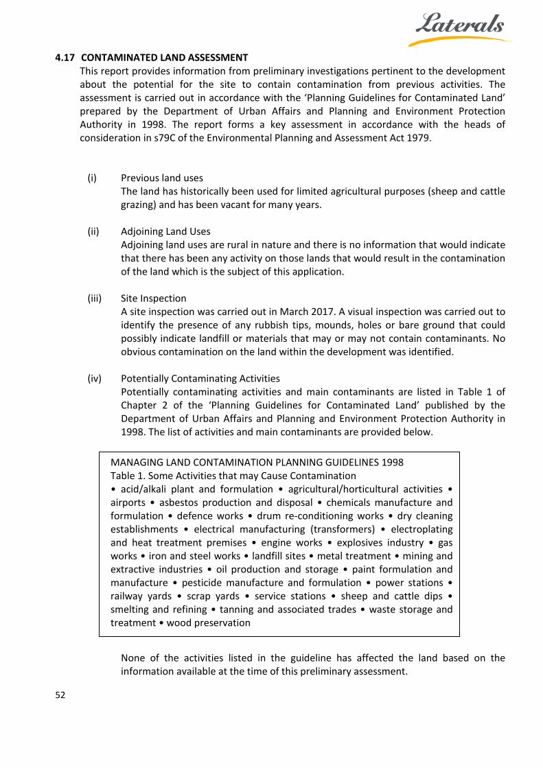
4.17 CONTAMINATED LAND ASSESSMENT This report provides information from preliminary investigations pertinent to the development about the potential for the site to contain contamination from previous activities. The assessment is carried out in accordance with the ‘Planning Guidelines for Contaminated Land’ prepared by the Department of Urban Affairs and Planning and Environment Protection Authority in 1998. The report forms a key assessment in accordance with the heads of consideration in s79C of the Environmental Planning and Assessment Act 1979.
(i) Previous land uses
The land has historically been used for limited agricultural purposes (sheep and cattle grazing) and has been vacant for many years.
(ii) Adjoining Land Uses Adjoining land uses are rural in nature and there is no information that would indicate that there has been any activity on those lands that would result in the contamination of the land which is the subject of this application.
(iii) Site Inspection A site inspection was carried out in March 2017. A visual inspection was carried out to identify the presence of any rubbish tips, mounds, holes or bare ground that could possibly indicate landfill or materials that may or may not contain contaminants. No obvious contamination on the land within the development was identified.
(iv) Potentially Contaminating Activities Potentially contaminating activities and main contaminants are listed in Table 1 of Chapter 2 of the ‘Planning Guidelines for Contaminated Land’ published by the Department of Urban Affairs and Planning and Environment Protection Authority in 1998. The list of activities and main contaminants are provided below.
None of the activities listed in the guideline has affected the land based on the information available at the time of this preliminary assessment.
MANAGING LAND CONTAMINATION PLANNING GUIDELINES 1998 Table 1. Some Activities that may Cause Contamination • acid/alkali plant and formulation • agricultural/horticultural activities • airports • asbestos production and disposal • chemicals manufacture and formulation • defence works • drum re-conditioning works • dry cleaning establishments • electrical manufacturing (transformers) • electroplating and heat treatment premises • engine works • explosives industry • gas works • iron and steel works • landfill sites • metal treatment • mining and extractive industries • oil production and storage • paint formulation and manufacture • pesticide manufacture and formulation • power stations • railway yards • scrap yards • service stations • sheep and cattle dips • smelting and refining • tanning and associated trades • waste storage and treatment • wood preservation
53
(v) Remediation Activities
There is no information that the land has been subject to any notices concerning the need for remediation of the site. There is no information to indicate that the land has been subject to voluntary remediation by any prior landowner.
(vi) Contaminated Land Assessment Summary From this assessment there appears to be no contamination of the land which is the subject of the proposed development. Based on this preliminary assessment it is considered that the site is presently suitable for the proposed development.
5 CONCLUSION
This SEE supports a development application to Queanbeyan Palerang Regional Council (QPRC) for a Recreational Facility (Outdoor) - Rifle Range to be established on Lots 114 and 200 DP 750008, and Lot 149 DP 750013, 2155 Collector Road, Currawang and demonstrates compliance with the Palerang LEP 2014 and Palerang DCP 2015. The proposed development should be approved by Council as it:
• Satisfies sustainable development principles; • Has a minimal and manageable impact on the environment; • Has a minimal and manageable impact on local amenity; and • Will contribute to the continued economic activity of the QPRC area.