1 Statement of Reasons for Decision 17 October 2018 West Culburra Concept Proposal (SSD 3846) 1. INTRODUCTION 1. On 20 June 2018, the Independent Planning Commission NSW (the Commission) received from the NSW Department of Planning and Environment (the Department) a State Significant Development (SSD) application (formerly a concept proposal application which on or about 6 February 2015 was transitioned to the SSD assessment system) from John Toon Pty Ltd, on behalf of the Halloran Trust, (the applicant), for a mixed-use subdivision to the west of the existing Culburra Beach township (the Project). 2. The Commission is the consent authority in respect of the Project under section 4.5(a) of the Environmental Planning and Assessment Act 1979 (EP&A Act) and clause 8A of the State Environmental Planning Policy (State and Regional Development) 2011 (SEPP SRD). This is because: • the Project constitutes SSD under section 4.36 of the EP&A Act as the Project involves subdivision for residential purposes into more than 100 lots; and • the Department received more than 25 submissions from the public objecting to the Project. 3. While the Project was submitted prior to 1 March 2018, clause 8A of SEPP SRD applies to the Project because the clause extends to development applications that were made before the 1 March 2018 commencement of the clause that have not been determined. 4. Professor Mary O'Kane AC, Chair of the Commission, nominated herself (as Panel Chair), Ross Carter, and Ilona Millar to constitute the Commission determining the Project. 1.1 Site and locality 5. The Project site is located to the west of the existing Culburra Beach township (the site), approximately 15 km southeast of Nowra. Figure 1 shows the site in a regional context of the Project, and Figure 2 shows the local context of the Project. 6. The applicant’s Environmental Assessment (EA) stated that the Project comprises three land parcels with a total site area of approximately 102 hectares (ha) and includes approximately three kilometres (km) of frontage to the Crookhaven River. The site is predominantly undeveloped with tracts of native bushland. The western boundary comprises a section of cleared land. The applicant’s EA noted that the site comprises a high ridge to the south and the land falls to the north from the catchment divide of Lake Wollumboola and Crookhaven River. Part of the site falls to the south and into the Lake Wollumboola catchment (see paragraph 7). 7. The Department’s Assessment Report (Department’s AR) stated that the site contains predominantly native vegetation, with an area of cleared land at the western boundary. From the western boundary, the site has extensive views of the Cambewarra range to
Transcript
1
Statement of Reasons for Decision
17 October 2018
West Culburra Concept Proposal (SSD 3846)
1. INTRODUCTION
1. On 20 June 2018, the Independent Planning Commission NSW (the Commission)received from the NSW Department of Planning and Environment (the Department) aState Significant Development (SSD) application (formerly a concept proposalapplication which on or about 6 February 2015 was transitioned to the SSD assessmentsystem) from John Toon Pty Ltd, on behalf of the Halloran Trust, (the applicant), for amixed-use subdivision to the west of the existing Culburra Beach township (the Project).
2. The Commission is the consent authority in respect of the Project under section 4.5(a)of the Environmental Planning and Assessment Act 1979 (EP&A Act) and clause 8A ofthe State Environmental Planning Policy (State and Regional Development) 2011(SEPP SRD). This is because:• the Project constitutes SSD under section 4.36 of the EP&A Act as the Project
involves subdivision for residential purposes into more than 100 lots; and• the Department received more than 25 submissions from the public objecting to the
Project.
3. While the Project was submitted prior to 1 March 2018, clause 8A of SEPP SRD appliesto the Project because the clause extends to development applications that were madebefore the 1 March 2018 commencement of the clause that have not been determined.
4. Professor Mary O'Kane AC, Chair of the Commission, nominated herself (as PanelChair), Ross Carter, and Ilona Millar to constitute the Commission determining theProject.
1.1 Site and locality
5. The Project site is located to the west of the existing Culburra Beach township (the site),approximately 15 km southeast of Nowra. Figure 1 shows the site in a regional contextof the Project, and Figure 2 shows the local context of the Project.
6. The applicant’s Environmental Assessment (EA) stated that the Project comprises threeland parcels with a total site area of approximately 102 hectares (ha) and includesapproximately three kilometres (km) of frontage to the Crookhaven River. The site ispredominantly undeveloped with tracts of native bushland. The western boundarycomprises a section of cleared land. The applicant’s EA noted that the site comprises ahigh ridge to the south and the land falls to the north from the catchment divide of LakeWollumboola and Crookhaven River. Part of the site falls to the south and into the LakeWollumboola catchment (see paragraph 7).
7. The Department’s Assessment Report (Department’s AR) stated that the site containspredominantly native vegetation, with an area of cleared land at the western boundary.From the western boundary, the site has extensive views of the Cambewarra range to
2
the west, Mount Coolangatta and the Crookhaven River to the north, Curleys Bay and the Pacific Ocean to the east. The northern part of the site is within the Crookhaven River catchment and the southern part of the site including the land south of Culburra Road is within the Lake Wollumboola catchment.
Figure 1 – Regional context
Source: Department of Planning and Environment’s Assessment Report
3
Figure 2 – Local context
Source: Department of Planning and Environment’s Assessment Report
8. The Department’s AR stated that: “Culburra Beach is surrounded by high quality natural
features including beaches, the Crookhaven River estuary, Lake Wollumboola and Jervis Bay National Park…The Crookhaven River estuary contains a number of priority oyster leases which are an important economic resource in the region and for NSW. The estuary also supports a protected wetland and marine vegetation, including saltmarsh, seagrass and mangroves”.
9. From a review of the applicant’s EA, the Department’s AR and the Commission’s site
and locality inspection, the Commission understands the site as described below: • land south of Culburra Road: approximately 2.55 ha, bounded to the north by
Culburra Road, to the south by extensive native bushland and Long Bow Point, to the east by a mix of cleared and sparsely vegetated land and a community retirement village further east, and to the west by sparse vegetation and an old transfer station. This land is within the Lake Wollumboola catchment and is zoned for residential use under Shoalhaven Local Environmental Plan 1985 (SLEP 1985);
• land north of Culburra Road: approximately 18 ha, bounded to the north by Curleys Bay, to the south by Culburra Road, to the east by Canal Street East and the existing residential area of Culburra Beach and the Culburra Sewerage Treatment Plant (STP) to the west. This land is zoned for business use under SLEP 1985; and
• land west and south of the Culburra Sewer Treatment Plant (STP): approximately 95 ha – bounded to the north by the Crookhaven River (western side), Curleys Bay (eastern side) and Billy’s Island Inlet which comprises State Environmental Planning Policy No 14 – Wetlands (SEPP14) through the central area of the foreshore. A 30 metre strip of crown land covers the riparian area adjacent to the northern boundary. The site is bounded to the south by dense native vegetation
4
and Culburra Road to the southeast, the Culburra STP to the east, a small existing industrial precinct to the southeast and a mix of cleared and sparsely vegetated land to the west. The land west of the STP is zoned for residential use and environmental protection along the foreshore and the land directly south of the STP is zoned for industrial use, SLEP 1985 (see Figure 2 and Figure 3).
1.2 Site and Locality Background 10. The Department’s AR noted that land west of Culburra Beach has been earmarked for
urban development since the 1980s. In 1992, Shoalhaven City Council (Council) rezoned parcels of land west of Culburra Beach from rural to mix of residential, industrial, commercial and environmental protection zones.
11. The Department’s AR noted that in 1993, the applicant submitted a development
application (DA No. SF 7477) to Council for an 837-lot residential subdivision at Long Bow Point, on the southern side of Culburra Road and included part of the location of Stage 1 of the Project. In 1996, a Commission of Inquiry (CoI) was held, on the direction of the then Minister, to examine and make recommendations into the environmental aspects of the proposed subdivision. The CoI was adjourned in 1996 to allow the applicant time to prepare a Fauna Impact Assessment, and was reconvened in November 1999, with final hearings held in January 2000. In March 2000 the CoI recommended to the Minister, that the residential subdivision be refused on the following grounds:
“its likely unacceptable environmental impacts, including loss of water quality of the important Lake Wollumboola and loss of fauna and habitat of conservation value.
Areas of the site identified as having conservation value should be protected and not cleared or modified based on likely adverse impacts to threatened fauna or threatened fauna habitat. Similarly, the highest levels of protection from pollution or impacts are required for the important Lake Wollumboola to protect habitat and fauna, including threatened species.
Review of overall planning controls is warranted to assist both the Applicant and agencies with integrating the Commission’s precautionary and staged development approach in this sensitive and important environment”.
12. In June 2000, the then Minister for Planning refused DA No. SF 7477. Healthy Rivers Commission 13. In 2002, the NSW State Government commissioned an independent inquiry into the
coastal lakes of NSW, which was conducted by the Healthy Rivers Commission (HRC) and culminated in the Coastal Lakes: Independent Inquiry into Coastal Lakes - April 2002 (HRC Inquiry). The HRC Inquiry gave Lake Wollumboola the highest classification of ‘Comprehensive Protection’, noting that the Lake has extreme natural sensitivity, a largely unmodified catchment, a slightly affected lake condition, and high conservation value.
14. The HRC Inquiry recommended that the Minister for Planning ‘call-in’ development
affecting a coastal lake if the Minister considers that the proposed development may not have a neutral or beneficial effect on natural ecosystem processes in cases where the Lake is classified as having Comprehensive Protection. In 2002, Lake Wollumboola was
5
added to the Jervis Bay National Park, in line with recommendations of the HRC Inquiry. Draft South Coast Regional Strategy and South Coast Sensitive Urban Lands Review 15. In 2006, the Draft South Coast Regional Strategy (SCRS) was publicly released.
Following this, the then Minister for Planning appointed an independent panel to investigate and report on sensitive sites in the South Coast Sensitive Urban Lands Review, 2006 (SCSULR) to help inform the finalisation of the SCRS. The SCSULR considered Culburra, including land within the Lake Wollumboola catchment. In relation to suitability of the site, the SCSULR recommended:
“Land within the Lake Wollumboola catchment is considered unsuitable for urban development, principally on the grounds of the potential negative impacts on the Lake which is a sensitive Intermittently Closing & Opening Lake or Lagoon ICOLL. The remaining land within the catchment of the Crookhaven River is considered suitable for limited urban development”.
16. In relation scale and type of land release, the SCSULR recommended: “It would be appropriate for sufficient land within the Crookhaven River catchment, north of Culburra Road and immediately west of the Culburra Village centre to progress for urban development. The amount of land should meet estimated needs for the next 10-15 years. The release area should achieve densities which are higher than traditionally achieved to reduce the land-take and economise on the use of land resources. Site planning should allow for suitable bushfire setbacks; protection of EECs and riparian setbacks exceeding current DNR requirements. The Council should monitor closely the rate of development, dwelling construction and the nature of dwelling tenure (to determine whether dwellings are permanently occupied or not) to determine land demand trends. Further rural land adjoining to the west (outside the Lake Wollumboola catchment) is suitable for investigation for additional urban development/ release in due course, subject to environmental assessments and demand for land. The planning for Culburra should be revisited in 10 years to determine the need for further urban land. Council should instigate planning reform within the established areas of Culburra and Orient Point to increase the potential for higher density dwellings to meet changing demographic needs, and manage the demand for urban expansion land”.
17. In relation to alternate land uses, the SCSULR recommended:
“The land in the Lake Wollumboola catchment should be zoned for conservation purposes (the most appropriate zone under the LEP template is Zone E1 National Parks and Nature Reserves).
6
Negotiations should be commenced with the land owner to determine their interest in dedicating the land in the Lake Wollumboola catchment for conservation purposes, and including the site as a potential bio-banking site.”
18. The Department’s AR noted that the outcomes and recommendations of the SCSULR
are embodied in the current Illawarra Shoalhaven Regional Plan 2015 (ISRP) (this is considered further in paragraphs 90-97).
Shoalhaven City Council Growth Management Strategy 19. On 14 December 2012, Shoalhaven City Council adopted its Growth Management
Strategy (the GMS), which was endorsed by the Department on 20 May 2014. The purpose of the GMS is to manage the social and economic implications of future growth in Shoalhaven. The GMS identified the Culburra urban expansion area and endorses the recommendations of the SCSULR. The GMS noted that Culburra is covered by the Jervis Bay Settlement Strategy and in relation to opportunities for expansion states:
“There is a large parcel of undeveloped land immediately to the west of Culburra Beach that is zoned for residential development under the Shoalhaven LEP 1985. It was previously estimated that this area could provide for an additional 3,200 dwellings in the Culburra Beach locality.”
20. The GMS further stated that opportunities for expansion are limited by the findings of
the HRC, which has recommended that any new urban development within the catchment of Lake Wollumboola be limited to within the existing boundaries of developed areas (see paragraphs 13 and 14). The GMS is considered further in section 5.6.
Illawarra Shoalhaven Urban Development Program 21. The Illawarra Shoalhaven Urban Development Program (ISUDP) is the State
Government’s program for managing land and housing supply in the Illawarra and was used in the development and implementation of the ISRP (see paragraph 90). The ISUDP monitors the planning, servicing and development of new urban areas in Wollongong, Shellharbour and Kiama and was expanded in the ISUDP Update 2016 to include the Shoalhaven local government area (LGA). The ISUDP Update 2016 utilised population and dwelling projections released by the Department to inform greenfield land supply for housing.
22. The ISUDP Update 2016 identified the Culburra Beach Investigation Area, as one of the
Shoalhaven Greenfield release areas. The ISUDP Update 2016 noted: “Culburra was identified as sensitive urban land through the Sensitive Urban Lands Review 2007 due to the potential impact of urban growth on the health of Lake Wollumboola. The Lake contains significant biodiversity values which are highly sensitive to deterioration of water quality from runoff and groundwater. The Sensitive Urban Lands Review determined that there is limited urban potential in this area outside of the Lake Wollumboola catchment. Potential yields are to be determined and will depend on evaluation of scale, water catchment issues, and other environmental considerations. A number of planning processes are currently proceeding for this area that will, once finalised, resolve appropriate land use yields”.
7
23. In 2017, Council commissioned the West Culburra groundwater assessment:
Preliminary report (Stage 1), prepared by Hgeo in June 2017 (Hgeo 2017) to carry out a groundwater investigation in the area west of Lake Wollumboola, including land at Long Bow Point. The purpose of Hgeo 2017 is to inform preparation of an integrated water cycle assessment for a Planning Proposal submitted by the applicant (see paragraph 25). Hgeo 2017 recommended a monitoring network comprising 14 locations and a baseline monitoring program over a two-year period, with groundwater samples being collected quarterly, to establish baseline groundwater chemistry and nutrient concentrations. The Commission understands from Council that this monitoring program has commenced.
Other Proposals by the Halloran Trust 24. On 29 June 2011, Allen Price & Scarratts, on behalf of the Halloran Trust, lodged a
development application with Shoalhaven City Council to develop an 18-hole championship golf course on Long Bow Point. The Long Bow Point Golf Course was declared SSD in March 2017 and the development application was referred to the Department for assessment. The development application was referred to the Commission for determination separately to this Project and was refused by the Commission on 26 September 2018.
25. On 4 August 2014, the applicant lodged a Planning Proposal to rezone 1,681.5 ha of
land for residential, commercial, industrial, recreation and environmental conservation uses in the Shoalhaven LGA, including land at Long Bow Point, West Culburra, West Callala Bay and Kinghorn Point. In November 2015, a Gateway Determination was issued for the Planning Proposal recommending that land in the Lake Wollumboola catchment be zoned for environmental protection, dependent on the outcomes of a biodiversity offset strategy and water quality studies prepared to support the Planning Proposal. The Department’s AR stated that the Gateway Determination also requires preparation of other studies, including Aboriginal cultural heritage, community impacts and economic studies. The Department’s AR stated that Council predicts that the Planning Proposal will take between three to four years to complete.
1.3 Summary of Development Application before the Commission 26. As set out in paragraph 6, the Project comprises three land parcels, including two
parcels of land north of Culburra Road within the Crookhaven catchment and one parcel south of Culburra Road within the Lake Wollumboola catchment. During the assessment of the Project, the applicant made various amendments, which included the following, as set out in SRTS: 1. “The area of the industrial zone (Stage 5) was reduced by half, with the deleted area
being retained as woodland; 2. All the wetlands aligned alongside, but outside, the 7(a) zone have been deleted
because they are no longer required for the amended water cycle treatment train (that is there is no longer a reliance on infiltration) with the wetland area now being retained woodland; and
3. The size of the pondage on the east side of the proposed oval being increased to 3200m2 to satisfy the amended Water Cycle Management requirements”.
27. The Commission notes that the applicant’s Supplementary Response to Submissions
8
(SRTS) stated that the Project includes provision for 650 dwellings. Following its meeting with the Commission, the applicant submitted written comments to the Commission which stated: “The final plan for the West Culburra Concept Plan indicates the number of dwellings proposed is 585”. The Commission further notes that the applicant stated at the Public Meeting, on 24 July 2018, in relation to the proposed number dwellings: “stage 1 is 46 dwellings, stage 2 will be about 150 dwellings and stage 3 is similar and stage 4 is similar. And we anticipate that those stages will take something like - between 10 and 20 years depending on the rate of demand”.
28. The Commission notes that it has not received any formal request from the applicant to
amend the number of dwellings being sought under the Project. The Commission has therefore assessed the Project on the basis that approval is being sought for 650 dwellings.
29. The Project now before the Commission for determination is detailed below and
illustrated in Figure 3: • Development footprint:
- Approximately 75 ha of the approximate 102 ha site; • Development stages and timeframe:
- five stages of development over a 20-year period; - Stages 1 to 4 – residential and tourist development; - Stage 5 – industrial development;
• Residential: - 650 dwellings delivered over Stages 1 to 4; - a range of lot sizes from 300 square metres (m²) to 800 m², an average of 550 m²; - combination of development types including medium density, small lots and mixed
use (units above shops); - medium density area near the development entrance roundabout, potential seniors
living area; - Stage 1 residential includes 46 lots south of Culburra Road closest to the town
centre and adjacent to the existing retirement village. Stage 1 includes a mix of low and medium density with up to four-storey apartments along the Culburra Road frontage;
• Tourist development: - children’s play area and adjoining café near the foreshore (delivered in Stage 2); - tourist accommodation, cafés, restaurants, park and viewing areas at Cactus Point
(delivered in Stage 4); • Industrial:
- 3.5 ha of industrial development adjacent to existing industrial area and STP (delivered in Stage 5);
• Sports field: - Sports field located south of the residential areas and main access road (delivered
in Stage 3); • Parks and open space:
- 3 km of managed waterfront including boardwalks and viewing platforms, playgrounds and picnic areas;
- two view corridors through the residential areas to create views of Curleys Bay and Mount Coolangatta;
- Vista Park, a linear park from the Stage 1 residential area through to the Crookhaven River;
• Roads and access: - new 1.8 km collector road off Culburra Road running east-west through the
9
development; - roundabout on Culburra Road serving as the main entrance to the residential areas
of Stages 2, 3 and 4; - gradual speed reduction in the approach to roundabout on Culburra Road from 100
km per hour (km/hr), to 80 km/hr to 50 km/hr to facilitate the roundabout; - foreshore drive/path, including cycle/walkway adjacent to the new collector road,
extending along Culburra Road to the existing town centre; - layout of new local roads to follow a circular pattern, similar to the existing layout
in Culburra Beach (detail to be included in separate development applications); • Supporting infrastructure:
- internal roads, drainage and electricity; - new electrical substation near the industrial area; - stormwater ponds at the sports oval, entrance roundabout, industrial area and
medium density development. 30. The Department’s AR noted that there are aspects of the Project that remain unclear.
The Department’s AR stated: “Aspects that remain unclear, despite requests for clarification from the Applicant, include: • the size of the development footprint • the total number of residential dwellings • scope and extent of mixed uses (i.e. housing above shops) and medium density
development • proposed development within the 100m foreshore buffer zone, such as cycleways,
walkways and viewing platforms”.
10
Figure 3 – Project
Source: Response to Submissions 2017
11
1.4 Need for Project 31. The applicant’s SRTS does not include any socioeconomic studies addressing the need
for the project but the SRTS stated that the justification for the Project: “rests on seven pillars:
• the provision of housing for known and anticipated demand; • promotion of new business opportunities in tourism and recreation, in health and
aged care and in management of ecologies and items of heritage significance; • promotion of local employment opportunities; • use of land that is well suited to urban development; • use of land consistent with relevant zoning and statutory instruments; • efficient and economic use of existing infrastructure; and • integrating development with local public transport services”.
2. THE DEPARTMENT’S CONSIDERATION OF THE APPLICATION 2.1 Key steps in Department’s consideration of the Development Application 32. The Department’s AR stated that the Project was publicly exhibited from 26 April 2013
until 7 June 2013. A total of 44 submissions were received during the exhibition period, including seven from Government agencies (agencies), three from special interest groups and 34 from the public. Of the 37 submissions from the public and special interest groups, 26 objected, including petitions containing 750 signatures, and 11 supported the proposal.
33. The Department’s AR stated that during the exhibition period, members of the public
met with the then Minister for Planning and presented a 1,400-signature petition in support of the application. The petition was presented by several local residents that had made individual submissions during the exhibition period. The Department noted that the petition was not submitted to the Department as a formal submission.
34. A breakdown of the matters raised in objections, and the percentage of submissions
attributed to these matters is provided in Figure 4.
12
Figure 4 - Public objections by issue and percentage of submissions that raised each issue
Source: Department of Planning and Environment’s Assessment Report
35. A breakdown of the matters raised in support of the Project, and the percentage of
submissions attributed to these matters is provided in Figure 5.
Figure 5 - Public support by issue and percentage of submissions that raised each issue
Source: Department of Planning and Environment’s Assessment Report
36. In October 2013, the applicant provided a Response to Submissions (RTS) to address
issues raised and included updates to the Water Cycle Management Report (WCMR), Water Quality Monitoring Plan (WQMP) and Estuarine Management Study (EMS). The Department made the RTS publicly available on its website and requested comments from agencies that made submissions on the EA. The Department’s AR noted that “significant deficiencies were identified with the RTS and further information requested
13
from the Applicant to address the key issues”. 37. In September 2014, the applicant provided a Preferred Project Report (PPR). The
Department’s AR stated that the PPR did not include further analysis or assessment to address any of the key issues. The PPR was therefore not provided to agencies for comment. The Department’s AR stated that the Department requested the applicant provide a final RTS to address the issues that the Department considered to be outstanding.
38. In July 2017, the applicant submitted its SRTS. The Department’s AR stated that the
SRTS included the following revisions to the Project: • “removing the proposed commercial development • reducing the stage 5 industrial development from 7.25 ha to 3.5 ha • increasing the total number of residential dwellings from 637 to 650 • removing the boat ramp at the proposed Cactus Point tourist development • removing the proposed wetland adjacent to the 7(a) environmental protection zone
along the foreshore and retention of native vegetation • increasing the size of the stormwater pond adjacent to the sports field”.
39. The Department’s AR stated that the SRTS was made available on its website and was
provided to agencies with a request for final comments. The SRTS was accompanied by a WCMR Addendum dated June 2017. The Department’s AR stated that the SRTS describes the final Project that was evaluated by the Department in its assessment and by agencies in their final submissions. The Department’s AR stated: “Some aspects of the concept proposal were not clearly described, as there have been multiple and sometimes conflicting versions submitted by the Applicant”.
40. The Department’s AR further stated that following a review of SRTS and final water
quality assessment, a number of agencies maintained the concerns they had highlighted in 2013 when the EA was first submitted, “that the water quality impacts of the proposal present an unacceptable risk to the Crookhaven River estuary, oyster aquaculture, and the catchment of Lake Wollumboola and are unlikely to be adequately mitigated”. A summary of outstanding issue raised by agencies, that remain unresolved at the time the Department published the its AR, is set out below (these matters are discussed further in sections 5.4.1, 5.4.2, 5.4.3 and 5.5): • Department of Primary Industries (Fisheries):
- potential water quality impacts on the Crookhaven River and on priority oyster aquaculture areas (POAAs) and direct harvest oysters;
- water quality treatments are not properly designed for storm events and monitoring is inadequate;
- creation of ‘vistas’ is not sufficient justification for clearing riparian vegetation and mangroves;
- clearing of riparian vegetation and mangroves to provide ‘vistas’ is not supported; - development within 100 m of the riparian buffer, including earth diversion bunds,
would compromise its ecological integrity and effectiveness of the buffer; - the proposed tourist development at Cactus Point is inappropriate given the
location is unsuitable for water focused leisure activities; • Office of Environment and Heritage (the OEH):
- the OEH strongly support a Neutral or Beneficial Effect (NorBE) outcome on water quality in Lake Wollumboola, noting that some of the proposal is within the Lake catchment;
- hydrologic and geomorphic studies are underway to delineate the extent of the Lake Wollumboola catchment. Until known, a precautionary approach is needed;
14
- the proponent’s justification for land uses is the premised on an administrative land use legacy, rather than a contemporary appreciation of environmental sensitivities;
- the ongoing and long term capacity to adequately manage waste water away from the Lake catchment and into the Crookhaven catchment remains a concern as it largely relies on engineering solutions and is unlikely to deal with groundwater infiltration implications. Engineering solutions can, and do fail;
- OEH preference remains for biodiversity offsets to be sourced from within the Lake’s catchment, as required by SCSULR;
- OEH support recommendations for conducting archaeological test excavation and development of a conservation management plan;
- impact to the Crookhaven River midden complex, which will come under threat from the proposed recreational use of the foreshore;
• NSW Office of Water (NOW): - clearing of foreshore riparian areas is inappropriate and is inconsistent with the
NOW Guidelines for Controlled Activities on Waterfront Land 2012; - the proposed tourism facility may create expectations for boat access which may
lead to requests to dredge and subsequently impacting on the estuary; - potential for the lengthy construction phase to impact water quality;’
• Crown Lands (CL): - the proposed development over Crown Land is not supported, including viewing
platforms, walkways, clearing of marine vegetation and any other structures; - use of Crown Land as an offset is not supported, although it is not clear in the
concept proposal how much of the proposed foreshore is located over Crown Land; - there is already considerable public access to the foreshore within Curleys Bay
and Crookhaven river estuary; • NSW Food Authority (NSW FA):
- the proposal has the potential to have localised impacts on estuary and shellfish; - one area of the estuary is used for direct harvest, which involves human
consumption direct from the water, a vital element to the farmers business model. 2.2 The Department’s Assessment Report 41. The Department’s AR, dated 16 June 2018, stated that the Department had considered
the issues raised by agencies, the public and special interest group submissions, and that the Department had visited the site and considered the applicant’s EA, RTS, SRTS as well as independent advice from the Department’s water quality experts Dr Michael Barry of BMT WBM and Tony Weber of Alluvium (see paragraphs 147). The Department’s AR stated: “The Department and other Government agencies repeatedly requested additional assessment information from the Applicant throughout the assessment period, to fully address the key issues. Despite multiple revisions to the concept proposal and key environmental studies, the Department and other Government agencies consider the issues remain unresolved”.
42. The Department’s AR stated that in assessing the suitability of the site for the proposed
development, on the key issues associated with the Project are water quality, biodiversity, Aboriginal heritage and traffic.
43. The Department’s AR concluded:
• “the site is unsuitable for the scale of urban development proposed and is not consistent with areas identified for urban expansion in current strategic plans
• the proposed 650 dwellings exceeds Council’s growth projections for Culburra Beach for the next 20 years (estimated at 280 dwellings)
• the proposed development does not utilise the area identified in strategic plans for
15
future urban development in Culburra Beach (the Culburra investigation area) • the potential water quality impacts of the concept proposal on the Crookhaven River
estuary present an unacceptable risk to oyster aquaculture, protected wetlands, marine vegetation and fish habitat
• there is scientific uncertainty that the water quality impacts can be adequately mitigated by the proposed stormwater management system, and the Applicant has been unable to adequately demonstrate there would not be serious or irreversible impacts
• the potential water quality impacts on Lake Wollumboola are inconsistent with strategic planning
• objectives to protect the lake from urban development • the proposal is likely to have serious and irreversible impacts on Aboriginal heritage
sites of regional conservation significance and high cultural significance to Aboriginal people
• there are unresolved aspects relating to traffic and access to the concept proposal that the Applicant has been unable to address to a satisfactory level”.
3. THE COMMISSION’S MEETINGS AND SITE VISIT 44. As part of its determination, the Commission met with the Department, the applicant,
Council, and the Jerrinja Local Aboriginal Land Council (Jerrinja LALC). The Commission also conducted a site inspection, toured the locality, and conducted a public meeting.
3.1 Meeting with the Department 45. On 18 July 2018, the Commission met with the Department to discuss the Department's
AR. The Department's technical water quality experts (BMT WBM and Alluvium) joined the meeting by telephone. A record of this meeting and the issues discussed has been available on the Commission's website since 27 July 2018.
3.2 Meeting with the Applicant 46. On 19 July 2018, the Commission met with the applicant, representatives from the
Halloran Trust and the applicant’s consultant, Martens. A copy of the applicant’s presentation from the day was made available on the Commission’s website shortly after the meeting. A record of this meeting and the issues discussed has been available on the Commission’s website since 27 July 2018.
3.3 Site inspection 47. On 23 July 2018, the Commission conducted a site inspection. The applicant attended
the site inspection. The Commission also invited a representative from each of four local community groups to attend and observe the site inspection. The groups and representatives that attended the site inspection were: • Frances Bray (Wollumboola Protection Association, President); • Alan Pendleton (Culburra Beach Progress Association, President); • Jack Kerr (Culburra Beach Progress Association, Member); and • Brian Muller (Culburra Chamber of Commerce, President).
48. The inspection included a drive through the site, stopping at key points. The applicant identified the proposed location of each stage of the Project. The applicant provided maps that were made available on the Commission’s website shortly after the site
16
inspection. A summary of what took place on the site inspection has been available on the Commission’s website since 5 August 2018.
49. The Commission separately and independently of the applicant inspected the surrounding locality, to understand the physical attributes of the site and locality. No other individuals attended the inspection of the surrounding locality.
3.4 Meeting with Shoalhaven City Council 50. On 23 July 2018, the Commission met with Council to discuss its views on the Project.
A record of this meeting and the issues discussed was made available on the Commission’s website shortly after the meeting. The Council provided the Commission with a hard copy of the CoI Report, which has been available on the Commission’s website since 31 July 2018.
3.5 Meeting with the Jerrinja Local Aboriginal Land Council 51. On 24 July 2018, the Commission met with the Jerrinja LALC who also form the Jerrinja
Traditional Owners Corporation (Jerrinja TOC) to discuss their views on the Project. A record of this meeting and the matters discussed has been available on the Commission’s website since 31 July 2018.
3.6 Public meeting 52. On 24 July 2018, the Commission held a public meeting at the Culburra Bowling Club,
Cnr Prince Edward Avenue and West Crescent, Culburra Beach, to hear the public’s views on the Project. The Commission received requests to speak from 24 people. Of the 24 registered speakers, 22 elected to speak at the public meeting and two registered speakers elected not to speak on the day. The Chair accepted three late registrations to speak, bringing the total number of speakers to 25. A list of speakers was made available on the Commission’s website on 22 July 2018. An updated list incorporating changes made at the public meeting was made available on the Commission’s website on 21 August 2018. The transcript from the public meeting was made available on the Commission’s website on 26 July 2018. Written comments and presentations of speakers who presented at the public meeting were made available on the Commission’s website within ten days of the meeting.
53. An opportunity to lodge written comments with the Commission was afforded until seven
days following the public meeting. The Commission received 112 written comments. All comments were available on the Commission’s website after they were received.
54. Counsel assisting, Kate Richardson SC, assisted in the conduct of the public meeting in
accordance with the Commission’s Public Meeting Guidelines. 55. The speakers at the public meeting reflected a mix of views both in support of and in
objection to the Project. The Commission however notes that the views of the majority of speakers at the public meeting and those in attendance, were strongly in support of the Project. Following the public meeting, the Commission received a number of written comments from the public, including from people in attendance at the public meeting, objecting to the Project. The written comments noted that the demonstration of support for the Project was not necessarily reflective of the views of all community members in attendance at the public meeting.
17
56. In summary, the main issues raised at the public meeting and in written comments received by the Commission following the public meeting, included: • economic and social benefits, including employment generation, support for local
businesses and services; • provision of a mix of housing types in an area with aging population including
affordable housing and aged care housing. Concerns were raised by residents who have age-related restricted driving licenses; they would have problems living in Culburra if the current services closed;
• concerns that the town is in decline, and the future of the town if the permanent resident population continues to decline, including a reduction in local services and infrastructure;
• the Culburra Beach township has good local services and infrastructure including an ambulance, primary school, medical centre and other services. Concerns were raised regarding these services closing down if the population declines;
• new development would provide much-needed employment and housing options and allow younger residents to stay in the Culburra area;
• surface water quality impacts and potential for the Project to impact on the Crookhaven River estuary, SEPP 14 wetlands and potential impacts on Lake Wollumboola;
• potential impacts to oyster leases in the Crookhaven River; • potential impacts on receiving environments; • potential impacts on groundwater and uncertainty due to limited baseline data; • the importance of the Crookhaven River and Lake Wollumboola and the surrounds
to the Jerrinja culture and impacts on Aboriginal cultural heritage; • biodiversity impacts associated with clearing of native vegetation; • impacts on rare bird species, including migratory birds, that use the Crookhaven
River and estuary and Lake Wollumboola as a breeding and nesting ground; and • strategic planning matters and outcomes of environmental studies that have
considered the site. 4. INDEPENDENT CONSULTANT ENGAGED BY THE COMMISSION 57. After the public meeting, the Commission sought independent advice on the hydrology
and water quality impacts of the proposal from water quality experts at the University of New South Wales, Water Research Laboratory (UNSW WRL). The UNSW WRL is one of the world’s leading water research laboratories. The UNSW Water Research Centre website states: “WRL can best be described as an expert problem solver in engineering relating to water, the coast, the environment and groundwater. WRL undertakes commercial projects to address complicated water engineering problems relating to groundwater, hydrology, river flow and flood plain management, estuarine and ocean hydraulics, sediment transport, stratified flow, pipe flow, major pump installations, hydraulic structures, water distribution, wave and surge predictions, foreshore protection, breakwater design, sea level rise and climate change adaptation, coastal zone management and environmental studies” (see www.engineering.unsw.edu.au).
58. The Commission requested that UNSW WRL review all of the documentation submitted
by the applicant, including consultant reports, the Department’s AR and the independent expert advice and studies commissioned by the NSW Government.
59. The UNSW WRL report titled Independent Review of the Water Quality assessment for
the West Culburra Concept Proposal (Major Project Application SSD 3846) (Independent Review), dated 11 September 2018, was provided to the applicant and
the Department, with a timeframe of seven days to provide any written response. The Independent Review was also made publicly available on the Commission’s website on the same day. The UNSW WRL report concluded that: “based on the review of the technical surface water, estuarine modelling, groundwater and water quality reports prepared in support of West Culburra Concept Proposal State Significant Development (SSD 3846), as well as the warranted precautionary approach due to the sensitive ecological nature of Lake Wollumboola, the reviewers support DPE’s recommendations to the Independent Planning Commission”.
60. On 19 September 2018, the applicant requested an extension of time to provide a
response to the UNSW WRL Independent Review. On 20 September 2018, the Commission wrote to the applicant by email and agreed to extend the timeframe to 24 September 2018 for the applicant to provide a response. The email correspondence was uploaded to the Commission’ website on 25 September 2018.
61. On 24 September 2018, the applicant provided four separate responses to the
Commission responding to the UNSW WRL Independent Review. These responses were made publicly available on the Commission’ website on 25 September 2018. The responses included: • West Culburra Mixed Use Concept Plan, Submission by John Toon in response to
the Independent review of the Water Quality Assessment for the West Culburra Mixed Use Concept Plan undertaken by UNSW Water Research Laboratory (WRL) (applicant’s September 2018 response), dated 24 September 2018;
• West Culburra Mixed Use Subdivision (SSD 3846) - Stormwater Quality - Response to UNSW WRL Review, Cardno Pty Ltd (Cardno Response), dated 24 September 2018; and
• Proposed West Culburra Residential Development: Response to UNSW WRL Review - Matters of Merit, Martens (Martens Response), dated 24 September 2018;
• Response to the UNSW’s Independent Review of the Water Quality Assessment of the proposed Concept Subdivision at West Culburra, Allen, Price & Scarratts Pty Ltd (APS Response), dated 26 September 2018 (received two days after the extended timeframe for responses, but accepted by the Commission in an exercise of its discretion).
5. THE COMMISSION’S CONSIDERATION 5.1 Material considered by the Commission In determining this Project, the Commission has carefully considered all of the material set out in Appendix 1 (the “Material”). 5.2 Mandatory considerations 62. In determining this Project, the Commission has taken into consideration the following
relevant mandatory considerations, as provided in section 4.15 of the EP&A Act (mandatory considerations): • the provisions of all:
- environmental planning instruments; - proposed instruments that are or have been the subject of public consultation
under the EP&A Act and that have been notified to the Commission (unless the Secretary has notified the Commission that the making of the proposed instrument has been deferred indefinitely or has not been approved);
- development control plans;
19
- planning agreements that have been entered into under section 7.4 of the EP&A Act, and draft planning agreements that a developer has offered to enter into under section 7.4; and
- the Environmental Planning and Assessment Regulations 2000 (Regulations) to the extent that they prescribe matters for the purposes of section 4.15(1) of the EP&A Act;
that apply to the land to which the application relates; • the likely impacts of the development, including environmental impacts on both the
natural and built environments, and social and economic impacts in the locality; • the suitability of the site for development; • submissions made in accordance with the EP&A Act and Regulations; and • the public interest.
5.3 Relevant Environmental Planning Instruments 63. The applicant’s EA, RTS and SRTS and the Department’s AR (Appendix B) provide an
assessment of the environmental planning instrument (EPIs) that apply to the Project: • State Environmental Planning Policy (State and Regional Development) 2011
(SEPP SRD); • State Environmental Planning Policy (Infrastructure) 2007 (ISEPP); • State Environmental Planning Policy No. 14 Wetlands (SEPP14); • State Environmental Planning Policy No. 62 - Sustainable Aquaculture (SEPP62); • State Environmental Planning Policy No. 71 - Coastal Protection (SEPP71); • Jervis Bay Regional Environmental Plan 1996 (JBREP); • Illawarra Shoalhaven Regional Plan 2015 (ISRP); and • Shoalhaven Local Environmental Plan 1985 (SLEP1985).
State Environmental Planning Policy (Infrastructure) 2007 (ISEPP) 64. The Department’s AR stated that the ISEPP “aims to facilitate the effective delivery of
infrastructure across the State by identifying matters for assessment providing for consultation with relevant public authorities”. The ISEPP identifies traffic generating development, which includes subdivision of land into 200 or more allotments where the subdivision includes the opening of a public road. The Department’s AR stated that the Project constitutes a traffic-generating development and was therefore referred to the Roads and Maritime Services (RMS) for its consideration and comment on the potential traffic and accessibility impacts.
65. The Department’s AR stated that RMS does not object to the Project but requested
further design and assessment of the proposed entrance roundabout (see paragraph 29). The Department’s AR noted RMS’ final position that the required design information has not been provided. The Department’s AR stated that: “as traffic and access issues remain unresolved, the Department is unable to definitively state that the proposal is consistent with the aims of the ISEPP”.
Commission’s Consideration 66. The Commission has reviewed the ISEPP and the Material and finds that the ISEPP
applies to the Project, pursuant to clause 104 and Schedule 3, as the subdivision involves more than 50 allotments with access to a classified road (Culburra Road). Clause 104(3) of the ISEPP states that a consent authority must give written notice of the application to RMS within seven days after the application is made and take into
20
consideration any submission that RMS provides in response to that notice.
67. The Commission has reviewed the comments made by RMS on the Project and notesthat RMS’ final submission on the applicant’s SRTS was as follows: “RMS hasreconsidered its position in relation to a speed reduction and will now support a speedreduction to 80km/h to facilitate the provision of a roundabout that provides aconsolidated access to the development”. The RMS further stated that this is subject tocompliance with:• “The roundabout must be designed and constructed in accordance with Austroads
Guide to Road Design;• The roundabout would need to be placed to achieve appropriate sight
distances...The location of the roundabout and demonstration of compliance withsight distances would need to be based on survey and design;
• The roundabout would need to be supported by a suite of measures on CulburraRoad to reinforce the change of environment from a rural environment to an urbanenvironment…”.
68. The RMS submission concluded that: “Insufficient details to address the above havebeen provided as part of the SRTS (e.g. plans demonstrating compliance with theabove)”. This is addressed in further detail in section 5.7).
State Environmental Planning Policy No.14 (SEPP 14) - Wetlands and State Environmental Planning Policy No. 71 - Coastal Protection (SEPP 71)
69. The applicant’s EA included a map of SEPP 14 wetlands based on their field survey data and compared it with the maps included in SEPP 14. The applicant’s WCMR concludes that the Project would have a negligible impact on the SEPP 14 wetlands.
70. The Department’s AR stated that SEPP 14 aims to ensure coastal wetlands are preserved and protected in the environmental and economic interest of NSW. The Department’s AR provided a map of the SEPP 14 wetlands, based on the applicant’s EA and historical mapping undertaken by the Department, which identifies the site and the boundaries of the adjacent SEPP 14 wetlands, see Figure 6. The Department’s AR concluded that the Project has the potential to cause serious impacts on the SEPP 14 wetlands through increased pollutant loads and changes to surface and groundwater discharges. See paragraph 150.
21
Figure 6 - SEPP 14 Wetland
Source: Department of Planning and Environment’s Assessment Report
71. The applicant’s SRTS noted that SEPP 71 applies because the land is identified on therelevant SEPP 71 maps. The SRTS further stated that the site comprises “a 3.5 kmfrontage to Crookhaven River and Curley’s Bay which are classed as an estuary andbay; these lands may be subject to changing sea levels due to climate change but areotherwise unlikely to be affected by wave action or erosion”. The SRTS further statedthat Lake Wollumboola is identified as a coastal lake in SEPP 71 however; “no land inthe concept plan is within 100 m of the lake”.
72. The APS response stated that Independent Review stated that “the provisions of SEPP(Coastal Management) 2018 do not relate to this DA as it was not even in draft formwhen the DA was lodged in 2011”.
73. The Department’s AR stated that SEPP 71 aims to protect and manage the NSW coastthrough improving public access, protecting Aboriginal cultural heritage, protectingvisual amenity and coastal habitats and managing the scale, bulk and height ofdevelopment along the coast. The Department’s AR stated that the Project is:“inconsistent with the aims of SEPP 71 and other matters for consideration in SEPP 71.The concept proposal would remove 91.65 ha of high quality native vegetation and islikely to result in irreversible, flow-on impacts on Lake Wollumboola, which has beenidentified as having high ecological significance for the State of NSW”.
Commission’s Consideration
74. The Commission notes that SEPP 14 and SEPP 71 have now been repealed andreplaced by State Environmental Planning Policy (Coastal Management) 2018 (SEPPCoastal Management 2018). However, the savings and transitional provisions in SEPPCoastal Management 2018 state that it does not apply to development applications
22
lodged prior to the commencement of the SEPP, and therefore is not a relevant consideration for this Project. The Commission notes that the Independent Review refers to SEPP Coastal Management 2018 however that SEPP has not been considered as part of this determination.
75. The Commission has reviewed the now repealed SEPP 14 which stated that it ‘appliesto the land outlined by the outer edge of the heavy black line on the map’. TheCommission has not been provided with the map referred to in SEPP 14 but has beenprovided with a map from the Department at Figure 6. The Project appears to be outsidethe SEPP 14. However, there is a SEPP 14 wetland located immediately adjacent to theProject (identified as 350 at Figure 6) and a SEPP 14 wetland opposite the site (identifiedas 351 at Figure 6). The Commission notes that Figure 6 also identifies the SEPP 14wetlands Maps to the north of the site. On the basis that SEPP 14 aims to ensure thatcoastal wetlands are preserved and protected, and one SEPP 14 wetland is immediatelyadjacent to the Project, the Commission finds that SEPP 14 is relevant to itsconsideration.
76. In addition, the Independent Review highlighted concerns regarding the clearing ofriparian vegetation immediately adjacent to the SEPP 14 wetland to create viewcorridors, as well as the establishment of a cycle path and walkway, which theIndependent Review stated: “will increase the risk of long term damage to this sensitiveecosystem”.
77. The Commission has reviewed SEPP 71 (now repealed) and finds that it applies to theProject because the Project falls within the coastal zone.
78. The Commission has reviewed all of the Material, including Department’s assessmentof these EPIs, the Independent Review and the applicant’s response to the IndependentReview, as well as issues raised in written comments to the Commission. TheCommission finds that the Project is inconsistent with the objectives of SEPP 14 andSEPP 71 because of the reasons in paragraphs 73 and 76 and the uncertainty relatedto Project generated water quality impacts, as discussed further in section 5.4.1.
79. The applicant’s WQMP stated that it was prepared in accordance with SEPP 62. TheWQMP noted that a Stormwater Quality Improvement Device (SQID) Management Plan(SQIDMP) is to be prepared at the construction certificate (CC) stage in accordance withSEPP 62.
80. The Department’s AR stated that one of the key aims of SEPP 62 is to encouragesustainable oyster aquaculture, and to protect and enhance the resource into the future.SEPP 62 requires a consent authority to consider whether a development may have anadverse effect on oyster aquaculture and POAAs and requires consultation with theDepartment of Primary Industries (Fisheries). The Department’s AR states that consentmay be refused if the development will have an adverse effect on any oyster aquaculturedevelopment and priority oyster aquaculture areas, or if measures proposed to avoid orminimise adverse effects are not satisfactory.
81. The Department’s AR stated that the Crookhaven River estuary contains a number ofpriority oyster leases which are an important economic resource in the region and forNSW. The Department noted that a number of submissions from agencies includingFisheries, OEH, NOW, CL and NSW FA, consistently raised concerns regarding the
23
potential impacts on water quality in the Crookhaven River and the subsequent adverse impacts on oyster production, particularly given that there is one direct harvest POAA close to the site, which is approved for the sale of oysters for human consumption, direct from the water (see paragraph 143). The Department’s AR concluded: “The proposal is inconsistent with SEPP 62 (oyster aquaculture) as it would impact on water quality which would adversely affect oyster production”.
Commission’s Consideration 82. The Commission has reviewed SEPP 62 and finds that it is a relevant consideration
because, as set out in paragraph 80, it requires the Commission to consider whether the Project may have an adverse effect on oyster aquaculture and POAAs. As set out in paragraph 81, the Crookhaven estuary contains a number of POAAs.
83. The Commission accepts the Department’s assessment of SEPP 62 as set out in
paragraph 81, particularly given the ongoing and unresolved issues raised by Fisheries and the NSW FA (see paragraphs 40 and 140-143).
84. The Independent Review stated that the Crookhaven estuary can be considered
sensitive as it supports priority oyster leases. 85. The Commission has reviewed all of the Material, including agency submissions and
written comments received by the Commission from Oyster Harvesters. The Commission finds that there is uncertainty related to the Project’s water quality impacts in Crookhaven River and estuary. Given this uncertainty and the sensitivity of the Crookhaven estuary (paragraph 84), the Commission finds that the Project has the potential to adversely impact on water quality in the Crookhaven River and estuary and in turn adversely impact direct harvest POAA. The Commission makes this finding for the reasons set out in paragraphs 40, 81 and 84.
Jervis Bay Regional Environmental Plan 1996 (JBREP) 86. The JBREP was repealed in 2016 but was in force at the time that the application was
lodged, and therefore applies to the Project. The aims of the JBREP are to protect the natural and cultural values of Jervis Bay and allow proposals that contribute to the natural and cultural values of the area. The JBREP details requirements for new development proposals to address, including catchment protection, landscape quality, cultural heritage and habitat protection.
87. The applicant’s EA did not assess the Project against the provisions of the JBREP. 88. The Department’s AR stated that it evaluated the JBREP in its assessment of the
Project, as set out in the assessment section of its report and concluded that the development is not consistent with the aims of the JBREP which are to “protect the natural and cultural values of Jervis Bay and to allow proposals that contribute to the natural and cultural values of the area”.
Commission’s Consideration 89. The Commission has reviewed all of the Material, including the Department’s
assessment of the JBREP, the Independent Review and the applicant’s response to it, and issues raised by the Jerrinja. The Commission finds that the Project does not meet the requirements for protection of the Crookhaven River catchment or the Lake
24
Wollumboola catchment and is inconsistent with the aims of the JBREP. The Commission makes this finding for the reasons discussed in section 5.4.1, 5.4.2 and 5.6.
Illawarra Shoalhaven Regional Plan 2015 (ISRP)
90. The ISRP states in relation to the SCSULR: “the Panel’s recommendations have beenreflected in planning that is either finalised or substantially progressed for all but one site- Culburra Beach”.
91. The ISRP further states: “The Culburra Beach site contains land within the catchment ofLake Wollumboola. This lake is considered an ecological jewel that must be protected.A planning proposal for development was lodged with the Department of Planning andEnvironment in November 2014.
The lands within the catchment are considered unsuitable for urban developmentbecause of potential negative impacts on the lake, which is a sensitive, intermittentlyclosing and opening lake with very high conservation values. The NSW Governmenthas also completed a joint agency study entitled the Environmental Sensitivity of LakeWollumboola. The outcomes and recommendations of the Sensitive Urban LandsReview and the joint agency study will guide protection and conservation of the LakeWollumboola catchment, and future land use planning decisions such as that for theCulburra Beach site”.
92. The ISRP provides a vision and goals for the region, including housing, communities,resources and the natural environment. Direction 2.3 of the ISRP states: “Deliverhousing in new release areas best suited to build new communities, provide housingchoice and avoid environmental impact”. Direction 2.3 identifies West Culburra as “Otherestablished and smaller release areas that will add to the diversity of supply”.
93. The ISRP identifies the significance of aquaculture in the region, noting that it isdominated by oyster farming within the Shoalhaven-Crookhaven estuary. The ISRPstates that it is also a significant contributor to agricultural output and the need to protectregionally important agricultural lands as an asset to food and fibre production (Direction4.1).
94. The ISRP identifies the significance of Lake Wollumboola, and the need to adopt astrategic approach to provide certainty about future land use and to preserve the uniquecharacteristics of the natural environment as the region grows (Direction 5.4). The ISRPstates that Lake Wollumboola is one of Shoalhaven’s sensitive estuaries, stating that“lands within the catchment are considered unsuitable for urban development becauseof potential negative impacts on the lake, which is a sensitive, intermittently closing andopening lake with very high conservation values”.
95. The Department’s AR stated that the Project includes the following development withinthe Lake Wollumboola catchment:• “Stage 1 - 46 lot residential development, south of Culburra Road• entrance roundabout, drainage swale and part of the new collector road• part of the medium density development adjacent to the new collector road• sports field• Stage 5 - 1.1 ha of industrial development.
These elements of the concept proposal are inconsistent with the strategic direction of
25
the ISRP, as they include urban development within the catchment of Lake Wollumboola, with the potential to cause adverse impacts on the lake”.
Commission’s Consideration
96. The Commission has reviewed the ISRP and finds that it applies to the Project becausethe Project falls within the land to which the ISRP applies. The Commission notes thatthe ISRP identifies West Culburra as having potential to add to diversity of housingsupply options whilst avoiding environmental impact, in line with Direction 2.3. However,the Commission also notes that the ISRP highlights the significance of the CrookhavenRiver estuary to aquaculture and oyster production and that Direction 5.4 of the ISRPaddresses the importance of protecting Lake Wollumboola and its catchment as theregion grows.
97. The Commission has considered all of the Material, including the Department’sassessment of the ISRP, the Independent Review and the applicant’s response to it.The Commission accepts the conclusions stated in paragraph 95 in relation to elementsof the Project that are within the Lake Wollumboola catchment and finds that thecomponent of the Project within the Lake Wollumboola catchment is inconsistent withthe strategic direction of the ISRP, because the Project represents urban developmentwithin the catchment (see paragraph 94).
98. As stated in paragraph 85 the Commission finds “that the Project has the potential toadversely impact water quality in the Crookhaven River and estuary and in turnadversely impact direct harvest POAA” and, as such, the Commission finds that theProject has the potential to impact on fisheries and oyster production, for the reasonsset out in paragraphs 40, 81, 84 140-143 and section 5.4.1.
Shoalhaven Local Environmental Plan 1985 (SLEP 1985)
99. SLEP 1985 aims to provide for orderly and timely development of land, to enhancecommunity well-being now and for future generations and to work towards anecologically sustainable future through a proper balance of development andconservation.
100. The Department’s AR stated that, pursuant to the SLEP 1985, the site is zoned:• 2(c) Residential (Living Area);• 3(f) Business (Village);• 4(a) Industrial (General); and• 7(a) Environmental Protection ‘A’ (Ecology).
101. The applicant’s EA states that the Project is permissible with consent in the existingapplicable land use zones, with the exception of the 5(a) Special Uses Community zone,which covers land adjacent to Stage 1 of the Project. The applicant’s EA stated: “Theproposal complies with the zonings with the exception of the area zoned 5(a) specialuses for which no purpose is specified and no purpose can be identified”.
102. The Department’s AR stated that the Project is permissible with consent underSLEP 1985, therefore the Commission may determine the carrying out of thedevelopment. The Department further noted that the Project: “is consistent with theobjectives of the residential zoning. However the concept proposal is not consistent withthe broader aims of SLEP 1985 as it does not provide an appropriate balance ofdevelopment and conservation”.
26
Commission’s Consideration 103. The Commission has considered all of the Material, including the Department’s
assessment of the SLEP 1985. The Commission finds that the Project is permissible with the 2(c), 3(f) and 4(a) land use zones and is consistent with the zone objectives as the Project would:
• provide for new residential areas with a range of housing types with provision for urban facilities to serve the local community;
• provide for village retail and business development to serve the needs of the village community and which is compatible with the village environment; and
• provide for a wide range of general industrial development, including warehousing, processing and general service industries.
104. However, in relation to the 7(a) land use zone, whilst the components of the
development that are proposed within this zone are permissible, the Commission finds that the Project is not consistent with the objectives of the zone because it will not:
• protect and conserve important elements of the natural environment, including wetland and rainforest environments,
• maintain the intrinsic scientific, scenic, habitat and educational values of natural environments,
o to protect areas of high biodiversity value, and • to protect and enhance water quality in the catchment.
105. The Commission agrees with the Department’s assessment, for the reasons set out in
paragraph 102, namely that the Project is inconsistent with the broader aims for the SLEP 1985 because it does not provide an appropriate balance between development and conservation and because of the potential for the Project to produce adverse water quality impacts, as discussed in section 5.4.1.
Shoalhaven Local Environmental Plan 2014 106. The Department’s AR stated that Council released the Shoalhaven Local Environmental
Plan 2014 (SLEP 2014) shortly after the application was lodged with Council. On 31 July 2013, Council resolved to defer the zoning of the land until the application is determined. The Department’s AR stated: “The former Minister for Planning agreed to the deferral, subject to a Planning Proposal for the land that protects the Lake Wollumboola catchment and provides for the sustainable growth of Culburra Beach” (see paragraph 25). The Department’s AR noted that as the original development application was submitted prior to SLEP 2014 being enacted, SLEP 1985, still applies to the Project, as set out in paragraphs 9 and 100.
Commission’s Consideration 107. The Commission notes that SLEP 2014 shows the site as a ‘deferred matter’ to which
SLEP 1985 applies and therefore SLEP 2014 does not apply to the Project. For the reasons set out in paragraph 106, the Commission finds that SLEP 2014 does not apply to the Project.
27
5.4 Likely impacts of the development on both natural and built environments 5.4.1 Water quality 108. The Commission has taken into account the Material insofar as it relates to the impacts
of the Project on water quality and hydrology of Crookhaven River estuary and Lake Wollumboola.
Comments received 109. The Commission heard concerns from speakers at the public meeting and received
written comments regarding the impacts of the Project on surface water quality. The Commission also considered submissions made to the Department including comments made by Council. In relation to surface water quality the concerns raised included: • stormwater discharge points must be located at appropriate locations having regard
to nearby aquaculture and the ecological constraints of the river; • proximity of the Project to sensitive mangroves and SEPP14 wetlands; • nutrient levels in Lake Wollumboola are already too high with existing urban runoff
already polluting the lake; • no further urban development should be allowed in the Lake Wollumboola
catchment; • there are significant oyster leases in the Crookhaven estuary which are zoned for
direct harvest and export. Oysters in the estuary are harvested and sold without depuration as testing shows a high standard of water quality; and
• failure to adequately assess surface water impacts and potential impacts of stormwater runoff into the Crookhaven estuary and impacts on aquaculture.
110. The Commission notes that a number comments made at the public meeting accepted
the applicant’s approach regarding water quality impacts and how these would be managed. A number of speakers at the public meeting also stated that Lake Wollumboola has been coping satisfactorily with untreated urban run-off from existing urban areas of Culburra.
Applicant’s consideration Surface water quality 111. The applicant prepared water quality studies to examine the potential impacts of the
Project and to provide a conceptual design for capture, treatment and discharge of stormwater. These studies were revised several times throughout the assessment process. The water quality studies included the following studies, all prepared by Martens and Associates (Martens): • WCMR, prepared in November 2012 and revised in October 2013, November 2016
and WCMR Addendum June 2017 (referred collectively as WCMR); • WQMP incorporating a Sediment and Erosion Control Plan (SECP), prepared in
October 2013 and revised in November 2016 (referred collectively as WQMP); • EMS, prepared in October 2013; • Estuarine Processes Modelling Report (EPMR), prepared in November 2016; • Stormwater Quality Assessment - Stage 1; Culburra West Mixed-Use Development,
Culburra NSW (SQA), prepared in November 2017.
28
Water Cycle Management Report 112. The WCMR stated that based on Council’s requirements and consultation with the OEH,
the adopted water quality objectives for the Project are: • NorBE - pollutant loads in the post development scenario that are equal to or less
than those currently generated from the site; and • Treatment train effectiveness will be designed to achieve Council’s requirements for
pollutant load reduction. 113. The WCMR stated that the Model for Urban Stormwater Improvement Conceptualisation
(MUSIC) was utilised to evaluate pre and post development pollutant loads from the site. The WCMR noted that the preferred stormwater treatment strategy for the site utilises stormwater reuse, at source controls, and end of line controls to ensure treatment objectives are satisfied. The WCMR noted that individual SQIDs would be prepared and details confirmed during detailed design, once the internal Project layout is confirmed, including: • rainwater tanks; • bioretention swales and basins; • Stormfilter/Enviropod (SFEP) treatment devices; • parkland wetland; • infiltration system; • substation treatment; • industrial zone and proposed roundabout treatment; • 7(a) Environmental Protection zone buffer; and • exfiltration treatment.
114. The WCMR stated that the results of the MUSIC modelling: “indicate that the proposed
development is reducing runoff coefficients across the site. This effect is most notable in outlet ‘06’ (Lake Wollumboola catchment) where the coefficient is reduced by half. Results are not typical of an urbanised catchment (such as shown for existing Culburra) but are appropriate for an urban development integrating extensive water quality treatment measures with considerable infiltration systems. The reduction reflects design efforts to achieve water quality objectives by treating stormwater through detention, evapotranspiration and infiltration, thereby reducing site runoff. The existing Culburra township has little to no water sensitive urban design measures (WSUD) and as a result of additional impervious surfaces increases the runoff coefficient (i.e. from an equivalent area of forest) by 60%”.
115. The WCMR concluded that: “the MUSIC models generated to assess water quality
impacts of the proposed development suitably represent the site hydrology”. 116. In addition, the WCMR set out the MUSIC model results which show that with the
proposed treatment train in place, NorBE would be achieved at each of the following receiving environments: • Crookhaven River; • Lake Wollumboola; • Billy’s Island inlet (SEPP 14 wetlands); • seagrass and oyster leases; and • Curley’s Bay.
29
117. The applicant’s WCMR included a sensitivity analysis to address comments received bythe Department and its independent reviewers, which suggested that “water qualitymodelling should bypass any infiltration, untreated, to the model outlet node”. TheWCMR stated that this approach does not take into account “the natural processes thatwill occur within the 7(a) vegetated buffer zone. Although this is considered to beincorrect and overly conservative, sensitivity analysis was completed to determine theeffects of removing treatment of infiltration from the model”. The results of the sensitivityanalysis show that NorBE objectives are not achieved for all pollutants at all receivingenvironments. See paragraphs 128-131.
118. The WCMR assessed water quality impacts on sensitive ecosystems, including theSEPP14 wetlands, seagrass, oyster leases and Lake Wollumboola. Based on theMUSIC modelling, the WCMR concluded that water discharged into the Billy’s Island(SEPP14 wetlands), as well as into areas containing seagrasses and oyster leases, willbe of better quality than is currently being discharged.
119. In relation to the oyster leases, the WCMR stated “the importance of faecal coliformimpacts on oyster leases is acknowledged and considered in the design of water qualitytreatment devices, although MUSIC modelling only considers nutrients, suspendedsediments and gross pollutants. The proposed infiltration systems and bioretentionbasins are designed to increase residence time to allow for the breakdown of faecalcoliforms. The presence of wetland planting shall increase the rate of this breakdown”.
120. The WCMR stated that Project the would be sewered with a system operated byShoalhaven Water and no onsite effluent disposal is proposed, “which reduces the riskof release of human pathogens to stormwater”.
121. In relation to Lake Wollumboola, the WCMR stated that development areas draining tothe Lake achieve the NorBE objective for water quality through runoff capture, treatmentand, where possible, reuse for irrigation. The WCMR also stated that there isapproximately 700m separation from the Project to Lake Wollumboola, which receivefurther treatment of runoff prior to discharge.
122. The WCMR stated: “the proposed areas of development represent approximately 6% ofthe Wattle Creek and less than 0.5% of the Lake’s catchment. These areas areconsidered negligible in the context of the catchment and, given modelled stormwaterquality runoff, are considered unlikely to result in negative environmental outcomes inthe Lake”.
123. The applicant submitted the WCMR Addendum in support of the SRTS, whichconsidered amendments made to the Project, as set out in paragraph 26. The purposeof the WCMR Addendum was to address issues raised by the Department’s peerreviewers. Specifically, the peer reviewer did not support the approach taken in themodelling which includes nutrient assimilation with the vegetation in the 7(a) protectionzone located between the development and the Crookhaven River. The WCMRAddendum adopted the performance standard that NorBE be achieved at the 7(a)protection zone boundary. The results of the amended modelling concluded that NorBEobjectives are achievable.
124. The WCMR Addendum concludes that: “The revised water quality model confirms thatthe proposed development will have a neutral or beneficial effect on stormwater qualityat the boundary of the development at the 7(a) zone, and therefore on the downslopereceiving environments”.
30
Construction impacts 125. The WCMR noted that the construction phase of the Project would be undertaken in five
stages. The WCMR stated that the “stages are to be confirmed at the detailed design stage when a detailed Construction Management Plan is prepared”. The WCMR states that a WQMP has been prepared to provide details of sediment and erosion control requirements during the construction phase, in accordance with the Soils and Construction ‘Managing Urban Stormwater’, Landcom, 2004.
126. The WQMP stated that sediment and control measures would be installed prior to
commencement of any upslope construction works and would remain in place until the upslope catchment is stabilised. Measures include: • sediment detention basins to manage site runoff; • earth diversion bunds to temporarily divert water from construction areas to
sediment detention basins for treatment; • sediment fences to be placed downstream of construction areas; • energy dissipaters required at each end of sediment basin outlets and earth
diversion bund outlets to ensure erosion, scour and sedimentation of downslope receiving environments does not occur;
• stabilised site entry for construction traffic to utilise when entering and exiting the site;
• nominated stockpile locations for material delivered to the site and spoil from earthworks;
• works south of Culburra Road - which naturally drains to Lake Wollumboola would have runoff diverted towards the north throughout the construction phase using drainage trenches and diversion bunds to be installed prior to clearing;
• filter fencing to be installed for works within 7(a) zone to construct the cycleway/pedestrian pathway;
• revegetation with quick growing grasses, of areas with exposed soil, as works are progressively competed across the site; and
• monitoring of sedimentation basins and secondary indicator monitoring of all measures and elements listed above.
Monitoring and management 127. The WQMP sets out a risk assessment for water quality hazards identified for each
treatment element. The WQMP stated that water quality hazards with the risk of medium or higher, require monitoring and/or management measures, which it noted would form part of a long-term program, and include the following elements: • sedimentation basin water quality (during construction) as detail in paragraph
126; • estuary water quality, designed to supplement existing monitoring undertaken in
the Crookhaven to consider requirements from human health, oyster health and estuarine environment health perspective;
• shellfish monitoring, to supplement an existing regime in the Crookhaven. Additional monitoring based on recommendations from NSW FA;
• secondary indicator monitoring, including weed, scour and erosion, sediment plumes or disposition and receptor health monitoring;
• SQID monitoring, including roadside bioretention swales, bioretention basins, constructed parkland wetland, infiltration systems and SFEP. The WQMP noted that any SQIDMP should detail a monitoring and maintenance schedule and provide
31
details for the periodic maintenance of site landscaped areas and foreshore areas and be prepared in accordance with SEPP62 (see paragraphs 79 and 113); and
• groundwater monitoring, to be completed from eight wells, three of which are existing devices, which may be utilised for ongoing monitoring depending on the condition and final location of stormwater treatment devices. Continuous and quarterly monitoring of groundwater levels and quality is proposed.
Estuarine Processes Modelling Report 128. The applicant prepared the EPMR to consider the impacts of the Project on estuarine
characteristics and to confirm the suitability of the model used for the purposes of the estuarine assessment. The EPMR included the amendments to the Project (as set out in paragraph 26 and discussed above in paragraph 123).
129. The EPMR stated: “A comprehensive monitoring regime was undertaken to collect water
level, flow and salinity data in the Crookhaven River for the purposes of model calibration. A Tuflow AD model was setup and calibrated. The resultant model replicates estuarine hydrodynamics and advection / dispersion processes; is very well calibrated; and is adequate for the purposes of development impact assessment”.
130. The EPMR stated that the ‘sensitivity model’ confirmed the adequacy of the selected
‘development assessment models’ and confirmed acceptable modelling uncertainty. The model results concluded: “that the changes to the estuary water quality are characterized as very minor. The maximum change to mean and median pollutant concentrations is 1%, and the maximum change to infrequent (90th to 99th percentile) concentrations is 5%. These represent negligible impacts, especially in the context of the large degree of natural concentration fluctuation which occurs under existing conditions. The large degree of natural variation is typical of an estuarine environment”.
131. The EPMR further stated: “The comprehensive impact assessment has demonstrated
that the proposed development will not cause any significant negative impacts on estuarine water quality. The modelling completed supports the conclusion that stormwater treatment structures as detailed in the WCMR successfully ameliorate potential impacts of the proposed development on estuary water quality. Therefore, no further recommendations for water quality management are required other than those already detailed in the WCMR, Estuarine Management Study (EMS) and Water Quality Monitoring Plan (WQMP)”.
Groundwater quality 132. The WCMR included a groundwater assessment, which considered the site-specific
groundwater conditions based on field investigations undertaken in November 2010. The investigation consisted of 26 boreholes and, completion of eight of the 26 boreholes as groundwater monitoring bores and collection of 3 groundwater samples for laboratory testing. Further field investigations were undertaken in June 2014 to address agency concerns regarding soil hydrology. The June 2014 field work consisted of a further 8 test pits, soil classification of each and testing to estimate hydraulic conductivity at 7 of the 8 pits.
133. The WCMR stated that the Project site consists of two low permeability aquifers, including residual clay, and siltstone, both of which have low hydraulic conductivity. the WCMR stated that the “data collected from recent (2014) field works is generally consistent with 2010 results”. Groundwater quality samples were analysed, which found:
32
• “Groundwater is acidic. • Groundwater is fresh at GMB2, brackish at GMB1 and saline at GMB6. • Nutrient levels are low”.
134. In relation to groundwater and surface water interaction, the WCMR found: “Interaction
of groundwater from the upper unconfined aquifer with surface water is expected to be minimal given the majority of site boreholes and GMBs did not encounter water”.
135. The WCMR stated the results of the groundwater impact assessment, which stated that:
“groundwater recharge will increase as a result of the proposed development. However, given the nature of local groundwater conditions and results of the modelling completed in Section 4, this change will result in negligible environmental impact. Consequently, no mitigation measures is required to address changes to groundwater discharge”.
Cardno Peer Review 136. Following the applicant’s meeting with the Commission on 19 July 2018, the applicant
provided the Cardno Peer Review to the Commission on 10 August 2018, which peer reviewed the information submitted by the applicant, the Department’s AR and the BMT WBM and Alluvium peer reviews.
137. The Cardno Peer Review stated that the information provided by the applicant is
considered appropriate and typical for this stage in the planning and design process and that the stormwater treatment devices proposed for the Project are commonly implemented in a range of urban development scenarios.
138. The Cardno Peer Review concluded: “The stormwater quality management strategy for
the proposed development has been developed using best management practice techniques. While there were some valid concerns raised by DPE’s peer reviewers regarding modelled pollutant removal performance, from our own review of the latest MUSIC models prepared by Martens and making a reasonable allowance for uncertainty in the modelling and performance of the proposed treatment devices, we are satisfied that the NorBE water quality target is able to be met”.
Comments from Martens 139. The applicant provided a response to the Commission on 30 July 2018 prepared by
Martens. The response sought to address comments in the Department’s AR and issues raised by the peer reviewers. The response concluded: “the MUSIC and TUFLOW AD modelling undertaken are examples of industry best practice modelling and assessment with the additional of a detailed peer review. The models assess the development’s water quality impacts and provide scientific certainty of the modelled results thereby addressing the requirements of the precautionary principle. The modelling confirms there will be no significant impacts on receiving environment water quality, hence the development should be approved”.
Department’s consideration Agency submissions 140. The Department’s AR stated that several agencies raised water quality as a key
concern, including Fisheries, NSW FA and OEH. The Department’s AR noted that the agencies questioned specific aspects of the water quality modelling, stormwater
33
treatment systems and the WQMP. The key areas of concern as raised by agencies are summarised in paragraph 40. Fisheries’ final submission on the SRTS stated: “DPI remains unconvinced that the development as proposed can be carried out without substantial risk of significant adverse impact upon the fisheries values of the Crookhaven River estuary”.
141. Fisheries’ final submission to the Department stated in relation to the results of the modelling: “The modelled pre-development loads contribute to the prediction of substantial improvements in water quality as a result of the development with predicted substantial reductions in TSS, TP (total phosphorus), TN (total nitrogen) and gross pollutants between the pre-development and post-development scenarios (see Table 2). DPI considers these predicted improvements are implausible given the pre-existing site conditions and the nature and extent of the proposed development”.
142. The Department’s AR noted that: “Fisheries considered it implausible that water quality
would be improved post development, given the site is currently covered in mature native vegetation with minimal pollutant sources. Fisheries identified specific inadequacies in the modelling and stated the exclusion of stormwater sampling from the monitoring plan meant that water quality decline would unlikely be detected”. The Department’s AR noted that Fisheries remained concerned about the Project’s potential water quality impacts on the POAAs, seagrasses, mangroves and fish habitats.
143. The NSW FA noted in its final submission on the SRTS that there are three shellfish
harvest areas which may be impacted by the Project, “one of which is approved for Direct Harvest allowing sale for human consumption direct from the water without any further treatment processes. This direct harvest approval is vital to the local shellfish farmers’ business model”. The NSW FA stated that the approval for direct harvest is granted based on current water quality findings, which are reviewed annually and can be revoked if water quality deteriorates below the established criteria.
144. The Department’s AR stated that the OEH’s submission stated: “the Department is
advised that a precautionary approach is needed in determining the extent of any proposed development within (and close to) the Lake Wollumboola catchment”. The OEH further stated: “development in the Lake’s catchment would be irreversible and any decision would be better informed by the final catchment boundary”.
Independent water quality advice 145. As set out in paragraphs 41, the Department engaged BMT WBM and Alluvium to
provide independent advice on the reliability of the predictions of water quality impacts. The Department’s AR noted that BMT was originally engaged to review the WCMR and, over a three-year period, liaised directly with the applicant’s water quality consultant (Martens) to refine the modelling and the stormwater treatment system, resulting in the EPMR and subsequent revised WCMRs, Addendum and the WQMP.
146. The Department’s AR provides a summary of the concerns and questions raised by BMT
and Alluvium throughout period of time it liaised directly with Martens, which included: • “the suitability of using the MUSIC model for the Crookhaven estuary, given its
hydrologic characteristics • accuracy of the assumptions used in the modelling in relation to infiltration, seepage
losses, uptake of nutrients from the 100 m foreshore buffer and use of inappropriate rainfall scenarios
• limited assessment of construction impacts, when the risks to water quality would be
34
greatest • inadequate groundwater assessment including consideration of recharge rates,
groundwater and surface water interactions and potential increase in nutrient discharge
• proposed stormwater treatment devices inappropriate for the location and the types of pollutants generated by urban development
• risks to oyster leases not adequately addressed, in particular pathogen contamination
• inadequate water quality monitoring and lack of specific water quality objectives by which to measure the performance of the concept proposal
• potential to double the nitrogen and phosphorus loads to the Lake Wollumboola catchment, which is inconsistent with strategic planning objectives for protection of the lake
• reliance on the stormwater treatment system to achieve the NorBE objective without sufficient design detail or evidence to support the claimed pollutant reductions
• treatment performance of proposed stormfilters/envirpods may have been ‘double-counted’ in the modelling
• sensitivity analysis does not demonstrate with sufficient certainty that the stormwater treatment system would protect the estuary”.
147. The Department’s AR stated that BMT’s latest advice provided in July 2017, concluded:
“there is considerable uncertainty in the water quality impact predictions provided by the Applicant. BMT do not agree the proposed modifications to the concept proposal (reduction in industrial area and modified impervious surface assumptions) would lead to the scale of water quality improvements stated by Martens. BMT continue to question the assumptions made about the ability of the stormwater treatment system to improve water quality discharged from the developed site. BMT do not support the Applicant’s conclusion that a NorBE objective would be achieved”.
148. The Department’s AR noted that water quality impacts were identified early in the
assessment process and that it provided considerable opportunity for the applicant to address the concerns raised by BMT. The Department noted that it reviewed multiple revisions of the WCMR and the WCMP and made a number of requests to the applicant to demonstrate that it can achieve NorBE on water quality, which the applicant has not been able to do to a level of certainty to satisfy the Department.
149. The Department’s AR stated: “Given the sensitive receiving environments of the
Crookhaven estuary and Lake Wollumboola, it is important the Department has confidence that the impacts can be managed to an acceptable level. The advice of BMT and key Government agencies indicate there is no confidence that the impacts can be adequately managed”. In addition, the Department noted that it has considerable concerns regarding potential water impacts on the Crookhaven estuary and Lake Wollumboola.
150. The Department’s AR concluded: “the proposal has the potential to cause serious
impacts on the oyster industry and the SEPP 14 wetlands through increased pollutant loads and changes to surface and groundwater discharges. The Department considers the ecological and economic significance of these receiving environments and the potential for serious and irreversible impacts to occur represents an unacceptable risk. The Department advises a precautionary approach and concludes the potential benefits of the concept proposal do not outweigh the potential adverse ecological and economic impacts”.
35
Commission’s consideration Modelling issues 151. As set out in paragraph 57, the Commission sought independent expert advice on the
water quality impact assessments and the additional information submitted by the applicant. The Independent Review stated that MUSIC “requires calibration based on local flow data and treatment performance”. The Independent Review stated: “Based on our review, it appears that the presented MUSIC model was extensively peer-reviewed but has not been field calibrated for pre-development conditions which are key to establish the appropriateness of the proposed treatment solution achieving NorBE”.
152. The Independent Review stated that it appears that there had been active collaboration
on the development of the modelling and while the proponent implemented some of the requests raised by the reviewers (BMT), “a number of significant concerns regarding the overall reliability of the proposed stormwater treatment solution and results of the modelling remain outstanding”.
153. The Independent Review provided comments on the modelling results that indicate a
decrease in the annual average pollutant loads, into the two neighbouring SEPP14 wetlands and into Lake Wollumboola, a conclusion that has been questioned by the Department and OEH. The Independent Review stated: “In our opinion, this conclusion has not been sufficiently justified by the proponent. The proponent has stated on numerous occasions that the proposed stormwater treatment solution was able to achieve the required NorBE criteria by showing that post-development values were less than pre-development values”.
154. The Independent Review stated that while the reviewers would expect the modifications
to the treatment train solution to change post-development values of pollutants: “we are concerned that pre-development values of TSS, TN and TE for the SEPP 14 wetlands area and Lake Wollumboola catchment were respectively increased by 30%, 60s% and 70% between the November 2016 main water quality report (Martens 2016a) and the short addendum provided in June 2017 (Martens 2017b) without any clear explanation”. In addition, the Independent Review stated: “the peer-reviewer appointed by the proponent also pointed out that the most recent modelling, which we can only suppose used these unjustified increased pre-development conditions, was actually not able to achieve NorBE within the SEPP14 wetlands”.
155. In addition, the Independent Review states that based on the reviewers’ experience in
the Shoalhaven area in relation to oyster leases, the risk of faecal coliform contamination will be increased as a result of the Project, and “this risk should be better addressed by the proponent both in the stormwater design and in the water quality monitoring plan”.
156. The Commission acknowledges the extensive work undertaken by the applicant’s
consultants to date as well as the 24 September 2018 Cardno Response and Martens Response to the Independent Review. However, the Commission finds that use of the MUSIC model, whilst used widely by industry and especially used in an urban environmental context, is not appropriate in its current form in the context of sensitive receiving environments, because it is a generic model that has not been calibrated to local conditions. The Commission accepts the statement in the Independent Review that local calibration based on local flow and pre-development data and treatment performance is required (see paragraph 151), because of the sensitivity of receiving
36
environments and particularly the SEPP 14 wetlands. The applicant has not provided calibrated modelling based on local flow and pre-development data to address the issue of whether there would be any adverse impacts on the Crookhaven estuary and any subsequent impacts on the SEPP 14 wetlands and the POAA.
Water quality treatment train 157. The Independent Review noted that the staging of construction over a 20-year period is
concerning given the risk of high intensity rainfall events during that time and the high potential for the release of total suspended solids (TSS) into the Crookhaven River estuary and Lake Wollumboola as well as potential sedimentation impacts on both the estuary, the POAAs and the SEPP 14 wetlands. The Independent Review further stated that based on its review of the modelling, the effectiveness of the erosion control and construction phase controls remains unclear. The Independent Review specifically notes that the latest version of the WCMR (November 2016) does not provide any detailed modelling results, nor does it appear to have been peer reviewed.
158. In addition, the Independent Review stated that the stormwater treatment solution relies
on a combination of bioretention basins connected to filter-catch basin devices, the SFEP. Based on UNSW WRL’s experience in testing such devices, UNSW WRL was concerned that: “the available data used to represent the effectiveness of this type of device may not be appropriate for the conditions experienced in the Shoalhaven area, due to the potential for dissolved iron to rapidly clog the filter and media used in the catch-pit. This potential clogging has a high risk of rapidly decreasing the effectiveness of the proposed solution and will likely require additional monitoring and maintenance”.
159. The Commission acknowledges the applicant’s submission that construction will be
staged and not necessarily continuous over the 20-year period. However, the Commission finds that the erosion and sedimentation treatment systems proposed by the applicant (as set out in paragraphs 125-127) may not be appropriate and may have limited effectiveness, given the overall length of the construction phase, which will disturb parts of the site in different stages over a potential 20-year period, and the sensitive receiving environments, including the adjacent SEPP 14 wetlands, because of the evidence set out in paragraphs 157 and 158. The Commission accepts the statement in the Independent Report and finds that the effectiveness of the proposed erosion and sediment controls remains unclear (see paragraph 158). The Commission is persuaded to apply the precautionary principle, because of the potential for adverse impacts on sensitive receiving environments, including the SEPP 14 wetlands.
Groundwater 160. In relation to groundwater, the Independent Review noted that the information available
on groundwater conditions in the area is limited. The Independent Review stated that the groundwater investigation commissioned by Council that is currently underway will provide “valuable insight into the groundwater contribution to Lake Wollumboola and regimes within the West Culburra proposed development”.
161. The Commission agrees with the observation in the Independent Review that there is
limited information available in relation to groundwater conditions (paragraph 160). The Commission concludes that the groundwater monitoring study currently underway (see paragraph 23 and 25) will likely provide evidence of the extent of groundwater contribution to inform a better understanding of the potential risks to the hydrology of the SEPP 14 wetlands and the extent to which the wetlands may be adversely impacted by
37
intensification of urban development in the West Culburra area. Summary 162. Having considered the applicant’s WCMR and accompanying reports and the
applicant’s responses to the Independent Review, the Commission finds that the Crookhaven estuary and Lake Wollumboola are sensitive receiving environments, with the estuary in particular comprising POAA and SEPP 14 wetlands. The Commission finds there is uncertainty as to the potential adverse water quality impacts and the adequacy of controls for managing potential impacts, based on the advice from agencies (see paragraphs 140-144), the advice of the Department’s peer reviewer (see paragraphs 145-149) and the Independent Review (see paragraphs 151-155, 157, 158 and 160).
163. The Commission notes that the applicant considers there to be “no unresolved water
quality assessment issues between MA and peer reviewers” (John Toon 2018), which is contrary to the Independent Review, which recommends further studies to assess any impact on the sensitive coastal wetlands and Lake Wollumboola. For the reasons given above at paragraphs 155, 156, 159 and 161, the Commission is persuaded by the Independent Review’s conclusions that further work is required on stormwater design and in development of a water quality monitoring plan.
164. The Commission accepts the Department’s assessment at paragraphs 149 and 150,
and finds that, given the ecological and economic significance of the receiving environments, particularly the significance of the SEPP 14 wetlands and oyster leases (see paragraph 143), and the potential for irreversible adverse impacts to occur, the Project represents an unacceptable risk to the environment. The Commission finds that, in light of this uncertainty, the precautionary principle should be applied.
5.4.2 Aboriginal cultural heritage 165. The Commission has taken into account the Material insofar as it relates to the impacts
of the Project on Aboriginal cultural heritage. Comments received 166. The Commission heard concerns from speakers at the public meeting and received
written comments regarding the impacts of the Project on Aboriginal cultural heritage. As outlined in paragraph 51, the Commission met with the Jerrinja LALC and Jerrinja TOC and received written comments from the Jerrinja in relation to the proposed Project. The Commission also considered submissions made to the Department during public exhibition of the application. A summary of the matters raised at the meeting and in written comments is provided below: • the proposed development will impact the Jerrinja traditional lands and community; • concerns regarding a lack of consultation between the applicant and the Jerrinja; • if the development is carried out in a haphazard manner, it could have a destructive
impact on culture and heritage, midden and other sites along the Crookhaven River, as well as impacts on water quality, flora, fauna and sea life. Middens are still used and need to be maintained appropriately for continuing use;
• Lake Wollumboola is a sensitive ecosystem, opening to the sea intermittently and therefore does not get flushed often. The lake is an important breeding ground for birds and fish and the lake catchment contains an important fish trap site. It is a culturally significant environment to the Jerrinja; and
38
• the Crookhaven River and Lake Wollumboola have always been used and are still valued by the Jerrinja for their cultural and related resource significance. The lake is geographically situated between the Bundarwa, the Jerrinja birth place, and the Cullunghutti, on the eastern ridge of Mount Cullunghutti is the departure site when Jerrinja people pass on and go into the spiritual world.
Applicant’s consideration 167. The applicant submitted an Aboriginal Cultural Heritage Assessment (ACHA), prepared
by South East Archaeology Pty Ltd, May 2012. The ACHA included a field inspection undertaken on 9 and 10 August 2011 with representatives from the Jerrinja LALC and the Jerrinja TOC.
168. The ACHA stated that the survey included sampling of a study area, which comprised
the investigation area and 5.4 ha of land immediately adjacent. The total area surveyed measured at 105.2 ha, the ‘heritage study area’.
169. The ACHA stated that: “No Aboriginal heritage sites or cultural sites were identified
directly within the investigation areas during the present survey. However, three sites were identified immediately adjacent to the investigation area during the survey, within the slightly broader ‘heritage study area’”. The ACHA stated that these sites: “are all open artefacts occurrences”.
170. In addition, the AHCA stated that “18 previously recorded sites, including 17 middens
and one artefact scatter, are located immediately adjacent to the investigation area, between it and the Crookhaven River estuary”.
171. The ACHA stated that part of the investigation area borders the Crookhaven River
estuary, a primary resource zone: “The numerous midden sites provide evidence of the procurement of shellfish resources from this environment and their consumption immediately adjacent to the source”.
172. The ACHA stated that two of the open artefact sites within the study area have been
assessed as being of low to potentially moderate significance within a local context and a third site has been assessed as being of low significance. The ACHA stated in relation to the adjacent midden sites: “have previously been assessed as being of ‘considerable heritage and scientific value and of considerable importance’ to the Jerrinja people. A conclusion endorsed here. These midden sites are of regional representative value. It is important to observe that all heritage evidence tends to have some contemporary significance to Aboriginal people, because it represents an important tangible link to their past and to the landscape”.
173. The ACHA recommended further investigations to be undertaken, including test
excavations within the survey area: “within the zone of high potential for sub-surface deposits of artefacts, to identify the nature, extent and significance of any heritage evidence present, and to enable the subsequent formulation of appropriate management strategies in consultation with the registered Aboriginal parties”.
174. The applicant’s SRTS noted that there are several middens in the vicinity of Cactus
Point, the location of the proposed tourist leisure hub. The applicant stated “it is recognised that the middens, which are of regional significance, will need to be protected whilst also being of historical interest. Their historical importance will be demonstrated through interpretation panels and potentially exhibits of any artefacts discovered in-situ”.
39
175. In its presentation to the Commission on 19 July 2018 and during the site visit on 23 July
2018, the applicant reiterated its intention to conserve the middens and either construct a boardwalk over the midden complex or create an open-air exhibit as part of the Project.
Department’s consideration 176. The Department’s AR stated that the ACHA did not cover key aspects of the Project,
including the proposed tourist development at Cactus Point and walkway/cycleway and other recreational structures within the foreshore buffer zone.
177. The Department’s AR stated that: “the ACHA identified an area of 200 m extending from
the water’s edge as having high potential for archaeological deposits. The concept proposal includes a 100 m wide buffer zone, with no residential development and roads proposed within the area of high archaeological potential”.
178. The Department’s AR stated that the ACHA recommended that further survey be
undertaken, which was reiterated by the OEH in its submissions to the Department in June 2013, May 2014 and its final submission in August 2017. The Department’s AR stated that this additional work has not been submitted. In addition, the Department’s AR stated that from the ACHA and OEH’s submissions, it understands that “the Crookhaven River midden complex is of regional significance and warrants total conservation”.
179. The Department’s AR concluded: “the proposal has the potential to have irreversible
impacts on Aboriginal heritage sites of regional conservation significance and high cultural significance to Aboriginal people, as noted in the JLALC submission. The Department considers the concept proposal presents an unacceptable risk and should be refused”.
Commission’s consideration 180. The Commission has considered the Material including the comments made during its
meeting with the Jerrinja and the discussion regarding the significance of the Crookhaven middens and the importance of both Lake Wollumboola and the Crookhaven River to the Jerrinja. The Commission notes that the ACHA acknowledges the significance of the Crookhaven River and the midden sites to the Jerrinja, see paragraph 172.
181. The Commission notes that the ACHA recommended an additional survey, as set out in
paragraph 173, a recommendation that was reiterated by OEH, see paragraph 178. The Commission also notes that the Department’s AR highlights that key aspects of the Project were not included in the ACHA, as set out in paragraph 176. Based on the Material and in particular the ACHA and the OEH’s recommendations, the Commission finds that the full extent of archaeological deposits, sites and artefacts is unknown given the limited survey information.
182. The Commission finds that the applicant’s proposal to construct a boardwalk over the
midden complex or to create an exhibit of the culturally significant sites, as set out in paragraph 174, is inappropriate. The Commission finds that the midden complex should be preserved in situ to support conservation and ongoing use by the Jerrinja of these significant sites and therefore supports the Department’s AR, for the reason that “the Crookhaven River midden complex is of regional significance and warrants total
40
conservation” (see paragraph 178). 183. The Commission accepts the Department’s AR and its conclusion set out in paragraph
179, because there is potential for the Project to have irreversible impacts on Aboriginal heritage sites.
5.4.3 Biodiversity Comments received 184. The Commission heard concerns from speakers at the public meeting and received
written comments regarding the impacts of the Project on biodiversity. The Commission considered submissions made to the Department during public exhibition of the application. A summary of the matters raised at the meeting and in written comments is provided below: • sensitive coastal location with high level of conservation; • impacts of clearing of large area of native vegetation on flora and fauna species and
habitats; • inadequate survey of some threatened fauna species known to occur on the site; • no consideration of threatened species listed on the Commonwealth’s Environment
Protection and Biodiversity Conservation Act 2000 (EPBC); • potential impacts to birdlife and bird habitats; and • potential impacts on water birds such as the Chestnut Teal and Black Swan and
other bird and marine species populations. Applicant’s consideration 185. The applicant submitted an Ecological and Riparian Issues Assessment Report
(ERIAR), prepared by SLR Consulting, March 2013. Additional information was submitted by the applicant to address issues raised by OEH and Council throughout the assessment process, including targeted surveys and a biodiversity assessment and offset strategy undertaken in accordance with OEH’s Framework for Biodiversity Assessment 2014 (FBA) and the Biobanking Assessment Methodology 2014 (BBAM).
186. The ERIAR stated that “most of the forest and woodland communities on the subject
site and in the study area are in very good condition with respect to levels of disturbance, and/or levels of weed infestation. There are, however patches of significant weed infestation (predominantly of Bitou Bush and/or Lantana) within the subject site, and in the Crown land to its immediate north, along the Crookhaven River”. The ERIAR noted that the much of the site is regrowth and that the site had been previously cleared or thinned.
187. The ERIAR stated that the Project would require “removal of approximately 73 hectares
of native vegetation from the subject site…The Project also proposes the modification (by the removal and/or trimming of trees) of an additional 2ha (approximately) of native vegetation at 3 locations along the Crookhaven River”. The ERIAR noted that the removal of this vegetation is to create “view lines”, however all of the threatened ecological communities (TECs) along the Crookhaven River frontage would be retained.
188. The applicant’s SRTS stated that the “integrity of the ecology of the foreshore reserve
will be maintained. Certain areas have been vandalized and other areas are extensively invaded by lantana, blackberries and other noxious weeds. The rehabilitation of the foreshore will involve ecologists and landscape designers as well as the local community
41
and Council in co-ordinating the program of rehabilitation and the provision of facilities for controlled access to maximise the ecological experience of the foreshore zone”.
189. The ERIAR concluded that “the presence of threatened biota and/or habitats and
resources for those biota on the Culburra West Project site does not constitute a constraint sufficient to modify or prevent the development as currently proposed”.
190. In relation to threatened fauna species, the ERIAR concluded that the Project site is not
considered to be “of significance or special value for any threatened fauna species” considered in the ERIAR.
191. The applicant submitted a Summary of Biodiversity Offset Strategy (SBOS), prepared
by Eco Logical Australia, May 2017, as part of its SRTS. The SBOS stated that: “A total of 5,472 credits are required for the clearance of 91.65 ha of native vegetation at the West Culburra subdivision”. The SBOS revised the area of clearing from 73 ha to 91.65 ha.
Department’s consideration 192. The Department’s AR stated that of the 91.65 ha of native vegetation proposed to be
cleared, this includes 9.57 ha of endangered ecological communities (EEC) and critically endangered ecological communities (CEEC). The Department’s AR stated that while some of the site is cleared at the western boundary, “it is not clear from the Applicant’s biodiversity studies, how large this area is, or how much would be utilised for the proposal”.
193. The Department’s AR states that the area proposed to be cleared supports a number of
fauna species, including owls, cockatoos, bats and flying foxes listed as vulnerable under the Threatened Species Conservation Act 1995 (TSC Act). The Department’s AR stated that the applicant considered the extent of impact on these species to be minimal, however the Department’s AR: “contends the assessment of the impacts on these species was cursory and not backed by detailed scientific evidence”. However, the Department’s AR stated that “Despite this, the Department acknowledges that the locality surrounding the site contains significant stands of native vegetation, much of which is protected within the Jervis Bay National Park”.
194. The Department’s AR further stated that “OEH was satisfied the concept proposal is
unlikely to have a significant impact on threatened species, subject to exclusion of development from the foreshore buffer and provided suitable offsets are secured. OEH was also satisfied with the final BOS”.
195. The Department’s AR stated that it remains concerned about the scale of the Project
within the Crookhaven catchment and the retention of Stage 1 within the Lake Wollumboola catchment, stating that: “When considering the biodiversity impacts in isolation, they are not insurmountable. However, when considering the interactions between native vegetation clearing and water quality impacts on the Crookhaven estuary, the cumulative impacts present an unacceptable level of risk. The Applicant’s insistence on retaining aspects of the proposal that involve clearing of mangrove vegetation within the foreshore buffer, despite repeated requests for these components to be removed, provides the Department with further reason to consider the risks unacceptable”.
42
196. The Department’s AR concluded that “the potential biodiversity impacts and associatedflow-on effects to water quality warrant refusal of the scale of development proposed”.
Commission’s consideration
197. The Commission accepts the Department’s statements regarding the significant standsof native vegetation in the surrounding locality, much of which is within and protected bythe Jervis Bay National Park.
198. The Commission acknowledges that the OEH is satisfied that the Project is unlikely tohave a significant impact on threatened species, subject to the exclusion of developmentwithin the foreshore and the provision of suitable offsets, as noted in paragraph 194.
199. Based on its consideration of all the Material, the Commission shares the Department’sconcerns regarding the clearing of mangrove vegetation within the foreshore buffer andaccepts the Department’s assessment that while the biodiversity impacts in isolation arenot considered insurmountable, the interactions between the clearing of nativevegetation and potential water quality impacts, present an unacceptable level of risk(see paragraph 195).
5.5 Social and economic impacts and benefits in the locality
200. The Commission has taken into account the Material insofar as it relates to the impactsof the Project on social and economic benefits and impacts in the locality.
Submissions / comments received
201. The Commission heard from speakers at the public meeting and received writtencomments regarding the social and economic benefits and impacts of the Projectreceived within seven days of the public meeting. The Commission also consideredsubmissions made to the Department during public exhibition of the Project. TheCommission noted that many of the matters raised are contested by various parties, andtherefore some submissions on those matters are inconsistent with other submissions.
Summary of social and economic benefits identified in submissions:• provision of a mix of housing types in an area with ageing population including
affordable housing and aged care housing;• the Project would provide housing supply and a mix of housing types to cater to
young people entering the property market and the elderly population that areconsidering downsizing;
• increasing housing supply and providing new development would generateemployment opportunities for local residents and may alleviate the fear of the town‘dying’;
• many properties are purchased in the Culburra area as holiday homes and are notpermanently occupied, decreasing permanent population numbers. Claims that theProject would provide more varied housing stock and enable people to stay in thearea;
• concerns regarding existing services closing down if the population declines. Forexample, the local hardware store had announced its closure the week of the publicmeeting. Concerns were raised by residents who have age-related restricted drivinglicenses; they would have problems living in Culburra if the current services closed.Claims that the Project would attract more people to the area and enable thecontinuation of existing services;
43
• the Project is consistent with the strategic planning direction of the area and is identified in Council’s Growth Management Strategy and the Jervis Bay Settlement Strategy;
• the STP was built to cater for increased densities in the West Culburra area and would not require further augmentation to cater for the Project; and
• the tourist facility would attract visitors and tourists to the area.
Summary of social and economic detriments or other issues identified in submissions: • potential impacts on oyster leases in the Crookhaven River; • no socio-economic study undertaken to support the claims that the Project would
bring social and economic benefits; • the concept plan does not propose affordable housing, notwithstanding claims made
that the development will provide affordable housing for younger people in the area; • property in Culburra will always have a higher value due to holiday home ownership
and the Project will not change this; • consultation process said to have been marred by bullying, intimidation and
misrepresentation; and • the ‘need for the project’ has not been demonstrated.
202. Council provided separate written comments to the Commission on 10 July 2018, 31
July 2018 and 10 August 2018 and provided its speaking notes from the public meeting on 25 July 2018. Council’s written comments contended that the Project is consistent with strategic planning direction of the area. At the public meeting, the Council further stated it was concerned that “the Department’s report misrepresents the strategic planning for Culburra Beach and, in particular, does not acknowledge the guiding strategy that has been adopted following community consultation, which is the Growth Management Strategy” (Phil Costello, 24 July 2018) (see paragraphs 19 and 20 and section 5.6).
203. Following the Commission’s meeting with Council on 25 July 2018, Council provided the
Commission with Shoalhaven Economic Profile Reports (SEPR), generated from Remplan, a data tool used by local government. The SEPR show employment numbers by industry and output by industry across key sectors in the Shoalhaven region and for Culburra Beach to provide a comparison. On 30 July 2018, Council provided the Commission with a hypothetical economic analysis (HEA) of a 600-lot subdivision using the Remplan tool, based on a number of assumptions. The HEA estimated the following (see paragraph 217): “Modelled over 20 years the development will generate: • A total development expenditure, including both the direct and indirect aspects, will
generate an expenditure of $241,200,000 over 20 years • An increase in population of 1,399 after 20 years • An increase in the labour force of 509 after 20 years with an expected income in
wages & salaries of $38m at year 20”. Applicant’s consideration 204. The EA, RTS and SRTS noted that the Project would provide social and economic
benefits for the Culburra community. The SRTS stated “In our view there is sufficiently significant public benefit to be gained from the proposed Concept Plan to justify the project. The Concept Plan is strongly supported by the majority of residents of Culburra Beach”.
44
205. The SRTS noted that the economic base of Culburra Beach is very limited, with a lack of employment opportunities. The SRTS stated that “it is both necessary and desirable to diversify the economic base for the benefit of current and future residents and visitors”. The applicant noted it has identified locations where it believes the economic base can be enhanced and diversified, including provision of access to the Crookhaven River, identification of sites for activities to take advantage of the waterfront position and strengthening the existing town centre. The applicant stated that it has “consistently supported the reinforcement of the existing town centre by both the intensification of commercial uses within the existing centre and by increasing the density of residential uses within walking distance of the town centre”. The applicant further added “there is now no proposal to introduce new mixed use commercial development in the plan”.
206. In terms of employment opportunities, the SRTS noted there are several approaches
adopted in the Project intended to generate employment: • “The main one focuses on the leisure hub at Cactus Point…The uses envisaged are
motels, restaurants, cafés and tourist-orientated shops.” • “A second approach to employment is the ongoing management of the foreshore
reserve…It is anticipated the on-going maintenance of the foreshore reserve and associated facilities will generate a small and continuing number of local employment opportunities.”
• “The active construction phase is considered likely to lead to the take-up of some of the industrial estate as works depots, suppliers of building materials and domestic fittings etc.”
• “The incoming population is expected to lead to an increase in employment in retail and community services, including health and additional community facilities, benefitting the whole Culburra Beach community through increasing diversity of available services and facilities.”
• “The industrial zone is also considered essential to the diversification of the Culburra Beach economy and to promoting local employment opportunities”.
207. The applicant’s September 2018 response stated in relation to the Project: “It is, at
present, primarily a residential development although the level of demand for residential lots is uncertain. What is known is that there is a strong demand for ‘down-sizers’ accommodation…The proponents are sufficiently confident that this demand exists to have committed to construct the small-lot housing proposed for Stage 1 and sell house and land packages….It is anticipated that later stages will be part house and land packages and part land sales. There is less certainty about demand beyond that initially identified”.
Department’s consideration 208. The Department’s AR stated that it received many submissions during public exhibition
in support of the Project. It observed: “Those supporting the proposal cited social and economic benefits for the local community and businesses through the provision of housing, jobs and services”.
209. The Department’s AR stated that the Project would provide more housing in Culburra
Beach, however it notes “the Applicant did not provide a socio-economic study to clearly demonstrate the proposal would improve social services, infrastructure or generate a significant number of on-going jobs”. The Department’s AR further stated: “The Applicant maintains there is a demand for new housing in Culburra Beach and considers the provision of new housing would stimulate the local economy by promoting new business opportunities in tourism and providing local employment. No detailed information was
45
provided to support these assumptions”.
210. The Department’s AR further stated that there has been declining population trend inCulburra Beach in the last decade, which it states is due to a lack of employmentopportunities, a lack of suitable housing and the high holiday ownership in the area. TheDepartment’s AR stated that “Despite this trend, Council estimates Culburra Beach willgrow by 582 people over the next 20 years, which would require an estimated 280 newdwellings. This is substantially less than the 650 dwellings in the concept proposal”.
211. The Department ‘s AR also stated that the Project has the potential to adversely impactthe economic viability of the adjacent oyster leases, which “are an important economicresource in the local area and for NSW”.
212. The Department’s AR stated that Culburra Beach requires some further urbandevelopment “to provide an appropriate mix of housing types and to service andstimulate future growth”. It also acknowledged that some further urban developmentmay promote the social and economic welfare of the existing community, however itstated that “the scale of this concept proposal does not provide an appropriate balanceof development and conservation of environmental resources”.
Commission’s consideration
213. The Commission acknowledges that the Project is likely to generate some employmentopportunities, both during the construction and operational phases. However, theCommission finds that it cannot assess the full economic benefit, including approximateemployment generation, and flow-on impacts for the Culburra Beach area, as set out bythe applicant (see paragraph 206), because no detailed assessment has been provided.The Commission therefore finds that statements regarding the social and economicbenefits of the Project (see paragraphs 205 and 206) are not able to be relied upon,because no detailed evidence, based on detailed expert analysis, has been provided.
214. In addition, the Commission notes that many of the employment opportunities identifiedby the applicant relate to activities in the foreshore area, including the tourist hub atCactus Point and ongoing management of the foreshore reserve (see paragraph 206).The Commission finds that such activities are inconsistent with managing that zone toprotect cultural heritage sites and as a buffer to protect the SEPP 14 wetlands.
215. The Commission notes that the number of dwellings being sought substantially exceedsthe estimates of growth for Culburra over the next 20 years (see paragraph 210). TheCommission therefore finds that the scale of the Project to be unjustified.
216. The Commission accepts the Department’s assessment regarding the potential for theProject to adversely impact on the economic viability of the oyster leases within theCrookhaven River estuary, for the reasons set out in paragraphs 81, 143 and 155 above.
217. The Commission notes that the HEA provided by Council (see paragraph 203) refers toa number of limitations to the analysis it contains, as set out in the summary of outcomes:“The scale of benefits is relative and the numbers by themselves lack perspective unlessconsidered against a number of scenarios within the Shoalhaven context”. While theHEA provides some context to the likely benefits, the Commission notes that it assumesa 100% dwelling occupancy rate, while, according to statements made at the publicmeeting, permanent population numbers in the Culburra area are decreasing as a resultof holiday home ownership in the area increasing.
46
218. The Commission also heard that existing residents are unable to purchase property inthe area due to reduced housing affordability and that the Project would provideaffordable housing options, particularly for first home buyers. The Commission noteshowever that there is no affordable housing proposed as part of the Project. In addition,the Commission notes the applicant’s September 2018 response in relation to ‘strongdemand’ for down-sizers, which has informed its commitment to develop Stage 1 of theProject. However, the Commission remains concerned that the reported demand (seeparagraph 207) is not based on empirical data or a robust analysis of actual supply anddemand.
219. The Commission would expect a detailed socio-economic study to be prepared by anexpert in this field to establish the potential positive and negative social and economicimpacts of the Project. The Commission finds that the HEA cannot be relied on as it isnot sufficiently detailed for a Project of this scale. The Commission further notes that theHEA’s estimated population increase of 1399 is inconsistent with the informationprovided in the Department’s AR, which stated that Council estimates the populationincrease in Culburra Beach over the next 20 years to be 582, which would require anestimated 280 dwellings (see paragraph 210).
220. The Commission concludes that there is insufficient empirical evidence to support theasserted benefits, and mitigation of economic detriments, of the Project. TheCommission acknowledges that the Gateway Determination (see paragraph 25)requires an economic and business impact study to be prepared to consider the impactof any new neighbourhood centres or development on the existing Culburra Beach area.The Commission finds that the scope of this study, as set out in the GatewayDetermination, should provide necessary empirical data for determining the benefits anddetriments of intensification of urban development in the West Culburra area.
5.6 Suitability of the site for the development
Submissions / comments received
221. The Commission heard from speakers at the public meeting and received writtencomments with a mix of views regarding the suitability of the site for the proposeddevelopment. The Commission notes that many of the issues raised are contested byvarious parties. A summary of the written comments received is provided at paragraphs56 and 201.
222. As set out in paragraph 202, Council provided a number of written comments to theCommission. One of Council’s key concerns was that Department’s AR did not addressCouncil’s GMS in its consideration of the strategic context of the site and that the GMSidentifies land covered by the Project. Council stated that “the GMS identifies the landas an area for urban expansion within its limited environmental capacity. The failure toconsider the GMS leads the report to the erroneous conclusion that the site is notconsistent with areas identified for urban expansion in the current strategic plans (pagev)”.
Applicant’s consideration
223. The applicant’s EA noted the outcomes of the SCSULR (see paragraphs 15-18), andnoted that the following principles have guided the Project:“The first is that land within the catchment of Lake Wollumboola is not considered
47
suitable for urban development. The second is that land within the catchment of the Crookhaven River is considered suitable for limited urban development. The third is that it is considered appropriate for land west of Culburra Beach town centre and north of Culburra Road to be allocated for urban development sufficient to meet the estimated demand for 10 – 15 years. The fourth is that higher densities than those traditionally achieved should be achieved, allowing land for the protection of endangered ecological communities and appropriate bushfire protection”.
224. The EA concluded that “Overall the proposal is considered to be fully consistent with therecommendations of the South Coast Sensitive Urban Lands Review”.
225. The applicant’s SRTS further states that the land is stable and well suited to urbandevelopment and notes that the SCSULR “also emphasises the need to promote leisure,recreation and tourism jobs and to this end seeks to secure locations that are very wellsuited to recreation and tourism related businesses for leisure uses and tourism relatedemployment” (see paragraph 206).
Department’s consideration
226. The Department’s AR considered the suitability of the site in relation to theenvironmental attributes of the site and its immediate surrounds, outcomes of strategicstudies and the Planning Proposal that is currently being assessed by Council.
227. The Department’s AR concluded that: “the scale of the concept proposal is incompatiblewith the environmental attributes of the site and immediate surrounds. The proposalincludes 46 residential lots of low and medium density within the catchment of LakeWollumboola. This is despite the Secretary’s Environmental Assessment Requirementsexpressly stating the application should not include land within the Lake Wollumboolacatchment and numerous strategic studies highlighting the need to protect the lakecatchment from development. The Department also considers the scale of developmentwould have an adverse and irreversible impact on the water quality of the adjacentCrookhaven River estuary, which supports priority oyster aquaculture, wetlands of stateimportance and key fish habitat. The proposed tourist facility at Cactus Point is also likelyto have adverse impacts on regionally significant Aboriginal middens”.
228. In relation to the consideration of strategic planning issues, the Department concludedthat “the concept proposal is incompatibly located with regard to strategic planning forbalancing housing delivery with environmental protection. The Department concludesthe concept proposal would not adequately protect the sensitive ecological resources ofLake Wollumboola and the Crookhaven River estuary. On this basis, the Departmentconsiders the concept proposal is not in the public interest and should be refused”.
Commission’s consideration
229. Based on consideration of all the Material, the Commission accepts the Department’sassessment that the site is not suitable for the Project, for the reasons set out inparagraphs 227 and 228. The Commission further finds that for the reasons given inparagraphs 97, 98, 105, 162-164, 182, 183, 199 and 213-216, the site is not suitable forthe Project, as currently proposed.
48
230. Based on consideration of the all Material and in particular the findings of the SCSULR,as set out in paragraphs 15-17, 22 and reiterated in the applicant’s EA (see paragraph223), the Commission finds that the West Culburra area may be suitable for some limitedurban development, but that the Project as currently proposed is inappropriate in scaleand has the potential to adversely impact the adjoining SEPP 14 wetlands, adverselyimpact water quality in the Crookhaven River estuary, with potential flow-on effects toPOAAs. The Project has potential to adversely impact the Crookhaven River and LakeWollumboola catchment’s (see paragraph 89) and furthermore has potential toirreversibly impact on Aboriginal cultural heritage, in particular the Crookhaven middencomplex (see section 5.4.1 and 5.4.2).
5.7 Other Issues
231. The applicant submitted a Transport and Accessibility Impact Assessment (TAIA),prepared by GTA Consultants, March 2013. An addendum to the TAIA (TAIAAddendum) was submitted as part of the applicant’s RTS in October 2013, to addressissues raised by RMS. RMS’ issues principally related to the projected traffic volumesfrom the development and potential impacts on intersection performance.
232. The TAIA Addendum estimated Project generated traffic, based on a fully developedsite to be as follows:• 199 vehicle movements per hour in the weekday AM peak;• 192 vehicle movements per hour in the weekday PM peak; and• 158 vehicle movements per hour on the weekend.
233. The Department’s AR noted that the Project would increase traffic within and from theCulburra Beach area but considers that the “potential traffic impacts on the existing roadnetwork could be managed through appropriate design treatments and financialcontributions from the Applicant to intersection upgrades”.
234. The Department’s AR further noted that “Council supports the proposed entranceroundabout and RMS agreed to a speed reduction to facilitate the roundabout”. TheDepartment stated however that the agreement was contingent on design elementsbeing satisfied prior to determination, as requested by the RMS in its submission on theSRTS in August 2017. The Department’s AR has concluded “there is insufficientinformation to determine whether the entrance roundabout would be designed to astandard that meets the requirements of RMS”. The Department further noted that theentrance roundabout and parts of the access road are within the Lake Wollumboolacatchment.
235. In relation to the secondary access road, the Department’s AR noted that this elementremains unresolved “with Council and RFS recommending its inclusion to meet bushfireprotection requirements and RMS recommending its exclusion to meet road safetyrequirements”.
236. Based on consideration of all the Material, the Commission accepts that, as stated inparagraph 67, insufficient detail has been provided to address the concerns of RMS.However, the Commission notes that detailed design information in relation to trafficarrangements and road layouts is generally not required at this stage of the applicationprocess, with greater detail and specification to be provided at the project developmentapplication stage. Accordingly, greater detail and specification would be required to besubmitted at the project development application and the construction certificate (CC)stages for Stages 1 and 2 of the development and a lack of sufficient information does
49
not detract from the Project’s merits.
5.8 The public interest
237. In determining the public interest merits of the project, the Commission has had regardto the objects of the EP&A Act.
Department’s consideration
238. The Department’s AR assessed the consistency of the Project against the objects of the= EP&A Act, see Table 4, section 4.9 of the Department’s AR. This assessment led the= Department to conclude that the Project is not consistent with the objects of the EP&A= Act.
239. The Department’s AR considered the principles of ecologically sustainable development= (ESD) throughout its assessment of the Project, noting the aspects of most relevance= include (a) the precautionary principle; and (c) conservation of biological diversity and= ecological integrity.
240. In relation to the precautionary principle, the Department’s AR stated:“The POEA Act states, if there are threats of serious or irreversible environmental damage, the lack of full scientific certainty should not be used as a reason for postponing measures to prevent environmental degradation.
The Department’s assessment has identified the potential for serious or irreversible water quality impacts on the Crookhaven River estuary and Lake Wollumboola. These issues were highlighted as early as 2010, in the SEARs which specifically recommended no development within the catchment of Lake Wollumboola. Despite this, the Applicant continues to propose 46 residential lots within the catchment of Lake Wollumboola, as well as other aspects such as the collector road, entrance roundabout and sports oval. The SEAR’s also identified the need to address potential water quality impacts on the Crookhaven River estuary and the oyster leases it supports.
The Applicant has attempted to address these concerns through multiple revisions of the water quality modelling and design of the stormwater management system. However, the application documents have failed to convince the key Government agencies including Department of Primary Industries (Fisheries), OEH and NSW Office of Water (NOW) that the water quality impacts can be adequately managed to achieve a neutral or beneficial effect on water quality. The Applicant has been unable to demonstrate with certainty there is no threat of serious or irreversible damage, or that these impacts can be effectively avoided or mitigated. The Department has considered the merits of the concept proposal under Section 4.15 and drawn its own conclusions regarding its impacts”.
241. In relation to conservation of biological diversity and ecological integrity, the Department’s AR stated:“The Department’s assessment has concluded the impacts of clearing 91.65 ha of good quality native vegetation and the flow on water quality impacts presents an unacceptable risk to biodiversity and ecological integrity. The Applicant’s insistence on the need to trim marine vegetation to provide view corridors provides further reason for the Department to conclude the risks are unacceptable. The Department’s view is supported by Fisheries, NOW and Crown Lands.
50
The Department’s assessment concludes the concept proposal poses an unacceptable risk to threatened species and habitat and the water quality and ecology of the Crookhaven River estuary and Lake Wollumboola. Therefore, it does not satisfy the objectives of conserving biodiversity and ecological integrity.
242. The Department’s AR concluded that the Project would adversely impact on the environment and is not consistent with the objects of the EP&A Act and the principles of ESD.
Commission’s consideration 243. The relevant objects of the EP&A Act to the Project, as set out in section 1.3 of the EP&A
Act, include: (a) to promote the social and economic welfare of the community and a better environment by the proper management, development and conservation of the State’s natural and other resources, (b) to facilitate ecologically sustainable development by integrating relevant economic, environmental and social considerations in decision-making about environmental planning and assessment, (c) to promote the orderly and economic use and development of land, (e) to protect the environment, including the conservation of threatened and other species of native animals and plants, ecological communities and their habitats, (f) to promote the sustainable management of built and cultural heritage (including Aboriginal cultural heritage), (i) to promote the sharing of the responsibility for environmental planning and assessment between the different levels of government in the State, (j) to provide increased opportunity for community participation in environmental planning and assessment.
244. The Commission accepts the Department’s assessment in paragraphs 238-242, that the
Project is inconsistent with the objects of the EP&A Act for the reasons given by the Department in Table 4, section 4.9 of the Department’s AR. Based on consideration of all the Material, the Commission finds that the Project is not in the public interest because: • the Crookhaven estuary and Lake Wollumboola are sensitive receiving
environments, comprising SEPP 14 wetlands and POAA. Uncertainty remains as to whether potential adverse water quality impacts from the Project can be adequately managed;
• there is potential for the Project to adversely impact on the economic viability of the oyster leases within the Crookhaven River estuary;
• the Project has the potential to have irreversible adverse impacts on Aboriginal heritage sites, in particular the Crookhaven midden complex, given the proximity of the Project to the midden complex;
• the Commission is not satisfied that the scale of the Project as currently proposed is appropriate;
• the Project has the potential to adversely impact water quality in the Crookhaven River estuary and the Lake Wollumboola catchment, and potential consequential ecological impacts and has the potential for irreversible impacts on Aboriginal cultural heritage; and
• the asserted social and economic benefits are not supported by adequate empirical evidence, as set out in paragraphs 217 and 220.
51
6. HOW THE COMMISSION TOOK COMMUNITY VIEWS INTO ACCOUNT IN MAKING
DECISION 245. The Commission has taken the community views into account via public submissions to
the Department and written comments to the Commission, as well as speakers at the public meeting. The Commission also received further written comments from members of the public following the public meeting.
246. The Commission carefully considered all views of the community. The way in which
these concerns were taken into account by the Commission is set out in detail in section 5 above.
7. CONCLUSION: THE COMMISSION’S FINDINGS AND DETERMINATION 247. The Commission has carefully considered all of the Material. 248. The Commission finds that:
• the Project is inconsistent with the objectives of certain EPIs, as outlined in paragraphs 75, 78, 85, 89, 97, 98, 104 and 105;
• the model used to assess the water quality impacts of the Project was not calibrated to local conditions and accordingly is not appropriate in its current form in the context of the sensitive receiving environments, as outlined in paragraphs 151-154 and 156;
• the Project has the potential to adversely impact water quality in the Crookhaven River and estuary and the immediately adjacent SEPP 14 wetlands, as outlined in paragraphs 75, 76, 78, 154, 157, 159, 161, 162, 164, 214, 230 and 244;
• the Project has the potential to adversely impact water quality and in turn adversely impact direct harvest POAA and the economic viability of oyster leases, as outlined in paragraphs 40, 85, 98, 157, 162, 230 and 244;
• there is uncertainty in relation to construction impacts and adequacy of management measures over the 20-year construction period, as outlined in paragraphs 40, 157 and 159;
• there is insufficient empirical evidence in relation to the social and economic benefits and detriments of the Project and the need for the Project, as outlined in paragraphs 213, 214 and 218-220; and
• the Project is not in the public interest, as outlined in paragraph 244. 249. For all the reasons outlined in this Statement of Reasons for Decision, the Commission
has decided to refuse consent to the Project.
Mary O’Kane (Chair) Ross Carter Ilona Millar Chair of the Commission Member of the Commission Member of the Commission
52
Appendix 1 - Material considered • July 2010:
- Director Generals Requirement, Alan Bright, 8 July 2010 • December 2012:
- Growth Management Strategy, Shoalhaven Council, 14th December 2012 • February 2013:
- Concept Plan Map, Allen Price & Associates, 13 February 2013; • March 2013:
- West Culburra Environmental Assessment Report and accompanying figures, John Toon Pty Ltd, March 2013;
• April 2013: - Submissions received by the Department during the public exhibition. April 2013 –
June 2013; • May 2013:
- Submissions received by Council and Public Interest Groups, May 2013 – June 2013 - Public Submissions Table, May 2013
• June 2013: - Chris Profke Petition, Chris Profke, 5 June 2013 - E Hood Petition, Emma Hood, 5 June 2013 - Oyster Coast Objection, Andrew Wales, 6 June 2013
• September 2013: - Proposed Mixed Use Subdivision at West Culburra Plans 1, Allen Price & Scarratts,
27 September 2013 • October 2013:
- Culburra Community Portrait 2011, Public Practice, 3 October 2013 - Culburra Impact Assessment Addendum Report, GTA Consultants, 1 October 2013 - Culburra Projections from 2011 – 2036, Public Practice - Proposed Mixed Use Subdivision at West Culburra Plans 2, Allen Price &
Associates, 31 October 2013 - Water Cycle Management Report, Martens, October 2013 - Water Quality Monitoring Plan, Martens, October 2013 - Estuarine Management Study, Martens, October 2013 - Environmental Assessment Response to Submissions, John Toon Pty Ltd, October
2013 • December 2013:
- Shoalhaven Water RTS, Shoalhaven City Council, 17 December 2013 • January 2014:
- RFS RTS, Amanda Moylan, 23 January 2014 - RMS RTS, Adam Berry, 20 January 2014 - Submission from Education & Communities, Glenn Downie, 10 January 2014
• February 2014: - Submissions received by Council and Public Interest Groups, February 2014 – May
2014 • December 2014:
- APZ Plan 1, Allen price & Scarratts Pty Ltd, December 2014 • November 2016:
- Estuarine Processes Modelling Report, Martens, November 2016
53
- Water Cycle Management Report, Martens, November 2016 - Water Quality Monitoring Plan, Martens, November 2016
• January 2017: - Submission to Supplementary RTS, Jerrinja Local Aboriginal Land Council, 25
January 2017 • June 2017:
- Water Cycle Management Report Addendum, Martens, 8 June 2017 • July 2017:
- Supplementary Response to Submissions and Appendices, John Toon Pty Ltd, July 2017;
- Submissions from Council and Public Interest Groups, July 2017 – September 2017 • August 2017:
- NSW Food Authority Shell Fish Program, Phil Baker, 9 August 2017 • September 2017:
- Council Submission on SRTS, Phil Costello, 1 September 2017 - RFS Final Submission, Martha Dotter, 11 September 2017 - Stormwater Quality Assessment - Stage1; Culburra West Mixed Use Development,
Culburra NSW, Martens, 22 November 2017 • October 2017:
- West Culburra Mixed Use Concept Plan;m Review of Sept. 2017 submission, John Toon Pty Ltd, 30 October 2017
• June 2018: - Conflict of interest register, IPC, June 2018
• July 2018: - Economic Analysis Part 1, Greg Pullen, 30 July 2018 - Economic Analysis Part 2, Greg Pullen, 30 July 2018 - UDP Mapping, Shoalhaven Council, 2018 - Economic Profile Report, Shoalhaven City Council, 2018 - Economic Profile Employment Report, Shoalhaven City Council, 2018 - Speakers Notes, Phil Costello, 24 July 2018 - Comparison Map 1 for Culburra Beach, Shoalhaven Council, 2018 - Comparison Map 2 for Culburra Beach, Shoalhaven Council, 2018 - Briefing for IPC, Phil Costello, 2018 - Applicant Correspondence 1, Dr Robert Tong AM, 17 July 2018 - Applicant Correspondence 2, Dr Robert Tong AM, 19 July 2018 - Comments on the Assessment bye DPE, John Toon, 9 July 2018 - Letter to Dr Robert Tong, David McNamara IPC, 18 July 2018 - Water Quality Briefing, martens, 30 July 2018 - Site Visit Itinerary, John Toon, 21 July 2018 - Plans tabled at applicant briefing, allen price & scarrats pty ltd, July 2018 - Letter to Chris Ritchie DPE, David McNamara IPC, 18 July 2018 - Notes from Applicant Briefing, IPC, 19 July 2018 - Notes from Shoalhaven Council Briefing, IPC, 23 July 2018 - Notes from DPE Briefing, IPC, 18 July 2018 - Notes from meeting with Jerrinja Local Aboriginal Land Council, IPC, 24 July 2018 - Notes from site visit, IPC, 19 July 2018 - Public Meeting Notice, IPC, July 2018 - Public Meeting Schedule, IPC, July 2018 - Updated Public Meeting Schedule, IPC, July 2018
54
- Registration form, IPC, July 2018 - Written comments and presentations received before and after July 2018
• August 2018: - Storm Water Quality Peer Review, Cardno, 10 August 2018 - Letter to Mary O’Kane IPC, Chris Ritchie DPE, 7 August 2018 - Further Response to Mary O’Kane IPC, Gordon Clark Shoalhaven Council, 10
August 2018 • September 2018:
- Independent review of the water quality assessment, Grantley Smith UNSW, 11 September 2018
- Response to the UNSW’s Independent Review, Allen Price & Scarratts Pty Ltd, 27 September 2018
- Response to UNSW WRL Review, Martens, 24 September 2018 - Submission for West Culburra, John Toon, 24 September 2018 - Stormwater Quality response to UNSW WRL Review, Cardno, 24 September 2018 - Correspondence to IPC, Dr Robert Tong AM, 21 September 2018 - Letter to Dr Robert Tong, David McNamara IPC, 28 September 2018 - Proposal to Mary O’Kane IPC, Phil Costello, 25 September 2018.

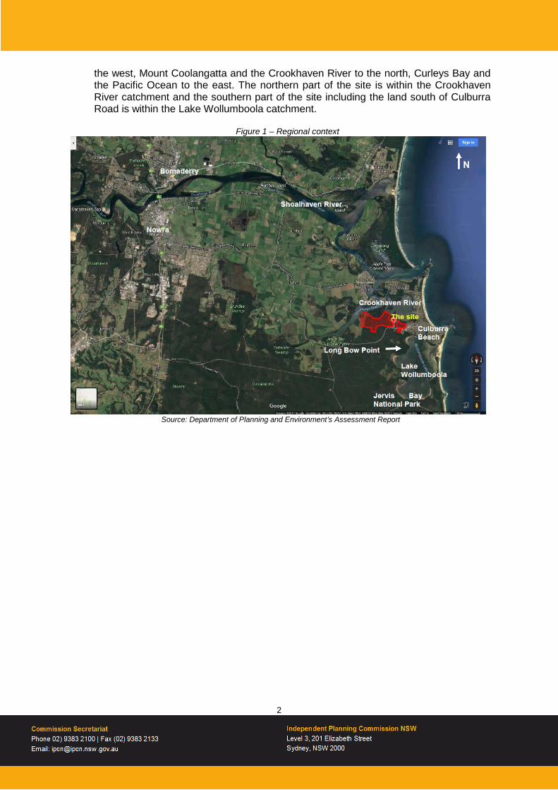
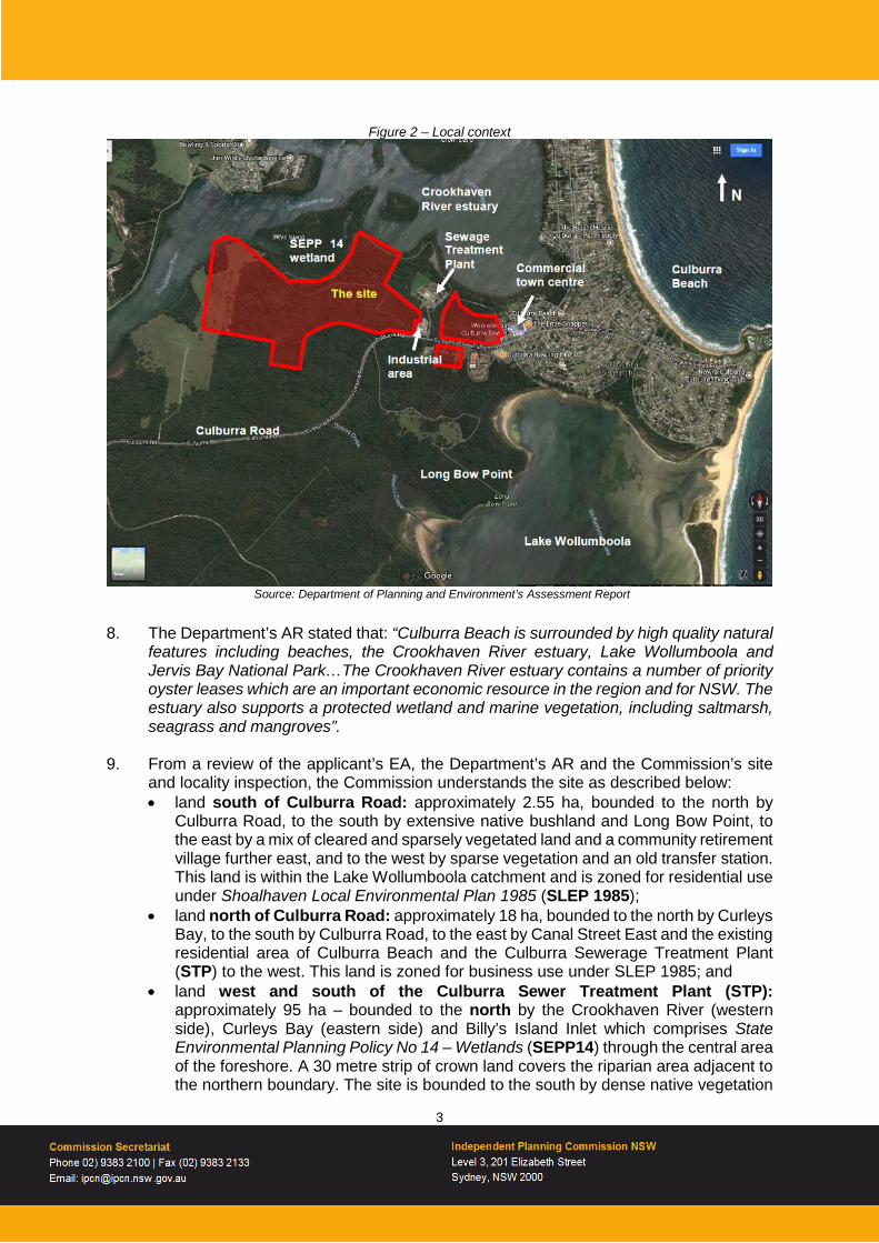


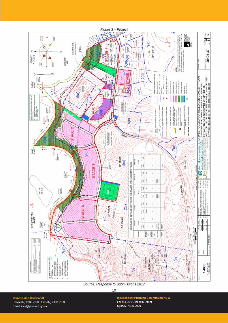


![SSD - ESOS LAB€¦ · SSD . 1 SSD Block Diagram 3.2 SSD NAND HDD . . SSD FTL . FTL NAND out-of-place update address mapping . Gabage Collection, Wear-leveling . 4. 4.1 SSD . Disksim[8]](https://static.documents.pub/doc/80x56/5ea6b67696cb1838a26c1ab1/ssd-esos-ssd-1-ssd-block-diagram-32-ssd-nand-hdd-ssd-ftl-ftl-nand-out-of-place.jpg)


