WM2017 Conference, March 5-9, 2017, Phoenix, Arizona, USA 1 Statistical Tools and Lines of Evidence Used to Differentiate FUSRAP/Non- FURAP Related Material at an Inactive Landfill – 17553 Ann Ewy*, David Hays*, AmyMarie Accardi-Dey**, Richard Califano**, Ed Dudek**, and Ted Rahon*** * United States Army Corps of Engineers (Kansas City, Missouri) ** Louis Berger US (Elmsford, New York) *** CoPhysics Corporation (Florida, New York) ABSTRACT The Middlesex Municipal Landfill (MML) Site is a former municipal landfill in Middlesex, New Jersey that operated between approximately 1940 and 1974; it is currently part of FUSRAP. Because of the lack of waste management regulations at the time, unregulated disposal of municipal and industrial waste occurred, including the acceptance of radioactively contaminated soils from the Middlesex Sampling Plant (MSP) that were used as cover material on the northwest side of the landfill. The radioactive MSP contaminated soils are described as “FUSRAP-related materials.” In some areas of the landfill, FUSRAP-related material exists comingled with other non-FUSRAP radioactive waste (such as an antique radioluminescent marker and concrete construction material with elevated gamma readings). However, in other areas of the landfill (specifically the street’s right-of-way, called Pershing Avenue, which borders the landfill), non-FUSRAP material is isolated. Several lines of evidence and statistical tools were used to differentiate FUSRAP- related materials from non-FUSRAP-related material, including Z-Score analysis, Tukey-Kramer Honestly Significant Difference test, box-and-whisker plots, Wilcoxon Signed Rank test, and Principal Component Analysis. INTRODUCTION MML is a former municipal landfill in Middlesex, New Jersey that operated between approximately 1940 and 1974; it is currently part of FUSRAP. Because of the lack of waste management regulations at the time, unregulated disposal of municipal and industrial waste occurred, including the acceptance of radioactively contaminated soils from MSP that were used as cover material on the northwest side of the landfill. One of the responsibilities of MSP was to receive uranium ore purchased by the federal government between 1943 and 1955, and then to crush/grind, dry, screen, weigh, assay, store, package, and ship the ore as directed by the government to private and public enterprises to perform development work. At MSP, uranium ore, or pitchblende, was not enriched or depleted in Uranium-235 (U-235); this natural, unaltered material is described as FUSRAP-related material. In 1948, the government decided to pave the area at MSP where the ore was stored. Prior to paving, the area was graded, and approximately 6,000 cubic yards of radioactively contaminated soils were reportedly shipped to MML (an unregulated municipal landfill) to serve as fill and/or landfill cover material [1].
Transcript
WM2017 Conference, March 5-9, 2017, Phoenix, Arizona, USA
1
Statistical Tools and Lines of Evidence Used to Differentiate FUSRAP/Non-FURAP Related Material at an Inactive Landfill – 17553
Ann Ewy*, David Hays*, AmyMarie Accardi-Dey**, Richard Califano**, Ed Dudek**, and Ted Rahon***
* United States Army Corps of Engineers (Kansas City, Missouri) ** Louis Berger US (Elmsford, New York)
*** CoPhysics Corporation (Florida, New York) ABSTRACT The Middlesex Municipal Landfill (MML) Site is a former municipal landfill in Middlesex, New Jersey that operated between approximately 1940 and 1974; it is currently part of FUSRAP. Because of the lack of waste management regulations at the time, unregulated disposal of municipal and industrial waste occurred, including the acceptance of radioactively contaminated soils from the Middlesex Sampling Plant (MSP) that were used as cover material on the northwest side of the landfill. The radioactive MSP contaminated soils are described as “FUSRAP-related materials.” In some areas of the landfill, FUSRAP-related material exists comingled with other non-FUSRAP radioactive waste (such as an antique radioluminescent marker and concrete construction material with elevated gamma readings). However, in other areas of the landfill (specifically the street’s right-of-way, called Pershing Avenue, which borders the landfill), non-FUSRAP material is isolated. Several lines of evidence and statistical tools were used to differentiate FUSRAP-related materials from non-FUSRAP-related material, including Z-Score analysis, Tukey-Kramer Honestly Significant Difference test, box-and-whisker plots, Wilcoxon Signed Rank test, and Principal Component Analysis. INTRODUCTION MML is a former municipal landfill in Middlesex, New Jersey that operated between approximately 1940 and 1974; it is currently part of FUSRAP. Because of the lack of waste management regulations at the time, unregulated disposal of municipal and industrial waste occurred, including the acceptance of radioactively contaminated soils from MSP that were used as cover material on the northwest side of the landfill. One of the responsibilities of MSP was to receive uranium ore purchased by the federal government between 1943 and 1955, and then to crush/grind, dry, screen, weigh, assay, store, package, and ship the ore as directed by the government to private and public enterprises to perform development work. At MSP, uranium ore, or pitchblende, was not enriched or depleted in Uranium-235 (U-235); this natural, unaltered material is described as FUSRAP-related material. In 1948, the government decided to pave the area at MSP where the ore was stored. Prior to paving, the area was graded, and approximately 6,000 cubic yards of radioactively contaminated soils were reportedly shipped to MML (an unregulated municipal landfill) to serve as fill and/or landfill cover material [1].
WM2017 Conference, March 5-9, 2017, Phoenix, Arizona, USA
2
In 1984-1986, remedial action was taken by US DOE on the northwest side of the landfill to remove FUSRAP-related material [2]. Following this remedial work, small uranium ore nuggets (representing FUSRAP-related material) continued to be discovered and removed from soils (in 1986, 2010, and 2014-2015) within and near the footprint of the 1984-1986 US DOE remedial action. However, the highest radionuclide activity remaining at MML was reported in the Pershing Avenue right-of-way, which is located adjacent to the historical landfill and outside the former 1984-1986 US DOE remedial action. The USACE conducted a remedial investigation (RI) and Risk Assessment (RA) at the MML to investigate the nature and extent of FUSRAP-related material, evaluate fate and transport, develop a conceptual site model, and evaluate the potential for adverse human and ecological health effects associated with exposure to low-level radioactivity detected in environmental samples. DESCRIPTION One of the objectives of the RI was to incorporate geochemical and statistical tools to investigate and evaluate sources and to identify whether the radioactive soils were impacted by FUSRAP-related material or non-FUSRAP-related material. To assist with decision making, the USACE divided the Study Area into “Areas of Interest” (AOI) (refer to Fig. 1 for Study Area and AOI) [3]. Several statistical tools were incorporated to differentiate FUSRAP-related material from non-FUSRAP-related material both within the AOIs and across the entire landfill (Study Area). Tools used and discussed herein include:
• Z-Score evaluation of gamma scan survey data, • Tukey-Kramer Honestly Significant Difference test, • Box-and-whisker plots of surface soil radioactivity levels, • Wilcoxon-Signed Rank test, and • Principal Component Analysis (PCA).
WM2017 Conference, March 5-9, 2017, Phoenix, Arizona, USA
3
Fig. 1. Study Area and Areas of Interest (AOI) DISCUSSION Gamma Scan Survey Evaluation In 2010, two gamma scan surveys were completed: the “drive-over” was conducted with two RSX-256 4-liter sodium iodide (NaI) scintillation detectors and the “walk-over” was conducted with a Ludlum Model 2221 meter connected to 3×3 NaI probe [3]. The objective of the 2014-2015 gamma scan survey (conducted with a Ludlum Model 2221 meter connected to Bicron 3×3 NaI probe) was to supplement the 2010 gamma scan surveys and fill in data gaps. To account for the calibration difference between the multiple surveys, the 2010 and 2014-2015 surveys were combined into one presentation using Z-Score by Study Area (refer to Fig. 2 for results of Z-Score). Z-Score is used to identify data points that fall outside of the population mean. For example, a Z-Score > 3 indicates data points that exceed three times the standard deviation of the population. One observation in this presentation is the elevated Z-Score along in AOI-1 Perching Avenue. Landfill operations did not extend to Pershing Avenue until sometime between 1963 and 1970 based on historical photographs [4]. Non-native material is likely present underneath the asphalt on the northwest side of Pershing Avenue (near the intersection of Pershing Avenue and Sheridan Avenue) based on the 1979 aerial photograph. Moreover, elevated surface gamma readings in AOI-1 Pershing Avenue coincide with the 1998 water line extension. According to New Jersey American Water [5], the water line on Pershing Avenue was extended in 1998 to
WM2017 Conference, March 5-9, 2017, Phoenix, Arizona, USA
4
improve water quality. This utility excavation may have disturbed landfill material located in the Pershing Avenue right-of-way to depths of approximately 150 cm bgs (approximately 60 inches). During backfilling of the water line, excavated landfill soils were placed at the surface. While it is possible that radioactive backfill may have been delivered to the work site, this scenario is unlikely because a trail of elevated gamma readings was not observed southeast along Sheridan Avenue. It is also important to note gamma field instruments detect gamma emission regardless of its source. Consequently, elevated gamma emissions displayed in Fig. 2 may represent FUSRAP-related material or non-FUSRAP-related material, such as: natural radioactive material or municipal debris in the surface soils. Elevated gamma readings were also recorded during the surveys when field crew encountered non-FUSRAP related material, such as: a radioluminescent instrument dial, an antique radioluminescent marker that had radium-based radio-luminous paint, and concrete construction material. In addition to these non-FUSRAP objects, uranium nuggets (representing FUSRAP material) have been discovered in AOI-1 Landfill, AOI-2, and AOI-3. These nuggets have been removed from the Study Area; however, in some instances, locations where uranium nuggets have been previously encountered continue to exhibit elevated gamma emission and Z-Score > 3. Uranium nuggets were encountered and removed from the Study Area in 1986, 2010, 2014, and 2015. Nuggets discovered in 2014 and 2015 were crushed and analyzed, showing that the nuggets represent “natural uranium” with no evidence of enrichment.
Fig. 2. Z-Score for Study Area with Pershing Avenue Right-of-Way
WM2017 Conference, March 5-9, 2017, Phoenix, Arizona, USA
5
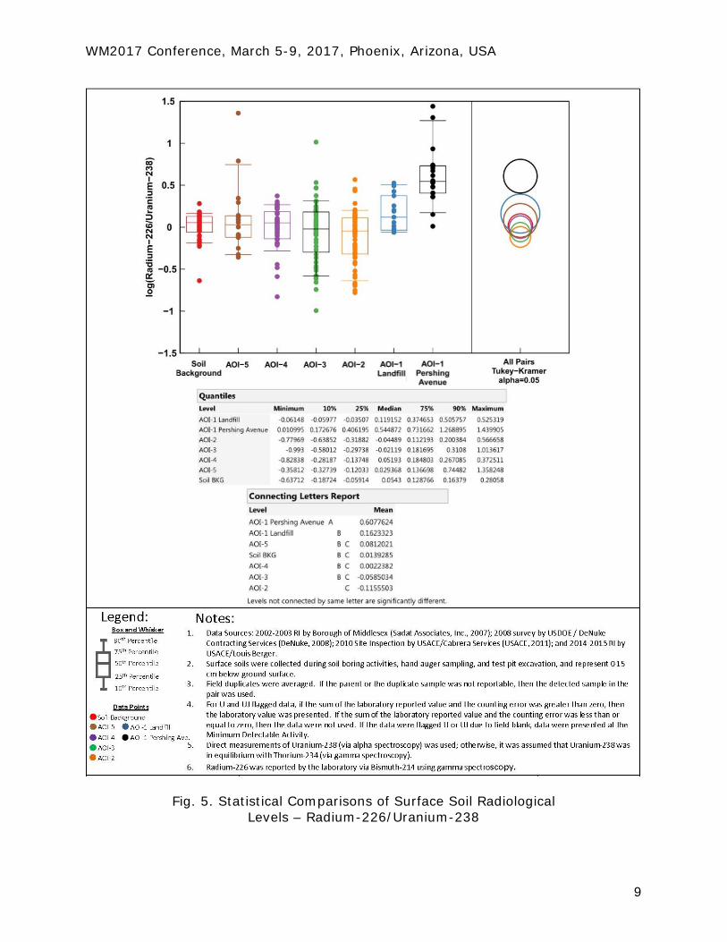
Comparison Of Surface Soil Radionuclide Activity The radionuclide activity in the surface soils of the landfill was compared to the distribution of activities in background soils. For this evaluation, radionuclide activities are grouped by AOI and presented relative to background for Uranium-238 (U-238), Thorium-230 (Th-230), Radium-226 (Ra-226), Thorium-232 (Th-232) and Thorium-228 (Th-228). Background surface soils are defined by 39 samples collected from Mountain View Park, Veteran’s Park, and Lake Nelson. Each AOI is defined by surface soil samples collected between 2002 and 2015 and representing depths less than 15 cm bgs (or 6 inches). Key conclusions from this evaluation are: (1) radionuclides associated with the thorium decay chain (including Th-232 and Th-228) have activities across the Study Area that are comparable to background surface soils, and (2) U-238, Th-230, and Ra-226 activities in surface soils from AOI-1 Pershing Avenue are significantly different from background. Radionuclide Ratios In AOI-1 Pershing Avenue To further investigate the radionuclide activities in AOI-1 Pershing Avenue that were significantly different than background soil activities, radionuclide ratios were examined. If radionuclides are in equilibrium, then the ratio of Th-230/U-238 and Ra-226/U-238 will be close to 1. If Th-230 and Ra-226 are enriched in the surface soils relative to U-238, the ratios will be greater than 1. For this presentation, a box-and-whisker plot was generated for each group of data, showing the range, median, and quantiles on a logarithmic scale. A Tukey-Kramer Honestly Significant Difference test was applied to identify populations that were significantly different from each other. The results of the Tukey-Kramer test are presented graphically with circles on the right side of the box-and-whisker presentation. Circles represent the geometric mean (i.e., the center of the circle on a logarithmic scale) and its uncertainty at the 95 percent confidence level (i.e., the circle radius) for each of the sample groups examined. Tukey-Kramer circles that do not touch or only slightly intersect are indicative of sample groups that are significantly different from each other; circles that intersect or are nested are not significantly different. The “Connecting Letter Report” in the figure assists with the interpretation of the statistics; datasets that are not connected by the same letter are significantly different. The U-238 activities (absolute) in AOI-1 Pershing Avenue and AOI-2 are significantly different from background activities (Fig. 3). Statistically, the U-234/U-238 ratio in the Study Area is not significantly different from background as noted by the nested Tukey-Kramer circles and the similar Connecting Letter “A.” This evaluation shows that while U-238 activities in AOI-1 Pershing Avenue and AOI-2 are elevated, U-238 is not enriched or depleted relative to U-234. Conversely, an enrichment of Th-230 and Ra-226 relative to U-238 is observed in AOI-1 Pershing Avenue surface soils (Fig. 4 and Fig. 5, respectively). For example, the median ratio of Th-230/U-238 in AOI-1 Pershing Avenue is 100.648 (or 4.4), while surface soils from background locations and the remaining portions of the
WM2017 Conference, March 5-9, 2017, Phoenix, Arizona, USA
6
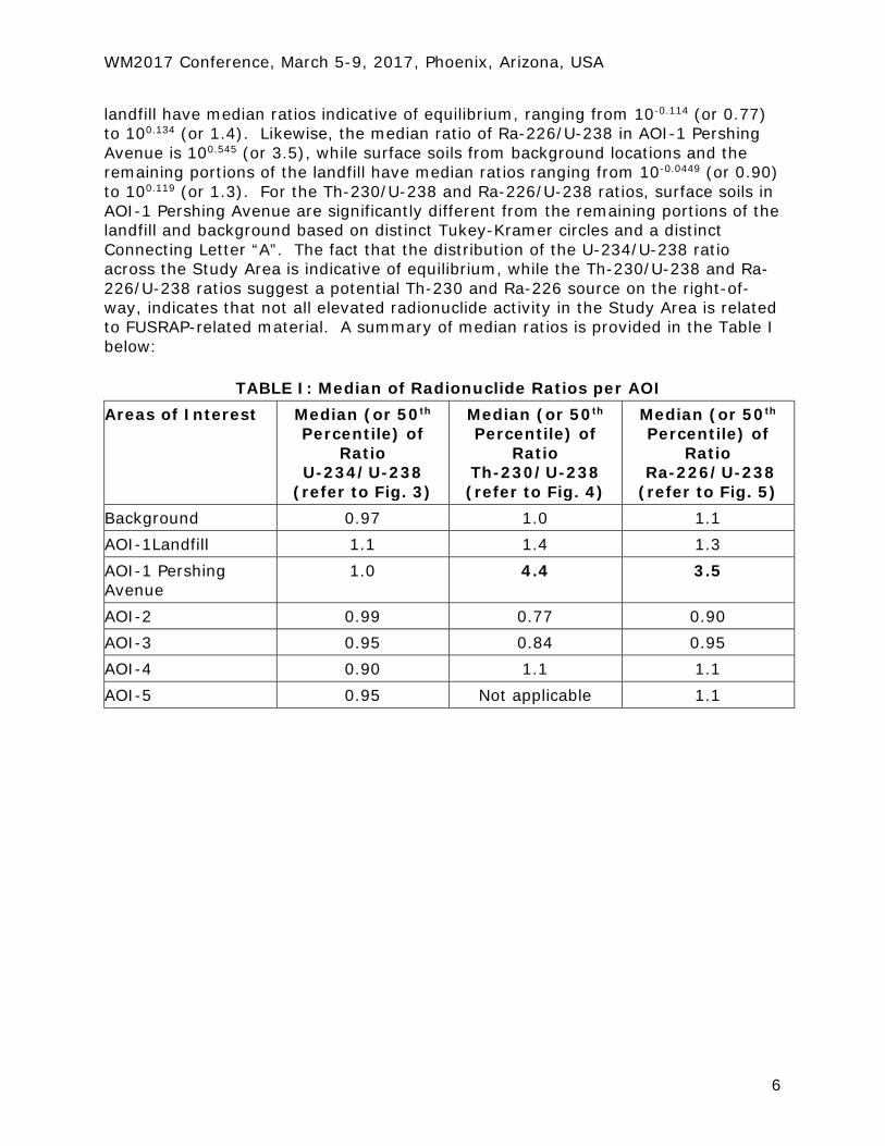
landfill have median ratios indicative of equilibrium, ranging from 10-0.114 (or 0.77) to 100.134 (or 1.4). Likewise, the median ratio of Ra-226/U-238 in AOI-1 Pershing Avenue is 100.545 (or 3.5), while surface soils from background locations and the remaining portions of the landfill have median ratios ranging from 10-0.0449 (or 0.90) to 100.119 (or 1.3). For the Th-230/U-238 and Ra-226/U-238 ratios, surface soils in AOI-1 Pershing Avenue are significantly different from the remaining portions of the landfill and background based on distinct Tukey-Kramer circles and a distinct Connecting Letter “A”. The fact that the distribution of the U-234/U-238 ratio across the Study Area is indicative of equilibrium, while the Th-230/U-238 and Ra-226/U-238 ratios suggest a potential Th-230 and Ra-226 source on the right-of-way, indicates that not all elevated radionuclide activity in the Study Area is related to FUSRAP-related material. A summary of median ratios is provided in the Table I below:
TABLE I: Median of Radionuclide Ratios per AOI Areas of Interest Median (or 50th
WM2017 Conference, March 5-9, 2017, Phoenix, Arizona, USA
10
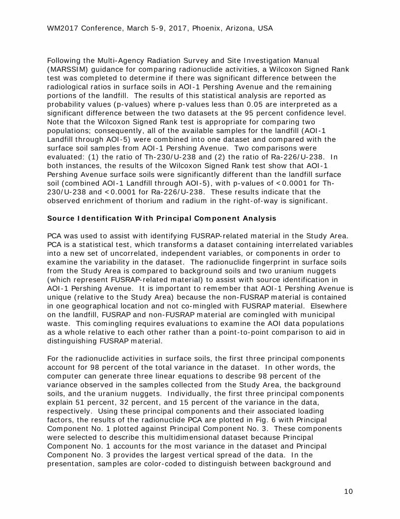
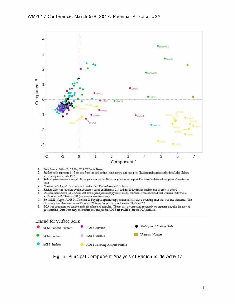
Following the Multi-Agency Radiation Survey and Site Investigation Manual (MARSSIM) guidance for comparing radionuclide activities, a Wilcoxon Signed Rank test was completed to determine if there was significant difference between the radiological ratios in surface soils in AOI-1 Pershing Avenue and the remaining portions of the landfill. The results of this statistical analysis are reported as probability values (p-values) where p-values less than 0.05 are interpreted as a significant difference between the two datasets at the 95 percent confidence level. Note that the Wilcoxon Signed Rank test is appropriate for comparing two populations; consequently, all of the available samples for the landfill (AOI-1 Landfill through AOI-5) were combined into one dataset and compared with the surface soil samples from AOI-1 Pershing Avenue. Two comparisons were evaluated: (1) the ratio of Th-230/U-238 and (2) the ratio of Ra-226/U-238. In both instances, the results of the Wilcoxon Signed Rank test show that AOI-1 Pershing Avenue surface soils were significantly different than the landfill surface soil (combined AOI-1 Landfill through AOI-5), with p-values of <0.0001 for Th-230/U-238 and <0.0001 for Ra-226/U-238. These results indicate that the observed enrichment of thorium and radium in the right-of-way is significant. Source Identification With Principal Component Analysis PCA was used to assist with identifying FUSRAP-related material in the Study Area. PCA is a statistical test, which transforms a dataset containing interrelated variables into a new set of uncorrelated, independent variables, or components in order to examine the variability in the dataset. The radionuclide fingerprint in surface soils from the Study Area is compared to background soils and two uranium nuggets (which represent FUSRAP-related material) to assist with source identification in AOI-1 Pershing Avenue. It is important to remember that AOI-1 Pershing Avenue is unique (relative to the Study Area) because the non-FUSRAP material is contained in one geographical location and not co-mingled with FUSRAP material. Elsewhere on the landfill, FUSRAP and non-FUSRAP material are comingled with municipal waste. This comingling requires evaluations to examine the AOI data populations as a whole relative to each other rather than a point-to-point comparison to aid in distinguishing FUSRAP material. For the radionuclide activities in surface soils, the first three principal components account for 98 percent of the total variance in the dataset. In other words, the computer can generate three linear equations to describe 98 percent of the variance observed in the samples collected from the Study Area, the background soils, and the uranium nuggets. Individually, the first three principal components explain 51 percent, 32 percent, and 15 percent of the variance in the data, respectively. Using these principal components and their associated loading factors, the results of the radionuclide PCA are plotted in Fig. 6 with Principal Component No. 1 plotted against Principal Component No. 3. These components were selected to describe this multidimensional dataset because Principal Component No. 1 accounts for the most variance in the dataset and Principal Component No. 3 provides the largest vertical spread of the data. In the presentation, samples are color-coded to distinguish between background and
WM2017 Conference, March 5-9, 2017, Phoenix, Arizona, USA
11
Fig. 6. Principal Component Analysis of Radionuclide Activity
WM2017 Conference, March 5-9, 2017, Phoenix, Arizona, USA
12
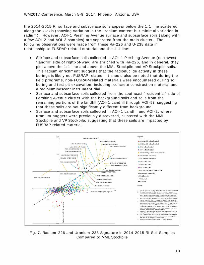
respective AOI; samples with the same radionuclide pattern or “fingerprint” cluster together, regardless of geographical location. The PCA results show that the main cluster of surface soil samples plots near the zero intersection with background surface soil samples, indicating that the majority of the surface soils from the landfill (AOI-1 Landfill through AOI-5) have a similar radionuclide fingerprint as background surface soils. A subset of surface soil samples from AOI-1 Landfill and AOI-2 where uranium nuggets were co-located then spread to the upper right quadrant towards the uranium nugget data points. This spread is expected because some of the AOI-1 Landfill and AOI-2 surface soil samples are a mixture of landfill soils and nuggets residue. Surface soils from AOI-1 Pershing Avenue (northwest side of right-of-way) form a separate cluster in the lower right quadrant, which does not overlap with background surface soils, and plots in a separate quadrant than the nugget. It is important to note that surface soils from the southeast side of Pershing Avenue (residential side of the road) do plot with the main cluster near the zero intersection. The lack of uranium nuggets discovered in AOI-1 Pershing Avenue along with other lines of evidence (including site chronology of landfill activities, development of Pershing Avenue and placement of water line, and presence of non-FUSRAP material) suggests that the right-of-way is not impacted by FUSRAP-related material. Conversely, the radionuclide PCA suggests a similarity between some of the AOI-3 and AOI-2 soils; these PCA results along with the presence of uranium nuggets and site chronology of the landfill indicate that FUSRAP-related material is impacting some soils on the landfill. Source Identification With MSP Stockpile Soils Following the 1984-1986 US DOE remedial action at MML, excavated “radioactive contaminated” material was stockpiled and stored at MSP. A second Vicinity Property (VP) Stockpile was stored at MSP following the 1980 remedial action of residential properties. A total of 30 soil samples were collected from the MML Stockpile and VP Stockpile for waste disposal characterization [6]. In terms of source identification, the MML Stockpile and VP Stockpile represent FUSRAP-related material. These data could not be added to the main radionuclide PCA evaluation because the radionuclides were limited to three isotopes: Ra-226, Th-232, and U-238. Consequently, a separate evaluation was completed by comparing the 2014-2015 RI surface and subsurface soils (collected from soil borings, test pits, and hand auger locations) to the MML Stockpile and VP Stockpile data. Fig. 7 examines the Ra-226 and U-238 relationship. In this presentation, soils for each AOI are marked by different colored symbols (solid symbols represent subsurface soils and open symbols represent surface soils). Background surface soils are presented by grey crosses; the MML Stockpile soils are presented as a black X; and the VP Stockpile soils are presented as a black dash. The 1:1 line represents equilibrium in the uranium decay chain. As expected, the MML Stockpile and VP Stockpile soils have elevated activities, but the radionuclide ratios are consistent with the 1:1 line. In addition, the background surface soils appear at the center of the graphic on the 1:1 line. The majority of
WM2017 Conference, March 5-9, 2017, Phoenix, Arizona, USA
13
the 2014-2015 RI surface and subsurface soils appear below the 1:1 line scattered along the x-axis (showing variation in the uranium content but minimal variation in radium). However, AOI-1 Pershing Avenue surface and subsurface soils (along with a few AOI-2 and AOI-3 samples) are separated from the main cluster. The following observations were made from these Ra-226 and U-238 data in relationship to FUSRAP-related material and the 1:1 line:
• Surface and subsurface soils collected in AOI-1 Pershing Avenue (northwest “landfill” side of right-of-way) are enriched with Ra-226, and in general, they plot above the 1:1 line and above the MML Stockpile and VP Stockpile soils. This radium enrichment suggests that the radionuclide activity in these borings is likely not FUSRAP-related. It should also be noted that during the field programs, non-FUSRAP-related materials were encountered during soil boring and test pit excavation, including: concrete construction material and a radioluminescent instrument dial.
• Surface and subsurface soils collected from the southeast “residential” side of Pershing Avenue cluster with the background soils and soils from the remaining portions of the landfill (AOI-1 Landfill through AOI-5), suggesting that these soils are not significantly different from background.
• Surface and subsurface soils collected in AOI-1 Landfill and AOI-2, where uranium nuggets were previously discovered, clustered with the MML Stockpile and VP Stockpile, suggesting that these soils are impacted by FUSRAP-related material.
Fig. 7. Radium-226 and Uranium-238 Signature in 2014-2015 RI Soil Samples Compared to MML Stockpile
WM2017 Conference, March 5-9, 2017, Phoenix, Arizona, USA
14
CONCLUSIONS AOI-1, AOI-2, and AOI-3 were determined to have portions impacted by FUSRAP-related materials. AOI-4 and AOI-5 were determined to not be impacted by FUSRAP-related materials and radionuclide activities were not elevated compared to background. When examining the AOI-1 Pershing Avenue sample population as a whole, soils in AOI-Pershing Avenue are enriched in both radium and thorium relative to uranium (which is characteristic of non-FUSRAP material). The excess thorium and excess radium observed in AOI-1 Pershing Avenue may be characteristic of the material’s original source, and if from an industrial process, that process did not alter the Th-230 to Ra-226 ratio. AOI-1 Pershing Avenue is unique (relative to the Study Area) because the non-FUSRAP material is contained in one geographical location and not commingled with FUSRAP-related material. Several statistical tools were used to differentiate the FUSRAP-related material from the non-FURAP-related material in the Study Area, including Z-Score calculations of the gamma scan survey data; Tukey-Kramer Honestly Significant Difference test and box-and-whisker plots of radionuclide activity ratios; Wilcoxon Signed Rank test for comparing two populations; and source track down using PCA and fingerprinting. Other lines of evidence indicating that the right-of-way was impacted by a non-FUSRAP source were: aerial photography analysis and historical records review providing site chronology of landfill expansion; chronology of the development and paving of the right-of-way; the physical presence of radioactive non-FUSRAP debris in the right-of-way; and thorium, in addition to radium, as drivers of potential human health risk. REFERENCES 1. US DOE, “Middlesex Sampling Plant, Middlesex, New Jersey, Site Fact Sheet.” USDOE Office of Legacy Management (2004). 2. US DOE, “Certification Docket Action for the Remedial Action Performed at the Middlesex Municipal Landfill, Middlesex New Jersey in 1984 and 1986.” (1989). 3. USACE, “Site Inspection Report: Middlesex Municipal Landfill Formerly Utilized Sites Remedial Action Program, Borough of Middlesex, New Jersey.” (2011). 4. Nationwide Environmental Title Research, “Historical Aerials and Topographic Maps” Website last accessed on May 2015. 5. New Jersey American Water, “Electronic Mail and Conference Call Communication with Operations Supervisor, American Water Works Company, Inc., (Voorhees, New Jersey).” Communication dated May 2015 and June 2015. 6. US DOE, “Characterization Report for the Interim Storage Piles at the Middlesex Sampling Plan. Volume I.” (1991).